Embed Size (px)
Citation preview
DIGITAL TERRAIN MODEL (DTM) TOPOGRAPHY OF SMALL CRATERS IN THE HOLOCENE CHIEMGAU (GERMANY) METEORITE IMPACT STREWN FIELD. K. Ernstson1 and J. Poßekel2, 1Uni-versity of Würzburg, D-97074 Würzburg, Germany, [email protected] 2Geophysik Poßekel Mülheim, Germany, [email protected]
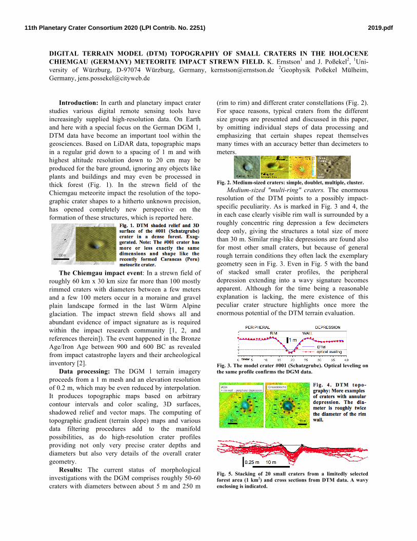
Introduction: In earth and planetary impact crater
studies various digital remote sensing tools have increasingly supplied high-resolution data. On Earth and here with a special focus on the German DGM 1, DTM data have become an important tool within the geosciences. Based on LiDAR data, topographic maps in a regular grid down to a spacing of 1 m and with highest altitude resolution down to 20 cm may be produced for the bare ground, ignoring any objects like plants and buildings and may even be processed in thick forest (Fig. 1). In the strewn field of the Chiemgau meteorite impact the resolution of the topo-graphic crater shapes to a hitherto unknown precision, has opened completely new perspective on the formation of these structures, which is reported here.
The Chiemgau impact event: In a strewn field of
roughly 60 km x 30 km size far more than 100 mostly rimmed craters with diameters between a few meters and a few 100 meters occur in a moraine and gravel plain landscape formed in the last Würm Alpine glaciation. The impact strewn field shows all and abundant evidence of impact signature as is required within the impact research community [1, 2, and references therein]). The event happened in the Bronze Age/Iron Age between 900 and 600 BC as revealed from impact catastrophe layers and their archeological inventory [2].
Data processing: The DGM 1 terrain imagery proceeds from a 1 m mesh and an elevation resolution of 0.2 m, which may be even reduced by interpolation. It produces topographic maps based on arbitrary contour intervals and color scaling, 3D surfaces, shadowed relief and vector maps. The computing of topographic gradient (terrain slope) maps and various data filtering procedures add to the manifold possibilities, as do high-resolution crater profiles providing not only very precise crater depths and diameters but also very details of the overall crater geometry.
Results: The current status of morphological investigations with the DGM comprises roughly 50-60 craters with diameters between about 5 m and 250 m
(rim to rim) and different crater constellations (Fig. 2). For space reasons, typical craters from the different size groups are presented and discussed in this paper, by omitting individual steps of data processing and emphasizing that certain shapes repeat themselves many times with an accuracy better than decimeters to meters.
Fig. 2. Medium-sized craters: simple, doublet, multiple, cluster.
Medium-sized "multi-ring" craters. The enormous resolution of the DTM points to a possibly impact-specific peculiarity. As is marked in Fig. 3 and 4, the in each case clearly visible rim wall is surrounded by a roughly concentric ring depression a few decimeters deep only, giving the structures a total size of more than 30 m. Similar ring-like depressions are found also for most other small craters, but because of general rough terrain conditions they often lack the exemplary geometry seen in Fig. 3. Even in Fig. 5 with the band of stacked small crater profiles, the peripheral depression extending into a wavy signature becomes apparent. Although for the time being a reasonable explanation is lacking, the mere existence of this peculiar crater structure highlights once more the enormous potential of the DTM terrain evaluation.
Fig. 3. The model crater #001 (Schatzgrube). Optical leveling on the same profile confirms the DGM data.
Fig. 5. Stacking of 20 small craters from a limitedly selected forest area (1 km2) and cross sections from DTM data. A wavy enclosing is indicated.
2019.pdf11th Planetary Crater Consortium 2020 (LPI Contrib. No. 2251)

The model nature of the #001 crater in Fig. 3 is also emphasized by a perfectly rotational topographic symmetry found in a more or less identical manner with most individual craters in the Chiemgau strewn field.
Fig. 6. Perfect rotational symmetry: eight DTM radial profiles with height deviations no more than 20 cm in the crater bowl and over the rim wall, and no more than 50 cm over the 40 m complete sections. The larger craters. More than a dozen craters with diameters between roughly 50 m and 250 m have aroused particular interest because they are concentrated in a moraine landscape rich in lakes to the north-west of Lake Chiemsee and have so far generally been regarded as glacial (dead ice) depressions, partly filled with water. As in the case of medium-sized craters, a model structure is presented here (Fig. 7) that illustrates essential features and practically excludes ice-age formation.
Fig. 7. The almost perfectly circular ND crater (ND = natural landmark) and eight mirrored radial profiles. Despite the irregular moraine landscape, the profiles do not deviate by more than 2.5 m over 200 m extension with one exception. A terraced structure and slight walling occurs in many closely related craters (Fig. 8).
Discussion and conclusions: The results presented here are an extract of a meanwhile much larger data and interpretation pool of the DTM application. The essential points are:
� The application of the DTM for crater exploration even in dense forest and swamp areas has led to an enormous increase in the number of postulated impact craters. � The previously valid rule that impact nature is only proven by direct observation, projectile remnants or shock effects is given the additional aspect of morphology in the case of the Chiemgau impact, and for the time being only here.
Fig. 8. A selection of larger circular craters within an area of roughly 10 km x 5 km. In most cases, crater lakes, some of which are up to 200 m in size, have sharply contoured riparian margins that are more or less morphologically congruent on radial profiles with deviations of no more than 1 m.
Fig. 9. Depth-to-diameter relationship for 18 larger craters in the Chiemgau strewn field. The dispersed distribution shows a generally low ratio and rather a clustering than a systematic dependency.
� Perfect circular symmetry including crater bowl, ring wall and peripheral depressions, which enlarge the structure to two to three times the size of the pure crater, reasonably exclude any human installation and, e.g., simple sinkhole formation. A central, point-like force "from above" can explain this. � The associated mechanism of crater (explosion) formation is not yet understood, although the wavy shape could be a reaction to the mostly soft ground of loose, water-saturated rock, with the possible effect of seismic surface (Rayleigh) waves [3]. The soft ground may also explain the very low depth-to-diameter ratio (Fig. 9) and a terraced morphology (Fig. 7) by reflux of rim wall material. So far it is also unclear to what extent the consistency of the Chiemgau impactor for the large strewn field has influenced the crater formation. � The larger craters and their amazingly perfectly circular shape fundamentally rule out the ice age genesis assumed so far by geologists who would have to explain how this sharply contoured, very flat picture-book shape could have been preserved over more than 10,000 years (end of ice age) from dead-ice melting. � We conclude that the results have a certain statistical significance due to the high number of crater shapes precisely measured with the DTM. Well-known cratering models for the group of simple craters with a bowl and a ring wall that merges into a blanket of decreasing ejecta thickness have to consider much more complex shapes, at least in targets with a bedrock of loose rocks. For critics of an impact genesis, this poses the problem of explaining crater morphologies for which human formation or simple sinkholes can be absolutely ruled out.
References: [1] Ernstson, K. et al. (2010) J. Siberian Federal Univ., Engin. & Techn., 1, 72-103. [2] Rappenglück, M.A. et al. (2017) Z. Anomalistik, 17, 235-260. [3] Poßekel, J. and Ernstson, K. this meeting.
2019.pdf11th Planetary Crater Consortium 2020 (LPI Contrib. No. 2251)


![Overview and Scutiny Power BI slides.pptx [Read-Only]€¦ · Dtm 4 Consultant Pod g Dtm I Dtm 8 7 Dtm 3 8 7 Dtm 6 Dtm Pod 4 8 Dtm Pod 4 5 Dtm 2 8 Dtm Pod 8 Dtm I 7 Dtm 4 Dtm Pod](https://img.dokumen.tips/doc/110x75/5fb41d34b5c9a8274925974c/overview-and-scutiny-power-bi-read-only-dtm-4-consultant-pod-g-dtm-i-dtm-8-7-dtm.jpg)