Embed Size (px)
Citation preview

2.3308
Geological, Stripping and Diamond Drilling Report for Claim 3002853
Harvey Township, Southeastern Ontario
NTS 31D/9W Lots 14-16, Con 7
RECE,ve
By M.K.McGill September 2006
SEP 1 ij 1006 ~

Contents
Introduction Location and Access Previous Work and Local Activities Scope of the Work Topography and Vegetation Geology
Regional Geological Overview Property Mapping Property Geology Paleozoic Rocks Precambrian Rocks
Physical Work Logging Stripping, Trenching, Test Holes
Diamond Drilling Conclusions Recommendations Selected Bibliography
Maps, Figures and Appendixes
Map 1- Location Map- Ontario Map 2- Claim Location Map with Regional Geology Map 3- Geology Map Map 4- Traverse Map with Drill Hole Locations Map 5- Stripping, Trenching and Test Hole Location Map Map 6- Test Hole Locations- North Site Map 7- North Trench Mapping Sketch Map 8- Test Hole Locations- South Site Map 9- South Stripping Area Mapping Sketch
3 3 3 4 4
5 5 6 6 7
8 9 11 12 13 14
Figure 1- Geological Legendffable of Formations 15 Appendix 1- Work Logs, Expenditure Details Appendix 2- Diamond Drill Logs and Sections Appendix 3- Photographs

Introduction
This report documents geological mapping, physical work and diamond drilling carried out during May, July, August and September of 2006 on claim 3002853 (10 units, L14-17 C7). The claim is located east of the Mississauga River in south-eastern Harvey Township. Claim number 3002853 was staked in December of2001 to cover a portion of a large Paleozoic limestone outlier, the geographic center of which lies about 6 km northeast of Buckhorn Ontario. Both Paleozoic rocks and Precambrian granitic rocks are exposed on the claim. The recorded holder of the claim is 564348 (Ontario) Limited (100%).
Location and Access
The property is located approximately 7 kilometers due north of Buckhorn, Ontario, in Harvey Township in the County of Peterborough. The Southeastern Mining District centered in Tweed Ontario encompasses this area. The claims are accessible via a secondary road and provincial Highway 36. One proceeds eastward from Buckhorn on Highway 36 some 2.5 kilometres to the Buckhorn Landfill site access road and then northward approximately 2 kilometers on a graveled all weather road to the southern boundary of the claim. A number of skidder roads cross the property from east to west and provide good access to much of the eastern portion of the claim (See Maps I and 2).
Previous Work and Local Activities
One diamond drill hole approximately 50 deep was completed on the property in 2004(see Map 4). This core was logged as part of the work described in this report (see Appendix 2).
Approximately 2 kilometers to the north in Lots 20 and 21 Cons 6 and 7, Harvey township, Edenderry Agg Ltd. operates a small quarry (Rigbe's Quarry) which extracts armour stone and flagstone for landscaping and shoreline improvement purposes.

~
I I I \
""'-.
KM
ONTARIO
"-..
o 200 I
KM
\ \
QUEBEC
\ GRENVIlLE
SUDBURYO /' ~ONT '/ ----.. -JI
~<::::::>-~~- .............. ~AWA ------.; PRECAMBRIAN
MAP!
PROPERTY LOCATION MAP - ONTARIO

ca.en'"'' ~o~~ - - - - - ------- . ___ \\a!"e'j '\:o\'/t\snW
.-.-.-' .-
o
~.~.~ .. -
.....
Kilometres
2
// ......
If/' \, ..... , ~,~ \
'\\/'1r ' ,I '") \ I I I! \
I I I \ (II"
.).66)' I / \ '1 I 1 '
, ' { 1 , ' / \ I / ~I
1
, Phanerozoic '~
Precambrian
\ 1 1
1 \ \ I I
I /1
, (
" \
I I I
I \
(
I I
/
----:;.,/ ~
I I
/ I
\ \
Phanerozoic
'.
\
/~
~" I / .....
,.../ f J
( (.1 1 ( I , '-" , \
\ Phanerozoic I \ / I \ / \ \
Precambrian
/ (
/
I I
r, / -.., I
\ I
..... ,;.',. ~I , .... "'" 'I ) 1 _" i \, I 1 "'00285~, / 1 ~,\.I / (I
, ..... \:1 /' "\.-:,. I Phanerozoic ' "".-\ / \ ~' ~-
I' I / \ / i 1
/ : LANDFILL SITE I
Precambrian
"
, \ -~p ..... ,@' ) ~ --/......) ..... /"
~
\ \
\
--~-..
\ \ \
\ \ \ \ \ \
--,
\
~ ~
\ \ ~ '*\ ~ 'L. \ ~. ~ ~ ~\ ~ o~\\ ~.\~. ~ ~
\ \
"'-\ \ \
" Harvey Township _ ---- - -- ---
"-- - -----Smith Township ~_--..j Phanerozoic
\\
\.
I MAP21
CLAIM LOCATION MAP WITH REGIONAL GEOLOGY
GEOLOGY (modified) after LUMBERS et aI, 2000

Scope of the 2006 Work Programme
The objective of the 2006 program was twofold: I) to produce a preliminary geological map of the property outlining and describing the major lithologic units, and 2) to begin investigating the quality of the Paleozoic limestone by mechanical stripping/trenching and diamond drilling.
Two vertical (-90d) diamond drill holes were completed in the northern and central parts of the claim to document the thickness and characteristics of the limestone along the easternmost portions of the claim. All core recovered was logged and is documented in Appendix 2. A single hole drilled in 2004, collared in the south-eastern part of the claim was also logged and forms part of this report (see Map 4).
Topography and Vegetation
The claim covers an area of gently rolling topography with limited elevation to locally more abrupt, irregular terrain defmed by small (meter-scale) escarpments. Higher elevation topography in the eastern half of the property is generally coincident with the limestone outlier and is overlain by quite variable amounts of overburden (cobble and boulder rich till) covering hummocky rounded to roughly north-south striking ridges of subcrop. Scattered outcrop exposures along some of the ridges are typically small subvertical scarps 2 to 4 metres high.
Lower elevation, gently rolling terrain is present in the western portion of the claim. The topography falls westward towards swampy creeks occurring along the western claim boundary. These flatter areas are locally either swampy and/or infilled with silty to muddy Quaternary deposits. Scattered smooth rounded outcrops of the basement granitics are common in these areas.
Higher elevations are treed predominantly with maple; some beech and rare butternut is also seen. At lower elevations, spruce, balsam and pine occur. Swampy areas are heavily treed with cedar.
4
Geology
Regional Geological Overview
Claim 3002853 is located just north of the Precambrian-Phanerozoic boundary in the Central Metasedimentary Belt of the Grenville Province near Buckhorn, Ontario. Thurston (1991) aptly describes the Central Metasedimentary Belt as " .. consist[ ing] of belts of juvenile Mesoproterozoic crust, largely supracrustal rocks, generally at amphibolite to granulite grade."
Outliers of Paleozoic clastic and chemical sedimentary rocks (shales, limestones, dolostones) belonging to the Middle Ordovician Gun River Fonnation also occur in the region. These younger rocks unconfonnably overly the Precambrian basement rocks.
Morton (1983) describes the [Precambrian] geology underlying the eastern portion of Harvey township (and the claim) as being part of the "Burleigh Gneiss Complex", an area of granodioritic migmatites roughly encircled by banded gneisses of similar composition.
Later mapping by Lumbers et al.(2000) subdivides the basement rocks in the vicinity of the property into a Trondhjemite/Granodiorite suite (1280-1270 MA) and a slightly younger Alaskite suite (1250-1240 MA). Both of these units are in turn cut by members of a later Fenite-Carbonatite suite (1070-1040 MA)(see Figure 1).
Property Mapping
In May 2006, 5 days were spent mapping the claim to outline the property geology and assess areas suitable for stripping, diamond drilling and bulk sampling. Existing skidder roads were examined and located and a number of roughly east-west traverses were completed across the block.(see Map 4).
Outcrops were examined and photos and samples taken. Compass, base map and a 12 channel GPS were used to navigate and locate the data and traverses. A number of GPS stations were flagged with orange tape for later reference.

Property Geology
The property covers a portion of the western edge of a large Paleozoic outlier overlying Precambrian rocks of the Central Metasedimentary Belt of the Grenville Province.
Three of these kilometre-scale features are located north, northwest and northeast respectively of Buckhorn, Ontario (see Map 2).
The claim is roughly divided in two by the north-south striking contact between the overlying Gull River Formation (east half of claim) and the underlying Precambrian (Proterozoic) "granitics"(west half of claim). The Paleozoic-Precambrian contact is inferred from outcrop positions but it is not generally well defmed in anyone location. Reference should be made to Map 3 for details of outcrop locations, lithologic contacts and the float encountered on the property.
Overburden cover (boulder till and organics) is rather variable in thickness across the property (0.4 to 3 metres+).
Paleozoic Rocks
The Gull River rocks are pale grey-white to slightly blueish or tan in colour on freshly broken surfaces and are generally very fine grained, massive and calcitic. A subtle concoidal fracture pattern is often found on freshly broken surfaces. These rocks are referred to as "lithographic limestones" in the literature.
Weathered exposures are typically bone white or pale grey and have either a slightly etched to pitted appearance or a grooved appearance with subcentimetre scale relief developed. (see Appendix 4, photos 3107-1)
Very few fossils or fragments of the same were noted. Centimetre and millimetre scale dark grey wormy calcitic infillings and lighter toned watery rounded to ovoid calcite pods several centimetres across are present in some beds. Very fme styolitic textures lying along the bedding are visible in some outcrops. Dark grey shaley partings defme some individual beds. A dark green micaceous mineral (glauconite?) is also present in some partings and in very fme fractures.

Small scarps (outcrops) show sub-horizontal bedding developed at submetre scales. Mapping in trenches and stripped areas shows bedding dipping as steep as 5 degrees with variable strikes. In a few flat outcrops with minimal overburden cover, strongly weathered, open fractures are visible. The openings vary from 5 to 30 centimetres across and may extend for several metres along strike before resuming as tight fractures. On the extreme eastern margin of the claim, fractures strike at approximately 006, 060, 100, 125, 300 and 350 degrees (measured at several locations) and have sub-vertical dips.
Good type examples of the Shadow Lake Formation were not found in outcrop within the claim. Instead, a few scattered cobbles of a dark grey, immature sandstone or arkose were found in several localities across the property. One of these was located near the inferred basement contact. These rocks are probably thin accumulations of basal clastics analogous to the Shadow Lake fonnation (See Appendix 4, photos 3106-3).
One good example of the contact area is located near the northern claim boundary at a point approximately 420 metres west of Post #1. Several granodiorite and limestone outcrops in close proximity on a topographic high defme the contact. Overburden appears to be thinner in this area and several sub-angular cobbles of a dark grey sandstone (station 3137A) were found on the hillside. This rock consists of angular, 1-2 millimetre clasts of pale grey carbonate and lesser watery quartz and pale pink feldspar chips barely supported in sub-millimetre quartz grains. A few very fine biotite flakes are scattered throughout the rock (see Appendix 4, photo 3137 A-2).
Precambrian Rocks
Precambrian rocks are exposed in low, rounded, rather smooth outcrops and generally weather to a pale pink or grey pink tone. These massive to gneissic rocks are medium to medium-coarse grained and locally contain very coarse-grained layers or bands. They consist of predominantly feldspar (plagioclase), quartz and varying amounts of biotite. Larger outcrops show the laying dipping at shallow angles to the west and striking roughly northsouth.
The basement "granitics" are probably better described as granodiorites or trondhjemites compositionally. The majority of exposures consist of largely feldspathic rocks with varying amounts of slightly smokey interstitial or fme wormy quartz and a very minor mafic component, typically biotite. Other
7

outcrops are greyer in colour and contain slightly more mafic minerals (see Appendix 4, photo 3136-4). Layers of either biotite-rich or much coarsergrained feldspathic (with slightly more quartz) phases are strung across outcrops striking in roughly north-south orientations (Appendix 4 photo 3151-1). Accessories include very small amounts of amphibole, chlorite and magnetite. The rocks are weakly magnetic (pen magnet) in many outcrops, with local hot spots where millimetre scale magnetite is visible.
Very little quartz occurs as discreet vein material. A few examples of irregular roughly east-west striking veinlets are generally 1-3 centimetres thick and boudinaged. The quartz is slightly glassy and or smokey and does not carry any significant sulphide or silicate mineralization (see Appendix 4, photo 3182-2).
Most flat outcrops are quite massive and are cut by tight, sub-vertical fractures. A few fractures/slips show apparent sub-metre scale movements in the strike direction. Locally some of the layering is kinked and drag-folded along very subtle fractures (see Appendix 4, photos 3179-1, 3179-4). Larger outcrops along the extreme western edge of the claim exhibit centimetre scale mafic and felsic-rich layers striking at 310 to 335 degrees with dips ranging from 20 to 30 degrees to the west (see Appendix 4, photo 3151-5).
Physical Work
Logging
Logging was conducted on the ground before any physical work was performed as per MNR requirements. During June of 2006 logging operations occurred in Lot 15 and 16, Con 7, Harvey Township. Two areas of approximately 0.16 and 0.6 Ha were cleared for stripping.(see Map 5). A licensed logger removed the timber using two cutters, a John Deere 653 feller-buncher and a Clark 664 skidder. Costs incurred for logging are detailed in this report as an of these costs were reported on 1 invoice (see Appendix 1).
The 0.16 ha area was cleared for test holes excavated at the "south site location"(see Map 5). Costs for this work are allocated to this report
The 0.6 Ha area was cleared for the removal of a bulk sample. Costs for this work are not allocated to this submission. They will be allocated with the work performed during the bulk sampling work. Reference should be made

to the "Preliminary Bulk Sample Report, 2006 for Claim 3002853" for further information.
Stripping, Trenching and Test Hole Excavation
Tn late August and early September 2006, physical work was perfonned at several locations in order to assess overburden characteristics and begin investigating the quality and extractability of the limestone. Work was performed in cleared (logged) areas only. A breakdown of activities and costs can be found in Appendix 1.
North Site~ Test Holes
Initially, it was assumed that bedrock was close to surface at this site and that stripping and diamond drilling could be conducted at this topographically higher location. After opening a bank and digging 5 test holes greater than 3 meters in depth, no bedrock was encountered in the area. All test holes were dug to the limits of the excavator (Cat 320) and encountered sandy till littered with numerous sub~angular limestone cobbles and boulders up to 2 metres across (see Appendix 3, photos 3479-1, 3479-3, 3479-6, 3480-1, 3480-2, and 3481-3). All excavations were filled in after photos were taken. See Maps 5 and 6 for further details. Drilling was not attempted at this site because of the heavy boulder concentration in the overburden.
North Trench
A number of small test holes were dug to the southeast of the above site and a location was found where approximately 1 to 2 metres overburden was present. An L-shaped trench was opened up and shovelled and swept clean(see Maps 5 and 7). The outcrop was mapped and photographed (see Appendix 3, photos "north trench 4,6,7,8,12,16,21,23 and north trench backtl11ing 4").
A very fme grained, pale grey massive limestone was examined. The outcrop was cut by several sub-vertical tight joints with strike directions of roughly due north, and east-west (090d to 125d true). Bedding was measured at about 3 degrees dipping southeasterly. The rocks were tight and no blocks could be removed for measurement of potential block size.
Q

bank cut r\
/ r St 3478
\----
/\ /
\, ·St./3479 ./
test hole v
Scale 1:300
o 10
I I metres
/"-, / . /
<. ~t 3480 'v
test hole
St 3477A 711408E 4941735N
test hole
/'" / / / test hole
-) I .St 3481 I I test hole ,-J
;-- -o 'l St 3482
- -J
~ \t') N '<I' .... .... f'-
4941750N
I Tomlinson-PropertyJ
NAD 83
Map 6
Test Hole Locations North Site
Harvey Township

4941720N
St 3483 711470E, 4941720N ./ -.......
b~inv /2-5
1.9 m of sandy till ovb )
/
tight,
wk jt,
o I
tight, sub-vert jt
tight, sub-vert jt
up area
~ limestone, very fine grained, pale grey, massive ~ with little internal texture, very liltle jointing. ~ Gull River Fm.
tight. sub-vert jt
Scale 1:100
metres
~.
tight, sub-vert jt
5 I
"'" ----~
II ~ --
1.7
\
m of sandy till ovb
I Tomlinson Property I
Map 7 North Trench
Mapping Sketch
NAD 83 Harvey Township

Approximately 1.7 to 2 metres of sandy till with numerous cobbles and submetre sized limestone boulders were removed from the trench. After mapping, the trench was ftIled in.
Drill hole T -2 was subsequently collared nearby oweing to the relatively shal10w overburden at this location.
Water Sump
A clean water sump for the diamond drill was excavated beside the skidder road accessing the north site test holes and north trench. (see Map 5). It was dug to a depth of 3 meters and did not expose bedrock. This excavation exposed silty and sandy till carrying sub-metre sized limestone cobbles and small boulders (see Appendix 3, photo 3477B-6).
South Site-Test Holes
As with the north test hole location, this area was assumed to have minimal overburden when logged in June of 2006. It was also planned to drill the second diamond drill hole from this location.
Three test hole sites were selected; 1 at each of topographically high and low spots and a third at a position near the claim line, just westerly of known outcrop. All three holes were excavated to depths exceeding 3 metres and no bedrock was tound. Cobble and boulder-rich sandy till was removed from the test holes; after photos were taken the holes were filled in for safety reasons. Reference can be made to Maps 5,8 and Appendix 3, photos 3484A-2 and 3484A-3.
After this work was complete, the location of further stripping and drill hole T -3 was moved to location farther south at a topographically higher position (see Map 5).
South Stripping Site
An area of about 65 square metres were stripped at location some 260 metres south of the "south test hole site" (see Maps 5, 9). About 0.6 metres of a light, silty to sandy to slightly cobbly till was removed and the outcrop shovelled and swept clean. A GPS station was established and the outcrop mapped and photographed.

~ lD lD lD ~
~
l'-
[ TomHnsonProperty]
NAD 83
Map 8
Test Hole Locations South Site
Harvey Township
4941375N
Scale 1 :400 o 10
I I metres
st 3484A /' /. /
test hole \ ./ /
~ bu.h, •• ,
lle",l.Y/ ~ okll'ed
~l'e~
st 3484B __ \ \ . --
-- test hole
-- -- \ \ el ___
test hole
st 3484
~

dark grey. fa limestone. massive Gull River Fm.
0.7 m of sandy till ovb -open sub-vert fracture
bx zone
st 3.85 -- -----.,.
3
\ ) ~ bx zone ~-.l open sub-vert (racture ' • ~ ~\
.1 --1
8 7
\ \
tight. Irregular (ractures
\ \
6 6 •
tight (racture
------
2 1 10
\ drlll hOle)
o T-03
--/ ------ 0.6 m ot sandy till ovb
Scale 1: 100 o 5
I
metres
~ "" ~ to
.94111f>N
discontinous weathered out fractures ~
[TOmlinsonPropertY]
Map 9
South Stripping Area Mapping Sketch
NAD 83 Harvey Township

The rocks exposed here are a fme-grained, rather dark grey to almost brownish toned limestone with a massive aspect. Two prominent intersecting fractures criss-cross the outcrop. These features are weathered and range from 3 to 30 centimetres across with a subtle boudined type of expression. No offsetting was noted at the intersection of the fractures.
The wider areas have included rock fragments (breccias?). Finer arcuate and tight fractures also cut across the outcrop. Attempts to remove blocks for measurement were not successfu1~ although the rocks are weathered along fractures no blocks were loose. Reference should be made to Appendix 3 and photos "south stripping 1,2,6,and 9".
Drill Hole T -3 was collared on this stripped outcrop.
Diamond Drilling
Two BQ sized holes (T-2 and T-3) were drilled in September 2006 with a small, easily movable diamond drill.("Prospector 88"). Although potentially able to penetrate some 400 feet of rock, the machines' capability in rough overburden conditions is questionable.
Hole T -2 was therefore located near the "north trench" which allowed a reasonable assessment of overburden depth and quality. T -2 supplied information on limestone thickness and quality at a relatively low topographic elevation. Hole T -3 was collared on flat outcrop at the "south stripping location". This hole, in contrast to T-2, returned information at a location of potentially maximum limestone thickness on the claim.
Both holes were drilled at -90 degrees and advanced until the basement granitic rocks were cut. The core was logged and photographed; logs, sections and photos can be found in Appendix 2. An earlier hole (T -1 ) drilled in 2004 was relogged and is included in this report.
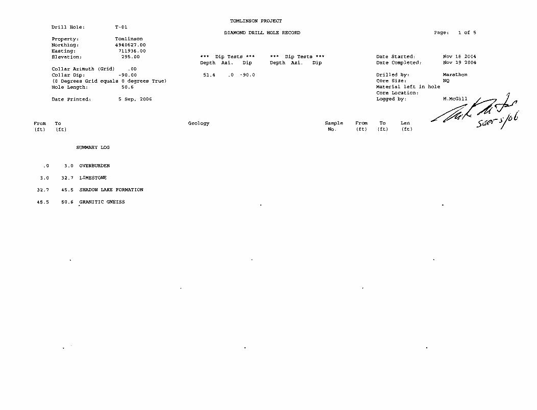
Hole T-l
This hole returned about 30 feet (9.1 m) of fairly massive limestone below which is a sequence of intercalated clastics and limestone beds. In both sections there are intervals of good quality material that is thick enough to be pulled/quarried and which will probably return material up to 3 feet (0.9 m) in thickness. Basement granitics were cut at 45 feet depth (I3.7m) and the
11

hole was stopped at 50.6 feet (15.4 m). The basement rocks are similar to those mapped on the western portion of the claim.
Hole T-2
Hole T-2 returned approximately 10 feet (3.0 m) of good quality limestone before cutting basal clastics. Although most beds were somewhat thinner than those seen in the other holes, at least one unit has the potential to allow pulling of material up to a metre in thickness. The basement rocks are recognizable units seen elsewhere on the property.
Hole T-3
Hole T -3 cut about 66 feet (20. 1m) of good quality limestone, many beds of which may exceed 3 feet in thickness (1 metre). The uppennost portions of the hole cut darker grey to slightly tan toned beds. Lower in the hole, the rocks become lighter in colour and look very similar to those seen in the other two holes. The granitic basement rocks are similar to those rocks mapped elsewhere on the claim.
Conclusions
1) Initial exploration on the claim has uncovered potentially recoverable deposits of sand, gravel and good quality fill contained in glacial outwash material.
2) Initial exploration of the claim has outlined the surface exposure of both Precambrian granitic rocks and the overlying younger Paleozoic limestone
3) Diamond drilling and preliminary examination of the limestone in outcrop suggests a good quality of potential building/landscaping stone exists on the property. At its greatest extent, the limestone strata may range between 9 and 20 metres in thickness.
4) The property has very good access both internally and externally, via an adjacent all weather road and existing skidder roads which may easily be upgraded and extended as needed.

Recommendations
1) Make application to obtain a mining lease on the property 2) Remove a bulk sample from the property to better evaluate the quality
of buildingllandscaping stone 3) Continue exploring the property with a more comprehensive program
of test holes to evaluate the amount and distribution of potential aggregate available from glacial deposits
4) Continue exploring the property with additional diamond drill holes and small trenches to better evaluate the limestone building stone resource (size, shape, tonnage) /J
//~//ZY:Y {'.t6J< 0,- 1S:',;t<1cG
Murray K. McGill (License #K22638)
(report and maps prepared by M.K.McGi11, P.Geo (Sask))

Selected Bibliography
Bright, E. G. 1981: Precambrian Geology of Cavendish Township(Northem Part), Peterborough County, Southern Ontario; OGS Preliminary Map P2420.
Lumbers, S.B. and Vertolli, V.M. 2000: Precambrian Geology, Burleigh Falls area, OGS Preliminary Map P.3404
Morton, R.L. 1983: Geology of Harvey Township, Peterborough County: OOS Report 230,50p.
OGS Map 1957B, Haliburton-Bancroft Area
Thurston, P. C. 1991 : Geology of Ontario, Introduction, in Geology Of Ontario, Ontario Geological Survey, Special Volume 4, Part 1, p.3-25. OGS Map 1957B, Haliburton-Bancroft Area
14

Figure 1 Geological Legend
Quatemary- Pleistocene and Holocene- swamp, bog, peat, marl, glaciofluvials, lacustrine and fluvial sediments unconformity
(21) Paleozoic- Middle Ordovician- clastic and chemical sediments (Shadow Lake, Gull River, Bobcaygeon Fms )sandstones, siltstone, shale limestone, shaley limestone unconformity
Precambrian- Protorozoic ~esoprotorozoic
F enite-Carbonatite Suite (20) Late pegmatite and Fenite
Monzonite-Diorite Suite Intrusives (19) Granite (18) Syenite (17) Mafic Rocks
Regional Metamorphism
Alaskite Suite Intrusives (16) Felsic Intrusive Rocks
Diorite Suite Intrusives (15) Mafic Intrusives
Late Trondhjemite Suite Intrusives (14) Trondhjemite and Granodiorite (13) Mafic Rocks
Nepheline Syenite Suite Intrusives (12) Alkalic Syenite (11) Nepheline Syenite (10) Mafic Alkalic Rocks

Calcareous Metasedimentary Rocks
(9) Calcitic Marble (8) Dolomitic Marble (7) Amphibole-Rich Metasedimentary Rocks (6) Calcareous and Siliceous Shaley Metasedimentary Rocks
Siliceous Clastic Metasedimentary Rocks
(5) Micaceous Sandy Metasedimentary Rocks
Metavolcanic Rocks
Calc-Alkaline to Alkalic Rhyolite Suite (4) Felsic Metavolcanic Rocks (3) Mafic Metavolcanic Rocks
Andesite-Dacite Suite (2) Felsic Metavolcanic Rocks (1) Mafic Metavolcanic Rocks (rs) rusty weathering schists
after Lumbers, et al (2000)
lh

Appendix 1- Work Logs
PHYSICAL WORK
1) Logging 2006
contractor- Tom Hill Logging and Firewood, RR#4 Lakefield, Ont KOL-2HO phone 705-657-3463
man time: 2 men @ 8 hrs per day @ $200 per man= $400 per day machine time: 1 Clark 664 skidder @ $500 per day machine time: 1 John Deere 653 feller buncher @ $1250 per day operators: Kevin Hill, Jeff Hill
logging for south site test holes (Lot 15,16 C7) (see Map 5)
June 2006 June 28 2 men, 1 machine day feller-buncher, daily total $1650 June 29 2 men, 1 machine day feller-buncher, daily total $1650 June 30 2 men, 1 machine day skidder, daily total $900 3 days total
subtotal $4200.00 GST@ 7% $294.00 Total with tax $4494.00
(Change in GST rate)
July 2006 July 3 July 4 2 days total
2 men, 1 machine day skidder, daily total $900 1 man, 112 machine day skidder, daily total $450
subtotal $1350.00 GST@ 6% $81.00 Total with tax $1431.00
Total logging costs allocated to this Work Report: $5925.00
17

bulk sample location (Lot 15, C7)
July 4 July 5 July 6 July 7 July 10 July 11
1 man, 1 machine day feller-buncher, daily total $1450 2 men, 1 machine day feller-buncher, daily total $1650 2 men, 3/4 machine day fel1er-buncher, daily total $1337.50 2 men, 1 machine day skidder, daily total $900 2 men, 1 machine day skidder, daily total $900 2 men, 112 machine day skidder, daily total $650
6 days total subtotal $6887.50 GST@ 6% $413.25 Total with tax $7300.75
Grand Total for 2006 logging Subtotal @ 70/0 GST $4494.00 Subtotal @ 6% GST $8731.75 Final Total with tax $13225.75
Logging Costs to be allocated to Preliminary Bulk Sample Report: $7300.75
2) Stripping, Trenching, and Test Hole Excavation
contactor- Buckhorn Sand and Gravel PO Box 100, Buckhorn, Ont KOL-l JO Phone: 705-657-9311
rate: $125.00/hr machine and man time
Aug 30- 10.5 hours machine time (Cat 320 excavator) 10.5 hours operater time (Josh Fawcett)
Activities: upgrade skidder road into north test hole site open up bank exposing soil profile and underlying till dig 5 test holes at north test hole site backfill 5 test holes at north test hole site dig smaller test holes to locate bedrock start to open up north trench

Aug 31- 10.5 hrs machine time (Cat 320 excavator) 10.5 hrs operator time (Josh Fawcett)
Activities: finish opening north trench make drill set up for drill hole T-2 open up water sump for diamond drill backfill north trench upgrade road to south test hole site open up 3 test holes at south test hole location
Sept 1- 4 hrs machine time (Cat 320 excavator) 4 hrs operator time (Josh Fawcett)
Activities: Backfill 3 test holes at south test hole location Walk excavator to south stripping site Remove overburden at south stripping site
25 hrs total @ $1251hr $3125.00 GST @ 6% $187.50 Total $3312.50
Total costs for physical work al10cated to this work report: $3312.50
GEOLOGICAL WORK
Geological work is charged at a rate of $320.00 per day. Mileage charges where applicable are charged at 0.40 per kilometre. (Murray McGill)
Administration and Data Compilation Mar 12/2006 Y2 day @ 320.00 .............. $160.00 May 23, 25, 27/2006 % day @ 320.00... ... ... ... ... $240.00
19

Mapping May 10/2006
May 16/2006
May 17/2006
May 18/2006
May 19/2006
112 day @ 320.00... ... ... .... $160.00
1 day @ 320.00... ... ... ... ..... $320.00 Mileage 51km @ 0.40....... $20.40
1 day @ 320.00 .................. $320.00 Mileage 51km @ 0.40... .... $20.40
1 day @ 320.00 ................... $320.00 Mileage 51km @ 0.40... .... $20.40
1 day @ 320.00 .................... $320.00 Mileage 51km @ 0.40... .... $20.40
Core Logging, preparation of digital sections May 3112006 1 day @ 320.00 .................... $320.00
Core Logging, Drill Supervision Sept 1/2006 112 day @ 320.00 .................. $160.00
Sept 2/2006 1 day @ 320.00 .................... $320.00 Mileage 51km @ 0.40... .... $20.40
Sept 5/2006 1 day @ 320.00 .................... $320.00
Supervision of Stripping, Mapping of stripped/trenched areas August 30/2006 1 day @ 320.00 .................... $320.00
Mileage 51km @ 0.40... .... $20.40
August 3112006 1 day @ 320.00 .................... $320.00 Mileage 51km @ 0.40... .... $20.40
September 112006 112 day @ 320.00 .................. $160.00 Mileage 51km @ 0.40... .... $20.40
1()

Preparation of Report and Maps June 15/2006 1 day @ 320.00 ......... '" .... , .... $320.00 June 16/2006 1 day @ 320.00 ..................... $320.00 Sept 6/2006 1 day @ 320.00 ..................... $320.00 Sept 7/2006 1 day @ 320.00 ..................... $320.00
Subtotal Mar to June 30 GST @ 70/0 Subtotal July 1 to Sept 30 GST@6%
Total
$2881.60 $201.71 $2321.60 $139.30 $5544.21
Total costs for geological work al10cated to this work report: $5544.21
DIAMOND DRILLING
Sonic Soil Sampling, Concord Ont, L4K-3V2 905-660-0501 Rate: $125.001hr runner: Keith Thatcher, helpers; Sean Strefanski,
Andrew Thatcher
Activities:
Aug 31/06 1.5 hrs - mobilization to site 6 hrs - drill set up on hole T -2, set up water lines, tanks, pumps
Sept 1106 12 hrs - drilling hole T-2, move drill and water lines and tanks/pumps to T -3 setup
Sept 2/06 8 hrs - fInish set up, drilling hole T-3 1.5 hrs - demob from site
tota129 hrs drill and 2 man crew 29 @ $125.00 total 29 hrs extra drill helper 29 @ $35.00
expenses: 2 trucks, gasoline, 6x6 ATV rental, water tanks, water tank fills, pumps and generator
$3625.00 $1015.00
$823.16
71

Subtotal GST@6% Total
Summary of Costs
Physical Work Logging Strippingffrenching
Geological Work Mapping, Logging, Supervision
Diamond Drilling Drilling
Total Costs
$5463.16 $327.79 $5790.95
$5925.00 $3312.50
$5544.21
$5790.95
$20572.66

. _ _ ~-'~ w I:/J
TOM !J !lL LOGGING C;, FIREWOOD
R.R.#4 LAKEFIELD. ONT. KOL 2HO 705-657-3468
NAME-P .......... ~it4<~:L---------l
AMOUNT FWD,
- , 10
TAX
45 TOTAL Y y ~ ;?j
SALES BOOK
.$"'
-1 "54 v -'it 8 (- 6::"fC 6? 'r;'IS( -

-, ' t·" L r · .':" l-j iL LOGGI N C:~ ~, FIREWOOD
R.R.#4 LAKEFI Et_D . ONT. KOL 2HO 705-657-3468
-----G S T # ~-R9 .... 70:f--2Lf£-J? "'--w.o:.",c...<..<O~-I
N"ME ~\--~;tL~;L------------l
AMOUNT FWD.
47 TOTAL
SIGNATURE
S3IICR·2 SALES BOOK

Sonic ID:9056607143 SEP 06'06 8:~6 NO.GOl P.Ol I ,.,J \ -' ._-- •• -, ••• -~
668 Millway Av~nue, Suite 15 ~.v.'- < _ Concord. Ontarro, Canada ~.:.'-"". ~/f.., .-LNC- J
L4K3V2 ~,~J...t,yG. Invoice Telephone: (905) 660·0501 Facsimile: (905) 660-7143 Toll Free: (877) 89-S0NIC Facsimile: (888) 251-7445
Bill To: Murray McGill
Eden Derry Aggregates 2005 Ltd. 819 Ward Street Bridge North Ontario KOL 1 HO
. Invoice Number I Customer P.O. Number
Project Description;
Diamond Drilling Project 2 Boreholes to 68' max Depth Locations: T-2 & T-3
Ship Via Terms Date PAGE
iODOD6917 1 . -_ .. - Murray-McGiiT--- . _.+.
Net 30 02/09J2006 ... , .... -._- •... - . ----_ .. _-- ...
!:QTY ITEM NO. DESCRIPTION I PRICE . ... . -.-_ .. ..•. _--_ . ... ---_ .... .. --- .
20 1005 Prospector Drill & Crew I $125.00 6 1005 Prospector Drill Set-up Tlms I $125.00
(Locate drUI site and set-up, Includes pump & water set-up)
3 1005 Prospector Drill Mobiliz~tion & $125,00 De-mobilization (local charges only. not mobilized from Toronto)
29 1060 Drilling Technician I $35.00
4000 (extra man required. difficult access) I
$823.16 Expenses: Incl. 2 trucks. gasoline. ATV ax6. water tanks & fills, pumps & generator
Note: No extra charges for AccomodDtions. Meals or Daily Mobilization,
GST Registration #: 869661843 CODE RATE
.21 7% Z06 6%
Memo: Celebrating Our 25th Anniversary !!!!
Visit our website at www.60niC$oil.com
lAX. SALE AMOUNT $0.00 $0.00
$327.79 $5.463. '6
UNIT DISC %
hour hour
hour
hour
I
i i .. .l.. . .1 .•
SALE AMOUNT : ~
GST
TOTAL,
PAID TO DATE ' .
BALANCt:; DUE
EXTENDED TAX
$2.500.00 l06 $750.00 l06
$375.00 l06
$1.015.00 Z06
$823.16 l06
$5.463.18
$327.79
$5,"790.95
. _ $O~
$5.790.95 (
/11'; ~7

1106488 Ontarfo LimIted Qfa
BUCKHORN SAND & GRAVEL
P.O. Sox 100, Buckhorn. Ontario KOL 1JO (705) 657-9311 Office (705) 657-9627 Fax E-Mail: [email protected] .. icom.net Web Site: buekhomsandgravel.eom
Sold to: Eden~ Aggregates - 2005 Umited
Murray Me Gill 819 Ward Street Bridgenotth, Ontario KOL 1TO
Business No.: 89777 3073RT
!loUIS
GST: #89777 307 T
Shipped By: Tracking Number::
INVOICE
Invoice No.: Oate:
Page:
Re: Order No.
Ship 10:
27494
Aug 31. 2006 1
Edendeny Aggregates - 2005 Umited
25 320 Cat Excavator - to do Geologk:;lll Exploration
G-GST6% GST
G 125.00
!~'-;:':~7.(:-."(P~~ , ....... : ~";
. . Comment: Payment In FuR Upon Job Completion. 2% over 30 days.
. :-: ',\;j,;j ~ '~'pl.'JJ\,~ '~~:.', '. • ...... ~ ..... -',w
;:~.;. ~.~:",~ :: ~ '" ~~.~,: Sold By. ~ ...... ~:.i': • .J~":".~
tOOITOO ~ '3A~~ "8 <INVS NlIOIDI:::>n1I LZ96 L.S9 SOL. Q,
3,125.00
1&7.50
(

MCGI SERVICES
In Account With: Mr. Bryan Tomlinson INVOICE C 7' ~ b~() 6 6-vr- ~T9) Geological Services
INVOICE No DATE Terms GSTNo Time Frame
3402 Sept 11, 2006 Net 15 days 894540764RTOOOI
Location Description of Work Unit Price Amount
Re: Claim No 3002853, Harvey Township, Mar to Sept 2006 Work
Administration and Data Compilation
Total 1.25 days @ 320.00 ........•.............•....................................•............ $400.00
Geological Mapping
Total 4.5 days @ 320.00 ...•................................................................•... $1440.00
Core Logging. Drill Supervision
Total 3.5 days @ 320.00 ......................................................................... $1120.00
Supervision of Stripping. Mapping of Stripped Areas
Total 2.5 days @ 320.00 ......•......•............................................................ $800.00
Supervision of Bulk Sample. Mapping of Sample Area. Reports
(No work completed on this project to date)
Preparation of Reports and Maps
Total 4.0 days @ 320.00 ..•..................................................................... $1280.00
Mileage May 2006 204 km @ 0.40 •..•......•..•.•....••....•..•.•.•........•...........•..••.••••....... $81.60 August 2006 102 km @ 0.40 ................................................................ $40.80 September 2006 102 km @ 0.40 ............................................................ $40.80
Murray K. McGill P.Geo.
Subtotal GST Total
vUC()/.£ .$-Jl'h~
wlfC/lJf!- '" /~'Iv

Appendix 2 Drill Logs and Sections
From (ft)
.0
3.0
32.7
45.5
Drill Hole:
Property: Northing: Easting: Elevation:
T-Ol
Tomlinson 4940627.00
711936.00 295.00
Collar Azimuth Collar Dip:
(Grid) .00 -90.00
(0 Degrees Grid Hole Length:
equals 0 degrees True) 50.6
Date Printed: 5 Sep. 2006
To (ft)
SUMMARY LOG
3.0 OVERBURDEN
32.7 LIMESTONE
45.5 SHADOW LAKE FORMATION
50.6 GRANITIC GNEISS
TOMLINSON PROJECT
DIAMOND DRILL HOL.E RECORD
*** Dip Tests *** Depth Azi. Dip
*** Dip Tests *** Depth Azi. Dip
51.4 .0 -90.0
Geology Sample No.
From (ft)
Date Started: Date Completed:
Drilled by: Core Size: Material left in Core Location: Logged by:
To Len (ft) (ft)
Page: 1 of 5
hole
Nov 18 2004 Nov 19 2004
Marathon NO

From (ft)
To (ft)
Geology
. 0 3 . 0 OVERBURDEN Measurement in feet. No information is available on the type or thickness of overburden. The hole was drilled in 2004 and logged on May 31, 2006.
3.0 32.7 LIMESTONE Collaring in a fine to very fine grained, massive to slightly gritty lithographic limestone. Gull River Formation. Pale grey to slightly blueish to tan or greenish toned. Moderately hard and calcitic throughout. Locally developing into a graded siliciclastic rock at the base of some of the beds. Generally sharp although subtle contacts between beds. Some interfaces are brecciated while others are defined by very narrow shaley partings or changes in texture ie micritic verses clastic derivations. More details follow in the breakout.
3.0 13.0 Broken Blocky Core The initial interval is crushed and broken making footage determinations difficult. At least 7 feet of core has been lost or ground in this interval. The recovered core is a pale tan clour, fairly massive and extremely fine grained. Core fragments often show a weak concoidal fracture. Irregular wormy 2-3 mm thick dark grey calcitic infillings cut the core at high angles at about 8 feet. Traces of fine spotty to subhedral pyrite occurs as irregular fracture fillings at 12.9 feet.
13.0 18.6 Limestone A very fine grained, pale grey to almost greenish toned section cut by numerous high angle hairline fr,lctures and associated fine tectonic breccia (mm scale pale whil:e carbonate fragments) This ·occurs down to 15.5 feet. Below 15.5 feet the rocks exhibit a very subtle brecciated texture without the high angle fracturing; a very fine greenish mineral (glauconite?) is beginning to form in and around the re-cemented fragments. Traces of spotty anhedral pyrite is also visible from 15.5 to l8.5 feet.
18.6 21.4 Fault Zone A crushed and broken section cut by a 15 t.o 20 degree fault. A remnant of the coarse gritty to rubbly fault breccia shows the mobile zone to be at least 3/4 of an inch t.hick. Rocks adjacent to the fault are a pale greenish tone and have been brecciated and recemented; these rocks are similar to those noted above at 15 to 16 feet. About 3 feet of core has been lost or ground in this interval.
21.4 22.3 Limestone Pale tan in colour, very fine grained, fine styolitic textures.
22.3 22.9 Limestone Pale grey-greenish tone, very fine grained.
22.9 25.2 Limestone Pale tan colour with some weak greenish overprinting (green mica?). Contains scattered coarse sand grains and some very fine styolitic textures. 1/4 inch thick shaley parting at 24.1 feet at 85 DTCA. Gritty parting at 25.2 feet.
25.2 2B.B Limestone Pale grey toned section. Very fine grained, and slightly
Sample No .
Drill Hole T-01
From (ft)
To (ft)
Len (ft)
Page: 2 of 5

From (ft)
32.7
To (ft)
Geology
greenish in hairline fractures and as subtle overprint.s. Scattered fine sand grains throughout the interval. A few watery rounded calcite pods (infillings?) up to 1/2 inch across are present. Generally uniform with some subtle laminated areas. Softer than the overlying tan toned section. Slightly more greenish approaching the 28.8 foot point.
28.8 29.9 Limestone Pale cream coloured interval with scattered tiny vugs. Very fine grained and fairly uniform throughout.
29.9 30.7 Limestone textures. which is bed.
Pale tan coloured interval with very fine styolitic The lowermost 2.S inches consists of a fine breccia composed of fragments of the underlying lighter coloured
30.7 32.7 Limestone A very pale tan to almost cream coloured section of very fine grained lithographic limestone. Very fine wispy and irregular fractures cut the core at high angles. Some of these features are styolitic textures. Moderately hard. Fine qtz grains begin to appear low in the interval. 1/4 inch thick shaley parting at 32.4. Slightly more fractured below 32.4 through to 32.7.
4S.S SHADOW LAKE FORMATION A sequence feldspathic Shadow Lake noted above sharp.
of intercalated fine grained clastic limestone beds and thin sandstones. Interpreted to be a weakly developed example of the
Formation. The carbonate components are'very similar to those in the Gull River Fm. Bedding contacts are subtle but fairly
32.7 32.9 Sandy Limestone A pale cream toned interval of mostly very fine grained carbonate ?fragments with about S% included 1-2 mm watery sub-rounded qtz grains. Subtle size grading in the qtz grains. Cracked with hairline, high angle fractures.
32.9 34.1 Limestone A pale cream coloured section, "again, very fine grained and containing the odd qtz grain. The qtz grains are very slightly larger than those in the overlying interval. Styolitic in part and cut by shaley? high angle hairline fractures.
34.1 34.8 Feldspathic sandy Limestone A pale cream toned interval with an increasing amount of included watery qtz grains and fragments (sub rounded to angular, 2mm to 8mm) and the occasional pale pink feldspar fragment to about Smm across. Finely fractured especially towards the basal contact. Slightly more clastic materials moving downward.
34.8 3S.2 Limestone Very fine grained, pale cream coloured limestone, with fine styolitic textures and scattered mm scale qtz grains. Slightly silty layers 1-2 cm thick are present.
Sample No.
Drill Hole T-01
From eft)
To (ft)
Len (ft)
Page: 3 of S

From (ft)
45.5
To (ft)
Geology
35.2 36.0 Feldspathic sandstone A pale cream coloured section the upper half of which resembles the sandy limestone layers above. The lower half is a gritty immature feldspathic sandstone consisting of about 50/50 qtz grains and limestone clasts. Although still uncommon, the number of feldspar fragments is slightly greater as compared to overlying units. Clasts range in size from 2 to 5 mm and are rounded to sub-angular. Styolitic and finely fractured at high core angles in part.
36.0 36.7 Interbedded sandstone A short section of pale cream toned limestone intercalated with approx 3 cm thick sandy beds. Feldspar clasts are present in small amounts in the sandy layers. Finely fractured wih shaley/micaceous material. Bedding lies at 85 to 90 dtca.
36.7 38.2 Lost core Core in this interval was sent in for physical testing.
38.2 41.2 Limestone Opening in a very fine grained interval of tan coloured limestone overprinted with a subtle cm scale green and reddish banding (alteration?). Thin layers of slightlY more sandy material 2-3 cm thick are found in the upper parts of the unit. Scattered 2-4 mm qtz grains are seen throughout the interval also. 2 inch diameter watery calcite nodules or cavity fillings? (some of these are slightly vuggy) occur in the lower 12 inches of the unit. Slightly shaley parting defines the lower contact.
41.2 41.6 Sandstone Sharp contact at 85-90 dtca into a narrow sequence of fine sandy clastics with scattered glauconite? needles and very fine gritty limestone. The interval consists of several alternating beds 1 to 4 cm thick. Several very fine slightly wavey shaley partings cross the core at about 90 dtca.
41.6 45.5 Limestone Opening into a pale cream to almost bone whi.te coloured interval of very fine grained limestone. Styolitic and crudely banded/bedded where 1-3 cm thick slightly sandy layers are developed .• Locally slightly greenish in irregular shaley partings (?glauconite). A few reddish feldspar clasts are presen.t; a larger example about 3/4 of an inch across lies at about 43 feet in a narrow sandy lense. Traces of fine anhedral pyrite occur in and around some of the sandy beds. Subtle desicca~ion cracking? (fine calcite-filled fractures lying parallel to the CA) occur below 42 feet. Sharp lower contact @ 85-90 dtca against underlying precambrian gneiss; no regolith is present although material may have been lost from the core boxes since the hole was drilled.
50.6 GRANITIC GNEISS Sharp contact into a medium grained, dirty pink toned finely speckled and banded granitic gneiss. Consists of qtz, feldspar, and biotite with the latter forming darker toned layers where more strongly developed. The biotite-rich layering lies at 60-70 dtca typically. Alternating biotitic and reddish to pinkish feldspathic layers vary from 1 to 8 cm thick. Dark green
Sample No.
Drill Hole T-01
From (ft)
To (ft)
Len (ft)
Page: 4 of 5

From (ft)
To (ft)
Geology
chlorite and some finer amphibole are present in parts of the matrix. Plates of magnetite are also present in some areas. Variably magnet.ic. Might be granodiorite. No reaction to cold HCI.
End of Hole 50.6 feet.
Sample No.
Drill Hole T-Ol
From (ft)
To (ft)
Len (ft)
Page: 5 of 5

w
collar al 711936E 4940627N
T-Ol
BBC
UlST ~;:::: FAZ
-.: UlST ~~ .i UlST ::! UlST UlST
- ~y 4!IiSr == LC = UlST _ __ UlST
- ---
EOH 50. 6 fee t
Section looking
0 !~ -===
FEET
OVB
Limestone (Gull River Fm)
FELDSPA~fD~~~I~rNDSTONE INTERBEDDED SANDSTONE Shadow Lake Fm
SANDSTONE
Grani tic Gneiss
North
50 !
I Tomlinson Property I
Diamond Drill Hole Section Hole T-Ol
295 eln
E
SCALE 1 in= 25 feel NAD 83 Harvey Towns h ip
1:300


C' C!"'l .. j;\~'
00 From
1 . (tt) .. r-) '~.""
0':> ~ .0
0 3.8
C\l 14.0
16.0
20.7
Drill Hole:
Property: Northing: Easting: Elevation:
T-02
Tomlinson 4941687.00
711485.00 293.00
Collar Azimuth (Grid) .00 Collar Dip: -90.00 (0 Degrees Grid equals 0 degrees True) Hole Length: 22.0
Date Printed: 5 Sep, 2006
To (tt)
SUMMARY LOG
3.8 OVERBURDEN
14.0 LIMESTONE
16.0 SHADOW LAKE FORMATION
20.7 GRANODIORITE
22.0 GRANITIC GNEISS
TOMLINSON PROJECT
DIAMOND DRILL HOLE RECORD
••• Dip Tests *** Depth Azi. Dip
Geology
*.* Dip Tests *.* Depth Azi. Dip
Sample No.
From (tt)
Date Started: Date Completed:
Drilled by: Core Size: Material lett in Core Location: Logged by:
Page: 1 ot 3
hole
Sep 1 2006 Sep 1 2006
Sonic BQ
M.McGill
To (tt)
Len (tt) ~0d5

From (ft)
To (ft)
Geology
. 0 3.8 OVERBURDEN Measurement in feet. Silty/sandy till containing numerous sub-meter to metre sized limestone cobbles and boulders. Fragments of the limestone cobbles were recovered running the casing.
3.8 14.0 LIMESTONE
.14.0
Collaring in a fine to very fine grained, massive to slightly gritty lithographic limestone. Gull River Formation. Light grey to dirty grey to slightly reddish toned locally. Moderately hard and calcitic throughout. Locally interbedded with slightly sandy beds. The massive limestone beds also contain small numbers of discreet sub-angular feldspar clasts and sub-rounded watery to slightly greyish qtz grains ranging from 2 mm up 10 mm across. More details follow in the breakout.
3.8 6.3 Limestone Pale grey, very angle very fine irregular with fine sub-rounded qtz few 4-5 mm across. The rocks
fine grained and massive. Cut by high shaley fractures (styolitic). Littered
grains, mostly 1-2 mm in diameter with a break with a concoidal fracture.
6.3 7.7 Sandstone High angle gradational contact into a dark grey gritty interval consisting of 1-2 mm scale qtz grains, angular limestone chips and fragments and a few feldspar fragments. Slightly coarser fragments at the top of the interval; angular red feldspars and dark grey qtz grains are prominent in a lighter toned, finer grained carbonate matrix. Below 7.0 feet the rocks contain lesser amounts of qtz grains. Finely fractured at very high core angles wi t.h dark grey shaley material. Sharp lower contact at about 85 dtca.
7.7 12.3 Limestone Sharp contact at about 85 DTCA into this unit. Pale grey, very fine grained limestone. Cut with numerous high angle, very fine styolitic fractures at about 1-2 cm intervals. A lesser number of very low angle fractures also cut the interval. The lowermost 10 inches becomes increasingly reddish in colour and more broken up approaching the basal contact.
12.3 12.4 Sandstone A narrow interval of pale green-grey toned, tightly packed 1-2 mm qtz grains and lesser feldspar fragments set in slightly finer grained carbonate chips. Slightly reddish at 12.4 feet. High angle contacts top and bottom.
12.4 14.0 Limestone A pale red-green, irregularly patchy and or mottled section of fine grained limestone containing increasing amounts of subangular qtz grains moving downhole. Slightly larger (up to 5 mm) grey to watery qtz clasts appear approaching the lower contact. A massive interval with minor amounts of fine, high angle fracturing. Weakly washed with hematite in an irregular, mottled fashion. Slightly more hematitic at the lower contact.
16.0 SHADOW LAKE FORMATION Fairly sharp, high angle contact into a short interval of limestone breccia
Sample No .
Drill Hole T-02
From (ft)
To (tt)
Len (ft)
Page: 2 of 3

From (ft)
16.0
20.7
To (ft)
Geology
set in a weathered? sandy feldspathic matrix. Interpreted to be a local expression of the Shadow Lake Formation.
14.0 15.3 Breccia A coarse splotchy unit of pale grey slightly sandy limestone supported by pockets of a coarse sand-sized gritty maroon and pale green coloured matrix. The carbonate clasts are typically 2-5 cm across, very irregular in outline and angular. Some exhibit in-situ fracturing. The matrix consists of weathered qtz and feldspar grains 1-3 mm across, lesser fine carbonate fragments and small amounts of fine mica (?muscovite). The volume of matrix increases slightly moving downhole. Calcitic fragments. The greenish matrix material occurs at the top of the unit and consists of qtz grains and fine carbonate chips washed with a very fine-grained greenish alteration? product (glauconite?).
15.3 16.0 Lost core A finely crushed interval with cm scale fragments of the underlying granodiorite.
20.7 GRANODIORITE A pale red-orange, coarse grained interval of granodiorite. Consists of pale salmon toned feldspar plates with minor subangular interstitial quartz, anhedral chlorite, angular sub-cm scaled specular hematite and traces of fine mica. Quite cracked up and fractured/weathered throughout with pale greenish chlorite developing on fracture surfaces, especially in the uppermost few feet of the unit. Slightly magnetic in part (hematite). Becoming banded/gneissic with biotite-rich layers approaching the lower contact. The core is cut by arcuate high angle carbonate-hematite fractures in the lowermost 12 inches of the unit. Sharp lower contact at about 75 dtca.
22.0 GRANITIC GNEISS A dirty brown to maroon toned, medium biotite-rich granodiorite. A gritty, qtz and biotite. Weakly developed thick. Planar fabric at about 75 dtca.
End of Hole 22.0 feet.
grained interval of slightly gneissic, schistose rock consisting of feldspar, quartzo-felspathic layers up to 3 cm Non-magnetic.
Sample No.
Drill Hole T-02
From (ft)
To (ft)
Len (ft)
Page: 3 of 3

w
collar al 711485E 4941687N
T-02 OVB
EOH 22 .0 feet
Section looking North
0 50
~ ! ~
FEET
SCALE 1 in =25 feel
1:300
Fm)
I Tomlinson Property l
Diamond Drill Hole Sec tion Hole T-02
293 e ln
E
NAD 83 Har vey Town ship


From (ft)
.0
66.1
66.5
Drill Hole:
Property: Northing: Easting: Elevation:
Collar Azimuth Collar Dip: (0 Degrees Grid Hole Length:
Date Printed:
To (ft)
T-03
Tomlinson 4941110.00
711733.00 311. 00
(Grid) .00 -90.00
equals 0 degrees True) 68.5
6 Sep, 2006
SUMMARY LOG
66.1 LIMESTONE
66.5 SHADOW LAKE FORMATION
68.5 GRANODIORITE
TOMLINSON PROJECT
DIAMOND DRILL HOl.E RECORD
*** Dip Tests *** Depth Azi. Dip
Geology
*** Dip Tests *** Depth Azi. Dip
Sample No.
From (ft)
Date Started: Date Completed:
Drilled by: Core Size: Material left in Core Location: Logged by:
To Len (ft) (ft)
Page: 1 of 4
hole
Sep 1, 2006 Sep 2, 2006
Sonic BQ
~/;$~ y/r0't

From (ft)
To (ft)
Geology
. 0 66.1 LIMESTONE Measurment in feet. Hole drilled on a stripped area, from which about 0.7 metres of overburden was removed. The ovb consists of brown silty to sandy till containing cm scale limestone cobbles. The hole was collared on bedrock in a fine to very fine grained, massive to slightly gritty dark grey lithographic limestone. Gull River Formation. The hole traverses a series of pale grey to slightly tan or greenish toned beds some of which have a fine clastic character. Moderately hard and calcitic throughout. Very good core recovery. More details follow in the breakout .
. 0 20.0 Limestone Opening in a dark grey, very fine grained interval of massive limestone cut by numerous wispy to arcuate to irregular very fine shaley partings. Bedding/partings sit at very high core angles. Fine irregular calcite infillings occur throughout the unit; some may represent small worm bores, while others may be fine fractures or tiny (mm scale) leached out voids infilled with lighter coloured watery calcite. More discreet rounded voids with pale white calcite up to 2 cm across are less common. No fossils or sulphide mineralization was noted. Qtz grains occur in a few shaley lenses and in a few very narrow layers. Well cored with some local disking at about 10 feet.
20.0 25.0 Limestone A very fine grained, light grey to almost cream toned section cut by a moderate number of high angle locally styolitic hairline fractures and very fine shaley partings. Finely mottled with tiny (mm scale) calcite infilled worm bores and scattered scrappy voids. Less mottled and more massive in the lowermost 12 inches. Cut by a very high angle fault at about 21 feet; a gritty pale grey-green gouge was returned. Sharp, high angle lower contact into the underlying unit.
21.4 21.7 Fault zone.
25.0 25.3 Limestone A narrow dark brownish toned, very fine grained bed. Similar texture to the overlying unit. Very fine shaley partings internally. High angle lower contact.
25.3 31.1 Limestone Resuming in a pale grey to slightly tan toned interval of very fine grained limestone. Quite massive except for high angle extremely fin~ shaley partings some of which are styolitic. Becoming slightly darker in colour approaching the lower contact. Little internal texture developed. Cut by a narrow fault at about 27 feet; this fissile and muddy structure lies at about 85 dtca. High angle, irregular lower contact along a wiggly shale parting.
27.1 27.2 Fault zone.
31.1 34.1 Limestone Pale grey to weakly tan in tone and very fine grained. A greater density of very fine shaley partings occur between 32 and 33 feet. These lie at 85 to 90 dtca. A t~ny layer of disseminated pyrite lies at 32.3 feet. Slightly more gritty with an increasing
Sample No .
Drill Hole T-03
From (ft)
To (ft)
Len (ft)
Page: 2 of 4

From (ft)
To (ft)
Geology
amount of fine qtz grains moving downhole in the lowermost 12 inches of the unit. Sharp lower contact at 85 dtca.
34.1 35.9 Sandy Limestone A pale grey-greenish toned interval with a locally fine gritty texture and a crudely banded to layered aspect. Consists of cm scaled layers of very fine greenish glauconite? bearing limey to slightly muddy sediments interbedded with slightly gritty, fine sand sized clastic layers. The latter consists of fine sand grains and tiny carbonate chips. Layering lies at high core angles. In part the greenish component has been reworked, scoured and broken forming a fine scale breccia in places. Very small amounts of fine disseminated pyrite is present at several locations in the interval. Slightly larger carbonate fragments are visible in the sediment approaching the lower contact. Very sharp, high angle contact with a very fine serrated aspect.
35.9 39.1 Limestone Resuming in a light grey coloured, very fine grained interval. Becoming dirtier with more shaley material ,IS very fine high angle partings moving downhole. Styolitic in t:he upper 12 inches or so. Quite dark in colour in the lowermost 3 inches. Locally littered with weathered out, fine angular voids at about 37 feet. Traces of fine pyrite are present near some of the shaley partings. Fairly sharp lower contact at about 85 dtca.
39.1 44.1 Limestone Returning to a pale green, finely mottled to slightly gritty textured section. Consists of very fine grained greenish glauconitic limey sediment interspersed with more greyish carbonate sediment without the mica component. Sprinkled throughout parts of the lowermost portion of the section are small qtz grains with a slightly increasing concentration moving downhole. Slightly brecciated in part at a fine scale. Weakly pyritic in part; fine disseminations and anhedral patches occur near 40 feet. Fairly soft and slightly pitted (weathered out) in part at a mm scale. Fairly sharp high angle lower contact.
44.1 47.2 Limestone A pale grey toned interval with a very fine grain size. Becoming darker grey in colour and slightly gritter in appearence below 46 feet where a subtle clastic texture develops. Cut by very fine styolitic partings high in the section. Bou~ded at 47.2 by an irregular shaley parting.
47.2 66.1 Limestone Resuming in a pale grey coloured interval with a very fine grain size. Massive to locally slightly gritty via included fine watery qtz grains. Cut by a series of very fine high angle shaley partings, some of which are styolitic. Becoming slightly reddish below 62 feet. Gradational high angle lower contact; the limestone is grading into a progressively coarser breccia consisting of fragments of the underlying granitic rocks.
Sample No.
Drill Hole T-03
From (ft)
To (ft)
Len (ft)
Page: 3 of 4

From (ft)
66.1
66.5
To (ft)
Geology
66.5 SHADOW LAKE FORMATION A narrow breccia zone separating the massive limestone above and the underlying granodiorite may represent the Shadow Lake Formation in this hole. Reddish angular fragments up to 4 cm across are barely supported in a greenish, immature sandstone consisting of fine qtz grains, limestone chips, sub-cm sized qtz and rock fragments and a dark greenish very fine grained interstitial mica (glauconite?). Slightly irregular albiet high angle contact against the underlying intrusive.
68.5 GRANODIORITE Contact into a coarse grained, fractured and broken granodiorite. Consists of coarse pale orange-red feldspar plates with subordinate interstitial qtz, chlorite and brownish biotitic zones. Larger chloritic plates might be replacing amphiboles. Small amounts of specular hematite also fill in angular voids.
End of Hole 68.5 feet.
Sample No.
Drill Hole T-03
From (ft)
To (ft)
Len (ft)
Page: 4 of 4

collar a t 711 733E 4941110N
T- 03 3 11 eln
w . ~ ,
1=
I ~
LMST
FZ LMST
FZ LMST
LMST
LMST Lim.estone (Gull River Fm) SANDY LMST
LMST
LMST
LMST
FIn
E
II /-ShadOw Lake
~~ Granodiorite .--------------------------------------.
EOR 68 .5 feet
Section looking North
o '5&Ee! -
FEET
SCALE 1 in=25 fee t
1:300
50 !
!Tomlinson Property l
Diamond Drill Hole Sec tion Hole T-03
NAD 83 Har vey Town shi p


Appendix 3 Photographs


:;;

,

'" ~ .s.:.r4.,,?,-:Jr /\/G /J4G~ ,.
;