Embed Size (px)
Citation preview
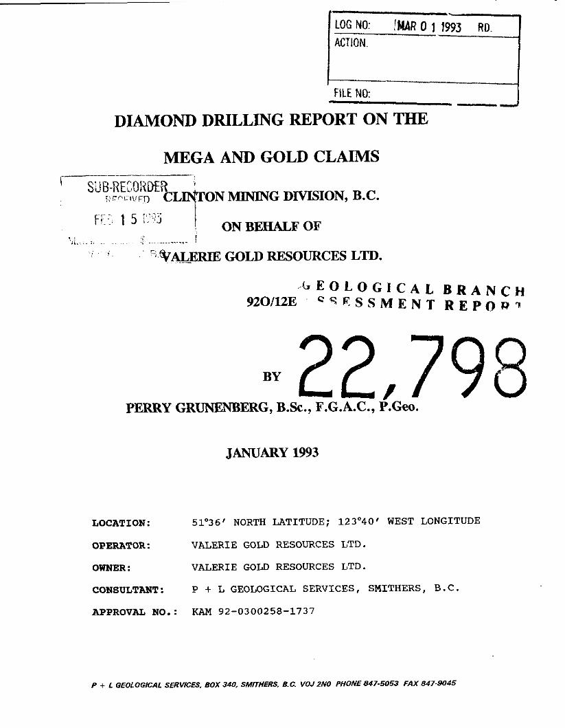
MEGA AND GOLD CLAIMS
-
, - G E O L O G I C A L B R A N C H 9201123 C q E S S M E N T R E P O P ?
. LOGNO: !MAR011993 RD. ACTION.
FILE NO: - --I
BY 2,7 PERRY GRUNENBERG, B.Sc., F.G. A.C., P.Geo.
.
JANUARY 1993
DIAMOND DRILLING REPORT ON THE
LOCATION: 51'36' NORTH LATITUDE; 1230401 WEST LONGITUDE
OPERATOR : VALERIE GOLD RESOURCES LTD.
OWNER : VALERIE GOLD RESOURCES LTD.
CONSULTANT: P + L GEOLOGICAL SERVICES, SMITHERS, B.C. APPROVAL NO.: KAM 92-0300258-1737
P + L GEOLOGICAL SERVKES, BOX 340, SMITHERS, B.C. VOJ ZNO PHONE 847-5053 FAX 847-9045

DIAMOND DRILLING REPORT ON THE MEGA AND GOLD CLAIMS
CLINTON MINING DMSION, B.C.
SUMMARY
This report summarizes diamond drilling which took place at three locations on the MEGA and GOLD claims belonging to Valerie Gold Resources Ltd. These claims lie east of the Taseko River along a known mineral bearing geologic belt, north of the Fish Lake deposit. Drilling took place in November of 1992. Drill targets were primarily derived from Induced Potential Survey results as defined by P.E. Walcott and Associates' surveys of 1991 and 1992. A total of 691.10 metres of core was extracted from three NQ size drill holes.
All three drill holes intersected recent Chilcotin Group basalts to approximately 100 metres depth. Holes 92MG01 and 92MG02 intersected weak hydrothermal alterations in upper sections of Kingsvale Group sediments.
No appreciable amounts of sulfides were intersected in any of the drill holes. The Induced Potential anomalies in this area appear to be related to graphite and clays present within the Kingsvale Group sediments.

TABLE OF CONTENTS
SUMMARY
TABLE OF CONTENTS
INTRODUCTION 1 1.1 LOCATION AND ACCESS 1 1.2 TOPOGRAPHY, CLIMATE AND PHYSIOGRAPHY 1 1.3 PROPERTY STATUS 3 1.4 HISTORY AND PREVIOUS EXPLORATION 5 1.5 DIAMOND DRILLING BY VALERIE GOLD RESOURCES LTD., 1992 6
GEOLOGY 2.1 REGIONAL GEOLOGY 2.2 PROPERTY GEOLOGY
DIAMOND DRILLING 3.1 DRILL TARGETS 3.2 RESULTS AND DISCUSSION
ENVIRONMENTAL 11
REFERENCES 13
STATEMENT OF QUALIFICATIONS 14
COST STATEMENT 15
APPENDIX 1 - CHEMEX LABS LTD. ASSAY CERTIFICATES APPENDIX 2 - DIAMOND DRILL LOGS
FIGURES AND TABLES
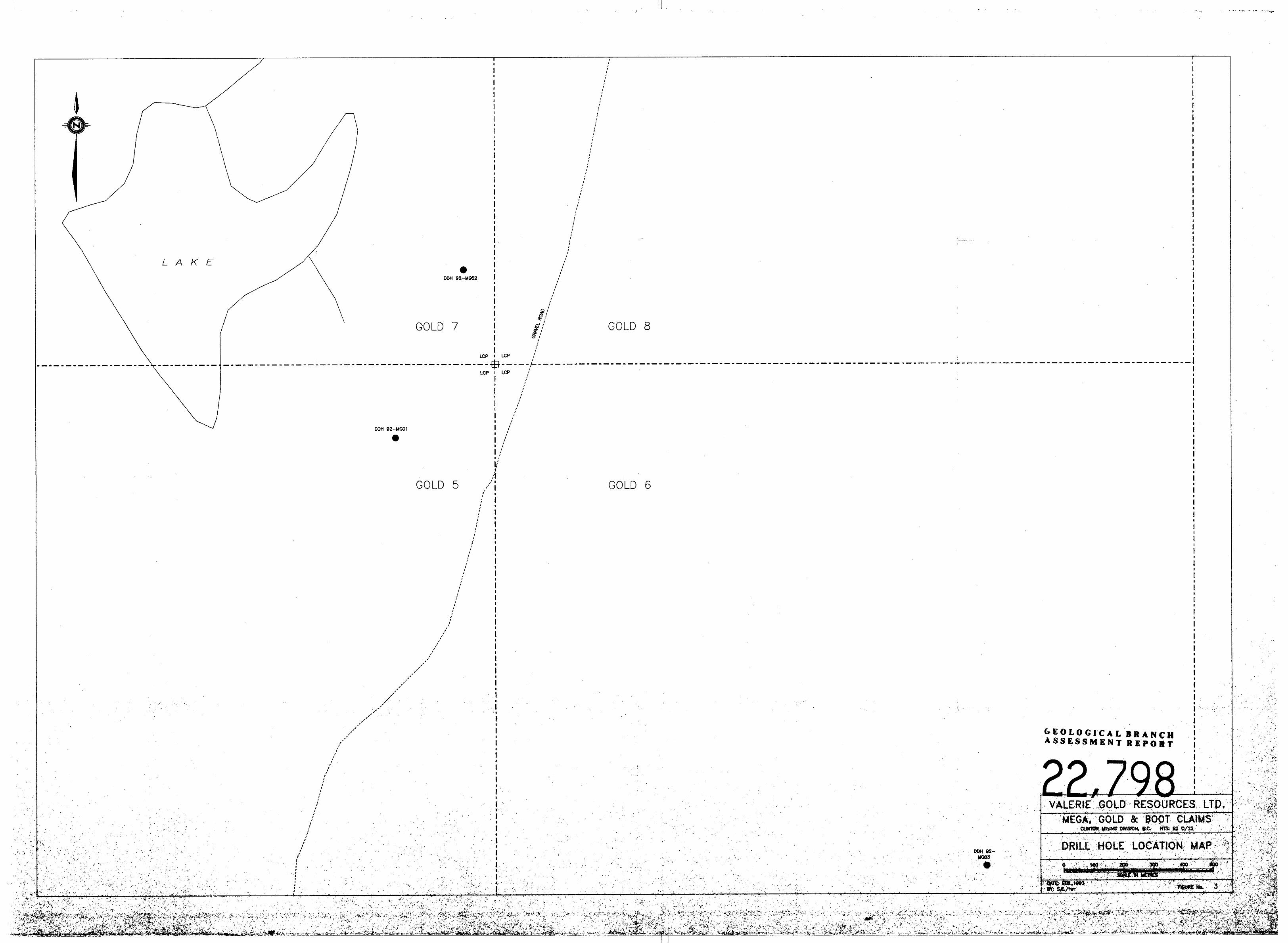
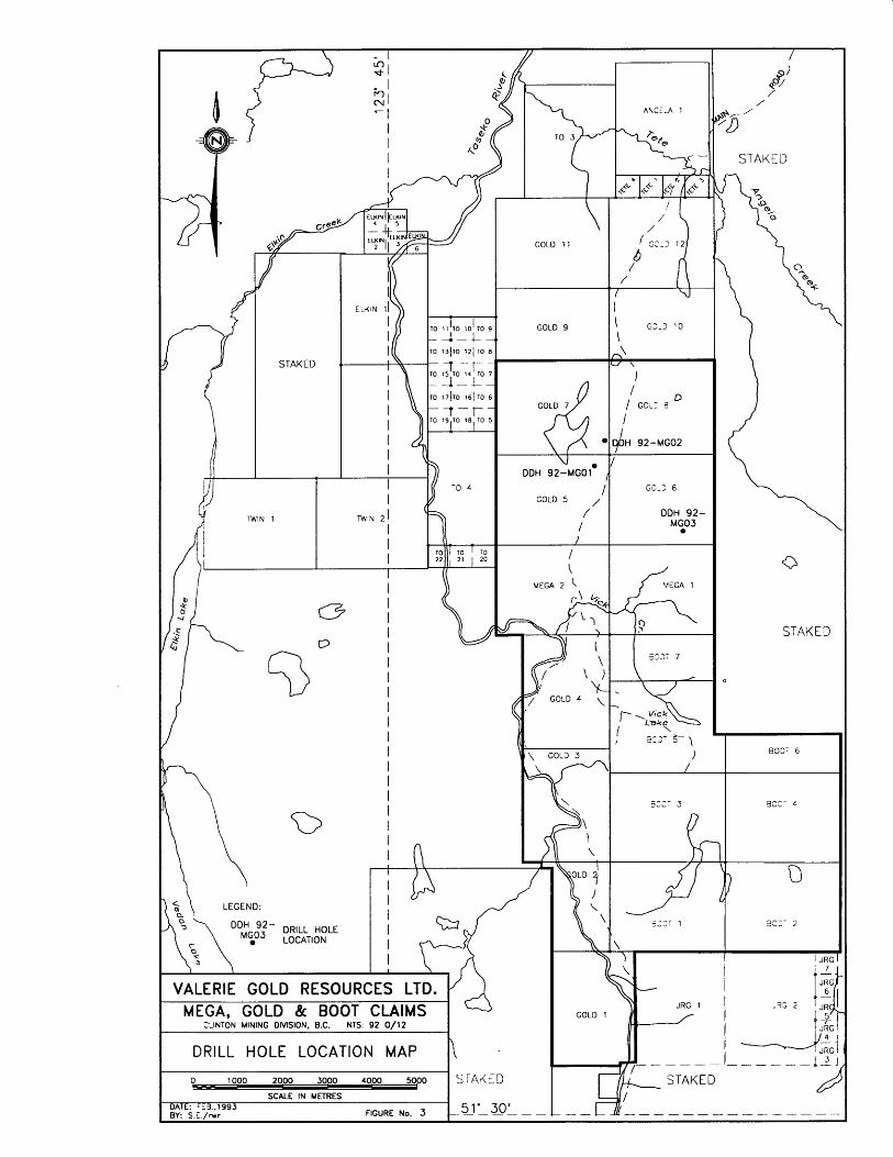
FIGURE 1 - LOCATION MAP FIGURE 2 - CLAIM MAP FIGURE 3 - DRILL HOLE LOCATIONS FIGURE 4 - WATER SAMPLE LOCATIONS
TABLE I - LIST OF CLAIMS TABLE I1 - DRILL HOLE SUMMARY
2
4
Pocket, 9
12

iii
DIAMOND DRILLING REPORT ON THE MEGA AND GOLD CLAIMS
CLINTON MINING DIVISION, B.C.
1.0 INTRODUCTION
In September 1991, Valerie Gold Resourcea Ltd. purchased ten Modified Grid Claims totalling 174 units, in the Taseko River Area of the Clinton Mining Division. These claims were staked along a geologic belt know to contain mineralization, at Fish Lake to the south, and at Scum Lake to the north. Previous work, including airborne and ground magnetics, induced potential, geochemical and geological surveying, delineated several targets for diamond drilling. This report summarizes diamond drilling which took place at three locations on the property from November 1 to November 30, 1992.
1.1 LOCATION AND ACCESS
The property is located in central British Columbia at 51'36' N, 123'40' W (NTS 920/12E), 120 kilometres southwest of the city of Williams Lake and approximately 10 kilometres east of Elkin Lake (Figure 1).
The MEGA, BOOT and GOLD claims cover an area approximately 60 square kilometres, roughly straddling the Taseko River (Figure 2). A good quality, all-weather, graded gravel road connects the property to B.C. Highway 30 at Hanceville, 65 kilometres to the north. Hanceville is approximately 95 kilometres, by paved highway, west of Williams Lake.
Access to the claims on the east side of the Taseko River is aided by a network of cattle roads, recent logging roads and seismic lines across relatively flat topography. Access to the small portion of the claims that are on the west side of the river is more difficult; however, the main road crosses the river near the south boundary of the GOLD 3 claim.
1.2 TOPOGRAPHY, CLIMATE AND PHYSIOGRAPHY
The area is in the physiographic division known as Fraser Plateau (Holland, 1965), which is an upland of low relief (approximately 500 metres). Topography is largely controlled by extensive flat-lying basalt flows which form a nearly flat plateau with a surface at approximately 1400 metres (4600 feet) above sea level. Relief on the plateau is very gentle and alkaline lakes are common. This plateau is cut by the Taseko River and by the Elkin Creek drainage to the west, both forming steep-sided valleys with 250 to 300 metres (800 to 1000 feet) reiief. Cone Hill, located on the southern boundary of the claims, is the highest feature in the area with an elevation of approximately 1770 metres (5800 feet).

VALt 5 LTD. ME' AIMS c ..-.. . ...... .- . . -- 1/12
LOCATION MAP
DATE: f03. 13.1992 at S€/m FIGURE No. I

The north flowing Taseko River and a minor 10 kilometre long tributary, Vick Creek, are the only significant drainage features on the property.
Tree cover is extensive and consists mostly of lodgepole pine, which is well spaced and movement through the forest is easy. The area has been devastated by a mountain pine beetle infestation and vast tracts of standing dead pines are visible. To control the infestation, the entire region is very rapidly being logged. Extensive areas of clear-cut logging, with the associated road network provides easy access to the entire claim block. Large areas of grassland occur around the alkali lakes and the flat drainages. These grasslands are used for cattle grazing.
The climate is this portion of interior British Columbia is generally warm and dry with a moderately long, cold winter. Frost may occur at any time; however, day time temperatures in excess of 10°C are normal from early May until mid to late October. Temperatures in excess of 30°C are common during the summer months, while winter lows below -40°C are rare. The greatest accumulation of moisture (average of 25 mm per year) occurs during the fall, winter and early spring in the form of snow. The remainder of the year is generally dry. Moisture in the form of rainfall is confined to afternoon showers during the warm months.
Most of the area was covered by the Wisconsin ice-sheet which flowed northeastwardly toward the Fraser Depression. It was this ice-sheet that was responsible for the present shape of the plateau, mountains and valleys. During the height of this last glacial advance, it is likely that most of the claim was covered by ice. As the ice retreated, a thin mantle, varying from 2 to 20 metres of generally unsorted sand and gravels with little clay, covered the property. The glacial till covering the area has been little altered to soil, and in general the 'B' soil horizon is poorly developed. Glacial erratics, resting on the surface, up to several metres in diameter, are common.
1.3 PROPERTY STATUS
The property is composed of 18 Modified Grid Claims consisting of 326 units (Figure 2). All claims were staked in 1991. The claims, record numbers, size and anniversary dates are listed in Table I.

STAKED
O M S
STAKED

1.4 HISTORY AND PREVIOUS PRODUCTION
The earliest record of exploration in the area dates to the early 1930's when prospectors followed float to exposures of narrow pyrite, chalcopyrite and gold-bearing zones associated with diorite or feldspar porphyry dykes a few kilometres south of the claims. The porphyry copper potential of the area was recognized int eh 1960's. Since that time, most exploration activities have been concentrated on the Fish Lake deposit, 10 kilometres to the south, and to a much lesser extent, on the Scum Lake deposit 15 kilometres to the north. The Fish Lake deposit is now in an advanced stage of definition drilling. This deposit may prove to be the largest tonnage copper porphyry system in Canada, with reserves estimated in December of 1992 of 1.265 billion tons grading 0.22% copper and 0.012 ounces gold per ton.

In 1984, the area now covered by the Mega, Boot, and Gold claims was staked by Brinco Mining Ltd. In late 1984, Brinco contracted an aeromagnetic and VLF electromagnetic survey, resulting in 1162 line kilometres of data collection over their claims. At the same time, they contracted a geological and geochemical survey on selected portions of the property. In 1985, Brinco did additional geochemical sampling, ground magnetometer and VLF-EM surveys to complement and aid in geological and structural interpretations. This work was followed by percussion drilling of the highest priority targets. Four downhole hammer percussion drill holes were completed for a total of 492 metres of drilling.
The property was eventually allowed to lapse and the ground remained open until 1991. The area was restaked in 1991 by a number of individuals and private companies, following an announcement by Taseko Mines Ltd. of its plan to complete a major drill program over the nearby Fish Lake deposit.
In 1991, Valerie Gold Resources Ltd. purchased, optioned, and staked the 18 modified grid claims that comprise the present property. From August to December of 1991 Valerie carried out the following work over the property.
1) Prospecting and reconnaissance mapping was carried out over the entire property.
2) A reconnaissance ground magnetometer survey was carried out over the Mega 1 and 2 claims.
3) Reconnaissance soil sampling was carried out over the Mega 1 and 2 claims.
4) A reconnaissance induced polarization survey was carried out along existing roads and cut lines on the property.
1.5 DIAMOND DRILLING BY VALERIE GOLD RESOURCES LTD. IN 1992
In 1992, Valerie Gold Resources Ltd. contracted P.E. Walcott and Associates to carry out induced potential geophysical surveying over a large portion of the claim group, and several chargeability anomalies were discovered.
A1 Harvey of Core Enterprises, Clinton B.C., was contracted to diamond drill 3 of these chargeability anomalies. A total of 691.10 metres of drilling was completed and geologically logged on the property, and a total of 48 drill core samples, averaging 1.2 metres of section, were shipped to Chemex Labs Ltd. for assay. Drilling took place from November 1 to November 30, 1992.
In an effort to collect early background environmental data, 8 water samples were taken along Taseko River and some of its tributaries, as well as from a small unnamed lake on the property.
2 . 0 GEOLOGY
2 . 1 REGIONAL GEOLOGY
The Taseko River area is located near the northeastern erosional edge of rocks forming part of the Tyaughton Trough (Jeletsky and Tipper, 1968) and lies at the east end of a belt of east trending folds, faults and feldspar porphyry dykes (Tipper, 1963). The Tyaughton Trough, a mid-Jurassic to late Cretaceous successor basin, contains both marine and non-marine sedimentary and volcanic rocks. The last major marine transgression occurred in early Cretaceous time. During the remainder of the Cretaceous, continental sedimentation and volcanism were dominant, accompanied by transcurrent movement on the northwest trending Yalakom Fault. Structures related to the Yalakom Fault may have provided controls important in the localization of mineral deposits in the region.
The regional geology of the Taseko River area was compiled by Tipper in 1978. An older basement of Middle Jurassic granodiorite occurs in scattered outcrops throughout the region. Overlaying folded sedimentary and volcanic strata were assigned to the Upper Cretaceous Kingsvale Group. Units within this group were intruded in various places by Eocene felsic igneous rocks. The area was later capped by Miocene to Holocene basalts (Matthews and Rouse, 1984), and subsequently further covered by variable thicknesses of glacial till and river gravels.
Tipper (1978) mapped a series of arcuate, normal faults trending NNW along the Taseko River. He considered these faults to be relatively recent (i.e. post Eocene), and later than the main transcurrent movement on the Yalakom Fault system. These faults are evident along the western portion of the present claim block.
2 . 2 PROPERTY GEOLOGY
Exposures of bedrock on the property is minimal. Rock types in the area can be broadly classified, irrespective of age, into basalt flows, andesitic pyroclastics, andesitic flows, andesitic breccias, quartz diorites, sandstones, greywackes, and siltstones. Hydrothermally altered equivalents of the above types are observed locally.
The youngest rocks in the area are a really extensive, flat laying crystalline, highly vesicular Miocene basalt flows of the Chilcotin Group, which created tableland plateau topography. In Vick Creek valley, which divides the Mega claims into north and south halves, a sequence of Kingsvale volcanics and minor sediments is exposed in the dissected valley. Near the southern border of the Boot claims a contact between sediments, to the north, and a quartz diorite intrusive, to the south was observed. The intrusive shows weak propylitic alteration, with secondary chlorite, silicification, and minor pyrite. The sediment-intrusive contact is marked by a narrow band of hornfels.

Prospecting to the north of the property, along claim lines of the Angela 1 claim, shows flat laying crystalline, highly vesicular Miocene basalt flows cover the northeast half of the claim, while Kingsvale sediments underlay the southwest half of the claim. Deep exposures of Kingsvale sediments are also present along Tete Angela creek and along Taseko River in the southwest corner of the Mega 2 claim, where 30 metre tall bluffs show a succession of poorly sorted siltstone to conglomerates with a predominance of sandy greywackes.
Several outcrop exposures along the Taseko River directly northwest of the claim block show a stockwork of carbonate stringers within Kingsvale Group rocks, apparently the result of wehk, localized hydrothermal alterations in the area.
3.0 DIAMOND DRILLING
3.1 DIAMOND DRILLING TARGETS
The targets for drilling on the Mega and Gold claims were primarily derived from Induced Potential surveys carried out by P.E. Walcott and Associates during 1991 and 1992. Currently a report summarizing this geophysical work is unavailable, however, the data is compiled on both profiles and colour contour maps from which drill hole targets were calculated.
The I.P. data covers an area of roughly 11.5 square kilometres, with 200 and 400 metre line spacing and station spacing of 75 metres. The grid is located 2 to 3 kilometres east of Taseko R5ver, directly north of Vick Creek, and 4 to 5 kilometres south of Tete Angela Creek. In general, the results of the I.P. survey outline a central anomalous chargeability zone of approximately 800 metres diameter present at depths greater than 75 to 150 metres (n=2), centred at Line 200W and station 1+50 north. Several smaller chargeability anomalies exist to the east and west of this main anomaly. Chargeability values greater than 10 are considered highly anomalous against background values of 3 to 6 milliseconds on the grid. At shallower depths (less than n=l) , the I.P. results show that less chargeable, highly resistive ttcap8t material covers the anomalous zone of higher chargeabilities.
Individual descriptions of each drill target is given below.
DDH 92 MGOl - This hole was positioned on line 400W at 1+25S, drilled at -75 degrees to the north (360'). This hole was designed to test the core of higher chargeability values.
DDH 92 MOO2 - This hole was positioned on line 200W at 5+50N, drilled at -46 degrees to the south (180'). This hole was designed to test a slightly weaker area on the northern boundary of the anomalous chargeability values.
3
T
83:- 6
---- Z.," 3 93:- 4
0
aoc- 2
I JRG 1
MEGA, GOLD & BOOT CLAIMS d ? S 2
:,INTON MINING DIVISION, B.C. NTS 92 0/12 A$, 'q DRILL HOLE LOCATION MAP I JRG - - - - - 1 2 1
SCALE IN METRES DATE 'E3.1993 BY: S C /wr
GOLD 1 1
1 I . / GCLZ 3
I qbH 92-MG02
DDH 92yMG01e / GG-3 6
DDH 92- M y 3
STAKED
STAKED
0
DDH 92 MG03 - This hole was positioned on line 1200E at 16+25S, drilled at -55 degrees to the south (180'). This hole was designed to test one of the lesser, small chargeability anomalies to the southeast of the main anomaly. Also, previous soil sampling (Gonzalez 1991) identified an extensive mercury soil anomaly in this area, with contoured values over 1000 ppb. This soil anomaly is centred over a magnetic low, and carries coincident anomalous arsenic values. The weak chargeability anomaly on line 1200E is located on the northern edge of the soil geochemical anomaly.
Chargeability anomalies defined by the geophysical data are normally related to weak disseminations of sulfides in bedrock. The objective of drilling these targets was to determine wether disseminated sulfides exist in this area, and if so, wether they are related to a hydrothermal system which may be ore bearing.
3.2 RESULTS AND DISCUSSION
Drill hole locations, orientations, and lengths are shown on Table 11. Drill hole collar locations are also shown on figure #3. Complete drill logs with sample intervals, and Chemex Labs Ltd. assay sheets for these samples are provided in the appendix.
TABLE I1
All three of the drill holes encountered Chilcotin Group basalts to approximately 100 metres. This suggests that the base of this recent capping of lavas occurs at an average elevation of roughly 1350 metres. Underlying the basalt the drill holes encountered a succession of Kingsvale Group sedimentary rocks. These are dominated by sandytextured, poorly sorted greywackes and mixtures of siltstones, mudstones, and conglomerates. Finer sediments often contain a large amount of clays and a minor amount of graphite. Contacts are ill-defined and gradational, with very little recognizable cross-bedding. Thepoor sorting, combined with a large percentage of somewhat angular fragments in conglomerates, is suggestive of a lahar depositional setting.
DRILL HOLE #
DDH 92MG01
DDH 92MG02
DDH 92MG03
DIP
-75
-46
-55
COLLAR LOCATION
L4OOW;1+25S
L200W;5+50N
L1200E;16+25S
AZIMUTH
360
180
180
Holes 01 and 02 display weak hydrothermal alterations at the upper sections of each hole, evidenced by the destruction of calcium and iron cementing in the sediments, which have been mobilized and deposited along narrow stringers of calcium carbonate and hematite deeper into the sedimentary stratigraphy. Hole 03 displayed no alterations or mineralization of note.
None of the drill holes contained recognizable sulfides which could be related to the I.P. chargeability anomalies as targeted. The presence of conductive/chargeable graphite and chargeable clays in the sediments, and the presence of minor hematite in fractures, is likely the source of the geophysical anomalies.
4 . 0 ENVIRONMENTAL
In an effort to begin collecting background environmental data, 8 water samples were obtained from Taseko River, several tributaries to Taseko River, and one small lake to the north of the claims. Water sample sites are shown on figure #4. Two water samples were collected at each sample site, one "preserved" sample in which the sample container had a premeasured amount of zinc acetate, and a second l1unpreserved8l sample.
Samples were shipped to Chemex Labs Ltd. in North Vancouver for analysis. Copies of the certificate of analysis are given in the appendix. All of the stream and river samples contained normal background values for this area. Sample number 8, taken from the small lake in the northwest corner of the claim block shows that this is an alkaline lake with a pH of 9.5, with relatively high metals content shown by the zinc value of 2200 ppb.

GOLD 1 1
GOLD 9
GOLD 7 4 GOLD 5 /
/
/ /
' 0 / GOLD 8
GOLS 6
1 \
MEGA 2 VECA 1 6 STAKED
0

5 . 0 REFERENCES
BUTTERWORTH, B.P., EPP, W.R., 1985; Geology, Geochemistry, Geophysics and Percussion Drilling of the Taseko claims, Southwestern British Columbia: Unpubl. Assessment Report, B.C. Dept. of Mines and Petroleum Resources File No. 14,159.
DICKIE, G.J., 1984; Tas Project, Report on 1984 Exploration in the Taseko River Area, Southwestern British Columbia: Unpubl. Report Prepared by Minequest Exploration Associates Ltd. for Brinco Mining Ltd, Ref. RM1301.
GONZALEZ, R.A., 1992; Geochemical Report on the Mega, Boot, Angela and Gold Claims: Ministry of Energy, Mines and Petroleum Resources Assessment Report.
HOLLAND, S.S., 1964; Landforms of British Columbia - A Physiographic Outline: B.C. Dept. of Mines and Petroleum Resources, Bulletin 48, p. 69.
JELETSKY, J.A. and TIPPER, H.W., 1968; Upper Jurassic and Cretaceous Rocks of Taseko Lakes Map Area and Their Bearing on the Geologic History of Southwestern British Columbia: Geological Survey of Canada, Paper 67-54.
MATTHEWS, W.H., AND ROUSE. G.E., 1984; The Gang Ranch - Big Bar Area, South-central British Columbia, Stratigraphy, Geochronology and Palynology of the Tertiary Beds and their Relationship to the Fraser Fault: Canadian Journal of Earth Sciences, Vol. 21, p. 1132-1144.
TIPPER, H.W., 1963; Geology, Taseko Lakes, British Columbia: Geological Survey of Canada, Map 29-1963.
TIPPER, H.W., 1968; Mesozoic and Cenozoic Geology of the Northeast Part of Mount Waddington Map Area (92N), Coast District, British Columbia: Geological Survey of Canada, Paper 68-33.
TIPPER, H.W., 1978; Taseko Lakes (920) Map Area, British Columbia: Geological Survey of Canada, Open File 534.
WOLFHARD, M.W., 1976; Fish Lake: in Porphyry Deposits of the Canadian Cordillera, CIM Special Volume No. 15, A. Sutherland-Brown (Editor), p. 317-322.
WOOLHAM, R.W., 1984; Report on the Helicopter-Borne Magnetic and VLF Electromagnetic Surveys, Taseko Project: Unpubl. Report prepared by Derry, Michener, Booth and Wahl Ltd. for Brinco Mining Limited, Ref. 84-57.
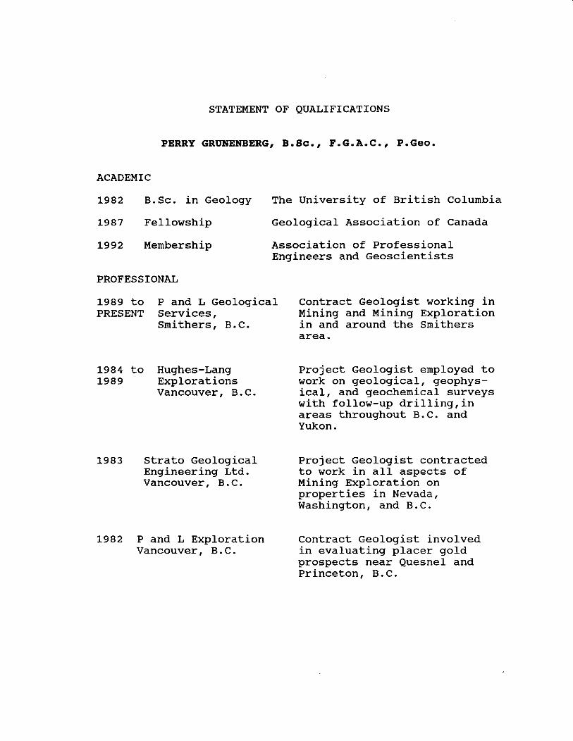
STATEMENT OF QUALIFICATIONS
PERRY GRUNENBERG, B.SC., F.G.A.C., P.Ge0.
ACADEMIC
1982 B.Sc. in Geology The University of British Columbia
1987 Fellowship Geological Association of Canada
1992 Membership Association of Professional Engineers and Geoscientists
PROFESSIONAL
1989 to P and L Geological PRESENT Services,
Smithers, B.C.
1984 to Hughes-Lang 1989 Explorations
Vancouver, B.C.
3 Strato Geological Engineering Ltd. Vancouver, B . C .
1982 P and L Exploration Vancouver, B . C .
Contract Geologist working in Mining and Mining Exploration in and around the Smithers area.
Project Geologist employed to work on geological, geophys- ical, and geochemical surveys with follow-up drilling,in areas throughout B.C. and Yukon.
Project Geologist contracted to work in all aspects of Mining Exploration on properties in Nevada, Washington, and B.C.
Contract Geologist involved in evaluating placer gold prospects near Quesnel and Princeton, B.C.

COST STATEMENT 28 July - 17 December 1993
GENERAL COST
FOOD & ACCOMMODATION: 75.5 mdays @ $36.16 FIELD TELEPHONE SERVICE: FIXED WING: Air BC, Van-Wml 1 SHIPMENTS: FUEL: SUPPLIES & SUNDRIES: RENTALS : P.G. TRUCK, 44.5 days @ $40 $ 1,780.00 SWEENEY TRAILER 2 ~ O S @ $500 1,000.00 TRAILER DELIVERY 150.00 P.G. EQUIPMENT, 55 days @ $10 550.00
CONSULTANT FEES: Archean Engineering REPORT PREPARATION: TOTAL GENERAL COST:
GEOCHEMICAL SURVEY COST
SALARIES & WAGES: 2 pers. 6 mdays @ $280.88 ASSAYS & ANALYSES: - CHEMEX LABS 121 Soil for Au & 32el ICP @ $15.46 $ 1,870.84 1 Rock for Au,Ag & 32el ICP 18.40
GENERAL COST APPORTIONED (6/75.5 X $18,922.83): TOTAL GEOCHEMICAL SURVEY COST:
DIAMOND DRILLING COST
SALARIES & WAGES: 3 pers. 69.5 mdays @ $186.29 ASSAYS & ANALYSES: - CHEMEX LABS 38 Core for Au & 32el ICP @ $19.63 $ 746.11 9 H20 for 24el ICP @ $76.08 684.73
CORE ENTERPRISES LTD: 690.98m @ $72.48 GENERAL COST APPORTIONED (69.5/75.5 X $18,922.88): TOTAL DIAMOND DRILLING COST:
GEOPHYSICAL SURVEY
P.E. WALCOTT & ASSOCIATES:

APPENDIX 1
ASSAY CERTIFICATES

To: VALERIEGOLD RESOURCES LTD. Page Number :<-A h O a Chemex Labs Ltd. 1000 - 1177 W. HASTINGS ST. Tot ' ce, 'gas le Date: :I OBDEC-92 \ N Ana!yllcal Chsmlsls ' GeocbmiMs ReglmBd Agsayers VANCOUVER. BC I n m ~ d No. : I9225534 o 212 Brmksbank Ave., North Vancouver V6E 2K3 P.O. Number : 0 Brllish ColumMa, Canada V7J 2C1
Acwunl : IZU @ PHONE: 504-984-0221 Prolect : MEGA-GOLD Comments: CC: ART TROUP
q2 M G o ( CERTIFICATE OF ANALYSIS A9225534
PREP Auppb Ag .O A6 Ma Be i Ca Cd Co Cr Cu Pe (la Bg K L l K g N n CODE r A M P W % P P P W PFA % P P D P E W % P W % PW % PPm
CERTIFICATION: &"*+

f- Chemex Labs Ltd. To: VALERIE GOLD RESOURCES LTD. 0 0 '. 1000 - 1177 W. HASTINGS ST. 0 AMIyiiml Wpmkis. ' G&amlsls ' Re~lstered Assaysrs VANCOUVER. BC o 212 Bmoksbank Ava.. Nalth Vancouver V6E 2K3 0
w British Columbia. Canada V7J 2C1 PHONE: 604-S844Z21
Pmjecl : MEGA-GOLD Cammenls: CC: ART TROUP
Page Number :I-0 Tot-' "ages :1 Cr .te Dale: 02.DEGS2 Inv~..- No. : 19225534 P.O. Number : Account : IZU
q a N'~L?O C CERTIFICATE OF ANALYSIS A9225534 I
CERTIFICATION: --PbjA

Chemex Labs Ltd. To: VALERIE GOLD RESOURCES LTD.
1000 - 1177 W, HASTINGS ST. Analptkal Chen*rls'Goa.hemlsVI ' Rsgistorell Asseyers VANCOUVER. BC 212 Bmaksbnnk Avs., North Vnnccuver VGE 2K3 Britlsh Columbia. Canada V7J 2C1 PHONE: 804.984.0221 Project : QA GOLD
cornman?:$: ART TRouP .- CERTIFICATE OF ANALYSIS A9224953
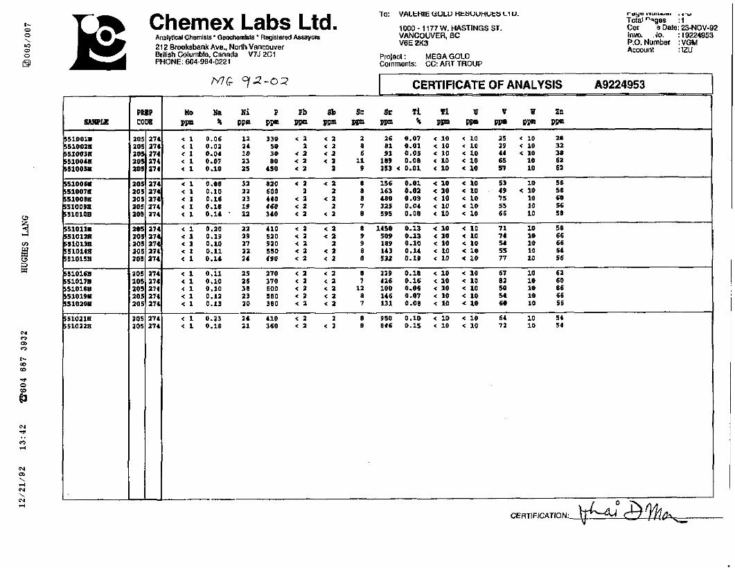
Chemex Labs Ltd. lo: V A L t H I UULV HkSUunCitsLlV
1000 - 1177 W. HASTINGS ST. A n a l m l Chsmists ' G ~ f f i ~ 6 I S ' R@terBd A ~ 6 a y ~ m VANCOUVER, BC 21 2 Brooksbank Awe.. NorlhVancouver VBE2K3 B~ilish Golurnble. Cannda V7J X I PHONE. 604.984-0221
Pmjecl: MEGAGOLD Co~nmnls: CC: ART TROUP
' m y , " U ' L ' Y ~ ' . .-V
Totat "-gas : I Car e Date: %NOV-92 Inw. .do. : 19224953 P.O. Number : VGM Acwunt : 1ZU
MCr 72-07 CERTIFiCATE OF ANALYSIS A9224953 I
I I 105 a74 1 0.08 32 aao e I 8 a 1 156 0.01 < 10 4 10 53 10 $6 mr 271 0 . l n 2 1 son 1 2 a 163 0.02 10 < 10 49 ( 10 56
CERTIFICATION:

To: VALERIE GOLD RESOURCES LTD. Page Number :LA & Chemex Labs Ltd. lODO.1177 W. HASTINGS ST. TO^-, c
Pages ate Datrl: :I 16-OEC-92 AnsIyiical Chemirls ' Geodremlsls ' Regislored Asrayen VANCOUVER, BC In, t No. : 19226046 212 Brooksbank Am.. North Vancwver V6E 2K3 P.O.Number : British Columbia, Canada V7J ZC1 Account : IZU PHONE: 604-984-0221
Projecl : MEGA GOLD Comments: CC: A.TROUP /
q.2 M G o 3 -~
CERTIFICATE OF ANALYSIS A9226046 I

Chemex Labs Ltd. AMlflical Chemists ' GeocherniN ' Rqlslered Assayers 212 Bmoksbank Ave.. NorthVancouver British Columbia, Canado V7J 2C1 PHONE 604-984-0221
To: VALERIE GOLD RESOURCES LTD.
1000 - 1177 W. HASTINGS ST. VANCOUVER. BC V6E 2K3
Plolecl MEGA GOLD Comments: CC: A.TROUP
1 CERTIFICATE OF ANALYSIS
Paqa Number : 1-B Tar :I Ce. %ate: 16-DEW32 lnmce No. : 19226046 P.O. Number : Accwnl : IZU
CERTIFICATION: hL+"*wez

To: VALERIE GOLD RESOURCES LID.
Chemex Labs Ltd. looO - 1177 W. HASTINGS ST. Anowicnl ChemlsU ' Geochomlsls RnglsIemd Assayers VANCOUVER. BC
21 2 Brooksbank Avn.. NorUl VarlmNnr V6E 2K3
Brtlish Culumbia, Canada V7J X I PHONE: 604-984-0221
CERTIFICATE A9225739
VALERIE GOLD RESOURCES LTD
Project MEGA G O D P.O. # : NONE
S-lea mibaittad to ( m ~ 1 6 in Vancouver, Bf. %is report was print06 on 9-DBC-92.
SAMPLE PREPARATION
HEMEX MUM XOE AMF b
water mlwla
Comments: ATTN: A.G. TROUP CC: S. EDWARDS
-
IEME ODE -
63 66
B B 7 a 7 8 7 7 7 8 7 B 7 7 6 B 7 6 6 8 B 7 6 6
--
- 1MBI MPL
1 1 1 1 1 1 I 1 1 1 1 1 1 1 1 1 1 1 1 1 1 1 1 1 1 1
ANALYTICAL PROCEDURES
DESCRIPTION
I tlf ida mgll 8 ugllt Water sa?~l.8
1 =/I: Watar s-las L uGll i water mGlas
DETECTION METHOD LIMIT
-- UPPER LIMR
14.0 10000 10000 a000 10000 10000 10000 a000 10000 10000 10000 10000 2000 a000 2000 10000 10000 a000 10000 10000 100d0 10000 2000 10d00 10000 10000

To: VALERIE GOLD RESOURCES LTD. Page Number :1 Tobl Pages : 1
1000 - <I77 W. HASTINGS ST. CertiAca' 'ste:O9-DEC-92 VANMWER. BC Inmice : 19225739 V6E 2K3 P.O. NUhl.dr :NONE
Accounl : IZU Project : MEGA GOLD Commenls: ATTN: A.G. TROUP CC: S. EDWARDS -
CERTIFICATE OF ANALYSIS A9225739
ff' ff' I sample preparation code s m l e preparation code

Chemex Labs Ltd. nmlylic~I Chmlsls' Gsochensts' Reg(6lersd Assayen 212 Bmoksbank Ave., NorlhVaffiouver
I Brit~shColumbie. Canada V7J 2C1 PHONE: 604-904-0221
To: VALERIE GOLD RESOURCES CTO.
'000 - It77 W. HASTLNGS ST. ANUKIVER. BC
116E 2K3
Prolect : MEGA GOLD Comments: ATTN: A.G. TROUP CC: S. EDWARDS
I CERTIFICATE OF ANALYSIS A9225739
PARANETER DESCRIPTIONS
sample preparation code Sample preparation code

To: HUGHES LANG EXPLORAV"t9 I TO
Chemex Labs Ltd. 1000 - 1177 W. HASTINGS ST. A o ~ i c a l chemists - Qaohendsa' Regklered Awayers VANCOUVER. BC 212 hoksba rn AV*. NO* Vancower V6E 2K3 BriUSh Colurnbla. Canada V7J 2C1 PHONE: 604-984-0221 Comments: ATTN: PERRY GRUNENBERO CC: A. TROUP
-- I CERTIFICATE A9224274 ANALYTICAL PROCEDURES
HUGHES LANG MPLORATTONS LTD.
Project: MEGA-GOLD P.O. ti: NONE
Basplea s u k d t t c d to our leb in Vanaauver, eC. ~ h i 8 report was ~rinted on 14-W-9a.
SAMPLE PREPARATION
-
HEME mDE - -
65 '56
a 8 7 a 7 B 7 7 7 a 7 a 7 7 6 a 7 6 6 8 8 7 6 6
a u l f ide m g / l 8 g ugllx Water aaBu?les 1 mull i Water smwlos
P O F E N T I ~ K R TITRhTIOX I C P - M S Z C P - a m ICP-Am I C P - A s s I C P - M 8 I C P - A m ICP-AX8 ICP-hxs 1CP-A66 I C P - M S 1 C P - M 8 ICP-AES 1 C P - m I C P - r n I C P - M a ICP-AES I C P - m s I C P - m 1CP-ASS I C P - M S I C P - M S I C P - M S IQ-MS 1CP-AES
DETECTION LIMIT UPPER LIMIT ~-
1 4 . 0 10000 10000
a000 10000 iaooo 10000 10M)
10000 10000 10000 1d0d0
2000 1000 aooo
10000 10000
aooo 10000 10000 10000 10000
2000 10000 10000 10000
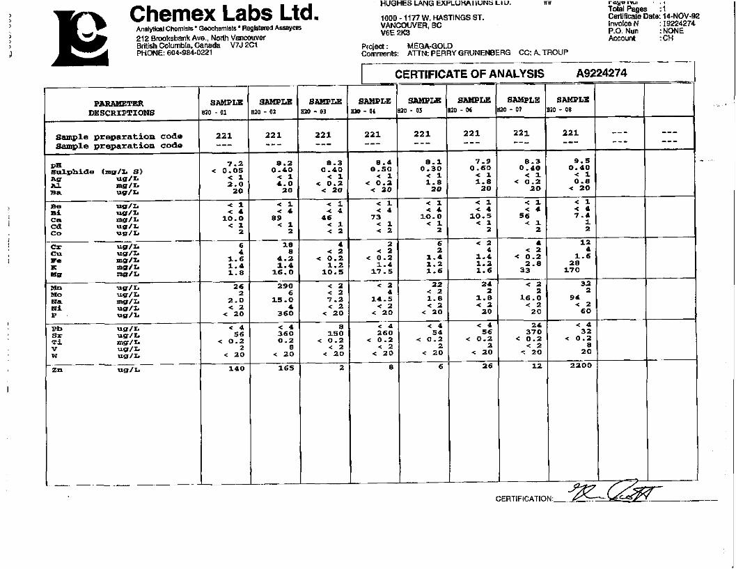
Chemex Labs Ltd. A n a l ~ l Chemlsls. GPocharnlsta Regi~lsred kisayers 212 ~moksbank Ave.. Norlh Vanaruver Briiish Colurnb[a.Canada V7J 2C1 PHONE' 604-984-0221
HUOHES LANG EXPLUmI LUNb LI U. m r q w nut . , Told Pages :I
10QD - 1177 W. HASTINGS ST. Ceriificale Date: 14-NOV-92 VANCOUVER, BC Inmke N : I9224274 V6E 2K3 P.O. Nun :NONE
Account : CH Projoject : MEGA-GOLD Cornmenls: ATTN: PERRY GRUNENBERG CC: A TROUP
I CERTIFICATE OF ANALYSIS
SAMPLE 0 - D l
221 ---
SAMPLE lo - 04
P-TER DESCRIPTIONS
sample preparation code 8-10 preparation Code
CERTLFICATION: %

APPENDIX 2
DIAMOND DRILL LOGS

1 ' ~ H ~ O S I a I .P . chargeabi I i t y zone, magnetometer < OSII ' I I 1 I I) I tiovenlber 19, 1992
ROC h
DIS( ~ l l ' l I O N
OVERBURDEN - C A S I N G
Apparently sand textured
mater ia ls .
BASALT
Dark grey t o black, f i n e - t o
medium-grained, equigranular ,
h igh ly ves icu la r i n places, w i t h
zeal i t e i n f i l l s c o m n
( p h i l l i p s i t e ) and soda1 i t e
(b lue) .
V I I N 1 1 TS
m tncruls In decrcawng rbunddncc 1 htchncss
mm
Sccl
rrom m
0
2 1 .34
A l l 1 HAT I O N
M I N I K A I I L A I I O N ctc Angle
to core
aon
to m
2 1 - 3 4
70.73
lrctcrs
from rn
ROD = 0 t o 50
Recovery = SO t o 1009
a t
70.73
A I
to rn
70.73
75.5
Red co loura t ion over 1 t o 2 m
segments appear t o represent
successive d e p o s i t o r i a l episodes.
Contact broken i r r e q u l a r
WACKE - MUDSTONE
Grey, f i n e grained m a t r i x , i n
places w i t h rounded pebbles o r
angular fragments t o 1 cm
RQD = 20
Recovery = 90%
Magnetic b lotches t o 3 m
diameter. 5% o f rock i n places.

Sccc Ion n o t k
111 S< Hlt' l lo\
diameter.
B e d d i n g ~ i s i b l e a t 8 5 ~ t o C . A .
Contact d i s t i n c t i v e a t 15JtoC.A.
from m
70.73
( c o r t )
a t
l o m
75.5
75.5
75.5
a t
RQD = 1 5 t o 50
Recovery = 708
RQD - 10
Recovery = 100%
RQD - 5 t o 30
Recovery - 75%; down t o 40%
near end o f sect ion
Samples 98.4 - 99.7 X551023
102.6 - 104.0 #551024
108.0 - 109.5 f551025
114.0 - 115.3 #551026
118.5 - 120.0 X55lO27
from m
~ 1 . 1 t R A T I O N
MI h l R A L I I A l l O h clc
I
Intcc\aI
to m
84.8 BASALT
Vesicular minor amygdaloids,
Th~cLt~css mm
GREYWACKE
Muddy mat r i x , grey-green, w i t h
sandy grained t e x t u r e throughout
Minor pebbles t o 2 o r 3 mn
diameter.
Gradational con tac ts
HUDSTONE
Black (graphi t i c? ) t o green and
brown, poor ly consolidated, i n
places pebbly, w i t h poor ly
d is t ingu ishab le I t o 5 m
rounded pebbles (wacke) .
Poor ly sorted, near1 y grading
34.8
f7.4
85.8
187.4
147.1
Anglc lo corc
s l i g h t red co lour near bottom.
Minor glassy inc lus ions .
CONTACT
Apparent 90° t o C.A.
V t I N C 1 TS
m~ncrrlr tn dccrcartng abundance
Scc ton R O C K
Inlcr%al
Ill St R IP1 l t ) b
147.1
r -
Bedding 2S0 t o C.A. Broken
semi-gradational contact t o
next u n i t .
161.6
7 7
- - -
AI.1 I RAT ION. V t l N L 1 . T S
M I hl R A L I J A ~ l0h clc. mtncral, rn dcctcrstns abundance
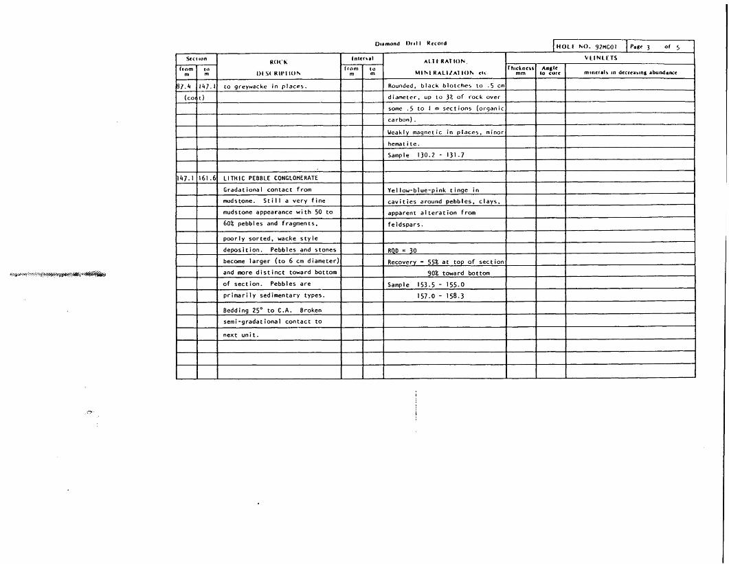
LlTHlC PEBBLE CONGLOMERATE
Gradational contact from
mudstone. S t i l l a very f i n e
mudstone appearance w i t h 50 t o
60% pebbles and fragments.
poor ly sorted, wacke s t y l e
deposi t ion. Pebbles and stones
become la rger ( t o 6 cm diameter)
and more d i s t i n c t toward bottom - -
o f section. Pebbles are
p r i m a r i l y sedimentary types.
Rounded, b lack b lotches t o .5 cm
diameter. up t o 3% of rock over
some - 5 t o I m sect ions (organic
carbon) .
Weakly magnetic i n places, minor
I
hematite.
Sample 130.2 - 131.7
I I
RQD = 30
Recovery = 55% a t top o f sect ion
90% toward bottom
Sample 153.5 - 155.0
157.0 - 158.3
I
Yellow-blue-pink t i n g e i n
c a v i t i e s around pebbles, clays,
apparent a l t e r a t i o n from
feldspars.
I 1

Grey coloured, poor ly sorted,
weakly bedded IS0 t o C.A.
Broken contact , anqle unknown --
t o next sect ion.
I
165.8 177.5 HUDSTONE/WACKE
dark grey, f i n e r grained, t o 9
Grada t ional contact .
I I
177.5 181. C WACKE - CONGLOMERATE
Grey, poor ly sor ted, pebbly
texture, 0.3 t o 1 cm pebbles.
Broken contact , apparent ly
sharp, angle unknown.
181.0 187.8 WACKE - MUDSTONE
Predominently grey, mud t o
sandy grained, equigranular w i t h
lesser segments s l i g h t l y coarser
grained.
,mom4 O r t l l Uccord HOLE NO. 92UGOI
RQD = 5 I t o 2 5 t o 45 L o w % s t r i n q e r s , carbonateand ,
Recovery = 95% c lays .
Sample 164.0 - 165.5 Stockwork appearance.
1
Weakly magnetic i n places 1 t o 3 asstd. Low & s t r i n g e r s , c lay , carbonate.,
RQD = 6 t o 25 minor t a l c ?
Recovery = 95%
Samples 168.7 - 170.0
173.0 - 174.5
I
Weak1 y magnetic Very minor wh i te s t r i n q e r s
ROD = 15 (carbonate. some c lays)
Recovery = 95%
Samples 182.9 - 184.4
RQD = 6
Recovery = 95% I
I
1 t o 8 0 t o 90 Carbonate, c lay . minor t a l c

I)tamond t )r t l l Kccord i t i 0 1 t hO. 92MGOl t
Scc t ron RO< 'h
Intcr \al A1 1 t RAT ION V t I N L t TS
f rom l o f r o m to Thtcknos Anglc rn m 1)t S( R IP1 lOhr m m M l h f R ~ l l l ~ l lOh ctc mm lo cure rncncrds tn dccrcartng rbundancc
187.8 131.15 WACKE - CONGLOMERATE Blue-green colour over 3ome 3 cm Minor 5 t r ingers . carbonate, c lay ,
Poor ly sorted, sandy matr ix , i n sect ions ( t a l c ) near f rac tu res and i n places massive green t a l c .
places w i t h pebbles o f . 3 t 0 3 c n ~ RQD = 7 Less s t r i n g e r s towards bottom
diameter. both angular and Recover = 95% o f sect ion.
rounded. Sample 187.8 - 188.4
191.15~26.8) MUDSTONE - UACKE RQD = 7 Several whispy "horse ta i l " !
Dark grey, f i n e gra ined I I I 1 I I
Recovery = 95%
Appears t o be more quarts i n
22683
g r a p h i t i c .
Minor bedding v i s i b l e a t 75'
t o C.A.
END OF HOLE A

r
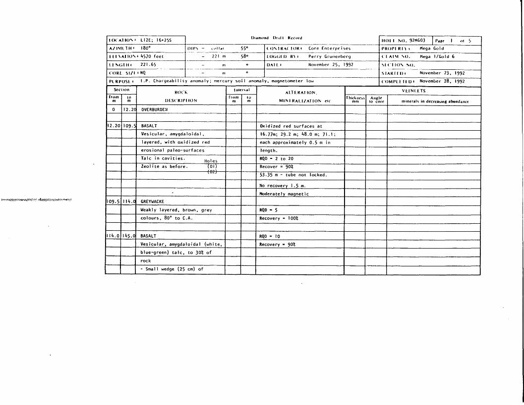
1401 I ho. 92HG02 I l ' d ~ I 01 4
P R O P I 1 a Hega Gold
( I A . Gold 7
\I ( 1 I ( ) \ h0.
S I A H l 1 I) 1 t4ovcniber 2, 1992
< OMI ' I I 1 1 1) 1 f4pven;ber 12, 1992
1 O( 41 lo\ : L ~ U ; 5 + 5 0 ~
A / I\lI 1 Ii 1 180'
I 1 I \ A ! I O N 8 4450 feet
I t ~ ( i l l l ~ 2 4 2 . 6 2 m
( O K 1 % I / ( 1 NQ-BQ
I'C H l 'O \ f 1 I .P. chargeabil i t y zone, mercury anomaly, aeromagnet i c
I ) ~ d n ~ t ~ n d I)I t l l Kcc o td
I - I 46O I ( 1 H 4( 1 OK I Core Dr i 1 I ing (A1 ~ a r v e ~ )
- m O
- n~ o
- m o
V I I N 1 I TS
m ~ n c r r l \ 111 dccrca~rcig d b u ~ i d d ~ ~ c
Red co loura t ion . o x t d ~ 7 e d . . .
Small I cm v e i n l e t . auartz-
carbonate near d e v i t r i f n
Very b lo tchy , fraqmented 50%
d e v i t r i e d g lass.
I o(,(,t I) H) r Perry Crunenberg
I ) A l l : November 4, 1992
411 I HA1 I O N
h l l N I K A I I / A I I O N ctc
RQD = t o f breaks / 5 feet
H i l d t o moderately magnetic
RQD ranges approximates 5 - 20
each 10 t o 15 m i n t e r v a l s
appears t o represent surface
ox ida t ion o f successive vo lcan ic
layers
HO('h
1)l S< W I I ' I I O N
OVERBURDEN
BASALT
Dark grey t o grey-green, f i n e
grained equigranular.
Highly vesicular i n places,
Sect
f r o m m
0
5-18
f r o m m
25.7
79.8
minor amygdaloids o f z e o l i t e
( p h i l l i p s i t e ) .
Vesicles t o 40% of rock.
Several 1 crn t o 5 cm zenol i ths
o f semitranslucent, l i g h t g r e e n ?
d e v i t r i f i e d volcanic glass.
26.1 t o 26.2 - t h i n wedge o f
wacke i n red, ox id ized segment.
Per iodic red colourat ions approx.
ton
to m
5.18
99-11
I n t c c \ r l
to m
26.5
30.3
- -
82.5

R O ( ' h
Ot \( KIP1 1 0 \
CONTACT
Basalt -+ Sandstone-wacke
Uneven. approximately 75" to 8S0
t o C.A.
COARSE SANDSTONE/WACKE
Bedded. I t o 3 cm red and grey
colours.
Bedding 47' t o C.A.
(represents sha 1 1 ow d i p) I
Contact 47O t o C.A.
MUDSTONE
Sharp contact . Brown t o grey- I
brown colour . f a i r l y equigranula-110.5
Minor fragments a t 110 m
(primary depos i t iona l ) . I
Top o f sec t ion very clayey,
uncemented. Hard toward 136 m,
very "mushy" 146.5 t o 155 m
I
t401 f rue. 9 2 ~ ~ 0 2 Ih rmond O r t l l Rccord
1 htckncss mm
1 t o 2
1 t o 2
A L I I RAT I O N
M I h l R A L I I A l l O h clc Anglc
lo corc
35
4 5 t o 90
Intcrbrl
from m
V t I N L L T S
mlncralr ~n dccrcasmg abundrncc
Claysand a1 tered fe ldspar
Black. magnetic, i r o n oxides,
HnOx, and wh i te t o p i n k and
blue-green c lays
Spaced approximately 20 t o 30 cm
to m
123.0
125.0
Samples 104.5 - 105.5 X551002
109.0 - I lO.0 XSSl003
118.0 - 119.0 #551004
122.5 - 123.5 8551005
130.5 - 131.5 #551006
138.4 - 140.0 #551007
1250)
Bronze coloured mica throughout.
RQD = I 0
Sample 100.10 - 100.70 #551001
RQD range 5 t o 50
Hematite porphyroblasts
Small nodules, t o 1 o r 2%
I 1355 Approximately 95% recovery
D~arnond Or I l t Rccord
S c c ~ ton 1-1 ~ 1 . 1 t RAT ION.
M l h t R A L I L A I ION c k
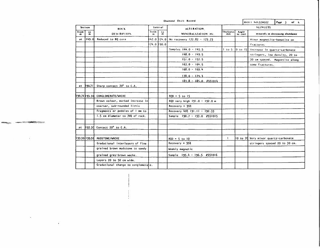
m p ~ i d " c e d - t o BQ core 1147.0 1174.01 No recovery 172.82 - 173.73 1 1 Mirror magnet i te-hemat i t e on
f rac iures
Samples 144.0 - 145.5
151.0 - 152.5
- --
Increase i n quartz-carbonate
s t r ingers , low dens i ty , 20 t o
30 cm spaced. Magnetite alonq
some f rac tu res . I
178.0 - 179.3
183.8 - 185.0 #551014
a t 190.71 Sharp contact 20° t o C.A.
1
I 90.71 I 93.3~ CONGLOMERATE/WACKE
Brown colour , marked increase i n
I
RQD = 5 t o 15
RQD very h iqh 191.0 - 192.0 m
coarser, sub-rounded l i t h i c
fragments o r pebbles of I m t o
1.5 cm diameter t o 70% o f rock.
Recovery = 958 I 1 Recovery 40% 191.1 1 - 192.33
Sample 190.7 - 193.0 #551015
I I
a t 193.3C Contact 20' t o C . A .
RQD = 5 t o 10 1 l o t 0 7 1
Recovery = 95%
Very minor quartz-carbonate
I 1 1 Gradational i n t e r l a y e r s of f i n e I 1 grained brown mudstone t o sandy Weak1 y magnetic
Sample 195.4 - 196.5 8551016

-
O~amond 1)rt l l Rccord I H0L.L NO. 92MGO2 I Page 4 of 4
black, b lue pebbles a t bottom
o f section. making up t o 90%
o f rock. 0.5 t o 3 cm diameter.
Secttun
from to m m
199.5
- - -- I 1 1 grey. I n places conta ins 1 t o
R o t - l i
I ) t S t W l t J l 1 0 4
212.3
.
a t
2 12 -3
Sample 209.0 - 210.3 #551017
I I I I I 1 RQD = 5. very broken over 120 t o 84 Very minor quartz carbonate 1
ln tc r r r l
f r o m to rn m
CONGLOMERATE
Gradational increase i n g r a i n
coarseness from top o f sec t ion
t o bottom.
Verv c o l o u r f u l red. areen.
212.3
239.0
- -
Contact 4S0 t o C.A.
HUDSTONE/WACKE
Intermixed, g rada t iona l dark
I I I I I 1 I
I I 2 cm. Poor ly d i s t i n q u i s h a b l e 1 f 1 1
219.0 - 220.0 X551019 1 I
A1 1 1 R A I I O N
M l h l W A L I I A I lOh ctc
RQD = 30 a t top to 5 a t bottom
Recovery = 70%
I
V t . l N L t T S
mm to core rntncrals tn dccrcasrna rbundancc lh~chncsr Angle
Bedding weak, 75' t o C.A. I
-
I
-
several 1 m sections = 50
Recovery = 75%
Samples 213.5 - 215.0 #551018
I I I
sandy pebbles.
Gradational contact t o next u n i t .
-
Very minor carbonate s t r ingers .
- --
s t r i n g e r s .
39.0
225.0 - 226.0 #551020
230.0 - 231.4 #551021
conglomerate.
Colour fu l pebbles i n places
I I
\
Sample 237.8 - 239.0 X551022
I
242.62
I I I I
RQD = 12
Recovery = 100%
Weakly magnetic
24262
END OF HOLE
J Minor quartz-carbonate s t r ingers . WACKE/CONGLOMERATE
Gradational from unsorted sandy
wacke, t o 0.5 - 1 cm pebble
I I
p ~ ~ p ~ s t I .P . Chargeabi l i t y anomaly; mercury soi I anomaly. magnetometer low I (.OM PI- t 1 I o r November 28. 1992 I Sect Ion
1
Vesicular, amygdaloidal ,
layered, with oxidized red
erosional paieo-surfaces
KO('h
1)t S('KI1'I I O N
OVERBURDEN
f rom m
0
I
Oxidized red surfaces at
16.77m; 29.2 m; 48.0 m; 71.1;
each approximately 0.5 m in
length. L
10 m
12.20
I In- , \ \ " L I
I
Talc in cavities. Ho l es
Zeolite as before. (01) I 1
53.35 m - tube not locked. I I
109.5
I n l c n a l
114.0
A l l I.RAT I O N .
M I N I K A I I / A l I O N ctc f rom
m
I
114.0
ro m
145.0
VI.IN1-1 TS
RQD = 2 to 20
Recover = 90%
GREYWACKE
Weak1 y layered, brown, grey
colours, 80' to C.A.
l IitcLncss mm
I
Yo recovery 1.5 m.
Hoderatel y maqnet ic
RQD = 5
Recovery = 100%
BASALT
Vesicular, amygdaloidal (white,
blue-green) talc, to 30% of
rock
- Small wedge (25 cm) of
A~ig lc to corc
RQD = I0
Recovery = 90%
mtncrals In dccrcasmg abundance
A

Fuc t Inn ROC'h
111 3(. RIP1 I O N
fine mudstone at 134 m?
from m
114.0
(tor
to m
145.0
t
145.0 ROO = 50
Inrcr \al
D u l l grey. broken, poorly 1
consolidated, sandy matrix with
areas of smal l (to 5 nun) pebbles
I
A 1 T t R A T K ) N
MI hl R A L I I A I I O N ctc
Moderately magnetic
from nr
161.3
Recovery = 75%
T ~ T .
Samples 145.0 - 147.0 #551039H
t o m
UACKE-CONGLOMERATE
V C I N l f TS
1 hlcLncrr mm
I
Anglc to Corc
to 20%. pebbles poorly
distinguishable.
mlnccalr an dccrcartns rbundrncc
157.0 - 158.2 #551040H
161.3
Very muddy in places.
Gradational contacts
SILTSTONE
I
173.0
I
RQO = 5
I
1
1 I
Does not test for mercury
under heating?
Sample 161.3 - 162.0 8551041~
Semi-consolidated.
173 -0
Light grey. very clayer,
unconsolidated. Consistency
of molding clay.
of rock, in sandy, grey matrix,
173 -2
I
Recovery = 90%
Red coloured, patchy areas
throughout, I an to 5 cm
diameter?, originally pebbles?
I
CONGLOHERATE
I
toloured (green, red) pebbles
0.5 to 3.0 cm diameter, to 60%

Scc c w n ROC'K
l ) i S( R l f ' l lO\
clayey i n places. Sharp contact .
broken approximately go0 to C.A.
HUDSTONE
from m
173.0
cn m
173.2
tntcrtal
I
Brorn and qrey. mott led. w b b l v
n t )
t
A 566 - 570 - broken rock fraaments
l i k e l y f a l l - i n from surface o f
AI 1 I HA1 I O N
Mihl H * r L I I A l l 4 ) h c t t
Em = ?a ! 7 3 . 2
i n places (wacke) , qradat ional
to n e x t u n i t .
hole
25% recovery
Sample 173-8 - 175.0 #!is1042
RQD = 10
Recovery = 752
176.C
I
I 1
WACKE - CONGLOMERATE
Brown and grey, very unsorted,
i n places pebbly w i t h 1 t o 3 cm
Sample 178.0 - 179.0 b551043
RQD = 30
Recovery = 60% average
Areas o f core loss t o 10%
194.5 t o 202.0 m cor ing, reaming
I
V L l N LETS
pebbles, vary ing matr ix , sandy
t o s l i g h t l y clayey.
Gradational contact w i t h less
pebbles, and increase i n
mud-clay.
tlUOSTONE
Dull grey. equigranular, semi-
consolidated, c layey i n places.
Green t inged i n areas, perhaps
189.5 203.4
rn tncfalr tn dccrcvrtng abundance rh~ckncrs
mrn
I
Angle 40 C O ~ C

Scclwn Ro(- Ii
l) t .S( 'RlPl ( O h from
m
189-5
I
lo m
203.4
('oat)
weakly c h l o r i t i c . Gradational
t o n e x t u n i t , increase i n U g r i t " .
Sample 191.5 - 192.5 1551044
lntcrral
through "drop in" overburden a t
183 m and 195 m.
1
f rom m
203.4
1
707.0
I
t o m
ALT f R A T I O N . I Vt . INLCTS
MINI R A L I Z A I I O N ctc
207.9 GREYUACKE
Anglc to corc
r h d n c r r mm mcncrdr an dccrc8rlng abundmmc
I RQD = 10
SQO - 1s
Pecovery = 99%
Sample 211 - 212111 C551047
Well developed cleavage, along
lamellae plane.
HUDSTONE
Du l l grey, semi-consol idated,
210.4
Recovery = 80%
Sample 205.0 - 206.0 8551045
approximately Bq i n s i z e
RQD = 8
Recovery = 60%
I
Grey, sandy textured, poor ly 1
consolidated.
Loss o f core. c o r i n g
Overburden near 204 - 6 m
clayey i n places, f a i r l y equi-
granular but sandy i n places. Contact undlst inauishable.
212.8
210.4
(graphite?) . Apparent sharp con tac t t o next
u n i t , l o s t between change i n
core boxes. I
S I n O N F I Dark grey, equiqranular
Weakly cross-bedded a t 70° t o C.A.
Sample 209.0 - 210.0 P551046
Few black lamellae o f 3 mm width

I ,
I tom m
U0C.k
111 \( HIt'1 lo\
Scct ton
t o m
212.8221.6)
.
f rom m
UACKE-CONGLOMERATE
At top of section, well defined
stones to 6 cm diameter, roundec
RQD =
Recovery =
Sample 22015 - 221.5 #551048
A l l 1 R A T I O N .
M l h l R A L . I L A 1 l O h c lc
I n t c r t r l
to m
Grades in short distance (20 c m j
to poorly defined, primarily
wacke with anqular to subroundec
gragments in sandy, poorly
sorted matrix.
Well developed stones again at
bottom of section.
Sediment core beg i nn i ng to be
more consol idated toward bottom - - - -
l h ~ k n c r r mm
-7
Absolute1 y no evidence of fractured
fillinq minerals whatsoever.
No fractures.
VLINLCTS
Anglc to corc m incra l r tn dccrcartng ubundaruc
221.6)
of hole.
Unconsolidated nature of core
toward surface.
Apparently oxidation of
carbonate cement due to surface
groundwater perculation.
END OF HOLE