Embed Size (px)
Citation preview
PLANS MART Development Solutions
9 November 2015
Gympie Regional Council PO Box 155 GYMPIE OLD 4570
Att: Planning and Development
Dear Sir/Madam
GYM~!~ ~EGIO'f\JA[ rOOJ\ICTL FILE ID _10t~ =-\54-:7 I ACTION
DOCID OR DIN
WiSHOP
- 9 NOV 1015 BUDGET
~_REF REFER
2 3 <1 .
"&.
Re: Development Application for Preliminary Approval for Material Change of Use -Local Centre (500m2 GFA), over Part Lot 301 on SP337340 and Part Lot 250 on SP173088, located at cnr Woodland Drive and Groundwater Road, Southside
Please accept lodgement of the above application, which includes the following:
Relevant IDAS Forms Town Planning Report A3 Proposal Plans Relevant Fee
I trust that the application meets the requirements to be considered 'properly made' and that sufficient town planning grounds have been demonstrated to enable a favourable assessment against the provisions of the Gym pie Regional Council Planning Scheme 2013.
Should you require any further information please do not hesitate to contact us on the details provided.
Yours faithfully
/$//-Mike Hartley
PRINCIPAL PLANSMART Development Solutions
Unit 1 I 21 Nash Street PO Box 989 GYMPIE QLD 4570
M: 0418 136 828 I 0447 640 677
Development Application for Preliminary Approval Material Change of Use - Local Centre (500m2 GFA)
over Part Lot 301 SP337340 & Part Lot 250 SP173088, Cnr Woodland Dve and Groundwater Rd, Southside

EXECUTIVE SUMMARY
DEVELOPMENT APPLICATION- PRELIMINARY APPROVAL FOR MATERIAL CHANGE OF USE - LOCAL CENTRE (500M2 GFA)- CORNER OF WOODLAND DRIVE AND GROUNDWATER ROAD, SOUTHSIDE
CLIENT:
PROPERTY DETAILS: Site Address:
Real Property Description:
Site Area:
LOCAL GOVERNMENT AREA: (Assessment Manager)
Sigma Developments A TF C/- PLANSMART Development Solutions PO Box 989 GYMPIE QLD 4570
Corner of Groundwater Road and Woodland Drive, Southside Part of Lot 301 SP337340 and Part of Lot 250 SP173088 2550m2
Gympie Regional Council
APPLICABLE PLANNING SCHEME: Gympie Regional Council Planning Scheme 2013
Planning Area: Nil Zone: Residential Living Zone Precinct: Southside Local Development Area Precinct
Applicable Overlays: N/A
Level of Assessment: Impact Assessable
Report prepared by: PLANSMART Development Solutions (November 2015)

1.0 Introduction
This town planning report has been prepared by PLANSMART Development Solutions in support of an application for preliminary approval for a local centre with a maximum gross floor area of 500m2 on land at the corner of Groundwater Road and Woodland Drive between the developing Aspect residential subdivision and the approved Bellings residential subdivision.
The location of the land is illustrated on the plan included at appendix 2.
2.0 Sustainable Planning Act 2009
This application is made under Section 241 of the Sustainable Planning Act 2009 (SPA). Accordingly, it is acknowledged that if approved, such approval would not authorise assessable development to occur, and that a future application for a development permit would be required for the physical development of the site.
The purpose of this application is to seek Council's conceptual approval for a 500m 2 local centre at this location. Other than the actual location and size of the centre, no approval is being sought for the actual design of the centre nor its ability to satisfactorily perform against the planning scheme measures applicable to this type of land use.
Put simply, the applicants are seeking Council's approval to secure this site as an appropriate site for a local centre, with specific details of the centre to be provided with a subsequent development application in the future.
It is noted that the nature of the application - that is, a high level approval for the concept of a future local centre - is entirely consistent with the intent behind section 241 of SPA and its associated explanatory notes.
3.0 Site Description and Surrounding Uses
The subject land forms part of both The Aspect estate and the approved Bellings residential subdivision, and is formally described as part of Lot 301 SP337340 and part of Lot 250 SP173088.
Both parent parcels have been approved for large residential subdivisions. The Aspect comprises a total of 209 lots and the early stages have been completed. The Bellings subdivision comprises 329 lots and has yet to commence. In fact, and despite the age of the approval, the development approval for the Bellings subdivision has yet to take effect as representations in relation to certain conditions of approval have yet to be final ised .
The land is located within the Southside Local Development Area Precinct. It is an area experiencing rapid change from semi-rural activities to a fully serviced residential
Report prepared by: PLANSMART Development Solutions (November 2015) 2

community. In addition to the number of new residential lots already approved by Council in the immediate area, the broader area is zoned exclusively residential and further urban development can be expected in the future.
Aerial Photo showing the development site and surrounding development pattern
4.0 Level of Assessment
As an application for preliminary approval for a Local Centre on land zoned Residential Living, the proposal requires impact assessment.
5.0 Wide Bay Burnett Regional Plan
Section 2.1 of Part 2 of the Gympie Regional Council Planning Scheme 2013 confirms the Minister has identified that the Wide Bay Burnett Regional Plan (WBBRP) as it applies to the Planning Scheme Area is appropriately reflected in the planning scheme. Accordingly, there is no specific need to resort to that document in the assessment of this application, however there are a number of useful references within the document to the Southside area in general and the Southside Development Area (as referred to in the WBBRP) in particular.
The following is an extract from the WBBRP as it applies to the Gympie Region.
Report prepared by: PLANSMART Development Solutions (November 201 5) 3

"Urban growth will continue to be accommodated by the expansion of the suburb of Southside. Large tracts of relatively flat broadhectare land to the south of the Mary River will enable the development of diverse dwelling types that are able to be adapted to changing demographic and housing needs over time. As the development of Southside is progressing, but not yet self-sustaining, residents will continue to travel across the Mary River daily to access health, employment, education and commercial services. Residential intensification will require additional infrastructure investment, and possibly additional or augmented river crossings to retain accessability to the CBD and other employment hubs.
The Southside DA will provide medium-to-long term opportunities to accommodate residential growth for Gympie. Further development of the area will not occur until comprehensive planning has been completed. This will require consideration of the fragmented nature of the area, natural features, potential flooding impacts and topography to provide high levels of accessibility and connectivity. Sequencing and coordination of development and infrastructure delivery will be required. Access across the Mary River will be a key consideration in the sequencing and delivery of development."
A number of important considerations fall out of these high level policy statements:
Southside is the suburb that will do most of the "heavy lifting" in terms of accommodating population growth and urban residential expansion in Gympie well into the future. Subject to demonstrating site suitability, a local centre on the Southside will assist the suburb to become self sustaining. The locational attributes of the subject land will be discussed in section 7.0 of this report. The site is located at the interface of 2 approved large subdivisions, where infrastructure provision, natural features, accessibility and connectivity have previously been considered and settled by Council
It is understood that Council has recently commenced, or is about to commence, a detailed planning exercise for the Southside Local Development Area. The purpose of this application is to assist and influence that planning exercise by demonstrating the appropriateness and suitability of the subject land to accommodate a local centre.
Given that the location is at the interface of 2 approved subdivisions, any higher order planning outcomes from the planning exercise will have no effect on the ability of these subdivisions to proceed as planned and approved. The applicant is a major landholder within Southside, and as such will be a key stakeholder in the planning exercise to be undertaken by Council.
Report prepared by: PLANSMART Development Solutions (November 2015) 4

6.0 Gympie Regional Council Planning Scheme 2013
6.1 Strategic Framework
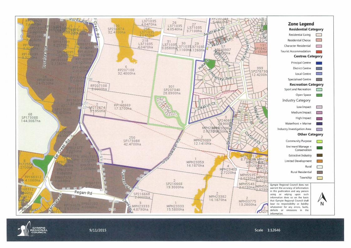
The subject land is located within a New Urban Area, as illustrated on the Strategic Plan Map extract below.
/ -..\" ...... / ' * \ ~
\ I
There are a number of references within the Strategic Framework to the Southside and the Southside Local Development Area. Section 3 of the Strategic Framework relates to the settlement pattern for the Gympie Region, and the following context statement is made in relation to how Gympie is characterised:
'~ relatively low residential density. Most people live in houses on relatively large lots, with most recent development occurring on the Southside. A range of living options are available, however furlher opporlunities exist to establish a more compact settlement pattern, comprising a range of multiple dwellings and small lot housing, in close proximity to centres, services and infrastructure. The Southside Local Development Area Precinct has the potential to accommodate significant future growth in the medium to longer term, however to ensure efficient use of the land, structure planning is anticipated to be underlaken prior to any significant development occurring."
Section 3.3.1 of the Strategic Framework relates to strategic outcomes. Element 3.3.2 (1) of Table 3.1 relating to the settlement pattern and growth expects that "the established urban areas of the Gympie Region are expanded to accommodate the Region's projected growth over the next 20 years". In relation to that element, specific outcome 3.3.3(c) states:
Report prepared by: PLANSMART Development Solutions (November 2015) 5

"Structure Planning of the local development areas at Southside (residential purposes), Victory Heights (employment purposes) and East Deep Cleek (employment purposes) is undertaken in the short term to ensure that medium to long term growth occurs in an efficient and logical manner."
The following observations and comments are relevant to the way in which the Strategic Framework affects the subject land.
The context statement clarifies that structure planning is required to ensure efficient use of the land. In relation to the The Aspect and Bellings subdivisions, that issue has already been determined by Council.
The context statement also clarifies that structure planning is anticipated "prior to any significant development occurring." In the overall scheme of the Southside Local Development Area, a 500m2 local centre flanked by 2 large approved subdivisions consisting of over 500 lots, cannot reasonably be described as "significant development".
Specific Outcome 3.3.3 (c) refers to structure planning being undertaken in the short term to ensure that medium to long term growth occurs in an efficient and logical manner. The fact that The Aspect and Bellings subdivisions have been approved by Council , and the fact that The Aspect has been progressively developed in recent years, confirms that development is occurring at this location in the short term, and that any future planning in the broader area would need to take this fact into account.
In short, there is nothing about the concept of a 500m2 local centre at this location that would in any way conflict with the Strategic Framework or compromise any future planning outcomes in the broader Southside area.
6.2 Residential Living Zone Code
The Subject land is zoned Residential Living and is located within the Southside Local Development Area Precinct, as illustrated on the zoning plan extract overleaf.
Report prepared by: PLANSMART Development Solutions (November 2015) 6

Section 6.2.1 of the zone code confirms that the overarching purpose of the Residential Living zone is to provide for predominantly dwelling houses supported by community uses and small scale services and facilities that cater for local residents. The local government purpose of the code is to accommodate housing consistent with the low density residential character of the zone and to ensure timely, efficient and well serviced development occurs within the Southside Local Development Area Precinct, in accordance with an approved structure plan.
Specifically in relation to the Southside Local Development Area Precinct, the purpose of the code is to be achieved by 8 overall outcomes requiring that development:
(a) is appropriately coordinated and sequenced; (b) does not compromise the future development potential of the area for urban
purposes; (c) is based on the provision of the full range of urban infrastructure and desired
settlement pattern; (d) is supported by the necessary transport infrastructure; (e) is sustainable in emerging urban areas; (f) includes a mix of housing types; (g) protects and enhance significant historical, topographic, landscape and scenic
values, including natural habitat areas, wildlife corridors, wetlands, and waterway corridors; and
(h) provides a high level of residential amenity.
It is clear by their nature and wording that these overall outcomes apply more readily to larger urban residential developments on greenfield sites. Similar considerations would
Report prepared by: PLANSMART Development Solutions (November 2015) 7
have applied in Council's assessment of The Aspect and Bellings estates when they were approved some years ago. Because the combined estates comprise over 500 lots over a large tract of land, infrastructure, sustainability, lot sizes, natural features etc., and amenity considerations were addressed and resolved at the time of approval.
In relation to the subject application for preliminary approval:
(a) The proposal relates to the use of land within 2 approved subdivisions, where coordination and sequencing have already been addressed;
(b) The use of the subject land for a local centre would in no way compromise the future development of the broader area for urban purposes;
(c) The full range of urban infrastructure is available to the subject land; (d) The subdivisions themselves accommodate provision for public transport in the
future; (e) The proposal will not affect the sustainability of the area. On the contrary, as a
small local centre servicing the needs of local residents, the proposal will in fact enhance the sustainability of this emerging area.
(f) The approved subdivisions at this location incorporate a range of lot sizes to accommodate a mix of housing types;
(g) Natural features , landscape and topographic features were addressed at the time of subdivision approval and incorporated into the overall design. No such features exist on the site of the proposed local centre; and
(h) a high level of residential amenity will be maintained following the development of the proposed local centre. The site has been carefully selected as an "island" site where the proposed development can occur without directly affecting any existing or planned future dwelling. The site will ultimately adjoin an embellished area of extensive open space within the Bel lings subdivision (discussed elsewhere), demonstrating the advantage of co-location of activities to create a community hub at th is location.
Having regard to the prevailing circumstances outlined above, the proposed local centre is fully consistent with the overall outcomes for the Residential Living zone at this location. Similarly, the proposal complies implicitly with the overarching purpose of the zone in that the proposed local centre constitutes a small scale facility that will cater for local residents.
The zone code consists of a single performance outcome for the Southside Local Development Area Precinct, as follows:
P01 Development of emerging urban areas: (a) appropriately addresses geographical constraints; (b) protects environmental and cultural heritage values; (c) integrates with existing or approved development in the
surrounding area;
Report prepared by: PLANSMART Development Solutions (November 2015) 8

(d) provides appropriate road, cycle way, pedestrian or open space linkages with satisfactory internal connectivity and integration with surrounding development;
(e) provides for major stormwater flow paths through the site; (f) protects floodplains and water quality; (g) provides necessary physical infrastructure; and (h) achieves an appropriate level of amenity and safety for
adjoining land uses.
This performance outcome largely reflects the higher order overall outcomes discussed above, against which the proposal satisfactorily performs. The associated acceptable outcome for this performance outcome (that is, one way of achieving the performance outcome) requires development to occur in accordance with an approved structure plan.
The land selected for the proposed local centre sits between two large subdivisions, where the higher order planning considerations relating to development suitability have previously been considered by Council. The local centre site is unconstrained and under the circumstances, the completion of a broad scale structure planning exercise over the wider Southside Local Development Area Precinct is not required in order for Council to favorably consider this application. Council simply needs to be satisfied that the proposed use and its location are appropriate.
7.0 General Planning Discussion
A "Local Centre", as the name suggests, provides for a range of land uses and activities to service local needs. Industry standards for this type of use suggest that they comprise a small range of local convenience activities such as a general store, single operator hairdresser, cafe etc. They attract frequent trips from within the catchment, have good local accessibility and act as a focal point and meeting place for the local community. Local centres generally service a population within walking/cycling distance of the centre and are established in emerging residential neighbourhoods.
Based on this standard , there are a sufficient number of approved lots within The Aspect and Bellings developments alone to sustain a local centre at this location. However, the subject land is strategically and centrally located to service a significantly wider catchment of existing dwellings and approved and developing residential lots, including the nearby Crest Estate and the expansive rural residential development to the south.
The plan overleaf illustrates the location of the site in relation to the broader Southside and Gympie area.
Report prepared by: PLANS MART Development Solutions (November 2015) 9

The plan identifies a range of established uses including the Southside Town Centre and the Jones Hill local centre, the only 2 centres existing on the Southside at present. The plan clearly demonstrates that although the Jones Hill local centre will service the established and emerging residential catchment nearby (including the Echelon Estate), no such local centre exists within the existing and emerging residential catchment containing the subject site. The site is also strategically located in relation to the established and growing rural residential area of Pie Creek.
The Southside Town Centre is a District Centre by zoning and land use definition, whose catchment extends over the entire Southside and beyond. As a local centre in an area where no such centre currently provides for the convenience needs of local residents, the subject proposal would in no way undermine the hierarchy of centres currently existing in the general area.
Given:
- the extent of existing residential development in the general area; - the large number of approved lots either under construction or approved and
awaiting construction in the Southside area;
Report prepared by: PLANSMART Development Solutions (November 2015) 10

- the strategic location of the subject site to service the convenience needs of existing and future local residents in the local area; and
- the suitability of the site to accommodate a local centre in terms of services availability, lack of physical constraints etc,
It is considered that the site is the most appropriate location in the general area to accommodate the proposed local centre.
8.0 Conclusion
The application seeks Council's preliminary approval for the concept of a Local Centre on the subject land. This report establishes that Council may favorably consider the proposal ahead of the structure planning exercise over the broader Southside Local Development Area Precinct, and that the site selected is strategically located to accommodate a Local Centre.
Subject to preliminary approval being obtained , a further development permit for a material change of use of premises will be applied for within the relevant currency period and supported by detailed design plans. The necessary application to rearrange property boundaries to formally create the site of the local centre will also be made to Council following approval of this application.
Finally, and as mentioned in Section 2 of the report, representations in relation to the development approval for the Bellings subdivision need to be finalised, particularly in relation to the dedication of public open space as part of that development. Negotiations with Council to finalise those representations are intended to commence immediately following the granting of this preliminary approval and/or as part of the planning exercise to be undertaken by Council on the Broader Southside area.
The application is commended to Council for approval.
PLANSMART Development Solutions November 2015
Report prepared by: PLANSMART Development Solutions (November 2015) II

ATTACHMENT 1: IDAS FORMS
Report prepared by: PLANSMART Development Solutions (November 2015) 12

Department of Infrastructure, Local Government and Planning
IDAS form 1-Application details (Sustainable Planning Act 2009 version 4.2 effective 3 August 2015)
This form must be used for ALL development applications.
You MUST complete ALL questions that are stated to be a mandatory requirement unless otherwise identified on this form.
For all development applications, you must:
• complete this form (IDAS form 1-App/ication details)
• complete any other forms relevant to your application
• provide any mandatory supporting information identified on the forms as being required to accompany your application.
Attach extra pages if there is insufficient space on this form.
All terms used on this form have the meaning given in the Sustainable Planning Act 2009 (SPA) or the Sustainable Planning Regulation 2009.
This form and any other IDAS form relevant to your application must be used for development applications relating to strategic port land and Brisbane core port land under the Transport Infrastructure Act 1994 and airport land under the Airport Assets (Restructuring and Disposal) Act 2008. Whenever a planning scheme is mentioned, take it to mean land use plan for the strategic port land, Brisbane core port land or airport land.
PLEASE NOTE: This form is not required to accompany requests for compliance assessment.
I Mandatory requirements
Applicant details (Note: the applicant is the person responsible for making the application and need not be the owner of the land. The applicant is responsible for ensuring the information provided on all IDAS application forms is correct. Any development permit or preliminary approval that may be issued as a consequence of this application will be issued to the applicant.)
Name/s (individual or company name in full)
For companies, contact name
Postal address
Contact phone number
Mobile number (non-mandatory requirement)
Fax number (non-mandatory requirement)
Sigma Developments Pty Ltd atf Sigma Developments Pty Ltd atf The Astronomer Developments Trust C/- PLANSMART Development Solutions
I Mike Hartley I Kimberley Toomey
PO Box 989
Suburb GYM PIE
State QLD
Country AUSTRALIA
1 0418 136 828/0447 640 677
I As Above
N/A
I Postcode 14570
10/1111'5 . Queensland Government
Email address (non-mandatory requirement) I [email protected]
Applicant's reference number (non-mandatory IN/A requirement)
1. What is the nature of the development proposed and what type of approval is being sought?
Table A-Aspect 1 of the application (If there are additional aspects to the application please list in Table B-Aspect 2.)
a) What is the nature of the development? (Please only tick one box.)
Jg] Material change of use 0 Reconfiguring a lot 0 Building work 0 Operational work
b) What is the approval type? (Please only tick one box.)
Jg] Preliminary approval 0 Preliminary approval Jg] Development permit under s241 of SPA under s241 and s242
of SPA
c) Provide a brief description of the proposal, including use definition and number of buildings or structures where applicable (e.g. six unit apartment building defined as a multi-unit dwelling, 30 lot residential subdivision etc.)
I Local Centre (500m2 GFA)
I d) What is the level of assessment? (Please only tick one box.)
Jg] Impact assessment 0 Code assessment
Table B-Aspect 2 of the application (If there are additional aspects to the application please list in Table C-Additional aspects of the application.)
a) What is the nature of development? (Please only tick one box.)
0 Material change of use 0 Reconfiguring a lot 0 Building work 0 Operational work
b) What is the approval type? (Please only tick one box.)
0 Preliminary approval 0 Preliminary approval 0 Development permit under s241 of SPA under s241 and s242
of SPA
c) Provide a brief description of the proposal, including use definition and number of buildings or structures where applicable (e.g. six unit apartment building defined as a multi-unit dwelling, 30 lot residential subdivision etc.)
I I
d) What is the level of assessment?
0 Impact assessment 0 Code assessment
Table C-Additional aspects of the application (If there are additional aspects to the application please list in a separate table on an extra page and attach to this form.)
0 Refer attached schedule 0 Not required

2. Location of the premises (Complete TableD and/or Table E as applicable. Identify each lot in a separate row.)
Table D-Street address and lot on plan for the premises or street address and lot on plan for the land adjoining or adjacent to the premises (Note: this table is to be used for applications involving taking or interfering with water.) (Attach a separate schedule if there is insufficient space in this table.)
IZl Street address and lot on plan (All lots must be listed.)
0 Street address and lot on plan for the land adjoining or adjacent to the premises (Appropriate for development in water but adjoining or adjacent to land, e.g. jetty, pontoon. All lots must be listed.)
Street address Lot on plan Local government area description (e.g. Logan, Cairns)
Lot Unit Street Street name and official Post- Lot no. Plan type no. no. suburb/locality name code and plan no.
i) - - Woodland Drive, 4570 Part SP337340 Gym pie Regional Council Southside Lot 301
ii) - - Groundwater Road, 4570 Part SP173088 Gympie Regional Council Southside Lot250
Planning scheme details (If the premises involves multiple zones, clearly identify the relevant zone/s for each lot in a separate row in the below table. Non-mandatory)
Lot Applicable zone I precinct Applicable local plan I precinct Applicable overlay/s
i) Residential Living Zone Southside Local Development Area
Table E-Premises coordinates (Appropriate for development in remote areas, over part of a lot or in water not adjoining or adjacent to land e.g. channel dredging in Moreton Bay.) (Attach a separate schedule if there is insufficient space in this table.)
Coordinates Zone Datum Local government (Note: place each set of coordinates in a separate row) reference area (if applicable)
Easting Northing Latitude Longitude
0 GDA94
0 WGS84
0 other
3. Total area of the premises on which the development is proposed (indicate square metres)
2,250m'
4. Current use/s of the premises (e.g. vacant land, house, apartment building, cane farm etc.)
vacant land
5. Are there any current approvals (e.g. a preliminary approval) associated with this application? (Non-mandatory requirement)
0 No Yes-provide details below
List of approval reference/s Date approved (dd/mm/yy) Date approval lapses ( dd/mm/yy)
The Aspect Estate & Bellings Estate
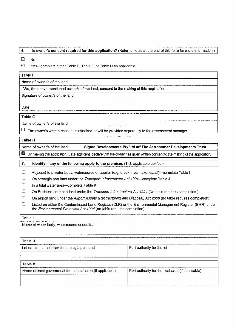
6. Is owner's consent required for this application? (Refer to notes at the end of this form for more information.)
D No
IZI Yes-complete either Table F, Table G or Table H as applicable
Table F
Name of ownerls of the land
1/We, the above-mentioned ownerls of the land, consent to the making of this application.
Signature of ownerls of the land
Date
Table G
Name of ownerls of the land
D The owner's written consent is attached or will be provided separately to the assessment manager.
Table H
Name of ownerls of the land Sigma Developments Pty Ltd atf The Astronomer Developments Trust
IZI By making this application, I, the applicant, declare that the owner has given written consent to the making of the application.
I 7. Identify if any of the following apply to the premises (Tick applicable boxles.)
D Adjacent to a water body, watercourse or aquifer (e.g. creek, river, lake, canal)-complete Table I
D On strategic port land under the Transport Infrastructure Act 1994-complete Table J
D In a tidal water area-complete Table K
D On Brisbane core port land under the Transport Infrastructure Act 1994 (No table requires completion.)
D On airport land under the Airport Assets (Restructuring and Disposal) Act 2008 (no table requires completion)
D Listed on either the Contaminated Land Register (CLR) or the Environmental Management Register (EMR) under the Environmental Protection Act 1994 (no table requires completion)
Table I
Name of water body, watercourse or aquifer
Table J
Lot on plan description for strategic port land Port authority for the lot
Table K
Name of local government for the tidal area (if applicable) Port authority for the tidal area (if applicable)

8. Are there any existing easements on the premises? (e.g. for vehicular access. electricity, overland flow, water etc)
D No IZI Yes-ensure the type, location and dimension of each easement is included in the plans submitted
9. Does the proposal include new building work or operational work on the premises? (Including any services)
IZI No D Yes-ensure the nature, location and dimension of proposed works are included in plans submitted
10. Is the payment of a portable long service leave levy applicable to this application? (Refer to notes at the end of this form for more information.)
IZI No-go to question 12 D Yes
11. Has the portable long service leave levy been paid? (Refer to notes at the end of this form for more information.)
D No
D Yes-complete Table L and submit with this application the yellow local governmenUprivate certifier's copy of the receipted QLeave form
Table L
Amount paid Date paid QLeave project number (6 digit number
(dd/mm/yy) starting with A, B, E, L or P)
12. Has the local government agreed to apply a superseded planning scheme to this application under section 96 of the Sustainable Planning Act 2009?
IZI No
D Yes-please provide details below
Name of local government Date of written notice given Reference number of written notice given by local government by local government (if applicable) (dd/mm/yy)
13. List below all of the forms and supporting information that accompany this application (Include aiiiDAS forms, checklists, mandatory supporting information etc. that will be submitted as part of this application)
Description of attachment or title of attachment Method of lodgement to assessment manager
IDAS Form 5 In person
Covering Letter & Relevant Fee In person
Town Planning Report In person
A3 Proposal Plan In person

114. Applicant's declaration
181 By making this application, I declare that all information in this application is true and correct (Note: it is unlawful to provide false or misleading information)
Notes for completing this form
• Section 261 of the Sustainable Planning Act 2009 prescribes when an application is a properly-made application. Note, the assessment manager has discretion to accept an application as properly made despite any noncompliance with the requirement to provide mandatory supporting information under section 260(1 )(c) of the Sustainable Planning Act 2009
Applicant details • Where the applicant is not a natural person, ensure the applicant entity is a real legal entity.
Question 1 • Schedule 3 of the Sustainable Planning Regulation 2009 identifies assessable development and the type of assessment. Where schedule 3 identifies assessable development as "various aspects of development" the applicant must identify each aspect of the development on Tables A, Band C respectively and as required.
Question 6 • Section 263 of the Sustainable Planning Act 2009 sets out when the consent of the owner of the land is required for
an application. Section 260(1 )(e) of the Sustainable Planning Act 2009 provides that if the owner's consent is required under section 263, then an application must contain, or be accompanied by, the written consent of the owner, or include a declaration by the applicant that the owner has given written consent to the making of the application. If a development application re lates to a state resource, the application is not required to be supported by evidence of an allocation or entitlement to a state resource. However, where the state is the owner of the subject land, the written consent of the state, as landowner, may be required. Allocation or entitlement to the state resource is a separate process and will need to be obtained before development commences.
Question 7 • If the premises is listed on either the Contaminated Land Register (CLR) or the Environmental Management Register (EMR) under the Environmental Protection Act 1994 it may be necessary to seek compliance assessment. Schedule 18 of the Sustainable Planning Regulation 2009 identifies where compliance assessment is required .
Question 11 • The Building and Construction Industry (Portable Long Service Leave) Act 1991 prescribes when the portable long
service leave levy is payable. • The portable long service leave levy amount and other prescribed percentages and rates for calculating the levy
are prescribed in the Building and Construction Industry (Portable Long Service Leave) Regulation 2002.
Question 12 • The portable long service leave levy need not be paid when the application is made, but the Building and
Construction Industry (Portable Long Service Leave) Act 1991 requires the levy to be paid before a development permit is issued.
• Building and construction industry notification and payment forms are available from any Queensland post office or agency, on request from QLeave, or can be completed on the QLeave website at www.qleave.qld.qov.au . For further information contact QLeave on 1800 803 481 or visit www.gleave.qld.gov.au.
Privacy-The information collected in this form will be used by the Department of Infrastructure, Local Government and Planning (DILGP), assessment manager, referral agency and/or building certifier in accordance wi th the processing and assessment of your application. Your personal details should not be disclosed for a purpose outside of the IDAS process or the provisions about public access to planning and development information in the Sustainable Planning Act 2009, except where required by legislation (including the Right to Information Act 2009) or as required by

Parliament. This information may be stored in relevant databases. The information collected will be retained as required by the Public Records Act 2002.
OFFICE USE ONLY
Date received Reference numbers
NOTIFICATION OF ENGAGEMENT OF A PRIVATE CERTIFIER
To
I I CounciL I have been engaged as the private certifier for the
building work referred to in this application
Date of engagement Name BSA Certification license Building number classification/s
QLEAVE NOTIFICATION AND PAYMENT (For completion by assessment manager or private certifier if applicabl.e.)
Date receipted Name of officer Description of the work
QLeave project Amount paid Date paid form sighted by
who sighted the number ($) assessment
manager form
The Sustainable Planning Act 2009 is administered by the Department of Infrastructure, Local Government and Planning. This form and all other required application materials should be sent to your assessment manager and any referral agency.
Department of State Development, Infrastructure and Planning PO Box 15009 City East Qld 4002 te\13 QGOV (13 74 68) [email protected]!d.gov au
www.dsdip.qld.gov.au

Department of Infrastructure, Local Government and Planning
IDAS form 5 -Material change of use assessable against a planning scheme (Sustainable Planning Act 2009 version 3.1 effective 3 August 2015)
This form must be used for development applications for a material change of use assessable against a planning scheme.
You MUST complete ALL questions that are stated to be a mandatory requirement unless otherwise identified on this form.
For all development applications, you must:
complete IDAS form 1-Application details
• complete any other forms relevant to your application
• provide any mandatory supporting information identified on the forms as being required to accompany your application.
Attach extra pages if there is insufficient space on this form.
All terms used on this form have the meaning given in the Sustainable Planning Act 2009 (SPA) or the Sustainable Planning Regu lation 2009.
This form must also be used for material change of use on strategic port land and Brisbane core port land under the Transport Infrastructure Act 1994 and airport land under the Airport Assets (Restructuring and Disposal) Act 2008 that requires assessment against the land use plan for that land. Whenever a planning scheme is mentioned, take it to mean land use plan for the strategic port land, Brisbane core port land or airport land.
I Mandatory requirements
1. Describe the proposed use. (Note: this is to provide additional detail to the information provided in question 1 of IDAS form 1- App/ication details. Attach a separate schedule if there is insufficient space in this table. )
General explanation of the Planning scheme No. of dwelling units Days and proposed use definition (include each (if applicable) or hours of
definition in a new row) gross floor area (if operation (non-mandatory) applicable) (if applicable)
PA for MCU - Local Centre Shop 500m2 GFA N/A
2. Are there any current approvals associated with the proposed material change of use? (e.g. a preliminary approval.)
0 No Yes-provide details below
No. of employees (if applicable)
N/A
List of approval reference/s Date approved (dd/mm/yy) Date approval lapses (dd/mm/yy)
The Aspect Estate & Bellings Estate
• ------------------------------------------------------------------------------------ Qu«ns~nd Government

Department of Infrastructure, Local Government and Planning
3. Does the proposed use involve the following? (Tick all applicable boxes.)
The reuse of existing buildings on the premises 181 No D Yes
New building work on the premises 181 No D Yes
The reuse of existing operational work on the premises 181 No D Yes
New operational work on the premises 181 No D Yes
I Mandatory supporting information
4. Confirm that the following mandatory supporting infonnation accompanies this application
Mandatory supporting information Confirmation of Method of lodgement lodgement
All applications
A site plan drawn to an appropriate scale (1 : 100, 1:200 or 1:500 are 181 Confirmed In person recommended scales) which shows the following :
• the location and site area of the land to which the application relates (relevant land)
• the north point
• the boundaries of the relevant land
• any road frontages of the relevant land, including the name of the road
• the location and use of any existing or proposed buildings or structures on the relevant land (note: where extensive demolition or new buildings are proposed , two separate plans [an existing site plan and proposed site plan] may be appropriate)
• any existing or proposed easements on the relevant land and their function
• the location and use of buildings on land adjoining the relevant land
• all vehicle access points and any existing or proposed car parking areas on the relevant land. Car parking spaces for persons with disabilities and any service vehicle access and parking should be clearly marked
• for any new building on the relevant land, the location of refuse storage
• the location of any proposed retaining walls on the relevant land and their height
• the location of any proposed landscaping on the relevant land
• the location of any stormwater detention on the relevant land .
A statement about how the proposed development addresses the local 181 Confirmed In person government's planning scheme and any other planning instruments or documents relevant to the application.
A statement about the intensity and scale of the proposed use (e.g. number 181 Confirmed In person of visitors, number of seats, capacity of storage area etc.).
Information that states: 181 Confirmed In person
• the existing or proposed floor area, site cover, maximum number of D Not applicable storeys and maximum height above natural ground level for existing or new buildings (e.g. information regarding existing buildings but not being reused)
• the existing or proposed number of on-site car parking bays, type of vehicle cross-over (for non-residential uses) and vehicular servicing arrangement (for non-residential uses).
/DAS form 5 Matcnal change of usc assessable against a planning scheme
Vers1on 3.1-3 August 2015

Department or lnrrastructure, Local Government and Planning
A statement addressing the relevant part(s) of the State Development D Confi rmed Assessment Provisions (SOAP). l8l Not applicable
When the application involves the reuse of existing buildings
Plans showing the size, location, existing floor area, existing site cover, D Confirmed existing maximum number of storeys and existing maximum height above l8l Not applicable natural ground level of the buildings to be reused.
When the application involves new building work (including extensions)
Floor plans drawn to an appropriate scale (1 :50, 1:100 or 1:200 are D Confirmed recommended scales) which show the following:
• the north point
• the intended use of each area on the floor plan (for commercial, industrial or mixed use developments only)
• the room layout (for residential development only) with all rooms clearly labelled
• the existing and the proposed bui lt form (for extensions only)
• the gross floor area of each proposed floor area .
Elevations drawn to an appropriate scale (1: 100, 1:200 or 1:500 are D Confirmed recommended scales) which show plans of all building elevations and facades, clearly labelled to identify orientation (e.g. north elevation)
Plans showing the size, location, proposed site cover, proposed maximum D Confirmed number of storeys, and proposed maximum height above natural ground level l8l Not applicable of the proposed new building work.
When the application involves reuse of other existing work
Plans showing the nature, location, number of on-site car parking bays, D Confirmed existing area of landscaping, existing type of vehicular cross-over (non- l8l Not applicable residential uses), and existing type of vehicular servicing arrangement (non-residential uses) of the work to be reused.
When the application involves new operational work
Plans showing the nature, location, number of new on-site car parking bays, D Confirmed proposed area of new landscaping, proposed type of new vehicle cross-over l8l Not applicable (non-residential uses), proposed maximum new vehicular servicing arrangement (non-residential uses) of the proposed new operational work.
Privacy-Please refer to your assessment manager, referral agency and/or building certifier for further details on the use of information recorded in this form.
OFFICE USE ONLY
Date received Reference numbers
The Sustainable Planning Act 2009 is administered by the Department of Infrastructure, Local Government and Planning. This form and all other required application materials should be sent to your assessment manager and any referral agency.
IDAS form 5 '111atenal cl1811ge of use assessable agamst a plannmg scheme
Verston 3.1-3 August 2015

ATTACHMENT2:PROPOSALPLAN
Report prepared by: PLANSMART Development Solutions (November 2015) 13

CLIENT
SIGMA DEVELOPMENTS PTY. LTD.
PRELIMINARY APPROVAL LOCAL CENTRE
on Lot 301 on SP237340 & Lot 250 on SP173088
5 0 5 10
Scale 1:500 - Lengths are in Metres.
15 20 25 30 35 40 45 50 55 60 65 70
NOTES Cadasatral Boundaries shown
have been compiled from original survey plan information
only, and are subject to cadastral survey. New boundaries shown
are are approximate only, and are subject to field survey.

ATTACHMENT3: SMARTMAP
Report prepared by: PLANSMART Development Solutions (November 2015) 14

..
99
70nn t"'nnm • t ~, ... , ... . 800
24 ~P1 6.1Q99 RP143678
FH
.. 170••
1 $2' T 59".$18
STANDARD MAP NUMBER
9445-42331
MAP WINDOW POSITION & NEAREST LOCATION
64
6 RP207108
FH
llfiQ)S
'"
SP173088
FH
9.46ha
250 500 750
HORIZONTAL DATUM GOA94 ZONE 56 SCALE 1 12500
301 SP237340
65 t52•39'0z-.215
L 57 "~ ... 25'" 13'08".102
FH 71 00
99
2
FH
MPH23487 FH l 2G'14't<"e00
16.1874r
1000 1250
152" z-.215
SmartMap An External ProdUct of
SrNr\Map lnlonnatlon s.Mces
t SUBJECT PARCEL DESCRIPTION CLIENT SERVICE STANDARDS BHed upon an oxllac:bon from lh9 ,.,.,..,..., lrl l"ti'UI
""'""" DCDB ...... l oiiPian 250ISP173048
+ AnWI/durM .. 2.47ha
TOOU<& FREEHOLD
LOCII Government GYMPIE REG+ONAL
l ocality PIE CREEK
Parish WOONGA
/( County LENNOX -tiP- 3918212 .. 7
GDA
PRtNTED (ddlmmlyyyy) 09(1112015
DCDB 0711112015 (l ots wr.h an ..a teN than 1 500m~ are not shown)
Ut.en of the lnfounatk)n recorded in this doc:umont (the lnrormat.oon) accept Ill nnponlbMty and nsk assoaaled wdh the use ol lhe Information end Shoukf Melt tndependent profos~ odvk:e 10 rolallon <odoallnQsW111lpropo<~y.
Oespfte Oepet1rnenC of Natural Rosoun;a end MMt(DNRM)'s best efforts, ONRM n'IIBkH no ~llltlonl or warrant.esln ...._Uon 1o Uw Information. •nd. to the extent piN'I'I'1tt1ed by &aw, txdude or l.tn.l al warrant.es reMilng ao c:orrectnHS, accuf8CY, reli~iiCy, eompte**s or axroncy and Dlllabllty Jor any direcl. n:Jwoctand consoquen:ial mats. louoe, ~and expenses .ncurred in any way fn::ltdng but notlriAd 1o that aM~nQ from ~}in oonnedton 'With any use of or rei~SnCe on 11'16 lnfonnetlon
FOf' furthw lnfonnallon on SmartMap PfodOO• ~sill h lt.pJhww.qld.gov.aulpropertylmappinglbM'1map
D.g.t.i Cedl,str.a ~ta Base
Queensland Government
(c) The State of Queensland, (Department of Natural Resources and Mines) 201 5.

ATTACHMENT 4: SITE LOCATION PLAN
Report prepared by: PLANSMART Development Solutions (November 2015) 15

Malone Buchan Laird & 8awdon Ply Lid AGN 066 985 046 1.31156 069 ~4 614 Architecture+ Master Planning+ lnte~ors +Graphics 342 Wkkn!lll Streol (POBox 341) Forli'JJde Vol!ey, 81sbane Old 4006 AUSIRAI.LI T +61 7 3859 9222 I I +61 7 3859 9234 w www. ~uchan.co11.a.J
A member ol The Buchan Group
-~ PIE CREE K -
8 04.12.09 FOR UlfOAMATION A 03.12.09 FOR INFORMATION Issue date revl51on
Plv PW
lnl.s aulh
' GROUNDWATER ROAD GYM PIE for AGM SERVICES
GVMPIE LOCATION PLAN
(~
' \
II
'.000
0 1.5KM
B lHIBUCHAN~
. - . - .
1 purpose for INFORMATION ! dwn ! dwg no '"'p-ro:-) n-. "'70""8,.,-;1 66:-::-----~--- ! PW ' SK-501
scale 1 :30,000@A3 ' Oo not. 5Uie lhl>ck>•T<l vc·ly 11 cll,...,slo,"' "' - · -c-,.-.,-ed,...,0~3""D""EC""2""o""o9...--- :';;~:',.w~c;o~~~:n%~ """"'""
plotted 04 .12.2009 at 15:51 ile":>.ltJC1lo1L,.-O<LlOl'lw<'W1i)'io<COm .. l-."""""~
Issue
I file X:\708\7081661ARCH\PLOT\SK\SK-501.dwg
68 SP173088 144.3087 ha
6 PP207108 32.4000ha
250 SP173088 42 4700ha
1 MPH23333 15.5800ha
2 MPH23382 16.1870ha
Zone Legend Residential Category
Residential Living D Residential Choke D
Character Residential c:J Tourist Accommodation -
Centres Category
Pnncipal Centre -
Distnct Centre -
locaiCentre c::J
Specialised Centre -
Recreation Category Sport and RecreatiOn c::J
OpenSpace -
Industry Category
low lmp;x:t D Med1um Impact D
H~gh Impact -
Waterfront + Manne -
Jndustry Jnvesb9ation Area c:J Other Category
Community Purpose c:J
Env·ment Manage + -Co1\Se1Vation
Extract1ve Industry -
L1m1ted Development D
Rural D
Rural Residential -
Township D Gympte Reg1onal Council does not
warrant the accuracy of information ~' in this publication and any person
usmg or relying upon such mformation does so on the bas1s that Gymp1e Reg1onal Counc1l shall bear no responsibility or habihty whatsoever for any errors, faults. defects Or OffiiSSIOOS In the information.
~
:Ill GYMPIE ) REGIONAL 9/11/2015 Scale 1:12646 { COUNCI L