Embed Size (px)
Citation preview
1
DEVELOPMENT POLICY COMMITTEE 29 September 2016
AGENDA ITEM 6
Subject LOCAL PLAN EVIDENCE BASE DOCUMENT - HOUSING CAPACITY IN
CHELMSFORD URBAN AREA
Report by DIRECTOR OF SUSTAINABLE COMMUNITIES
Enquiries contact: Jenny Robinson – Planner/Urban Designer 01245 606265 [email protected]
Purpose The report presents a Local Plan evidence base document focusing on an assessment of housing capacity in the Chelmsford urban area from 2021-2036.
Recommendations
1. That the Committee notes the evidence base document at Appendix 1 of this report.
2. That the Director of Sustainable Communities be authorised to finalise and publish the document at Appendix 1 of this report as part of the Local Plan evidence base.
Corporate Implications
Legal: Compliance with Government requirements for the preparation of Statutory Development Plan documents.
Financial: The preparation of a Local Plan is a major area of work, extending over a three year period, and involves significant financial resources for Evidence Base preparation, Public Consultation, Sustainability Appraisal work, legal fees and Examination by the Planning Inspectorate. Current work is being met from the approved Budget for 2016/17.
Personnel: None
Risk Management: Potential risk of Government intervention if the City Council does not progress a new Local Plan.
Equalities and Diversity: (For new or revised policies or procedures has an equalities impact assessment been carried
An Equality and Diversity Impact Assessment has been undertaken for the Council’s emerging Local Plan.

2
out? Y/N)
Health and Safety: None
IT: None
Other: None
Consultees
CCC - Sustainable Communities Directorate
Policies and Strategies The report takes into account the following policies and strategies of the Council:
Local Development Framework (LDF) Documents Core Strategy and Development Control Policies - Adopted DPD Focused Review of Core Strategy and Development Control Policies – Adopted DPD Chelmsford Town Centre Area Action Plan - Adopted DPD North Chelmsford Area Action Plan – Adopted DPD Site Allocations Development Plan Document – Adopted DPD Planning Obligations SPD – Adopted SPD Duty to Co-operate Strategy – Adopted Strategy Statement of Community Involvement – Adopted and Draft Documents Local Development Scheme – Adopted Document The Chelmsford Local Development Framework takes into account all published strategies of the City Council, together with the Sustainable Community Strategy published by The Chelmsford Partnership.
Corporate Plan Priorities The report relates to the following priorities in the Corporate Plan
Attracting investment and delivering infrastructure
Facilitating suitable housing for local needs
Providing high quality public spaces
Promoting a more sustainable environment
Promoting healthier and more active lives
Enhancing participation in cultural activities

3
1. Introduction
1.1 This report presents a document focusing on housing capacity in the Chelmsford urban area (attached at Appendix 1), which officers propose to publish as part of the Local Plan evidence base.
1.2 The document is the result of a desktop study and site visits of brownfield land in Chelmsford urban area. It supplements the results of the Strategic Land Availability Assessment (SLAA), first reported to Development Policy Committee in September 2015, following a Call for Sites, and updated at this Development Policy Committee (29 September 2016). Very few of those submitted sites were on brownfield land in the city centre and urban area.
1.3 The findings of the study were used to inform the Issues and Options consultation, where the potential for 2,500 new homes is shown as Location 1 (Chelmsford Urban Area) in each of the three Spatial Options, and will continue to inform the Preferred Options stage.
1.4 The document does not allocate sites for development but provides important information which will be used to help prepare the Preferred Options Local Plan.
2. Suitability assessment
2.1 Sites identified in the study were tested using the SLAA database, which the Council uses to assess whether sites are suitable, available and achievable for housing development.
2.2 In terms of assessment outputs, the categories for outputs are as follows:
Category 1 – Deliverable: Available now, suitable for development, achievable within 5 years, and viable
Category 2 – Developable: A reasonable prospect of development from 5 and 10 years
Category 3 – Non-developable: Not appropriate for residential development, unlikely to come forward within 10 years, or facing significant constraints
2.3 Housing capacity estimates produced through this database assessment were further tested by officers. In some cases the resulting capacities were higher than the database figure, due to opportunities including apartments, taller buildings and higher densities. The individual ‘Site Assessment Details’ sheets in Appendix 1 note where higher density is anticipated.
2.4 Density varies according to a number of factors including the type of development, number of bedrooms per unit, whether there are commercial units or undercroft parking at ground floor level, outdoor space, and storey heights of apartment buildings. Generally, houses are built at around 30-35 dwellings per hectare (dph) (e.g. Falcons Mead), mixed houses and apartments are higher at around 70 dph (e.g. Fairview, Writtle Road), then rising quickly for apartment only developments up to 160 dph or more - e.g. Lockside Marina at 160 dph; Victoria Court, New Street at 160 dph; Upper Chase, Writtle Road at 160 dph, City Park West (former ARU campus) at 193 dph.

4
2.5 The study assessed 51 sites, of which 26 are considered Category 1 - Deliverable or Category 2 - Developable. Capacity for these sites is estimated at a maximum of around 3,000 dwellings. This includes 11 brownfield sites which were submitted as part of the SLAA Call for Sites, to enable a total figure for all urban area sites to be calculated, whether submitted as part of the SLAA or identified by officers.
2.6 This does not necessarily mean that all the sites will be allocated for development, but they will help the Council to establish options for distribution of homes in the Preferred Options Local Plan. It is envisaged that a realistic figure for potential capacity for 2,500 new homes is carried forward to the Preferred Options Local Plan.
2.7 Category 3 – Non-developable sites amount to 25, due to reasons including unsuitability for housing, high value existing uses, or land assembly issues. The total number of additional units is estimated at just over 1,000, but for the reasons stated it is unlikely that these would come forward during the Local Plan period. These sites and the reasons for discounting them, appear at Page 73 of Appendix 1.
3. Next steps
3.1 The ‘Housing Capacity in Chelmsford Urban Area’ document will be published as part of the Local Plan evidence base.
3.2 Officers will continue to update the database as new information on site availability or clarity on site area and capacity emerges.
4. Conclusion
4.1 The assessment of housing capacity in the Chelmsford urban area supplements the SLAA and will aid the Council in developing a Preferred Options Local Plan.
List of Appendices Appendix 1 - Housing Capacity in Chelmsford Urban Area
Background Papers Nil

Chelmsford Local Plan
Housing Capacity in Chelmsford Urban Area
August 2016
Evidence Base: Population and Homes
1

2

3

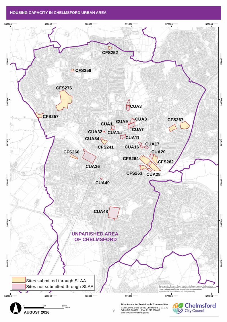
HOUSING CAPACITY IN CHELMSFORD URBAN AREA
1 Introduction
1.1 This report supplements the results of a Strategic Land Availability Assessment (SLAA) which were reported to the Development Policy Committee in September 2015 and September 2016.
1.2 The SLAA was prepared in response to the requirement of Paragraph 159 of the National Planning Policy Framework for local planning authorities to have a clear understanding of housing needs in their area.
1.3 The purpose of the SLAA is to identify land that may be suitable for development in the new Local Plan for the period to 2036. A Call for Sites took place in late 2014 to identify available land for all types of uses, to establish what land could potentially be made available in the future. A further opportunity was offered for site registration alongside the new Local Plan Issues and Options consultation in winter 2015/16.
1.4 The City Council wants to prioritise brownfield sites in the urban area for development, to minimise the amount of development on greenfield sites in the wider city area. However, very few of the sites submitted in the Call for Sites were on brownfield land in the urban area.
1.5 Council officers carried out a desktop study of brownfield land in the urban area, separate to the Call for Sites. This included a review of sites allocated in the Chelmsford Town Centre Area Action Plan (2008), site visits, and an examination of maps and planning history. Data was fed into the SLAA database to test whether identified sites are suitable, available and achievable. The outcomes of that study follow in this report.
1.6 This report does not allocate sites for development or grant planning permission, but it does provide important information which will be used to prepare the new Local Plan.
2 Sites assessment
2.1
2.2
Some of the sites identified are owned by Chelmsford City Council, or are sites where informal discussions have taken place on potential for development. However, many of the sites tested are not being promoted by the owner, but have been subject to the same objective assessment to help drive progress.
Housing capacity estimates were produced through the SLAA assessment database. Following that, individual sites were assessed with the housing capacity estimate as a baseline, to see whether higher capacities can be achieved. In many cases the capacities demonstrated by this site planning exercise were higher than the database figure, due to opportunities including taller buildings and higher densities. The individual ‘Site Assessment Details’ sheets note where higher density is anticipated.
4

2.3 Density varies according to a number of factors including the type of development, number of bedrooms per unit, whether there are commercial units or undercroft parking at ground floor level, outdoor space, and storey heights of apartment buildings.
2.4 Of the 51 sites in the study, 11 were SLAA sites. These were also reviewed, and in some cases capacity estimates were raised to take account of the potential for mitigation of constraints, and for higher density development.
2.5 The assessment database not only generates a potential capacity figure, but assesses sites on their suitability, availability, achievability, physical constraints, environmental impact, and compliance with existing planning policy.
2.6 In terms of assessment outputs, the categories for outputs are as follows: Category 1 – Deliverable: Available now, suitable for development,
achievable within 5 years, and viable Category 2 – Developable: A reasonable prospect of development from 5
and 10 years Category 3 – Non-developable: Not appropriate for residential
development, unlikely to come forward within 10 years, or facing significantconstraints
3 Outcomes
3.1 Of the 51 sites in the study, 26 are categorised as Category 1 or Category 2, and divided into SLAA and non-SLAA sites. The assessment of housing capacity shows that a maximum of 3,098 homes could be accommodated on these sites. This is summarised in Table 1 below. Individual site assessments are attached at Appendix 1. In addition a small number of brownfield sites were identified with a combined potential capacity of up to 14 units, which are not included in Table 1 due to their limited scope.
Table 1: Deliverable/developable sites by category
Category Number of sites
Gross Site Area (ha)
Yield (Dwellings)
Category 1 - Deliverable 2 6.24 143 Category 2 - Developable 14 11.75 1145Urban Area submitted for SLAA Category 1 - Deliverable
5 19.48 889
Urban Area submitted for SLAA Category 2 - Developable
5 10.27 921
TOTAL 26 47.74 3098
5

3.2
3.3
The remaining 25 of the 51 sites are not considered to be developable and are considered as Category 3. They have been rejected for a number of reasons including unsuitability for housing (but for commercial development instead), high value existing uses, difficulty with assembling land in multiple ownership, or other matters which would delay availability until after the plan period. These are listed on Page 73 of Appendix 1.
Identification of sites which are deliverable and/or developable does not mean that the sites will be allocated for development, but they will help the Council to establish what sites and land could be made available in the future, and will form part of the evidence base.
4 Next steps
4.1 The Council has written to owners of land and property which are not currently being promoted by the owner, to explain why sites have been assessed for their development potential and to gain further understanding of the possibility for sites coming forward for development in the future.
4.2 Officers will continue to update the database as new information on site availability or clarity on site area and capacity emerges.
Chelmsford City CouncilSustainable Communities August 2016
6
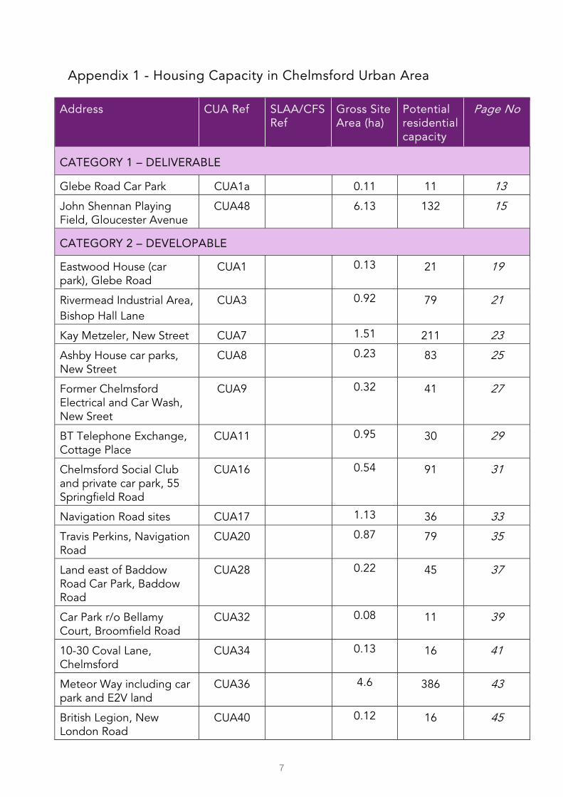
Appendix 1 - Housing Capacity in Chelmsford Urban Area
Address CUA Ref SLAA/CFS Ref
Gross Site Area (ha)
Potential residential capacity
Page No
CATEGORY 1 – DELIVERABLE
Glebe Road Car Park CUA1a 0.11 11 13
John Shennan Playing Field, Gloucester Avenue
CUA48 6.13 132 15
CATEGORY 2 – DEVELOPABLE
Eastwood House (car park), Glebe Road
CUA1 0.13 21 19
Rivermead Industrial Area, Bishop Hall Lane
CUA3 0.92 79 21
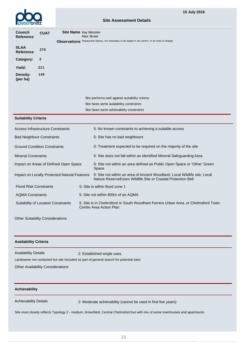
Kay Metzeler, New Street CUA7 1.51 211 23
Ashby House car parks, New Street
CUA8 0.23 83 25
Former Chelmsford Electrical and Car Wash, New Sreet
CUA9 0.32 41 27
BT Telephone Exchange, Cottage Place
CUA11 0.95 30 29
Chelmsford Social Club and private car park, 55 Springfield Road
CUA16 0.54 91 31
Navigation Road sites CUA17 1.13 36 33
Travis Perkins, Navigation Road
CUA20 0.87 79 35
Land east of Baddow Road Car Park, Baddow Road
CUA28 0.22 45 37
Car Park r/o Bellamy Court, Broomfield Road
CUA32 0.08 11 39
10-30 Coval Lane, Chelmsford
CUA34 0.13 16 41
Meteor Way including car park and E2V land
CUA36 4.6 386 43
British Legion, New London Road
CUA40 0.12 16 45
7

Address CUA Ref SLAA/CFS Ref
Gross Site Area (ha)
Potential residential capacity
Page No
URBAN AREA SITES SUBMITTED FOR SLAA – CATEGORY 1 – DELIVERABLE
Land North West of Lockside Marina, Hill Road South
CFS262 1.8 130 49
Baddow Road Car Park CFS263 0.95 100 51
Waterhouse Lane Depot and Nursery
CFS266 0.84 23 53
Essex Police HQ and Sports Ground, New Court Road
CFS267 4.7 451 55
Former St Peter’s College, Fox Crescent
CFS276 11.19 185 57
URBAN AREA SITES SUBMITTED FOR SLAA – CATEGORY 2 – DEVELOPABLE
Civic Centre land CFS241 1.93 190 61
Church Hall site, Woodhall Road
CFS252 0.37 19 63
Garage site, St Nazaire Road
CFS256 0.24 12 65
Garage site and land, Medway Close
CFS257 1.28 50 67
Chelmer Waterside, Wharf Road
CFS264 6.45 650 69
TOTAL 26 47.74 3098
8
Directorate for Sustainable CommunitiesCivic Centre, Duke Street, Chelmsford, CM1 1JETel.01245 606606 Fax. 01245 606642Web www.chelmsford.gov.uk° AUGUST 2016
0 1,000500Metres
Text
568000.000000
568000.000000
569000.000000
569000.000000
570000.000000
570000.000000
571000.000000
571000.000000
572000.000000
572000.000000
573000.000000
573000.000000
20
40
00
.00
00
00
20
40
00
.00
00
00
20
50
00
.00
00
00
20
50
00
.00
00
00
20
60
00
.00
00
00
20
60
00
.00
00
00
20
70
00
.00
00
00
20
70
00
.00
00
00
20
80
00
.00
00
00
20
80
00
.00
00
00
20
90
00
.00
00
00
20
90
00
.00
00
00
HOUSING CAPACITY IN CHELMSFORD URBAN AREA
UNPARISHED AREAOF CHELMSFORD
Based upon the Ordnance Survey mapping with the permission of the Controller ofHer Majesty's Stationery Office. Crown Copyright. Unauthorised reproduction infringesCrown Copyright and may lead to prosecution or civil proceedings.Chelmsford City Council Licence No. 100023562.2015.
CUA28CFS263
CFS264CFS262
CUA20
CUA17CUA16
CUA7
CUA11
CUA8CUA9
CUA1
CUA1aCUA32
CFS241
CUA34
CUA40
CUA36
CFS266
CUA48
CFS267
CUA3
CFS276
CFS257
CFS256
CFS252
Sites submitted through SLAASites not submitted through SLAA
9

10
HOUSING CAPACITY IN CHELMSFORD URBAN AREA
Category 1 - Deliverable
11

12

15 July 2016
Site Assessment Details
SLAAReference
268
Site Name Glebe Road Car ParkChelmsford
Suitability Criteria
Access Infrastructure Constraints 5: No known constraints to achieving a suitable access
Ground Condition Constraints 5: Treatment not expected to be required
Flood Risk Constraints 5: Site is within flood zone 1
Site performs well against suitability, availability and achievability criteria
Category: 1
Other Suitability Considerations
Availability Criteria
Availability Details 5: Held by developer / willing owner / public sector
CCC may consider disposal of land
Achievability
Other Availability Considerations
Site is available
Achievability Details 3: Good achievability (can be used in five year supply)
Site most closely reflects Typology 1 - small, brownfield, Central Chelmsford (although lower density due to lower heights in this location)
Mineral Constraints 5: Site does not fall within an identified Mineral Safeguarding Area
Impact on Locally Protected Natural Features 5: Site not within an area of Ancient Woodland, Local Wildlife site, Local Nature ReserveEssex Wildlife Site or Coastal Protection Belt
Suitability of Location Constraints 5: Site is in Chelmsford or South Woodham Ferrers Urban Area, or Chelmsford Town Centre Area Action Plan
Bad Neighbour Constraints 5: Site has no bad neighbours
AQMA Constraints 5: Site not within 800m of an AQMA
Impact on Areas of Defined Open Space 5: Site not within an area defined as Public Open Space or ‘Other’ Green Space
Observations Cycle route 47 to north; Footpath to south, TCAAP Opportunity Site 23. In West End Conservation Area
Yield: 11
Density: (per ha)
100
Council Reference:
CUA1a
13

GLEBE ROAD
TOWNFIELD STREET
RAILWAY STREET
9
5
7
1
6
3
4
15
17
23
10
24
26
21
PH
Essex FM
Townfield House
Ste
ame
r Te
rra
ce
Posts
1 to 8
Works
16 to
29
10 to
15
El Sub Sta
Multistorey Car Park
10
PH
°
Crown copyright and database rights 2016 Ordnance Survey 100023562. Your are permitted to use this data solelyto enable you to respond to, or interact with, the organisation that provided you with the data. You are not permittedto copy, sub-licence, distribute or sell any of this data to third parties in any form.
Civic Centre, Duke Street, Chelmsford, CM1 1JETel 01245 606606 Web www.chelmsford.gov.uk
Directorate for Sustainable Communities0 10 205
Metres
CUA1a Glebe Road Car Park, Chelmsford
14

15 July 2016
Site Assessment Details
SLAAReference
288
Site Name John Shennan Playing FieldGloucester Avenue
Suitability Criteria
Access Infrastructure Constraints 5: No known constraints to achieving a suitable access
Ground Condition Constraints 0: Treatment expected to be required on the majority of the site
Flood Risk Constraints 5: Site is within flood zone 1
Site performs well against suitability, availability and achievability criteria
Category: 1
Other Suitability Considerations
Availability Criteria
Availability Details 5: Held by developer / willing owner / public sector
owned by CCC
Achievability
Other Availability Considerations
Achievability Details 3: Good achievability (can be used in five year supply)
Site most closely reflects Typology 4 - medium, brownfield, Urban Area.
Mineral Constraints 5: Site does not fall within an identified Mineral Safeguarding Area
Impact on Locally Protected Natural Features 5: Site not within an area of Ancient Woodland, Local Wildlife site, Local Nature ReserveEssex Wildlife Site or Coastal Protection Belt
Suitability of Location Constraints 5: Site is in Chelmsford or South Woodham Ferrers Urban Area, or Chelmsford Town Centre Area Action Plan
Bad Neighbour Constraints 5: Site has no bad neighbours
AQMA Constraints 5: Site not within 800m of an AQMA
Impact on Areas of Defined Open Space 5: Site not within an area defined as Public Open Space or ‘Other’ Green Space
Observations Playing field, some contamination.
Yield: 132
Density: (per ha)
30
Council Reference:
CUA48
15

PRINCES ROAD
LONG
STOM
PS AV
ENUE
GLOUCESTER AVENUE
FORTINBRAS WAY
HEAT
H DR
IVE
GORD
ON RO
AD
JUNIPER DRIVE
HILL
SIDE G
ROVE
ALDER DRIVE
TYLE
RS C
LOSE
9
1
2
7
4
6
5
3
11
32
7914
12
97
77
30
43
23
10
54
2285
42
15
84
3171
13
73
6116
67
94
55
80
33
66
20
75
82
62
92
41
40
72
21
60
El
LB l44
FS
Gardens
Moulsham
2
LB
12
Moulsham
1
13
1
1
1
2
42
16
14
30
9
1
7
11
14
12
1
13
1
2
122
11
1
1
54
75
° Civic Centre, Duke Street, Chelmsford, CM1 1JETel 01245 606606 Web www.chelmsford.gov.uk
Directorate for Sustainable Communities0 50 10025
Metres
CUA48 John Shennan Playing Field, Gloucester Avenue, Chelmsford
Crown copyright and database rights 2016 Ordnance Survey 100023562. Your are permitted to use this data solely to enable you to respond to, or interact with, the organisation that provided you with the data. You are not permitted to copy, sub-licence, distribute or sell any of this data to third parties in any form.
16
HOUSING CAPACITY IN CHELMSFORD URBAN AREA
Category 2 - Developable
17

18

15 July 2016
Site Assessment Details
SLAAReference
267
Site Name Eastwood HouseGlebe Road
Suitability Criteria
Access Infrastructure Constraints 5: No known constraints to achieving a suitable access
Ground Condition Constraints 3: Treatment expected to be required on part of the site
Flood Risk Constraints 5: Site is within flood zone 1
Site performs well against suitability criteria
Site faces some availability constraints
Site faces some achievability constraints
Category: 2
Other Suitability Considerations
Availability Criteria
Availability Details 5: Held by developer / willing owner / public sector
Initial discussions taken place
Achievability
Enabling work needed to relocate or reduce current parking demand .Other Availability Considerations
Site is potentially available
Achievability Details 2: Moderate achievability (cannot be used in first five years)
Site most closely reflects Typology 1 - small, brownfield, Central Chelmsford
Mineral Constraints 5: Site does not fall within an identified Mineral Safeguarding Area
Impact on Locally Protected Natural Features 5: Site not within an area of Ancient Woodland, Local Wildlife site, Local Nature ReserveEssex Wildlife Site or Coastal Protection Belt
Suitability of Location Constraints 5: Site is in Chelmsford or South Woodham Ferrers Urban Area, or Chelmsford Town Centre Area Action Plan
Bad Neighbour Constraints 5: Site has no bad neighbours
AQMA Constraints 5: Site not within 800m of an AQMA
Impact on Areas of Defined Open Space 5: Site not within an area defined as Public Open Space or ‘Other’ Green Space
Observations Part of site. Currently car parking for business. Cycle route 47 at north of site. Footpath 83CFD to south of site. TCAAP OpportunitySite 23. Conservation area adjacent to southern boundary.
Yield: 21
Density: (per ha)
160
Council Reference:
CUA1
19

GLEBE ROAD
TOWNFIELD STREET
MARCONI ROADBISHO
P ROA
D
9
5
7
1
6
2
3
4
10
66
15
17
86
19
24
26
111
130
102
PH
Car
Essex FM
Townfield House
Ste
ame
r Te
rra
ce
PostsWorks
ESS
32 to 37
16 to
29
10 to
15
Warehouse
El Sub Sta
Multistorey Car Park
10
1
10
5
PH
°
Crown copyright and database rights 2016 Ordnance Survey 100023562. Your are permitted to use this data solelyto enable you to respond to, or interact with, the organisation that provided you with the data. You are not permittedto copy, sub-licence, distribute or sell any of this data to third parties in any form.
Civic Centre, Duke Street, Chelmsford, CM1 1JETel 01245 606606 Web www.chelmsford.gov.uk
Directorate for Sustainable Communities0 20 4010
Metres
CUA1 Eastwood House (car park), Glebe Road, Chelmsford
20

15 July 2016
Site Assessment Details
SLAAReference
269
Site Name Rivermead Industrial AreaBishop Hall Lane
Suitability Criteria
Access Infrastructure Constraints 5: No known constraints to achieving a suitable access
Ground Condition Constraints 0: Treatment expected to be required on the majority of the site
Flood Risk Constraints 4: Site is wholly or partially within Flood Zone 2
Site faces some suitability constraints
Site performs well against availability criteria
Site performs well against achievability criteria
Category: 2
Other Suitability Considerations
Availability Criteria
Availability Details 5: Held by developer / willing owner / public sector
Owner in dialogue with CCC
Achievability
Other Availability Considerations
Achievability Details 3: Good achievability (can be used in five year supply)
Phased at 100 units a year, potential start 2016. Site most closely reflects Typology 2 - medium, brownfield, Central Chelmsford. Yield may be higher dependent on use and height.
Mineral Constraints 5: Site does not fall within an identified Mineral Safeguarding Area
Impact on Locally Protected Natural Features 5: Site not within an area of Ancient Woodland, Local Wildlife site, Local Nature ReserveEssex Wildlife Site or Coastal Protection Belt
Suitability of Location Constraints 5: Site is in Chelmsford or South Woodham Ferrers Urban Area, or Chelmsford Town Centre Area Action Plan
Bad Neighbour Constraints 5: Site has no bad neighbours
AQMA Constraints 5: Site not within 800m of an AQMA
Impact on Areas of Defined Open Space 5: Site not within an area defined as Public Open Space or ‘Other’ Green Space
Observations EDS Engineering site, moving to new premises. TCAAP Opportunity Site 37. Planning Brief Sept 2012.
Yield: 79
Density: (per ha)
150
Council Reference:
CUA3
21

ALAN CHERRY DRIVE
9
4
5
7
3
8
1
2
6
Estate
House
Harvey
Institute
Industrial
Mildmay
Rivermead
Pipe Bridge
Postgraduate
Lord Ashcroft
Telecomm
s
River C
helm
er
4a
Ps
FB
ET
L
Pat
h
ESS
Drain
Sluice
El Sub Sta
House
ETL
4
Drain
6
FB
7
8
5
3
ETL
Drain
° Civic Centre, Duke Street, Chelmsford, CM1 1JETel 01245 606606 Web www.chelmsford.gov.uk
Directorate for Sustainable Communities0 20 4010
Metres
CUA3 Rivermead Industrial Area, Bishop Hall Lane, Chelmsford
Crown copyright and database rights 2016 Ordnance Survey 100023562. Your are permitted to use this data solely to enable you to respond to, or interact with, the organisation that provided you with the data. You are not permitted to copy, sub-licence, distribute or sell any of this data to third parties in any form.
22
15 July 2016
Site Assessment Details
SLAAReference
270
Site Name Kay MetzelerNew Street
Suitability Criteria
Access Infrastructure Constraints 5: No known constraints to achieving a suitable access
Ground Condition Constraints 0: Treatment expected to be required on the majority of the site
Flood Risk Constraints 5: Site is within flood zone 1
Site performs well against suitability criteria
Site faces some availability constraints
Site faces some achievability constraints
Category: 2
Other Suitability Considerations
Availability Criteria
Availability Details 2: Established single uses
Landowner not contacted but site included as part of general search for potential sites
Achievability
Other Availability Considerations
Achievability Details 2: Moderate achievability (cannot be used in first five years)
Site most closely reflects Typology 2 - medium, brownfield, Central Chelmsford but with mix of some townhouses and apartments
Mineral Constraints 5: Site does not fall within an identified Mineral Safeguarding Area
Impact on Locally Protected Natural Features 5: Site not within an area of Ancient Woodland, Local Wildlife site, Local Nature ReserveEssex Wildlife Site or Coastal Protection Belt
Suitability of Location Constraints 5: Site is in Chelmsford or South Woodham Ferrers Urban Area, or Chelmsford Town Centre Area Action Plan
Bad Neighbour Constraints 5: Site has no bad neighbours
AQMA Constraints 5: Site not within 800m of an AQMA
Impact on Areas of Defined Open Space 5: Site not within an area defined as Public Open Space or ‘Other’ Green Space
Observations Polystyrene factory, not necessary to be based in city centre. In an area of change.
Yield: 211
Density: (per ha)
140
Council Reference:
CUA7
23

NEW
STRE
ET
BROOK STREET
VICTORIA COURT
DUNN SIDE
BISHOP ROAD
MARCONI ROAD
WATSON HEIGHTS
16
54
Ma
rconi
Depot
25
41 40
WB
Sal
mon
Par
ad
e
Tank
ESSHotel
El Sub Sta
WB
El Sub Sta
°
Crown copyright and database rights 2016 Ordnance Survey 100023562. Your are permitted to use this data solelyto enable you to respond to, or interact with, the organisation that provided you with the data. You are not permittedto copy, sub-licence, distribute or sell any of this data to third parties in any form.
Civic Centre, Duke Street, Chelmsford, CM1 1JETel 01245 606606 Web www.chelmsford.gov.uk
Directorate for Sustainable Communities0 20 4010
Metres
CUA7 Kay Metzeler, New Street, Chelmsford
24
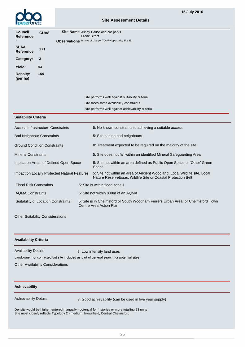
15 July 2016
Site Assessment Details
SLAAReference
271
Site Name Ashby House and car parksBrook Street
Suitability Criteria
Access Infrastructure Constraints 5: No known constraints to achieving a suitable access
Ground Condition Constraints 0: Treatment expected to be required on the majority of the site
Flood Risk Constraints 5: Site is within flood zone 1
Site performs well against suitability criteria
Site faces some availability constraints
Site performs well against achievability criteria
Category: 2
Other Suitability Considerations
Availability Criteria
Availability Details 3: Low intensity land uses
Landowner not contacted but site included as part of general search for potential sites
Achievability
Other Availability Considerations
Achievability Details 3: Good achievability (can be used in five year supply)
Density would be higher; entered manually - potential for 4 stories or more totalling 83 unitsSite most closely reflects Typology 2 - medium, brownfield, Central Chelmsford
Mineral Constraints 5: Site does not fall within an identified Mineral Safeguarding Area
Impact on Locally Protected Natural Features 5: Site not within an area of Ancient Woodland, Local Wildlife site, Local Nature ReserveEssex Wildlife Site or Coastal Protection Belt
Suitability of Location Constraints 5: Site is in Chelmsford or South Woodham Ferrers Urban Area, or Chelmsford Town Centre Area Action Plan
Bad Neighbour Constraints 5: Site has no bad neighbours
AQMA Constraints 5: Site not within 800m of an AQMA
Impact on Areas of Defined Open Space 5: Site not within an area defined as Public Open Space or ‘Other’ Green Space
Observations In area of change. TCAAP Opportunity Site 35.
Yield: 83
Density: (per ha)
160
Council Reference:
CUA8
25

BROOK STREET
HOFFMANNS WAY
Depot
WB
Mill
ESS
Hotel
Durrant Court
Ashby House
WB
°
Crown copyright and database rights 2016 Ordnance Survey 100023562. Your are permitted to use this data solelyto enable you to respond to, or interact with, the organisation that provided you with the data. You are not permittedto copy, sub-licence, distribute or sell any of this data to third parties in any form.
Civic Centre, Duke Street, Chelmsford, CM1 1JETel 01245 606606 Web www.chelmsford.gov.uk
Directorate for Sustainable Communities0 10 205
Metres
CUA8 Ashby House car parks, New Street, Chelmsford
26

15 July 2016
Site Assessment Details
SLAAReference
272
Site Name Chelmsford Electrical & car washNew Street
Suitability Criteria
Access Infrastructure Constraints 5: No known constraints to achieving a suitable access
Ground Condition Constraints 0: Treatment expected to be required on the majority of the site
Flood Risk Constraints 5: Site is within flood zone 1
Site performs well against suitability criteria
Site faces some availability constraints
Site faces some achievability constraints
Category: 2
Other Suitability Considerations
Availability Criteria
Availability Details 1: Established multiple uses
Two owners. Initial contact has been made
Achievability
Two owners are known and CCC has made contactOther Availability Considerations
Site is potentially available
Achievability Details 2: Moderate achievability (cannot be used in first five years)
Site most closely reflects Typology 1 - small, brownfield, Central Chelmsford but at 130 dph (lower height)
Mineral Constraints 5: Site does not fall within an identified Mineral Safeguarding Area
Impact on Locally Protected Natural Features 5: Site not within an area of Ancient Woodland, Local Wildlife site, Local Nature ReserveEssex Wildlife Site or Coastal Protection Belt
Suitability of Location Constraints 5: Site is in Chelmsford or South Woodham Ferrers Urban Area, or Chelmsford Town Centre Area Action Plan
Bad Neighbour Constraints 5: Site has no bad neighbours
AQMA Constraints 5: Site not within 800m of an AQMA
Impact on Areas of Defined Open Space 5: Site not within an area defined as Public Open Space or ‘Other’ Green Space
Observations Area of change, opposite new Marconi dev. Cycle routes west and south - 37 and 34. TCAAP Opportunity Site 36.
Yield: 41
Density: (per ha)
130
Council Reference:
CUA9
27

NEW
STRE
ET
BROOK STREET
DUNN SIDE
BISHOP ROAD
MARCONI ROAD
WATSON HEIGHTS
16
54
Ma
rconi
Depot
25
41 40
Sal
mon
Par
ad
e
Tank
1 to 5
1 to 4
ESSHotel
5 to 10
Salmon Court
°
Crown copyright and database rights 2016 Ordnance Survey 100023562. Your are permitted to use this data solelyto enable you to respond to, or interact with, the organisation that provided you with the data. You are not permittedto copy, sub-licence, distribute or sell any of this data to third parties in any form.
Civic Centre, Duke Street, Chelmsford, CM1 1JETel 01245 606606 Web www.chelmsford.gov.uk
Directorate for Sustainable Communities0 10 205
Metres
CUA9 Former Chelmsford Electrical & Car Wash, New Street, Chelmsford
28

15 July 2016
Site Assessment Details
SLAAReference
273
Site Name BT Telephone ExchangeCottage Place
Suitability Criteria
Access Infrastructure Constraints 5: No known constraints to achieving a suitable access
Ground Condition Constraints 5: Treatment not expected to be required
Flood Risk Constraints 5: Site is within flood zone 1
Site performs well against suitability criteria
Site faces some availability constraints
Site faces some achievability constraints
Category: 2
Other Suitability Considerations
Availability Criteria
Availability Details 2: Established single uses
Initial discussions taken place for consolidation of existing uses
Achievability
Other Availability Considerations
Achievability Details 2: Moderate achievability (cannot be used in first five years)
Site most closely reflects Typology 1 - small, brownfield, Central Chelmsford. Density higher, conversion could yield 36 units, yield entered manually.
Mineral Constraints 5: Site does not fall within an identified Mineral Safeguarding Area
Impact on Locally Protected Natural Features 5: Site not within an area of Ancient Woodland, Local Wildlife site, Local Nature ReserveEssex Wildlife Site or Coastal Protection Belt
Suitability of Location Constraints 5: Site is in Chelmsford or South Woodham Ferrers Urban Area, or Chelmsford Town Centre Area Action Plan
Bad Neighbour Constraints 5: Site has no bad neighbours
AQMA Constraints 5: Site not within 800m of an AQMA
Impact on Areas of Defined Open Space 5: Site not within an area defined as Public Open Space or ‘Other’ Green Space
Observations 1960s building with section arching over the road. Adjacent to Conservation Area. Buildings not used to capacity. Close to Cathedral.
Yield: 30
Density: (per ha)
160
Council Reference:
CUA11
29

VICTORIA ROAD
COTTAGE PLACE
LEGG STREET
CHUR
CH ST
REET
DUKE STREET
1
Court
Hotel
MagistratesChelmsford
Amlin House
21
13
17
10
El
FB Sta
The
YMCA
Day Centre
Sub
PH
St Marks Centre
CHURCH STREET
1to 7
Ellton
LanePosts
1 to 6
Wo
rks
7 to 12
9 to
10
(PH)
Steeple
Imperial
13 to 18
90 to 96
Sub Sta
War
ehou
se
Exchange
House
Bankside
Telephone Exchange
Posts
Works
El
PostsPosts
Sta
7 to 12
° Civic Centre, Duke Street, Chelmsford, CM1 1JETel 01245 606606 Web www.chelmsford.gov.uk
Directorate for Sustainable Communities0 10 205
Metres
CUA11 BT Telephone Exchange, Cottage Place, Chelmsford
Crown copyright and database rights 2016 Ordnance Survey 100023562. Your are permitted to use this data solelyto enable you to respond to, or interact with, the organisation that provided you with the data. You are not permittedto copy, sub-licence, distribute or sell any of this data to third parties in any form.
30
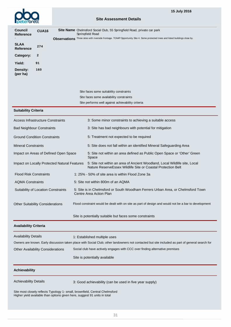
15 July 2016
Site Assessment Details
SLAAReference
274
Site Name Chelmsford Social Club, 55 Springfield Road, private car parkSpringfield Road
Suitability Criteria
Access Infrastructure Constraints 3: Some minor constraints to achieving a suitable access
Ground Condition Constraints 5: Treatment not expected to be required
Flood Risk Constraints 1: 25% - 50% of site area is within Flood Zone 3a
Site faces some suitability constraints
Site faces some availability constraints
Site performs well against achievability criteria
Category: 2
Flood constraint would be dealt with on site as part of design and would not be a bar to developmentOther Suitability Considerations
Availability Criteria
Availability Details 1: Established multiple uses
Owners are known. Early discussion taken place with Social Club; other landowners not contacted but site included as part of general search for
Achievability
Social club have actively engages with CCC over finding alternative premisesOther Availability Considerations
Site is potentially suitable but faces some constraints
Site is potentially available
Achievability Details 3: Good achievability (can be used in five year supply)
Site most closely reflects Typology 1- small, brownfield, Central ChelmsfordHigher yield available than options given here, suggest 91 units in total
Mineral Constraints 5: Site does not fall within an identified Mineral Safeguarding Area
Impact on Locally Protected Natural Features 5: Site not within an area of Ancient Woodland, Local Wildlife site, Local Nature ReserveEssex Wildlife Site or Coastal Protection Belt
Suitability of Location Constraints 5: Site is in Chelmsford or South Woodham Ferrers Urban Area, or Chelmsford Town Centre Area Action Plan
Bad Neighbour Constraints 3: Site has bad neighbours with potential for mitigation
AQMA Constraints 5: Site not within 800m of an AQMA
Impact on Areas of Defined Open Space 5: Site not within an area defined as Public Open Space or ‘Other’ Green Space
Observations Three sites with riverside frontage. TCAAP Opportunity Site 4. Some protected trees and listed buildings close by.
Yield: 91
Density: (per ha)
160
Council Reference:
CUA16
31

SPRINGFIEL
D ROAD
SHRUBLA
NDS CLO
SE
NAVIGATION ROAD
2
House
to
Shalford Court
Mackmurdo
18
85
27
79
75
77
958136
1573
80
83
74
8482
Yard
80a
Navigation
Fenchurch House
Club
1 to 4
1 to 8
TCBsShe
lter
86 to
94
47 to
53
64 to
68
Council Office
Pipe Line
Riverbank Court
ROMAN R
OAD
°
Crown copyright and database rights 2016 Ordnance Survey 100023562. Your are permitted to use this data solelyto enable you to respond to, or interact with, the organisation that provided you with the data. You are not permittedto copy, sub-licence, distribute or sell any of this data to third parties in any form.
Civic Centre, Duke Street, Chelmsford, CM1 1JETel 01245 606606 Web www.chelmsford.gov.uk
Directorate for Sustainable Communities0 20 4010
Metres
CUA16 Chelmsford Social Club & private car park, 55 Springfield Rd, Chelmsford
32
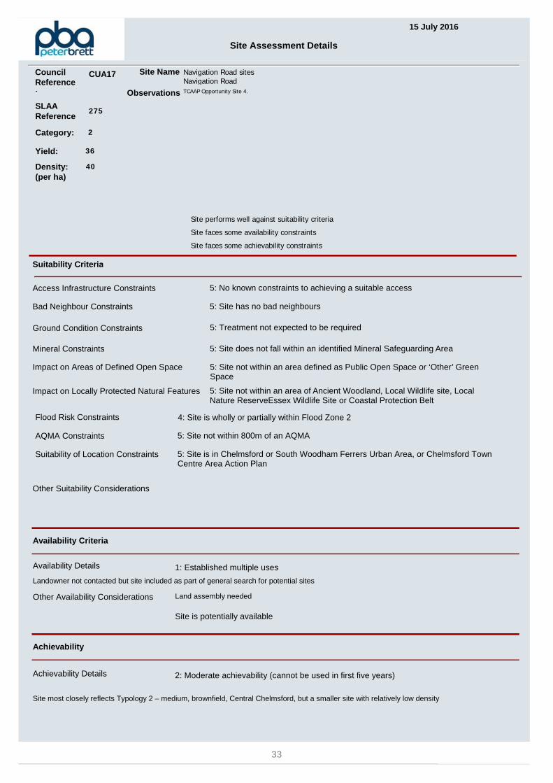
15 July 2016
Site Assessment Details
SLAAReference
275
Site Name Navigation Road sitesNavigation Road
Suitability Criteria
Access Infrastructure Constraints 5: No known constraints to achieving a suitable access
Ground Condition Constraints 5: Treatment not expected to be required
Flood Risk Constraints 4: Site is wholly or partially within Flood Zone 2
Site performs well against suitability criteria
Site faces some availability constraints
Site faces some achievability constraints
Category: 2
Other Suitability Considerations
Availability Criteria
Availability Details 1: Established multiple uses
Landowner not contacted but site included as part of general search for potential sites
Achievability
Land assembly neededOther Availability Considerations
Site is potentially available
Achievability Details 2: Moderate achievability (cannot be used in first five years)
Site most closely reflects Typology 2 – medium, brownfield, Central Chelmsford, but a smaller site with relatively low density
Mineral Constraints 5: Site does not fall within an identified Mineral Safeguarding Area
Impact on Locally Protected Natural Features 5: Site not within an area of Ancient Woodland, Local Wildlife site, Local Nature ReserveEssex Wildlife Site or Coastal Protection Belt
Suitability of Location Constraints 5: Site is in Chelmsford or South Woodham Ferrers Urban Area, or Chelmsford Town Centre Area Action Plan
Bad Neighbour Constraints 5: Site has no bad neighbours
AQMA Constraints 5: Site not within 800m of an AQMA
Impact on Areas of Defined Open Space 5: Site not within an area defined as Public Open Space or ‘Other’ Green Space
Observations TCAAP Opportunity Site 4.
Yield: 36
Density: (per ha)
40
Council Reference:
CUA17
33
SPRINGFIEL
D ROAD
NAVIGATION ROAD
WHARF
ROAD
BOSWELLS DRIVE
SANDRINGHAM PLACE
COATES QUAY
21
6
87
4
9
5
3
House
to
Shalford Court
Mackmurdo
26
4115 13
85
14
79
75
25
96
40
83
21
17
4745
3529
31
87
93
24
9581
37
39
73
16
91
8482
Yard
Sta
114
112
80a
213
207
215
201
214
204
209
208
63a
202
Navigation
The
Balm
oral
Cou
rt
Tyrell Lodge
Fenchurch House
PH
1 to 4
1 to 8
1 to 206 to 14
86 to
94
96 to
98
32 to
74
39 to 42
15 to 23
65 to
75
Warehouse
Cottage
100
to 1
02
Car Park
Kenmore
El Sub Sta
Robjohns House
83
to
4
2
1
1
1
5
2
1
13
°
Crown copyright and database rights 2016 Ordnance Survey 100023562. Your are permitted to use this data solelyto enable you to respond to, or interact with, the organisation that provided you with the data. You are not permittedto copy, sub-licence, distribute or sell any of this data to third parties in any form.
Civic Centre, Duke Street, Chelmsford, CM1 1JETel 01245 606606 Web www.chelmsford.gov.uk
Directorate for Sustainable Communities0 20 4010
Metres
CUA17 Navigation Road sites, Chelmsford
34

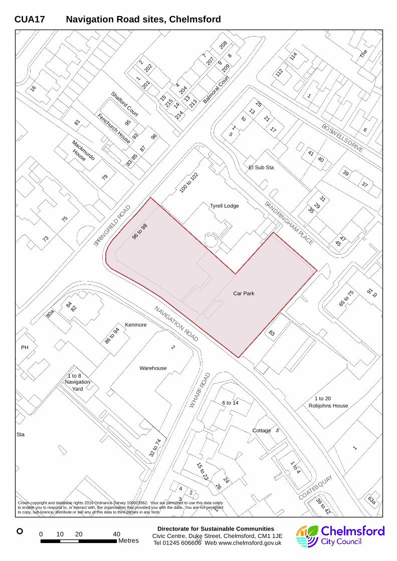
15 July 2016
Site Assessment Details
SLAAReference
278
Site Name Travis PerkinsNavigation Road
Suitability Criteria
Access Infrastructure Constraints 5: No known constraints to achieving a suitable access
Ground Condition Constraints 0: Treatment expected to be required on the majority of the site
Flood Risk Constraints 2: 10% - 25% of site area is within Flood Zone 3a
Site faces some suitability constraints
Site faces some availability constraints
Site performs well against achievability criteria
Category: 2
On-site mitigation would be requiredOther Suitability Considerations
Availability Criteria
Availability Details 2: Established single uses
Landowner not contacted but site included as part of general search for potential sites
Achievability
Other Availability Considerations
Site is potentially suitable but faces some constraints
Achievability Details 3: Good achievability (can be used in five year supply)
Site most closely reflects Typology 2 - medium, brownfield, Central Chelmsford, with slightly higher yield
Mineral Constraints 5: Site does not fall within an identified Mineral Safeguarding Area
Impact on Locally Protected Natural Features 5: Site not within an area of Ancient Woodland, Local Wildlife site, Local Nature ReserveEssex Wildlife Site or Coastal Protection Belt
Suitability of Location Constraints 5: Site is in Chelmsford or South Woodham Ferrers Urban Area, or Chelmsford Town Centre Area Action Plan
Bad Neighbour Constraints 5: Site has no bad neighbours
AQMA Constraints 5: Site not within 800m of an AQMA
Impact on Areas of Defined Open Space 5: Site not within an area defined as Public Open Space or ‘Other’ Green Space
Observations Builders' Merchants, part of site previously developed. Help to find alternative site. TCAAP Opportunity Site 27. C&BN ConservationArea. Waterside site.
Yield: 79
Density: (per ha)
90
Council Reference:
CUA20
35
NAVIGATION ROAD
BROC
KLEY
ROAD
WHARF ROAD
QUEE
N'S R
OAD
CRES
SY Q
UAY
COATES QUAY
8
2
1
Estate
5856
51
52
45
63
Chelmer and Blackwater N
avigation
LB
63a
1 to 4
ESS
1 to 10
Unit 1
Unit 3
39 to 42
27 to 48
16 to 26
11 t
o 15
Unit 4-5
Unit 5a to 5c
El Sub Sta
°
Crown copyright and database rights 2016 Ordnance Survey 100023562. Your are permitted to use this data solelyto enable you to respond to, or interact with, the organisation that provided you with the data. You are not permittedto copy, sub-licence, distribute or sell any of this data to third parties in any form.
Civic Centre, Duke Street, Chelmsford, CM1 1JETel 01245 606606 Web www.chelmsford.gov.uk
Directorate for Sustainable Communities0 10 205
Metres
CUA20 Travis Perkins, Navigation Road, Chelmsford
36

15 July 2016
Site Assessment Details
SLAAReference
282
Site Name Land east of Baddow Road Car ParkBaddow Road
Suitability Criteria
Access Infrastructure Constraints 5: No known constraints to achieving a suitable access
Ground Condition Constraints 5: Treatment not expected to be required
Flood Risk Constraints 0: Over 50% of site area is within Flood Zone 3a
Site faces some suitability constraints
Site performs well against availability criteria
Site performs well against achievability criteria
Category: 2
Flood mitigation would be incorporated into developmentOther Suitability Considerations
Availability Criteria
Availability Details 5: Held by developer / willing owner / public sector
Owned by CCC
Achievability
Other Availability Considerations
Site is potentially suitable but faces some constraints
Achievability Details 3: Good achievability (can be used in five year supply)
Site most closely reflects Typology 5 - small, greenfield, Urban Area. Vacant land, though perhaps only can be developed in conjunction with adjacent site CFS00263. Yiled higher due to height, entered manually
Mineral Constraints 5: Site does not fall within an identified Mineral Safeguarding Area
Impact on Locally Protected Natural Features 5: Site not within an area of Ancient Woodland, Local Wildlife site, Local Nature ReserveEssex Wildlife Site or Coastal Protection Belt
Suitability of Location Constraints 5: Site is in Chelmsford or South Woodham Ferrers Urban Area, or Chelmsford Town Centre Area Action Plan
Bad Neighbour Constraints 5: Site has no bad neighbours
AQMA Constraints 3: Site 200m - 800m of an AQMA
Impact on Areas of Defined Open Space 5: Site not within an area defined as Public Open Space or ‘Other’ Green Space
Observations Land east of Baddow Road car park. Read in conjunction with CFS00263. This applies only to the additional land. TCAAP OpportunitySite 26 (adjacent).
Yield: 45
Density: (per ha)
160
Council Reference:
CUA28
37

Mill
Centre
Moulsham
FB
Jetty
Sluice
Automatic
°
Crown copyright and database rights 2016 Ordnance Survey 100023562. Your are permitted to use this data solelyto enable you to respond to, or interact with, the organisation that provided you with the data. You are not permittedto copy, sub-licence, distribute or sell any of this data to third parties in any form.
Civic Centre, Duke Street, Chelmsford, CM1 1JETel 01245 606606 Web www.chelmsford.gov.uk
Directorate for Sustainable Communities0 10 205
Metres
CUA28 Land east of Baddow Road Car Park, Baddow Road, Chelmsford
38

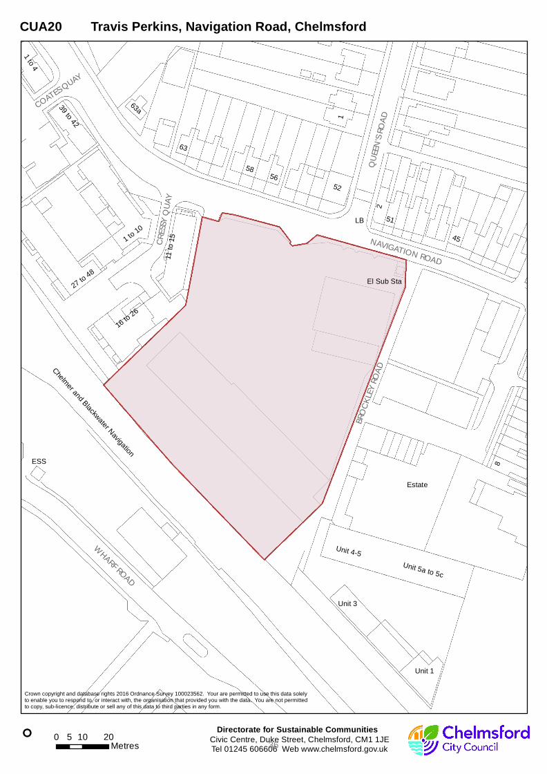
15 July 2016
Site Assessment Details
SLAAReference
283
Site Name Car park r/o Bellamy Court,Broomfield Road
Suitability Criteria
Access Infrastructure Constraints 5: No known constraints to achieving a suitable access
Ground Condition Constraints 5: Treatment not expected to be required
Flood Risk Constraints 5: Site is within flood zone 1
Site performs well against suitability criteria
Site faces some availability constraints
Site performs well against achievability criteria
Category: 2
Other Suitability Considerations
Availability Criteria
Availability Details 3: Low intensity land uses
Landowner not contacted but site included as part of general search for potential sites
Achievability
Other Availability Considerations
Achievability Details 3: Good achievability (can be used in five year supply)
Site most closely reflects Typology 1 - small, brownfield, Central Chelmsford
Mineral Constraints 5: Site does not fall within an identified Mineral Safeguarding Area
Impact on Locally Protected Natural Features 5: Site not within an area of Ancient Woodland, Local Wildlife site, Local Nature ReserveEssex Wildlife Site or Coastal Protection Belt
Suitability of Location Constraints 5: Site is in Chelmsford or South Woodham Ferrers Urban Area, or Chelmsford Town Centre Area Action Plan
Bad Neighbour Constraints 5: Site has no bad neighbours
AQMA Constraints 5: Site not within 800m of an AQMA
Impact on Areas of Defined Open Space 5: Site not within an area defined as Public Open Space or ‘Other’ Green Space
Observations Car park r/o shops.
Yield: 11
Density: (per ha)
130
Council Reference:
CUA32
39
BROO
MFIEL
D RO
AD
PARKWAY
CEDA
R AVE
NUE
DUKE STREET
RAINSFORD ROAD
COVA
L LAN
E
RAILWAY STREET
WICK
S PLA
CE
FAIRF
IELD R
OAD
BROO
MFIEL
D RO
AD
PARKWAY
2
1
6 3
8
5
9
to
Car Park
Hall
The
11
15
56
53
1725
30
13
3245
28
23
2051
36
21
29
47
44
52
37
46
16
38
48
22
14
27
26
Civic
Court
LB
Coval
Bellamy
10c
11b
War
17a
47a
Beacon House
SM
Spalding Court
Th
omp
son
Co
urt
Bank
3 to 5
2 to
8
TCB
Surgery
1 to 14
1 to
53
1 to 37
1 to 12
1 to 26
7 to 11
(PH)
She
lter
Theatre
50 to
60
El Sub Sta
Lesley Court
TCB
30
36
32
SM
1
15
47
20
2
Car Park
SM
° Civic Centre, Duke Street, Chelmsford, CM1 1JETel 01245 606606 Web www.chelmsford.gov.uk
Directorate for Sustainable Communities0 10 205
Metres
CUA32 Car park r/o Bellamy Court, Broomfield Road, Chelmsford
Crown copyright and database rights 2016 Ordnance Survey 100023562. Your are permitted to use this data solely to enable you to respond to, or interact with, the organisation that provided you with the data. You are not permitted to copy, sub-licence, distribute or sell any of this data to third parties in any form.
40

15 July 2016
Site Assessment Details
SLAAReference
284
Site Name 10-30 Coval LaneChelmsford
Suitability Criteria
Access Infrastructure Constraints 5: No known constraints to achieving a suitable access
Ground Condition Constraints 5: Treatment not expected to be required
Flood Risk Constraints 5: Site is within flood zone 1
Site performs well against suitability criteria
Site faces some availability constraints
Site faces some achievability constraints
Category: 2
Other Suitability Considerations
Availability Criteria
Availability Details 0: In complex/multiple ownership or subject to ransom strip
Landowner not contacted but site included as part of general search for potential sites
Achievability
Land assembly requiredOther Availability Considerations
Site is potentially available
Achievability Details 2: Moderate achievability (cannot be used in first five years)
Site most closely reflects Typology 1 - small, brownfield, Central Chelmsford.Yield is for ADDITIONAL units, entered manually
Mineral Constraints 5: Site does not fall within an identified Mineral Safeguarding Area
Impact on Locally Protected Natural Features 5: Site not within an area of Ancient Woodland, Local Wildlife site, Local Nature ReserveEssex Wildlife Site or Coastal Protection Belt
Suitability of Location Constraints 5: Site is in Chelmsford or South Woodham Ferrers Urban Area, or Chelmsford Town Centre Area Action Plan
Bad Neighbour Constraints 5: Site has no bad neighbours
AQMA Constraints 5: Site not within 800m of an AQMA
Impact on Areas of Defined Open Space 5: Site not within an area defined as Public Open Space or ‘Other’ Green Space
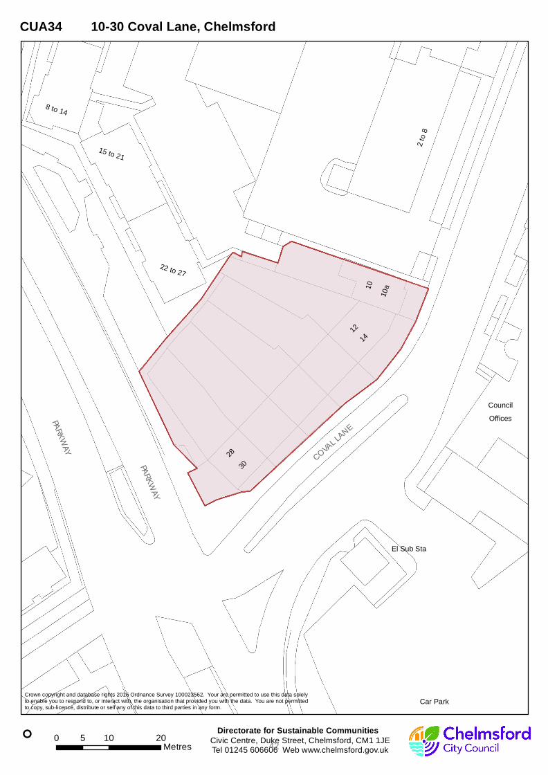
Observations Low rise housing site in area of change. TCAAP Opportunioty Site 18 (part). Large good tree to be retained (not TPO).
Yield: 16
Density: (per ha)
160
Council Reference:
CUA34
41
PARKWAY
COVAL LANE
PARKWAY
10
28
14
12
30
10a
Offices2
to 8
8 to 14
22 to 27
15 to 21
Council
Car Park
El Sub Sta
°
Crown copyright and database rights 2016 Ordnance Survey 100023562. Your are permitted to use this data solelyto enable you to respond to, or interact with, the organisation that provided you with the data. You are not permittedto copy, sub-licence, distribute or sell any of this data to third parties in any form.
Civic Centre, Duke Street, Chelmsford, CM1 1JETel 01245 606606 Web www.chelmsford.gov.uk
Directorate for Sustainable Communities0 10 205
Metres
CUA34 10-30 Coval Lane, Chelmsford
42

15 July 2016
Site Assessment Details
SLAAReference
285
Site Name Meteor Way inc. car park and part E2VMeteor Way
Suitability Criteria
Access Infrastructure Constraints 5: No known constraints to achieving a suitable access
Ground Condition Constraints 3: Treatment expected to be required on part of the site
Flood Risk Constraints 4: Site is wholly or partially within Flood Zone 2
Site performs well against suitability criteria
Site faces some availability constraints
Site faces some achievability constraints
Category: 2
Other Suitability Considerations
Availability Criteria
Availability Details 1: Established multiple uses
Initial discussions taken place
Achievability
Owners are known, in TCAAP, dialogue startedOther Availability Considerations
Site is potentially available
Achievability Details 2: Moderate achievability (cannot be used in first five years)
Site most closely reflects Typology 2 – medium, brownfield, Central Chelmsford.Yield higher due to height and density, entered manually
Mineral Constraints 5: Site does not fall within an identified Mineral Safeguarding Area
Impact on Locally Protected Natural Features 5: Site not within an area of Ancient Woodland, Local Wildlife site, Local Nature ReserveEssex Wildlife Site or Coastal Protection Belt
Suitability of Location Constraints 5: Site is in Chelmsford or South Woodham Ferrers Urban Area, or Chelmsford Town Centre Area Action Plan
Bad Neighbour Constraints 5: Site has no bad neighbours
AQMA Constraints 5: Site not within 800m of an AQMA
Impact on Areas of Defined Open Space 3: Site partially within an area defined as Public Open Space or ‘Other’ Green Space
Observations Site assembly for development in good waterside location. TCAAP Opportunity Site 38.
Yield: 386
Density: (per ha)
140
Council Reference:
CUA36
43

COVA
L LAN
E
METEOR WAY
PRYKES DRIVE
WATER
HOUS
E LAN
E
BAYNES PLACE
RAINSFORD LANEANDREWS PLACE
HARDY CLOSEALMA DRIVEELGIN AVENUE
1
3
6
7
2
4
5
8
9
Pond
Car Park
River Can
Waterhouse
Central Park
Admirals Park
11
28
30
32
25
18
10
23
37
40
46
12
89
59
75
99
85
35
61
31
73
27
57
20
2917
14
81
22
79
9250
El
LB
SL
FB
79c
2
31
Pond
14
1
12
85
2
89
2
1
311
11
12
5
118
Pond
610
° Civic Centre, Duke Street, Chelmsford, CM1 1JETel 01245 606606 Web www.chelmsford.gov.uk
Directorate for Sustainable Communities0 50 10025
Metres
CUA36 Meteor Way including car park and E2V land, Chelmsford
Crown copyright and database rights 2016 Ordnance Survey 100023562. Your are permitted to use this data solely to enable you to respond to, or interact with, the organisation that provided you with the data. You are not permitted to copy, sub-licence, distribute or sell any of this data to third parties in any form.
44

15 July 2016
Site Assessment Details
SLAAReference
286
Site Name British LegionNew London Road
Suitability Criteria
Access Infrastructure Constraints 5: No known constraints to achieving a suitable access
Ground Condition Constraints 5: Treatment not expected to be required
Flood Risk Constraints 5: Site is within flood zone 1
Site performs well against suitability criteria
Site faces some availability constraints
Site performs well against achievability criteria
Category: 2
Other Suitability Considerations
Availability Criteria
Availability Details 3: Low intensity land uses
Landowner not contacted but site included as part of general search for potential sites
Achievability
Other Availability Considerations
Achievability Details 3: Good achievability (can be used in five year supply)
Site most closely reflects Typology 1 – small, brownfield, Central Chelmsford
Mineral Constraints 5: Site does not fall within an identified Mineral Safeguarding Area
Impact on Locally Protected Natural Features 5: Site not within an area of Ancient Woodland, Local Wildlife site, Local Nature ReserveEssex Wildlife Site or Coastal Protection Belt
Suitability of Location Constraints 5: Site is in Chelmsford or South Woodham Ferrers Urban Area, or Chelmsford Town Centre Area Action Plan
Bad Neighbour Constraints 5: Site has no bad neighbours
AQMA Constraints 5: Site not within 800m of an AQMA
Impact on Areas of Defined Open Space 5: Site not within an area defined as Public Open Space or ‘Other’ Green Space
Observations BL hall, between modern church and locally listed building
Yield: 16
Density: (per ha)
130
Council Reference:
CUA40
45

NEW LO
NDON ROAD
SOUTHBOROUGH ROAD
4
2
Hall
67
57
63
73
48
52
76
78
82
74
83
8587
75
51
81
2a
66
70
86
79
49
7753
434541
54
60
12
64
5880
72
88
59
Christ
BritishLegion
United
Royal
Church
Reformed
160
164
199
162
180
178
176
201
166
174
St Phi
lip's
Priory
The Farthing Centre
Tank
1 to
12
The Manse
Church
° Civic Centre, Duke Street, Chelmsford, CM1 1JETel 01245 606606 Web www.chelmsford.gov.uk
Directorate for Sustainable Communities0 10 205
Metres
CUA40 British Legion, New London Road, Chelmsford
Crown copyright and database rights 2016 Ordnance Survey 100023562. Your are permitted to use this data solely to enable you to respond to, or interact with, the organisation that provided you with the data. You are not permitted to copy, sub-licence, distribute or sell any of this data to third parties in any form.
46

HOUSING CAPACITY IN CHELMSFORD URBAN AREA
Urban Area sites submitted for SLAA Category 1 - Deliverable
47

48

15 July 2016
Site Assessment Details
SLAAReference
244
Site Name Land North West of Lockside Marina, Hill Road South, Chelmsford
Suitability Criteria
Access Infrastructure Constraints 5: No known constraints to achieving a suitable access
Ground Condition Constraints 3: Treatment expected to be required on part of the site
Flood Risk Constraints 4: Site is wholly or partially within Flood Zone 2
Site performs well against suitability, availability and achievability criteria
Category: 1
Other Suitability Considerations
Availability Criteria
Availability Details 1: Established multiple uses
Site identified through submission process - therefore assume willing owner
Achievability
Land in various ownerships. Subject to negotiations and leaseholder circumstances.Other Availability Considerations
Site is available
Achievability Details 3: Good achievability (can be used in five year supply)
Site most closely reflects Typology 2 - medium, brownfield site,Central Chelmsford (Residential).Higher density potential, capacity estimate entered manually.
Mineral Constraints 5: Site does not fall within an identified Mineral Safeguarding Area
Impact on Locally Protected Natural Features 5: Site not within an area of Ancient Woodland, Local Wildlife site, Local Nature ReserveEssex Wildlife Site or Coastal Protection Belt
Suitability of Location Constraints 5: Site is in Chelmsford or South Woodham Ferrers Urban Area, or Chelmsford Town Centre Area Action Plan
Bad Neighbour Constraints 5: Site has no bad neighbours
AQMA Constraints 5: Site not within 800m of an AQMA
Impact on Areas of Defined Open Space 5: Site not within an area defined as Public Open Space or ‘Other’ Green Space
Observations Footpath 69CFD runs through part of site on western boundary. Chelmer and Blackwater Navigation Conservation Area adjacent tothe Western and Southern boundaries.
Yield: 130
Density: (per ha)
160
Council Reference:
CFS262
49

HILL
ROAD
NAVIGATION ROAD
HILL ROAD SOUTH
QUEE
N'S R
OAD
BYRON ROAD
BROC
KLEY
ROAD
WHARF ROAD
HILL CRESCENT
CRES
SY Q
UAY
COATES QUAY
1
4
23
7
8
5Estate
Industrial
Playground
Playing Field
Allotment Gardens
58 56
21
13
65
32
18
68
33
24
51
83
34
28
72
73
39
23
52
6062
45
66
95
71
55
31
17
14
63
Chelmer and Blackwater N
avigation
LB
FB
115
112
107
105
127106
135
63a
140
132
Jetty
Essex Record Office
MP
1 to 4
49 50
ESS
Sluice
2 to
29
1 to 20
Unit 3
Unit 1
79 to
90
27 to 48
16 to 26
56 to 71
Unit 4-5
91 to
102
FB
13
8
23
1
1
5
2
24
Allotment Gardens
1
1
°
Crown copyright and database rights 2016 Ordnance Survey 100023562. Your are permitted to use this data solelyto enable you to respond to, or interact with, the organisation that provided you with the data. You are not permittedto copy, sub-licence, distribute or sell any of this data to third parties in any form.
Civic Centre, Duke Street, Chelmsford, CM1 1JETel 01245 606606 Web www.chelmsford.gov.uk
Directorate for Sustainable Communities0 40 8020
Metres
CFS262 Land North West of Lockside Marina, Hill Rd, Chelmsford
50
15 July 2016
Site Assessment Details
SLAAReference
245
Site Name Baddow Road Car Park, Baddow Road, Chelmsford
Suitability Criteria
Access Infrastructure Constraints 5: No known constraints to achieving a suitable access
Ground Condition Constraints 3: Treatment expected to be required on part of the site
Flood Risk Constraints 4: Site is wholly or partially within Flood Zone 2
Site performs well against suitability, availability and achievability criteria
Category: 1
Other Suitability Considerations
Availability Criteria
Availability Details 5: Held by developer / willing owner / public sector
Site identified through submission process - therefore assume willing owner
Achievability
Other Availability Considerations
Site is available
Achievability Details 3: Good achievability (can be used in five year supply)
Site most closely reflects Typology 13 - medium, brownfield, Central Chelmsford (Mixed use including residential)
Higher potential - Yield entered manually. Additional land included in site area for potential access.
Mineral Constraints 5: Site does not fall within an identified Mineral Safeguarding Area
Impact on Locally Protected Natural Features 5: Site not within an area of Ancient Woodland, Local Wildlife site, Local Nature ReserveEssex Wildlife Site or Coastal Protection Belt
Suitability of Location Constraints 5: Site is in Chelmsford or South Woodham Ferrers Urban Area, or Chelmsford Town Centre Area Action Plan
Bad Neighbour Constraints 5: Site has no bad neighbours
AQMA Constraints 0: Site within 200m of an AQMA
Impact on Areas of Defined Open Space 5: Site not within an area defined as Public Open Space or ‘Other’ Green Space
Observations Adjacent to Chelmsford Watermeadows Wildlife Site (south west boundary). Adjacent to green wedge on northern boundary. WithinChelmer and Blackwater Navigation conservation area.
Yield: 100
Density: (per ha)
160
Council Reference:
CFS263
51

PARKWAY
BADDOW ROAD
HIGH B
RIDGE
ROAD
GOLD
LAY RO
AD
LYNMO
UTH A
VENU
E
LYNMOUTH GARDENS
GOLD
LAY G
ARDE
NS
PARKWAY
High Bridge
1
5
2
to
Car Park
River Can
Frenchs Walk
River Chelmer
Meadow Walk
40
66
30
29
43
62
34
74
65
84
82
70
59
48
54
68
39
63
64
57
45
41
Citadel
FB
45a
Flats
Club
5 to 7
Works
Slipway
Sluice
OutfallJetties
8 to 16
Church
Goldlay
64 to
214
Automatic
House
El Sub Sta
2
FB
59
Car Park
Car Park
FB
°
Crown copyright and database rights 2016 Ordnance Survey 100023562. Your are permitted to use this data solelyto enable you to respond to, or interact with, the organisation that provided you with the data. You are not permittedto copy, sub-licence, distribute or sell any of this data to third parties in any form.
Civic Centre, Duke Street, Chelmsford, CM1 1JETel 01245 606606 Web www.chelmsford.gov.uk
Directorate for Sustainable Communities0 20 4010
Metres
CFS263 Baddow Road Car Park, Chelmsford
52

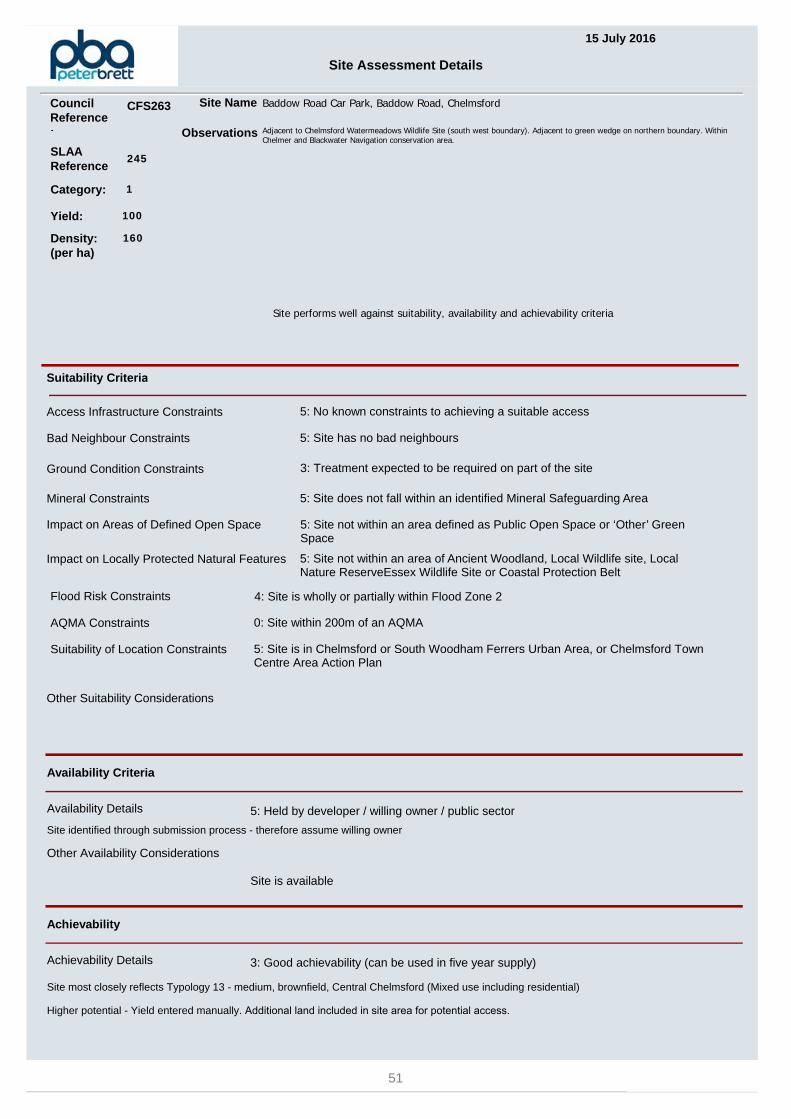
15 July 2016
Site Assessment Details
SLAAReference
248
Site Name Waterhouse Lane Depot and Nursery Waterhouse Lane, Chelmsford
Suitability Criteria
Access Infrastructure Constraints 5: No known constraints to achieving a suitable access
Ground Condition Constraints 3: Treatment expected to be required on part of the site
Flood Risk Constraints 5: Site is within flood zone 1
Site performs well against suitability, availability and achievability criteria
Category: 1
Other Suitability Considerations
Availability Criteria
Availability Details 5: Held by developer / willing owner / public sector
Site identified through submission process - therefore assume willing owner
Achievability
Other Availability Considerations
Site is available
Achievability Details 3: Good achievability (can be used in five year supply)
Site most closely reflects Typology 3 - Small, brownfield site,Urban Area (Residential)
Mineral Constraints 5: Site does not fall within an identified Mineral Safeguarding Area
Impact on Locally Protected Natural Features 5: Site not within an area of Ancient Woodland, Local Wildlife site, Local Nature ReserveEssex Wildlife Site or Coastal Protection Belt
Suitability of Location Constraints 5: Site is in Chelmsford or South Woodham Ferrers Urban Area, or Chelmsford Town Centre Area Action Plan
Bad Neighbour Constraints 5: Site has no bad neighbours
AQMA Constraints 5: Site not within 800m of an AQMA
Impact on Areas of Defined Open Space 5: Site not within an area defined as Public Open Space or ‘Other’ Green Space
Observations Currently used as a maintenance depot / nursery for the Council. Council Offices and 2 residential dwellings to front of site. Fallswithin a 'final stage sand and gravel' buffer zone.
Yield: 23
Density: (per ha)
45
Council Reference:
CFS266
53
WATERH
OUSE L
ANE
BEECHES ROAD
ASH TREE CRESCENT
CANU
DEN
ROAD
ASH TREE CLOSE
BAYN
ES PLA
CE
BEECHES CRESCENT
1
7
8
4
2
3
6
Allotment Gardens
19
18
14
25
17
21
46
30
45
78
10
13
57
68
34
16
40
28
56
47
15
31
23
GardenNursery
113
101
106
109
107
1 to 7
TCB
Tanks
El Sub Sta
2
1
Tanks
7
2
1
7
2
1 1
16
° Civic Centre, Duke Street, Chelmsford, CM1 1JETel 01245 606606 Web www.chelmsford.gov.uk
Directorate for Sustainable Communities0 20 4010
Metres
CFS266 Waterhouse Lane Depot and Nursery, Chelmsford
Crown copyright and database rights 2016 Ordnance Survey 100023562. Your are permitted to use this data solely to enable you to respond to, or interact with, the organisation that provided you with the data. You are not permitted to copy, sub-licence, distribute or sell any of this data to third parties in any form.
54

15 July 2016
Site Assessment Details
SLAAReference
249
Site Name Essex Police HQ and Sports Ground, New Court Road, Chelmsford
Suitability Criteria
Access Infrastructure Constraints 3: Some minor constraints to achieving a suitable access
Ground Condition Constraints 3: Treatment expected to be required on part of the site
Flood Risk Constraints 5: Site is within flood zone 1
Site performs well against suitability, availability and achievability criteria
Category: 1
Other Suitability Considerations
Availability Criteria
Availability Details 5: Held by developer / willing owner / public sector
Site identified through submission process - therefore assume willing owner
Achievability
Other Availability Considerations
Site is available
Achievability Details 3: Good achievability (can be used in five year supply)
Site most closely reflects Typology 13 - medium, brownfield, Central Chelmsford (Mixed use including residential)
Mineral Constraints 5: Site does not fall within an identified Mineral Safeguarding Area
Impact on Locally Protected Natural Features 5: Site not within an area of Ancient Woodland, Local Wildlife site, Local Nature ReserveEssex Wildlife Site or Coastal Protection Belt
Suitability of Location Constraints 5: Site is in Chelmsford or South Woodham Ferrers Urban Area, or Chelmsford Town Centre Area Action Plan
Bad Neighbour Constraints 5: Site has no bad neighbours
AQMA Constraints 5: Site not within 800m of an AQMA
Impact on Areas of Defined Open Space 5: Site not within an area defined as Public Open Space or ‘Other’ Green Space
Observations The site is currently Essex Police Headquarters and Police Training School. The site also includes a sports field. Footpath 60CFD runs directly adjacent to the eastern boundary of the HQ buildings. The perimeter of the sports field has several trees which are protected under a Tree Protection Order - number TPO/2011/004.
Yield: 451
Density: (per ha)
160
Council Reference:
CFS267
55
SANDFORD ROAD
SPRINGFIEL
D ROAD
STUMP LANE
TYRELLS CLOSE
OAKLEA AVENUE
YARWOOD ROAD
CHELM
ER RO
ADKINGSTON AVENUEKINGSTON CRESCENT
COPPINS C
LOSE
GAINSBOROUGH CRESCENT
ST MARGARET'S ROAD
MOUNTHILL AVENUENEWCOURT ROAD
CAVENDISH GARDENS
PEARSON GROVE
Sports Ground
2
7
1
8
9
6
3
Pond
to
3
1
2
9
to
2
2
2
2
2 1
2
6
7
8
2
1
1
1
1
8
2
9
1
21
1
1
2
3
°
Crown copyright and database rights 2016 Ordnance Survey 100023562. Your are permitted to use this data solelyto enable you to respond to, or interact with, the organisation that provided you with the data. You are not permittedto copy, sub-licence, distribute or sell any of this data to third parties in any form.
Civic Centre, Duke Street, Chelmsford, CM1 1JETel 01245 606606 Web www.chelmsford.gov.uk
Directorate for Sustainable Communities0 50 10025
Metres
CFS267 Essex Police HQ and Sports Ground, New Court Road, Chelmsford
56

15 July 2016
Site Assessment Details
SLAAReference
258
Site Name Former St Peters College, Fox Crescent, Chelmsford
Suitability Criteria
Access Infrastructure Constraints 5: No known constraints to achieving a suitable access
Ground Condition Constraints 3: Treatment expected to be required on part of the site
Flood Risk Constraints 5: Site is within flood zone 1
Site performs well against suitability, availability and achievability criteria
Category: 1
Other Suitability Considerations
Availability Criteria
Availability Details 5: Held by developer / willing owner / public sector
Site identified through submission process - therefore assume willing owner
Achievability
Other Availability Considerations
Site is available
Achievability Details 3: Good achievability (can be used in five year supply)
Site most closely reflects Typology 6 - large, greenfield site,Chelmsford Outer Fringe (Mixed use including residential)
Mineral Constraints 5: Site does not fall within an identified Mineral Safeguarding Area
Impact on Locally Protected Natural Features 5: Site not within an area of Ancient Woodland, Local Wildlife site, Local Nature ReserveEssex Wildlife Site or Coastal Protection Belt
Suitability of Location Constraints 5: Site is in Chelmsford or South Woodham Ferrers Urban Area, or Chelmsford Town Centre Area Action Plan
Bad Neighbour Constraints 5: Site has no bad neighbours
AQMA Constraints 5: Site not within 800m of an AQMA
Impact on Areas of Defined Open Space 5: Site not within an area defined as Public Open Space or ‘Other’ Green Space
Observations Site promoted for a mix of uses though residential led. TPO/2001/017 and TPO/1987/015 just outside of site on south west boundary. TPO/2002/013, TPO/1985/035 and TPO/2002/013 just outside of site on south eastern boundary.
Yield: 185
Density: (per ha)
40
Council Reference:
CFS276
57

LANGTON AVENUE
HIGHFIELD ROAD
KINGS R
OAD
FOX
CRES
CENT
TAYLOR AVENUE
ANDE
RSON
AVEN
UE
ACRES END
HOBART CLOSE
ST FABIAN'S DRIVE
QUEENSLAND CRESCENT
THE G
REEN
ALBANY CLOSE
COWELL AVENUE
LICHFIELD CLOSE
3
7
2
5
18
9
4
6
Pond
Gardens4
9
57
2
7
2
1
1
2
1
8
7
3
2
1
9
9
6
2
7
94
1
1
1
5
3
7
8
2
1
9
1
2
2
5
1
1
9
1
5
8
° Civic Centre, Duke Street, Chelmsford, CM1 1JETel 01245 606606 Web www.chelmsford.gov.uk
Directorate for Sustainable Communities0 50 10025
Metres
CFS276 Former St Peter's College, Fox Crescent, Chelmsford
Crown copyright and database rights 2016 Ordnance Survey 100023562. Your are permitted to use this data solelyto enable you to respond to, or interact with, the organisation that provided you with the data. You are not permittedto copy, sub-licence, distribute or sell any of this data to third parties in any form.
58

HOUSING CAPACITY IN CHELMSFORD URBAN AREA
Urban Area sites submitted for SLAA Category 2 - Developable
59

60

15 July 2016
Site Assessment Details
SLAAReference
233
Site Name Civic Centre Land Site, Duke Street, Chelmsford
Suitability Criteria
Access Infrastructure Constraints 5: No known constraints to achieving a suitable access
Ground Condition Constraints 5: Treatment not expected to be required
Flood Risk Constraints 5: Site is within flood zone 1
Site performs well against suitability criteria
Site faces some availability constraints
Site faces some achievability constraints
Category: 2
Other Suitability Considerations
Availability Criteria
Availability Details 5: Held by developer / willing owner / public sector
Site identified through submission process - therefore assume willing owner
Achievability
Subject to leases with two occupiersOther Availability Considerations
Site is potentially available
Achievability Details 2: Moderate achievability (cannot be used in first five years)
Site most closely reflects Typology 1 for residential - Small, brownfield site, Central Chelmsford (Residential) and Typology 14 (mixed use) - small, brownfield, Central Chelmsford (B1 Office use onlyHigher density potential, including taller buildings (10 storey), so yield entered manually
Mineral Constraints 5: Site does not fall within an identified Mineral Safeguarding Area
Impact on Locally Protected Natural Features 5: Site not within an area of Ancient Woodland, Local Wildlife site, Local Nature ReserveEssex Wildlife Site or Coastal Protection Belt
Suitability of Location Constraints 5: Site is in Chelmsford or South Woodham Ferrers Urban Area, or Chelmsford Town Centre Area Action Plan
Bad Neighbour Constraints 3: Site has bad neighbours with potential for mitigation
AQMA Constraints 5: Site not within 800m of an AQMA
Impact on Areas of Defined Open Space 5: Site not within an area defined as Public Open Space or ‘Other’ Green Space
Observations Cycle Route 45 runs along western boundary. Civic Centre building to north of the site is Locally Listed. War Memorial in the north of the site is Listed ref CBC/00983. North of site within West End Conservation Area.
Yield: 190
Density: (per ha)
160
Council Reference:
CFS241
61

PARKWAY
COVA
L LAN
E
VIADUCT RO
AD
FAIRF
IELD
ROAD
COVAL WELLS
PARKWAY
1
1014
2830
SL
Kings Tower
10a
Post
Offices
Posts
Issues
Subway
Statue
1 to 51
Theatre
11 to
105
Car Park
El Sub Sta
Car Park
Posts
El Sub
Sta
°
Crown copyright and database rights 2016 Ordnance Survey 100023562. Your are permitted to use this data solelyto enable you to respond to, or interact with, the organisation that provided you with the data. You are not permittedto copy, sub-licence, distribute or sell any of this data to third parties in any form.
Civic Centre, Duke Street, Chelmsford, CM1 1JETel 01245 606606 Web www.chelmsford.gov.uk
Directorate for Sustainable Communities0 20 4010
Metres
CFS241 Civic Centre land, Chelmsford
62
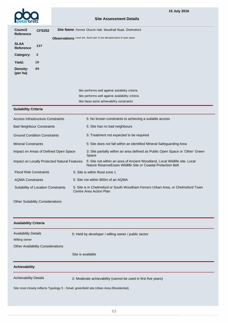
15 July 2016
Site Assessment Details
SLAAReference
237
Site Name Former Church Hall, Woodhall Road, Chelmsford
Suitability Criteria
Access Infrastructure Constraints 5: No known constraints to achieving a suitable access
Ground Condition Constraints 5: Treatment not expected to be required
Flood Risk Constraints 5: Site is within flood zone 1
Site performs well against suitability criteria
Site performs well against availability criteria
Site faces some achievability constraints
Category: 2
Other Suitability Considerations
Availability Criteria
Availability Details 5: Held by developer / willing owner / public sector
Willing owner
Achievability
Other Availability Considerations
Site is available
Achievability Details 2: Moderate achievability (cannot be used in first five years)
Site most closely reflects Typology 5 - Small, greenfield site,Urban Area (Residential)
Mineral Constraints 5: Site does not fall within an identified Mineral Safeguarding Area
Impact on Locally Protected Natural Features 5: Site not within an area of Ancient Woodland, Local Wildlife site, Local Nature ReserveEssex Wildlife Site or Coastal Protection Belt
Suitability of Location Constraints 5: Site is in Chelmsford or South Woodham Ferrers Urban Area, or Chelmsford Town Centre Area Action Plan
Bad Neighbour Constraints 5: Site has no bad neighbours
AQMA Constraints 5: Site not within 800m of an AQMA
Impact on Areas of Defined Open Space 3: Site partially within an area defined as Public Open Space or ‘Other’ Green Space
Observations Level site. South part of site allocated piece of open space.
Yield: 19
Density: (per ha)
65
Council Reference:
CFS252
63
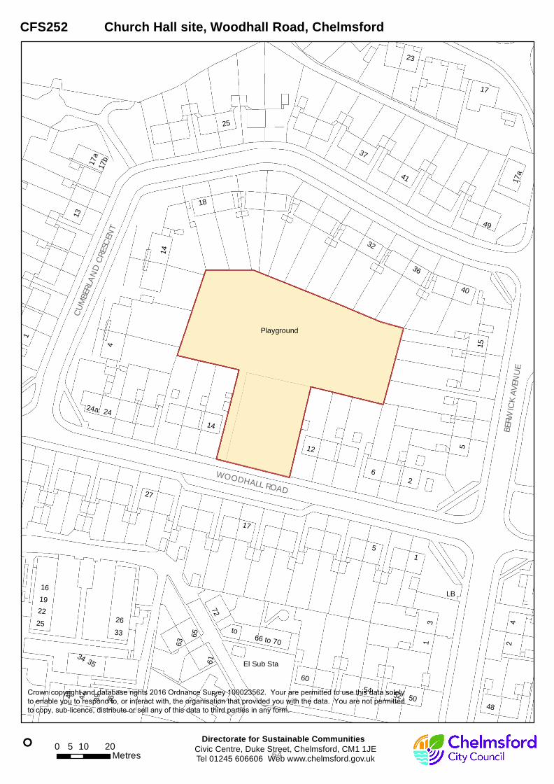
BERW
ICK A
VENU
E
WOODHALL ROAD
CUMB
ERLA
ND CR
ESCEN
T
6
1
5
3
2
4
to
Playground
45
22
25 26
42 39
33
16
36
19
37
27
18
23
24
48
54
12
52
14
60
41
17
50
72
13
49
40
15
32
34 35
65
61
63
LB
24a
17a
17b
66 to 70
El Sub Sta
1
5
17a
25
4
1
17
2
36
2
14
° Civic Centre, Duke Street, Chelmsford, CM1 1JETel 01245 606606 Web www.chelmsford.gov.uk
Directorate for Sustainable Communities0 10 205
Metres
CFS252 Church Hall site, Woodhall Road, Chelmsford
Crown copyright and database rights 2016 Ordnance Survey 100023562. Your are permitted to use this data solelyto enable you to respond to, or interact with, the organisation that provided you with the data. You are not permittedto copy, sub-licence, distribute or sell any of this data to third parties in any form.
64

15 July 2016
Site Assessment Details
SLAAReference
240
Site Name Garages rear of 44 St Nazaire Road, Chelmsford
Suitability Criteria
Access Infrastructure Constraints 0: Achieving a suitable access is likely to be subject to major constraints
Ground Condition Constraints 5: Treatment not expected to be required
Flood Risk Constraints 5: Site is within flood zone 1
Site performs well against suitability criteria
Site faces some availability constraints
Site performs well against achievability criteria
Category: 2
Other Suitability Considerations
Availability Criteria
Availability Details 5: Held by developer / willing owner / public sector
Site identified through submission process - therefore assume willing owner
Achievability
Subject to existing garage occupiers being relocated / selling their garages to CCC or CHPOther Availability Considerations
Site is potentially available
Achievability Details 3: Good achievability (can be used in five year supply)
Site most closely reflects Typology 3 - Small, brownfield site,Urban Area (Residential)
Mineral Constraints 5: Site does not fall within an identified Mineral Safeguarding Area
Impact on Locally Protected Natural Features 5: Site not within an area of Ancient Woodland, Local Wildlife site, Local Nature ReserveEssex Wildlife Site or Coastal Protection Belt
Suitability of Location Constraints 5: Site is in Chelmsford or South Woodham Ferrers Urban Area, or Chelmsford Town Centre Area Action Plan
Bad Neighbour Constraints 5: Site has no bad neighbours
AQMA Constraints 5: Site not within 800m of an AQMA
Impact on Areas of Defined Open Space 5: Site not within an area defined as Public Open Space or ‘Other’ Green Space
Observations Cycle Route 65 and footpath 2CFD run close to northern and eastern boundaries. TPO closest to boundary appears to have beenrevoked (TPO/1975/001). TPO/1993/012 relates to trees close to southern part of site boundary and this is still in place.
Yield: 12
Density: (per ha)
65
Council Reference:
CFS256
65

JARND
YCE
OLIVE
R WAY
ST NAZAIRE ROAD
TOBRUK ROAD
VARD
EN C
LOSE
CRUS
HTON
PLAC
E
3
2
6
5
8
7
11
23
13
26
36
29
16
2230
14
18
21
50
39
10
20
52
28
El
StaSub
Path
Posts
2
14
22
30
21
5
10
20
° Civic Centre, Duke Street, Chelmsford, CM1 1JETel 01245 606606 Web www.chelmsford.gov.uk
Directorate for Sustainable Communities0 10 205
Metres
CFS256 Garage site, St Nazaire Road, Chelmsford
Crown copyright and database rights 2016 Ordnance Survey 100023562. Your are permitted to use this data solely to enable you to respond to, or interact with, the organisation that provided you with the data. You are not permitted to copy, sub-licence, distribute or sell any of this data to third parties in any form.
66

15 July 2016
Site Assessment Details
SLAAReference
241
Site Name Garages rear of 27 Medway Close, Chelmsford
Suitability Criteria
Access Infrastructure Constraints 5: No known constraints to achieving a suitable access
Ground Condition Constraints 5: Treatment not expected to be required
Flood Risk Constraints 4: Site is wholly or partially within Flood Zone 2
Site performs well against suitability criteria
Site faces some availability constraints
Site performs well against achievability criteria
Category: 2
Other Suitability Considerations
Availability Criteria
Availability Details 5: Held by developer / willing owner / public sector
Site identified through submission process - therefore assume willing owner
Achievability
Subject to garage owners selling their garages to the Council & leaseholders being found alternative garaging / relinguish their lease.
Other Availability Considerations
Site is potentially available
Achievability Details 3: Good achievability (can be used in five year supply)
Site most closely reflects Typology 4 - Medium, brownfield site,Urban Area (Residential)
Mineral Constraints 5: Site does not fall within an identified Mineral Safeguarding Area
Impact on Locally Protected Natural Features 5: Site not within an area of Ancient Woodland, Local Wildlife site, Local Nature ReserveEssex Wildlife Site or Coastal Protection Belt
Suitability of Location Constraints 5: Site is in Chelmsford or South Woodham Ferrers Urban Area, or Chelmsford Town Centre Area Action Plan
Bad Neighbour Constraints 5: Site has no bad neighbours
AQMA Constraints 5: Site not within 800m of an AQMA
Impact on Areas of Defined Open Space 5: Site not within an area defined as Public Open Space or ‘Other’ Green Space
Observations
Yield: 50
Density: (per ha)
65
Council Reference:
CFS257
67
AVON ROAD
ROXWELL ROAD
MEDWAY CLOSE
THAMES AVENUE
ROXWELL AVENUE
2
5
3
1
8
to
One Bridge
10
28
41
18
30
2a
24
8880
53
17
29
25
71 65
Drain
Pavilion
Tennis Courts
2
2
1
° Civic Centre, Duke Street, Chelmsford, CM1 1JETel 01245 606606 Web www.chelmsford.gov.uk
Directorate for Sustainable Communities0 20 4010
Metres
CFS257 Garage site and land, Medway Close, Chelmsford
Crown copyright and database rights 2016 Ordnance Survey 100023562. Your are permitted to use this data solelyto enable you to respond to, or interact with, the organisation that provided you with the data. You are not permittedto copy, sub-licence, distribute or sell any of this data to third parties in any form.
68
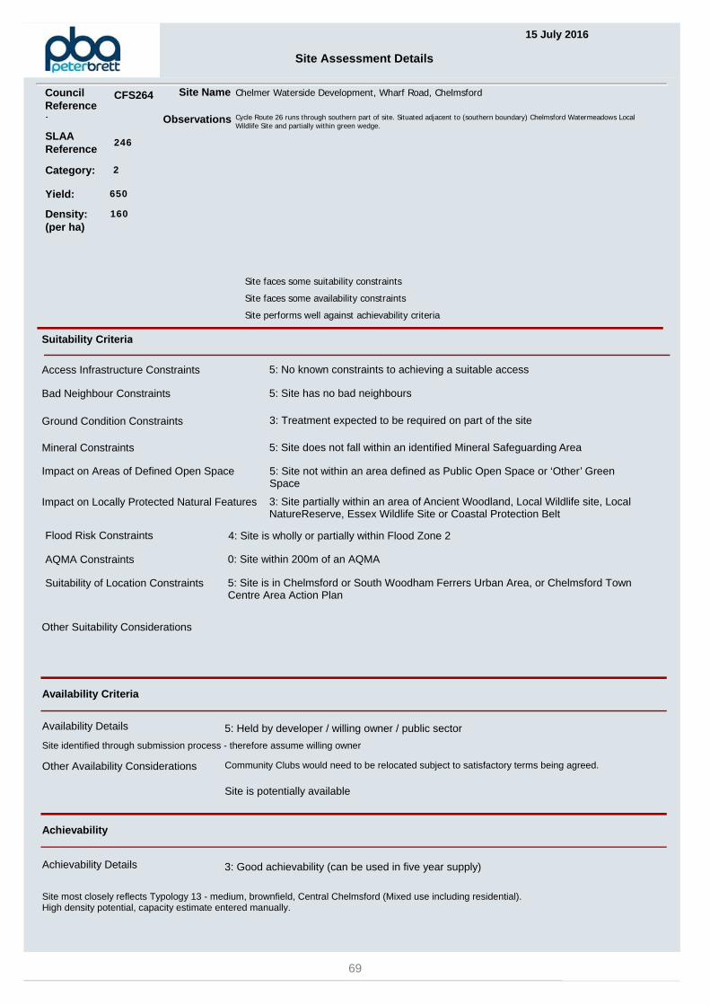
15 July 2016
Site Assessment Details
SLAAReference
246
Site Name Chelmer Waterside Development, Wharf Road, Chelmsford
Suitability Criteria
Access Infrastructure Constraints 5: No known constraints to achieving a suitable access
Ground Condition Constraints 3: Treatment expected to be required on part of the site
Flood Risk Constraints 4: Site is wholly or partially within Flood Zone 2
Site faces some suitability constraints
Site faces some availability constraints
Site performs well against achievability criteria
Category: 2
Other Suitability Considerations
Availability Criteria
Availability Details 5: Held by developer / willing owner / public sector
Site identified through submission process - therefore assume willing owner
Achievability
Community Clubs would need to be relocated subject to satisfactory terms being agreed.Other Availability Considerations
Site is potentially available
Achievability Details 3: Good achievability (can be used in five year supply)
Site most closely reflects Typology 13 - medium, brownfield, Central Chelmsford (Mixed use including residential).High density potential, capacity estimate entered manually.
Mineral Constraints 5: Site does not fall within an identified Mineral Safeguarding Area
Impact on Locally Protected Natural Features 3: Site partially within an area of Ancient Woodland, Local Wildlife site, Local NatureReserve, Essex Wildlife Site or Coastal Protection Belt
Suitability of Location Constraints 5: Site is in Chelmsford or South Woodham Ferrers Urban Area, or Chelmsford Town Centre Area Action Plan
Bad Neighbour Constraints 5: Site has no bad neighbours
AQMA Constraints 0: Site within 200m of an AQMA
Impact on Areas of Defined Open Space 5: Site not within an area defined as Public Open Space or ‘Other’ Green Space
Observations Cycle Route 26 runs through southern part of site. Situated adjacent to (southern boundary) Chelmsford Watermeadows Local Wildlife Site and partially within green wedge.
Yield: 650
Density: (per ha)
160
Council Reference:
CFS264
69
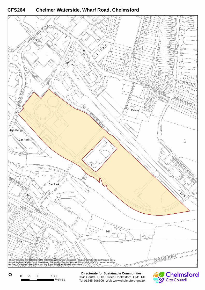
PARKWAY
HILL
ROAD
NAVIGATION ROAD
WHARF ROAD
HILL ROAD SOUTH
QUEE
N'S RO
AD
CHELMER ROAD
HIGH
BRID
GE RO
AD
BADDOW ROAD
LYNM
OUTH
AVEN
UE
BROC
KLEY
ROAD
SPRINGFIEL
D ROAD
BYRON ROAD
HILL CRESCENT
PARKWAY
High Bridge
1
23
4
7
5
8
9
Mill
Lock
Estate
to
Car Park
2
to
2
2
1
5
1
Car Park
1
3
7
to
1
2
8
2
to
1
°
Crown copyright and database rights 2016 Ordnance Survey 100023562. Your are permitted to use this data solelyto enable you to respond to, or interact with, the organisation that provided you with the data. You are not permittedto copy, sub-licence, distribute or sell any of this data to third parties in any form.
Civic Centre, Duke Street, Chelmsford, CM1 1JETel 01245 606606 Web www.chelmsford.gov.uk
Directorate for Sustainable Communities0 50 10025
Metres
CFS264 Chelmer Waterside, Wharf Road, Chelmsford
70

HOUSING CAPACITY IN CHELMSFORD URBAN AREA
Category 3 - Non-Developable
71

72

Housing Capacity in Chelmsford Urban Area – Discounted Sites
Address CUA ref Gross Site Area (ha)
Potential residential capacity
Reason for discounting
ARU CUA2 2.2 124 Outside SLAA periodMarriages Mill CUA4 1.3 176 Outside SLAA periodHoffmann's Way offices CUA5 1.07 0 Business use onlyRailway sidings CUA6 0.97 0 Business use onlyYMCA, The Snip, Clarke & Oritz (Bankside)
CUA10 0.24 70 Land assembly issues
Empire House, Regina Rd and Council car park
CUA12 0.16 24 Outside SLAA period
Riverside Retail Park, Victoria Road
CUA13 0.24 22 Outside SLAA period
47-73 Victoria Road CUA14 0.51 36 Land assembly issuesRiverside Ice & Leisure car park; & Waterloo Lane car park
CUA15 0.69 88 Valuable existing use
Ski Plus, adjacent retail premises
CUA18 0.29 38 Outside SLAA period
Iceland, Burgundy Court, parking at rear
CUA19 0.17 46 Outside SLAA period
Meadows II surface car park
CUA22 0.19 27 Outside SLAA period
Friars Walk parking areas, Amlin, Barrack House
CUA24 0.48 128 Land assembly issues
George Street car park CUA25 0.38 54 Valuable existing useMoulsham Street car park
CUA26 0.23 24 Valuable existing use
Mildmay Road Garage Site, r/o 85-99
CUA27 0.08 5 Under 10 units
Former Tesco Homestore
CUA29 1.3 0 Business use only
Railway Street car park north side, south side, workshop
CUA31 0.62 81 Valuable existing use
Coval Lane car parks CUA35 0.63 56 Valuable existing useRectory Lane East car park
CUA38 0.2 0 Valuable existing use
ECC overflow car park, Molrams Lane, Gt Baddow
CUA49 0.83 9 Under 10 units
ECC Highway depot, Springfield
CUA50 2.05 0 Business use only
Homelands (B&Q) CUA51 0.3 0 Business use onlyCar Auction site CUA53 4.1 0 Business use onlyFreighter House, Drovers Way
CFS254 2.87 0 Business use only
TOTAL 22.1 1008
73