Embed Size (px)
Citation preview

Nottingham City
land and planning policies
Development Plan Document
Local Plan Part 2
Infrastructure Delivery Plan Submission Version
Partial update March 2018

Quick Guide to the Nottingham Infrastructure Delivery Plan to the
Land and Planning Policies Development Plan Document Submission
Version of the Land and Planning Policies (LAPP) document (Local
Plan Part 2) (see www.nottinghamcity.gov.uk/localplan)
Purpose of this document:
The Nottingham City Land and Planning Policies Development Plan
Document (Local Plan Part 2) Submission Version March 2018 forms part
of the Local Plan for Nottingham City along with the Core Strategy which
guides future development in Nottingham City.
The Local Plan Part 2 contains development management planning policies
and site allocations against which planning applications for future
development proposals in Nottingham City will be determined.
The Nottingham Infrastructure Delivery Plan (IDP) is a supporting
document, which forms a key part of the evidence base for the Nottingham
City Council Local Plan Part 2. The purpose of the IDP is to identify
infrastructure required to meet the spatial objectives and growth anticipated
by the LAPP. It considers a range of infrastructure categories and the
extent to which each is a constraint to the delivery of the LAPP. Where
possible it identifies the cost and delivery route for new infrastructure and
whether the infrastructure is critical to the delivery of the strategies. The IDP
has been produced in consultation with officers at the City Council and
external stakeholders and organisations.

Table of Contents
1. Introduction ............................................................................................................... 1
2. Policy Context ........................................................................................................... 2
3. Delivery by topic ....................................................................................................... 3
a) Transport .............................................................................................................. 3
b) Utilities (water) .................................................................................................... 15
c) Utilities (Energy) .................................................................................................. 17
d) Utilities (Digital Infrastructure) ............................................................................. 21
e) Flooding and Flood Risk ..................................................................................... 23
f) Health and Local Services ................................................................................... 27
g) Education ............................................................................................................ 29
h) Emergency Services (police, fire and ambulance) .............................................. 32
i) Waste Management (Collection and Disposal) .................................................... 35
j) Green Infrastructure and biodiversity ................................................................... 36
k) Heritage Assets ................................................................................................... 38
4. Plan Wide Viability .................................................................................................. 39
5. Monitoring & Review ............................................................................................... 49
Appendices
Appendix 1: Site allocation connectivity issues/enhancements
Appendix 2: Potential impact of proposed growth on water supply infrastructure assets
Appendix 3: Potential impact of proposed development on sewerage infrastructure assets
Appendix 4: Health and Services by Local Area
Appendix 5: Community issues/ enhancements
Appendix 6: Schools by Local Area
Appendix 7: Open space Issues/enhancements
Appendix 8: Biodiversity/Green Infrastructure Issues/enhancements
Appendix 9: Summary of Key Changes made (since Publication Version)
Appendix 10: List of Consultees

1
1. Introduction
1.1 The Nottingham Infrastructure Delivery Plan (IDP) is a supporting document, which forms a key part of the evidence base for the Nottingham City Council Local Plan Part 2, the ‘Land & Planning Policies Development Plan Document’ (LAPP). The purpose of the IDP is to identify infrastructure required to meet the spatial objectives and growth anticipated by the LAPP. It considers a range of infrastructure categories and the extent to which each is a constraint to the delivery of the LAPP. Where possible it identifies the cost and delivery route for new infrastructure and whether the infrastructure is critical to the delivery of the strategies. The IDP has been produced in consultation with officers at the City Council and external stakeholders and organisations.
1.2 This partial update has taken account of amendments to the LAPP between the Publication version and Revised Publication version.
1.3 The IDP should be read alongside the 2013 Greater Nottingham Infrastructure Delivery Plan (GNIDP). The GNIDP document, which remains relevant, was produced in support of the Local Plan Part 1, The Greater Nottingham Aligned Core Strategy.
1.4 The GNIDP assessed the potential impact on infrastructure arising from projected
housing growth, employment land provision levels and strategic development sites over the wider Greater Nottingham Housing Market Area, and was found to be sound at Public Examination of the Core Strategy. The GNIDP report was underpinned by significant analysis of transport modelling for the area. This IDP report will therefore not repeat work already undertaken for the Part 1 Local Plan, but will supplement and update it and focus on critical infrastructure which would prevent the plan from being delivered within the Nottingham City administrative area.
1.5 Throughout the preparation of the Local Plan and this IDP report, the Council has
consulted infrastructure partners, including statutory consultees, who contributed to the GNIDP to seek their views on proposed site allocations, and given consideration to comments made throughout the plan making process.
1.6 The IDP is a living document and it is anticipated that it will be amended over the
LAPP plan period in order to reflect opportunities and priorities as they arise.
Changes since LAPP Revised Publication Version
1.7 Since the release of the Revised Publication Version of the plan Sites PA5 - Ridgeway
and PA6 - Beckhampton Road have been reviewed in light of the fact that the community sports hub is no longer identified as a need in the Council’s Playing Pitch Strategy. Accordingly, some of the housing development originally identified for Ridgeway is to be accommodated on Beckhampton Road. Overall there is a modest uplift in housing numbers across the two sites.
1.8 Site PA22 - Western Boulevard is deleted from the plan as a housing site. It is currently occupied by Travelling Showpeople who would require alternative accommodation were the site to be developed. There is no known suitable available site for relocation, and therefore the site is not considered to have a reasonable prospect of being available within the plan period.
1.9 A number of changes have been made to the Policy Map to accurately reflect policy amendments as identified in the Schedule of Submission Changes, and to reflect up to date

2
information. Changes include the removal of safeguarding relating to the Ring Road major highway improvements scheme (now completed), and the addition of further safeguarded future cycle routes, identified in the City’s Cycle Action Plan (2017 Draft) .
1.10 Further changes, including amendments to site boundaries and uses proposed can
be viewed in the Submission version of the LAPP.
1.11 Progress has continued in implementing and securing funding for supporting
infrastructure schemes.
1.12 The IDP has therefore taken these changes into account and updated programming
information where appropriate.
2. Policy Context National Planning Policy Framework
2.1 The National Planning Policy Framework March 2012 (NPPF) states that in order to ensure that there is a reasonable prospect that planned infrastructure is deliverable in a timely fashion, it is important that Local Planning Authorities understand district wide development costs at the time Local Plans are drawn up.
2.2 The NPPF also set out that Local Authorities should plan positively for development and infrastructure required in the area to meet the objectives, principles and policies for their Local Plans. The guidance also acknowledges the importance of cross boundary working and the need to assess the quality and capacity of transport, water, energy, telecommunications, utilities, health and social care, waste and flood defence infrastructure Authorities should also meet forecast demands and take account of the need for nationally significant infrastructure within local areas.
2.3 The NPPF seeks to ensure that investment in business is not over-burdened by the
requirements of planning policy expectations. It states that planning policies should recognise and seek to address potential barriers to investment, including a poor environment or any lack of infrastructure, services or housing.
Aligned Core Strategy
2.4 The Greater Nottingham Aligned Core Strategies (ACS) was produced in partnership with the neighbouring authorities of Broxtowe Borough Council (BBC) and Gedling Borough Council (GBC), and is in close alignment with Rushcliffe Borough Council (RBC) and Erewash Borough Council (EBC) Core Strategies. Core Strategies for all authorities were adopted in 2014.
2.5 The ACS was formally adopted in September 2014 and sets out the strategic planning policies and development principles for Nottingham City to guide development until 2028. The ACS was supported by the GNIDP. The GNIDP concluded that the strategic allocations identified within the Core Strategy were broadly viable but noted that the councils and developers would need to have a collaborative ‘open book’ approach to agreeing S106 contributions. The report also noted that the availability of land and apparent viability of some of the Core Strategy’s undeveloped green field sites pointed to wider issues in the market, related to finance and investor confidence, rather than site viability per se.

3
Local Plan Part 2
2.6 This plan will sit alongside the ACS and set out planning policies to guide how decisions on planning applications will be made in the future. It also allocates development sites for housing, employment and other uses and safeguards land for health, education and transport schemes. The Plan proposes that some 14,140 new homes, 236,150 sq m of office space and 23.15 hectares of industrial/warehouse land be provided within Nottingham City between 2017 and 2028. A significant amount of new employment development is also proposed in the City within the Plan period, at the Boots site, the Canal and creative Quarters and the Eastcroft part of the Waterside Area.
3. Delivery by Topic
3.1 This IDP considers Whole Plan Viability. The following categories of infrastructure are considered within this report: a) Transport; b) Utilities – Water; c) Utilities - Energy; d) Utilities – IT; e) Flooding and Flood Risk; f) Health and Local Services; g) Education; h) Emergency Services (police, fire and ambulance); i) Waste Management (Collection and Disposal); j) Green Infrastructure and biodiversity; k) Heritage Assets.
a) Transport
3.2 This section builds upon the GNIDP, which assessed strategic transport issues over the wider Greater Nottingham area, including the Nottingham City area in its entirety, and the cumulative proposals for housing and employment now carried forward into the LAPP. Transport Modelling undertaken for that process concluded that whilst there will be impact, the housing and employment growth levels set out in the now adopted ACS can be delivered without significant detriment to the operation of the transport networks. It assumed the delivery of currently committed schemes and delivery of the Smarter Choices, Public Transport and local highway mitigation and access improvements through the development management process and public sector funding streams. Any further transport modelling requirements were regarded as site specific requirements that could be dealt with as part of the detailed planning application process.
3.3 Having established that total growth levels proposed can be accommodated, it is not considered necessary at this stage to undertake further cumulative transport modelling of individual development sites. The focus of this section will be to consider the extent to which the proposed Local Plan allocation sites are supported by appropriate local infrastructure including the Transport Networks (highways, bus, and light rail), Rail and Walking and Cycling Routes.

4
3.4 Nottingham City is a compact and high-density urban area which benefits from an excellent existing transport network. The proposed allocation sites, by nature of their sustainable locations, will benefit from existing transport infrastructure provision and a significant programme of highway improvement schemes has been programmed in or commenced in anticipation of the proposed future growth, to further improve the transport network.
Nottingham Core Strategy
3.5 The strategic planning framework for development in Nottingham is set out by the ACS. Policies 2 (Spatial Strategy) and 14 (Managing Travel Demand) have a direct impact on transport Infrastructure issues within the City. Policy 2 seeks to achieve sustainable development and reduce the need to travel by private car through a strategy of urban concentration with regeneration, and also sets out a number of large strategic development sites in the City. Policy 14 sets out a hierarchical approach for transport, prioritising sites accessible by walking, cycling and public transport first, to ensure the delivery of sustainable development. Nottingham Local Transport Plan
3.6 The Nottingham Local Transport Plan 3 outlines the City Council's long-term transport strategy and sets out a three-year rolling investment programme. The current LTP came into effect on 1 April 2011. The Councils five overarching strategic objectives for transport are set out below:
Deliver a world-class sustainable transport system which supports a thriving economy and enables growth;
Create a low carbon transport system and a resilient transport network;
Improve access to key services, employment, and training including creation of local employment and training opportunities;
Improve the quality of citizens’ lives and transform neighbourhoods;
Support citizens to live safe, independent and active healthy lifestyles.
Key Transport Issues
3.7 The key transportation issues relevant to the Nottingham City area are:
Accessing communities and services by sustainable modes of transport;
Minimising congestion and pollution;
Making best use of existing transport infrastructure and assets;
Supporting healthy lifestyles;
Minimising and reducing carbon emissions.
Bus/tram Network
3.8 Nottingham benefits from well-established bus networks, and the Nottingham Express Transit (NET) tram. Public transport patronage within the City is very high compared to many English Cities, with 78.26 million passenger journeys by bus or tram in 2016/2017 within Greater Nottingham, including 15.3 million on the tram. The City has won recognition for its successful management of travel demand, and for reversing national trends by increasing public transport use even during periods of strong economic growth.
5
3.9 Around 90% of Nottingham’s current bus network is operated by commercial services, with the main operators being Nottingham City Transport and Trentbarton. Other operators currently include Yourbus, Skills AOT and Marshalls.
3.10 The remaining 10% of the network is run under tendered contracts, with financial
support, service specification and fares determined by the City Council. These services have a generic Linkbus brand and are designed to fully integrate with the rest of the network. They ‘fill in the gaps’ left by commercial operation either on a long term basis or in the short term pending them becoming commercially viable.
3.11 The linkbus network takes around 4 million passengers a year and includes:
Citylinks: park and ride and works services from Queens Drive to the City Centre;
Ecolink: park and ride and retail services from Victoria Retail Park and Racecourse to the City Centre
EasyLink: is a fully accessible door to door service operated by Nottingham Community Transport;
Medilink: subsidised park and ride from Queens Dr and Wilkinson St to both hospitals;
Localinks: a series of local connections to the district centres and the City Centre;
Worklinks: a series of connecting peak services from the City Centre to employment zones;
Shoplink: a small network of bus services providing links between communities and shopping facilities;
Collegelink: connecting service from the City Centre to Bilborough College.
3.12 Nottingham City Transport (NCT) and Trent Barton, the primary public transport operators in Greater Nottingham have commented on the Greater Nottingham Infrastructure Delivery Plan. They indicated (without prejudice to decisions on future services) that for the most part, new development proposed in the Core Strategy is likely to be served by existing commercial services or alterations to existing services.
3.13 Nottingham City Transport have also reviewed the proposed allocation sites in the
LAPP and have advised that due to the size and location of most of the sites, for the period 2015 -2028 the vast majority would be easily accessible to the existing NCT commercial bus route network. NCT did however note that 4 proposed development site allocations (Boots, Woodhouse Park, Waterside Daleside Road (Eastpoint), Waterside Daleside Road (Trent Lane Basin)) were in locations considered to be more remote from the commercial network, and that at least initially; an element of kick start funding would be required to sustain a bus service.
3.14 Measures are now programmed in to address these identified issues, also benefiting
the wider City area. Bus improvement measures will help facilitate greater access to the Boots and Waterside sites. In accordance with the S.106 planning agreement associated with the planning permission for up to 300 homes at Woodhouse Way the site owner is required to make financial contributions of £251,250 towards public transport serving the development. Residential development has now commenced at Trent Basin and retail park development at Eastpoint, Daleside Road has been completed.
3.15 On 19 October 2017, central government announced that 76 projects had been
successful in bids to the 3.15 National Productivity Investment Fund programme, as

6
part of a £244 million package nationally from the £490million fund for local roads. The £2.4 million bid for Contactless and Mobile Public Transport Ticketing across the Robin Hood area, which Nottingham City Council submitted was successful in this announcement.
3.16 Work commenced on the Southern Growth Corridor scheme in October 2016. The
scheme is included in the D2N2 Local Transport Board Infrastructure Programme for delivery in 2018. The route will run from Daleside Road (east of Nottingham city centre) through to Beeston (in the west) connecting with Racecourse Park and Ride site, the Creative Quarter (city centre), the Waterside and Southern Gateway regeneration areas, Queens Drive Park and Ride and the Nottingham Enterprise Zone (Boots site), potentially extending through to Beeston.
3.17 The route will include new low emission vehicles only lanes, running in each direction
of the road. The EV lanes, which will also be used by electric buses, will be accompanied by a cycleway and lanes for conventional vehicles.
Figure 1: Southern Growth corridor
3.18 The scheme comprises a package of major bus priority and other integrated transport
measures running east-west to create a high quality, frequent cross-city bus corridor linking key regeneration zones, areas of housing, employment and commercial development. Proposed improvements include road widening, junction remodelling and Intelligent Transport Systems measures to improve the efficiency of bus movements.

7
3.19 The Boots site will also benefit from infrastructure improvements included in the D2N2
Strategic Economic Plan Infrastructure Programme for delivery in 2018 for the Nottingham Enterprise Zone.
3.20 Successful grant funding from the green bus fund together with funding from the Workplace Parking Levy enabled the expansion of the electric buses across the city, taking the total number of electric buses in Nottingham to 58. The electric bus network will support key existing and future employment land sites within the Nottingham area.
3.21 Nottingham City Transport, in partnership with the council, has also been awarded
grant funding under the government’s OLEV Low emission bus scheme. £4.4m has been awarded to buy 53 bio-gas fuelled double deckers, and the installation of supporting fuelling infrastructure at the Parliament Street garage. These buses were added to the NCT fleet in 2017.
8
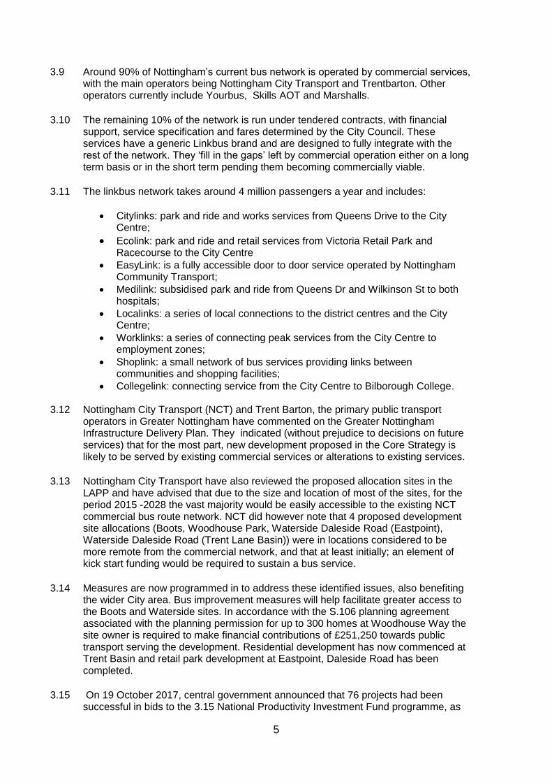
Figure 2: Electric bus network

9
3.22 Proposed allocation sites in the north of the City, in particular those in and around Bulwell and Basford areas, enjoy access to the existing Line One of the NET, which runs from Nottingham centre and has stops at key locations through to Hucknall, and includes a spur to Phoenix Park, adjacent to the proposed Stanton Tip allocation site.
3.23 The 2nd phase extension to the NET system is now completed and further improves access to and within the built-up area, including connectivity to Clifton and Beeston/Chilwell. This greatly benefits proposed site allocations to the south and south west of the City.
Figure 3: NET Phase Two network
Rail
3.24 Nottingham enjoys excellent access to the rail network with a main line Station close to the City Centre, which connects to the north of the City at Bulwell town centre. Additionally, possible further rail stations are safeguarded within the emerging local plan at Faraday Road, Beechdale, and Wollaton.
3.25 In November 2016 the Transport Secretary announced route refinements for both the Eastern and Western legs of the proposed High Speed Two route north of Birmingham.
3.26 In Nottingham, the high speed line follows the M1 corridor. The route has only seen
minor changes to the alignment in this area. It has been moved east by approximately 15m at the southern portal of the proposed tunnel, and 10m east at Bulwell Wood (close to Nottingham Business Park). Northwards of Strelley Village the vertical alignment has changed again, with the route being up to 3m higher to improve
10
clearances over watercourses and roads. As with the 2013 alignment, the line cuts through Nottingham Business Park in the Nottingham City Council area, and would affect some businesses in this estate.
3.27 Whilst there are variations to some parts of the route, minor changes to the alignment
within Nottingham City at Strelley were regarded as ‘refinements’ and considered to have “no appreciable change in impact.”
3.28 Safeguarding Directions were issued in July 2017 to protect planned infrastructure from conflicting development for the entire Phase 2b route. It is planned that a hybrid bill for Phase 2b will be deposited by the end of 2019, with the full network opened in 2033. Walking & Cycling
3.29 A key principle of the Council’s Planning and Transport strategy is the ambition to link new developments to the existing walking and cycling networks, making improvements to those networks where necessary. Whilst all sites are expected to provide convenient and safe cycling and walking links, some sites have the potential to provide wider benefits with the creation of new links between communities or to strategic cycle and walking routes. These individual requirements for walking and cycling measures are included within wider development principles for each proposed site allocation, and can be viewed in Appendix 1. Work is now underway on producing a Local Cycling and Walking Infrastructure Plan (LCWIP), which will outline strategic walking and cycling routes in future.
3.30 There is already an extensive network of cycle routes crossing the City area, including a section of the National Cycle Network (Route 6) which runs parallel to the proposed Chalfont Road allocation site.
3.31 Nottingham City Council secured £6.1 million from the D2N2 Local Enterprise
Partnership (LEP) process to invest in and kick start an overhaul of Nottingham's cycle facilities. The funding started in April 2015 and runs through to March 2018. The measures are being delivered in collaboration with a number of partner organisations.
3.32 The Nottingham Cycle Ambition Package (NCCAP) will have a major impact on how people travel to work, a reduction in congestion, improve the health of residents, and attract investment through an improved transport network and public realm. In brief the projects include:
Enhanced north-to-south and east-to-west cross city cycle corridors;
A network of cross city centre cycle routes;
Improved off road routes through parks and green spaces;
Improved neighbourhood cycle facilities.
3.33 The Infrastructure improvements for the Boots Enterprise Zone include upgraded pedestrian and cycle links, linkages to local public transport services and surrounding areas, including a new pedestrian/cycle bridge over the railway line, an upgraded bridge over the Beeston Canal linking with the Big Track leisure route and upgraded cycle links.

11
Highways
3.34 Several significant highway schemes have been programmed in by the City Council which will serve to assist the highway network in accommodating the growth proposed in the Local Plan. Nottingham Inner Ring Road Strategy (City Centre North)
3.35 This scheme is included in the D2N2 Local Transport Board Infrastructure Programme for delivery beyond 2018/19, subject to business case approval. It aims to achieve transformational change of the Inner Ring Road and city centre streetscape to support creation of a city centre conference quarter area in the heart of the Royal Quarter. Building on the Turning Point North scheme which was completed in 2006 which recast bus services and traffic movements in the area, enabling the delivery of high quality public realm around the Victoria Shopping Centre, Nottingham Trent University city centre campus, the Guildhall, Theatre Royal and the Playhouse. The proposed works will involve the remodelling of key junctions within the area, rationalising of bus services and further pedestrian environment improvements to the public realm including road closures and traffic restrictions. Connecting Eastside Phase 2
3.36 Eastside Phase 2 is a transport infrastructure and associated access and public realm package to serve the Creative Quarter, and forms part of the wider City Centre transport strategy to help deliver the City’s key Economic Growth Plan objectives. The required infrastructure to complete the Connecting Eastside traffic reprioritisation scheme includes the following elements:
Completion of a two way through-traffic route on Lower Parliament Street between Southwell Rd and London Rd;
Bellar Gate/Belward Street/Cranbrook Street bus loop and local access improvements;
Pedestrian priority improvements.
3.37 These improvements will greatly improve access to the whole Creative Quarter area and allow a more logical route for through traffic to be introduced separated from local access movements. In particular an extended bus loop will allow services that currently terminate in the north of the City to be re-routed via the Creative Quarter and redeveloped Broadmarsh/Canal Quarter area. Turning Point South
3.38 Turning Point South (incorporating the Southern Relief Route Upgrade and Carrington Street) is a package of transport measures being identified to complement the Broadmarsh Centre redevelopment proposals and provide a step-change in public realm quality, transforming the Broadmarsh area.
3.39 Key elements of the scheme might include:
Enhanced pedestrian facilities on Collin Street;
Alterations to the Maid Marian Way alignment around the current car park to provide an improved alternative route between Maid Marian Way and the
12
Southern Relief route for through traffic including an all movements junction with Canal Street;
Some access restrictions on Canal Street between Maid Marian Way and Middle Hill;
Carrington Street pedestrianisation initially between Canal Street and Collin Street;
Canal Street/Carrington Street junction simplification;
Canal Street/Middle Hill junction remodelling;
Potential future NET tramstop on Middle Hill, adjacent to the proposed Central College site to serve the Broadmarsh area;
Southern Relief Route Upgrade – this comprises junction improvements at London Road/Queen’s Road and Queen’s Drive/Waterway Street West.
Ring Road Major
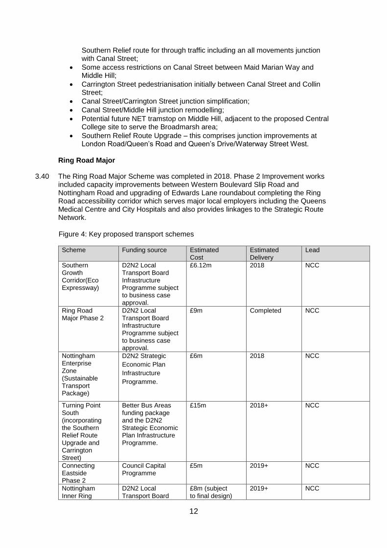
3.40 The Ring Road Major Scheme was completed in 2018. Phase 2 Improvement works included capacity improvements between Western Boulevard Slip Road and Nottingham Road and upgrading of Edwards Lane roundabout completing the Ring Road accessibility corridor which serves major local employers including the Queens Medical Centre and City Hospitals and also provides linkages to the Strategic Route Network. Figure 4: Key proposed transport schemes
Scheme Funding source Estimated Cost
Estimated Delivery
Lead
Southern Growth Corridor(Eco Expressway)
D2N2 Local Transport Board Infrastructure Programme subject to business case approval.
£6.12m 2018 NCC
Ring Road Major Phase 2
D2N2 Local Transport Board Infrastructure Programme subject to business case approval.
£9m Completed NCC
Nottingham Enterprise Zone (Sustainable Transport Package)
D2N2 Strategic
Economic Plan
Infrastructure
Programme.
£6m 2018 NCC
Turning Point South (incorporating the Southern Relief Route Upgrade and Carrington Street)
Better Bus Areas funding package and the D2N2 Strategic Economic Plan Infrastructure Programme.
£15m 2018+ NCC
Connecting Eastside Phase 2
Council Capital Programme
£5m 2019+ NCC
Nottingham Inner Ring
D2N2 Local Transport Board
£8m (subject to final design)
2019+ NCC

13
Scheme Funding source Estimated Cost
Estimated Delivery
Lead
Road Strategy (City Centre North)
Infrastructure Programme subject to business case approval.
Nottingham Cycle Ambition Package (NCCAP)
D2N2 Strategic Economic Plan Infrastructure Programme.
£6.1m 2018 NCC
Woodhouse
Way
S106 £251,250 Underway Developer
Smarter Choices
3.41 In addition to the programme of schemes detailed above, Nottingham City will continue to pursue a strategy which supports the promotion and application of Smarter Choices travel planning to influence travel behaviour and maximise the use of walking, cycling and public transport, alongside the necessary improvements to the highway network. Local access and highways issues will be considered on a site-by-site basis, as development sites come forward. Clean Air Zone
3.42 In July 2017, the Department for Environment, Food and Rural Affairs (DEFRA) published its revised proposals for tackling Nitrogen Dioxide (NO2) Emissions. This included proposals for the establishment of Clean Air Zones within designated areas identified as breaching air quality thresholds. Nottingham City Council has been identified as one of 40 areas nationally that will be required to implement a Clean Air Zone. Work is currently underway to develop this proposal with a requirement to deliver this as soon as possible. Policy IN2 covers air quality issues, and SPD may be prepared as part of a wider comprehensive approach to air quality. Transport Conclusions
3.43 Nottingham City Council has a reputation for excellence in sustainable transport provision and has secured significant investment in transport infrastructure and public transport provision. The City has one of the most comprehensive and well used public transport networks in the country with a full programme of further improvements to further improve the efficiency of the highway network and encourage modal shift.
3.44 The strategic modelling work completed for ACS (and updated to include growth proposals for Rushcliffe Borough Council) considered the full quantum and likely distribution of development proposed in the LAPP. This strategic modelling confirmed that there was no requirement for any single large infrastructure scheme. As a consequence of the urban built up nature of Nottingham, the proposed development sites are located in highly sustainable locations which benefit from strong existing transport links. It is considered that the additions and enhancements programmed in, as listed in this section, would support the overall transport network in accommodating the overall effect of growth proposed over the plan period.
3.45 However, further transport assessments will be required at planning application stage as detailed proposals emerge for individual sites. It is not anticipated that major
14
highway interventions will be required over the plan period but there may be a need for localised improvements and measures to protect the operation of the principal road network. These are likely to mainly include junction improvement schemes. The cost of local highway interventions will be determined by route strategies and transport assessments at a site specific level as part of the development management process – with dialogue with adjacent highway authorities and Highways England where appropriate. The Boots site, which is located both within Nottingham City and Broxtowe Borough, serves as an example of a collaborative process in practice.
3.46 Nottingham City Council has well established working in partnership with adjacent districts, highway authorities, transport operators and Highways England on a diverse range of transport projects and initiatives (such as rail and highways infrastructure, public transport provision, integrated ticketing, cycling and walking and promoting sustainable travel behaviours). Nottingham City will continue to work closely with key partners in delivering integrated, cross boundary transport planning through its engagement in Midlands Connect and Midlands Engine.
3.47 Although major changes to the City Centre highway network/public realm are planned
by the City Council, these are not critical to the delivery of individual sites. The Boots site requires a package of measures to facilitate the planned development, and here, planning permission has been granted for the site and a funding package for the associated works is in place.
3.48 However, sites may require local highway/connectivity improvements as part of the
Development Management process. Many of these will result in enhanced local connectivity, benefitting both the development site and existing communities. Key proposed transport schemes are listed in figure 4 and enhancements incorporated in development principles for sites are set out in Appendix 1
3.49 It is concluded that there are no critical transport issues which would prevent the
delivery of the LAPP.

15
b) Utilities – Water
3.50 The key utility issues for the Nottingham City area are:
The provision of sufficient clean water supply for both existing and new developments;
Satisfactory waste water and sewerage disposal; and
Ensuring minimal impact on water resources and water quality.
3.51 The Water Cycle Scoping Study and an Outline Water Cycle Study were completed for Greater Nottingham and Ashfield District (May 2009 and February 2010). The Outline Water Cycle Study (OWCS) considered the impact of the ACS on the Water Resources/Supply, Waste Water Treatment and Sewerage, Sewer Flooding and Surface Water Drainage (see also flooding section), Water Quality and Fluvial Flooding, (see later section for information on flooding).
3.52 The area covered by the IDP falls entirely within the remit of one Water Company - Severn Trent Water (STW) which has responsibility for providing clean water and sewerage services. Both STW and the Environment Agency (EA) were represented on the Steering Group responsible for overseeing the Water Cycle Studies. Following completion of the Outline Water Cycle Study ongoing dialogue with Severn Trent Water and the Environment Agency has taken place to discuss specific constraints identified within the Study. The cumulative impacts of growth are particularly important in assessing water supply and services.
3.53 STW’s Final Water Resources Management Plan (2014) sets out how the company will
provide supplies of water to customers over the next 25 years and beyond. The plan explains the challenges and uncertainties and sets out a range of options to ensure that future demand for water can be met. The strategy includes demand management and leakage reduction, as well as new water resource development in the longer term. The plan focuses on providing reliable water supplies at least cost, and in a way that will minimise the impact on the natural environment. The plan includes assumptions on the level of future growth based on figures previously set out within the East Midlands Regional Spatial Strategy, and now taken forward in the adopted ACS.
3.54 STW are currently preparing a revised Water Resources Management Plan looking at
water supply over the next 25 years. The final plan is anticipated in Autumn 2018.
3.55 The City Council is adopting the National ‘optional’ Standard limiting water usage in
house designs to 110 litres per person per day. The viability work undertaken to support the LAPP includes cost assumptions for this standard. STW have appraised development sites proposed in the LAPP to assess potential impact on both water and sewerage supply infrastructure assets. The results can be viewed in Appendices 2 and 3 respectively. A red/amber/green scoring assessment has been made against each site identifying those sites where:
Network capacity available adjacent to/ close proximity to the site (Green)
Some off-site work will be required to support the existing network (orange)
Extensive off-site work required that may impact on site delivery. (Red)
3.56 A single site was identified within the ‘red’ category in relation to potential impact on sewerage infrastructure. The site at Chingford Road (PA25) was considered to be a large site that will require connection into a small diameter system. There is also known external flooding downstream that this site will impact on. It is anticipated that

16
infrastructure upgrades would be required to accommodate flows. However, it is important to note that STW have advised that having a ‘red’ assessment doesn’t mean that potential impact would prevent implementation of the site, but that more work would be required to provide the capacity to meet the demands of the completed site. The Development Principles for this site requires that Developers undertake early engagement with Severn Trent Water regarding connection to water/waste water services. Water Conclusions
3.57 The Policies within the LAPP would serve to promote the sustainable use of water, as well as protect water quality.
3.58 No critical issues have been identified in respect of sewerage infrastructure that would prevent the delivery of the LAPP, subject to the further work identified by Severn Trent regarding allocation site PA25 (Chingford Road) site in respect of provision of sufficient capacity to meet the demands of the completed site.
3.59 Given STW’s Water Resources Management Plan assumptions for future development
and their analysis of the potential impact to water infrastructure assets, it is considered that the water network would be able to accommodate the overall effect of growth proposed over the plan period.

17
c) Utilities- Energy
3.60 The key Energy issues for the Nottingham City area are:
Providing the ability for new developments to access gas and electricity services without adverse impacts on existing provision;
How to maximise potential for generation and use of green energy from water, wind, sun, ground and waste sources.
3.61 This section considers the potential for new developments to be supported by appropriate energy infrastructure including Electricity, Gas and Green Energy. Electricity
3.62 National Grid operates, owns and maintains the national electricity transmission network in England providing electricity supplies from generating stations to local distribution companies. The company has a statutory duty to develop and maintain an efficient, co-ordinated and economical transmission system of electricity and to facilitate competition in the supply and generation of electricity.
3.63 National Grid do not distribute electricity to individual premises but their role is to ensure a reliable and quality supply to all via a high voltage electricity system, which operates at 400,000 and 275,000 volts and is transmitted by a network of pylons, overhead lines, underground cables and substations.
3.64 To facilitate competition in the supply and generation of electricity, National Grid must
offer a connection to any proposed generator, major industry or distribution network operator who wishes to generate electricity or requires a high voltage electricity supply. Often proposals for new electricity projects involve transmission reinforcements remote from the generating site, such as new overhead lines or new development at substations. If there are significant demand increases across a local distribution electricity network area then the local network distribution operator may seek reinforcements at an existing substation or a new grid supply point. In addition National Grid may undertake development works at its existing substations to meet changing patterns of generation and supply. Electricity Distribution and Supply
3.65 Separate regional companies own and operate the electricity distribution networks that comprise overhead lines and cables at 132,000 volts and below. It is the role of these local distribution companies to distribute electricity to homes and businesses. Western Power operates the local distribution network for the Nottingham area.
3.66 Western power assessed the LAPP development sites noting that the assessment cannot take into account future connections to the network, and has not estimated the effect of future technology such as the widespread use of electric vehicles, etc. which could change the electricity landscape significantly. Given the existing electricity network and planned reinforcement projects which are already in the pipeline, the majority of the residential sites can be supplied from existing major infrastructure and would at most require standard reinforcement works at 11kV such as the installation of 11kV cables to

18
reach the new sites, and of course local distribution substations and cables to provide the low voltage supplies to the houses. This may change and Primary Reinforcement may be required if the electricity capacity which is currently available should be used up by other customers and consumers.
3.67 One area of concern identified by Western Power, is the area to the east of London Road, encompassing the sites 83, 82, 85 from Area Committee East (Dales, Mapperley and St Anns), and sites PA75, 68, 70, 80, 79, 77, 76, 78, 81 from Area 8 (Bridge, Clifton North and South). The total estimated residential load is close to triggering the need for a new Primary Substation to create additional electricity capacity in this area, which in turn may require the construction of a new Bulk Supply Point to support the city centre Primaries. This was highlighted in the Greater Nottingham study as a requirement, and would certainly be needed if any additional loads from industrial or commercial customers were added. However the timing of the trigger for this reinforcement will depend on the general movement on the network and is unlikely to be triggered by the residential loads alone.
3.68 Western Power therefore encourage any developer to apply for their electricity
connections in plenty of time to ensure an up-to-date assessment can be made for their site and any necessary action taken, but considering the current electricity network situation and only the residential loads in the Infrastructure Development Plan, then Western Power state that no major primary reinforcement would be required.
Gas Gas Transmission
3.69 National Grid owns and operates the high pressure gas transmission system in England
(including pipelines, compressor stations and distribution networks). National Grid has a duty to develop and maintain an efficient co-ordinated and economical transmission system for the conveyance of gas and respond to requests for new gas supplies in certain circumstances. New gas transmission infrastructure developments (pipelines and associated installations) are periodically required to meet increases in demand and changes in patterns of supply. Developments to the network are as a result of specific connection requests e.g. power stations, and requests for additional capacity on the network from gas shippers. Generally network developments to provide supplies to the local gas distribution network are as a result of overall demand growth in a region rather than site specific developments.
Gas Distribution
3.70 National Grid also owns and operates the lower-pressure distribution gas mains in the
East Midlands delivering gas to homes and employment sites. Reinforcements and developments of local distribution network generally are as a result of overall demand growth in a region rather than site specific developments. A competitive market operates for the connection of new developments.
3.71 National Grid, having reviewed the proposed development sites in the LAPP, confirmed
that there were no identified constraints in terms of National Grid Infrastructure. Furthermore they reported that local growth and development would not have a significant effect upon the strategic electricity or gas transmission network and additional growth would be unlikely to result in any capacity issues for the transmission networks. The existing transmission networks are likely to have the capacity to cope with additional demand. Further discussion is needed to assess the effect of future growth on local

19
distribution networks to identify what constraints exist in the distribution network and what additional infrastructure will be needed to serve growth. It will also be necessary to liaise with local distribution suppliers to determine through what mechanism any necessary infrastructure will be delivered. Green Energy
3.72 The adopted Core Strategy supports the application of an ‘energy hierarchy’ for new development encouraging design solutions which reduce energy use, use energy efficiently and maximise the use of low carbon and renewable energy sources. The GNIDP sought to establish at a strategic level whether there are constraints which might have a serious impact on the incorporation of Green Energy within new developments. The assessment was primarily informed by work commissioned by the East Midlands Councils – ‘Low Carbon Energy Opportunities and Heat Mapping for Local Planning Areas across the East Midlands’ (March 2011). Consultation was also undertaken with the Nottingham Energy Partnership and Enviroenergy.
3.73 The Low Carbon Opportunities1 (LCO) report (March 2011) commissioned by the East Midlands Councils assesses the technical potential for renewable and low carbon energy technologies across the East Midlands. The report does not provide guidance on specific sites but looks at the theoretical potential for renewable energy. The key conclusions of the report are included in the assessment below.
Solar Energy All areas within the Greater Nottingham Housing market area have considerable
potential for solar thermal and solar photovoltaic renewable energy;
Wind The area may be suitable depending on local characteristics;
Ground/Air There is considerable potential for air source heating and heat pumps across the
HMA (subject to site specific ground conditions);
Water There is limited potential for hydro generation across the area. However the report
makes little comment on the potential for water source heat pumps and this may
have some potential for LAPP sites close to water courses (such as the recent
development at River Crescent in Nottingham for example);
Waste/Biomass Nottingham has particular potential for the generation of energy from municipal and
commercial/industrial waste and waste wood.
3.74 A District Heating System operated by Enviroenergy serves part of Nottingham City Centre and provides heat and electricity from steam generated from the Eastcroft Energy from Waste Plant (EEFWP). Heat/energy capacity is closely linked to operation of the EEFWP, whilst physical extensions to the district heating network are largely reliant on external funding. Recent and committed extensions to the network have the potential to serve developments within the Waterside and The Canal Quarter.
1Low Carbon Energy Opportunities and Heat Mapping for Local Planning Areas Across the East Midlands: Final Report - Land Use Consultants, Centre for Sustainable Energy and SQW (March 2011)

20
3.75 Enviroenergy comment that large developments may have the critical mass to support local combined heat and power (CHP) generation. In 2014 the Council granted planning permission an Energy Park at Blenhiem Lane, Bulwell. Permission was given for an Energy from waste facility (160,000 tonnes of waste per annum capacity), manufacturing, research and development facility and associated offices. The Nottingham Energy Park is recognised as a major strategic priority for the city with potential to provide significant employment opportunities in the key low carbon and renewable sectors.
3.76 Changes to introduced by the Government via the National House Building Standards
mean that councils’ ability to influence the type and scale of renewable technology used in new homes is reduced. However, the Council will continue to encourage low carbon technologies and several large sites (such as Stanton Tip and Waterside) have the critical mass to support small scale decentralised energy generation.
Energy conclusions
3.77 No abnormal costs have been identified relating to electricity and gas transmission, distribution and supply. There may be additional costs related to local electricity distribution. Although Western Power has an extensive capital programme for reinforcement which is not attributable to individual developments they may recover costs of reinforcement works required to meet the needs of specific developments.
3.78 Lead in times for electricity distribution are the main potential constraint. However providers have indicated that for large developments there is usually sufficient supply for early phases to proceed whilst main works commence. Early dialogue between developers and utility providers is key.
3.79 Developers may be required to pay for two main elements – the full costs of local
infrastructure for the sole purpose of serving a development site and a proportion of any higher voltage reinforcement required to make the local connection (based on the proportion to be used by the development). Where adequate capacity exists ‘upstream’ reinforcement works may not be necessary. Smaller developments will probably be accommodated without additional cost.
3.80 Any extension to the District Heating System in Nottingham City Centre would require
developer/external funding. No cost information is available and estimates would be based on specific requirements.
3.81 Costs relating to the inclusion of green energy measures can be difficult to calculate and
may depend on the investment model used and return period and site specific circumstances.
3.82 No critical constraints have been identified for energy provision.
21
d) Utilities - Digital Infrastructure
3.83 The key Digital infrastructure Issue for the Nottingham City area is: • Satisfactory access to IT (Broadband and Telecommunications) to support businesses
and connected communities.
3.84 Provision of high-speed broadband services is particularly important to support the growth of knowledge based economies and has an increasing role in enabling sustainable home working patterns and supporting residents to be part of digital community with easy access to online information and services.
3.85 IT and telecommunication services can be provided by a range of suppliers but as with energy supply, this study focuses on establishing whether, in principle, reasonable access can be provided to development sites and locations. Two main suppliers for Greater Nottingham were invited to comment on the IDP – Openreach and Virgin Media.
3.86 Openreach owns and manages a local access network that connects homes and businesses to telephone exchanges. It also provides installation and maintenance services on behalf of Communications Providers. The Company’s approach to serving new sites is set out within ‘Builder’s guide to telecommunications infrastructure and installation’. In response to the GNIDP, Openreach confirmed that there are unlikely to be any limitations to broadband and telephone services for new developments and that the company is currently obliged to service new developments. Virgin Media did not respond and no further responses were received from consultees with regard to the potential impact of the proposed LAPP site allocations on digital infrastructure.
3.87 For knowledge based industries and media businesses, the provision of high speed/ dependable broad band services via fibre is becoming increasingly important. Nottingham City Council is developing digital strategies to meet the needs of the area needs, and is working with neighbouring authorities to coordinate approaches across the LEP area. Strategies include consideration of future business needs and how best to plan for and deliver high speed networks to employment sites and regeneration areas making the best use of existing assets.
3.88 The Portal site, located in queens Drive provides a new 90,000 sq ft carrier class
colocation data centre providing network connectivity and is an important centre for the storage, pooling and transmission of national and international high-speed data. The development of data centres elsewhere in the UK has been a stimulus to new high tech global employment opportunities as blue chip companies seek to be located as close as possible to the data centre for reasons of connectivity.
3.89 Nottingham City Council have agreed with British telecom for the operator to deploy free
public WiFi wireless Internet hotspots across much of the city centre, which should benefit 310,000 residents as well as local businesses and visitors. Openreach are building 41 key access points for the service throughout the city centre (including the Market Square, main shopping and leisure areas and the Creative Quarter). This service went live in 2015 and is still being rolled out.

22
Digital Infrastructure Conclusions
3.90 No abnormal constraints are identified for the delivery of the LAPP. There are no anticipated phasing constraints. The standard lead in time for Openreach is 3 to 6 months for larger developments (e.g. over 100 dwellings). No abnormal costs associated with digital infrastructure are anticipated. Openreach has previously confirmed that under its policy a set of standard site costs applies to developers.
23
e) Flooding & Flood risk
3.91 Flooding and flood risk are potentially the most significant physical constraints on use and development of land within Nottingham. The key issues are:
Minimising development in areas of flood risk;
Reducing and mitigating against flood risk;
Planning for future climate change via the location and design of development.
3.92 Flooding can occur from a number of sources including:
River flooding;
Groundwater;
Reservoir flooding;
Surface Water/Sewer Flooding;
Coastal Flooding.
3.93 The IDP considers all of the above with the exception of coastal flooding which is not relevant to Nottingham. Sewerage is considered in the Utilities Section.
3.94 A number of technical studies have been prepared by or with close consultation with the Environment Agency and Severn Trent Water and neighbouring authorities in Greater Nottingham. The source material for this chapter can be summarised as follows:
Scoping Water Cycle Study (Scott Wilson, 2009);
Outline Water Cycle Study (Entec,2010);
Trent Catchment Flood Management Plan (Environment Agency, 2008);
LowerDerwent Strategy (Environment Agency, 2008);
Fluvial Trent Strategy (Environment Agency, 2005);
River Leen and Day Brook Strategic Flood Risk Assessment (Black and Veatch, 2008);
Greater Nottingham Strategic Flood Risk Assessment (Black and Veatch, 2008 with update 2010, AECOM update 2017);
Ashfield District Council Strategic Flood Risk Assessment Level 1 (Ashfield District Council, 2009);
Environment Agency Flood Zone Maps;
Nottingham Left Bank Flood Alleviation Scheme;
Nottingham Right Bank Flood Alleviation Scheme;
Environment Agency Reservoir Flood Maps;
Environment Agency observations on policies and site allocations;
Information from Planning Applications.
i. River Flooding
3.95 The main source of flooding in Nottingham is from the River Trent and its tributaries, mainly the River Derwent and the River Soar. Other sources include the River Leen and the Day Brook, River Smite and other smaller brooks and dykes.
3.96 Flood Zones 2 and 3 of the River Trent affect Nottingham City. Significant flooding events related to the Trent occurred in 1998 and 2000 which highlighted the limitations of Nottingham’s flood defences and led to a review of flood risk and the publication of the Fluvial Trent Strategy. This strategy and the River Trent Strategic Flood Risk

24
Assessment have informed the development of the Nottingham Left Bank Flood Alleviation Scheme (FAS).
3.97 The FAS has reduced the risk of flooding to 16,000 homes and businesses along a 27 kilometre stretch of the River Trent, from Sawley to Colwick. The works aim to reduce the probability of flooding across Nottingham from two per cent (1 in 50 chance) in any given year to one per cent (1 in 100 chance). Work on the FAS was completed in Autumn 2012 and has a positive impact on a number sites and locations within Nottingham including the strategic site allocation at Boots Enterprise Zone (PA54). Leen and Day Brook
3.98 A Strategic Flood Risk Assessment for the River Leen and Day Brook was prepared in 2008. Flood risk from the Leen and Day Brook largely affects existing properties but the following areas including development sites within Nottingham City are affected: • Bulwell Town Centre; • Vernon Road; • P Z Cussons; • Bobbers Mill.
3.99 The Environment Agency have undertaken additional modelling across parts of the catchment which provides further information on the risk of flooding. An addendum to the SFRA was published in 2017. The River Trent flood model was updated in 2016 and the River Leen and Day Brook flood model was updated in January 2017. These models reflect the new climate change guidance and feature modelled flood outlines relating to climate change breach scenarios. The 2012 Trent Left Bank Flood Alleviation Scheme has reduced the area at risk of flooding in Nottingham City, particularly in the Nottingham University, Lenton, Queens Drive and Meadows areas. The River Trent Climate Change and Breach modelling identifies new and larger areas at a residual risk of flooding. There have also been updates to the fluvial modelling of the River Leen and Day Brook and the extent of the functional floodplain has increased in the Old Basford area, and flood zone 3a flood extent has increased in the Old Lenton area.
3.100 The development principles for the LAPP site allocations have been amended to take account of this new modelling, and the comments of the Environment Agency made at Revised Publication stage
Hucknall
3.101 Although outside the City boundary, flood risk issues in Hucknall are important to the Nottingham area. The River Leen and Day Brook SFRA indicate that some existing properties in parts of Hucknall are at risk of flooding. In addition, water from development into the River Leen and its tributary streams could have significant implications for flooding downstream in the City of Nottingham. Although rural catchments outside Nottingham City Council’s boundary currently do not contribute significant volumes of floodwater to the River Leen and Day Brook, small increases could exacerbate the existing flooding situation to the detriment of people and property in Nottingham.
3.102 The SFRA advises that where possible, major development proposals within the catchment area of the River Leen and Day Brook should seek to reduce volumes and peak flow rates of surface water generated by a development to pre-developed greenfield rates. Urban expansion and major development proposals within the District of Ashfield or the Borough of Gedling should assess the impact of additional surface water run-off on receiving watercourses. The Council will engage with Gedling and

25
Ashfield Council’s on the detail and content of their flood risk management policies to ensure that potential impacts of their developments on Nottingham is minimised.
3.103 The Site Assessment Background Paper sets out the council’s approach to the sequential and exception site analysis and sets out those sites which are at risk of flooding - informed by the SRFA’s above and further assessment on each site provided by the Environment Agency. Where appropriate, requirements for flood risk assessment and flood risk mitigation measures are included within the Development Principles for each site within the LAPP itself.
3.104 Whilst no absolute ‘showstoppers’ have been identified there are several sites where very careful consideration of flood risk will be required. Parts of the Boots Campus (PA54), Waterside sites, Linby Street/Filey Street (PA4), PZ Cussons (PA27) and Vernon Road (PA18) have more challenging flood risk issues but are important housing, employment and regeneration sites. The Council will work closely with the Environment Agency and developers to achieve the optimum outcome for these sites balancing growth and regeneration with appropriate flood risk solutions and seeking additional funding where necessary to address flood risk. Assumptions on the cost of flood risk measures has been included in viability tests where relevant. ii. Ground Water Flooding
3.105 The River Leen and Day Brook catchment area is located on rocks which are capable of storing large amounts of water. With the decline of abstraction from traditional industries and increases in rainfall there has been a rise in ground water levels resulting in flooding of basements and cellars in the Basford area. This may have an impact on the appropriateness of surface water drainage systems in some locations. iii. Reservoir Flooding
3.106 The Environment Agency on their website state that reservoir flooding is extremely
unlikely and there has been no loss of life from reservoir flooding since 1925. Since then reservoir legislation has been introduced to ensure that reservoirs are well maintained and monitored and identification of possible risks from reservoirs is not necessarily a constraint to development. iv. Surface Water Flooding
3.107 Due to the urbanised nature of Nottingham, managing surface water is increasingly important. Nationally, the Government now requires all major developments to incorporate Sustainable Drainage systems (SuDS). Climate Change policies within the LAPP support this approach and encourage all developments to include SuDS. In addition Policy CC3 sets out an approach which seeks to the maintain greenfield run off rates on greenfield sites ad achieve the maximum possible reduction on brownfield sites. The cost of implementing SuDS has been included in the cost assumptions of Plan Wide Viability testing. The Council will prepare a Supplementary Planning Document with further guidance on the design and maintenance of SuDS. Flood Risk Conclusions
3.108 Risk of flooding has the potential to impact on the delivery of several sites and early dialogue with the Environment Agency is essential to agree flood management and mitigation measures. Where relevant, flood risk issues and the need for assessment and mitigation, are highlighted in the Development Principles for the Local Plan site allocations. Incorporation of appropriately designed (site specific and area wide) flood

26
mitigation measures may have adverse impacts on delivery (time and cost) and will need to be considered as part of site specific flood risk assessments.

27
f) Health and Local Services
3.109 The key Health Issues for the Nottingham City area are:
Ensuring local health services are in accessible locations;
Making provision of new/extended facilities appropriate to the scale of new development; and Clustering/sharing of facilities and services to provide integrated services for local communities.
3.110 This section considers the provision of local services, including health services, to support growth. This section considers Hospitals, General Practitioners, Dentists `and Local and town centres.
3.111 Consultation has taken place within the council regarding the accessibility of a range services such as retail, food retail and community facilities and this section is also informed by the Tribal Sustainable Locations for Growth report and Retail Health Checks undertaken by the local authorities for the ACS.
3.112 Consultation has also taken place with Clinical Commissioning Group (CCGs), formed
in response to the Government’s re-organisation of commissioning in the NHS. Access to Hospitals and GPs by Public Transport
3.113 Hospital services are very accessible for City residents. The latest data shows that 94% of households (94% of households without a car) are within 30 minutes travel time of Nottingham University Hospital (either the Queens Medical Centre or the City Hospital site) by public transport.
3.114 Access to hospital services provided by Nottingham University Hospital Trust at the QMC and City Hospital campuses and the link between the two sites has been improved following the introduction of the Medilink, a subsidised shuttle bus service running every 10 minutes between 7.40 and 18.35 during the week, linking the two sites and with connections to other bus and tram services at Queens Drive and Wilkinson Street Park and Ride sites.
3.115 A dedicated NET tram stop opened at the Queens Medical Centre in September 2015,
allowing fast, direct access from across the expanded NET system. Geographical access to local GP services by public transport is also very good for residents of Nottingham. National Core Indicator data provided by DfT in 2013 showed that 100% of all households and 100% of households without a car in the City are within 15 minutes travel time of a GP surgery by public transport. This has increased from 99% in previous years.
3.116 Funding is directed to hospitals by CCGs and is made available on the basis of
population levels and sensitised to reflect the characteristics of the population in terms of age and deprivation. General Practitioners and Dentists
3.117 NHS Nottingham City Clinical Commissioning Group (CCG) reviewed the proposed site allocations and commented that new housing will add demand to the local health facilities. However the current patient to GP ratio within the city is manageable, therefore it is not envisaged that additional practices are required within the next 5 years. Further review will be required in the later stages of the plan. They also commented that existing buildings are dated and will in some cases need updating. The CCG and Area Team will

28
work with practices to support this, however some facilities may require extending and will require planning permission.
3.118 The phasing and delivery of healthcare contributions and facilities is agreed on a case by case basis. However new and expanded facilities are generally expected to be in place prior to first occupation of dwellings. The CCG have confirmed that the need for new healthcare services will need to be reviewed on a case by case basis as detailed proposals come forward. At Waterside, for example, CCG have confirmed there is no requirement for additional health service provision within waterside site allocations as a result of the development proposed.
3.119 Consultation undertaken as part of the GNIDP confirmed that although funding is
provided for NHS dental services, the location of services and their capacity is a business-led decision made by practitioners and is largely driven by market forces. This is the position nationally. Although local authorities and now CCGs have no direct control over the location and accessibility of new dental practices, the Core Strategy, and Local Plan seek to promote sites with good access to local services. Local Centres and Town Centres
3.120 The council has sought to provide development close to existing local and town centres to maximise the use of existing facilities, reduce the need for car journeys and support the vitality and regeneration of local centres. The locations of the proposed sites can be viewed, relative to shopping areas, doctor’s surgeries, libraries and community centres in Appendices 4 and 6.
3.121 A number of site allocations, such as Boots and Stanton Tip, will, due to their size and the uses proposed, effectively result in the creation of new or enhanced communities, further adding to the social capital of the City. These can be viewed in Appendix 5.
3.122 One area of retail deficiency was identified relating to the western estates of Nottingham. Site PA32 (Beechdale Road) is proposed for allocation for retail, with scope for residential use, to address the deficiency.
Health and Local Services conclusions
3.123 Whilst local services are not considered a critical issue for the delivery of the LAPP, they are important to securing the sustainability and attractiveness of communities and wider objectives to reduce car journeys.
3.124 In relation to healthcare, no critical issues have been raised and further engagement will be required with CCGs to refine future requirements which will be informed by more detailed site information as allocations are confirmed and individual proposals come forward.
3.125 In relation to local services such as shopping, the City is compact with excellent public transport services to local and City Centre facilities. Appendix 4 demonstrates the strong relationship between the site allocations and health and local services facilities in the City, where even the more remote sites are still relatively well placed for ease of access to services (Particularly if compared to residential areas in adjacent Districts).
3.126 Accessibility to key services has also been assessed for each site allocation as part of the site allocation and assessment process. More information on this can be found in the Site Assessment Background Paper. The policies of the Local Plan seek to locate new

29
development in the most accessible locations and support new and enhanced services where appropriate.
g) Education
3.127 The key education issue for Nottingham is to ensure development is supported by accessible and appropriate educational facilities.
3.128 The IDP defines education as a non-critical infrastructure category, as physical delivery of a site is not directly dependant on school places. However, adequate provision of accessible education facilities is recognised as a very important element in delivering attractive and sustainable communities, and the government attaches great importance to ensuring that sufficient school places are available to meet the needs of existing and new communities. The NPPF sets out that Local Planning Authorities should take a proactive, positive and collaborative approach to meeting this requirement, giving great weight to the need to create, expand or alter schools.
3.129 The information within this chapter has been informed by consultation with Nottingham
City Council Education Department which has been undertaking a rolling programme of school reorganisation since 2002. In terms of primary phase proposals the city is responding to significant growth in the number of school age children requiring places within city schools, this increase in demand will also impact upon secondary provision in coming years. The Council has invested £41.9m in its school expansion programme since 2009, which has created a total of over 4,000 additional primary school places over the period of expansion, once all year groups are full.
3.130 The increased demand for school places is moving from the primary phase into the
secondary phase. City secondary schools have historically run with a significant surplus capacity. However, the growth in both birth rate and new arrivals to the city has resulted in a projected overall deficit of secondary school place provision.
3.131 Forecasting projections based upon the numbers of pupils currently in the primary
system suggest that there is a need for the city to provide between 15 – 17 additional forms of secondary entry, by the time demand peaks in 2022.
3.132 For September 2017 secondary school admissions, in the face of increasing demand,
89% of pupils were offered their first or second choice secondary school. The Local Authority’s ambition strives to ensure that all pupils in Nottingham attend a good school, close to home. More secondary places are required across the city to achieve this goal.
3.133 The 2019/20 Basic Need allocation has been announced on the 3rd April 2017 resulting
in an allocation of £3.8m. Whilst this is welcome it falls well short of enabling the identified demand to be met.
3.134 With no current available capital to add capacity the Council has pursued the following
options:
Commissioned a review of secondary estate – to provide and assessment of sufficiency.
Supported Fernwood Academy to submit a bid for expansion capital funding to add 3 additional forms of entry.

30
Supported the proposal to alter the age range of NUAST from 14 -19 to 11-19. This will add 4 forms of entry from September 2018
Trinity school has added 1 additional form of entry from Sept. 2017 following rebuilding work.
3.135 Therefore five additional forms are available in 2018 with a potentially 3 further forms identified
3.136 Discussion with other Good/Outstanding secondary schools and Multi Academy Trusts have been held and options for additional capacity are being identified and discussed. Where current capacity can be utilised without additional capital expenditure being required, good and outstanding schools will be encouraged to expand provision. If capital works are required, the Local Authority will explore with academies how this may be supported. However, capital funding to meet the requirements needs to be supplied by central government
3.137 New housing development which may yield additional school-age resident children could increase the pressure on school places in the City.
3.138 A new urban extension is planned to the South of Clifton, within Rushcliffe Borough,
which may include new primary provision and potentially a new secondary school. Whilst the development is intended to meet the needs of the new development, education colleagues will review any cross boundary impacts or opportunities as development proposals emerge.
3.139 An increasing number of existing schools have made the transition to academies.
Academy schools have greater autonomy and are not obliged to share future pupil rolls or growth plans with the Local Authority. This can create some difficulties for Local Authorities in planning for future provision. In addition, the accuracy of planning/projecting pupil numbers beyond a 5 year horizon is limited. Regular review and monitoring of school places is therefore essential.
3.140 However, estimates can be made of the number of additional school age children
generated by planned housing development. The Core Strategy sets out the number of homes required over the plan period and allowing for completions approximately 12,520 homes are required up to 2028. Of these, approximately 5,740 dwellings already have permission, prior approval or are under construction.
3.141 This leaves 6,780 dwellings. Whilst not all of these will be suitable for family accommodation using this figure gives a bench mark of the maximum likely cost of school places over the plan period assuming that all development generates a need for school place and that there is no capacity in existing schools.
3.142 The cost of additional school places is estimated as £11,455 for a primary place and
£17,260 for a secondary place. Should every new home create a demand for a school place (based on the pupil generation assumptions in the Greater Nottingham IDP) then the cost of primary education spaces over the remaining plan period would be approximately £14.0m for primary places and £9.4m for secondary places. Over the plan period this equates to around £1.4m and £936k per year respectively but as mentioned this is an artificially inflated figure.
3.143 The above figures are based on national assumptions regarding the cost of school
places. Using local information, the cost of school places in Nottingham has been estimated to be an average of approximately £4,400 for a primary place and £6,250 for

31
a secondary place. Again, assuming that all new dwellings create a need for school place and no capacity exists, the maximum costs of providing school places up to 2028 is £5.4m and £3.4m for primary and secondary respectively (or £ 537kk and £ 339k per year).
3.144 Nottingham City Council is extremely pro-active in the delivery of enhanced school
provision and to date few sites have been subject to S106 agreements. However, there is likely to be an increasing need to support new places. The Education Department has reviewed the LAPP site allocations and has highlighted the need for a review on a case by case basis as each development comes forward to understand the nature of the catchment and existing capacity.
3.145 Although most schemes are not currently subject to S106 contributions for education,
the Plan Wide Viability Assessment includes an allowance per dwelling to support local services in addition to other Local Plan policy requirements.
3.146 The location of existing primary and secondary schools in relation to allocation sites can be viewed in Appendix 6. The urban nature of the Nottingham area means that developments are relatively close to primary and secondary school provision
Education Conclusion
3.147 Whilst school place provision is not necessarily a physical ‘show stopper’ for development, provision of appropriate facilities is an extremely important factor in securing attractive and sustainable development.
3.148 The development sites for residential development are likely to be required to contribute to the provision of school places or new schools on larger sites and due the dynamic nature of pupil rolls and projections a review on a case by case basis as development comes forward is required based on the capacity of schools who’s catchment the development falls within. On-going dialogue will be required with education colleagues including joint meetings where schools have potential cross boundary impacts (Clifton South).

32
h) Emergency Services
3.149 The key Emergency services issue for the Nottingham City area is the provision of satisfactory levels of emergency services for existing and new development.
3.150 This section considers the potential for new developments to be supported by appropriate emergency services including Police, Fire and Ambulance services.
3.151 Consultation was undertaken for the GNIDP associated with the ACS with representatives from Nottinghamshire Police, Nottinghamshire Fire and Rescue Services and the East Midlands Ambulance Service (EMAS). Police
3.152 Policing within the Nottingham City area is provided by Nottinghamshire Police, through the Nottingham City division, which is sub-divided into a number of Neighbourhood Policing Areas (NPAs), each of which is headed by a Neighbourhood Policing Inspector (NPI). The key issue for policing relates to revenue funding for staffing rather than capital to support physical assets.
3.153 Funding for local policing is agreed centrally and is part of a complex formula related to population and policing needs. Police budgets have recently been subject to severe budget cuts.
3.154 In respect of the Strategic objectives and sites set out in the Core Strategy. The
Nottingham Police service commented that barriers were perceived in terms of gearing up police services for new development and beat arrangements could be reorganised to accommodate changes associated with new development. They also stated that the physical attributes of a development - design, layout, form and housing mix can influence the potential for crime and fear of crime and subsequently the levels/type of policing delivered. Police colleagues would encourage these issues to be considered as early as possible in the development process.
3.155 With reference to the Core Strategy regarding 3,000 homes at Clifton South (within
Rushcliffe but close to Nottingham), the police services consider that this would lead to a requirement for the provision of a new police station. This requires further review in the context of new approaches to Estate Strategies. No other specific constraints to the delivery of the Core Strategy were identified.
3.156 As new approaches to accommodating police services within local communities are
considered, early discussion with LA’s and developers is increasingly important to explore partnership opportunities for shared space and services. Nottinghamshire Police confirmed that contributions to support policing are likely to be required but this can only be assessed on a case by case basis considering the nature of development and type of units proposed. Nottinghamshire Police welcome further dialogue on innovative ways to support new styles of policing.

33
Ambulance Services
3.157 East Midlands Ambulance Service (EMAS) NHS Trust provides emergency and urgent care transport services within Nottinghamshire. EMAS take a formulaic approach to forward planning of ambulance services linked to population, resident numbers, housing type and socio-economic factors.
3.158 EMAS stated that they did not have major concerns about the proposals. Only 2 sites may cause concern - the Boots and Bestwood Road proposals, which do not currently sit within their demand profile. They commented (prior to recent completion of the NET extensions) that the Boots site may have issues with access with the tram system. EMAS concluded however, that they could build the LAPP proposals into their demand profile, and that they have looked at possible standby sites in Beeston and Bulwell which would help address concerns.
Fire
3.159 Fire Services for Nottingham are provided by the Nottinghamshire Fire and Rescue Services. Service provision is changing from an approach based on target response times to one of risk assessment. Risk levels are determined by a range of factors including the type of homes, their design and occupier profiles with interventions such as sprinkler systems having a significant impact on assessment of risk levels. This new approach has implications for the way in which the need for new fire stations is assessed and subsequently the way staff and appliances are deployed including consideration of ‘standby’ locations on areas of hard standing. Generally Nottingham City is regarded as a high risk area for fire services (compared to other locations across Nottinghamshire). However current arrangements for fire services are considered adequate although this may be affected by future budget cuts.
3.160 As part of previous consultations regarding development proposals at Clifton South (within Rushcliffe but close to Nottingham) the Fire Service sought S106 contributions for a new station. This was based on the need to provide a 10 minute response time. However the new risk based approach may mean that this is no longer appropriate however this will be informed by more detailed information on the type and tenure of housing proposed and transport accessibility.
3.161 A brand new £3.7m fire station has been developed on London Road, replacing the Central Fire Station. The state-of-the-art building houses three fire engine bays, modern training facilities and office space for Nottingham City Council’s Emergency Planning Team and opened in September 2016.
3.162 Although optimal locations for stations are under review within the Nottingham City area, no specific infrastructure requirements related to the Core Strategies have been identified.
3.163 Consultation as part of the Core Strategy and GNIDP confirmed that there was a general
downward trend in fire related incidents but traffic and road safety incidents were on the increase. Ease of access to new developments was becoming an increasingly important consideration for the service.

34
Emergency Services Conclusions
3.164 No requirements relating to the LAPP have been identified by the Police, Ambulance and Fire Services.

35
i) Waste Management
3.165 The key waste issues for the Nottingham City area are how to:
Reduce household, business and construction waste;
Reduce landfill and increase recycling;
Reduce energy consumption and increase sustainable energy generation.
3.166 Waste is generated from many sources including industrial/commercial activities, construction, demolition, municipal and household waste. Municipal waste is collected and disposed of by the City Council whilst other forms of waste are dealt with by the private sector. Strategic policies for waste management are set out in the Nottinghamshire and Nottingham Waste Core Strategy document, which was jointly prepared by Nottingham City and Nottinghamshire County Councils. It sets out the scale, location and type of facilities required to manage different types of waste in Nottingham (and Nottinghamshire). The WCS was adopted on 10 December 2013.
3.167 A review of the Core Strategy, to include any site allocations and development management policies, is due to commence later in 2018.
3.168 Nottingham City Council has assessed the growth proposed within Nottingham in the plan period. The Infrastructure assessment carried out for the ACS is still relevant and it is considered that there are no immediate constraints. Nottingham City households each produce approximately 1 tonne of waste per annum of which 40-50% is currently recycled. If these estimates are applied to new households proposed within Nottingham then there is sufficient disposal infrastructure in place to manage additional waste arisings within the plan period. More detailed information on the precise nature and timing of commercial/health/education provision is required to enable a further assessment of waste infrastructure however the Council anticipates that the current disposal facilities are able to support these additional waste streams and there are no requirements for lead in planning arrangements to build capacity into current service provision.
3.169 The ACS set out a requirement for additional waste collection infrastructure costing in
the region of approximately £0.5 million capital and £0.5 m revenue per annum. Disposal costs would be in the region of £0.9 million per annum. A standard refuse collection round is estimated to service around 5,000-8,000 properties per week (depending on density/ type of housing etc.) at a cost of £150,000 per round per annum. It is estimated that 3 additional rounds may be required to service additional homes within the City at a cost of £0.5 million plus capital costs of infrastructure. Average waste disposal costs equate to approximately £50 per tonne of waste equating to £0.9 million pa.
3.170 As a Waste Collection Authority and Waste Disposal Authority Nottingham City Council
would meet revenue costs but may require developers to meet some of the capital costs in terms of site provision for recycling centres and containers for collection where required. No additional facilities are required at present (as a result of the Core Strategies proposals) but this will be kept under review. It is estimated the costs of a new Household Waste Recycling Centre to be in the region of £500,000 – 700,000 excluding land costs.
Waste Management Conclusions
3.171 No requirements relating to the LAPP have been identified for waste management.

36
j) Green Infrastructure & Biodiversity
3.172 The key Green Infrastructure (GI) and Biodiversity issues for the Nottingham area are:
Protection of green infrastructure corridor and assets; and
Promoting appropriate access to new and enhanced green infrastructure and open spaces.
3.173 This section assesses the impact of the development proposed in the LAPP on green infrastructure/ assets and biodiversity.
3.174 Information in this chapter has been informed by the GNIDP and Habitats Regulation Assessments documents produced in association with the ACS. The Habitats Regulation assessment (HRA) Screening Record undertaken for the ACS did not identify any significant impacts on sites within the City area. The assessment did identify a potential issue as a consequence of the overall scale of development proposed (in the Greater Nottingham Area) to parts of a prospective Sherwood Forest Special Protective Area (outside Nottingham City). That HRA concluded that policies should not encourage further visits to that area. It is not considered that the net effect of the policies or site allocations within the LAPP would encourage such journeys, and it is reasonably assumed here that there will not be any cumulative/in combination impact taking into account the effect of plans of neighbouring authorities. In this respect the Council will continue to undertake its duty to co-operate with neighbouring authorities to avoid such impact.
3.175 Consultation has been undertaken at each stage of the development of the LAPP with
Natural England, the Environment Agency, and Sport England on each proposed allocation site. Natural England welcomed the intention to maximise opportunities for enhanced Green Infrastructure as part of development proposals including areas of flood mitigation and parks and open spaces.
3.176 Comments received in the consultation have contributed to the site selection process
and specific issues and/or opportunities relating to Green Infrastructure and Biodiversity have been incorporated within the Development Principles for each site going forward from the Publication Version
3.177 In addition, each site has also been appraised by the City Council Parks & Open Spaces
section, with particular reference to the Councils open space toolkit. In order to ensure that future proposals are dealt with in a coherent manner, a toolkit has been developed which looks at assessing future proposals which may have an impact on open and green space within the City. This toolkit seeks to ensure that there is a consistent process undertaken which determines the effect any proposal may have on existing open and green space. The toolkit process assesses the type of land by its current quality rating, its accessibility by typology, the impact of losing the site, and against a set of area based commentary information relating to open and green space in the area.
3.178 The Councils Parks and Open space section considers that new on-site open space or
improvements to off-site open space infrastructure will be required on all development sites, in line with the Council’s open space SPG. On some sites, specific requirements for on-site open space have been outlined in the development principles, which can be viewed in Appendix 7.

37
3.179 The scale of development offers significant potential for enhancements to Biodiversity and Green Infrastructure and such opportunities have been identified within a series of Development Principles for each site allocation. These can be viewed in Appendix 8.
3.180 All polices and allocations have been subject to the Sustainability Appraisal process.
Where detrimental impact on Biodiversity and open space has been predicted, mitigation measures have been identified. Green Infrastructure & Biodiversity Conclusions
3.181 Many of the site allocations are located on brownfield land. Development therefore offers significant opportunities to provide new or enhanced open space and GI/Biodiversity within Nottingham, as set out within individual development principles for sites.
3.182 A significant proportion of areas of open space affected by the allocation of sites are not publically accessible. Their development provides opportunities to form new publicly accessible open space either on site or in the locality. The policies of the Local Plan seek to protect and enhance existing GI.
3.183 The presence of existing GI and Biodiversity, and the further provision /enhancement is not regarded as a critical constraint to the delivery of the LAPP.

38
k) Heritage Assets 3.184 The key Heritage issue for the Nottingham area is the preservation and enhancement of
heritage assets.
3.185 This section considers the impact of the LAPP on heritage assets such as buildings, sites or landscapes of historic, archaeological, architectural or artistic interest. Nottingham includes many heritage sites and buildings. Policies within the LAPP seek to preserve and enhance heritage assets and their settings in line with their interest and significance but also to realise opportunities for enhancement linked with development proposed.
3.186 Individual heritage assets were identified and considered in the process of appraising and selecting site allocations. Development principles for the selected site allocations set out key issues specifically relating to heritage assets, including opportunities for enhancement through development.
3.187 Further more detailed consideration regarding design which is sensitive to heritage
assets would be required as detailed schemes come forward, and it is considered that development proposed through the site allocation process offers significant opportunities for enhancement and increased value of heritage assets generally.
3.188 The Castle Quarter - Maid Marian Way - College site (PA66) is one such example of a
site which is set in the vicinity of significant heritage assets, including Nottingham Castle, but does not currently contribute significantly to their setting. Development of the site therefore offers opportunities for significant enhancement of the historic environment in this location.
3.189 Similarly, existing heritage assets within, and in the vicinity of, the Sneinton Market site
(PA64), located within the Creative Quarter, make a significant contribution to the site and surrounding context for this site. Development would therefore offer opportunities for enhancement of valued buildings alongside the removal of unsympathetic elements in the site.
3.190 Nottingham City Centre contains a unique and distinctive network of caves. Policies in
the LAPP would serve to protect these heritage assets, and site specific assessment would be undertaken through the Development Management process as developments come forward. Heritage Asset conclusions
3.191 In summary, it is not considered that the presence of heritage assets represents a critical infrastructure constraint on the delivery of the LAPP.

39
4. Plan Wide Viability Background
4.1 The NPPF requires local authorities to plan for high quality sustainable development and sets out the range of infrastructure requirements to be considered in planning for new development.
4.2 The NPPF also sets out that ‘…the sites and scale of sites identified in the plan should not be subject to such a scale of obligations and policy burdens that their ability to be developed viably is threatened’. Councils are expected to use appropriate proportionate available evidence to demonstrate the deliverability of their proposals. Plan Wide viability Study
4.3 In partnership with Broxtowe and Rushcliffe Councils, Nottingham City Council commissioned a study to review Plan Wide Viability to consider the broad deliverability of the Local Plan taking into account the nature and cost of development in Nottingham and the cumulative impact of Local Plan policy requirements on viability.
4.4 Nottingham Regeneration Limited and the National Wide CIL Service undertook the study given their knowledge and experience of development in the local area and their recent work with councils in Nottinghamshire (e.g. Newark and Sherwood and Gedling Borough Councils Community Infrastructure Levies). In undertaking the study the consultants have had regard to the NPPF and the Harman Viability Guidance.
4.5 In order to provide an assessment of viability across the plan area as a whole, the study
assesses the viability of a range of representative or ‘typical’ development scenarios/sites for Nottingham. The viability appraisal considers two principal land value benchmarks from which development is likely to emerge – greenfield and brownfield and also considers market land transactional evidence as part of the benchmarking exercise. The model uses a range of inputs and evidence which supports the creation of sub markets where it is appropriate to apply different values.
4.6 The values used in the model are informed by up to date local information on costs such
as house prices, land values, build costs on so on. In line with best practice, engagement with the development sector has refined the methodology and assumptions, and adjustments have been made to more closely reflect local circumstances and the ‘real life’ development experience of stakeholders. This range of evidence has been used to develop the baseline development scenarios on which to apply any additional costs resulting from Local Plan Policies.
Impact of Local Plan Policies
4.7 The proposed Local Plan policies have been assessed to review whether they are likely to result in additional development costs. Where additional costs are likely, these are set out in table below. Some of the costs resulting from the policies can be calculated per dwelling or per square metre of floorspace. Some will be dependent on detailed assessment on a site by site basis at Development Management stage.
4.8 In order to ensure that more generic costs are included, particularly for residential development, an additional allowance has been applied to all dwellings based on a review of recent planning decisions and S106 costs. It should be noted that whilst this cost has been applied to all residential development, in practice a review of historic S106

40
shows only a relatively few very large schemes are subject to additional S106 obligations. Therefore the costs are at the higher end to ensure the appraisals take a ‘worst case’ cost impact approach.
Figure 5: Local Plan Policy Impacts
Local Plan Policy Requirements Viability Study
Approach
CC1 Sustainable Design
and Construction
BREEAM excellent for non-
residential development
(where viable)
Sustainable construction
methods/use of recycled
materials.
Additional cost included
in build costs per sqm
Costs for Code for
Sustainable Homes Level
4 used as proxy for
additional costs.
CC3 Water
Optional Higher Standard for
Water Consumption for
residential dwellings.
Sustainable Drainage
Systems
Costs for Code for
Sustainable Homes used
as proxy for additional
costs
As above and up to date
build costs which include
Sustainable Drainage
Systems
EE4 Local Employment
and Training
Opportunities
Employment/training
packages to support City
residents
Site specific. Allowance
made for general S106
contribution.
HO1 Housing Size, Mix
and Choice
Provision of family homes on
sites outside City Centre
(where appropriate)
Type of homes tested in
scenarios and site
specific assessments.
HO3 Affordable Housing
20% affordable housing on
site above 15 dwellings or
0.5 hectares.
Cost of provision included
in all residential
scenarios. This will be
kept under review in line
with emerging
Government policy.

41
Local Plan Policy Requirements Viability Study
Approach
HO4 Specialist and
Adaptable Housing
10% ‘Accessible and
Adaptable’ homes on sites of
10 or more dwellings.
Additional build costs
included in residential
scenarios.
DE1 Building Design and
Use
National Space Standard for
residential dwellings
Build costs are based on
National Space
Standards
IN4 Developer
Contributions
Site specific S106 to support
local services such as
transport, open space,
education.
Generic S106
contribution included per
dwelling or specific costs
where known on
individual sites.
Appraisal Results
Residential Appraisal
4.9 The assessment of residential land and property values indicates that there are significantly different residential sub-markets that warrant differential value assumptions being made in the Whole Plan Viability Assessment. The residential viability testing illustrated that, in general terms, most housing development proposed in all locations in the Nottingham City Local Plan are viable whilst maintaining the Council’s Affordable Housing aspirations. However brownfield sites in the low value zone display marginal viability when applying the full affordable housing requirement.
4.10 In common with appraisals carried out for other Local Authorities, the appraisals for apartments suggest marginal/negative appraisals. However, apartment developments are successfully being delivered in Nottingham. The appraisals clearly apply the maximum Local Plan requirements and in the case of apartments suggest that open book appraisals are required at Development Management stage to ensure viability.
4.11 For other smaller scale residential development there can be great differences in viability at a site specific level due to issues such as flood risk or contamination. Flexibility of approach on individual sites is required to ensure their deliverability. This is reflected in the Local Plan approach which sets out the need for careful consideration of feasibility and viability in the application of Local Plan policies. As the details of the Governments Starter Homes Policy is not yet clear, the appraisals do not include specific assumptions on starter homes. However, provision of Starter Homes as an alternative form of affordable housing may provide further flexibility to developers and may have a positive impact on viability. The viability margins for residential development are set out in Figure 6.
4.12 Appraisals for years 6 + were undertaken using assumptions from industry research to
inform potential increases in future costs and values. An additional test, assuming modest growth, was also undertaken. This resulted in reduce viability margins and negative viability for some brownfield sites in the low value areas and a requirement for a flexible approach to policy requirements such as affordable housing on a site by site basis.

42
Figure 6: Residential Viability
Source: Plan Wide Viability Report (Nationwide CIL Service Jan 2016)
Commercial Viability Assessments
4.13 The initial assessment of commercial land and property values indicated that there were not significant differences in values to justify differential sub-market based assumptions. Only food supermarket retail and general retail demonstrated positive viability.
4.14 All of the remaining commercial use class appraisals indicated negative values or marginal values. It should be stressed that whilst the generic appraisals showed that most forms of commercial and employment development are not viable based on the test assumptions, this does not mean that this type of development is not deliverable. For consistency a full developer’s profit allowance was included in all the commercial appraisals. In reality many employment developments are undertaken direct by the operators. If the development profit allowance is removed from the calculations, then much employment development would be viable and deliverable. This is evidenced by development taking place across the City and particularly the City Centre. The viability results are shown in Figure 7.
4.15 In order to ensure information on plan wide viability is kept under review, a refresh of
the Plan Wide Viability Report has been commissioned at submission and will give an up to date view of viability issues for the examination hearings.
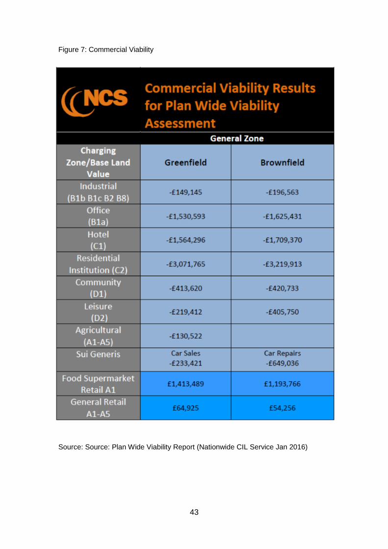
43
Figure 7: Commercial Viability
Source: Source: Plan Wide Viability Report (Nationwide CIL Service Jan 2016)

44
Commentary on Deliverability of Local Plan Sites
4.16 Nottingham City is predominantly urban in nature with a legacy of past industrial uses with areas at risk of flooding. Despite these challenges, the City’s housing delivery compares favourably with neighbouring authorities which are less urban and more affluent. The City has a track record of bringing forward difficult schemes and using funding streams innovatively. It is working proactively with Government agencies and public private sector partnerships (such as Blueprint and the Homes England) to target investment towards difficult sites.
4.17 Whilst the council has a duty to set out the infrastructure requirements which they would normally expect as part of any development, as highlighted in the NPPF the council takes a realistic and pragmatic approach to development, balancing S106 requirements against the wider benefits of the scheme.
Strategic Sites
4.18 The Core Strategy identified three strategic broad locations for future development:
Boots;
Stanton Tip;
Waterside.
4.19 These broad locations are carried forward in the LAPP as site allocations. The Waterside area has been allocated as several separate and smaller development allocations and the generic appraisals results are applicable. Boots
4.20 The Boots site straddles the boundaries of Broxtowe and Nottingham City and has been designated as an Enterprise Zone and a priority for delivery. The site has high abnormal costs associated with development due to flood risk, contamination and the need for access improvements. A partnership approach between the councils, Boots, Homes England, the Department for Communities and Local Government and the D2N2 Enterprise partnership has secured significant funding (including Growing Places Fund loan), to support site delivery.
4.21 Outline planning permission for a mixed use scheme has been secured alongside detailed permission for site remediation and infrastructure which is underway. A detailed site appraisal for this site was prepared as part of the Development Management process on which S106 contributions were considered and therefore a separate appraisal has not been prepared for this site.
Stanton Tip
4.22 Generic assumptions including allowances for remediation have been applied to Stanton Tip, however it is recognised that the City will need to work closely with the site developers to review development costs with an open book approach. The site is expected to come forward late in the plan period and development assumptions will be reviewed as appropriate through the development management process.

45
Waterside
4.23 The LAPP identifies several individual site allocations in the Waterside area. With improving economic conditions significant progress on Waterside sites is emerging as outlined below:
Site preparation and construction of first residential phases at Trent Basin PA85;
Planning Permission granted for relocation of leisure boat operator to site east of Trent Lane to facilitate release/redevelopment of Park Yacht Club (PA85) site for development;
Planning permission for residential redevelopment of Park Yacht Club PA85.
Planning permission for residential development on part of PA81 Meadow Lane, and further pre application discussions on another plot within the site.
Further Work on Viability and Community Infrastructure Levy
4.24 The Council will continue to develop and refine the IDP viability work in consultation
with developers and other stakeholders and the IDP will be updated as appropriate. The work will be refined as part of additional work to be progressed on the potential for introduction of the Community Infrastructure Levy. Further work on Plan Wide Viability is underway to inform the examination. Infrastructure Schedule and Funding
4.25 Successful delivery of the Local Plan and associated infrastructure will rely on funding from a range of sources. The Infrastructure Schedule (Figure 8) sets out the likely funding sources, lead agencies and estimated timescale for delivery for each element of infrastructure. Inevitably the list of infrastructure requirements will exceed available funding. Significant progress has been made in delivering or securing funding for major infrastructure projects since the publication of the Core Strategy IDP. As these projects also support the delivery of the LAPP progress on all schemes is included the schedule. As set out in the preceding chapters the delivery of the LAPP is not predicated on the delivery of any one single major infrastructure scheme but is reliant on smaller, incremental improvements.

46
Funding
4.26 Economic conditions are challenging with limits on both public and private resources. The funding sources and investment programmes most relevant to the Local Plan are set out below. However, there is a need to focus not simply on funding availability, but also on more innovative mechanisms to secure growth and infrastructure - such as the appropriate phasing and timing of infrastructure, delayed land receipts, the use of new finance initiatives such as Growing Places Fund loans, strong partnerships and open book development appraisals at planning application stage to ensure viability and constraints are fully explored. Further commentary on potential funding sources is set out below. S106 Contributions and Community Infrastructure Levy
4.27 Developer contributions are expected to make the most significant contribution to delivery of the Local Plan although it is recognised that Government are encouraging councils to adopt a flexible approach to secure delivery of growth.
4.28 Building on Plan Wide Viability work, the Council reviewed the potential to introduce a Community Infrastructure Levy and considers that at this point in time, the wide variation in viability between sites limited the potential for CIL. It therefore has no immediate plans to introduce a CIL. This will be kept under review and should it prove viable in the future, the establishment of a levy could have the potential to help fund more generic types of infrastructure which may require higher levels of funding than from a limited number of development schemes. D2N2, Combined Authorities and Devolution
4.29 The Local Enterprise Partnership, D2N2, has access to devolved funding to support economic growth and prosperity. The City Council has successfully secured contributions to a number of major development schemes and transport projects (such as Growing Places funding for Boots Enterprise Zone). The Council is also working collaboratively with adjacent authorities to maximise opportunities of the ‘Midlands Engine’ and ‘Midlands Connect’. Local Transport Plan, Local Sustainable Transport Fund and Work Place Parking Levy
4.30 The Local Transport Plan has provided the framework for several major transport schemes which are important to the delivery of the Core Strategy and the LAPP. The infrastructure schedule demonstrates the progress on scheme delivering and funding. Many of the major schemes are outside the scope of S106 and rely on additional central Government funding. To support the Local Plan approach to sustainable development and air quality, the City is actively pursuing funding opportunities to deliver a step change in the number of low emission vehicles in Nottingham.
4.31 Nottingham City Council introduced a Work Place Parking Levy in April 2012. The Levy places a charge on parking spaces within the City for organisations employing more than 10 people. The levy collected directly supports the provision of public transport in Nottingham, including Lines Two and Three of the Nottingham Express Transit and has supported the delivery of the Nottingham Midland Station improvements.
4.32 Nottingham received £16.196m for Local Sustainable Transport Fund 2011 to 2015 and then £1.180m for 2015/2016. A further £1.180 million was secured through the continuation round to help local people connect to jobs and services and support the local economy through promoting greater use of sustainable travel choices. This
47
funding ended on 31 March 2016.This directly supported the range of sustainable transport packages identified in the transport modelling study which underpins the growth proposals in Nottingham and neighbouring authorities.
4.33 In January 2017, the Department for Transport announced that the Nottingham Derby Access Fund bid was successful. The bid has secured £2.735m revenue funding for the Nottingham urban area and Derby City, for spend by March 2020. There is £1.459m available for Nottingham City, with a further £150,000 for household personalised journey planning in the Nottingham conurbation.
4.34 In February 2017 DEFRA announced that Nottingham had successfully secured further
£200,000 revenue funding for 2017/18 for the Nottingham Ultra Low Emission fleet (ULEF) programme in the Nottingham Urban Area. Local Authority Main Stream Funding and Assets
4.35 Although council budgets are under severe pressure, councils do have flexibility in the use of receipts from New Homes Bonus and in the way that council assets are used to secure delivery. Where council holdings form part of development sites, councils may consider delayed or reduced receipts where appropriate. Many of the housing sites are owned by the Council are subject to proactive regeneration activities. Further flexibility may be provided via Devolution Deals in the future.
4.36 The IDP provides a platform for co-ordinated investment on a range of services within and across council boundaries. Early dialogue on growth proposals will enable investment in, for example school places, to be made in timely way and at least cost – blending private sector contributions with existing expansion/improvements plans. City Deal
4.37 In July 2012, the Government confirmed a £60m ‘City Deal’ to help deliver Nottingham’s Growth Plan - Nottingham City Council met with Government ministers to firm up a series of proposals to unlock economic growth within Nottingham. The plan supports the City’s Core Strategy objectives via 3 themes:
Fostering enterprise – focusing on business finances and entrepreneurs; Developing a skilled workforce – focussing on skills and training;
21st Century Infrastructure – focussing on digital infrastructure, land and property and a new ‘Creative Quarter’.
Homes England funding
4.38 In 2017 £855,000 large sites and housing zones capacity funding was awarded by Homes England to support the delivery of 9,096 dwellings by 2026 across the Greater Nottingham area. The support is targeted at a portfolio of sites across the eligible categories which together cover an area of over 1,200 ha. The funding is intended to accelerate and increase delivery on sites with a high level of local authority support, a high degree of public ownership and positive engagement with developers and landowners. It will allow Greater Nottingham Local Authorities to work with land owners and developers to fully investigate and understand the barriers to site delivery, undertake appropriate feasibility work, site investigation, optioneering and drawing on specialist skills to broker meaningful and realistic development programmes and infrastructure phasing.
48
Other Funds
4.39 The councils have a strong track record in bidding for and securing one off ‘challenge’ funds and blending funding streams to maximise outputs (e.g. European Regional Development Funds). This has been particularly important in progressing economic development schemes - such as Southglade Food Park which was awarded European Regional Development Funding with contributions from Nottingham City Council via prudential borrowing. An extension to the food park is now complete (and the proposed site allocation has been reduced in size accordingly) The Council is working closely with partner organisations such as Registered Social Landlords to maximise delivery using public land and support from the Affordable Homes Programme.

49
5. Monitoring and Review.
5.1 The IDP is a living document and will require further review as more detailed information becomes available from both service providers and developers. In particular, the conclusion of the CIL assessment will be important in refining the IDP along with on-going dialogue with utilities providers and public sector stakeholders. Monitoring of site delivery will continue to take place via the Council’s Annual Monitoring Report, Strategic Housing Land Availability Assessment and emerging Brown Field Land Register.

50
Figure 8: Infrastructure Schedule, Funding, Monitoring and Review
The schedule below sets out the strategic infrastructure required to support the Nottingham Local Plan
Nature Infrastructure
Site/Area
(where
relevant)
Description Progress
Est.
Cost
£k
Funding
Secured
£k
Funding
Source Lead Partners
Timescale for
delivery - Years Comments
0-5 6-10 10-15
Critical
Strategic
and Site
Specific
Flood Risk
Boots
Creative
Quarter
Meadows
Waterside
River Trent Left
Bank Flood
Alleviation
Scheme
Completed 51,000 51,000 DEFR EA
Complete.
Critical
Strategic
and Site
Specific
Transport
Supports
Range of
LAPP Sites
NET Phase Two
(Lines 2 and 3
serving the
Meadows,
Clifton, Beeston
and Chilwell)
Likely to deliver
capacity
improvements
at Hucknall NET
stop relevant
sites within
GBC.
Completed 570,000 570,000
DFT
NCC
PFI
Tramlink
Nottm NCC
Completed
Summer 2015

51
Nature Infrastructure
Site/Area
(where
relevant)
Description Progress
Est.
Cost
£k
Funding
Secured
£k
Funding
Source Lead Partners
Timescale for
delivery - Years Comments
0-5 6-10 10-15
Critical
Strategic
and Site
Specific
Transport
Supports
Range of
LAPP Sites
Nottingham
Hub. Integrated
transport hub
including new
station car park,
station facilities
and NET
interchange
Completed 67,000 67,000
NR
EMT
NCC
NsCC
NDE
RHT
NR
EMT
NCC
NsCC
NDE
NRL
RHT
Completed
May 2014
Critical
Strategic Transport
Supports
transport
accessibilit
y across
the City
Ring Road
Major.
Improvements
to Nottingham
Ring Road
Completed 16,200 16,200
DFT
LTP
S106
NCC
Completed
Critical
Strategic
and Site
Specific
Transport
Implementation
of A453
improvement
scheme.
Relevant to all
councils. Critical
to the delivery
of Land to the
south of Clifton
Completed 164,000 164,000 DFT
NsCC HA
DFT
NCC
Completed
Critical
Site
Specific
Contamination Boots Site
Remediation
Site
preparation
works
underway
Tbc (part
confident-
ial)
Possibly
GPF
S106
HCA
Develope
r
Alliance
Boots
NCC
BBC
LEP
Underway
(see schemes
section)

52
Nature Infrastructure
Site/Area
(where
relevant)
Description Progress
Est.
Cost
£k
Funding
Secured
£k
Funding
Source Lead Partners
Timescale for
delivery - Years Comments
0-5 6-10 10-15
Critical
Site
Specific
Contamination Stanton Tip Site remediation
Master
planning
underway
tbc Direct
provision
Develope
r
Remediation
likely to
require
innovative
solutions and
potential
public sector
support.
Critical
Site
Specific
Flood Risk
(jointly with
Broxtowe)
Boots
Flood risk
protection/mitig
ation
Site
Preparation
Work
Underway
tbc
Possibly
GPF
HCA
S106
Develope
r
Alliance
Boots
NCC
BBC
LEP
Site
infrastructure
requirements
and funding
mechanisms
for the
Enterprise
Zone being
explored by
Boots in
collaboration
with LEP.
Estimated
costs relate to
all
infrastructure
requirements
Important
Strategic Transport Citywide
High Speed Rail
2 (outside of
plan periods but
route/station
Design
Stage 32bn DFT DFT
Delivery
outside plan
period but
decision on
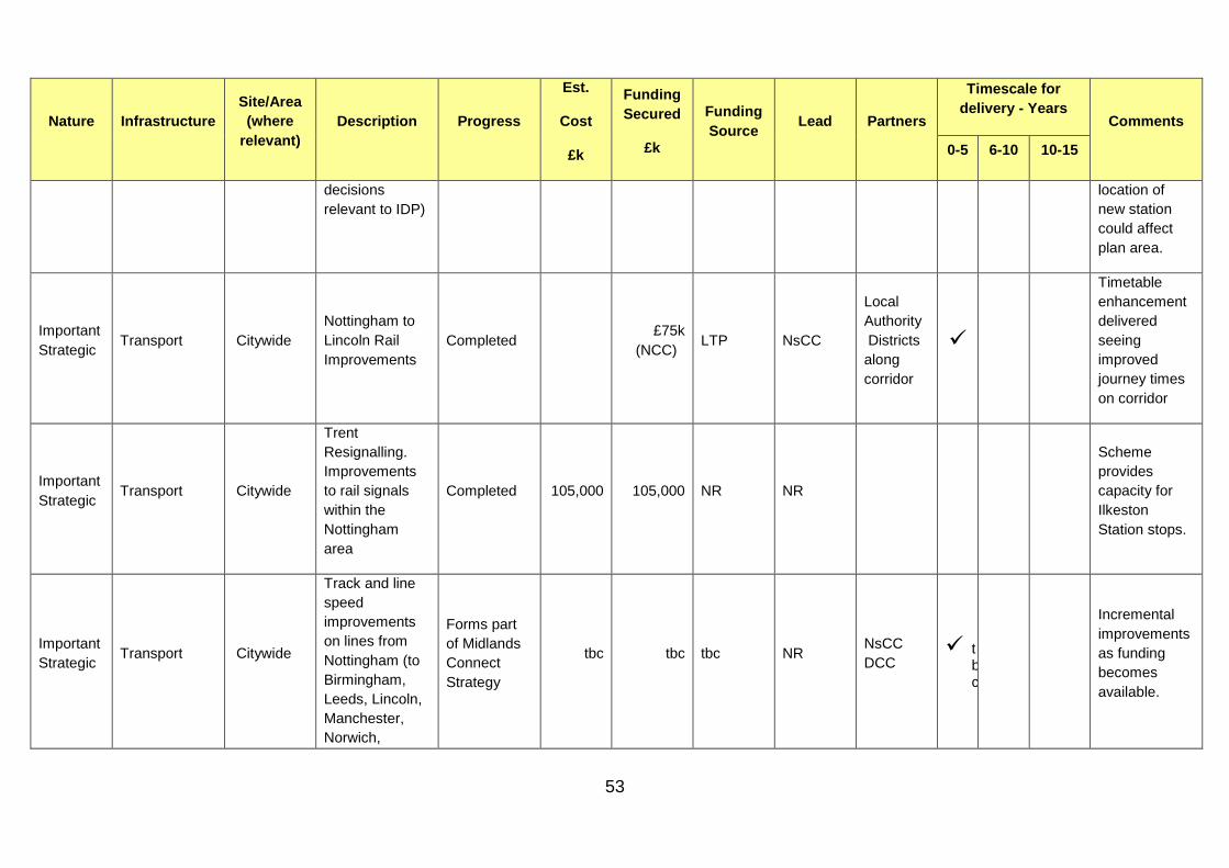
53
Nature Infrastructure
Site/Area
(where
relevant)
Description Progress
Est.
Cost
£k
Funding
Secured
£k
Funding
Source Lead Partners
Timescale for
delivery - Years Comments
0-5 6-10 10-15
decisions
relevant to IDP)
location of
new station
could affect
plan area.
Important
Strategic Transport Citywide
Nottingham to
Lincoln Rail
Improvements
Completed £75k
(NCC) LTP NsCC
Local
Authority
Districts
along
corridor
Timetable
enhancement
delivered
seeing
improved
journey times
on corridor
Important
Strategic Transport Citywide
Trent
Resignalling.
Improvements
to rail signals
within the
Nottingham
area
Completed 105,000 105,000 NR NR
Scheme
provides
capacity for
Ilkeston
Station stops.
Important
Strategic Transport Citywide
Track and line
speed
improvements
on lines from
Nottingham (to
Birmingham,
Leeds, Lincoln,
Manchester,
Norwich,
Forms part
of Midlands
Connect
Strategy
tbc tbc tbc NR NsCC
DCC t
bc
Incremental
improvements
as funding
becomes
available.
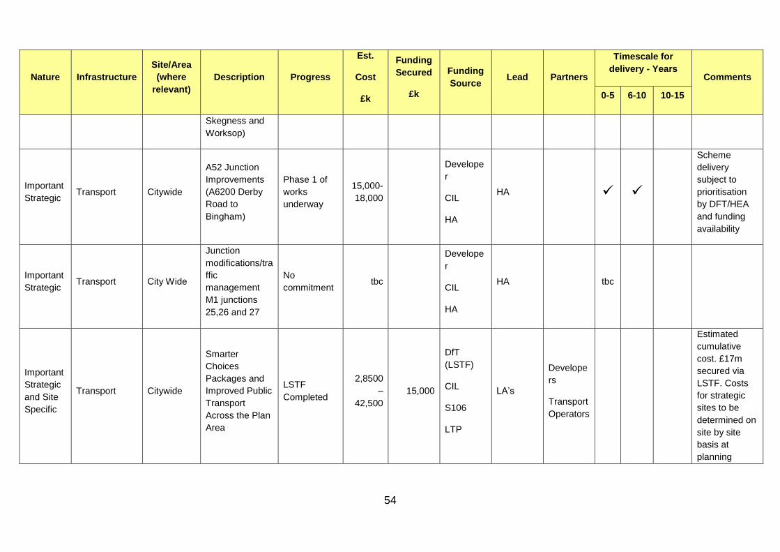
54
Nature Infrastructure
Site/Area
(where
relevant)
Description Progress
Est.
Cost
£k
Funding
Secured
£k
Funding
Source Lead Partners
Timescale for
delivery - Years Comments
0-5 6-10 10-15
Skegness and
Worksop)
Important
Strategic Transport Citywide
A52 Junction
Improvements
(A6200 Derby
Road to
Bingham)
Phase 1 of
works
underway
15,000-
18,000
Develope
r
CIL
HA
HA
Scheme
delivery
subject to
prioritisation
by DFT/HEA
and funding
availability
Important
Strategic Transport City Wide
Junction
modifications/tra
ffic
management
M1 junctions
25,26 and 27
No
commitment tbc
Develope
r
CIL
HA
HA tbc
Important
Strategic
and Site
Specific
Transport Citywide
Smarter
Choices
Packages and
Improved Public
Transport
Across the Plan
Area
LSTF
Completed
2,8500
–
42,500
15,000
DfT
(LSTF)
CIL
S106
LTP
LA’s
Develope
rs
Transport
Operators
Estimated
cumulative
cost. £17m
secured via
LSTF. Costs
for strategic
sites to be
determined on
site by site
basis at
planning

55
Nature Infrastructure
Site/Area
(where
relevant)
Description Progress
Est.
Cost
£k
Funding
Secured
£k
Funding
Source Lead Partners
Timescale for
delivery - Years Comments
0-5 6-10 10-15
application
stage.
Important
Strategic
and Site
Specific
Transport Citywide
GPS Bus
Priority and
Physical Bus
Priority
Measures
No
commitment
19,000
–
21,000
S106
CIL
LTP
DCC
NsCC
NCC
Districts
Site
Specific Utilities
Creative
Quarter
Waterside
Canal
Quarter
New Bulk
Supply Point
and possible
primary
substation
Not
Committed
Not
known
Western
Power
Western
Power
Site
Specific Utilities Boots
New
transformer at
Boots primary
and new circuit
to Nottingham.
Possible
upgrade to Bulk
Supply Point
Site
preparation
works
underway
tbc tbc
Develope
r
Western
Power
Western
Power
Site
Specific Transport Boots
Improved site
access
Site
preparation
works
underway
25,000
Possibly
GPF
HCA
Develope
r
Develope
r
NCC
BBC
LEP
Site
infrastructure
requirements
and funding
mechanisms
for the

56
Nature Infrastructure
Site/Area
(where
relevant)
Description Progress
Est.
Cost
£k
Funding
Secured
£k
Funding
Source Lead Partners
Timescale for
delivery - Years Comments
0-5 6-10 10-15
Enterprise
Zone being
explored by
Boots in
collaboration
with LEP.
Estimated
costs relate to
all
infrastructure
requirements
Site
Specific Transport Boots
Integrated
transport
package
Planning
Permission
Site
Preparation
Works
underway
tbc S106 NCC
BBC NsCC
Strategic
integrated
transport
measures to
be confirmed
via transport
modelling
Site
Specific Transport Island Site
Integrated
transport
package
Master
planning
underway
tbc S106 NCC
Strategic
integrated
transport
measures to
be confirmed
via transport
modelling
Site
Specific Transport
Creative
Quarter
A612 Commuter
Cycle Route
Not
Committed 250
S106
LTP NCC

57
Nature Infrastructure
Site/Area
(where
relevant)
Description Progress
Est.
Cost
£k
Funding
Secured
£k
Funding
Source Lead Partners
Timescale for
delivery - Years Comments
0-5 6-10 10-15
Site
Specific Transport
Creative
Quarter
Connecting
Eastside Phase
II
Funding
secured 5,000 5,000 TIF 2 NCC
Site
Specific Transport
Creative
Quarter
Waterside
Bus Rapid
Transport Link
Not
Committed 4,000
S106
LTP NCC
Site
Specific Transport
Canal
Quarter
Integrated
transport
package
Master
planning
underway
tbc S106 Develope
r
Strategic
integrated
transport
measures to
be confirmed
via transport
modelling
Site
Specific Transport
Canal
Quarter
Turning Point
South
Design
Stage tbc
S106
LTP NCC t
bc
Dependant on
delivery of
Broadmarsh
Shopping
Centre
Site
Specific Transport
Canal
Quarter
Arkwright Walk
Pedestrian
Improvements
Works on
site 750
S106
LTP NCC
Phase 1 of
works
complete.
Development
now on site
Site
Specific Transport Stanton Tip
Integrated
transport
package
Master
planning
underway
tbc S106 NCC
Strategic
integrated
transport

58
Nature Infrastructure
Site/Area
(where
relevant)
Description Progress
Est.
Cost
£k
Funding
Secured
£k
Funding
Source Lead Partners
Timescale for
delivery - Years Comments
0-5 6-10 10-15
measures to
be confirmed
via transport
modelling
Site
Specific Transport Waterside
Integrated
transport
package
Master
planning
underway
tbc S106 NCC
Strategic
integrated
transport
measures to
be confirmed
via transport
modelling
Site
Specific Transport Waterside
Cattle Market
Road
Straightening
Design
Complete 3,500
S106
LTP NCC
Site
Specific Transport Waterside
Cattle Market
Road/London
Road Junction
Improvements
Design
phase 750
S106
LTP NCC
Site
Specific Transport Waterside
Pedestrian
Improvements
at 2 x level
crossings
Completed 1,500 NR NR
Trent Lane
and Meadow
Lane
pedestrian
bridges
completed as
part of
Nottingham

59
Nature Infrastructure
Site/Area
(where
relevant)
Description Progress
Est.
Cost
£k
Funding
Secured
£k
Funding
Source Lead Partners
Timescale for
delivery - Years Comments
0-5 6-10 10-15
Signalling
works.
Site
Specific Transport Waterside
Lady Bay
Bridge/Meadow
Lane pedestrian
crossing
facilities
Not
Committed 750
S106
LTP NCC
Site
Specific Transport Waterside
North-south
cycle route from
Sneinton/A612
to river
Not
Committed tbc
S106
LTP NCC tbc
Site
Specific Transport Waterside
East-west cycle
route adjacent
to Trent
Master plan
complete tbc
Direct
provision
Develope
r
Cycle/pedestri
an route to be
provided as
part of
development
proposals.
Site
Specific Transport Waterside
Neighbourhood
centre facilities
Master
planning
underway
tbc Develope
r
Develope
r
Site
Specific Transport Waterside
Lady Bay
Bridge Walking
and Cycling
Improvements
Outline
Design
No
Commitment
2,500 S106
LTP NCC NsCC
Feasibility
Completed.
Desirable but
not essential

60
Nature Infrastructure
Site/Area
(where
relevant)
Description Progress
Est.
Cost
£k
Funding
Secured
£k
Funding
Source Lead Partners
Timescale for
delivery - Years Comments
0-5 6-10 10-15
Site
Specific Local Services Stanton Tip
Provision of
local scale retail
uses on site
Master
planning
underway
tbc S106 Develope
r NCC
Site
Specific Local Services Waterside
CCG have
confirmed that
expansion of
GP facilities not
required as
consequence of
development
proposed.
Master
planning
underway
N/A S106 Develope
r CCG
CCG
confirmed
expansion not
required
Site
Specific
Green
Infrastructure
Creative
Quarter
Waterside
Sneinton
Greenway
Not
Committed 250
S106
LTP NCC
Site
Specific Education Cumulative
Primary School
Places
Contribution
Site by site
basis
7,200 -
18,700
S106/Pub
lic NCC
Indicative
costs are
provided for
school places
generated
over the plan
period on the
basis of
current
multiplier.
Detailed
requirements
to be
confirmed with

61
Nature Infrastructure
Site/Area
(where
relevant)
Description Progress
Est.
Cost
£k
Funding
Secured
£k
Funding
Source Lead Partners
Timescale for
delivery - Years Comments
0-5 6-10 10-15
detailed site
proposals.
Site
Specific Education Cumulative
Secondary
school places
contribution
Site by site
basis
4,545-
12,500
S106/Pub
lic NCC
Indicative
costs are
provided for
school places
generated
from non-
strategic
housing sites
over the plan
period on the
basis of
current
multiplier.
Detailed
requirements
to be
confirmed in
parallel with
DPDs and
detailed site
proposals.
Site
Specific Flood risk
PA27
Wilkinson
Street -
Tbc
Flood risk
costs and
detailed
requirements

62
Nature Infrastructure
Site/Area
(where
relevant)
Description Progress
Est.
Cost
£k
Funding
Secured
£k
Funding
Source Lead Partners
Timescale for
delivery - Years Comments
0-5 6-10 10-15
Former PZ
Cussons
PA29
Bobbers
Mill Bridge
- Bobbers
Mill
Industrial
Estate
PA30
Bobbers
Mill Bridge
- Bobbers
Mill
Industrial
Estate
PA18
Vernon
Road -
Former
Johnsons
Dyeworks
to be
confirmed with
detailed site
proposals as
they emerge
through the
development
management
process.

63
Nature Infrastructure
Site/Area
(where
relevant)
Description Progress
Est.
Cost
£k
Funding
Secured
£k
Funding
Source Lead Partners
Timescale for
delivery - Years Comments
0-5 6-10 10-15
Site
Specific
Local Cycling
and Walking
Infrastructure
Plan (LCWIP)
Cumulative
Provision of
strategic
walking and
cycling links
Design
phase tbc tbc tbc NCC
D2N2
LEP
Development
of clean air
zone feasibility
underway
Site
Specific
Clean Air
Zone
City Centre
area
Creation of
Clean Air Zone
to meet DEFRA
air quality
objectives
Design
phase tbc tbc
DEFRA /
NCC NCC DEFRA
Development
of clean air
zone feasibility
underway

64
Appendices
Appendix 1: Site allocation connectivity issues/enhancements
Appendix 2: Potential impact of proposed growth on water supply infrastructure assets
Appendix 3: Potential impact of proposed development on sewerage infrastructure assets
Appendix 4: Health and Services by Local Area
Appendix 5: Community issues/ enhancements
Appendix 6: Schools by Local Area
Appendix 7: Open space Issues/enhancements
Appendix 8: Biodiversity/GI Issues/enhancements
Appendix 9: Summary of Key Changes made since Publication Version
Appendix 10: List of Consultees
Note: Information provided by stakeholders and the City Council has been updated where possible, and may be
subject to further change as this is a living document which will require further review as more detailed
information becomes available from both service providers and developers.
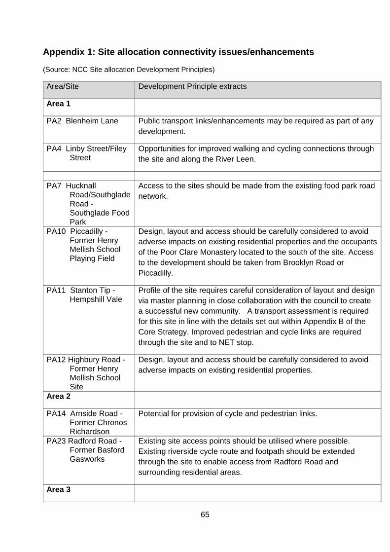
65
Appendix 1: Site allocation connectivity issues/enhancements
(Source: NCC Site allocation Development Principles)
Area/Site Development Principle extracts
Area 1
PA2 Blenheim Lane Public transport links/enhancements may be required as part of any
development.
PA4 Linby Street/Filey Street
Opportunities for improved walking and cycling connections through
the site and along the River Leen.
PA7 Hucknall Road/Southglade Road - Southglade Food Park
Access to the sites should be made from the existing food park road
network.
PA10 Piccadilly - Former Henry Mellish School Playing Field
Design, layout and access should be carefully considered to avoid
adverse impacts on existing residential properties and the occupants
of the Poor Clare Monastery located to the south of the site. Access
to the development should be taken from Brooklyn Road or
Piccadilly.
PA11 Stanton Tip - Hempshill Vale
Profile of the site requires careful consideration of layout and design
via master planning in close collaboration with the council to create
a successful new community. A transport assessment is required
for this site in line with the details set out within Appendix B of the
Core Strategy. Improved pedestrian and cycle links are required
through the site and to NET stop.
PA12 Highbury Road - Former Henry Mellish School Site
Design, layout and access should be carefully considered to avoid
adverse impacts on existing residential properties.
Area 2
PA14 Arnside Road - Former Chronos Richardson
Potential for provision of cycle and pedestrian links.
PA23 Radford Road - Former Basford Gasworks
Existing site access points should be utilised where possible.
Existing riverside cycle route and footpath should be extended
through the site to enable access from Radford Road and
surrounding residential areas.
Area 3
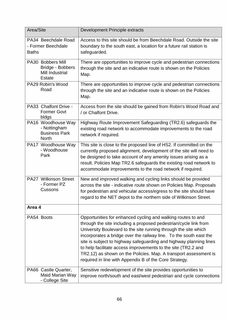
66
Area/Site Development Principle extracts
PA34 Beechdale Road
- Former Beechdale
Baths
Access to this site should be from Beechdale Road. Outside the site
boundary to the south east, a location for a future rail station is
safeguarded.
PA30 Bobbers Mill Bridge - Bobbers Mill Industrial Estate
There are opportunities to improve cycle and pedestrian connections
through the site and an indicative route is shown on the Policies
Map.
PA29 Robin's Wood Road
There are opportunities to improve cycle and pedestrian connections
through the site and an indicative route is shown on the Policies
Map.
PA33 Chalfont Drive - Former Govt bldgs
Access from the site should be gained from Robin's Wood Road and
/ or Chalfont Drive.
PA16 Woodhouse Way - Nottingham Business Park North
Highway Route Improvement Safeguarding (TR2.6) safeguards the
existing road network to accommodate improvements to the road
network if required.
PA17 Woodhouse Way - Woodhouse Park
This site is close to the proposed line of HS2. If committed on the
currently proposed alignment, development of the site will need to
be designed to take account of any amenity issues arising as a
result. Policies Map TR2.6 safeguards the existing road network to
accommodate improvements to the road network if required.
PA27 Wilkinson Street - Former PZ Cussons
New and improved walking and cycling links should be provided
across the site - indicative route shown on Policies Map. Proposals
for pedestrian and vehicular access/egress to the site should have
regard to the NET depot to the northern side of Wilkinson Street.
Area 4
PA54 Boots Opportunities for enhanced cycling and walking routes to and
through the site including a proposed pedestrian/cycle link from
University Boulevard to the site running through the site which
incorporates a bridge over the railway line. To the south east the
site is subject to highway safeguarding and highway planning lines
to help facilitate access improvements to the site (TR2.2 and
TR2.12) as shown on the Policies. Map. A transport assessment is
required in line with Appendix B of the Core Strategy.
PA66 Castle Quarter, Maid Marian Way - College Site
Sensitive redevelopment of the site provides opportunities to
improve north/south and east/west pedestrian and cycle connections
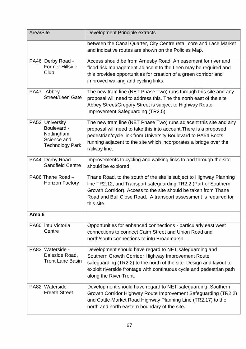
67
Area/Site Development Principle extracts
between the Canal Quarter, City Centre retail core and Lace Market
and indicative routes are shown on the Policies Map.
PA46 Derby Road - Former Hillside Club
Access should be from Arnesby Road. An easement for river and
flood risk management adjacent to the Leen may be required and
this provides opportunities for creation of a green corridor and
improved walking and cycling links.
PA47 Abbey Street/Leen Gate
The new tram line (NET Phase Two) runs through this site and any
proposal will need to address this. The the north east of the site
Abbey Street/Gregory Street is subject to Highway Route
Improvement Safeguarding (TR2.5).
PA52 University Boulevard - Nottingham Science and Technology Park
The new tram line (NET Phase Two) runs adjacent this site and any
proposal will need to take this into account.There is a proposed
pedestrian/cycle link from University Boulevard to PA54 Boots
running adjacent to the site which incorporates a bridge over the
railway line.
PA44 Derby Road - Sandfield Centre
Improvements to cycling and walking links to and through the site
should be explored.
PA86 Thane Road – Horizon Factory
Thane Road, to the south of the site is subject to Highway Planning
line TR2:12, and Transport safeguarding TR2.2 (Part of Southern
Growth Corridor). Access to the site should be taken from Thane
Road and Bull Close Road. A transport assessment is required for
this site.
Area 6
PA60 intu Victoria Centre
Opportunities for enhanced connections - particularly east west
connections to connect Cairn Street and Union Road and
north/south connections to intu Broadmarsh. .
PA83 Waterside - Daleside Road, Trent Lane Basin
Development should have regard to NET safeguarding and
Southern Growth Corridor Highway Improvement Route
safeguarding (TR2.2) to the north of the site. Design and layout to
exploit riverside frontage with continuous cycle and pedestrian path
along the River Trent.
PA82 Waterside - Freeth Street
Development should have regard to NET safeguarding, Southern
Growth Corridor Highway Route Improvement Safeguarding (TR2.2)
and Cattle Market Road Highway Planning Line (TR2.17) to the
north and north eastern boundary of the site.

68
Area/Site Development Principle extracts
Design and layout to exploit riverside frontage with continuous cycle
and pedestrian path along the River Trent
PA85 Waterside - Trent Lane, Park Yacht Club
A continuous riverside cycle and walking path should be provided
with opportunities to improve Riverside as a green corridor.
PA40 Daleside Road - Former Colwick Service Station
Proposals should take account of the Highway Planning Line to the
south of the site (TR2.11) associated with Daleside Road.
Proposals should ensure that the safe operation of the cycle route to
the front of the site is not adversely affected.
Area 7
PA35 Woodyard Lane - Siemens
Walking and cycling links to Woodyard Lane should also be created.
The Policies Map safeguards Hallowell Drive for future highway
improvements.
Area 8
PA55 Ruddington Lane Rear of 107-127
Proposals should explore opportunities to improve pedestrian
access to the tram stop to the east of the site.
PA67 intu Broadmarsh
Centre and
surrounding area
This is a major development site and proposals will be expected to
radically improve connectivity of this part of the city. Proposals
should introduce more traditional street patterns with active
frontages - improving north/south and east/west pedestrian linkages
and high quality connections to intu Victoria Centre, the Canal
Quarter, the retail core, Creative and Castle Quarters with
opportunities for new external routes. To facilitate development
major changes to the highway network are planned and proposals
should have regard to Highway Planning Lines and Highway Route
Improvements Safeguarding TR2.4 and TR2.16 as shown on the
Policies Map.
PA74 Canal Quarter - Arkwright Street East
Development to have regard to relationship with tram route, new
areas of public realm and nearby housing. Positive linkages to be
created with The Meadows. Proposals should have regard to
Highway Route Improvement Safeguard close to the site on Queens
Road (TR2.4)
PA68 Canal Quarter - Island Site
The site should include new open space and make provision for
walking and cycling links to and through the site which also link to
the canal tow path. Proposals should have regard to Highway

69
Area/Site Development Principle extracts
Safeguarding and Highway Planning Lines which affect the site as
shown on the Policies Map - TR2.1, TR2.2 and TR2.10.
PA70 Canal Quarter - Queens Road, East of Nottingham Station
Proposals should have regard to Highway Route Improvement
Safeguarding TR2.2 and TR2.4 to the east and south of the site.
PA73 Canal Quarter - Sheriffs Way/Arkwright Street
Proposals should provide positive linkages to the Meadows and
enhance walking and cycling routes, having regard to the
relationship with the tram route that crosses the south of the site and
housing to the south of Meadows Way.
PA69 Canal Quarter - Station Street/Carrington Street
Redevelopment should carefully consider the relationship between
the site and the canal towpath, exploit opportunities to create access
and links between them and enhance the canal frontage. Any on-
site car parking to serve the development to be located below
ground floor frontage level, where flood risk limits scope for other
uses. Servicing / car parking access should be gained via existing
Station Street access (to east of 21 Station Street).
PA72 Canal Quarter - Waterway Street
Proposals should provide positive linkages to the Meadows and
enhance walking and cycling routes, having regard to the
relationship with the tram route that crosses through the site.
Proposals should have regard to Highway Route Improvement
Safeguarding TR2.4 to the south of the site.
PA57 Clifton West Access to the site is safeguarded from Hawksley Gardens and
Finchley Close under TR2.18.
PA21 Mansfield Road - Sherwood Library
Adequate parking should be ensured as part of development
proposals.
PA53 Electric Avenue Highway improvements are planned to road network close to the site
as part of the Southern Growth Corridor (TR2.2).
PA59 Farnborough Road - Former Fairham Comprehensive School
Opportunities for local vehicular connectivity and improved
pedestrian and cycle links between Clifton and the adjacent Clifton
Pastures development (in Rushcliffe Borough Council area) should
be explored
PA50 NG2 South - Queens Drive
Development should have regard to potential highway
improvements on Experian Way, safeguarded under TR2.9.
70
Area/Site Development Principle extracts
PA80 Waterside - Cattle Market
Development should support the delivery of enhanced east west
linkages across the Waterside Area. Highway access into and
through the site requires careful consideration and discussion with
the City Council. There is potential for delivery of highway
rationalisation and proposals should have regard to Cattle Market
Road Highway Planning Line (TR2.17) running through the centre of
the site and to the south on County Road. An indicative route for a
future NET line is safeguarded to the south east of the site.
PA79 Waterside - Iremonger Road
Development should have regard to the Cattle Market Road
Highway Planning Line (TR2.17) and NET safeguarding to the
northern boundary of the site.
PA77 Waterside - London Road, Eastcroft Depot
Layout and design should exploit the canal side location, opening up
access to the tow path. There is potential for improved cycling and
walking connections from the canal through to the Waterside area.
Development should have regard to planned highway improvements
near the site as part of Turning Point South (TR2.4).
PA76 Waterside - London Road, Former Hartwells
Where possible new walking and cycling routes should be provided
through the site. Development should have regard to planning
highway improvements near the site as part of the Southern Growth
Corridor (TR2.2).
PA78 Waterside - London Road, South of Eastcroft Depot
Where possible new walking and cycling routes should be provided
through the site. Development should have regard to proposals for
planned highway improvements near to the site as part of Turning
Point South (TR2.4) and Cattle Market Road Highway Planning Line
(TR2.17) and NET safeguarding to the south of the site.
PA81 Waterside - Meadow Lane
Development should have regard to NET safeguarding and Cattle
Market Road Highway Planning Line (TR2.17) to the northern
boundary of the site. Design should exploit riverside position and
provide a continuous cycle and pedestrian path along the River
Trent.

71
Appendix 2: Potential impact of proposed growth on water supply infrastructure
assets.2
(Source: Severn Trent Water)
Red Amber Green Assessment
Network capacity available adjacent to/ close proximity
to the site
Some off-site work will be required to support the
existing network
Extensive off-site work required that may impact on
site delivery.
Area/
Site
Ref
Site Water Supply Comments
(RAG)
Area 1 Bulwell and Bullwell Forest
PA1 Bestwood Road - Former Bestwood Day Centre
Some off-site work
required
PA2 Blenheim Lane
PA12 Highbury Road - Former Henry Mellish School Site
PA10 Piccadilly - Former Henry Mellish School Playing Field
PA7 Hucknall Road/Southglade Road - Southglade Food Park
PA4 Linby Street/Filey Street
PA11 Stanton Tip - Hempshill Vale
Area 2 Basford and Bestwood Area
PA14 Arnside Road - Former Chronos Richardson
2 These are STW desktop assessments (April 2014) using readily available information and have not been subjected to detailed hydraulic modelling

72
Area/
Site
Ref
Site Water Supply Comments
(RAG)
PA23 Radford Road - Former Basford Gasworks
PA15 Bulwell Lane - Former Coach Depot
PA3 Eastglade, Top Valley - Former Eastglade School Site
PA8 Padstow Road - Former Padstow School Site
Off-site work and supply
rezoning
PA6
Beckhampton Road - Former Padstow School Detached
Playing Field
Off-site work and supply
rezoning
PA5
Ridgeway - Former Padstow School Detached Playing
Field
PA9
Edwards Lane - Former Haywood School Detached
Playing Field Off-Site work required
PA18 Vernon Road - Former Johnsons Dyeworks
Area 3 West Area Committee
PA34 Beechdale Road - Former Beechdale Baths
PA32 Beechdale Road - South of Former Co-op Dairy
PA30 Bobbers Mill Bridge - Bobbers Mill Industrial Estate
PA29
Bobbers Mill Bridge - Land Adjacent to Bobbers Mill
Industrial Estate
PA33 Chalfont Drive - Former Government Buildings
PA25 Chingford Road Playing Field Off-Site work required
PA26 Denewood Crescent - Denewood Centre
PA24 College Way - Melbury School Playing Field
PA16 Woodhouse Way - Nottingham Business Park North
PA17
Woodhouse Way - Woodhouse Park (Formerly Nottingham
Business Park South)
PA27 Wilkinson Street - Former PZ Cussons
73
Area/
Site
Ref
Site Water Supply Comments
(RAG)
Area 4
Arboretum, Dunkirk and Lenton, Radford and Park
Area Committee
PA54 Boots
PA66 Castle Quarter - Maid Marian Way, College Site
PA46 Derby Road - Former Hillside Club
PA41 Alfreton Road - Forest Mill
PA47 Abbey Street/Leen Gate
Tram Route may hinder
laying of new mains.
Needs particular
assessment.3
PA52
University Boulevard - Nottingham Science and
Technology Park
Tram Route may hinder
laying of new mains.
Needs particular
assessment.4
PA42 Ilkeston Road - Radford Mill
PA43 Salisbury Street
PA44 Derby Road - Sandfield Centre
PA86 Thane Road Horizon Factory
Severn Trent advised
26/10/16 There are no
known sewer capacity
issues which are
expected to be affected
by the redevelopment of
this site and so provided
surface water is
managed sustainably no
sewer capacity
constraints are
envisaged.
3 Information provided prior to August 2015 completion of NET phase2 works 4 Information provided prior to August 2015 completion of NET phase2 works

74
Area/
Site
Ref
Site Water Supply Comments
(RAG)
Area 5 Berridge and Sherwood Area
PA19 Lortas Road
PA20 Severn Trent Water Depot
PA21 Mansfield Road - Sherwood Library
Area 6 Dales, Mapperley and St Anns
PA38 Carlton Road - Former Castle College
PA65 Creative Quarter - Bus Depot
Off-site local
reinforcements required
PA64 Creative Quarter - Sneinton Market
PA39 Carlton Road - Former Co-op
PA37 Robin Hood Chase
PA61
Royal Quarter - Burton Street, Guildhall, Police Station and
Fire Station
PA60 intu Victoria Centre
Water requirements
need to be coordinated.
Off-site works will be
needed but provided as
part of the strategy to
supply the area of
regeneration
Water requirements
need to be coordinated.
Off-site works will be
needed but provided as
part of the strategy to
supply the area of
regeneration
PA83 Waterside - Daleside Road, Trent Lane Basin
PA82 Waterside - Freeth Street
PA85 Waterside - Trent Lane, Park Yacht Club
PA62 Brook Street East
75
Area/
Site
Ref
Site Water Supply Comments
(RAG)
PA40 Daleside Road - Former Colwick Service Station
Area 7 Wollaton and Lenton Abbey
PA35 Woodyard Lane - Siemens Off site work required
Area 8 Bridge, Clifton North and South
PA67 intu Broadmarsh Centre and surrounding area
PA74 Canal Quarter - Arkwright Street East
The supply area will
need to be rezoned to a
different supply zone.
PA75 Canal Quarter - Crocus Street, Southpoint
The supply area will
need to be rezoned to a
different supply zone.
Trunk Main crosses the
site. Easement required
PA68 Canal Quarter - Island Site
PA70 Canal Quarter - Queens Road, East of Nottingham Station
PA73 Canal Quarter - Sheriffs Way/Arkwright Street
PA71 Canal Quarter - Sheriffs Way, Sovereign House
PA69 Canal Quarter - Station Street/ Carrington Street
PA72 Canal Quarter - Waterway Street
PA57 Clifton West
PA53 Electric Avenue
PA59
Farnborough Road - Former Fairham Comprehensive
School
PA58 Green Lane - Fairham House
PA50 NG2 South - Queens Drive
PA49 NG2 West - Enterprise Way
76
Area/
Site
Ref
Site Water Supply Comments
(RAG)
PA80 Waterside - Cattle Market
PA79 Waterside - Iremonger Road
PA77 Waterside - London Road, Eastcroft Depot
PA76 Waterside - London Road, Former Hartwells
PA78 Waterside - London Road, South of Eastcroft Depot
PA81 Waterside - Meadow Lane
PA55 Ruddington Lane - Rear of 107-127

77
Appendix 3: Potential impact of proposed development on sewerage
infrastructure assets.
(Source: Severn Trent Water)
Site Ref Sewerage Comment Potential impact on
sewerage
infrastructure - (RAG)
Area 1
PA1 Bestwood Road - Former Bestwood Day Centre
Provided surface water is dealt with
sustainably and foul only flows are
connected into the network, flows from
this site are not envisaged to cause any
major impact. However, flows will be
required to drain a long way past known
hydraulic flooding points. Hydraulic
modelling is recommended to assess the
impact of flows from this site.
Low - subject to
hydraulic modelling
PA2 Blenheim Lane
Without knowledge of what type of
employment is proposed for this site, it is
not possible to comment on flows.
However, this site is a long distance from
the treatment works and flows may
impact on known flooding areas.
Hydraulic modelling is recommended in
order to assess any adverse impact on
the system.
Low - subject to
hydraulic modelling
PA12 Highbury Road - Former Henry Mellish School Site
Provided surface water is dealt with
sustainably and foul only flows are
connected into the network, flows from
this site are not envisaged to cause any
major impact. However, flows will be
required to drain a long way past known
hydraulic flooding points. Hydraulic
modelling is recommended to assess the
impact of flows from this site.
Low - subject to
hydraulic modelling
PA10 Piccadilly - Former Henry Mellish School Playing Field
Provided surface water is dealt with
sustainably and foul only flows are
connected into the network, flows from
this site are not envisaged to cause any
major impact. However, flows will be
Low - subject to
hydraulic modelling

78
Site Ref Sewerage Comment Potential impact on
sewerage
infrastructure - (RAG)
required to drain a long way past known
hydraulic flooding points. Hydraulic
modelling is recommended to assess the
impact of flows from this site.
PA7 Hucknall Road/Southglade Road - Southglade Food Park
Without knowledge of what type of
employment is proposed for this site, it is
not possible to comment on flows.
However, this site is a long distance from
the treatment works and flows may
impact on known flooding areas.
Hydraulic modelling is recommended in
order to assess any adverse impact on
the system.
Low - subject to
hydraulic modelling
PA4 Linby Street/Filey Street
Provided surface water is dealt with
sustainably and foul only flows are
connected into the network, flows from
this site are not envisaged to cause any
major impact. However, flows will be
required to drain a long way past known
hydraulic flooding points. Hydraulic
modelling is recommended to assess the
impact of flows from this site.
Low - subject to
hydraulic modelling
PA11 Stanton Tip - Hempshill Vale
This is a large site to the North West of
the Stoke Bardolph catchment. Flows will
have to travel a long distance to reach the
treatment works past known flooding
points which may be impacted. Hydraulic
modelling is strongly recommended.
Medium - large site
Area 2
PA14 Arnside Road - Former Chronos Richardson
Provided surface water is dealt with
sustainably and foul only flows are
connected into the network, flows from
this site are not envisaged to cause any
major impact. However, flows will be
required to drain a long way past known
hydraulic flooding points. Hydraulic
Low - subject to
hydraulic modelling
79
Site Ref Sewerage Comment Potential impact on
sewerage
infrastructure - (RAG)
modelling is recommended to assess the
impact of flows from this site.
PA23 Radford Road - Former Basford Gasworks
Provided surface water is dealt with
sustainably and foul only flows are
connected into the network, flows from
this site are not envisaged to cause any
major impact. However, flows will be
required to drain a long way past known
hydraulic flooding points. Hydraulic
modelling is recommended to assess the
impact of flows from this site.
Low - subject to
hydraulic modelling
PA15 Bulwell Lane - Former Coach Depot
Provided surface water is dealt with
sustainably and foul only flows are
connected into the network, subject to
hydraulic modelling, flows from this site
are not envisaged to cause any major
impact.
Low - subject to
hydraulic modelling
PA3 Eastglade, Top Valley - Former Eastglade School Site
Provided surface water is dealt with
sustainably and foul only flows are
connected into the network, flows from
this site are not envisaged to cause any
major impact. However, flows will be
required to drain a long way past known
hydraulic flooding points. Hydraulic
modelling is recommended to assess the
impact of flows from this site.
Low - subject to
hydraulic modelling
PA8* Padstow Road - Former Padstow School Site
Individually these sites may cause
adverse impact on the downstream
system as they are all large sites which
would require connection into a small
diameter system. They should also be
considered together as the impact of
flows from these four sites may require
infrastructure upgrade to accommodate. It
is recommended that hydraulic modelling
is undertaken in order to ascertain the
Medium - Large sites.
Infrastructure upgrade
may be required

80
Site Ref Sewerage Comment Potential impact on
sewerage
infrastructure - (RAG)
impact of flows from each site individually
and combined.
PA6* Beckhampton Road - Former Padstow School Detached Playing Field
Individually these sites may cause
adverse impact on the downstream
system as they are all large sites which
would require connection into a small
diameter system. They should also be
considered together as the impact of
flows from these four sites may require
infrastructure upgrade to accommodate. It
is recommended that hydraulic modelling
is undertaken in order to ascertain the
impact of flows from each site individually
and combined.
Medium - Large sites.
Infrastructure upgrade
may be required
PA5* Ridgeway - Former Padstow School Detached Playing Field
*Individually these sites may cause
adverse impact on the downstream
system as they are all large sites which
would require connection into a small
diameter system. They should also be
considered together as the impact of
flows from these four sites may require
infrastructure upgrade to accommodate. It
is recommended that hydraulic modelling
is undertaken in order to ascertain the
impact of flows from each site individually
and combined.
Medium - Large sites.
Infrastructure upgrade
may be required
PA9* Edwards Lane - Former Haywood School Detached Playing Field
*Individually these sites may cause
adverse impact on the downstream
system as they are all large sites which
would require connection into a small
diameter system. They should also be
considered together as the impact of
flows from these four sites may require
infrastructure upgrade to accommodate. It
is recommended that hydraulic modelling
is undertaken in order to ascertain the
Medium - Large sites.
Infrastructure upgrade
may be required

81
Site Ref Sewerage Comment Potential impact on
sewerage
infrastructure - (RAG)
impact of flows from each site individually
and combined.
PA18 Vernon Road - Former Johnsons Dyeworks
Provided surface water is dealt with
sustainably and foul only flows are
connected into the network, flows from
this site are not envisaged to cause any
major impact. However, flows will be
required to drain a long way past known
hydraulic flooding points. Hydraulic
modelling is recommended to assess the
impact of flows from this site.
Low - subject to
hydraulic modelling
Area 3
PA34 Beechdale Road - Former Beechdale Baths
Provided surface water is dealt with sustainably
and foul only flows are connected into the
network, subject to hydraulic modelling, flows from
this site are not envisaged to cause any major
impact.
Low - subject to hydraulic
modelling
PA32 Beechdale Road - South of Former Co-op Dairy
Provided surface water is dealt with sustainably
and foul only flows are connected into the
network, flows from this site are not envisaged to
cause any major impact. However, flows will be
required to drain a long way past known hydraulic
flooding points. Hydraulic modelling is
recommended to assess the impact of flows from
this site.
Low - subject to hydraulic
modelling
PA30 Bobbers Mill Bridge - Bobbers Mill Industrial Estate
Although this is a slightly larger site, the trunk
sewer runs directly past the proposed location.
Provided surface water is dealt with sustainably
and foul only flows are connected into the
network, flows from this site are not envisaged to
cause any major impact. Hydraulic modelling is
recommended to assess the impact of flows from
this site.
Low - subject to hydraulic
modelling
PA29 Bobbers Mill Bridge - Land Adjacent to Bobbers Mill Industrial Estate
Provided surface water is dealt with sustainably
and foul only flows are connected into the
network, flows from this site are not envisaged to
cause any major impact. Hydraulic modelling is
recommended to assess the impact of flows from
this site.
Low - subject to hydraulic
modelling

82
Site Ref Sewerage Comment Potential impact on
sewerage
infrastructure - (RAG)
PA33 Chalfont Drive - Former Government Buildings
This is a very large site in the centre of
Nottingham. The closest sewer for connection is a
225mm diameter sewer which would not be able
to cope with the extra flows proposed from this
development. However, there is a larger pipe
nearby that could be connected into. Hydraulic
modelling is strongly recommended for this site
and early involvement with Severn Trent is
requested.
Medium - large site
PA25 Chingford Road Playing Field
This is a large site that will require connection into
a small diameter system. There is also known
external flooding downstream that this site will
impact on. It is anticipated that infrastructure
upgrades would be required to accommodate
flows from this development.
High - known external
flooding downstream
PA26 Denewood Crescent - Denewood Centre
Provided surface water is dealt with sustainably
and foul only flows are connected into the
network, flows from this site are not envisaged to
cause any major impact. However, flows will be
required to drain a long way past known hydraulic
flooding points. Hydraulic modelling is
recommended to assess the impact of flows from
this site.
Low - subject to hydraulic
modelling
PA24 College Way - Melbury School Playing Field
Provided surface water is dealt with sustainably
and foul only flows are connected into the
network, flows from this site are not envisaged to
cause any major impact. However, flows will be
required to drain a long way past known hydraulic
flooding points. Hydraulic modelling is
recommended to assess the impact of flows from
this site.
Low - subject to hydraulic
modelling
PA16 Woodhouse Way - Nottingham Business Park North
Without knowledge of what type of employment is
proposed for this site, it is not possible to
comment on flows. However, this site is a long
distance from the treatment works and flows may
impact on known flooding areas. There is also a
large development site proposed (LA53) which
would connect into the same system. Hydraulic
modelling is recommended in order to assess any
adverse impact on the system.
Medium - not sure of daily
flows from site and large
resedential development
planned right next to it
PA17 Woodhouse Way - Woodhouse Park (Formerly Nottingham Business Park South)
This is a large site proposed a long distance from
the treatment works. Flows will have to pass
known hydraulic flooding points and also pass
potential future development points. Hydraulic
Medium - large site

83
Site Ref Sewerage Comment Potential impact on
sewerage
infrastructure - (RAG)
modelling is recommended in order to assess the
impact of flows from this site.
PA27 Wilkinson Street - Former PZ Cussons
Provided surface water is dealt with sustainably
and foul only flows are connected into the
network, flows from this site are not envisaged to
cause any major impact. However, flows will be
required to drain a long way, through the centre of
Nottingham and past known hydraulic flooding
points. Hydraulic modelling is recommended to
assess the impact of flows from this site.
Low - subject to hydraulic
modelling
Area 4
PA54 Boots This site is right next to the treatment works. The
nearest sewer is a large diameter which, subject
to current capacity, should be able to accept the
extra flows from this site.
Low - subject to hydraulic
modelling
PA66 Castle Quarter - Maid Marian Way, College Site
This site will drain directly into a very large
diameter brick sewer. Flows from this site are not
expected to cause any adverse impact on the
downstream capacity. There is however, some
know external hydraulic flooding downstream.
Due to the number of sites also proposed in the
same location, hydraulic modelling is
recommended to assess the impact of combined
flows from the area.
Medium - multiple sites
PA46 Derby Road - Former Hillside Club
A large diameter sewer runs through the centre of
this site. This may impact the delivery of proposed
development. There are known hydraulic incidents
downstream of this development and multiple
areas of re-development and new development
that would be impacted by flows from this site.
However, due to the size of the site, the flows
anticipated will not have any major impact on the
hydraulic capacity downstream.
Low - subject to hydraulic
modelling
PA41 Alfreton Road - Forest Mill As with LA22, this site drains directly into a large
diameter brick sewer. However, flows will travel
through an area identified for major re-
development / development. Whilst the impact of
flows from this site would be Low (subject to
hydraulic modelling) this area of Nottingham
needs to be reviewed for all planned
development.
Medium - multiple sites

84
Site Ref Sewerage Comment Potential impact on
sewerage
infrastructure - (RAG)
PA47 Abbey Street/Leen Gate This is a large site that will be draining into a
system potentially already under capacity. There
are known external hydraulic flooding incidents
that could be exacerbated by flows from this site.
It is recommended that hydraulic modelling is
undertaken to assess the impact of this site.
Medium - known hydraulic
flooding
PA52 University Boulevard - Nottingham Science and Technology Park
Provided surface water is dealt with sustainably
and foul only flows are connected into the
network, subject to the capacity at the
downstream pumping station, this site is not
anticipated to cause any adverse impact (subject
to hydraulic modelling).
Low - subject to hydraulic
modelling
PA42 Ilkeston Road - Radford Mill Provided surface water is dealt with sustainably
and foul only flows are connected into the
network, this site is not anticipated to cause any
adverse impact on the downstream system
(subject to hydraulic modelling)
Low - subject to hydraulic
modelling
PA43 Salisbury Street Provided surface water is dealt with sustainably
and foul only flows are connected into the
network, this site is not anticipated to cause any
adverse impact on the downstream system
(subject to hydraulic modelling)
Low - subject to hydraulic
modelling
PA86 Thane Road Horizon factory
There are no known sewer capacity issues which
are expected to be affected by the redevelopment
of this site and so provided surface water is
managed sustainably we do not envisage and
sewer capacity constraints.
Area 5
PA19 Lortas Road This site will drain past known hydraulic flooding
points before entering the trunk sewer. Provided
surface water is dealt with sustainably, the foul
only flows are not envisaged to cause any major
impact on the system (subject to hydraulic
modelling)
Low - subject to hydraulic
modelling
PA20 Haydn Road/Hucknall Road - Severn Trent Water Depot
This site will connected straight into the trunk
sewer. Provided surface water is dealt with
sustainably and foul only flows are connected into
the system, this site is not envisaged to cause any
major impact on the system (subject to hydraulic
modelling).
Low - subject to hydraulic
modelling

85
Site Ref Sewerage Comment Potential impact on
sewerage
infrastructure - (RAG)
PA21 Mansfield Road - Sherwood Library
Provided surface water is dealt with sustainably
and foul only flows are connected into the
network, this site is not anticipated to cause any
adverse impact on the downstream system
(subject to hydraulic modelling)
Low - subject to hydraulic
modelling
Area 6
PA65 Creative Quarter - Bus Depot
Provided surface water is dealt with sustainably
and foul only flows are connected into the
network, subject to hydraulic modelling, this site
should not cause any adverse impact on the
downstream network. It should be noted that there
are some downstream known external hydraulic
flooding points that should be taken into
consideration when draining this site. It would also
be worth noting the quantity of development in this
area. If they were to all go ahead, this may require
improvements to the infrastructure capacity.
Low - subject to hydraulic
modelling
PA64 Creative Quarter - Sneinton Market
Provided surface water is dealt with sustainably
and foul only flows are connected into the
network, subject to hydraulic modelling, this site
should not cause any adverse impact on the
downstream network. It should be noted that there
are some downstream known external hydraulic
flooding points that should be taken into
consideration when draining this site. It would also
be worth noting the quantity of development in this
area. If they were to all go ahead, this may require
improvements to the infrastructure capacity.
This seems to be a like for like replacement. It is
not envisaged to cause any issues downstream.
Low - subject to hydraulic
modelling
Low - subject to hydraulic
modelling
PA39 Carlton Road - Former Co-op
PA37 Robin Hood Chase PA61 Royal Quarter - Burton
Street, Guildhall, Police Station and Fire Station
PA60 intu Victoria Centre
PA83 Waterside - Daleside Road, Trent Lane Basin
This is a very large proposed development. It will
however, connect directly into a trunk sewer which
flows straight to the works. With the quantity of
proposed upstream development, all of which will
require transference through this trunk sewer,
there may be capacity issues. Hydraulic modelling
is required to assess to impact of all development
upstream of this location in addition to flows from
this large development.
Medium - large site with
multiple upstream
developments
PA82 Waterside - Freeth Street This is a very large proposed development. It will
however, connect directly into a trunk sewer which
flows straight to the works. With the quantity of
proposed upstream development, all of which will
PA85 Waterside - Trent Lane,
Park Yacht Club PA62 Brook Street East

86
Site Ref Sewerage Comment Potential impact on
sewerage
infrastructure - (RAG)
require transference through this trunk sewer,
there may be capacity issues. Hydraulic modelling
is required to assess to impact of all development
upstream of this location in addition to flows from
this large development.
Provided surface water is dealt with sustainably
and foul only flows are connected into the
network, subject to hydraulic modelling, this site
should not cause any adverse impact on the
downstream network. It should be noted that there
are some downstream known external hydraulic
flooding points that should be taken into
consideration when draining this site. It would also
be worth noting the quantity of development in this
area. If they were to all go ahead, this may require
improvements to the infrastructure capacity.
Medium - large site with
multiple upstream
developments
Low - subject to hydraulic
modelling
Provided surface water is dealt with sustainably
and foul only flows are connected into the
network, subject to hydraulic modelling, this site
should not cause any adverse impact on the
downstream network. It should be noted that there
are some downstream known external hydraulic
flooding points that should be taken into
consideration when draining this site. It would also
be worth noting the quantity of development in this
area. If they were to all go ahead, this may require
improvements to the infrastructure capacity.
Provided surface water is dealt with sustainably
and foul only flows are connected into the
network, subject to hydraulic modelling, this site
should not cause any adverse impact on the
downstream network.
Low - subject to hydraulic
modelling
Low - subject to hydraulic
modelling
PA40 Daleside Road - Former Colwick Service Station
Area 7
PA35 Woodyard Lane - Siemens There are known hydraulic flooding incidents just
downstream of this development location.
Capacity improvements may be required.
Medium - known hydraulic
incidents downstream
Area 8
PA67 intu Broadmarsh Centre and surrounding area
PA74 Canal Quarter - Arkwright Street East
Provided surface water is dealt with sustainably
and foul only flows are connected into the
network, the flows from this site are not envisaged
to cause any major impact. There are however,
Low - subject to hydraulic
modelling

87
Site Ref Sewerage Comment Potential impact on
sewerage
infrastructure - (RAG)
known hydraulic incidents downstream that could
be exacerbated by flows from this site. Hydraulic
modelling is recommended.
PA75 Canal Quarter - Crocus Street, Southpoint
There is a lot of development planned in this area.
Capacity may be overwhelmed if all of it goes
ahead. However, for this site, provided surface
water is dealt with sustainably and foul only flows
are connected into the network, subject to
hydraulic modelling, this site should not cause any
adverse impact on the downstream network.
Low - subject to hydraulic
modelling
PA68 Canal Quarter - Island Site This is a very large site with known hydraulic
flooding incidents located around it. It is also
situated in an area with lots of proposed
development. Hydraulic modelling is
recommended for this site and for the
combinations of the proposed sites.
Medium - known hydraulic
incidents and large site
PA70 Canal Quarter - Queens Road, East of Nottingham Station
There is a lot of development planned in this area.
Capacity may be overwhelmed if all of it goes
ahead. However, for this site, provided surface
water is dealt with sustainably and foul only flows
are connected into the network, subject to
hydraulic modelling, this site should not cause any
adverse impact on the downstream network.
Low - subject to hydraulic
modelling
PA73 Canal Quarter - Sheriffs Way/Arkwright Street
There is a lot of development planned in this area.
Capacity may be overwhelmed if all of it goes
ahead. However, for this site, provided surface
water is dealt with sustainably and foul only flows
are connected into the network, subject to
hydraulic modelling, this site should not cause any
adverse impact on the downstream network.
Low - subject to hydraulic
modelling
PA71 Canal Quarter - Sheriffs Way, Sovereign House
There is a lot of development planned in this area.
Capacity may be overwhelmed if all of it goes
ahead. However, for this site, provided surface
water is dealt with sustainably and foul only flows
are connected into the network, subject to
hydraulic modelling, this site should not cause any
adverse impact on the downstream network.
Low - subject to hydraulic
modelling
PA69 Canal Quarter - Station Street/Carrington Street
There is a lot of development planned in this area.
Capacity may be overwhelmed if all of it goes
ahead. However, for this site, provided surface
water is dealt with sustainably and foul only flows
are connected into the network, subject to
Low - subject to hydraulic
modelling

88
Site Ref Sewerage Comment Potential impact on
sewerage
infrastructure - (RAG)
hydraulic modelling, this site should not cause any
adverse impact on the downstream network.
PA72 Canal Quarter - Waterway Street
There is a lot of development planned in this area.
Capacity may be overwhelmed if all of it goes
ahead. However, for this site, provided surface
water is dealt with sustainably and foul only flows
are connected into the network, subject to
hydraulic modelling, this site should not cause any
adverse impact on the downstream network.
Low - subject to hydraulic
modelling
PA57 Clifton West There is a lot of development planned in this area.
Capacity may be overwhelmed if all of it goes
ahead. However, for this site, provided surface
water is dealt with sustainably and foul only flows
are connected into the network, subject to
hydraulic modelling, this site should not cause any
adverse impact on the downstream network.
Low - subject to hydraulic
modelling
PA53 Electric Avenue Provided surface water is dealt with sustainably
and foul only flows are connected into the
network, subject to hydraulic modelling, this site
should not cause any adverse impact on the
downstream network. However, there is a lot of
development planned downstream of this area.
Capacity improvements may be required.
Low - subject to hydraulic
modelling
PA59Farnborough Road - Former Fairham Comp.
There are multiple known flooding incidents just
upstream of this site. Flows will then have to travel
a long distance in order to reach the treatment
works and pass by areas with a lot of proposed
development. Hydraulic modelling is strongly
recommended in order to assess the impact of
flows from this site.
Medium - known hydraulic
incidents
PA58 Green Lane - Fairham House
Provided surface water is dealt with sustainably
and foul only flows from this site are connected
into the network, it is not envisaged that this site
will cause any adverse impact. However, there is
a lot of proposed development downstream that
may require infrastructure upgrades. Flows from
this site will impact on these potential works.
Low - subject to hydraulic
modelling
PA50 NG2 South - Queens Drive Provided surface water is dealt with sustainably
and foul only flows from this site are connected
into the network, it is not envisaged that this site
will cause any adverse impact. However, there is
a lot of proposed development downstream that
Low - subject to hydraulic
modelling

89
Site Ref Sewerage Comment Potential impact on
sewerage
infrastructure - (RAG)
may require infrastructure upgrades. Flows from
this site will impact on these potential works.
PA49 NG2 West - Enterprise Way Provided surface water is dealt with sustainably
and foul only flows from this site are connected
into the network, it is not envisaged that this site
will cause any adverse impact. However, there is
a lot of proposed development downstream that
may require infrastructure upgrades. Flows from
this site will impact on these potential works.
Low - subject to hydraulic
modelling
PA80 Waterside - Cattle Market There is a lot of development planned in this area.
Capacity may be overwhelmed if all of it goes
ahead. However, for this site, provided surface
water is dealt with sustainably and foul only flows
are connected into the network, subject to
hydraulic modelling, this site should not cause any
adverse impact on the downstream network.
Low - subject to hydraulic
modelling
PA79 Waterside - Iremonger Road There is a lot of development planned in this area.
Capacity may be overwhelmed if all of it goes
ahead. However, for this site, provided surface
water is dealt with sustainably and foul only flows
are connected into the network, subject to
hydraulic modelling, this site should not cause any
adverse impact on the downstream network.
Low - subject to hydraulic
modelling
PA77 Waterside - London Road, Eastcroft Depot
There is a lot of development planned in this area.
Capacity may be overwhelmed if all of it goes
ahead. However, for this site, provided surface
water is dealt with sustainably and foul only flows
are connected into the network, subject to
hydraulic modelling, this site should not cause any
adverse impact on the downstream network.
Low - subject to hydraulic
modelling
PA76 Waterside - London Road, Former Hartwells
There is a lot of development planned in this area.
Capacity may be overwhelmed if all of it goes
ahead. However, for this site, provided surface
water is dealt with sustainably and foul only flows
are connected into the network, subject to
hydraulic modelling, this site should not cause any
adverse impact on the downstream network.
Low - subject to hydraulic
modelling
PA78 Waterside - London Road, South of Eastcroft Depot
There is a lot of development planned in this area.
Capacity may be overwhelmed if all of it goes
ahead. However, for this site, provided surface
water is dealt with sustainably and foul only flows
are connected into the network, subject to
Low - subject to hydraulic
modelling

90
Site Ref Sewerage Comment Potential impact on
sewerage
infrastructure - (RAG)
hydraulic modelling, this site should not cause any
adverse impact on the downstream network.
PA81 Waterside - Meadow Lane This is a very large site in an area with a lot of
proposed development. Capacity may be
overwhelmed if all of this development goes
ahead and flows from this site will impact heavily
on a potentially full network. Hydraulic modelling
is required in order to ascertain the impact of
flows from this site as well as the combination of
flows from all proposed development in the area.
Medium - large site
PA55 Ruddington Lane - Rear of 107-127
Provided surface water is dealt with sustainably
and foul only flows from this site are connected
into the network, it is not envisaged that this site
will cause any adverse impact. However, there is
a lot of proposed development downstream that
may require infrastructure upgrades. Flows from
this site will impact on these potential works.
Low - subject to hydraulic
modelling

91
Appendix 4: Health and Services by Local Area

92

93

94

95

96
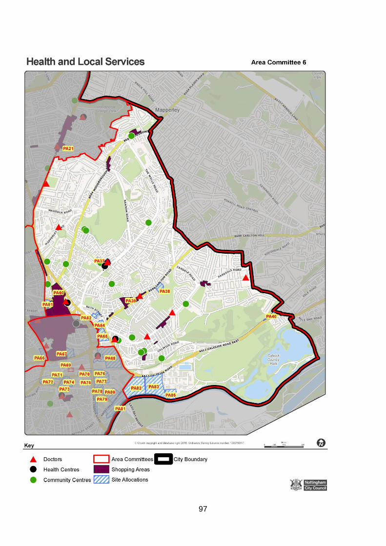
97

98

99

100
Appendix 5: Community issues/ enhancements
(Source: NCC Site allocation Development Principles)
Site Ref Development Principle extracts
Area 1
PA8 Former Padstow School
Existing youth facility to be retained or relocated in a suitable and
appropriate location
PA6 Former Padstow School Detached Playing Field (Beckhampton Road)
Layout of site should maximise opportunities to accommodate a range
of sporting activities to support local needs.
PA11 Stanton Tip – Hempshill Vale
Profile of the site requires careful consideration of layout and design
via masterplanning in close collaboration with the council to create a
successful new community.
Area 6
PA83 Waterside - Daleside Road (Trent Lane Basin)
Potential for transformational development to create a new Riverside
community.
Existing bank-side habitats to be retained and an accessible riverside
green corridor created to provide wildlife and community value.
PA82 Waterside - Freeth Street
Potential for transformational development to create a new Riverside
mixed use community
Existing bank-side habitats to be retained and an accessible riverside green corridor created that provide wildlife and community value.
Area 8
PA81 Waterside - Meadow Lane
Potential for transformational development to create a new Riverside
community.

101
Appendix 6: Schools by Local Area

102

103

104

105

106

107
108

109

110
Appendix 7: Open space issues/enhancements
(Source: NCC Site allocation Development Principles)
Local Area/Site Ref Development Principles extracts
Area 1
PA10 Piccadilly - Former Henry Mellish School Playing Field
Development should result in mitigation for open space lost on this site
which may include provision elsewhere and/or an overall increase in the
quality and ecological value of open space in the wider area. Appropriate
mitigation could of consist of improved green corridors; new allotments,
improvement of local LWS/LNRs; new equipped play areas.
Area 2
PA14 Arnside Road - Former Chronos Richardson
New open space should be created as part of this development.
PA23 Radford Road - Former Basford Gasworks
There is potential for this development to help address identified open
space deficiencies in the area.
PA3 Eastglade, Top Valley - Former Eastglade School Site
Residential development should include publicly accessible on site open
space. Due to the proximity of PA3, PA5, PA6, PA8 and PA9 there is the
opportunity to look at the Open Space requirements across all the sites.
Development should include mitigation measures which result in an overall
increase in the quality and ecological value of open space in the area.
Appropriate mitigation could consist of improved green corridors, new
allotments, improvement of local LWS/LNRs, new equipped play area,
creation of additional accessible open space elsewhere.
PA8 Eastglade Road - Former Padstow School Site
Residential development should include a significant proportion of
improved publicly accessible on site open space. Due to the proximity of
PA3, PA5, PA6, PA8 and PA9 there is the opportunity to look at the Open
Space requirements across all the sites. Development should include
mitigation measures which result in an overall increase in the quality and
ecological value of open space in the area.
PA6 Beckhampton Road – Former Padstow School Detached Playing Field
Residential development should include publicly accessible on site open
space. Due to the proximity of PA3, PA5, PA6, PA8 and PA9 there is the
opportunity to look at the Open Space requirements across all the sites.
Development should include mitigation measures which result in an overall
increase in the quality and ecological value of open space in the area.

111
Local Area/Site Ref Development Principles extracts
PA5 Ridgeway - Former Padstow School Detached Playing Field
Residential development should include publicly accessible on site open
space. Due to the proximity of PA3, PA5, PA6, PA8 and PA9 there is the
opportunity to look at the Open Space requirements across all the sites.
Development should include mitigation measures which result in an overall
increase in the quality and ecological value of open space in the area.
PA9 Edwards Lane - Former Haywood School Detached Playing Field
Residential development should include publicly accessible on site open
space. Due to the proximity of PA3, PA5, PA6, PA8 and PA9 there is the
opportunity to look at the Open Space requirements across all the sites.
Development should include mitigation measures which result in an overall
increase in the quality and ecological value of open space in the area.
Area 3
PA30 Bobbers Mill Bridge - Bobbers Mill Industrial Estate
There is potential for this development to help address identified open
space deficiencies in the area. Open space could be provided either side
to buffer, protect and enhance the River Leen.
PA29 Robin's Wood Road
There is existing open space on the site this should be retained and
enhanced with opportunities for additional open space provision within the
site.
PA33 Chalfont Drive - Former Government Buildings
There is existing open space on the site this should be retained and
enhanced with opportunities for additional open space provision within the
site.
PA25 Chingford Road Playing Field
Development proposals should secure the provision of publicly accessible
formal on-site open space. To provide a buffer to and to help protect the
setting of heritage assets, this open space should be located to the north
west of the site and cover approximately one third of the site area. It
should include a proportion of semi-natural open space.
PA24 College Way - Melbury School Playing Field
Residential development should include publicly accessible on site open
space with links to existing open space in the north west.
PA17 Woodhouse Way - Woodhouse Park
There is potential for this development to help address identified open
space deficiencies in the area.
Area 4
PA54 Boots
There is potential to help address identified open space deficiencies in the
area, where possible existing open space should be retained or re-
provision should be made elsewhere on site.

112
Local Area/Site Ref Development Principles extracts
PA66 Castle Quarter, Maid Marian Way - College Site
Development should be sensitive to, and maximise opportunities provided
by the historic environment and incorporate high quality open space that
preserves or enhances the significance and setting of heritage assets.
PA47 Abbey Street/Leen Gate
The River Leen green corridor should be preserved and enhanced through
development, with new on site open space connecting to this.
PA86 Thane Road
Horizon Site
Where possible, existing open space should be retained or re- provision
should be made elsewhere on site.
Area 5
PA19 Lortas Road Residential development should include on site public open space which is
overlooked, secure and well integrated.
Area 7
PA35 Woodyard Lane - Siemens
There is potential for the development to provide accessible public open
space to help address deficiencies in the area with opportunities to
improve and retain the grassland.
Area 8
PA68 Canal Quarter - Island Site
The site should include new open space
PA57 Clifton West There is potential for this development to help address open space
deficiencies in the area, including for allotment provision.
PA59 Farnborough Road - Former Fairham Comprehensive School
There are opportunities to the south of the site for provision of improved
publicly accessible green space
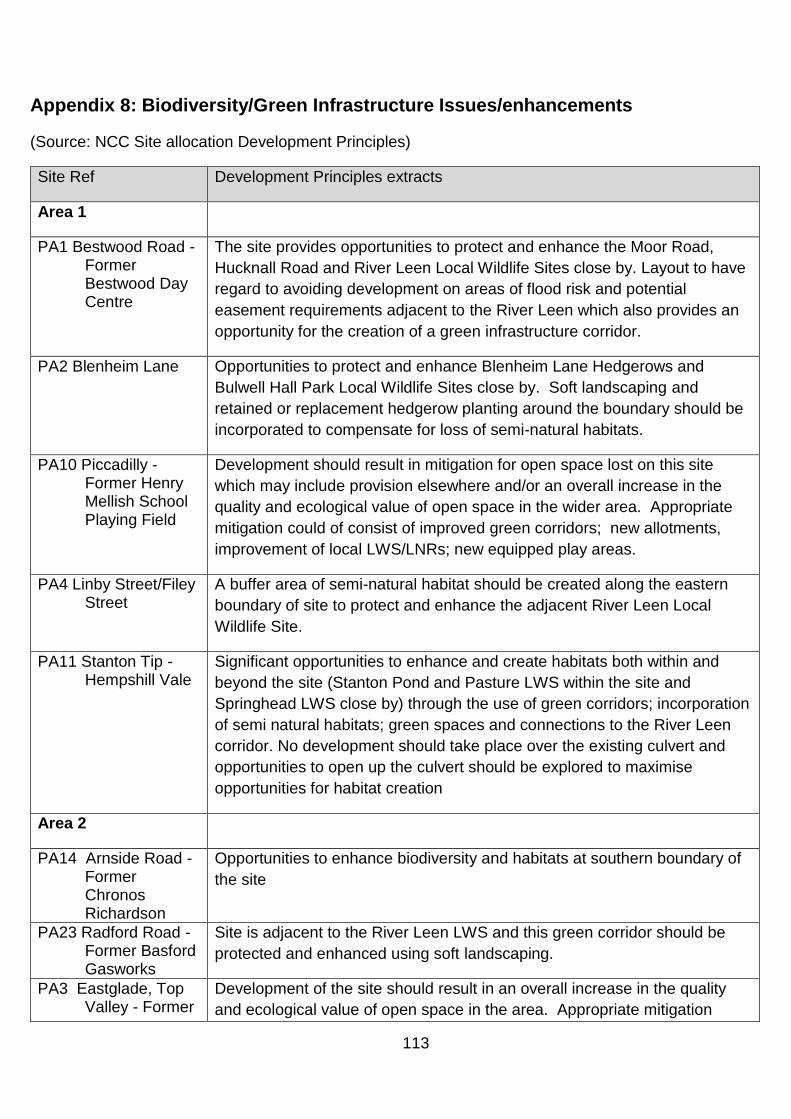
113
Appendix 8: Biodiversity/Green Infrastructure Issues/enhancements
(Source: NCC Site allocation Development Principles)
Site Ref Development Principles extracts
Area 1
PA1 Bestwood Road - Former Bestwood Day Centre
The site provides opportunities to protect and enhance the Moor Road,
Hucknall Road and River Leen Local Wildlife Sites close by. Layout to have
regard to avoiding development on areas of flood risk and potential
easement requirements adjacent to the River Leen which also provides an
opportunity for the creation of a green infrastructure corridor.
PA2 Blenheim Lane
Opportunities to protect and enhance Blenheim Lane Hedgerows and
Bulwell Hall Park Local Wildlife Sites close by. Soft landscaping and
retained or replacement hedgerow planting around the boundary should be
incorporated to compensate for loss of semi-natural habitats.
PA10 Piccadilly - Former Henry Mellish School Playing Field
Development should result in mitigation for open space lost on this site
which may include provision elsewhere and/or an overall increase in the
quality and ecological value of open space in the wider area. Appropriate
mitigation could of consist of improved green corridors; new allotments,
improvement of local LWS/LNRs; new equipped play areas.
PA4 Linby Street/Filey Street
A buffer area of semi-natural habitat should be created along the eastern
boundary of site to protect and enhance the adjacent River Leen Local
Wildlife Site.
PA11 Stanton Tip - Hempshill Vale
Significant opportunities to enhance and create habitats both within and
beyond the site (Stanton Pond and Pasture LWS within the site and
Springhead LWS close by) through the use of green corridors; incorporation
of semi natural habitats; green spaces and connections to the River Leen
corridor. No development should take place over the existing culvert and
opportunities to open up the culvert should be explored to maximise
opportunities for habitat creation
Area 2
PA14 Arnside Road - Former Chronos Richardson
Opportunities to enhance biodiversity and habitats at southern boundary of
the site
PA23 Radford Road - Former Basford Gasworks
Site is adjacent to the River Leen LWS and this green corridor should be
protected and enhanced using soft landscaping.
PA3 Eastglade, Top Valley - Former
Development of the site should result in an overall increase in the quality
and ecological value of open space in the area. Appropriate mitigation

114
Site Ref Development Principles extracts
Eastglade School Site
could consist of improved green corridors; new allotments, improvement of
local LWS/LNRs; new equipped play area; creation of additional accessible
open space elsewhere.
PA8 Eastglade Road - Former Padstow School Site
Development of the site should result in an overall increase in the quality
and ecological value of open space in the area. Appropriate mitigation
could consist of improved green corridors; new allotments; new equipped
play area; links to and improvement of local LWS/LNR at Sunrise Hill.
PA6 Beckhampton Road - Former Padstow School Detached Playing Field
Opportunities to increase quality and ecological value of open space in the
area.
PA9 Edwards Lane - Former Haywood School Detached Playing Field
Development of the site should result in an overall increase in the quality
and ecological value of open space in the area. Appropriate mitigation could
consist of improved green corridors; new allotments, improvement of local
LWS/LNRs; new equipped play area.
PA18 Vernon Road - Former Johnsons Dyeworks
The site is located immediately adjacent to the Day Brook and the
ecological value of this feature should be enhanced through development.
Area 3
PA32 Beechdale Road - South of Former Co-op Dairy
Development proposals should ascertain the alignment of a culverted
ordinary watercourse beneath the site and maximise opportunities for the
creation of a green corridor through the site. This may have potential to link
to the Robin's Wood LWS which abuts the site to the east. Proposals should
have regard to the Ancient Woodland particularly with sensitive boundary
treatment.
PA30 Bobbers Mill Bridge - Bobbers Mill Industrial Estate
The River Leen LWS runs through the centre of the site and this should be
a feature of development and the opportunity should be taken to enhance
the ecological and visual amenity value of watercourse. The existing green
corridor, adjacent to the River Leen, should also be protected or enhanced.
PA25 Chingford Road Playing Field
A proportion of the site should be retained as provision for semi-natural
open space. This could be incorporated into multi-purpose greenspace
PA17 Woodhouse Way - Woodhouse Park
The water course in the north east corner of the site should be retained and
its wildlife value enhanced. Opportunities to enhance biodiversity and
habitat corridors to Stone Pit Plantation LWS to the south west.
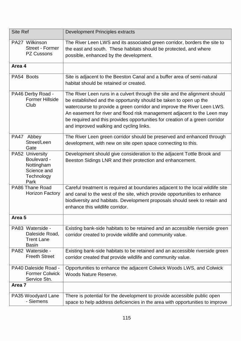
115
Site Ref Development Principles extracts
PA27 Wilkinson Street - Former PZ Cussons
The River Leen LWS and its associated green corridor, borders the site to
the east and south. These habitats should be protected, and where
possible, enhanced by the development.
Area 4
PA54 Boots Site is adjacent to the Beeston Canal and a buffer area of semi-natural
habitat should be retained or created.
PA46 Derby Road - Former Hillside Club
The River Leen runs in a culvert through the site and the alignment should
be established and the opportunity should be taken to open up the
watercourse to provide a green corridor and improve the River Leen LWS.
An easement for river and flood risk management adjacent to the Leen may
be required and this provides opportunities for creation of a green corridor
and improved walking and cycling links.
PA47 Abbey Street/Leen Gate
The River Leen green corridor should be preserved and enhanced through
development, with new on site open space connecting to this.
PA52 University Boulevard - Nottingham Science and Technology Park
Development should give consideration to the adjacent Tottle Brook and
Beeston Sidings LNR and their protection and enhancement.
PA86 Thane Road Horizon Factory
Careful treatment is required at boundaries adjacent to the local wildlife site
and canal to the west of the site, which provide opportunities to enhance
biodiversity and habitats. Development proposals should seek to retain and
enhance this wildlife corridor.
Area 5
PA83 Waterside - Daleside Road, Trent Lane Basin
Existing bank-side habitats to be retained and an accessible riverside green
corridor created to provide wildlife and community value.
PA82 Waterside - Freeth Street
Existing bank-side habitats to be retained and an accessible riverside green
corridor created that provide wildlife and community value.
PA40 Daleside Road - Former Colwick Service Stn.
Opportunities to enhance the adjacent Colwick Woods LWS, and Colwick
Woods Nature Reserve.
Area 7
PA35 Woodyard Lane - Siemens
There is potential for the development to provide accessible public open
space to help address deficiencies in the area with opportunities to improve

116
Site Ref Development Principles extracts
and retain the grassland. The trees along the western and northern edges
of the site should be retained as buffer to the rail line to the north and to
provide green corridors.
Area 8
PA74 Canal Quarter - Arkwright Street East
Opportunities exist to open up the water course to create a green corridor.
PA71 Canal Quarter - Sheriffs Way, Sovereign House
Tinkers Leen is a culverted ordinary watercourse running along the northern
boundary of this site. There should be no development on top of the culvert
and opportunities should be explored to open up the watercourse to provide
a green corridor with associated amenity and wildlife benefits.
PA72 Canal Quarter - Waterway Street
Tinkers Leen is a culverted ordinary watercourse running along the
northern boundary of this site. There should be no development on top of
the culvert and opportunities should be explored to open up the
watercourse to provide a green corridor with associated amenity and wildlife
benefits.
PA57 Clifton West The careful layout of open/greenspace/allotments could also help to protect
both the setting of heritage assets and avoid adverse impacts on the
adjacent two LWS's, Clifton Woods Local Nature Reserve and Holme Pit
SSSI by providing a buffer of semi-natural habitat.
PA53 Electric Avenue An element of green space should be retained or provided and integrated
into the layout of the development.
PA59 Farnborough Road - Former Fairham Comprehensive School
There are opportunities to the south of the site for provision of improved
publicly accessible green space and biodiversity with careful consideration
to the character of the existing landscape. A green corridor of semi-natural
habitat should be established to connect the adjacent Local Wildlife Site
and proposed Fairham Brook Local Nature Reserve and Brecks Plantation,
located to the west of Summer Wood Lane. The presence of pylons at the
eastern boundary of the site provides opportunities for green
corridors/habitat creation.
PA58 Green Lane - Fairham House
There is potential for this development to help address identified open
space deficiencies in the area, including allotment provision.
PA50 NG2 South - Queens Drive
Soft landscaping should link with the green corridor to the south of the site.

117
Site Ref Development Principles extracts
PA49 NG2 West - Enterprise Way
Green corridor along the adjacent railway line should be retained and any
onsite landscaping should comprise semi-natural habitats to link to and
complement adjacent Queen's Meadow.
PA79 Waterside - Iremonger Road
Any proposal should be designed to exploit the canal frontage and to
protect and improve the existing green corridor.
PA77 Waterside - London Road, Eastcroft Depot
The Tinkers Leen runs in a culvert through the site, upon which no
development should take place. If possible, this should be opened up to
improve its ecological value.
PA78 Waterside - London Road, South of Eastcroft Depot
The Tinkers Leen culvert runs though the north east corner of the site, the
alignment of this should be established and if possible opened up to provide
a green corridor.
PA81 Waterside - Meadow Lane
No development to take place above culverted Tinkers Leen that runs
through the site and opportunities should be taken to open up the
watercourse which could provide a green corridor with associated amenity
and wildlife benefits. Opening up the culvert may require an easement.
PA55 Ruddington Lane - Rear of 107-127
Proposals should not adversely affect the Local Wildlife Site to the east of
the site.
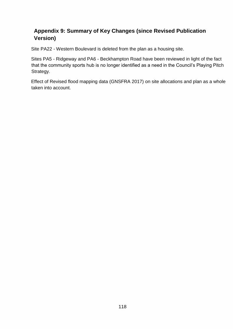
118
Appendix 9: Summary of Key Changes (since Revised Publication
Version)
Site PA22 - Western Boulevard is deleted from the plan as a housing site.
Sites PA5 - Ridgeway and PA6 - Beckhampton Road have been reviewed in light of the fact
that the community sports hub is no longer identified as a need in the Council’s Playing Pitch
Strategy.
Effect of Revised flood mapping data (GNSFRA 2017) on site allocations and plan as a whole
taken into account.

119
Appendix 10: List of Infrastructure consultees Openreach Nottingham City Council Virgin Media Nottingham City Council Nottinghamshire County Council East Midlands Ambulance Service Nottinghamshire Fire and Rescue Service Nottinghamshire Police Environment Agency Natural England NHS Nottingham City Highways Agency NHS Nottingham City Clinical Commissioning Group (CCG) East Midlands Trains Network Rail Nottingham City Transport Nottingham Express Transit Nottinghamshire County Council Trent and Barton British Gas National Grid Western Power Severn Trent Water