Embed Size (px)
Citation preview

Development patterns and
socioeconomic transformation
in peri-urban area
Case of Yogyakarta, Indonesia
Wisnu Pradoto
Technische Universität Berlin

ISBN 978-3-7983-2430-5 (Printing-version)
ISBN 978-3-7983-2431-2 (Online-version)
Berlin 2012
D 83
∞∞∞∞ Printed on acid-free permanent paper
Druck/ docupoint GmbH Magdeburg
Printing: Otto-von-Guericke-Allee 14, 39179 Barleben
Vertrieb/ Universitätsverlag der TU Berlin
Publisher: Universitätsbibliothek
Fasanenstr. 88 (im VOLKSWAGEN-Haus), D-10623 Berlin
Tel.: (030) 314-76131; Fax: (030) 314-76133
E-Mail: [email protected]
http://www.univerlag.tu-berlin.de

i
Contents
Contents i
Acknowledgement v
List of Tables vii
List of Figures viii
Abstract x
Zusammenfassung xi
Chapter 1
Introduction: The peri-urban as a new contested arena of urban development 1 1.1. Major related issue 1
1.2. Significance of the study 4
1.3. Theoretical standpoint 6
1.4. Research questions and scope of investigation 7
1.5. Conceptual and methodological approach 9
1.6. Limitation of the works 9
1.7. Chapter outline 11
Chapter 2
Peri-urban development and its implications for governance: a theoretical framework 14 2.1. Urbanization in developing countries and the dynamics of migration 14
2.1.1. Urban growth and urban transformation 15
2.1.2. The determinant of urban and regional changes 19
2.2. Peripheral urbanization and transforming rural spaces 20
2.2.1. Peri-urbanization: a concept and a pattern of development 22
2.2.2. Rural-urban economy and agricultural livelihood changes 24
2.2.3. Settlement transformation and the emerging socio-spatial segregation 25
2.3. Contemporary urban development in Indonesia 27
2.3.1. Problems and challenges of urban land-use planning and management 27
2.3.2. The role of land speculation in peri-urban development 31
2.4. Peri-urban development governance 33
2.4.1. Local government and political economy perspective 34
2.4.2. Growth management: concept and dilemmas 35

ii
Chapter 3
Research strategy and analysis methods 37 3.1. The relevance of multiple case study strategy 38
3.1.1. Selection of representatively cases 39
3.1.2. Elaborating research questions into operational studies 40
3.1.3. Framework of investigation 41
3.2. Choice and development of research instruments 42
3.2.1. Data collection and analysis for Research Question One 43
3.2.2. Data collection and analysis for Research Question Two 46
3.2.3. Data collection and analysis for Research Question Three 47
Chapter 4
The resulting spatial transformation and land development pattern of peri-urbanization in Yogyakarta 50 4.1. The regional setting and historical background 51
4.1.1. Geographical features and demographic trends 51
4.1.2. Yogyakarta: from a Mataram Kingdom to a Special Region 57
4.2. Dynamics and characteristics of migration 59
4.2.1. Differentiation level of population growth 59
4.2.2. Various motivations and the influencing factors of migration 61
4.3. Spatial development and growth pattern of built-up area 65
4.3.1. Development and growth pattern between 1987 and 1997 66
4.3.2. Development and growth pattern between 1997 and 2007 73
4.3.3. Identifying the tendency of peri-urban growth in Yogyakarta in the future 83
4.4. Modes of land use and space use 101
4.4.1. Mixed land use as a strategy of increasing land use value 102
4.4.2. Mixed space use as a trend of commercialization of space 107
4.5. Typology of new settlement pattern 109
4.5.1. In-between development: a model of small-scale housing 109
4.5.2. Cluster development: spatial fragmentation and social exclusion 112
4.5.3. Self-help housing and the mobility of poverty 115
4.6. Land market within the dynamism of land speculation 119
4.6.1 Farmland: direct negotiation with the farmer or landholder 120
4.6.2 Sultan Ground: property belonging to the Sultanate 125
4.6.3 Tanah Kas Desa: organized under the kelurahan (local authority of village) 128
4.7. Summary of findings 131

iii
Chapter 5
The emerging rural-urban economy in Yogyakarta: livelihood 133 adaptation and income generation 5.1. Deagrarianization and the emergence of non-farm livelihoods 136
5.2. Inter-relationship between formal and informal economy 141
5.3. The persistence of local community for sustaining agricultural activities 146
5.3.1. Share-cropping agreement: cooperation between land owner and worker 149
5.3.2. Multifunctional agriculture and land commercialization 150
5.4. New enterprises and its contribution to the rural-urban economy 153
5.4.1. Home-based enterprises and the emerging local entrepreneurship 153
5.4.2. Medium-scale industry and its role in economic development 163
5.4.3. The opportunity to engage in tourism-based activities 171
5.5. Summary of findings 176
Chapter 6
Urban planning and development policy: an examination of peri-urban governance in Yogyakarta 179 6.1. Urban planning and policy 180
6.1.1. Urban Plan as a product of negotiation 181
6.1.2. Urban Plan as a means of determining investment 182
6.2. Land control and community participation in land development 184
6.2.1 Tanah Kas Desa: between public assets and commodities 185
6.2.2 The challenge of Land Development and Building Permit 189
6.3. Fragmented land management and development policy 192
6.4. Summary of findings 194
Chapter 7
Conclusions 197 7.1. Lesson learned: understanding peri-urban development in Yogyakarta 197
7.1.1. The growth pattern and socio-spatial fragmentation 198
7.1.2. Economic change and the development of non-agrarian livelihood 200
7.1.3. The role of local government in driving peri-urban growth 203
7.2. Revisiting peri-urbanization: a reflection on urban growth management 205
7.3. Some ideas for further study 208
Bibliography 209
iv
Appendix A Questionnaire for households 216 Appendix B Questionnaire for small industries or home-based enterprises 218 Appendix C Questionnaire for developers or land brokers 220 Appendix D Questionnaire for local government 221 Appendix E List of Respondents 222
v
Acknowledgement
Many people have helped me in the course of pursuing my research and writing this
dissertation. They deserve my thanks and have my heartfelt appreciation. I am deeply
indebted to Professor Peter Herrle, my supervisor, from the Berlin University of Technology
who was an invaluable resource during my research and for his being available to discuss it
with me at any time, despite his hectic schedule. I owe great gratitude to Professor Adrian
Atkinson as well for his valuable contributions and for being the external examiner. His
thoughtful comments were always meaningful. Franziska Berger and Marie Neubert most
certainly deserve my thanks too for her assistance with many administrative matters during
my PhD research and during preparation of the final defense.
I am grateful to Dr. Astrid Ley from Habitat Unit – Berlin University of Technology for her
input on research methodological approaches, especially on grounded theory strategy. My
thanks also go to Carsten Zehner for editing the German translation, and to Josefine Fokdal
and Paola Alfaro d’Alencon for their constructive comments given during doctoral
colloquiums. I thank particularly Jean Borgatti, PhD, from Clark University who edited my
manuscript and increased the readability of this dissertation.
During my fieldwork in Yogyakarta, I received much help and advice from Professor Hadi
Sabari Yunus and Dr. Sri Giyarsih from the Faculty of Geography, Gadjah Mada University,
regarding the current issues of peri-urbanization in Yogyakarta. I also thank Projo
Danoedoro, PhD, head of PUSPICS-Gadjah Mada University and Dipo Yudhatama from the
Indonesian National Institute of Aeronautics and Space who provided me with spatial data.
Special thank go to Ivan Samudera and Ardianto who helped me to analyze the spatial data,
and also to Taufiqurohman and some students from the Department of Urban and Regional
Planning, Diponegoro University, who helped me in collecting survey data. My empirical data
would not have been sufficient without valuable information from official staff members
attached to several institutions associated with Yogyakarta local government. The key
informants from Bapeda (Local Planning Board) were Kunto Riyadi; Arief Setio Laksito;
Ratnani Hidayati along with one person from Badan Pengendalian Pembangunan Daerah or
BPPD (Local Development Control Board), namely Agus Subekti. Important local government

vi
officials from Dinas Perdagangan dan Perindustrian (Local Trade and Industry Agency)
included Dwiadi Wahyuningsih and Dwi Wulandari. In addition, I owe thanks to the many
individuals engaged in the business of property development or who worked in medium-
scale industry and home-based enterprises who shared with me valuable information about
their economic activities.
Part of this research was presented at the 2nd conference of the International Journal of Arts
and Sciences at Harvard University, Cambridge, MA. I am indebted to Katolischer
Akademischer Ausländer-dienst (KAAD) and Freunde der Technische Universität Berlin, for
their assistance with a conference grant. During my doctoral study, I received financial
support from the Directorate General of Higher Education, Ministry of National Education,
Indonesia, and Katolischer Akademischer Ausländer-Dienst (KAAD), Germany. I would also
like to express my appreciation to Dr. Heinrich Geiger and Karin Bialas who not only
administered the scholarship, but became real friends during my four years of living in
Germany. I also thank Julio David Peláez Solórzano, PhD, my best friend from Guatemala,
who helped me in completing the documents required to bring my family to Germany.
Last but not least, I am blessed in having a family that has been a long-lasting source of
energy during my study in Berlin. My wife Deasy, and my sons, Kevin and Dimas always
uplifted my spirits and encouraged me during the exhausting days of working on my
dissertation.

vii
List of Tables
Table 3.1 General characteristic of peri-urban growth in Sleman and Bantul 39
Table 3.2 Framework of investigation 43
viii
List of Figures
Figure 2.1 Indonesia the archipelago country 27
Figure 4.1 Map of distribution of population density in DIY 2006 53
Figure 4.2 Map of projection of population density in DIY 2006 56
Figure 4.3 Map of land-use in peri-urban area year 1987 69
Figure 4.4 Map of built-up area growth year 1987-1997 71
Figure 4.5 Map of built-up area growth year 1997-2007 75
Figure 4.6 Farmland converted to commercial and residential uses 78
Figure 4.7 Conversion of farmland into shop-houses 79
Figure 4.8 Map of land-use in peri-urban area year 1997 88
Figure 4.9 Map of land-use in peri-urban area year 2007 90
Figure 4.10 Small-scale housing in Bantul developed by petty developer 97
Figure 4.11 A plot occupied by petty developer in Bantul 97
Figure 4.12 Paddy field occupied for urban use and gated community 101
Figure 4.13 Possibilities of mixed-land use patterns 102
Figure 4.14 Part of paddy-field rented-out for a restaurant in Sinduharjo, Sleman 103
Figure 4.15 Mixed-land use of residential and commercial in Kaliurang 104
Figure 4.16 Converted farmland for residential estate alongside main corridor 105
Figure 4.17 Small-scale housing occupies farmland in distant area 107
Figure 4.18 Mixed-space use of residential and commercial 108
Figure 4.19 In-between development within the local neighborhood 110
Figure 4.20 Lay-out of a small-scale in-between development housing 111
Figure 4.21 Rental student dormitory in Condong Catur 111
Figure 4.22 Lay-out of in-between housing alongside the local access 112
Figure 4.23 Development of new residential estate along the main road 114
Figure 4.24 An exclusive gated residential estate in Kaliurang 115
Figure 4.25 Lay-out and situation of Self-help Housing 117
Figure 4.26 Self-help housing developed on Tanah Kas Desa in the Village of Sinduharjo 118
Figure 4.27 Small-scale and large-scale conversion of paddy field 123
Figure 4.28 In-between development within the local neighborhood 124
Figure 4.29 Self-help housing developed on Tanah Kas Desa in the Village of Sardonoharjo 130
Figure 5.1 Daily activities in pasar represent the link between formal and informal economy 142

ix
Figure 5.2 Paddy field under organization of a Kelompok Tani 148
Figure 5.3 Home-based industry in Kasongan, Bantul selling the products at their own showroom 155
Figure 5.4 Medium-scale furniture industry PT. JAWA in Kaliurang 168
Figure 5.5 Diagram of Medium-scale Industry’s Network in Bantul 169
Figure 5.6 Diagram of Medium-scale Industry’s Network in Sleman 170
Figure 5.7 Medium-scale leather industry Dian Mandala in Kaliurang 171
Figure 5.8 Semi-permanent buildings for cafés established on Tanah Kas Desa 174
Figure 5.9 Hotels located along main corridor or within local neighborhood 176
Figure 6.1 Procedure of land transfer and land-use change of Tanah Kas Desa 186
Figure 7.1 Rural-urban linkages in Yogyakarta 203

x
Abstract Peri-urban areas as the interface between urban and rural regions are currently experiencing enormous changes due to the extension of urban activities. The rapid growth of newly built environment and the apparent transformations of socioeconomic structure reveal how these areas become contested regions. It is recognized that peripheral areas have many advantages to accommodate the agglomeration of urban functions. As a result, the rapid pace of in-migration has been reshaping land-use patterns, economic structures, traditional culture, and neighborhood life. This research attempts to address these issues. By focusing on the case of Yogyakarta as one of the fast growing metropolises in Indonesia, at the theoretical level, this study is concerned with urban growth, urbanization, and the expansion of urbanism. These concerns are then explored through an investigation on three related phenomena: (1) land-use and space-use changes and the resulting socio-spatial patterns; (2) economic restructuring and the diversification of rural livelihood that leads to social transformation; (3) the role of local government and planning policy in driving development. Data was collected through a combination of methods including spatial data from IKONOS satellite images and aerial photographs, survey’s questionnaires, direct observation, and in-depth interviews. Questionnaires were distributed to households of ten villages located in two districts, Sleman and Bantul. In-depth interviews involved several groups of expert respondents including academics, government officials, planners, and developers or business actors. Field research was carried out between April and July 2009. Based on two case studies, this work finds that peri-urbanization in Yogyakarta could be characterized in several ways. First, it is generated by property investment, particularly for the development of residential estates and institutions of higher education. Second, the level of urbanization, with reference to the percentage of households engaging in non-farm activities, is not influenced by the market mechanism but by regional development policy implemented by local government. Third, the emerging socioeconomic transformation presents a particular feature of which the multi-ethnic community and neighborhood based on occupation, social status and economic class characterize the dualism between urban and rural ways of life and express pseudo-urbanism. Fourth, working in the informal economic sector as survival strategy leads the peasant into marginality, as exemplified by the situation in Sleman, whereas pervasive small industry as the rural economy’s agent of development stimulates the emergence of local entrepreneurship, the situation in Bantul.
This study makes no attempt to draw a general conclusion from these two cases. Rather it aims to provide live evidence of particular situational dynamics and resulting development patterns of peri-urbanization. Understanding the impact of development policy on spatial and socioeconomic change has implications for urban governance and growth management, as well as for future research.

xi
Zusammenfassung Peri-urbane Gebiete als Übergangsräume zwischen Stand und Land erfahren in jüngster Zeit aufgrund der Ausdehnung urbaner Aktivitäten einen tiefgreifenden Wandel. Das rapide Wachstum städtischer Siedlungsgebiete und die damit einhergehenden Veränderungen sozio-ökonomischer Strukturen führt dazu, dass diese Gebiete zu umkämpften Räumen werden. Es zeigt sich, dass periphere Räume vielfältige Möglichkeiten für die Ansiedlung städtischer Funktionen bieten. In der Folge verändert die steigende Zuwanderung die Flächennutzung, die ökonomischen Strukturen, die traditionelle Kultur und das Nachbarschaftsleben. Die vorliegende Forschungsarbeit untersucht den Zusammenhang dieser Phänomene am Fallbeispiel von Yogyakarta als eine der am schnellsten wachsenden Metropolen Indonesiens. Es wird die Entwicklung des städtischen Wachstums und der Urbanisierung im Zusammenhang mit 3 Phänomenen untersucht: (1) die Veränderungen in der Landnutzung und den sozialräumlichen Strukturen, (2) die ökonomische Umstrukturierung, soziale Transformation und Diversifizierung der Lebensbedingungen in lokalen Gemeinschaften und (3) die Rolle lokaler Regierungsinstitutionen und insbesondere der Planungspolitik bei der Steuerung räumlicher Entwicklung. Die Datengrundlagen basieren auf verschiedenen Quellen bzw. wurden mithilfe unterschiedlicher Methoden erhoben: räumliche Daten von IKONOS Satelliten-Aufnahmen und Luftbildern, Umfragen mit Fragebögen, direkte Beobachtung sowie Tiefeninterviews. Umfragen wurden mit Haushalten in 10 Dörfern in den Gemeinden Sleman und Bantul durchgeführt. Tiefeninterviews wurden mit verschiedenen Expertengruppen, wie z.B. Akademikern, Regierungsmitarbeitern, Planern, Projektentwicklern oder Unternehmern geführt. Die Feldforschung dauerte von April bis Juli 2009. Basierend auf der Analyse der zwei untersuchten Fallstudien stellt diese Arbeit im Ergebnis fest, dass Peri-Urbanisierung in Yogyakarta in verschiedener Hinsicht charakterisiert ist. Erstens ist sie durch Investitionen getrieben - insbesondere durch die Entwicklung von Wohnsiedlungen und Ansiedlung höherer Bildungsinstitutionen. Zweitens wird die Intensität der Urbanisierung (bezogen auf den Anteil der Haushalte mit nicht-landwirtschaftlichen Einkommen) nicht durch Marktmechanismen beeinflusst, sondern vielmehr durch die von der lokalen Regierungsebene umgesetzte regionale Entwicklungspolitik. Drittens hat der aktuelle sozio-ökonomische Transformationsprozess zur Folge, dass sich die multi-ethnische Bevölkerung in Bezug auf Beschäftigung, sozialen Status und Einkommensniveau in einer Dualität zwischen urbanen und ruralen Lebensstilen befindet, die sich in einer Pseudo-Urbanität ausdrückt. Viertens zeigt der Fall Sleman, dass Arbeit im informellen Sektor als Überlebensstrategie in die Marginalisierung führt, währenddessen der Fall Bantul belegt, dass die für die rurale Wirtschaft typischen Kleinunternehmen als Treiber für lokales Unternehmertum fungieren. Im Rahmen der vorliegenden Arbeit können keine allgemeingültigen Schlussfolgerungen aus diesen beiden Fallstudien gezogen werden. Vielmehr ist es das Ziel, empirische Erkenntnisse über spezifische Situationen von Peri-Urbanisierung und die damit zusammenhängenden Dynamiken und Entwicklungsmuster zu liefern. Die Kenntnis der Dynamiken des räumlichen und sozio-ökonomischen Wandels ist wichtig für städtische Governance und ein effektives Wachstumsmanagement sowie für die zukünftige Forschung.

1
Chapter 1
Introduction:
The peri-urban area as a new contested arena of urban development
1.1 . Major related issue
Urban development in Indonesia has recently been characterized by the high rate of land
conversion, especially in peripheral areas. According to World Bank data (2000), no less than
ten per cent of Java’s cultivated land has been converted to urban use. High consumption of
land for both commercial and residential use in city centers has stimulated development in
city outskirts. Large areas of agricultural land have been occupied by individual or
institutional investors. Peri-urban areas have become the arena which developers and land
speculators pursue to control the urban land market.
As is the case in other parts of the developing world, the high level of urbanization in
Indonesia is also characterized by the rapid pace of transformation of urban areas. In the
1990s, urban areas experienced a population growth of 4.3 per cent per annum. It was
approximately triple that of the national population growth of 1.5 per cent per annum. Java
became the most populated island, with 65 per cent of the total population residing in the
urban areas. In 2025, the country is predicted to be 61 per cent urbanized with an urban
population of 167 million (World Bank, 2000).
The high rate of population growth and urbanization in Java was generated by a
concentration of economic development and sociocultural activity as well as political
practices. It resulted not only in Java’s primacy, but also in sharpening the disparity between
Java and elsewhere, particularly with respect to the availability of economic infrastructure
and sociocultural facilities. People from various regions in Indonesia came to Java in search
of a better livelihood since they believed that there was greater opportunity for new
employment. Population density of such major cities in Java as Jakarta, Surabaya, Bandung,
Semarang and Yogyakarta drastically increased.

2
As one of the densely populated and rapid growing cities in Java, Daerah Istimewa
Yogyakarta (henceforth referred to as DIY meaning the Special Region of Yogyakarta)
presents a particular situation with regard to spatial and socioeconomic phenomena. Some
of its peripheral areas show a high rate of land conversion, although the evidence reveals
that the high demand for developable land did not represent real need for housing at all, but
to speculators manipulating the market.1 Despite a significant rate of migration, either
intra-migration across the regions in DIY or in-migration from elsewhere in Java or beyond,
there is a surplus of housing units in several peripheral zones, notably where the new
university campus was built as well as in areas where the natural environment remains
undamaged. How could this be? To what extent could government policy have regulated
land development?
According to contemporary patterns of urbanization in which the capitalist economy and
liberalization of the market become the driving forces of urban development, agricultural
lands as non-urban spaces become contested arenas for development actors. The
movement of the middle-class to peripheral areas stimulates a new pattern of urbanism in
which the local agrarian-based culture and socioeconomic features are penetrated by an
urban-capitalist way of life, resulting in spatial fragmentation and social segregation in the
newly built-up areas. Despite problems with regard to social heterogeneity, the conversion
of farmland, and environmental problems related to increased land consumption for new
development, the economic transformation generates new opportunities for livelihood
diversification and additional income for the peasants. The emergence of a non-farm
economy, however, shows a developing pattern of economic dualism with a tendency
towards marginalization rather than modernization particularly within the informal economy
that characterizes the peri-urban areas. Equity clearly remains a challenge in urban growth.
Conflicts emerging as part of the steady agglomeration of urbanized regions grow out of
fundamentally different values held by various segments of society, rendering the situation
more complex, for how problems are framed in politics plays a central role in shaping how
these values are translated into policies.
1 Based on data from Local Development Board of Sleman Regency (Bapeda), back-log in 2008 is only 5000
housing units, comparing to housing supply in Sleman there was a surplus of 28,000 housing units in Sleman. The evidence reveals a rapidly growing of residential estate that is not referred to the demand analysis.

3
Urban diversity is at the center of current debates on cosmopolitanism in which the process
of socioeconomic and cultural hybridization takes place. Pacione (2001, p.359) emphasizes
residential differentiation based on socio-economic status as a defining characteristic of
cities. Why does residential segregation matter? Previous studies show that the social
dimensions of residential pattern, particularly the degree of social inclusion or exclusion,
strongly affect the inhabitants’ quality of life. Sampson and Raudenbush (1999 in Roberts
and Wilson, 2009:3) note that the physical and social features of neighborhoods create
advantages or disadvantages for individuals and families that are over and above those
arising from individual socioeconomic characteristics. Based on constructive and destructive
impact results from peri-urbanization studies (Beall, 1997; Beall and Fox, 2009 in Beall,
2010), it can be understood that diversity has been viewed both as negative and positive.
Based on contemporary problems of urbanization caused by capitalist interests, Molotch (in
Logan and Molotch, 2007) coined the concept of the city as a growth machine. He argues
that there is a strategy of development to optimize the performance of the urban economy
through exploiting the hinterland’s resources though this results in economic disparity. The
pro-growth agenda becomes the political economy of the government. Public agencies and
private sectors together become a development regime that privileges economic growth as
the most important indicator of success. Thus, private investment which generates income
for the regional economy is supported rather than the pursuit of social equity. In contrast,
the other development paradigm aims to enhance the grass-roots economy rather than
capitalist groups. The strategy here is to foster and facilitate the development of small-scale
industries and home-based enterprises. The belief is that the development of a grass-roots
economy will have a multiplier effect that will generate benefit for the lower economic
strata. This is essentially an anti-growth development strategy. Thus it tends not to support
capitalist interests.
Besides the factor of political economy, the other dimension that relates to peri-urban
development is the strategy of decentralizing local government. The increasingly important
role of the peripheral area as a new center of growth suggests that decentralization is both
urgent and necessary. Government, as argued by Overman and Venables (2010 in Beall,
Guha-Khasnobis, and Kanbur eds.,2011), has to play a strategic role in developing
infrastructure and regulation with a view to facilitating deconcentration in order to guide

4
capital investment into the proper channels, both in term of sector and spatial development.
Special attention should be paid to management strategies in order to control informal
land development and speculation.2 Better coordination among the development
authorities at local and regional levels as well as at the national level should become the
priority. Moreover, urban and development planning should accommodate change, being
sensitive to the need for flexibility in order to respond to the growth pattern demonstrated
by a particular area. In this sense, the need to build the capacity of government officials
should be complemented by the participation of the local communities, coordinated at the
lowest level of authority, such as the village, to control the development process. In other
words, the active participation of the community becomes an crucial factor not only in the
planning process but also in the more important process of development control. The other
classical problem that remains, and one that may be seen as critical, results from lack of
coordination among the authorities responsible for the decision-making on development.
Such fragmentation of authority in development governance is major challenge for the
effective urban planning.
1.2. Significance of the study
The idea for this research came from the scant attention paid to urban peripheral areas
relative to primary cities and regional urban centers. Significant research has been carried
out on Indonesian cities in recent times, their emerging dynamics and resulting development
patterns. An alternative urban vibrancy that takes place at the city’s periphery has been
given less attention by urban scholars and even by the Indonesia’s local government. The
peri-urban areas, particularly in less developed countries, though currently having a more
determinant role, were less interesting formerly, as they made no significant contribution to
local and regional economies. On one side, as indicated by DiGaetano and Klemanski (1999),
that peri-urban areas have become the home of many economic activities and the
destination of the middle class for residence purposes has brought multidimensional
changes. On the other side, these areas suffer from the negative consequences of urban
growth, rapid social change, land use changes, and degradation of natural resources. Such a
problematic situation is thought to be the outcome of lack of regulation over land use that
permits land speculation which in turn creates an over consumption of land. The strategic
2 The term “informality” here signifies the absence of legal procedures that must be fulfilled prior to land
development activities.
5
location at the interface of urban and rural areas makes the peri-urban zones more
complicated and their growth tends to be uncontrolled. Previous urban and regional studies,
especially in Indonesia, have focused on either urban or rural areas delineated by
administrative boundaries. Thus, the dynamics of the interface area remain to be less
intensively explored. There is the phenomenon of ‘rural’ activity in ‘urban’ spaces, and,
correspondingly, ‘urban’ dynamics in ‘rural’ regions. The ‘not urban and not rural’ areas are
now emerging as the region of the future in regional development, particularly in the less
developed nations. As the interdependence between urban and rural becomes more
intensive, a better understanding of the dynamics of its interface area becomes more
important prior to the implementation of any development strategy. There is an emergence
of small town embryos or new service centers influenced by both rural and urban realms
rather than by the primacy of metropolitan area at the region’s center.
The rapid urbanization of cities in Indonesia since early 1980s has followed a consistent
pattern. Increasing development in the urbanized area over the decade has transformed
space and fostered socio-economic change. Yogyakarta as an Indonesian metropolis has
experienced the peripheral urbanization characterized by ongoing urban agglomeration and
now faces great challenges in urban development and land management. The growing city of
Yogyakarta occupies cultivated farmland and rural neighborhoods. Its peripheral areas are
gradually becoming small towns and the dispersed pattern of newly built-up areas continues
to spread into its surrounding, previously rural regions. The rural-urban transitions seen in
almost all the new settlements have reached unprecedented levels, with the intensity of
problems and challenges increasing in the future. Population growth and continued land
development are the current challenges, whereas socio-spatial segregation, socio-economic
and cultural gaps as well as uncontrolled land markets and the spread of informal
development are the emerging problems.
It is evident, that in many cases urban planning itself is part of the problem rather than being
the source of the solution. Rapid development beyond the peri-urban areas has resulted in
an inability to control the growth effectively with reference to existing urban land-use plans.
The unpredictable dynamics are not covered in conventional development planning. Each
local government reacts differently to a developer’s plan in terms of zoning regulations and
development policy. Informal development and land speculation not only by petty non-

6
institutional developers but also by government’s officials complicates the problem. The
research on peri-urbanization (Afsar 1999; Simon et al. 2004; Torres et al. 2007; Huisman
and Stoffers 1998; Rotgé 2000) demonstrates that each peri-urban area has particular
characteristics that lead to different dynamics that in turn dictate the specific planning
strategies. The mosaic of environment, social strata, economic structure, and government
institutions that implement development policy are all contributing factors.
How local authorities prepare for this transition and deal with a city’s size through a strategy
of urban growth management is the most important factor. A new age of urban planning
and development strategy is crucial if socially and environmentally disruptive and
unsustainable development practices are to be avoided. In order to formulate an adaptive
approach of growth management, a better understanding of how new urban area have
developed and transformed, and how development policies have contributed to the changes
is necessary.
1.3. Theoretical standpoint
The rural-urban linkages theory may be a convenient way to explain the dynamics of peri-
urban growth. Pacione (2001) mentioned three scholars who built the classic conception of
urban and rural linkages, i.e. Von Thünen, Christaller and Lösch. Von Thünen’s seminal work
analysing the spatial allocation of economic activity has inspired several other studies on the
relationship between urban and rural areas. Thünen employed a model of agricultural land
use and found that urban demand was a key driver of spatial allocation. His work was
followed by that of Christaller who investigated the formation of urban settlements and
coined the Central Place Theory. This was later reviewed by Lösch who suggested an urban
hierarchy based on human settlement.
Based on contemporary research, Tacoli (1998) outlined two types of relationship defining
linkages between urban and rural, i.e. the spatial relationship and the sectorial relationship.
She concludes that spatial linkages between city and towns generated by the mobility of
capital, goods, and humans between them grows in relation to the improvement of
infrastructure and advancement of technology. In this she utilizes work by Castells (1989)
who developed the concept of spatial flow, the resulting pattern of space generated by
globalized economy and market liberalization.
7
Based on a study conducted by Potter (1998), it is largely recognized that the concentration
of economic activities becomes the generator of spatial growth as it attracts migration.
According to Potter, Stark and Bloom in 1985 emphasized that migration was a household
decision motivated by employment or the desire for income diversification. In their view, the
rural-urban continuum was the arena where the relationship of living space and working
space was delineated.
Other theoretical perspectives concerned with the economic aspect of rural-urban linkages
comes from Modernization Theory that examines the role of the city in creating the
opportunity for hinterland areas to benefit from growth through a multiplier effect. Thus,
the development process of new rural-urban economic activity results in two types of
economy, namely the formal and the informal. The emergence of unequal development in
peri-urban areas not entirely caused by the availability of natural resources and geographical
characteristics are then investigated typically through urban governance with an agenda of
political economy reflecting the roles of public sector and private interests in leading the
development.
The theories referenced above provide the framework through which the phenomena of
peri-urbanization as a complex process of rural-urban linkages is approached. However, the
conclusions in this study will depend on the empirical data gathered during fieldwork rather
than regard or disregard for existing theories. The relevant theoretical discourse will be
presented in Chapter 2.
1.4. Research questions and scope of investigation
This study of peri-urban development is by nature comparative. Various considerations
influenced the selection of the regions for study, mainly the distinct growth process, and the
socio-economic structure of migrant households together with the political and economic
views of the local and regional governments. The aim of this research is to gain an
understanding of the ways that different policies and socioeconomic characteristics drive the
particular dynamics of peri-urbanization in which a variety of spatial transformations and
livelihood changes of local residents and migrant households takes place, utilizing either
rural-based or urban-based economic sources.
8
Based on the general conditions of urban growth process in Yogyakarta and several concepts
drawn from theoretical framework, several questions specified below are addressed and
become points of reference in field investigation and data collection.
1) How has the process of peri-urban growth and migration taken place and in what
ways have land development patterns change the socio-spatial configuration?
2) How has rural-urban transformation affected the existence of local agriculture and
generated a range of diversification in the rural-based and urban-based economies?
3) To what extent has the government’s role influenced the modes of development and
the direction of urban growth, and what are the challenges of urban governance
ahead with respect to urban growth management?
Referring to the aims of the study and aligning it with the research questions mentioned
above, the scope of the investigation and analysis is then determined as follows:
1) Analyzing the differential of population growth and settlement pattern, identifying
the determinant factors of migration and its impact on the dynamics of the land
market as well as describing changes in land use and space use (Chapter 4);
2) Investigating the impact of peri-urbanization on agricultural activities and the
development process of small- and medium-sized enterprises which present
different characteristics of socioeconomic and livelihood opportunities in the case
studies (Chapter 5);
3) Examining the role of local government and planning institutions in relationship to
business interests in driving investment and land development, and identifying the
problems and challenges for urban governance (Chapter 6).
Drawing on the conceptual and related phenomena of peri-urban development described
above, an area characterized by rapid changes in demographic structure, economic basis,
occupational multiplicities, and land use patterns has been chosen as the case study. This
area has experienced high rates of immigration and changing livelihood opportunities. The
traditional economic bases are being replaced by such new economic opportunities as the
production of export-oriented products or processed goods. Thus, as suggested by

9
Agergaard et al. (2009), the term “peri-urban” is not limited to denoting areas in the throes
of rapid change in spatial arrangement, but includes areas experiencing social and economic
fluidity because of new opportunities.
1.5. Conceptual and methodological approach
Multiple case studies is the research strategy to be used in order to gain insight into the
different characteristics of development patterns in peri-urban areas, and several methods
have been used to address the research questions. First, a survey covering a representative
selection of ten villages in the peri-urban area of the city of Yogyakarta was undertaken in
between April and July of 2009. A quantitative approach was used in the analysis of the
survey results that provided baseline information on the nature of peri-urban development.
This analysis provided the foundation for conducting an in-depth investigation. That
investigation employed a more qualitative approach. Thus this study mainly relies on the
primary data collected by means of field mapping peri-urban land-use change and making
sample surveys among heads of households and owners or directors of small and medium
enterprises, and by carrying out structured and open interviews with target groups and key
informants rather than relying on secondary data with its limitations and validation
problems.
Such an approach seemed the most appropriate for examining the functions of new growth
centers in the peri-urban areas with regard to changes in modes of production and living
conditions of the heterogeneous population.
1.6. Limitation of the study
There are limitations that are faced from the beginning of fieldwork until the phase of
analysis in which the interpretations are from which conclusions are drawn. Based on The
limitations are categorized into two different levels as follows:
The operational level
This study is based on quantitative and qualitative data gathered from a survey of 263
households in ten villages within two regencies, Sleman and Bantul. Such empirical data
collected by open-ended and close ended questionnaires were then complemented with in-
10
depth interviews with key respondents from four Rural Bank officials (Bank Perkreditan
Rakyat or BPR); representatives from three medium-scale industries; eighteen individuals
involved in petty trade and services, mostly street vendors; eight involved in home-based
enterprises; eight institutional or formal developers; six land brokers and/or petty
developers; six officials of local government; three professional planners; and three
university academicians. Despite, the relative breadth and depth of the sample, some of the
data is not reliable making it difficult to draw generalizable findings. The problem primarily
stems from the household survey questionnaires. They do not entirely represent the
aspirations and opinions of the head of household, since approximately twenty percent of
the questionnaires were filled out by housemaids or relatives of the property owners. The
conclusions outlined in the last chapter are therefore considered provisional. The other
operational limitation is associated with the Focus Group Discussion that involved
development actors with different interests. Several institutional or formal developers
objected to the idea of a Focus Group, making it difficult to collect a more objective or
considered opinion. Thus, to create an indirect dialog among stakeholders, multi stage in-
depth interviews were conducted, or commonly referred to as the Delphi Method.
In addition, the competence of the interviewed officers must be considered. Few of them
seemed to have the requisite information on particular issues. There is tendency for officers
to be put in an inappropriate job, since their educational backgrounds are often not at all
relevant to their jobs. Some of them also tended to share relatively incorrect data for
political reasons. The multi-staged interviews mentioned above actually became effective
triangulations to minimize this problem.
The methodological level
This research is based on the principles of qualitative inquiry. The grounded theory approach
was implemented to explore the dynamics of peri-urban development in case studies of
notably the two Regencies, Sleman and Bantul, which have experienced the most rapid
population growth and migration as well as intensive development of newly built-up areas.
Description based on context-rich settings may create multiple interpretation among
different observers. With regards to empirical findings, the reader must be the final judge of
external validity. Even an expert in the field whose knowledge is derived from a different
case study may understand and interpret the data differently.

11
This study is then orientated to present ‘live evidence’ rather than to make a generalization
through the narrative explanation about the particular dynamics, compares to another
phenomena in developing countries, and the resulting patterns of peri-urban development
in Yogyakarta.
1.7. Chapter Outline
This research is a multi-facetted study that utilizes different methodological approaches and
analyses. Peri-urbanization and its resulting development pattern as the main subject of the
study contain several areas of exploration and examination, the spatial dimension,
socioeconomic features, and local government policies on planning and development.
Scholars who study urbanization maintain that these three phenomena, that is, the spatial,
socioeconomic, and policy, should be investigated together to understand the dynamics and
the patterns of urbanization. In order to present the empirical findings in a way to make it
easier to identify to which phenomenon an investigated subject belongs, each phenomenon
associated with a research question will be presented in a particular chapter. This
dissertation is divided into seven chapters.
Chapter one outlines the initial discourse and the related issue of peri-urban development to
give a contextual framework for the study. In addition, a brief description and discussion of
The Special Region of Yogyakarta (Daerah Istimewa Yogyakarta) is presented to provide a
firm basis.
Chapter two reviews the relevant literature on urbanization in the developing world and the
dynamics of migration, particularly related to peri-urban development and rural-urban
linkages. Contemporary urban development in Indonesia is then briefly outlined to provide
the macro context of peri-urbanization in Yogyakarta. Peri-urbanization is then compared
across several developing countries to give insight into this particular characteristic of
urbanization. Finally, several viewpoints on the role of public policy in driving the
development pattern in peri-urban areas are described.
Chapter three elaborates upon the research approach and analytical methods used. The
explanation is divided into two parts. The first part provides the basic argument regarding
the selection of a research strategy. The second part then elaborates upon the methods of
analysis and tools of data collection. This part consists of three sections, each concerned

12
with a research question and an accompanying discussion of data collection methods and
data analysis.
Chapters four, five and six contain the findings of the research. Chapter four analyzes the
pattern of spatial change and distribution of newly built-up areas using satellite image data
and aerial photographs. This spatial evidence is then correlated with the data gathered from
household surveys and interviews to explore the factors of migration and modes of
habitation in the peri-urban area of Yogyakarta. The dynamics of the land market are
investigated to understand the forces driving land development and how they work. This
chapter identifies several findings: pseudo-urbanism (in which physical urban characteristics
penetrate the remaining rural-based cultural areas); the mobility of poverty (as reflected in
the socio-spatial pattern); the reconfiguration of land use patterns and commercialization of
farmland; and the speculation in housing development (that reveals the bias of housing
demand).
Chapter five focuses on exploring the pattern of the new rural-urban economy and the
transformation of agrarian livelihood into non-farming activities. The emerging of such an
urban-based economic feature results in conflicting socioeconomic characteristics, namely
both the marginalization and the modernization of agricultural production. With less land
available as a result of land commercialization, the remaining agrarian community tends to
practice new modes of cultivation commonly referred to as multifunctional agriculture.
Chapter six explores the implementation of relating policy to urban development and land
management practices that affect spatial pattern and land development. The main issues
with regard to peri-urbanization in the case study areas are the “pro-growth” and “pro-poor”
paradigms that imply different development performances. Together with market
liberalization and the interests of a capitalist economy, the strategy of development
executed by a local government plays a determinant role in the development model of a
peri-urban area.
The concluding chapter, will present reflections on several dimension of peri-urban
dynamics. This final chapter will also reference the study’s findings in order to examine
current urban growth management. In revisiting urban development strategy, this chapter

13
also invokes the theoretical framework, related issues, and research questions posed and
answered by the study to indicate its contribution to existing knowledge. Furthermore, by
comparing the findings with the major issues of peri-urban development discussed in the
literature, this chapter also presents several ideas for future studies.

14
Chapter 2
Peri-Urban Development and Its Implication for Governance: A Theoretical Framework
This chapter contains the discourse on the dynamics of rural-urban transformation and its
impacts on spatial patterns and the socioeconomic adjustments of society. Contemporary
urbanization theory provides the conceptual framework for the research findings.
Additionally, the empirical evidence of several earlier studies in related areas will also be
reviewed. Comparative study is limited to phenomena occurring in developing countries, in
order to be more relevant to the situation in Indonesia. Nonetheless, this chapter presents
major issues of contemporary urban development practice in Indonesia, especially in regard
to the problems and challenges of land-use planning and management, as well as the
dynamics of land speculation beyond peri-urban regions.
2.1 Urbanization in developing countries and the dynamics of migration
A current feature of urbanization, as stated by Pacione (2001), involves a process of
population decentralization that manifests itself in two ways. The first, counter-urbanization
or urban de-concentration, is characterized by net in-migration from the urban core into its
surrounding region. The second is suburbanization that has taken place over a long period of
time as the urban function and facilities have been more widely developed and the urban
infrastructure supports mobility. In the post-modern era, the phenomenon of
suburbanization has become more dynamic and its role in urban development tends to be
more central since it extends further and embraces a broad range of previously rural area.
Nelson (in Pacione 2001:84) suggests the main aspects to investigate in the dynamic of
extended suburbanization (ex-urbanization):
1. Continued de-concentration of employment and the rise of ex-urban industrialization,
2. Preference of urban households to relocate in more “natural” and less congested environments,
3. Technological advancement that makes it possible to live at a distance from the city,
4. Shifting of government initiatives to develop the outer area rather than revitalize the inner city.

15
2.1.1 Urban growth and urban transformation
Cities grow for different reason at different times. Migration is one important factor that
affects the spatial distribution pattern as well as socioeconomic adjustment at different
levels of society. Clark (1996) states that urbanization is one of the influential process of
urban development that transforms the spatial pattern. Redman (in Pacione 2001:67) adds
that urbanization it is a complex arrangement in which a series of interacting incremental
facets form the new urban living rather than being a linear process. Economic development
is recognized as the main factor that stimulates urbanization and urban growth. Higher levels
of urbanization, in turn promote economic growth. The concentration of economic activity
resulting from the large number of investments, including property development and
building construction, subsequently attracts people (see also Turok 1992; Gibb et al. 2002).
The term “urbanism” is associated with both the character of habitation and the society hat
lives in the city--their social, economic, cultural, and political dynamics, However, as stated
by Beall and Fox (2009), a large number of social scholars agree that urbanism not only
belongs to life in the city, it also involves the countryside where the population takes on the
character of urban culture and patterns of consumption.
Relevant questions include: How do we understand this development process? What are the
pivotal forces that have driven its growth? How are local traditions and customer values
affected by entrepreneurial spirit? What role does local government play and what is the
impact of planning policy on socioeconomic and spatial change?
This study focuses on the practice of development in the peri-urban area, in which
contemporary urbanization tends to be region-based rather than city-based.3 It takes place
as described by McGee et al. (1991) in Asia during 1990s. Moreover, this research is oriented
to examine the formation of third world urbanization Keiner et al. (2005).
3 There are now more than three hundred city-regions around the world with populations greater than one
million. These city-regions are expanding vigorously, and they present many new and deep challenges to researchers and policy-makers in both the more developed and less developed parts of the world. The processes of global economic integration and accelerated urban growth make traditional planning and policy strategies in these regions increasingly inadequate, while more effective approaches remain largely in various stages of hypothesis and experimentation. "Global City-Regions" represents a multifaceted effort to deal with the many different issues raised by these developments. It seeks at once to define the question of global city-regions and to describe the internal and external dynamics that shape them; it proposes a theorization of global city-regions based on their economic and political responses to intensifying levels of globalization

16
Concern with urban-rural linkages, as described by Pacione (2001) started with the work of
Von Thünen who initiated studies on the interrelationship of city and countryside. In 1826,
he analysed the spatial allocation of economic activity using a model of agricultural land use.
He found that urban demand was a key driver of such spatial allocation. Von Thünen’ work
inspired Christaller, who in 1933 investigated the formation of urban settlements and how
they spaced out relative to each other. He coined the Central Place Theory which was later
reviewed by Lösch in 1954 who created an urban hierarchy based on human settlement. In
1998, Tacoli outlined two types of relationship defining the linkages between urban and
rural. The first is a spatial relationship and the second a sectoral relationship. She concluded
that spatial linkages between cities and towns as well as villages would increase in intensity
as the mobility of capital, goods, and humans between them became greater (von Braun,
2007).
Paralleling the dynamics of urban growth, Potter (1998) studies the spatial differentiation
that take place with regard to the process of geographical concentration of particular
economic activities. The concentration of economic activities is recognized as the generator
of spatial expansion as it attracts migration. According to the dynamic of migration, Stark
and Bloom (1985) emphasized that migration was a household decision stimulated by the
search for income diversification. They view the rural-urban continuum as the spatial
appearance representing the relationship of living space and working space. The
modernization process (Hirschman, 1959) is recognized as the impulse that changes the
orientation from rural-based activity into urban-characterized economy. He was an adherent
of the theory of modernization that argues for the economic development of the city
creating a multiplier effect in the peripheral area. Modernization theory is also referred to as
an explanation of the process of peri-urban development in this study.
The other is globalization theory in which market liberalization stimulates economic growth-
oriented development that leads in turn to the emergence of the Flow theory coined by
Castells (1989) in which he tries to reconceptualize spatial patterns. To him, space should
not be separated from time as it is a really dynamic entity related to time. Driven by
improvements of infrastructure, technological progress, and market liberalization, previously
rural areas are transformed. In this process of transformation, the peri-urban area as the
interface between urban and rural experiences the phenomenon in which the rural-based

17
socio-economic and cultural character gradually changes into a new form of urbanism, a
hybridization of urban and rural features across spatial, economic, social, and cultural
dimensions. In this process, the development actors consisting of public agencies and private
sectors will drive the pattern of development and the opportunities for development
differently upon those peri-urban areas (Castells, 1989; Beall & Fox, 2009; Potter & Lloyd-
Evans, 1998).
Afsar (1999) who studies the contemporary rural-urban linkages in Dhaka, Bangladesh,
argues that the process of rural to urban transformation is not only about population
concentration, but also about changes in social and economic characteristics. The failure of
urban development has been caused, in part, either by the failure to understand the
dynamics of migration and its impact or government negligence regarding the society’s
structural adjustment brought about by the process of rural-urban transformation.
Afsar finds several factors contributing to rural-urban interactions as follows: (a) structural
adjustment in economic and political sectors will transform the society; (b) structural
changes in employment will affect local livelihood. In the case of Dhaka, occupations related
to agriculture have gradually become more significant in urban areas, since the rural areas
encompassed by the urban expansion still depend on farm activity. At the same time,
infrastructure development, especially roadways to the urban fringe along with increased
construction, manufacturing, and traditional types of services generate greater employment
opportunities that draw large numbers of people.
Torres et al. (2007) investigate the pattern of urban sprawl in Brazil’s Sao Paulo metropolitan
area driven by the growth of real estate investment. In particular, this research focuses on
the dynamics of land markets triggered by land use regulation and public policy. Comparing
spatial patterns of population growth and real estate investment, they found that the city
was losing population where real estate development was growing. Population moves to the
peri-urban areas where the price of land is low. The lower-income migrants develop informal
settlements due to the lack of affordable housing. Informal land use becomes a crucial
problem, a recurrent pattern in developing nations. It has been suggested that regularization
and simplification of land use planning and development permitting processes are the most
urgent matters to address to improve the socioeconomic conditions in peri-urban areas.

18
However, there remains the need to improve the social facilities and economic
infrastructure as well if poverty is to be alleviated.
A third work relevant to this study is that conducted by Simon et al. (2004) on changes of the
rural-urban interface in Kumasi, Ghana, Africa. They found that the features characterizing
transformation from rural to urban occurred in different degrees depending upon distance
from the city, accessibility, and the provision of infrastructure. Their research findings
confirm the concept of a non-linear and non-uniform gradient of urban influence on peri-
urban areas. Areas experiencing a higher degree of changes experience a correspondingly
higher degree of land commercialization, diversity in social structure, and economic activity.
The pressures of urbanization are manifest in increasing plot prices and rates of land
conversion (farmland or vacant land) to urban uses, especially for new residential and
commercial development.
Research conducted by Huisman and Stoffers (1998 in Titus and Hinderink eds., 1998) in the
District of Bantul, Yogyakarta centered on the level of urbanization achieved through a
progressive transformation from a farming-dominated activities to a more diversified
economy. They classified the peri-urban area using a measure based on the proportion of
labor force that worked in the non-agricultural sectors. The sub-districts in which more than
65 per cent of the work force engaged in urban-based economy would be categorized as
peri-urban areas, while the rural ones would be divided into three other categories: (a) rural
zone 1 that contains less than 10 per cent of irrigated land; (b) rural zone 2 that contains 10-
36 per cent of sawah (paddy land); (3) rural zone 3 with more than 36 per cent of the total
area covered by agricultural land. Using these measures, only three of Bantul’s seventeen
sub-districts could be categorized as peri-urban areas. These were Banguntapan, Sewon and
Kasihan, all located around five to ten kilometers from Yogyakarta’s city center. The sub-
district Bantul, the capital of Bantul district, located approximately 12 km from the city
center of Yogyakarta is categorized “rural zone 3” since it contains more than 36 per cent of
irrigated paddy land.
The initial investigation of Bantul done in this study corresponds with the work of Huisman
and Stoffers. This study also delineates the three sub-districts of Banguntapan, Sewon and
Kasihan into peri-urban areas on the basis of the intensity of built up area observed in the
spatial data provided by GIS analysis of aerial photographs made in 1987, 1997, and 2007.
19
This study also uses other parameters to delineate the peri-urban areas, demonstrating that
there are various measures, bothspatial and non-spatial, useful for investigating and
categorizing the scale of urbanization in the previously rural areas like Bantul. The sample of
households in Bantul in this study are separated into two categories, those located near the
city’s boundary (around 5 km from the city center), and those located approximately 10 km
from the city center (see Chapter 3.2.1). This data reflects a situation quite different from
that presented by Sleman Regency in which the peri-urbanization suggests a pattern of leap
frog development that reaches relatively remote areas more than 15 km from the city center
of Yogyakarta.
Another related study of Yogyakarta is that conducted by Rotgé (2000) who assessed the
nature and level of rural-urban linkages in Bantul District and how such linkages created
opportunity for additional income sources. He found that agriculture’s share of employment
decreased in communities located alongside the main corridor, while the share of trade and
services rose. His research findings further reveal that though a considerable number of the
work force engage in non-farm activities in terms of primary employment, many still work in
the agricultural sector as a secondary activity within a scheme of sharecropping since they
do not have access to farmland. Those who work in non-farming activities mostly engage in
industry located in the city of Yogyakarta or town of Bantul as well as neighboring districts.
His empirical findings show that agricultural remains the primary livelihood for the local
inhabitants. The opportunity for I involvement in other employment sectors, particularly in
small and medium sized enterprise or industry, is mostly taken up by the younger
generation living in farming households.
2.1.2. The determinant of urban and regional changes
Peri-urbanization in most developing countries generally reveals the phenomenon of spatial
disorder and social segregation. The interplay of economic, cultural and political
determinants creates the contemporary peri-urban spatial form, according to Campbell and
Fainstein (2011). Advances in the infrastructure of transportation and information
technology makes it possible for people to live at some distance from their downtown
workplaces. The extent to which new spatial deconcentration occurs in the periphery,
however, varies considerably across countries (as well as within countries that have a

20
heterogeneous population), depending on the nature and strength of cultural attitudes
about habitation in their respective societies. Differences of social and cultural
characteristics between native communities and migrants ultimately produce change in
socio-spatial patterns.
The new housing subdivisions and the spreading of informal settlement beyond the urban
periphery are the most profound evidence of how the political economy of local
governments and business interests, as well as the spontaneous practice of land speculation
have been playing influential roles.
2.2 Peripheral urbanization and transforming rural spaces
The peri-urban area as the manifestation of urban-rural interaction shows how the
functional integration of urban and rural economic activities have changed local livelihoods
and spatial arrangements, or generally speaking, how those areas are taking on new
development patterns. The peripheral area becomes a dynamic space in which economic
forces, demographic change, and development policy play pivotal roles in shaping a new
urban-rural society. Mikesell (1960) and Cleary (1993) suggest several issues central to
understanding peri-urban dynamics: (1) the relationship between migrants and indigenous
people; (2) social and economic transformation; and (3) the nature of mobility and
urbanization within the region (in Agergaard, Fold and Gough, 2009).
The spatial dynamics can be seen in the process whereby the existing settlements are being
consolidated and becoming much denser. The transformed areas are not clearly
distinguishable as either rural or urban, raising questions about the combined effects of
livelihood strategies in response to new economic opportunities linked to habitation and
settlement patterns. Through a study of the developing settlement pattern, we can also
examine how the process of peri-urbanization has an impact on both individuals and the
society as a whole.
One pattern of new settlement is spontaneous, either with or without sufficient functional
infrastructure and organizational capacity. Another residential pattern demonstrates how a
new facility such as a university campus, government office center, shopping mall, or
recreation area creates economic strength and drives the urbanization process, eventually
emerging as a new growth center. The influx of huge numbers of people, predominantly in
21
search of higher education or jobs, is seen as a potential market by the private developer
who creates new residential estates to house the migrants. These two forms of settlement
express the diversity of the population emerging in the space of the urban-rural continuum.
It has also been suggested (Agergaard, Fold and Gough, 2009) that analysis of the emerging
development patterns and their multiplier effects on socio-economic conditions is resulting
in a greater historical understanding of the origins of urban-rural linkages and how they have
been shaped by individuals and institutions over time.
Contemporary urbanization in developing countries, particularly in Asia, has been
characterized by the expansion of spaces and activities to peripheral areas, blurring the
distinction between rural and urban. This has resulted in ambiguous landscapes, as many
indigenous villages have experienced significant changes in demographic structure, land and
space use, social relationships, cultural values, and economic features.
McGregor et al. (2006) argue that the transformation from rural to urban is a function of
distance from the city, the closer to the city, the more intensive the urban characteristics.
Prior to this, McGee (1991 in Ginsburg eds., 1991) had formulated a model of spatial
configuration of space-economy transition drawn from the city center towards its
surrounding region. In his model, the peri-urban area or desa-kota,4 to use McGee’s term, is
followed by a highly populated rural area then a sparsely populated frontier. Other scholars,
particularly van den Berg et al. (1982)5 examine the urban agglomeration based on the
direction and rate of population movement between urban core and urban ring. A complex
interdependency and linkage system occurs between cities, towns, villages, and their
surrounding countryside. As Jamieson (1991 in Ginsburg, Koppel and McGee eds., 1991) and
Hugo (1996 in Guggler, 1996) note, urban dwellers who reside in areas categorized as rural
4 McGee uses the term of peri-urban area and desa-kota to address the urban-rural interface. He defines peri-
urban as the region surrounding the city within a daily commuting distance, while desa-kota (similar to urban village) is used to characterize a mixed realm with an agricultural and non-agricultural-based economy adjacent to the main corridor. 5 Berg et al. (1982) characterizes the typology by which the process of urban agglomeration follow (see, for instance, Pacione 2001, Clark 2004, Ronan 2001) :
a) Urbanization occurs when people from the urban ring and countryside move to the urban core. b) Suburbanization or exurbanization occurs when people from the urban core move to the urban ring. c) Disurbanization or counterurbanization occurs when people either from the urban core or countryside
move to the urban ring. d) Reurbanization occurs when people from the urban ring move either to the urban core or to the
countryside.

22
spend much their lives in cities, working, either commuting daily or through circular
migration.
The interaction of people living and working in the rural-urban interface has created new
dynamics, in which rural economic and socio-cultural systems have been given metropolitan
overtones. A densely populated rural area is the pattern created by the spillover from
congested cities and can be seen as a new process of urbanization, region-based as opposed
to city-based. The heterogeneous mosaic of rural-urban interface can be observed not only
from ecological features, but also from dynamic features of socio- economic and cultural
heterogeneity.
The former socio-economic and cultural features, characterized by agricultural-based
livelihoods, have been diversified as urban middle-class commuters have settled in the city’s
peripheral areas. The new rural-urban interdependencies and dynamics of rural-urban
interface nowadays must be recognized by policy makers and development agencies. The
success of urban and regional development practices, particularly in Asian countries
nowadays, depends on this, on the capability of local government and development agencies
to manage peri-urban growth
2.2.1 Peri-urbanization: a concept and a pattern of development
The phenomenon of peri-urbanization can be observed from the spatial dynamics of the
city’s fringe areas as well as more complex dimensions involving social, cultural and
economic aspects of community life. The transformation of the economic structure, from
rural-based economy (agricultural) to urban-based economy (manufacturing and services),
rapid population growth due to migrant workforces, rising land costs due to speculation, and
a changing development pattern are the common features associated with the peri-
urbanization process.
The word “peri-urban” has been used widely in recent years to denote the area of transition
between the clearly urban and the distinctly rural (Simon et al. 2004). It has become the
term that incorporates the hybridization of urban and rural areas. From the viewpoint of
semantics, this phrase derives from the words “peri,” meaning around or near, and “urban,”
meaning situated in or living in a city or town (Oxford Dictionary for Advanced Learners,

23
1989). The word “urban” itself derives from the Latin word urbanus meaning characteristic
of, or pertaining to, the city (Macionis et al. 2007). [In the domain of urban and regional
development planning, the terminology of peri-urban is defined by Phillips et al. (2006) as
below
“the interface area between city and village, which characterized by strong urban influence, easy access to markets, services and other inputs, ready supplies of labour, but relative shortages of land and risks from pollution and urban growth.” (Cited in McGregor 2006:10; see also Simon et al. 2004:238)
Webster and Muller (2002:6) offer a more accessible and narrative explanation of the
concept, explaining “peri-urbanization” as follows:
“a process, often a highly dynamic one, in which rural areas located on the outskirts of established cities become more urban in character, in physical, economic, and social terms, often in piecemeal fashion.”
In this study, a peri-urban area is delineated according to the following criteria:
a) increased demand for land for non-agricultural use, b) transformation of the economic base from agriculture to service, c) demographic structural change identified by new residential development.
The other term commonly used to address the growth process beyond the fringe area of the
city is “suburbanization.” Pacione (2001) uses the term suburbanization to specify the
development dynamics of the city’s peripheral area which is affected by the movement of
the urban core inhabitants. According to Pacione and Feagin (1998) suburbanization is
characterized by the development of a middle class in a peripheral area as the result of real
estate developers, the powerful land-interested actors, creating a large number of
prestigious, new residential areas in the regions surrounding the city. Some scholars argue
that large scale urbanization will produce diseconomies in development and suggest that
governments in developing countries need to limit urban growth, while others retain the
view that expanding urbanization generates economic growth. The development
administrator should direct the development process to make city growth work more
efficiently (Ginsburg et al., 1991; Laquian, 2005 in Yeong-Hyun, 2008).
Contemporary urban development and urbanization in Indonesia has recently been marked
by rural-urban transformation. The urban areas have experienced massive population
growth since the 1980s, resulting in extended urban areas incorporating surrounding peri-

24
urban and rural areas. There are different patterns of peri-urban development, some taking
place within established residential zones or sprawling beyond vacant land, while others
tend to grow linearly and radially along the main transportation corridors (see, among
others, McGee in Ginsburg, 1991; Simon et al. in McGregor, 2006)
2.2.2 Rural-urban economy and agricultural livelihood changes
Demographic changes are one factor influencing urbanization and urban change. Burgess
(1925 in Parker, 2004), for example, argues that the city is a place of economic opportunity
and exchange which is characterized by population movement. The movement of people
into and out of cities provides scope for investigating how economy forces reshape social
structure and reconfigure urban social space. Such movement, in turn, effect changes in
social norms and traditional values as society becomes increasingly more heterogeneous.
Wirth (1938 in Parker, 2004) suggests that “the bigger the city, the wider the spectrum of
individual variation and also the greater its social differentiation.” He notes, however, that
emerging common interests can lead to cultural integration despite social heterogeneity.
Family income has become diversified, with almost all deriving from non-agricultural
sources. The new settlement pattern enables an examination of how pluralities create socio-
spatial segregation, from enclave residential estates to traditional, intensively cultivated land
with intervening densely populated areas (Coy, 2006 in Hall, 2008; Pacione, 2001; Ginsberg
et al., 1991). Yeong-Hyun (2008) argues that economic growth or decline and changes in
political ideology are not only the factors that trigger the flow of people, but also the ones
that determine either urban growth or decline
Agergaard (2009) argues that the demographic, social, and economic transformation
occurring in the peri-urban area is the manifestation of a complementary relationship
between urban and rural. There is a contiguous set of linkages between urban and rural as
pointed out by Tacoli (1998), namely linkages of space as the result of the flow of
commodities, people, and information; and linkages of sectors, involving agriculture,
manufacturing, and service. The flow of goods, people, capital, and economic sectors
overlap at both household and wider levels creates reciprocal linkages between agriculture,
manufacturing, and service as part of the urbanization. This, in turn, increases productivity
through transfer of knowledge, technology, and training. Small and intermediate urban

25
centers rely on the demand for elementary goods and services to develop their secondary
and tertiary sectors. The synergy between agricultural outputs and urban-based enterprise
significantly contributes to the local economy as well as to the regional economy (Tacoli and
Satterthwaite, 2003 in Agergaard, 2009).
The urban-rural linkages are multi-dimensional, enabling analysis of the urban and rural
transformation from the perspectives of government administration, livelihood and
economy, and society and culture. The administrative approach allows us to delineate the
urban and rural areas based on such criteria as population density, socio-economic
characteristics, and so on. Looking at livelihood and economy, Rigg (1998, in Agergaard,
2009) links urban and rural with certain types of production and their associated occupations
and livelihoods. From social and cultural viewpoints, the urban and rural areas are not seen
only as administrative entities and production units. As rural area are encroached upon by
urbanites and become more densely inhabited via processes of ex-urbanization and counter-
urbanization, the peri-urban area or rural-urban interface is transformed into an ambiguous
space in terms of socio-cultural features.
In the physical dimension, it can be seen that the pattern of land use becomes more diverse
as families take advantage of new opportunities for commercialization, creating a mixed use
of space for residences and shops or renting family property for additional income.
Individuals may divide their yards for a migrant household or to develop a small student
dormitory. They may rent part of their agricultural land located along the highway for a
commercial use, such as for shops, restaurants, showrooms, and so on. In the economic
dimension, it can be observed how closely related are the informal and formal economies,
both in service industries and small-scale manufacturing enterprises. New demands for
services create diversity in the informal economy. Such services could include establishing a
motor service station, alternative mode of transportation, or providing protection by being a
watchman in a supermarket or bank.
2.2.3 Settlement transformation and the emerging of socio-spatial segregation
It is obvious that contemporary cities, particularly in the developing world, manifest social
inequality, that is, a dualism between the wealthy community and the poor. Urban social

26
inequality, as argued by Thorns (2002), is generally associated with spatial segregation,
poverty, unemployment or under employment, and lack of skills.
Migration and the change of socioeconomic features are associated with urbanization result
in the reconfiguration of urban social space. The integration or exclusion of distinct groups of
people can be explored using the new labor and settlement patterns, from enclave
residential estates to increasingly dispersed new settlement configurations (Cox, 2006 in
Hall, 2008).
Conventional land registration systems in many developing countries do not provide the use
of a plot with any security of tenure. This condition is exacerbated by lack of consistency in
spatial planning related to controlling land-use. The pace of urban expansion has outstripped
the capacities of planning authorities to cope with the need for developable land. This has
led to the emergence of an unplanned periphery, including the informal development of
housing without building permits spreading between established neighborhoods and on un-
serviced land. Yet relatively little is known about the drivers and mechanisms of ongoing
urbanization processes.
According to European convention, Yeoh (2008, in King, 2008) notes that land should be
mapped, registered, controlled, and divided into parcels that belong to either individuals or
institutions. Thus, persons or institutions who do not have a legal permit to occupy and/ or
own the land could be categorized as squatters.
The spreading of gated communities beyond the outskirts of urban area confirms the
existence of social exclusion. Property corporations that develop high-end estates often do
not comply with planning and building regulations. The failure of local government to
monitor and empower development is not only the result of a limited number of trained
staff and lack of urban management capacity, but also because there is an elite group’s
interest that influences the government’s decision in issuing the development permit. Local
government is actually the key actor that encourages or discourages the development of
enclave settlement (Roitman, 2010).

27
2.3 Contemporary urban development and urbanization in Indonesia
This part aims to give general insight into land development and land administration
problems in Indonesia, focusing on the issues and challenges of planning and management.
McGee et al. (1991), based on their Asian studies, note a shift from city-based urbanization
to region-based urbanization through which the urban fringe areas experience rapid growth
changes. The continuing process of region wide urbanization in Indonesia has also been
characterized by informal development including the implementation of land use policy
(Keiner et al., 2005). Keiner’s study may indicate a lack of government capacity in Indonesia
in urban land management. The analysis of land development policy and its implementation
that has resulted in an uncontrolled land market is the underlying reason for this study.
Figure 2.1 Indonesia the archipelago country
2.3.1 Problems and challenges of land-use planning and management
The republic of Indonesia is by far the largest nation in Southeast Asia both in terms of area
and population. Currently home to approximately 230 million inhabitants, it is also the
world’s largest archipelago country. It consists of approximately 17,473 islands, totaling
1,919,443 square kilometers of land, spread out over about 5,300 km (east to west) and
2,100 km (north to south). Despite the huge number of islands, only 6,044 are inhabited and
only five are significant in size. The so-called big islands are Papua, Kalimantan or Borneo,
Sumatra, Sulawesi or Celebes, and Java. Java is the smallest of these five.
28
Indonesia has experienced a high level of urbanization in recent decades. In the period from
1990 until 1999, urban areas grew at 4.3 percent per annum, approximately three times the
national population growth rate of 1.5 percent per annum. In 2025, the country is predicted
to be 61 percent urbanized with an urban population of 167 million (World Bank, 2000).
Comparing to data 2010, total population who live in urban area was 44 percent, while in
1990 was 31 percent and in 1970 was 17 percent (Central Intelligence Agency, 2012). Java
becomes the most populated island, with 65 per cent of its total population residing in urban
areas. The high rate of population growth and urbanization in Java has resulted from a
concentration of economic development, sociocultural activity, and political practice. It has
led not only Java’s primacy, but also exacerbated the disparity between Java and other areas
of Indonesia, especially in terms of the availability of economic infrastructure and
sociocultural facilities. People from elsewhere in Indonesia came to Java in search of a better
livelihood, believing that there would be greater opportunity for employment. The
population density of major cities in Java such as Jakarta, Surabaya, Bandung, Semarang, and
Yogyakarta has drastically increased. Investment accumulation and flow of population into
urban areas indicates a growing need for land. Capitalist groups have tried in various ways to
control urban land and it has become a contested commodity.
Because of the high rate of urbanization in Java, the issues of urban land use planning and
management have become ever more critical. There is no doubt that land administration in
Indonesia is inefficient. Lack of administration and the limitations of any existing land
database registering surveyed parcels and ownership are likely to present obstacles to the
land development process rather than provide guidelines. This disadvantageous condition
may stimulate many land-interested actors to try and manipulate the legal status of the land
for higher profits in land transactions. Database year 2000 of the World Bank indicated only
20 percent of approximately 70 million existing land parcels have actually been registered
under the management of the National Land Board (Badan Pertanahan Nasional or BPN),
whose main responsibility is recording and issuing Land Rights Titles.6 Moreover, 30-35
6 Several types of Indonesian Land Rights Title under regulation authority of BPN are as follows (Available at:
http://okusi.net/garydean/works/landlaw.html)
a) Hak Milik (roughly translated into Freehold Title)
b) Hak Guna Usaha (Cultivation Rights Title) c) Hak Guna Bangunan (Building Rights Title) d) Hak Pakai (Right to Use Title)
29
percent of Indonesia’s urbanization, mainly concentrated in Java, is occurring through the
transformation of rural areas as settlement pushes outward from the city and occupies
agricultural land. The problems of land development are currently moving beyond the peri-
urban area.
The land market plays an important role in urban development. This study assumes a strong
correlation between land market and land use. Consistency between land use planning and
its implementation should minimize the volatility of the land market. Form (1954, in Feagin,
1998, p.137) points out determinant actors who operate in purposeful ways intervene in the
land market.7 Furthermore, he emphasizes that social structure must be examined in order
to understand the dynamics of land use change that affects the land market. This study
argues that, with regard to the situation in Indonesia, dealings between public sector and
business actors who actually control land use policy must be investigated. In this sense, the
examination should be done through an investigation of both socioeconomic characteristics
of the society and the extent to which the procedures of land use regulation are consistently
implemented by local government.
Menezes (1988, in Firman 2004, p.352) emphasizes that land use regulation must be the
basic instrument for driving urban physical growth and controlling land values. Therefore,
land development policy should include clear guidelines and mechanisms of control for land
use and land development permitting. Besides, in almost any case of development, land use
planning should refer to the spatial plan. The Indonesian Spatial Plan (Rencana Tata Ruang
Wilayah), as argued by Firman (2004) contains principal weaknesses. It is designed to control
land development in detail, despite a lack of local government capacity to implement such a
plan. Firman suggests that spatial planning should rather offer long term strategic guidelines,
instead of trying to define the physical arrangement of the development. The primary
problem with this argument has less to do with the content of the Spatial Plan and more to
e) Hak Sewa untuk Bangunan (Right to Rent for Buildings) f) Hak Membuka Tanah (Land Clearing Rights) g) Memungut Hasil Hutan (Forestry Rights) h) Hak Guna-air, Pemeliharaan & Penangkapan Ikan (Water Use and Fisheries Rights) i) Hak Guna Ruang Angkasa (Airspace Use Rights) j) Hak-hak Tanah untuk Keperluan Suci & Sosial (Land Title for Social & Religious Purposes)
7 Form added that real estate and building construction business, together with such other factors as industry,
homeowners,and local government play important roles in varying the land use pattern.
30
do with the competence and commitment of the government officials. The deficit in the
degree of control and the tendency among the local authorities to be inconsistent is clearly
seen in the violations of land development practice by powerful investors. There is
considerable evidence that governments have executed particular schemes of development,
proposed either by the private sector or planned by the Local Planning Board (Badan
Perencanaan Daerah or Bapeda), without referring to the Spatial Plan, probably because the
legislative process associated with the Draft of Spatial Plan gets bogged down in debate in
the local parliament (Dewan Perwakilan Rakyat Daerah or DPRD) before any Draft of Spatial
Plan is approved. There were also many development programs conducted before the
Spatial Plan was put into place. The evidence shows that a crucial problem is the local
government’s unwillingness to enforce the law consistently, particularly with regard to the
Spatial Plan.
The other weakness that significantly affected land use planning formulation in the past,
noted by Firman (p. 352), is the absence of an operations manual regarding the
implementation procedures for the Legislation of Spatial Planning (Undang-undang
Penataan Ruang or UUPR), i.e. Law 24/1992. This weakness should be rectified after the new
Legislation of Spatial Planning, i.e. Law 26/2007, has been enacted, because this legal
product was followed by Presidential Regulation 15/2010 as its operations manual. Thus,
misinterpretation and alternative perceptions at the practical level of land use planning
should be minimized. As the operations manual operation has just been released, there is as
yet no report on the way the new UUPR is being carried out.
Parallel with decentralization in local governance as mandated by Law 32/2004, the
authority of local government is being extended. Such government reformation creates new
implications for the urban land governance authority. Under this legislation, the national
government will deal with fiscal and monetary issues, international affairs, justice, religious
affairs, and national economic planning and administration, while programs of public works,
land development, agriculture, education, public health, and labor policy are authorized to
District (Kabupaten) and City (Kota). Thus, the approval process of land development permits
is currently fully delegated to local authorities. The top-down paradigm in development
planning has been replaced by a bottom-up perspective. Accordingly, there will be more
space for public participation in the whole process, from planning to implementing and

31
controlling the development program. At the same time, priority should be given to
improving the capacity of local public administrations in managing and coordinating the
development process, especially in regard to land use planning and implementation.
The new land development permitting process should enable local authorities to control
development more effectively. Government officials should be able to ensure that all
development policy conforms to the formulated programs and not be distorted by special
interests linked to coalitions between public sector and business actors as in the recent past.
Related to a new era of decentralization and the need to manage the impact of urbanization,
escalated in peri-urban areas, it is important to understand the great challenges for land
development in Indonesia. What strategies can be employed to direct urban and regional
development properly? Which instruments or mechanisms formerly used should be
retained? Addressing these challenges, Dowall and Clarke (1993 in Firman 2004, p. 349)
proposed a macro strategy by which the urban land parcels, particularly in developing
nations where the land registration and administration systems are still underdeveloped,
could be managed more appropriately. It included: (1) land market assessment to provide
an accurate, up-to-date database of urban land market transactions; (2) decentralization of
land management authority; (3) deregulation to simplify control over land use and
development as well as to shorten the approval cycle; (4) curtailing public land development
authority, including the restructuring, privatization, or liquidation of companies; (5)
improving efficiency in land market operations; and (6) the provision of financial,
institutional, and spatial structures for installing infrastructural networks. Although,
generally speaking, the proposed strategies may be relevant in the context of Indonesia,
especially with regard to the dynamics of region-based urbanization characterized by an
informal approach in development practice, they need to be further examined.
2.3.2 The role of land speculation in peri-urban development
Urban development in Indonesia has recently been characterized by a high rate of land
conversion, especially in peripheral areas. According to World Bank data (2000), no less than
10 per cent of Java’s cultivated land has been converted to urban use. High consumption of
land for commercial and residential use in the city center has stimulated the extension of
built-up areas to the city’s outskirts. Large areas of agricultural land have been snapped up

32
by both individual and institutional investors, making the peri-urban area the arena in which
the developers and land speculators contend to control the urban land market.
Research on Jakarta which was conducted by Dorléans (in Nas ed., 2002, p. 49) in the middle
1990s indicated that private developers were free to select and share the desired areas
since there were neither legal obstacles that could not be overcome nor effective fiscal
restraints on their activities. He noted that the steady urbanization has been problematized
by urban planning characterized by a policy of “no intervention” or laissez-faire that
indirectly favored private interests. Control over land registration under the authority of BPN
and coordination among public administrations could not effectively direct development in
the context of a land shortage. This situation encourages land speculation by private
developers.
According to Feagin (1998), an urban scholar who has investigated real estate speculation
and its impact on urban planning in the United States, real estate developers and land
speculators are the most influential forces directing urban land use.8 This is in contrast to
Form (1954 in Feagin, 1998) who stresses the influence of the society’s social characteristics
in driving patterns of land use. Feagin (1998) suggests that a coalition of business and
government in developing countries primarily shapes the built-up area through real estate
and property development, whereas the people are merely the consumers who enter the
property market driven either by looking for family housing or for a means of capital
investment. The situation noted by Feagin is particularly relevant to Indonesia, especially in
major cities on Java, where residential estates are not just a means of housing but also an
interesting way to invest since land acquires and holds its value through both its scarcity and
its permanence of location. Although the study done by Feagin was based on the situation in
the United States, the rapidly spreading of new residential estates beyond the urban fringe
areas on Java confirms his statement that peri-urbanization is linked closely to the flow of
capital into suburban land speculation and the construction of residential housing (1998, p.
140). Similarly, the peri-urbanization process in Indonesia suggests that the powerful land-
use actors representing the capitalist class are major actors that shape urban land use and
development.
8 Feagin (1998) defines land speculator as an entrepreneur or corporate entity who purchases (or purchases and
develops) land with the hope of a profit from rising price of the land or property values.

33
In terms of economic opportunity, Feagin found that capital would be invested in land and
buildings, instead of manufacturing and that suburbanization was linked closely to heavy
capital flows into land speculation and the construction of residential housing. The
spontaneous and disorganized development beyond the urban fringe, the result of an
unpredictable free-wheeling market system, was primarily affected by the increasing
number of affluent and middle class people who resided there. The land speculators pushed
the holders of farmland off their land, either subdividing it or keeping it for later
development. The speculators who acquired land in a strategic area tended to make a
subdivision as soon as possible, whereas those whose land was located some distance from
roadways tended to wait until the anticipated building density was reached. The situation in
Yogyakarta, in which manufacturing sectors become less important because of their lower
contribution to regional income, confirms Feagin’s findings. A considerable amount of
surplus capital goes into land speculation around the city, rather than into commercial
development within the city. A large number of wealthy people in and around Yogyakarta
are buying and holding suburban land, particularly land located nearby such new facilities as
a university campus or surrounding a new residential estate. They anticipate a rising demand
for land that will continue to force prices up.
Goodkin (1974) examined the complex of interrelationships inherent in land speculation
activities. He states that government institutions and banking organizations contribute
greatly towards leveraging land speculation activity. The ease of getting credit for buying a
parcel of land by using as collateral the certificate of ownership for a house allowed the
speculators in property development to use far less of their own money. In many cases, they
could get credit from a bank for 80-90 per cent of the total amount of capital needed for
starting the business. That government officials tended to be inconsistent in imposing
regulations upon urban planning can be seen from the ease with which development
permits could be gained and as a result of urban land use not being rigidly defined.
2.4. Peri-urban development governance
Cities expand toward their surroundings and create new growth centers of varying character
within and between the peri-urban areas themselves. Herrschel (2010) states that as a
consequence, the region-wide spatial pattern emerges fragmented, as do the socioeconomic
features and the ensuing political landscape. Peri-urban development encompasses a wide-

34
range of interrelated actors from business sectors and local authorities whose interests
differ. The rapid growth of poverty-driven peri-urbanization initiated by the informal sector
results from speculation and tends to lack functional integration with the city.
The emerging issues of city vis-à-vis region in Yogyakarta relate to the dynamics of functional
relationships and the interplay of interests between actors at local and region-wide levels as
well as inter-sector governmental coordination. Herrschel (2010) contends that peri-urban
areas as “in-between spaces” have a unique characteristic with regard to their role and
function in linking the city and its countryside, making it necessary to integrate all involved
development parties through a new urban governing agenda. In contrast, Mossberger and
Stoker (2001) suggest that the business leader as the outsider will play a more influential
role. Together with the government, the business leader will drive the direction of the
development path, fostering a mutual relationship between the city and its peripheral zones
through a framework of inter-governmental cooperation.
2.4.1 Local government and political economy perspective
A complex spatial arrangement as the outcome of urban region-wide growth also illustrates
the competition of multi-actor interests. As pointed out by Hall (1998), globalization brings a
new paradigm to urban development through which the government tends to drive the city
as the growth machine in order to increase its competitiveness. Logan and Molotch (2007)
argue, in the capitalist context of the urban system in the United States, that settlement
patterns and population distribution are related closely to the dynamics of exchange value
and use value,9 that is, how the land or buildings, represented by the emergence of newly
built-up areas, reflect social phenomena. The differentiation of the land market creates
uneven growth and a pattern that in turn affect the distinct level of economic opportunity
that attracts the massive concentration of people.
In line with the work of Logan and Molotch, this study assumes that the dynamics of the land
market is not just driven by differentiation of location characteristics, but has strongly been
influenced by various interests of social groups and government’s role. Thus, this study
9 This terminology derives from the perspective of Marxist economics. “Use value” reflects its utility where
people take advantage of it as a shelter or home, whereas “exchange value” reflects an economic dimension that
people can treat as a commodity that appears as rent and generates profit. Homeownership gives exchange
value in addition its use value as a shelter for the owner.
35
argues that understanding the dynamics of the land market demands an examination of
social issues, particularly community responses to land and housing prices. In this regard, the
spatial pattern of development is recognized as a social production.
Harvey (1973) and Castells (1977) analyzed urban political economy in the 1970s. They
return to Marxist perspectives and criticize the capitalism that leads to competitive
economic and social conditions expressed through the pattern of urban development. In
contrast, Sassen (1991, 1994) suggests that global capitalism will structure global activity and
new forms of spatial distributions leading to the emergence of global cities. The growth of
global cities encouraged by the flow of information, property markets, and global
investment will create new problems for urban governance since capital will tend to drive
government policy to neglect social considerations in regulating urban development (Thorns,
2002).
2.4.2 Growth management: concept and dilemma
The peri-urban is the critical zone where urban and rural realms are juxtaposed. Its dynamic
drives a rapid, multi-dimensional transformation that neither urban nor rural government
could respond to in a proper way, since there are many competing interests and
simultaneous events. The continuous movement of people from both the urban core and the
rural hinterland has resulted in a complex socio-economic and socio-spatial fabric (Douglas
in McGregor, 2006). Based on their investigation of urban phenomena in Birmingham,
England and Boston (MA), USA, in the 1990s, DiGaetano and Klemanski (1999) found that
peri-urbanization became the new feature of urban development, stimulated by investment
in peripheral areas that offered new sources of land and labor. The other driving force was
the movement of the middle class to suburban areas in search of better living conditions.
In order to explain the government regulation, they examined the complex relationship
between political decision-making and the dynamics of socioeconomic processes, (ibid, pp.
6-9) identifying the following significant aspects.
a) The Urban political economy, meaning the social, economic, and intergovernmental context in which urban governance occurs.

36
b) The Urban governing agendas, meaning the development strategies and policies formulated by governing coalitions.10
c) The Urban governing alignments, meaning the coalitions and power structures that set and carry out governing agendas.
At the practical level, the implementation of growth management is often constrained by
the tendency to foster economic growth by attracting new investment, creating something
of a dilemma. It is particularly acute in the context of globalization where each region makes
every endeavor to push its economic potential. Land and densely populated regions as the
main resource for establishing new economic activities become exploited. This exploitation
is accompanied or followed by a division of labor that engages in diversified livelihoods.
The rapid growth of land development in peri-urban areas may be seen as the outcome of a
pro-growth strategy of development fostered by a capitalist spirit and resulting in an uneven
pattern of development. Spatial fragmentation and socioeconomic segregation is recognized
as the product of development practices that tend to exploit the resources and view the
region as the engine of growth. Urban government interests allow local authorities to build a
network or coalition with other powerful parties, especially in terms of financial and
managerial capacity.
Current urban development practice shows a government tendency to provide business
actors with all sorts of facilities to attract and enhance investment, with land use planning
and development permitting as the instruments for controlling land development being
adapted to private needs rather than social welfare. In this regard, the reformation of urban
governance becomes the crucial issue rather than reviewing the development plan and
strategy. The capacity building of community and the fostering of people’s participation in
the process of planning, implementing, and controlling the development plan is recognized
as an effective control of the development agenda when executed by local authorities.
10
Governing agendas implemented in the USA and the UK: (1) Progrowth focuses on the importance of encouraging business development for ensuring urban economic growth. It includes the reduction or elimination of local governmental planning power and business regulation as well as provision of subsidies and necessary services, in order to foster market power in shaping the urban development pattern; (2) Growth management includes implementing all of instruments in land use planning to control urban growth and ensure the sustainability of the natural environment; (3) Social reform aims at developing the community through the creation of affordable housing and employment for the people and enhancing labor’s skill with educational, training, and employment programs; (4) Caretaker is oriented towards limiting or reducing the government’s role in the decision-making processes of development.

37
Chapter 3
Research strategy and analysis methods
This research is by nature a multifaceted study in which the primary approach to be
implemented will be qualitative. As suggested by Corbin (2008, p. 39), this research uses a
qualitative paradigm as its theoretical framework for several reasons:
a) To complement, extend, and verify the findings; b) To offer alternative explanations; c) To provide insight, direction, and a useful list of initial concepts; d) To determine the methodology to be used.
The fourth purpose above is not relevant to this research since the method was dictated by
research questions rather than by theoretical framework. From the spatial perspective, this
study employs urban growth and settlement transformation theories in order to evaluate in
more detail the development pattern, in particular the spread of built-up areas, and to
identify the determinant factors affecting spatial change. In addition, the theory of rural-
urban linkages is utilized to analyze the economic and social dynamics generated by peri-
urban development. Contemporary urban development governance in Indonesia, in
particular the practice of land use planning and regulation, is also referenced to give
preliminary insight into the phenomenon of urban land speculation and the role of planning
policy in guiding the development process.
This chapter presents the research methodology and principle considerations underlying the
choice of approach and methods to be employed. First, it recalls the research questions that
dictated the methodology. Second, it explains the particular methods deemed appropriate
as instruments for collecting and analyzing the data and in the ways those instruments have
been employed. Third, it discusses several methodological problems.
38
3.1. The relevance of the strategy of multiple case studies
Many earlier scholars in urban studies, particularly in urban sociology, emphasize that direct
observation is the appropriate way to gain a better understanding of daily urbanism.11 There
are different situations of peri-urban dynamics not only in Yogyakarta but also in other
developing areas, through which distinct development patterns are created. This study
intends to describe the pattern of peri-urban development occurring in areas with distinctive
population and socioeconomic characteristics, and where the important driver is a
development policy dictated by local government, in order to give a clearer picture of how
these factors affect the dynamics of the peri-urbanization process.
Following the ideas mentioned above, the multiple case study and grounded theory
approach are considered to be the appropriate strategies to use in this study which is
exploratory in nature. The case study is also recognized as a suitable strategy for
interdisciplinary studies like this work. Through the case study, it is possible to depict the
particular phenomena of the area being studied with regard to the spatial boundaries of the
region and temporal changes (Byrne, 2009). By and large, the case study approach in this
research was applied by conducting field research, designed to complement and deepen the
meaning of quantitative data collected during survey research. Written and verbal
descriptions gathered through observation and structured or unstructured interviews
dominate the survey data (Singleton, Jr. and Straits 2010). As this study is field research in
nature, data analysis occurs throughout the period of data collection. While making field
notes, the researcher often inserts memos and begins analysis in order to gain some insight
into the case under study (Hakim 1987; Patton 2002; Tashakkor and Teddlie (eds) 2003; Yin
2009; Singleton, Jr. and Straits 2010). The process of data analysis conducted during field
research, as pointed out by Bernard (1994), may be divided into three steps: (1) coding and
organizing data into categories; (2) developing concepts or ideas; and (3) building a theory.
Bernard’s approach is seen as a simplification of the work of Glaser and Strauss (1967) who
11
It has been pointed out that the built environment reflects the process of how a community has created social and economic transformation. Robert E. Park, as one of the Chicago Sociologists who suggested the importance of observing the details of city life to understand the real characteristics of the urban realm, states that the city is not just a physical structure but a complex human habitat in which the dynamic interaction of socioeconomic and cultural factors takes place (Parker 2004; Gerder and Thornton 1997).) In order to carry out creative fieldwork, as emphasized by Patton (2002:302), it is necessary to use every part of oneself to experience and understand what is happening. Creative insight comes from being directly involved in the setting being studied.

39
established Grounded Theory as a strategy in qualitative research and one that has recently
gained considerable currency among social science scholars.
3.1.1 Selection of representative cases
The districts of Sleman and Bantul are the focus of the case study since they demonstrate
different characteristics of urbanism, both in terms of spatial pattern and demographic
structure as well as socio-economic features. Both Sleman and Bantul have experienced the
most rapid change influenced by peri-urban growth compared to two other districts, namely
Kulonprogo and Gunungkidul, and the city of Yogyakarta. The dynamics of development in
Sleman and Bantul can be categorized and compared according to the following parameters:
Parameters Sleman Bantul
Economic base activities Trading and services Agriculture and small industry
Migrants’ income category Dominated by upper-middle
class
Dominated by lower-middle
class
New settlement pattern and
scale
Scattered and medium to large
scale
Continuum and small to
medium scale
Land development dynamics Commercialized farmland Conserved farmland
Land market characteristics High speculation and
uncontrolled
Relatively controlled
Sociocultural features More urbanized Less urbanized
Urban governance policy Pro-growth Anti-growth
Table 3.1 General characteristic of peri-urban growth in Sleman and Bantul
Source: Author, concluded from preliminary observation
Field research was conducted between April and July 2009. The survey method utilizing both
structured and open-ended questionnaires was used in ten villages to collect both
quantitative and qualitative data. The investigation involved 25-30 households in each
village. The survey data was supplemented by more detail qualitative information acquired
through in-depth interviews and multiple stage discussions rather than Focus Group

40
Discussion (FGD). Expert respondents rejected FGD as inappropriate given the local culture
of communication that tends to avoid direct debate. As suggested by social science scholars
Corbin (2008) and Singleton, Jr. and Straits (2010) among others, the interview provides an
insider’s view of the society being researched. There were twelve expert respondents or key
informants--three scholars and academicians, eight local government officials, and two
private planners. They were interviewed in order to explore different perspectives as well as
to triangulate the information. Furthermore, in order to understand the aspirations and
paradigms of the business and private actors, the study added nine individuals who
represented developers and land brokers and fifteen more persons who represented
entrepreneurs associated with either small-scale or medium-scale enterprises.
In order to the differentiate the pattern of growth and the level of urbanization among the
regions chosen for the case study and determine the sample households, the peri-urban
areas were categorized into two types: first, the adjacent peri-urban region that included all
the peripheral districts located nearby the city; and second, the remote peri-urban region,
that covered the suburban areas located far from the city.12 These categories incorporated
distinctions between areas near roadways and those located far from the main access
routes.
3.1.2 Elaborating research questions into operational studies
In order to define the research goals which later became the reference for data collection
and methods of analysis, this section reviews the research questions around which the
operations of the study were oriented.
1) What factors affect migration? How is population density distributed? In what ways
does new settlement transform the spatial pattern and generate social segregation?
These questions would be answered by analyzing differences in population growth
and settlement pattern, identifying the determinant factors of people’s movement
and the impact of this movement on the dynamics of the land market, and mapping
uneven spatial intensification caused by the respective location preferences of
developer(s) and migrants.
12
This typology is adopted from the work of Zhang and Zhao (1998) who re-examine China’s urban concept and
its level of urbanization (see Zhang and Zhao 1998)

41
2) How does the new economy affect the existence of agricultural livelihood and
generate new opportunities for income as well as income diversification? How does
urban culture impinge on local values and customs? These questions provide an
organizational structure for investigating how urbanization impacts livelihood
diversification, how a decrease in agricultural activities takes place, and how the new
economy affects traditional values and causes change in local customs.
3) To what extent does the government’s role affect the modes of development and the
direction of urban growth? What are the challenges of urban governance ahead with
respect to urban growth management? These questions dictate the need to examine
the role of local government and planning institutions in relation to business
interests in driving private investment and land development, and to identify the
problems and challenges for urban governance emerging from such patterns of
development.
3.1.3 Framework of investigation
Following Corbin (2008), this work largely adopts the principle of qualitative inquiry in which
a theoretical framework is employed to determine the structure of the study rather than its
investigation or examination. In this respect, concepts derived from the literature and
previous relevant studies are considered as sources for making comparisons with the data
collected. Research questions, as suggested by Yin (2008), become the starting point for
conducting case study research. Those research questions then determine the goals or scope
of the investigation to which the subsequent research is oriented.
This study focuses on three main topics: First, the process for investigating spatial dynamics
of peri-urbanization in Yogyakarta; second, the inquiry to understand the transformation of
socioeconomic features through which new dimensions of rural-urban livelihoods emerge;
and third, the examination of public policy related to land use and development affairs in
peripheral areas of Yogyakarta.
The matrix below presents the framework of investigation implemented in this study. It can
be seen that the findings linked to each subject mentioned above are described in an
articular chapter, while the data collection and methods of data analysis are elaborated in
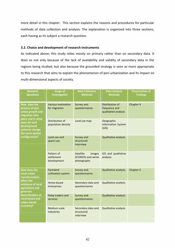
42
more detail in this chapter. This section explains the reasons and procedures for particular
methods of data collection and analysis. The explanation is organized into three sections,
each having as its subject a research question.
3.2. Choice and development of research instruments
As indicated above, this study relies mostly on primary rather than on secondary data. It
does so not only because of the lack of availability and validity of secondary data in the
regions being studied, but also because the grounded strategy is seen as more appropriate
to this research that aims to explain the phenomenon of peri-urbanization and its impact on
multi-dimensional aspects of society.
Research Questions
Scope of Investigation
Data Collection Methods
Data Analysis Methods
Presentation of Findings
How does the process of peri-urban growth and migration take place and in what ways do land development patterns change the socio-spatial configuration?
Various motivation for migration
Survey and questionnaires
Distribution of frequency and qualitative analysis
Chapter 4
Distribution of population density
Land use map Geographic Information System (GIS)
Land-use and space-use
Survey and structured interview
Qualitative analysis
Pattern of settlement development
Satellite images (ICONOS) and aerial photographs
GIS and qualitative analysis
How does the rural-urban transformation affect the existence of local agriculture and generate diversification of rural-based and urban-based economy?
Farmland cultivation system
Survey and questionnaires
Qualitative analysis Chapter 5
Home-based enterprises
Secondary data and questionnaires
Qualitative analysis
Petty traders and services
Survey and questionnaires
Qualitative analysis
Medium scale industries
Secondary data and structured interview
Qualitative analysis

43
Tourism-based businesses
Structured interview
Qualitative analysis
To what extent does the government’s role influence the modes of development and the direction of urban growth and what are the challenges of urban governance ahead with respect to urban growth management?
Land use policy Serial in-depth interview
Qualitative analysis Chapter 6
Land development permit
Serial in-depth interview
Qualitative analysis
Span of development control
Serial in-depth interview
Qualitative analysis
Table 3.2 Framework of investigation Source: Author
3.2.1. Data collection and analysis for Research Question One
Phenomena to be investigated in order to answer Research Question One are the dynamics
of migration and the spatial patterns resulting from settlement that transforms the modes of
land use and space use. Survey methodology is taken as the main approach. In accordance
with this methodology, questionnaires and structured interviews are used as the
instruments of data collection.
Size of the sample
To address Research Question One, the samples focused on the regions nearby the city as
well as those in relatively remote areas. According to the spatial data presented by IKONOS
satellite images of Sleman 2007 and aerial photographs of Yogyakarta, there are ten villages
in Sleman and Bantul regency showing the fastest growth rates, based on in-migration and
population density. Those villages include: (1) Sidoarum, (2) Sendangadi, (3) Sinduharjo, (4)
Sukoharjo, (5) Umbulmartani, (6) Purwomartani, (7) Maguwoharjo, all located in Sleman
regency, and three villages from Bantul regency: (1) Banguntapan, (2) Bangunharjo, and (3)
Panggungharjo. In actual practice, the sample households were determined based on several
factors: (1) distance to the main road, and by this parameter the settlement was divided into
households located nearby or alongside the main road and those located between one and
two kilometers from the main road; (2) distance of the settlement from the city, and by this
parameter the settlement was divided into households located about five kilometers from
44
the city or beyond the ring road (see map of land use in figure 4.1) and those located ten
kilometers beyond or more. The distance to the main road is considered in order to
investigate to what extent the different characteristics of main roads influence the
subsequent process of peri-urbanization. This study wished to examine the different
dynamics of development between the area nearby the primary corridors (or regional
corridors) which connect Yogyakarta with its surrounding big cities (Surakarta and Magelang)
and those nearby the local corridors. Those primary corridors include Corridor Solo and
Corridor Magelang, whereas the local corridors are Corridor Kaliurang, Corridor Godean,
Corridor Bantul, and Corridor Parangtritis. The distance to the city center is considered in
order to examine to what extent peri-urban growth is influenced by the city of Yogyakarta.
Random sampling was used in collecting the data on the general characteristics of the
household, its members, and their migration motivation. A sample of thirty respondents
from each village, with consideration given to their relative distance to main road and city
center, was gathered. The other method of data collection was so-called theoretical
sampling, commonly used in grounded theory research, then applied to investigating ideas
concerning land use and space use changes. The basis of this method is the concept, not the
person, so data collection is dictated by the need to identify categories and concepts. In this
case, the researcher is less interested in the size of the sample and how representative the
respondents are of the larger population. The purpose of further sampling is to saturate a
specific category and concept. In this sense, as suggested by Corbin (2008), data analysis is
done within data gathering. There is no limit on sample number, but rather sampling is
continuous until a category reaches the point of saturation.
Most of the data, with the exception of spatial data obtained from the IKONOS satellite
image and aerial photographs, was gathered by survey and interview. Using the
demographic data provided by the local government was problematic since it was organized
into administrative boundaries (kelurahan and kecamatan).13 Therefore, this study collected
the sample of population of the area that bounded by the distance of the settlement to the
main road and the distance from the city as explained above. However, the respondents are
13
Kelurahan is the smallest unit of administrative boundaries which might be similar with village or desa,
whereas kecamatan is the unit of administration under the district or regency that could be called a sub-district.

45
asked to write down the precise administrative region to which their family house
registered.
Other data related to Research Question One is the spatial data obtained from the IKONOS
satellite image 2007 and aerial photographs. In order to present time-series data of land use
to investigate the pattern of change in the built-up area in the peripheral region, the data
from 1987 and 1997 are used for comparison with the present as represented by the 2007
data. The year 1987 was taken as a base line because of a ring road that has been in use
since then. It is recognized that the rapid growth of peri-urban development in Yogyakarta
was fostered by the ring road that connects the city of Yogyakarta with its surrounding
regions.
Data analysis method
Analysis is a process of generating, developing, and verifying concepts. It is a process that
develops over time with the acquisition of data. In this study, data analysis involves coding
to derive concepts. In accordance with the process of theoretical sampling, qualitative
analyses was started during data collection, precisely as Patton (2002:436) suggests, by
recording and tracking analytical insights drawn from the data gathered during fieldwork. In
this sense, the analytical process is conducted iteratively through the writing of field notes or
memos.14
Computer analysis utilized CAQDAS (Computer-Assisted Qualitative Data Analysis) with
Atlas.ti software specifically for coding and categorizing. Subsequently, household data was
analyzed through qualitative methods, mostly by descriptive or narrative analysis. However,
data associated with migration motivation was quantitatively analyzed using the Distribution
of Frequency method. It is clear that most non-spatial data here is household data, and the
household becomes the unit of analysis. With regard to the spatial data obtained from
IKONOS satellite images and aerial photographs, GIS analysis, particularly ER-Mapper 7.2,
was used to investigate the transformation in the patterns of land use. As mentioned above,
the data of 1987 and 1997 are used to depict the earlier process of peri-urbanization, while
the data of 2007 is used to examine the current situation. The general data of land use
14
Corbin (2008:124) distinguished between Field-note and Memo. She defines Field-note as data that may
contain some conceptualization and analytical remarks, while Memo is defined as more in-depth thoughts about
an event, usually written in a conceptual form after leaving the field.

46
presented by GIS analysis is cross-checked by direct observation in order to investigate in
more detail the space use and to know from respondents the reasons stimulating changes in
land and space use.
3.2.2. Data collection and analysis for research question 2
In this phase, the investigation focuses on the dynamics of socioeconomic activity and the
emergence of a new rural-urban economy that has tended to change previous agricultural
occupations into non-farm activities. New economic features range from small businesses to
medium scale enterprises (SMEs). Field research revealed that petty traders and services
became the new sectors which offered income generation for lower income families,
especially the former peasants. These sectors were stimulated by new settlement and social
facilities that developed beyond the peri-urban area. Trading and service sectors in
peripheral areas, recognized as the emergent rural-urban economy, varied from the formal
to the informal. In this part of the study, non-participant observation (survey) and face-to-
face structured interviews were the predominant approaches.
Size of the sample
With respect to the collection of data, petty businesses were divided into two types,
activities pursued by local farm households and those engaged in by migrant households.
Such data was collected randomly through survey research (non-participant observation)15
since these businesses were generally unaccounted for in the statistical data compiled by
government officials. Questionnaires and structured interviews were used as the
instruments for data collection. Traders interviewed consisted of those who worked either
during the day or at night, and whose workplaces were their own homes, alongside the
roadways (street vendors), or in the traditional marketplace. The survey of medium scale
enterprises utilized data provided by the Local Trade and Industry Agency.
Sleman and Bantul display different specialties in the commodities produced by their
respective medium scale enterprises. Generally speaking, the manufacturing industry in
15
Singleton, Jr. and Straits (2010:362-65) defined participant observation as the practice of field research in
which the researcher involves actively in the daily lives of the people and situation under study, whereas non-
participant observation is characterized by the practice of the field work in which the researcher observe without
or with a less intensive interaction with the community or situation. The non-participant approach is commonly
known with survey, while participant observation approach is the derived into several methods such as
ethnography.

47
Sleman is less developed than that in Bantul. In contrast, retail businesses and services are
well developed in Sleman, mostly in the villages of Sinduharjo, Sukoharjo and Umbulmartani
(Region of Kaliurang) with small industry and home-based enterprises in the village of
Sidoarum (Region of Godean). In Bantul, agrarian activity still dominates local livelihood as
along with small and medium enterprises (SMEs), generally handicraft industries. Stratified
purposeful sampling was chosen for collecting appropriate data representative of the
various types of business entities mentioned above. The investigation of retail and services
was focused on in Sleman, while the home-based industry that particularly produced
handicraft was focused on in Bantul. Medium enterprises participating in the interviews in
Sleman included PT. Jawa (furniture) and Yayasan Dian Mandala (leather goods. Several
home-based enterprises in Bantul, especially in Kasongan which is internationally well-
known as Sentra Gerabah (Center of Pottery Art), were also interviewed. Data for small
enterprises was collected by face-to-face interviews with owners, while for medium ones,
the interview was with the management.
Data analysis method
Concerning economic activity and business institutions, the unit of was the unit of business
that could be represented either by a firm or a household. Household and street vendor
surveys were conducted in order to understand the dynamics of individual informal activities
and the characteristics of entrepreneurship beyond the community level, while the firm-
level survey was carried out to investigate similar characteristics presented by medium scale
enterprises. Only a small part of the data (specifically, name, location and the enterprise’s
business type) was provided by Local Trade and Industry Agency.
The evidence was then analyzed using qualitative methods. General data and concepts
deriving from both quantitative and qualitative data were interpreted by means of narrative
analysis, the description of live evidence being more important in this context than
generalization and theory building.
3.2.3. Data collection and analysis for research question 3
The investigation on the role of planning and public policy in driving the development
pattern is not only related to local government, but it also examines to what extent the
business actors influence public decision making. The case study approach is implemented

48
for this purpose. Stake (1995) suggests that the case study is a proper approach for
understanding the complexity and inter-relationship of each component within a community
or an organization.
Size of the sample
Local governments, particularly those officials whose authority and responsibility relate to
development planning, became the primary agents from which data was collected and
explored. Thus, members of the local governments of Sleman and Bantul, especially
members of the local planning boards were interviewed. The key informants from Bapeda
(Local Planning Board) were Kunto Riyadi; Arief Setio Laksito; Ratnani Hidayati; and one
person from Badan Pengendalian Pembangunan Daerah or BPPD (Local Development
Control Board) namely Agus Subekti, and local government officials of Dinas Perdagangan
dan Perindustrian (Local Trade and Industry Agency). These were Dwiadi Wahyuningsih and
Dwi Wulandari. Developers or investors were approached in order to investigate their ideas
and practices with regard to the pattern of development in the peri-urban area. They ranged
from formal developers who established several new residential areas to petty developers
who conducted relatively small projects. In this study, there were two relatively large
institutional developers (residential developments) in Sleman where interviews took place,
namely PT. Bumi Merapi Eratama that developed two hundred units of exclusive housing
and PT. Sumber Baru Land that established forty-three units of exclusive housing. There was
also a medium corporation that established projects in Godean, namely, PT. Niti Buana that
developed two hundred units of housing for the middle class as well as a small developer
(PT. Alam Asri, owned and directed by Ardi Karakan) that established only twenty-one units
of small housing for lower income residents. Additionally, there were three petty developers
(individual developers) from Sleman interviewed. In Bantul, representatives of other
development corporations were interviewed: PT. Damai Putera Group and PT. Sumber Baru
Land, builders of luxury houses, and representing lower income housing, PT. Griyatama Abdi
Nusa and Permata Sedayu that consisted of eight units.
Lastly society is seen as made up of stakeholders more or less affected by spatial, social, and
economic changes. Members of the academic community, specifically urban researchers
from the Department of Geography, Gadjah Mada University, namely Professor Doctor Hadi
Sabari Yunus, Doctor Sri Rum Giyarsih, and Doctor Hartono were interviewed. In addition,
49
other groups of private planners from consultant bureaus were also interviewed, namely
Ermaula Aseseang, the Director of Teknoplan, an urban and regional planning bureau, who
led the project Master Plan of DIY 2008 (Rencana Tata Ruang Wilayah or RTRW DIY 2008),
along with Mardianto and Hananto, both urban planners who work for the planning
consultant (PT. Proporsi) that led the project of RTRW Sleman 2008.
Data analysis method
The author planned to organize a Focus Group Discussion, but because of stakeholders’
preferences to be interviewed personally, multiple or serial interviews as in the Delphi
Method were conducted. This was time-consuming and had the disadvantage of the
panelists’ not confronting each other, generally a more efficient way to obtain real opinions
from different perspectives and interests. Data collected from multiple interviews was coded
and categorized with the assistance of CAQDAS and using Atlas.ti software. The concepts
that emerged from the computerized processing were then developed in order to examine
issues addressed by Research Question Three. The analysis itself employed a qualitative
paradigm, notably narrative analysis.
50
Chapter 4
The Resulting Spatial Transformation and Land Development Pattern of Peri-urbanization in
Yogyakarta
Peripheral areas surrounding cities become strategic zones where the expansion of urban
growth takes place. Considerable spatial transformation and land use changes especially
with regard to farmland. Brook and Dávila (2000) found that peri-urbanization is marked by
changes of land tenure and land ownership in which the investor (usually private sector)
occupies and replaces the previously rural farmland with urban functions. There are several
empirical questions which need to be addressed: What is the dynamic of urban growth and
the resulting spatial development in the peri-urban area? What are the influential factors
that catalyze such a dynamic? How does the expanding urbanization affect the land use and
land market? To what extent does it transform the spatial pattern? This chapter seeks to
provide some answers to these questions by exploring the current dynamics of peri-
urbanization in Yogyakarta, exploring the realm of land use change, particularly new
residential and other urban functions, and taking a closer look at the distribution of new land
development. Urban agglomeration inevitably occurs along with rapid urbanization. This is
certainly the case in Indonesia, especially in Java.
Using data collected through a combination of methods (i.e., survey and interview for the
primary data and geographical information systems to analyze spatial data from IKONOS
satellite images and aerial photographs), this study argues that the impacts of peri-
urbanization on residential and agricultural use of land are continuously expanding and
creating changes in land use and exchange values. Furthermore, it suggests that these
changes are the inevitable consequence of two factors, the rapid growth of new housing and
the development of urban facilities, particularly university campuses, along with the decline
of agricultural activity.
The analysis begins with the description of the dynamics of regional development to give
preliminary insight into peri-urbanization in Yogyakarta before presenting the empirical

51
findings. It then portrays the pattern of land development, including the transformation of
settlement patterns and the process of farmland conversion. A discussion of the dynamics of
the land market and land speculation follows. In order to understand the nature of poverty
in the peri-urban area, this chapter also examines spontaneous land subdivision and self-
help settlement development. The final part of this chapter provides a summary and
synthesis of the findings. .
4.1. The regional setting and historical background
It is widely recognized that contemporary urban development and urbanization in Indonesia
has recently been marked by rural-urban transformation. The urban areas that have
experienced massive population growth since 1980s onwards, as investigated by urban
scholars (McGee in Ginsburg 1991, Simon et al. in McGregor 2006), have created extended
urban areas around the city boundaries and local authority. There are different patterns of
peri-urban development. Some sprawls to fill in established residential areas and others
tend to grow in a linear pattern along the main transportation corridors. As urbanization
spreads, distinctions between rural and urban become blurred (Jamieson in Ginsburg, 1991;
Hugo in Guggler, 1996). Rural and urban space changes as well, creating ambiguous
landscapes, from the peri-urban to the extended-urban, the so-called desa-kota (urban
village) within the countryside environment. Along with the city’s growth, many indigenous
villages have experienced significant changes in demographic structure, land and space use,
social relationships and cultural values, and diversity of economic features.
A complex interdependency and linkage system has developed between cities, towns,
villages, and their surrounding countryside. Urban dwellers who reside in areas categorized
as rural spend much of their lives in cities, working, either by commuting or circular
migration. On the other hand, many rural dwellers keep their families and their permanent
residences in rural areas, even though they work in the city and reside there for years.
4.1.1. Geographical features and demographic trends
The Metropolitan area of Yogyakarta covered 3185.80 square kilometers of territory with a
population of 3,452,390 inhabitants according to 2010 records. Kulonprogo Regency
extended over 586.27 square kilometers, Bantul Regency, 506.85 square kilometers,
Gunungkidul Regency, 1,485.36 square kilometers, Sleman Regency, 574,82 square

52
kilometers and Yogyakarta City, 32.50 square kilometers. Gunungkidul has the greatest land
area (46.62 percent) and Yogyakarta City, the least (1.02 per cent). The land area of Sleman
Regency is around 18.25 per cent, while Bantul Regency is around 15.91 per cent. As noted
previously, for the purposes of administration, Metropolitan Yogyakarta is divided into four
districts or regencies (locally called kabupaten) i.e. Kabupaten Sleman, Gunungkidul, Bantul,
and Kulon Progo) and one kota (city), namely Yogyakarta, which encompasses 78 sub-
districts and 440 villages.
Yogyakarta is located in the southern part of the Island of Java, bordering the Indian Ocean
and Central Java provinces. The beach acts as a constraint to the development of port and
marine transportation for the city of Yogyakarta. Therefore, the potential and opportunities
for industrial development in Yogyakarta is relatively low, particularly for manufacturing
which requires a transportation facility that is easy and economical for production and
distribution activities.
The population of Special Region of Yogyakarta (Province of DIY) or locally called Daerah
Istimewa Yogyakarta (DIY) in year 2006, based on the 2000 Census Population Projections
2005 was 3,388,733 persons. There are 374,112 persons in Kulonprogo Regency, 879,825 in
Bantul Regency, 683,389 in Gunungkidul Regency, 1,008,295 in Sleman Regency, and
443,112 in Yogyakarta City. Sleman Regency is the most populated region (around 29.75
percent), followed by Bantul Regency (around 25.96 percent) (see Figure 4.1). In accordance
with the Local Regulation (Peraturan Daerah) of Province of DIY Number 10/ 2005, Article
41C, Yogyakarta functions as a Urban Activity Center (Pusat Kegiatan Nasional/ PKN) that
covers the city of Yogyakarta and parts of Sub-districts Kasihan, Sewon, and Banguntapan
which belong to Bantul Regency and the Districts of Depok, Ngemplak, Ngaglik, Mlati and
Gamping in Sleman Regency. The total region is delineated as an urban agglomeration area.

53
Figure 4.1. Map of distribution of population density in DIY 2006 Source: Bantuan Teknis Penyusunan RTRW Province of DIY

54
That Yogyakarta as the only remaining kingdom in Indonesia represented by the Sultanate’s
Palace and Royal Government gives it a powerful cultural identity. Since Javanese culture
remains strongly embedded in the fabric of life, this provides potential advantages for
Yogyakarta. Socio-cultural attractions give Yogyakarta a comparative advantage in tourism,
especially cultural tourism. The natural potential of the south coast and the Highlands of
Mount Merapi volcano in the north provide another advantage for the development of
nature tourism. Tourism is the leading sector driving the economy of the Yogyakarta region
and is the highest contributor to Gross Domestic Product of DIY. Besides its identity as a
cultural city, Yogyakarta is also known as student city. Statistical data shows that
Yogyakarta’s population is second only to Jakarta in terms of its level of education.
Yogyakarta’s image as student city is enhanced by the presence of various educational
institutions. On a national scale, migration to Yogyakarta for the purpose of continuing
education is also second only to Jakarta.
As explained in the Chapter 3, the Districts of Sleman and Bantul were selected to be case
studies, as Sleman and Bantul experienced the highest population growth and the most
newly built-up areas. The general data regarding geographic and demographic conditions of
these regencies, based on secondary data from the year 2007, is described below.
General features of Sleman Regency The area of Sleman Regency extends from 110o 13’ 00” to 110o 29’ 30” Longitude East, and
from 7o34’51” until 7o47’03” Latitude South, with an altitude between 100 – 2500 meters
above sea level. The greatest distance north to south is approximately 32 kilometers, east-
west approximately 35 kilometers. Sleman Regency consists of 17 subdistricts, 86 villages,
and 1,212 hamlets. The northern part borders on Boyolali Regency (Central Java Province),
the eastern part borders on Klaten Regency (Central Java Province), and the southern part
borders on Bantul Regency and Yogyakarta Municipality (DIY Province). The southern area is
a fertile lowland area. In contrast, the northern area is mostly dry land consisting of un-
irrigated agricultural fields and yards. It also has slopes to the south, with the northeast area
bordering Mount Merapi. On the south slope of Mount Merapi, two hills, namely Turgo Hill
and Plawangan Hill, form a part of the Kaliurang Tourism Area.
55
Based on the projection of Population in 2008, the number of Sleman inhabitants is
1,041,951 consisting of 525,598 males (51 per cent) and 516,853 females (49 per cent). With
area of 574.82 square kilometers, the population density is 1,813 people per square
kilometer. Some districts with a relatively dense population are Depok with 5,146 people
per square kilometer, Mlati with 3,130 people per square kilometer, Gamping and Godean
with 2,968 people and 2,320 people respectively per square kilometer.
In the year 2007, the dominant sectors in the Sleman Regency economy are the trade-hotel-
restaurant sector (21.98 percent), service sector (18.83 percent), manufacturing industry
(15.05 percent), and agricultural sector (13.36 percent). In 2007, the economy of Sleman
(Gross Regional Domestic Product or GRDP) grew 4.61 percent. All sectors grew, except
agriculture which declined because of climate factors.
General features of Bantul Regency 2007 Bantul Regency is one of five regencies in Daerah Istimewa Yogyakarta (DIY). Bantul Regency
is bordered by the City of Yogyakarta and Sleman Regency on the north, Gunungkidul
Regency on the east, Kulonprogo Regency on the west and the Indonesian Ocean on the
south. It consists of 17 sub-districts: Srandakan, Sanden, Kretek, Pundong, Bambanglipuro,
Pandak, Bantul, Jetis, Imogiri, Dlingo, Pleret, Piyungan, Banguntapan, Sewon, Kasihan,
Pajangan, and Sedayu.
According the data of 2006, the population in Bantul Regency numbered 820,541 persons,
with a growth rate of approximately 1,2 per cent per annum. Its territory includes a total
area of 506.85 square kilometers. The population density of Bantul Regency in 2007 was
1.641 persons per square kilometer. The total number of families was 233,286 families.
Family size averaged out at 4 persons.
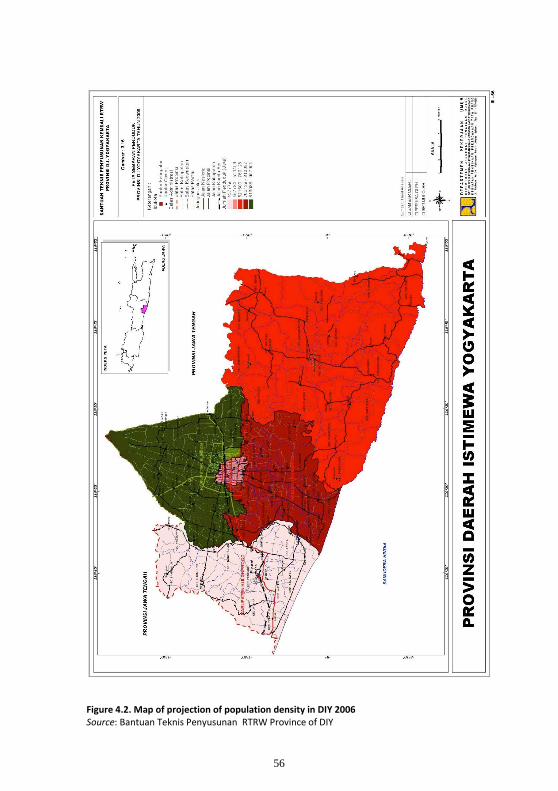
56
Figure 4.2. Map of projection of population density in DIY 2006 Source: Bantuan Teknis Penyusunan RTRW Province of DIY

57
The wetland area of Bantul Regency in the year 2007 was recorded as 15,884 hectares
according to Agriculture and Forestry Service. The dryland was recorded at 11,371 hectares
with the remaining land recorded at 23,430 hectares. Dryland area overwhelms
dryfield/garden, arable land, forest small holdings, dykes, meadows, ponds, and temporarily
fallow land, although other land areas overwhelm house compounds and their surroundings,
forests, and swamps.
Based on data compiled by Cooperation Service, the number of manufacturing entities in
Bantul Regency in 2007 was 17,911, with a total number of employee of 79,904 persons. In
2006, the number of small industries recorded was 17,865, with employees numbering
78,783 persons. Meanwhile, according to the results of the Large/Middle Industry Survey
done by Local Statistics Agency (Biro Pusat Statistik) of Bantul Regency in 2006, 202 factories
in this category were inplace, distributed across 16 districts and employing 18,343 people.
This shows considerable increase over the 2005 data that listed 129 factories employing
15,539 persons. The agricultural sector retains an important share in the GRDP, contributing
21.03 percent in 2007. Bantul Regency’s economic growth rate in 2007 was 4.52 percent.
4.1.2. Yogyakarta: from Mataram Kingdom to a Special Region
Geographically, the region of Yogyakarta is located in the southern part of the island of Java.
The island itself is currently divided into three provinces and two special regions: West Java
Province with Bandung as its capital, Central Java Province with Semarang as its capital, East
Java Province with its capital at Surabaya, Yogyakarta Special Region and the Jakarta
(Indonesia’s capital) Special region. Embryo development of settlements in the area now
called Yogyakarta began in the 8th century under the Hindu-Buddhist Syailendra dynasty
responsible for the construction of the Borobudur Temple. Borobudur, a place of worship
for adherents of Buddhism, is today defined by UNESCO as one of the wonders of the world.
The Syailendra dynasty also built Prambanan temple for Hindu worship. The seat of central
government at that time is thought to have been located midway between the Borobudur
and Prambanan temples, currently the location of the region of Yogyakarta (Rutz, 1981 in
Rotgé, 2000).
At the beginning of the 10th century, a new Hindu-Buddhist kingdom, Majapahit, was
established and the settlement shifted to the eastern area of Java Island, along the banks of
58
the Brantas River. The Kingdom of Majapahit had its heyday in the 13th century, becoming
the center of growth for a region that included not only the island of Java, but also Sumatra,
the Malay Peninsula, Borneo, Sulawesi and parts of Eastern Indonesia. Majapahit became
the destination of migrants from various regions, but especially from the island of Java. A
fairly rapid economic growth occured through inter-island trade between neighboring
kingdoms spread across Southeast Asia. Inter-island trade activities in the Java Sea brought
new developments along the northern coastal areas of Java. This region evolved and became
a new growth center. In the meantime, Majapahit kingdom declined significantly.
In the 15th century, the religion of Islam penetrated Java through the north coast region. As
this region developed and the Majapahit kingdom declined, the Kingdom of Demak emerged
as a center of growth becoming the largest Islamic Kingdom on Java Island. At the beginning
of the 16th century, the King of Demak was defeated by the King of Pajang. The collapse of
the Kingdom of Demak marked a shift in the power of the Islamic center from Demak to
Pajang. In the next period, the late 16th century, the Kingdom of Pajang collapsed and a new
Islamic kingdom was established in the area believed to be the place where Syailendra
dynasty’s Hindu-Buddhist 8th century kingdom was located.
The establishment of a new power, later named the Mataram Kingdom marked a shift in
development from the north coast of Java to the hinterland. The influence of Islam that had
arrived via trade relations on the northern coast of Java spread to hinterland areas under the
authority of the Kingdom of Mataram. In the mid-18th century, through the Treaty of Giyanti
(1755) which was driven by the Dutch United East Indies Company (VOC), the Kingdom of
Mataram was split into two sections, the Sultanate of Yogyakarta and the Principality of
Surakarta. The 18th century marked the beginning of Netherlandish feudalism as well as
colonial influence on regional development (Hugo et al., 1991 in Rotgé, 2000). During the
Dutch colonial period, regional and urban development was focused on the areas along the
northern coast of Java because of its strategic position in relation to trade. Economic activity
was centered in this region and settlement activity grew rapidly as a consequence while
inland areas grew very slowly because the southern coast was unsuitable for the
construction of new ports for shipping activities.

59
Daerah Istimewa Yogyakarta, shortened to DIY (Special Region of Yogyakarta)
administratively includes the city of Yogyakarta and its surrounding conurbation area which
consists of the regencies of Sleman, Gunungkidul, Bantul, and Kulonprogo. Besides being the
center of government and political activity, the city of Yogyakarta also became a center of
economic and cultural activity. On a national level, Yogyakarta has played an important role
in Indonesia's history, from the Dutch colonial period through the early post-independent
era.
The special status and autonomy belonging to Yogyakarta is a legacy of the pre-
independence period. The Sultanate of Yogyakarta as the embryo of Daerah Istimewa
Yogyakarta, had the status of a "Vassal kingdom/ State/ Dependent state" in the colonial
administration, both under the Dutch and the imperial Japanese empire. The Netherlands
referred to this status as Zelfbestuurende Landschappen; Japan called it Koti or Kooti. This
status had legal and political consequences, giving Yogyakarta authority to regulate and
manage itself under the supervision of the colonial government. This status was then given
legal protection by the founding father and first president of Indonesia, Sukarno, with the
issuance of Law No. 3/1950. It changed the status of Yogyakarta, making it no longer a
sovereign, if dependent, state, to a special region.
4.2. Dynamics and characteristics of migration
As a demographic component, migration plays an important role in urban growth and peri-
urbanization in Yogyakarta. The growing urbanized area is characterized by much stronger
growth beyond the peripheral area. The movement of people between city and village
fosters links between urban and rural resulting in an ever increasing flow of information,
capital, goods, and people.
4.2.1. Differentiation level of population growth
Based on survey questionnaires and structured interviews with key informants, it can be
seen that several forces have stimulated urban growth in Yogyakarta. First, there is the
movement of lower income people who face the lack of affordable land for housing in the
city. They look for relatively lower priced developable land located on the city’s outskirts.
The most desirable choice is land or residential areas that enable them to minimize their
monthly living expenses through low-cost commuting. Second, there is the movement of
60
middle income and higher status individuals to a peri-urban area that is already relatively
autonomous and has a more pleasant natural environment. They seek less populated spaces
and to avoid the city’s problems, particularly air and water pollution. The improvement of
accessibility and the extension of infrastructure, notably the development of a ring road
surrounding the city of Yogyakarta, are recognized as catalysts for growth in the peripheral
area. Third, there is the development of new public facilities, particularly higher education
facilities that attract people from the adjacent city and surrounding regions to come and
reside either permanently or temporarily. Finally, there is also opportunity for employment
as a motivating factor. Parts of the peri-urban area are becoming more densely populated
due to the development of new enterprises, both medium and small-scale industries, though
the former predominate. Establishing businesses should also be examined as a motivating
factor for developers, both in terms of the scale of land occupation and development, and of
legality in operation. The remaining business actors are dominated by such secondary and
tertiary economic sectors as manufacturing, trading, and service industries whose distinctive
characteristics affect their location preferences. With respect to the new rural-urban
economy,16 the behavior and development characteristics of small-scale industries and
home-based enterprises widely identified as survival strategies for local low income
households will be analyzed. The dynamic of rural-urban economy will be elaborated in
chapter 5.
The District of Sleman is ranked to have the highest rate of population growth, (see Figures
4.1 and 4.2). Kaliurang region, one of the case studies, has become the most popular
destination for people to reside, whether local or regional migrants. With new residential
areas spreading from the frontline area located along the main corridor, inland where there
is greater distance from primary access roads. Godean, elsewhere in Sleman regency, is
experiencing a different pattern. There, growing numbers of new are concentrated in the
area located near commercial facilities. In Bantul Regency, the new migrants reside primarily
in new settlements established in the sub-districts and villages surrounding the ring road. As
16
This terminology is used to identify the new pattern of economic activity in which the character of rural
livelihood and urban occupation are influencing altogether. Such new employment are largely represented by
several kind of businesses, i.e. small and medium scale enterprises that mostly produce the intermediate or final
goods based on rural sources; the petty traders that range from retailers, who largely occupy the public spaces
alongside the main road ways, to wholesalers; home-based enterprises with which many peasant household
engaged.

61
explained in chapter 3, Sleman Regency and Bantul Regency were chosen as case studies
since they demonstrate the highest population growth and population density in DIY.
This study reveals that the newly built-up areas spreading beyond those regions is driven by
the preferences of migrants that vary according to the characteristics of the regions and
differences in migrants’ motivation for moving. A process of unequal growth is also
observed. Such differential growth is influenced by such determinant factors as geographical
features, the development of new public facilities, and the political economy of respective
local governments. In the following section describes the development stages of the peri-
urban area in Sleman Regency and Bantul Regency respectively. Governmental development
policy will be examined in chapter 6.
4.2.2. Various motivations and the influencing factors of migration
Just as there were differences in residents’ motivation for having migrated (described
above), there were distinct preferences regarding their choices to go to Sleman or Bantul.
Their choices were influenced predominantly by the geographic and socioeconomic
characteristics of the respective territories. The new areas of settlement development can
be distinguished in terms of differences in motivation and socioeconomic segmentation.
Questionnaire data collected during fieldwork shows that the motivation of people who
migrated, either permanently or temporarily, to the peri-urban area of Yogyakarta falls into
the following categories.
a. Seeking better living conditions. Migrants from the city of Yogyakarta and its
surrounding region gave this as their reason for moving. Most come from the middle
income group. The region of Kaliurang, like Sinduharjo and Sukoharjo, attract a huge
number of migrants because the environment has much more green space, relatively
cool climate, and greater availability as well as better quality of groundwater.
Analysis of questionnaires indicated the characteristics of migrants to Sleman as
follows:
(1) In terms of origins, about 35 percent came from the city of Yogyakarta, and
70 percent of these were mature families and the remaining 30 percent
were young families, followed by people who moved from other regions

62
within DIY making up 23 percent and finally those from outside DIY, both
from Java and outside of Java being the dominant portion of 42 percent.
(2) In terms of socio-economic level, approximately 79 percent were upper-
middle income people, with 81 percent of these university graduates and
the remaining 19 percent having reached only secondary school.
Approximately 21 percent of the migrants were lower-middle income whose
education level was secondary school.
Sleman has become the most expensive region in the peri-urban area. The price of
land located beyond Condong Catur, Sinduharjo, and Sukoharjo ranged in 2009 from
IDR 1,000,000 – 2,500,000 per square meter (around USD 100-250 at mid-2009
exchange rates). This is quite expensive compared to the per capita income in
Yogyakarta which was about USD 2,717 in 2009.17 Compared to the price of land in
other parts of peri-urban DIY of equal distance from the city center, it can be shown
that this was three to four times the price of land in Condong Catur was, two-three
times the price in Sinduharjo. In other words, many people say that Sleman is a peri-
urban in which the rich have been concentrated. The disparity of land price is
stimulated by the higher demand of land in Sleman than those of other areas,
including in Bantul.
b. Opportunity to establish or engage in small industry. As noted above, the
agglomeration of small industries in several parts of DIY’s peri-urban regions has
attracted new settlement. Approximately 64 percent of these migrants come from
DIY and the remaining 36 percent come from Java. They are distributed among the
villages of Banguntapan, Bangunharjo, and Panggungharjo in Bantul and the village of
Sidoarum in Sleman. Almost all those from DIY were young families whose parents
engaged in farming activities. They generally obtained the capital for their enterprise
from parents. Those coming from outside DIY were mostly mature families with
experience in factory work, particularly in handicraft production.
17
Biro Pusat Statistik (Indonesian Central Statistics Agency) August, 2010. Data available at:
http://dds.bps.go.id/download_file/IP_Agustus_2010.pdf

63
c. Looking for cheaper land for housing. The regions of Sleman, particularly Condong
Catur and Sinduharjo (areas approximately six to ten kilometers from the city center)
are associated with high-end districts. As Sleman has several advantages that attract
the people from across the regions of DIY, including the lower-middle income group,
it has become the favored destination for settlers. There are parts of Sleman,
Sidoarum (Godean), Sendangadi (Mlati), and Purwomartani (Kalasan), where the
price of the land is still reasonable (around IDR 300,000 – 600,000 per square meter
or USD 30-60 at middle 2009 exchange rates). Younger people whose workplace is
close to these villages or those whose income is not so high tend to buy plots or
houses there.
d. Undertaking further study. The identity of Yogyakarta as a city of education is a
consequence of the many universities spreading across the DIY region. It has become
the most important factor for the high rate of in-migration flowing from regions all
over Indonesia. 18 Most of these private universities are located in Sleman,
particularly in the villages of Condong Catur and Maguwoharjo. Consequently,
population densities in Maguwoharjo and Condong catur are in the top rank.
e. Means of property investment. The identity of Yogyakarta as a city of culture and
tourism as well as the opinion of those that Yogyakarta is a quiet resort town makes a
lot of people, especially the economic middle class, interested in buying a home
there. The house is intended as the home of the future after they retire. Others buy a
home with the idea that it will be used by children during their study at the university
in Yogyakarta. Besides being used as a residence, they think that property, especially
housing in Yogyakarta, is very profitable. This can be seen from the tendency of the
prices of land and housing in Yogyakarta which continue to rise dramatically
compared to the prices of land and houses in other big cities in Indonesia.
The interest of the public in buying property in Yogyakarta is increasing due to many
new residential areas offering a variety of attractively designed houses developed by
private realtors. They are convinced that relatively high property prices as in Sleman,
especially in Condong Catur, Sinduharjo, Sukoharjo, and Maguwoharjo, reflects the 18
There are 4 state universities and 115 private universities and higher education institutions established in
Yogyakarta. Data available at: http://kopertis5.org/?p=listpts&page=5&m=&h=1
64
high value of investments. The people who have enough funds are more likely to buy
a house in an exclusive residential estate rather than buying land that belongs to
local people and later building their own houses.
With regard to this motivation, this study observed many exclusive residential
estates, mainly located in the northern part of Sleman, were owned by the migrants
from outside Yogyakarta. Those luxury houses were mostly inhabited only by two or
three persons, namely the sons of the homeowners who is a student in Yogyakarta
and two house-maids whose responsibility is the daily care and cleaning of the house.
Regarding the lower income group of migrants, they may be classified into two groups as
follows:
1. The migrants who work in the city. In order to minimize the transport cost,
particularly from home to workplace, they tend to seek a location which is close to
the city. They tend to occupy areas of in-between development, beyond the edge of
the city. The established kampongs located adjacent to the main corridor become
their main targets of occupation. They usually buy older houses belonging to
members of the native community or farmers, because these are more affordable.
2. The migrants who do not work in the city. This group tends to look for the affordable
land or housing that is close to the workplace. The new residential areas developed
by relatively small developers who construct lower price housing, that reflects the
relatively lower quality of building and infrastructure, become their targeted choice.
These patterns of land occupancy then reconfigure the spatial structure. It could be
questioned why some parts of the peripheral urban fringe are developed more intensively
than others. As development progresses, the resulting pattern represents a tendency
towards spatial homogeneity or spatial heterogeneity.
Such a process of spatial reconfiguration will be described and analyzed more
comprehensively in the following section. We will see that there are several determinants
which lead to different patterns of spatial growth and population distribution.

65
4.3. Spatial development and growth pattern of built-up area
As has been explained previously, the development of ring roads surrounding the city of
Yogyakarta stimulated the rapid pace of urban growth. The spatial data that include images
of IKONOS satellite and aerial photographs are then used as data series to investigate the
spatial changes occurring from 1987 to 2007. The development process is divided into three
phases, i.e., from 1987 to 1997 and from 1997 to 2007 both representing past dynamics, and
data gathered by fieldwork representing the actual dynamics today. By observing several
periods, the growth process linked to different times and spaces will be better understood,
as will the development factors that might influence the different pace and pattern of
growth of built-up areas in the peri-urban regions of Yogyakarta.
Analysis in this section is first based on data gathered from in-depth interviews with key
informants consisting of government officials both in Sleman and Bantul, developers (both
institutional and individual), and several community leaders. These respondents are
considered as having the deepest knowledge about the process of development and its
determinant factors. This primary data then compares to other empirical data gathered from
household survey questionnaires and interviews during fieldwork. The interviewed
respondents are selected based on their length and location of their residence. The data
collected from household respondents is expected to complement the primary data
gathered from key respondents. Moreover, it is also intended to triangulate the data. As
explained in chapter 3, that analysis and interpretation in this study rely on primary data
because of the limitations of secondary data and concerns about its validity. In addition, as
previously noted, this research employs the grounded theory approach. Thus the study aims
to analyze and examine the empirical findings through direct observation in the study area.
According to the location criteria for selecting household respondents as a sample of the
population, both for survey questionnaires and structured interview, as described in chapter
3, there are four points that were considered in each district:
a) A location close to the city, divided into two key areas, first being the area alongside
the main roadway, and the second being that area located about one kilometer away
from the main road. Both Sleman and Bantul, the chosen areas, are located beyond
the ring road. They are about five to six kilometers from the city center.

66
b) A location far from the city, based on the extent to which the impact of urbanization
could be identified by visual observation of changes in land-use from rural-based
functions to urban-based activities. In Sleman Regency, the impact of urbanization
which has resulted from the city’s growth includes the area located about ten
kilometers from the city center. There is also growth in Sleman not the result of
urban agglomeration but rather from the presence of a university campus. In this
case, the sample was also taken from the area surrounding the university campus,
which is located about fourteen kilometers away from the city center. The sample
from Bantul Regency is derived from the area located about eight kilometers from
the city center.
With regard to the criterion “length of stay or residency,” respondents were divided into
several groups, households living there for more than twenty years; those settled between
five and ten years; and finally, those who have resided there for less than five years. The
respondents who have been living in the area for twenty years, between five and ten years,
and for less than five years represent the data for the development pattern in the period
1987-1997, 1997-2007, and today. All of the data representing the chronological growth
pattern are then examined to make a kind of projection in order to define the tendencies of
future growth. This projection is very important since it will be the primary basis for stating
the implications for development governance and growth management of the peri-urban
area in Yogyakarta that will be formulated in the last chapter (chapter 7).
4.3.1. Development and growth pattern between 1987 and 1997
The year 1987 is used as a reference point since it corresponds with the operational
beginning of a ring road constructed around the city of Yogyakarta. The hypothesis that the
presence of a ring road fosters the development process in peri-urban areas is justified by
comparing maps of land use. The Map of Land Use 1987 (see Figure 4.3) makes it obvious
that built-up areas beyond the urban fringes remained in the inner area of the ring road. This
evidence is confirmed by key informants. The people who lived there, in Sardonoharjo
(northern part of Sleman), Sendangadi (western part of Sleman), Maguwoharjo (eastern part
of Sleman), and Banguntapan (eastern part of Bantul) at that time were mostly the native
inhabitants. Gradual development began after the ring road was formally opened in 1987.
The pattern of growth between 1987 and 1997 is demonstrated by Figure 4.4. The territory
67
of Sleman Regency which is located in the northern part of the city of Yogyakarta
experienced a more rapid pace of development than did Bantul Regency located on the
southern side of the city of Yogyakarta. The density of settlement is represented by a light
brown color.
Spatial growth pattern in Sleman Regency
In the region of Sleman, it can be observed that in this period the development of
settlement was concentrated in the village of Condong Catur (Sub-district of Ngaglik) in the
north and in the village of Sidoarum (Sub-district of Godean) in the west. Massive growth of
newly built-up areas happened in the village of Maguwoharjo (Sub-district of Depok), as
well, because of its strategic location close to the city center and to central business district
in Jalan Solo. That area is located in the eastern part of DIY. Jalan Solo, connecting the city of
Yogyakarta and Surakarta in Central Java Province, developed as an embryonic economic
corridor during this period (1987-1997).
Two villages in Sleman Regency, the villages of Sukoharjo and Sinduharjo, located about
seven to nine kilometers away from the city center served as pioneer growth areas. In the
mid-1990s, these two villages displayed the sprawl development that grows hand-in-hand
with the practice of land speculation. These regions clearly represent the transformation
from rural, with its particular characteristics, to urban (with its distinctive features). The
pattern of informal development also began to spread widely across the local
neighborhoods. An interesting pattern is found in the comparison of growth trends between
areas located in the eastern and western parts of Jalan Kaliurang respectively. The village of
Sinduharjo located in the eastern part and the village of Sariharjo in the western part
demonstrates different intensities of growth, though both belong to the same sub-district
(Ngaglik). The newly built-up areas in Sariharjo were denser than those in Sinduharjo. Based
on field observation and household interviews, it is known that the western area is adjacent
to the regional access road to Jalan Magelang, the road that connects Yogyakarta and the
city of Magelang in Central Java Province. The other reason for such intense development
was the domination of the western part by settlement area, while the eastern part
contained a large portion of agricultural land. Thus, the basic infrastructure, such as local
access and telecommunication lines, were better provided in the western as opposed to the
eastern area. The presence of Perumahan Banteng as the pioneer of new residential areas in

68
Sariharjo was then followed by massive growth of in-between development in this western
part of Jalan Kaliurang. As described by Ridwan, an individual developer who established
several small-scale housing developments:
”It is very profitable developing small-scale housing in the area surrounding
Perumahan Banteng, though the price of land is more expensive than in the eastern
part of Jalan Kaliurang. People prefer to reside in a location that is already intensively
developed rather moving to a less developed area, as in the eastern part.” (Ridwan,
interview, 20/04/2009).
Many interviewed respondents explained that they chose to live in Sariharjo for such
reasons as the provision of basic infrastructure, the location close to the city center, and the
price of housing that was relatively more affordable. Such information gathered from
household respondents in Sariharjo was then compared with that from those who live in
Sinduharjo which belongs to eastern part of Jalan Kaliurang. The majority of respondents
who live in Perumahan Kaliurang Pratama which has been established since 1990 argue that
living in a relatively exclusive residential estate gives them more privacy and security. They
prefer to spend much more money for these amenities. The social milieu is also a
determinant factor for residents who decide to live in a gated community.

69
Figure 4.3: Map of land-use in peri-urban area year 1987 Source: GIS analysis 2009
70
Kaliurang Pratama as the pioneer of gated communities in Sleman represents social
homogeneity. Land prices in Sinduharjo, formerly cheaper than those in Sariharjo, gradually
rose, and in several sectors have become much more expensive, particularly in areas
adjacent to an exclusive estate like Kaliurang Pratama. The western part which more densely
settled is actually dominated by a lower-middle class population, while the new residents
who live in the eastern part, though still less densely than the west, dominated by an upper-
middle class community. The circumstances of the western part region of Jalan Kaliurang
also occurred in the Godean region where most new residents preferred relatively new, but
economical housing. The growth that took place in the village of Sidoarum represents how
lower-middle class people have come to occupy the peripheral areas close to the city center.
Based on household survey questionnaires again, it is revealed that most of the migrants
who live in the western part of Jalan Kaliurang come from the city of Yogyakarta (around 54
percent) and other districts in DIY (around 31 percent), while only 15 percent of the migrants
come from other cities in Java. This demographic feature is contrary to that of the eastern
part, where the majority of migrants, approximately 71 percent, originated from other cities
in Java as well as outside Java while only 29 percent of the new residents come from the city
of Yogyakarta and neighboring districts in DIY. New residents who live in Sinduharjo and
Sariharjo, both located about five to six kilometers away from the city center, consider the
proximity to the city center as the most important factor in deciding on a location. In this
period (1987-1997), the availability of public facilities was still limited. This conclusion is
justified by the household survey results from residents who have been living there for more
than twenty years. The majority of respondents were also attracted by Kaliurang region’s
natural environment, better than that of other parts of the peripheral urban fringe
surrounding the city of Yogyakarta.

71
Figure 4.4 Map of built-up area growth year 1987-1997 Source: GIS analysis 2009

72
Spatial growth pattern of Bantul Regency
Compared with what happened in Sleman Regency, the growth observed in Bantul Regency
was different both in term of spatial pattern and socioeconomic features. The penetration of
Bantul by urbanized areas occurred in the area adjacent to the city of Yogyakarta’s
boundary, beyond the ring road. Bangunharjo and Panggungharjo are the regions in Bantul
which experienced urbanization as can be seen in Figure 4.4. In term of demographic
features, several key informants noted that nearly half of the migrants who moved to Bantul
in this period were local residents, living previously in the neighboring villages of
Panggungharjo and Bangunharjo. Most of them were young families that looked for a house
still close to their parents or relatives. This preference was affected by the traditional custom
of regular family gatherings. The other half came from the neighboring districts of Bantul
and only a small portion (lower than ten percent) came from the city of Yogyakarta. Almost
all the new inhabitants were motivated by the need to find a residence adjacent to their
workplace. A large number of them engaged in handicraft manufacturing, concentrated in
the sub-district of Kasihan, located close to Panggungharjo and Bangunharjo, whereas a
small percentage of them were officials in Bantul Regency’s local government.
Observation in the village of Banguntapan that lies in the eastern part of Bantul
demonstrates the contrasting situation of growth concentrated on the inner side of the ring
road, adjacent to the edge of the city of Yogyakarta. This area of the city’s expansion is
located approximately five kilometers away from the city center. Most of those living in
Banguntapan were residents whose businesses were located in the city or whose work was
in the public sector or private corporate. A small portion of the new residents were people
starting new small businesses in Banguntapan. With regard to the presence of new
businesses in Banguntapan, analysis of economic activity and urban-rural linkages between
the city and the rural area in the south-eastern part of Yogyakarta that was connected by
Jalan Raya Wonosari, showed that Banguntapan became the center or hub that serviced the
region of Gunungkidul. This region had the lowest economic growth in DIY because of very
low agriculture productivity caused by lack of ground water, making wetlands cultivation
rare. Thus, development in Banguntapan played a significant role as a counter magnet for
people who lived beyond its hinterland areas, especially in Gunung Kidul region, who could
be serviced there rather than going to the city.

73
Based on the spatial pattern of development, the period 1987-1997, showed further
development and intensification of several embryos, both in Sleman and Bantul. After 1987
Sendangadi became the center of Sleman local government offices with limited economic
facilities, while the growth to Godean, or the western part of Sleman, only reached the area
beyond the inner ring road as well as extending into or including Kasihan, Bantul. Condong
Catur in Slemen began its early extension into Sinduharjo and Sariharjo, both located
approximately six kilometers away from the city center. By 1997 the newly built-up area had
grown radially both in Sleman and Bantul. There were numerous medium-scale residential
estates established in Sleman, in Sinduharjo and Sariharjo in Kaliurang (the northern area), in
Sidoarum, Godean (the western part), and in Sinduadi (the northwestern area). In Bantul,
the growth area was concentrated in Banguntapan, Panggungharjo, and Bangunharjo. Late
1997 was also marked by the initial development of economic activities and their supporting
facilities, especially in Kaliurang and Godean.
4.3.2. Development and growth pattern between 1997 and 2007
In this period, the growth in the territory of Sleman Regency was marked by the occupation
of relatively remote areas which could be characterized as rural. New residential estates
target upper-middle income groups. The new settlement areas have intensively occupied
rural, mostly cultivated land. Some of the developers have established medium scale but still
exclusive housing estates that range between ten and twenty hectares, gradually purchased
either directly from the land owner, i.e. the local farmer, or from the person(s) who initially
purchased and occupied the farmland. For Sleman Regency, this period is the phase in which
a large portion of cultivated land was converted. In contrast with what was happening in
Sleman, the growth of newly built-up areas in Bantul Regency was relatively stagnant. The
steady growth in Bangunharjo and Panggungharjo as an extension of the development in the
village of Kasihan, adjacent to the city’s edge, declined. The only village in Bantul still
growing is Banguntapan.
Development pattern of Sleman Regency
The presence of new residential estates that could be categorized as gated communities, in
turn generated a massive conversion of farmland. People from various backgrounds have
taken the opportunity to seek profit from renting the land. There are local government

74
officials involved in the land business. It is also clear that local farmers who hold relatively
large tracts of farmland sell their land either directly to investors or to land speculators. This
period is recognized as the beginning of land speculation activity. As noted above, since the
mid-1990s, a large portion of cultivated land, particularly in Sleman, has been converted into
urban use. In the words of a local farmland holder, a key informant:
”Since 1995, there are many paddy lands (sawah) that have been sold to the buyers. The buyers who come from the city of Yogyakarta usually purchase small-sized plots, mostly 1-2 parcels (a parcel of sawah equals 2500 square meters). The buyers from outside Yogyakarta, especially those who plan to establish a residential estate project, purchases bigger plots. There was investor from Magelang, Central Java who purchased 20 parcels or 5 hectares from several local farmers.” (Sumanto, interview, 20/05/2009).
Sumanto is a farmer in Sukoharjo and cultivates his own paddy field. He inherited four
parcels of land from his father, selling two to the investor from Semarang, Central Java in
1996. He spent part of his money to buy another paddy field in the inland area, about two
kilometers away from the main corridor Jalan Kaliurang, and the rest he then utilized for
beginning a laundry business in Jalan Kaliurang. He leased a fifteen square meter plot in the
front of a road-side family house in 1997, taking out a five- years-contract. His business did
well and he leased in 2002 a nine meter square plot for a cellular phone shop. His elder son
manages the first store and his younger son manages the second. Sumanto adds that the
land he sold in 1996 was left idle until 2004.
There are many land holding farmers in the villages of Sukoharjo and Sardonoharjo who had
the same experience as Sumanto. In this period, the rapid pace of growth shifted to the
northern parts of Seman, to the villages of Sukoharjo, Umbulmartani, and a small part of
Sardonoharjo. The new settlement area also extended in the other direction, to the
northeast, focused on the village of Purwomartani. The development of other parts of
Sleman region depended on particular characteristics belonging to each territory. The mostly
contoured land in Sardonoharjo is not attractive for development.
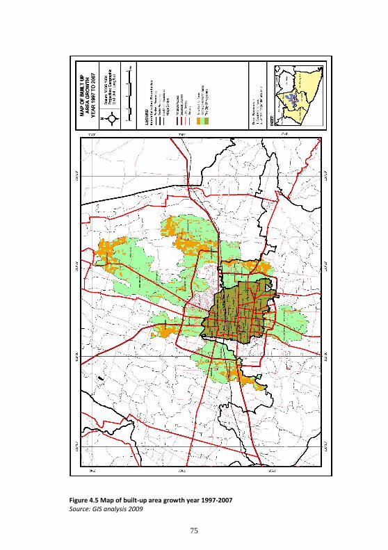
75
Figure 4.5 Map of built-up area growth year 1997-2007 Source: GIS analysis 2009
76
New development in the areas of Sukoharjo and Umbulmartani is not only caused by
decreasing areas of developable land elsewhere, but also by an attractive natural
environment.The investors look for natural areas suitable for exclusive residential estates.
Their target market is the migrant from outside Yogyakarta who buys a new house for
children who undertake their studies in the universities but who will likely live in the house
after retirement, or for investment purposes. This household interview-based analysis is
then viewed from another perspective, from the investor’s point of view. Jutata, a private
investor who developed a medium-scale housing project in the village of Sukoharjo
emphasized the value of the higher profit that would result from an exclusive estate as
opposed to lower-middle income housing. He said:
”Yogyakarta is one of the destinations for the wealthy people in Indonesia to buy a second or third family house. The buyers are attracted by the potential for tourism and the Javanese cultural identity that still relatively well-preserved in Yogyakarta. Large scale demonstrations in Jakarta during the fall of Suharto’s regime convinced the people of Jakarta that it was not an ideal city for living because of unstable political circumstances. They want to reside in Yogyakarta when they v retire. The region in Kaliurang is attractive for them as the consumers look for a housing with a more natural landscape.” (Jutata, interview, 05/06/2009).
The other rapid peri-urban development in Sleman is in the village of Purwomartani.
Reasons underlying the choice of this area for new development comes out of the
commentary made householders living in this region. The presence of National Housing
(Perumnas) developed by the national government and its proximity to the airport and the
embryio of economic development represented by the corridor of Jalan Solo became the
determinant factors in their decision-making process. These preferences are underscored by
the opinion of a developer of small-scale residential areas that targeted lower-medium
income households. He said:
”The people who move to this area mostly work in the neighboring areas or they are looking for a new settlement in their price-range. The availability of infrastructure like access roads and telecommunication lines makes the people, predominantly from Yogyakarta, move here. Moreover, the broader use of cellular phones in the early 2000s enhanced the growing process of this territory, since there are no longer communication problems relating to distance. This is my second project after the first one, in Sariharjo, Kaliurang. The density of this region has gradually increased since the development of the surrounding areas of Perumnas. The public infrastructures that every day becomes more complete attracts more migrants to come here.” (Herwaskito, interview, 01/06/2009).

77
Herwaskito sees the drastic increase of land prices in Kaliurang as a trend. As a consequence,
many people, particularly young families of Yogyakarta will not be able to afford living here.
This segment of the market should be provided for by other choices of location and housing
type that meet their purchasing capacity. With respect to the scale of development,
Herwaskito adds:
”I prefer to develop a relatively small-scale of housing project since this region is still in the beginning phase of development. I intend to wait five to ten more years until this territory becomes more densely populated. I have occupied other land in this new development area. I have reserved those plots for the next project that might be started in 5 years. I am sure that this area will rapidly grow after the area in Kaliurang becomes saturated. I plan to purchase or hold one more plot close to Jalan Solo for an exclusive residential project that I plan to construct when the economic activity will have extended to there.“
Herwaskito predicts that the future condition of Purwomartani will be a good prospect. He
decided to allocate part of his profits from previous projects for purchasing additional plots
in Purwomartani. This attitude serves as evidence that from the very beginning, land
speculation has been a problem. At that time, the price of land in Purwomartani could be
described as the lowest in Sleman region, but in five or ten years, the land price will double.
It is clear that the problem of land acquisition for housing will be more widespread and the
land market will become the most critical problem for development policy.
This second decade of peri-urban growth in Yogyakarta has been marked by the extension of
new development further into the non-built-up greenspace area located farther from the
city, as the massively built-up areas closer to the city have become saturated. There is no
more large-scale development but rather just a pattern of in-between development in small
areas still remaining in the vicinity of established settlements. Figure 4.5 show no significant
growth of newly built-up areas in the villages of Sinduharjo and Sariharjo during phase 4.

78
Figure 4.6. Farmland converted to commercial and residential uses Source: Fieldwork data
The figure above illustrates the form of farmland conversion that has occurred in Sinduharjo. The commercial facilities consisting of shop-houses have been extensively developed, making plots alongside the main corridor the most wanted areas. Developers usually combined shops with residential uses at the rear as expressed in the picture above. Due to the local regulations that a maximum of one thousand square meters of farmland could be converted and certified as freehold, the developer then divides the plot into several parts and gradually applies for certification. In phase one, it can be seen that the developer has gotten certification for the first one thousand square meters. In phase two, he applies again for the second thousand square meters, while the first thousand square meters is developed into 4 units of shop-house and 4 units of house.
Then, in phase three, he applies for the third certification of the last five hundred square meters that he develops into 8 house units; Finally, when the last five hundred square meters have been certified, he completes the development with 4 more house units. This practice of sub-dividing land and speculation is done not only by investors but also by farmers whose land abuts the main roadways.
The Land Use Map 1997 (Figure 4.5) shows the base pattern of settlement in Purwomartani
(the eastern part of Sleman) and Umbulmartani (the northern part of Sleman), and Sidoarum
(the western part of Sleman) in order assess the growth pattern between 1997-2007.

79
Figure 4.7 Conversion of farmland into shop-houses Source: Fieldwork data
Development pattern of Bantul Regency
As described above, in general there has been no significant growth in Bantul since early
2000, except the village of Banguntapan. Information gathered from household survey
questionnaires showed a steady growth in Bangunharjo and Panggungharjo caused by the
rapid development of handicraft industries, mostly in small-scale enterprises, concentrated
in the neighboring village of Kasihan. The emergence of many residential estates in
Panggungharjo, Bangunharjo, and Kasihan gradually decreased after 1998. The declining
growth of newly built-up areas in what had been the fastest growing regions in Bantul may
relate to the Economic Crisis which attacked Asian countries in 1998. This presumption is
confirmed by information synthesized from the small and medium-scale enterprise survey
questionnaires. A comprehensive analysis of the dynamics of small and medium scale
enterprises in Bantul, particularly those concentrated in Kasihan, will be elaborated in
chapter 5.
As was explained in section 4.2.2, there are various motivations and factors influencing
migration. Below is some additional discussion relating the motivation for migration in a
more spatial context. Based on information collected from household respondents
interviewed in Panggungharjo and Bangunharjo, it is clear that several pull forces generate
in-migration beyond those villages.
a) The development of small and medium scale enterprises. This factor is recognized as
the primary generator of local economic development in Bantul besides agriculture.

80
Many respondents, mostly new inhabitants, said that they moved to Bantul to seek
employment. They worked in several home-based industries distributed across
Kasihan, Bangunharjo, and Panggungharjo. It was also determined that most of them
(around 80 percent) who work in small industries live there permanently, once they
marry. The remaining 20 percent commutes from one of several villages in other
districts, particularly Wonosari, and Kulonprogo. The 80 percent who have moved
there permanently generally reside in such small size housing as 36 square meter
buildings on 90-110 square meter lots or 45 square meter buildings on 120-140
square meter lots. Approximately 70 percent of the new residential area or estates
in Bantul may be categorized as small size housing.
b) The relatively low price of land in Bantul. The other motivation for people moving to
Bantul affordable housing. There are many householders that do not engage with
any industries in Kasihan, Panggungharjo, and Bangunharjo. They work in the city,
either in the private or public sectors. They live in Bantul due to their limited budgets
for housing. Most of them, more than 80 percent, are young families. Bantul
becomes their choice because many investors have developed relatively low priced,
small scale housing. For example, land prices in Bantul could be 50 percent lower
than those in Sleman, particularly in regions beyond Kaliurang. With regard to the
origin of the new inhabitants in Bantul, the data from questionnaires shows that
nearly 65 percent come from outside Bantul, with something like 40 percent working
outside Bantul. This data reveals that most new residents purchasing property and
living in Bantul are not native, but a large percentage work in Bantul, mostly in the
handicraft industries. These are concentrated in Panggungharjo and Bangunharjo
(case studies), but also in Kasihan. Kasihan was not included in the case study
because a large portion of its territory is categorized as urban rather than peri-urban
area.
c) The proximity to the city (about six to eight kilometers). The advantage of proximity
to the city attracts many people to live in Bantul even though don’t work there. As
described above, the concentration of migrants who reside in the area of
Panggungharjo and Bangunharjo engage in the handicraft industries sector. Another
group of migrants who do not engage in industrial sectors and who are not native to

81
the area is concentrated in Banguntapan. Based on household survey questionnaires
again, a large proportion of new inhabitants in Banguntapan, around 70 percent,
comes from the city of Yogyakarta itself or other districts in Yogyakarta. Only 30
percent are natives. Most of the migrants work in Banguntapan rather than in the
city. This finding confirms the presumption that development in Banguntapan relates
to its function as a service hub for the hinterland area to the southeast, namely
Gunungkidul which is known as the poorest region in DIY. The agricultural land in the
area is very arid, and settlement has not developed in because of the scarcity of
groundwater. The economic activities that developed in Banguntapan serves the
settlements located in remote areas that are mostly natives of Gunungkidul. Those
who do not work in Banguntapan, decided to live there because of its location
relatively close to the city. Most of those who work outside Banguntapan are
employed by either public or private institutions in the vicinity, particularly in Jalan
Solo that is only one to two kilometers away from Banguntapan. Jalan Solo, as was
explained above, is the regional economic corridor that connects the central business
district of Yogyakarta and the city of Surakarta which is categorized as the most
highly developed trade and service sector in Central Java Province.
Comparing the development of built-up areas in the period of 1987-1997 and 1998-2007,
several distinct development patterns emerge:
a) The newly built-up areas developed in this period were not limited to residential
functions, but were diversified into many commercial uses, such as minimarkets,
shops or stores, restaurants, cafeterias, and service stations, among others. This
period was characterized by massive growth in commercial development in the peri-
urban area.
b) There are indications of some areas becoming saturated, particularly in Condong
Catur, Sariharjo, and Sinduharjo (in Sleman), and in Bantul, Kasihan, Banguntapan,
Bangunharjo, and Panggungharjo. In these areas, development of relatively large or
medium-scale residential areas has stopped, since the availability of developable land
has decreased considerably and land prices have increased sharply, especially in the
region of Kaliurang.

82
c) As several previously developed areas have become saturated, there is the new
phenomenon of in-between development. Land holders and land speculators who
had purchased relatively small plots many years before have begun to involve
themselves in the practice of informal development. The average number of houses
that could be built on those plots ranges between three and twelve units. These new
housing development businesses operate without the business licence (ijin usaha)
usually issued for a developer. Such petty development is being widely practiced by
individuals who have no experience or background in constructing any buildings, not
even houses of farmers or local inhabitants. This kind of informal housing
development is initially done by residents of the city, but recently numerous local
inhabitants have gone into this highly profitable business. The people who purchases
those small scale houses are dominated by the middle class group, especially those
who prefer living in an area with good facilities, and with service businesses and
commercial areas as well, but still be close to the city.
d) As a result of the saturated conditions of previously developed areas, mentioned
above, farmland located at a greater distance from the city becomes the extension
area for housing development. Thus, the region of Sleman, especially Kaliurang and
its surrounding areas located between nine and fourteen kilometers from the city
become contested areas. There are numerous formal developers19 who have
established medium-scale housing targeted for the wealthy. These housing projects
are usually constructed in green areas, either close to or distant from the main access
road. The more distant from the main corridor, the cheaper the price of the housing.
19
The term formal developer or institutional developer or sometimes also called private developer is use to address the agent or institution of business whose core of business in developing residential estate that commonly includes medium and large scale of housing, while the term of informal developer or individual developer or sometimes also called petty developer is used to address the mostly individual or persons who build a project of housing. This group of developer usually establishes relatively small-scale housing. In many evidence, the individual developers are largely operate in the peripheral urban fringe. Their activities used to represent the lack of housing provision of public sectors, but at the current situation the presence of informal housing or petty developer strongly reflects the rapid pace development in a particular area, especially housing and settlement facilities such as shop-house or office-house. In this sense, regarding with the phenomena of peri-urbanization in Yogyakarta, it could be argued that the wider the informal developer operates the higher the peri-urban land being contested. Considering the term private developer, this terminology is also intended to differ with the term public developer which is used to address the agent or constitution represents both the local and national government whose main duty is developing and providing the affordable housing for the people especially the low income groups. In the context of Indonesia, such public developer is commonly called Perumnas (Perumahan Nasional) that could be translated into National Housing. In the case study, there is a residential estate developed by Perumnas in the Village of Purwomartani.
83
e) It was noted that there were many people who formerly lived in the city of
Yogyakarta and its surrounding districts who moved to Kaliurang in order to look for
a better living environment. They often chose the exclusive gated residential estates
that were extensively built at some distance from the city. Almost all were from the
upper-middle class and mature households whose members had reached good
positions in their careers. The local migrants from the city of Yogyakarta who moved
to Kaliurang are reported to be the largest group followed by those who came from
Bantul, specifically from Kulon Progo and Wonosari respectively, and other regional
migrants who came from such cities as Jakarta, Semarang, and Surabaya as well as
from outside Java. This last group was generally motivated by interest in investment
property, while the others were generally those who sent their children for further
studies in Yogyakarta.
4.3.3. Identifying the tendency of peri-urban growth in Yogyakarta in the future
As previously noted, the analysis in this section is based solely on data gathered during
fieldwork. The data chronologically presents the pattern of development from 1987 the
benchmark representing the beginning of the process of peri-urbanization in Yogyakarta
until 2009 when the fieldwork was conducted. Thus, it reflects past trends of development
and patterns of growth in the built-up areas that have important implications for the future
of development in peri-urban areas, especially in the case study areas of Sleman and Bantul.
Such projections are created by examining both the continuous and discontinuous patterns
of development as well as by analyzing the causes that influenced the decisions of people to
move into or to reside in a particular peri-urban area in Yogyakarta. The pattern of growth
in built-up areas demonstrated by land use data of 1987, 1997, and 2007 gathered from GIS
analysis is then combined with the preferences of development stakeholders including local
and regional migrants,20 developers, brokers or mediators in land transactions, land
speculators, and government, including the local authorities. The role and the development
policies of local government that affected development patterns in the peri-urban areas of
Yogyakarta will be examined in chapter 6.
20
The term local migrants refers to the new inhabitants who come from the city of Yogyakarta and surrounding
districts, while the term regional migrants refers to the new residents who originate in other cities or regions on
Java Island as well as beyond Java.
84
Development tendencies of Sleman Regency
In general, it could be argued that almost all regions in the Regency of Sleman have
experienced significant population growth, with some parts of those regions continuously
showing an increase in growth. This is confirmed by the projections of population density
(see Figure 4.2 above) that showed Sleman projected to have the highest growth. According
to information gathered from an interview with a government official who works on the
local planning board (Badan Perencanaan Daerah or Bapeda), it is worth noting that since
the end of the 1990s several areas in the District of Sleman have experienced relatively high
population growth. This can be seen from the numbers of in-migration to the sub-districts of
Depok, Mlati, Ngaglik. Two other sub-districts showed a medium rate of growth,21 namely
the sub-districts of Kalasan and Godean. The sub-dictrict of Ngemplak has demonstrated the
lowest growth rate. This is confirmed by the data presented on the 1997 land use map in
Figure 4.8 below. The relatively faster rate of growth characterizing the three sub-districts,
Depok, Mlati, and Ngaglik, is explained by the experts as being due to their proximity to the
city of Yogyakarta. Those sub-districts are projected to be the new sub-urban centers that
will provide services for their hinterland areas. Thus, a further intensification of building
both housing and the facilities associated with urban service centers will take place. To be
more specific, the villages that will be denser in settlement and population are Condong
Catur (Ngaglik), Maguwoharjo (Depok), Sendangadi (Mlati), and Sidoarum (Godean). In
addition, the previously rapid pace of development in Maguwoharjo will be affected by its
position alongside the national road that links the city of Yogyakarta and the city of
Surakarta. Thus, further development of economic activity along that corridor will be the
prime mover for greater intensification of built-up areas in Maguwoharjo in the forthcoming
years.
Development in Purwomartani (sub-district Kalasan), the neighboring village of
Maguwoharjo showed a gradual growth in the 1997-2007 period. This was initially
stimulated through the development of public housing estates by national government
authorities like Perumnas or Perumahan Nasional (National Housing) and other housing
established by the PLN (National Electricity Corporation). These should continue to stimulate
21
Growth rates were derived by comparing the lowest and the highest populated regions. It was determined that
the urbanization process only occurred beyond the regions which experienced high and medium rates of
population growth. Those regions then were chosen as the case study regions.

85
acceleration in line with additional development along the corridor Jalan Solo and its
surrounding areas. The growing population in Godean is also projected to be more intensive
and more extensive as it will be the service center for its neighboring areas, namely Kulon
Progo Regency which is located in the Southwestern part of DIY. The development of
Godean region will be generated by the growth of trading sectors, both retail and wholesale,
and the gradual development of small-scale industries. The trending of such development
may be investigated through their dynamics today.
The other prospect for development is in the district of Ngemplak, to be specific, the village
of Umbulmartani. In comparison with high growth regions like Depok, Mlati, and Ngaglik, the
sub-district of Ngemplak shows considerable disparity in the growth rate of its newly built-
up areas. Understandably, its relatively low of growth is linked to its distance from the city
center, about sixteen kilometers. However, based on the development pattern of the
villages of Sinduharjo and Sukoharjo which show gradually widening developed areas, the
village of Umbulmartani is expected to be the potential area for the extension of Sukoharjo.
Another generator for development in Umbulmartani is its proximity to the Islamic
University of Indonesia (Universitas Islam Indonesia or UII). Development in the surrounding
areas of UII has been getting more intensive and will extend to neighboring areas including
the territory of Umbulmartani Village.
When such projections are compared with the development pattern of 1987, the land use
map in Figure 4.3 shows clearly that the rapid growth experienced by the villages of
Condong Catur and Maguwoharjo is linked to their proximity to the city of Yogyakarta. This
statement is supported by the respondents whose house abutted Jalan Kaliurang as well as
those who reside in inland villages areas about one kilometer from Jalan Kaliurang, villages
that actually serve as an extension area of the city’s agglomeration. Below is an opinion from
a resident in Condong Catur:
“[…] for me the ease of access to the city was the primary consideration that should be fulfilled when I decided to stay in Condong Catur twenty-five years ago. At that point I was convinced that the development of settlement areas along Jalan Kaliurang would be increasingly broadened due to its proximity to the Universitas Gadjah Mada. In addition, the natural environment of Kaliurang with its relatively cooler air, with good ground water conditions are the other factors that will accelerate the growing process of newly built-up areas in the near future ” (Prabowo, interview, 30/06/2009).

86
Prabowo’s statement represents the opinion of respondents who live alongside Jalan
Kaliurang located about five to six kilometers away from the city. A statement that
represents the aspiration of peoples who live in inland areas but still close to the city is given
by Pulunggono, as cited below:
“the main motivation for living in this location is the distance to the city center which is still accessible. Compared to the area located alongside Jalan Kaliurang, the land prices here are much cheaper. I purchased a three hundred square meter plot of land for housing with a land price only one-third of those [plots] located alongside the road. In my opinion, living in a strategic location would give great opportunity to commercialize our land, but the resulting noise and the daily crowded traffic are disadvantageous factors that would decrease the comforts of living. For me, the cheaper price of land and the accessibility are the most important. By purchasing a cheaper plot, I have a chance to occupy a relatively larger area for living. Besides, I do not want to commercialize my family home, rather I only want to use it for living” (Pulunggono, interview, 29/06/2009)
The accessibility and the opportunity to commercialize the family house become the main
concern of other people who live in Kaliurang. Most of those who live alongside the
roadways rent out part of their land for commercial use. The opportunity commercialize the
undeveloped space becomes the common consideration for both new and old residents in
Kaliurang. A statement from a Maguwoharjo resident emphasizes the importance of being
close to economic facilities. Sebastian, the head of a young family, said:
“The proximity to the commercial center makes it easy for us to meet daily needs in a more economical way because we do not need to spend a lot of money for transport. In addition, I am sure that the location near the center of economic activity will have better development prospects. Thus the price of land and property will also get increased. I think we should look for an area for living that has relatively high use value as well as exchange value” (Sebastian, interview, 28/06/2009).
Sebastian’s opinion is also confirmed by other respondents who live in Maguwoharjo and its
surrounding area. The rapid development of several private universities there serves as the
catalyst for further development of public facilities like shopping centers, hotels, and
restaurants. The motivation to gain high exchange value for property becomes the primary
concern of people who consider moving to an area adjacent to the center of a particular
activity like a university campus or commercial center. The development of Maguwoharjo is
also enhanced by its proximity to Jalan Solo, the most important economic corridor in
Yogyakarta. There are numerous plots alongside the roadways converted into various

87
commercial uses. This circumstance corresponds to that in Jalan Kaliurang where much
farmland has been converted into urban-based functions as well as that in Purwomartani
due to its location alongside the national access road that links Yogyakarta to the city of
Surakarta. Such an advantage attracts potential residents.
The situation presented by the development process in the village of Sendangadi (Sub-
district of Mlati) is one in which a relatively moderate growth occurs because of its location
adjacent to the government offices of Sleman Regency. Such a defined activity does not
greatly attract migration. New residents who live there are mostly employees who work in
government offices and people who initiate a business or a supporting service for the center
of government activity.
In addition, areas where new development functioned to generate movement and attract
people took place in areas that experienced rapid growth. For example, in the area
surrounding Universitas Islam Indonesia in Kaliurang, land demand figures rouse sharply,
and market price for land far exceeds the standards set in the Land Tax regulation or Nilai
Jual Objek Pajak (Exchange Value of Land Property).

88
Figure 4.8 Map of land-use in peri-urban area year 1997 Source: GIS analysis 2009

89
The large-scale purchase of farmland, especially alongside the main corridor of Kaliurang, is
indicative of the practice of land-tax manipulation. Investors hold idle large areas of
farmland purchased several years prior to making a deal with the Board of Land Tax Service
(Kantor Pelayanan Pajak Bumi dan Bangunan) to raise the actual price of land. The idea of
raising the price of the land is driven by the desire to get higher credit from the bank. The
more highly priced the land used as collateral, the more venture capital that can be
obtained. Furthermore, this helps to push the actual price of the land up, and as the price of
land rises, the investor or speculator can get a higher selling price. This strategy is mainly
practiced by land holder who only wants to engage in the business of land transactions.
They have no intention of developing the land into a settlement area or an area with
another function. They are simply obsessed by the idea of benefiting through the sale of
their land. This tendency should be controlled due to the risk of manipulation in the land
market. Rapid growth in certain areas has made it clear that proximity to the city and the
concentration of new public facilities as well as economic activities are the most important
factors attracting people to move and reside there. In the next phase, when those areas
become the new service centers for the rural areas around them, they will also attract rural
migrants who will come for both employment reasons and for urban services.

90
Figure 4.9 Map of land-use in peri-urban area year 2007 Source: GIS analysis 2009

91
The processes and patterns of previous growth allow us to predict the pathways that further
development will take. Different patterns will dictate different impacts and have distinctive
implications. The patterns that could happen are as follows:
a. Gradual but massive growth. Gradual but massive growth happened in several
villages adjacent to the city, encompassing all of the village of Condong Catur, but
only small parts of Sinduharjo and Sardonoharjo. They show the continuous growth
of settlements developed by individual or private developers. Small scale
development and individual house building generally takes place in the areas closest
to the city. We can see from the map that the areas beyond the ring road (about five
kilometers from the city center of Yogyakarta) demonstrate the highest density. The
density level of new settlement gradually decreases with increasing distance from
downtown. It can be seen that the level of settlement density in the upper area22 of
Sinduharjo and Sardonoharjo that is more distant from the downtown is much lower
than in Condong Catur and the lower part of Sinduharjo and Sardonoharjo.
b. Spontaneous linear and dispersed growth. Spontaneous linear and dispersed growth
occurs in almost all of parts of the village of Sukoharjo and in a relatively small
section of northern Sinduharjo. From the 1997 land use map (Figure 4.8), we can see
that there was a massive growth of newly built-up area alongside the Kaliurang
highway, the main access road, while the inland part of the region experienced much
less development. Almost all of the greenspace in Sardonoharjo is technically
irrigated paddy field as is a considerable portion of farm land in Sinduharjo.
Therefore, developers are somewhat reluctant to develop the area because the
procedure to acquire a land use change permit normally takes time and requires a
nominal extra fee, since they have to apply for a Ijin Pengeringan Sawah (Paddy Land
Drying Permit) in conjunction with the Ijin Perubahan Pemanfaatan Lahan (Land
Conversion Permit). The developers prefer locations that are ready to be developed
and thus profitable as soon as possible. A location where large developers are
reluctant to invest creates an opportunity for brokers and small developers to build
22
As described in the early part of this chapter, Sleman Regency has a varied topography, the lowlands in the
south slope toward the city center and the highlands in the north rise from downtown until they join the slopes of
Mount Merapi, precisely in the tourist area of Kaliurang. The south is a fertile lowland area, while the north is mostly dry land area of un-irrigated agricultural fields and yards.

92
small scale housing. They get around the limitations of draining the paddy field land
by applying for permissions incrementally. According to local regulations, rice field
land can be dried in increments up to a thousand square meters. Petty developers
thus divide their land into multiples of a thousand square meters using different
owners’ names. Once a permit is issued, they start offering plans and house designs
to potential customers. New construction will commence after an advance payment
by the prospective customer of approximately 20 percent of the selling price of the
house. These small scale houses, in many cases, are also developed on plots still not
accessible or located at some distance from jalan desa (local access). The developer
constructs his own access, sometimes passing through the paddy fields. Although the
small portion of new settlement in the inland part of Sinduharjo has been individually
developed by migrants and is mostly located beyond the area adjacent to an access
road (jalan desa), the development pattern in Sukoharjo village differed considerably.
Its growth was relatively massive and occurred in a dispersed pattern. This is because
the north area is mostly dry land consisting of unirrigated agricultural fields and
yards. The enthusiasm of developers for such areas is very high. In addition to the
process of land use change permissions being much simpler without having to get a
permit for drying the rice fields, the natural environment is attractive. Hadi Wibowo,
an investor who established a medium scale residential estate in Sukoharjo located
about nine kilometers from downtown, maintained:
“For me, developing an area like the one here in Sukoharjo has several advantages including the price of land which is relatively cheap because most of it is upland soil, the air is relatively cool, and it has a green natural environment as well as the distance to the city is not too far (ranging between seven and nine kilometers). These conditions are in high demand by consumers, especially young families, mostly professionals, whether they are from the city of Yogyakarta or outside DIY. Such an advantageous region also attracts the migrant to establish a single family house” (Hadi Wibowo, interview, 01/06/2009).
Another respondent, a landbroker, indicated his preference for buying a plot of land
with an area ranging between 2500-5000 square meters from a farm householder to
sell, but then developing it himself, building small scale housing to sell to the lower-
middle income group of migrants. Santoso explained:
93
“I bought this land five years ago. My previous plan was selling it to developers, but observing a considerable demand for housing from immigrants who are interested in the natural environment of the Sukoharjo region made me interested in trying to run a business of small scale housing development. Then I worked with my friend who works as a building contractor to handle the construction work.” (Santoso, interview, 03/06/2009).
Land brokers like Santoso, who became involved in the provision of new housing in
turn stimulated the farm householder who was interested in taking the opportunity
to undertake non-farm business by developing part of his farmland into a small-scale
housing. Karsono, a farmer, rationalized the development of his farmland thus:
“I decided to try to develop some of my cornfields into small-scale housing encouraged by the success of my friend, who also grows corn, in the village of Sardonoharjo in running the business of developing housing on his farm. The advantage gained from the corn harvest is often too small and not worth the effort and time and capital to purchase seeds and fertilizers. Most of the benefits I get from this housing project I will use to buy other farmland around here since the price is still relatively low. I am trying to develop 2500 square meters or a quarter of my cornfield as residential area. From this land area of 2500 square meters, I can set up 10 housing units” (Karsono, interview, 05/06/2009).
Karsono continued, explaining where he obtained the capital he used for developing
his housing business:
“Each unit of house built on a land area of 200 square meters with building area of 36 square meters, I can sell at a price of IDR 175 million (USD 1750 at the middle 2009 exchange rate). The area of 200 square meters conforms to local government regulations which stipulate that all buildings built within the catchment area must have a minimum area of 200 square meters. Construction work begins after the buyer pays an initial payment of 20 percent of the house price. As of now, seven housing units have already sold and most of the buyers are people from the city of Yogyakarta. Most of the capital I got from the sale of a paddy field I got from my parents which is located in a neighboring village” (Karsono, interview, 05/06/2009).
c. Clustered growth. The area of Godean village in the western part of Sleman
experienced yet a different pattern of growth. The existence of a wide range of small
industries in the Godean region became a major pull factor for the growth of new
neighborhoods. These clustered around each of the small industrial centers. In
addition, some areas within approximately one kilometer from the Godean highway

94
also developed into a cluster of settlements generally inhabited by lower- middle
class groups. The process of new settlement within the region of Sidoarum village
also confirms the spread of a pattern of clustered growth.
d. Pioneering development. Still another pattern of growth found in Sleman Regency is
the beginning of development within pioneer areas. Such a pattern is seen in areas
where a new facility or service center was built as in the villages of Sendangadi and
Umbulmartani. The initial development was followed by an explosion of
development in Sendangadi and the surrounding area, stimulated by the locating of
Sleman Regency’s local government offices close to the district of Mlati. The
development in Umbulmartani village was generated by the building of a university
campus complex, notably a campus of the Islamic University of Indonesia or
Universitas Islam Indonesia (UII). The emerging of newly built-up areas occurred in
parallel with the development of the UII campus. The previously rural neighborhoods
surrounding the campus complex were gradually transformed into new settlement.
Not only was there housing as in the areas of Sendangadi and Umbulmartani, but
also the development of a small commercial center. Similarly, growth in the village of
Purwomartani occurred after the establishment of the Perumnas and Perumahan
PLN public housing complexes. This type of development foreshadows the way
growth centers will develop in the future.
The patterns of growth in the case study areas in Sleman Regency described above reflect
the trends and population dynamics of new settlements. In addition to the linear growth
taking place along roadways as in Kaliurang, settlements also invaded several areas
attractive because they had public facilities, were centers of economic activity, or had other
determinant features. Cluster settlements will be increasingly developed and in turn will
spread out rapidly into areas that are still classified as rural regions. Although the region
located close to the city of Yogyakarta experienced continuous growth at a relatively
constant pace, while cluster developments will continue to grow spontaneously and
sporadically as the result of new residential development initiated by developers.
Based on the data of land use change, particularly for settlement use, in 1987, 1997, and
2007 as well as empirical findings from household interviews, this study concludes that the

95
growth of population and distribution of newly built-up areas in the future will be strongly
influenced by determinant factors, notably
1. Distance to the main road. New small-scale or individual housing built by migrants,
especially local migrants, tends to take place in an area relatively close to the main
corridor. The in-between development spreading across many villages in the sub-
districts of Depok, Ngaglik and Kalasan investigated during fieldwork confirms that
new housing is built within local neighborhoods, no more than one kilometer from
the highway.
2. Proximity to the city. Most lower-middle income migrants preferred to reside in areas
from which they could still access the city easily and cheaply. A large percentage of
this group works in the city and/ or their children’s schools are predominantly
located in the city. The self-help housing developments in the villages of Sinduharjo
and Sardonoharjo observed in this study reveal that the most crucial need for their
inhabitants is ease in reaching the city, since that is where they spend much of their
time.
3. Accessibility to a public facility or service center. Among the public facilities most
attractive to migrants choosing a residence are local government centers and
university campus complexes. This is established by the continuous development of
new settlement beyond the local government center of Sleman Regency in the village
of Sendangadi and its surrounding areas, and beyond the many private universities
located within the sub-districts of Depok and Ngaglik where large scale residences
have been established by private developers or small scale houses constructed by
individuals in the villages of Maguwoharjo, Sukoharjo and Umbulmartani.
4. The emergence of new, exclusive gated communities. The gated community is the
preference of upper-middle income migrants. The increasing number of residential
estate projects initiated by developers corresponds to the demand of wealthy people
to purchase property as a means of investment. The image of Yogyakarta as a center
of culture, tourism and education will lead many wealthy migrants from across the
region of Java and beyond to purchase property there in the future. The springing up
96
of fashionable residences, in turn, draws an increase in population. The increasing
value of the land subsequently attracts brokers and speculators who further the
process of land development. The poor people inhabiting the surrounding local
neighborhoods are being excluded and the spatial pattern of settlement in peri-
urban area of Yogyakarta, especially in Kaliurang and Palagan where the exclusively
residential estate are concentrated, will be much more fragmented in the future.
Development tendencies of Bantul Regency
As described in Chapter 3, the District of Bantul constitutes the second intensive urbanized
region23 neighboring the city of Yogyakarta after Sleman Regency (see Figure 4.1 The
distribution of density in Yogyakarta), even though the level of urbanization is mostly found
beyond the ring road, extending out about eight kilometers. 24 The farthest areas are still
predominantly agricultural, although there has been some new, small-scale residential
development. Such new settlements were not classified as new urbanized areas, since the
majority of residents came from the neighboring village.25 The research questionnaires
reveal that 40 percent of the households that reside are made up of young families whose
parents still engage in farming activities or have a small enterprise. The remaining 60
percent of the migrants come from other villages across DIY and engage in handicraft
industries, either as employees or as entrepreneurs establishing a new small scale industry.
They obtain the venture capital from their parents or relatives who were previously
successful in running a handicraft industry. A concentration of small scale enterprises, in
particular handicraft industries, has developed in Bantul Regency. Chapter 6 will explain why
Bantul Regency has become the center for small scale industry and home-based enterprise.
23
This is based on the increasing amount of in-migration and the development of new residential estates as well
as the development of individual housing across some villages within the sub-districts of Sewon and
Banguntapan.
24
The level of urbanization was determined by the percentage of households engaged in non-farm activity and
the intensity of wetland conversion into urban use, particularly for settlement development and commercial
centers with reference to the situations investigated during fieldwork that took place between April-July 2009.
25
This study assumes that the level of urbanization is determined by the percentage of urban people who move
permanently to the rural or peri-urban areas.
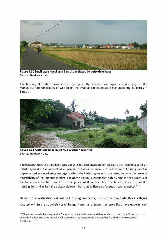
97
Figure 4.10 Small-scale housing in Bantul developed by petty developer Source: Fieldwork data
The housing illustrated above is the type generally available for migrants who engage in the manufacture of handicrafts or who begin the small and medium-scale manufacturing industries in Bantul.
Figure 4.11 A plot occupied by petty developer in Bantul Source: Fieldwork data
The established house unit illustrated above is the type available for purchase and residence after an
initial payment in the amount of 20 percent of the unit’s price. Such a scheme of housing credit is
implemented as a marketing strategy in which the initial payment is considered to be in the range of
affordability of the targeted market. The above picture suggests that sub-division is not a success. It
has been marketed for more than three years but there have been no buyers. It seems that the
housing demand in Bantul is quite a bit lower than that in Sleman’s “pseudo housing market.”26
Based on investigation carried out during fieldwork, this study pinpoints three villages
located within the sub-districts of Banguntapan and Sewon, as ones that have experienced
26
The term “pseudo housing market” is used to characterize the condition in which the supply of housing is far
exceeds the demand, even though such a surplus of property could be absorbed by market for investment
purposes.

98
considerable transformation of their rural demographic and social characteristics into urban
features. These are the villages of Panggungharjo and Bangunharjo belonging to the sub-
district of Sewon and the village of Banguntapan that belongs to the sub-district of
Banguntapan. As noted above, these villages are located adjacent to the city of Yogyakarta
and crossed by the ring road. According to several key informants and experts interviewed in
this study, development of these three villages began when the ring road became
operational. The future role of the ring road as the catalyst for intensified development of
built-up areas beyond the ring road remains to be determined. However, this seems likely
given the experience of the Village of Maguwoharjo which grew dramatically as the urban
areas of DIY linked to the presence of a major economic corridor, the national road
connecting the city of Yogyakarta to the city of Surakarta, one of the centers of economic
growth in Central Java province. The 1997 land use map in Figure 4.8 shows that the built-up
areas were significantly increased during the 1987-1997 period. The growing number of
newly built-up areas indicates an increase in the rate of migration.27 The map showing the
growth of built-up areas between 1987 and 1997 presented in Figure 4.4 above illustrates
the pattern of distribution of newly built-up areas within the villages of Panggungharjo,
Bangunharjo, and Banguntapan. These new developments were mainly the result of
migration that took place after the ring road was opened. Figure 4.4 also demonstrates that
the village of Banguntapan experienced the greatest growth of newly built-up areas followed
by the village of Bangunharjo, whereas the dispersion and intensity of newly built-up areas
within the village of Panggungharjo were less. It also can be seen that the areas adjacent to
the city of Yogyakarta experienced the highest intensity of growth, as exemplified in those
parts of Banguntapan village and Bangunharjo village. This was especially true for
Banguntapan, where the increase in developed areas was believed not only to be due to its
proximity to the City of Yogyakarta, but also to its position bordering the sub-district of
Depok. Depok has the greatest population density as well as the largest population in
absolute numbers. It is, as well, the most massively developed sub-district in Sleman
Regency in terms of the built-up area. Moreover, Banguntapan is located near the national
economic corridor that links the city of Yogyakarta and the city of Surakarta. This strategic
location clearly had an effect on the flow of in-migration and the extension of built-up areas.
27
This study takes an assumption that the spreading and intensifying of new developed areas indicate an expansion of the density of population and an increase in the number of people, especially as a result of in-migration flows.

99
Thus, it can be concluded that the significant changes experienced by the village of
Banguntapan, outstripping Bangunharjo and Panggungharjo, came as a result of its proximity
to the centers of regional-scale economic activity.
Generally, the pattern of growth projected to continue in Bantul may be categorized as
follows:
a. Gradual linear growth. The pattern of gradual linear growth can be found alongside
the main access road that connects the city of Yogyakarta with the region of Bantul.
The most intensive growth occurs in the area adjacent to the city and beyond the ring
road, in particular in the region of Banguntapan.
b. Dispersed growth. Dispersed growth represented by small scale housing can also be
found beyond the local neighborhood. There are several petty developers who
established new settlements for lower-middle class and migrants who work as
lower-middle level staff in local government. Such new housing has been spreading in
several parts of Bangunharjo and Panggungharjo and features thirty-six square meter
floor plans set on plots ranging from ninety to one hundred and twenty square
meters. Their sites are usually located at a relative distance of five hundred meters to
one kilometer away from the main corridor linking Bantul and Yogyakarta.
c. Clustered growth. Since Bantul is a center for many small scale industries like Godean
and Sleman, the area surrounding the industrial cluster has become a new growth
settlement area. As opposed to housing established by small realtors, this new
settlement has been developed predominantly by individuals. New migrants with a
business relationship to small industry, especially handicrafts, buy land for housing
from local people and build there a family house or workshop. The location also is
often some distance from the primary access road.
Based on data gathered from interviewed respondents, this study concludes that the areas
adjacent to the city, both within Sleman Regency as exemplified by the village of Condong
Catur and within Bantul Regency as exemplified by the village of Banguntapan, will

100
experience a continued high level of urbanization.28 This conclusion may not be justified,
since there is not sufficient secondary data that can be used to assess the real situation.
However, the level of urbanization, in general, gradually decreases in relation to a location’s
distance from the city, as in the cases of Sinduharjo village in Sleman and Bangunharjo
village in Bantul. The responses of migrants who reside in the parts of Sardonoharjo, Sleman
and Panggungharjo, Bantul that still contain large areas of farm land maintained that the
spillover of urban facility development into the rural area has played an important role in
attracting in-migration. The condition of relatively low in density in both Sardonoharjo and
Panggungharjo confirmed that argument.
This research has identified two particular findings with regard to the dynamics of
population movement, notably that either the establishment of new residential estates or
the concentration of small industry become important factors in leading the flow of people
to an area. For example, the relatively high population growth in Sinduharjo and Sukoharjo
was recognized as the result of the rapid pace of new settlement. This situation will become
intensify and extend into the future, overtaking neighboring regions. The more exclusive the
new estates on a site, the greater the attraction and influx of new residents. With regard to
this, the increasing value of the land has an important role in driving the growth.
The other notable finding concerns the role of a concentration of small industry to lead in-
migration. It has been seen that pioneering small-scale industries, such as those found in the
districts of Godean, Sleman, and several villages growing in Bantul, have attracted migrants
to engage in industrial activity. These have been predominantly local migrants from the
other regencies in DIY. Since the migrants have come from the neighboring regions, they are
similar in terms of social, cultural, and economic characteristics. A more urbanized
environment may develop as a result of the majority of migrants engaging in small industry,
and the economic ramifications of this activity. It is predicted that local people will become
increasingly less satisfied working in the agricultural sector as industrial activity grows.
However, investigation in this region indicates that land values have not increased as much
here as they have in Condong Catur, Sinduharjo, or Sukoharjo. The land market is relatively
stable and land speculation is not so prevalent. This situation looks very promising for
28
This prediction is made with the reference to the increasing urban activities such as the growing number of
mixed-use between residential and commercial uses along the primary access road and the emerging new
residential estates that inhabited by the migrants whose higher income.

101
initiating a more equal development in which the practice of land speculation could be
controlled in the future.
4.4. Modes of land use and space use
In accordance with a pattern of population distribution and growth driven by the availability
of affordable vacant land for housing and an opportunity for employment, the pattern of
land use and space use could be stated as an outcome linked to the dynamics of socio-
economic forces. The way the people utilize their plots or buildings is merely a reflection of
society's response to the dynamics of growth and transformation of the region which is in
progress. In more specific terms, the land and space use patterns represent how the use
value and exchange value of the land are being traded-off. This study found that the higher
the intensity of use mixing the interests of consumers and producers in a peri-urban area,
both of land and buildings, the greater the influence of urbanism.
Figure 4.12. Paddy field occupied for urban use and gated community Source: Fieldwork data

102
4.4.1. Mixed land use as a strategy of increasing land use value
Changes in land use and spatial pattern generally occur spontaneously. The spreading of the
newly built environment for both residential functions and urban facilities to the outskirts of
town is the main driver of increased demand for land. Areas along the main corridor as well
as areas some distance from the highway become the target for acquisition by the
developers and land speculators.
Figure 4.13 Possibilities of mixed-land use patterns Source: Fieldwork data
Figure 4.13 above shows how a house on a relatively large plot could be developed in a way that
accommodates numerous different uses. Such a strategy of intensification is widely practiced by local
residents, especially those located strategically adjacent to a university campus, in the neighborhood
of a new public facility like a health clinic, shopping center, or commercial district.
Commercialization of land along the main corridor that connects the city of Yogyakarta with
its peri-urban areas not only shows symptoms of the conversion of land from agricultural use
into settlement, but also to mixed-uses combining residential and business places. Many
residential buildings along the highway are used in part for such commercial purposes as a

103
shop, mini market, or restaurant. Either the lower floor is kept for commercial use and the
upper floor for residential use, or the house is partitioned so that the front may be dedicated
to the commercial function.
Figure 4.14 Part of paddy-field rented-out for a restaurant in Sinduharjo, Sleman Source: Fieldwork data
The picture above also represents a pattern of mixed-land use between paddy-field and service sector. This kind of land-use pattern broadly occurs in Sleman, particularly in the Jalan Palagan and its surrounding area since it was designated by local government for a new culinary center in Yogyakarta that attracts more tourists on weekends.
Titus and Van der Wouden (in Titus and Hinderink eds., 1998) who examined the
development of several small towns in Java found that the urban growth process reduced
the average farm-size to less than half a hectare, fragmenting the land. Rotgé, Mantra and
Rijanta suggest that strengthened rural-urban linkages accelerate physical urbanization.29
29
Rotgé, Mantra and Rijanta investigated the process of rural-urban integration in Java and Yogyakarta during 1991-1992 and categorized a three types of urbanization (2000:242)
a) Peripheral physical urbanization, or urbanization of urban fringes mainly around Yogyakarta;
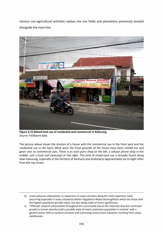
104
Various non-agricultural activities replace the rice fields and plantations previously located
alongside the main line.
Figure 4.15 Mixed-land use of residential and commercial in Kaliurang Source: Fieldwork data
The picture above shows the division of a house with the commercial use in the front yard and the residential use in the back. What were the front grounds of the house have been rented out and given over to commercial uses. There is an auto parts shop on the left, a cellular phone shop in the middle, and a food stall (warung) on the right. This kind of mixed-land use is broadly found along Jalan Kaliurang, especially in the territory of Sariharjo and Sinduharjo approximately six to eight miles from the city center.
b) Linear physical urbanization, or expansion of urban corridors along the most important roads
(occurring especially in areas crossed by Klaten-Yogyakarta-Wates thoroughfares which are those with the highest population growth rates), but also along roads of minor significance;
c) ”Diffused” physical urbanization throughout the countryside due to the relatively slow but continued growth in human density (until a possible state of nearly stationary population is reached with a general sector shift to nonfarm activities and a booming construction subsector resulting from urban remittances.
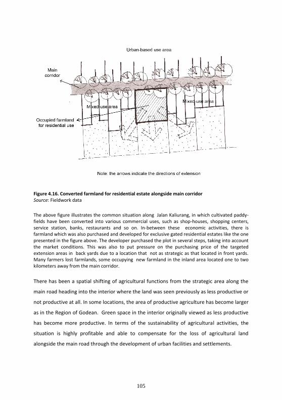
105
Figure 4.16. Converted farmland for residential estate alongside main corridor Source: Fieldwork data
The above figure illustrates the common situation along Jalan Kaliurang, in which cultivated paddy-fields have been converted into various commercial uses, such as shop-houses, shopping centers, service station, banks, restaurants and so on. In-between these economic activities, there is farmland which was also purchased and developed for exclusive gated residential estates like the one presented in the figure above. The developer purchased the plot in several steps, taking into account the market conditions. This was also to put pressure on the purchasing price of the targeted extension areas in back yards due to a location that not as strategic as that located in front yards. Many farmers lost farmlands, some occupying new farmland in the inland area located one to two kilometers away from the main corridor.
There has been a spatial shifting of agricultural functions from the strategic area along the
main road heading into the interior where the land was seen previously as less productive or
not productive at all. In some locations, the area of productive agriculture has become larger
as in the Region of Godean. Green space in the interior originally viewed as less productive
has become more productive. In terms of the sustainability of agricultural activities, the
situation is highly profitable and able to compensate for the loss of agricultural land
alongside the main road through the development of urban facilities and settlements.

106
The emergence of urban activity in peri-urban areas greatly affects the sustainability of
agricultural activities. This is evident in the high interest of family farmers, especially the
younger generation, in pursuing non-farming activities. Detailed descriptions of the decline
in agricultural activity and the younger generation’s weakening interest in farm work will be
explained further in chapter 5.
Rather than exercising the option to sell part or all of an existing wetland along the highway,
some farmers have chosen to rent their farm land for a period of several years (generally 5-
10 years) to entrepreneurs who convert the land to such non-agricultural activities as
workshops (small scale industry), warehouses, showrooms, stores or kiosks, food and
beverage shops, mini markets, and service enterprises. In addition to land used for housing
development, some land is reserved for the construction of shop-houses. The model of
shop-houses is more attractive in the area of Godean, because of the commercial
development and spatial plan to attract retail and wholesale trade to this area. Similarly,
the area along Jalan Palagan (Palagan Street) to the north of, but parallel to, Jalan Kaliurang
(Kaliurang Street), evolved into a center of environmental and culinary tourism. The
development of tourism in Palagan corridor also affected the change of land use and the
conversion of agricultural land in the vicinity. Development featuring recreational facilities
such as hotels, restaurants, cafes, boutiques, spas, and saunas have evolved linearly along
the main route and are clustered in certain locations. Many investors, who leased land
owned by farmers (generally over a period of at least for 5 years) developed cafes,
constructing buildings which were semi-permanent. Hotels, however, generally occupy land
that has been purchased since business in the hospitality sector indicates that hotels are
should last longer than cafes.
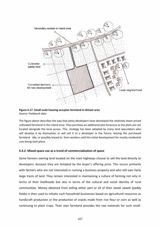
107
Figure 4.17. Small-scale housing occupies farmland in distant area Source: Fieldwork data The figure above describes the way that petty-developers have developed the relatively lower priced
cultivated farmland in the inland area. They purchase an additional plot foraccess as the plots are not
located alongside the local access. This strategy has been adopted by many land speculators who
will develop it by themselves or will sell it to a developer in the future, leaving the purchased
farmland idle, or possibly leased to farm workers until the initial development for mostly residential
uses being took place.
4.4.2. Mixed-space use as a trend of commercialization of space
Some farmers owning land located on the main highways choose to sell the land directly to
developers, because they are tempted by the buyer’s offering price. This occurs primarily
with farmers who are not interested in running a business property and who still own fairly
large tracts of land. They remain interested in maintaining a culture of farming not only in
terms of their livelihoods but also in terms of the cultural and social identity of rural
communities. Money obtained from selling either part or all of their tanah sawah (paddy
fields) is then used to initiate such household businesses based on agricultural resources as
handicraft production or the production of snacks made from rice flour or corn as well as
continuing to plant crops. Their own farmland provides the raw materials for such small-

108
scale industries. What money remains is used to buy new farmland located relatively far
inland. The land area acquired can be many times that of the land sold. Thus there is still a
continuation of agricultural activity, whether they are doing themselves or hiring peasants.
Figure 4.18 Mixed-space use of residential and commercial Source: Fieldwork data
There are many family houses located alongside Jalan Kaliurang being divided for commercial use. The picture above shows the front yard of a house occupied by three different tenants, selling insurance, cellular phones, and providing printing services respectively. They lease the property for a minimum of three years. There are also restaurants and mini markets occupying front yards. All this business has generated unanticipated traffic. As a result, the traffic jams have become quite serious along Jalan Kaliurang. Another problem generated by this development concerns the distance of the new buildings from the roadways. They encroach upon the public space, and it seems that the local government does not enforce this kind of building code violation.
Figure 4.18 shows the commercial area on the lower floor of a house split into three parts, rented out to different tenants with different business. The section on the left side is used by an insurance service provider, the one in the middle for the petty-enterprise of printing, and the one on the right for cellular phone sales. In addition, the façade of the buildings is almost completely covered by a billboard.

109
Investors who run cafe businesses mostly come from the city of Yogyakarta and surrounding
areas (68%) or from outside the area of Yogyakarta (32%), from big cities in Java such as
Jakarta, Surabaya, and so on. The hotel business in the study area is dominated by non-star
hotels owned by local entrepreneurs (73%). These hotels are greatly enjoyed by customers
because of their small scale and intimate atmosphere. Arcor and Hyatt have developed
several five-star resort-hotels that take advantage of the natural environment. Some of the
hotel business has been developed by entrepreneurs who come from the local area. Their
strategy has been to transform their own houses or yards into hotels with six to twelve
rooms. The natural landscape and paddy fields attract the visitors who choose these hotels.
Such hotels tend to be full every weekend and during school holidays.
4.5. Typology of new settlement pattern
Affluence and poverty are juxtaposed, creating a stratified and diverse pattern of settlement
in the neighborhood. There is also considerable variation in the structure of villages and the
level of their community integration, differentiating their social cohesion.
4.5.1. In-between development: a model of small-scale housing
The emerging in-between development is inspired by the needs of middle-class mature
families who previously lived in the city of Yogyakarta and surrounding districts, mostly from
Bantul and Kulon Progo. As these families become wealthier, they look for a better living
environment. The regions around Kaliurang become the most attractive. Field research
revealed that most of this population preferred to live in an area with proximity to the city.
They did not wish to live in a more distant area even though it offered a much better
residential atmosphere. Only about 35 percent chose to purchase houses built by a formal
developer. This group was dominated by young, but well-educated families. Local migrants
who looked for an area adjacent to the city now reside in in Condong Catur, Sinduharjo, and
Sariharjo. About 65 percent of the new residents in this area are local migrants and the
remaining 35 percent come from outside Yogyakarta. About half of the local migrants live in
small-scale housing built by an individual developer. In-between housing like this takes
place within existing neighborhoods.
The development of in-between housing is currently concentrated in Sinduharjo and
Sariharjo since the area of Condong Catur is relatively fully occupied. The impetus for in-
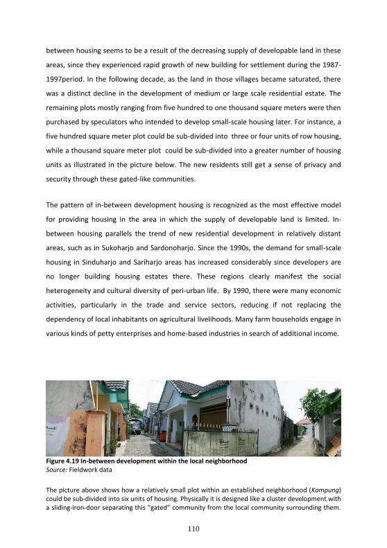
110
between housing seems to be a result of the decreasing supply of developable land in these
areas, since they experienced rapid growth of new building for settlement during the 1987-
1997period. In the following decade, as the land in those villages became saturated, there
was a distinct decline in the development of medium or large scale residential estate. The
remaining plots mostly ranging from five hundred to one thousand square meters were then
purchased by speculators who intended to develop small-scale housing later. For instance, a
five hundred square meter plot could be sub-divided into three or four units of row housing,
while a thousand square meter plot could be sub-divided into a greater number of housing
units as illustrated in the picture below. The new residents still get a sense of privacy and
security through these gated-like communities.
The pattern of in-between development housing is recognized as the most effective model
for providing housing in the area in which the supply of developable land is limited. In-
between housing parallels the trend of new residential development in relatively distant
areas, such as in Sukoharjo and Sardonoharjo. Since the 1990s, the demand for small-scale
housing in Sinduharjo and Sariharjo areas has increased considerably since developers are
no longer building housing estates there. These regions clearly manifest the social
heterogeneity and cultural diversity of peri-urban life. By 1990, there were many economic
activities, particularly in the trade and service sectors, reducing if not replacing the
dependency of local inhabitants on agricultural livelihoods. Many farm households engage in
various kinds of petty enterprises and home-based industries in search of additional income.
Figure 4.19 In-between development within the local neighborhood Source: Fieldwork data
The picture above shows how a relatively small plot within an established neighborhood (Kampung) could be sub-divided into six units of housing. Physically it is designed like a cluster development with a sliding-iron-door separating this “gated” community from the local community surrounding them.

111
It can be observed that the access is only about three meters wide and there no longer space for two-way-traffic.
Figure 4.20. Lay-out of a small-scale in-between development housing Source: fieldwork data Figure 4.20 above demonstrates how the developer inserted the six-units of housing into the existing neighborhood. He purchased plots in the back yards of several houses and then built a private access that couldserve only one-way-traffic from the existing local access. He then built a wall to separate the new residents from the local community.
Figure 4.21 Rental student dormitory in Condong Catur Source: Fieldwork data
Figure 4.21 above presents a model of how a student dormitory was located within an existing local community, again with a relatively narrow access road that serves one-way-traffic only. This property is owned by a person who lives in Jakarta. He hired two persons to maintain the building and collect the payment from students who live there.

112
Figure 4.22. Lay-out of in-between housing alongside the local access Source: fieldwork data
Figure 4.22 above shows an in-between development adjacent to the local access road. These three housing units are not separated from the local community. The developer purchased the plots from a local inhabitant whose a large yard. In many cases, such plots were purchased from someone who had owned the land for a long time. Such a practice of land purchase and sale is often found in an area that has been saturated, limiting drastically the opportunities and the space for development.
4.5.2. Cluster development: spatial fragmentation and social exclusion
The empirical findings indicate that there is a high level of speculation in housing
development in Yogyakarta. Many developers who established exclusive-gated-residential-
estates had little or no experiences in the fields of housing or property development. Some
of them even had major businesses in automotive sales. High demand for housing in
Yogyakarta and ease of financing encouraged entrepreneurs to start a business in the field of
housing supply. The property industry was booming in Indonesia from the late 1980s until
the end of the 1990s as a result of support funding from the banks. Investors used the land
certificate as collateral for credit. They cut a deal with the tax service officer and
manipulated the land price recorded on the tax certificate from which the credit analysts of

113
the bank calculate the value of the collateral. The desire for higher credit thus motivated
investors to jack up land prices. Considering these circumstances, there is a need to involve
banks in controlling land development speculation.
Regarding the backlog in Sleman Regency, the challenge in housing policy is to control the
rapid growth of housing development as commercial property and a means of investment
rather than to limit the housing provision program. Public developers such as Perumahan
Nasional (Perumnas) are still building to provide housing for lower-middle income families.
More attention should be focused on the large scale development of residential estates that
adversely affect the land market. Often land speculation is stimulated by the development of
large scale housing projects, since the projects tend to extend the area of development into
to the surrounding neighborhood or cultivated farmland. The acquisition of large portions of
farmland owned by local residents reveals that speculation impinges steadily upon the
paddy fields.

114
Figure 4.23 Development of new residential estate along the main road Source: Fieldwork data
Figure 4.23 above represents an exclusive gated large scale housing project whose very strategic location i.e. alongside the ring road. It covers an area around 40 ha. In the front side, there are shop-houses building that very attractive for the person either who wish to purchase for an investment or for doing a business such as retail. This residential estate is one of the most expensive properties in peri-urban Yogyakarta. It is located at the territory of Maguwoharjo. The developer purchased 70 percent of the land from the village land treasuries (Tanah Kas Desa) and the remaining 30 percent from several local farmers.
Spatial fragmentation and social segregation are crucial problems related to exclusive cluster
developments. A cross subsidy to the local settlement to provide a sewerage system or
corporate social responsibility for this purpose should be implemented since the affluent
community usually produces more waste than the local poor residents. There is a clear need
to establish a small group that represents the native community in negotiating every
physical or environmental consequence or reparations for damages caused by the
establishment of new luxurious residential estates.

115
Rent-seeking has been described as “a polite way of corruption” (Harvey, 1991 cited in Beall
& Fox, 2009, p.148). It refers to the practice of government officials who use their authority
or bureaucratic position to drive development policy or spatial planning to benefit
themselves. Local government staffs involve themselves in land speculation by purchasing
plots that will be developed by large developer. Those government officials normally join
with an investor to establish the new housing project.
Figure 4.24 An exclusive gated residential estate in Kaliurang Source: Fieldwork data
Figure 4.24 above presents an exclusive-gated-community that is reported by several informants to be on a plot belonging to the Sultan (or king). Nearly 70 percent of the owners are migrants who come from outside Yogyakarta. They generally do not live there, instead leasing it, or letting their relatives or children who take their further study in Yogyakarta live there. Several houses are inhabited only by a housemaid and security guard who have been hired to maintain the building.
4.5.3. Self-help housing and the mobility of poverty
The idea of providing people, particularly poor migrants with a developable plot, has
motivated several villages to sub-divide a part of the village land treasuries (Tanah Kas Desa
and offer land to anyone who needs a plot for living. Minimum lease prices range from IDR
350,000 to IDR 500,000 per year. This initiative matches the management goal of Tanah Kas
116
Desa to provide services for the public rather than for commercial gain, even though there is
considerable evidence of transactions through which village land treasuries are being
depleted.
Mathéy (1997 in Guggler ed., 1997, p.281) categorized self-help housing into two types:
a) Autonomous self-help constitutes a spontaneous action by which the housing
development was neither planned by planners nor referred to in the urban or spatial
plan. It is evident that such actions are generally well-organized by the stakeholders.
b) Assisted self-help is characterized by a government-led housing development action.
Normally there are agencies who deliver both technical and managerial assistance.
This strategy is recognized as the conventional housing provision that originated from
traditional European systems of public housing. It was the forerunner of a non-
conventional development policy commonly known as the site-and-service scheme.
In this program, the participation of the community remains a key factor determining
the availability of developable land and developing the basic infrastructure of the
settlements as well as evaluating the success of the housing project.

117
Figure 4.25. Lay-out and situation of Self-help Housing Source: Fieldwork data
Figure 4.25 above illustrates the way a plot of Tanah Kas Desa is divided into several small parcels of land creating self-help housing. The plot is usually located in proximity to the city and surrounded by existing neighborhood composed of local community and migrant households established long before. There is paddy land that remains cultivated by the neighboring people. The farm workers give one-third (locally called mertelu) of their harvest to Kelurahan as the land owner. Referring to the model of self-help housing in Sinduharjo, Sleman, the land is divided into several one hundred square meter plots. This is really only a land sub-division, since the area is not provided with any basic infrastructure.
The lack of infrastructure forces the self-help housing community to initiate the provision of
such basic utilities as access roads, water supply, drainage, and sewerage systems according
to its members’ financial capacity. They organize collective actions to maintain their
neighborhood. They are likely to maintain their independence from local government
intervention and provision. The pictures below illustrate the situation of a community-based
housing development. It can be seen that the building materials vary from bamboo and
wood to concrete blocks. The variety not only indicates the economic level of the migrant,
but also represents buildings that vary from semi-permanent to permanent.
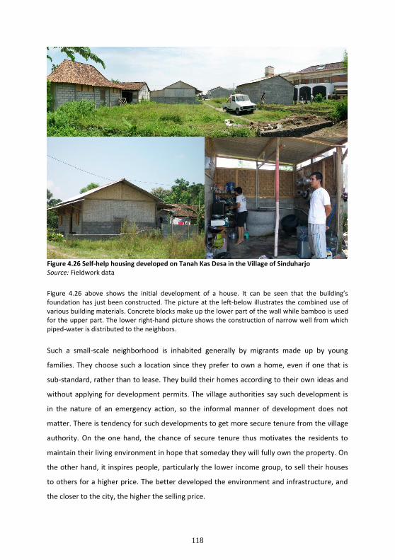
118
Figure 4.26 Self-help housing developed on Tanah Kas Desa in the Village of Sinduharjo Source: Fieldwork data
Figure 4.26 above shows the initial development of a house. It can be seen that the building’s foundation has just been constructed. The picture at the left-below illustrates the combined use of various building materials. Concrete blocks make up the lower part of the wall while bamboo is used for the upper part. The lower right-hand picture shows the construction of narrow well from which piped-water is distributed to the neighbors.
Such a small-scale neighborhood is inhabited generally by migrants made up by young
families. They choose such a location since they prefer to own a home, even if one that is
sub-standard, rather than to lease. They build their homes according to their own ideas and
without applying for development permits. The village authorities say such development is
in the nature of an emergency action, so the informal manner of development does not
matter. There is tendency for such developments to get more secure tenure from the village
authority. On the one hand, the chance of secure tenure thus motivates the residents to
maintain their living environment in hope that someday they will fully own the property. On
the other hand, it inspires people, particularly the lower income group, to sell their houses
to others for a higher price. The better developed the environment and infrastructure, and
the closer to the city, the higher the selling price.

119
The buildings in which they live are generally made to be easy to disassemble. The existence
of several locations of self-help housing across the peri-urban area provides them with an
opportunity to make a rent-profit. After selling a house, usually a temporary-constructed
building, for a good price, they move to the other self-help housing project that is much
cheaper, and after a period of living there, they will sell again, moving to the another
location for rent-seeking reasons. Thus we see mobile poverty as an emerging phenomenon.
4.6. Land market within the dynamism of land speculation
Migration rates are strongly correlated with the demand for developable land, whether for
residential use or for other facilities like stores and offices. Field research revealed, however,
that the high rate of land demand does not necessarily reflect the actual demand for new
housing. The growing numbers of new houses in Sleman, for example, does not correlate
with the rate of population growth, either through birthrates or migration. Arif Setio Laksito,
the head of the sub-division of urban development in the District of Sleman, maintained that
the supply of new houses in Sleman is far higher than the demand. He said:
”By the end of 2008, the backlog in Sleman was 5,000 housing units, but in reality there are 28,000 units of housing developed across the regions” (Arif Setio Laksito, interview, 23/04/2009).
Nonetheless, the dynamics of the land market is continues to be driven by migration, and to
be more specific, by the movement of the middle income group. Although middle class
migrants consume much more land than others, especially for residential use, the empirical
findings of this study show that even regions with a large number of middle class migrants
have more new buildings than migrants. The new construction of residential property lead
by private developers is still growing, even though the availability of developable land as well
as basic infrastructures and social facilities is relatively low. There are many new family
houses only inhabited by house-maids.
With respect to land ownership, land market categories in Yogyakarta can be distinguished
into three, namely (1) land purchased from farmers; (2) land leased from Tanah Kas Desa; (3)
land obtained from the Sultan Ground or Sultanate in the form of land sharing.

120
4.6.1 Farmland: direct negotiation with the farmer or landholder
The developers target areas of heavily controlled public lands, mainly rice fields and
plantations to be developed into new facilities that support higher education and the rapidly
growing residential estates that spring up along with the development of the university
campus. Investor interest in developing exclusive estates around campus is driven by
consumer preferences. Many people consider the area around campus to be prestigious.
Thus, having a house nearby campus will raise the status of the inhabitants. In an interview,
Ahmadi, representing a family who lived near the campus of Universitas Islam Indonesia
among other new migrants, said:
“[…] neighborhoods around campus are generally populated by professors and educated families. This will affect the daily life environment, especially the social environment for children“ (Ahmadi, interview, 10/04/2009).
It is clear that the social milieu is a particular consideration for some new migrants when
considering housing. Nugroho, articulated a more commonly held perspective the
opportunity of increasing the exchange value of the property--when he commented,
”Having a house located around the campus complex will provide a better return on investment for our property, because the environment has become a residence for the upper-middle class so that the physical condition will remain well-maintained. Another factor is the existence of various economic and social facilities which will continue to grow and will certainly increase the sale price of existing homes and land around the university campus” (Nugroho, interview, 11/04/2009).
In addition, for parents who send their children to attend school in Yogyakarta, investing in
houses around the campus is believed to be better than paying for a dormitory space. Of
course, this applies to parents who have excess assets. Besides the issue of convenience for
their child’s continuity of learning, they worry about his social interactions. Living in student
dormitories will certainly open up a wider range of social opportunities. Widjanarko, a
government official from Jakarta whose daughter was taking a degree in the Faculty of Law
at Gadjahmada University, revealed:
‘Social interaction among the younger generation currently tends to be uncontrolled. I decided to buy a house for my child. Staying at home I think can minimize the risk of social interaction that might be less favorable. Incidentally, I have a relatives who does not have a job, so asked him and his wife to live in that house, to care for and clean the house, and also at the same time to be watching my daughter” (Widjanarko, interview, 12/04/2009).
121
Widjanarko represents an upper-middle class family who bought a second or third family
house for children who take further study in Yogyakarta. Almost all the respondents whose
responsibility was to take care of an employer’s or relative’s children addressed the problem
of social interaction among the younger generation to some extent. Other reasons driving
interest in buying a house in Yogyakarta were investment and owning a second house, that
could be used during the holidays or when visiting their children who were studying in
Yogyakarta instead of staying in a hotel. As mentioned in the previous chapter, the
establishment of Yogyakarta as a center of higher education has been a great attraction for
migrants settling in Yogyakarta. This situation has spurred an increase in land prices in
almost all regions in Yogyakarta, but especially in the areas surrounding university campus
development.
Furthermore, the fact that Yogyakarta is a region that is relatively stable politically and has a
relatively low of cost of living attracts upper-middle income groups to live there after
retirement. They believe the city of Yogyakarta is a good place to reside, because society
there is relatively cohesive even though it is marked by a varied economic structure and
social diversity. The high interest of that Indonesians, particularly the Javanese, have in
spending their retirements in Yogyakarta increases the demand and consequently the value
of real estate. The city of Yogyakarta is the center of Javanese culture. The palace of
Yogyakarta is not just a monument to Javanese culture and tradition. It is the symbol of its
actual sovereignty within Indonesia as a region with special status known as Daerah
Istimewa Yogyakarta. Such a unique sociocultural feature makes the Javanese community,
especially those born in Yogyakarta, wish to return and/ or live there once retired. Hidayat,
who currently lives in another city, confirms the socio-cultural realm as one of Yogyakarta’s
attractions. He said:
”Yogyakarta city is known as a safe and peaceful, almost never sees any political upheaval. Although there are many immigrants from various tribes and cultures, the social relations of life in Yogyakarta continues in harmony” (Hidayat, interview, 15/04/2009).
At the same time, groups of migrants or investors who purchased land to be developed for
productive functions were attracted by the status of Yogyakarta as a center of education and
tourism. Investors have targeted the city because it has the highest number of universities
and high schools as well as the best educated population after the city of Jakarta. They

122
develop modern residential areas, especially around the university campus aimed at the
upper middle class while land on the slopes of Mount Merapi like Kaliurang and Palagan as
well as areas along the main road to Parang Tritis beach more widely used for the
development of such tourist support facilities as hotels, homestays, restaurants, and cafes.
The demand for land no matter the function is equal, although the spatial pattern evolves in
different ways. The pattern of land development for productive functions generally is linear
along regional lines or main transportation corridors. The pattern of development for
consumptive function takes the form of a cluster, as around the area of Universitas Islam
Indonesia in Kaliurang, or nearby local government offices like those in the areas around the
central district of Sleman.
Another practice of land speculators is to hold vacant land that for several years, leaving it
undeveloped until a good opportunity arises to sell or develop it, that is, when the area
around the vacant land begins to develop as a newly built environment. The brokers or
developers usually have access to information about spatial planning and land use, that is,
zoning designations, set up by local government. However, because the spatial plan is not
effectively disseminated to the public, especially in the countryside, most farmers, the
owners of agricultural land, do not have detailed information about the potential
development of such urban facilities as educational or commercial centers in their areas. The
spatial plan or zoning designation of a region tends to be known only to a fraction of the
community. Those who benefit most are those who have access to such information, such as
government officials and certain groups close to local governments, like investors and
developers. This is evident since most land speculators are government employees.
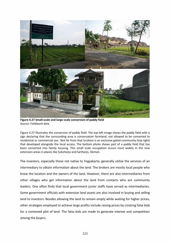
123
Figure 4.27 Small-scale and large-scale conversion of paddy field Source: Fieldwork data
Figure 4.27 illustrates the conversion of paddy field. The top left image shows the paddy field with a sign declaring that the surrounding area is conservation farmland, not allowed to be converted to residential or commercial use. Not far from that location is an exclusive gated-community (top right) that developed alongside the local access. The bottom photo shows part of a paddy field that has been converted into family housing. This small scale occupation occurs most widely in the new extension areas in places like Sukoharjo and Sariharjo, Sleman.
The investors, especially those not native to Yogyakarta, generally utilize the services of an
intermediary to obtain information about the land. The brokers are mostly local people who
know the location and the owners of the land. However, there are also intermediaries from
other villages who get information about the land from contacts who are community
leaders. One often finds that local government junior staffs have served as intermediaries.
Some government officials with extensive land assets are also involved in buying and selling
land to investors. Besides allowing the land to remain empty while waiting for higher prices,
other strategies employed to achieve large profits include raising prices by creating false bids
for a contested plot of land. The false bids are made to generate interest and competition
among the buyers.
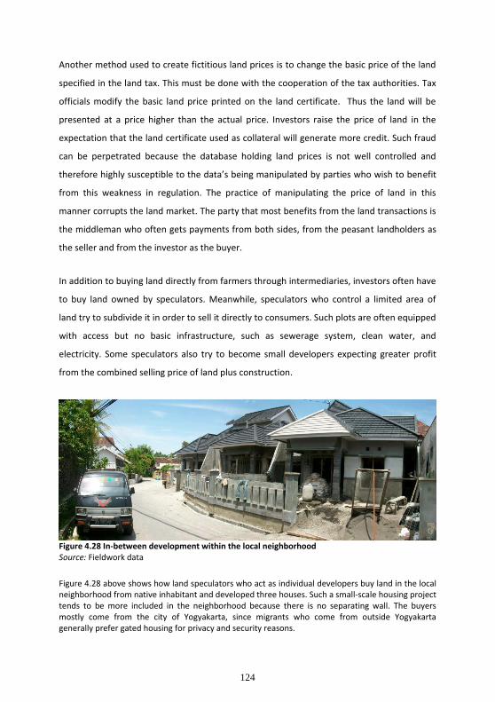
124
Another method used to create fictitious land prices is to change the basic price of the land
specified in the land tax. This must be done with the cooperation of the tax authorities. Tax
officials modify the basic land price printed on the land certificate. Thus the land will be
presented at a price higher than the actual price. Investors raise the price of land in the
expectation that the land certificate used as collateral will generate more credit. Such fraud
can be perpetrated because the database holding land prices is not well controlled and
therefore highly susceptible to the data’s being manipulated by parties who wish to benefit
from this weakness in regulation. The practice of manipulating the price of land in this
manner corrupts the land market. The party that most benefits from the land transactions is
the middleman who often gets payments from both sides, from the peasant landholders as
the seller and from the investor as the buyer.
In addition to buying land directly from farmers through intermediaries, investors often have
to buy land owned by speculators. Meanwhile, speculators who control a limited area of
land try to subdivide it in order to sell it directly to consumers. Such plots are often equipped
with access but no basic infrastructure, such as sewerage system, clean water, and
electricity. Some speculators also try to become small developers expecting greater profit
from the combined selling price of land plus construction.
Figure 4.28 In-between development within the local neighborhood Source: Fieldwork data
Figure 4.28 above shows how land speculators who act as individual developers buy land in the local neighborhood from native inhabitant and developed three houses. Such a small-scale housing project tends to be more included in the neighborhood because there is no separating wall. The buyers mostly come from the city of Yogyakarta, since migrants who come from outside Yogyakarta generally prefer gated housing for privacy and security reasons.

125
Another group of development actors are farmers who cooperate with a building contractor.
Such coalitions generally try to develop small scale settlements on land owned by the
farmers. Within the framework of this cooperation, the farmer usually contributes part of his
farmland as his share of the venture capital, whereas the contractor as his business partner
bears the construction costs. Benefit from the sale of the housing then is divided
proportionately between them. Small scale settlements developed either by speculators or
coalitions of farmer and contractor are generally marketed to local consumers. Shop-house
(Rumah-toko) is the most popular type of property developed in these cases, and farmland
located along the main access road becomes the target of occupation.
Frequently a small-scale residential complex is built among the rice field with access to local
roads or village paths. These are moderately priced considering the location of land, lack of
adequate access, and low quality construction. The land controlled by speculators is
generally located among the traditional kampongs or local neighborhoods.
New settlements that develop in-between local community housing is generally preferred by
local consumers who are natives of Yogyakarta. Most migrants coming from outside the city
of Yogyakarta choose to live in new areas, although often in houses with relatively minimal
facilities reflecting their incomes (lower to middle). Immigrants with upper-middle class
incomes generally choose to buy houses in modern residential areas developed by an
institutional developer. The main consideration of this group is ease of access and the
completeness of the facility. However, they also value the higher quality construction and a
more homogenous neighborhood that reflects their own socio-economic status.
4.6.2. Sultan Ground: property belonging to the Sultanate
Sultan Ground in Yogyakarta is the only remaining land tenure system today found in
Indonesia. The proclamation of independence in 1945 marked the beginning of the
democratic era. The land tenure system is a legacy of the era when Indonesia was divided
into kingdoms. As outlined earlier in the text, the Mataram Kingdom known as the Kingdom
of Ngayogyakarta Hadiningrat located in Yogyakarta is the only remaining kingdom in
Indonesia. Its existence is recognized through its architecture, notably the palace, and
affirmed by government recognition of the King’s authority. Therefore, Ngayogyakarta
Hadiningrat as a Kingdom in Yogyakarta is not just a cultural entity but also a territorial one.

126
Traditionally the Sultan or King, as the supreme power in the Kingdom of Ngayogyakarta
Hadiningrat, owns the land throughout his realm. The land belonging to the King is managed
by employees of the Court who are appointed to manage land use for the benefit of the
Royal family, although some lands are managed by village heads, the so-called Lurah or
Bekel, for the benefit of society, particularly farmers. In general, this community's interests
focuses on land use for settlement and for agriculture.
As the individuals in charge of managing the land belonging to the Sultan, Lurah, or village
heads, receive as compensation one-fifth of the total area under their authority. Land serves
as a wage given by the Sultan to the Lurah. The remaining four-fifths is turned over to the
villagers who are obligated to remit half of their crops to the Sultan as tribute. The land
belonging to the Lurah is then rented out to the workers with the same condition attached.
If the soil is dry and barren, as is the case in Gunung Kidul, where agricultural activities rely
on rain water rather than groundwater, the farmworkers only have to give the Sultan a third
of the harvest, keeping the remaining two-thirds themselves. This system is known as the
mertelu. The other system which is more popular is maro (share-cropping) by which each
party obtains a half portion of the harvest. This maro system is currently applied by the
owners of rice fields to their farmworkers, while the mertelu system is rarely found today
outside the Sultanate. It does, however, underly any results-sharing agreement not only in
agriculture but also in other economic activities carried out in village communities in
Indonesia. At present, the granting of land to the Lurah is called Maosan, while the land
granted to Lurah is called Bengkok or Tanah Kas Desa.
During the era of Dutch colonialism, the land belonging to the Sultan was divided into
several types as follows30:
a. Land used by Sultan himself, mainly used for developing such palace facilities as gardens, leisure areas, and so forth.
b. Land granted to the Dutch government to be developed both for basic infrastructure and public facilities like roadways, railways, stations, hospitals, market places, and for special purposes such as the Dutch Governor’s residence.
30
This categorization is based on data gathered from in-depth interviews with several key respondents, including
members of such official government organizations as the Local Development Board (Bapeda) and Local
Development Control Board (BPPD), as well as local community leaders.

127
c. Land granted to Dutch and Chinese businessmen as a privilege or property with right of ownership for plantations or farms.
d. Land granted to people who worked in the government of the Kingdom called Abdi Dalem that was managed by the group.
e. Land granted to the relatives of the Sultan as a privilege called Kasentanan Land.
f. Land granted to the Regent (Bupati) as a property with right of ownership.
g. Land for agricultural activities outside the city center granted to the Sultan’s security guard (Patih Dalem) for public use called Tanah Kebonan.
h. Land for settlement granted under the authority of the Sultan.
i. Paddy fields granted to the Bekel (village heads like the Lurah) and cultivated by farm-workers called Maosan as well as land belonging to the Sultan cultivated by farm-workers as well.
Recently many plots that used to belong to the Sultan but had been granted to village heads
(Lurah), to the Regent (Bupati) and to palace bureaucrates (Abdi Dalem) have been sold by
their beneficiaries to other parties. Within case study areas there are numerous farmland
plots and paddy fields that were purchased from Lurah. Land owned by the Sultan, the so-
called Sultan Ground, is distributed across the region of DIY. Such property is often leased
for a relatively long period of time (about 20-30 years) by investors who develop commercial
centers such as shopping malls, or service businesses like hotels, exhibition halls, and so on.
The investor deals in a cooperative business arrangement with the Sultanate. All of the
procedures necessary for the issuance of land use rights is handled by a committee that
represents the Sultanate as the land owner. The issuing of development permits is managed
and controlled by local government where the plots are located. There is limited evidence of
residential estate development built on the Sultan Ground, since most of this land is
developed under a cooperative agreement. In this respect, the Sultanate prefers to lease or
to develop a business that is managed together. Thus, there are several hotels, food and
beverages industries, banks, and other service businesses owned by the Sultanate.

128
4.6.3. Tanah Kas Desa: organized under the kelurahan (local authority of the village)31
Many plots developed for new building across the peri-urban regions in Yogyakarta were
cultivated agricultural land, either owned by a local farmer or a distant owner who
purchased it from a local farmer, and Tanah Kas Desa. Management and administration of
such village property is under the authority of the village and may be utilized fully for basic
infrastructure, public facilities, and community needs as noted in Article 6 of Regulation of
the Ministry of Home Affairs (Peraturan Menteri Dalam Negeri) or shortened as Permendagri
No.4 Year 2007. According to the regulation above, Tanah Kas Desa should be utilized for
any development that meets the community’s needs, but in actual practice, there is
considerable evidence that exclusive residential estates have been built on community land.
The investors usually contacts the village head (Lurah) to handle the transaction.
Considerations important to the developer in land acquisition include first, the location of
the plot; second, a relatively low price; and, third the ease of acquiring the land and the
development permit. Village land treasuries or Tanah Kas Desa, tends to be more attractive
to investors, particularly to middle- and large-class investors in comparison with land owned
by individual farmers, since they can get a larger plot of land and just have one point of
negotiation, the village head (Lurah).
With regard to the application and issuance of required permits for land development,
investors say that it is easier, cheaper, and faster to deal with Lurah rather than with a
private owner when purchasing land owned by local farmers. This may be a result of the
collegial relationship between Lurah and the related vertical institutions, particularly the
Local Development Control Board (Badan Pengendalian Pembangunan Daerah or BPPD) that
issues both the Land Acquisition Permit (Ijin Prinsip) and the Location Permit (Ijin Lokasi),
and the Public Works Service (Dinas Pekerjaan Umum or DPU) that issues the Development
Permit. Investors prefer to purchase the land from village authorities because it is more
convenient. They tend to avoid land procurement from individual farmers as they are
involved in the land speculation engaged in by local residents or even by speculators from
other cities. In many instances, it is difficult to purchase the land directly from the original
owner or farmer, since almost all plots located in strategic areas have been purchased
31
Literary translated as the village treasury. Beside obtains by renting, those land can be exchanged with the land in another location, but with the same value or price. The mechanism of land exchange is popularly known as tukar guling (or ruislag in Dutch).
129
already by speculators. If the developer is able to purchase land directly from the farmer, he
still must pay a considerable commission or “finder’s fee” to intermediaries, since they
provided information about the land. In general, transaction with the Kelurahan is seen to be
efficient both in terms of cost and time.
Problems related to the acquisition of Tanah Kas Desa are linked to the cooperation
between kelurahan and those vertical institutions at the district level that issue the required
development land permits as well as to potential social problems with the people or the
farmer who derives benefit from those lands. Thus, there is now discussion of how to
minimize the commercialization of Tanah Kas Desa, as being stated in the Permendagri
4/2007 that such a village treasury should be utilized for public services. According to Article
10 of the mentioned regulation, Tanah Kas Desa is specified to be leased to people for a
period of three years. The tariff is set by the village head in consultation with the village
control board (Badan Permusyawaratan Desa or BPD). The management of Tanah Kas Desa
is currently about to be regulated through Local Regulation (Peraturan Daerah or Perda). The
draft of the regulation is now being intensively discussed by Commission A32 in Local
Parliament (Dewan Perwakilan Rakyat Daerah or DPRD DIY).
32
This Commission deals with all matters related to the Organization of Government.

130
Figure 4.29 Self-help housing developed on Tanah Kas Desa in the Village of Sardonoharjo Source: Fieldwork data Figure 4.29 illustrates relatively permanent buildings located on an unserviced plot. The pictures on the left, above and below, show that the access road is not yet paved yet and there is no sewerage system in place. The layout of rooms and the interior configuration of such housing is represented by the picture at the right. The buildings in this area generally run between forty-five and fifty-four square meters on a one-hundred square meter plot.
According to the utilization of Tanah Kas Desa for public needs, lots may be leased to
people, especially migrants, who develop self-help housing such as that illustrated above. As
outlined in the section 4.5.3, the community leases the plot for five years, but it may be
extended.

131
4.7. Summary of findings
The sections above present evidence of various land development patterns and spatial
reconfigurations as the outcome of peri-urbanization in Yogyakarta. Multiple actors with
different interests bring the peri-urban area into a process of urban and rural hybridization.
Such a development dynamic marks the emergence of new urbanism that displays spatial
fragmentation and social segregation in term of socio-spatial characteristics. The specific
findings are then summarized and it can be seen that the experiences of peri-urban
Yogyakarta are somewhat distinct from those occurring in other less developed nations. This
research findings are summarized below:
1. Pseudo urbanism. In terms of spatial pattern, peri-urbanization in Yogyakarta actually expresses the rapid growth of settlement development and an intensive extension of newly built-up areas. There is some evidence that social structure and economic features have changed, but other evidence indicates that local inhabitants refuse exclusively gated community development because it inhibits social contact. For most of the local population, social relationships are still important and seen as a value that should be maintained. Thus, the individualism characterizing urban cultural identity has not fully been accepted. There are conflicts between residents in gated communities and local people, particularly with regard to the lesser level of participation of new migrants in such communal activities as collective work to maintain the living environment (kerja bakti) and wedding celebration (upacara perkawinan) .
2. Self-help housing as a pattern of mobile poverty. As the environment and public infrastructure of informal housing becomes better, some inhabitants try to profit from these improvements by selling their plots. They then look for another plot which is lower in price. For them, the distance from home to the workplace is not so important because most of them work at some distance, only coming back once a week to be with their families.
3. Residential development as a speculative business and the bias of housing demand. Some developers who establish the exclusive, gated residential estates across the peri-urban area in Yogyakarta have no experiences in the property industry. Some of them even have major businesses in other areas that have no relevance to land development. The empirical findings reveal that the housing development in Yogyakarta, either small scale or large scale, tends to be a kind of speculation. It results from the high demand of housing in Yogyakarta and the ease with which credit can be obtained from banks. They manipulate the land price standard data in order to get higher credit.
4. The broadening rural networks. Farm households move inland and cultivate new areas that are sometimes conservation zones. This extension of agricultural fields may threaten the sustainability of the environment since it will involve not only the

132
farm activity but the development of new settlement areas. It represents a broadening of rural networks that will gradually extend urbanization.
5. Decreasing the availability of ground water. As a catchment area of DIY, the rapid growth of population density and residential areas in Sleman will decrease the availability of ground water. Almost all of new dwellers exploit the ground water from individual narrow wells sunk to a depth of between eight to fifteen meters. Tapping the water supply in this way will eventually have an impact on the ground water.
6. Pro-growth and pro-poor policies and their impact on peri-urban development. The pro-growth policy of Sleman Local Government will encourage the socioeconomic transformation of the local community through economic diversity but endanger the sustainability of farming activities through its effect on the uncontrolled land market as exemplified by Sleman Regency’s experience, particularly in Kaliurang region. Whereas the pro-poor policy implemented by Bantul Local government discourages new investment and limits the diversity of economic activities. However, local economic development, in particular, small industries and home-based enterprises are good prospects for continued development that will contribute more significantly to both local and regional economies, as illustrated by Bantul Regency’s experience.

133
Chapter 5
The Emerging Rural-Urban Economy in Yogyakarta: Livelihood Adaptation and Income Generation
Virtually all peri-urbanization is characterized by a transformation of economic activities
from agriculture-based livelihoods into non-farming occupations. Based on his investigation
of in-situ urbanization in China, Dong (2004) finds that rural areas are no longer associated
with agrarian livelihoods. There are several significant forces fostering the transformation of
rural to urban economy including: (1) the relocation of manufacturing and service industries
in peripheral areas of the city because land prices are lower that in turn attracts people to
leave the city and reside in suburban areas; (2) the declining of local employment,
particularly for those who live in relatively remote regions, has forced the young people to
migrate out and engage in non-farm work ; (3) the desire of the urban middle-class to seek a
better quality of life by residing in a green environment in the peripheral zones. Pedersen
(1990) argues that the rising demand generated by the penetration of the middle income
strata into peri-urban areas stimulates the development of small-scale enterprises. In their
work on the development of enterprises in Mopti, Mali, Africa, Jong and Broekhuis (1998)
created a typology of such enterprises, representing the informal and formal economies and
based on several indicators, i.e.: the level and security of employee income, the degree of
organization, and the level of investment. That typology consists of: (1) Self-employed
individual enterprises; (2) Household units; (3) Owner-operated family firms; (4) Private
enterprises; (5) Manager-operated companies. The first three types may be described as
petty enterprises or part of the informal economy. Such previous studies provide some
insights of into peri-urban dynamics in less developed nations. The analysis in this research
will entirely depend on the empirical findings gathered during fieldwork since this study does
not propose any hypotheses to be answered.
This chapter aims to explain the empirical findings with respect to the kind of rural economic
transformations taking place as a consequence of development processes. It will be divided
into three major sections. The first part examines the process of local livelihood changes by
which specific circumstances and new opportunities lead the local people to involve in the

134
non-farm sectors. The investigation focuses on the phenomenon of deagrarianisation33 of
the peasantry in the case study villages. The second part analyzes the realm of agricultural
activities that persist despite the rapid occupation of farmland. This section will describe the
pattern of share-cropping in farm cultivation and the strategy of commercializing the land by
renting out paddy fields strategically located along the main corridor for urban uses. The
third part investigates the dynamics of multi-level enterprises, in particular home-based and
small enterprises as well as, though to a lesser extent, medium-scale industries that present
new economic opportunities in the peripheral newly urbanized areas.
Data was collected by stratified random sampling of medium-scale and small-scale
industries, and also in terms of the formal and informal economic sectors.34 Because of the
process of de-agrarianization, the investigation then focuses on the production structure and
the functional relationship with both hinterland areas and the higher order centers outside
the region, their employment structures, and labor markets. The aim is to depict the
transformation of economic features in the peri-urban area from an economy dominated by
agriculture to one that is more complex and diversified. Sleman region’s agriculture is
currently characterized by the commercialization of peasant agriculture that has become
more intensive along with the development of both suburban and rural areas. By this time,
landlessness is seen as the crucial constraint because of the high rate of population growth
swollen by the large number of migrants seeking relatively cheap land for housing.
The population pressure has affected 40-50 percent of the farmland. The land occupation
for new settlement has also reduced the average farmland-size to less than half a hectare
(data based on interview with a government official of Sleman District in 2009). Moreover, a 33
Based on her work in Africa, Bryceson defines a process of rural occupational adjustment that leads to
diversification into non-farm activities in order to earn additional income as a means of improving both
individual and household incomes. It does not necessarily mean leaving farm activities, but diversifying means
of support among family members in order to gain more income by engaging in manufacturing, petty-trading, or
service industries. It is a long-term process of occupational adjustment, income-earning reorientation, and spatial
rearrangement of farm households away from subsistence modes of livelihood (Iliya 1999; Yaro 2006). Rigg, a
scholar who works in Asia, argues that the shifting process of farm into non-farm activities in Asia is marked by
rural economic change even though farm work is not completely abandoned. The farm household still gets most
of its income from its agrarian livelihood even though of the new economy has changed the social and cultural
life of the local people and leads to a change of spatial arrangement (see Geoffrey Allan Wilson 2007).
34
The terminology of formal and informal economy was firstly employed by Hart (publication date)? in a study
of a community suffering underemployment in Ghana, Africa, in 1971. This dichotomy was then popularized by
the International Labor Organization (ILO) when conducting research on urban unemployment in Kenya in 1974
(Titus and Hinderink. eds., 1998:20). In this study, the formal economy includes any businesses that have been
registered, while the informal economy refers to petty enterprises, either home-based operated or occupying
public spaces alongside the main corridor as happens in Yogyakarta, which have not been registered.

135
considerable portion of farmland is now owned by distant investors. The farmers who have
sold their land to investors have acquired capital that they could use to initiate a non-farm
business or buy other farmland located in a more remote area. However, the loss of
farmland leaves farmland workers jobless. This situation pushes them to pursue new non-
farm income earning opportunities. They tend to look for employment in factories or
embark on their own home-based enterprises. As the region with rapidly growing population
and increasing land development, Sleman demonstrates a pattern of income diversification,
mostly in the informal economic sector, in which local people are increasingly marginalized
rather than enabled to improve their well-being.
Bantul’s situation is quite different with the development of urban functions spilling over
only in peripheral areas adjacent to the city’s border. As the result, existing farmland being
cultivated locally remains more plentiful. However, non-farm activities dominated by small-
scale industry and home-based enterprise are rapidly growing. They have become the most
attractive non-agricultural economic sector, employing not only a large number of local
young villagers but also attracting in-migration of young people from neighboring districts,
either as permanent residents or as seasonal migrants, as well as regional migrants
originating from other provinces. Non-farm activities being developed in Bantul are distinctly
different from those developing in Sleman. In general, an urban economy has characterized
the peri-urban areas in Sleman with trading and service sectors dominating non-farm
occupations in Sleman as new residential estates have been established by private
developers. Such urban-source-based economic activities indicate a high-level of urbanism
particularly in terms of social and economic features as the result of the movement of a
middle-class community into Sleman region. The development of manufacturing sectors in
Bantul that depend primarily on a rural source-base or local source-base has meant a
relatively lower-level of urbanism. However, the small-scale industries and home-based
enterprises in Bantul contribute considerably to local economic development and spread its
benefit to the peasants and lower income community. This is confirmed by the large number
of local community members who engage in the medium-scale manufacturing industry or
who own a home-based enterprise. Jonathan Rigg (1998) who investigates the de-
agrarianization process in Asia has argued that the less extensive the shift from farm to non-
farm activities, the less social and cultural change that occurs change that potentially leads
to the spatial relocation of farm households. The situation in Bantul tends to confirm his

136
argument, since there have been fewer changes in socio-economic characteristics there
compared to Sleman.
Besides depicting the dynamics and development of the emerging non-farm vis-à-vis the
remaining local agricultural economy, this chapter also aims to examine whether the non-
farm economy, representing both informal and formal economic sectors, creates an
opportunity for improving the well-being of local communities or further marginalizes the
peasant.
5.1. De-agrarianization and the emergence of non-farm livelihoods
Off-farm work is no longer supplementary occupation in many farmer households, but has
become the predominant livelihood. Poor farmers now involved solely in the non-
agricultural economy find that this new economic activity gives them significant additional
income, releasing them from their former subsistence level. At the same time, there are
peasants who combine farm and non-farm work. The reason behind this dual economy is the
intention to inherit agriculture as the traditional livelihood and the need to maintain the
farmland as a legacy for the future.
Both the new off-farm or combination of farm and non-farm work results in small-scale
industry catalyzed by the peri-urbanization process. The spreading of factories in former
rural areas attracts young people to get involved in manufacturing and stimulates the
emergence of home-based enterprises among the peasantry. In some cases, the small-scale
industries are associated with factories through outsourcing contracts. New small-scale
industries emerging in relatively large numbers gradually become part of the wider regional
economy and significantly contribute to regional development. The non-farm economy
tends to have a more significant impact on rural livelihoods as farmland holdings diminish in
size and industry becomes more attractive than agriculture as the local livelihood.
The non-farm occupancy attracts not only farmer households, but also migrants. When
industry was still concentrated in the city of Yogyakarta, only a small percentage of villagers
pushed to migrate to the city in order to find new jobs. At that time, the young people who
left the farm work came from the region nearby the city. The remaining members of the
working-age generation who lived in the rural area persisted in their agrarian livelihood.

137
More recently, the diminishing of farmland and the number of farmworkers who have left
agricultural work has left farmland under-utilized. New opportunities for employment
brought about by new industries, mostly in medium scale manufacturing, have been
available in the fringe areas since the mid-1990s because of the saturation of the city space.
These have attracted people resident in relatively remote parts of the rural region. Both the
growing number of new industrial factories and the decrease in farmland have stimulated
rural and economic change. The factories offer new jobs, both part and fulltime, that give
considerable new income to the local people. There is less paddy-land to farm as it is now
occupied by newly built-up areas, changing its function to such urban uses as residential
areas or economic facilities like shop-houses, mini-markets, industrial plants, workshops, or
warehouse storage. The younger generation tends to leave home villages and paddy
cultivation for the emerging growth centers located nearby. The migrants who work in these
new growth centers return to their neighboring rural home two to three times a month. A
new pattern of rural people’s mobility has emerged, compared to the past.
Marginalization35 of the peasant: a portrait of inequality in rural society
Based on fieldwork data, the peasants who have lost the farmland on which they worked for
a landowner represent the marginal group in rural society. The steady investment that has
stimulated the rapid growth of built-up area has resulted in the conversion of a large amount
of rural land, particularly cultivated farmland along highways. The farm workers who
engaged in the process of land cultivation lost their livelihood. Generally poor farm
households work for a landowner as share-croppers, their engagement in farming activity
being their only source of income. The informal economic sector is their only hope since they
have neither the capacity nor the skill to qualify for jobs in the formal sector. Many
respondents who formerly engaged in agrarian work explained that working in the informal
economy was the only strategy to survive.
Beall and Fox (2003) point out that the reliance on employment in the informal economy,
social fragmentation, and lack of access to basic infrastructure are significant indicators of
poverty in urbanized regions. Rural households that formerly relied on subsistence
agriculture must engage in several jobs within the informal economy as a survival strategy,
35
The term marginalization has changed since the 1980s when the discourse moved towards concepts of social
exclusion, inequality, injustice, and spatial segregation. These notions were also linked to issues of transparency,
participatory democracy, and citizenship (Roy & Alsayyad, 2004).

138
as well as take job opportunities offered by new manufacturing industries developing in the
peripheral areas of the city.
Based on survey data, petty traders and service providers who operate along the main
roadways as street vendors (locally so-called Pedagang Kaki Lima or PKL) suffer social
threats. There is a kind of local mafia, the so-called ‘Preman’ whose members consider
themselves the rulers of the areas along the main corridor. Each new vendor must pay a
minimum of IDR 3,000,000 (USD 300) prior to using the area or embarking on their petty
businesses. In addition, they must also pay a sum of money monthly to these ”agents” as a
security fee. The practice of ‘Premanism’ 36 is essentially informal in nature, but not even the
government seems capable of halting this practice. This situation demonstrates the social
marginalization of the petty trader. In term of spatial marginalization, evidence shows that
the locations where they operate have no supporting infrastructure like piped water and
electricity. The informal “organizer” coordinates with the National Electricity to supply
electricity through a special installation. Each stall purchases the water from hawkers.
In addition to the security fees they must pay to the local authority (Kelurahan), they are
required to pay a daily remittances, one ranging from IDR 7500 – 10,000 (around USD 1), and
another fee to the Preman also around USD 1. The sum depends on the size of stall, the
larger the stall, the more expensive the fees. According to the local government staff in
Sleman, the rapidly growing number of Pedagang Kali Lima or PKL is a complex problem. In
term of space, there is no specific place that accommodates its activity. Their existence
occupies the public spaces, particularly the pedestrian ways along the main corridors. In this
sense, the PKL is classified as illegal activity. There are more than 400 PKLs located in a two
kilometer stretch along Kaliurang Street (Jalan Kaliurang). The local government of Sleman
cannot regulate their existence since jalan Kaliurang is under the authority of the
government of Central Java Province. There is also no possibility of issuing a local regulation
(a so-called Peraturan Daerah or Perda) on the PKL since the Roadway Law already regulates
all matters related to the roadway’s function, the area delineated as belonging to the
roadway (Daerah Milik Jalan or Damija), the pedestrian ways, and so on. Thus, there is no
need to issue another regulation regarding the use of pedestrian ways. To do so would
36
The term Premanism is derived from the Netherlands namely Vrijman which means independent people that
used to refer to activities conducted by a group of people who earn their income mainly from the blackmail of
certain groups of people. [Available at: http://id.wikipedia.org/wiki/Premanisme].

139
create a double standard of reference. According to existing law, the presence of PKL on the
pedestrian ways is legally prohibited. This situation presents a dilemma. On the one hand,
the development of the informal economy creates a social safety for peasants who have lost
their workplace, giving them either new or additional income as the farmland they once
worked has been purchased by investors or land speculators and converted to a variety of
urban uses. On the other hand its existence stimulates another kind of social problem,
namely Premanism that exploits public space and the taking of illegal fees from illegal
activities (street vendors or PKL). These phenomena demonstrate the problematic
characteristics of informality (and illegality) of petty businesses that grow in number parallel
with the intensity of the peri-urbanization process.
This study reveals that in areas like Sleman where the development of built-up areas has
grown rapidly, the number of peasants excluded from farming work is larger. Such
marginalization of peasants as the outcome of the process of peri-urbanization has led to
different forms of response depending on context and social characteristics of the situation.
Different urban functions in the peripheral area result in differences in the emerging
informal sector. Development of a university stimulates new small businesses generally not
owned by native people. Migrants or persons who lives in an outer area purchase the land
to develop a small businesses like photocopy centers, internet centers, cafeterias, food
stalls, and so on. They grow spontaneously. This situation differs from that along the
highways adjacent to the city, since these businesses develop gradually and around seventy-
five percent of the owners are the native people who formerly worked in agriculture.
Besides embarking on their own micro enterprise, many peasant households work in
factories, mostly in the handicraft and furniture industries. Generally the women and
children of the poor farm households engaged in low wage employment or start a petty
enterprise in their own rural houses that produce handmade products from local materials.
The characteristic of other informal sectors in which the peasants engage, particularly home-
based or cottage industries, will be outlined in section 5.3 below.
Livelihood adaptation and multiple income of farm-household
The dynamics and characteristics of petty businesses carried out by former peasants
demonstrate how informality interacts with illegality. Other choices that the peasant has for
pursuing additional income or even a new livelihood involve non-formal employment. Field
140
research revealed that women and children from poor farm households engage in low wage
employment. For example, many wives and daughters from poor families work as
housemaids in Sleman in the new residential estates, or sell fruit or vegetables at the
traditional markets, while the fathers and sons work as watchmen in banks or private offices,
or as land transaction intermediaries (locally referred to as Perantara).
Besides the informal sector, there are opportunities to work in medium-scale industry. A
young woman from Sleman who was interviewed explained that she started working in a
handicraft industry because she could not buy inputs for paddy cultivation. By getting
involved with the new economic sector, she earned additional income. Her husband worked
in the furniture industry. She gave other reasons, described below,
“Working at the factory if I count the time, it is relatively more profitable than working in the paddy fields. Besides getting additional money for working overtime, I often receive an achievement reward because sometimes I accomplish more than targeted. The hours of work in the paddy field do not seem to be clearly appreciated, especially when we fail to harvest. Often, working on cultivation is meaningless and yields nothing. In addition, there is the disadvantage of capital losses associated with what has been allocated for the purchase of seed and fertilizer” (Sumarni, interview, 20/05/2009).
The socio-economic situation described above provides general insight into how the poverty
of peasants has led them to diversify their livelihood, so that each family member tries to
earn money in several ways. Joseph Awetori Yaro (2006) defines livelihood adaptation as a
continuous process of changing work to escape poverty by seeking a new job that seems
more secure and gives more benefits. With regard to livelihood adaptation, this research
found two different perspectives. First, is the perspective of those who respond to the
vulnerability of their agricultural livelihood, as mentioned by Ellis above. Second, is those
whose perspective centers on the greater opportunity provided by the secondary sector
(trading and industry) and tertiary sector (commercial service) of the economy brought by
the peri-urbanization of the rural area. The transformation from agrarian to non-agrarian
livelihoods can be seen simply in the diversification of work and the multiple incomes of
farm-households. Such economic transformations reflect a change in the social and cultural
life of the rural community. The increasing number of peasants engaging in several kinds of
petty trading and micro-business show that the informality is not just a survival strategy in
the face of current urbanization threatening their existence as a farming community. Rather,

141
the informal economy has been welcomed as a new way of life among the peasants in newly
urbanized areas.
5.2. Inter-relationship between formal and informal economy
To further analyze the dynamics of the informal economy that characterizes the new rural-
urban economy in the newly urbanized area, this section will explain the interaction
between the informal economy and more formal economic activity. The influx of new
investments in both the industrial and service sectors classified as corporate-economy or
medium-scale enterprises (firm-type economy)37 has become one of the drivers of growing
interest in the community giving rise to small business or micro business38 units that are
mostly household-scale as described above. Based on the criteria of institutional,
managerial, and resource capacity, these corporations must meet economic standards set
out in legislative provisions. Therefore, this group is commonly referred to as the formal
economy, while small-scale industries or home-based enterprises (including petty trading)
are classified as the informal economy.39 The dichotomy of formal and informal economies
is today more often used to classify differences in capital investment. A capital intensive
business falls within the formal sector and is run with the support of advanced technology
and highly skilled labor while with a business begun with just a little capital, simply operated
by the owner without the support of sufficiently skilled labor or technological devices (Titus
and Hinderink, eds., 1998). In this study, differentiating between formal and informal
economies focus attention on their respective dynamics and on the mechanics of their inter-
relationship.
37
The terms “bazaar-centered economy” and “firm-centered economy” that differentiate the small scale business
that is simply organized from those more complicated in terms of business management were first used by
Geertz (1963) in his study on social change and economic modernization in the small city of Modjokerto in
Eastern Java, Indonesia (cited in Titus and Hinderink, eds., 1998:20).
38
According to Law 20/ 2008, small business is defined as a separate and distinct business entity, together with
its branches or subsidiaries, if any, managed by one owner or more with total capital, excluding land and the
building established on the land, between IDR 50-500 million and with a turnover not more than IDR 300
million to 2.5 billion, whereas micro business is a business owned by one person or more with total capital mot
more than IDR 50 million and turnover not more than IDR 300 million.
39
The terms “formal economy” and “informal economy” were first employed by Hart (1971) in a study of
underemployment in a Ghanian community, Africa in 1971. This dichotomy was then popularized by the
International Labor Organization (ILO) in research on urban unemployment in Kenya in 1974 (cited in Titus and
Hinderink. eds., 1998:20).

142
Figure 5.1 Daily activities in pasar represent the link between formal and informal economy Source: Fieldwork data
The sequence of images in figure 5.1 above (clockwise from the upper-left) includes (1) the petty traders in daily traditional market whose vegetable stands occupy the circulation line and public space in their struggle to get closer or direct access to buyers; (2) a conventional transport vehicle called bécak (rickshaw) passing through carrying passengers with their purchased goods; (3) Pasar Colombo (Colombo Market) located along the main road causes a heavy traffic jam in the mornings; (4) the merchandise of petty traders takes place in front of the took (shops) and represents the competition between the informal and formal economies.
Dynamics that occur in the context of expanding urban areas where the economic structure
of society is still oriented to the primary sector necessarily vary when the context is an urban
society that tends to be oriented towards secondary and tertiary sectors. It is widely
recognized that the functional relationship between the formal and the informal economy in
urban areas in developing countries is generally characterized by competition. Research in
the case study areas, however, reveals a mutually beneficial relationship between medium-
scale industries and small-scale industries. This contrasts with the relationship between the
traditional retailer in pasar tradisional and the modern retailer or supermarket seen in
Sleman where they are direct rivals. The chain of production in the manufacturing sector
shows an intensive functional linkage between rural areas as suppliers of raw materials and
143
peri-urban industrial groups that develop products and market them as economic
commodities, both for local and export markets at regional, national, and global levels. The
farmers who supply the wood and bamboo as raw materials for the furniture industry
represent the production chain (backward linkage), while the store owner who has a
showroom and sells furniture products represents the distribution chain (forward linkage).
At the level of local consumption, such products are absorbed at such different recreational
facilities as hotels and restaurants as well as the cafes that are widely spread in the region
around Kaliurang, Sleman.
Another example of a mutually beneficial relationship between medium-scale and home-
based industries can be seen in food production, where raw materials in the form of crops
are supplied by local farmers. The processed food products then are marketed locally,
through toko (shop) and sold by the petty traders or street vendors whose warung (food-
stall) are established along-side the main corridor, as well as outside the region. Thus, both
medium-scale industry, home-based enterprises, and petty businesses all play significant
roles in the regional economy.
With regard to the merchant or distributor, the wholesalers carry on their business without
disturbing the existence of small traders, and vice versa, because each has a different market
share. Almost all the petty traders selling on the street, small stores, and small restaurants
purchase their supplies from local medium scale enterprises. The raw materials are supplied
under a scheme of credit by which the petty trader pays after selling the products. Such
schemes bind the marginal sector to their suppliers. This pattern of transactions is well-
maintained so that there is no harmful competition among wholesalers to retailers.
However, strong competition occurs among the petty traders themselves. As rivals, they
compete for a larger market share by offering bargains, often undercutting the average
market price. Petty economic players, in particular those who engage in trading activities,
have a relatively high turnover rate. This contrasts sharply with the situation of petty traders
like retailers in traditional market places who do not engage in a production relationship
with corporate industry. These traders have been experiencing decreasing turnover due to
competition with modern markets. The wholesalers generally will not sell their wares to
shops or in the traditional markets (pasar), instead placing goods in warehouse stock
storage, while retailers offer the merchandise at the store or in the traditional markets.

144
Without doubt, the group of medium-scale industries and wholesalers with greater capital
make higher profits than the home-based enterprise or small traders. However, the petty
businesses benefit proportionately from trickle down effects.
The case-studies contain fewer corporate-type enterprises than petty-type activities. The
corporations tend to be medium scale businesses that are owner-operated family firms
rather than professionally-managed ones, and include manufacturers of handicrafts and
furniture industry as well as intermediate scale wholesalers. Such privately held corporate-
type enterprises contribute significantly to the gross regional product. Such evidence proves
that small peri-urban regions that are gradually developed in terms of basic infrastructure
and purchasing power of the society can still enhance a rural area’s economy and contribute
considerably to the regional and national economy as well. One important conclusion that
may be drawn from this study is that the stronger the link between large firms and petty
enterprises, the higher the possibility they can strengthen the economic capacity of the rural
economy through their increasing of the value chain that subsequently generates more
added value. A surplus of labor ready to be trained becomes a strength that underlies
economic growth.
Besides the situation in which mutual linkages between formal and informal economies
provide benefits for both formal and informal sectors as described above, there is also the
contradictory one in which the petty traders, representing the informal economy suffer from
competition with modern businesses representing the formal one. Shopping habits are
changing in the community, not only for migrants and new inhabitants, but also for local
people. This phenomenon may be readily observed among villagers who sell many kinds of
goods and services in the so-called bazaar economy of the traditional market place. They
have been facing a decreasing number of customers as buyers shift to using supermarkets
for their daily necessities because they offer better facilities and services. One-stop shopping
means that customers can buy what they need quickly in one place. Consequently, the
operation time of the market bazaar has been shortened by three hours, open from 5:00 am
to 11:00 am instead of from 5:00 am until 2:00 pm, and turnover has decreased
considerably. Before modern markets, small traders who sold vegetables and fruits could get
an average turnover of IDR 300,000 (USD 30 at mid-2009 exchange rates) per day with a
starting capital of IDR 250,000 (USD 25 at mid-2009 exchange rates). Currently their average

145
turnover has been reduced to IDR 255,000 (USD 25.50 at mid-2009 exchange rates) per day
with a starting capital of IDR 220,000 (USD 22 at mid-2009 exchange rates). Thus there has
been a 16 percent decline in turnover followed by a 30 percent decrease in profits.
Meanwhile, fresh meat traders who once generated an average turnover of IDR 4 million
(USD 400 at mid-2009 exchange rates) per day with an average starting capital of IDR 3.6
million (USD 360 at mid-2009 exchange rates) currently turnover only 3.5 million (USD 350 at
mid-2009 exchange rates) per day with a starting capital of IDR 3.2 million (USD 320 at mid-
2009 exchange rates). In this case, turnover has decreased by 12.5 percent resulting in a 25
percent decline in in profits even with a lower required starting capital. Apparel merchants,
especially retailers, have experienced even greater losses. Formerly, they could get an
average sales turnover of IDR 2 million (USD 200 at mid-2009 exchange rates) per day, but
now, only IDR 1.2 million (USD 120 at mid-2009 exchange rates) per day. It is clear that their
income has decreased quite dramatically.
This has not been the case for the street traders who sell food or drink, especially the ones
who operate in the evening. Though many modern restaurants and cafes have been opened,
those small merchants stay afloat. They do not experience losses due to the presence of
modern businesses in the food trade as they do not compete directly with them. It turns out
that the street vendors have their own market share. People in the upper-middle class often
buy food and drinks in restaurants or cafes, especially on weekends when enjoying a
vacation with the family. On weekdays these same restaurants and cafes are not too
crowded. In order to compete successfully for customers, the managers of restaurants and
cafes with each other creating new attractions. For example, in one restaurant, the guests
can catch their own fish and send it to the kitchen to be cooked. The ability of a restaurant’s
manager to create an atmosphere of recreation in addition to providing a unique menu
determines the survival of the business. The consumers in modern restaurants and cafes are
less concerned with the menu’s pricing than with the entire package since visiting the
restaurant is not just about enjoying the food. Eating out is a form of recreational activity
that has also become a business activity, a way to entertain business associates.
It should be noted that the restaurant’s patrons do not come only from Yogyakarta
community but include tourists temporarily in Yogyakarta. As noted in chapter 4, the area of
Jalan Palagan (Palagan Street) is the center of culinary tourism. Almost all tourists in

146
Yogyakarta take time to come to this neighborhood to enjoy the unique dishes offered by a
variety of restaurants and cafes in interesting surroundings. These businesses remain open
from 11:00 am until 11:00 pm, some even until 2:00 am. The same culture of consumption is
shared by the patrons of restaurants and modern markets. They are from the upper-middle
income group, and the relatively more expensive prices are not a problem. In general they
prefer service and convenience to lower prices, and of course are conscious of the social
status or prestige associated with dining out in restaurants.
A large restaurant may have an average turnover of IDR 3.5 million (USD 350 at the mid-
2009 exchange rates) per day on weekdays and on weekends and holidays, reaching IDR 6
million (USD 600 at the mid-2009 exchange rates) in one day. The warung makan (food
stalls, in the local context popularly known as warung tegal) located along the main road
generally serve employees at lunch. The turn over on average IDR 2 million (USD 200 at the
mid-2009 exchange rates) per day with a starting capital averaging IDR 1.4 million (USD 140
at the mid-2009 exchange rates). However, on holidays they close or operate shorter hours
because they have fewer customers then. Street vendors also sell food and beverages from
5:00 pm to 11:00 pm, with an average turnover of IDR 1.5 million (USD 150 at the mid-2009
exchange rates) per night with an initial capital outlay of IDR 1 million (USD 100 at the mid-
2009 exchange rates). Comparing the sales of food stalls with those of the street vendors, it
seems clear that the profits earned by the street vendors are significant. Of course, street
vendors have few costs because they use simple equipment, do not pay wages, and pay no
taxes but only a fee amounting to approximately IDR 3000-5000 (USD 0.30-0.50 at the mid-
2009 exchange rates) per night. Although food stalls and restaurants use more capital to pay
employees, procure adequate equipment, and pay tax, they reap benefits that are
proportionately higher, but not fantastically so.
5.3. The persistence of local community for sustaining agricultural activities
Although the transformation of agrarian livelihood into non-farm activities has progressed
steadily, a considerable proportion of the population persists in cultivating their farmland.
Most of them live in inner areas that have not yet been occupied for urban expansion. Such
settlements represent local rural neighborhoods that are organized in specific ways. There is
the so-called Peasants Group (Kelompok Tani) whose membership is based on the location of
147
their farmland. Each group represents a hamlet (Dukuh) that consists of around eighty farm
households. The members select one person to be part of a council of leaders or “heads of
farmers” (Ketua Kelompok Tani). Generally, there are twenty hamlets in each village,
therefore the number of kelompok tani in a village is also twenty, and they are organized
into a combined group of peasants (Gabungan Kelompok Tani or Gabpoktan). Each
Gabpoktan obtains a soft loan of IDR 100 million from the local agricultural service that can
be used for the purchase of rice seed, fertilizer, and farm equipment to support the farming
activity. The grant is essentially a revolving loan fund that can be used by each member.
They have equal rights to these funds, generally borrowed at the time of planting rice when
they need the funds to purchase seed and fertilizer. Immediately after the harvest, the funds
must be returned so that loans can be harnessed by other members.
In addition to the responsibility of managing the funds, each farmers’ group determines the
type of grain or seed that to be planted, determines the timing of planting, manages work
schedules at harvest and undertakes the process of distributing and marketing the crop in
coordination with the Office of local agriculture. Rice fields that belong to the members are
adjacent. Therefore each area belonging to a particular Kelompok Tani is marked with an
information board giving the identity of the group as illustrated in figure 5.2 below. The
purpose of this study is to examine the activities of agriculture, but rather to see the extent
to which community groups still engaged in agricultural activities have been affected by the
process of urbanization as well as to observe whether agrarian culture persists as the
identity of the local community in the face of the culture of modernization brought by
migrants from the city.

148
Figure 5.2 Paddy field under organization of a Kelompok Tani Source: Fieldwork data
As indicated in figure 5.2 above, the findings of this study reveal that the existence of
Kelompok Tani are not only responsible for maintaining the agricultural activity among the
local inhabitants but they are also the media through which the indigenous culture and
farming identity persist. Interviews with several households confirm that this kind of farming
collective is recognized as a means of strengthening social capital, not only among the
individual members, but among all the farmer groups. Many of them recognize that they
foster solidarity and cohesiveness among the native inhabitants.
A relatively higher of proportion of paddy fields exists in Bantul compared to Sleman, and
therefore agriculture remains the main livelihood of the natives in Bantul. As outlined in
chapter 4, the development of non-farm activity in Bantul attracts mostly the younger
generation. Their parents still engage in agrarian work. The situation is quite different in
Sleman where a relatively large proportion of farm households, particularly the peasants
who lost their fields when their employers sold the land to investors, have left agricultural
work and become involved in an urban informal economy. Such a situation will also be

149
experienced in Bantul if local farmers pursue non-farm work as they find that agriculture no
longer guarantees their well-being. This is actually the challenge for local government how
to prioritize agriculture within the development program.
5.3.1. Share-cropping: cooperation between land owner and farm worker
The changing relationship between the agricultural and non-agricultural sectors has had an
impact on cropping patterns. Based on case studies, there is evidence that the availability of
labor for cultivating the farmland is decreasing. The younger generation has moved into the
manufacturing sector which has penetrated the rural areas. The case study information
demonstrates that the emerging urban-based economy changes the established rural culture
and its socioeconomic features.
Even though the percentage of farmer households that persist in agricultural work remains
relatively high, as occurs in Bantul, the emerging urban economy inevitably affects and
attracts rural people. People who work in service sectors and trading earn considerable extra
income. Many landholder farm households realize that time they spend on farming is likely
to yield much more benefit if they spend it doing business. Thus, they look for workers to
cultivate their land. Sleman and Bantul have dual systems of land tenure, namely Land
Customary Rights and Land Statutory Rights.40 Currently, customary rights no longer exist in
Yogyakarta, though peasants still cultivate farmland through a share-cropping scheme, and
migrants or investors can also lease farmland for non-farm activities. This kind of transfer of
land use rights was the regulatory mechanism in the era of Land Customary Rights. It made it
possible for landholders to commercialize their farmland and deliver secondary rights to
other parties. At that time, all provisions related to the rights and obligations of rent for
farmland and crop-sharing subject to traditional rules.
For some landholders, the shortage of workers has led them to adopt modern mechanical
devices such as tractors to cultivate their land. They necessitates a capital investment and
results in an intensification of farming. The farmer household that still continues farming as
their primary livelihood often invest income from non-farm jobs in machine procurement,
40
Land customary rights are associated with land management and land allocation generally arranged by such
traditional authorities as the village leader or village council, and usually apply to rural areas. Land statutory
rights is a formal land titling and registration system more likely to apply to cities and urbanized areas.

150
while those who do not have any non-agricultural work seek credit from tengkulak41 or
apply for a loan from Bank Perkreditan Rakyat42 (Rural Bank) that has higher interest rates
but less strict standards regarding ability to pay. Thus, the urbanization that has brought
new opportunity for the local neighborhood to become involved in non-farm activity has
also led to a kind of modernization in the agricultural sector. Moreover, field research
reveals that the dependency of peasants on tengkulak has gradually decreased as
opportunities in the non-formal economy, i.e. working as petty traders, hawkers, peddlers,
or in food stalls or providing sewing service, has intensified.
5.3.2. Multifunctional agriculture and land commercialization
In addition to collaborating with peasants for cultivating paddy fields, the landowners can
rent out part of his farmland to entrepreneurs. Some of the rice paddy fields located along
the highway have been rented for a minimum of five years and utilized for a variety of non-
agricultural functions, generally for restaurants, mini markets, showrooms, and workshops.
According to interviews with land brokers, many small-scale residential units along jalan
Kaliurang originated from leased fields. Some speculators even purchase land at a cost
higher than market price. Acquisition price depends on such factors as the degree of
accessibility, the condition of basic infrastructure, and the availability of social facilities.
Another method of acquisition investigated during the field research was the partnering of
land owners with developers, particularly petty developers. In this case the contribution of
developable land comes from the farmers while investors take responsibility for the
procurement of basic infrastructure and building construction. The profit is then shared
proportionately between them. Through such cooperative schemes, investors do not need
41
The literal English translation of tengkulak is money lender, namely the people who lend money informally
with high interest. The loan is not granted by an official body, such as a bank, and if not paid, the borrower will
be humiliated or beaten. Brokers typically operate in times of failed harvest, when farmers desperately need
money but cannot give assurance to the bank. Loans from moneylenders do not require a certificate of home
warranty or other valuables, but has a high risk. Available at: http://id.wikipedia.org/wiki/Tengkulak [Accessed 1
August 2011]
42
In Indonesia there are four types of banks based on their functions: (1) the Central Bank is responsible for
maintaining price stability, in this case controlling what is known as inflation; (2) Commercial Banks conduct
conventional business, sometimes using Sharia principles, especially for activities that provide payment services
in traffic, (3) Bank Perkreditan Rakyat (Rural Bank) supplements the activities of conventional banks that do
not provide services in payment traffic. BPR is more mainstream in lending to small and medium enterprises
(SMEs) that are small scale and the minimum required capital is lower than in commercial banks, (4) Islamic
Banking is the bank that runs its business based on Sharia principles like Sharia Banks and Financing (Bank
Rakyat Sharia). Islamic banks are growing rapidly, as can be seen from many conventional banks that have
sharia components also. Available from:
http://www.blogtopsites.com/outpost/dcc1489ce4ed611abda2856836b84790 [accessed 21 October 2011]

151
to spend funds for purchasing the land. Generally such partnerships are undertaken by
investors with limited capital who develop small-scale housing in areas located at a distance
from the main road or in between indigenous neighborhoods. The remaining farmland is
offered to farm workers or peasants to cultivate, from planting through harvesting for a
share of the crop. Through this method of sharecropping, traditionally called maro, the
landholder acquires half of the harvest and shares half of the cost of cultivation, notably for
the purchase of seed and fertilizer.
Such a multi-use farmland pattern is representative of the relatively high land values in the
peri-urban area. It is clear that the newly built-up areas along the highways stimulate
rising land prices. Many landowners think that it will be better to commercialize their paddy
fields for urban uses rather than to cultivate them. This attitude has actually emerged in
reaction to government policy on rice pricing. Basic grain prices set by the Government have
yet to benefit the farmers as producers. It is primarily the distributor who benefits. This is
clearly unfair because they are not involved in the production process or capital investment
for planting, maintenance, and harvest. Such a policy should not be allowed to take hold,
because it will threaten the sustainability of farming activities. The increasingly intensive
process of urbanization, especially in areas of Sleman, further threatens the existence of
agricultural land. The declining interest of farmers to continue farming activities as their
main livelihood is an obvious indication of the threat to the future sustainability of farming.
Many members of farm households interviewed emphasized that income from farming
activities, is considered too low to meet the needs of a family. Indeed, most peasants
practice subsistence agriculture in which the agricultural products are utilized only for
household consumption rather than for commercial export (McGregor, 2008).
Wilson (2007:180) outlines the varied aspects of multifunctional agriculture: farm activities,
land use, and human activity. Such a term was first used by both academics and policy
makers in the early 1990s. The European Council for Agricultural Law officially used it for the
first time in 1993 in a program to synchronize agricultural regulation across Europe and to
provide a legal basis for sustainable agriculture (Losch, 2004; Garzon, 2005). Garzon (2005)
views multifunctional agriculture in broader terms as a way of farming that serves multiple
functions and therefore reduces the concentration on food production. OECD (2011),
however, characterizes it as an economic activity based on agricultural sources that produce

152
multiple outputs that may contribute simultaneously to several socioeconomic objectives.
Taking a more general view, Daugstad et al. (2006) see multi-functionality as the production
of value beyond food, such as environmental services, rural tourism, settlement expansion,
and so on. In recent years, multifunctional agriculture has emerged as an important topic in
debates on the future of agriculture and the rural area and its relations with the wider and
predominantly urban society. This is an expression of the fact that agriculture is not only
valued for its contribution to food and fibre production and the economic development of
agro-industry, but that it also needs to be assessed according to a much wider range of
social, environmental, economic and ethical criteria. Taking into account the several points
of view expressed above, this study tends to categorize the phenomenon of mixed-use
farmland that occurs in both case study areas as multifunctional agriculture with emphasis
on the process characterized by a variety of entrepreneurial strategies and activities to
commercialize the rural land for urban functions rather than maintain it for agrarian use.
Investigation of farmland in Sleman and Bantul showed location along the main corridor as
economically strategic and location distant from the road as disadvantaged. Thus, this
research concludes that the location of the paddy field, but also farmland ownership, and
the level of education of the rural household are the factors driving the tendency to engage
in non-farm activities. In this respect, this group treats the farmland as a source potentially
exploitable in several ways to meet market needs. Rural households with farmland located
strategically such as along the highway but whose members have limited education tend to
still rely on agriculture as their main source of livelihood. Even if they commercialize part of
their land, generally they run a business passively, renting out their land for a store,
workshop or restaurant. Meanwhile, those who have limited land but at least a high school
education tend to sell their land and look for business to run, whether it is one associated
with the agricultural sector or not. For those who utilize a portion of proceeds from the sale
of land along the highway to buy another plot of farmland in an inner area and engage in
some business generally pursue an activity that still utilizes agricultural resources. There is
evidence that parents normally provide the capital for their children who wish to start a non-
farm activity.

153
5.4. New enterprises and its contribution to the rural-urban economic
This section will discuss several types of enterprise and their different roles in creating the
particular dynamics of the new rural-urban economy in peripheral areas. Despite interesting
a tendency among the farmer households to disengage themselves from agricultural work,
there are still opportunities to maintain farming activity in the midst of modernization in the
countryside, even to create opportunities, entrepreneurial in spirit, in rural communities.
The development of home-based industries reflects the positive influence of urbanization.
At the same time, peri-urban areas oriented towards strengthening local economic
development through the investment of modern businesses face the dilemma of
marginalizing a segment of the population by that very development.
This section will be divided into four sub-sections: (1) the description of home-based
industry and petty enterprises as representations of the informal economy that generate
significant economic growth as in Bantul; (2) the role of medium-scale industries and their
contribution to local economic development through subcontracting with small-scale
industries, again, as in Bantul; (3) the competition between traditional petty traders and
modern businesses that has resulted in decreasing income for the poor trader as observed
in Sleman; and (4) the emerging opportunity to engage in tourism based activities, seen as
the prime mover of development in Sleman.
5.4.1. Home-based enterprises and the emerging local entrepreneurship
This section will discuss emerging local entrepreneurship among rural people who develop
home-based enterprises. This is the opposite of what has happened in Sleman where
peasants engaged as laborers in industry still experience poverty. Both these situations, the
emergence of local entrepreneurship and the poverty of industrial labor go hand in hand
with the economic opportunities created by new residential development and the
establishment of new medium-scale industries. It is important to note at this point that
social and economic inequality among the poor remains a crucial problem. The questions
remain: Who are the real beneficiaries of urbanization and to what extent does the new
rural-urban economy and diversification of livelihood among the rural people, particularly
among the peasantry, bring them a better life? This section will attempt to answer these
questions.
154
There is no doubt that the number of farmer households in the rural area of Yogyakarta who
continue to live at the subsistence level is still relatively high. There is no secondary data
available that accurately explains this. However, most of the micro-enterprise players
originate from poor families. They have almost no savings. Revenue from the harvest tends
to be allocated for the purchase of rice seedlings or seeds for crops, agricultural tools,
fertilizers, and insecticides. Another part of their income may be invested in children’s
education that generally reaches only the level of secondary school or vocational training.
High income from a good harvest is generally invested in the purchase of farm animals such
as cows and goats. Ownership of livestock is a form of savings as well as a traditional survival
strategy in the event of famine resulting from drought, too much precipitation, nuisance
pests, or plant diseases. Sometimes the sale of livestock is used to pay for a wedding or
perform the Haj, the pilgrimage to Mecca made by Muslims. Livestock business may be the
main source of income for families living in remote areas that are environmentally suitable
because of their prairie environment or because these families do not know how to access
credit facilities for agricultural activities provided by the public bank, namely Bank Rakyat
Indonesia. Keeping livestock may also be undertaken as a secondary source of income.
The expansion of urban activities into areas that previously were rural, especially the
development of new settlement areas and medium-scale industries, created new
opportunities for service activities and home industries among the local people. On the one
hand, urbanization brought a challenge for the peasants to improve their economic capacity
and welfare by running various kinds of small-scale enterprise. On the other hand, the
penetration of such new urban facilities as super markets and commercial centers in a
modernized setting have had a negative impact on many traditional economic activities
generally located in the marketplace or bazaar (pasar).43 The petty traders have suffered
considerably from the competition with the new and modern businesses as community
shopping habits have changed. The causal relationship between peri-urbanization and the
fall in income of the traditional petty trader will be discussed below in section 5.3.3.
43
The literal English translation of pasar in this case is traditional market (place) to differentiate it from the
modern market.

155
Figure 5.3 Home-based industry in Kasongan, Bantul selling the products at their own showroom Source: Fieldwork data
All home-based enterprises owners or managers interviewed in this study addressed the
problem of getting credit from formal institutions like banks. Most financed their initial
businesses with their own money, either from savings or from the sale of their cattle,
whereas a small proportion borrowed the money from relatives or illegal money lenders, the
so-called tengkulak, who operate in the bazaar or traditional market (pasar). Petty traders
may borrow from them without providing collateral. The survey research shows that access
to funding is a crucial issue for the small scale industries since financial capacity determines
the extent to which they can develop the scale of their business. Obtaining financial support
from relatives or using savings as venture capital has different implications than getting
credit from the bank or tengkulak. The relatively high interest rates in the latter situations
pushes them to work harder in order to pay off the loan on time and maintain “good credit”
so they have the chance of getting a larger loan in the future.
Some owners of micro-business, when interviewed, explained that they had tried asking
banks for credit, especially the Rural Bank (Bank Perkreditan Rakyat or BPR). Their credit
156
applications were rejected. The bank requires a certificate of land or paddy field ownership
as collateral. As Kusbandi explains below:
"[…] banks already know that our business is rated advanced enough according to the marketing network of our products, but still banks ask for collateral in the form of land ownership certificates” (Kusbandi, interview, 22/06/2009).
A similar comment came from Rahmadi, another respondent:
"[…] we have even presented several business units that distribute our products and they also reported on the turnover of our products, but nonetheless the bank refused a credit application which we submitted. Some fellow businessmen do get credit simply by attaching the sales data only, without attaching a certificate of land” (Rahmadi, interview, 22/06/2009).
Cross-checking these comments with the banks provided some clarification. Hidayat, one of
the owners of a bank in Sleman, explained,
"[…] we have indeed often refused credit applications from the principals of small businesses, especially those doing business activities at home, rather than having the business unit in the form of the shop. Our consideration is entirely related to the level of their ability in returning the credit. As long as there is no guarantee in the form of property assets, we would not approve any application for a credit.” (Hidayat, interview, 23/06/2009)
When asked what rate of turnover would be sufficient in an analysis of a micro-enterprise’s
credit worthiness, Hidayat added the following to his explanation:
“[…] though data sales and marketing of the product appears quite adequate in an attached application, we remain not fully confident that the loan could be paid back. Facts show that many micro-businesses, whether done at home or in the shop, go bankrupt due to competition. Many of them have gone bankrupt after being in business between 3 to 5 years.” (Hidayat, interview, 23/06/2009)
In addition to considering credit-worthiness linked to the collateral’s adequate value, the
bank may be concerned that the loan will not be used for venture capital but rather to buy
consumer goods, like electronics, as indicated by Kristiono, credit manager in another BPR,
“We found data that some of micro-enterprise owners utilize the credit to purchase electronic equipment which is not at all relevant to the needs of the development of their business. As a result the monthly repayments of the credit cannot be paid

157
regularly. There are even a few that end up bankrupt and unable to reimburse the loan“ (Kristiono, interview, 25/06/2009).
There is no doubt that the process of urbanization has resulted in changes in the public
consumption habits of poor farmers. Various models of television and telecommunication
equipment in the form of cell phones tempt them, especially those who have young or teen-
age children.
In spite of various limitations that exist on the side of the poor farmer who has no paddy
fields or farmland, his effort to begin a new life as a small entrepreneur should be a concern
since research proves the existence of the injustice faced by the poor in rural communities.
Urbanization has had a negative impact on the viability of poor families. Their failure to
access capital should provoke local governments to initiate programs that promote the well-
being of its citizens.
Role of local government in the development of small businesses
There is an institution in both Sleman and Bantul concerns with small-scale enterprise
development. However, it is clear that the local government of Bantul gives more attention
to the micro business development in terms of programs than does that of Sleman. The main
indication of Bantul’s concern is a commitment to support any investment with strong
linkages to small industries or home-based enterprises. There are no supermarkets or malls
in Bantul. Furthermore, local government is working to maintain farming activities by
providing incentives in the form of loans to farmers through Kelompok Tani. On the contrary,
the local government of Sleman sees investment in modern business as the prime mover of
local economy with the consequence that fewer local people engage in agricultural work,
because of the shortage of paddy fields due to conversion of land to such urban uses as
malls and supermarkets. As noted earlier, the causal relationship between peri-urbanization
and the predicament of the traditional petty trader will be discussed below in section 5.3.3.
Bantul’s Pro-Poor program has resulted in the development of small industries without
undermining agricultural life, whereas the new employment generated by modern business
in Sleman could not stimulate the development of home-based enterprises. The rural people
only became labor with no employment security. The petty traders interviewed in Sleman
represent peasants who lost their land or labor fired by their employers.
158
Local government has begun to focus on micro-enterprise development, especially the work
of Trade, Industry and Capital Investment Agency (Dinas Perdagangan, Perindustrian,
Koperasi dan Penanaman Modal or shortened by P2KPM). Regular coaching efforts are
given to registered micro-business units. The Program holds entrepreneurial training
sessions one or two times a year, each admitting up to thirty attendees. Operators of micro-
enterprises that do not yet have permits may also get training through a Particular Business
Group (Kelompok Usaha Bersama or shortened by KUB) as did a group of entrepreneurs in
typical food and traditional medicines in Pakem, Sleman. Registered micro-enterprises can
get help from credit banks, but can also apply to P2KPM for a loan ranging between IDR 5-30
million (USD 500-3000 based on currency exchange rates in mid-2009) for two years at 6
percent interest per year with a grace period of four months. KUB currently does not provide
any loans.
Different characteristics of micro enterprises in Sleman and in Bantul
In general, small businesses have the following characteristics: (1) family managed (husband
or wife); (2) employees are neighbors or relatives, although interest among children to
continue the business is low, especially if they are well-educated; (3) long term, generally in
business for more than 10 years; (4) unpermitted; (5) provide sufficient income for home
ownership and educating children through high school; (6)wage labor is not generally
included in the cost of production; (7) use local raw materials; (8) their marketing area
generally covers only one district or regency.
The survey sample included eighteen 18 petty traders, mostly street vendors (twelve street
vendors in Kaliurang and six petty traders in Bantul). In addition, twelve owners of home-
based enterprises were interviewed (six from small-scale industries which produced
handicrafts in Bantul and six from the service and food processing sectors in Sleman). The
type of small industrial products or services used in determining the sample included food
and beverage products, handicraft products (mainly from natural materials such as leather,
bamboo, wood, clay and sand), traders of petty products like toothpaste, soap, and other
daily necessities, tailoring, barbering, laundry service, internet centers, and photocopying
services.
159
Dominant products and services are determined by development activities in each study
area. Kaliurang and surrounding areas characterized by education and settlement activities
as well as Bantul witnessed the growth small industries that produced food, beverages, and
handicrafts. The reasons for choosing food and beverages as their products is clear from
informants’ comments below.
“[…] food and beverage production takes less capital and they do not require particular equipment which would require more investment” (Sri Lestari, interview, 29/06/2009).
Sri Lestari added another reason for choosing food production:
“Yogyakarta has many typical foods which are among its tourist attractions. I think that as long as Yogyakarta is still much visited by tourists, marketing typical food products will continue to be a great opportunity” (Sri Lestari, interview, 29/06/2009).
Similar opinions were expressed by manufacturers of other types of food. Yanti Suwarno, for
example, stated that a food product was right type of merchandise because it did not
require special skills for production, saying:
“My mother is used to producing food, and I need no other job because this field already gives us enough welfare. I choose to market my products in traditional markets, due to the location not far from my house so it doesn't cost the extra fare for transportation. If the transportation fare was part of my cost for production, then my merchandise would not be able to compete with other foods. Therefore I am trying to minimize the cost to increase its competitiveness” (Yanti Suwarno, interview, 01/07/2009).
Yanti Suwarno’s statement confirms the importance of the traditional market place among
the local inhabitants, as well as the need to be competitive, particularly for new business
actors, by minimizing the production cost including transportation or distribution cost.
Sugiyanto, another respondent, chose to produce woven bamboo because, as he points out,
the raw material is easily found and affordable, given his own capital. He says:
“This woven bamboo along with being an easily obtainable material, is much needed by households in the village as a component of household appliances. I think that the products I make should have a fairly broad market appeal. In addition, another consideration is related to competition. It is important to choose a product that is not already produced by other entrepreneurs who have more capital and better

160
means if we are to have the chance of developing” (Sugiyanto, interview, 30/06/2009).
Sugiyanto’s comment makes clear the importance of choosing a particular product that is
not being produced by a larger firm is a strategy to avoid competing with the businessmen
who have more capital. Soemardi suggests an alternative strategy for survival in the context
of competition with better established businesses, that is, working as a sub-contractor for
one of those firms. With this scheme, he ensures success for his products and no longer has
to think about marketing. He prefers to deliver his products to the factory rather than trying
to build his own business. He says:
“I choose to work through sub-contracting schemes. Even though the benefit is relatively low, I am reducing the risk of capital loss given that I don’t have enough capital” (Soemardi, interview, 02/07/2009).
The service sector in both regions has seen the spread of shops and stalls selling stationery,
food, soft drinks, internet services, photocopying, tailoring, and haircutting services, while
the Godean area has become a center of retail and wholesale trade activities focused on the
sale of building materials, cloth as well as transportation and delivery services.
This study argues on the basis of the survey data that three significant criteria explain the
choices of products or services chosen by the petty businessmen: (1) the capital capacity; (2)
basic skills requirements; (3) the location of workplace.
As described above, most of the sons or daughters in a poor farm household in Sleman work
in their own home-based industry. There are also many households that focus on the
handicraft industry, and their workshops are usually adjacent to the family home. After the
production process is completed at home, these items are sold in traditional markets at their
own kiosks, especially if the products are apparel, food, or drink. Only a small number of
home-based producers in Sleman deposit their products with distributors whose marketing
outreach is broader. For marketing overseas, they usually work in cooperation with medium-
scale industries, producing semi-finished or intermediate goods through a sub-contracting
system. For example, several small industries collaborate with PT. JAWA as the overseas
exporter for Sleman’s furniture industry.

161
In general, the income gained from a home-based enterprise in Sleman is no higher than
subsistence level, even though there are few producers who could develop their production
capacity and broaden their distribution. Most have been operating their enterprises
between five and ten years. Once a business passes its fifth year, it is more likely to have a
real future. Generally, these entrepreneurs raised their own capital from savings or selling
their cattle. Around 40 percent of the businesses were not registered, making it impossible
for them to access credit from banks. The employees were nearly all family members. If they
had no children, other relatives participated in their business. Around 80 percent of the
home-based enterprises in Sleman distribute their production within the region of a district.
Thus, most of them were oriented towards the local market. Their profit is relatively low.
With approximately IDR 300,000 or USD 30 of capital, they turnover approximately IDR
350,000 or USD 35 per day. Most of the people who engage in this kind of micro-enterprise
are native, often peasants who have lost their farmland. Despite total engagement in the
new non-farm activity, they are unable to improve their standard of living.
Compared to the situation in Sleman, the development of home-based enterprises in Bantul
seems to be a good model of local economic development in which the growing number of
farmer household engaged in small scale industries has not resulted in their abandoning
agriculture. In Kasongan, Bantul, many crafters who produce pottery and ceramic goods
market them in their own kiosks located in a cluster or adjacent to their homes. There are
also specialized crafters producing intermediate goods for a larger industry which collects
such products to be finished and then exported out of the country. A comparable situation
may be observed in Manding Village, Bantul, where the leather crafters market their
production in stalls near their residences. The face of urbanization in Bantul shows an urban
transformation, or an extension of the urban into the rural area, in which small industries
and agricultural activities complement rather than compete with one another.
It is worth noting that most of the owners of small industries or home-based enterprises in
Bantul still engage in agricultural activities. Sanyoto expressed his sentiments on the
combination of livelihoods, saying:
“This small business is for me still a sideline activity. My son is the man who does it, while my sister works in a clothing store as a sales clerk. My wife and I assisted by a relative stay working in the rice fields. For us, agriculture will remain the main

162
livelihood as long as rice is still needed as the main food for our society. In addition, local governments also provides assistance that is sufficient to perform the activity of agriculture” (Sanyoto, interview, 01/07/2009).
An alternative view is presented by a a crafter whose family works solely in the handicraft
sector since he has no farmland. He decided to rely on the industrial sector for his family’s
livelihood. He is convinced that these sectors have a good future in Yogyakarta since
Yogyakarta is still a popular tourist destination in Indonesia. Imam Barokah said:
“My family is already sure about practicing craft as our livelihood. From the results of this industry, we've been able to get a patch of land to farm in addition to contributing to the community's investment in cultural identity. I had my neighbor grow rice on the land, using the maro system. I believe the craft industry in Yogyakarta has a good chance to be developed in the future because it already has a fairly extensive global customer base. I hope my sons and grandsons will be willing to continue the business that I have pioneered” (Imam Barokah, interview, 04/07/2009).
The above commentary shows the entrepreneurial spirit has become the economic culture
for some native crafters in Bantul, whereas the agricultural source of income, in particular
the paddy field, is seen as part of an agrarian cultural identity that should be maintained.
Thus, farming should be continued, even if outsourced to another person.
This situation contrasts sharply with what has happened in Sleman, particularly in the area
around the Kaliurang and Palagan, where the home-based industries households are less
developed compared to those in Bantul. The poor peasant households in Sleman are more
likely to work in the service sector or as laborers or employees rather than running their own
businesses. If they do open a business independently, they prefer to trade rather than
produce goods.
With regard to the inability of micro-enterprises to access bank credit, this research found
that social capital is critically important to their success in the informal economy. The
entrepreneurs’ limited financial capacity can be compensated for by their cohesiveness.
Besides getting loans from one another, they learn about business strategy. Based on
interviews with respondents, this study concluded that knowledge about business is derived
primarily through an informal exchange of information. The sharing of knowledge is evident
in the agglomeration kiosks selling similar products or services, and in market orientation.

163
5.4.2. Medium-scale industry and its role in local and regional economic development
Manufacturing industries, especially handicrafts, which evolved in the peri-urban region
became one of the agents of change for the rural economy. Surplus labor, land availability,
and the decreasing interest of the rural younger generation in agricultural activities support
the existence of the manufacturing sector. Fairly easy access to capital and a fairly wide
distribution network for handicraft products created significant opportunities for activities
generally categorized as medium-scale industries to grow and become important drivers of
the economy. In addition to serving regional and national markets, product manufacturers
have a network of marketing at the global level. The government, through the department
of industrial and institutional development of local investment, and private groups engaged
in banking offer a variety of credit or loan schemes.
Characteristics and capacity of several medium-scale industries
Participants in several medium-scale industries located in Sleman and Bantul were
interviewed, the industries and regions differing in terms of activities in the case of the
former and development process in the case of the latter. In addition, this investigation aims
to examine to what extent medium-scale enterprises could provide new employment for
rural people and affect the continuity of agricultural work. Furthermore, the analysis will be
oriented towards understanding the relationship between medium and small-scale
industries in order to assess the potential level of economic opportunity that they could
generate.
Several medium-scale industries were selected according to the following criteria: length of
operation, number of employees, production capacity, scope of distribution, and
organization and management. These businesses included:
a) PT. Jawa in Kaliurang, Sleman
This firm was founded in 1999, comprised of four production units: (1) wholesale
furniture (oriented to the overseas market); (2) retail furniture (oriented to the
domestic market); (3) interior design; (4) handicraft and accessories. It was originally
a small-scale industry. Since 2004, it has been classified by banks and the Indonesian
Survey Institute as a medium-scale industry. This happened when it got an ISO 9001

164
certificate because of improvements in management standards, including human
resource management. With regard to human resource management, the firm has
implemented the regulation of employment grades from the lowest grade one, i.e.
apprentices or trainees to the highest grade fifteen, i.e. the position of general
manager. The firm employs sixty people as office staff and around one hundred
craftsmen who work in four workshops (two workshops in Sleman and one workshop
in each Kalasan and Klaten, Central Java Province. All of the craftsmen are from the
local community of Sleman. 70 percent are high school graduates and 30 percent
elementary school graduates. 60 percent of the workers are men and 40 percent are
women and their ages range between 20 and 30 years of age. The office staff consists
of 10 percent university graduates and 90 percent high school graduates. 15 percent
of the workers have been employed for more than five years, 60 percent between
one and five years are, and 25 percent less than one year. All of the manufactured
products, especially furniture, come from intermediate versions supplied by home-
based industries in Bantul (40 percent), Klaten (40 percent) and Jepara, Central Java
Province (20 percent). The factory and workshop are situated on a five thousand
square meter plot leased for five years from Tanah Kas Desa with an option to
extend. With regard to production capacity, in 2000-2007, the firm exported
eighteen four-foot-containers per month to Europe, US, Canada, and the Middle East.
Since the global economic crisis of 2008, the export volume has decreased to twelve
four-foot-containers per month. The turnover was approximately 8000-10,000 USD
per container, so that the sum per month totaled 144,000-180,000 USD in 2000-2007
and decreased to 96,000-120,000 USD per month since 2008 and until the present.
The turnover of employees is very low, only one or two persons per year. Employee
turnover is low because of high job security, good health insurance, workplace
accident insurance, soft loan access, good wages for both sub-contractors paid
according to their volume of production and for daily workers who have a fixed
schedule, working from 8:00 am to 4:00 pm. In terms of salary, the sub-contractors
receive a 45 percent higher salary than daily workers. With regard to raw materials,
all woods, as the main materials, originate from a Certified Community Forest or
from a local forest which has had its legality verified. Raw materials are collected
from Bantul and Sleman and several locations in Central Java Province and delivered
to the sub-contractors, entirely home-based enterprises in Bantul, Sleman, Klaten,

165
and Kalasan. The raw materials for leather working and rattan weaving are collected
from several regions in Yogyakarta and Central Java Province. Rattan comes from
outside Java, originating in Sulawesi and Kalimantan and forwarded to sub-
contractors.
b) Yayasan Dian Mandala in Kaliurang, Sleman
This firm was established in 1995 and named Yayasan Dian Desa. The idea for this
company came initially from an intention to empower the poor fishermen who live in
the coastal area of Jepara, Central Java Province. In 1995, the firm owned a farm
business that concentrated on shrimp cultivation in Jepara. The situation in which the
fishermen’s households relied on loans from moneylenders or tengkulak to extend
them credit stimulated the creation of a new firm to make handicrafts from the
stingray’s skin. The fishermen were trained to skin carefully the stingrays and deliver
the skins to Yogyakarta as raw material for such leather goods as hand bags, wallets,
home interior accessories, and so on. The firm then founded a new business with
different products, i.e. handicraft industry. With the help of Social Services, they
gathered physically disabled children to be trained as leather craftsmen. In the
beginning, 85 percent of their labor force was made up of men and 15 percent were
women. All were over the age of eighteen. Currently the workforce composition has
changed so that 55 percent are male and 45 percent are female. Demand for quality
from consumers has resulted in the workforce being drawn from the graduates of
vocational schools. There are currently eighty-four to one hundred crafters with 75
percent coming from Sleman, 10 percent from Bantul, 5 percent from outside
Yogyakarta, and 10 percent being people with disabilities. There is no particular
training for the new employee. In the beginning, they work under supervision. After
three or four months they can work independently. The annual turnover of
employees is around 5 percent (or 5 persons) mainly associated with violations of
labor discipline. This firm became classified as a medium-scale industry when it
embarked on this venture. Yayasan Dian Mandala is classified as medium-scale
industries with working capital from private funds. 25 percent of their products go
into a domestic market comprised of Jakarta, Bali, and Surabaya and the remainder
to an overseas market, 45 percent to Japan as the main importer, 15 percent to the
Philippines, Australia, Italy, Switzerland and Germany, and 15 percent to South

166
Korea. The volume of exports to Japan is around 10,000 pieces of product delivered
two times per annum, and the total export to other countries is around 6500 pieces
per annum, while the domestic market consumes around 4500 pieces per annum.
The annual turnover is approximately USD 1,050,000. Production is entirely done in-
house rather than being outsourced to home-based enterprises due to the difficulties
of quality control.
c) PT. Timbul Keramik in Banguntapan, Kasihan, Bantul
This firm is owned by Timbul Raharjo and produces ceramic pottery. There are 581
home-based industries in Kasongan produce several kinds of clay products as
handicrafts, home interior accessories and household supplies. It was reported that
each home-based enterprise employed 5-7 workers, making a total of some 4000
workers engaging in this kind of small-scale industry. Nearly 70 percent of these
employees are local residents that generally come from farm households. By the
early 2000s, Kasongan was delivering on the average of twenty containers per month
to global markets including Japan, Europe, Canada, USA, Australia and Southeast Asia
with a total income of not less than IDR 1.5 billion (USD 150,000 at mid-2009
exchange rates) per month. The annual turnover was approximately USD 1,8 billion.
PT. Timbul has organized many home-based industries in Kasongan, especially
surrounding the main factory to facilitate the export of their products overseas. Most
of the products are given such finishing touches there as coating with melamine and
other materials in order to meet global market standards and trends. This enterprise
employing more than thirty workers includes artists.
Development of medium-scale industry in Bantul
Medium-scale industries developed in Bantul have been particularly successful in creating
multiplier effect in benefits to the local community. Industries dominated by handicraft
manufacturing have improved the well-being of low-income and peasant groups. Many
small-scale industries and home-based enterprises are emerging since the medium-scale
entrepreneurs initiate the involvement of poor farm households, not just as labor but also as
business partners. The process of production is sub-contracted to those small-scale
industries and home-based enterprises that are generally scattered in the area surrounding

167
the company. Sub-contracting production is advantageous for the medium-scale industries
themselves because it means they do not have to provide a workplace large enough to
accommodate all the employees. The benefit accruing to the worker, in this case the sub-
contractor, is the opportunity to initiate and develop a business.
The sub-contractors are really working for themselves, rather than as a labor for a boss. The
emerging petty entrepreneurs then hire workers themselves, being capable of paying the
wages of persons who work for them, usually members of their own families or relatives,
who would have had to work voluntarily in the past. The cooperation of family members in
such economic as the cultivation of farmland was a kind of survival strategy broadly
practiced in Bantul. Such activities did not create any added-value, only subsistence. The
sub-contract production in Bantul fosters entrepreneurial efforts among members of the
lower income community, especially poor farmers. The profit goes not only to the
businessmen who own the medium-scale industries but also to people in the local
communities.
Based on household survey questionnaires and structured interviews, employee turnover of
the home-based industries or subcontractors is generally relative low, i.e. between one to
two persons per year. As sub-contractors, the small-scale industries and home-based
enterprises are producing intermediate goods and sending them to higher level industries.
Intermediate goods are subsequently subjected to a finishing process done by the
specialized workers, some of whom are artists and graduates of art academies. Some small
industries sell intermediate goods directly to local markets for domestic needs. The majority
of products that go through the finishing process are intended export products that meet
the needs of global markets in several countries in Asia, Europe and the United States,
although a small percentage are distributed in such major cities in Indonesia as Jakarta and
Bali, among others.

168
Figure 5.4 Medium-scale furniture industry PT. JAWA in Kaliurang Source: Fieldwork data
With respect to the process of urbanization in Bantul, as described in section 4.2, the
proportion of migrants who came to Bantul for pioneering industrial activity, particularly in
the craft industry, is not insignificant. Based on survey data, approximately 35 percent of the
immigrants who live in the regions of Bangunharjo and Panggungharjo work in the sector of
small and medium industries, 55 percent managing their own household industry. The
situation is very different from the characteristics of migration in Sleman. Most of the
migrants in Sleman are from the upper-middle income group who work in Yogyakarta. The
enterprise owners in Sleman generally do not reside there.

169
Figure 5.5 Diagram of Medium-scale Industry’s Network in Bantul
Source: own design
The economically motivated migration that occurred in Bantul reflects the influence of
location, environment, and government programs. Based on fieldwork data, almost all
business units owned by migrants partner very closely with local home industry through sub-
contracting agreements to produce semi-finished goods. Thus the motivation of running
businesses in small and medium scale industries that brought migrants to Bantul and the
active involvement of the local people on indicates the potential magnitude of the economic
benefits to be gained emerging economic activities.
Development of medium-scale industry in Sleman
Generally, the medium-scale industries operated in Sleman do not have strong linkages with
the small businesses or home-based enterprises. They merely hire their employees from the
local people living in the surrounding areas. The labor receives a monthly or weekly income
according to the Regional Minimum Wage (Upah Minimum Regional or UMR). Thus, there is
little or no scheme of outsourcing or subcontracting through which the spirit of
entrepreneurship in the local people could be gradually stimulated.
Local Raw
Materials
Raw Materials
MEDIUM-
SCALE
INDUSTRY
Home-
based
Enterprises
Local
Market
Home-
based
Enterprises
Local
Market
Regional
Market
Market
Global
Market
Market

170
Figure 5.6 Diagram of Medium-scale Industry’s Network in Sleman
Source: own design
As described in section 5.1, the people who run their petty businesses as PKL are generally
former peasants who were either fired from a factory or who have resigned. They must then
try to work independently. Children from these families who are reaching working age are
expected to work in an informal sector in order to gain additional income for the family.
Many family members interviewed in such households explained that while the father works
as a street vendor, the mother is selling fruit or vegetables in the traditional market, or
embarking on a home-based industry to produce something that could be sold in the
traditional market. Daughters normally work with their mothers or as sales assistants in
shops or malls, while sons can work as watchmen in banks or private offices.
This situation clearly shows that the investment of medium-scale industries in Sleman
generally have not generated production networks with the smaller industries owned by
local people or stimulated local entrepreneurship among native inhabitants. In this regard,
the benefits of urbanization have been largely gained by the capitalists rather than spreading
to the poor.
Local
Raw
Materials
Regional
Raw
Materials
MEDIUM-SCALE INDUSTRY
INDUSTRY
Rural
Labor
Labor
Rural
Labor
Labor
Regional
Market
Global
Market

171
Figure 5.7 Medium-scale leather industry Dian Mandala in Kaliurang Source: Fieldwork data
5.4.3. The opportunity to engage in tourism-based activities
Yogyakarta is known as the most popular tourist destination in Indonesia after Bali.
Traditional Javanese culture along with several historic monuments scattered in various
areas attract tourists from both domestic and foreign. The popularity of tourism in the cities
of Yogyakarta and the surrounding areas is supported by a wide range of attractions.44
44
Tourist attractions in Yogyakarta and the surrounding areas can be categorized as: (1) Cultural Tourism which
includes Yogya Sultanate Palace built by the first king of Mataram, Sultan Hamengkubuwono I in 1756, Puro
Pakualaman founded by the British Governor General Raffles in 1813, and Taman Sari Water Castle--the site of
a former royal garden of the sultanate of Yogyakarta built in the middle of the eighteenth century that had such
multiple functions as a being a resting area, workshop, meditation area, defense area, and hiding place; (2)
Religious Tourism which includes Borobudur Temple, Kalasan Temple, Sari Temple (all three places of worship
for Buddhists) and Prambanan Temple, Ratu Boko Temple, Sambisari Temple, Barong Temple and Banyunibo
Temple (all of which are used by Hindus); (3) Art and Tradition Tourism that includes ceremonial or cultural
festivals such as Sekaten, Grebeg Maulud, Labuhan Pantai, Tumplak Wajik and such traditional arts as the
Ramayana ballet, Javanese wayang (puppet), Kethoprak (traditional opera) and Jathilan dance; and (4) other
tourism that includes Village Tourism as in Kasongan, a center of ceramic handicrafts, where tourists can stay
with the local community and witness the process of making pottery and even learn how to make it.

172
Borobudur Temple45 and the Sultanate Palace46 have become major tourist destinations. The
atmosphere of culture and tradition as embodied in the social life of society in Yogyakarta is
enhanced by the Sultanate Palace, a symbol of power. The strength of central Javanese
culture has made Yogyakarta a place with a strong local identity. These factors make
Yogyakarta a favorite tourist destination in addition to Bali. Various meetings and national
conferences are also held in this city.47
Comparing between Kaliurang, Godean and Bantul, Kaliurang and Bantul regions have the
greatest potential for the development of tourism. Kaliurang, located on a plateau on the
slopes of Mount Merapi, has the advantage of natural beauty and a relatively cool climate.
The attractions of this location make it appropriate for the development of activities for
tourists, particularly eco-tourism and supporting facilities such as hotels and restaurants.
Within the framework of tourism development, the local government of the City of
Yogyakarta has set a goal to make tourism the prime mover of development based upon the
strength and primacy of the local culture.48 As an elaboration of this vision, the program to
optimize the potential of tourist attractions, notably the art and culture of Yogyakarta as a
main asset of the basic mission, is supported by another endeavor which is to build
conductive partnerships between government, society, and private or business actors in the
planning and development of tourism activities.
Aligned with the vision and mission, the City government of Yogyakarta in coordination with
local district governments in Yogyakarta Special Region, especially those that have the
potential, to develop tourism activities and supporting facilities as well as creating a dynamic
climate for business development in tourism. Providing incentives is a way that local
government attracts the interest of investors. The most effective incentive is streamlining
45
Vesak Day ceremony is held each year at the temple and is attended by various people from around the world.
The inauguration of the temple as a world heritage site by UNESCO in 1991 also attracts many tourists to the
temple every weekend, especially on national holidays and school vacations.
46
Yogyakarta Sultanate Palace become a major attraction not only because the palace is home to the king but
also the Mataram kingdom in Yogyakarta is the only kingdom that still exists in Indonesia, given special
authority in the hierarchy of local government as the Special Region of Yogyakarta (see explanation in chapter
4.1 )
47
In line with the program of Visit Indonesia Year 2009, Yogyakarta was promoted as a major destination for
meetings, convention, and exhibitions (MICE).
48
Available at: http://pariwisata.jogja.go.id/index/extra.detail/1810 [accessed 20 October 2010]

173
and easing the process of issuing licenses for hospitality and restaurant businesses as well as
other facilities that support tourism activities. In addition, other incentives offered to
investors are leasing land owned by local governments (Tanah Kas Desa or Village Treasury
Land) at low rates for the establishment of such tourist facilities as restaurants and cafes.
One of the implemented programs supporting tourism activities in Kaliurang, for example, is
a focus on culinary tourism. With regard to this, the local governments in the District of
Sleman set Palagan corridor as one of the new centers of cuisine in Yogyakarta along with
developing the Condong catur Culinary Garden. Investors who opened restaurants and cafes
along the corridor of jalan Palagan and its surrounding areas have almost all rented Tanah
Kas Desa. The land lease period is a minimum of five years and with an option to extend.
Most of the entrepreneurs have come from the city of Yogyakarta, others have come from
major cities in Central Java like Solo, Semarang, and Magelang, or from other large cities
such as Jakarta, Surabaya, and Bandung. It should be noted here that most businessman
who claim to be from the city of Yogyakarta are not actually natives of the city, but have
lived there so long that from the administrative point of view, they are officially residents.
Thus, ownership data for restaurant and café businesses in the Palagan area cannot be used
to draw conclusions about the native of Yogyakarta’s entrepreneurial spirit. It seems that
business in Yogyakarta is still largely dominated by immigrants, an idea confirmed by
information given by the businessmen interviewed.
Development of service enterprises like restaurants and cafés have generated significant
economic benefit. An emerging economic multiplier effect is evident from the various
linkages of activities with other small businesses e.g. food supplier and travel agent. In
addition, the restaurant and café business is able to absorb considerable manpower. Young
people want to work in these service sectors because these jobs do not require venture
capital.49 The employees simply work for about a month under supervision as trainees, after
which they may be judged ready to perform daily tasks independently.
49
This consideration is also relevant to those who work in other hospitality sectors like hotels since the kind of
hotel developed in the peri-urban area in Yogyakarta tends to be a lower class hotel. It does not requires high
levels of skill although particular departments such as hotel manager still require a person who has the proper
background in terms of education or who has trained in a vocational school.

174
Figure 5.8 Semi-permanent buildings for cafés established on Tanah Kas Desa
Source: Fieldwork data
Source of venture capital and turn over
With regard to venture capital, the same sources are not utilized for cafes as for restaurants,
particularly at the start-up level. The entrepreneur who starts a restaurant business
generally uses his own land and building whereas the café entrepreneur tends to rent the
land from another party. The interview with Andreas, a restaurant owner in Jalan Palagan,
illustrates this. He says:
”I founded this restaurant on land owned by my family that was passed down by my parents to me as was the next portion of the funds that I used to erect the building and procure equipment” (Andreas, interview, 05/05/2009).
Budiman, another respondent, shares his experiences of developing a second business, saying:
”This cafe is my second project in the city of Yogyakarta. This time I am still in the phase of testing whether this venture could be profitable. Thus, I think there is no need to invest much more by purchasing land and establishing a permanent building and I have not applied to the bank for a loan. Maybe if this business runs well, I will expand my building and equip it with children's play facilities. At that time maybe I will need financing from banks” (Budiman, interview, 06/05/2009).
175
Bankers also point out that they loan less venture capital to service sectors than to trading
sectors. Utomo, a Bank Perkreditan Rakyat (BPR or Rural Bank) owner in Bantul, comments
that
”[…] the venture capital needed by the group of businesses engaged in services is relatively small. They mostly do not need to invest in land and buildings that require large funds. And when they need the help of investment, of course they will go to the general banks or commercial banks50 to apply for credit. BPR is not serving the syndicated loans as it generally great enough” (Utomo, interview, 10/05/2009).
The reluctance of the restaurant and café businesses to apply for credit from a bank is not
entirely influenced by the willingness of the business itself, but also because consideration of
the bank. The service sector is not a major target of credit by the BPR. In addition associated
with venture capital is not needed for this sector, it is also caused by the condition of cash
flow that the service sector in general is very volatile as spoken by Utomo further.
”Services business is not a priority or the main target of credit by the BPR mainly deals with the dynamics of the service business that in general cannot promise a fixed profit and turnover. Credit in the service sector is very risky due to debtors' inability to pay installments” (Utomo, interview, 10/05/2009).
From the perspective of the absorption of microcredit, service businesses, particularly
restaurants and cafés, may be less meaningful than the trading sectors. However, these
businesses provide a major contribution to regional income through tourism taxes. The
Government of Sleman Regency benefits considerably from the increased tax revenue
associated with tourism since its territory has a lot of tourism potential and has targeted the
development of a wide range of tourist facilities and infrastructure supporting tourism in
Yogyakarta. The growing number of tourists also stimulates the development of handicraft
industry.
50
In Indonesia in general there are four types of banks Based on the functions: (1) Central Bank is responsible
for maintaining price stability in this case known as inflation, (2) Commercial Bank is a bank conducting
conventional business and or based on sharia principles in activities that provide payment services in traffic, (3)
Bank Perkreditan Rakyat (Rural Bank) namely that the activities of conventional banks do not provide services
in payment traffic. BPR more mainstream in lending to SMEs in small scale and have the minimum required
capital is lower than commercial banks, (4) Islamic Banking is the bank that runs its business based on Sharia
principles and according to the type consisting of Sharia Banks and Financing Bank Rakyat Sharia. Islamic bank
is going rapid growth, this can be seen from many public banks have sharia banks also. Available at:
http://www.blogtopsites.com/outpost/dcc1489ce4ed611abda2856836b84790. [accessed 21 October 2011]

176
Figure 5.9 Hotels located along main corridor or within local neighborhood Source: Fieldwork data
On a regional scale, tourism is a major contributor to the Gross Domestic Product, along with
agriculture. To this end, tourism generates activity in the food, beverage, hospitality,
handicrafts, and transportation businesses. In the end, the correlating linkages across the
entire production chain to support tourism will create added value and mutually beneficial.
Developing linkages between the tourism sector and small industries should be prioritized.
Strengthening the capital capacity and production standards of home-based industries may
be seen as determining factors for their success in supporting tourism. In addition, the other
important factor which must be seen as a prerequisite for regional economic improvement is
labor absorption. The potential of the tourism sector to create jobs will give it a comparative
advantage over other sectors.
5.5. Summary of findings
The magnitude of rural socioeconomic transformation affected by peri-urban development
in Yogyakarta affects the future of agriculture. The conversion of farmland into urban uses
has led the peasant into other forms of poverty. Agricultural work as the previous
predominant local livelihood has lost its central position in the rural community. However,
177
peri-urbanization brings new opportunities for land owners to benefit from land
commercialization. These are the inevitable impacts that have destroyed agriculture as the
economic backbone of farm households--as argued by Dong (2004). Such a transformation
changes the sociocultural features of the rural area and the way farmers live as emphasized
by Wilson (2007). Such have been the effects of peri-urbanization in Yogyakarta. However, it
is also clear that different social and economic characteristics of newly urbanized areas lead
to different characteristics of transformation.
Non-farm activities, as one apparent transformation, have developed in tandem with the
steady growth of urbanization both in Sleman and in Bantul, while presenting different
characteristics of development. The experience of Sleman teaches us that sprawling urban
functions bring significant structural changes. The spreading activity of the informal
economy, both in trade and service sectors, tends to be more intensive as built-up areas
broaden, especially with new housing estates and higher education facilities. The experience
in Bantul District suggests an alternative reaction. The evidence in Bantul demonstrates that
farmers remain relatively conservative. They are convinced that agriculture is still their
primary source of livelihood, therefore it should be maintained. Many farmers still cultivate
their farmland though they also engage in various kinds of small-scale industry. Many farm
households choose to earn additional income by working in a medium-scale industry or
embarking on a petty home-based enterprise in their family house rather than
commercializing their farmland by renting it out to an investor or selling it.
Pacione (2001), an urban scholar, recognized that urbanization is associated with economic
growth. Based on the research findings, this study argues that economic benefits as the
result of urbanization may be gained by elements of society or areas of a country in very
different proportions. Intensive urban investment in Sleman reveals that the spread of urban
economics in rural areas tends to create economic inequality and social disparity. The
capitalist always benefits the most, while poor farmers become increasingly desperate,
looking for a new livelihood in the informal sector that far from guarantees their well-being.
Several conclusions or discussion points identified from the investigation on socioeconomic
transformation in the two case studies, Sleman and Bantul, follow:

178
Local entrepreneurship might be generated by the relationship between medium-
scale and small scale industries that in turn foster local economic development as in
Bantul. The evidence shows that industries that have no links with micro businesses
will only create marginal workers rather than build employee capacity to improve
their well-being.
Multifunctional agriculture and farmland commercialization are the obvious
responses to the opportunity of gaining profit from the expansion of urban activities.
People with farmland may benefit, but peasants with no land simply lose their jobs
and livelihood.
Informality becomes a new way of life in the newly urbanized society. In the
economic dimension, the informality might bring contradictory consequences, i.e.
marginalization and poverty for the peasants as in Sleman and emerging local
entrepreneurship within home-based industries as in Bantul.
Local government plays a very important role in maintaining the continuity of
agriculture and in improving the welfare of poor farmers. The pro-poor development
policy undertaken by local government of Bantul has succeeded in stemming
exploitation by investors and protecting local economic potential.

179
Chapter 6
Urban Planning and Development Policy: An Examination of Peri-Urban Governance in
Yogyakarta
The economy that used to be the primary generator of rapid development retains much of
its role with regard to the phenomenon of peri-urbanization. Government policy and private
investment are recognized as the most influential driving forces. The relationship between
business groups and local authorities creates a particular political economy that leads the
process of urban growth. Urban growth as the outcome of development policy is not usually
referred to in the goals stated in the urban plan. City growth is the result of a complex of
interests including different levels of governance along with market forces. A neo-liberalist
economic approach favors market forces over the role of local government, loosening
planning and government controls. According to the dynamics of peri-urbanization in
Yogyakarta, the role of local government is a key because of the implementation of urban
planning and other regulations related to development.
This chapter will examine the effectiveness of planning and local governance in leading
urban growth. The research question stated in chapter 1 (To what extent does the
government’s role influence the modes of development and the direction of urban growth,
and what are the challenges of urban governance ahead with respect to urban growth
management?) will guide analysis and discussion. Analysis will be based primarily on the
results of interviews with key individuals, including staff of local government-related
agencies such as the Local Planning Agency (Badan Perencanaan Daerah or Bapeda) and the
Local Land Control Agency (Badan Pengendalian Pertanahan Daerah or BPPD). Results of
interviews with government officials have been compared with the results from other
respondent groups for verification and confirmation. Several academics associated with
regional development affairs as well as developers who are directly involved in the activities
of regional development, particularly peri-urban development, and land use were also
interviewed. These interviews were conducted in multiple phases as a substitute for a focus

180
group discussion. With this method it was hoped to get a more objective discussion, based
on various points of view and levels of interest.
6.1. Urban planning and policy
Land development issues arise when land transactions are rampant. Land resources are
traded and investors become the group that controls the land market. Such is the situation
in the peri-urban development of Yogyakarta. The control of the government is weak. In
many cases, it is unable to implement consistently the land use plan that has been set in the
spatial plan. With regard to the spatial plan, the Head of Land Use Control of BPPD in Sleman
argues,
“[…] the content of the land use plan (Rencana Tata Ruang Wilayah or RTRW) remains not adequate to be a guidance of development. There is no detailed plan that can guide a particular use for a particular area. If the government should provide a more detailed plan, the local budget is not enough to cover it” (Official 1, interview, 24/04/2009).
With respect to the RTRW, from the academic’s point of view, the main problem is not just
the availability of a detailed plan but the consistency of its implementation and control of
land development as stated below,
“[…] the willingness to be consistent with the planning seems to be a legacy problem. It has generally been understood that the spatial plan favors the owners of capital. The fact is that many of the development regulations in the spatial plan are consciously not applied. This is solely due to the insistence of the interests of the investor or local council. Regulation of development in practice is not more than a tool of negotiation in which the government can relatively easily be influenced by others to change land use policies that have been defined in the spatial plan” (Academic 1, interview, 27/04/2009).
Several small developers who tend to operate in the informal sector who were interviewed
confirmed the academics assertion, as follows:
“It is quite clear that there are several housing projects established on inappropriate land. […] government breaks the rules that have been set in the spatial plan. When the decision was being discussed in a variety of media and scrutinized in terms of the quality of the construction, the government argued that the pattern of development has been adjusted through the proper composition between built-up and non-built-up plots. Therefore there is no problem with regard to the sustainability of the

181
environment, especially in relation to the remaining catchment area” (Handojo, interview, 03/05/2009).
Related to public opinion that the local government is unable to carry out the program of
development and spatial plans consistently, an official of the BPPD posited his opinion as
follows:
“[…] it is a really complicated situation. It is widely known that the Spatial Plan is not just a product of planning in nature, but it actually represents a political trade-off between local government as the party who executes the Development Programs and Local Representative Council (DPRD) as the party who ratifies the Local Regulation (Peraturan Daerah or Perda). […] This is not an ideal situation, but we have to be able to make a compromise.” (Official 2, interview, 15/05/2009)
6.1.1 Urban Plan as a product of negotiation
According to the discussion above, it is clear that in more recent situations, a Spatial Plan is
the product of political compromise. It is not easy for urban planners to ignore all of the
influencing powers especially from the public sector’s side. It is also said, that in the era of
democracy and local autonomy that began in 1998, the politicians’ role in the Legislative
Council (DPRD) tends have more influence in the public decision making, including assessing
drafts of a spatial plan before it will be promulgated as a Local Regulation.
It seems, then, that the politicians tend to be more powerful and the local government less
so. A professional urban planner confirms this idea, saying:
“[…] the journey of democracy in our country seems to be still far from what we had hoped for. Many of the ruling elite, especially from the political party, seized the opportunity to press the government for the sake of personal or group interests without considering the interests of the wider community, especially the poor.” (Mardiyanto, interview, 30/04/2009)
In addition, a professional urban planner who was involved in the making of RTRW Sleman
2009-2019 gave his opinion as follows:
“[…] the debate to agree on the urban plan we proposed was fierce. The members of the Legislative Council (DPRD) are likely to impose its will, though their understanding of development dynamics is extremely limited, and they have no social sensitivity” (Hananto, interview, 01/05/2009).
182
This information shared by key respondents reveals how the role of politicians has strongly
influenced public policy. Their aspirations actually represent the bargaining position of
private interest or business groups. Such a situation indicates that there is great opportunity
for the capitalist to predominate and drive development policies and programs. In this
respect, the grass roots movement is widely seen as an appropriate strategy to ensure that
all stakeholders will benefit equally from the development’s outcomes. Direction and
development programs managed by the local authorities need to be controlled so they will
not be dictated soley by the investors or capitalists, but will also support the interests of the
poor, especially the peasants in order that they not be further marginalized in the new
urbanized society.
6.1.2 Urban Plan as a means of determining investment
Public opinion suggests that before a spatial plan is published, some of the area allocated to
become the center of urban facilities or residential development has already been
purchased by speculators. They are generally bureaucrats and members of the Legislative
Council. One land broker suggested that it was important to maintain a good relationship
with local government agencies concerned with planning and land affairs in order to have
access to the spatial plan, shares his opinion:
“[…] for some bureaucrats, the spatial plan is a document that could give them an advantage. Similarly the investors utilize land use plan documents as a reference to determine the location of land which will be acquired.” (Cahyono, interview, 11/05/2009)
Another petty developer shared this opinion, saying:
“It is revealed that some of the new residential estates are owned by some local government officials. […] They are generally the financiers and the business operation is handed over to an entrepreneur […]. Spatial plans are generally already conditioned beforehand to accommodate both business officials” (Setiawan, interview, 16/05/2009).
Related to the depth of content of a Spatial Plan, a government official, again from BPPD,
adds a further opinion,
“[…] the plan should be able to accommodate the changing dynamics of land development, particularly in Kaliurang. In this sense, it will be reasonable to update the RTRW in five years instead of ten years […]. The local Legislative Council (DPRD)

183
should also be convinced that the need for a detailed Spatial Plan, especially for a rapid growth area, is really crucial to be provided. The spatial plan in more detail needs to be immediately held. Thus, the members of Legislative Council (DPRD) are expected to approve the proposed budget for a Detail Spatial Plan.” (Official 1, interview, 20/05/2009)
Besides being a tool for political negotiation, the Urban Plan is also recognized as a product
of economic negotiation between land-owners and the local planning agency. More recently,
it is evident that the land-owners and developers tend to be more influential than the urban
planners and local planning authority. Are the decisions of land use and economic
development still the prerogative of local government or they now made by the capital
investors? Ideally, planning should drive the process of urban development in a right way,
particularly concerning social equity. Planning from its origin has been associated with urban
governance practices. It has become an integral part of the administrative and management
body of the city (Thorns, 2002). Planning should deliver some guidance with regard to the
equal allocation of physical and social resources. Inequality, both in social and economic
terms, may be identified from the pattern of spatial arrangement, and, in the context of
Yogyakarta’s peri-urban development, could be investigated through the pattern of several
newly built-up areas in Sleman. Evidence here indicates that there have been distortions of
land use.
Because of considerable influence from both horizontal institutions (such as the local
Legislative Council or DPRD) and other government agencies at the local level) and vertical
networks (including the provincial government and national public institutions whose
interests are at the district level) that intervene in the decisions of public policy, particularly
the enforcement of the implementation of the spatial plan, any effective public participation
is open to discussion, that is to say, is problematic. It is reported by local or community
leaders that the planning process is more about the preferences of local planning officials
than the aspirations of local stakeholders, as follows,
“[…] there was held a public hearing at the moment before the endorsement of the spatial plan. Nevertheless all the gathered aspirations of society were not accommodated in the reviewed product of spatial plan. The community was very disappointed […]. (Samiyo, interview, 02/05/2009)

184
Such information about public hearings in development planning indicates that the activity
of gathering the community so they can air their interests and opinions as conducted by
local government is still limited to formalities. Thus it can be concluded that the role of
society in the planning, implementation, and control of development has not been
completely effective yet.
As a consequence, the spatial arrangement creates socioeconomic disparity and breaks the
social balance. Such problems are reflected in the rapid development of new residential
estates established among the local neighborhoods. These are the sites of emerging
disparate socio-spatial features. Evidence confirms what Wang et al. (2010) has argued that
the new residential development, whether through government-led or market driven plan,
has stimulated unplanned rapid urban growth. Such speculative property development has
not just captured the exchange value of farmland by attracting commuting people from the
densely populated and polluted urban core, but also reshaped the landscape, modes of
social relationship, and resource consumption, particularly land and water. In order to
control such rapid growth, local governments have to play key roles to ensure that the land
is allocated and buildings are constructed in appropriate ways as stated in the planning and
development regulatory.
Realizing that local government is currently limited in its ability to control land development,
the village-level governmental authorities (Kelurahan) should be empowered. The authority
in terms of controlling the land development activities, whether carried out by developers
and land speculators, should be delivered to the Kelurahan and further involve effectively
and systematically local community participation. Thus, even if the Urban Plan in the
planning stage has been manipulated by the capitalist and political elite, at the stage of
implementation, it can still be controlled effectively by the public.
6.2. Land control and community participation in land development
Land is the most decisive factor for development. It is recognized that failure to control land
development will lead to failure in managing urban growth. Thus the land market should be
the focus of land development control. The experience of Sleman as the most rapidly
growing area in Yogyakarta reflects how the dynamics of the land market plays a pivotal role
185
in driving the pattern of peri-urban growth. Land speculation is one index reflecting the
dynamics of the land market.
Agricultural land and Tanah Kas Desa (Property of Village) have been treated as tradable
commodities. Land brokers and entrepreneurs as well as farmers all play important roles in
the practice of land speculation. With proximity to the farming community in the
surrounding villages making them the "new players" in land provision, they do not find it
difficult to get land to offered or sold to developers. Farmers whose capital is gained from
the sale of their farmland even participate in the development of small-scale housing.
Because of their lack of experience in the field of construction, they usually collaborate with
a contractor to realize the project. This section will describe the strength of land market
dynamics vis-à-vis the weakness of local government’s land controls.
6.2.1 Tanah Kas Desa: between public assets and commodities
Tanah Kas Desa becomes a focus in this study because such land dominates existing vacant
land in the peri-urban area of Yogyakarta for which many speculators and brokers compete.
Agricultural land or paddy field as an asset belonging to an individual is difficult to monitor
and control because transactions are carried out on an individual basis. Control can only be
effected when the purchased land is being developed for a particular function. The land that
belongs to the public or Tanah Kas Desa can be controlled more transparently because any
transactions must follow an official procedure required when village assets are to be sold
and/or its function changed. Based on the decision of the Governor of DIY, number eighty-
two in 2003 (Keputusan Gubernur 82/ 2003) concerning changes in the release procedures
for renting out the Tanah Kas Desa, the procedure for land transfer has been outlined
clearly and can be implemented only with the approval of several parties. Thus any
transaction or land-use change of such a public asset will become known to the relevant
parties, especially the villagers through their board of representatives, the so-called
Representative Board of the Village’s community (Badan Perwakilan Desa).
It can be seen from the chart below that the entire process of transferring and changing
land-use should be done through direct deliberation (musyawarah) and achievement of
consensus (mufakat). Such a procedure entails the involvement of the community and
related institutions, and at the end phase, the compensation offered for the released land by

186
the new land user. Through the process of ‘musyawarah’ (deliberation) and ‘mufakat’
(consensus) within the representative body of the village, any opinions and argument
against the release plan of the village assets is also accommodated. The basic procedure
functions as a control mechanism for each transaction or land-use change in the Tanah Kas
Desa in order to prevent illegal transactions. The main thing to note is the guarantee that
every transaction relating to the Tanah Kas Desa is always subjects to this regulation. Thus, it
is expected that abuse of authority by any party, especially village authorities, to unilaterally
derive advantage from such public assets is impossible.
Figure 6.1 Procedure of land transfer and land-use change of Tanah Kas Desa Source: BPPD, 2009
Representative Board of Village
Approval of the waiver, land-use change or renting out.
Head of the village
1. Publication of the
Decree;
2. The proposal for
land-use change and
lay out of the
proposed land;
3. Application to the
Regent.
Sub-district
Review the application of the Head of Village and issue a Letter of Recommendation.
The Regent
Approve or Reject the Application.
The Governor
Approve or Reject the Application.
BPPD
1. Administrati-
ve
assessment;
2. Site visit;
3. Recommen-
dation to the
Regent.
Government Bureau
1. Administrati-
ve
assessment;
2. Site visit;
3. Considera-
tion of
related
institution;
4. Recommen-
dation to the
Governor.
Applicant
Proposal for land-use change and lay out of the proposed land.
187
The management of Tanah Kas Desa is then referred to the appropriate village in the
appropriate province of DIY according to Governor Rules of DIY 11/2008 on the management
of Tanah Kas Desa. It is stated in this regulation that the process of permitting the utilization
of such a village asset is no different from permitting the utilization of other land. According
to Article 6 of the Regulation of the Ministry of Home Affairs (Peraturan Menteri Dalam
Negeri or Permendagri ) 4/2007 mentioned in section 4.6.3, Tanah Kas Desa may be utilized
for any development to meet community needs. However, at a practical level there are
many examples of the occupation of Tanah Kas Desa for urban uses or commercial functions
such as exclusive residential estates, shop houses, minimarkets, workshops, showrooms, and
so on including self-help housing, as has been established in several villages in Sleman. An
investor usually contacts the village head (Lurah) regarding the transaction of intended plots.
Several land brokers and local inhabitants who were interviewed described their experiences
or made observations, as follows:
“There are many illegal transactions of Tanah Kas Desa. […] most of them are acquired for exclusive residential estates” (Sapto, interview, 10/05/2009).
A land broker who acquired a plot originating in the Tanah Kas Desa shared his experience:
“I purchased a six hundred square meter plot originating from Tanah Kas Desa. The plot was then developed into four shop-houses as it was located alongside the main corridor. I got the information about the land from a friend who works as an official at the level of village government” (Darwito, interview, 14/05/2009)
Regulations allow for a plot of land of the same value to be exchanged with a Tanah Kas
Desa plot, rather than buying it. Thus, Darwito exchanged his farmland plot of fifteen
hundred square meters located some two kilometers away from the main corridor for a
more strategically located TKD plot. Darwito explained that the price of the replacement
land was much lower than that of the acquired Tanah Kas Desa. Darwito was then asked to
add some money to make up the difference. However, no one knew for sure whether the
payment was deposited in the Village Treasury or divided proportionately among the village
officials. Concerning such payments, an official of village-level government in Sleman
explained:
“[…] the payment is asked if the exchanged land is much lower in value than the released Tanah Kas Desa. Such payment is then used for the purchase of another plot that that will be a new asset for the village” (Dwi Hananto, interview, 23/05/2009).
188
Several developers who had established an exclusive residential estate also said that most of
their land was acquired from Tanah Kas Desa. The example given below by Prabawanto, a
developer who was interviewed, is typical:
“I acquired the first plot of one and a half hectares two years ago. The land belonged to a village that had exchanged it for another two and a half hectare plot in another village. […] I then purchased the other hectare plot a year later from several farmers” (Prabawanto, interview, 20/05/2009).
Compared to the agricultural land commonly purchased through a middleman, land
speculators tend to acquire plots that formerly were part of the Tanah Kas Desa. As
explained by another developer, purchasing Tanah Kas Desa for housing is preferred for the
ease of negotiation and because it is relatively overhead free. The other difficulty when
purchasing farmland from an individual owner or household is related to family approval,
particularly when the land is part of an ancestral heritage and should be approved by all of
the beneficiaries. Such a negotiation can be very complicated, as expressed by a respondent
below:
“I prefer to purchase land that belongs to the village. […] it is quite easy to negotiate and most of that land usually suits with both the intended size and location” (Ninditarini, interview, 25/05/2009).
Based on the information gathered during fieldwork, it is clear that many plots that formerly
belonged to villages were acquired by investors for any kind of property development rather
than for the public facilities as stipulated for Tanah Kas Desa. Such abuse can happen
because of the the limited land database organized by the National Land Agency (Badan
Pertanahan Nasional or BPN). An awful lot of Tanah Kas Desa scattered across the peri-
urban regions has not been recorded in the land database as indicated by a respondent who
an academic:
"[…] many plots of Tanah Kas Desa are being purchased by investors without any approvals from relevant parties including the local community as well as vertical institutions like district government and provincial government. The transactions are generally done on the basis of an agreement between the head of the village and the investors. […] somehow the land is recorded in the land ownership certificates as a property that belongs to the head of the village, and is later renamed for the new owner when land is purchased" (Academic 2, interview, 24/05/2009).
189
The evidence above indicates that the standard mechanisms are not adequate to anticipate
and prevent illegal transactions of land belonging to the village. The limitations of the land
database is a factor that encourages the authorities, in this case the village head and his
staff, to misuse their authority for personal benefit. In other words, land market continues
to be an unsolved problem in the peri-urban areas, especially in those that are rapidly
growing. What might actually curb rampant land transaction would be the enforcement of
development restrictions, particularly in the conservation areas and paddy fields. The
permitting process for drying paddy fields needs to be re-examined immediately. The limit of
eight hundred square meters of wetlands is often ignored by speculators seeking larger
areas of land, as one official from Bapeda Sleman explained. The way they do this is to apply
for the permits in stages to dry rice fields, so that they can get an expanse of land that is
much larger than the eight hundred square meters permitted by the government.
Concerning the need to control the land market, Law No. 5 of 1960 that contains the Basic
Regulation of Agrarian Land (Undang-undang Pokok Agraria or UUPA), particularly Article 6,
asserts that all rights in the land are social in function. Thus the treatment of land as a
commodity is unjustified, though the land has an economic value in addition to its use value.
As the UUPA was promulgated to address the issues of rural land rather than urban land,
many parties question whether UUPA is still sufficiently relevant for use as a reference in the
midst of rapid urban development which requires stronger measures to control the supply
and utilization of land for development.
6.2.2 The challenge of Land Development and Building Permit
Investors who intend to acquire and assemble land for subdivisions or housing projects
should apply for a Land Purchase Permit (Ijin Prinsip) that includes the Land-use Change
Permit which in Yogyakarta is commonly known as Ijin Perubahan Pemanfaatan Tanah (IPPT)
or Ijin Pengeringan, and the Location Permit (Ijin Lokasi). According to the new regulation of
Land Development Permit promulgated in 1999, developers are allowed to acquire
maximum of four hundred hectares of land in a provincial area and not exceed than four
thousand hectares in the national area of Indonesia.
As mentioned earlier, the conversion of farmland into urban uses in Yogyakarta seems to be
rapidly continuing. Many parties have become rent seekers, leading to competition for land.

190
Regulations concerning the construction of housing in the catchment area enacted by the
local government of Sleman set four hundred square meters as the minimum land area that
could be developed for housing in the rural area and two hundred fifty square meters in the
urban area, with a maximum of 40 percent building coverage. This restriction is enforced
when the housing unit is newly purchased. After several years, the composition of the built-
up area rarely conforms to the 40 percent regulation, many housing units expanding their
buildings as required (or desired).
Local government then attempted to control the intensity of land-use through the Building
Permit (IMB), as pointed out below by an official:
“[…] to maintain the function of the catchment areas as a conservation zone, new restrictions were imposed on expansion areas of new settlement. But in fact, there are new buildings that were established without any development permit.” (Official 3, interview, 18/05/2009).
In addition, another government official in charge of building control has said that it remains
difficult to control development. Many developers deliberately ignore the Location Permit
(Ijin Lokasi) and Building Permits (Ijin Mendirikan Bangunan or IMB), especially small
developers described below by a government official:
“Violation of the building codes are not committed only by the owners of single buildings but also by residential estate developers. According to data, among the four hundred settlements in Sleman Regency, only two hundred fifty had permission to erect buildings. Thus, after getting the land use permit, the developers built immediately without applying for any Location Permit and Building Permit prior to construction.” (Official 4, interview, 23/05/2009)
As a result, there are many unmet requirements and the building or project owners are
subject to a sanction only in the form of a relatively small fine. The relatively large number of
offences that occurs in the new developments results from the absence of criminal sanctions
for offenders since the fines are too small to serve as a deterrent.
When developers are asked about the violations of the Location Permit and Building Permit,
they give such reasons as those noted below as to why they do not want to apply for
permissions prior to construction:

191
“The issuance of a Location Permit (Ijin Lokasi) takes a lot of time. According to the rules, it should be issued within two months, but in fact it could take a year. If we had to wait too long, our businesses would collapse. Therefore we choose to immediately establish the buildings while awaiting the issuance of a building permit.” (Jutata, interview, 30/05/2009)
Those who would not apply for a development permit for their small housing projects argue
as follows:
“Based on my calculation, the application fee for a Location Permit (Ijin Lokasi) is not much different from the violation fines. Meanwhile, it can take more than one year to get such a permit issued. Therefore, I choose to pay fines and get my project started earlier.” (Andhika, interview, 03/06/2009)
Developers take advantage of the government’s weak control of land development, as
explained by another academic:
“[…] they can acquire the land in a variety of ways including using the services of a middleman or even community leaders who persuade farmers to sell their paddy fields. They then apply for a permission of land use change (Ijin Perubahan Pemanfaatan Lahan) while starting to market the property to a wider public, either in the form of developable land, as commonly done by petty developers, or in the form of a residential estate ” (Academic 3, interview, 25/05/2009).
Concerning the limitations of local government control, it is quite reasonable to empower
the community by coordinating the local village-level government to participate actively in
curbing violations of development, especially with regard to the use of the green areas for
such commercial functions as shop-houses, minimarkets, and others. District and village-
level authorities should also be promoted to handle control functions as they are in a more
accessible position to supervise the process of development on the ground.
The participation of the people should not be limited to the process of discharging, land-use
changing, and renting-out transactions of Tanah Kas Desa as outlined in the chart displayed
in figure 6.1 above. The continuing process of land development should be monitored
closely to ensure that development conforms to land use regulation and planning. Popular
involvement is not easy to realize since the rural population has considerable constraints in
understanding the Spatial Plan and the details of Land Regulation due to their relatively low
levels of education. Also crucial is the wider publication of the Urban and Spatial Plans as
well as Land Regulation. Until recently, there were many people who had only minimal

192
understanding of such development instruments. In addition, if the local community is to be
involved in monitoring and controlling land development practice, their knowledge of new
regulations should regularly be updated.
6.3. Fragmented land management and development policy
Poor land administration in Yogyakarta reflects the general situation in Indonesia. It is widely
recognized that land regulation and policy in Indonesia are fragmented in terms of
objectives, orientation, and institutions as emphasized by Firman (2004). Therefore,
inconsistency in land development becomes a common issue in each autonomous region,
down to the district level. The government's low commitment to controlling land use is also
driven by the desire to spur investment.
Such a situation is worsened by a lack of coordination among the institutions that deal with
land administration affairs. The institutions which deal with land administration in
Yogyakarta are as follows:
a) the National Land Agency (Badan Pertanahan Nasional or BPN) whose authority is to
process land titles and to manage land recorded under Agrarian Law 5/1960 ;
b) the Local Land Control Agency (Badan Pengendalian Pertanahan Daerah or BPPD)
whose task is to administer land development, issuing the following permits: the
Land-use Change Permit (Ijin Peruntukan Penggunaan Tanah or Ijin Pengeringan), the
Location Permit (Ijin Lokasi), and the Land-use Permit (Ijin Pemanfaatan Tanah) that
refers to Local Regulation or Perda 19/2001;
c) the Local Planning Agency (Badan Perencanaan Daerah or Bapeda) whose task is to
manage and implement the land-use plan contained in RTRW (Spatial Plan) and the
development program that is divided into the Long-term Development Program
(Rencana Pembangunan Jangka Panjang or RPJP) and the Short-term Development
Program (Rencana Pembangunan Jangka Pendek or RPJP).
Sleman is the only district in Indonesia that established BPPD as the specific institution for
dealing with land development control affairs. All the data related to land administration is
organized by into a system of proprietary databases owned by individual institutions and
interest groups. This data cannot be synchronized and exchanged. As a result, there is no

193
integrated system detailing land information. Such poor organization of the data makes for
inefficient procedures in land administration, as, for example, in the issuance procedure for
the Location Permit, a process, as indicated above, that can take up to a year and a half to
complete.
Poor coordination of administrative efforts among these institutions can be seen in their lack
of communication with each other. There are no systematic and regular meetings for
assessing problems related to land use or land development which is urgently needed for
rapidly growing areas, such as in Sleman. In practice, each problem is resolved from the
perspective and interests of institutions that lack capacity in terms of land management.
This lack of coordination is apparent in some housing development projects. Many of the
new residential estates have already been built even though the investors obtained no
Building Permits issued by the BPPD. The property could be sold because the developer has a
Certificate of Land Ownership. The Certificate of ownership is then used to apply for
Certificates of the Land Ownership (Subdivision), the document delivered to every home
buyer. From the BPPD’s perspective, such land development practice is a really a violation
explained an official of BPPD:
“Many people, particularly the petty developers, think that the most important thing prior to developing or assembling the land is obtaining the certificate of land ownership. They do not care about the other regulations associated with land development. It is very naive of them when they are found in proven violation to say that they do not want to wait for the permission process, or that they have no idea about land use permits and building permits.” (Official 1, interview, 08/06/2009)
When this comment was put to “the focus group” for confirmation, one petty developer made this rejoinder:
“[…] we know everything about such permits regarding the housing development. I have applied for Location Permits and Building Permits. However we did deliberately run this project pending the permit process that lasts long enough. […] this we do for business considerations and not for deliberately breaking any rules that apply.” (Primanto, interview, 12/06/2009)
Other developers interviewed claimed that the application for Location Permit could be
completed in a shorter time if the applicants gave an extra payment. It is generally

194
understood that the land permit application has been used by the local government to
collect revenues.
With regard to the transfer land ownership, an official of BPN (National Land Agency), the
institution that issues the Certificate of Land Ownership, argues:
“[…] the issuance of a certificate of land ownership is done according to established procedures. Anyone who meets the requirements is determined eligible for the certificate. Land use permit-related issues do not come under the authority and are not the responsibility of the BPN.”(Official 5, interview, 14/06/2009)
There is no doubt that every institution has its own duties. Although it is understood that
coordination is indispensable in preventing violations, coordination is not easily
accomplished, since each institution has its own policy and point of view. Establishing One-
Stop Service as the organization dealing with all matters having to do with the transfer of
land ownership and utilization as well as land development would ameliorate the situation.
Its members would be are composed of people who represent their respective institutions,
namely the BPN and BPPD as well as DPU (Public Works Agency) which publishes a Building
Permit (IMB).
Several parties including local authorities, groups of entrepreneurs, academics, and
members of the legislative council are confident that reorganizing or restructuring the
institutions that issue all permissions associated with the land transactions and development
will solve the problems resulting from the fragmentation of those institutions associated
with land affairs. This has been successfully practiced by a One-Stop Service established by
the local government of Sragen Regency in Central Java that handles investment permits.
6.4. Summary of findings
The evidence of land development in Yogyakarta outlined above shows that the Spatial Plan
and the current land policy system do not work. Land-use regulation which is outlined in the
Spatial Plan cannot continue to be the primary reference for determining land values and
controlling the growth of newly built-up areas since it has resulted in an uncontrolled land
market. BPPD established by Sleman Regency is the only innovative institution in Indonesia
and should be empowered to be the intermediary agent that links Bapeda as the land use
plan creator and BPN as the party responsible for issuing the certificate of land ownership.

195
The Land and Building Tax (Pajak Bumi dan Bangunan or PBB) as the only fiscal instrument
for land should be empowered to control land-use through the mechanism of incentives and
disincentives. This is particularly to address the problem of speculators who leave land idle.
Lack of land market controls encourages investors, land brokers, and intermediary agents
speculate in land to gain greater profit from renting idle land and creating subdivisions.
Land speculation and illegal construction indicates the necessity to review urban land
management processes and instruments of land policy, particularly relating to land use and
the issuance of land and building development permits, notably the Land-use Change Permit
and Location Permit. Dowall and Clarke (1996) highlight several determining factors in land
development reform policy in developing countries:
a) Land market assessment;
b) Decentralization of land management authority;
c) Enforcement of land use and land development and a shortened approval procedure;
d) Simplification of the organizing institution of land development;
e) Monitoring the operation of the land market;
f) Improving institutional coordination of land management.
In addition to the land policy reforms, it makes sense to use fiscal instruments as tools for
ensuring effective urban land management. The time-consuming process of issuing land
development permits, particularly the Location Permit, could lead local authorities to take
illegal fees. It is understandable that the local government has recently strongly encouraged
the new development in peri-urban areas as part of a strategy to foster investment that in
turn enhances economic growth. Local government has tended to treat the Location Permit
(Ijin Lokasi) and Building Permit (Ijin Mendirikan Bangunan or IMB) along with the Land and
Building Tax (Pajak Bumi dan Bangunan or PBB) as sources for revenue. According to the
Legislation of Local Government (Undang-undang Pemerintahan Daerah), i.e. Law 32/2004,
and the Legislation of Spatial Planning (Undang-undang Penataan Ruang), i.e. Law 26/2007,
it is clear stated that all of the local development policies including spatial planning should
be managed by the local government and its community. Thus, the need to improve the
capacity for controlling the land-use and spatial plan among the local institutions is urgent,
196
particularly to overcome the problems of fragmented land administration that have led to
inefficiencies in land management and conflicts among the developers.
Village land treasury (Tanah Kas Desa) is the potential source that could be served as Land
Bank. With regard to the uncontrolled land market as one of the critical problems for the
implementation of the spatial plan and urban land use, Tanah Kas Desa plays an important
role, since it becomes the target of land transaction. Developers or investors who are looking
for a larger plot tend to purchase Tanah Kas Desa. Thus, the effective peri-urban
development control will also depend on the commitment of local government to maintain
the Tanah Kas Desa as the public asset.
197
Chapter 7
Conclusions
The investigation conducted in this research reveals the dynamic of peri-urbanization to be
multi-faceted, affecting differently regions with distinctive characteristics. The particular sets
of issues and questions outlined in the introductory sections have guided the work through a
systematic process of learning about and reflection upon the challenges and opportunities of
peri-urban development. This research has showed that, despite problems and difficulties,
urban growth and transformation has brought new perspectives on urbanism and urban
future.
In this last section, the empirical findings resulting from the study will be reviewed with
reference to existing knowledge and previous relevant research. This section does not aim at
summarizing the key findings as these have been outlined in each section of each chapter.
This section aims rather at identifying the actual issues or problems emerging from key
findings or posing new question(s) which should be addressed in further research. In
addition, based on the problems identified from each key finding, reflections on both
theoretical and empirical levels will be presented in an attempt to indicate some
implications for urban development governance and growth management.
7.1. Lesson learned: understanding peri-urban development in Yogyakarta
This study has examined the spatial and socioeconomic phenomena of peri-urbanization.
The empirical evidence of in-migration has been more prominent in Sleman than in Bantul. It
was proven that the rapidly growing settlement area in Sleman Regency consumed a larger
extent of farmland than in Bantul but was not followed by an increased level of well-being
for the local inhabitants, especially the peasantry. In contrast, the slow growth of land
development and investment in Bantul showed an increasing prosperity in poor farm
households through the development of small-scale industries and home-based enterprises.
This section will highlight some key points of in the empirical findings of this study by
recalling the research questions posed in chapter 1. Those questions will then be addressed
in a brief discussion to identify particular patterns of peri-urbanization in Yogyakarta and
determine how spatial, social, and economic factors interlink. Distinctive regional
198
characteristic of Sleman and Bantul respectively have led to differences in the resulting
development patterns.
7.1.1. The growth pattern and socio-spatial fragmentation
The distribution of population growth and the transformation of spatial structure build the
social mosaic that characterizes the newly built environment. There is no doubt that the
influx of middle-class society into the peripheral area creates a fragmented pattern of
settlement that illustrates socio-economic disparity. Cao and Priemus (2007) argue that such
social segregation is a common feature accompanying suburbanization, particularly when
market-led housing development predominates, as happened in Yogyakarta.
Initial research questions are the starting point. What factors affect migration? How is the
population density distributed? In what ways does the new settlement transform the spatial
pattern and generate social segregation?
Based on the empirical evidence explained in chapter 4, some actual issues or problems that
emerged from each key finding are as follows:
a) The restructuring of land-use patterns leads to the emergence of land values that
differ from one location to another. Several strategic locations become contested
areas, stimulating land speculation. This study reveals that such conditions have led
to an uncontrolled land market. The social function of farm land was defeated by its
economic function. In this sense, the spatial plan and any regulation of land-use
would not be effective as a development guide as long as the government could not
guarantee that land, as the main resource of land-use activity and as the main object
of spatial planning, would be available at appropriate location and of the size
demanded by the spatial plan.
b) With regard to migration, people moved into new areas for several reasons: to look
for a larger family house, to have a more natural or “green” living environment, and
to establish new businesses as could be observed in Sleman. Bantul had other
advantages related to the development of small-scale industry. The different
patterns of population movement were strongly determined by the endogenous

199
potential of the respective destination regions. The migrants tended to exploit such
potential, thereby creating unequal development, both spatial disparity in terms of
density and economic disparity in terms of space. The continuing growth in peri-
urban areas will gradually decrease the primacy of the city. The data of Bapeda
(2009) shows that Sleman and Bantul have developed the highest population density
with population growth rates of 8.10 percent and 7.65 percent respectively as
compared to 6.38 percent in the city.
c) The spatial fragmentation observed in peri-urban Yogyakarta, especially in Sleman
reflects the diversity of household income and social status rather than ethnic or
racial segregation. Concerning the socio-economic gap between migrants who live in
an exclusive residential estate and its surrounding local neighborhood, this study
found that social problems related to economic disparity could be minimized
through employment initiatives benefitting the local inhabitants, by giving the
members of poor households work as housemaids, security guards, or involving
them as construction workers during the development phase. Providing employment
opportunities for the surrounding local people will foster better social relationships
between the residents of gated communities and the native inhabitants. Another
pattern of new settlement is in-between development established in local
neighborhoods. This second pattern of settlement fosters social heterogeneity that
provides a better social environment where cultural assimilation between local
people and new inhabitants can take place. A pseudo-urbanism evolves in which
modernity, especially in terms of the physical characteristics and design of housing
as well as economic aspects of the mingrants’ lives gradually has an effect on the
social life of the local community. Many local people have remodeled their
traditional houses into modern ones even though their lives still demonstrate rural
characteristics. For example: there are many people who still keep farm animals like
cows, buffaloes or goats in their front or back yards. In addition, in-between
settlement allows a social cohesiveness in which the process of social transformation
from the agrarian culture into a modern one takes place.
d) Illegal development in peri-urban Yogyakarta has been classified into three
categories by Yunus (2008): (1) settlement established on land belonging to

200
someone or an institution; (2) settlements established on land not intended for
settlement activities; (3) settlement established on one’s own land that is not
intended for the settlement function. This study has found that violations of spatial
plan and land-use regulation are not only committed by petty developers but also by
large-scale housing investors. This work discovered a tendency for the village
authority to sell their asset (Tanah Kas Desa) for new residential estate development
even if it were located in a conservation area. Furthermore, this study discovered
that any decision related to Tanah Kas Desa was highly dependent on the attitude of
the village authority. Thus, there is always the chance for land seekers to negotiate
their needs and interests directly with the village authority.
e) The relatively large number of land development violation is results from an absence
of criminal sanctions (Sanksi Pidana) against offenders. This situation will continue if
local government fails to put into place control mechanisms through the instrument
of incentives and disincentives. The “timeless paddy field” program (Program Sawah
Abadi) which has not been implemented yet is expected to control the sale of
farmland to developers. Through this program, the property rights title will be
granted together with a reduction of the tax for the farmer who allows his farmland
to remain as an agricultural area, for at least ten years. However, the problem will
still be there after this period of time has passed.
7.1.2. Economic change and the development of non-agrarian livelihood
The different patterns of change in agrarian livelihood that took place in Sleman and Bantul
respectively reflect the distinctive socioeconomic characteristics of communities in different
localities. Social change and economic diversification are effected through the mobility of
labor and investment caused by urbanization and urban development (Gül and Dulupcu,
2010). One group may benefit from such a change and development process, while another
group may suffer from such an exploitation of economic resources. The changes in the
economic structure might be seen as a response to take advantage of situations brought by
new investment or as a survival strategy of a group with less capacity. Concerning the socio-
economic transformation, the government as the leading sector of urban and regional
development should consider excluded groups, those who have no competitive advantage
201
vis-à-vis those who are beneficiaries--in this context, the peasants and poor local inhabitants
(Hasse, 2005).
The discourse on the emergence of new economic activity and the diversification of
employment refers to the second set of research questions: How does the new economy
affect the existence of agricultural livelihood and generate new opportunities for income
diversification? How does urban culture the local value and customs?
Recalling the empirical evidence given in chapter 4 concerning the transformation from
agrarian to non-agrarian livelihoods, some actual issues or problems that emerged from
each key finding are as follows:
a) The conversion of farmland into several urban uses affects local communities
differently. On the one hand, it has generated the marginalization of the peasant.
They have lost their jobs as farm laborers and become engaged with informal
economic sectors as they cannot access the formal ones. On the other, the land
owners benefit from the commercialization of their farmland. As explained in section
7.1.1, the farmers’ enthusiasm for selling or renting out their farmland is still high.
With regard to that problem and the viability of agricultural activity, there is need to
develop a strategy to keep the supply of food sustainable since the rural areas in
Yogyakarta, including Sleman and Bantul, still have an important role as food
producers.
b) With regard to economic structural change, the relationship between medium- and
small-scale industries becomes stronger through the scheme of sub-contracting that
stimulates local entrepreneurship in farm households that engage in small-scale
industry, as in Bantul. This kind of livelihood diversity contributes significantly to local
household income, but still allows householders to cultivate their farmland either by
themselves or by share-cropping with farmworkers. Furthermore, the expansion of
small-scale industry will foster local economic development, not only providing new
employment but also contributing to an increased regional per capita income. Thus,
the further development and sustainability of small-scale industries and micro
enterprises should be prioritized within economic development strategy.
202
c) The emerging rural-urban economy has led peasants to diversify their livelihoods so
that each family member tries to earn money in several different ways. Joseph
Awetori Yaro (2006) defined livelihood adaptation as a continuous process of
livelihood change to get out of poverty by seeking new livelihoods which seem more
secure and give more benefits. Field research suggests that livelihood adaptation has
two different perspectives, that of the vulnerable farmworkers who lose their
livelihoods and that of the ones who try to benefit from the opportunity brought by
peri-urbanization by initiating a new business in the secondary (trading and industry)
or tertiary sector (commercial service). This study demonstrates that the first group
has been excluded socially and their social status is worse now than when they
engaged in farming activity. Their family members are employed as housemaids,
security guards or store attendants. They earn only a minimum income that is
sometimes even less than the regional minimum wage (Upah Minimum Regional or
UMR).
d) Many of the farmers who have sold their strategically located farmland and
purchased other land in the inner area for new farmland, as also reported by Yunus
(2008), intend to convert their new farmland into urban uses when such an
opportunity arises in the future. This argument is based on the evidence of several
land subdivisions built on newly purchased farmland in the inner area made by local
farm households in cooperation with petty developers. Such newly developed areas
in turn raise the land prices in the surrounding area. Land transactions tend to
continue extending across a wider area, potentially threatening the existence of
conservation area.
e) Livelihood diversification and multiple incomes pursued by farm-households reflect
social and cultural life changes in the rural community. The increasing number of
peasants engaging in several kinds of petty trading and micro-business show that the
informal economy is not just a survival strategy, but a new way of life. They realize
that their time is a valuable resource, something they can use to earn money. This
understanding no doubt accompanies the increasing tendency of land-owning
farmers to hire workers to cultivate their land, while they embark on a new business.

203
This situation is found especially in farm households with relatively well-educated
children.
Figure 7.1 Rural-urban linkages in Yogyakarta Source: author
7.1.3. The role of local government in driving peri-urban growth
There is no doubt that land development control plays a pivotal role in driving peri-urban
growth. Land speculation emerged as a response to the absence of land-use plan
enforcement. Bridge and Watson (2000) emphasize that uncontrolled land and housing
markets contribute to urban fragmentation and spatial division. Chapter 6 has outlined some
problems concerning peri-urban governance in Yogyakarta, notably fragmented land
management, lack of coordination in land development control, and ineffectiveness of land-
use planning. These have resulted in the escalation of land commercialization in, for
example, Sleman.
The discourse on the role of local government in driving the development patterns in peri-
urban areas of Yogyakarta addresses the third set of research questions: To what extent
does the government affect the modes of development and the direction of urban growth?
Employment:
Manufacturing industry
Service sectors
Employment
Non-formal Economy
Non-farm works
Poor-farm family
Productive-motivated
migration
Middle strata economy
Consumptive-motivated
migration
motivated
Industrial
products
Industrial
products
PERI-
URBAN
URBAN
AREA
RURAL
AREA
204
What are the challenges of urban governance ahead with respect to urban growth
management?
Concerning governance practice particularly in land-use planning and land development
control as examined in chapter 6, some actual issues related to development governance
may be outlined as follows:
a) Capital investment is recognized as the foremost driver of peri-urbanization in
Yogyakarta, as evidenced in Sleman where a pro-growth development policy was put
into place in order to increase the revenue from land taxes and building. Moreover,
economic growth was anticipated, gained from service sectors generated by new
investment, particularly the development of new residential areas. Previously,
studies carried out by Pacione (2001), Turok (1992), and Gibb et al. (2002) recognized
that the concentration of investment in urban peripheral areas would generate
migration. People moving to the city’s outskirts in search of employment create a
demand for land that in turn attracts venture capitalists who come and take control
of the land market (Boddy and Parkinson, 2004; Berner, 1997). Lack of local
government capacity has meant that a balance could not be maintained between use
value and exchange value of land. As the result, the land market is uncontrolled and
the government faces difficulties in balancing the supply and demand of land.
Housing supply far exceeds demand because of rampant construction of new
residential units by developers, and the oversupply of housing remains absorbed by
the market, as can be seen in Sleman, since property buyers are mostly speculators
or consumers motivated by investment possibilities. The market of housing in Bantul
is not as high as those of in Sleman.
b) The particular policy implemented by the local government of Bantul that limited the
influx of new investment has resulted in the development of small-scale industry.
Such a development strategy was successful in enhancing local economic
development. It not only improved the living standards of the farm households, but
enabled the controlled conversion of farmland for such urban commercial uses as
supermarkets, shop-houses, and new residential estate.
205
c) The rapid development of settlement areas stimulates land-use and space-use
changes in order to optimize the economic benefits of land and location. The
different interests of the stakeholder require an adaptive and responsive planning
policy. Such a planning product should be able to accommodate the needs of the
stakeholders. The variations across peri-urban areas dictate the planning strategies.
The mosaic of natural, rural, and urban landscapes, the changing social strata (all
with different interests and practices), and overlapping institutions all contribute to
this variety. The land-use plan must be the primary reference for the issuance of all
land permits. With regard to controlling land development, the involvement of the
local community is seen as the appropriate strategy. The intensification of land-use
and space-use becomes a critical problem that must be brought under control, since
there are many households renting out part of their front or back yards for
commercial use, especially if they are located alongside the main road.
d) The level of urbanization, with reference to the percentage of households engaging in
non-farming activities, is not influenced solely by the market, but also by regional
development policies implemented by local government. The pro-growth policy
conducted by Sleman Regency has resulted in decreasing the area used as farmland,
while the pro-poor policy implemented by Bantul Regency has been demonstrably
successful in maintaining agricultural activities for local inhabitants. It is clear, then,
that the role of local government in driving the spatial growth in peri-urban areas
remains significant.
7.2. Revisiting peri-urbanization: a reflection on urban growth management
Urbanization followed by modernization appears to lead to a greater disparity between the
wealthy and the impoverished. As society gradually modernizes, rural communities leave
behind their historical agrarian lifestyles. Based Yogyakarta’s urban growth, the process of
urbanization can be observed through the distribution of migrants motivated by residence
and occupation. It shows how spatial disparities intensify due to different economic and
demographic processes occurring in the expanding core metropolitan region, and how they
may be exacerbated or mitigated by discursive development policies and coordination (or
lack thereof) among local governments.
206
Peri-urban regions are associated with continuous pressures on land controlled by private
investors and transformations of the social and economic world, its demography and spatial
morphology as agricultural life is replaced by a more modern, urban life. Ironically, the peri-
urban phenomenon is often supported by local community groups. They are fairly eager to
sell their farmland to developers or land speculators. The current interfacing areas between
urban and rural should not be seen merely as disadvantaged rural areas. They are growing
into small towns and playing a more significant role in regional development.
This research reveals that the informal economy, that is, the emerging rural-urban economy
that tends to transform the local peasant’s agrarian livelihood into petty businesses and
home-based enterprises, plays an important role in local economic development. It provides
new sources of additional income, especially for those who hold no farmland. Primary cities
in Indonesia have found that new towns spreading across their peripheral zones increases
the traffic caused by daily commuting patterns. Learning from this precedence, new growth
centers in the peripheral areas of Yogyakarta are expected to become the counter magnets
for surrounding rural areas, minimizing their dependency on the city. Therefore, such a new
economic development must be supported with the proper infrastructure in order to
generate multiplier effects for the local people, particularly the peasants, and create more
value-added to the local products.
The pace of urban growth is an interrelationship process in which migration and economic
development are influencing each other. According to this study, the emerging economy in
peri-urban Yogyakarta confirms the argument of Beall and Fox (2009) that the informal
economy shows a significant degree of economic activity in most developing urban regions.
It also reveals that the pace of urban growth is actually accompanied by the substantial
development of an informal sector, both in terms of land development for housing and
economic development. Informality in land occupation and development are the products of
poor land management. As a result, the land market has become uncontrolled and this has
led to unequal development and spatial segregation that in turn has resulted in higher social
costs including the fragmentation of the community. Based on the empirical findings of an
investigation of the rapidly growing “in-between” and small-scale housing development, it
can be concluded that informality operates in the absence of effective development control.
In addition, the self-help housing developed on public land (Tanah Kas Desa) demonstrates,

207
on the one hand, that the poor can improve their neighborhoods as long as they have secure
land tenure. On the other hand, it shows how the poor move from one informal settlement
to another, and they remain poor.
With regard to new rural-urban livelihoods, this study confirms that informality in the
economic sector is an inevitable process in rural-urban transformation when the urban-
based economy characterized by modernity gradually penetrates into an agricultural-based
livelihood still maintaining a strong traditional character. Such transition affects people’s
entire way of life. The limitations of education and skill of the rural people in Sleman and
Bantul forces them to operate such simple economic activities as petty trade and home-
based industries that tend to depend on locally-based sources. However, the experience of
peri-urban development in Yogyakarta reveals that these new economic opportunities have
transformed a former survival strategy into diversification that has been economically
profitable. As the result, there has been considerable social change along with the peasant’s
increased standard of living standard. However, the informal economy still shows a
dichotomy in the development process that results in the economic improvement of farm
households in Bantul, on the one hand, and the marginalization of the peasantry in Sleman,
on the other. This situation signals the need for appropriate economic policy with regard to
the encouragement of petty informal sector actors to move gradually into formal lines of
economic activity. The local government can provide incentives such as giving micro- and
medium-credit for start-up businesses to generate higher value-added economic activities
that will in turn enhance local economic development. Thus, the peri-urban region may be
seen as an engine of growth in which the process of peri-urbanization leads to diversity in
the local economy.
In general, peri-urbanization has a high potential for creating complex problems because of
its dynamics and reciprocal effects. The way development actors and stakeholders treat such
a sensitive area will determine whether the urban-based region is sustainable. A new
approach to spatial planning that emphasizes systemic thinking oriented to the need for
adaptation and a resilient framework should become a common concern. Without such
frameworks, peri-urbanization will continue to be socially and environmentally disruptive
and unsustainable.

208
7.3. How this research can serve as a platform for further study
The phenomenon of urbanization described in this study produced findings that are still at a
macro level. However, such a study is expected to provide the basis for the development of
future, more focused research. Relevant topics and approaches are suggested below.
a) A detailed investigation could be made of poverty as a result of peri-urbanization
and the various ways in which poverty can be identified. As revealed in this study,
the informal economy generates additional income for local communities, but it
fails to release the peasant from poverty since the peasantry has no access to
financial support.
b) A study of the social transformation of the young households whose members
engage in non-farming employment could be made, focusing on their everyday
lives. There is tendency among young, rural families to have a more urban-like
lifestyle. They mostly work in rural factories or medium-scale industries. A shift in
their consumption patterns is one obvious cultural change that would be
interesting to examine.
c) Different economic structures and demographic changes in rapidly-growing areas
are intensifying settlement divisions. The social segregation results from the
spatial disparity and results in a neighborhood in which both social harmony and
disharmony will determine the development process. It would be interesting to
investigate spatial behavior as a force integral to building a particular pattern of
urbanism.

209
BIBLIOGRAPHY
Afsar, R., 1999. Rural-urban dichotomy and convergence: emerging realities in Bangladesh.
Environment and Urbanization, vol. 11, pp. 235-46.
Agergaard, J., Fold N. & Gough V.K. eds., 2009. Rural-urban dynamics: Livelihoods, mobility
and markets in Africa and Asia frontiers. London and New York: Routledge.
Andersen, H. & Van Kempen, R. eds., 2001. Governing European cities: social fragmentation,
social exclusion and urban governance. Aldershot, England: Ashgate.
Auty, R.M. 1995. Patterns of development: Resources, policy and economic growth. London:
Edward Arnold.
Beall, J. & Fox, S., 2009. Cities and development. London & New York: Routledge.
Beall, J., Guha-Khasnobis, B. & Kanbur, R. eds., 2010. Urbanization and development. New
York: Oxford University Press.
Berner, E., 1997. Opportunities and insecurities: globalization, localities and the struggle for
urban land in Manila. The European Journal of Development Research, vol. 9, pp.
167-182.
Boddy, M. & Parkinson, M. eds., 2004. City Matters: competitiveness, cohesion and urban
governance. Bristol, UK: The Policy Press.
Bounds, M., 2004. Urban social theory: city, self and society. Australia: Oxford University
Press.
Bridge, G. & Watson, S. eds., 2000. A companion to the city. Oxford: Blackwell Publishing.
Brook, R.M. & Dávila, J.D. eds., 2000. The peri-urban interface: a tale of two cities. School of
Agricultural and Forest Sciences, University of Wales and Development Planning
Unit, University College London.
Byrne, D. & Ragin C. C. eds., 2009. Case-based methods. London: Sage Publications.
Campbell, S. & Fainstein, S. S. eds., 2011. Readings in urban theory. 3rd ed. United Kingdom:
John Wiley and Sons Ltd.
Cao, L. & Priemus, H., 2007. Spatial disparities and housing market deregulation in the
Randstad region: a comparison with the San Fransisco Bay Area. European Urban
and Regional Studies. Vol. 16, pp. 362-81.
Castells, M., 1989. The informational cities. Oxford, UK: Basil Blackwell.

210
Central Intelligence Agency, 2012. The world factbook. Available at
https://www.cia.gov/library/publications/the-world-factbook/fields/2212.html.
[Accessed 19 March 2012]
Champion, T. & Hugo, G. eds., 2004. New forms of urbanization: beyond the urban-rural
dichotomy. Aldershot, England: Ashgate.
Chen, A., Liu, G.G. & Zhang, K.H. eds., 2004. Urban transformation in China. Aldershot,
England: Ashgate.
Clark, D., 1996. Urban world global city. London & New York: Routledge.
Corbin, J. & Strauss, A., 2008. Basics of qualitative research: Techniques and procedures for
developing grounded theory. Los Angeles, CA: Sage Publications.
Daugstad, K., Ronningen, K. and Skar, B., 2006. Agriculture as an upholder of cultural
heritage? Conceptualizations and value judgements: a Norwegian perspective in
international contexts. Journal of Rural Studies 22: 67-81. In: G.A. Wilson, 2007.
Multifunctional Agriculture: a transition theory perspective. UK: CABI Publishing.
De Jong, A. & Broekhuis, A., 1998. Town and hinterland in Central Mali: the case of Mopti. In:
M. Titus and J. Hinderink., eds., 1998. Town and hinterland in developing countries.
Amsterdam: Thela-Thesis. Ch.3.
DiGaetano, A. & Klemanski, J.S., 1999. Power and city governance: comparative perspectives
on urban development. Minneapolis: University of Minnesota Press.
Dong, Q. H., 2004. Structure and strategy for In-Situ rural urbanization. In: A. Chen, G.G. Liu
& K.H. Zhang, eds. 2004. Urban transformation in China. Aldershot, England:
Ashgate, pp.57-68.
Dowall, D. & Clarke, G., 1996. A framework for reforming urban land policies in developing
countries. Washington, DC: World Bank, Urban Management Program.
Evers, H.-D., 2007. The end of urban involution and the cultural construction of urbanism in
Indonesia. International Quarterly for Asian Studies, 38, pp. 51-65.
Ewers, H., Goddard, J.B. & Matzerath, H. eds., 1987. The future of the metropolis Berlin,
London, Paris, New York: economic aspects. New York: Walter de Gruyter & Co.
Feagin J.R., 1998. The new urban paradigm: critical perspectives on the city. Rowman and
Littlefield.
Firman, T., 2004. Major issues in Indonesia’s urban land development. Land Use Policy, 21,
pp. 347-55.

211
Garson, I., 2005. Multifunctionality of agriculture in the European Union: is there substance
behind the discourse’s smoke? San Fransisco: University of California (Institute of
Agriculture and Resource Economics). In: Wilson, G.A., 2007. Multifunctional
Agriculture: a transition theory perspective. UK: CABI Publishing.
Gerder, K. & Thornton, S. eds., 1997. The subcultures reader. London and New York:
Routledge.
Gibb, K., Mackay, D. & White, M., 2002. The property sector and its role in shaping urban
competitiveness: a selective review of literature and evidence. In: I. Begg, ed. 2002.
Urban competitiveness. Bristol: The Policy Press, pp. 81-100.
Ginsburg N., Koppel B. & McGee T.G. eds., 1991. The extended metropolis: settlement
transition in Asia. Honolulu: University of Hawaii Press.
Glaser, B.G. & Strauss, A.L., 1967. The discovery of Grounded Theory: strategies for
qualitative research. Chicago: Aldine.
Goodkin, L.M., 1974. When real estate and home building become big business: mergers,
acquisitions, and joint ventures. Boston: Cahners Books.
Gottdiener, M., 1994. The new urban sociology. New York: McGraw-Hill, Inc.
Guggler ,J. ed., 1996. The urban transformation of the developing world. New York: Oxford
University Press.
Gül, H. & Dulupcu, M.A., 2010. Local economic development, urban change and
regeneration in Turkey. In: J. Diamond, eds., 2010. Urban regeneration
management. New York & London: Routledge. Ch.7.
Hakim, C., 1987. Research design: strategies and choices in the design of social research.
London and New York: Sage Publications.
Hall, P., 1998. Cities in civilization. London: Weidenfeld and Nicolson.
Hall, T. ed., 2008. The sage companion to the city. Los Angeles: SAGE.
Hasse, A., 2005. ‘Topographies of values’: urban transformation in East Germany. Urban
Design International, vol. 10, pp. 115-136.
Herrschel, T., 2010. Cities, suburbs and metropolitan areas: governing the regionalized city.
Research in urban sociology, 10, pp. 107-30.
Hillier, J., 2008. Plan(e) speaking: a multiplanar theory of spatial planning. Planning Theory,
vol.7, pp.24-51.
Hirschman, A.O., 1959. The strategy of economic development. New Haven: Yale University
Press.

212
Hugo, G., 1996. Urbanization in Indonesia: city and countryside linked. In: J. Guggler, ed. The
urban transformation of the developing world. New York: Oxford University Press.
Ch.5.
Iliya, M.A., 1999. Income diversification in the semi-arid zone of Nigeria: a study of Gigane,
Sokoto, North-West Nigeria. Working paper. Leiden: Africa-Studiecentrum, Center
for Research and Documentation (CRD).
Jamieson, N. 1991. The dispersed metropolis in Asia: attitudes and trends in Java. In: N.
Ginsburg, B. Koppel and T.G. McGee, eds. 1991. The extended metropolis:
settlement transition in Asia. Honolulu: University of Hawaii. Ch.13.
Keiner, M., Koll-Schretzenmeyer, M. & Schmid, W.A., 2005. Managing urban future:
sustainability and urban growth in developing countries. Ashgate Publishing Limited.
Kelly, P.F. & McGee, T.G., 2003. Southeast Asian urbanization in an era of volatile
globalization. In: C.L. Sien, ed. 2003. Southeast Asia transformed: a geography of
change. Singapore: ISEAS, Ch. 7.
King, V.T., 2008. The sociology of Southeast Asia: Transformations in a developing region.
Copenhagen: Nias Press.
Lin, J. & Mele, C., 2005. The urban sociology reader. London & New York: Routledge.
Logan J. R. & Molotch H. R., 2007. Urban fortunes: the political economy of place. University
of California Press.
Losch, B., 2004. Debating the multifunctionality of agriculture: from trade negotiation to
development policies by the South. Journal of Agrarian Change 4(3) : 336-360. In:
G.A. Wilson, 2007. Multifunctional Agriculture: a transition theory perspective. UK:
CABI Publishing.
McGregor, A., 1997. Cities in the developing world: issues, theory and policy. New York:
Oxford University Press.
McGregor, A., 2008. Southeast Asian development. London & New York: Routledge.
Macionis J.J. & Parrillo, V.N., 2007. Cities and urban life. Upper Saddle River, New Jersey:
Pearson.
McGregor, D., Simon D. & Thompson D. eds., 2006. The peri-urban interface: approaches to
sustainable natural and human resource use. London, Sterling V.A: Earthscan.
Mossberger, K. & Stoker, G., 2001. The evolution of urban regime theory the challenge of
conceptualization. Urban Affairs Review, 36(6), pp. 810-35.
Nas, P.J.M. ed., 2002. The Indonesian Town Revisited. Germany: LIT Publishers.

213
OECD (Organisation for Economic Cooperation and Development), 2001. Multifunctionality:
towards an analytical framework. Paris: OECD. In: G.A. Wilson, 2007.
Multifunctional Agriculture: a transition theory perspective. UK: CABI Publishing.
Pacione, M., 2001. Urban Geography: a global perspective. London and New York:
Routledge.
Parker, S., 2004. Urban theory and the urban experience: encountering the city. London &
New York: Routledge.
Patton, M.Q., 2002. Qualitative research and evaluation methods. 3rd ed. California: Sage
Publications.
Pedersen, P.O., 1990. The role of small rural towns in development. In: M. Titus and J.
Hinderink., eds., 1998. Town and hinterland in developing countries. Amsterdam:
Thela-Thesis. Ch.3.
Pieterse, E., 2008. City Futures: confronting the crisis of urban development. London & New
York: ZED BOOKS.
Rajak, R., 2009. Does public ownership and management of land matter for land market
outcomes? In: S.V. Lall., eds. 2009. Urban land market: improving land management
for successful urbanization. London & New York: Springer. Ch. 12.
Rigg, J., 1997. Southeast Asia: the human landscape of modernization and development.
London and New York: Routledge.
Rigg, J., 1998. Rural-urban interaction, agriculture and wealth: a Southeast Asian
perspective. Progress in Human Geography 22(4): 497-522. In: Wilson, G.A., 2007.
Multifunctional Agriculture: a transition theory perspective. UK: CABI Publishing.
Roberts, B.R. & Wilson, R.H. eds., 2009. Urban segregation and governance in the Americas.
New York: Palgrave Macmillan.
Roitman, S., 2010. The changing image of suburban areas in Latin America and the role of
local government. Research in urban sociology, 10, pp. 107-30.
Ronan, P., 2001. Handbook of urban studies. London: Sage Publications.
Rotgé V.L., Mantra I.B. & Rijanta R., 2000. Rural-Urban Integration In Java: consequences for
regional development and employment. Aldershot, England: Ashgate.
Schröder, F. & Waibel, M., 2010. Urban governance of economic upgrading processes in
China: the case of Guangzhou Science City. International Quarterly for Asian Studies,
41, pp. 57-82.

214
Sieverts, T., 1998. Zwischenstadt: zwischen ort und welt, raum und zeit, stadt und land.
Germany: Vieweg.
Simon, D., McGregor, D. & Nsiah-Gyabaah, K., 2004. The changing urban-rural interface of
African cities: definitional issues and an application to Kumasi, Ghana, Africa.
Environment and Urbanization, 16, pp. 235-47.
Singleton Jr., R.A. & Straits, B.C., 2010. Approaches to Social Research. 5th ed. New York:
Oxford University Press.
Stark, O and Bloom, D.E., 1985. The new economics of labor migration. The American
Economic Review, 75(2), pp. 173-78.
Stevenson, D., 2003. Cities and urban cultures. Maidenhead, Philadelphia: Open University
Press.
Pieterse, E., 2008. City futures: confronting the crisis of urban development. London & New
York: ZED Books.
Potter, R.B. & Lloyd-Evans, S., 1998. The city in the developing world. Harlow, UK: Addison
Wesley Longman Limited.
Tacoli, C., 1998. Beyond the rural-urban divide. Environment and Urbanization 10(1), pp.
147-67.
Tajbakhsh, K., 2001. The promise of the city: space, identity, and politics in contemporary
social thoughts. Berkeley: University of California Press.
Tashakkor, A. & Teddlie C. eds., 2003. Handbook of mixed methods in social and behavioral
research. London: Sage Publications.
Thorns, D. C., 1992. Fragmenting societies? A comparative analysis of regional an urban
development. London and New York: Routledge.
Thorns, D. C., 2002. The transformation of cities: urban theory and urban life. New York:
Palgrave Macmillan.
Titus, M. and Hinderink, J. eds., 1998. Town and hinterland in developing countries.
Amsterdam: Thela-Thesis.
Torres, H., Alves, H. & De Oliveira, M.A., 2007. Sao Paulo peri-urban dynamics: some social
causes and environmental consequences. Environment and Urbanization, 19, pp.
207-23.
Turok, I., 1992. Property-led urban regeneration: panacea or placebo? Environment and
Planning, 24, pp. 361-79.

215
Von Braun, J., 2007. Rural-urban linkages for growth, employment, and poverty reduction.
In: Ethiopian Economic Association, 5th International conference on the Ethiopian
economy, Addis Ababa, United Nations Conference Center, 7-9 June 2007.
Washington, D.C.: International Food Policy Research Institute.
Wang, L., Kundu, R. & Chen, X., 2010. Building for what and whom? New town development
as planned suburbanization in China and India. Research in urban sociology, 10, pp.
319-45.
Yaro, J.A., 2006. Is deagrarianisation real? A study of livelihood activities in rural Northern-
Ghana. The Journal of Modern African Studies, 44, pp. 125-56.
Yeong-Hyun, K. & Short, J.K., 2008. Cities and Economies. London & New York: Routledge .
Yin, R.K., 2009. Case study research: design and methods. 4th ed. California: Sage
Publications.
Yunus, H. S., 2008. Dinamika wilayah peri-urban: determinan masa depan kota. Yogyakarta:
Pustaka Pelajar.
Webster, D. & Muller. L., 2002. Challenges of peri-urbanization in the lower Yangtze region:
the case of the Hangzhou-Ningbo corridor. California: Stanford University, Asia/
Pacific Research Center.
Wilson, G.A., 2007. Multifunctional Agriculture: a transition theory perspective. UK: CABI
Publishing.
World Bank, 2000. Issues and dynamics: urban systems in developing East Asia [pdf]
Available at:
http://siteresources.worldbank.org/INTEAPREGTOPURBDEV/Resources/Indonesia-
Urbanisation.pdf [Accessed 20 May 2009].
Zhang, L. & Zhao, S.X.B., 1998. Re-examining China’s urban concept and the level of
urbanization. The China Quarterly, 154, pp. 330-81.

216
Appendix A
Questionnaires for Households
1. General data: Address, Occupation, Age, Education, Marrietal status, Number of children.
2. How long have you (and your family) been living here? a) <5 years b) 5-10 years c) >10 years
3. Where did you live before? a) Other city in central Java b) Other city surrounding Yogyakarta c) In the city of Yogyakarta d) From neighboring village e) Other city/region across Java Island
4. If you had lived in the city of Yogyakarta before, what is your motivation to live in the peri-urban area?
a) To find better environment for living b) Being closer to the workplace c) To find cheaper land for housing d) Other motivation ……
5. If you come from other city, what is your motivation to be living here? a) To take a further study b) To work in Yogyakarta c) To find better living after retired d) Other motivation ……
6. If you come from neighboring village, what is your motivation to be living here? a) To find the fertile soil for agriculture b) To find another settlement after selling the former land at the side of the
highway c) To find a strategic place to start new business and/or enterprise d) Other motivation ……
7. From whom did you buy the land and/or house? a) From the private developer b) From the land broker and/or informal developer c) From someone (native inhabitant) who sold this land and/or house d) From your parents or relatives
8. After you have been lived here, do your daily expenditures increase or decrease? If increase or decrease, what kind of expenditures are those?
a) Transport cost b) Daily necessities c) Other expenditures ……
217
9. Do you have another income sources? No/ Yes. If yes, what kind of enterprise do you have?
a) Small shop/ kiosk b) Mini market/ supermarket c) Services (auto service station, telephone kiosk, internet kiosk, travel agent) d) Hotel, motel, student dormitory e) Other kind of enterprise ……
10. Does this peri-urban area gives beneficial condition to your enterprise? Yes/No. If yes, what kind of conditional factors are those?
a) High rate of migrants growth b) Development of new facilities such as high school or universities c) Development of new settlements or real estate d) Other factor ……
11. Are you the new inhabitant (coming from the other city or village) or native inhabitant (was born and has been living here up now)? New/Native. If you are the new inhabitant, do you have any problems with native inhabitants? Yes/No? If yes, what kind of problem are those?
a) Traditionally norms/values b) Traditionally livelihoods c) Religion d) Daily communication e) Other problem ……
12. If you are the native inhabitant do you have any problems with native inhabitants? Yes/No? If yes, what kind of problem are those?
a) Traditionally norms/values b) Traditionally livelihoods c) Religion d) Daily communication e) Other problem ……
13. What kind of advantages do you find here? a) Better environmental condition for living b) New economy opportunities c) Better infrastructure condition d) Conductively socio-cultural atmosphere e) Other advantage ……
14. What kind of disadvantages do you find here? a) Worse environmental condition for living b) Higher daily expenditures (especially transport cost) c) Worse infrastructure condition d) Non-conductively socio-cultural atmosphere e) Other disadvantage ……
218
Appendix B
Questionnaires for Small Industries/
Home-based Enterprises
1. What kind of product do you produce? a) Food and beverages b) Textiles, clothing and leather goods c) Daily necessities d) Paper and plastics e) Services (auto service station, travel agent, student dormitory) f) Handicraft, toys and accessories g) Other product ……
2. How long have you been running this enterprise? 3. Is this your first enterprise? If not, what is your first enterprise and why did you change
and/or diversify your business? 4. Where do you get the raw materials?
a) Locally sources b) Neighboring rural region c) From the city of Yogyakarta d) From other city/village in Central Java e) From other city/region across Java Island
5. Where is your market destination? a) Yogyakarta and surrounding areas b) Central Java Province c) Region of Java d) National wide
6. Do you find any comparative advantages or in contrary any constraints from this region concerning your product distribution? If you find constraints, what kind of constraints and why? If you find advantages, what kind of comparative advantages:
a) The proximity to the highway b) The availability of the expedition facilities c) The number of inhabitants as the end-user or customer d) Other comparative advantage ……
7. How many employees do you have currently? a) <5 persons b) 5-10 persons c) 10-20 persons d) >20 persons
8. How many employees do you have previously? e) <5 persons f) 5-10 persons g) 10-20 persons h) >20 persons
219
9. From where do your employees come? a. Neighbors b. From neighboring villages c. From other regencies in Yogyakarta d. From other city or village in Central Java
10. Do your employees have specific skills? If yes, are there any comparative advantages of this region concerning the recruitment of the employees?
11. How was the performance of your enterprise a. 5 years ago b. 5-10 years ago c. >10 years ago
12. What is your expectation which can be achieved in the future regarding the circumstances of this location? If you are optimistic, what are the conductive factors? In contrary, if you are pessimistic, what are the constraints?
13. From whom did you get the capital? a. From your own saving b. From your relatives c. From the banks d. From the informal financial agents

220
Appendix C
Questionnaires for Land Broker
1. How was the dynamics of the land prices here since the beginning of the rapid development?
2. What are the pull and the push factors which affected the rapid growth in this region? 3. Are there any constraints within the land acquisition? If yes, from whom? (from the land
owners’ side or from the government’s side?) 4. If the constraints come from the owners, what kind of constraints are those? 5. If the constraints come from the government, what kind of constraints are those? 6. Why do the former land owners sell their properties (land and/or house)? 7. Who were the dominant actors which developed this region? (private developer,
informal developer, individual) 8. What is your prediction on the land price in the future? If it will be increasing, then why?
In contrary, if it will be decreasing, then why? 9. Would you make a map of land distribution concerning the land price and the higher
potency growth in the future and the lower potency growth as well? What are the pull- and push factors affecting those tendencies.

221
Appendix D
Questionnaires for the Local Government
1. Are there any significance problems regarding the rapid development in this region? If yes, what kind of problems?
a) Environmental problem b) Infrastructure problem c) Social facilities problem d) Availability of affordable land for housing e) Availability of affordable public housing f) Other problem ……
2. Are there any distortion regarding the land use regulation? If yes, why it can be happened out of control?
3. Are there any development regulations which have been out of dated and have to be reformed?
4. What kind of significant factors which affected the rapid development in this region? 5. What kind of intervenes which have been done by the local government in order to guide
the development process (especially in this region)? 6. Is there any renewable plan which will be implementing to guide this fast growing
development?

222
Appendix E
List of Key Respondents
1. Local government officials
Institution Respondent
Local Land Development Control Board (BPPD) Agus Subekti
Head of Urban and Rural Planning (Bapeda) Kunto Riyadi
Deputy of Urban Planning (Bapeda) Arif Setio Laksito
Deputy of Rural Planning (Bapeda) Retnani Hidayati
Head of Industrial Sector (DP2K) Dwi Adi Wahyuningsih
Deputy of Industrial Sector (DP2K) Dwi Wulandari
National Land Agency (BPN) Ahmad Irsan
2. Academics
Institution Respondent
Gadjah Mada University Prof. Dr. Hadi Sabari Yunus
Gadjah Mada University Dr. Sri Rum Giyarsih
Gadjah Mada University Dr. Hartono
3. Practitioner Urban Planners
Name of Consultant Respondent
PT. Teknoplan Ermaula Aseseang
PT. Proporsi Mardianto
PT. Proporsi Hananto
4. Developers
Name of Company Respondent
PT. Bumi Merapi Eratama Wibowo Tedjosukmono
PT. Sumber Baru Land Hananta Widjaja
PT. Niti Buana Agus Prasetyo
PT. Alam Asri Ardi Karakan
PT. Damai Putera Group Budi Santoso
PT. Griyatama Abadi Gunawan Aribowo
PT. Permata Sedayu Herwaskito
PT. Kaliurang Permai Jutata Wirahardja
PT. Palagan Utama Wirjawan

223
5. Medium-scale industries
Name of Company Respondent
PT. Jawa Group (Furniture) Budi Hartono
Yayasan Dian Mandala (Leather handicraft) Murni Nari
PT. Timbul Keramik ( Timbul
6. Home-based enterprises
Types of Product Respondent
Food (dodol salak) Sumiyati
Food (sale pisang) Yanti Suwarno
Food (keripik tempe) Sri Lestari
Food (keripik tahu) Rusbandinah
Beverage (herbal secang) Eva Fitriana
Beverage (kopi jahe) Kusumo Handoko
Beverage (jamu) Agung Pangarso
Beverage (madu) Bangun Purnomo
Handicraft (batik) Ifah M. Dewi
Furniture (wood) Soemardi
Handicraft (bamboos) Abdulah Kadir
Handicraft (leather) Suripin
7. Rural Bank (Bank Perkreditan Rakyat)
Name of company Respondent
BPR Kurnia Sewon Tiono Utomo
BPR Chandra Muktiartha Andang Rinanto
BPR Mitra Amal Mulia Sugeng Fathoni