Embed Size (px)
Citation preview

1
Development of GIS Educational Tools for Urban PlanningUsing Free and Open Source Software
Kei SAITO*, Shinji CHIBA** and Michihiko SHINOZAKI***
* Faculty of Systems Engineering, Shibaura Institute of [email protected]
** Archi Pivot, [email protected]
*** Faculty of Systems Engineering, Shibaura Institute of [email protected]
Abstract
The purpose of this paper is to develop the GIS educational environment in trainingprogram using open-source GIS software. First, we have verified the substitutability oflaboratory exercise materials at our university from commercial GIS to open-source GISsoftware. Next, we grasp the improvement situation of the free spatial data that are opened tothe public by the government and present the development of supportive tools for GIS trainingand the actual example using free spatial data. Moreover, we prepared the data format converterto import directly the several downloaded free spatial data into GRASS-GIS. By usingconverter, users are able to prepare the direct readable data into GIS software and to concentrateoneself to learning.
Keyword
Free / Open Source Software, GIS, Educational Tools
8th INTERNATIONAL CONFERENCE OF THE ASIAN
PLANNING SCHOOLS ASSOCIATION

2
1 IntroductionGIS (Geographic Information System) manages large quantities of urban spatial information
efficiently, and is used not only in urban planning, but also in various other research fields as a toolfor visualization and analysis. Moreover, mobile communication devices, such as a mobile phonesand Personal Digital Assistants, have also spread widely in Japan, and GIS is used in geographicinformation services (ex. Search service of a restaurant or a nearest station, car navigation systems,and others.). On the other hand, there is a serious shortage of GIS specialists in our country. Theshortage extends to software and technique developers, as well as to user-end specialists. In responseto this shortage, the importance of GIS education is being discussed in various areas. In addition, theperceived high purchase and maintenance cost, and limited influence over enhancements, ofproprietary GIS software are being questioned in some quarters.
2 Purpose of this studyIn this study, we challenge the development of GIS educational tools in the field of urban
planning for undergraduate students in the university using the open-source software that cangenerally be used by anyone. This paper is regarded as the introductory part towards the purposeachievement. First, we compare the functions of open-source GIS software and commercial GISsoftware, and then verify the substitutability by using open-source GIS software. Moreover, we graspthe situation of the free spatial data that are opened to the public by the government. In addition, thispaper presents the development of supportive tools for GIS training and the actual example using freespatial data.
3 Free / Open Source GIS Software3.1 What is “GRASS-GIS”? GRASS-GIS 1(Geographic Resources Analysis Support System) was originally developed byU.S. Army Construction Engineering Research Laboratories (USA-CERL, 1982-1995) for landmanagement in military facilities in the 1980s. GRASS can handle the raster and vector format mapand widely applicable to analyze the geographical issue as statistics, environment, terrain analysisand assessment of natural disaster. The stable latest version is GRASS 6.0.x. This software is runningunder regardless of plat home as Linux, MS-Windows and MacOS (Figure 1).
Figure 1. Screenshot of GRASS-GIS
3.2 Comparative study of Open-source GIS and Commercial GIS In this section, we consider the possibility of replacement of commercial GIS software byOpen-source GIS software from functional standpoint especially treatment of several format data andspatial analysis. As a sample for comparison, we use the data that was treated in training program forundergraduate students. The Department of Architecture and Environmental Systems, ShibauraInstitute of Technology is using ArcGIS 8.2 2 and MicroStation/Geographics 3.

3
3.2.1 Vector and Raster map data Overlay Fig.3 shows the screenshot of map overlay training using two different format data formats-Vector map (Black Line in the fig.2.1, 2.2) and Raster map- using MicroStation GeoGraphics. Asshown in Fig. 4, it was demonstrated that it was possible to reproduce the same work satisfactorilyunder the GRASS environment. GRASS’ features include high compatibility between variousformats and resolutions of data in the same database. Moreover, it has well developed import andexport functions.
Figure 2.1 Microstation Geographics Figure 2.2 GRASS-GIS
We converted to the ASCII format the digital data in the proprietary software, such as a digital mapand land use mesh map. We then developed approaches to facilitate the conversion of those ASCIIdata into GRASS binary formats with a customized import command macro.
3.2.2 Construction and Management of Attribute Data and Data AnalysisNext, Figure Figure3.1 shows the screenshot of data search and classification training using
attribute databases. Attribute data derived from an investigation of the 1995 Kobe earthquake inJapan were originally stored in DBMS (Microsoft Access2003 4). As shown in Figure 3.2, it checkedthat it was possible to reproduce the same work satisfactorily under the GRASS environment.
Figure 3.1 Microstation + MS-Access Figure 3.2 GRASS-GIS + PostgreSQL
GRASS managed various kinds of files by the tree structure called “GRASS database''. In thismanagement structure, figure data connect with attribute data by unique IDs. Herewith, it is possibleto extract the data classified regardless of the map file format such as vector or raster. Moreover, it isalso possible to stock attribute data in an external full-featured DBMS (PostgreSQL 7.3.4 5) and toperform powerful analyses therein.
3.2.3 Geo-Spatial Analysis Function (ex. Generating Buffer)

4
Next, Figure 4.1 shows a screenshot of data analysis training such as calculation of bufferingcentering on a station point data. Figure 4.2 confirms that it was possible to reproduce the same worksatisfactorily under the GRASS environment. GRASS is equipped with substantial geographicalanalysis functionality. It is possible to easily execute buffering on the raster data treated here, and alsoof combination and display of multiple output layers of raster and vector data.
Figure 4.1 ArcGIS Figure4.2 GRASS-GIS
3.3 Substitutability by GRASSAs explained using the previous examples, we confirmed that GRASS is equipped with
sufficient functionality to reproduce the processes and results of work in the training exercises notedhere. The GRASS-GIS's functionality and operational characteristics are summarized in Table 1through comparison with the general commercial GIS software's functionality and operationalfeatures. In comparing the functionality of the commercial GIS and GRASS-GIS, we can safely saythat there is no effective difference with respect to the tested procedures. In the case of university GISeducation/training, it is considered practical to replace all such materials with open-source GISsoftware.
Table 1. Comparison of Functionality and Operability
Function and Operate in Commercial GIS Software Replacement by GRASS-GIS Various Data Input / Output, Data Convert +++ Display of Legend Symbol, Create Histogram ++ Vector Map Data Handling +++ (V5.7 or later) Raster Map Data Handling and Calculation +++ Linkages between Figure and Attribute Data +++ Spatial Analysis Functions +++ User Interface, Operationality + Presentation use +
+++ : Sufficient, ++ :Possible, + :Bit difficult
As mentioned above, GRASS has the enough functions as GIS-Software favorably comparewith the some major commercial GIS-Software. On the other hand, it has some technical issues. TheGRASS and other necessary library installations are a little bit difficult task for a computer beginner.In addition, to treat languages other than English on GRASS is supported only display on the map.We look forward to improve these some inner technical problems by GRASS developers in the nearfuture.
4 Spatial Data improvement in JAPANNext, we describe the application of the GIS and the spatial data that anyone can generally use,
especially in the field of urban planning in Japan. The governments embarked for active efforts

5
toward improve GIS-related in the wake of the 1995 Great Hanshin Earthquake. Land, Infrastructureand Transportation Ministry have been engaged on the improvement and usage for “digital nationalland information” from 1974. These basic digital data were freely opened to the public through theInternet from 2001.
4.1 About the Source and Utilization of the Spatial Data In the land, Infrastructure and Transportation Ministry of our country, free service of browse ofland information and GIS spatial data is offered through the Internet as part of the measure ofspreading and promotion of GIS from April 2001. The service currently offered is listed to below.
Download Service of Digital National Land Information.Download Service of Block Position Reference Information.Land Information Web Mapping System (Experimental Stage).
The number of the data currently offered with “Download Service of Digital National Information''is 42 (as of December, 2003), and it is offered by vector, mesh, and the table data shown in Table 2.
Table 2. Classification of the Digital National InformationFormat Classification Number ExmpleVector Data Point 11 Harbor, Land Price, Cultural Resource, Public Facilities, etc.
Line 4 Coastal Area Line, Road, Railroad, etc.Polygon 11 Urban Planning Area, Natural Park, Coastline
Mesh Data 2nd Mesh 1 Direction of Sea Wave, Sea Fog, Natural Fishing Ground3rd Mesh 8 Commercial Statistics 3rd Mesh, Industrial Statistics Mesh1/2size-Mesh 1 Commercial Statistics 4th Mesh1/10size-Mesh 3 Land User Mesh, Lake MeshOther 1 Natural Landscape Mesh
Height Above sea Level MeshValley Density Mesh
Table Data 2 Tidal Wave / Tsunami Table, River / Water System Table
“Download Service of Block Position Reference Information” is the service that has thedatabase for Geo-Coding and refers the latitude longitude information on a block level from theaddress. The conversion program and the maintenance tool are also usable with coordinate data. Byusing those data, the position information showed by latitude and longitude in a block level is addedto the various statistics data containing address information. At the same time, it becomes possible tooperate a display, analysis, and other functions on GIS. In addition, the “aerial photograph browsing system” and “Digital map download service” bythe Geographical Survey Institute is maintained as a part of public information service. Especially, in“Digital map download service” two vector-map data of different scale (1/2,500 and 1/25,000) areoffered through the Internet. These data can be used as a base-map at the time of using GIS.
5 Development of the GIS Educational Materials Using GRASS-GIS Next, we attempt the development the GIS training materials using combination ofGRASS-GIS and free spatial data actually in the educational institution. Through these studies, weconclude the technically difficult points and other required points for actual utilize in the practicaltraining.
5.1 About Available Spatial Data (Map and Statistics Data)Available spatial data as noted above are described the normal ASCII format as a way for users
to deal with them using several GIS software. Moreover, these spatial data’s format is notstandardized according to the year of the prepared under the influence of change in the survey item
6
and switches the way of data acquisition. For all of these reasons, GIS user can’t read the directlydownloaded spatial data. It is necessary to convert from several format data to adequate format data toimport into the GIS software.
5.2 About data read on GRASS- GISIt is easy to convert that a number of different format data using the toolkit converter and just
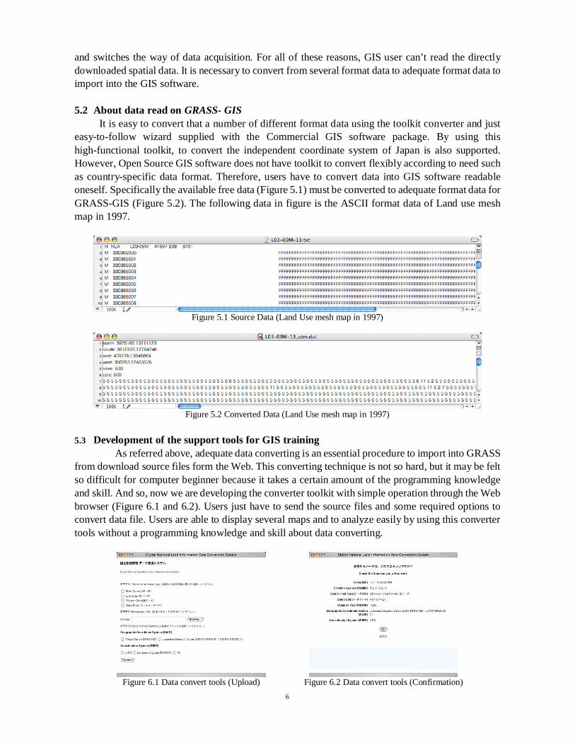
easy-to-follow wizard supplied with the Commercial GIS software package. By using thishigh-functional toolkit, to convert the independent coordinate system of Japan is also supported.However, Open Source GIS software does not have toolkit to convert flexibly according to need suchas country-specific data format. Therefore, users have to convert data into GIS software readableoneself. Specifically the available free data (Figure 5.1) must be converted to adequate format data forGRASS-GIS (Figure 5.2). The following data in figure is the ASCII format data of Land use meshmap in 1997.
Figure 5.1 Source Data (Land Use mesh map in 1997)
Figure 5.2 Converted Data (Land Use mesh map in 1997)
5.3 Development of the support tools for GIS trainingAs referred above, adequate data converting is an essential procedure to import into GRASS
from download source files form the Web. This converting technique is not so hard, but it may be feltso difficult for computer beginner because it takes a certain amount of the programming knowledgeand skill. And so, now we are developing the converter toolkit with simple operation through the Webbrowser (Figure 6.1 and 6.2). Users just have to send the source files and some required options toconvert data file. Users are able to display several maps and to analyze easily by using this convertertools without a programming knowledge and skill about data converting.
Figure 6.1 Data convert tools (Upload) Figure 6.2 Data convert tools (Confirmation)
7
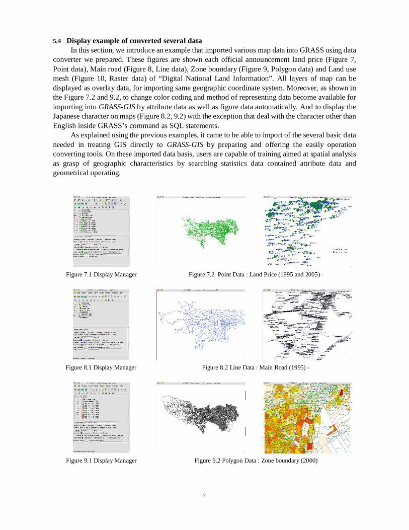
5.4 Display example of converted several dataIn this section, we introduce an example that imported various map data into GRASS using data
converter we prepared. These figures are shown each official announcement land price (Figure 7,Point data), Main road (Figure 8, Line data), Zone boundary (Figure 9, Polygon data) and Land usemesh (Figure 10, Raster data) of “Digital National Land Information”. All layers of map can bedisplayed as overlay data, for importing same geographic coordinate system. Moreover, as shown inthe Figure 7.2 and 9.2, to change color coding and method of representing data become available forimporting into GRASS-GIS by attribute data as well as figure data automatically. And to display theJapanese character on maps (Figure 8.2, 9.2) with the exception that deal with the character other thanEnglish inside GRASS’s command as SQL statements. As explained using the previous examples, it came to be able to import of the several basic dataneeded in treating GIS directly to GRASS-GIS by preparing and offering the easily operationconverting tools. On these imported data basis, users are capable of training aimed at spatial analysisas grasp of geographic characteristics by searching statistics data contained attribute data andgeometrical operating.
Figure 7.1 Display Manager Figure 7.2 Point Data : Land Price (1995 and 2005) -
Figure 8.1 Display Manager Figure 8.2 Line Data : Main Road (1995) -
Figure 9.1 Display Manager Figure 9.2 Polygon Data : Zone boundary (2000)

8
Figure 10.1 Display Manager Figure 10.2 Raster Data : Land Use Mesh (1997)
6 Conclusion In this paper, we have verified the substitutability of laboratory exercise materials at ouruniversity from commercial GIS to open-source software, on the basis of a functional comparisonbetween commercial GIS and GRASS-GIS. It is thought that to introduce the open-source softwarehas some advantages such as avoidance of vendor-depend and software cost reduction for educationalinstitutions. Moreover, anybody has complete access of the source code that makes up the software, itis hoped that lead to advance in programming skill for users. Next, we prepared the data format converter to import directly the several downloaded freespatial data into GRASS-GIS. By using converter, users are able to prepare the direct readable datainto GIS software and to concentrate oneself to learning. Continuing with this approach, we plan tocontinue the development of teaching materials and other educational tools for urban planning studiessuch as data set package for one purpose of training task.
Notes1 http://grass.itc.it/2 ESRI Corporation (http://www.esri.com/software/arcgis/)3 Bentley Systems, Inc. (http://www.bentley.com/en-US/Products/MicroStation/)4 Microsoft Corporation (http://www.microsoft.com/office/access/prodinfo/)5 http://www.postgresql.org/
References[1] Markus Netteler and Helena Mitasova, OPEN-SOURCE GIS: A GRASS GIS Approach, KAP.
2002.[2] Kei SAITO, Shinji CHIBA, Michihiko SHINOZAKI, Development of open-source GIS
Educational Tools for Urban Planning -Migration to the GRASS-GIS package in the GISeducational environment-, International Journal of GeoInformatics, Vol 1, No. 1, pp.101 - 107,2005.