Embed Size (px)
Citation preview

Appendixes

APPENDIX A
Development and Production ofFederal Coal Leases in the Southern
Rocky Mountain States
Colorado
Overview
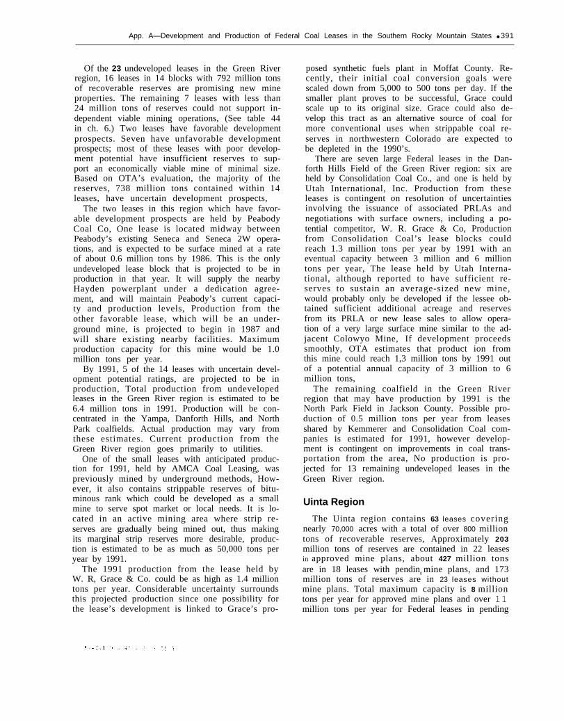
Colorado has Federal leases in four coal re-gions: the Green River, the Uinta, the San Juan,and the Denver Raton Mesa regions, (See table 34in ch, 6 for a summary of acreage and reservesunder lease.) The San Juan and the Denver-RatonMesa regions contain the fewest number of Feder-al leases. There is one Federal lease in an ap-proved mine plan in the San Juan region. Six Fed-eral leases in the Denver-Raton Mesa region arecurrently undeveloped. Most of Colorado’s 127Federal leases and reserves are located within theUinta and Green River regions. In the Green Riverregion, 31 leases are in approved mine plans, 3 arein pending mine plans, and 23 are not in mineplans. In the Uinta region, 22 leases are in ap-proved mine plans, 18 are in pending mine plans,and 23 are not in mine plans. (See fig. A-l.)
In total, Colorado’s 127 Federal coal leasescover more than 126,000 acres of land and containover 2.2 billion tons of recoverable coal reserves.The State thus ranks second to Utah, and beforeNew Mexico in lease acreage and reserves in theSouthern Rocky Mountain region. In 1979, Colo-rado mines with Federal leases produced almost16 million tons of coal, as compared to roughly 10million tons from Federal mines in Utah, andabout 8 million tons from New Mexico Federalmines.
Overall the maximum production capacity forColorado’s existing and proposed Federal mines isalmost 45 million tons per year. production fromthese mines in 1986 could exceed 29 million tons.Production from undeveloped leases in 1986 isonly 0.6 million tons, By 1991, production fromexisting and proposed Federal mines could in-crease to about 35 million tons, and productionfrom currently undeveloped leases could also in-crease substantially, to about 8 million tons,
The Department of Energy (DOE) 1985 produc-tion goals for Colorado of 34 million to 38 milliontons are higher than OTA’s estimate of potential
Figure A-1 .—Coal Mines on Federal Landsin Colorado
MOFFAT
● 6“!RIO BLANCO
Map locations
1- Canadian Strip 15- Somerset2- Colowyo 15- Blue Ribbon3- Eagle Nos. 5, 9 16- Loma Complex4- Trapper 17- Bear5- Deserado 17- Mt. Gunnison6- Meeker Area 18- Coal Basin7- Apex No. 2 19- Hawksnest East & West8- Edna 20- Ohio Creek No. 28- Trout Creek 21- Windjammer No. 19- Energy Fuels Nos. 1, 2 22- Cameo Nos. 1, 2
10- Johnnies 22- Roadside11- Seneca, 2W 23- Coal Canyon12- National King Coal 24- Cottonwood Creek13- Orchard Valley 25- Snowmass14- Red Canyon No. 2 26- Marr
SOURCE: Office of Technology Assessment.
production from Federal mines in 1986 (29.4 mil-lion tons), The difference in large part will prob-ably be offset by production from non-Federalmines and from mines on Federal preference rightlease applications (PRLAs), The OTA Coloradotask force estimated that 1986 minimum State pro-duction would be about 26 million tons from allmines. By 1991, the Colorado task force projectedthat minimum State production would range from
389

390 An Assessment of Development and Production Potential of Federal Coal Leases
32 million to 38 million tons. OTA’s analysisfound that potential production from mines withFederal leases could reach 43 million tons in 1991exceeding the task force projection and almostequaling the DOE high-level 1990 production goalof 43.3 million tons. (The DOE low-level goal is 28million tons and the midlevel goal is 35 milliontons,) By the 1990’s Federal mines are expected tocontribute a larger share of total State production.
Green River Region
Of the four coal regions in Colorado, the GreenRiver region is the most important in terms of itstotal coal reserves, its total mine capacity, and itspast and anticipated coal production. Roughly 60percent of the region’s total Federal lease reservesare not yet included in any mining plans. Only 2.5percent of the region’s lease reserves are con-tained within mine plans pending with the Officeof Surface Mining IOSM), The remaining 38 per-cent of the reserves are included within approvedmining plans. (Additional Federal productioncould come from the first new lease sales underthe Federal coal management program whichwere held in the Green River-Hams Fork region ofColorado and Wyoming. Almost 56 million tonswere leased in the January 1981 sale, and an addi-tional 64 million tons were sold in April 1981).
Approved Mine Plans.—There are 10 mine plansinvolving 31 Federal leases that have been ap-proved in the Green River region. Of these, 8 wereactively in production in 1979 and produced atotal of 11.2 million tons of coal in that year. Twomines were not producing in 1979, Six mines aresurface operations and accounted for 93 percentof the production in 1979. All of the approvedmines in this region are expected to be in produc-tion in 1986; moreover, all are expected to meetDepartment of the Interior’s (DOI) diligent devel-opment requirements by that year. Total operatingcapacity for these mines is estimated at 23.6 mil-lion tons per year, of which 21 percent is under-ground capacity. According to mine plan projec-tions, production for 1986 will reach about 19 mil-lion tons and could increase slightly to almost 20million tons per year by 1991. These productionlevels represent 83 and 88 percent of maximumdesign capacity for existing mines. The totalcapacity of currently approved mines will declineslightly as 2 mines exhaust their existing leasereserves, several other large surface mines in theregion will exhaust their strippable reserves in the1990’s and plan to shift eventually to undergroundoperations to maintain production.
Most of the currently operating Federal minesin the Green River region are large operationswith annual capacities ranging from 1.1 million to4,8 million tons per year. The five largest minesaccount for 80 percent of the operating capacity;the mine with the greatest planned capacity is anunderground mine, the multilease Meeker AreaMine, operated by Northern Minerals. This opera-tion, which produced less than 0.1 million tons in1979, is projected to be in full production by 1991,and will be a four-mine complex with a capacityof 4.8 million tons per year.
Of the approved, operating mines in the GreenRiver region, the two with the greatest currentproduction are surface mines. These are the Trap-per Mine, operated by Utah International, Inc.,and the Energy Nos. l&2 Mines, operated by Ener-gy Fuels Corp. Both of these mines, with 1979 pro-duction of 2.3 million and 3.4 million tons, respec-tively, are producing at roughly 85 percent of theirmaximum capacity.
Pending Mine Plans.—There are three mineplans with a total of four Federal leases in theGreen River region that are currently pending ap-proval, Two mines, Western Fuel’s DeseradoMine, and Gulf Oil’s Trout Creek Mine, are ex-pected to produce a total of 1.3 million tons in1986. The Trout Creek Mine is a separate under-ground mine proposed to operate on a Federallease that is also included in Gulf Oil’s existingEdna Strip Mine. This mine is expected to beoperating at its maximum capacity of 0,5 milliontons per year in both 1986 and 1991. The DeseradoMine in the Lower White River Field will supplythe Moon Lake Electric Co. ’s new powerplant inBonanza, Utah. production from proposed minesin this region is expected to increase from the1986 level as a result of increased production fromthe Deserado Mine. Total projected productionfrom pending mine plans in this region is 1.8million tons per year in 1991. One proposed smallmine on a post-FCLAA lease will probably not gointo production because of financial difficultiescaused by the delay in issuing the lease.
Undeveloped Leases.—The Green River regionhas the greatest amount of undeveloped reservesand the highest estimated future production fromits undeveloped leases of any region in Colorado.
The region has 23 undeveloped leases whichcontain approximately 816 million tons of coalwithin about 24,400 Federal lease acres. Theseleases are relatively large, both in acreage and inreserves, For example, 10 of the leases are greaterthan 1,000 acres in size and contain from 20 mil-lion to 250 million tons of recoverable coal re-serves each.
App. A—Development and Production of Federal Coal Leases in the Southern Rocky Mountain States ● 391
Of the 23 undeveloped leases in the Green Riverregion, 16 leases in 14 blocks with 792 million tonsof recoverable reserves are promising new mineproperties. The remaining 7 leases with less than24 million tons of reserves could not support in-dependent viable mining operations, (See table 44in ch. 6.) Two leases have favorable developmentprospects. Seven have unfavorable developmentprospects; most of these leases with poor develop-ment potential have insufficient reserves to sup-port an economically viable mine of minimal size.Based on OTA’s evaluation, the majority of thereserves, 738 million tons contained within 14leases, have uncertain development prospects,
The two leases in this region which have favor-able development prospects are held by PeabodyCoal Co, One lease is located midway betweenPeabody’s existing Seneca and Seneca 2W opera-tions, and is expected to be surface mined at a rateof about 0.6 million tons by 1986. This is the onlyundeveloped lease block that is projected to be inproduction in that year. It will supply the nearbyHayden powerplant under a dedication agree-ment, and will maintain Peabody’s current capaci-ty and production levels, Production from theother favorable lease, which will be an under-ground mine, is projected to begin in 1987 andwill share existing nearby facilities. Maximumproduction capacity for this mine would be 1.0million tons per year.
By 1991, 5 of the 14 leases with uncertain devel-opment potential ratings, are projected to be inproduction, Total production from undevelopedleases in the Green River region is estimated to be6.4 million tons in 1991. Production will be con-centrated in the Yampa, Danforth Hills, and NorthPark coalfields. Actual production may vary fromthese estimates. Current production from theGreen River region goes primarily to utilities.
One of the small leases with anticipated produc-tion for 1991, held by AMCA Coal Leasing, waspreviously mined by underground methods, How-ever, it also contains strippable reserves of bitu-minous rank which could be developed as a smallmine to serve spot market or local needs. It is lo-cated in an active mining area where strip re-serves are gradually being mined out, thus makingits marginal strip reserves more desirable, produc-tion is estimated to be as much as 50,000 tons peryear by 1991.
The 1991 production from the lease held byW. R, Grace & Co. could be as high as 1.4 milliontons per year. Considerable uncertainty surroundsthis projected production since one possibility forthe lease’s development is linked to Grace’s pro-
posed synthetic fuels plant in Moffat County. Re-cently, their initial coal conversion goals werescaled down from 5,000 to 500 tons per day. If thesmaller plant proves to be successful, Grace couldscale up to its original size. Grace could also de-velop this tract as an alternative source of coal formore conventional uses when strippable coal re-serves in northwestern Colorado are expected tobe depleted in the 1990’s.
There are seven large Federal leases in the Dan-forth Hills Field of the Green River region: six areheld by Consolidation Coal Co., and one is held byUtah International, Inc. Production from theseleases is contingent on resolution of uncertaintiesinvolving the issuance of associated PRLAs andnegotiations with surface owners, including a po-tential competitor, W. R. Grace & Co, Productionfrom Consolidation Coal’s lease blocks couldreach 1.3 million tons per year by 1991 with aneventual capacity between 3 million and 6 milliontons per year, The lease held by Utah Interna-tional, although reported to have sufficient re-serves to sustain an average-sized new mine,would probably only be developed if the lessee ob-tained sufficient additional acreage and reservesfrom its PRLA or new lease sales to allow opera-tion of a very large surface mine similar to the ad-jacent Colowyo Mine, If development proceedssmoothly, OTA estimates that product ion fromthis mine could reach 1,3 million tons by 1991 outof a potential annual capacity of 3 million to 6million tons,
The remaining coalfield in the Green Riverregion that may have production by 1991 is theNorth Park Field in Jackson County. Possible pro-duction of 0.5 million tons per year from leasesshared by Kemmerer and Consolidation Coal com-panies is estimated for 1991, however develop-ment is contingent on improvements in coal trans-portation from the area, No production is pro-jected for 13 remaining undeveloped leases in theGreen River region.
Uinta Region
The Uinta region contains 63 leases coveringnearly 70,000 acres with a total of over 800 milliontons of recoverable reserves, Approximately 203million tons of reserves are contained in 22 leasesin approved mine plans, about 427 million tonsare in 18 leases with pending mine plans, and 173million tons of reserves are in 23 leases withoutmine plans. Total maximum capacity is 8 milliontons per year for approved mine plans and over 11million tons per year for Federal leases in pending

392 ● An Assessment of Development and Production Potential of Federal Coal Leases
plans. potential capacity for leases without plansis estimated at 1.5 million tons.
As displayed in table 37 in ch. 6, projected pro-duction for 1991 is 7.4 million tons per year forpending plans, 5.8 million tons per year for ap-proved plans, and up to 1.3 million tons per yearfor leases without plans.
Approved Mine Plans.— In the Uinta region thereare eight operating mines which include 22 Fed-eral leases. All but one of these mines began pro-ducing in the late 1970’s and all of them reportedproduction for 1979. Furthermore, past and an-ticipated future rates of production indicate thatall of the mines will satisfy DOI’s diligent develop-ment requirements by 1986.
Federal lease reserves total 203 million tons inapproved mine plans. Total mine plan reservesare 208 million tons. All of the reserves are highvolatile bituminous and all are best suited for re-covery by underground mining methods. Severalmines in the region produce high-grade metallur-gical coal.
Total maximum design capacity of these minesis almost 8 million tons per year. The maximumcapacity of individual mines varies widely—from0.1 million tons per year for the small Ohio CreekNo. 2 Mine to 1.4 million tons per year for West-ern Slope Carbon’s Hawksnest complex. WesternSlope’s 1979 production was only 31 percent oftheir design capacity. However, they expect to beoperating at full capacity by 1991, The Coal BasinMine’s multilease operation held by Mid Conti-nent Resources, represents another large incre-ment of capacity for approved mine plans. Theirunderground operation is designed to handle 1.3million tons per year, and their projected produc-tion for both 1986 and 1991 of 0.9 million tons isexpected to account for about 65 percent of thiscapacity,
Two mines, the Bear Mine, operated under asublease from ARCO, and the Roadside Mine,operated by Cambridge Mining, are expected toexhaust their reserves by the end of this decade.The Bear Mine is currently operating at close toits capacity of 0.26 million tons per year and willshut down in the next few years before operationsbegin on ARCO’s larger, Mt. Gunnison mine onthe same lease. The Roadside Mine, which beganproducing in the 1900’s and which has a capacityof 1.2 million tons per year, is reducing its oper-ations and anticipates production of only about0.3 million tons by 1986.
The Orchard Valley Mine operated by ColoradoWestmoreland will exhaust its current lease re-serves by the mid-1980’s at its present production
rate. The mine is expected to continue operationswith the acquisition of new Federal lease reserves.
Pending Mine Plans.—The Uinta region has 18Federal leases in 8 currently pending mine plans.In total, there are about 427 million tons of recov-erable reserves on over 34,700 lease acres. One ofthese proposed mines, the Loma complex of Sheri-dan Enterprises, reported production for 1979.This was the result of development work at themine site.
By 1986 five new mines are projected to pro-duce approximately 2.8 million tons of coal. Atthis rate of production, three of these mines, theBlue Ribbon, Loma complex, and Windjammermines, seem likely to meet DOI’s development re-quirements by 1986. All eight of the proposedmines are expected to be in production by 1991,and all but one seems likely to meet diligencedevelopment requirements by then.
When all mines are brought into production,maximum operating capacity is expected to ex-ceed 11 million tons per year. Given this capacitybase, anticipated 1986 production of 2.8 milliontons will represent approximately 25 percent oftotal mine capacity, and projected production of7.4 million tons for 1991 will represent 67 percentof full capacity. several of the newer mines willprobably not achieve full capacity until after l990.
Operating capacity for individual mines rangesfrom 0,12 million to 5.0 million tons per year. Twomines—the Loma project, operated by SheridanEnterprises, and the Mt. Gunnison Mine, oper-ated by ARCO—account for 70 percent of the totalcapacity for pending mine plans in the Uintaregion.
When completed, the Loma project is expectedto be producing from six underground minesusing both longwall and room-and-pillar methods.Estimated production for 1991 is expected to beabout 56 percent of the 5.0 million tons per yeareventual planned capacity for the Loma Mines.
The Mt. Gunnison Mine is projected to beginproduction in 1983, and to take approximately 10years to reach the estimated operating capacity of2.8 million tons per year. The coal will be re-covered by room and pillar underground miningmethods, The reserves in the Mt. Gunnison leasesare very large. If all seams in the lease, includingseams not currently mined, are made part of thelogical mining unit (LMU) reserves for diligence,Mt. Gunnison might have some difficulty in meet-ing the 2,5 percent production required for dili-gence.
Undeveloped Leases.—The Uinta region has atotal of 173 million tons of recoverable reserves
App. A—Development and Production of Federal Coal Leases in the Southern Rocky Mountain States ● 393
contained within 23 undeveloped leases. The ma-jority of these reserves are recoverable by under-ground mining only, and their quality ranges fromsubbituminous to bituminous. Based on OTA’s re-view of these leases, 18 leases in 6 blocks coveringabout 17,660 acres and containing approximately159 million tons of reserves could sustain newmining operations. The remaining five leases,containing about 14 million tons of recoverablereserves do not have sufficient good qualityreserves to support viable new mines.
Not all of the 18 viable leases, are likely to be de-veloped. Eight leases were classified as favorabledevelopment prospects, three leases have uncer-thin development prospects, and the remainingseven leases have unfavorable development poten-tial.
None of the Uinta region undeveloped leasesare expected to be in production by 1986. For1991, OTA projects that two lease blocks held byU.S. Steel with a total of nine leases could be pro-ducing up to 1.3 million tons. Of this production,up to 0.75 million tons of high-quality metallurgi-cal coal could be produced from eight U.S. Steelleases in the Coal Basin Field. There is someuncertainty about this production, however, duein part to the lease area’s steeply dipping seams,faulting, and deeply buried seams which willmake underground mining difficult and the factthat U.S. Steel has been purchasing productionfrom the neighboring Coal Basin Mine. U.S. Steelhas no current plans to develop the Coal Basinleases before 19$10. Two other mining companieshave developed or planned development of adjoin-ing mine properties which have similar propertycharacteristics, indicating that the adverse miningconditions can be overcome. The remaining un-certainty concerns the currently depressed mar-ket for metallurgical coal. Three other lease blocksheld by U.S. Steel in the Somerset-Paonia areahave uncertain development prospects based onthe expectation that they would be developed aspart of a company strategy to expand coal oper-ations to steam coal, since the coal on these blocksis not of metallurgical quality. U.S. Steel has anexist ing mine in Somerset that supplies i tsGeneva, Utah steel plants. The OTA Colorado taskforce estimated that, by making use of their ex-isting loading and other facilities, surface miningproduction from the other leases could reach 0.5million tons per year by 1991, Alternatively, theleases might be assigned to an independent oper-ator.
No production is anticipated from the remain-ing 14 leases in the Uinta region including two
blocks with a total of 7 leases held by KemmererCoal Co. in the Tongue Mesa Field. These leaseshave sufficient high-quality reserves to support anew mine, but there is not an adequate coal trans-portation system in place.
Denver-Raton Mesa Region
Currently there are no active Federal mines orany pending mine plans for Federal leases in theDenver-Raton Mesa region of southeastern Colo-rado. The region contains six Federal leases with-out mine plans, which OTA has organized intofour lease blocks. Based on a review of the qualityof leased coal, the size of the reserve base and thelessee’s development capabilities, four of theleases in two blocks are considered to be viablemining properties. Peabody Coal Co. holds thefour favorable lease properties which contain atotal of over 48 million tons of surface recoverablereserves,
These leases have uncertain development pros-pects largely because the coal is lignite. Develop-ment of these tracts will likely require a near siteuse, such as a mine-mouth powerplant or synfuelsfacility, in order to overcome the less favorableeconomics of transporting the lower quality coal.The four leases could be producing up to 0.5 mil-lion tons in 1991, and thus may satisfy the DOI’sdiligent development requirements by that year,although this is still speculative. The other twoleases in the region have unfavorable develop-ment potential. The lease held by CF&I Co., hasunfavorable development prospects for 1991 be-cause the lessee has available more attractive non-Federal reserves than those contained within thissingle lease block composed of small scatteredparcels of Federal coal.
The remaining lease, a 40-acre tract with under-ground reserves, is not considered a viable miningproperty due primarily to its small reserves base.
San Juan River RegionThe San Juan River coal region is located in Col-
orado and New Mexico; the larger portion of theregion lies in New Mexico. There are six activenon-Federal mines operating in the Colorado por-tion. The only Federal lease in the region is in theNational King Coal Mine, a small operation pro-ducing about 70,000 tons per year for sale to localconsumers. Coal was first produced from thelease in 1936 and production is expected to de-crease from 83,000 tons in 1979 to 65,000 tons peryear by 1986. The Federal lease reserves are ex-pected to be mined out by 1991.

394 ● An Assessment of Development and Production Potential of Federal Coal Leases
Summary of Production Potential
In 1979, the 19 mines with Federal leases pro-duced over 16 million tons of coal with about halfof this production (7.7 million tons) from Federalreserves. By 1986, two of the currently operatingmines are expected to deplete their reserves, how-ever, nine new Federal mines are expected to bein production. Overall, OTA projects that, totalproduction from Federal mines will increase tonearly 30 million tons—almost double the 1979production. The percentage of total productionfrom Federal reserves is also expected to increase.By 1991, 35 mines containing Federal leases areprojected to produce 43.1 million tons of coal,About 8 million tons of this production couldcome from currently undeveloped leases.
New Mexico
Overview
The 29 Federal coal leases in New Mexicocover over 44,000 acres and contain 447 milliontons of recoverable coal. The State has the fewestleases and leased reserves among the threeSouthern Rockies States and fewer leased reservesthan any major coal-producing Western State ex-cept North Dakota. Three of the leases are in theRaton Mesa region of northeast New Mexico andthe other 26 are found in the San Juan basin in thenortheastern part of the State.
Only one large coal mine complex is operatingin the Raton Mesa region, It is located entirely onnon-Federal land, No extensive development is ex-pected to occur in this region on either Federal ornon-Federal land, although an additional minecould be developed in the region. Coal is found insmall scattered deposits throughout the rough andmountainous terrain of this region. Though theRaton Mesa contains high-quality and metallurgi-cal-grade coals with a Btu content averaging14,340 Btu/lb and sulfur levels averaging less thanone percent, the difficult terrain, small reserves,and lack of markets has inhibited development.Other problems facing developers of three smallleases here include limited local rail capacity(although the region itself is served by a main lineof the Santa Fe Railroad), and complicated coalland access problems involving intermingled Fed-eral, railroad, Spanish land grant, and privateland blocks.
The San Juan basin contains 96 percent of theremaining coal resources in New Mexico, includ-ing nearly all of the strippable reserves, A substan-tial portion of the basin’s reserves are controlled
by the Navaho Tribe. Over 80 percent of the 1980coal production of 16.5 million tons in the Statecame from this region and by 1990 it could ac-count for over 95 percent. Typical San Juan coalhas a Btu content of 10,492 Btu/lb and a sulfurcontent of 0.84 percent. It has relatively highaverage ash levels of 13.8 percent, although theash content can be as high as 25 percent in someareas.
Mining currently occurs in two areas within theSan Juan basin, There is at present little or no pro-duction in the central part of the basin (see fig.A-2). Production from the northwest corner, in-cluding the San Juan Mine on Federal land, isused at mine-mouth generating stations. Produc-tion from the McKinley Mine on Federal and In-dian land in the southwest part of the region isshipped by rail mostly to Arizona and otherWestern markets. Most of the San Juan basin coalreserves, including areas with leased Federal coal,are not served presently by rail transportation.This central region of the basin is one of thelargest untapped strippable coal deposits in theWestern United States. The Santa Fe Railroad hasproposed to build a 114-mile line into the area,
Figure A-2.—Coal Mines on Federal Lands inNew Mexico
ISOURCE: Office of Technology Assessment.
App. A—Development and Production of Federal Coal Leases in the Southern Rocky Mountain States ● 395
called the Star Lake Railroad. The final environ-mental impact statement has been issued. The re-maining uncertainty involves 3 miles of right-of-way that cross land owned by Indian allotmentholders. Rugged terrain makes rerouting acrossother land prohibitively expensive. Negotiationswith the Indian allottees are underway and therailroad has asked the Secretary of Interior towaive the landowner consent requirement. TheBureau of Land Management had deferred grant-ing of the rights-of-way across Federal land untilresolution of the allottee issue, though it has ap-proved use of Federal land for the project. TheStar Lake-Bisti Regional Coal EnvironmentalStatement projected that coal production associ-ated with the railroad could eventually reach 75million tons per year, About 8 million tons ofFederal mine production in 1991 is tied to devel-opment of the Star Lake Railroad,
The 29 New Mexico Federal coal leases can bedivided into 16 lease blocks. Three of these unitsare single leases in the Raton Mesa. The other 13are located in the San Juan region.
Nine leases in two lease blocks are currentlypart of operating mines. These two mines pro-duced 9.7 million tons of coal in 1980, about halfof the State’s total production with about 6.3million tons produced from Federal reserves.Three lease blocks including nine leases are partof proposed mine plans which are now pendingbefore DOI. The remaining 11 leases and 10 leaseblocks are undeveloped and no mine plans todevelop them had been submitted to DOI as ofSeptember 30, 1980.
Approved Mine plans.—The two producingmines which include Federal coal leases are theMcKinley and San Juan Mines. The McKinleyMine includes four Federal leases owned by GulfOil Corp. and Indian and private lands. The SanJuan Mine includes five leases owned by WesternCoal Co., a joint venture of Public Service Co. ofNew Mexico and Tuscon Electric Co. It is operat-ing almost entirely on Federal lands, althoughpossible expansion onto coal lands on the UteMountain Indian Reservation to the north is beingconsidered. Both are surface mines. The approvedmine plans for these projects call for small in-creases in mining on Federal land over the nextdecade. The McKinley Mine is scheduled to in-crease production from 4.6 million to 5.0 milliontons by 1991 and the San Juan Mine is scheduledto increase from 5.1 million to 5,5 million tons.The San Juan Mine will shift a portion of its ca-pacity to underground operations on a new Fed-eral lease acquired in 1980.
Pending Mine Plans.—Like the operating mines,the three lease blocks for which mine plans arepending are located in the San Juan region. Fiveleases are part of the La Ventana Mine project pro-posed by the lessee, Ideal Basic Industries. It is theonly active or proposed mine on Federal leases inNew Mexico that will be solely an undergroundoperation. At least seven inactive leases in the LaVentana area once supported small undergroundmines, but these were closed due to structural andfire hazards, inability to comply with health andsafety regulations, and the decline of the domesticcoal market in New Mexico, The proposed LaVentana Mine plan has been designed to resolvewhat had been difficult safety problems involvingpoor roof conditions and the tendency of La Ven-tana coals for spontaneous combustion, A marketfor at least part of the coal produced exists atIdeal’s cement plant in Albuquerque, The mine isscheduled to produce 1.1 million tons by 1986 and1.5 million tons by 1991; it has an eventual capaci-ty of 3 million tons per year.
The other two pending mine plans with fourFederal leases are located in the area of the SanJuan basin presently without rail service. Develop-ment of these tracts will depend on either the con-struction of the Star Lake Railroad or the con-struction of mine mouth power or synfuels plants,The proposed Bisti Mine includes three leasesowned by Western Coal Co. Public Service Co. ofNew Mexico has proposed building a mine-mouthpowerplant near this mine, but that project is inonly preliminary planning stages and the con-struction schedule is still uncertain. The secondlease block is a single lease owned by PeabodyCoal Co., and Thermal Energy Co. The mine pro-posed for this site, however, is being developed byChaco Energy Co., a subsidiary of Texas Utilities,Inc. The Star Lake Mine, as it is called, will likelysupply powerplants owned by the parent com-pany or serve other utility markets. The Star LakeMine eventually will include reserves from pend-ing PRLAs. The Bisti Mine is scheduled to pro-duce 2.5 million tons by 1986 and 3 million tons by1991. The Star Lake Mine is scheduled to produce3 million tons in 1986 and between 3 million and 6million tons by 1991. Coal from Star Lake wouldbe shipped via the Star Lake Railroad.
Undeveloped Leases.—Eleven leases in ten leaseblocks are inactive and have no mine plans fortheir development pending before DOI, althoughsome planning work is underway on several ofthese. The three small leases in the Raton Mesaregion fall into this category of undevelopedleases, The group also includes six small leases

396 ● An Assessment of Development and Production Potential of Federal Coal Leases
and two large leases in the San Juan region. Thesetwo large leases are part of proposed mining proj-ects which have not yet reached the completedmine plan stage. Production from these mines islikely before the end of the decade, Some prelimi-nary investigations of mine development on sev-eral of the smaller leases as part of mine devel-opment on adjacent lands has been reported, how-ever, prospects for production before 1991 are un-favorable.
The two leases that might be in production by1991 include 98 percent of all the undevelopedFederal lease reserves in New Mexico. The firstlease is owned by Cimmaron Coal Co. and is partof the proposed LaPlata surface mine in north-west New Mexico. The mine could serve the sup-ply needs of the nearby San Juan powerplant asreserves from the San Juan Mine are mined out.Based on a review of a wide range of factors, in-cluding coal quantity and quality, transportationaccess, environmental issues, engineering prob-lems, and markets among others, OTA found thatthe lease has a favorable development potential.Production is scheduled to total 0.2 million tons in1986 and between 1 million and 2 million tons in1991.
The second large New Mexico lease (1,910acres) is located along the route of the Star LakeRailroad. It is owned jointly by Fannin SquareCorp. (a subsidiary of Texas Eastern TransmissionCorp.) and Eastern Associated Properties Corp. (asubsidiary of Eastern Gas and Fuel Associates).The lease also received a favorable developmentprospect rating by OTA though several uncertain-ties cloud its future. The lessees are likely to needadditional coal reserves adjoining the lease inorder to create an economical mining unit forlarge-scale operat ions. The companies holdPRLAs for much of this land which might be con-verted to lease shortly. Texas Eastern Trans-mission received a DOE grant in 1980 to study thefeasibility of building a major synfuels complexnear the lease and supplied with coal from it.Prospects for building such a plant are uncertain,Any export use of the coal on this lease will be de-pendent on the completion of the Star Lake Rail-road. The companies nevertheless are proceedingwith plans for the Black Lake Mine, which if itproceeds, is likely to produce between 0.7 millionand 6 million tons by 1991 depending on the com-panies’ coal needs and the rate of development ofadjoining reserves.
Of the nine small leases in eight lease blocksthat are not likely to be in production before 1991,four blocks received uncertain development pros-
pect ratings by OTA and four were rated as unfa-vorable for development.
Two of the leases with uncertain developmentratings are located in the Raton Mesa region. Thelessees of both are studying mining projects thatinclude the leases, but small reserves, mining andtransportation problems caused by the rough ter-rain earned these leases an uncertain rating atbest. The other two lease blocks receiving uncer-tain ratings adjoin the proposed La Ventana Minesite, Each of these lease tracts once were under-ground mines, but they were closed because firesand explosions made them unsafe and uneco-nomical to mine. If Ideal Basic Industries acquiresthese leases and incorporates their reserves intothe La Ventana Mine plan, these problems couldperhaps be overcome. The leases would probablybe surface mined. In their present status it isunlikely that individual mines on these blockscould ever compete.
The final four lease blocks, one in Raton Mesaand three in the San Juan region, received un-favorable development prospect ratings by OTAand were judged to have minimal production po-tential. All four are isolated tracts with small re-serves. Underground mines serving local marketsonce operated on them, but they have been closedfor at least a decade because of safety, engineer-ing, and economic problems. There is currentlylittle or no effort on the part of the present lesseeto develop new mine plans and no published ex-pressions of interest on the part of outside partiesto acquire the leases.
Production Potential
To summarize the production potential of ex-isting Federal coal leases in New Mexico:
Two mines are currently producing about 9.7million tons of coal per year; and by 1986 thesetwo mines with approved mine plans are sched-uled to produce 10.0 million tons. In addition,three mines which currently have mine planspending at DOI could be producing 6,6 milliontons, and one mine which is now in the premine-plan stage could be producing 0.2 million tons by1986.
By 1991, the six existing and proposed minesare scheduled to produce between 19.0 millionand 23.0 million tons. One other mine is due tobegin production after 1986, and is scheduled toproduce between 0.7 million and 6.0 million tonsby 1991. Total 1986 production from mines on ex-isting leases is projected to be 16.8 million tonsand 1991 production is projected to be between19.7 million and 29.0 million tons.

App. A—Development and Production of Federal Coal Leases in the Southern Rocky Mountain States ● 397
If these projections hold true, 6 of the 16 leaseblocks covering 79 percent of the leased reserveswill be included in active mining operations in1986. By 1991, 7 lease blocks covering 20 of the 29New Mexico coal leases and over 98 percent ofthe coal reserves under lease are likely to be asso-ciated with active mining projects.
The DOE 1985 production goals of 33 million to44 million tons are higher than OTA’s estimate ofpotential 1986 production from Federal mines of16.8 million tons. The OTA task force estimatedthat 1986 total State production would be 30million tons, and recent New Mexico Energy andMinerals Department estimates have set plannedproduction from all mines in the State for 1985 at47 million tons. Most of any shortfall between theDOE goals and potential Federal mine productionin 1985 to 1986 would probably be absorbed bymines on Indian and non-Federal reserves, whichcurrently provide more than half of New Mexico’sannual coal output.
For 1991, the OTA task force estimated that themaximum production potential of all mines in theState would reach 72 million tons—higher thanboth the DOE 1990 high level goal of 67 milliontons and the recent State government estimate of68 million tons of production in 1990. Accordingto OTA’s analysis, production from mines withexisting Federal leases could reach 20 million to29 million tons in 1991.
Actual production levels could vary from theOTA’s projections. Several obstacles to coal min-ing could lower actual production below theseprojections, while the removal of some barriers todevelopment and a strong coal market couldcause production to increase above these levels.
A key determinant of actual coal productionfrom New Mexico leases will be the level of out-of-State utility coal demand specifically and coalmarket considerations generally. A market studyprepared for OTA concluded that the price com-petitiveness of New Mexico coal in major Easternand Western markets is considerably underesti-mated. ” Actual market demand will depend on awide range of issues including the growth of elec-tric consumption, coal supply decisions of Texasutilities (Texas is the major potential new marketfor New Mexico coal), and the growth or declinein coal use relative to substitute fuels for powergeneration. Within New Mexico, the rate of com-mercialization of synfuels technology and the pos-sible construction of additional powerplants to
See Energy and Environmental Analysis, Inc., Feos]bilit~, of [ ~singCool ,Jlorket Projections To Appruiw Potential Production of FwjmmJCorIl Leaseholds, draft report, May 1980.
serve out-of-State customers are two additionalfactors bearing heavily on demand.
The lack of rail service to the central portion ofthe San Juan basin is the second most significantfactor affecting the growth rate of New Mexicocoal production, As explained above, the pro-posed Star Lake Railroad is in an advanced plan-ning stage, but a right-of-way acquisition problemcould still delay or prevent its construction.
Other major issues and uncertainties that willaffect the future of the New Mexico coal industryinclude environmental impacts, land-use con-flicts, socioeconomic impacts on local commu-nities, and the amount of additional Federal re-serves made available for mining through PRLAsand new lease sales. Mining and associated in-dustrial development such as synfuels plants posepotentially unacceptable and unavoidable airquality impacts in this arid region. Mining in theBisti area conflicts with protection of threewilderness study areas and with potentially im-portant archeological and paleontological sites.An exchange of existing leases for new Federalcoal to avoid some of these conflicts is under con-sideration. (See discussion in ch. 9.) Demand foradequate water supplies for mining, reclamation,synfuels development, and community needs andthe need to protect water supplies from possibledegradation could create conflicts between coaldevelopment and other users. Because of the aridclimate, sparse vegetation, and high susceptibilityto wind and water erosion, reclamation ofsurface-mined lands in the San Juan basin mayprove more difficult than in other areas of theWest, This difficulty is not, however, expected torestrict mine development. Most of the expandedcoal development on Federal leases in New Mex-ico will occur in areas that are relatively isolatedand sparsely populated. Associated population in-creases and demands for community services willimpose additional administrative and financial re-quirements on the existing communities, More-over, because Native Americans own or occupysubstantial acreages throughout the basin, reso-lution of potential conflicts between mining andNative interests will require cooperation withtribal governments and the U.S. Bureau of IndianAffairs. (See ch, 12.)
There are currently twice as many acres underPRLAs than under existing leases in New Mexico.Processing of PRLAs in New Mexico will have asignificant effect on the future of Federal coaldevelopment there. Two proposed Federal minescould be adversely affected by loss of reserves ifadjoining PRLAs are rejected. New leased re-

398 . An Assessment of Development and Production Potential of Federal Coal Leases
serves from other PRLAs will compete in the mar-ket with other Federal and non-Federal coal cur-rently available for mining.
Utah
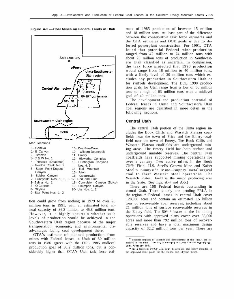
Overview
Utah has the largest number of Federal coalleases of any State. There are 204 leases currentlyoutstanding in Utah covering over 279,000 acresand more than 3.2 billion tons of recoverable coalreserves. Utah also has 25 pending PRLAs totalingover 75,000 acres and containing over 1 billiontons of recoverable reserves. According to U.S.Geological Survey (USGS) estimates, about 82 per-cent of the coal resources in Utah are federallyowned, This high percentage is due, in part, to thefact that most of the coal deposits occur in therugged mountainous terrain and the upland pla-teaus of central and southern Utah—areas thathave largely remained in Federal ownership,while State and private land selections, landgrants, and homesteads were concentrated in thevalleys and flatlands. Most of Utah’s known coalreserves are underground minable.
Utah has two major coal regions: the Uintaregion which includes the Wasatch Plateau, BookCliffs, and Emery coalfields in central Utah; andthe Southwestern Utah coal region, which in-cludes the Alton, Kolob, Kaiparowits Plateau, andHenry Mountain coalfields.* There are 108 Feder-al leases in the Uinta region and 96 leases in theSouthwestern Utah region. The recoverable re-serves are divided almost equally between the tworegions.
Nearly 65 percent of the Federal leases in Utahare part of existing or proposed mines and thustheir development and production plans are in-cluded in mine plans filed with DOI. The 14 mineswith approved mine plans are all located in theUinta region and contain 50 Federal leases with atotal of 792 million tons of reserves, Eleven newmines have been proposed covering another 78leases and 1.3 billion tons of reserves. Over 1billion tons of new mine plan reserves are con-tained in the three proposed new mines in theSouthwestern Utah region. The remaining 76 Fed-eral leases without mine plans include severallarge tracts of good quality minable reserves thatcould be producing by 1990, as well as many
* The BLM coal productlon region Uinta-Southwestern Utah com-bines the Uinta coal region of Utah and Colorado and the SouthwesternUtah coal region into a single region for coal management program andproduction target purposes.
smaller tracts that once supported small minesthat will probably not be reopened. The Uintaregion has 44 undeveloped leases and about 447million tons of undeveloped reserves, The South-western Utah region has 32 undeveloped leaseswith 744 million tons of reserves—most of whichare on the Kaiparowits Plateau.
Production Potential
In 1979, Utah mines produced 11.8 million tonsof coal with 10.4 million tons of this from mineswith Federal leases. Federal production was 6.9million tons in 1979 and came from 27 leases. In1980, total State production increased to 13.1million tons with 8.7 million tons coming fromFederal reserves. All production in the State camefrom underground mines in the Uinta region.Figure A-3 shows the location of active and pro-posed mines with Federal leases in Utah.
Most of the coal produced was used by electricutilities, but a significant portion (about 1 millionto 2 million tons) was used by the steel industry.About 40 to 50 percent of the coal produced in1979 was used in the State; the rest was exportedto consumers in the Southwest, west coast, andMidwest, Up to 2 million tons reportedly wasstockpiled in 1979 because of soft market condi-tions. However, by the end of 1980 most, if not all,of Utah’s excess production had been sold, inpart, because of increased foreign export sales. In1981, at least one Utah Federal mine was shippingcoal under contract to Asian markets,
Coal production and mine capacity in Utah areexpected to increase substantially during the1980’s as new mines are opened and existingmines reach full capacity. Production from mineswith Federal leases will account for most of thegrowth. By 1986, total output from mines withFederal leases is expected to be as much as 30.2million tons with up to 6.2 million tons of thiscoming from proposed new mines. By 1991, pro-duction from mines with Federal leases is ex-pected to reach as high as 47 million to 74 milliontons. About 7 million to 8.6 million tons couldcome from undeveloped leases in central Utah.Up to 25 million tons of coal could come from newmines in Southwestern Utah. The total capacity ofexisting mines on Federal leases at full productionis 32.2 million tons per year, If all the pendingmine plans went into production they would add43 million tons of annual capacity. OTA estimatesthat the undeveloped leases could support an ad-ditional 18.5 million to 28.0 million tons of annualcapacity. Southwestern Utah Federal coal produc-
App. A—Development and Production of Federal Coal Leases in the Southern Rocky Mountain States ● 399
Figure A-3.— Coal Mines on Federal Lands in Utah
Salt Lake City! 1
0
IN Utah region
Map locations
1- Geneva 10- Des-Bee-Dove1- B Canyon 10- Wilberg-Deercreek2- Braztah 11. Emery3- C & W No. 1 12- Hiawatha Complex4- Pinnacle (Deadman) 13- Huntington Canyons5- Gordon Creek No. 2 Nos. 4, 56- Sage Point-Dugout 14- Trail Mountain
Canyon 15- Alton6- Soldier Canyon 16- Kaiparowits7- Sunnyside Nos. 1, 2, 3 17- Red and Blue8- Belina No. 1 18- Convulsion Canyon (Sufco)8- O’Connor 19- Skumpah Canyon8- Skyline 20- Ute Nos. 1, 29- Star Point Nos. 1, 2
tion could grow from nothing in 1979 to over 25million tons in 1991, with an estimated total an-nual capacity of 36.3 million to 45.8 million tons.However, it is highly uncertain whether suchlevels of production would be achieved in theSouthwestern Utah region because of the majortransportation, economic, and environmental dis-advantages facing coal development there.
OTA’s estimate of planned production frommines with Federal leases in Utah of 30 milliontons in 1986 agrees with the DOE 1985 midlevelproduction goal of 30,2 million tons, but is con-siderably higher than OTA’s Utah task force esti-
mate of 1985 production of between 15 millionand 18 million tons. At least part of the differencebetween the conservative task force estimates andthe OTA estimates and DOE goals is due to de-ferred powerplant construction. For 1991, OTAfound that potential Federal mine productionranged from 47 million to 74 million tons withabout 25 million tons of production in Southwest-ern Utah classified as uncertain. In comparison,the task force projected that 1990 productionwould range from 18 million to 40 million tons,with a likely level of 30 million tons which ex-cludes any production in Southwestern Utah orfor synfuels development. The DOE 1990 produc-tion goals for Utah range from a low of 36 milliontons to a high of 63 million tons with a midlevelgoal of 49 million tons.
The development and production potential ofFederal leases in Uinta and Southwestern Utahcoal regions are described in more detail in thefollowing sections.
Central Utah
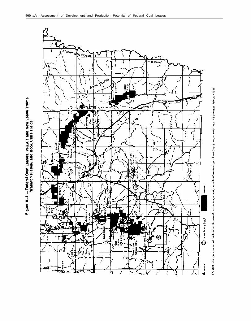
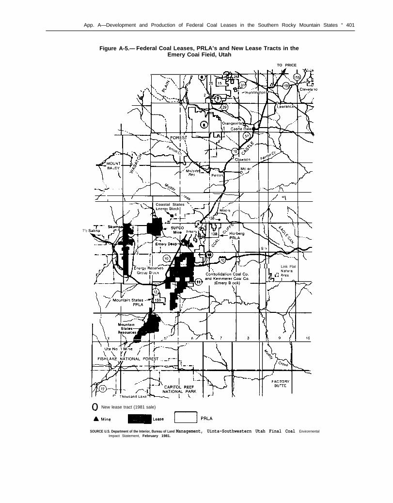
The central Utah portion of the Uinta region in-cludes the Book Cliffs and Wasatch Plateau coal-fields near the town of Price and the Emery coal-field near the town of Emery. The Book Cliffs andWasatch Plateau coalfields are underground min-ing areas. The Emery Field has both surface andunderground minable reserves. The central Utahcoalfields have supported mining operations forover a century. Two active mines in the BookCliffs Field—U.S. Steel’s Geneva Mine and KaiserSteel’s Sunnyside Mine—suppIy metallurgicalcoal to their Western s teel operat ions. TheWasatch Plateau Field is the major producing areain the State. (See figs. A-4 and A-5.)
There are 108 Federal leases outstanding incentral Utah. There is only one pending PRLA inthe region. * Federal leases in central Utah cover128,930 acres and contain an estimated 1.5 billiontons of recoverable coal reserves, including about21 million tons of surface recoverable reserves inthe Emery field, The 50* * leases in the 14 miningoperations with approved plans cover over 55,000acres and more than 792 million tons of recover-able reserves and have a total maximum designcapacity of 32.2 million tons per year. There are
* Possible impacts of issuance and development of this PRLA are ex-amined in the Final [ rin to-!jou I}] wws[ern [ Itoh Cool Enl,ironmentaj Sto tP-ment, Februar}, 1981.
* *Tbrec leases in the C)’ Connor mine area are also partly included inthe approved mine plans for the Belina and Skyline mines,
400 ● An Assessment of Development and Production Potential of Federal Coal Leases
\
App. A—Development and Production of Federal Coal Leases in the Southern Rocky Mountain States “ 401
Figure A-5.— Federal Coal Leases, PRLA’s and New Lease Tracts in theEmery Coai Fieid, Utah
TO PRICE
T“o
, \ . .‘. I\ I
..\;d - - \, .
/ ‘ \A
c%
@.fi i “\
1 [/ / .“-”-” \ \ Coastal States ‘. f.+ . I I
.-- SUFCO
— ~ [..> I II Link Flat I
, 1 a
a1>1
1 m a8 1 , n
1 lx 11 1 r
r11
o New lease tract (1981 sale)
SOURCE U.S. Department of the Interior, Bureau of Land Management, Uinta-Southwestern Utah Final Coal EnvironrnentalImpact Statement, February 1981.

402 ● An Assessment of Development and Production Potential of Federal Coal Leases
also eight proposed new mines in the Uinta regionwith 14 leases that are in pending mine plans. *These leases cover 25,711 acres and contain about264 million tons of recoverable reserves. The pro-posed new mines have a total annual capacity ofover 13 million tons per year.
The remaining 44 leases in central Utah areundeveloped. These leases cover 47,679 acres andmore than 447 million tons of reserves. When thecontiguous leases held by the same owners aregrouped together into minable blocks, the unde-veloped leases in central Utah form 20 leaseblocks with 12 blocks each composed of only 1lease.
The active mines in central Utah range from afew small underground operations producing lessthan 100,000 tons per year to new large mines pro-ducing over 1 million tons per year. Several minesare in the process of expanding their productioncapacities to produce up to 5 million tons per yearor more by 1985, The 14 approved mining opera-tions on Federal leases in central Utah are all un-derground mines and all, but the newly approvedSkyline Mine, were producing in 1980, In 1980,over 8.7 million tons of production from Federalleases were reported to USGS for royalty pur-poses.
By 1986, production from operations with ap-proved mine permits is projected to reach 24million tons, more than double the 1979 produc-tion levels. By 1991, production from these minescould rise to 29 million tons. One small operation,the Trail Mountain Mine is expected to be de-pleted by 1991 unless it acquires additional re-serves to maintain production. Both U.S. Steel’sGeneva Mine and Kaiser Steel’s Sunnyside Mineare expected to be nearing the limit of their eco-nomically recoverable reserves by the late 1980’sand would then begin to shift production to newmines on their other Federal leaseholdings. OTA’smine plan review indicates that about 5 million ofthe 32.2 million tons of capacity on approvedmine plans might not be constructed as plannedbecause of changes in the lessee’s captive coalneeds out-of-State.
Six of the operating mines are captive opera-tions, including two mines operated by steelcompanies, two complexes run by Utah Power &Light, the Soldier Canyon Mine run by CaliforniaPortland Cement, and the Braztah Mine complex
“These leases include two leases that are partially included in twodifferent mines: the newly approved Skyline Mine and the adjacentBelina and O'Connor mines which are dissected by several fault zonesand the lessees executed operating agreements to mine those portions of
the leases on their respective sides of the fault.
held by a subsidiary of American Electric Power(AEP) and supplying AEP powerplants in Indiana.Total production for these mines in 1979 was 6.1million tons—over half the total production in theState. By 1986 captive production from Federalmines is expected to total about 13 million tonsmaking a slight decline in its share of total Stateproduction. The captive segment of the Utah coalindustry is expected to maintain it’s position inthe 1980’s and 1990’s since a significant amountof production from new mines on Federal leaseswould supply captive markets.
Pending Mine Plans.—The eight proposed newmines on Federal leases would, if all were devel-oped as scheduled, add more than 13 million tonsof annual production capacity in central Utah by1990. One new mine, Eureka Energy’s 3.2 milliontons per year Sage Point-Dugout Canyon Mine, isintended to supply a new 1,600-MW coal-firedpowerplant to be built by its parent Pacific Gasand Electric Co. U.S. Steel’s new B Canyon Minewould replace the existing Geneva Mine whenthat operation reaches the limits of its economi-cally minable reserves. Mountain States Re-sources’ Ute Nos. l&2 mines near Emery wouldinclude both underground and surface operations.Several of the proposed new mines have been inplanning stages for 5 years or more, however,mine permitting and construction activities havebeen deferred by the lessees because of soft mar-ket conditions and slower than expected electrici-ty demand growth.
If all the proposed new mines meet theirplanned production schedules, six of the eightmines will be operating by 1986 with an estimatedtotal production of 5.6 million tons. By 1991, alleight mines could be producing a total of 11.3 mil-lion tons according to the mine plan estimates.However, because at least two of the new minesare captive operations, their construction and pro-duction schedules are dependent on the needs oftheir parent companies. Current indications arethat the Sage Point-Dugout Canyon Mine and theB Canyon Mine could be deferred several years,thus making about 4.2 million tons of 1991 pro-duction capacity somewhat uncertain.
Undeveloped Leases.—The 44 leases in centralUtah without mine plans cover 47,679 acres andcontain 447 million tons of recoverable reserves.These leases are 57.9 percent of the undevelopedleases, 42 percent of the undeveloped lease acresand 37 percent of the undeveloped Federal leasereserves in the State of Utah. The 44 undevelopedleases in the Uinta region are divided into 20 leaseblocks ranging in size from 80 acres to more
App. A—Development and Production of Federal Coal Leases in the Southern Rocky Mountain States ● 403
18,000 acres. Most of the reserves are under-ground minable only—however, one tract con-tains some surface recoverable reserves. About sixof these lease blocks have supported some miningactivities in the past. All of the undeveloped leasereserves in central Utah are bituminous with heatvalue of 11,000 Btu/lb or more, sulfur contents of1.5 percent or less, and ash contents of 15 percentor less.
Eight undeveloped lease blocks with 30 leaseshave enough good quality minable reserves to sus-tain a new average-size mine of 500,000 tons peryear with a 30-year mine life. These 30 leases con-tain a total of 417 million tons of recoverablereserves. The remaining 14 leases in 12 blocks didnot have enough reserves for a new large mine. Atleast three of these blocks (six leases) have ade-quate reserves for a small mine, however. Two ofthe three blocks have been mined previously andprobably would not be reopened because con-struction and safety costs would be prohibitive,Four undeveloped leases without enough reservesfor a new independent mine are adjacent to activeor proposed operation and could possibly beadded to those mines through assignments oroperating agreements,
After reviewing the quality and amount of re-serves, the mining conditions, transportationavailability and the expected market conditionsover the next decade, OTA classified as favorabledevelopment prospects the eight lease blocks withadequate reserves to support new mines, Theseeight blocks with a total of 30 leases and 417 mil-lion tons of reserves have almost 95 percent of theundeveloped lease reserves in central Utah. Threeone-lease blocks were rated as uncertain devel-opment prospects depending on the availability ofadditional reserves. The remaining 11 leases innine lease blocks have unfavorable prospects fordevelopment.
The eight blocks with favorable prospects in-clude two large tracts with a total of eight leasesheld by Kaiser Steel in the Book Cliffs Field andone very large block of eight leases in the EmeryField with more than 18,000 acres jointly held byConsolidation Coal Co. and Kemmerer Coal Co.Two other favorable blocks are held by companieswith active mines on Federal leases: one leaseblock held by a subsidiary of ARCO, Beaver CreekCoal Co. (successor to Swisher Coal Co.), and athree lease block held by Energy Reserves Group,Inc., adjacent to its proposed Skumpah Canyonoperation,
Three more blocks with favorable developmentprospects are located in a single township near
two proposed Uinta new lease sale tracts andseveral active mines on existing leases. * Theseblocks include: one tract of five leases in RildaCanyon owned by Utah Power & Light near itsDeer Creek-Wilberg Mine; a two-lease block con-trolled by Nevada Electric Investment Co, adja-cent to the Hiawatha Mine complex; and anotherblock that was originally a single lease and wasrecently segregated into two leases, one assignedto Northwest Carbon Corp. and the other to COPCoal Development.
Development plans for four of the eight favor-able blocks are known based on company inter-views. Kaiser Steel plans to develop the two-leaseSunnyside North tract which has metallurgicalcoal reserves as replacement capacity for the ex-isting Sunnyside Mine when it reaches the eco-nomic limits of its minable reserves. The block isnot contiguous to the existing mine. The six-leaseSunnyside South block with lower quality, metal-lurgical-grade reserves could be mined for steamcoal. Consolidation Coal, which already has oneproposed mine on Federal leases in the EmeryField, plans to combine surface and undergroundmining operations in developing its remainingeight leases near Interstate 70 in Emery County,Utah Power & Light is expected to mine its fiveundeveloped leases as either a new mine or as anexpansion of the Deer Creek-Wilberg Mine. UtahPower & Light is also actively seeking the Meet-inghouse Canyon and Rilda Canyon new leasetracts adjacent to these lease blocks to supply itscoal-fired powerplants.
The two blocks held by Beaver Creek Coal Co.and Energy Reserves Group will probably bemined when those companies shift operationsfrom existing mines as they are depleted. Produc-tion plans for the two remaining blocks are un-known, however, it is expected that they will bedeveloped since all three lessees involved own ad-ditional reserves in the same area and one lessee,Nevada Electric, is a major consumer of Utahcoal.
The total estimated capacity that could be sup-ported by the favorable lease blocks is 12 milliontons per year, By 1986, none of the leases are ex-pected to be producing, However, by 1991, the
‘All of these blocks have been acquirwi h~ the (,urrrrlt Icssm; withinthe []ast 2 years, onc hlock of fite Icas(!+ was rm;[,ntl~ a{ {Iuirt,(i })}, IJlahPower & I,]ght (;orp. I rom P{,ill)()(j} (;oi]l (;(), A n o t h e r I)lo(:k of leas(,swas segregated and lmrt was ,]cqulrrd hy hlorthuwst Carhon (;orp. Ther(:malndrr \\,as assigned to COP Coal Development and i]noth(.r l)lo(:km’as acquired h} (;O1] Coal I)t:\,[;iol)l?][~t~t (~orp trorn Pcaho(i},. A not hrrhlo( k is held h) the IN(N ada E:Ic( t ri( I n~ mtment. a suhs)diary of Nma(]aPo~flr Co.
404 ● An Assessment of Development and Production Potential of Federal Coal Leases
leases could produce between 7,0 million and 8.6million tons.
No production is estimated for the three leaseswith uncertain development prospects or for the11 leases with unfavorable development prospectssince these leases are not likely to be producingduring the next 10 years unless they are combinedwith other reserves controlled by the lessee ormined as part of an adjoining operation, Two ofthe uncertain leases and four of the leases with un-favorable prospects are adjacent to or contiguouswith existing or proposed mines.
Some of the major concerns involving coal de-velopment in central Utah are: potential impactson water availability and water quality such as theinterruption of springs due to subsidence, in-terception of aquifers during mining operations,discharges into streams, increased sediment load,and leaching of salts, trace elements, and heavymetals from strata disturbed during mining. Otherconcerns include: losses in wildlife habitat fromexpansion of the areas disturbed by mining; im-pairment of air quality; and population increasesfrom mine development resulting in concentra-tion of socioeconomic impacts in the Price-Helperarea. These issues are addressed more fully in theenvironmental impact statements on central Utahcoal development and the recently completedfinal environmental impact statement for theUinta coal lease sales.
One area that could have substantial impactsfrom new mining on Federal leases is the EmeryField. The coal leases belonging to Consolidationand Kemmerer Coal companies are bisected by In-terstate 70-a major tourist route, However, be-cause the area would most likely be undergroundmined and the coal reserves in the vicinity of I-70are of poorer quality, it is unlikely that any miningwould be done near the highway. The Emery areais just west of the San Rafael Swell—a scenic areaof geologic interest—and expansion of mining ac-tivities could contribute to increases in airbornparticulate and to reduced visibility, especiallyduring dry spells. The Emery Field is not current-ly served by rail transportation so existing minestruck coal to loadout facilities near Price. The pro-posed Castle Valley Railroad would extend alongthe Wasatch Plateau to the Emery coalfield. Con-struction of the railroad is dependent on expand-ed mine production in that area.
Southwestern UtahThe Southwestern Utah coal region includes
the Alton, Kolob, Kaiparowits Plateau, and Henry
Mountains coalfields. The Henry Mountains Fieldhas no Federal leases, it does, however, have threePRLAs. The southwestern Utah coalfields haveboth underground and surface minable reserves,however, underground reserves predominate.There are no active mines in the region, althoughthere were several small mines operating on Fed-eral leases that supplied coal to local markets.Three new large mines have been proposed for theAlton and Kaiparowits fields. Proposed miningoperations in the Alton Field have encounteredsubstantial opposition from environmentalistsbecause of its proximity to several major nationalparks, the possible impacts on visibility andground water, and potential reclamation prob-lems. Mining on the Kaiparowits Plateau has beenopposed because it would occur in one of the lastremaining undisturbed roadless areas in theUnited States outside of Alaska, and also becauseof potential air quality impacts.
There are 96 Federal leases in the SouthwesternUtah coal region covering over 150,000 acres and1.75 billion tons of recoverable coal reserves. The24 pending PRLAs in the region cover an addi-tional 72,000 acres and over 1.0 billion tons of re-coverable reserves. Three new large mines havebeen preposed in southwestern Utah: The AltonMine with combined surface and undergroundoperations on 28 leases held by Nevada Power andUtah International, Inc.; and two proposed under-ground mines on the Kaiparowits Plateau—ElPaso Energy Co.’s Red and Blue Mines and theKaiparowits Mine on leases held by resourcedevelopment subsidiaries of three Southwesternutilities. These three proposed mines include 64 ofthe existing leasesover 93,000 acresreserves.
The remaining 32and 743.5 million
in southern Utah and coverand over 1 billion tons of
leases cover over 57,000 acrestons of recoverable under-
ground reserves. These undeveloped leases are di-vided into 11 lease blocks—seven single leaseblocks and four multilease blocks. Several of theleases supported small mines in the past. Six leaseblocks with 27 of the leases are located in the Kai-parowits Plateau.
Pending Mine Plans.—The three mine plans pro-posed for southwestern Utah contain over 1 bil-lion tons of recoverable reserves with about three-quarters of the reserves underground minable.The proposals include the Alton Surface Mine
App. A—Development and Production of Federal Coal Leases in the Southern Rocky Mountain States ● 405
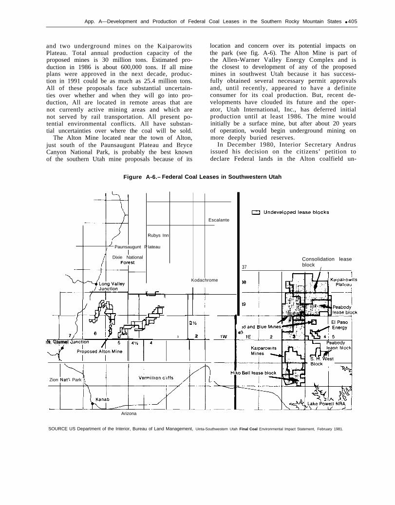
and two underground mines on the KaiparowitsPlateau. Total annual production capacity of theproposed mines is 30 million tons. Estimated pro-duction in 1986 is about 600,000 tons. If all mineplans were approved in the next decade, produc-tion in 1991 could be as much as 25.4 million tons.All of these proposals face substantial uncertain-ties over whether and when they will go into pro-duction, All are located in remote areas that arenot currently active mining areas and which arenot served by rail transportation. All present po-tential environmental conflicts. All have substan-tial uncertainties over where the coal will be sold.
The Alton Mine located near the town of Alton,just south of the Paunsaugunt Plateau and BryceCanyon National Park, is probably the best knownof the southern Utah mine proposals because of its
location and concern over its potential impacts onthe park (see fig. A-6). The Alton Mine is part ofthe Allen-Warner Valley Energy Complex and isthe closest to development of any of the proposedmines in southwest Utah because it has success-fully obtained several necessary permit approvalsand, until recently, appeared to have a definiteconsumer for its coal production. But, recent de-velopments have clouded its future and the oper-ator, Utah International, Inc., has deferred initialproduction until at least 1986. The mine wouldinitially be a surface mine, but after about 20 yearsof operation, would begin underground mining onmore deeply buried reserves.
In December 1980, Interior Secretary Andrusissued his decision on the citizens’ petition todeclare Federal lands in the Alton coalfield un-
Figure A-6.– Federal Coal Leases in Southwestern Utah
i7
Mt. Carmel JI
Escalante
Rubys Inn
/ Paunsaugunt P Iateau
Dixie National
Kodachrome
[ I— I
3 1 — I
21/2
2
Zion Nat’1 Park
Consolidation lease
37 block/
Arizona
SOURCE US Department of the Interior, Bureau of Land Management, Uinta-Southwestern Utah Final Coal Environrnental Impact Statement, February 1981.

406 . An Assessment of Development and Production Potential of Federal Coal Leases
suitable for mining under the Surface MiningControl and Reclamation Act of 1977 (SMCRA).This was the first section 522 unsuitability peti-tion accepted. Secretary Andrus declared Federallands adjacent to Bryce Canyon National Park asunsuitable for surface mining and the surface ef-fects of underground mining. The decision af-fected about 9,049 acres on the eastern side of theAlton Field out of the more than 26,000 acres leas-ed by Utah International and Nevada Power. As aresult of the decision, about 24 million tons of themore than 290 million tons under lease would notbe minable. The decision cited the potentialadverse impacts on the park from blasting, heavytruck traffic, air quality degradation, and noisefrom the mining operations which would have ex-tended to within 5 miles of the Yovimpa Pointlookout in Bryce Canyon Park. The original peti-tion had requested that Andrus declare a total of325,000 acres (240,000 acres of Federal land) asunsuitable for mining. The lessees have filed suitin Federal District Court in Salt Lake City chal-lenging the adequacy of the technical informationsupporting the decision and alleging that theAlton leases should be exempt from the unsuit-ability provisions because of substantial legal andfinancial commitments to development madebefore passage of the act.
In Feburary 1981, two of the partners in theAllen-Warner Valley Power project, SouthernCalifornia Edison and Pacific Gas & Electric,withdrew their applications for participation inthe project from consideration by the CaliforniaPublic Utility Commission. The decision was, inpart, based on the decisions by the Secretary of In-terior and EPA to approve permits for construc-tion of one portion of the project, the Harry Allenplant in Nevada, and to withhold approval of thesmaller Warner Valley Plant in Utah pending ad-ditional study. Southern California Edison also at-tributed its decision to a shift in company policyto the use of renewable energy sources. Substan-tial questions thus still remain over constructionof the two plants and of the proposed slurry linefrom the Alton Mine to the powerplants.
The Alton lessees have submitted an informalmine plan proposal for use in environmental anal-yses. The lessees have reportedly deferred submit-tal of a final plan until after the Alton unsuitabilitydecision was made. The proposed mine wouldproduce up to 11.2 million tons of coal annually.The impact of the unsuitability petition on devel-opment is still unclear—about 10 percent of the re-serves were withdrawn from production. Shouldthe decision stand, the lessees are expected to seek
an exchange of the affected leases for other com-parable Federal coal lands in the area. Interiorhad previously indicated it would give prompt at-tention to such a request.
Two mine plans have also been submitted forunderground mines on the Kaiparowits Plateau.El Paso Energy proposes to open a large under-ground mine complex on its 40,00()-acre” leasetract. The first two mines, the Red and BlueMines, would produce a total of about 1.1 milliontons per year. El Paso plans to expand productionon the plateau in other reserve areas to reach aneventual annual capacity of 6.8 million tons peryear.
The Kaiparowits Nos. 1-5 complex is proposedby a consortium of three resource developmentsubsidiaries of electric utilities: Mono Power, asubsidiary of Southern California Edison; Re-sources Co., a subsidiary of Arizona Public Serv-ice Co.; and New Albion Resources Co., a subsidi-ary of San Diego Gas & Electric Co. These leasesare located on the southern portion of the plateaujust south of the El Paso leases. The lessees plan toopen several underground mines on the jointlyheld lease tract of over 47,000 acres which wouldeventually produce 12 million tons per year. Theleases were originally acquired as PRLAs andwere intended to supply electric utilities in theSouthwest or, possibly, a powerplant near themine area. Because of concerns about impacts onthe region’s air quality and water supply, power-plant construction at or near the mine complex toserve out-of-State consumers is now consideredunlikely.
Development of the two planned mines on theKaiparowits Plateau is uncertain. Both mine planswere submitted before the implementation ofSMCRA and have not been updated to reflect thecurrent mine plan requirements. The major uncer-tainties affecting their development are lack oftransportation to move coal to market and lack ofany definite market for the production. Estimatesby the Union Pacific Railroad are that a minimumproduction of 30 million tons per year would benecessary to offset the costs of construction of arail line to the plateau. The two proposed mineswould produce 18.8 million tons at full capacity—just over 60 percent of the minimum required pro-duction. It is very uncertain whether a market forthe required 30 million tons or more of Kaiparo-wits coal will materialize over the next decade. Anadditional factor that affects the development ofthese mines is the remote location and the need toprovide a supporting infrastructure for mine de-velopment. The nearby communities are few,
App. A—Development and Production of Federal Coal Leases in the Southern Rocky Mountain States . 407—-—
small, and far between, Mine construction wouldbring an increase in population and greater de-mand for services such as roads, utilities, water,and housing to serve the mine employees. Theserequirements could put southwestern Utah devel-opment at a disadvantage when compared toother established mining areas.
Undeveloped Leases.—There are 32 undevel-oped leases in southwestern Utah. These leasescover 57,537 acres and 744 million tons of recov-erable underground reserves. The leases are di-vided into 11 lease blocks, 7 of these are singlelease blocks ranging in size from 40 to 1,440 acres.There are four multilease blocks ranging in sizefrom 6,400 acres to more than 25,500 acres, Six ofthe lease blocks are located on the KaiparowitsPlateau, and the five others are small leases thatare scattered across the region. Four of the fivesmall lease blocks have previously operated assmall mines but were shut down in the 1950’s and1960’s as local markets diminished.
In reviewing the development potential of theselease blocks, OTA found that four of the six tractson the Kaiparowits Plateau each had sufficientreserves of good quality coal that could support in-dependent mining operations. These four blocksinclude two separate tracts held by Peabody CoalCo., one large tract on the northern portion of thePlateau held by Consolidation Coal Co., and athree-lease tract held by Hiko Bell Oil & MiningCo. on the southern edge of the plateau near theGlen Canyon Recreation Area withdrawal. Twotracts on the plateau did not meet the minimumquality and reserve requirements for new mines.One block held by El Paso has difficult miningconditions relative to the lease configuration andis separated from the company’s other leases inthe Red and Blue mine plan proposal, The otherblock, a lease owned by an individual, is on thesouthern portion of the plateau with generallylower quality reserves and more difficult prob-lems of access to the seams because of topogra-phy.
All of the leases on the Kaiparowits Plateau arein an isolated, rugged area, not served by existingtransportation systems capable of moving coal tomarket. Access for mine development is difficultbecause of the steep, highly dissected cliff faces ofthe plateau and the complex geology of the multi-ple coal seams. The area would require more ex-ploratory and developmental drilling, and con-struction of roads, utility lines and other support-ing services before substantial mining operationscould begin. The 25 leases in the four lease blocks
on the plateau that could support new mines werethus rated as having uncertain development pros-pects. The two single lease tracts were classifiedas unfavorable development prospects.
The five remaining small lease tracts inSouthwestern Utah were found to have unfavor-able development prospects as new mines. Theygenerally did not have sufficient reserves to sup-port a new large mining operation. Their loca-tions made them potentially suitable to serve lim-ited local markets only, The reserves on the smalltracts are also generally poorer quality coals. Twoleases located near Zion NationaI Park have somepotential environmental problems (wildlife andwater quality impacts) although they have beenmined in the past and are not located in highlyvisible areas so they would not, as compared toAlton, pose a visual intrusion onto the park areas.
An analysis of the production potential of thefour tracts on the Kaiparowits Plateau with uncer-tain development prospects indicated that theycould support a total annual production of 7 mil-lion to 16 million tons depending on the choice ofmining technologies and mine life. This calcula-tion was made on the basis of available informa-tion on the reserves, geology, topography and pos-sible mining conditions that could be encoun-tered. Full production capacity is expected to beattained in 3 to 6 years from initial commercialproduction. At a minimum, because of the timeneeded for mine plan development and other con-struction, it was estimated that 1987 is the earliestdate that production could begin on the plateau.This date assumes 2 years for mine plan submittal,another 2 years for approval of the mine plan andother permits, and about 2 to 3 years of prelimi-nary mine development and construction. It is notknown how long it would take to construct the re-quired railroad or supporting community infra-structure. If the potential 7 million to 16 milliontons annual production capacity from the un-developed leases is added to the 18 million tons ofproduction proposed from the Kaiparowits and ElPaso mine complexes, the annual regional pro-duction approaches the range required to supportconstruction of the rail line. It was suggested inthe regional environmental impact statement forSouthwestern Utah that initial production frommines could be trucked to Page, Ariz., and usedfor power generation there—however, that ap-pears an unlikely alternative at present. It isbecoming clear, however, that development of ex-isting Federal leases on the Kaiparowits Plateau isvery much an all or nothing proposition.