Embed Size (px)
Citation preview

Developing Reasonable Assurance: A Guide to Performing Model-Based
Analysis to Support Municipal Stormwater
Program Planning
SUBMITTED TO:
U.S. EPA Region 9 75 Hawthorne St. San Francisco, CA 94602
PREPARED BY:
Paradigm Environmental 9320 Chesapeake Dr. Suite 100 San Diego, CA 92123
FEBRUARY 2017

Guide to Performing Model-Based Analysis to Support Municipal Stormwater Program Planning
DISCLAIMER
This is not a U.S. Environmental Protection Agency (EPA) guidance document; nor does it represent official EPA policy. This document does not substitute for the Clean Water Act (CWA) or associated implementing regulations. Approaches and practices identified in this document are not binding; other approaches consistent with the CWA and associated implementing regulations may also be available. This document is intended to be consistent with but does not modify existing EPA policy or guidance. This guide may be revised in the future to account for developments in this fast-
changing field.
Mention of trade names or commercial products does not constitute endorsement or recommendation for use. Although a reasonable effort has been made to assure that the information
presented is correct, some of the approaches described in this guide are relatively new and undergoing additional testing, refinement, and review. Therefore, the author and the U.S. Environmental Protection Agency are not responsible and assume no liability whatsoever for any results or any use made of the results obtained from these programs and approaches, nor for any damages or litigation that result from the use of these programs and approaches for any purpose.
ACKNOWLEDGEMENTS
We would like to acknowledge the extensive technical and editorial contributions to this guide by David Smith from EPA Region 9. We also thank the following people for their technical reviews of and/or technical contributions to this guide: Dr. Nicole Beck (2NDNATURE), Dr. Dino Marshalonis (EPA Region 10), Dr. Thomas Mumley (San Francisco Regional Water Quality Control Board), Renee Purdy (Los Angeles Regional Water Quality Control Board), Dominic
Roques (Central Coast Regional Water Quality Control Board), Mark Vorhees (EPA Region 1), and Dr. Jing Wu (San Francisco Estuary Institute). However, we remain solely responsible for the content of this guide.
EXECUTIVE SUMMARY
This document is designed to assist municipal stormwater program managers, watershed stakeholders, consultants, and permitting authorities in understanding, selecting, and using model- based approaches to support development of rigorous, comprehensive municipal stormwater program management plans. Over the past 5 years, many municipal stormwater NPDES permits and associated local programs have shifted their planning focus to use robust analytical modeling tools to identify the specific stormwater management strategies and practices that will be necessary over the long term to attain specified water quality protection requirements. This general approach,
based on what has been termed “reasonable assurance analysis” (RAA), has been developed as an alternative to traditional municipal stormwater permitting approaches that relied upon implementation of programmatic minimum stormwater management efforts and an iterative approach to stormwater control development that were often not grounded in rigorous analytical frameworks. This document is based on evaluation of several recent permits and local programs that are implementing this new RAA approach and is intended to provide a structured approach to selecting among alternative analytical tools and efficiently using the selected tools to support development of long-term stormwater management programs that will comply with NPDES permit
requirements. The document is organized as follows:
February 2017 i
Guide to Performing Model-Based Analysis to Support Municipal Stormwater Program Planning
1. Purpose of a Reasonable Assurance Analysis Why have alternative approaches based on RAA been implemented? This section briefly reviews the evolution of municipal stormwater program planning to address new water quality management challenges and concerns about the efficacy of traditional program approaches. The section summarizes the role of the RAA in the stormwater management planning process and the basic elements for completing the RAA.
2. Emerging MS4 Permit Requirements This section discusses changes in NPDES permits to authorize use of RAA-based program planning as an alternative to traditional permits that rely solely on qualitative, iterative program improvements or imposition of outcome-based water quality limitations. This discussion summarizes alternative methods used by permitting authorities to develop prescriptive permitting requirements concerning the RAA, and is intended to educate permitting authorities and permittees
about the pros and cons of establishing more prescriptive RAA expectations through NPDES permits and associated implementation guidance.
3. Factors to Consider in Selecting RAA Methods This section discusses key regulatory, planning, technical/analytical, and practical considerations decision-makers should evaluate in selecting among a range of available RAA modeling and planning methods. The intent of this section is to assist local programs in selecting analytical methods that are practicable and will fully address their long-term permit compliance and program
planning and implementation needs.
4. Performing a Reasonable Assurance Analysis This section presents a general framework for performing the RAA and discusses key considerations that should be addressed in designing and implementing the RAA approach. Key elements in the
framework include:
1. Designation of the Area Addressed by the RAA 2. Characterization of Existing Conditions and Practices 3. Determination of Stormwater Control Needs and Improvement Goals 4. Demonstration that Proposed Stormwater Controls and Management Actions Will Attain
Goals
5. Documentation of Results to Inform Implementation, Tracking, and Evaluation of Success
5. Transitioning from Planning to Implementation This section discusses how RAA results inform development of long-term stormwater management plans and asset management systems that guide long-term program operations and implementation of new infrastructure projects. The section also describes how RAA results and associated long-term plans can be used to support development of program financing plans to ensure sufficient capital and
O&M resources are available to fund the program.
Appendix A provides seven in-depth case studies that illustrate a wide range of permitting requirements and potential RAA technical approaches and applications in use by cities and states around the country. The case studies demonstrate that different RAA approaches may be appropriate given the differences in “on the ground” stormwater management needs, the state of evolution of local stormwater programs, and the regulatory and planning frameworks present in
different areas.
ii February 2017

Guide to Performing Model-Based Analysis to Support Municipal Stormwater Program Planning
While this guide will not substitute for careful, site-specific consideration of local circumstances, capabilities, and needs for stormwater management planning and analysis, it should assist local decision makers and regulatory authorities in better understanding the utility of RAA approaches, the key factors to consider in selecting among different RAA approaches, the practical experiences of several entities that have developed and implemented RAA-based stormwater management plans, and the potential applications of RAA-based planning for long- term asset management and
financial planning.
February 2017 iii

Guide to Performing Model-Based Analysis to Support Municipal Stormwater Program Planning
Contents Disclaimer ................................................................................................................................... i
Acknowledgements ...................................................................................................................... i
Executive Summary ..................................................................................................................... i
1 Purpose of a Reasonable Assurance Analysis .......................................................................... 1
1.1 Role of a Reasonable Assurance Analysis in Watershed or Stormwater Management Planning .................................................................................................................................. 2
1.2 Elements of a Reasonable Assurance Analysis ................................................................. 6
2
3
Emerging MS4 Permit Requirements ..................................................................................... 8
Selecting an ANalytical Method for Performing the Reasonable Assurance Analysis .............. 11
3.1
3.2
Factors to Consider in Selecting an Analytical Method .................................................. 11
Size Matters when Selecting an Analytical Method ........................................................ 15
4 Performing the Reasonable Assurance Analysis .................................................................... 17
4.1
4.2
Element 1: Designation of Area Addressed by Analysis ................................................. 17
Element 2: Characterization of Existing Conditions ....................................................... 20
Analysis of Monitoring Data ................................................................................. 20
Modeling Existing Conditions ............................................................................... 21
Element 3: Determination of Stormwater Improvement Goals ....................................... 24
Element 4: Demonstration that Management Actions Will Result in Attainment of Goals 27
Quantification of Benefits of Nonstructural BMPs .................................................. 28
Quantification of Benefits of Structural BMPs ........................................................ 29
Element 5: Documentation of Results that Inform Implementation and Tracking ............ 33
4.3
4.4
4.5
5 Transitioning from Planning to Implementation ................................................................... 35
5.1
5.2
Implementation Tracking and Adaptive Management .................................................... 36
Stormwater Program Planning Frameworks that Support Successful Implementation ...... 36
6 References .......................................................................................................................... 38
Figures Figure 1-1. Steps in the Watershed Planning and Implementation Process (USEPA 2008) ............... 4 Figure 1-2. Role of the RAA in the Watershed or Stormwater Planning Process .............................. 5 Figure 3-1. Considerations for Selecting an Analytical Method for the RAA ................................. 16 Figure 4-1. Los Penasquitos Watershed Pollutant Discharge Responsibilities (LP WQIP Responsible Agencies 2015) ........................................................................................................................... 19
Figure 4-2 Example analysis sequence for selecting priority water quality conditions (LP WMA 2015). 21 Figure 4-3. Example Process for Model Calibration to Minimize Propagation of Uncertainty......... 23 Figure 4-4 Example Assessment of Relative Sediment Loading Los Peñasquitos (LP WQIP Responsible Agencies 2015) ........................................................................................................ 24
iv February 2017

Guide to Performing Model-Based Analysis to Support Municipal Stormwater Program Planning
Figure 4-5 Example Illustration for how Exceedance Volume is Derived for Metals (ULAR WMG 2016) ......................................................................................................................................... 26 Figure 4-6. Identifying the Limiting Pollutant for the RAA Critical Condition using EVs (ULAR WMG 2016) .............................................................................................................................. 27 Figure 4-7. WRIA 9 Study Area BMP Storage in Watershed Inches for Full Stormwater Management in 2040 (King County 2014a) ................................................................................. 30 Figure 4-8. Example Cost-Optimization for Two Jurisdictions in the Upper Los Angeles River EWMP (ULAR WMG 2016) ..................................................................................................... 32
Figure 4-9. Example Scheduling of BMP Implementation Strategy to Meet TMDL Milestones (ULAR WMG 2016) .................................................................................................................. 34
Tables Table 4-3. Summary of Identified Critical Conditions for Example RAAs (Appendix A) ............... 25
February 2017 v

Guide to Performing Model-Based Analysis to Support Municipal Stormwater Program Planning
vi February 2017

Guide to Performing Model-Based Analysis to Support Municipal Stormwater Program Planning
1 PURPOSE OF A REASONABLE ASSURANCE ANALYSIS
Stormwater runoff from urban areas is often a major contributor of pollutant loadings and can result in impairments of beneficial uses of waterbodies. Throughout the US, thousands of Total Maximum Daily Loads (TMDLs) have been developed that include an analysis of the impairments and an identification and quantification of pollutant sources, including assignment of wasteload allocations to urban runoff. In some cases, the TMDLs include wasteload allocations that have been assigned to sources regulated by National Pollutant Discharge Elimination System (NPDES) permits that address polluted runoff from industrial areas, highways, and Municipal Separate Storm Sewer Systems (MS4s). Since the development of those TMDLs, many NPDES permits have incorporated wasteload allocations as Water Quality Based Effluent Limits (WQBELs) to provide regulation and oversight of the implementation of best management practices (BMPs) to reduce
pollutant loads. WQBELs have been expressed either as numeric limits or as BMP-based requirements in-lieu of numeric limits. However, many MS4 and other stormwater permits do not require the development of sufficiently detailed control plans or robust analytical evidence showing that proposed control plans will adequately reduce pollutant loadings to meet WQBELs and associated TMDL wasteload allocations. As a result, it has been difficult to demonstrate that implementation of stormwater permit provisions results in pollution controls that are sufficient to protect and restore water quality in many urban areas. To address this issue, EPA (2014) has suggested that increased understanding of BMP performance should be reflected in proper demonstration and supporting rationale showing that implementation of BMPs will likely result in the attainment of WQBELs and associated water quality standards and TMDL wasteload allocations, and including milestones or other mechanisms where needed to ensure that the progress of implementing BMPs can be tracked and permit compliance evaluated.
A new generation of MS4 permits throughout the U.S. includes specific requirements for a quantitative analysis to provide reasonable assurance that pollutant load reductions or reduced stormwater impacts will be achieved through the implementation of detailed stormwater or watershed management programs. Often called a Reasonable Assurance Analysis (RAA), the process typically employs the use of computer modeling or other quantitative techniques to demonstrate that a combination of specified BMPs or other control strategies will likely reduce pollutant loads or other stormwater impacts (e.g., peak flows) as necessary to result in achievement of WQBELs or TMDL wasteload allocations expressed as WQBELs within compliance schedules established by NPDES permits.
Although relatively new to MS4 permits, the concept of the RAA has been integral to the watershed planning process for several years. In the early 1990s, during the early stages of development of TMDLs that emphasized stormwater as a pollutant source, models available at the time were thoroughly evaluated regarding their ability to simulate urban runoff (USEPA 1991) and address the
quantitative needs of a TMDL source analysis and calculation of allowable loads (USEPA 1992). During this period, EPA and many states also recognized that models can assist in the watershed planning process, including targeting watersheds for management, developing goals and objectives, defining solutions, developing plans for management implementation, simulating storage and treatment effects of alternative management options, providing input to cost-benefit analyses, and tracking progress toward achieving goals (USEPA 1991 and 1997). As the process for developing watershed plans continued to evolve, including the collection of many lessons learned on effective plans, EPA sought to develop guidance to states, territories, tribes, local governments, watershed organizations, and the public regarding technical tools and sources of information for developing watershed-based plans. In 2008, EPA released the Handbook for Developing Watershed Plans to
1 February 2017

Guide to Performing Model-Based Analysis to Support Municipal Stormwater Program Planning
Restore and Protect Our Waters (Watershed Plan Handbook) to provide information on developing and implementing watershed management plans to restore or protect water quality. The Watershed Plan Handbook provides guidance on the selection and application of quantitative approaches to characterize point and nonpoint sources and pollutant loads and predict load reductions associated with planned management activities. In order to quantify anticipated pollutant reductions resulting from management strategies, the Watershed Plan Handbook provides an overview of a range of quantitative approaches from literature values and spreadsheet tools to more sophisticated modeling
approaches (USEPA 2008).
With the incorporation of new requirements in MS4 permits that include development of watershed or stormwater management programs that incorporate RAAs, lessons learned from the watershed planning process and early RAA implementation efforts can inform and assist communities beginning the process. The purpose of this document is to assist with the selection and application of technical frameworks for performing RAAs that are best suited to meet MS4 permit requirements
and watershed and stormwater planning needs. There is no “one-size-fits-all” approach for performing RAAs, and opportunities always exist for tailoring approaches to meet local needs, furthering the research and development of currently used tools or models, or developing new methods. Therefore, this guide is not meant to define the full range of possible approaches to be used for RAAs, but rather assist in the selection of an approach that best fits local needs while fulfilling
expectations of the MS4 permit, permitting authorities, and watershed stakeholders.
1.1 Role of a Reasonable Assurance Analysis in Watershed or
Stormwater Management Planning
The required components of a watershed or stormwater management plan vary depending on the MS4 permit or, where available, local regulatory guidance. Often, the planning approach includes components that are similar to traditional watershed or TMDL implementation planning processes.
For example, the Watershed Plan Handbook outlines multiple steps in the development and implementation of a watershed management plan (Figure 1-1). For the Watershed Plan Handbook steps outlined in Figure 1-1, “Characterization and Analysis Tools” are similar to approaches used to perform an RAA, as they support the characterization of the watershed (Step 1) and the setting of goals and identification of management solutions (Step 2) (USEPA 2008).
In California, similar guidance for TMDL implementation planning was developed by the California State Water Resources Control Board (SWRCB). In 2005, the SWRCB released A Process for
Addressing Impaired Waters in California, which outlines the following steps for designing a TMDL
implementation plan (SWRCB 2005):
1. Identify Current Activities: Considers management actions (e.g., NPDES requirements) that are already initiated in the watershed, and serves to establish the starting point for identifying further actions required to improve water quality.
Identify Common Interests and Overlapping Objectives: Assesses other multiple benefits (e.g., flood protection, water supply) that can be considered in the planning process.
Engage Stakeholders: Involves stakeholders in the planning process and selection of management activities.
Identify Opportunities for Management Practices: Identifies viable opportunities for management practices and considers source type, impairment type, and load reduction required. Evaluates suitable locations for management practices.
Consider Alternatives and Cost: Analyzes multiple implementation scenarios and
associated costs for selection of the most cost-effective plan. This step can include an analysis
2.
3.
4.
5.
2 February 2017

Guide to Performing Model-Based Analysis to Support Municipal Stormwater Program Planning
of the effectiveness of each scenario at meeting water quality standards and associated load reductions, as well as the cost of each scenario, for identifying the cost-effective implementation plan.
Steps 4-5 above are similar to an RAA in that a quantitative analysis of load reductions or water quality improvement is performed to evaluate the expected effectiveness of alternative management actions. The SWRCB also notes that “these analyses can be used to link the proposed management actions with the desired load reductions, and determine whether the proposed management actions will be sufficient to meet water quality objectives (e.g., through TMDL allocations).”
The above examples are for traditional watershed and TMDL implementation planning process and the role of RAAs. However, watershed or stormwater management plans addressing requirements of a MS4 permit should always consider components specifically described in that permit or associated regulatory guidance. Although typically similar to traditional watershed or TMDL implementation planning approaches, many MS4 permits have specific requirements for various planning activities including TMDL implementation.
In summary, the RAA is only one component of an overall process for effective watershed or stormwater management planning. The RAA can inform the entire planning process in terms of evaluating combinations of potential management actions and their effectiveness in attaining necessary pollutant reductions to meet TMDL wasteload allocations, WQBELs, or other water quality targets. Figure 1-2 provides an overview of the RAA (blue) and its interaction with typical processes included in the development of watershed or stormwater plans (gray).
February 2017 3

Guide to Performing Model-Based Analysis to Support Municipal Stormwater Program Planning
Figure 1-1. Steps in the Watershed Planning and Implementation Process (USEPA 2008).
4 February 2017

Guide to Performing Model-Based Analysis to Support Municipal Stormwater Program Planning
Figure 1-2. Role of the RAA in the Watershed or Stormwater Planning Process.
February 2017 5

Guide to Performing Model-Based Analysis to Support Municipal Stormwater Program Planning
1.2 Elements of a Reasonable Assurance Analysis
What constitutes reasonable assurance? From a regulatory perspective, reasonable assurance can be interpreted as the demonstration that the implementation of a watershed or stormwater management plan will, in combination with operation of existing system assets and programs, result in sufficient pollutant reductions or reduced stormwater impacts over time to meet TMDL wasteload allocations, WQBELs, or other targets specified in the MS4 permit or identified in the plan (USEPA 2014). From the perspective of a stakeholder in the watershed who is focused on the improvement of water quality or restoration of a beneficial use of a waterbody, reasonable assurance is often interpreted as a demonstration, as well as commitment, that specific management practices are identified with sufficient detail, and implemented on a schedule to ensure that necessary improvements in the receiving waters will occur. From the perspective of the MS4 permittee, reasonable assurance can be interpreted as a detailed analysis of the TMDL wasteload allocations and associated permit
limitations themselves. RAA may also assist in evaluating the financial resources needed to meet pollutant reductions based on schedules identified in the permit, and in preparing associated capital improvement plans. Proper attention to each viewpoint is especially important in the selection and application of an RAA to avoid many pitfalls that can jeopardize regulatory or stakeholder acceptance of a plan or its usefulness to guide future implementation efforts. To help avoid these pitfalls, the following basic elements of an RAA have been identified (corresponding to numbered components of the RAA depicted in Figure 1-2).
Element 1: Designation of Area Addressed by Analysis As the RAA associated with a stormwater management plan is developed in the context of the MS4 permit, the area where it is applied is typically (but not always) specific to urban areas within one or more municipal jurisdictions addressed by that permit. This may exclude areas that are regulated by other NPDES permits, including those issued to industrial dischargers, transportation agencies, or
other MS4 permits. However, RAAs that address all the areas within the watershed are more likely to successfully target controls needed by regulated MS4 permittees as well as other entities or sources not addressed by the MS4 permit. Section 4.1 provides a discussion of the considerations for designating urban areas addressed by a watershed or stormwater management plan and associated RAA.
Element 2: Characterization of Existing Conditions Critical to the RAA is careful characterization of stormwater pollutant loads or flows under existing conditions. This understanding serves as the foundation of the RAA and identifies the starting point for planning management actions. Where a TMDL is established, characterization of existing conditions may be documented within the TMDL and can be cited by the RAA. However, some TMDLs do not include a detailed characterization of existing conditions and specification of load reductions needed to meet wasteload allocations. For other TMDLs that include a characterization
of existing conditions, the RAA may require revisiting of calculation methods to account for factors or assumptions not addressed by the TMDL. The characterization of existing conditions should also consider all stormwater management practices and system assets currently in place or implemented at a specified point in time (e.g., date of approval of MS4 permit or TMDL). Section 4.2 provides a discussion of methods used to characterize existing conditions and factors to consider in selecting
the appropriate approach for a RAA.
6 February 2017

Guide to Performing Model-Based Analysis to Support Municipal Stormwater Program Planning
Element 3: Determination of Stormwater Improvement Goals Based on the existing conditions characterized above, and in combination with water quality targets established by TMDLs or other assessments, the MS4 permit, and/or the watershed or stormwater management plan, goals can be determined for addressing stormwater-caused impairments. These goals can be expressed in various forms, but usually include specified reductions in stormwater pollutant loads or concentrations, volumes, or peak flows. Section 4.3 outlines typical methods used to establish stormwater improvement goals for RAAs.
Element 4: Evaluation of Management Alternatives and Demonstration
that Management Actions will Result in Attainment of Goals As part of the watershed or stormwater management planning process, several opportunities for management actions can be identified. These management actions may include a combination of
programmatic activities (e.g., street sweeping, inspection and enforcement procedures, or source controls), low impact development (LID) practices incorporated within new development, re- development, or retrofit of urban areas, or municipal capital improvement projects that provide stormwater capture or treatment (e.g., regional treatment or infiltration facility, green streets). The goal of the RAA is not to identify these opportunities, as that is part of the overall watershed or stormwater management planning process (see Section 4.4). The RAA helps identify combinations of actions and practices that together will achieve desired water quality results. The RAA provides a quantitative evaluation of the stormwater pollutant loads or concentrations, volumes, or peak flows reduced via alternative management scenarios to ensure that the selected management scenario will result in attainment of stormwater improvement goals established in Element 3. RAA methods provide a critical framework for comparing stormwater management alternatives, including different mixes of structural and non-structural practices and different options for distributing stormwater management practices and facilities throughout the planning areas. By applying the selected RAA framework to support the broader planning process, program managers can rigorously compare implementation alternatives and their ability to ensure attainment of stormwater management goals and requirements.
The RAA is not a one-time concept. Stormwater program managers should anticipate that the modeling approach selected to perform the RAA will need to be used in the future in coordination with other program tracking and assessment tools to support adjustment of program implementation efforts over time. Stormwater program implementation opportunities and constraints change over time, and programs can expect to learn critical information from early implementation efforts about BMP performance and effectiveness of non-structural approaches. RAA models can and should be adjusted over time to take advantage of such new information. Moreover, as additional data and information are collected over time, it is important to update RAA modeling tools themselves to reduce modeling uncertainty and improve model performance. For example, program managers can benefit from uncertainty analysis conducted as part of an initial RAA modeling effort to identify
data needed to reduce important sources of model uncertainty over time. The key point is that all RAA efforts and associated stormwater programs entail iterative adjustment over time. This means that stormwater managers should assume an RAA is not a one-time analysis but is instead a critical ongoing element supporting long term implementation and adjustment of stormwater program actions. However, a commitment to iterative adjustment does not by itself provide reasonable assurance. Program managers will need to ensure that the RAA method selected at the outset provides sufficient analytical power to support detailed stormwater program planning and ensure that the program plan is likely sufficient to meet regulatory requirements, including TMDL allocations. A commitment to long term, iterative adjustment of the stormwater program and the
February 2017 7

Guide to Performing Model-Based Analysis to Support Municipal Stormwater Program Planning
RAA methods used to support planning and evaluation will be key to long-term program
effectiveness.
Element 5: Documentation of Results that Inform Implementation and
Tracking Documentation of RAA results is critical to ensuring their success in fulfilling regulatory requirements to demonstrate that the selected stormwater management plan will result in attainment of TMDL, water quality, and other management objectives. The RAA analytical framework also can be used to inform and track future implementation efforts, evaluate effectiveness of implemented projects and practices, and measure progress in attaining regulatory goals. This documentation can serve various purposes (see Section 4.5), including:
Providing reasonable assurance to stakeholders and regulators that the plan will lead to effective implementation;
Providing information that can support next steps for stormwater program enhancements, capital improvement planning, and investigation of funding options; and
Highlighting the quantitative results that support the adaptive management process, tracking of implementation over time, and/or assessment of progress towards attainment of
stormwater improvement goals and requirements.
2 EMERGING MS4 PERMIT REQUIREMENTS
In recent years, MS4 permits have been issued that include methods for incorporating TMDLs and associated wasteload allocations, as well as requirements for integrated watershed or stormwater management planning and RAAs, to demonstrate how TMDL allocations and other water quality based requirements will be met. Incorporation of TMDLs into MS4 permits presents numerous
challenges including:
Addressing a large number of discharge points;
Accounting for highly variable flows;
Assessing a wide array of pollutants-of-concern;
Evaluating the co-mingling among multiple municipal jurisdictions and areas addressed by other stormwater permits;
Considering multiple types of available BMPs;
Incorporating limited data regarding BMP effectiveness;
Considering limited sources of capital and O&M funding dedicated to stormwater management.
MS4 permits vary in terms of how they express water quality-based requirements. Some permits incorporate effluent or receiving water quality or loading requirements, while other permits
incorporate more BMP-based approaches in lieu of water quality-based requirements. In either situation, RAA methods are critical to evaluating and establishing needed connections between selected stormwater management practices and intended water quality goals. Many recent permits
offer alternative compliance pathways among which permittees can select.
To address the complexities of municipal stormwater management and the needs for regulatory oversight and compliance determination, many recent MS4 permits have included “BMP-based” permit requirements that require development of a watershed or stormwater management plan and a demonstration of the management actions needed over time to meet TMDL wasteload allocations
8 February 2017

Guide to Performing Model-Based Analysis to Support Municipal Stormwater Program Planning
or WQBELs. In requiring a robust analysis to demonstrate the ability of the stormwater management plan to meet water quality requirements within specified timeframes, this approach differs from many traditional MS4 permits that only require iterative implementation and adjustment of stormwater plans with the general goal of meeting water quality goals in the future. There are many potential advantages to BMP-based permit requirements supported by RAAs (as
opposed to numeric WQBELs) including:
Requirements to implement BMPs may facilitate projects being placed “in the ground” in the near-term;
A schedule of specific BMPs (with type, location, installation schedule, and expected performance) could be easier to monitor and enforce than end-of-pipe or receiving water limitations;
Requirements often viewed by municipal agencies as more tangible and controllable than water quality outcome-based requirements; and
Requirements to develop a well-justified list and schedule of BMPs can increase a municipality’s ability to obtain funding for stormwater quality projects.
The analysis may assist in defining “maximum extent practicable” for purposes of iterative program development.
Perhaps the biggest challenge with incorporating BMP-based permit requirements is development of a comprehensive watershed or stormwater management plan that is quantitative, reliable, and enforceable, yet flexible. A 2014 memo from EPA Office of Wastewater Management (OWM) and Office of Wetlands, Oceans and Watersheds (OWOW) directors to regional Watershed Division directors describes EPA’s expectations for BMP-based effluent limits, including the following
excerpt:
“The permitting authority’s decision as to how to express the WQBEL(s), either as numeric effluent limitations or as BMPs, with clear, specific, and measurable
elements, should be based on an analysis of the specific facts and circumstances surrounding the permit, and/or the underlying wasteload allocation, including the nature of the stormwater discharge, available data, modeling results, and other relevant information. As discussed in the 2002 memorandum, the permit’s administrative record needs to provide an adequate demonstration that, where a BMP-based approach to permit limitations is selected, the BMPs required by the permit will be sufficient to implement applicable wasteload allocations. Permits should also include milestones or other mechanisms where needed to ensure that the progress of implementing BMPs can be tracked. Improved knowledge of BMP effectiveness gained since 2002 should be reflected in the demonstration and supporting rationale that implementation of the BMPs will attain water quality
standards and be consistent with wasteload allocations.”
By definition, the RAA provides the necessary analysis to support BMP-based compliance mechanisms, and the demonstration that BMPs identified within a stormwater management plan will be sufficient to result in attainment of TMDL wasteload allocations. Approaches to BMP-based compliance and TMDL implementation have been incorporated within MS4 permits in various forms. EPA Region 9 consulted with other EPA regions across the U.S. to identify MS4 permits that include requirements for RAAs in order to highlight a range of geographic areas and approaches. Appendix A summarizes notable MS4 permits that include approaches to stormwater management planning and the incorporation of RAAs. For most of these MS4 permits, a case study is provided that outlines methods used by municipalities to perform RAAs and be responsive to the permit requirements. Each of these case studies include discussions regarding how the basic elements of an
February 2017 9

Guide to Performing Model-Based Analysis to Support Municipal Stormwater Program Planning
RAA (Section 1.2) were addressed. Appendix A includes the following example MS4 permits, which are referenced throughout this document.
1. Los Angeles County Phase I MS4 Permit (A.1) 2. Washington Phase I MS4 Permit (A.2) 3. San Diego Region Phase I MS4 Permit (A.3) 4. Central Coast California Phase I and Phase II MS4 Permit (A.4) 5. San Francisco Bay Area Regional MS4 Permit (A.5) 6. Virginia Phase I MS4 Permits Addressing the Chesapeake Bay TMDL (A.6)
7. Massachusetts General Phase II MS4 Permits (A.7)
For each of the example MS4 permits, computer modeling or other quantitative approaches served as a critical component of RAAs. However, the role of the RAA differs depending on the prescriptiveness of the permit and/or the degree to which previous modeling was performed to inform permit requirements or separate guidelines developed by the regulators. For example, previous modeling efforts and analyses performed by EPA and the Virginia Department of Environmental Quality (VDEQ) to address the Chesapeake Bay TMDL resulted in model output and quantitative approaches that were included within guidelines and reduced the need for further modeling. EPA Region 1 used a similar approach to established quantitative procedures for RAAs in the Massachusetts General Phase II MS4 Permits that are built upon previous modeling efforts, with the release of additional tools to support municipal efforts to follow these procedures and reduce the need for further modeling. For other California MS4 permits (Los Angeles and San Diego), modeling was previously used to support development of TMDLs, however, the RAAs typically require additional modeling or tools to provide assurance that these TMDLs or other water quality goals are met. For King County, no previous model was available, so the RAA required the development of new modeling approaches to address requirements of the Washington Phase I MS4 Permit. In summary, there are two main categories of approaches to use models to support RAAs, including:
Deterministic Approach: The MS4 permit may include requirements for RAAs and/or additional guidance, but the research and development associated with the modeling of pollutant loads and BMP performance is performed during the RAA following permit issuance. Some permits include associated guidance in terms of performance criteria or acceptable models to be used for the RAA. Examples of the Deterministic Approach include the Los Angeles County Phase I MS4 Permit, San Diego Region Phase I MS4 Permit, Washington Phase I MS4 Permit, San Francisco Bay Area Regional MS4 Permit and Central Coast California Phase I and Phase II MS4 Permit (Appendix A).
Prescriptive Approach: The MS4 permit provides detailed procedures for performing the RAA that are built upon output from past modeling and analysis efforts, typically used to support development and implementation of TMDLs. In this way, the research and development of modeling approaches and assumptions for pollutant loading and BMP
performance are performed up front, and provide a recipe for municipalities to follow using simple processes to perform an RAA. Examples include Virginia Phase I MS4 Permits Addressing the Chesapeake Bay TMDL, the Massachusetts General Phase II MS4 Permits, and the Central Coast California Phase I and Phase II MS4 Permit (Appendix A).
Regardless of the approach used, at some point either before or after the permit requirements are in place, modeling plays an integral role in the RAA process. The Prescriptive Approach to an RAA is defined by specific permit language or associated guidance provided by the permitting agency. As such, little or no other guidance is needed to inform a municipality on that approach. As
10 February 2017
Guide to Performing Model-Based Analysis to Support Municipal Stormwater Program Planning
Deterministic Approaches typically lack specific guidance in terms of selecting and performing modeling and presenting results of the RAA, the following Sections 3 and 4 provide a preliminary guide for evaluating and selecting among alternative analytical options. However, guidance provided within MS4 permits or associated documentation will always govern local regulator expectations of Deterministic Approaches to RAAs. For Example, the LARWQCB (2014) released detailed guidance for performing Deterministic Approaches for RAAs to address the Los Angeles County MS4 Permit (Appendix A.1), which includes local considerations and references specific
approaches to model selection and application for that region.
3 SELECTING AN ANALYTICAL METHOD FOR
PERFORMING THE REASONABLE ASSURANCE
ANALYSIS
Several key factors should be considered in selecting the most applicable and appropriate analytical framework for performing a RAA that best meets the local needs for a stormwater management plan. For those unfamiliar with models or other technical approaches, the number of options and considerations can be challenging to navigate. This section provides a general outline of factors to
consider in the selection of an analytical method for performing the RAA.
3.1 Factors to Consider in Selecting an Analytical Method
When selecting an appropriate analytical method for the RAA, the following factors should be addressed to ensure that the method meets the needs of the municipality. These factors include (1) regulatory and planning needs, (2) analytical capabilities, and (3) practical considerations.
The analytical method must be able to address specific regulatory requirements defined by the MS4 permit while meeting the stormwater and financial planning needs of the municipality. This category is probably the most important to the municipality, as it addresses the basic issues that are key to the overall purpose of the RAA. Factors that may be key to assessing Regulatory/Planning Needs can include:
Permit Requirements – The MS4 permit must be reviewed to identify specific basic requirements of the analytical method. For instance, the permit may require that the RAA address specific pollutants and applicable TMDLs. The permit may also define specific critical wet or dry conditions that must be considered, or guide how critical hydrologic conditions that informed TMDL development should be addressed during permit implementation. Some permits may also include specific reporting requirements based on the output from the RAA,
including degree to which individual BMPs or combinations of BMPs contribute to pollutant reductions. Permits may also vary in the degree of assurance and accuracy required to obtain plan approval by the permitting authority. These permit requirements can guide the municipality in evaluating specific analytical methods designed to address them. If the permit is unclear regarding specific expectations of the RAA, the municipality should consult with the regulating authority to obtain appropriate guidance and ensure that an effective analytical method is selected.
February 2017 11

Guide to Performing Model-Based Analysis to Support Municipal Stormwater Program Planning
Planning Process Requirements – As discussed in Section 1.1 and depicted in Figure 1-2, the RAA is a component of the overall stormwater management planning process. As the overall planning process is strategized, the role of the RAA should be specifically considered by the municipality in terms of how it should inform the planning process. For example, as the RAA can provide the ability to quantify pollutant reductions and other multiple benefits of individual BMPs, the municipality may choose to capitalize on this capability to compare the benefits of alternative BMP implementation strategies. Also, depending on the analytical method, various types of information will need to be compiled early in the planning process to provide sufficient assumptions or input to a model. Data and information limitations may practically limit the range of RAA methods that can be pursued in a specific situation. To support future implementation of the plan, a municipality may desire to have the RAA produce specific information to guide future planning efforts. For instance, a municipality may select an analytical method with capability to conceptually size or select specific structural BMPs, with output from the RAA that can inform future design or cost estimation efforts (linked to the
below factors). A municipality may also want to keep the analytical method simple, and focus on development of a method that can support the tracking of BMP implementation and associated pollutant reductions over time. To ensure that the analytical method meets the overall planning requirements of a municipality, the approach to stormwater management planning and implementation should be strategized prior to selection of the approach to the RAA. The conceptual plan for the planning process can then set the expectations of the RAA method to be
sure that the proper tools are available to effectively support the stormwater management plan.
BMP Types, Siting Opportunities, and Constraints – Prior to selecting an RAA method, a municipality should consider the types of BMP opportunities that will be assessed. Analytical methods for performing RAAs can differ considerably in terms of capability to represent
different BMPs and management actions.
Financial Planning Requirements – Looking beyond the stormwater management plan, a municipality may choose to consider an analytical approach that supports cost estimation, conceptual BMP design, or other capabilities that can inform financial planning. For example, some analytical approaches consider sizes of structural BMPs and other attributes (e.g., hydraulic designs, underdrains) to estimate pollutant loads or stormwater captured. This same information can be later used for estimating capital and O&M costs. Other RAA approaches provide added capability to incorporate mathematical cost functions, which can be used directly to estimate capital costs, O&M costs, etc. Selection of a simple RAA method may be sufficient to meet regulatory requirements or needs of the stormwater management plan, but additional investment may be needed later to develop necessary tools to support capital improvement planning, asset management, or other strategic planning efforts needed to secure funding for implementation. In summary, certain analytical approaches provide added capability to support implementation planning, and there can be cost-savings associated with selecting an RAA
method that can support these tasks at a later time.
Multi-Purpose Planning Needs – For a stormwater management plan to be successful, it is often beneficial if the plan considers multiple benefits of related project opportunities. For example, a structural BMP project may provide infiltration and potential recharge of groundwater supplies, reduced flooding of urban areas, or reduced hydromodifcation or erosion of downstream creek/river channels. Different RAA methods vary in their capacities to assist evaluation of multi-purpose project approaches. Consideration of multiple purposes and benefits can widen
funding opportunities and maximize returns on capital investments in stormwater projects.
12 February 2017

Guide to Performing Model-Based Analysis to Support Municipal Stormwater Program Planning
The analytical method must provide sufficient capability and precision to: (1) accurately characterize existing stormwater and pollutant loading conditions, and (2) demonstrate reasonable assurance that planned BMPs will meet their intended purpose at reducing stormwater and pollutant loads to meet applicable targets. Some MS4 permits may include specific guidance on expectations of the analytical capabilities of an RAA method. The following
factors can be considered in assessing Analytical Capabilities:
Spatial/Temporal Precision – The analytical method should provide the capability to assess spatial and temporal variability with adequate precision that is consistent with the planning or regulatory goals. For example, if the goal is to meet an allowable annual pollutant load, then the approach should provide sufficient capability to estimate pollutant loads for that annual period. If the goal is to meet a pollutant load or concentration target for a specific size storm, then the approach should provide capability to provide hourly or daily estimates of storm volumes, concentrations, or pollutant loads. The management plan may require assessment of pollutant loads at multiple locations throughout the area of analysis, which may vary depending on site- specific pollutant sources, rainfall variability, or other land characteristics that influence
pollutant transport.
Hydrologic Precision – Hydrology is the driving force for pollutant transport and forms the foundation of the stormwater management plan. Analytical approaches often vary considerably regarding representation of hydrologic processes, which typically include methods for estimating rainfall/runoff, infiltration, evapotranspiration, subsurface flow, among others. More sophisticated methods typically provide greater precision in representing multiple hydrologic processes. However, this does not mean that the most sophisticated methods are needed to meet the requirements of the RAA or stormwater planning goals. The hydrologic precision of a selected analytical approach should be in agreement with planning and regulatory goals, and sufficient to represent hydrology to a degree of accuracy that will provide reasonable assurance to the permitting authority, while ensuring confidence in terms of setting management goals that may have significant cost implications. Special attention should be placed on selection of an analytical approach that provides documentation of hydrologic precision or procedures to apply the method and measure precision. For example, models can be used to represent hydrology and predict stormflows over extended periods, which can be compared with measured flows to establish statistical representation of the precision of the model.
Pollutant Representation and Assessment – The RAA analytical approach should have sufficient capability to represent the pollutants to be addressed by the stormwater management plan, including key processes related to their sources and transport. This may require assumptions for pollutant loads that are associated with land use, imperviousness, or other characteristics in the drainage area to provided assessment of the spatial variability of pollutant
loads and inform selection and placement of BMPs. The method should also consider adequate capability to represent processes that drive or influence pollutant transport, including relevant hydrologic and/or sediment transport processes. Proper representation of hydrology and pollutant transport is essential to understanding the pollutant loads delivered to specific locations for BMPs, or discharged from the storm drain system to receiving waters where applicable water
quality targets apply.
BMP Process Precision – The analytical approach should provide BMP process simulation that is consistent with the capabilities for Spatial/Temporal Precision, Hydrologic Precision, and
February 2017 13

Guide to Performing Model-Based Analysis to Support Municipal Stormwater Program Planning
Pollutant Representation and Assessment discussed above. For example, if the Hydrologic Precision results in selection of a method that estimates peak hourly stormflows, then the BMP Process Precision should also provide the ability to estimate reductions of pollutant loads during that same period. Similar to hydrology discussed above, analytical approaches vary significantly in the degree to which BMP processes are represented. Some methods rely on literature assumptions for BMP effectiveness that can be used for assigning percent reductions or effluent concentrations for pollutants. Other methods attempt to represent the processes that contribute to these reductions, including BMP processes associated with infiltration, filtration, settling, evaporation, and others. Typically, the more processes represented, the more modeling assumptions will need to be documented based on local data or literature. However, representation of these multiple processes can assist in determining details for BMP sizing and design that can provide greater precision from a planning perspective. As a result, selection of the appropriate analytical approach should consider the Regulatory/Planning Needs, and ensure that the selected method will provide adequate BMP Process Precision to support planning
decisions.
Multi-Benefit Assessment and Optimization – A stormwater management plan may identify multiple opportunities for BMPs, with different combinations of BMP sizing and placement representing alternative implementation scenarios. If desired, an analytical approach can have the capability to provide relative comparison of these implementation scenarios and aid in the selection of an ideal BMP implementation plan that meets multiple planning goals. This relative comparison can also consider cost-effectiveness and other multi-benefit planning objectives (e.g., groundwater recharge, flood protection, habitat). Some analytical approaches provide comparison of multiple implementation scenarios and direct comparison of pollutant reductions and costs to support optimization of the plan and selection of the most cost-effective combination of BMPs to meet targets. Certain RAA methods can represent characteristics that provide a measure for a subset of benefits, ranging from the quantity of water infiltrated into the ground to aquifers of interest, to the reduction of peak flows that impact downstream areas and associated flood risk. Some approaches can also consider climate change scenarios and reduced impacts resulting from stormwater projects. Often, separate approaches outside of the RAA are
used to estimate other multiple benefits, with varying metrics used to quantify these benefits.
There are multiple Practical Considerations that can influence the selection of the analytical rigor of a RAA method. These considerations are based on the perspective of the municipality and their ability to invest in the RAA approach, including such factors as data needs, costs for performing the RAA, and ability of municipal staff to apply the approach or need to rely on contractor support. The following are examples of Practical Considerations for selecting an RAA method:
Data Needs/Availability – Appropriate selection of an analytical approach is highly dependent on the available data needed to develop that approach. All analytical approaches rely heavily on available GIS datasets to represent land characteristics. At minimum, these approaches require information on land use, impervious area, and topography. More sophisticated approaches may require additional information related to soils, vegetative cover, storm drain networks, among other datasets. Rainfall measurement data are typically used as the primary input for hydrologic representation. Other flow measurement data can be used to assess the Hydrologic Precision of the methodology. Although many of these datasets used to develop a RAA method are typically available from federal (e.g., USGS, NOAA, USDA) or state agencies, some datasets must rely on more site-specific information (e.g., water quality monitoring data). Typically, the more
14 February 2017

Guide to Performing Model-Based Analysis to Support Municipal Stormwater Program Planning
sophisticated the analytical method, the more data is required to support its application. However, in many cases these sophisticated approaches can be applied based on simplified assumptions, and once more data are collected in the future, these assumptions can be further investigated and tailored. As a result, selection of an analytical approach should consider the data needed for application, the availability of these data, and future considerations for data
collection/development.
Costs for Performing the RAA – Generally, the more complex the technical approach for the RAA, the more costly it is to perform. However, there are trade-offs for selecting an approach that should be considered during the selection of a RAA method. For instance, although a simpler approach may be sufficient to meet MS4 permit requirements or a permitting authority’s expectations for the RAA at the outset, such methods may provide insufficient information to guide later implementation and financial planning. As a result, a municipality that invests in a simpler approach may find themselves needing to invest later in development of tools and
information to guide cost-effective BMP implementation and financial planning. Also, some more rigorous approaches can be applied in a simplistic way that results in lower costs for the RAA. Later, these analytical frameworks can be revised or expanded to provide increased functionality to support implementation planning, preventing the need to start over and waste previous investments in the tools. As previously discussed, there is a need for iterative adjustment of any RAA approach over time to take advantage of lessons learned, new data, and adaptive management. In summary, when selecting an analytical method, a municipality should consider not only the initial costs for performing the RAA, but also future costs for continued maintenance and updates of the system over time to support ongoing planning needs as well as the adaptability of the system. This is especially true for large municipalities with complex systems and multiple BMP projects needed. However, for smaller municipalities with fewer BMP projects needed, simpler approaches may be sufficient for both the RAA and future implementation efforts.
User Skill/Training Needs – With RAA methods ranging from simple to complex, there is a corresponding range of skills needed to develop and use these systems. For example, if a simpler RAA approach (e.g., one based on a spreadsheet analysis) is selected, a wider range of user skills can be found to conduct the analyses, as long as there is a good understanding of the assumptions used in the approach. A more intensive analysis that relies on models would require modeling background to apply and operate. Often, municipal staff do not possess modeling expertise and require training to be able to develop or run such systems. Many of these municipalities rely on contractors to support model development efforts, although training is often provided to either provide municipal staff a basic understanding of the model processes, or to prepare staff for operation of the models. In summary, consideration must be given to whether in-house user skills are adequate for the selected approach or other options for applying the
approach are available.
3.2 Size Matters when Selecting an Analytical Method
Typically, the size of a municipality influences the weight that each factor above has in selecting an analytical method for performing the RAA. In this context, size corresponds to the amount of urban area within the area of analysis. More urban area is also often associated with more impacts to receiving waters, resulting in increasing number of impairments to beneficial uses of those waters and TMDLs. From the perspective of the stormwater management plan addressing MS4 permit requirements, more urban area and water quality impairments or TMDLs addressed by the plan can
result in increasing BMPs and higher costs for implementation. As a result, the sophistication of the
February 2017 15

Guide to Performing Model-Based Analysis to Support Municipal Stormwater Program Planning
RAA approach may increase with the size of the municipality to provide reasonable assurance that the stormwater management plan will address water quality goals while informing responsible, cost- effective decision-making for the municipality in terms of BMP selection. Given this variability, there is no one-size-fits all approach to selecting an analytical method for performing an RAA. Instead, each municipality must weigh the categories of factors (Figure 3-1) and make decisions as to what factors are most important to their stormwater management plan. The following are some general considerations that depend on size of the municipality. Each consideration includes a Venn diagram to illustrate the overlap of factors (Regulatory Drivers, Analytical Capabilities, Practical Considerations) that can influence the selection of an analytical approach, with the size of the dark grey area labeled “RAA” providing an indicator of the robustness to be anticipated.
Figure 3-1. Considerations for Selecting an Analytical Method for the RAA
Large Municipality or Complex Setting – As mentioned, large municipalities typically have a complex setting to be addressed by the RAA, including a large amount of urban area, multiple pollutants of concern, and a complicated storm drain system that may include various diversions/impoundments or comingling with separate NPDES permitted systems. Larger municipalities may also have an MS4 permit that requires a robust RAA demonstration with
commitments for BMP planning and tracking. Given the high potential BMP implementation costs, there can be increased burden to demonstrate certainty to the permitting authority, elected officials, or public that BMPs are sufficient at addressing planning goals and to support funding of implementation. As a result, multiple factors within each category in Section 3.1 may be important to the selection of the analytical method. Typically, the
more factors that apply, the more sophisticated the approach selected.
16 February 2017

Guide to Performing Model-Based Analysis to Support Municipal Stormwater Program Planning
Medium Municipality or Moderate Setting – A medium municipal jurisdiction can have a less urban area than the large municipality described above, with fewer pollutants of concern or applicable TMDLs. The MS4 permit may require an RAA, but provide greater flexibility in rigor, planning commitments, and tracking of BMP implementation. However, implementation costs can still range from moderate to high, requiring some sophistication to justify financial commitments to BMPs. In considering the categories of factors in Section 3.1, some factors may be considered more important than others, and all factors may not be addressed by the selected RAA. This can result in selection of an analytical method that is less sophisticated than a method selected by a larger municipality as described above.
Small Municipalities or Simple Setting – For small communities or areas with no specific pollutants of concern or TMDLs, hydrology or pollutant loading may be highly predictable or understood based on monitoring data. MS4 permits for these municipalities may not specifically require separate RAA tools and/or require little long-term tracking of BMP implementation, as a solid stormwater management plan may be in place that is funded and demonstrating success at preventing water quality impairments. As a result, modest implementation costs are expected as a result of future modifications of the stormwater management plan. If an RAA is pursued by the municipality to inform BMP implementation efforts, there may be less emphasis on several factors associated with categories
in Section 3.1. In this situation, a simple analytical method may be determined sufficient to support planning efforts.
4 PERFORMING THE REASONABLE ASSURANCE
ANALYSIS
This section provides a discussion of the processes generally followed to support each of the key Elements of an RAA outlined in Section 1.2. This RAA organizational framework can be applied in the design and implementation of RAA requirements both by permitting authorities developing new permit requirements and permittees as they develop specific RAA methods to address permit
requirements.
4.1 Element 1: Designation of Area Addressed by Analysis
While traditional approaches to watershed plans tend to use a holistic approach that considers all point and nonpoint sources that are hydrologically connected (USEPA 2008), the permit-driven approach aims to isolate, quantify, and manage pollutant sources that originate from within the MS4 permit boundary. In some cases, there may be more than one municipal jurisdiction that is addressed by a permit that collectively drain and comingle within a receiving water. Furthermore,
areas addressed by separate NPDES permits, federal land, or state-owned land subject to other
February 2017 17

Guide to Performing Model-Based Analysis to Support Municipal Stormwater Program Planning
management that fall within the delineated hydrologic boundaries should also be considered and, in
some circumstances, removed from the designated planning area.
There is no single, standardized approach for designating an area to be addressed by an RAA. There are many approaches and available datasets that can support Element 1, which typically include processes for analyzing areal imagery or GIS datasets that represent land use, municipal jurisdictional boundaries, storm drain collection systems, or impervious area. For some MS4 permits that include a Prescriptive Approach to performing RAAs, specific guidance is provided on the process to be followed for designating the MS4 jurisdiction to be addressed by the RAA. As discussed in Appendix A.6, the Virginia Phase 1 MS4 permits prescribe how different land uses and jurisdictions are to be evaluated and the Massachusetts General Phase II MS4 permit provides permittees a choice of whether to evaluate the entire areas within municipal boundaries or only the urbanized areas within those boundaries.
For MS4 permits that utilize a Deterministic Approach to performing an RAA, little or no guidance was provided in the example permits summarized in Section 2. This presented some challenges for permittees in terms of establishing methods for designating areas for analysis that were defensible to the permitting authority and stakeholders. It is important for permitting authorities to work with permittees as the geographical scope of RAA analysis is selected to ensure the approach selected will enable robust analysis of stormwater management alternatives and plans for which individual permittees are responsible. As summarized in Appendix A.3, the San Diego Region Phase I MS4 Permit and Los Angeles County Phase I MS4 Permit provided no guidance on performing this task, and some WQBELs associated with TMDL wasteload allocations in the permit were vague in terms of specific urban areas or spatial extent of storm sewer systems for which they apply. The permittees had discussions with the permitting authorities on this issue throughout the planning process and reached varying agreement on methods to address Element 1. Figure 4-1 shows a map of MS4 and non-MS4 permitted areas for an example watershed in the San Diego Region.
18 February 2017

Guide to Performing Model-Based Analysis to Support Municipal Stormwater Program Planning
Figure 4-1. Los Penasquitos Watershed Pollutant Discharge Responsibilities (LP WQIP Responsible
Agencies 2015)
Another key consideration in the designation of permitted areas to be addressed in the analysis is the hydrologic connectivity to receiving waters with associated WQBELs and/or TMDL wasteload
allocations that apply to permittees. In the MS4 permits that utilized a Prescriptive Approach, specific guidance is provided in terms of the applicable watershed boundaries and the permittees located within those boundaries. In performing a Deterministic Approach to an RAA, the delineation of watershed boundaries and segmentation of smaller subwatersheds is typically performed during the model development process, as the model utilizes this segmentation for model configuration. This segmentation must account for both municipal jurisdictional boundaries and hydrologic connectivity so that pollutant loading can be quantified within each jurisdiction (Element 2) and responsibility can be determined in terms of individual permittee pollutant reductions (Element 3) and associated management actions to meet these reductions (Element 4). As summarized in Appendix A.1, the Upper Los Angeles EWMP provides an example of how jurisdictional and hydrologic boundaries were considered during segmentation of the planning area for the RAA.
In summary, various approaches can be used for designation of the permitted area addressed by the RAA. These approaches are highly dependent on preferences of permitting agencies and the availability of GIS data to support the analysis. If a permit does not include guidance on methods to be used to address Element 1, the permittee should consult with the permitting authority to reach
agreement on methods to be used. The following are key considerations for addressing Element 1:
If multiple municipal jurisdictions are addressed by the RAA, the analysis should be capable of
distinguishing among jurisdictions in terms of relative contributions of flow and pollutant loads.
If areas not subject to municipal jurisdiction are included, their flows and loads should be
distinguishable.
February 2017 19
Guide to Performing Model-Based Analysis to Support Municipal Stormwater Program Planning
The area of analysis should make sense in terms of hydrologic function and connectivity, and for
some approaches flows and loads may require routing through the system.
4.2 Element 2: Characterization of Existing Conditions
For the RAA, management objectives and actions are determined relative to an existing condition that reflects the current understanding of stormwater flows, pollutant loads, and critical conditions to be managed. Under a Prescriptive Approach with an established TMDL, existing conditions and associated critical conditions may already be documented within the TMDL and can be cited by the RAA. Nevertheless, the RAA may still require evaluation of certain components to account for factors or assumptions not addressed in the TMDL. For example, while a TMDL and associated wasteload allocations are calculated for a particular point in a drainage network, contributing flows and loads may need to be further allocated to a scale that is compatible with associated jurisdictional boundaries and management actions. Using a Deterministic Approach, the research and development associated with modeling pollutant loads and BMP performance is performed during the RAA. Sometimes there is a need to explicitly represent the impacts of existing BMPs as part of the baseline condition so that it is possible to back-calculate their benefits. Other times, refinements to the RAA model are needed to address management practices at a different point in time, such as the date of approval of the MS4 permit or TMDL, or even a future date that includes committed or planned management activities. The objective of such a study is to identify additional practices (above and beyond planned actions) that are required to achieve management targets.
Analysis of Monitoring Data During the early stages, the RAA process includes data assessment and trends analysis to build an understanding of the applicability and limitations of available information used to characterize existing conditions in the watershed. The aim of this effort is to establish causal linkages and
prioritize water quality conditions for management (e.g. limiting pollutant loading or flow conditions). Figure 4-2 presents an example analysis sequence utilized in Los Peñasquitos Watershed Management Area WQIP (Appendix A.3) to identify and prioritize water quality
conditions.
20 February 2017

Guide to Performing Model-Based Analysis to Support Municipal Stormwater Program Planning
Figure 4-2 Example analysis sequence for selecting priority water quality conditions (LP WMA 2015).
Data analysis first begins with determining the receiving water conditions, with the goal of assessing the relative impact and contribution of MS4 discharges to those conditions. Part of this involves determining natural and anthropogenic impacts to the receiving water conditions. The analysis of
monitoring data can result in a thorough understanding of the pollutant sources addressed by the RAA and their impacts on receiving water quality. This analysis can also inform the selection and application of a model used to represent existing conditions. For instance, once the pollutant sources and impacts are well-understood, an appropriate model can be selected that provides the best representation of the processes associated with pollutant generation or transport. Depending on the selected model, the monitoring data can also be used as direct model input (e.g., assignment of stormwater pollutant concentrations). Most models used to support RAAs utilize monitoring data for model calibration and validation (Section 4.2.2). As a result, a thorough understanding of available monitoring data that characterizes stormwater runoff and water quality is key informing the selection and application of a model that best represents the system.
Modeling Existing Conditions Key to Element 2, Characterization of Existing Conditions, is the demonstration that a model provides reasonably accurate representation of existing managed conditions of stormwater runoff, pollutant concentrations, and/or pollutant loads. This representation of existing conditions becomes the foundation for evaluation of management strategies that seek to improve conditions, through the reduction of pollutant loads and/or capture of stormwater. Therefore, careful thought must go into the selection and application of an analytical framework to represent the existing conditions. Selection of the appropriate analytical method, including a model, can be based on several factors as discussed in Section 3. EPA’s Guidance for Quality Assurance Project Plans for Modeling outlines a
general three-step process that considers both the model selection and application process. Throughout this three-step process, the following procedures are recommended for evaluating model
February 2017 21

Guide to Performing Model-Based Analysis to Support Municipal Stormwater Program Planning
performance, which lend to the demonstration of accurate representation of the existing conditions
(USEPA 2002):
Define Model Performance Evaluation Criteria – Step 1 includes procedures for defining quality objectives, desired model performance criteria, and documentation of needs for model output. This process addresses questions such as the following: 1. How accurately and precisely does the model need to predict a given quantity at the
application site or in the process step of interest in order to satisfy regulatory or scientific objectives?
2. What are appropriate criteria for making a determination of whether the model estimate is accurate and precise enough (e.g., based on past general expertise combined with site or process specific knowledge)?
3. How would these criteria be used to determine whether model outputs achieve the needed quality?
Often, model performance criteria or quality objectives are based on typical metrics reported in literature, or can be specified in local guidance prepared by regulators. For example, Lumb et al. (1994) outlines a number of numeric criteria that can be used to assess the performance of HSPF models. To support RAAs performed in the Los Angeles Region, the Los Angeles Regional Water Quality Control Board (2014) developed guidance that specified model performance criteria to be used, as discussed in further detail in Appendix A.1. The selected numeric criteria are used to measure model precision and accuracy through comparison of model output with monitoring data (e.g., measure flow or pollutant concentration) or other benchmarks that characterize expected hydrology or pollutant loading (e.g., typical land loadings in lbs/year). Therefore, the selected criteria will need to be commensurate with the output available from the model. For instance, a model that predicts annual loads will not provide comparison to performance criteria associated with peak storm flows. However, a model that predicts hourly flows or pollutant concentrations can be compared with performance criteria for a single storm
volume or peak flow event, or can be summed across longer time periods for comparison to coarser criteria focused on annual volumes or pollutant loads. Selection of appropriate performance criteria for an RAA should therefore consider both the expectations of permitting authorities as well as capability of the selected model.
Model Calibration and Validation – Assessment and reporting of model performance is often achieved through the model calibration and validation process. Model calibration and validation is the method of adjusting rates and constants that represent physical, chemical, or biological processes, while confirming those adjustments to produce a robust predictor of the system modeled. The model calibration process is a step-wise procedure that starts with quality assurance of model input (e.g., weather data), and continues with calibration of model parameters that drive simulation of hydrology, transport, and water quality. Careful attention is used in each step of the process to ensure that model uncertainty is not propagated to latter steps,
as many model processes are dependent on other calibrated processes. For instance, hydrology calibration is one of the first steps in calibrating a model, and if not performed thoroughly, uncertainty in hydrology simulations could impact calibrations for sediment transport, water quality, etc. Figure 4-3 is a schematic describing a process for model calibration that aims to minimize the propagation of uncertainty. Once a model is calibrated, model predictions are then compared to an independent dataset for validation. This independent dataset may be monitoring data collected at another location or during a different period than that used for calibration. If the model is not validated, then the model calibration is revisited with an emphasis on the
adjustment of parameters that are hypothesized to result in the lack of validation. Throughout
22 February 2017

Guide to Performing Model-Based Analysis to Support Municipal Stormwater Program Planning
each step of this iterative calibration and validation process, appropriate statistical and sensitivity analysis should be performed to support assessment of model uncertainty. Through comparison with the model performance criteria, the RAA should document the model uncertainty to demonstrate that the model reasonably predicts existing conditions of the system. Additional sensitivity analysis can be used to further investigate the degree of uncertainty of key modeling assumptions that highly impact modeling results. Such an analysis can inform future monitoring efforts and the collection of data that can be used to improve the model over time through an
iterative process.
Figure 4-3. Example Process for Model Calibration to Minimize Propagation of Uncertainty.
Documentation of Results – The model performance is typically evaluated through the review of documentation of the calibration and validation and comparison to model performance criteria. There are various methods to present model comparisons to monitoring data and performance criteria, ranging from time-series plots to tabulated results of statistical analyses. Appendix A.2 includes example documentation of model calibration for hydrology (Stormwater Retrofit Plan for Water Resources Inventory Area 9) and water quality (Upper Los Angeles
River EWMP).
Once the model is fully calibrated, the model is typically used to assess pollutant loads that can vary by source category or spatially. This assessment can provide early indication of locations where management actions should be emphasized in the stormwater management plan. Figure 4-4 shows
an example assessment of the spatial variability of sediment loading predicted by the model
supporting an RAA for the Los Peñasquitos watershed management area (Appendix A.3).
February 2017 23

Guide to Performing Model-Based Analysis to Support Municipal Stormwater Program Planning
Figure 4-4 Example Assessment of Relative Sediment Loading Los Peñasquitos (LP WQIP Responsible Agencies 2015)
4.3 Element 3: Determination of Stormwater Improvement Goals
Once the model of existing conditions is complete, it can be used to assess a range of flow conditions and pollutant loading conditions that can be compared with relevant TMDL wasteload allocations, WQBELs, or other hydrologic or water quality targets to help specify necessary stormwater improvement goals. This modeling analysis is performed without inclusion of BMPs in the model, and is instead a direct comparison of model scenarios representing the existing condition (Element 2) and target conditions. Key to this analysis is the simulation of a specific critical hydrologic condition that ensures protection of beneficial uses under a managed scenario. Typically, a critical condition is identified in the stormwater management planning process or designated by the MS4 permit or applicable TMDLs. The existing condition model can be used to simulate the critical hydrologic condition to provide a baseline for evaluating the necessary reductions of flow or pollutant loads to meet hydrologic or water quality targets. Critical conditions may be expressed at different spatial and temporal scales, with diverse methodologies applied for both identifying and managing the critical conditions. Table 4-1 summarizes critical conditions for the example RAAs
summarized in Appendix A. For many developed watersheds, water quality impairments tend to be the direct result of an altered hydrologic condition. Some municipal agencies have developed or adopted evaluation metrics that directly address impaired hydrologic conditions, while others focus more on water quality targets. The methodologies vary considerably for the examples RAAs in Table 4-1 and Appendix A, and there is no one-size-fits all approach to determining stormwater improvement goals. Examples of methodologies that address hydrologic and water quality targets
are provided in the following sections.
24 February 2017
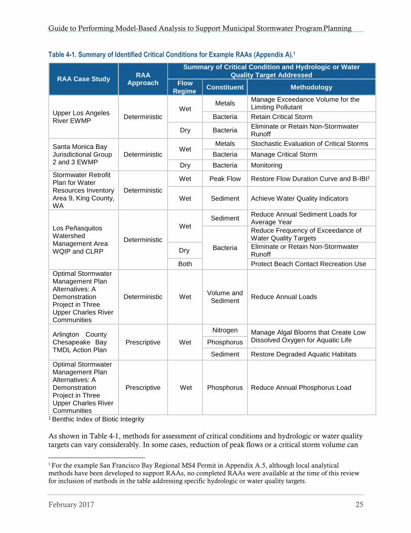
Guide to Performing Model-Based Analysis to Support Municipal Stormwater Program Planning
Table 4-1. Summary of Identified Critical Conditions for Example RAAs (Appendix A).1
1 Benthic Index of Biotic Integrity
As shown in Table 4-1, methods for assessment of critical conditions and hydrologic or water quality
targets can vary considerably. In some cases, reduction of peak flows or a critical storm volume can
1 For the example San Francisco Bay Regional MS4 Permit in Appendix A.5, although local analytical
methods have been developed to support RAAs, no completed RAAs were available at the time of this review
for inclusion of methods in the table addressing specific hydrologic or water quality targets.
February 2017 25
RAA Case Study
RAA
Approach
Summary of Critical Condition and Hydrologic or Water
Quality Target Addressed
Flow
Regime Constituent Methodology
Upper Los Angeles River EWMP
Deterministic
Wet
Metals Manage Exceedance Volume for the Limiting Pollutant
Bacteria Retain Critical Storm
Dry Bacteria Eliminate or Retain Non-Stormwater Runoff
Santa Monica Bay Jurisdictional Group 2 and 3 EWMP
Deterministic
Wet
Metals Stochastic Evaluation of Critical Storms
Bacteria Manage Critical Storm
Dry Bacteria Monitoring
Stormwater Retrofit Plan for Water Resources Inventory Area 9, King County, WA
Deterministic
Wet Peak Flow Restore Flow Duration Curve and B-IBI1
Wet
Sediment
Achieve Water Quality Indicators
Los Peñasquitos Watershed Management Area WQIP and CLRP
Deterministic
Wet
Sediment Reduce Annual Sediment Loads for Average Year
Bacteria
Reduce Frequency of Exceedance of Water Quality Targets
Dry Eliminate or Retain Non-Stormwater Runoff
Both Protect Beach Contact Recreation Use
Optimal Stormwater Management Plan Alternatives: A Demonstration Project in Three Upper Charles River Communities
Deterministic
Wet
Volume and
Sediment
Reduce Annual Loads
Arlington County Chesapeake Bay TMDL Action Plan
Prescriptive
Wet
Nitrogen Manage Algal Blooms that Create Low Dissolved Oxygen for Aquatic Life Phosphorus
Sediment Restore Degraded Aquatic Habitats
Optimal Stormwater Management Plan Alternatives: A Demonstration Project in Three Upper Charles River Communities
Prescriptive
Wet
Phosphorus
Reduce Annual Phosphorus Load

Guide to Performing Model-Based Analysis to Support Municipal Stormwater Program Planning
be demonstrated to be protective of biological or water quality targets. For these cases, reduction of the critical flow or volume can be proven through the RAA to provide sufficient reductions of impacts to biological conditions or pollutants to meet water quality targets. The King County Stormwater Retrofit Plan for Water Resources Inventory Area 9 (Appendix A.2) provides an example methodology used to address critical conditions to protect biological conditions. For the example RAA summarized in Appendix A.1 for the Upper Los Angeles River Enhanced Watershed Management Plan, the MS4 permit required that pollutants be in compliance with water quality targets for 90 percent of all wet-weather conditions over a recent 10-year period (wet weather conditions were defined as the highest 10 percent of instream flows). Stormwater improvement goals for the RAA were identified using a three-step process. First, modeled flow, pollutant concentrations, and water quality standards were plotted together over a ten-year period. Second, Exceedance Volumes (EV) were calculated for each wet-weather event as the sum of flows during times when the modeled concentrations exceeded the water quality standard (Figure 4-5). Finally, the critical condition was identified as the 90th percentile wet-weather EV. Expressing water quality
conditions on a volumetric basis allowed for normalized comparison among pollutants. The pollutant with the highest EV was identified as the limiting pollutant for the critical condition (Figure 4-6). Where multiple pollutants are being managed, the RAA can target the limiting pollutant because it can be demonstrated that controlling it addresses the other pollutants of concern. The limiting pollutant will therefore drive the selection of necessary BMPs to capture its associated EV, and the BMPs will be sufficient for capturing the EV associated with all other relevant pollutants.
Figure 4-5 Example Illustration for how Exceedance Volume is Derived for Metals (ULAR WMG 2016).
26 February 2017

Guide to Performing Model-Based Analysis to Support Municipal Stormwater Program Planning
Figure 4-6. Identifying the Limiting Pollutant for the RAA Critical Condition using EVs (ULAR WMG 2016).
Municipalities should always consult with the permitting agency on the selection of appropriate critical conditions and hydrologic or water quality targets to be addressed by an RAA, which may also be specified in the MS4 permit, relevant TMDLs, or local guidance. Where TMDLs have not been developed that quantify wasteload allocations for the MS4 permit, methods for determining stormwater improvement goals can have similarities to methods for calculating TMDLs and associated allocations. Therefore, there are multiple guidance documents that municipalities can reference to develop methods to address Element 3, including but not limited to the following:
Handbook for Developing Watershed Plans to Restore and Protect Our Waters (USEPA 2008)
Protocol for Developing Nutrient TMDLs (USEPA 1999a)
Protocol for Developing Pathogen TMDLs (USEPA 2001)
Protocol for Developing Sediment TMDLs (USEPA 1999b)
PCB TMDL Handbook (USEPA 2011a)
TMDLs with Stormwater Sources: A Summary of 17 TMDLs (USEPA 2007)
Helpful Practices for Addressing Point Sources and Implementing TMDLs in NPDES Permits
(USEPA 2015)
4.4 Element 4: Demonstration that Management Actions Will Result
in Attainment of Goals
Element 4 involves the quantification of the benefits of BMPs in terms of demonstrating capability to attain stormwater improvement goals and requirements identified in Element 3. This progress can be demonstrated in various ways, and typically include estimates of reduction of storm flows, pollutant loads, or pollutant concentrations over time resulting from an array of proposed management actions. Analytical methods for quantifying these reductions can range from simple calculations of
BMP effectiveness to more robust mechanistic computer modeling. It is important that the selected
February 2017 27

Guide to Performing Model-Based Analysis to Support Municipal Stormwater Program Planning
method have the capability to delineate necessary flow, loading, or concentration reductions at geographical scales and timesteps specified in applicable permits and associated TMDLs and/or water quality standards. Appendix A includes several example RAAs that vary in the methodologies used.
As shown in Figure 1-2, separate efforts of the stormwater management plan typically identify opportunities for nonstructural or structural BMPs. Nonstructural BMPs may include such practices as street sweeping, pollutant source control, water conservation efforts that impact urban lawn irrigation, public education, etc. Structural BMPs may include distributed stormwater capture projects such as green infrastructure or Low Impact Development (LID), or regional stormwater capture facilities that treat or infiltrate stormwater runoff from a larger drainage area. An example of a regional stormwater capture facility could be an underground infiltration gallery placed in a public park, which receives stormwater that is conveyed from the storm sewer system. A stormwater management plan may identify a combination of opportunities for nonstructural and structural
BMPs (including both distributed and regional stormwater capture). The following sections discuss model considerations for nonstructural and structural BMPs.
Quantification of Benefits of Nonstructural BMPs Nonstructural BMPs are typically implemented across the area of RAA analysis and can vary spatially in terms of density or intensity. Numerous nonstructural BMPs are often implemented in combination as a stormwater management program. As a result, it can be challenging to estimate the effectiveness of individual or specific combinations of nonstructural BMPs. The following are methods typically used to represent the effectiveness of nonstructural BMPs in terms of demonstrating stormwater or pollutant load reductions to support RAAs:
Assumptions for Nonstructural BMP Effectiveness based on Literature or Studies – Several studies have been undertaken throughout the U.S. that attempt to quantify the effectiveness of
individual nonstructural BMPs, which have been documented by state/federal agencies, municipalities, and academia. These studies vary in the type of BMPs assessed, pollutants analyzed, and the methods used to estimate benefits. Typical methods for measuring effectiveness rely on monitoring of stormwater and water quality, which can be costly and challenging given the characteristics of nonstructural BMPs summarized above. As a result, many RAAs formulate assumptions for nonstructural BMP effectiveness based on results reported in past studies or literature. For example, the Massachusetts General Phase II MS4 Permits (Appendix A.7) provides methods for estimating nutrient load reductions associated with enhanced street sweeping programs, catch basin cleaning, and organic waste and leaf litter collection programs that are based on assumptions from various literature sources. To address the Los Angeles County Phase I MS4 Permit (Appendix A.1), EWMPs made assumptions for effectiveness of nonstructural BMP programs as a whole, representing a combination of practices. The burden of proof for these EWMPs was based on an extensive list of new
nonstructural programs that were proposed, with pollutant reductions to be verified through
extensive monitoring programs also reported in the plans.
Modeled BMP Effectiveness - Some of the models typically used for RAAs have the capability to represent a subset of nonstructural BMPs (e.g., street sweeping) to estimate pollutant reductions. However, these models rely heavily on literature or local monitoring studies to base modeling assumptions. For the example RAA supporting the Los Peñasquitos Watershed Management Area WQIP and CLRP (Appendix A.3), modeling was performed to quantify
watershed-wide pollutant reductions resulting from multiple nonstructural practices, including
28 February 2017

Guide to Performing Model-Based Analysis to Support Municipal Stormwater Program Planning
street sweeping, catch basin cleaning, and a rain barrel incentive program, downspout disconnection incentive program, and irrigation runoff reduction program for residential and commercial areas. However, modeling assumptions for this RAA relied heavily on multiple special studies previously performed by the City of San Diego to quantify the benefits of these BMPs. Without substantial information to base such modeling assumptions, many
municipalities are limited to the literature-based assumptions above.
Quantification of Benefits of Structural BMPs Separate from the RAA (Figure 1-2), stormwater management planning efforts should identify opportunities for the placement of structural BMPs, which may include characterization of the BMP drainage area, site conditions, and proposed BMP type for individual projects. Stormwater management planning efforts can also identify design considerations of BMPs that can support modeling efforts. Appendix A.7 shows an example typical BMP design used to support RAAs addressing the Massachusetts General Phase II MS4 Permits. The siting of structural BMP
opportunities can be performed through GIS analysis that considers multiple characteristics of the site (e.g., soil infiltration rate, available space, slope) and associated BMP drainage areas (e.g., size, imperviousness) that influence the likelihood that a BMP will be selected, constructed, and provide meaningful performance. The robustness of this analysis is often dictated by the availability of local GIS datasets. Some RAA modeling tools include capabilities to site BMP opportunities, which may be considered in lieu of or in combination with GIS analysis techniques. For example, GreenPlan-IT (Appendix A.5) includes a GIS-based Site Locator Tool that combines the physical properties of different types of green infrastructure with watershed GIS information to identify and rank potential locations for green infrastructure implementation.
Once BMP opportunities and design considerations are identified by stormwater management planning efforts, this information is then used as input to RAA analytical methods to quantify stormwater flow or pollutant reductions expected to occur following BMP implementation. This will
require representation of the routing network for BMP locations, their associated drainage areas, and placement within the area addressed by the RAA to provide assessment of area-wide benefits. The methodology will also likely require characterization of the BMP drainage areas to provide assessment of storm flows and pollutant loads to the individual BMPs. For a stormwater management plan that includes a handful of BMPs, the explicit representation of the individual BMPs may be straightforward for model representation. However, for plans that address large watersheds that require representation of hundreds of BMPs, including many distributed BMPs within small drainage areas, model representation can present some challenges. To address model representation of a large number of BMP opportunities, assumptions can be made to reduce the complexity of the problem and prevent the need to individually represent each distributed BMP. Appendix A.2 and A.7 include example structural BMP routing networks used to model large numbers of distributed BMP opportunities for RAAs supporting the King County Stormwater Retrofit Plan for WRIA 9 and the Massachusetts General Phase II MS4 Permits, respectively.
The methods for representing BMP processes and associated stormwater and pollutant reductions vary considerably based on the analytical approach selected. As a result, documentation of the various models should be consulted to more fully understand the considerations for modeling BMPs.
Once the BMPs are configured within a model, the model can then be used to test alternative BMP scenarios and the necessary reductions of storm flows or pollutants to meet stormwater improvement goals from Element 3. This requires model simulation of the same critical condition used in Element 3 to provide direct comparison to stormwater or pollutant reduction targets. Consistent with the
stormwater improvement goals established in Element 3, the model output for the BMP scenarios
February 2017 29

Guide to Performing Model-Based Analysis to Support Municipal Stormwater Program Planning
may consider reductions of stormwater peak flows or volumes, pollutant concentrations or loads, or other metrics that coincide with water quality targets. Example RAA results for the King County Stormwater Retrofit Plan for WRIA 9 are shown in Appendix A.2, illustrating how BMP model scenarios can be used to demonstrate attainment of water quality and hydrology targets. Model results can also be presented spatially to communicate where and to what degree BMPs will be implemented. Figure 4-7 shows the King County RAA results with BMP volumes presented spatially for the 2040 future land use/development scenario with full stormwater management. This map provides an indication of the level of BMP implementation needed throughout the watershed to meet the stormwater improvement goals.
Figure 4-7. WRIA 9 Study Area BMP Storage in Watershed Inches2 for Full Stormwater Management in 2040
(King County 2014a).
The analytical method may also need to show improvements to stormwater to meet progressive goals over time. This is typical of stormwater management plans that address TMDL or MS4 permit requirements for phased pollutant reductions over time to meet WQBELs or wasteload allocations. As a result, the methodology will require simulation of multiple scenarios with increasing levels of
BMPs, and estimation of resulting stormwater flow or pollutant load reduction. Appendix A.3
2 Watershed inches are calculated as the amount of BMP volume needed divided by the area of developed land
use in the study area.
30 February 2017

Guide to Performing Model-Based Analysis to Support Municipal Stormwater Program Planning
shows results of an RAA performed for the Los Peñasquitos WQIP that demonstrates the increasing and diverse types of BMPs planned over future years to meet phased sediment load reduction targets defined by WQBELs and the TMDL wasteload allocation.
For stormwater management plans that include cooperative efforts of multiple municipalities, the MS4 permit may require that separate BMP implementation plans, stormwater improvement goals, and RAAs be performed for each individual participant. This was the case for plans developed in the Los Angeles and San Diego Regions to address their respective MS4 permits, as discussed in Appendix A.1 and A.3, respectively. For the example Los Peñasquitos WQIP in the San Diego Region, four municipalities and the California Department of Transportation participated in the plan. As a result, separate BMP implementation plans and RAAs needed to be reported for each participant. This required separate modeling efforts to evaluate BMPs and associated pollutant reductions for each individual jurisdiction.
For municipalities with a large jurisdictional area and many opportunities or alternatives for structural BMP implementation, certain RAA analytical methods can provide additional capability to assess numerous scenarios representing alternative BMP implementation strategies. As discussed in Section 3.1, these approaches can provide automated comparison of multiple implementation scenarios and direct comparison of pollutant reductions and costs to support optimization of the plan and selection of the most cost-effective combination of BMPs to meet targets. Although not central to the basic requirements of the RAA to address MS4 permit provisions, this capability can have an important role in decision-making and strategizing of BMPs to be incorporated within a stormwater management plan. Figure 4-8 shows an example cost optimization performed for two jurisdictions in the Upper Los Angeles River EWMP (Appendix A.1). Separate cost optimizations were performed for each permittee participating in the EWMP. The following example MS4 permits in Appendix A provide additional summary of RAA analytical approaches that include methods for BMP cost optimization:
Los Angeles County Phase I MS4 Permit
San Diego Region Phase I MS4 Permit
Washington Phase I MS4 Permit
Massachusetts General Phase II MS4 Permits
San Francisco Bay Area Regional MS4 Permit
February 2017 31

Guide to Performing Model-Based Analysis to Support Municipal Stormwater Program Planning
Figure 4-8. Example Cost-Optimization for Two Jurisdictions in the Upper Los Angeles River EWMP (ULAR
WMG 2016)3
3 This example shows the set of optimized BMP solutions for two ULAR EWMP jurisdictions that drain to
Arroyo Seco. Each optimization curve represents over 1 million BMP scenarios that were evaluated for cost-
effectiveness.
32 February 2017

Guide to Performing Model-Based Analysis to Support Municipal Stormwater Program Planning
4.5 Element 5: Documentation of Results that Inform Implementation
and Tracking
Apart from the RAA, a stormwater management plan can document information for a BMP implementation strategy that can inform future implementation efforts and the tracking of implementation progress (Figure 1-2). This can include maps of BMP locations, design information, and other details developed through the planning process. The RAA can provide specific results that will strengthen the documentation of the BMP implementation strategy, including key information used to link BMP effectiveness to reductions in stormwater or pollutant loads. Depending on the RAA analytical approach used, information on BMPs incorporated within the RAA can be reported in varying methods and levels of detail. As discussed in Section 3, proper attention should be placed on selection of an RAA analytical approach that provides necessary information to meet reporting requirements of the MS4 permit. If the permit does not provide sufficient guidance on reporting and
documentation of the BMP implementation strategy associated with the RAA, the permitting authority should be consulted to gain an understanding of expectations.
For Prescriptive Approaches for RAAs, expectations are typically clear in the MS4 Permit or associated guidance in terms of the detail and format for documenting the RAA results based on methods and tools developed by the permitting authority. Appendix A includes examples of Prescriptive Approaches for three MS4 permits that summarize different methods to report outcomes of the RAA.
For MS4 Permits that require Deterministic Approaches to RAAs, varying guidance is provided by permitting authorities in terms of documenting results of the RAA. Of these approaches summarized in Appendix A, the Los Angeles County Phase I MS4 Permit and guidance prepared by the LARWQCB (2014) provided the most specificity in terms of expectations and detail to be documented for the RAA. Appendix A.1 includes example documentation of the RAA results for the Upper Los Angeles River EWMP, which demonstrates how RAA optimization results (Section 4.4.2) can be used to inform the documented BMP implementation strategy. The RAA results reported for the Upper Los Angeles River EWMP provide details on the BMPs to be implemented within specific subwatersheds and municipal jurisdictions to cost-effectively meet TMDL compliance targets. These results are documented through the reporting of stormwater volumes managed (through treatment or capture) by the different categories of BMPs in separate subwatersheds and municipal jurisdictions to meet these targets over time. The EWMP also reports the capacity of storage within the BMPs (BMP capacity) to provide the needed stormwater volumes managed over time, which can guide implementation and planning of the BMPs (Figure 4-9). Similar RAA results were reported for the King County Stormwater Retrofit Plan for WRIA 9, as shown spatially in Figure 4-7. Through the adaptive management process, future opportunities may be identified that can change the combination of BMP capacities or locations, but the ultimate jurisdictional or watershed goals for stormwater volume capture or pollutant load reduction remain
valid to guide implementation and tracking of implementation efforts.
February 2017 33

Guide to Performing Model-Based Analysis to Support Municipal Stormwater Program Planning
San Gabriel Final EWMP Compliance by 2037 100
90
80
70
60
50
40
30
20
10
0
Rio Hondo
Control Measure Scheduling 100
90
80
70
60
50
40
30
20
10
0
2017 2024 2028 2032 2037
40 34 34
6 32 32 32
16 3 15.0 5 5 5 3
Interim Final
Rio Hondo
Figure 4-9. Example Scheduling of BMP Implementation Strategy to Meet TMDL Milestones (ULAR WMG
2016).4
The BMP information that can be reported by the RAA can also supporting the tracking of implementation or progress towards attainment of planning goals. For example, if stormwater volumes managed or pollutant load reductions are the goals of the stormwater management plan,
then these same quantitative metrics can be periodically evaluated to track implementation. Similar methods used in the RAA to estimate BMP performance can be used to support methods for tracking of these quantitative metrics as they are implemented. Alternatively, monitoring can be
performed to support estimates of BMP performance. As BMP projects are implemented, these
4 The bars represent the LID, green street and regional BMP capacity to be implemented over time to achieve
each water quality milestones established by TMDLs, the MS4 Permit, and the EWMP. The top panel
represents the BMPs to achieve final compliance in 2037; the bottom panel schedules them through 2037.
Results in the figure are shown for the City of San Gabriel. Similar results were presented in the EWMP for
each municipal jurisdiction and watershed addressed by the plan.
34 February 2017
Stru
ctu
ral B
MP
Cap
acit
y (a
cre-
ft)
Stru
ctu
ral B
MP
Cap
acit
y (a
cre-
ft)
31
%
50
%
Met
als
Toxi
cs
Bac
teri
a
78

Guide to Performing Model-Based Analysis to Support Municipal Stormwater Program Planning
methods can be applied to estimate each project’s reduction of stormwater volume or pollutant loads, and the collective reductions associated with a suite of BMPs can be added and compared to scheduled goals identified in the stormwater management plan or established by the MS4 permit or TMDLs. For example, to meet requirements of the Los Angeles County Phase I MS4 Permit, RAAs performed throughout the region included documentation of results with quantitative metrics used to provide reasonable assurance that the BMP implementation strategies will result in attainment of pollutant reductions. As summarized above for the Upper Los Angeles River EWMP, many of these EWMPs used volumes managed as the measurable metric. As a requirement of the MS4 permit, each permittee and EWMP group reports annually to the permitting authority their progress in terms of BMP implementation, which can be measured based on these metrics. As summarized in Appendix A.7, a similar process is used to track implementation of Phosphorus Control Plans addressing the Massachusetts General Phase II MS4 Permits, which requires periodic performance evaluations to quantitatively assess the progress and effectiveness of BMP implementation strategies. Section 5.1 summarizes additional considerations for tracking of
implementation.
The quantitative tracking of BMP implementation can also support effective adaptive management and continued improvement and refinement of BMP implementation strategies to ensure successful attainment of planning goals. Traditional assessments that have supported the tracking of BMP implementation or water quality improvement have relied on water quality monitoring combined with an inventory of BMPs that have been implemented or other qualitative/quantitative information for program effectiveness assessment. These traditional approaches can be combined with quantitative tracking of BMP implementation, based on metrics established by the RAA, to continuously evaluate the trajectory of the BMP implementation strategy to assess if refinements or changes are required. This can inform cost-effective BMP planning and periodic updates of the stormwater management plan over time that capitalize on lessons learned.
In summary, beyond meeting the requirements of the MS4 Permit, RAAs can provide important information that can further support BMP project planning and tracking. Depending on the analytical method used, information produced by the RAA can also inform future decisions regarding selection of cost-effective BMPs for implementation that maximize benefits, conceptual design or sizing of individual structural BMP projects, or development of project costs estimates to
support capital improvement planning or investigation of funding opportunities.
5 TRANSITIONING FROM PLANNING TO
IMPLEMENTATION
As municipalities transition from the development of stormwater management plans to the implementation of associated BMP implementation strategies, municipalities will face new
challenges associated with the realities of implementation and demonstration of continued success of the plan. Section 4.5 summarized potential needs for RAA documentation in terms of quantitative metrics that can support future tracking of BMP implementation and inform the adaptive management process for continued improvement of the plan over time. The RAA or analytical approach can support additional efforts associated with implementation, including capital improvement planning, individual project planning, engineering, construction, and operation and maintenance (O&M), financial planning, and integrated water resources planning. As discussed in Section 3, the needs of these future efforts can be considered in the selection and development of the RAA analytical method to provide necessary information or technical capability to potentially serve as a decision-framework or assist in the next phase of implementation of the stormwater
February 2017 35

Guide to Performing Model-Based Analysis to Support Municipal Stormwater Program Planning
management plan. The following sections briefly summarize considerations for these future planning
efforts.
5.1 Implementation Tracking and Adaptive Management
Section 4.5 discussed the potential need to provide quantitative metrics and other information to support the tracking of implementation of the stormwater management plan. Quantitative tracking of BMP implementation can support MS4 permit reporting requirements or the adaptive management process that guides continued revisions or updates of the stormwater management plan over time and adjustments of the RAA approach. Each municipality should review the reporting requirements in their MS4 permit to understand the future needs, which may require regularly scheduled reporting of implementation progress or evaluation of the performance of the plan, including specific methods or quantitative procedures to be used. For the example, during development of the RAA for the Upper Los Angeles River EWMP (Appendix A.1), the permittees understood the quantitative burden of proof that would be required by both the RAA and the following annual reports required by the MS4 permit to document progress towards attaining goals and implementing BMPs. To meet these requirements, quantitative goals were established in the form of volumes managed with BMPs to meet pollutant reduction goals (Section 4.5). To support implementation tracking, the Los Angeles County Flood Control District has initiated the development of the Watershed Reporting Adaptive Management and Planning System (WRAMPS), a public domain, web-based system that will allow each individual permittee in the county to enter BMP information (e.g., BMP type and size, characteristics of drainage area, infiltration rate), and the tool will calculate stormwater volumes managed that are in line with methods used to calculate quantitative goals in the RAA. Each permittee can input all BMPs implemented within their jurisdiction, and WRAMPS will compile information to support development of annual reports and assessment of progress. As the EWMP is updated in the future as part of the adaptive management process, the necessary data will already be compiled for BMPs that have been implemented, allowing and iterative process for streamlined updates and adjustments to the RAA to represent the
new managed condition or improve model predictions. As a holistic, planning, tracking and reporting system, the iterative approach currently employed in the Central Coast Region (Appendix A.4) is also purposely designed to meet the short and long term needs of managing, tracking, and accounting of the implementation of structural and non-structural BMPs to demonstrate water quality improvement progress and annual regulatory requirements.
5.2 Stormwater Program Planning Frameworks that Support
Successful Implementation
Although a stormwater management plan designed to meet MS4 permit requirements may be robust, these plans typically lack much of the information needed to support necessary critical decisions regarding funding for implementation. Funding for stormwater management is often in competition with other municipal services that have comprehensive capital improvement plans
and/or asset management plans that provide specificity for individual project engineering needs and detailed justification of funding needs. Although a cost estimate may be included as part of the stormwater management plan, these estimates are often coarse and lack the burden of proof needed by decision-makers and elected officials to justify the investment. If funding for the stormwater management plan requires additional revenue or appropriation of general funds, a detailed plan is often needed to support these funding decisions, including specific information on the design, construction, O&M, and all other costs associated with each individual project. Although development of the stormwater management plan addressing the MS4 permit may not include this information, the planning process can consider the future needs for capital improvement planning,
36 February 2017

Guide to Performing Model-Based Analysis to Support Municipal Stormwater Program Planning
financial planning, or asset management to provide an analytical method that can support these efforts. The following are examples of capital improvement planning and asset management projects that have been linked to stormwater management planning efforts:
City of San Diego Watershed Asset Management Plan and Masterplans - Parallel to efforts preparing WQIPs to address the San Diego Region Phase I MS4 Permit (Appendix A.3), the City of San Diego (2013) developed the Watershed Asset Management Plan to document the current state of assets, project long-term rehabilitation and replacement requirements, and serve as a roadmap for actions that address flood risk management and water quality. Development of the Watershed Asset Management Plan has been closely coordinated with the WQIP to comprehensively evaluate costs and funding strategies to meet future goals.
Upon completion of WQIPs addressing San Diego watersheds, the City initiated development of processes for developing masterplans for each watershed that provide improved information to support planning and engineering efforts, coupling stormwater projects with other capital improvement projects planned by the City to capture efficiencies
in spending. Models used to support the RAAs have been used as analytical tools supporting both the WAMP and watershed masterplanning.
City of Los Angeles Capital Improvement Planning and One Water LA - The City of Los Angeles (2015) has begun capital improvement planning efforts in the development of a Stormwater and Green Infrastructure 5-Year Capital Improvement Plan that combines projects across five separate watersheds with separate stormwater management plans, estimates costs for multiple project phases from design through construction, couples BMP projects with other currently planned storm drain projects, and prioritizes the most cost- effective projects for the first five years of the EWMP implementation schedule. Currently, the City is developing the One Water LA Plan as a long-term, integrated framework for managing the City’s watersheds, water resources, and water facilities. The One Water LA Plan will incoporate projects included in the EWMPs with a goal of integrating project planning with other multiple planning objectives addressing a range of benefits, from integrated management of water resources to improvement of watershed health. Models used to support the RAAs have been used to support both planning efforts above.
Whether the audience are city managers, elected officials, voters, or state or federal agencies soliciting grant opportunities, individuals who make funding decisions want to know what they are receiving for the investment. Stormwater managers have the burden of proof to make this case, which often require comprehensive planning efforts similar to the examples above. Stormwater management that focuses on water quality has traditionally been out-competed by water supply, wastewater, flood control, and other municipal services in terms of educating audiences on the importance of investments and the benefits received. Recent efforts have focused more on integrated watershed or regional planning efforts that emphasize management of all water as a collective resource to collaboratively identify water management solutions that concurrently achieve social, environmental, and economic objectives. The One Water LA Plan is a local example of an
integrated planning approach that serves the dual purpose of responsibly managing local water resources in Los Angeles, while providing a forum for educating the public on the importance of all
sustainable water management, including stormwater and water quality.
State and federal agencies have also recognized the importance of integrated water management, and have encouraged collaborative efforts with local agencies to develop watershed plans that identify multi-benefit projects that pool funding resources. For example, the State of California (2014) released the California Water Action Plan, which identifies the challenges of sustainably managing water resources, and goals and actions needed to collaboratively plan and identify
February 2017 37

Guide to Performing Model-Based Analysis to Support Municipal Stormwater Program Planning
management solutions. To specifically address integrated stormwater management, the SWRCB (2015) established guidance on the development of a Stormwater Resource Plan as a condition of receiving funds for stormwater projects from any bond measure approved by voters. The Stormwater Resource Plan is a watershed-based approach for integrated stormwater management that considers waters quality and other aspects of aquatic resource protection, flood control, water supply, habitat conservation, among others. The SWRCB guidelines for Stormwater Resource Plans also require methods for analysis of water quality projects based simulation of proposed watershed-based outcomes using modeling, calculations, pollutant mass balances, and/or other methods of analysis. Such an analysis is equivalent to the RAA supporting the stormwater management plan addressing an MS4 permit. Therefore, RAAs can serve the greater purpose of fulfilling requirements of state or
regional stormwater resource planning efforts that can support grant funding of proposed projects.
In summary, the RAA can serve as an analytical tool supporting a range of engineering, asset management, and financial planning activities beyond the stormwater management plan. Linking
the RAA with other water management, economic, and financial planning tools, the resulting evolving stormwater program planning framework can support quantitative assessment of the costs and benefits of stormwater projects to inform long-term planning objectives, as well as coupling of stormwater projects with other water resource project opportunities to capitalize on multiple project benefits and improve funding opportunities.
6 REFERENCES
Arlington County. 2015. Arlington County Chesapeake Bay TMDL Action Plan. Arlington County,
Arlington, VA.
Bicknell, B. R., , J. C. Imhoff, A. S. Donigian, R. C. Johanson. 1997. Hydrological Simulation Program – FORTRAN (HSPF), User’s Manual For Release 11. EPA – 600/R-97/080. U.S.
Environmental Protection Agency, Athens, GA.
City of San Diego. 2013. Watershed Asset Management Plan. City of San Diego Transportation and
Storm Water Department, San Diego, CA.
City of Los Angeles. 2015. City of Los Angeles Stormwater and Green Infrastructure 5-Year Capital
Improvement Plan. City of Los Angeles, Bureau of Sanitation, Watershed Protection Division,
Los Angeles, CA.
Commonwealth of Virginia. 2010. Chesapeake Bay TMDL Phase I Watershed Implementation Plan.
Commonwealth of Virginia, Office of the Governor, Richmond, VA.
Commonwealth of Virginia. 2012. Chesapeake Bay TMDL Phase II Watershed Implementation Plan.
Commonwealth of Virginia, Office of the Governor, Richmond, VA.
DeGasperi, C.L., Berge, H. B., Whiting, K. R., Burkey, J. J., Cassin, J. L. and Fuerstenberg, R. R. 2009. Linking Hydrologic Alteration to Biological Impairment in Urbanizing Streams of the Puget Lowland, Washington, USA. Journal of the American Water Resources Association
(JAWRA), 45: 512-533. Doi: 10.1111/j.1752-1688.2009.00306.x.
Geosyntec Consultants. 2008. A User’s Guide for the Structural BMP Prioritization and Analysis Tool
(SBPAT v1.0). Prepared for Heal the Bay, City of Los Angeles, and Los Angeles County
Department of Public Works by Geosyntec Consultants, Los Angeles, CA.
38 February 2017

Guide to Performing Model-Based Analysis to Support Municipal Stormwater Program Planning
Geosyntec Consultants. 2012. A User’s Guide for the Structural BMP Prioritization and Analysis Tool
(OCTA-SBPAT v1.0). Prepared for Orange County Transportation Authority by Geosyntec
Consultants, Huntington Beach and Los Angeles, CA.
Horner, R.R. 2013. Development of a Stormwater Retrofit Plan for Water Resources Inventory Area 9: Flow
and Water Quality Indicators and Targets. Prepared for King County, Water and Land
Resources Division, Seattle, WA.
Huber, W.C., and R.E. Dickinson. 1988. Storm Water Management Model Version 4, User’s Manual.
EPA/600/3-88/001a (NTIS PB88-236641/AS), U.S. Environmental Protection Agency, Athens, GA.
King County. 2013. Watershed Model Development for Water Resources Inventory Area (WRIA) 9
Stormwater Retrofit Planning Project. King County Department of Natural Resources and
Parks, Water and Land Resources Division. Seattle, WA.
King County. 2014a. Development of a Stormwater Retrofit Plan for Water Resources Inventory Area 9:
SUSTAIN Modeling Report. King County Department of Natural Resources and Parks, Water
and Land Resources Division. Seattle, WA.
King County. 2014b. Development of a Stormwater Retrofit Plan for Water Resources Inventory Area 9:
Comprehensive Needs and Cost Assessment and Extrapolation to Puget Sound. King County
Department of Natural Resources and Parks, Water and Land Resources Division. Seattle, WA.
LACDPW (Los Angeles County Department of Public Works). 2010a. Los Angeles County Watershed
Model Configuration and Calibration—Part I: Hydrology. Prepared for LACDPW, Watershed
Management Division, Los Angeles County, CA, by Tetra Tech, Pasadena, CA.
LACDPW (Los Angeles County Department of Public Works). 2010b. Los Angeles County Watershed
Model Configuration and Calibration—Part II: Water Quality. Prepared for LACDPW,
Watershed Management Division, Los Angeles County, CA, by Tetra Tech, Pasadena, CA.
LACDPW (Los Angeles County Department of Public Works). 2011. Phase II Report: Development of
the Framework for Watershed-Scale Optimization Modeling. Prepared for LACDPW, Watershed
Management Division, Los Angeles County, CA, by Tetra Tech, Pasadena, CA.
LARWQCB (Los Angeles Regional Water Quality Control Board). 2002. Santa Monica Bay Beaches
Wet-Weather Bacteria TMDL. LARWQCB, Los Angeles, CA.
LARWQCB (Los Angeles Regional Water Quality Control Board) and USEPA (U.S. Environmental Protection Agency). 2005a. Total Maximum Daily Load for Metals in Ballona
Creek. LARWQCB, Los Angeles, CA, and USEPA Region 9, San Francisco, CA.
LARWQCB (Los Angeles Regional Water Quality Control Board) and USEPA (U.S. Environmental Protection Agency). 2005b. Total Maximum Daily Load for Metals - Los Angeles
February 2017 39

Guide to Performing Model-Based Analysis to Support Municipal Stormwater Program Planning
River and Tributaries. LARWQCB, Los Angeles, CA, and USEPA Region 9, San Francisco,
CA.
LARWQCB (Los Angeles Regional Water Quality Control Board). 2006. Total Maximum Daily
Loads for Bacterial Indicator Densities in Ballona Creek, Ballona Estuary, & Sepulveda Channel.
LARWQCB, Los Angeles, CA.
LARWQCB (Los Angeles Regional Water Quality Control Board). 2010. Los Angeles River Watershed
Bacteria Total Maximum Daily Load. LARWQCB, Los Angeles, CA.
LARWQCB (Los Angeles Regional Water Quality Control Board) and USEPA (U.S. Environmental Protection Agency). 2011. Dominguez Channel and Greater Los Angeles and Long
Beach Harbor Waters Toxics Total Maximum Daily Loads. LARWQCB, Los Angeles, CA, and
USEPA Region 9, San Francisco, CA.
LARWQCB (Los Angeles Regional Water Quality Control Board) 2012. NPDES Permit No. CAS004001 Waste Discharge Requirements for Municipal Separate Storm Sewer System (MS4)
Discharges within the Coastal Watersheds of Los Angeles County, except those Discharges Originating
from the City of Long Beach MS4. Order No. R4-2012-0175. LARWQCB, Los Angeles, CA.
LARWQCB (Los Angeles Regional Water Quality Control Board). 2014. Guidelines for Conducting Reasonable Assurance Analysis in a Watershed Managmeent Program, Including an Enhanced
Watershed Management Program. LARWQCB, Los Angeles, CA.
LP WMA Responsible Agencies (Los Peñasquitos Watershed Management Area Responsible Agencies). 2015. Los Peñasquitos Watershed Management Area Water Quality Improvement Plan
and Comprehensive Load Reduction Plan. Prepared for the LP WMA Responsible Agencies by
Amec Foster Wheeler Environment & Infrastructure, Inc., San Diego, CA.
Lumb, A.M., R.B. McCammon, and J.L. Kittle. User’s Manual for an Expert System (HSPEXP) for
Calibration of the Hydrologic Simulation Program – FORTRAN. U.S. Geological Survey, Reston,
VA.
MassDEP (Massachusetts Department of Environmental Protection). 2008. Structural BMP
Specifications for the Massachusetts Stormwater Handbook. Volume 2, Chapter 2. Massachusetts
Department of Environmental Protection, Worcester, MA.
MassDEP (Massachusetts Department of Environmental Protection) and USEPA (U.S. Environmental Protection Agency). 2007. Total Maximum Daily Load for Nutrients in the Lower
Charles River Basin, Massachusetts – CN 301.0. Prepared for MassDEP, Worcester, MA, and
USEPA Region 1, Boston, MA by Charles River Watershed Association, Weston, MA, and Numeric Environmental Services, Inc., Beverly Farms, MA.
MassDEP (Massachusetts Department of Environmental Protection) and USEPA (U.S. Environmental Protection Agency). 2011. Total Maximum Daily Load for Nutrients in the
Upper/Middle Charles River, Massachusetts – CN 272.0. MassDEP, Worcester, MA, and
USEPA Region 1, Boston, MA.
40 February 2017
Guide to Performing Model-Based Analysis to Support Municipal Stormwater Program Planning
Prince George’s County. 2005a. BMP/LID Decision Support System for Watershed-Based Stormwater
Management: Users Guide. Prepared for Prince George’s County, Department of
Environmental Resources, MD, by Tetra Tech, Inc., Fairfax, VA.
Prince George’s County. 2005b. BMP/LID Decision Support System for Watershed-Based Stormwater
Management: Step-by-Step Application Guide. Prepared for Prince George’s County,
Department of Environmental Resources, MD, by Tetra Tech, Inc., Fairfax, VA.
Prince George’s County. 2007. Prince George’s County BMPDSS Calibration/Validation using Field
Monitoring Data. Prepared for Prince George’s County, Department of Environmental
Resources, MD, by Tetra Tech, Inc., Fairfax, VA.
Riverson, J., K. Alvi, J. Zhen, R. Murphy. 2014. SUSTAIN Application User’s Guide for EPA Region
10. USEPA – Region 10, Office of Water and Watersheds, Seattle, WA.
Shen, J., A. Parker, and J. Riverson. 2004. A New Approach for a Windows-based Watershed Modeling System Based on a Database-supporting Architecture. Environmental Modeling and
Software, July 2004.
SDRWQCB (San Diego Regional Water Quality Control Board). 2010. Revised Total Maximum Daily Loads for Indicator Bacteria Project I – Twenty Beaches and Creeks in the San Diego Region
(Including Tecolote Creek). SDRWQCB, San Diego, CA.
SDRWQCB (San Diego Regional Water Quality Control Board). 2012. Total Maximum Daily Load
for Sedimentation in Los Peñasquitos Lagoon. SDRWQCB, San Diego, CA.
SDRWQCB (San Diego Regional Water Quality Control Board). 2015. NPDES Permit No. CAS0109266 – National Pollutant Discharge Elimination System (NPDES) Permit and Waste Discharge Requirements for Discharges from the Municipal Separate Storm Sewer Systems (MS4s)
Draining the Watersheds within the San Diego Region. Order No. R9-2013-001 as amended by
Order Nos. R9-2015-0001 and R9-2015-0100. SDRWQCB, San Diego, CA.
SMB JG2/JG3 EWMP Group (Santa Monica Bay Jurisdictional Group 2 and 3 Enhanced Watershed Management Program Group). 2016. Santa Monica Bay Jurisdictional Group 2 and
3 Enhanced Watershed Management Program. Prepared for the SMB EWMP Group by MWH,
Pasadena, CA.
State of California. 2014. California Water Action Plan. California Natural Resources Agency,
California Department of Food and Agriculture, and the California Environmental Protection Agency, Sacramento, CA.
Sutherland, R.C. 1995. Methodology for Estimating the Effective Impervious Area of Urban Watersheds. Watershed Protection Techniques, Vol. 2, No. 1.
SWRCB (California State Water Resources Control Board). 2005. A Process for Addressing Impaired
Waters in Calfifornia. S.B. 469 TMDL Guidance. SWRCB, Sacramento, CA.
SWRCB (California State Water Resources Control Board). 2015. Storm Water Resource Plan
Guidelines. SWRCB, Sacramento, CA.
February 2017 41

Guide to Performing Model-Based Analysis to Support Municipal Stormwater Program Planning
Tetra Tech and USEPA (U.S. Environmental Protection Agency). 2002. The Loading Simulation
Program in C++ (LSPC) Watershed Modeling System – User’s Manual. Tetra Tech, Fairfax, VA,
and U.S. Environmental Protection Agency, Washington, DC.
ULAR WMG (Upper Los Angeles River Watershed Management Group). 2016. Enhanced
Watershed Management Program (EWMP) for the Upper Los Angeles River. Prepared for the
ULAR WMG by Black and Veatch, Los Angeles, CA.
USEPA (U.S. Environmental Protection Agency). 1991. Modeling of Nonpoint Source Water Quality in
Urban and Non-urban Areas. EPA/600/3-91/039. USEPA, Office of Research and
Development, Washington D.C.
USEPA (U.S. Environmental Protection Agency). 1992. Compendium of Watershed-Scale Models for
TMDL Development. EPA841-R-92-002. USEPA, Office of Water, Washington D.C.
USEPA (U.S. Environmental Protection Agency). 1997. Compendium of Tools for Watershed
Assessment and TMDL Development. EPA841-B-97-006. USEPA, Office of Water, Washington
D.C.
USEPA (U.S. Environmental Protection Agency). 1999a. Protocol for Developing Nutrient TMDLs.
EPA841-B-99-007. USEPA, Office of Water, Washington D.C. November 1999.
USEPA (U.S. Environmental Protection Agency). 1999b. Protocol for Developing Sedimnet TMDLs. EPA841-B-99-004. USEPA, Office of Water, Washington D.C. November 1999.
USEPA (United States Environmental Protection Agency). 2000. BASINS Technical Note 6:
Estimating Hydrology and Hydraulic Parameters for HSPF. EPA-823-R00-012. USEPA, Office of
Water, Washington D.C. July 2000.
USEPA (United States Environmental Protection Agency). 2001. Protocol for Developing Pathogen
TMDLs. EPA-841-R-00-002. USEPA, Office of Water. January 2001.
USEPA (United States Environmental Protection Agency). 2002. Guidance for Quality Assurance
Project Plans for Modeling – EPA QA/G-5M. EPA/240/R-02/007. United States
Environmental Protection Agency. Office of Environmental Information. December 2002.
USEPA (U.S. Environmental Protection Agency). 2003. Fact Sheet: Loading Simulation Program in
C++. USEPA, Watershed and Water Quality Modeling Technical Support Center, Athens,
GA.
USEPA (United States Environmental Protection Agency). 2006. BASINS Technical Note 8: Sediment
Parameter and Calibration Guidance for HSPF. United States Environmental Protection
Agency. Office of Water. January 2006.
USEPA (United States Environmental Protection Agency). 2007. Total Maximum Daily Loads with
Stormwater Sources: A Summary of 17 TMDLs. USEPA, Office of Wetlands, Oceans and
Watersheds, Washington, D.C. July 2007.
USEPA (U.S. Environmental Protection Agency). 2008. Handbook for Developing Watershed Plans to
Restore and Protect Our Waters. EPA 841-B-08-002. USEPA, Office of Water, Washington,
DC.
42 February 2017

Guide to Performing Model-Based Analysis to Support Municipal Stormwater Program Planning
USEPA (U.S. Environmental Protection Agency). 2009. SUSTAIN—A Framework for Placement of
Best Management Practices in Urban Watersheds to Protect Water Quality. EPA/600/R-09/095.
USEPA, Office of Research and Development, Edison, NJ.
USEPA (U.S. Environmental Protection Agency). 2010a. Chesapeake Bay Phase 5.3 Community
Watershed Model. EPA 903S10002 - CBP/TRS-303-10. USEPA, Chesapeake Bay Program
Office, Annapolis MD.
USEPA (U.S. Environmental Protection Agency). 2010b. Chesapeake Bay Total Maximum Daily Load
for Nitrogen, Phosphorus and Sediment. USEPA Region 3, Philadelphia, PA, and USEPA
Region 2, New York, NY.
USEPA (U.S. Environmental Protection Agency). 2010c. Stormwater Best Management Practices (BMP)
Performance Analysis. Prepared for USEPA Region 1, Boston, MA, by Tetra Tech, Inc.,
Fairfax, VA.
USEPA (U.S. Environmental Protection Agency). 2011a. PCB TMDL Handbook. USEPA, Office of
Wetlands, Oceans and Watersheds, Washington, DC. December 2011.
USEPA (U.S. Environmental Protection Agency). 2011b. Operating Instructions for EPA Region 1’s
BMP Performance Extrapolation Tool for New England. USEPA Region 1, Boston, MA.
USEPA (U.S. Environmental Protection Agency). 2014. Revisions to the November 22, 2002 Memorandum “Establishing Total Maximum Daily Load (TMDL) Wasteload Allocations (WLAs) for
Storm Water Sources and NPDES Permit Requirements Based on Those WLAs”. Memorandum
from EPA Office of Wastewater Management and Office of Wetlands, Oceans and
Watersheds to EPA Water Division Directors, Regions 1-10.
USEPA (U.S. Environmental Protection Agency). 2015. Helpful Practices forAddressing Point Sources
and Implementing TMDLs in NPDES Permits. USEPA Region 9, San Francisco, CA. June
2015.
USEPA (U.S. Environmental Protection Agency). 2016a. General Permits for Stormwater Discharges
from Small Municipal Separate Storm Sewer Systems in Massachusetts. USEPA Region 1, Boston,
MA.
USEPA (U.S. Environmental Protection Agency). 2016b. Overview of Methodology to Calculate Baseline Stormwater Phosphorus Load Reduction Requirements for Charles River Watershed – Final MA MS4
Permit [Memorandum]. USEPA Region 1, Boston, MA.
USEPA (U.S. Environmental Protection Agency). 2016c. BMP Accounting and Tracking Tool (BATT)
– User’s Guide. Prepared for USEPA Region 1, Boston, MA, by Tetra Tech, Inc., Fairfax,
VA.
USEPA (U.S. Environmental Protection Agency). 2016d. Fact Sheet: Stormwater Management with
Opti-Tool. USEPA Region 1, Boston, MA.
February 2017 43

Guide to Performing Model-Based Analysis to Support Municipal Stormwater Program Planning
USEPA (U.S. Environmental Protection Agency). 2016e. Opti-Tool for Stormwater and Nutrient
Management – User’s Guide. Prepared for USEPA Region 1, Boston, MA, by Tetra Tech, Inc.,
Fairfax, VA.
USEPA (U.S. Environmental Protection Agency) and MassDEP ((Massachusetts Department of Environmental Protection). 2009. Optimal Stormwater Management Plan Alternatives: A
Demonstration Project in Three Upper Charles River Communities. Prepared for USEPA Region 1,
Boston, MA, and MassDEP, Worcester, MA, by Tetra Tech, Inc., Fairfax, VA.
VDCR (Virginia Department of Conservation and Recreation). 2011. Virginia Stormwater
Management Handbook, 2nd Edition. VDCR, Richmond, VA.
VDCR (Virginia Department of Conservation and Recreation). 2013. NPDES Permit No. VA0088579 Authorization to Discharge under the Virginia Stormwater Management Program and the Virginia
Stormwater Management Act. VDCR, Richmond, VA.
VDEQ (Virginia Department of Environmental Quality). 2015. Guidance Memo No. 15-2005 –
Chesapeake Bay TMDL Special Condition Guidance. VDEQ, Richmond, VA.
WDOE (State of Washington Department of Ecology). 2012. Phase I Municipal Stormwater Permit – National Pollutant DSischarge Elmination System and State Waste Discharge General Permit for
Discharges from Large and Medium Municipal Separate Storm Sewer Systems. WDOE, Olympia,
WA.
44 February 2017


![SPECIAL CONSIDERATIONS IN PERFORMING ASSURANCE … · 11/7/2019 · SPECIAL CONSIDERATIONS IN PERFORMING ASSURANCE ENGAGEMENTS O N EXTENDED EXTERNAL REPORTING [Draft] Non-Authoritative](https://img.dokumen.tips/doc/110x75/5f97f19d1b199b4e230ff6aa/special-considerations-in-performing-assurance-1172019-special-considerations.jpg)