Embed Size (px)
Citation preview
This article was downloaded by: [University of Delaware]On: 05 October 2014, At: 14:03Publisher: RoutledgeInforma Ltd Registered in England and Wales Registered Number: 1072954 Registered office:Mortimer House, 37-41 Mortimer Street, London W1T 3JH, UK
Digital CreativityPublication details, including instructions for authors and subscriptioninformation:http://www.tandfonline.com/loi/ndcr20
Designing multimodal tracks for mobile usersin unfamiliar urban environmentsTeija Vainio aa Tampere University of Technology (TUT), Human-centered Technology ,Korkeakoulunkatu 6, 33101, Tampere, FinlandPublished online: 03 May 2011.
To cite this article: Teija Vainio (2011) Designing multimodal tracks for mobile users in unfamiliar urbanenvironments, Digital Creativity, 22:1, 26-39, DOI: 10.1080/14626268.2011.538929
To link to this article: http://dx.doi.org/10.1080/14626268.2011.538929
PLEASE SCROLL DOWN FOR ARTICLE
Taylor & Francis makes every effort to ensure the accuracy of all the information (the “Content”)contained in the publications on our platform. However, Taylor & Francis, our agents, and ourlicensors make no representations or warranties whatsoever as to the accuracy, completeness, orsuitability for any purpose of the Content. Any opinions and views expressed in this publicationare the opinions and views of the authors, and are not the views of or endorsed by Taylor &Francis. The accuracy of the Content should not be relied upon and should be independentlyverified with primary sources of information. Taylor and Francis shall not be liable for anylosses, actions, claims, proceedings, demands, costs, expenses, damages, and other liabilitieswhatsoever or howsoever caused arising directly or indirectly in connection with, in relation to orarising out of the use of the Content.
This article may be used for research, teaching, and private study purposes. Any substantialor systematic reproduction, redistribution, reselling, loan, sub-licensing, systematic supply, ordistribution in any form to anyone is expressly forbidden. Terms & Conditions of access and usecan be found at http://www.tandfonline.com/page/terms-and-conditions

Designing multimodaltracks for mobile usersin unfamiliar urbanenvironmentsTeija Vainio
Tampere University of Technology (TUT), Human-centered Technology,Korkeakoulunkatu 6, 33101 Tampere, Finland
Abstract
While there have been many studies of navigationdesign guidelines for integrating maps in mobiledevices, we argue that the research focus should turnmore towards the design of multimodal navigationaids, which would reflect the impact of typical humanwayfinding behaviour. Therefore, we suggest an inter-disciplinary design approach, i.e. building on urbandesign practice that focuses on supporting the naviga-tion of pedestrians in urban areas. The design impli-cations are explored in this study with the subjectsbeing pedestrians accomplishing wayfinding tasks inan unfamiliar, urban area. The main areas that thispaper contributes to are: investigating the design impli-cations of multimodal navigation aids; evaluating thesein the context of mobile wayfinding tasks; and reflectingthe results according to the user’s wayfinding strategiesand spatial anxiety. It is concluded that through design-ing multimodal tracks into mobile navigation appli-cations we can help users to find their way inunfamiliar, urban environments.
Keywords: navigation, design, multimodal aids, urbanplanning practice
1 Introduction
It is a well-known fact in human wayfinding be-haviour that individuals differ in their navigationabilities (Golledge 1999), feel spatial anxiety inunfamiliar environments (Hund and Minarik2006), have some typical navigation errors(Tversky 2003) and utilise different strategies tocope with the navigation tasks (Lawton 1994).Because there are certain key factors that affectnavigation performance in the physical environ-ment, such as individual navigation skills, experi-ence and familiarity with the environment, weargue that, when designing navigation aids accord-ing to user-centred design principles (InternationalOrganization for Standards 1999), we shouldidentify and evaluate the impact of these userdifferences on the design implications.
Previous studies have shown that the travel-related decision-making process is stronglyrelated to the individual’s level of spatial knowl-edge, which in turn partially depends on their fam-iliarity with the environment (see for example,Stern and Portugali 1999). Familiarity with theenvironment, or as Gale et al. (1990) put it,‘spatial familiarity’, is ‘a state of knowledgebrought about by repeated association with thatenvironment’. Therefore, how familiar users arewith the environment affects their navigationperformance, regardless of the type of navigation
Digital Creativity2011, Vol. 22, No. 1, pp. 26–39
ISSN 1462-6268 # 2011 Taylor & FrancisDOI: 10.1080/14626268.2011.538929http://www.informaworld.com
Dow
nloa
ded
by [
Uni
vers
ity o
f D
elaw
are]
at 1
4:03
05
Oct
ober
201
4
guidance that they are using. It is even argued thatfamiliarity can be a key explanatory variable inspatial behaviour (Gale et al. 1990). Hence,when designing navigation aids and evaluatingthem in a real context, we must take into accountthe impact of environmental familiarity in orderto be able to indicate a valid correlation betweennavigation performance and navigational aids.
When one navigates in unfamiliar environ-ments, one feels spatial anxiety (see for example,Hund and Minarik 2006), which involves feelingsof anxiety when following given instructions andnavigating in an unfamiliar environment. Fordesigners of navigation aids, it is important torealise that spatial anxiety is related to a person’snavigation efficiency because, as spatial anxietyincreases, the number of errors and the timeneeded to perform wayfinding tasks increases(Hund and Minarik 2006). We argue that wemust identify the impact of individually sensedspatial anxiety when designing navigation gui-dance for users. Moreover, humans try to avoidmaking the typical navigation errors of wrong dis-tances and directions by developing different typesof strategies to find their way around in a realenvironment. In previous studies about humanwayfinding behaviour, at least two types of strat-egies have been identified: a route strategy, focus-ing upon specific instructions on how to get fromone place to another; and an orientation strategy,in which people constantly monitor their ownposition relative to certain reference points in theenvironment (Lawton 1994). Thus, when design-ing navigation aids for mobile users, we mustacknowledge and understand how to support thevarious typical wayfinding strategies.
It is evident that the focus of navigation human-computer interaction (HCI) research has recentlyturned towards other human modalities, such asaudio modality (Holland et al. 2002) or tactilemodality (Brewster et al. 2003, Ghiani et al.2008). It seems that navigation HCI research onmultimodal aids has focused on two mainstreams: unimodal navigation support, and thecharacteristics of multimodality in interaction. Inmultimodal applications, unimodality refers to astate when the person’s focus is on one modality
at a time; whereas multimodality involves a focuson more than one modality at the same time.Recent studies have also shown that users havedifferent patterns when they interact multimodallywith computers, as they either interact simul-taneously or they integrate their interaction sequen-tially (Oviatt et al. 2004). Despite this current focusof navigational HCI research on multimodal gui-dance, very few studies have focused on wayfind-ing tasks and particularly on the design issues ofnavigation aids for mobile users. In addition, veryfew studies have explored the impact of wayfindingstrategies or spatial anxiety on the design ofnavigation aids for mobile devices and evaluatedthis in a real context with the aim of excluding anindividual’s differences in navigation abilities.Hence, in order to design multimodal navigationaids, one needs to understand the possible impactof these individual differences.
We suggest a different approach. It is arguedhere that when we are designing navigation aidsto be used in real environments, we must firstunderstand the impact of typical human wayfind-ing behaviour; and second, we should evaluateour design solutions to ensure that they reflectthe impact of typical human wayfinding behav-iour. Furthermore, the design solutions that weare evaluating should be based on some alreadyknown design practice in order to avoid an inco-herent and fragmented design. Such design prac-tices can be found, for example, in urban planning.
Therefore, when we argue that there is no sensein designing navigation aids based on the designpraxis of conventional maps or in having onlymap-like displays in navigation systems, we putforward the suggestion that novel methodsshould be explored when designing navigationaids. One design approach put forward that canbe explored is designing tracks, a design practiceadapted from an urban planning praxis in design-ing episodes of motion (Stenros and Aura 1987)into the physical environment, which takes intoaccount the experience of moving in the environ-ment. In our study, ‘designing the tracks’ meansthat multimodal tracks are provided to the user,either according to a regular rhythm or as predic-tive cues that indicate where a decision has to be
Designing multimodal tracks
27
Dig
italC
rea
tivity,V
ol.
22
,N
o.
1
Dow
nloa
ded
by [
Uni
vers
ity o
f D
elaw
are]
at 1
4:03
05
Oct
ober
201
4

made, such as just before a crossroads. This studyinvestigates multimodal tracks given as a predic-tive cue or according to a regular rhythm and therelationship between users’ wayfinding strategiesand their spatial anxiety using three different mod-alities: visual, audio and tactile. Here, a track refersto a unit of route information provided through thenavigation system, a cue refers to a unit of routeinformation provided through the navigationsystem at a certain point and a rhythm refers toroute information that is provided through thenavigation system regularly over a set period ofdistances. For HCI practitioners and academics,this study presents a novel interdisciplinary viewthat explores and supports human navigation. Inaddition, for developers of mobile navigationapplications, the results present an encouragingperspective on the integration of design practicesthat take into account the wayfinding task in anurban environment. Furthermore, the practicaldesign concepts of providing tracks are outlined.
This paper is structured as follows. In the nextsection, we first present a more detailed overviewof related multimodal or unimodal navigationresearch, before presenting that navigationdesign issues that originated from urban planningin the section ‘Designing tracks to support way-finding’. Following this, we describe the exper-iment and present the results. Finally, we discussthe findings and conclude the research, outliningour future work on navigation aid design.
2 Related work
When exploring users’ navigation performance,wayfinding tasks can be classified into travel toa familiar destination, exploratory travel andtravel to a novel destination (Allen 1999).Within these different tasks, individuals may usedifferent means to find their way. Allen (1999)categorised six wayfinding means, as follows:. oriented search (orientation, search and achieve
destination),. following a marked trail,. piloting between landmarks (relaying on exclu-
sively or sequentially organised knowledge),. path integration (relaying on self-movement),
. habitual locomotion (pertaining only to a fam-iliar destinations), and
. referring to a cognitive map.For navigators aiming at novel destinations, Allen(1999) believes that only oriented search, follow-ing a marked trail, piloting between landmarksand referring to a cognitive map are possiblewayfinding means. Therefore, when designingnavigation aids for users navigating in unfamiliarenvironments, these four wayfinding meansshould be emphasised. In our study, we focus onhelping users to follow marked trails and wedefine a marked trail as a multimodal track thatis provided either as a predictive cue or accordingto a regular rhythm.
When navigating in unfamiliar environments,recent studies have shown that users constantlyupdate their information about the environmentand the route, as Golledge (1999) put it:‘knowing an environment is a dynamic processin which the current state of information isconstantly being updated, supplemented andreassigned salience depending on the short- andlong-run purposes that activate a person’s thoughtsand actions’. Users frequently select between pathalternatives and plan novel ones while findingtheir way (Wiener et al., 2008). These findingsare in line with the design practice that navigationguidance should be provided either as a predictivecue or according to a regular rhythm.
In addition to familiarity with the environment,we must consider whether the characteristics of anenvironment, urban or natural, have an effect onnavigation performance. When human navigationtakes place in unstructured natural environments,moving from one place to another can occureither freely or along paths delineated by repetitivetravel; whereas in urban environments, navigationtakes place along artificial ways such as streets orroads (Golledge 1999). We argue that throughutilising urban planning design practices in thedesign of mobile navigation aids, we can supportwayfinding in urban areas.
Previous studies have found that people havedifferent kinds of strategies when they are navigat-ing in a real environment. At least two differentstrategies have been found: a route strategy,
Vainio
28
Dig
italC
rea
tivity
,V
ol.
22
,N
o.
1
Dow
nloa
ded
by [
Uni
vers
ity o
f D
elaw
are]
at 1
4:03
05
Oct
ober
201
4

where people focus on specific instructions onhow to get from one place to another; and an orien-tation strategy, where people monitor their ownposition relative to certain reference points in theenvironment (Lawton 1994). In addition, humanbeings experience spatial anxiety, which concernsthe extent to which the user feels anxiety whenfollowing given instructions and navigating inunfamiliar environments (Hund and Minarik2006, Lawton and Kallai 2002). Studies ofspatial anxiety state that this is related to aperson’s navigation efficiency; as the anxietyincreases, the number of errors and the timeneeded to accomplish a wayfinding task increase(Hund and Minarik 2006).
In the specific domain of navigation research onmultimodal tools, the tools are typically based onthree major modalities, visual, audio or tactile;but most studies describe unimodal systems,emphasising either visual, tactile or audiomodality. Recent studies related to multimodalapplications in mobile devices have stated thatmultimodality can enhance the usability ofmobile devices and that multimodal interactioncan be superior to classic unimodal interactionfor complicated tasks (Jost et al. 2005). It hasalso been stated that users have a strong preferencefor multimodal interaction when they are interact-ing on a map-based task (Cohen et al. 2000).Furthermore, research into geographic informationsystems (GIS) has potential for the mobile context,for example personalising maps in a multimodalmobile GIS (Wilson et al. 2007).
3 Designing tracks to supportwayfinding
Based on earlier studies of human wayfindingbehaviour (see for example, Thordyke andHayes-Roth 1982, Golledge 1999, Gale et al.1990, Ghiani et al. 2008, Hund and Minarik2006), we argue in our study that uncertainty inan unfamiliar urban environment can be counteredby the design of multimodal tracks. These tracksmay be provided either as a predictive clue oraccording to a regular rhythm. We adapted thedesign implications of these tracks from an urban
planning praxis design based on the experienceof moving.
Within the subject of urban planning andspecifically the area of design concerning theuser’s experience of moving in the physicalenvironment, Stenros and Aura (1987) presentedthe idea of designing episodes of motion. Regard-ing the experience of moving from one place toanother, Stenros and Aura (1987) presented thefollowing principles for designing episodes ofmotion: routes, clues, variation, rhythm andviews. The design of episodes of motion has itsorigins in Kevin Lynch’s imageability (1960)design, in using landmarks and routes to supportnavigation and the idea of cognitive mapspresented earlier by Tolman (1948). We adaptedtwo of the Stenros and Aura’s design elementsfor deeper analysis on designing a track, namelyproviding cues and designing a rhythm.
We suggest that people who report greaterspatial anxiety would be less efficient navigatorsif they had predictive cues within each modality.We also suggest that people who report a greaterpreference for route strategies would be moreefficient navigators with the guidance of aregular rhythm within each modality. Finally, itwas expected that wayfinding efficiency wouldvary as a function of the modality of navigationsupport.
In this study, we investigate the following:(1) Tracks as two types of navigation guidance in
three different modalities, namely: (a) predic-tive cues and (b) guidance with regularrhythm; with guidance provided through (i)visual, (ii) audio and (iii) tactile modality.
(2) Is the most efficient and the most perceivedtype of guidance obtained when it is (a) refer-enced to the self-reported wayfinding strategy,or (b) referenced to the self-reported spatialanxiety?
4 Methods
In this study, both quantitative and qualitativemethods were used. We first conducted a prelimi-nary study in order to explore user’s attitudestowards using tracks as navigation aids; and
Designing multimodal tracks
29
Dig
italC
rea
tivity,V
ol.
22
,N
o.
1
Dow
nloa
ded
by [
Uni
vers
ity o
f D
elaw
are]
at 1
4:03
05
Oct
ober
201
4
second, we evaluated our design implications inthe field experiment.
The field experiment consisted of two parts. Inthe first part, in addition to obtaining backgroundinformation, the wayfinding strategies and thelevel of spatial anxiety of the participants wereanalysed. The wayfinding strategies were studiedbecause it was assumed that different users withdifferent wayfinding strategies need differenttypes of guidance. Furthermore, the participantstook part in a Mental Rotation Test that used aversion of Cooper and Shepard’s (1973) mentalrotation paradigm (MENTROT), which analysedtheir ability to rotate objects mentally.
In the second part of the field experiment, thefield test was conducted in an urban area usingthe Wizard of Oz (WOZ) technique. The fieldstudy procedure was adapted from Brewsteret al. (2003). The participants were asked to com-plete seven wayfinding tasks and the researcher,simulating a computer, provided the navigationguidance. The participants were observed by tworesearchers. After each task, the participants eval-uated the task loads of each task subjectively. Theywere then interviewed after they had completed allseven wayfinding tasks. During the wayfindingtasks, the time it took to perform the task and thenumber of navigation errors were recorded.
4.1 Preliminary studyFirst, using online questionnaires, we explored theparticipants’ attitudes towards the general useful-ness of providing aids that have either cues or arhythm. In particular, we explored the relationshipbetween the usefulness of cues/rhythm and threefactors: (1) the familiarity of the environment(familiar or unfamiliar, urban or rural); (2) theirexperience of using navigation aids; and (3) therole of users (a pedestrian or an in-vehicle driver).
The participants were aged between 18 and 55years. Of the 104 participants, 48% were male.The majority of the participants (78%) had experi-ence in using mobile navigation aids.
The participants were recruited by email. Wenoticed that, due to the distribution medium, theresponses came from technologically competentusers. However, the responses did identify those
users who are willing to engage with navigationaids and the results represent their attitudestowards the usefulness of different types of navi-gation aids. In our study, we asked users forbasic demographic information, their experiencein using mobile devices and their experience ofnavigation aids designed particularly for in-vehicle drivers and pedestrians. This was followedby sections asking about the usefulness of eitherpredictive or regular guidance in urban and ruralenvironments and in familiar and unfamiliarenvironments. For both of these types of guidance,we asked participants to rate them in differentmodalities. We used a five-point scale, with thetwo end points labelled agree and disagree.
We computed cross-tabulation tables for bothusefulness and the types of guidance and forusefulness and the familiarity of the environment.
4.2 Field experimentsWe decided to base our further analysis on thefindings of our preliminary study on the impactof familiarity with the environment, since thishas been proven to affect attitudes towards naviga-tion aids. This finding is in line with earlier studiesabout the impact of familiarity with the environ-ment (e.g. Gale et al. 1990). Therefore, for ourfield experiment, we chose participants whowere not very familiar or not familiar at all withthe environment of the experiment. By doingthis, we eliminated the impact of familiarity withthe environment.
The participants in the field experiment werenot the same as those in the preliminary study.There were 21 participants altogether in the exper-iment (14 females, 7 males), aged between 18 and70 years.
Most of the participants were non-IT pro-fessionals, 40% were students and 15% wereresearchers. The participants all had experienceusing mobile devices, 40% had experience usingnavigation aids designed for in-vehicle driversand 15% had experience using navigation aidsdesigned for pedestrians. Only one participanthad experience in using multimodal applications.The participants were recruited by email andrewarded for their time with E15.00.
Vainio
30
Dig
italC
rea
tivity
,V
ol.
22
,N
o.
1
Dow
nloa
ded
by [
Uni
vers
ity o
f D
elaw
are]
at 1
4:03
05
Oct
ober
201
4
In the first part, the participants completed aquestionnaire asking them for demographic infor-mation and their experience of using mobiledevices and multimodal applications. Further-more, their wayfinding strategies and spatialanxiety levels were evaluated using the Wayfind-ing Strategy Scale and Spatial Anxiety Scale,both adapted from Lawton (1994). The Wayfind-ing Strategy Scale was developed to measurewhether subjects typically rely on a route-learningstrategy or an orientation strategy (Lawton 1994).We used seven-point scales, with the two endpoints labelled not at all typical of me and extre-mely typical of me.
In addition, we pre-tested the ability of all theparticipants to rotate objects mentally with theMRT (Mental Rotation Test) using MentalRotation Experiment Software (MENTROT),which was developed by Psych/Lab at WashingtonUniversity (Abrams 2004). In the MRT, sixteentrials per block and three blocks were conducted.
The second part of the experiment consisted ofseven wayfinding tasks using the WOZ method.The routes and modalities were counterbalanced.The order of the wayfinding tasks was organisedaccording to the principles of the Latin Square inorder to exclude learning effects. Each route wasapproximately 480 metres in length, with four tofive turns. The names of the streets wereremoved from the paper maps to simulate the unfa-miliarity of the environment so that the partici-pants could not find their way by onlyrecognising the street names. The actual taskgiven to the participants was to ‘find your wayas fast as you can by walking at your normalspeed’. Navigation guidance was given in theform of a paper map (visual modality), with avoice (audio modality) or haptic output (tactilemodality). Furthermore, for each modality, thewayfinding instructions were given either as pre-dicting cues or according to a regular rhythm.
While the participants were walking throughthe seven wayfinding tasks, they were asked twoquestions. These questions were asked at thesame, predefined place along the route to eachparticipant. Examples of the questions are: ‘Whattime is it?’, ‘Did you notice any mailboxes on
the streets?’ and ‘How many cars are parked inthat parking area?’ Interruption management andmodality selection are argued to be two keyissues in mobile contexts (Tamminen et al.2004). Furthermore, the cognitive resources ofmobile users are reserved in the real environmentfor multiple actions simultaneously: monitoring,selecting and reacting to the context and events(Oulasvirta et al. 2005). After each wayfindingtask, the participants filled out the seven-pointNASA Task Load Index (TLX), which was orig-inally developed by Hart and Staveland (1988).This was done to evaluate the subjective taskload for each task.
After completing the tasks, the participantswere interviewed. They were asked to rank themost useful and least useful modalities for naviga-tion support. They were then asked whether theyrecognised any differences between the navigationsupport within one modality to ascertain whetherthey separated predictive cues and rhythm fromeach other, and if they did, which one was better.Finally, they were each asked for ideas abouthow the multimodal navigation tool might beimproved in order to be more useful.
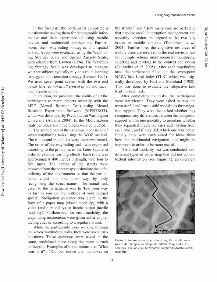
The visual modality test was conducted withdifferent types of paper map that did not containtextual information (see Figure 1): an overview
Figure 1. An overview map describing the whole route(route 4). Tampereen kaupunkimittaus Map and GISservices, available at http://www.tampere.fi/ytoteto/kartta/map.php.
Designing multimodal tracks
31
Dig
italC
rea
tivity,V
ol.
22
,N
o.
1
Dow
nloa
ded
by [
Uni
vers
ity o
f D
elaw
are]
at 1
4:03
05
Oct
ober
201
4
map and maps describing parts of the route. Thesewere given to the participant either before theywould need to turn left or right or as part of theirregular rhythm. The guidance in the audiomodality was given by the researcher (‘turn left/turn right/go straight forward’). The tactileguidance was given by shoulder tapping, eitherbefore they would need to turn left or right oraccording to a regular rhythm by tapping onthe right or left shoulder and between theshoulders.
The walking times were converted to walkingspeed in metres per minute. The ratio of navigationperformance was calculated in relation to time ofperformance and length of the route for eachparticipant for each mode of guidance. Theseratios were used as relative indicators of perform-ance improvement for each participant. Standardt-tests and a one-way analysis of variance(ANOVA) were performed in order to determinethe significance of navigation performance foreach mode of guidance. The participants’ subjec-tive evaluations of the task loads were used toascertain the most demanding and least demand-ing modes of guidance. Standard t-tests and aone-way ANOVA were performed to find possibledifferences.
4.3 Research designThe study involved a mixed factorial, whichincluded a between-subject comparison of individ-ual differences in the type of wayfinding strategy(orientation strategy, route strategy) and levels ofspatial anxiety (,2.5 or ≥2.5), in addition to awithin-subject comparison of the type of naviga-tion support (visual/audio/tactile predictive cues,visual/audio/tactile guidance with regularrhythm). The walking speed of each task wasmeasured and errors with directions were calcu-lated. The participants also self-reported the work-load of each task using the NASATask Load Index.
5 Results
This study is part of a larger study that explores thedesign of multimodal navigation aids in urbanareas (Vainio 2009a). Our previously published
study (Vainio 2009b) indicated that: (1) designingcues or a regular rhythm can be beneficial, particu-larly when mobile users interact with tactile oraudio modality; (2) there are differences betweenmale and female navigators, in relation to therelative walking speed, the use of visual ortactile guidance with regular rhythm and how par-ticipants experience the workload in audiomodality with rhythm; and (3) wayfinding strategyhas an impact on how humans experience theworkload of tactile guidance with cues. In thisstudy, we focus on users’ attitudes, wayfindingstrategies and spatial anxiety.
5.1 Preliminary study5.1.1 Overall usefulness
Our results indicate that, in general, both in-vehicle drivers and pedestrians recognise that theusefulness of providing navigation guidancebefore decision-making points is greater thanusing regular rhythms as navigation aids in fam-iliar and in unfamiliar environments (see Tables1 and 2). When the environment is familiar,users do not consider that regularly provided navi-gation aids are useful.
5.1.2 Usefulness of different modalities
For pedestrians, visual guidance with graphics andtext is preferred as the most suitable navigation aidin a familiar and an unfamiliar environmentaccording to 40% of the participants, whilehaptic guidance is the preferred guidance for lessthan 4% of the participants. For in-vehicledrivers, visual guidance with graphics (over 40%
Table 1. Usefulness of guidance just before a decision-makingpoint and guidance with regular rhythm among in-vehicledrivers.
Participants who feel that guidanceis extremely useful or useful (%)
Before decision-makingpoint Regularly
Familiar environment 25 15Unfamiliar environment 86 58Urban environment 73 46Rural environment 68 42
Vainio
32
Dig
italC
rea
tivity
,V
ol.
22
,N
o.
1
Dow
nloa
ded
by [
Uni
vers
ity o
f D
elaw
are]
at 1
4:03
05
Oct
ober
201
4

of the participants) and audio guidance (over 27%)are the most useful aids in both a familiar and anunfamiliar environment.
5.2 Field experimentThe results are presented according to the relativewalking speed, i.e. objective data, and accordingto the results of the workload experiencedmeasured using the NASA Task Load Index(TLX), i.e. subjective data. Because of the smallnumber of participants (n ¼ 21), the resultsbased on formal statistical analysis are limited.However, the results do provide indications andpotential trends for multimodal design.
Typical errors in human wayfinding can beclassified according to Tversky (2003) into threemain categories: errors of distance, errors of direc-tion and other errors. When a mistake is related tothe direction of a route, it could be caused by aperson mentally rotating the north–south andeast–west axes, so that these are more in linewith the geographical axes that are on a differentangle to the actual axes (Tversky 2003). In ourstudy, the total number of navigation errors wastwenty-one, and eleven of the participants madethese errors. All of the errors occurred when par-ticipants chose the direction, and 84% of theerrors were made with the paper maps. The mostcommon error was confusing north and south.The remaining 16% of the errors were made withthe audio modality with cues, when the participantsmixed up left and right turns. The results of theMental Rotation Test indicated no significantdifferences between the participants.
5.3 Tracks with regular rhythm vspredictive cues
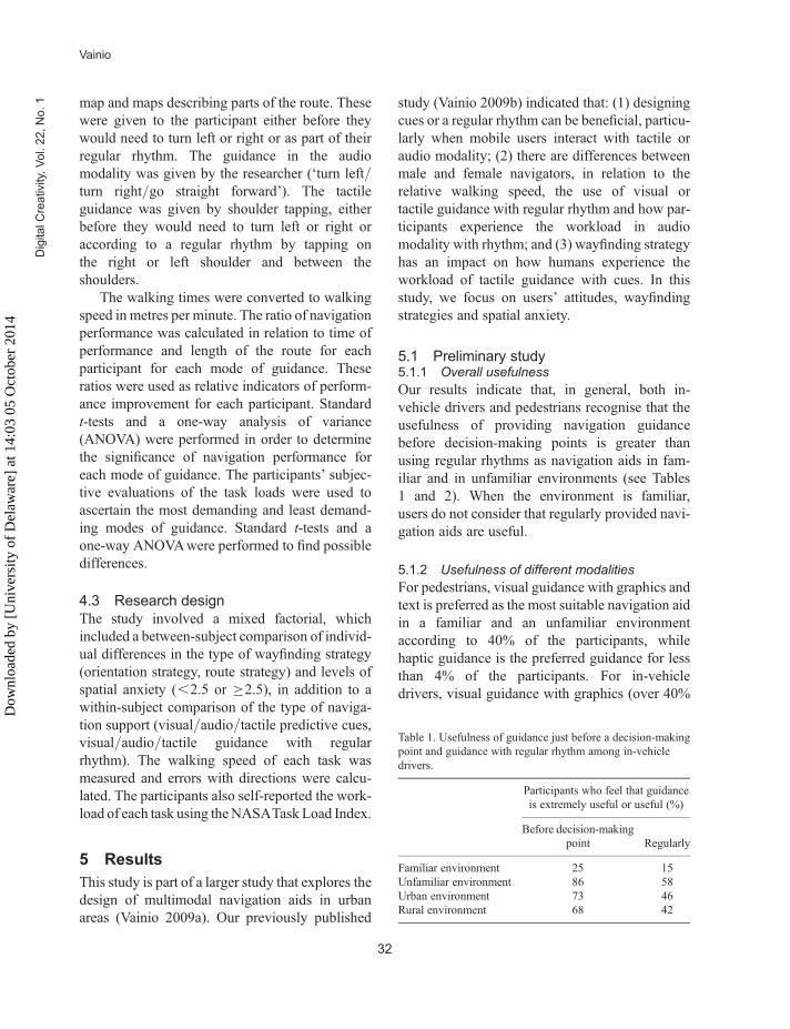
5.3.1 Walking speed
The average walking speeds were calculated oneach route, and the fastest and slowest modes (amodality with predicting cues or guidance with aregular rhythm) were ranked for each participant.Figure 2 summarises the fastest and slowestmodes. Based on this data, it can be argued thatdesigning cues or rhythms in the visual modalitydoes not improve the performance of users in way-finding tasks. However, guidance using the audiomodality with a regular rhythm seemed to beslightly better than having audio with predictingcues. Meanwhile, tactile guidance with predictingcues led to a better performance than providingtactile guidance with a regular rhythm (seeFigure 3).
A one-way ANOVA statistical analysis wasperformed and the results indicate no statisticalsignificance in the relative walking speed and gui-dance mode.
To summarise, the results of the various gui-dance modes indicate certain trends. The maintrend appears to be that the best performancewas achieved by tactile guidance with predictingcues, while the worst performance was achievedby visual guidance with predicting cues.
5.3.2 Workload
In relation to workload, the load index was rankedfor each participant to ascertain the tasks that theparticipants found to be most stressful and leaststressful (see Figure 3). According to this data, apaper-based map was the most difficult navigationguidance to use.
The key result comes from the participantsbeing asked (after completing the seven wayfind-ing tasks) whether they noticed any differencesbetween the instructions they were given withthe different modalities: 60% did not rememberany differences between being given predictivecues or instructions with a regular rhythm. Inaddition, we found no statistically significantdifferences between the different modalities onhow participants experienced the workload.
Table 2. Usefulness of guidance just before a decision-makingpoint and guidance with regular rhythm among pedestrians.
Participants who feel thatguidance is extremely useful or
useful (%)
Before decision-making point Regularly
Familiar environment 11 3Unfamiliar environment 53 38Urban environment 47 36Rural environment 35 27
Designing multimodal tracks
33
Dig
italC
rea
tivity,V
ol.
22
,N
o.
1
Dow
nloa
ded
by [
Uni
vers
ity o
f D
elaw
are]
at 1
4:03
05
Oct
ober
201
4

5.4 Impact of wayfinding strategiesAccording to Lawton’s (1994) work, the wayfind-ing strategies were categorised into orientationand route strategies. We investigated navigationperformance by measuring walking speeds andnavigation errors with directions both withineach modality and by the two types of wayfindingstrategy. Furthermore, we examined subjectivelythe experienced workloads within each modalityand the two types of wayfinding strategy.
Fifty-three per cent of the participants seemedto use the orientation strategy. Of these partici-pants, the fastest walking speed was obtainedwith predictive cues (see Table 3), either with thetactile or audio modality. In addition, the slowesttime for performance was with predictive cuesand the visual modality.
A route strategy was used by 57% of theparticipants. Most of the participants (90%) who
found that the route strategy suited them werefastest with tactile or audio guidance. There wereno major differences between guidance with pre-dicting cues and guidance with a regular rhythm.For these participants, the slowest walking speedwas with guidance from the visual modality andparticularly using visual predictive cues. Further-more, there were no statistically significantdifferences between the wayfinding strategiesand the relative walking speed.
In relation to the workload, the least stressfulguidance was the tactile modality with predictivecues, regardless of the wayfinding strategy (seeTable 3).
There was a statistically significant (p ,0.05)difference between how participants who used anorientation strategy evaluated the taskload withguidance from tactile cues. In addition, there wasa statistically significant (p , 0.05) difference
Figure 2. Relationships between relative walking speed and types of guidance.
Vainio
34
Dig
italC
rea
tivity
,V
ol.
22
,N
o.
1
Dow
nloa
ded
by [
Uni
vers
ity o
f D
elaw
are]
at 1
4:03
05
Oct
ober
201
4

between how participants who used a routestrategy evaluated the taskload with guidancefrom tactile cues.
To conclude, it seems that slowest navigationperformance is obtained with visual modality,regardless of the wayfinding strategy. The fastestnavigation performance is obtained with cues forthose participants who favour an orientation strat-egy and with a rhythm for those participants whofavour a route strategy. It also seems that partici-pants reported that the most stressful guidancewas visual modality (with an overview map),regardless of their wayfinding strategy; whereas
the least stressful guidance was identified astactile modality with cues.
5.5 Impact of spatial anxietyThe Spatial Anxiety Scale measures the level ofanxiety that participants experience in situationsthat require spatial/navigational skills. Developedby Lawton in 1994, it is a five-point scale with endpoints of ‘not at all’ and ‘very much’. We investi-gated the relationships between walking speedand experienced workload with levels of spatialanxiety.
Figure 3. Subjective estimation of the workload using the NASA Task Load Index.
Table 3. Relationships between wayfinding strategy and types of guidance.
Fastest performanceSlowest
performanceExperienced as least
stressfulExperienced as most
stressful
Participants emphasisingorientation strategy
Audio or tactile modalitywith cues (60%)
Visual modality withcues (40%)
Tactile modality withcues (40%)
Visual modality with anoverview map (45%)
Participants emphasisingroute strategy
Visual, audio or tactilemodality rhythm (54%)
Visual modality withcues (45%)
Tactile modality withcues (31%)
Vision modality with anoverview map (34%)
Designing multimodal tracks
35
Dig
italC
rea
tivity,V
ol.
22
,N
o.
1
Dow
nloa
ded
by [
Uni
vers
ity o
f D
elaw
are]
at 1
4:03
05
Oct
ober
201
4

Based on the relative walking speeds of thosewho experienced greater spatial anxiety, morethan 55% completed their tasks faster with tactileguidance and about 85% were slower with visualguidance. In particular, the predictive tactile cuesseemed to be a good choice, while the visualcues seemed to be poor navigation tools for thistype of participant (see Table 4).
Of those participants who experienced a lowerspatial anxiety than the average participant, therelative walking speed was faster with audio gui-dance from either a regular rhythm or predictivecues for 65% of the participants. The slowesttime of performance was achieved with visual gui-dance. The visual guidance with a regular rhythmseemed to be a little poorer than visual guidancewith cues. However, while these results are indi-cating trends, we found no statistically significantdifferences between relative walking speed andthe different levels of spatial anxiety.
Of those participants who experienced a higherlevel of spatial anxiety, 78% felt that tactile gui-dance was less stressful while performing way-finding tasks (see Table 4). Tactile guidance withpredictive cues or a regular rhythm seemed to bealmost equally good. In addition, of those partici-pants who felt greater spatial anxiety, 72% seemedto find visual guidance with an overview map orpredictive cues to be the most stressful.
6 Discussion
The results of this study show promising designissues for the development of multimodal naviga-tion aids to support typical human wayfinding be-haviour when mobile users are finding their way inunfamiliar urban environments. Interdisciplinary
approaches, such as adopting design practicesfrom urban planners, have potential when investi-gating human-centred novel interaction. Thisstudy explored the possible benefits of two typesof guidance with three different modalities ofnavigation guidance. The types of guidance werepredictive cues and guidance according to aregular rhythm. The design of these types ofguidance is based on the urban planning designpractice of episodes of motion.
A number of important lessons from the studydescribed in this paper can be drawn:(1) designing tracks in navigation guidance can
be beneficial when mobile users interact withtactile or audio modality, particularly in unfa-miliar environments;
(2) designing predictive cues for pedestrians whofavour the orientation strategy supports theirnavigation performance;
(3) designing tracks according to a regular rhythmfor pedestrians who favour a route strategysupports their navigation performance;
(4) in relation to the experienced level of spatialanxiety, those who experience a higher levelof anxiety prefer tactile guidance;
(5) users’ attitudes towards the usefulness ofdifferent multimodal navigation guidancemay be contradictory to the actual navigationperformance when measuring time and errors.
Furthermore, when evaluating users’ navigationperformance and their attempts to complete way-finding tasks in unfamiliar environments, under-standing and measuring their self-reportedworkload, particularly the level of spatial anxietyand wayfinding strategies should be explored.This conclusion is in line with earlier findingsregarding human wayfinding behaviour (see for
Table 4. Relationships between level of spatial anxiety and types of guidance.
Fastest performance Slowest performanceExperienced as least
stressfulExperienced as most
stressful
Participants feeling higherlevel of spatial anxiety
Tactile modality withcues (42%)
Visual modality withcues (42%)
Tactile modality withrhythm (42%)
Visual modality withcues (42%)
Participants feeling lowerlever of spatial anxiety
N/A Visual modality withrhythm (75%)
Audio modality withrhythm (60%)
Visual modality withrhythm 60%)
Vainio
36
Dig
italC
rea
tivity
,V
ol.
22
,N
o.
1
Dow
nloa
ded
by [
Uni
vers
ity o
f D
elaw
are]
at 1
4:03
05
Oct
ober
201
4

example, Golledge 1999, Allen 1999, Hund andMinarik 2006, Lawton and Kallai 2002), andthese factors may explain the different navigationperformances of participants.
7 Conclusion
This paper reported on design issues in order toinvestigate navigation performance with mobilemultimodal navigation aids used in an unfamiliarurban environment. The results show good potentialwith designing tracks using tactile and audioguidance. In particular, the results show that trackswere less beneficial with visual modality than withaudio or tactile modality. However, when exploringthe user’s general attitudes towards navigationguidance, visual guidance is seen to be the mostuseful in familiar and unfamiliar environments.
Fluent navigation, in the context of human–computer interaction and particularly in thecontext of this study, can be defined as, ‘as easyand smooth navigation performance as possible,including a relative fast walking speed, with onlya few navigation errors’. It also includes theuser’s subjective experience of navigation per-formance with a minimum workload. We arguethat urban planners in particular have developeddesign practices that support fluent navigationand therefore the research on mobile navigationaids could utilise these already known design prac-tices. Turning the focus onto how mobile usersexperience the usage of mobile navigation aids isin line with other studies on user experience vsusability issues (see for example, Hassenzahl andTractinsky 2006).
When seeking different modalities for ped-estrians to receive wayfinding instructions inurban areas, providing tracks should be one alterna-tive from which users can choose. According to ourresults, users do not differentiate between theseinstructions in every case, but there are still differ-ences found when measuring the walking speedor subjectively experienced workload.
At least two directions for potential futureresearch are emerging. The first concerns thestudy of navigation with both pedestrians anddrivers (in a vehicle), as well as gaining more
detail in further quantitative data, i.e. log files,and comparing the errors that navigators feel thatthey make with data representing the actual errorsthey make while they are finding their way. Thesecond direction of future research could be tofocus on exploring how to support differentwayfinding strategies better, i.e. how to adaptnavigation aids for different kinds of navigatorsand their strategies. Moreover, we are especiallyinterested in examining how these possible differ-ences could be used to accomplish better navigationboth in familiar and unfamiliar environments.
In conclusion, the results show that, whendesigning tracks into mobile navigation systems,we can support a wayfinding task when pedestriansare interacting with an audio or a tactile modality inunfamiliar urban environments. Furthermore, whenexploring wayfinding with mobile users in general,the possible impact of wayfinding strategies andspatial anxiety should be explored.
Acknowledgements
We thank Professors Kaisa Vaananen-Vainio-Mattila, Sari Kujala and research assistant JaanaMantyla for their support in conducting this study.
ReferencesAbrams, R.A., 2004. Mental rotation experiment soft-
ware (MENTROT), version 8/21/04. WashingtonUniversity, St Louis, MO, USA. Available at: http://artsci.wustl.edu/~rabrams/psychlab/mentrot.htm[Accessed 6 June 2009].
Allen, G.L., 1999. Spatial abilities, cognitive maps, andwayfinding: bases for individual differences inspatial cognition and behaviour. In: R. Golledge,ed. Wayfinding behavior: cognitive maps and otherspatial processes. Baltimore, MD: Johns HopkinsUniversity Press, 46–80.
Brewster, S., Lumsden, J., Bell, M., Hall, M., andTasker, S., 2003. Multimodal ‘eyes-free’ interactiontechniques for wearable devices. In: Proceedings ofthe SIGCHI conference on human factors in comput-ing systems (CHI 2003), 473–480.
Cohen, P., McGee, D., and Clow, J., 2000. The effi-ciency of multimodal interaction for a map-basedtask. In: Proceedings of the sixth conference on
Designing multimodal tracks
37
Dig
italC
rea
tivity,V
ol.
22
,N
o.
1
Dow
nloa
ded
by [
Uni
vers
ity o
f D
elaw
are]
at 1
4:03
05
Oct
ober
201
4

applied natural language processing, Seattle,Washington, 29 April–4 May 2000. San Francisco,CA: Morgan Kaufmann, 331–338.
Cooper, A.N. and Shepard, R.N., 1973. The timerequired to prepare for a rotated stimulus. Memory& Cognition, 1, 246–250.
Gale, N., Golledge, R.G., Halperin, W.C., and Couclelis,H., 1990. Exploring spatial familiarity. ProfessionalGeographer, 42 (3), 299–313.
Ghiani, G., Leporini, B., and Paterno, F., 2008.Vibrotactile feedback as an orientation aid for blindusers of mobile guides. In: Proceedings of the 10thinternational conference on human–computer inter-action with mobile devices and services (MobileHCI2008), 431–434.
Golledge, R.D., ed., 1999. Wayfinding behaviour:cognitive mapping and other spatial processes.Baltimore, MD: John Hopkins Press.
Hart, S.G. and Staveland, L.E., 1988. NASA task loadindex (TLX). Available at: http://www.cc.gatech.edu/classes/AY2005/cs7470_fall/papers/TLXScale.pdf [Accessed 6 June 2009].
Hassenzahl, M. and Tractinsky, N., 2006. User experi-ence—a research agenda. Behaviour and Infor-mation Technology, 25 (2), 91–97.
Holland, S., Morse, D., and Gedenryd, H., 2002.AudioGPS: spatial audio navigation with aminimal attention interface. Personal UbiquitousComputing, 6 (4), 253–259.
Hund, A.M. and Minarik, J.L., 2006. Getting fromhere to there: spatial anxiety, wayfinding strategies,direction type and wayfinding efficiency. SpatialCognition and Computation, 6 (3), 179–201.
International Organization for Standards (ISO), 1999.ISO 13407: Human-centred design processes forinteractive systems. Geneva: ISO.
Jost, M., Haußler, J., Merdes, M., and Malaka, R., 2005.Multimodal interaction for pedestrians: an evaluationstudy. In: Proceedings of the 2005 international con-ference on intelligent user interfaces, 10–13 January2005 San Diego, USA. New York: ACM, 59–66.
Lawton, C., 1994. Gender differences in wayfindingstrategies: relationship to spatial ability and spatialanxiety. Journal of Sex Roles, 30 (11–12), 765–779.
Lawton, C.A. and Kallai, J., 2002. Gender differences inwayfinding strategies and anxiety about wayfinding:a cross-cultural comparison. Sex Roles, 47, 389–401.
Lynch, K., 1960. Image of the city. Cambridge, MA:Technology Press & Harvard University Press.
Oulasvirta, A., Tamminen, S., Roto, V., and Kuorelahti,J., 2005. Interaction in 4-second bursts: the fragmen-ted nature of attentional resources in mobile HCI. In:Proceedings of the SIGCHI conference on humanfactors in computing systems (CHI 2003), 5–10April 2003 Ft. Lauderdale, USA. New York: ACM,919–928.
Oviatt, S., Coulston, R., and Lunsford, R., 2004. Whendo we interact multimodally? Cognitive load andmultimodal communication patterns. In: Proceed-ings of the 6th international conference on multi-modal interfaces, 2004, 129–136.
Stenros, H. and Aura, S., 1987. Time, motion and archi-tecture. Espoo: Weilin + Goos.
Stern, E. and Portugali, J., 1999. Environmental cogni-tion and decision making in urban navigation. In:R. Golledge, ed., Wayfinding behaviour: cognitivemaps and other spatial processes. Baltimore, MD:Johns Hopkins University Press, 46–80.
Tamminen, S., Oulasvirta, A., Toiskallio, K., andKankainen, A., 2004. Understanding mobilecontexts. Personal Ubiquitous Computing, 8 (2),135–143.
Thordyke, P. and Hayes-Roth, B., 1982. Differences inspatial knowledge acquired from maps and naviga-tion. Cognitive Psychology, 14, 560–589.
Tolman, E., 1948. Cognitive maps in rats and men.Psychological Review, 55, 189–208.
Tversky, B., 2003. Navigating by mind and by body. In:Freksa, et al., eds. Spatial cognition III. Heidelberg:Springer, 2003.
Vainio, T., 2009a. Exploring cues and rhythm fordesigning multimodal tools to support mobileusers in wayfinding. In: Proceedings of the 27thinternational conference: extended abstracts onhuman factors in computing systems (CHI EA ’09),Boston, MA, 4–9 April 2009, New York, NY:ACM, 3715–3720.
Vainio, T., 2009b. Exploring multimodal navigation aidsfor mobile users. In: Proceedings of the twelfthIFIP conference on human–computer interaction(INTERACT 2009), Sweden.
Wiener, J.M., Lafon, M., and Berthoz, A., 2008. Pathplanning under spatial uncertainty. Memory &Cognition, 36 (3), 495–504.
Wilson, D., Doyle, J., Weakliam, J., Bertolotto, M., andLynch, D., 2007. Personalised maps in multimodalmobile GIS. International Journal of Web EngineeringTechnology, 3 (2), 196–216.
Vainio
38
Dig
italC
rea
tivity
,V
ol.
22
,N
o.
1
Dow
nloa
ded
by [
Uni
vers
ity o
f D
elaw
are]
at 1
4:03
05
Oct
ober
201
4

Teija Vainio, Lic. Phil. (Computer Science),student of architecture, is a researcher in the fieldof human–computer interaction at TampereUniversity of Technology (Human-CenteredTechnology). She has been involved in anumber of research projects in mobile human
computer interaction with special research inter-ests relating to navigation and mobile work.Her PhD thesis (in progress) addresses bothdesigning of navigation aids for mobile usersand how urban planning praxis can be appliedfor such design.
Designing multimodal tracks
39
Dig
italC
rea
tivity,V
ol.
22
,N
o.
1
Dow
nloa
ded
by [
Uni
vers
ity o
f D
elaw
are]
at 1
4:03
05
Oct
ober
201
4


![Monitoria multimodal cerebral multimodal monitoring[2]](https://img.dokumen.tips/doc/110x75/552957004a79599a158b46fd/monitoria-multimodal-cerebral-multimodal-monitoring2.jpg)