1
KENT HURON SANILAC LAKE BAY IONIA IOSCO SAGINAW CLARE TUSCOLA ALCONA LAPEER NEWAYGO ST CLAIR ALPENA MASON ANTRIM OTTAWA GENESEE OSCODA CLINTON OCEANA GRATIOT MONTCALM CHEBOYGAN OGEMAW OTSEGO ISABELLA OSCEOLA MIDLAND MECOSTA WEXFORD GLADWIN KALKASKA MANISTEE MACOMB MISSAUKEE BENZIE CRAWFORD PRESQUE ISLE MUSKEGON ARENAC ROSCOMMON SHIAWASSEE MONTMORENCY LEELANAU CHARLEVOIX GRAND TRAVERSE 127 23 31 10 10 23 131 23 10 31 23 10 10 23 23 31 31 31 131 31 10 10 55 30 32 61 72 65 33 37 116 18 68 25 93 88 115 21 13 47 113 75 211 186 138 24 50 120 137 53 20 104 66 52 25 18 66 55 61 65 52 33 65 65 72 33 55 25 50 88 32 33 25 66 43 40 88 25 93 33 72 61 65 52 37 72 66 25 72 21 37 65 55 55 37 66 33 113 20 75 475 675 Michigan Department of Natural Resources Designated ORV, ATV, Motorcycle, and MCCCT Trails Devils Lake Cedar Creek Holton Loop Horseshoe Lake Big O Little O Little Manistee Tin Cup Evart M-20 to Big O M-55 to 20 Rd 20 Rd to Grand Traverse MCCCT to US-131 Lincoln Hills Missaukee Junction Long Lake North Missaukee Grand Traverse to Leetsville Leetsville Kalkaska Frederic West Higgins Leetsville to Kalkaska North Branch Tomahawk A Tomahawk to Red Bridge Bummers Roost Black Lake Red Bridge Atlanta Atlanta to Hunt Creek Mio to Meadows Hunt Creek Mio Meadows Bull Gap Alcona Huron Rose City Ambrose Lake Ogemaw Hills St Helen Beaver Creek Gladwin White Cloud Leota M-30 to North Gladwin M-30 to St Helen Old State House Denton Creek Red Bridge to Atlanta Tomahawk to Kalkaska Indian River Tomahawk B Kalkaska to Tomahawk Tomahawk C Crapo Creek Big Bear Grand Traverse Grand Traverse to Supply Rd Miss - Kal Geels Huron Sand Lake US-131 to N Missaukee M-55 to State Rd Legend Highway Motorcycle Trail - Motorcycles only. (DNR license (ORV Sticker) required) ATV Trail - ORV’s less than 50" in width including off-road motorcycles. (DNR license (ORV Sticker) required.) Motorcycle Trail - Motorcycles only. (Secretary of State license required) Michigan Cross Country Cycle Trail (MCCCT) ORV Route - ORV’s of all sizes including off-road motorcycles. (DNR license (ORV sticker) required unless licensed by the Secretary of State) State Boundary Counties Lakes and Rivers National Forest State Forest Advisory: Trails and Routes have two-way traffic. Disclaimer: Trails shown on this map are an approximate representation of the trail system at the time of publication and may not reflect current ground conditions. STAY ON SIGNED TRAILS ONLY! Map Updated: 9/6/2011

Designated ORV, ATV, Motorcycle, and MCCCT Trails · 127 23 131 31 10 12 223 127 10 23 12 ... Designated ORV, ATV, Motorcycle, and MCCCT Trails Devils Lake Cedar Creek Holton Loop

  • Upload
    dodiep

  • View
    219

  • Download
    0

Embed Size (px)

Citation preview

KENT

HURON

SANILAC

LAKE

BAY

IONIA

OAKLAND

CASS

ALLEGAN

IOSCO

SAGINAW

CLARE

TUSCOLA

ALCONA

EATON

LAPEER

BARRY

WAYNE

NEWAYGO

ST CLAIR

LENAWEE

JACKSON

ALPENA

CALHOUN

INGHAM

MASON

ANTRIM

OTTAWA

GENESEE

OSCODA

CLINTON

BERRIEN

OCEANA

GRATIOTMONTCALM

CHEBOYGAN

OGEMAW

BRANCH

OTSEGO

ISABELLA

MONROE

OSCEOLA

MIDLANDMECOSTA

HILLSDALE

WEXFORD

GLADWIN

WASHTENAW

KALKASKA

MANISTEE

MACOMB

VAN BUREN

MISSAUKEE

LIVINGSTON

BENZIE

CRAWFORD

ST JOSEPH

PRESQUE ISLE

KALAMAZOO

MUSKEGON

ARENAC

ROSCOMMON

SHIAWASSEE

MONTMORENCY

LEELANAU

CHARLEVOIX

GRAND TRAVERSE

127

23

131

31

10

12

223

127

10

23

12

131 23

223

10

127

31

12

131

23

12

10 10 23

131

12

23

31

31

31

127

31

12

23

131

31

31

1010

55

30

32

61

72

65

52

33

99

60

37

116

66

51

18

79

40

68

86

25

63

93

89

88

62

36

115

21

43

13

47

113

75

106

217

211

186

156

140

138

103

24

78

152

50

120

216

124

34

137

53

20

104

66

66

52

25

140

40

51

66

18

66

66

40

55

106

63

62

89

61

65

89

60

52

33

65

65

60

89

72

33

55

25

50

8832

60

60

33

25

66

36

4340

88

36

43

25

40

93

33

72

61

89

89

65

52

37

51

99

72

66

25

72

43

52

21

86

40

43

66

43

37

65

55

60

55

37

66

33

113

66

20

66

75

196

69

194

275

475

675

375

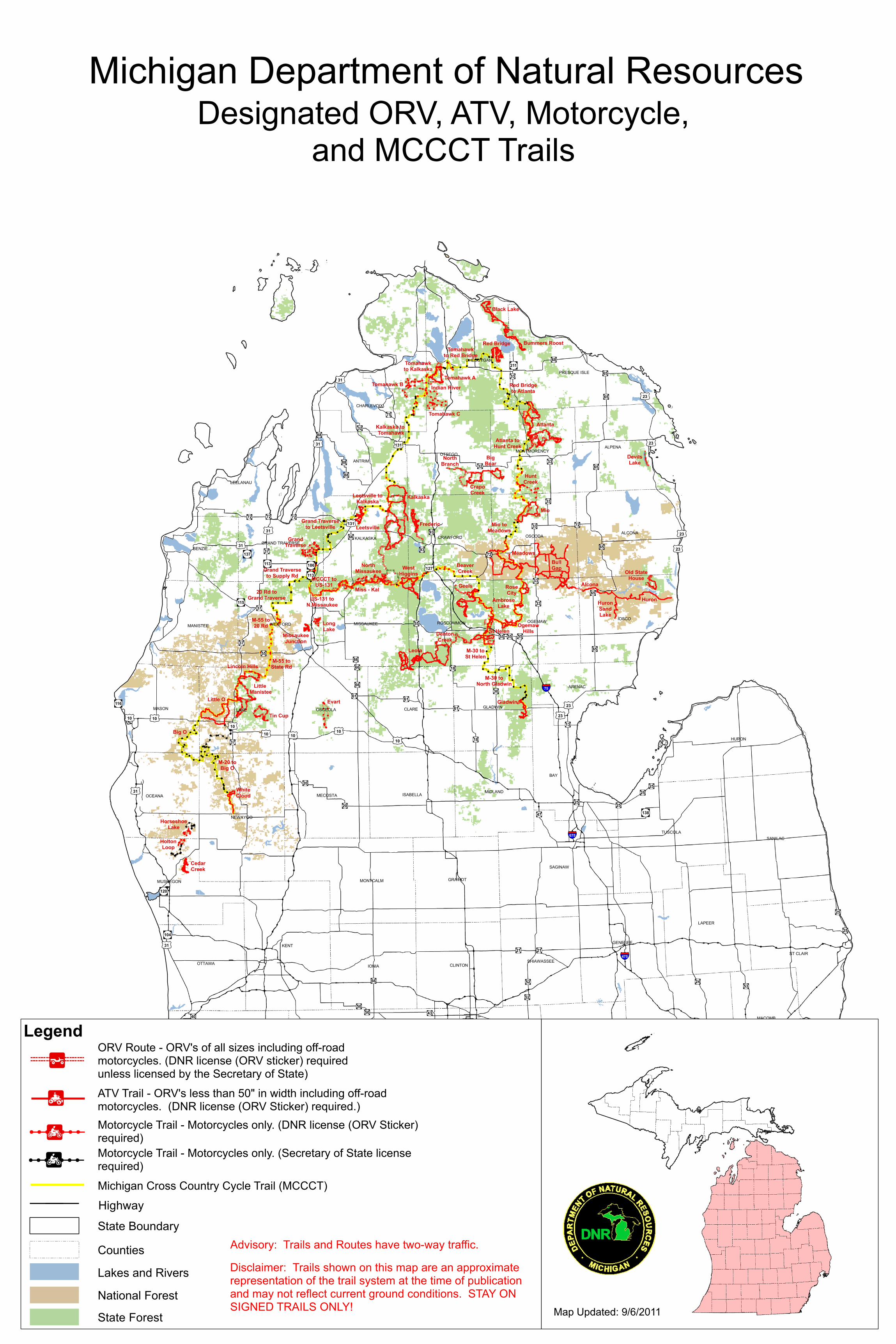
Michigan Department of Natural ResourcesDesignated ORV, ATV, Motorcycle,

and MCCCT Trails

DevilsLake

CedarCreek

HoltonLoop

HorseshoeLake

Big O

Little O

Little Manistee

Tin Cup

Evart

M-20 toBig O

M-55 to20 Rd

20 Rd toGrand Traverse

MCCCT toUS-131

Lincoln Hills

MissaukeeJunction

LongLake

NorthMissaukee

Grand Traverseto Leetsville Leetsville

Kalkaska

Frederic

WestHiggins

Leetsville toKalkaska

NorthBranch

Tomahawk A

Tomahawkto Red Bridge

Bummers Roost

Black Lake

Red Bridge

Atlanta

Atlanta toHunt Creek

Mio toMeadows

HuntCreek

Mio

Meadows

BullGap

Alcona

Huron

RoseCity

AmbroseLake

OgemawHillsSt Helen

BeaverCreek

Gladwin

WhiteCloud

Leota

M-30 toNorth Gladwin

M-30 toSt Helen

Old StateHouse

DentonCreek

Red Bridgeto Atlanta

Tomahawkto Kalkaska

Indian RiverTomahawk B

Kalkaska to Tomahawk

Tomahawk C

CrapoCreek

BigBear

GrandTraverse

Grand Traverseto Supply Rd

Miss - KalGeels

HuronSandLake

US-131 toN Missaukee

M-55 toState Rd

Legend

Highway

Motorcycle Trail - Motorcycles only. (DNR license (ORV Sticker)required)

ATV Trail - ORV’s less than 50" in width including off-roadmotorcycles. (DNR license (ORV Sticker) required.)

Motorcycle Trail - Motorcycles only. (Secretary of State licenserequired)

Michigan Cross Country Cycle Trail (MCCCT)

ORV Route - ORV’s of all sizes including off-roadmotorcycles. (DNR license (ORV sticker) requiredunless licensed by the Secretary of State)

State Boundary

Counties

Lakes and Rivers

National Forest

State Forest

Advisory: Trails and Routes have two-way traffic.

Disclaimer: Trails shown on this map are an approximaterepresentation of the trail system at the time of publicationand may not reflect current ground conditions. STAY ONSIGNED TRAILS ONLY! Map Updated: 9/6/2011