Embed Size (px)
Citation preview
DESERT REPORTDESERT REPORTDESERT REPORTDESERT REPORTNews of the desert from Sierra Club California & Nevada Desert Committee MARCH 2018
NATIONAL MONUMENTS BELONG TO US ALL
BY HILARY CLARK
FINDING COMMON GROUND
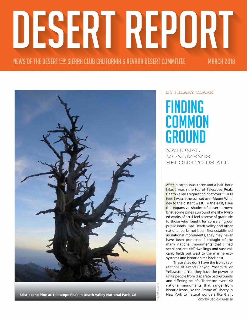
AAfter a strenuous three-and-a-half hour hike, I reach the top of Telescope Peak, Death Valley’s highest point at over 11,000 feet. I watch the sun set over Mount Whit-ney to the distant west. To the east, I see the expansive shades of desert brown. Bristlecone pines surround me like twist-ed works of art. I feel a sense of gratitude to those who fought for conserving our public lands. Had Death Valley and other national parks not been first established as national monuments, they may never have been protected. I thought of the many national monuments that I had seen: ancient cliff dwellings and vast vol-canic fields out west to the marine eco-systems and historic sites back east. These sites don’t have the iconic rep-utations of Grand Canyon, Yosemite, or Yellowstone. Yet, they have the power to unite people from disparate backgrounds and differing beliefs. There are over 140 national monuments that range from historic icons like the Statue of Liberty in New York to natural wonders like Giant
HIL
ARY
CLAR
K
Bristlecone Pine at Telescope Peak in Death Valley National Park, CACONTINUED ON PAGE 16

DESERT REPORT MARCH 20182
TThis is the story of what happens when residents dependent upon an over-drafted aquifer must face a county that seems biased toward well-financed commercial interests. The unincor-porated area of Ocotillo, in the southwestern corner of Impe-rial County, has a population of fewer than 400 and is entirely dependent upon groundwater for all domestic purposes. US Gyp-sum (USG), a Fortune 500 company, also exports water from this same aquifer. For a number of years, USG has exported water through a pipeline from Ocotillo to its Plaster City factory (8.5 miles east of Ocotillo) where it is used solely for the manufacture of wallboard. In 1993, USG sought to increase the size of its export pipeline, in order to increase its water export from about 350 acre-feet (AF) per year to 767 AF/year, and to build yet another pipeline from a well north of the factory to deliver water to its quarry some distance north of its manufacturing operation. For perspective, it must be realized that the Ocotillo community residents use about 125 acre-feet of water per year. Given the limited recharge rate of the aquifer, the concern of the local residents is obvious. Twenty-five years after the permit application the conflict is still unresolved. The problem is compounded by several other facts. Hydro-logical studies have revealed that below the fresh water aquifer
BY EDIE HARMON
THE CURIOUS CASE OF US GYPSUMTHE ONGOING GROUNDWATER WAR IN IMPERIAL COUNTY
IN THIS ISSUEFinding Common Ground: National Monuments Belong To Us AllThe Curious Case Of US GypsumCan Importing Water From The Gulf Of California Save The Salton Sea?Geothermal Energy Projects In Imperial CountyFire Hazard Shut-offs In Rural AreasConservation In Action: Partnering To Protect The Bi-State Greater Sage-Grouse Desert UpdatesThe Future Of Energy Through Local ControlDeath Valley Natives: Assessing The Bighorn SheepOutingsIn Passing
1
23
468
1214182022
CONTINUED ON PAGE 10
in question there is saline or brackish water in older marine sed-iments. If water levels decline sufficiently, there is the possibility that water withdrawals would begin to pump poor quality water as happened at another well somewhat to the south. Indeed, the water table has fallen about thirty feet since the 1920s. It is also relevant that Plaster City overlies a non-pota-ble aquifer entirely independent of the one being utilized in Ocotillo. California court decisions have upheld the priori-ty of overlying domestic use of groundwater over transfer for non-overlying uses or on properties not overlying the groundwa-ter basin. Finally, there has been an on-and-off history of small-scale water exports from the ‘60s through ‘80s, although these exports are no longer in effect. As a result of these earlier disputes, Imperial County real-ized in the late 1980s that it would have to update its General Plan or run the risk of having other projects successfully chal-lenged in court. This General Plan Update was published in 1993. This Update now includes approved plans for several distinct unincorporated communities in different locations within the county. One of these, the Ocotillo Nomirage Com-munity Area Plan (ONCAP), was adopted in 1994. Two of the specific objectives of the County’s plan for the groundwater
JIM P
ELLE
Y
Plaster City: a factory but no residents

DESERT REPORT MARCH 2018 3
CAN IMPORTING WATER FROM THE GULF OF CALIFORNIA SAVE THE SALTON SEA?
Does the idea of importing water to the Salton Sea distract from what can be done now?Right, so that’s the major problem. Even if you could snap your fingers and all of a sud-den there was a restored Salton Sea and you could bring in all this water, in we’d have a real conversation about whether it is worth all this additional money to have a whole Salton Sea? But when people continue to point to this solution, it distracts from what we really need to be doing right now, which is investing money in public health and protecting the environment and rebuilding habitat at least along the shoreline. And then hopefully get some kind of deeper North Lake where you can get a real fishery habitat. Those things seem to be achievable in what should be the relatively short term, versus under the very best circumstances seeing some resolution with the import plan. The other potential challenge is people say “oh we’re going to desalinate the water with all this geothermal resource at the Salton Sea and put some of that water back into the Sea.” But Geothermal is not cheap, and building desalinization plants is capital intensive. But the bigger problem is that once you get higher quality there, someone will buy it. The snow pack in California is terrible, and the current forecast for the Colorado Riv-er Basin is one of the worst in the past 20 years. So there’s just not a lot of good quality
A
TWO EXPERTS SHARE THEIR VIEWS
INTERVIEWS BY JOAN TAYLOR
CONTINUED ON PAGE 15
Michael Cohen, Senior Research Associate, Pacific Institute
A lot of people are saying you need to im-port water from Mexico to save the Salton Sea, but there are several challenges. It would require permission of the Repub-lic of Mexico, which is currently not very fond of our President. Even at the best of times, when there is clear mutual interest such as delivering water to the Colorado Delta, it’s taken five full years to reach agreement between the nations. There are ecological challenges. Theoretically you could put a pipeline or channel below the biosphere core area and avoid harming a pretty productive es-tuary. There’s also the Vaquita porpoise, the most endangered marine mammal in the world. You wouldn’t want to bring them into whatever pipeline or canal you’re developing. The second challenge is cost: the Cali-fornia Department of Water Resources es-timated the cost at $30-40 billion dollars. That’s because one of the key challenges with any kind of import plan is that, along with that water you’re importing a lot of salt – and you need to get rid of it. If you simply propose to bring in water and not export salt, what you do is address the dust control problem, but not the habitat challenge. It’s fairly easy to bring in a lot of water without hav-ing to worry about pumping that water back out. So if your intent is simply to have a brine lake where Salton Sea is, you can do that. So there are the issues of cost, salt balance, and the Mexican negotiation – all of which by my estimate would take 20 to 30 years before you get the solution you’re looking for. The Salton Sea will be completely different than it is now.
Salton Sea, Laguna Salada, and the Gulf of California
PERM
ISSI
ON
OF
THE
WIL
DLA
ND
S CO
NSE
RVAN
CY

DESERT REPORT MARCH 20184
W
The following article carefully describes the agencies and regulations governing geothermal development in Imperial County. It remains for the public, however, to watch that implementation of these pro-cedures are responsibly carried out. The September 2017 issue of the Desert Report contains an article by the same author on the basics of the geothermal system that is background for this article. - Editor Worldwide, geothermal energy fields that have a high enough temperature to be used for electrical production are common-ly found in geologically active areas. The Salton Sea geothermal field is in Imperial County, California, at the southern end of the Salton Sea lake. This is a known geologically active area of fre-quent natural small seismic activity and ground subsidence. At this field, generally using wells over 5,000 feet deep, hot salty brine is withdrawn from the reservoir and taken by pipeline to a power plant. Steam is produced in the plant to run a turbine, making electricity. The cool spent brine is taken by pipeline to injection wells and injected back into the reservoir. Imperial County officials have been frontrunners in planning for and permitting of geothermal power facilities. In 1971, the County Board of Supervisors adopted the “Terms, Conditions, Standards, and Application Procedures for Geothermal Develop-ment” outlining measures to minimize impacts to productive ag-ricultural lands and environmental resources. In 1975, the Board also adopted the “Imperial County Goals” to “. . . encourage geo-thermal exploration and development projects and development projects to increase knowledge of this resource and development of minerals and other uses and ensure development is compati-ble with agriculture and our environment.” In 1977, the Imperial County Board of Supervisors adopted the Geothermal Element of the Imperial County General Plan. The Element was the first of its kind in the United States, and spelled out policies to enable rapid development of geothermal energy production, while preserving agriculture, health and safe-ty, and other concerns. The Element has been used as a template to manage geothermal development by many counties across California, in other States, and in other countries. The Element has been updated several times, the last being in 2015 as part of the Renewable Energy and Transmission Element – County of Imperial General Plan. This Plan can be found at the following website: http://www.icpds.com/?pid=833 . The Element provides that the County of Imperial is the lead permitting agency for geo-thermal developments up to 49.9 megawatts net generation. Above that size limit, the California Energy Commission, a Califor-nia State agency, retains the permitting jurisdiction for all power
plants 50 megawatts net generation and above. The Element is a comprehensive document that provides a framework for review and approval of geothermal projects in the County of Imperial. The Element also lays out a matrix of rela-tionships with other regulatory and permitting agencies for new and/or ongoing projects. Some of the other agencies that have jurisdictional and oversight responsibility on geothermal proj-ects are the Imperial County Air Pollution Control District (APCD), California Regional Water Quality Control Board (RWQCB), Cali-fornia Department of Toxic Substances Control (DTSC), California Department of Conservation – Division of Oil Gas and Geother-mal Resources (DOGGR), and the Imperial Irrigation District (IID) electrical balancing authority. Other agencies that may have ju-risdictional oversight, depending on where a project is located, include the California State Lands Commission (for State Owned Lands), US Bureau of Land Management (for Federal Lands), US
ALEX
SCH
RIEN
ER
A closer view of a geothermal plant
GEOTHERMAL ENERGY PROJECTS IN IMPERIAL COUNTY
ALEXANDER SCHRIENER, JR.
WHO KEEPS TRACK?

DESERT REPORT MARCH 2018 5
Department of Defense (for projects near Military Lands) and Lo-cal Native American Tribal Councils (for sensitive cultural areas and Tribal Lands). As part of the Element, the County of Imperial Planning and Development Services Public Works Department (PDSPWD) develops and issues a Conditional Use Permit (CUP) for opera-tion of the geothermal power plant and ancillary facilities. This document approves the layout of the geothermal well field and how it will be operated to minimize impacts on the surrounding area. Three special aspects of the CUP are the requirement for 1) subsidence monitoring, 2) seismic monitoring, and 3) regulating the amount of produced brine that must be injected back into the sub-surface reservoir for each project. The CUP requires that an active seismic monitoring array is installed around the perimeter of each facility, including the area of the well fields. The CUP also requires that a subsidence benchmark array be approved and established. Data on this is collected annually, or more frequently, if required by the County. An annual report on subsidence and seismic data for each geo-thermal field is submitted to the PDSPWD and to the DOGGR for their review and comment. What these agencies are looking for is evidence of detrimental effects. For example, some the farm fields are underlain with tile systems that are sloped to allow wa-ter to flow across the fields, after which the subsurface water is collected and disposed of in the Salton Sea. If there were ground subsidence or faulting, these fields would not drain properly. If detrimental evidence is found in the monitoring, then the agencies have the authority to request changes in how the field is operated. Another aspect of the CUP is to dictate how much produced brine is required by the DOGGR to be injected back into the sub-surface reservoir. This is to help control ground subsidence. Gen-erally, the permitted amount is about 75% of the amount of brine that is being produced. The remainder of the liquid produced is mainly lost to evaporation in the cooling tower process. Shallow groundwater, Colorado River water, or Salton Sea lake waters are not injected into the subsurface reservoir. The RWQCB, Palm Desert office, is the regulatory agency for monitoring and pro-tecting both surface and subsurface waters in the County. The leaders in Imperial County were very proactive in requiring seis-mic and subsidence monitoring for all geothermal power plants. As per State regulation, the DOGGR has jurisdiction over geothermal wells, including the design of the wells, plans for drilling, maintenance, operating conditions, monitoring, and abandonment of the wells. All well work and work plans must be approved by the DOGGR, and they have on-sight oversight au-thority to inspect the well operations. Additionally, each plant op-erator must submit to the DOGGR monthly data on the amount of production and injection associated with the wells. This well production and injection data, as well as data on permitting, drill-ing, and maintenance, is open to the public. The well data can be found on the DOGGR website listed below. The Salton Sea area is in District 2 and the office is in Cyprus, California: https://tinyurl.com/ycbmymul. The DOGGR sets limits on the injection pressure that can be applied to each injection well. The fracture gradient has been de-termined for each geothermal field. This is the pressure in the
wellbore that is required to hydraulically fracture (“frack”) the nat-ural subsurface formation. Injection pressure limits are set by the DOGGR such that the pressure is always less than the fracture gradient for the shallowest exposed formation in each wellbore. Thus, production and/or injection at the Salton Sea geothermal reservoir do not “frack” the subsurface formation. In fact, due to the high number of natural fractures in the subsurface forma-tion, the production and injection wells often can produce or take abundant flow with little effort. The injection helps sustain and recharge the geothermal reservoir to avoid subsidence of adja-cent IID irrigation canals, drains, and farmlands. As mentioned earlier, other agencies have permitting and regulatory jurisdiction over aspects of the geothermal power plants. The RWQCB requires that shallow groundwater monitor-ing wells are installed around any areas where brine is stored in approved aboveground tanks and concrete-lined ponds. These monitoring wells have an annual schedule for monitoring of chemistry and water level data. The Air Pollution Control District requires that appropriate air pollution control equipment be per-mitted, installed, and maintained. They inspect the operations to assure the equipment is operating as designed and permitted. The DTSC oversees the disposal of any hazardous materials gen-erated during the process. These products include brine scale, silica, and other substances. These byproducts are disposed of at designated, permitted, and regulated off-project disposal sites. Land within the Salton Sea geothermal field includes both private mineral interests and private surface ownership. Less than 10% of the land located inside the defined limits of this geo-thermal field is either State or Federal public land. Many times, the relationship between the subsurface mineral interest and surface ownership is split. However only the subsurface mineral interest owner earns a royalty from the production of geothermal fluids or minerals. Each lease that will be used for geothermal de-velopment must have an approved lease agreement between the geothermal developer and the subsurface mineral interest hold-er. This agreement dictates the terms, compensation, and length of time the lease is in effect. The surface owner also is compen-sated for any land that is taken out of service for well pads, roads, pipelines, power plants, and other such ancillary items. Finally, each geothermal facility pays property taxes to the County of Imperial. Operating geothermal power plants are the highest tax revenue producers in the County, providing essential funding for infrastructure, fire and police protection, and public schools for the residences and communities of Imperial County. In closing, the Salton Sea geothermal projects in Imperial County have numerous levels of permitting, regulation, and over-sight by many agencies. This oversight allows for the safe opera-tion of an important source of this reliable renewable “green” en-ergy for the citizens of California and environmental protection of the adjacent farmland, surface water delivery systems, and the Salton Sea lake.
With bachelor’s and master’s degrees, Alex Schriener has been a ge-ologist for nearly forty years, most of it in geothermal energy devel-opment and exploration. For twenty years he worked as geologist and Resource Manager at the Salton Sea geothermal field. He is a California Licensed Professional Geologist.

DESERT REPORT MARCH 20186
BY BILL POWERS
FIRE HAZARD SHUT-OFFS IN RURAL AREAS
TThe role played by equipment owned by California’s inves-tor-owned utilities (IOUs) in California’s recent wildfires is front-page news in the state. It is important to understand how the electrical utilities have responded to high fire hazard conditions and to look at alternatives. Unilateral curtailment of grid power to rural customers during periods of high winds and low humidity, a procedure used by San Diego Gas and Electric (SDG&E) for several years, has recently received plaudits in the press farther north. This ap-proach limits utility liability under high fire danger conditions. However, it also leaves rural residents highly vulnerable, with no electricity to run: 1) critical water pumps to protect their homes and property, 2) life support systems for the elderly or infirm, or 3) refrigeration to prevent spoiling of food when access to sup-plies may be limited by road closures or other preventive public safety measures. The missing piece to this utility strategy is back-up power that seamlessly replaces grid power, that has no safety risk, no fuel requirements, and that can operate as long as the high fire hazard condition exists. The critical missing piece to this safety puzzle is rooftop solar with battery back-up. Backup generators are also a potential answer and are used by many rural residents. However, this answer brings with it oth-
er challenges. Potentially thousands of rural residents could be rushing to fill gasoline containers following a pre-emptive power shut-off, for which they received little or no prior warning, and then struggling to start little-used backup generators under stressful conditions (a potential fire hazard it its own right). Rural San Diego County residents expressed their frustration with SDG&E’s handling of pre-emptive shut-offs, and with the back-up generator option, in these December 2017 e-mails to a county supervisor following the Lilac Fire in San Diego County. “We have about 400 to 500 senior residents here (we are a 55 and older park); we need externally rented generators to keep our well water and sewage system operational; if we ever need to evac-uate our park in the event of a catastrophe at night without power, then I am planning for many deaths, possibly my own as well as my wife and our pets . . . The whole thing is a disaster waiting to happen,” and “approximately 36 hours ago SDG&E proactively shut off power in our area to avoid risk of fire due to wind damage. We were not affected by fires, nor in their path. We have had almost no wind at all for the past 24 hours, and there is no damage to the lines, but still the power is out.” Given the complete authority granted to the utility on when to shut off power to rural residents, and when to return power to these same residents, pre-emptive utility power shut-offs are not a complete answer to the fire hazard challenge. Rural residents must be equipped with a backup power system that seamless-ly displaces grid power and can operate indefinitely without the user having to obtain or replenish fuel for a back-up generator (if they have one) at a critical point in a potential fire emergency. SDG&E has long experience with firestorms. A hunter’s ille-gal fire started the 2003 conflagration. SDG&E’s equipment and tree trimming negligence were cited as the causes of the three distinct fires that made up the 2007 megafire. Many homes were destroyed, lives were lost, and billions of dollars in fire damage occurred. Fire insurance carried by SDG&E did not cover all of the pay-outs resulting from the 2007 fires. In January 2018, the Cali-fornia Public Utilities Commission (CPUC) denied SDG&E author-ity to collect from ratepayers $379 million in pay-outs the utility made beyond what its insurance covered. Southern California Edison (SCE) and Pacific Gas and Electric (PG&E) may now be facing similar or greater financial burdens, with pay-outs far exceeding fire insurance coverage, if utility hardware is found to be a cause of the December 2017 fires in SCE territory or the October 2017 fires in PG&E territory. Equipping rural customers with solar and batteries to ad-dress the pre-emptive power shut-offs has been recommended
ROOFTOP SOLAR AND BATTERIES ARE THE RIGHT SOLUTION
BILL
PO
WER
S
Wooden power poles in Imperial County

DESERT REPORT MARCH 2018 7
for a decade. All three of California’s IOUs initiated major distrib-uted solar programs in 2008. For example, the CPUC authorized SCE to put 500 megawatts (MW) of rooftop solar on warehouses in the Los Angeles Basin. In recognition of the 2007 fires, another CPUC proceeding that defined the $250 million SDG&E solar pro-gram, urged that SDG&E use the money to equip rural customers with rooftop solar and batteries. SDG&E chose a different course. In its application, SDG&E opted to focus on mini-utility-scale ground-mounted solar arrays in the 1 to 2 MW capacity range. The utility ultimately contracted for about 47 MW of solar projects under this program, built in rural areas of San Diego County and ranging in size from 2.5 MW to 26 MW. There are approximately 10,000 rural electric meters in SDG&E territory, less than 1 percent of the SDG&E total of 1.4 mil-lion meters. Even at the time, a decade ago, $250 million would have been more than sufficient to achieve the objective of pro-tecting all rural SDG&E customers in fire hazard areas from the negative impacts of pre-emptive power shut-offs. A utility-funded project is not the only alternative. Net-me-tered solar systems are paid for or leased by the solar customer, not be the utility. The customer offsets energy use at the retail electric rate with this solar power. There is currently more than 6,000 MW of net-metered solar capacity online in the state. The spectacular drop in the cost of solar systems in the last decade has been a major driver behind this net-metered growth. The spectacular drop in solar prices has been matched by a concomitant drop in the cost of battery storage systems. Recent-ly, California IOUs have modified their on-peak/off-peak pricing periods to make net-metered solar less attractive financially. On-peak pricing, at $0.50/kWh or more, now occurs in the 4 pm – 9 pm window, when there is relatively little solar production. This means solar customers are sending power back to the grid when prices are low and consuming electricity from the grid when pric-es are high. This utility effort to make net-metered solar less eco-
nomically attractive has incidentally made net-metered solar with batteries more economically attractive, as the batteries can shift the demand out of the high cost on-peak pricing window and generate considerable customer savings. As a result, individual customers, with no coordination with neighbors or the utility, can now save on electricity cost with commercial or residential “solar with battery” systems. Distributed battery storage is also a viable project for a utility on the scale of thousands of customers. Green Mountain Pow-er, an IOU in Vermont, in 2017 began offering retail customers 14 kWh battery storage units for a one-time cost of $1,500 or a lease of $15 per month. Green Mountain Power automatically aggregates the output of 2,000 residential battery storage sys-tems to serve as a virtual peaking power plant and assure grid reliability.1 This is a profit-generating project for the utility. Given the continued rapid decline in battery cost, it is not unreasonable to assume these batteries could be given to utility customers by 2019 or 2020 and the utility could still make a profit by effectively managing the dispatch of the batteries. The presence of batteries in each residence assures that these homes have power if the grid is down for whatever reason. With commonsense emergen-cy load management, 14 kWh of storage can last on the order of 24 hours in a typical home, with no battery recharge. The net cost, adjusted for the federal tax credit, for a 6,000 watt rooftop solar system and 14 kWh of battery storage should be no more than about $20,000 in 2018, even for a single retail residential system. Using this cost metric, all of 10,000 or so of SDG&E’s rural customers could be equipped with solar and battery systems that would allow them to painlessly ride out pre-emptive utility power shut-offs for a total investment in the range of $200 million. This is about one-half the of the financial burden of $379 million that SDG&E must now absorb due to its negligence in the 2007 fires. Distributed battery, virtual power plant projects of this kind are not hypothetical. Tesla just announced a 50,000 residen-tial Powerwall project in Australia that will produce up to 250 MW of grid support.2
Equipping all rural customers in designated fire hazard areas with solar and batteries is the best option for protecting these customers in a fire emergency. It is also the best way for the util-ities to protect themselves from future liability where poorly ex-ecuted fire hazard shut-offs would otherwise create major, and potentially catastrophic, problems for some customers.
Mr. Powers is a registered professional mechanical engineer in Cal-ifornia with over 30 years of experience in energy and environmen-tal engineering. He has written numerous articles on the strategic cost and reliability advantages of local solar power over large-scale, remote, transmission-dependent renewable resources, and he fre-quently appears as an expert witness on alternatives to conventional power generation infrastructure.
(1) Energy Storage News, Tesla launches first aggregated ‘virtual pow-er plant’ in US, May 16, 2017: https://www.energy-storage.news/news/tesla-launches-first-aggregated-virtual-power-plant-offering-in-us.
(2) https://www.utilitydive.com/news/tesla-to-outfit-50k-australian-homes-with-solarstorage-for-250-mw-virtual/516352/
BILL
PO
WER
S
The better solution

DESERT REPORT MARCH 20188
W
BY MARGUERITE MERRITT
CONSERVATION IN ACTIONPARTNERING TO PROTECT THE
BI-STATE GREATER SAGE-GROUSE
populations healthy. The Bi-State Local Area Working Group is composed of ranchers, landowners, conservationists, agency and county representatives, as well as concerned citizens from both sides of the state line. For nearly a decade, they have been working together to enhance habitat for their local, Bi-State pop-ulation of greater sage-grouse. Based in Bishop, CA, and founded in 2001, ESLT is commit-ted to helping the community conserve vital lands in the East-ern Sierra Nevada region for their scenic, agricultural, natural, recreational, historical, and watershed values. By partnering with forward-thinking landowners, agencies, and volunteers, ESLT
When early explorers first surveyed the Great Basin, greater sage-grouse were so plentiful that the sky was said to darken when flocks took to the air. But after facing two centuries of hab-itat destruction, predation, and other threats, sage-grouse are now much rarer in the American West. Once numbering more than sixteen million across the western United States, there are now only an estimated 500,000 of these iconic birds left. As a prominent voice in the community advocating for the conservation of sage-grouse habitat, Eastern Sierra Land Trust (ESLT) is a member of a dynamic partnership in eastern Califor-nia and western Nevada that aims to keep greater sage-grouse
PHO
TO ©
KAT
HLE
EN B
ISH
OP
Conway Ranch – now permanently conserved for wildlife and the community

DESERT REPORT MARCH 2018 9
is helping ensure that the greater sage-grouse continues to have a home in the Eastern Sierra, long into the future.
At Home on the Range Sage-grouse thrive in wide-open areas with abundant sagebrush, native grasses, and wet meadows – a landscape known as the sagebrush ecosystem, fre-quently found on working ranches in the Eastern Sierra. Good range management and sus-tainable grazing provide an ideal environ-ment for these birds to forage, perform their renowned courtship dances, and raise their chicks. Research shows that responsible cattle grazing goes hand-in-hand with helping the Bi-State greater sage-grouse thrive. When managed well, cattle can improve the soil, keep vegeta-tion from becoming overgrown, and en-hance the diversity of insects and plant seedlings that sage-grouse chicks depend on for food.
Sage-Grouse at Risk Though working landscapes pro-vide an excellent home to sage-grouse, barbed wire left on the range from old fencing has been known to snare birds in flight. In addition, invasive conifers – such as juniper and pinyon pine – are begin-ning to gain a foothold in many areas that contain important sage-grouse habitat. In open sagebrush rangelands without coni-fers, predatory birds like ravens and rap-tors naturally stay aloft while they hunt. But if predators can perch on a juniper, they can hunt much more effectively. Ra-vens, for example, will find a perch and watch for a sage-grouse hen to leave her nest, then swoop down and eat the eggs or nestlings she leaves behind. Sage-grouse have not evolved to evade intense hunting pressure. They have no defense. And with fire suppression and climate change, invasive pinyon and juniper are becoming much more common. What’s more, these challenges im-pact far more than sage-grouse. Species like the pygmy rabbit also face increased predation in areas where conifers have encroached on the native landscape. And old fencing left on the range poses risks to an array of other wildlife species, in-cluding pronghorn and mule deer.
Volunteers Take Action In 2014, the Eastern Sierra Land Trust worked with Mono County, as well as CalTrans and other funding partners, to permanently protect Conway Ranch – an open expanse in the Mono Basin that provides one of the most iconic viewsheds along California’s scenic Highway 395. Conway Ranch is one of several ESLT conservation projects that has been identified as critical to sage-grouse and other wildlife. ESLT volunteers have visited Conway Ranch numerous times to hang flags on ex-isting fencing to make it more visible to wildlife, remove downed wire and other debris, and install perch deterrents to decrease the risk of predation by ravens and raptors. Recently, students from the University of Redlands also traveled to the Eastern Sierra to learn more about habitat restoration and lend a hand on the land. “By cleaning irrigation systems, uprooting invasive species, and removing dead fo-liage, my classmates and I helped make Conway Ranch a healthier, safer environment,” reflected Quinn Navarro, University of Redlands Class of 2018. “To benefit the health of our entire planet, we need to embrace conservation in every way we can... That’s how you make a lasting difference.”
The Power of Partnership In a landmark victory for local conservation, the USDA’s Regional Conservation Part-nership Program (RCPP) recently created an $8 million fund to support initiatives con-serving the Bi-State population of greater sage-grouse and enhancing ranch water qual-ity in the region. ESLT spearheaded the funding request along with ten other national, state, regional, and private partners. CONTINUED ON PAGE 11
PHO
TO ©
T. G
ETTE
LMAN
Once numbering in the millions, today the iconic sage-grouse is a rare sight.

DESERT REPORT MARCH 201810
THE CURIOUS CASE OF US GYPSUM
dependent Ocotillo area were: Objective 5.8 The County will work with U.S. Gypsum and
the Imperial Irrigation District to examine other water sourc-es that can be used at the USG manufacturing plant and re-duce their dependence on groundwater.
Objective 5.9 Prohibit land uses which consume large quan-tities of water such as golf courses, water theme parks, aquaculture etc.
Four years later in 1998, the County Supervisors made a de-cision that no environmental review should be required for the USG application to significantly increase its export of potable groundwa-ter and increase factory and quarry operations. Sierra Club, represented by Ocotillo resident Edie Harmon and attorneys Julie Hamilton and Richard Wharton, believed the County’s decision to omit environmental review was in sharp con-trast to the plain language of the ONCAP. The County’s decision also ignored a determination by the US Environmental Protec-tion Agency (EPA) concerning the essential importance of the aquifer for overlying residents, and it seemed to contradict legal decisions and a County ordinance which gave domestic use of ground water higher priority than other uses. Accordingly, a legal challenge was filed in January 1999. In 2000, the Appellate Court determined that a CEQA environmental review was required, and the process began in 2001. It took until 2006 for release of the draft State and Federal Environmental Impact Analysis (EIR/EIS). Prior to its application to annually export up to 767 acre-feet of water from Ocotillo, USG reported to USGS in 1972 that it had once before used such a quantity. However, USG’s hydrologist and both the EIR/EIS and the Appellate Court noted that neither production levels nor elec-trical usage supported that claim. Documented changes in water levels raised concerns for USGS hydrologists which were revealed in email communications to the County Planning Department through a Public Records Act request. Additionally, hydrologist Matt Wiedlin, had submitted technical comments and concerns on behalf of Sierra Club in 2006 and again more recently. In 2008 the County gave its approval of the project, and sometime later Larry Silver took over litigation as attorney for Sierra Club. Alternatives for industrial water use at Plaster City includ-
ed the use of Colorado River water which could be obtained by construction of a pipeline from Imperial Irrigation District’s (IID) Westside Main Canal five miles east of the wallboard factory. In April 2006 the IID Board approved making up to 1000 AF/year of water from the canal available for use at Plaster City. This propos-al was formalized in 2008 when the County Local Agency Forma-tion Commission approved extending IID’s service boundary to allow such a pipeline to Plaster City. BLM had actually approved a Right-of-Way (ROW) for such a water pipeline at the request of IID in 1981. A BLM Right-of-Way grant must be renewed, or it will expire after 30 years. The IID ROW was still valid in 2008 when the Final EIR/EIS was published. The Final EIR/EIS of 2008 disclosed the IID 2006 decision to make Colorado River water available for use at Plaster City, but failed to discuss the 1981 BLM ROW granted to IID and seemed to ignore public and Sierra Club concerns in favor of USG’s financial concerns. The county certified the 2008 Final EIR and approved USG’s requests for factory and quarry expansion and increased ground water export, even though the County’s own hydrologist had recommended in 1993 that USG not be permitted to export more than 380 AF/Y. Subsequently, the Appellate Court determined that monitor-ing and mitigation measures in the 2008 document were inade-quate in the event that groundwater resources were depleted or became contaminated. Following several other legal filings, the County started in 2017 to prepare a Supplemental Environmental Impact Report (SEIR) to address mitigation and monitoring issues which had been raised during the process of legal challenges. The County held a public Scoping meeting in Ocotillo in Au-gust 2017 with written comments due in September. In the process of analyzing USGS groundwater data and the annual monitoring reports submitted by USG, it became more and more apparent that water levels were declining more rapidly than predicted, so the most viable and cost effective mitigation measure would be to make use of water supplied by IID from its WestSide Main Canal, exactly the alternative USG seemed for years to oppose. Because the water exported from Ocotillo to Plaster City crosses federal land, it was necessary for the BLM to issue a Re-cord of Decision (which had never been done) for the 2008 Final EIS. In November 2017 BLM issued a Notice of Intent to prepare a Supplemental EIS (SEIS), with a December Scoping meeting and January 2018 comment deadline. At the scoping meeting Harmon learned that there is at present no legally valid Right-of-Way for the existing 8.5 mile pipeline from Ocotillo to Plaster City, and that if the existing water pipeline were replaced with one of larger capacity and then abandoned , as proposed by USG, then the older asbestos pipeline would have to be removed and go to an EPA approved site that can accept such waste. More research revealed that removal of the asbestos pipeline would likely cost more than it would actually cost to install a new twelve inch diam-eter pipeline to carry IID water the five miles to Plaster City. Needless to say, comments submitted to the County and the BLM were focused on the need for the partial or full use of Colorado River water, the removal of asbestos containing water pipeline, and the air and diesel emissions associated with all the diesel truck trips to bring in new water pipe and remove asbes-tos containing materials. We (Harmon and Silver) could find no
CONTINUED FROM PAGE 2
JIM P
ELLE
Y
The wallboard plant in Plaster City

DESERT REPORT MARCH 2018 11
CONSERVATION IN ACTION
CONTINUED FROM PAGE 9place in the Draft or Final EIR/EIS or in the technical appendices that discussed the emissions related to use of diesel trucks to transport materials to the pipeline site or remove materials if the existing pipeline were to be replaced. In another development, BLM maps show the requested ROW for a pipeline from a water well north of Plaster City north to the USG quarry must cross a small portion of the Anza Borrego State Park. Sierra Club argues that the State of California must be the final decision maker related to any water pipeline and electri-cal line through the Park. At least on this last point BLM indicated that it agreed with our concerns and conclusions. Sierra Club believes that a Fortune 500 Company can well afford to do what is environmentally and socially right. The Coun-ty may legally issue a Statement of Overriding Considerations to approve a project in spite of adverse impacts. If this occurs there must be some meaningful monitoring and feasible mitiga-tion measures in the face of potential adverse impacts to over-lying domestic users. The export of potable groundwater from an over-drafted aquifer is an environmental justice and public health concern. Sierra Club volunteers have appreciated the ded-ication and persistence of Larry Silver and the decisions of the Appellate Court that our concerns have merit. Now, after 19 years, we all wait for the County’s SEIR and BLM’s separate SEIS, and the review and comments will start anew. Of course, there must also be a CEQA review for the water pipeline and electrical line through Anza Borrego State Park. Si-erra Club hopes that its recent analysis and comments, including those from hydrologist Wiedlin, will convince USG that accepting the Alternative using IID water is the most appropriate and cost effective mitigation measure.
Edie Harmon has lived in Ocotillo area since summer 1977 and been researching groundwater and other environmental justice and pub-lic health issues for Sierra Club and other organizations for more than forty years. Resources, environmental justice, and public health protection would not be possible without the inspiration, help, and successful legal efforts of attorneys like Larry Silver who are willing to use the law to do what we all believe is right!
JIM P
ELLE
Y
Water leaking from the pipeline between Ocotillo and Plaster City. Highway 80 is on the left and a railroad grade is on the right.
“Clean water and ranch stewardship are priorities that span state and party lines, and the Bi-State demonstrates that spirit of collaboration. This award is an affirmation of the work we are doing together and the power of partnership,” commented Su-sanna Danner, Land Conservation Program Director at ESLT. This funding will go directly to ranchers in the Bi-State area to support work similar to the projects ESLT has completed at Conway Ranch. It will also help fund new conservation easements on other properties that provide important sage-grouse habitat.To Kay Ogden, Executive Director of Eastern Sierra Land Trust, the RCPP award is a major success for the community as a whole. “From conservationists, to birding enthusiasts, to ranchers, to fishermen – this is a victory for everyone.”
After graduating from Washington University in St. Louis, Margue-rite Merritt moved to the Eastern Sierra and began working in non-profit communications to advance local conservation efforts. She has worked for Eastern Sierra Land Trust for nearly five years.
TAKE ACTION
Any landowner in the Bi-State area interested in pursu-ing a project that will benefit the goals of the RCPP is encouraged to contact: Susanna DannerESLT Land Conservation Program Director(760) [email protected] For more information about Eastern Sierra Land Trust and their conservation partnerships, please visit www.eslt.org.
PHO
TO ©
ESL
T
ESLT volunteers help remove downed fencing at Conway Ranch

DESERT REPORT MARCH 201812
DESERT UPDATES
OIL AND GAS LEASING IN NEVADAThe Bureau of Land Management in Nevada is currently consid-ering leasing 313,715 acres of public lands in central Nevada for oil and gas drilling and fracking. Spanning the Monitor, Little Fish Lake, Hot Creek, Sand Springs, and Railroad Valleys, as well as the Fish Creek Range, the areas proposed for leasing include some of the best and most productive greater sage-grouse habitat in Ne-vada. Indeed, tens of thousands of acres of these parcels are in Sage-Grouse Priority Habitat Management Areas (PHMAs) which are intended to have the highest level of protection. According to the sage-grouse BLM land use plan amendments of 2015, which are still the law of the land until Interior Secretary Ryan Zinke’s proposed changes go through, BLM should be prioritizing leasing outside of PHMAs. Additionally, the proposed sale would allow fracking in hydrographic basins which have springs supporting endemic and federally protected fish, such as the Railroad Valley springfish. The Center for Biological Diversity and allies are sub-mitting detailed comments on the Environmental Assessment for this sale, critiquing BLM’s violation of the National Environmental Policy Act due to their inadequate environmental analysis of the leasing plan. BLM Nevada has been pushing quarterly lease sales for many years – currently, over 1.5 million acres of Nevada have active leases for oil and gas drilling and fracking. While oil pric-es remain low these lands are under relatively little threat, but a change in geopolitics resulting in an increase in oil prices could put Nevada in the crosshairs as America’s next oil patch.
NEVADA STATE ENGINEER RESTRICTS NEW DOMESTIC WELLS IN THE PAHRUMP VALLEYThe Pahrump Valley lies on the west side of the Spring Moun-tains some sixty miles from Las Vegas. Its only source of water is groundwater. In 1970s the Nevada State Engineer ruled that agriculture was no longer the preferred use and has followed that up with further restrictions. The estimated annual recharge in the Pahrump Valley is about 20,000 acre-feet/year. There are over 56,000 acre-feet/year of outstanding water rights plus over 11,000 domestic wells which are allowed to pump up to 2 acre-feet/year without a water right, and there is potential for another 8,000 domestic wells. In recognition of the fact that the water table in the Pahrump Valley has been falling steadily for many years, that urban growth is accelerating, and that much of that growth is taking place on land not served by a municipal water provider, the State Engi-neer recently issued a new ruling: # 1293. This ruling prohibits the drilling of new domestic wells unless the property owner has purchased an existing water right equal to or exceeding the al-
lowable annual pumpage limit on a domestic well. This ruling will not stop development in the Pahrump Valley, but it will put a cap on the volume of outstanding water rights. The net effect will be that the cost of developing a domestic well will increase by the cost of purchasing existing water rights. This action, while useful, will not solve the problem of the overpumping of the Pahrump Valley aquifer.
DEATH VALLEY NATIONAL PARKSierra Club Desert Committee members and other groups, as well as park staff, attended a meeting graciously hosted by Mike Reynolds, superintendent of the park, to discuss issues and con-cerns. Illegal marijuana grows are on the rise in remote moun-tain canyons with stream water, and these are actively being halt-ed and cleaned up. Of especial concern are the toxic rodenticides that these illicit farmers are using on their grow sites (pesticides that are banned in the US), which may harm sensitive native spe-cies such as Panamint alligator lizards. Feral donkeys continue to pose a threat to Death Valley Na-tional Park plant communities, springs, and bighorn sheep. An estimated 2,000 to 4,000 donkeys dwell within the park bound-aries, and they have the capability of increasing 20% per year. The good news is a non-profit rescue organization has offered to humanely transfer these wild burros to care facilities in Texas and elsewhere and adopt them out. Please report any donkey sitings within the park to staff. Off-road activity has been occurring illegally all over the park, and apparently many of the offenders are benign visitors who drive off the highways and designated routes unintentional-ly damaging sensitive resources within the park. Education may be key to reducing these incursions, at rental car offices and else-where some visitors are simply not aware of the delicate nature of desert soils and the need to stay on routes. Please send photos and reports of any off-road trespass that you encounter to park staff. Volunteers are valuable and even essential for much of the work done in the Park.
NESTLE WATER ISSUEIn late December 2017, following a 20-month investigation, Cal-ifornia water regulators at the State Water Resources Control Board told Nestlé that the company doesn’t appear to have valid water rights for much of the water it’s been piping out of the San Bernardino National Forest and recommended the company lim-it its use of this water unless it can show it has valid rights for all of the water it’s been taking. Then in January 2018, the San Bernardino Valley Municipal

DESERT REPORT MARCH 2018 13
Water District, the water wholesaler for nearly 700,000 people from Yucaipa to Bloomington, sent a letter to the State Water Re-sources Control Board, asking the state for assistance in crafting a document to have Nestlé compensate the San Bernardino dis-trict for its over-appropriation of water used for its Arrowhead bottled water brand. “There has been a reduction of water levels in the San Ber-nardino Basin Area that has been approximately equal to the over-appropriation of water by Nestlé,” the letter states, “. . . the simplest way (to remedy that) would be for Nestlé to purchase a quantity of replacement water to refill the ‘hole’ in the San Ber-nardino Basin Area caused by the over-appropriation.” Local activists have noticed an increase in the number of Nestle trucks at the pickup point. It appears as if they are increas-ing their take in response to the four inches of rain we got in our only real storm of the season. Asks have been made of the Forest Service to cap the water diversion at the 26 acre-feet that the SWRCB has determined that Nestle actually has rights to.
TAPESTRY DEVELOPMENT IN SUMMIT VALLEYTapestry project was a proposed master-planned community on 9,365 acres south of Hesperia (but within the city limits). It was proposed to have 19,311 housing units, 500,000 to 700,000 square feet of commercial and retail, schools, recreational parks and public buildings. It included most of Summit Valley which is the headwaters of the west fork of the Mojave River below Silver-wood Lake Reservoir. Formerly known as Las Flores Ranch, Sum-mit Valley is a beautiful area that has significant biological and cultural resources. Center for Biological Diversity, San Bernardi-no Valley Audubon Society, and Sierra Club opposed this project, filed litigation, and ultimately settled for significant conservation gains that include:
• Reducing the housing units to 15,663;• Setting aside 1,070 acres of federally designated critical habitat
for arroyo toad and the Southwest willow flycatcher; • Connecting open spaces through wildlife corridors;• Removing threats to arroyo toads including off-road vehicles,
cattle, bullfrogs, and reducing beaver damages;• Requiring the generation of 2 kilowatts of rooftop solar energy
for every 1,000 square feet of development; and• Allowing for future engagement in the water verification pro-
cess for adequate water supply.
84 acres of Critical Habitat still remain to be developed, so US Fish & Wildlife Service will have an opportunity to require additional mitigation.
SWAINSON’S HAWK MITIGATIONSwainsons hawks (SWHA) that nest in the Antelope Valley are the most southerly nesting population left in California. They used to nest throughout southern California but have abandoned that part of their nesting range due to development and loss of habitat.
Back in 2011, Sunpower built part of the Antelope Valley solar ranch on private former agricultural lands in Kern County. They impacted SWHA foraging habitat adjacent to nesting habi-tat and were required to mitigate for this California endangered species, as well as mitigate for building on farmland of statewide importance. Ultimately Sunpower did not deliver the required on-the-ground mitigation, but instead they gave $14.3M to Kern County to find appropriate mitigation for the hawk & farmlands. How it was determined that $14.3 was adequate to implement the miti-gation measures, which the County itself imposed on Sunpower, is unknown. Now five years after Kern County became responsible for implementing the mitigation for Swainsons hawks & farmland in the Antelope valley, the County is finally moving to implement their required mitigation through a proposal that involves put-ting conservation easements on dairy farms in the San Joaquin Valley. It is uncertain if there are any SWHA nests that would benefit from the conservation. Clearly the SWHA in the Antelope Valley won’t benefit. The County plans on spending $11.4M, pre-sumably pocketing the “excess” $3M. The Center for Biological Di-versity is opposing this along with the Kern-Kaweah Sierra Club, four Audubon groups, and Defenders of Wildlife. There will be a hearing on 3/13/18.
THE LAND AND WATER CONSERVATION FUND NEEDS SUPPORT
The Land & Water Conservation Fund (LWCF), a 53-year old fed-eral funding program for parks and outdoor recreation that has benefited EVERY state, will expire at end of this year unless Con-gress acts to reauthorize it. H.R. 502, which is before the present Congress, would make permanent the authorization for the Land and Water Conservation Fund. It further stipulates that no less than 1.5% of the annual authorized funding amount or $10 mil-lion, whichever is greater, shall be used for projects that secure recreational public access to existing federal public land for hunt-ing, fishing, and other recreational purposes. Presently ALL California Democrats support the House bill, and both California Senators are on the corresponding Senate bill. In Nevada, the four Democrats from the delegation of six are on it. Altogether 219 members of Congress, just over half the House, have cosponsored HR 502 – almost all the Democrats, but also 25 Republicans. If the Fund has that many bipartisan supporters in Congress, why has it not yet been reauthorized? Simple answer it is being held hostage in the House Natural Resources Committee. The LWCF helps agencies acquire private inholdings in parks, forests and other federal lands – thus slightly increasing the federal do-main, a non-starter for some Republicans. Public lands belong to the public. You are invited to let your Congressional representatives know your wishes in this regard. For more details on message and follow-up just send email to [email protected], chair of the Sierra Club’s LWCF Task Force.

DESERT REPORT MARCH 201814
Taken from Father Crowley Lookout Point on the west side.
WWith California’s ambitious goal of receiving 50% of all its electric-ity from renewable sources by 2030, cities and counties are tak-ing matters into their own hands by forming Community Choice Aggregation (CCA) programs. CCA is a game-changing alterna-tive to the investor-owned utility and enables cities and counties to pool the electrical load of its residents and businesses to form a local power agency that is governed by local elected officials. While the CCA decides where its customers power comes from, the investor-owned utility still handles transmission, distribution, and billing services. CCA programs take shape in two ways: (1) a single city; or (2) multiple cities and counties, such as MCE (formerly Marin Clean Energy). If one city, by vote of the City Council, forms a CCA pro-gram, the power agency is typically governed by the City Coun-cil with the aid of the City Manager, as the City of Lancaster has done. If multiple cities and counties get together to form a CCA program, by vote of each City Council or County Board of Super-visors that wants to participate, the power agency is commonly governed by a Joint Powers Authority, which is a separate entity, that is led by a Board comprised of City and County representa-tives and an Executive Director. CCA became possible fifteen years ago, when California en-acted a new law (Assembly Bill 117) following California’s dereg-ulated electricity market. Since Marin Clean Energy became Cal-ifornia’s first operating CCA in 2010, the practice has enveloped the Bay Area and spread to Los Angeles, San Diego, and other cities between. If the momentum stays, CCAs are projected to serve more than half of California’s electrical needs in the next few years. While CCAs have the authority to choose where their power comes from, most, if not all have decided against purchas-ing coal and nuclear power and instead are on track to delivering 50% of their electricity from renewable sources before 2030.
THE FUTURE OF ENERGY THROUGH LOCAL CONTROL
BY LUIS AMEZCUA
Local benefits of Community Choice To enjoy the option of being served by a CCA, Californians must live in a city or county that has agreed to participate in a CCA program and stay opted in. CCAs typically provide two types of options for the consumers: (1) a default option that most par-ticipate in and is typically at 50% renewable energy; or (2) a 100% renewable energy option that you can voluntarily enroll in with a small price increase. CCAs have developed a track record of providing a compet-itively-priced, often cheaper, option than the incumbent utility and at a higher renewable energy content. The revenue generat-ed from selling electricity to you and other customers has the po-tential to be re-invested in the community through the develop-ment of local programs that benefit its customers, construction of local power projects, creation of local jobs, and an increase in economic development. It is important to note that there are a variety of ways to invest the revenue generated because it is ultimately up to the residents and businesses that are served by such entity. As a non-profit public agency, CCAs allow residents and businesses to have a say in where the revenue is re-invested and where their electricity comes from – either by purchasing it on the market or by developing local resources. By making the decision-making process of where your power comes from accessible to you and the public, a CCA can determine what local benefits best meet the community’s needs.
The energy access gap in California As California moves toward reducing the greenhouse gas emission footprint of its electricity, we must also not forget the Californians that do not have access to electricity and must work
THE POTENTIAL OF COMMUNITY CHOICE AGGREGATION
CONTINUED ON PAGE 17
IOU INVESTOR-OWNED UTILITY
IOU PURCHASES POWER CCA PURCHASES POWER MUNI PURCHASES POWER
IOU MAINTAINS TRANSMISSION LINES
IOU MAINTAINS TRANSMISSION LINES
MUNI MAINTAINS TRANSMISSION LINES
IOU PROVIDES CUSTOMER SERVICE
IOU PROVIDES CUSTOMER SERVICE
MUNI PROVIDES CUSTOMER SERVICE
MUNI PUBLIC UTILITYCCA: COMMUNITY CHOICE AGGREGATION
Differences between energy options

CAN IMPORTING WATER FROM THE GULF OF CALIFORNIA SAVE THE SALTON SEA?
CONTINUED FROM PAGE 3
15DESERT REPORT MARCH 2018
water in California or the Colorado Basin. So If you produce good quality water, someone’s going to want it – which means that it’s not going to go into the Salton Sea anyway. So if you desalinate water, what you’re really saying is you’re going to sell that water to somebody else and the Salton Sea is going to be a brine sink.
Do you have any other thoughts?There is so much opportunity out there. I wish they [the state] could get their act together.
Timothy Krantz,Senior Editor of the Salton Sea Atlas
With the rapid rise of salinity in the Salton Sea in the next couple of years we’ll lose what is left of the fishery and its value for migratory birds. At that point, concerns regarding the Salton Sea fishery will be moot. Meanwhile, the state plans to construct about 20 square miles of shallow shorebird habitat around the deltas and to treat a like amount for dust suppression over the next ten years. This is fine and good. But the state’s projects will only cover about a third of the exposed lakebed. The hyper-saline brine center of the lakebed will become surrounded by 100 square miles of untreated exposed playa, and this means potentially devastating dust storms. The real concern then becomes how to avert a health disaster? One alternative is to bring ocean water from the Gulf of Cal-ifornia via the Laguna Salada, a large dry lakebed southwest of Mexicali Valley. This has been evaluated before, but in the pres-ent political climate a bi-national project is “dead in the water.” This raises an interesting question: what about an all-Mexico side of the border project? No one has evaluated a Laguna Salada ma-rine habitat project unto itself. So, what would it take to simply bring water up from the Col-orado River Delta and fill the Laguna? One would still need to provide a discharge back to the Gulf for water exchange, but it would be far easier and cheaper than having to pump water up and out of the Salton Basin and clean it up for return to the Gulf.
How so?The drainage divide that separates the Laguna Salada from the Gulf of California is only about 12 feet high, with an existing ca-nal, the Coyote Canal draining flood flows from the Rio Hardy into the Laguna Salada. Once across the divide, it is all gravity flow into the Laguna. I’d like to convene a team of engineers, hydrolo-gists, and ecologists to look at the precise technical requirements for a stand alone Laguna Salada project as a first step. If we bring ocean water into the Laguna Salada then imagine this: we would have a 270 square mile inland sea – the largest ma-rine habitat creation project on Earth, providing critical habitat for migratory birds – just as the Salton Sea ecosystem is collaps-ing. We’re calling it “Birds Beyond Borders.” These are interna-tional birds, ranging from Alaska to Central America and beyond.
What’s in it for Mexico?In recent meetings with the Cucapah indigenous community
who owns the majority of the Laguna Salada playa and Coyote Canal, they have agreed to work with us in a series of planning workshops to explore a range of community development proj-ects that could take place around and on a restored Laguna Sala-da. These could include ocean water agriculture for salt-tolerant crops, aquaculture for shrimp and fish, and ecotourism develop-ment for birders and nature lovers. We’ve also met with representatives of the Baja Norte gov-ernment and they are very enthusiastic about the project. It would mean thousands of jobs and would turn what today is a worthless playa into an economic development area. We are thinking that this project could be approved and under construc-tion within two years including Mexico’s environmental process.
What does this do for the Salton Sea?As the Salton Sea begins to experience catastrophic dust storms, and with a change of politics, the option to import water to the Salton Sea now becomes feasible. To connect Laguna Salada to the New River channel would only require five miles of new water conveyance across a 180-foot rise and then it’s all downhill to the Salton Sea. Imported water could cover the hundred square miles of otherwise exposed lakebed in the Salton Sea to keep it from blowing dust, as well as provide supplemental water for state and county wetlands projects as needed. These constructed wet-lands would still be viable and provide some ecological support values for wildlife around the edges of the Sea. The Pacific Institute estimated that inaction at the Salton Sea will cost up 70 billion dollars in losses of property values, agricul-ture revenues, ecological services and human health costs. What have we got to lose by not evaluating the Laguna Salada “Birds Beyond Borders” project? A lot.
Michael Cohen is a Senior Research Associate with the Pacific Insti-tute. Since 1998, Mike’s work has focused on water use in the Col-orado River basin and delta region and the management and re-vitalization of the Salton Sea ecosystem. Mike was the lead author of the Institute’s acclaimed report “Haven or Hazard; The Ecology and Future of the Salton Sea.” Currently, Mike sits on the Long Range Planning and the 10- Year Plan Salton Sea advisory committees for the state of California.
Timothy Krantz served as the Salton Sea Database Program Director under the Salton Sea Science Subcommittee established by Interior Secretary Bruce Babbitt in 1997, supporting research into hydrology, bathymetry, sediment chemistry, water quality, and the fish, wildlife and ecology of the Salton Sea over twenty years. Senior Editor of the Salton Sea Atlas, Dr. Krantz has also published numerous articles and encyclopedia entries for the Salton Sea. Currently, Dr. Krantz is work-ing with The Wildlands Conservancy, Seawater Works, the Cucapah indigenous community, and the Baja state government to further the creation of a large sustainable inland marine ecosystem in the Lagu-na Salada, Mexico.

DESERT REPORT MARCH 201816
Sequoia National Monument in Califor-nia. The Statue of Liberty was a gift to the United States from France in 1886. It still serves as a universal beacon of democra-cy and freedom for immigrants who first come to America’s shores. Recently in 2017, President Obama established three national monuments that honor those who fought for Civil Rights. Both sites in Birmingham and An-niston, Alabama honor African Americans and Civil Rights activists who were sub-jected to violence. A third site in Beaufort, South Carolina, educates people about freed slaves who attempted to establish schools and tight-knit communities. In many ways, these sites serve as remind-ers about tolerance, and respect for peo-ple of all backgrounds and ethnicities. They are powerful history lessons that transcend text books, educating citizens about courage and resilience in the face of discrimination and intolerance. In re-gard to these monuments, Obama em-phasized that these sites “ensure that our national parks, monuments, and public lands are fully reflective of our nation’s diverse history and culture.” While some monuments serve as historic symbols of resilience and hope, others preserve towering trees that reach the height of sky scrapers. On May 19, 1945, four years after the attack on Pearl Harbor, delegates representing forty-six nations gathered at Muir Woods National Monument in California for Franklin Del-ano Roosevelt’s memorial service. During a time of war and turbulence, they found peace and humility under the towering redwoods. Secretary of Interior Ickes said to those at the service: “. . . Muir Woods is a cathedral, the pillars of which have stood through much of recorded human history . . . ” Franlin Roosevelt had a dream of planting a corridor of trees across the nation, which was never realized. It was his distant cousin Teddy Roosevelt that had set Muir Woods aside in 1908. Even though Teddy Roosevelt was a New Yorker, he always felt a special af-finity for the west and was particularly interested in science. Both he and natu-ralist John Muir recognized that natural and cultural resources were dwindling at an alarming rate. They differed in their views on how to protect them; Muir was a preservationist who believed nature
should remain untouched, whereas Roosevelt was a conservationist who advocated for sustainable use of resources. Muir had Roosevelt’s undivided attention in a camping trip in Yosemite in 1903, where he impressed the president with his knowledge of botany and geology. Historians believe that this trip with Muir influenced Teddy Roosevelt to add more acreage to Yosemite National Park. Three years after his Yosemite trip, Teddy Roosevelt was the first president to use the Antiquities Act of 1906 to establish Devils Tower National Monument in Wyoming. This Act gives the president the authority to establish national monuments by Executive Order, providing an important vehicle to protect both natural and cultural sites. The movement to protect both stemmed from the idea that these sites preserve our national heritage. They tell us about our past in the same way that studying and learning about different cultures gives us a broader understanding of ourselves. Teddy Roosevelt used this Act to establish many national monuments including a total of eighteen in Arizona, which boasts more monuments than any other state, Grand Canyon being the most famous, along with Petrified Forest, Montezuma Castle, Tonto, and many more. Many of the first monuments established were ancient cliff dwellings that date back to the 1100s and still remain intact. Even though these sites were set aside for cultural reasons, they also help protect wildlife habitat. Tonto National Monument, located in Roosevelt, AZ, is only a little over 1,000 acres but is home to javelina, mountain lions, foxes, a diversity of birds, and even Gila Monsters. The stories of those who advocated for these sites are as inspirational as the sites themselves. A former Southern belle, Minerva Hoyt, developed a passion for Joshua trees during the 1930s. After the sudden and devastating loss of her husband and son, she traveled to the Mojave Desert in search of solace and peace. She also found her call-ing. Joshua trees were being cut down at an alarming rate, used for everything from fire-wood to decoration. One botanist referred to them as the “ugliest plant in the vegetable kingdom.” Minerva Hoyt saw beauty in these twisted, Dr Seuss shaped, trees that were not actual trees, but members of the yucca family. She traveled around the country to
FINDING COMMON GROUND
CONTINUED FROM PAGE 1
HIL
ARY
CLAR
K
Gila Monster in Tonto National Monument, AZ

DESERT REPORT MARCH 2018 17
ENERGY THROUGH LOCAL CONTROL
CONTINUED FROM PAGE 14Boston, New York, and as far away as London, with exhibits about the Joshua trees. She wrote letters and got the attention of Presi-dent Franklin Delano Roosevelt. Secretary Ickes, who would later speak under the towering redwoods at Roosevelt’s memorial ser-vice, became convinced that Joshua Tree should be set aside. In 1936, Joshua Tree National Monument was established following on the heels of Death Valley, which was set aside in 1933. Today, a mural of Minerva Hoyt graces the Joshua Tree National Park Visitor Center. Almost 60 years later, the California Desert Protection Act was passed in 1994, converting Death Valley and Joshua Tree into national parks and establishing the 1.6 million acre Mojave Na-tional Preserve. These desert areas provide important habitat for wildlife ranging from bighorn sheep, mountain lions, bobcats, kit foxes, and more. Would we have these areas today without the Antiquities Act of 1906? The debate over the use of the Antiquities Act continues, and the future of America’s national monuments is uncertain. Rath-er than focusing on the divisiveness of opposing views, national monuments can become places of self–reflection and inspiration. Whether it is a monument to Civil Rights or long-lived trees that dwarf human life, these sites give us a sense of humility about a world much larger and longer lasting than our own lives. In this sense, public lands can serve as places of common ground that can unite people and perhaps help heal a divided nation.
Hilary Clark is an avid outdoor and public lands enthusiast who has worked out west as an environmental educator. She lives in the Mo-jave Desert and enjoys hiking, biking, and kayaking in her free time.
HIL
ARY
CLAR
K
Lower Cliff Dwelling in Tonto National Monument, AZ
toward opportunities to provide that access. Rural and remote communities have a need for energy that includes, but is not lim-ited to, internet access, cooking, space heating, basic lighting, and water heating. The common way most communities get electricity deliv-ered to them throughout California is through the electrical grid, which is managed by the investor-owned utilities (Pacific Gas & Electric, San Diego Gas & Electric, or Southern California Edi-son). The challenge in rural and remote communities is that the electrical grid may not be the best way to provide energy access due to the cost of setting up the needed infrastructure. It may take years to construct the infrastructure and even then regular maintenance is needed, especially in cases of extreme weather conditions and where fire prevention upkeep is required in areas surrounded by vegetation. Despite these challenges, the effort is worthwhile. It is widely recognized that access to electricity results in significant improve-ments to residents’ health and education and to a community’s local economy. From replacing wood-burning heating devices that cause unhealthy indoor pollution to having internet access to augment a community’s education system – so they have the tools to train the next generation for the jobs of the future – ac-cess to energy ultimately improves the living conditions and eco-nomic opportunities. A potential solution to tackle these challenges is moving away from a centralized energy system to a decentralized one. This means that we must focus on generating power near the point of use to reduce the need for expensive infrastructure that delivers power from miles and miles away. A decentralized energy system relies on generation close to the demand, including personal and community ownership of energy assets such as rooftop solar.
Community Choice is a potential solution to closing the energy access gap A Community Choice program is an effective vehicle for implementing a decentralized energy system that is responsive to overcoming a local communities’ unique challenges. Unlike municipal utilities and investor-owned utilities, CCAs need not purchase and maintain expensive utility infrastructure, nor are CCAs incentivized in expanding transmission systems because the investor-owned utility continues to maintain the transmis-sion lines. In other words, the public gains the benefits of local control of their power sources without the heavy financial cost in maintaining outdated transmission lines. It is common that the investor-owned utilities levy a small charge for the use of their services, but it spite of these, customer prices have fallen where CCAs have been created. Community Choice is a tool that places control of the elec-tricity system with the public. It is a vehicle for creating a local power agency that is responsive to its residents and businesses, and it is shaped by the local needs of the community it serves – this can include closing the gap to energy access.
Luis Amezcua is a Sierra Club leader in the San Francisco Bay Area, working on Community Choice issues in Marin, San Francisco, Ala-meda, and Contra Costa Counties. He currently sits on the Executive Committee for Sierra Club California.

DESERT REPORT MARCH 201818
ASSESSING THE BIGHORN SHEEP
BY BIRGITTA JANSEN
DEATH VALLEY NATIVES
IIt’s Monday, November 13, 2017. This is the day Death Valley’s wildlife biologist and bighorn sheep specialist Bill Sloan has long worked toward. The first sheep capture in Death Valley National Park in twenty-five years is about to come off. At dawn, Bill makes his way to the Furnace Creek airport, where an eleven-member California Fish and Wildlife team head-ed by Paige Prentice has gathered and set up a base camp. The wait for the helicopter is all that remains. The weather is perfect. The sky becomes an expanse of blue with a few hints of clouds. The air is nearly calm. Bill, with his long, white beard and trim body built for hiking, stands still for once, scanning the horizon. Then comes a rumble, a red helicopter is on fast approach. It is obvious that a skilled pilot is at the controls, and the landing is flawless. On board are pilot Jim Pope and three fit young men, muggers, who will be captur-ing sheep. After some discussion with Bill and Paige, they take off. Bill has provided information about possible locations for the sheep, but actually finding them can be challenging. Sheep move around a lot. A bit later, the capture team will be following a standard pro-cedure: once they spot a herd, they isolate a sheep and a mugger nets it with a net gun, which is considered less stressful than a using a tranquilizer gun. After an animal is netted, a mugger is landed from the helicopter and blindfolds the sheep. Then all the muggers remove the net and hobble the sheep. They fit it into an orange transport bag and attach the package with a steel cable to a secure hook under the helicopter. Finally, they transport it to base camp, where Jim Pope gently places it on the ground for the assessment crew. On this Monday at base camp, team members and a few on-lookers wait, sip coffee, munch on breakfast, and chat amiably. Then at 9:20, Paige, who has been in constant radio contact, calls out, “Sheep incoming. We have two ewes.” An electric current courses through the camp. People move into their smaller teams, one for each animal. Each technician has their own professional expertise and moves confidently through the procedure. Within forty-five minutes, they weigh each animal and then carry it to a canopied space to collect more data. They take its temperature and get a blood sample. They use ultrasound to check nutrition, including body fat. They check the ewes for preg-nancy. The team notes the overall health of the animals and re-cords any unique characteristics. They give these ewes injections of selenium and vitamin E to help offset the stress of capture. They clip a numbered tag to each ear. The last step is collaring the sheep. The researchers put a
GPS collar and a VHS (very high frequency) radio collar on each ewe. The GPS collar provides ongoing locations, but it lasts only two years. The VHS collar lasts much longer and provides infor-mation about the animal’s health. Of the many reasons why this research is vitally import-ant, one at the forefront is the tracking the spread and effects of a particular disease among bighorn herds. A bacteria called Mycoplasma ovipneumoniae is believed to affect bighorns’ lungs by compromising the cleaning action of cilia, the fine hairs that
BIRG
ITTA
JAN
SEN
Sheep are being brought to base camp.

DESERT REPORT MARCH 2018 19
BIRG
ITTA
JAN
SEN
BIRG
ITTA
JAN
SEN
move foreign particles out of the lungs, allowing other bacteria to colonize and cause severe damage. Bighorn sheep have small lung capacity, and when their respiratory system is jeopardized they be-come seriously ill. M. ovipneumoniae, an extremely con-tagious organism, is believed to be trans-mitted by contact with domestic sheep and goats. One contact between a big-horn ram and a single domestic sheep during mating season can potentially wipe out many bighorns if the ram be-comes infected and the herd is naive (free of the disease). The bacterium probably evolved in domestic sheep and goats. It may even be a normal inhabitant of their upper respiratory tracts. In these species the bacteria appear to be non-pathogen-ic. However, bighorns are naive to this disease and have no defense against it. Researchers throughout the western states are continuing to gain an under-standing of its transmission and effects. Brandon Munk, a wildlife veterinarian with California Fish and Wildlife explains, “We think that the Mycoplasma is a bacte-ria that is associated with the pneumonia that drives the disease process. But we really don’t know. When we culture the bacteria from different outbreaks, we see that the bacteria are different. It appears to be a complex of bacteria that together cause the pneumonia. We generally find more than one kind of bacteria, but the mechanism is unknown. It would appear that the Mycoplasma is necessary for this disease to occur, but that it does not act alone.” There could be other factors involved, such as environmental chang-es and individual differences in overall health, immune responses, and microbi-omes. On this particular Monday, how-ever, the burning question is, “Has Myco-plasma ovipneumonia found its way into the Death Valley sheep population?” Paige Prentice, a tall, energetic young woman dedicated to bighorn sheep, has been with California Fish and Wildlife for two and a half years. She manages big-horn data collection from fifty different mountain ranges. On this Monday she is excited because the team will be getting fresh information. The last sheep cap-tures in the Panamint Range were in the 1980s. She sees the desert bighorns as a unique resource that monitoring and
Paige Prentice runs to reach the two sheep that have just been brought into base camp at the Furnace Creek airport by the helicopter.
management can help survive for many generations. Bill Sloan is pleased over the captures and data collection so far. He says, “Death Val-ley is in the northern Mojave Desert, and it is possibly the most intact habitat for the big-horns because human encroachment and habitat fragmentation in the park are limited. In the more southern sections of the Mojave Desert, the sheep habitat has become frag-mented by I-40 and I-15, which has limited the genetic flow. Despite, but also because of the remoteness and integrity of the sheep habitat here, the Death Valley population has been studied much less than others in the Mojave Desert. Due to logistical reasons, it is one of the most difficult populations to study.” CONTINUED ON PAGE 21
The team discussing details involved in the assessment.

DESERT REPORT MARCH 201820
DESERTS OUTINGSOUTINGSOUTINGSSierra Club outings are open to non-members unless otherwise noted. The Sierra Club requires partici-pants to sign a standard liability waiver at the begin-ning of each trip. To read the liability waiver before you choose to participate, go to http://www.sierra club.org/outings/chapter/forms, or call 415-977-5528 to request a printed version. For any questions concerning an outing, contact the leader. For questions about Desert Committee outings in general, or to receive the outings list by e-mail, please contact Kate Allen at [email protected] or 661-944-4056. For the most current listing, visit the Desert Report website at www.desertreport.org and click on outings. The Sierra Club California Seller of Travel number is CST 2087766-40. (Registration as a seller of travel does not constitute approval by the State of California.)
DEATH VALLEY NATIONAL PARK SERVICE TRIPMarch 9-11, Friday-SundayJoin as we help geologist Dr. Torrey Nyborg with his research in Titus Canyon. We will meet Friday afternoon at a place and time to be determined and work Saturday and possibly Sun-day morning. Pot-luck Friday night. Camping may be primitive. Will send those who sign up the details as they are settled. Leader: Kate Allen, [email protected], 661-944-4056. CNRCC Desert Committee
TOUR OF MOJAVE NATIONAL PRESERVEMarch 20-23, Tuesday-FridayThe outing will begin on Tuesday at noon at Sunrise Rock camp-ground on Cima Road. That after-noon we will hike Teutonia Peak for scenic views of the area. (3 miles rd. trip.) The next day we will drive to the Rock House and hike the loop trail (1 mile) and then go the Midhills to camp. Thursday we will hike in the area. Friday we will go to Mitchell’s Cavern for a tour of the famous caverns at 11:00 am. Details will be available later. To sign up contact Car-ol Wiley at [email protected] or call 760-245-8734. Mojave Group/CNRCC Desert Committee
BONANZA SPRINGS TRAIL IMPOVEMENTFriday-Monday, March 30-April 2 Join us as we remove a trail from the Bonanza Spring wash in the new Mojave Trails NM. Saturday is a work day. Sunday we will be
hiking and looking for the best hiking route. Optional Central Commissary for breakfasts and dinners ($20). For details see complete write up at DesertReport.org/outings. Leader: Vicky Hoover, [email protected] or 415-977-5527. CNRCC Wilderness Com/CNRCC Desert Com.
ESCALANTE BACKPACKJune 17-23, Sunday-Saturday
There are two possible trips. Which one will be determined by water conditions and weather. Both trips are mostly moderate, but will be strenuous at times. Limit 12. Trip 1 would be 14 miles down 25-mile wash to the Escalante River. There would be several side trips to ruins and slots. First day hiking would start early to get to water and trees 4 miles up the wash. Will hike to Ringtail Slots and Neon Canyon. Trip 2 is on the Upper Escalante. Hike 3½ miles from town in afternoon to camp. Next day 3½ miles to Mamie Ck, option of backpacking a couple of miles up creek to Death Hollow. The following day is a long hike up to where the Mail Trail meets the canyon. The day after that is along the river to just below where Sand Ck. meets the river. Short day hike to arch and ruins. Last day to cars at bridge on Hwy 12. This possibility would require protecting anything you don’t want wet. Leader: David Hardy [email protected], (702) 875-4826, email preferred.
CENTRAL NEVADA BACKPACK: TWIN RIVERS LOOP, ARC DOME August 8-12, Wednesday-Sunday This area has been described as one of “deep, rugged canyons, high bald peaks, elk, and wet feet.” The trip begins on the North Twin River, near Carver, about an hour’s drive northeast of To-nopah, at an elevation around 6300 ft. After arriving at the trail-head, we will hike in 2 or 3 miles to our first camp. The next day we will hike around another 5 miles and camp. On day 3 we do a day hike (bring a day-pack) to the top of 11773 ft. Arc Dome, 12 miles r/t with 4100 ft. elevation gain. Day 4 sees the start down South Twin, with a camp after several miles. The last day is the hike out. Limit 12. David Hardy (702) 875-4826, [email protected] email preferred.
California & Nevada Regional Conservation Committee Desert Committee

DESERT REPORT MARCH 2018 21
DEATH VALLEY NATIVES
CONTINUED FROM PAGE 19
NEXT DESERT COMMITTEE MEETINGS
DESERT FORUM
SPRING MEETINGMAY 19 & 20, 2018
This meeting will be held at the Black Canyon group camp in the Mojave National Preserve. Chair is yet to be determined.
SUMMER MEETINGAUGUST 11 & 12, 2018
This meeting will be at the Nelson group camp in the White Mountains. The Chair is to be determined.
If you find Desert Report interesting, sign up for the CNRCC Desert Committee’s e-mail Listserv, Desert Forum. Here you’ll find open discussions of items interesting to desert lovers. Many articles in this issue of Desert Report were developed through Forum discussions. Electronic subscribers will continue to receive current news on these issues — plus the opportunity to join in the discussions and contribute their own insights. Desert Forum runs on a Sierra Club Listserv system.
TO SIGN UP
Signing up is easy, Just send this e-mail:To: [email protected]: Your real e-mail address [very important!]Subject: [this line is ignored and may be left blank]Message: SUBSCRIBE CONS-CNRCC-DESERT-FORUM YOURFIRSTNAME YOURLASTNAME[this must fit on one line.]
By return e-mail, you will get a welcome message and some tips on using the system. Please join us! Questions? Contact Cal French, [email protected] (805) 239-7338
DAV
ID D
UFR
ESN
E, C
REAT
IVE
COM
MO
NS
At noon the base camp crew moves to Hells Gate to be close to more northern herds. They reset camp, relax and wait. At 1:45 Paige runs in shouting, “Teams get ready. Two rams coming in.” Minutes later, the helicopter approaches with two orange bags securely fastened below. They are put down gently, one after the other, and the teams carry them to the weigh station. They as-sess them and put on tags and monitors just as the they had with the ewes. After the assessment, they release the rams directly from nearby the base camp because it is close to the herd. They free the legs, remove the blindfolds, and watch respectfully as the rams bolt for the rugged mountain slopes of home. By the end of the day, the team has captured and evaluated twelve animals, eight ewes and four rams. The muggers did three assessments with tags and collars directly in the field. To Bill Sloan, the collaring of the sheep is like “opening a book.” He will now be able to track the animals, locate their water sources, and map their corridors. He can provide better advice to managers so that the survival of the bighorns is less threatened by intrusions and development. The story of November 13th has been not only about sheep. It has also been about a dedicated group of people who care deeply about them.
Birgitta Jansen has volunteered in Death Valley National Park since 2008. Currently she and her husband, photographer Neal Nurmi, are working together documenting Death Valley’s backcountry cabins and other structures. Birgitta is also the coordinator, together with Kate Allen, of the Desert Committee Service Trips in Death Valley.
BIRG
ITTA
JAN
SEN
This ram is released directly from the base camp and is bolting for the rugged mountain slopes.

DESERT REPORT MARCH 201822
In the past year, three long time volunteers and desert activists have passed away. The following tributes were written by their colleagues.
GEORGE BARNESGeorge Barnes, a fixture in the Sierra Club involvement with the deserts, and especially off road vehicles, has left us. Sierra Club volunteers come in all shades. George Barnes was unique, truly. Forever in a woolen checked shirt, (camo for ordinary civilians), he was adept at parrying personal questions and photos, by diverting attention, or simply turning away. No “selfies”, no group photos. Hiding in the weeds, emerging only where needed. The tales of his commitment and selflessness are real. A mountaineer and climber who doesn’t tell of his adven-tures unless pushed. With military precision, George organized a crew of volun-teers to observe and document protest rides after BLM canceled the infamous Barstow-to-Vegas race. He identified lookout posi-tions, photos needed, etc. Others took the public spotlight—films for media, and interviews. His involvement in off-road-vehicle concerns extended to California’s Off Highway Vehicle Division. He was a fixture at OHV Commission meetings. Seldom speaking himself, he marshaled votes and got others to raise key issues. For 30 years he led the Sierra Club annual meeting with Death Valley National Monument, later Park, staff. Comprehen-sive agendas had time for him to share with the current Super-intendent and staff his latest observations on bighorn sheep, burros, wilderness proposals, bats, Yucca Mountain, Amargosa River, and more. George’s knowledge of the desert around Death Valley was put to the test in the 1980s when wilderness and possible ex-pansions of DV were being considered. He took on the task of preparing a range of alternatives with realistic boundaries. And the best of outcomes became law in 1994.
Judy Anderson
DONNA CHARPIEDDonna Charpied of the famed Larry and Donna Charpied passed away November 1st, 2017. As a young woman, Donna (from Pitts-burg, PA) moved to Santa Barbara, met Larry, married and got active in environmental issues. That led to their moving to the desert in 1980 to grow jojoba oil to replace Sperm Whale Oil. The story of their jojoba farming is at www.LaRonnajojoba.com . The Eagle Mountain MegaDump Saga is long. Between 1990 and 2015, the Charpieds led the opposition through countless BLM meetings, County Planning meetings, Board of Supervisors
meetings and six State and Federal Court trials. The Charpieds battled with a Do-It-Yourself manual on CEQA procedures and Donna typewriting 10,000 pages in defeating the first EIR. That MegaDump opposition also brought the Charpieds seven straight years of IRS audits and 35 agencies needing to inspect their farm. Donna was a fast learner and extremely knowledge-able about County, State, and Federal protocols in fighting this MegaDump. By 2005, Donna and Larry were legendary enough to be honored with the Joshua Tree National Park Association Minerva Hoyt award that goes along with over a dozen other awards of recognition. The MegaDump was mostly defeated by 2011, but the BLM had ideas on how to get even. The BLM approved the Desert Sunlight Solar Project as near to the Charpieds farm as possible. Then comes the Eagle Crest Project that will pull the water out from under their farm. That opposition work is what Donna was working on the day before she died with her boots on.
David Fick
JEFF MORGANLast month with the passing of Jeff Morgan, Chair of Tahquitz Group, we lost a wonderful friend and great champion of the California desert. Ever since Jeff moved to the Coachella Valley over two decades ago, he worked tirelessly to fight development and OHV threats to the desert’s special places. With wide-rang-ing experience around the globe as a mountaineer, spelunker, engineer, contractor, and finally property appraiser, Jeff brought many skills to the table. He could decipher maps and plans, and judge feasibility of development with expertise that often sty-mied our opponents when they tried to pull the wool over our eyes! True to his mountaineer background, Jeff always remained cool and undaunted in the face of adversity. Jeff worked on a number of environmental issues, but is es-pecially known for his leadership in the Pine Mountain, Shadow-rock, and Paradise Valley battles. The former two battles were consummated and the areas preserved in perpetuity. But the “new town” of Paradise Valley next to Joshua Tree National Park is still being processed by Riverside County. It will be very tough to fill Jeff’s shoes on that project, but we will try. Jeff was no armchair environmentalist. He loved to explore desert peaks, archaeological sites, and canyons, often discov-ering unique routes into hard-to-reach destinations. A “Renais-sance man,” Jeff was indeed a very special compatriot – he will be greatly missed.
Joan Taylor
DESERTS IN PASSINGIN PASSINGIN PASSING

DESERT REPORT MARCH 2018 23
DESE
RT RE
PORT
EDITORIAL STAFF
MANAGING EDITOR Craig [email protected]
CO-EDITORSCal [email protected]
Nathan [email protected]
CIRCULATIONKate [email protected]
OUTINGS EDITORKate [email protected]
GRAPHIC DESIGNJason [email protected]
OFFICERS
CHAIRTerry [email protected]
VICE CHAIRJoan Taylor760-778-1101
OUTINGS CHAIRKate [email protected]
COORDINATORS
CALIFORNIA WILDERNESS DESIGNATION AND PROTECTIONVicky [email protected]
DESERT WILDERNESS DESIGNATION AND PROTECTIONTerry [email protected]
IMPERIAL COUNTYTerry [email protected]
EASTERN SAN DIEGO COUNTYDonna [email protected]
MOJAVE NATIONAL PRESERVESid [email protected]
CARRIZO NATIONAL MONUMENTCraig [email protected]
PANAMINT/INYO MOUNTAINSTom [email protected]
ENERGY ISSUESJoan Taylor (California)760-778-1101
Laura Cunningham (Nevada)[email protected]
OFF-ROAD VEHICLE ISSUESTerry [email protected]
NEVADA WATER ISSUESJohn [email protected]
PUBLISHED BY SIERRA CLUB CALIFORNIA/NEVADA DESERT COMMITTEEAll policy, editing, reporting, and graphic design is the work of volunteers. To receive Desert Report please see details on the back cover. Articles, photos, and original art are welcome. Please contact Craig Deutsche ([email protected], 310-477-6670) about contributions well in advance of deadline dates: February 1, May 1, August 1, and November 1.
OUR MISSIONThe Sierra Club California/Nevada Desert Committee works for the protection and conservation of the deserts of California, Nevada, and other areas in the Southwest; monitors and works with public, private, and non-profit agencies to promote preservation of our arid lands; spon-sors education and service trips; encourages and supports others to work for similar objectives; and maintains, shares and publishes information about the desert.
JOIN SIERRA CLUBFrom community issues and action to lobbying on a na-tional level, membership helps you take action on many issues. As a member, you’ll have opportunities to get in-volved with local chapters, as well as be part of a large na-tional network of environmental advocates. Your voice will be heard through congressional lobbying and grassroots action. www.sierraclub.org/membership
THANK YOUThere have been many significant contributions for the printing expenses of the Desert Report in the past year.Institutional Sponsors Sierra Club California (sierraclub.org/ca)Desert Tortoise Council (deserttortoise.org)San Gorgonio Chapter, Sierra ClubMojave Group, San Gorgonio Chapter, Sierra ClubTahquitz Group, San Gorgonio Chapter, Sierra ClubToiyabe Chapter, Sierra Club

DESERT REPORTDESERT REPORTDESERT REPORTDESERT REPORT Non-ProfitOrganizationU.S. Postage PAIDLos Angeles, CAPermit No.36438
PUBLISHED BYCalifornia/Nevada Desert Committee of the Sierra Club3250 Wilshire Blvd #1106Los Angeles, CA 90010
RETURN SERVICE REQUESTED
DONATE & SUBSCRIBE
All policy, editing, reporting, and design at Desert Report is the work of volunteers. Please consider a donation or even become a Sponsor ($100 donation) online at
www.desertreport.org
We don’t charge subscribers for our publication, so any amount helps.To donate by check, please make payable to Desert Committee and mail to Stacy Goss, 293 Maria St., Santa Clara, CA 95050
To find out about tax-deductible options, email [email protected].
To receive Desert Report by mail, please send your name and mailing address to Kate Allen at [email protected].