Embed Size (px)
Citation preview

Department of Treasury & Finance
7-25 Hill Street Beaufort
Town Planning
Amendment C43 Request
01 March 2018
Department of Treasury & Finance 7-25 Hill Street Beaufort 01 March 2018 (Final)
Amendment Request www.curriebrown.com | page 1
Contents
1. Introduction ......................................................................................... 3
2. Subject Site and Surrounds ............................................................... 6
3. Existing Planning Framework .......................................................... 10
4. Proposed Planning Framework ........................................................ 38
5. Justification for amendment ............................................................. 48
6. Conclusion ........................................................................................ 53
Appendices .............................................................................................. 55
Appendix A – Site Photos ........................................................................ 56

Department of Treasury & Finance 7-25 Hill Street Beaufort 01 March 2018 (Final)
Amendment C43 Request www.curriebrown.com | page 2
Currie & Brown (Australia) Pty Ltd
ABN 97 128 823 843
Level 2, 179 Queen Street
Melbourne VIC 3000 Australia
Telephone: +61 3 9691 0000
Facsimile: +61 3 9670 7055
© Currie & Brown (Australia) Pty Ltd 2015
This document is the property of Currie & Brown (Australia) Pty Ltd. The information contained herein
is for the sole use of the intended recipient and its permitted advisors. This document may not be
used, copied or reproduced in any way for any purpose other than that for which it was supplied by
Currie & Brown (Australia) Pty Ltd. Currie & Brown (Australia) Pty Ltd accepts no responsibility for any
third party who may rely upon this document or the information contained in it.
Author: Dean Savage, Senior Town Planner and Development Manager
Signed:
Reviewer: Gerard Gilfedder, Associate - Manager Planning Services
Signed:
Director Responsible: Gary Pendlebury, National Director Property and Development Services
Signed:
Date: 01 March 2018
Document History
Date Version Comments
08/08/16 1 First Draft
07/10/16 2 Second Draft
13/12/16 3 Third Draft
15/12/16 4 Final
06/07/17 5 Final (DELWP Review)
14/02/18 6 Final (Amendment Exhibition)
01/03/18 7 Final (Amendment Exhibition Revision)

Department of Treasury & Finance 7-25 Hill Street Beaufort 01 March 2018 (Final)
Amendment C43 Request www.curriebrown.com | page 3
1. Introduction
The Department of Treasury and Finance have engaged Currie & Brown (Australia) to provide a
strategic town planning assessment to support a request to rezone the former Beaufort Primary
School site at 7-25 Hill Street, Beaufort, from the Public Use Zone 7 (Other Public Use) to a
General Residential Zone.
Currie & Brown has undertaken detailed inspections of the site and the surrounding area, as well
as a documentation review of the technical reports prepared for the site and the Pyrenees Shire
to form the basis of this assessment.
In preparing this report, Currie & Brown has considered the following key elements:
The condition of the site;
The site’s context including the surrounding areas;
The strategic objectives contained within the State and Local Planning Policy Frameworks;
and
The social, environmental and economic effects of the proposed rezoning.
Background
The site has been developed and used for the purposes of a school and currently contains a
number of classroom buildings and an oval. The land is Crown land and a mix of freehold titles.
Project Appreciation
The Department of Treasury and Finance are seeking to dispose of the former school site via a
public sale process. A rezoning is sought to enable disposal to occur and it is not Government
policy to sell land within the Public Use Zone. Given that the land is no longer required for a
school, the public land zone is no longer appropriate for the site. Victorian Government Land
Transactions Policy and Guidelines, April 2016 also states that ‘an agency must not offer land for
sale where the land is zoned for public purpose’. Therefore, in order for the site to be disposed
of, a new zone will need to be introduced.
This project therefore involves the preparation and submission of an amendment request to the
Government Land Fast Track Committee.
The Victorian Government Landholding Policy and Guidelines 2015 (VGLP Guidelines) set out
the policy framework and process for the purchase or retention of surplus land. Upon declaring
the land surplus, 60 days’ notice of the agency’s intention to dispose of the land must be
provided. During this period, any other State, Commonwealth or local government agencies may
express an interest in acquiring the land. As there has been no interest from any other
government agencies to purchase the land, the VGLP Guidelines require consideration of the
‘highest and best use of the land’ prior to public sale.
Methodology
Our approach in preparing this amendment has involved the following tasks:
Analyse the context of the site and the surrounding area;
Examine the technical reports prepared for the site and meet with the relevant experts to gain
a thorough understanding of the site condition and implications for future use options;
Review the objectives and strategies of the State Planning Policy Framework and the Local
Planning Policy Framework including the Municipal Strategic Statement;

Department of Treasury & Finance 7-25 Hill Street Beaufort 01 March 2018 (Final)
Amendment C43 Request www.curriebrown.com | page 4
Outline the deficiencies of the existing planning framework for the site and the surrounding
area, and outline the benefits of the proposed planning framework;
Review and assess the appropriate land zoning for the site;
Review and address the social, environmental and economic impacts of the proposed
rezoning; and,
Seek to address the objectives of the relevant State Government agencies.
We believe that this methodology is sufficiently exhaustive to ensure that all key aspects for
consideration are assessed.
Consultation
Pyrenees Shire
Written advice was provided by Pyrenees Shire Council on 30 June 2016. Points raised included:
The site is in an area of considerable residential amenity with potential for appropriately-
planned infill development;
The site has opportunities for access frontages and an appropriately designed road and
pathway network through the site has the potential to optimise solar orientation on future lots,
access to community facilities and amenity for future residents.
Low-lying sections of the school have a history of flooding and are covered by a Flood
Overlay (FO) and Land Subject to Inundation Overlay (LSIO). The Urban Floodway Zone
(UFZ) is applied to a portion of land south-west of the school site closer to the creek.
In order to manage constraints and maximise opportunities, consideration be given to a
Development Plan Overlay to direct access, links between the site and township, lot density,
and floodway management.
Heritage Overlay, Schedule 502 has been erroneously applied to the north-western corner of
the site and could be addressed as part of the amendment process.
Council has no concerns with the fast-tracking amendment process.
A meeting was held on 8 September 2016 with Pyrenees Shire planning staff. The following
advice was provided:
Flooding: The existing overlays may not reflect the current situation as works have been
undertaken on the railway culverts north of the town to provide larger culverts. The
watercourse through the site is a tributary of a larger stream to the north and is therefore
affected by upstream flows. Additionally, the Western Highway acts as a dam immediately to
the north and the existing culvert at the southern end of the oval would need to be
significantly upgraded;
BMO: The proposed BMO reflects the presence of a pine plantation to the south of the site.
This plantation is on land zoned PUZ2 (Education). Council are meeting with DELWP on 10
October to discuss the BMO review and have asked if we can obtain some information on the
status of plantation, how it is managed, whether it is to be harvested and what other intentions
the Education Department may have for the site;
Heritage Overlays: Council have no objection to the deletion of the HO that applies in the
north-west corner of the site (this is part of the Beaufort Township HO) however indicated that
the Council and community may have some interest in protecting the buildings on the site;
Other Issues: Council outlined the key issues as residential interfaces, flooding and the
ultimate use of the former oval and the number of land parcels including the fact that some
are occupied by Hill Street
Council Planning Control Position: Council had no concern with a General Residential
Zone, though proposed that the two flood overlays be replaced by an Urban Floodway Zone.

Department of Treasury & Finance 7-25 Hill Street Beaufort 01 March 2018 (Final)
Amendment C43 Request www.curriebrown.com | page 5
In addition they reiterated the comment about the use of a Development Plan Overlay to
address, lot restructure, interface issues, and use of the floodprone land.
Department of Treasury & Finance 7-25 Hill Street Beaufort 01 March 2018 (Final)
Amendment C43 Request www.curriebrown.com | page 6
2. Subject Site and Surrounds
Subject Site
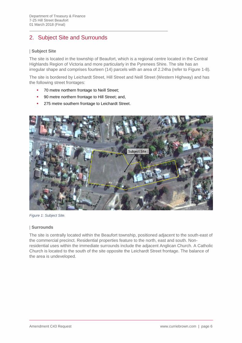
The site is located in the township of Beaufort, which is a regional centre located in the Central
Highlands Region of Victoria and more particularly in the Pyrenees Shire. The site has an
irregular shape and comprises fourteen (14) parcels with an area of 2.24ha (refer to Figure 1-8).
The site is bordered by Leichardt Street, Hill Street and Neill Street (Western Highway) and has
the following street frontages:
70 metre northern frontage to Neill Street;
90 metre northern frontage to Hill Street; and,
275 metre southern frontage to Leichardt Street.
Figure 1: Subject Site.
Surrounds
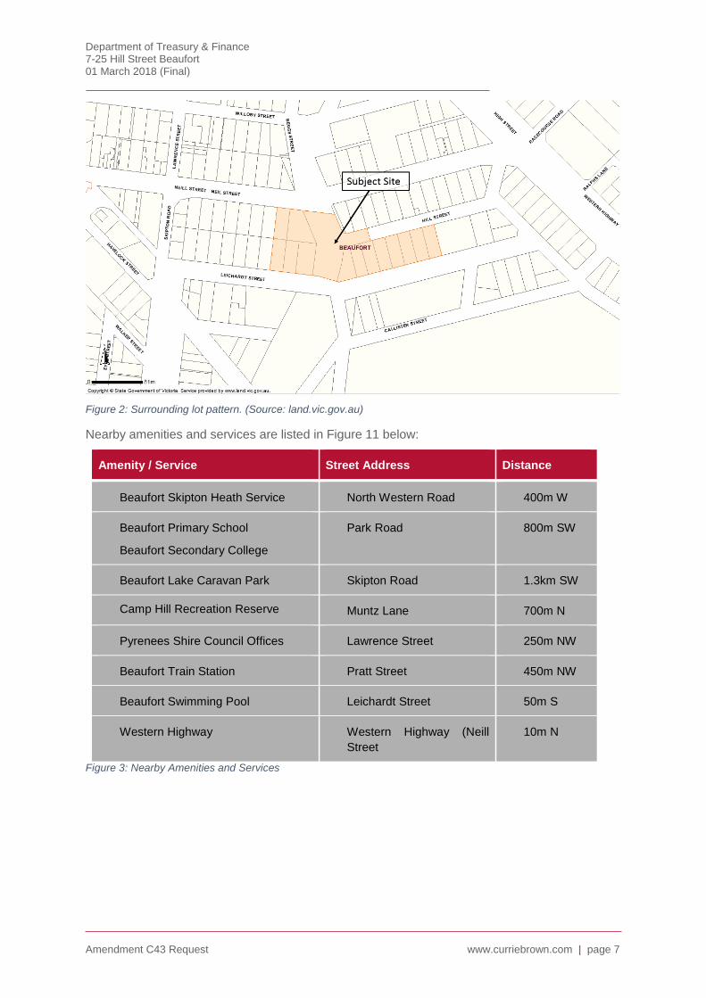
The site is centrally located within the Beaufort township, positioned adjacent to the south-east of
the commercial precinct. Residential properties feature to the north, east and south. Non-
residential uses within the immediate surrounds include the adjacent Anglican Church. A Catholic
Church is located to the south of the site opposite the Leichardt Street frontage. The balance of
the area is undeveloped.
Department of Treasury & Finance 7-25 Hill Street Beaufort 01 March 2018 (Final)
Amendment C43 Request www.curriebrown.com | page 7
Figure 2: Surrounding lot pattern. (Source: land.vic.gov.au)
Nearby amenities and services are listed in Figure 11 below:
Amenity / Service Street Address Distance
Beaufort Skipton Heath Service North Western Road 400m W
Beaufort Primary School
Beaufort Secondary College
Park Road 800m SW
Beaufort Lake Caravan Park Skipton Road 1.3km SW
Camp Hill Recreation Reserve Muntz Lane 700m N
Pyrenees Shire Council Offices Lawrence Street 250m NW
Beaufort Train Station Pratt Street 450m NW
Beaufort Swimming Pool Leichardt Street 50m S
Western Highway Western Highway (Neill
Street
10m N
Figure 3: Nearby Amenities and Services
Department of Treasury & Finance 7-25 Hill Street Beaufort 01 March 2018 (Final)
Amendment C43 Request www.curriebrown.com | page 8
Site Particulars
Legal Description
The site consists of nine reserved Crown parcels and five freehold titles (including nine freehold
parcels).
Lot/Plan or Crown Description
Lot 1 TP563434K Township of Beaufort Allot. 2 Sec. 41
Township of Beaufort Allot. 5 Sec. 4
Lot 2 TP563434K Township of Beaufort Allot. 2A Sec. 41
Township of Beaufort Allot. 6 Sec. 4
Township of Beaufort Allot. 1 Sec. 4
Township of Beaufort Allot. 3 Sec. 41
Township of Beaufort Allot. 7 Sec. 4
Township of Beaufort Allot. 2 Sec. 4
Township of Beaufort Allot. 4 Sec. 4
Township of Beaufort Allot. 8 Sec. 4
Township of Beaufort Allot. 20A Sec. 4
Encumbrances, Caveats and Notices
The subject is not burdened by any known encumbrances, caveats or notices including
covenants and 173 agreements.
The site is not subject to any known easements.
Current Use and Improvements
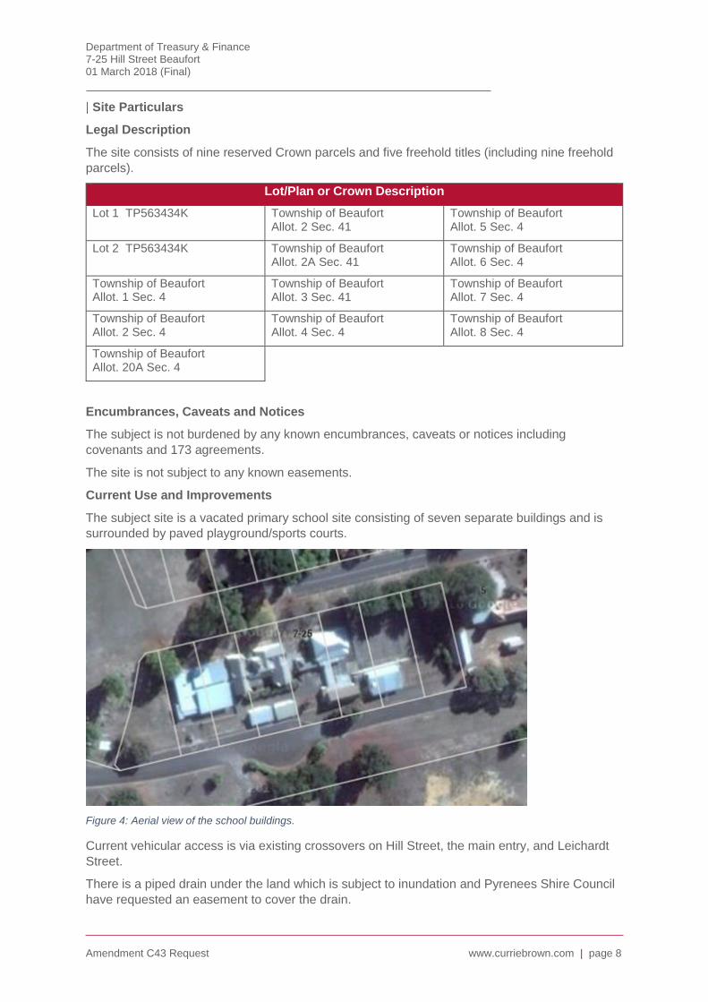
The subject site is a vacated primary school site consisting of seven separate buildings and is
surrounded by paved playground/sports courts.
Figure 4: Aerial view of the school buildings.
Current vehicular access is via existing crossovers on Hill Street, the main entry, and Leichardt
Street.
There is a piped drain under the land which is subject to inundation and Pyrenees Shire Council
have requested an easement to cover the drain.

Department of Treasury & Finance 7-25 Hill Street Beaufort 01 March 2018 (Final)
Amendment C43 Request www.curriebrown.com | page 9
A sewer main traverses through Crown Allotment 20A, Section 4.

Department of Treasury & Finance 7-25 Hill Street Beaufort 01 March 2018 (Final)
Amendment C43 Request www.curriebrown.com | page 10
3. Existing Planning Framework
Existing Zone
The majority of the site is currently zoned Public Use Zone 7 (Other Public Use). The purpose of
the Public Use Zone is:
To implement the State Planning Policy Framework and the Local Planning Policy
Framework, including the Municipal Strategic Statement and local planning policies.
To recognise public land use for public utility and community services and facilities.
To provide for associated uses that are consistent with the intent of the public land
reservation or purpose.
Under the Public Use Zone, an application for a permit by a person other than the relevant public
land manager must be accompanied by the written consent of the public land manager,
indicating that the public land manager consents generally or conditionally either:
To the application for permit being made.
To the application for a permit being made and to the proposed use and development.
A parcel on the eastern end of the site is currently zoned General Residential Zone – Schedule 1
(GRZ1). The purpose of the General Residential Zone is:
To implement the State Planning Policy Framework and the Local Planning Policy
Framework, including the Municipal Strategic Statement and local planning policies.
To encourage development that respects the neighbourhood character of the area.
To encourage a diversity of housing types and housing growth in locations offering good
access to services and transport.
To allow educational, recreational, religious, community and a limited range of other non-
residential uses to serve local community needs in appropriate locations.
Under the General Residential Zone, an application must be accompanied by the following
information, as appropriate:
For a residential development of four storeys or less, the neighbourhood and site
description and design response as required in Clause 54 and Clause 55.
For residential development of five or more storeys, an urban context report and design
response as required in Clause 52.35.
For an application for subdivision, a site and context description and design response as
required in Clause 56.
Plans drawn to scale and dimensioned which show:
Site shape, size, dimensions and orientation.
The siting and use of existing and proposed buildings.
Adjacent buildings and uses.
The building form and scale.
Setbacks to property boundaries.
The likely effects, if any, on adjoining land, including noise levels, traffic, the hours of
delivery and despatch of good and materials, hours of operation and light spill, solar
access and glare.
Amendment VC110, gazetted on 27 March 2017, introduced the ability for a schedule to the zone
to include neighbourhood character objectives.

Department of Treasury & Finance 7-25 Hill Street Beaufort 01 March 2018 (Final)
Amendment C43 Request www.curriebrown.com | page 11
The approval of Amendment VC110 also introduced a mandatory height limit of 11 metres and 3
storeys in the zone, unless varied by a schedule. It also included a requirement for the provision
of garden area, for dwellings and residential buildings, of between 25% for lots of 400sqm to 35%
for lots in excess of 650sqm.
Figure 5: Zone Map (Source: Planning Maps Online)
Existing Overlays
Three overlays currently apply to the site. These include
Floodway Overlay (FO)
Land Subject to Inundation (LSIO)
Heritage Overlay (HO502)
Floodway Overlay (FO)
The purpose of the Floodway Overlay is:
To implement the State Planning Policy Framework and the Local Planning Policy
Framework, including the Municipal Strategic Statement and local planning policies.
To identify waterways, major floodpaths, drainage depressions and high hazard areas which
have the greatest risk and frequency of being affected by flooding.
To ensure that any development maintains the free passage and temporary storage of
floodwater, minimises flood damage and is compatible with flood hazard, local drainage
conditions and the minimisation of soil erosion, sedimentation and silting.
To reflect any declarations under Division 4 of Part 10 of the Water Act, 1989 if a declaration
has been made.
To protect water quality and waterways as natural resources in accordance with the
provisions of relevant State Environment Protection Policies, and particularly in accordance
with Clauses 33 and 35 of the State Environment Protection Policy (Waters of Victoria).

Department of Treasury & Finance 7-25 Hill Street Beaufort 01 March 2018 (Final)
Amendment C43 Request www.curriebrown.com | page 12
To ensure that development maintains or improves river and wetland health, waterway
protection and flood plain health.
Pursuant to Clause 44.03-1, a permit is required to construct a building or to construct or carry
out works, including:
A fence.
Roadworks.
Bicycle pathways and trails.
Public toilets.
A domestic swimming pool or spa and associated mechanical and safety equipment if
associated with one dwelling on a lot.
Rainwater tank with a capacity of not more than 4500 litres.
A pergola or verandah, including an open-sided pergola or verandah to a dwelling with a
finished floor level not more than 800mm above ground level and a maximum building height
of 3 metres above ground level.
A deck, including a deck to a dwelling with a finished floor level not more than 800mm above
ground level.
A non-domestic disabled access ramp.
The Schedule to the Floodway Overlay establishes that the permit is not required to construction
the following building and works:
Any buildings and works, if appropriately detailed information is submitted to the satisfaction
of the responsible authority showing that:
the natural level of the land on which the buildings and works are proposed is at least 300
millimetres above the 100-year Average Recurrence Interval (ARI) flood level.
flood free access is available to the land during floods up to and including the 100-year ARI
event.
A pergola where the ground level will not be increased more than 150 millimetres over and
above natural surface level.
A verandah with a floor raised on stumps or piers provided the cladding applied to the outside
edge provides for the free passage of floodwater beneath the structure such as spaced timber
boards.
An open sided carport.
The addition of a second story, or other additional stories, on top of the existing building
where there is no increase in building footprint.
The alteration of an existing building where the original building footprint remains and the floor
level(s) are at and will be retained at more than 300 millimetres above flood level.
Extension of an existing dwelling on floodway land provided:
the floor of the extension is constructed on stumps or piers.
the finished floor level will be 300 millimetres or more above the 100-year ARI flood level.
the total area of the extension does not exceed 50 square metres.
An open sports ground excluding change rooms, pavilions, shelters, other buildings, and
raised viewing areas, provided that the natural surface level is not altered.
An outdoor recreation facility, excluding any buildings or structures that alter water movement
across or storage capacity of the floodplain, and works that alter the topography of the land.
Road works or works to any other access way (public or private) that:
do not increase the finished level of the road surface; or

Department of Treasury & Finance 7-25 Hill Street Beaufort 01 March 2018 (Final)
Amendment C43 Request www.curriebrown.com | page 13
are limited to resurfacing of an existing road.
Cycle or pedestrian tracks where there is no increase in the natural ground level.
An outdoor advertising sign fixed to an existing building or to a pole or pylon, where the
advertisement area is positioned above the 100 year ARI flood level.
A mast, antenna, lighting, or a telecommunications tower.
Pursuant to Clause 44.03-2, a permit may only be granted to subdivide land if the following
apply:
The subdivision does not create any new lots, which are entirely within this overlay. This does
not apply if the subdivision creates a lot, which by agreement between the owner and the
relevant floodplain management authority, is to be transferred to an authority for a public
purpose.
The subdivision is the resubdivision of existing lots and the number of lots is not increased,
unless a local floodplain development plan incorporated into this scheme specifically provides
otherwise.
Point 2.0 of the Schedule to the Overlay, requires that the Responsible Authority must consider
the Beaufort Local Floodplain Development Plan, incorporated at Clause 81 of the Pyrenees
Shire Planning Scheme, in addition to the Decision Guidelines in Clause 44.04-6.
Figure 6: Floodway Overlay.
Land Subject to Inundation (LSIO)
The purpose of the Land Subject to Inundation Overlay is
To implement the State Planning Policy Framework and the Local Planning Policy
Framework, including the Municipal Strategic Statement and local planning policies.
To identify land in a flood storage or flood fringe area affected by the 1 in 100 year flood or
any other area determined by the floodplain management authority.
Department of Treasury & Finance 7-25 Hill Street Beaufort 01 March 2018 (Final)
Amendment C43 Request www.curriebrown.com | page 14
To ensure that development maintains the free passage and temporary storage of
floodwaters, minimises flood damage, is compatible with the flood hazard and local drainage
conditions and will not cause any significant rise in flood level or flow velocity.
To reflect any declaration under Division 4 of Part 10 of the Water Act, 1989 where a
declaration has been made.
To protect water quality in accordance with the provisions of relevant State Environment
Protection Policies, particularly in accordance with Clauses 33 and 35 of the State
Environment Protection Policy (Waters of Victoria).
To ensure that development maintains or improves river and wetland health, waterway
protection and flood plain health.
Pursuant to Clause 44.04-1, a permit is required to construct a building or to construct or carry
out works, including:
A fence.
Roadworks.
Bicycle pathways and trails.
Public toilets.
A domestic swimming pool or spa and associated mechanical and safety equipment if
associated with one dwelling on a lot.
A pergola or verandah, including an open-sided pergola or verandah to a dwelling with a
finished floor level not more than 800mm above ground level and a maximum building height
of 3 metres above ground level.
A deck, including a deck to a dwelling with a finished floor level not more than 800mm above
ground level.
A non-domestic disabled access ramp.
The Schedule to the Land Subject to Inundation establishes that a permit is not required to
construction the following building and works:
Any buildings and works if appropriately detailed information is submitted to the satisfaction of
the responsible authority showing the natural level of the land on which the buildings and
works are proposed is at least 300 millimetres above the 100-year Average Recurrence
Interval flood level.
A pergola where the ground level will not be increased more than 150 millimetres over and
above natural surface level.
A verandah with a floor raised on stumps or piers provided the cladding applied to the outside
edge provides for the free passage of floodwater beneath the structure such as spaced timber
boards.
An open sided carport.
The addition of a second story, or other additional stories, on top of the existing building
where there is no increase in building footprint.
Extension of an existing dwelling on floodway land provided:
the floor of the extension is constructed on stumps or piers and provision is made in any
cladding of the sub-floor structure for the free passage of floodwater.
the finished floor level will be 300 millimetres or more above the 100-year Average
Recurrence Interval (ARI) flood level.
A non-habitable out-building (including replacement of an existing out-building) or garage
which has a floor area less than 20 square metres that is constructed to at least 150
millimetres above the 100-year ARI flood level, and where the relevant floodplain
management authority has agreed in writing that the flowpath is not obstructed.
Department of Treasury & Finance 7-25 Hill Street Beaufort 01 March 2018 (Final)
Amendment C43 Request www.curriebrown.com | page 15
A replacement building (not including an out-building) if the floor is set at least 300millimetres
above the 100-year ARI flood level and the original building footprint remains the same. The
responsible authority may require evidence of the existing building envelope.
Fencing, including any swimming pool fencing, with at least 60% openings and with the plinth
(if any) at least 150 millimetres above the flood level.
An in-ground swimming pool where the perimeter edging of the pool is constructed at natural
surface levels and excavated material is removed from the flowpath.
A sporting surface at existing surface level with fencing designed to minimise obstruction to
flows.
An open sports ground excluding change rooms, pavilions, shelters, other buildings, and
raised viewing areas, provided that the natural surface level is not altered.
An outdoor recreation facility, excluding any buildings or structures that alter water movement
across or storage capacity of the floodplain, and works that alter the topography of the land.
Landscaping works or the construction of driveways, vehicle crossovers, footpaths or bicycle
paths if there is no significant change to existing surface levels, or if the relevant floodplain
management authority has agreed in writing that the flowpath will not be obstructed.
One domestic rainwater tank of 4,500 litres capacity or less.
Stockyards or haysheds on land in a non-urban zone.
Radio masts, light poles, or antennas.
An outdoor advertising sign fixed to an existing building or to a pole or pylon, where the
advertisement area is positioned above the 100 year ARI flood level.
Road works or works to any other access way (public or private) that:
do not increase the finished level of the road surface; or
are limited to resurfacing of an existing road.
Cycle or pedestrian tracks where there is no increase in the natural ground level.
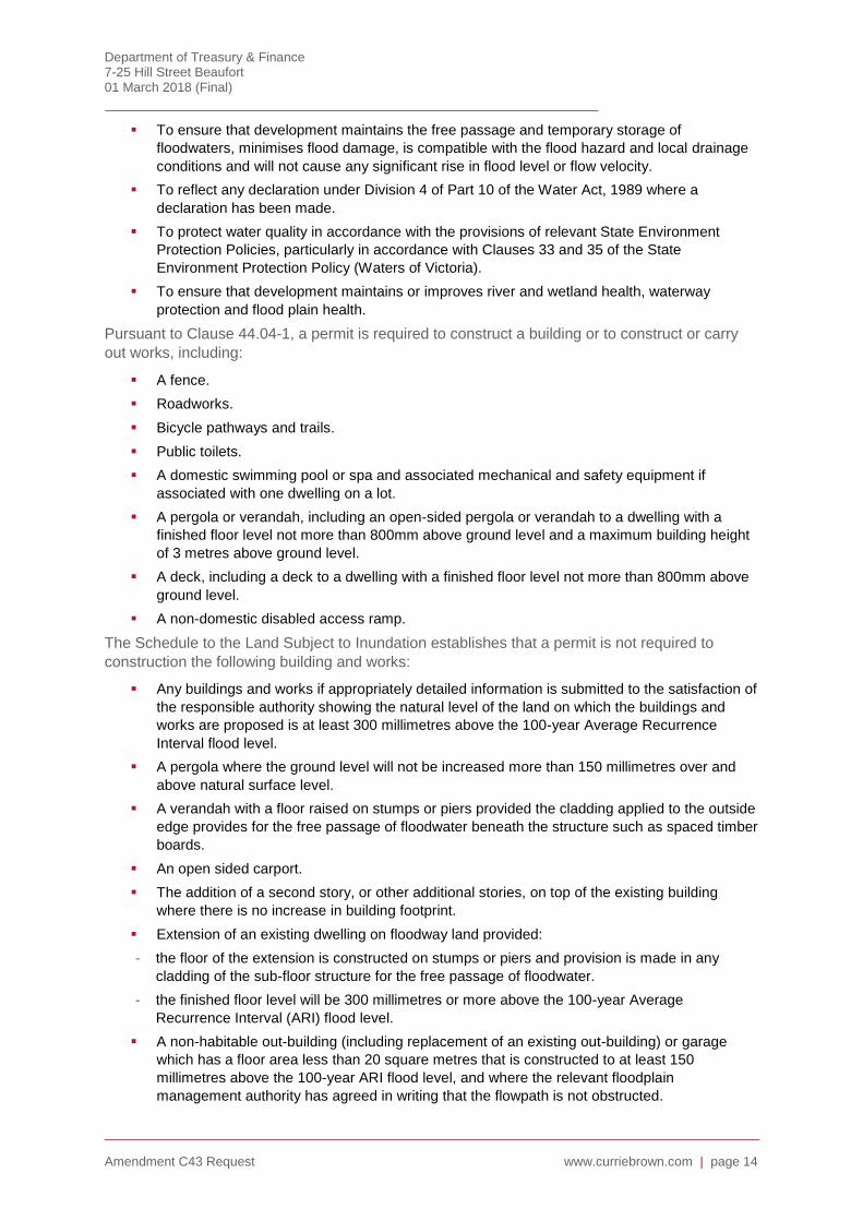
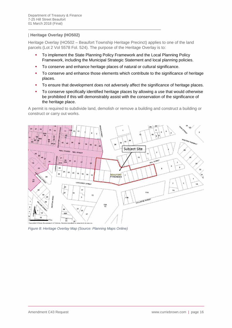
The dimensions of both overlays is shown on the plan in Figure 9 below.
Figure 7: Land Subject to Inundation Overlay
Department of Treasury & Finance 7-25 Hill Street Beaufort 01 March 2018 (Final)
Amendment C43 Request www.curriebrown.com | page 16
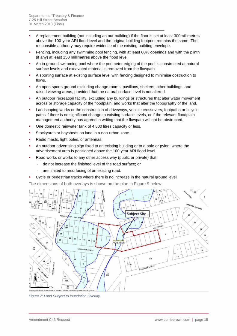
Heritage Overlay (HO502)
Heritage Overlay (HO502 – Beaufort Township Heritage Precinct) applies to one of the land
parcels (Lot 2 Vol 5578 Fol. 524). The purpose of the Heritage Overlay is to:
To implement the State Planning Policy Framework and the Local Planning Policy
Framework, including the Municipal Strategic Statement and local planning policies.
To conserve and enhance heritage places of natural or cultural significance.
To conserve and enhance those elements which contribute to the significance of heritage
places.
To ensure that development does not adversely affect the significance of heritage places.
To conserve specifically identified heritage places by allowing a use that would otherwise
be prohibited if this will demonstrably assist with the conservation of the significance of
the heritage place.
A permit is required to subdivide land, demolish or remove a building and construct a building or
construct or carry out works.
Figure 8: Heritage Overlay Map (Source: Planning Maps Online)
Department of Treasury & Finance 7-25 Hill Street Beaufort 01 March 2018 (Final)
Amendment C43 Request www.curriebrown.com | page 17
Figure 9: Floodway and Land Subject to Inundation Overlay definition plan
State Planning Policy Framework
This section provides a summary of the relevant strategic policy context that has guided the
preparation of the amendment request.
Clause 9.01 Plan Melbourne
Where relevant, planning and responsible authorities must consider and apply the strategy Plan
Melbourne 2017-2050: Metropolitan Strategy (Department of Environment, Land, Water and
Planning 2017).
Clause 10.04 Integrated decision making
Society has various needs and expectations such as land for settlement, protection of the
environment, economic well-being, various social needs, proper management of resources and
infrastructure. Planning aims to meet these needs and expectations by addressing aspects of
economic, environmental and social well-being affected by land use and development.
Planning authorities and responsible authorities should endeavour to integrate the range of
policies relevant to the issues to be determined and balance conflicting objectives in favour of net
community benefit and sustainable development for the benefit of present and future
generations. However in bushfire affected areas, planning authorities and responsible authorities
must prioritise the protection of human life over all other policy considerations.
Consistent with the objectives of local government under the Local Government Act 1989,
municipal planning authorities are required to identify the potential for regional impacts in their
decision-making and co-ordinate strategic planning with their neighbours and other public bodies
to achieve sustainable development and effective and efficient use of resources.
Clause 11.01-1 Settlement networks
To promote the sustainable growth and development of Victoria and deliver choice and
opportunity for all Victorians through a network of settlements”.

Department of Treasury & Finance 7-25 Hill Street Beaufort 01 March 2018 (Final)
Amendment C43 Request www.curriebrown.com | page 18
Key strategies include:
Ensure reqions and their settlements are planned in accordance with any relevant regional growth
plan.
Deliver networks of high-quality settlements by:
Building on strengths and capabilities of each region across Victoria to respond sustainably to
population growth and changing environments.
Developing networks of settlements that will support resilient communities and the ability to
adapt and change.
Balancing strategic objectives to achieve improved land-use and development outcomes at a
regional, catchment and local level.
Preserving and protecting features of rural land and natural resources and features to
enhance their contribution to settlements and landscapes.
Encouraging an integrated planning response between settlements within regions and in
adjoining regions and states in accordance with the relevant regional growth plan.
Providing for appropriately located supplies of residential, commercial, and industrial land
across a region, sufficient to meet community needs in accordance with the relevant regional
growth plan.
Improving transport network connections within and between regional cities, towns and
Melbourne.
Clause 11.02-1 Supply of urban land
To ensure a sufficient supply of land is available for residential, commercial, retail, industrial,
recreational, institutional and other community uses.
Clause 11.02-2 Structure planning
To facilitate the orderly development of urban areas.
Clause 11.02-3 Planning for growth areas
To locate urban growth close to transport corridors and services and provide efficient and
effective infrastructure to create benefits for sustainability while protecting primary production,
major sources of raw materials and valued environmental areas.
Clause 11.02-4 Sequencing of development
To manage the sequence of development in growth areas so that services are available from
early in the life of new communities.
Clause 11.07 Regional Victoria
Clause 11.07-1 Regional Planning
To develop regions and settlements which have a strong identity, are prosperous and are
environmentally sustainable.
Key Strategies include:
Identify and assess the spatial and land use planning implications of a region’s strategic
directions in Regional Strategic Plans.
Ensure regions and their settlements are planned in accordance with any relevant regional
growth plan.
The Policy also includes a series of principles as follows:
Support a network of integrated and prosperous regional settlements;

Department of Treasury & Finance 7-25 Hill Street Beaufort 01 March 2018 (Final)
Amendment C43 Request www.curriebrown.com | page 19
Maintain and provide for the enhancement of environmental health;
Maintain and enhance regional Victoria’s competitive advantages;
Respond to the impacts of climate change and natural hazards and promote community
safety;
Support the growth and development of distinctive and diverse regional settlements; and,
Promote liveable regional settlements and healthy communities.
Clause 11.08 Central Highlands
Clause 11.08-1 Planning for growth
To plan for population growth in sustainable locations throughout the region.
Clause 11.08-2 A diversified economy
To strengthen the region’s economy so that it is more diversified and resilient.
Clause 11.08-3 Regional links
To capitalise on the region’s close links with other regions and cities.
Clause 11.08-4 Sustainable Communities
To create sustainable and vibrant communities supported by enhanced access to key services.
Strategies include: Plan for growth by directing it to well-serviced settlements with good access
to Melbourne or Ballarat, particularly Bacchus March, Ballan, Creswick, Clunes, Beaufort and
Smythesdale.
11.08-5 A sustainable region
To make the region more self-reliant and sustainable.
11.08-6 Integrated Planning
To integrate planning for growth with the provision of infrastructure.
Clause 11.08-7 Environmental assets
To manage, protect and enhance the region’s land, soil, water, and biodiversity.
Clause 11.08-9 Cultural heritage and landscapes
To recognise the importance of cultural heritage and landscapes as economic and community
assets.
Clause 13.03-1 Use of contaminated and potentially contaminated land
To ensure that potentially contaminated land is suitable for its intended future use and
development, and that contaminated land is used safely.
Clause 13.04-1 Noise abatement
To assist the control of noise effects on sensitive land uses.
Clause 13.05-1 Bushfire planning
To strengthen the resilience of settlements and communities to bushfire through risk-based
planning that prioritises the protection of human life. The strategies are:
Protection of human life
Bushfire hazard identification and assessment
Settlement planning
Use and development control in a Bushfire Prone Area
Department of Treasury & Finance 7-25 Hill Street Beaufort 01 March 2018 (Final)
Amendment C43 Request www.curriebrown.com | page 20
The key outcome is to ensure that any planning scheme amendment will result in a development
being able to achieve a BAL 12.5 rating.
Clause 15.01 Urban environment
To create urban environments that are safe, functional and provide good quality environments
with a sense of place and cultural identity.
Clause 15.01-5 Cultural identity and neighbourhood character
To recognise and protect cultural identity, neighbourhood character and sense of place
Clause 15.02-1 Energy and resource efficiency
To encourage land use and development that is consistent with the efficient use of energy and
the minimisation of greenhouse gas emissions.
Clause 18.02-5 Car parking
To ensure an adequate supply of car parking that is appropriately designed and located.
Local Planning Policy Framework
Municipal Strategic Statement
Clause 21.01 Pyrenees Shire Key Influences & Issues
Clause 21.01-2 acknowledges among the key influences the settlement pattern that distributes
the shire’s population in Beaufort and Avoca and the smaller townships and settlement as
supporting the majority of the municipality’s population.
Relevant key issues include:
Settlement, built environment and heritage
The need to generate further employment opportunities.
The maintenance of viable communities at times of static or low population growth.
The retention of the established character and ethos of existing townships.
The protection of the cultural and heritage assets of the Shire.
Environmental and landscape values & risks
The protection and management of the Shire’s natural resources and environment.
Clause 21.02 Strategic Vision
Clause 21.02-2 establishes the Strategic Framework Plan, which addresses the following
matters:
Areas where particular environmental outcomes are required including:
Areas of environmental hazard (to which the Rural Conservation Zone has been applied).
Areas to which Environmental Significance overlays have been applied.
Low lying areas subject to inundation or drainage difficulty.
General farming areas in which different subdivisional minimums and requirements relating to
dwellings apply.
Areas of inappropriate subdivision which should be restructured.
Areas suitable for rural living.
Areas of high suitability for the growing of wine grapes.

Department of Treasury & Finance 7-25 Hill Street Beaufort 01 March 2018 (Final)
Amendment C43 Request www.curriebrown.com | page 21
Clause 21.03 Settlement, Built Environment and Heritage
Clause 21.03-1 establishes settlement policies for the Shire including:
To encourage the consolidation and enhancement of existing urban centres, through the
provision of the widest possible range of services and facilities and the provision of a diverse
range of housing types and lifestyle opportunities.
To encourage new urban development which makes efficient use of existing physical and
servicing infrastructure.
To allow for urban expansion only in areas which have a suitability for specified uses and
which represents an orderly extension of existing settlements and infrastructure.
To ensure that a compatible relationship exists between residential and industrial uses,
including the maintenance of appropriate environmental buffers.
To establish strategies for the development of small townships and residential settlements
that promote future consolidated growth and the provision of improved services and
community facilities.
To promote the retention of existing industries and employment uses and the attraction of
new use and development which can take advantage of the Shire’s natural and cultural
resources.
To encourage the maintenance and improvement of retail and commercial enterprises in the
larger towns so as to provide the best possible levels of service to residents and visitors.
To prepare and implement strategies for visual and landscape enhancement of townships,
designed to enhance their inherent qualities and to help create a sense of “place” and unique
identity. Particular emphasis should be given to roadside landscaping, and the creation of
themed entrances on principal road approaches.
Clause 21.03-2 establishes the objectives and strategies for Housing.
Objective 1 seeks “To ensure housing meets the needs of the Shire’s residents”.
The related strategies include:
Encourage a diverse range of housing, to attract and maintain a socially diverse population
base within the Shire.
Encourage higher density forms of development in central and accessible areas within
established townships.
Encourage an innovative approach to the development of special housing facilities,
particularly for the elderly, and non-family households.
Encourage site-responsive designs for dwellings which are pleasant to live in, are cost-
effective, and do not adversely impact on neighbours or the surrounding environment.
Clause 21.03-3 Heritage sets out the municipal heritage profile including key influences and
objectives, strategies and implementation methods for preserving indigenous and post-
settlement heritage.
The implementation of the objectives and strategies is to be achieved through:
Using policy and the exercise of discretion
Utilising the Local Planning Policy to protect culturally significant heritage places and areas.
Applying the Pyrenees Shire Heritage Precinct Policy Report (an incorporated document)
which includes specific local heritage objectives and policies for each of the heritage
precincts, together with policy maps and lists of relevant heritage places within the precincts.
The Heritage Overlay is to be applied to identify places and precincts of cultural significance.

Department of Treasury & Finance 7-25 Hill Street Beaufort 01 March 2018 (Final)
Amendment C43 Request www.curriebrown.com | page 22
Clause 21.04 Environmental and Landscape Values & Risks
The Land Use Capability Assessment at Clause 21.04-4 broadly reviewed the capability of
different areas in the Shire to support various land uses as well as areas where environmental
sensitivity presents implications in land management.
In the discussions regarding Planning Constraints (third dot point) includes:
Areas along other creeks and streams which are also considered to be potentially affected by
1 in 100 year probability floods – and which are also programmed for investigation by the
Flood-plain Management Unit of the Department of Natural Resources and Environment.
Clause 21.04-5 Areas Subject to Flooding or Drainage Difficulty sets out that areas either known
or suspected to be subject to flooding should appropriately have the Zoning and Overlay tools of
the Victorian Planning Provisions applied.
It is directed that these areas should be treated in the following ways:
Under-developed urban areas which are located on active flood plains (and which should
therefore be restrained from further development wherever possible) should be included in an
Urban Floodway Zone.
Active flood plains which represent a high level of risk to public safety (due to either the depth
or the velocity of floodwater flows) should be subject to a Floodway Overlay control.
Flood-fringe areas which are predicted to be subject to inundation in a 1% probability flood
event should be included in a Land Subject to Inundation Overlay.
Urban areas which are threatened with flooding due to inadequate drainage systems should
be included in a Special Building Overlay.
The Clause contains objectives which include:
To minimize risks posed by flooding to life, wellbeing and community infrastructure.
To protect floodplain areas of environmental significance or importance to river health.
Relevant strategies to the subject site include:
Identify areas which have the greatest risk of being affected by flooding.
Implement the findings of the Beaufort Floodplain Management Plan study and provide a
mechanism to implement the adopted Local Floodplain Development Plan for Beaufort.
Support Catchment Management Authority investigations into flooding across the Shire.
Develop a consistent approach to the assessment of planning proposals in areas subject to
flooding or drainage difficulties.
Prevent development from occurring which is likely to be adversely affected by flood
inundation and needlessly results in serious risks to life and property.
Avoid intensifying the impacts of flooding through inappropriately located land use and
development.
Reduce the impacts of flooding through encouragement of developments that are designed to
minimize risks to life, wellbeing, property and infrastructure.
Protect areas subject to flooding or drainage difficulty from inappropriate development.
Maintain the natural functions of floodplains in conveying and storing floodwater.
The proposed implementation include:
Using the results of investigations into flooding carried out by or in consultation with the
relevant Catchment Management Authority to apply appropriate zoning or overlay provisions
to protect areas that are potentially subject to inundation from inappropriate development.
Department of Treasury & Finance 7-25 Hill Street Beaufort 01 March 2018 (Final)
Amendment C43 Request www.curriebrown.com | page 23
Applying the following guidelines when considering proposals for the subdivision, use or
development of land in potentially flood-prone areas:
The potential for flooding and possible implications on development will be considered by the
responsible authority when assessing applications for development and use in those areas
which are identified as being potentially subject to inundation.
A dwelling should not be permitted on land which is subject to flooding, except where the
whole of the land in the tenement is so affected.
Floor levels in habitable buildings should be elevated so that they are at least 0.3 metres
above the known or anticipated 1 in 100 year probability flood line.
Private sewerage treatment and effluent disposal systems should be designed so as to
minimise the discharge of wastes into stream waters in periods of flood (whether or not they
are inundated by flood waters).
Buildings and works should not be constructed or carried out on flood plains in such a way as
to impede the orderly flow of floodwaters or to modify the performance of the flood-plain to the
detriment of other land owners in the locality.
Pending further investigation, all areas of the Shire which are known or suspected to be
subject to flooding or drainage difficulty should be included in a Design and Development
Overlay which provides a mechanism to set design and development parameters that will
help safeguard life and property.
Revising the above controls once detailed flood modelling studies have been completed and
more specific planning and development controls have been devised for incorporation in the
planning scheme.
Clause 21.04-6 establishes objectives, strategies and implementation methods for Public safety
and wildfire.
The objectives include:
To promote community awareness of the need to reduce bushfire risk.
To encourage development that incorporates suitable precautions against attack by bushfire.
To discourage or prevent development and land use that may create or aggravate fire risks
and hazards
Relevant strategies include:
Encourage the reduction of fire hazards and programs for the protection of property from
destruction by fire.
Require that subdivisions, buildings, public open space, roads and places of public use be
designed, sited and constructed to minimise the impact and emergency conditions arising
from fire.
Require that vehicle access, fencing and location of dams are developed to maximise the
ability of emergency service organisations to fight fires and protect life and property.
Require development to provide adequate water supplies with suitable flow rates.
Administer discretionary planning controls over the use and development of land in a way that
has regard to the relevant strategic initiatives and published guidelines for buildings in
bushfire-prone areas.
Require fuel levels to be modified to suitably minimise fire risk.
Require development associated with residential and public use to incorporate fire prevention
measures in accordance with the relevant fire prevention guidelines.
Require plantations to be located and designed to minimise the risk and spread of fire.
Department of Treasury & Finance 7-25 Hill Street Beaufort 01 March 2018 (Final)
Amendment C43 Request www.curriebrown.com | page 24
The identified implementation measure is to: “Undertake an ongoing review of rural and urban
areas that may have a high degree of exposure to wildfire risk in consultation with the Country
Fire Authority and apply the Bushfire Management Overlay controls as appropriate”.
Clause 21.06 Local Areas
Clause 21.06-1 establishes general land use strategy plans for Beaufort.
An identified strength and opportunity includes:
An excellent range of community services and facilities and excellent accessibility via the
Western Highway to Ballarat and Melbourne.
A potential to accommodate more substantial residential development, ranging from
conventional sized lots in the town itself, to low-density and rural residential lots on the
periphery.
The objectives for Beaufort include:
To maintain the town’s existing function as the Shire’s principal town.
To development the town’s role as a highway service centre.
To retain Beaufort’s character and sense of place.
To manage environmental risks and land use conflicts.
Relevant policies directions include:
Direct residential development to residential areas which have the potential to accommodate
significant infill development.
Seek to achieve a more compact urban form.
Apply special overlay planning controls to areas which are known or suspected to be subject
to flooding or drainage difficulty, so that new development can be appropriately regulated
Among the proposed implementation measures is the application of the General Residential
Zone to established residential areas.
Local Planning Policies
Clause 22.03 Floodplain Management in Beaufort
This policy applies to land in and surrounding Beaufort which is within the Floodway Overlay, the
Land Subject to Inundation Overlay, and the Urban Floodway Zone.
The Objectives of the policy include:
To limit to acceptable levels, the effect of flooding for the well-being, health and safety of flood
prone individuals and communities.
To minimise flood risk and promote sustainable use and development of the floodplain.
To ensure development and land use on the floodplain is consistent with flood risk.
To ensure that where permitted, development in the floodplain:
maintains the free passage and temporary storage of floodwaters;
minimises flood damage;
will not cause any significant rise in flood level or flow velocity; and,
will not cause any impact on adjacent property.
To discourage the intensification of land use and development in the floodplains of the Yam
Holes, Ding Dong, Cemetery and Cumberland Creeks at Beaufort.
To recognise the natural flood carrying capacity of rivers, streams and wetlands and the flood
storage function of floodplains.

Department of Treasury & Finance 7-25 Hill Street Beaufort 01 March 2018 (Final)
Amendment C43 Request www.curriebrown.com | page 25
To protect surface and ground water quality, and preserve important wetlands and areas of
environmental significance.
To minimise risk associated with overland flow of storm water.
With regards to exercising discretion, it is policy to:
Give effect to the provisions of the Beaufort Local Floodplain Development Plan (March
2013), which has been incorporated at Clause 81 of this Scheme.
Discourage new buildings and works, including earthworks and vegetation clearance in the
Floodway Overlay and the Urban Floodway Zone.
Discourage landfill in all areas subject to inundation, which is likely to exacerbate flooding
impacts on other properties nearby.
Permit buildings and works on land affected by the Floodway Overlay and Land Subject to
Inundation Overlay, only where those buildings and works are demonstrated to be of low flood
risk and consistent with the preferred dominant land use outcomes as identified by the stated
purposes of the relevant Zone.
Discourage extensions to buildings at levels below the 100 Year Average Recurrence Interval
(ARI) Flood.
Discourage the construction of levees in areas regarded by the floodplain management
authority as important for flood storage and/or environmental values.
Discourage earthworks that obstruct natural flow paths or drainage lines.
Encourage the retention of natural drainage corridors with suitable vegetated buffer zones
along waterways to maintain the natural drainage function, and stream habitat, to protect the
wildlife corridor, and landscape values.
Encourage new fences to be designed so as to avoid unreasonable obstruction to the orderly
flow of flood waters.
Minimise erosion of stream banks and verges and to reduce polluted surface runoff from
adjacent land uses.
Minimise the quantity of stormwater runoff from developed areas, and retard flow velocities to
maintain public safety, and to protect the integrity of existing streams and watercourses.
Encourage new buildings and works to occur on land which is not subject to flooding threat.

Department of Treasury & Finance 7-25 Hill Street Beaufort 01 March 2018 (Final)
Amendment C43 Request www.curriebrown.com | page 26
Council’s key strategic documents
Pyrenees Shire Growth Strategy 2015-2018
The Growth Strategy identified a series of strategies and actions to be undertaken in the 12 to 24
months after the plan’s adoption to drive its implementation. These include:
Objective 1: Attract new residents, visitors and investment
Strategy 1 – Promote the benefits and opportunities in the Pyrenees Shire to attract new
residents, visitors and investment.
Strategy 2 – Foster improvement of the Pyrenees Shires economic assets and local amenity.
Objective 2: Foster the capability of key economic sectors
Strategy 3 – Participate in regional industry development to grow the agriculture sector.
Strategy 4 – Foster increased capability and reputation of the local wine sector.
Strategy 5 Foster improved capability of the local tourism sector.
Strategy 6 – Leverage presence of the Langi Kal Kal and Hopkins correctional facilities.
Strategy 7 – Leverage opportunities in the renewable energy sector.
Objective 3: Develop local business and employee capability
Strategy 8 – Improve the sustainability of the local economy by fostering local business capacity.
Strategy 9 – Improve the capability of local residents to obtain employment.
This informs the Action Plan which includes a framework of strategic responses and actions.
Actions proposed for Beaufort include:
2.3 Advocate for road infrastructure funding including local roads, the arterial road network, and
for the construction of the Beaufort Bypass, and having regard to the importance of the road
network in transporting goods to market.
2.4 Advocate to VicRoads to undertake an economic impact study regarding the Beaufort Bypass
ahead of the completion of planning for the Bypass.
2.5 Advocate for the completion of a business case to support Government funding for the
development of an improved water supply for Moonambel.
2.6 Implement the outcomes of the review of the Pyrenees Planning Scheme to support demand
and population growth and incorporate the identification of:
Opportunities for additional residential development in Beaufort and Avoca
Opportunities for additional commercial space in Beaufort and Avoca
Potential site(s) for a major agricultural processing/value adding operation
2.7 Seek government funding to support the development of industrial land in Avoca and
Beaufort to stimulate investment and create jobs.
Beaufort Walkability Plan, October 2015
The plan seeks to improve the health and wellbeing of Beaufort residents through the review of
current provision of infrastructure including gaps, documenting best practice, recommending
actions, standards and priorities to improve current infrastructure.
Department of Treasury & Finance 7-25 Hill Street Beaufort 01 March 2018 (Final)
Amendment C43 Request www.curriebrown.com | page 27
The Former Primary School site is identified as a Formalised Pathway Gap. The plan identifies
the site in its Medium Term Priorities (page 37), proposing the following actions:
2.5 Investigate future opportunities for pedestrian access through former Primary School Site,
particularly if land is likely to be developed rather than kept as open space.
2.8 Investigate the opportunity for a new accessible safe crossing point on Neill Street from Apex
Park to the Former Primary School site.
Beaufort Local Floodplain Development Plan
This plan was adopted by Pyrenees Shire Council on 19 March 2013 and is incorporated in to
the Pyrenees Planning Scheme, pursuant to Clause 81.
The Development Plan applies to that part of the floodplain of Yam Holes Creek located north
and west of the Beaufort Township, and to the floodplains of the tributary local streams within the
township (including Cemetery Creek, Cumberland Creek, and Ding Dong Creek). These
floodplain areas are within either the Urban Floodway Zone, the Floodway Overlay, or the Land
Subject to Inundation Overlay of the Pyrenees Planning Scheme.
Point 6.0 establishes the Effect of the Local Floodplain Development Plan, which is:
Every Application for primary or secondary consent to construct a building, to carry out work,
or to subdivide land under Clause 37.03 (UFZ), Clause 44.03 (FO), or Clause 44.04 (LSIO) of
the Pyrenees Planning must be consistent with this Local Floodplain Development Plan.
A planning permit may only be granted for a development in a Floodway Overlay area which
either:
Complies fully with the particular (and relevant) provision in this Local Floodplain
Development Plan; or,
Meets the requirement of a site-specific Flood Risk Report which has been prepared in
accordance with the criteria set out in Clause 44.03-3 of the Pyrenees Planning Scheme, to
the satisfaction of the responsible authority.
The plan establishes provisions relating to: Fencing; Building and Works; Subdivision; Chemical
Storage; Water Tanks in the UFZ, FO and LSIO.

Department of Treasury & Finance 7-25 Hill Street Beaufort 01 March 2018 (Final)
Amendment C43 Request www.curriebrown.com | page 28
Other documents and considerations
Plan Melbourne
Plan Melbourne is a long-term plan to accommodate Melbourne’s future growth in population and
employment. It includes:
9 principles that underpin a long-term vision for Melbourne
7 outcomes to drive Melbourne as a competitive, liveable and sustainable city
32 directions setting out how these outcomes can be achieved
90 policies outlining how each outcome will be approached, delivered and achieved
Outcome 7 of the Plan is ‘Regional Victoria is productive, sustainable and supports jobs and
economic growth’. The following directions and policies will help achieve this outcome:
Direction 7.1: Invest in regional Victoria to support housing and economic growth
Policy 7.1.1: Stimulate employment and growth in regional cities
Policy 7.1.2: Support planning for growing towns in peri-urban areas
Direction 7.2: Improve connections between cities and regions
Policy 7.2.1: Improve transport and digital connectivity for regional Victoria
Policy 7.2.2: Strengthen transport links on national networks for the movement of commodities
The Plan also refers to Regional Growth Plans that are being developed across regional Victoria
(the Central Highlands Regional Growth Plan being relevant to the subject site). These are to
provide 20-30 year land use strategies and set out how each region can accommodate a greater
share of the State’s growth.
Central Highlands Regional Growth Plan (May 2014)
The Central Highlands Regional Growth Plan (the Plan) is the strategic land use plan for the
region to guide growth and change for the next 30 years. The plan covers the municipalities of
Ararat, Ballarat, Golden Plains, Hepburn, Moorabool, and Pyrenees. The plan has been
developed in partnership between local government and state agencies and authorities and
reflects state and local government objectives. It is one of eight Regional Growth Plans being
prepared for Victoria.
The Plan identifies:
Where future development will be supported, assessed at a regional scale;
Environmental, economic, community and cultural assets and resources of regional
significance that should be preserved, maintained or developed;
How the region can response to opportunities, challenges and long-term drivers for change;
Key regional priorities for future infrastructure planning and investment to support growth.
The Plan recognises challenges for growth will include: Development pressures in high amenity
areas; Spreading the benefits of population growth; Realising employment growth; Changing
climate; and, Providing new services and infrastructure, and maintenance of existing services
and infrastructure. The plan considers a wide range of land uses including agriculture, tourism
and the protection of environmental assets, commercial and residential uses.
The Plan provides a vision for the region (how the region will be characterised in 2041) which is
that the future of the Central Highlands region to 2030 and beyond to be a productive,
sustainable and liveable region for its people. It also contains a set of regional planning principles
to guide growth and change. These include:

Department of Treasury & Finance 7-25 Hill Street Beaufort 01 March 2018 (Final)
Amendment C43 Request www.curriebrown.com | page 29
Population growth should be planned in sustainable location throughout the region.
The region’s economy should be strengthened so that it is more diversified and resilent.
The region should capitalise on its close links with other regions and cities.
The development of sustainable and vibrant communities should be supported by enhancing
the level of access to key services/
Land use patterns, development and infrastructure should make the region more self-reliant
and sustainable.
Planning for growth should be integrated with the provision of infrastructure.
The Plan recognises that the region has a diverse economy but main driver in the last decade
had been population growth. Manufacturing, healthcare, finance, education and construction are
leading sectors. Other important economic activities include retail trade, agriculture, professional
services, transport, and public administration.
Commercial development
In terms of commercial land uses and development, the Plan lists the following future directions
at page 20:
Support commercial development in each settlement that is consistent with the role and
function of that settlement within the region.
Support commercial activity that will encourage economic self-sufficiency and reduce trade
leakage to Melbourne.
Support commercial development that reinforces the primacy of existing town centres.
Land use policies, strategies and actions for commercial development include:
Encourage commercial services to be provided to settlements consistent with their role in the
regional settlement network, taking into account relationships with other settlements within
and outside ther gion.
Support commercial land uses in designated locations in planning schemes and provide
sufficient appropriately zoned land.
Support the consolidation of prime commercial activties within existing town centres.
Regularly review commercial land supply and demand in areas experiencing population
growth to ensure that sufficient commercial zopned land is provided.
Support the implementation of economic development strategies to strengthen commercial
activity and enhance the quality of retailing in axisting town centres.
Beaufort
Beaufort is listed as a town in the regional settlement framework plan. The future directions for
Beaufort include:
Support Beaufort as a town providing services in the Ballarat hinterland.
Encourage residential growth to take advantage of existing services.
Support local employment opportunities.
Plan for managing the opportunities and impacts associated with upgrades to the Western
Highway.
The Plan identifies that Beaufort’s central location provide opportunities to commute to Ballarat
and Ararat for employment and will be an attractive location for those working in local industries
and retirees.
Residential development is to be encouraged to use existing services while having regard for
environmental risks such as bushfire and flood. Infill development is to be encouraged with

Department of Treasury & Finance 7-25 Hill Street Beaufort 01 March 2018 (Final)
Amendment C43 Request www.curriebrown.com | page 30
greenfield settlement to be directed to the west of the existing urban area. Local employment is
to be protected and encouraged to limit reliance on surrounding settlements.
Land use policies, strategies and actions for Beaufort include:
Retain and enhance services and facilities appropriate to servicing the local community.
Provide for residential growth as required, including infill development and development to the
west of Beaufort.
Monitor the need for additional industrial land and undertake rezoning of land as required.
Plan for a potential longer-term highway bypass of the town both in terms of a preferred route
and in consideration of how to manage any impacts on employment, the existing road
network and the character of the town.
Environmental Sustainability Strategy: A Vision for Pyrenees Shire 2011
The Environmental Sustainability Strategy establishes a strategic operational framework for
working towards environmental sustainability in Pyrenees Shire.
The Strategy contains a series of broad actions proposed to be implemented across the
Council’s operation. Relevant actions related to land use planning included, Develop and
promote information for building in fire and flood zone areas.
Regional Bushfire Planning Assessment – Grampians Region
The 2009 Victorian Bushfires Royal Commission (VBRC) emphasised the importance of
considering bushfire matters at all stages of the planning process, including through regional
settlement planning and in the LPPF. The SPP for Bushfire also identifies that strategic and
settlement planning should assist to strengthen community resilience to bushfire. The Regional
Bushfire Planning Assessment (RBPA) supports this approach and is part of the Government’s
response to the VBRC.
The RBPA provides information about areas where a range of land use planning matters
intersects with a bushfire hazard to influence the level of risk to life and property from bushfire.
The RBPA is not a statutory planning provision and does not directly translate into planning
schemes. However, it provides a basis to initiate further detailed analysis as part of other
planning processes such as planning scheme amendments.
The RBPA provides information on matters which may be relevant to strategic and settlement
planning and focuses on the factors considered particularly important by the VBRC, including:
Areas where smaller sized lots (less than 0.4ha) which may be used for residential purposes
are in or close to a bushfire hazard;
Areas where medium sized lots (between 0.4-4ha) which may be used for residential
purposes are in or close to a bushfire hazard;
Areas where there is a settlement or urban interface with the bushfire hazard;
Locations which may have limited access and egress, indicated by a single access road to
and from a settlement in addition to roads which connect a number of settlements in areas
with a bushfire hazard;
Areas where future strategic directions contained in planning schemes may conflict with the
bushfire hazard;
Areas where the broader landscape is particularly affected by a bushfire hazard;
Areas identified from local information provided by either the relevant fire authority or the
council that may need to be considered in planning decision making; and

Department of Treasury & Finance 7-25 Hill Street Beaufort 01 March 2018 (Final)
Amendment C43 Request www.curriebrown.com | page 31
Areas where multiple issues occur in a single area.
This information is shown spatially on maps at a strategic scale and is supported by a table that
gives a brief explanation for each identified area.
The RBPA is different to the BMO in that it informs a broader consideration of bushfire issues by
recognising that, in specific locations, the bushfire hazard increases the potential bushfire risk in
very specific ways, for example, due to access constraints. Addressing these factors is an
important way that strategic and settlement planning can respond to bushfire issues before
specific development proposals are considered. This provides an opportunity to resolve issues
and implement mitigation measures early in the planning process and at a strategic level.
The BMO is applied to areas where there is potential for bushfire behaviour such as a crown fire,
extreme ember attack and radiant heat. The application of the overlay is based on a technical
evaluation of the bushfire hazard validated with relevant fire authorities and councils. The key purpose
of the BMO is to identify areas where a planning permit is specifically required to consider the bushfire
matters prior to development occurring.
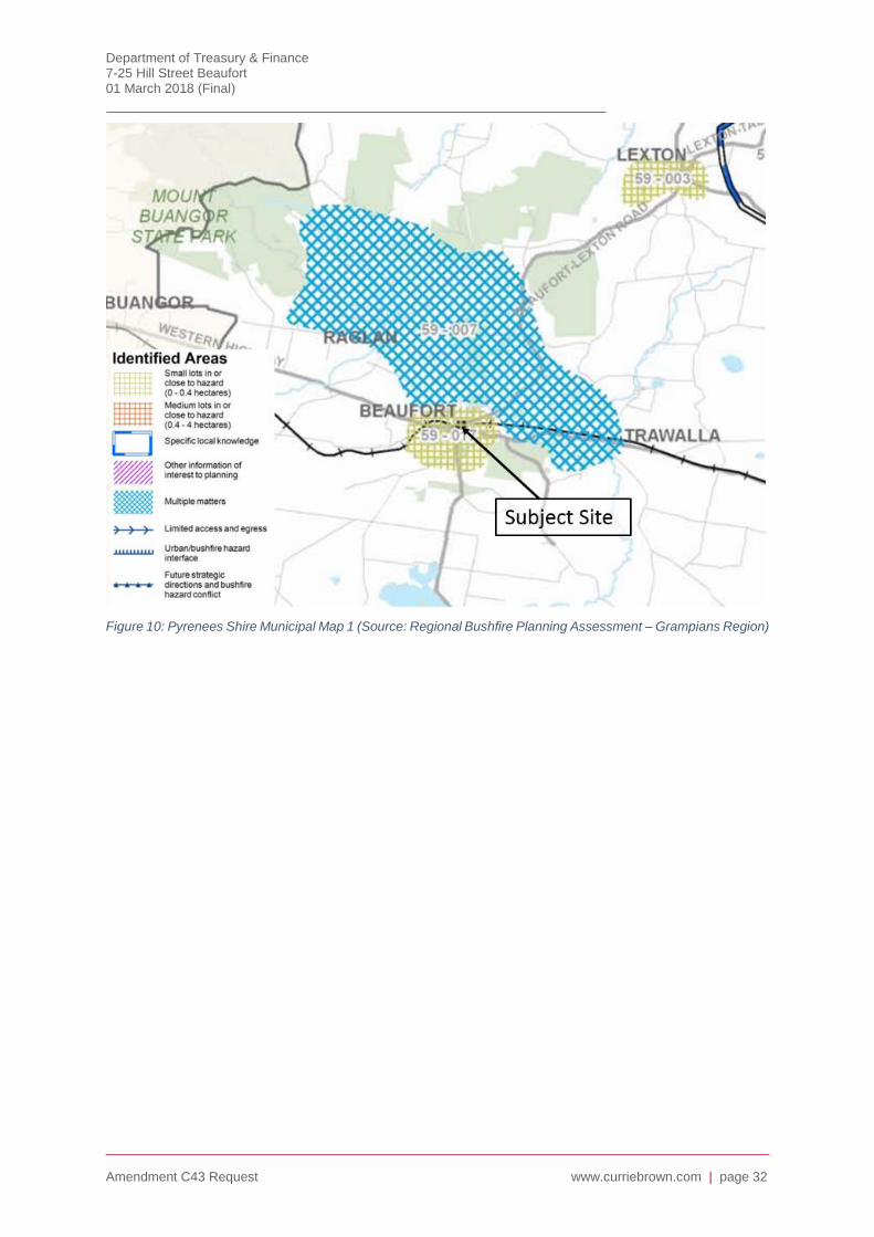
Beaufort is located on the Pyrenees Municipal Map – Map 1 (p 37 of Part 2 of the strategy). The
township is identified as having small lots in or close to hazard (0 to 0.4 hectares) with an
identified area description (59-017) of “Clusters of small lots in Beaufort which are adjacent to
bushfire hazard area to the north and south-east of the township”. Rural area to the north has
multiple matters evident. The identified area description (59-007 is:
Multiple bushfire considerations including clusters of small and medium size lots in a
dispersed settlement pattern in or in close proximity to bushfire hazard area associated with
the adjacent Great Dividing Range.
Settlement pattern developed in a linear form along Main Lead road with connecting single
access roads servicing surrounding dwellings.
Northern and southern boundaries of Beaufort interface with bushfire hazard.
Existing vegetation includes areas of vegetation of high and very high conservation
significance.
Department of Treasury & Finance 7-25 Hill Street Beaufort 01 March 2018 (Final)
Amendment C43 Request www.curriebrown.com | page 32
Figure 10: Pyrenees Shire Municipal Map 1 (Source: Regional Bushfire Planning Assessment – Grampians Region)
Department of Treasury & Finance 7-25 Hill Street Beaufort 01 March 2018 (Final)
Amendment C43 Request www.curriebrown.com | page 33
Ministerial Directions
Direction No. 1- Potentially Contaminated Land
The purpose of this Direction is to ensure that potentially contaminated land is suitable for a use
which is proposed to be allowed under an amendment to a planning scheme and which could be
significantly adversely affected by any contamination. The direction applies to potentially
contaminated land.
In preparing an amendment which would have the effect of allowing (whether or not subject to
the grant of a permit) potentially contaminated land to be used for a sensitive use, agriculture or
public open space, a planning authority must satisfy itself that the environmental conditions of
that land are or will be suitable for that use.
Potentially Contaminated Land, is land used or known to have been used for industry, mining or
the storage of chemicals, gas, wastes or liquid fuel (if not ancillary to another use of land). This
practice note also deals with land that may have been contaminated by other means such as by
ancillary activities, contamination from surrounding land, fill using contaminated soil or
agricultural uses.
For land that has been identified as potentially contaminated land and where a planning permit
application may allow potentially contaminated land to be used for a sensitive use, the SEPP
(Prevention and Management of Contamination of Land) 2012 requires that the responsible
authority seek a Certificate of Environmental Audit or a Statement of Environmental Audit
indicating that the site is suitable for the proposed use.
The Direction requires planning authorities when preparing planning scheme amendments, to
satisfy themselves that the environmental conditions of land proposed to be used for a sensitive
use (defined as residential, child-care centre, pre-school centre or primary school), agriculture
or public open space are, or will be, suitable for that use.
The implementation of this Direction is assisted by a Practice Note on Potentially Contaminated
Land.
The purpose of this General Practice Note is to provide guidance for planners and applicants
about:
How to identify if land is potentially contaminated;
The appropriate level of assessment of contamination for a planning permit scheme
amendment or planning permit application;
Appropriate conditions on planning permits;
Circumstances where the Environmental Audit Overlay should be applied or removed.
Potentially contaminated land is defined in Ministerial Direction 1 as land used or known to have
been used for industry, mining or the storage of chemicals, gas, wastes or liquid fuel (if not
ancillary to another use of land).
The planning system is acknowledged as the primary means for regulating land use and
development and is an important mechanism for triggering the consideration of potentially
contaminated land.
The Planning and Environment Act 1987 requires a planning authority when preparing a planning
scheme or planning scheme amendment to ‘take into account any significant effects, which it
considers the scheme or amendment might have on the environment or which it considers the
environment might have on any use or development envisaged in the scheme or amendment’
(Section 12).

Department of Treasury & Finance 7-25 Hill Street Beaufort 01 March 2018 (Final)
Amendment C43 Request www.curriebrown.com | page 34
There are two forms of assessment that can be applied. These are:
Require an environmental audit: a statutory audit undertaken by an environmental auditor
under the Environment Protection Act 1970. The outcome is either a Certificate of
Environmental Audit or a Statement of Environmental Audit.
Require a site assessment: a preliminary review of the site history (including current and
previous uses and activities) by a suitably qualified environmental professional.
Table 1 of the Practice Note lists the type of land uses that may have potential for contaminating
land. High potential, medium potential and low potential land uses are listed. Schools are not a
listed use.
The matrix in the follow table indicates the appropriate assessment level, based on proposed
land use and current or historic land uses or activities carried out on the land. Including the land
within a General Residential Zone would result in a ‘C’ score for addressing potential
contamination.
Environmental consultants were appointed to undertake a site assessment. The tests did not
reveal any adverse findings and the consultants have declared the site suitable for residential
use.
Figure 11: Assessment Matrix
Direction No. 11 Strategic Assessment of Amendments
The purpose of this Direction is to ensure a comprehensive strategic evaluation of an
amendment and the outcomes it produces.
In preparing an amendment a planning authority must evaluate and include in the explanatory
report a discussion about how the amendment addresses the following strategic considerations:
Why is an amendment required?
How does the amendment implement the objectives of planning in Victoria?
How does the amendment address any environmental effects?
How does the amendment address any relevant social and economic effects?
Does the amendment comply with the requirements of any other Minister’s Direction
applicable to the amendment?
Department of Treasury & Finance 7-25 Hill Street Beaufort 01 March 2018 (Final)
Amendment C43 Request www.curriebrown.com | page 35
How does the amendment support or implement the State Planning Policy Framework and
any adopted State policy?
How does the amendment support or implement the Local Planning Policy Framework, and
specifically the Municipal Strategic Statement?
Does the amendment make proper use of the Victoria Planning Provisions?
How does the amendment address the views of any relevant agency?
Does the amendment address the requirements of the Transport Integration Act 2010?
A response to these ministerial directions is provided in Section 8.
Practice Note No. 12: Applying the Flood Provision in Planning Schemes (June 2015)
The purpose of this practice note is to provide guidance about applying the flood provision in
planning schemes including the preparation of policy, identifying land affected by flooding,
preparing a local floodplain development plan and the application and operation of the flood
provision, including the preparation of schedules.
The Practice Note addresses how a council can use flood information to articulate local planning
objectives and strategies for flooding in its Local Planning Policy Framework (LPPF) and apply
the most appropriate flood provision to control land use and development in flood affected areas.
The application of the four types of available flood provisions – Urban Floodway Zone (UFZ),
Floodway Overlay (FO), Land Subject to Inundation Overlay (LSIO) and Special Building Overlay
(SBO) – is guided by the type of flooding and the potential risk to life and property. The level of
planning control is commensurate with the potential for flood risk.
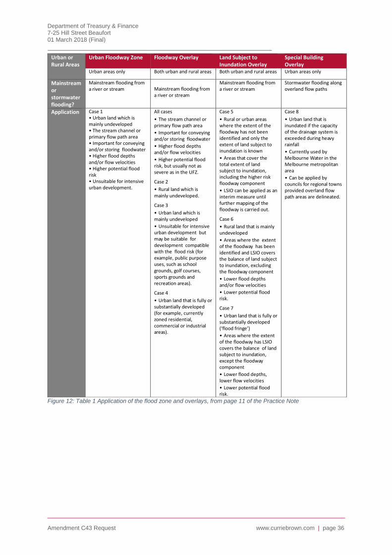
Department of Treasury & Finance 7-25 Hill Street Beaufort 01 March 2018 (Final)
Amendment C43 Request www.curriebrown.com | page 36
Figure 12: Table 1 Application of the flood zone and overlays, from page 11 of the Practice Note
Urban or Rural Areas
Urban Floodway Zone Floodway Overlay Land Subject to Inundation Overlay
Special Building Overlay
Urban areas only Both urban and rural areas Both urban and rural areas Urban areas only
Mainstream or stormwater flooding?
Mainstream flooding from a river or stream Mainstream flooding from
a river or stream
Mainstream flooding from a river or stream
Stormwater flooding along overland flow paths
Application Case 1 • Urban land which is mainly undeveloped • The stream channel or primary flow path area • Important for conveying and/or storing floodwater • Higher flood depths and/or flow velocities • Higher potential flood risk • Unsuitable for intensive urban development.
All cases
• The stream channel or primary flow path area
• Important for conveying and/or storing floodwater
• Higher flood depths and/or flow velocities
• Higher potential flood risk, but usually not as severe as in the UFZ.
Case 2
• Rural land which is mainly undeveloped.
Case 3
• Urban land which is mainly undeveloped
• Unsuitable for intensive urban development but may be suitable for development compatible with the flood risk (for example, public purpose uses, such as school grounds, golf courses, sports grounds and recreation areas).
Case 4
• Urban land that is fully or substantially developed (for example, currently zoned residential, commercial or industrial areas).
Case 5
• Rural or urban areas where the extent of the floodway has not been identified and only the extent of land subject to inundation is known
• Areas that cover the total extent of land subject to inundation, including the higher risk floodway component
• LSIO can be applied as an interim measure until further mapping of the floodway is carried out.
Case 6
• Rural land that is mainly undeveloped
• Areas where the extent of the floodway has been identified and LSIO covers the balance of land subject to inundation, excluding the floodway component
• Lower flood depths and/or flow velocities
• Lower potential flood risk.
Case 7
• Urban land that is fully or substantially developed (‘flood fringe’)
• Areas where the extent of the floodway has LSIO covers the balance of land subject to inundation, except the floodway component
• Lower flood depths, lower flow velocities
• Lower potential flood risk.
Case 8
• Urban land that is inundated if the capacity of the drainage system is exceeded during heavy rainfall
• Currently used by Melbourne Water in the Melbourne metropolitan area
• Can be applied by councils for regional towns provided overland flow path areas are delineated.
Department of Treasury & Finance 7-25 Hill Street Beaufort 01 March 2018 (Final)
Amendment C43 Request www.curriebrown.com | page 37
Existing Planning Framework Problems
The site is zoned Public Use, the purpose of which is to provide for public utilities and community
services and facilities. Given that the land is no longer required for a school, the public land zone
is no longer appropriate for the site. Victorian Government Land Transactions Policy and
Guidelines, April 2016 also states that ‘an agency must not offer land for sale where the land is
zoned for public purpose’. Therefore, in order for the site to be disposed of, a new zone will need
to be introduced.
Department of Treasury & Finance 7-25 Hill Street Beaufort 01 March 2018 (Final)
Amendment C43 Request www.curriebrown.com | page 38
4. Proposed Planning Framework
Introduction
In order to determine the most appropriate zone for the site, a detailed analysis of the available
suite of zones included within the Victorian Planning Provisions has been undertaken. In order to
cater for the desired flexibility that is necessary to allow a range of permitted uses and
development of the site, nine (9) zones have been identified as being possible options. These
are:
General Residential Zone (GRZ1)
Residential Growth Zone (RGZ)
Commercial 1 (C1Z)
Commercial 2 Zone (C2Z)
Mixed Use (MUZ)
Comprehensive Development Zone (CDZ)
Urban Floodway Zone (UFZ)
Public Park & Recreation Zone (PPRZ)
Public Use Zone 6 (Local Government)
No additional overlay controls were reviewed.

Department of Treasury & Finance 7-25 Hill Street Beaufort 01 March 2018 (Final)
Amendment C43 Request www.curriebrown.com | page 39
PLANNING
CONTROL
PURPOSE OF THE
CONTROL
PROS CONS COMMENTS
ZONE
General Residential Zone (GRZ1)
Encourages development that respects the neighbourhood character of the area.
Provides a diversity of housing types.
Allows some non-residential uses.
Permits subdivision and dwelling development.
Medical centre and residential aged care facility among the allowed uses.
Simple and clear control.
Some potential to create own character however long term vision for the site cannot be protected.
Applies to eastern end of the subject site where the basketball court adjoins the neighbouring Anglican Church site.
Regional Growth Plan does not indicate significant population growth in Shire (1100 people in 20 years).
Key link to Ballarat and part of the Ballarat Hinterland.
Land Use policies seek to promote growth with easy access to services and employment.
Land Use strategy seeks to support growth.
Limited growth on fringe or as infill consistent with Council strategies.
Infill development encouraged.
Zone would allow development consistent with the character of the area.
Flooding and Bushfire Hazard are key constraints.
Third party notification is retained.

Department of Treasury & Finance 7-25 Hill Street Beaufort 01 March 2018 (Final)
Amendment C43 Request www.curriebrown.com | page 40
PLANNING
CONTROL
PURPOSE OF THE
CONTROL
PROS CONS COMMENTS
Residential Growth Zone (RGZ)
Provide housing at increased densities and encourage a diversity of housing types in locations offering good access to services and transport including activities areas.
Allow educational, recreational, religious, community and a limited range of other non-residential uses to serve local community needs in appropriate locations.
Could establish a specific character for the site.
Allows height to 4 storeys.
Adjoins highway and the activity centre.
Likely to create a prominent development.
No Housing Strategy.
Part of land constrained by floodways.
Regional Growth Plan does not indicate significant population growth in Shire (1100 people in 20 years).
Key link to Ballarat and part of the Ballarat Hinterland.
Land Use policies seek to promote growth with easy access to services and employment.
Land Use strategy seeks to support growth.
Limited growth on fringe or as infill consistent with Council strategies.
Infill development encouraged.
Zone would allow development consistent with the character of the area.
Site has two road frontages, adjoins the commercial area and adjoins O’Neill Street (Western Highway). It is an infill site that could create its own character.
Flooding and Bushfire Hazard are key constraints.
Used for former school sites.

Department of Treasury & Finance 7-25 Hill Street Beaufort 01 March 2018 (Final)
Amendment C43 Request www.curriebrown.com | page 41
PLANNING
CONTROL
PURPOSE OF THE
CONTROL
PROS CONS COMMENTS
Commercial 1 (C1Z) Creates vibrant mixed use commercial centres for retail, office, business, entertainment and community uses.
Provide for residential uses at densities complementary to the role and scale of the commercial centre.
Adjoining land to west on Neill Street.
Contrary to policy to constrain commercial area.
Predominantly residential area.
Would extend commercial area into residential area.
Access would be difficult.
Topography.
Residential interfaces.
Commercial 2 Zone (C2Z)
Seeks to develop commercial areas for offices, appropriate manufacturing and industrial and limited retail uses that do not affect the safety and amenity of adjacent, more sensitive uses.
Could provide for offices.
Transition to residential area.
No sensitive uses.
Intrusion of commercial area into residential area.
Contrary to policy to constrain commercial and industrial areas.
Would extend commercial area into residential area.
Access would be difficult.
Topography.
Residential interfaces.
Mixed Use (MUZ) Provide for a range of residential, commercial, industrial and other uses which complement the mixed-use function of the locality.
Provide for housing at higher densities which responds to the existing or preferred character of an area.
Residential Zone.
Allows for a variety of uses.
Allows for commercial uses.
Residential Zone.
Transition between commercial and residential areas.
Urban Floodway Zone (UFZ)
Identifies waterways and major flood paths within urban areas which have the greatest risk and frequency of being affected by flooding.
Ensure development maintains the free passage and temporary storage of floodwater and minimises flood damage.
Clearly identifies land subject to flood risk.
Establishes area for flood storage.
Duplicates existing Flood and Land Subject to Inundation Overlay.
Would limit use and development to agriculture and some recreation uses.
Duplicates existing overlays.
Significant development constraint.
Does not acknowledge that works could be undertaken to reduce risk.
Defacto open space/public use zone.
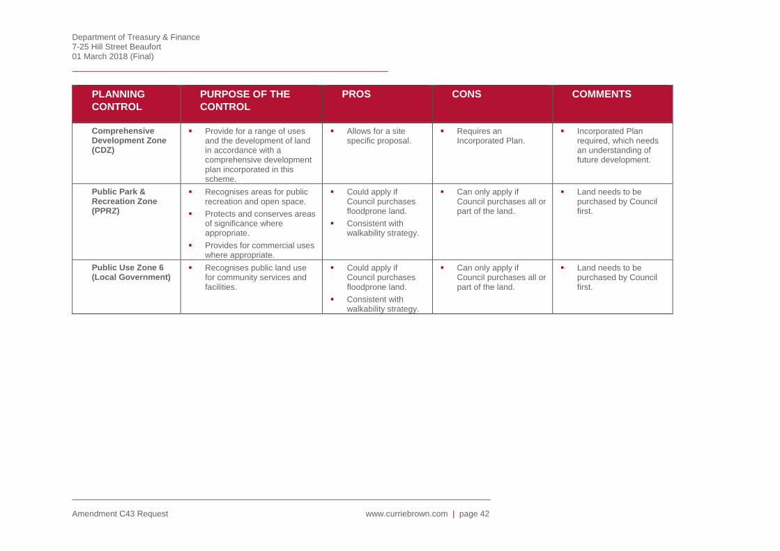
Department of Treasury & Finance 7-25 Hill Street Beaufort 01 March 2018 (Final)
Amendment C43 Request www.curriebrown.com | page 42
PLANNING
CONTROL
PURPOSE OF THE
CONTROL
PROS CONS COMMENTS
Comprehensive Development Zone (CDZ)
Provide for a range of uses and the development of land in accordance with a comprehensive development plan incorporated in this scheme.
Allows for a site specific proposal.
Requires an Incorporated Plan.
Incorporated Plan required, which needs an understanding of future development.
Public Park & Recreation Zone (PPRZ)
Recognises areas for public recreation and open space.
Protects and conserves areas of significance where appropriate.
Provides for commercial uses where appropriate.
Could apply if Council purchases floodprone land.
Consistent with walkability strategy.
Can only apply if Council purchases all or part of the land.
Land needs to be purchased by Council first.
Public Use Zone 6 (Local Government)
Recognises public land use for community services and facilities.
Could apply if Council purchases floodprone land.
Consistent with walkability strategy.
Can only apply if Council purchases all or part of the land.
Land needs to be purchased by Council first.
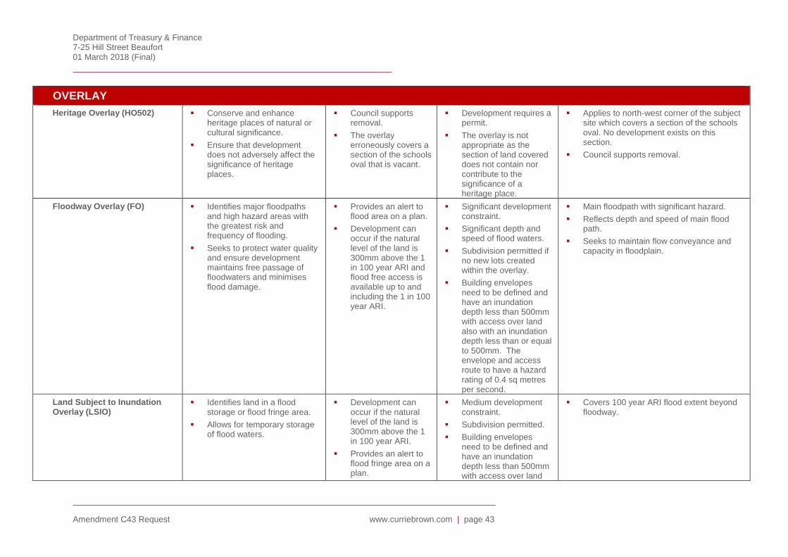
Department of Treasury & Finance 7-25 Hill Street Beaufort 01 March 2018 (Final)
Amendment C43 Request www.curriebrown.com | page 43
OVERLAY
Heritage Overlay (HO502) Conserve and enhance heritage places of natural or cultural significance.
Ensure that development does not adversely affect the significance of heritage places.
Council supports removal.
The overlay erroneously covers a section of the schools oval that is vacant.
Development requires a permit.
The overlay is not appropriate as the section of land covered does not contain nor contribute to the significance of a heritage place.
Applies to north-west corner of the subject site which covers a section of the schools oval. No development exists on this section.
Council supports removal.
Floodway Overlay (FO) Identifies major floodpaths and high hazard areas with the greatest risk and frequency of flooding.
Seeks to protect water quality and ensure development maintains free passage of floodwaters and minimises flood damage.
Provides an alert to flood area on a plan.
Development can occur if the natural level of the land is 300mm above the 1 in 100 year ARI and flood free access is available up to and including the 1 in 100 year ARI.
Significant development constraint.
Significant depth and speed of flood waters.
Subdivision permitted if no new lots created within the overlay.
Building envelopes need to be defined and have an inundation depth less than 500mm with access over land also with an inundation depth less than or equal to 500mm. The envelope and access route to have a hazard rating of 0.4 sq metres per second.
Main floodpath with significant hazard.
Reflects depth and speed of main flood path.
Seeks to maintain flow conveyance and capacity in floodplain.
Land Subject to Inundation Overlay (LSIO)
Identifies land in a flood storage or flood fringe area.
Allows for temporary storage of flood waters.
Development can occur if the natural level of the land is 300mm above the 1 in 100 year ARI.
Provides an alert to flood fringe area on a plan.
Medium development constraint.
Subdivision permitted.
Building envelopes need to be defined and have an inundation depth less than 500mm with access over land
Covers 100 year ARI flood extent beyond floodway.

Department of Treasury & Finance 7-25 Hill Street Beaufort 01 March 2018 (Final)
Amendment C43 Request www.curriebrown.com | page 44
also with an inundation depth less than or equal to 500mm. The envelope and access route to have a hazard rating of 0.4 sq metres per second.

Department of Treasury & Finance 7-25 Hill Street Beaufort 01 March 2018 (Final)
Amendment C43 Request www.curriebrown.com | page 45
Proposed Zone for the Subject Site
General Residential Zone
As previously discussed, the current Public Use Zone is no longer appropriate given that the land
is to be disposed of through sale process. In order for the land to be sold, a new zone must first
be introduced.
A General Residential Zone is now proposed to be applied to the site in its entirety. The purpose
of the zone is to:
To implement the State Planning Policy Framework and the Local Planning Policy
Framework, including the Municipal Strategic Statement and local planning policies.
To encourage development that respects the neighbourhood character of the area.
To encourage a diversity of housing types and housing growth particularly in locations
offering good access to services and transport.
To allow educational, recreational, religious, community and a limited range of other non-
residential uses to serve local community needs in appropriate locations.
The application of the General Residential Zone will allow for development of the site for
residential purposes, which is consistent with the use and pattern of development of adjacent
properties.
Applying the General Residential Zone to the subject land
The following table provides a summary of the land uses that are ‘as-of-right’, permit required
and prohibited under the General Residential Zone.
As of Right Permit Required Prohibited
Animal keeping (other than Animal boarding) (subject to conditions
Bed and breakfast (subject to conditions)
Dependent person’s unit (subject to conditions)
Dwelling (other than Bed and breakfast)
Home occupation
Informal outdoor recreation
Medical centre (subject to conditions)
Minor utility installation
Place of worship (subject to conditions)
Railway
Residential aged care facility
Any use listed in Clause 62.01 (must meet requirements of clause)
Accommodation (other than Dependent person’s unit, Dwelling and Residential aged care facility
Agriculture (other than Animal keeping, Animal training, Apiculture, Horse stables and Intensive animal husbandry)
Animal keeping (other than Animal boarding) – if the Section 1 condition is not met (subject to conditions)
Car park (subject to conditions)
Car wash (subject to conditions)
Community market
Convenience restaurant (subject to conditions)
Convenience shop
Food and drink premises (other than Convenience restaurant and Take away food premises)
Leisure and recreation (other than Informal outdoor
Amusement parlour
Animal boarding
Animal training
Brothel
Cinema based entertainment facility
Horse stables
Industry (other than Car wash)
Intensive animal husbandry
Motor racing track
Nightclub
Office (other than Medical centre)
Retail premises (other than Community market, Convenience shop, Food and drink
premises, Plant nursery)
Saleyard
Stone extraction
Transport terminal
Warehouse (other than Store)

Department of Treasury & Finance 7-25 Hill Street Beaufort 01 March 2018 (Final)
Amendment C43 Request www.curriebrown.com | page 46
recreation and Motor racing track)
Place of assembly (other than Amusement parlour, Carnival, Circus, Nightclub, and Place of worship
Plant nursery
Service station (subject to conditions)
Store (subject to conditions)
Take away food premises (subject to conditions)
Utility installation (other than Minor utility installation and Telecommunication facility)
Any other use not in Section 1 or 3
Figure 13: General Residential Zone Use Table
Summary of Benefits of Applying the General Residential Zone
It is submitted that based on the above analysis, the General Residential Zone provides an
appropriate fit for the site. This is based on the following key findings:
The General Residential Zone will allow for appropriate residential development to be
established in forms appropriate for the location;
The zoning is consistent with that applied to adjacent residential land; and,
The provisions of the existing Floodway and Land Subject to Inundation Overlays will
continue to apply to the land and any future development will be subject to these controls.
Application of the General Residential Zone
Figure 124: Proposed application of the General Residential Zone.

Department of Treasury & Finance 7-25 Hill Street Beaufort 01 March 2018 (Final)
Amendment C43 Request www.curriebrown.com | page 47
Additional Adjustments
The existing Heritage Overlay 502, which applies to a lot on the north-western corner of the site,
can be deleted. The overlay is a precinct control for the Beaufort Township. The overlay applies
to vacant land in the north-west corner of the property, which has no heritage significance. The
Council have no objection to its deletion and in fact consider that it has been applied in error.
Amendment C39 included an Incorporated Document “Planning Permit Exemptions to Heritage
Overlay Precincts HO501 & HO502 into the Pyrenees Planning Scheme. The document
introduces permit exemptions for minor buildings and works within the Avoca and Beaufort
Township Heritage Precincts. The document includes a plan on the second last page, which
includes the property to be deleted from the Heritage Overlay. The document and the Heritage
Overlay and Incorporated Document Schedules also need to be amended to delete reference to
the school site.
Department of Treasury & Finance 7-25 Hill Street Beaufort 01 March 2018 (Final)
Amendment C43 Request www.curriebrown.com | page 48
5. Justification for amendment
Why is an amendment required?
The subject site has been declared as being surplus to the government’s operating requirements
and is therefore required to be disposed. The Victorian Government Land Transactions Policy
and Guidelines, April 2016 states that ‘an agency must not offer land for sale where the land is
zoned for a public purpose’. Given that the land is currently zoned Public Use Zone Schedule 7
(Other public use), it must therefore by rezoned prior to disposal.
How does the amendment implement the objectives of planning in Victoria?
The amendment ensures that the objectives of planning in Victoria are met by providing for the
fair, orderly, economic and sustainable use of the land by including the site in the most
appropriate zone.
The amendment implements the planning objectives in Victoria as set out in Section 4(1) of the
Planning & Environment Act 1987 by:
Providing for the fair, orderly, economic and sustainable use and development of the land
The amendment implements this objective by including the site in the most appropriate zone that
will enable the site to be used to its full potential. This will be achieved through providing a zone
that can facilitate development and land uses that are encouraged to provide for the ongoing
economic stability of the township and region.
Protecting natural and man-made resources, ecological processes and genetic diversity.
The amendment will not impact significant flora and fauna habitats. The amendment proposes to
rezone land that is significantly altered from its natural state. The site is generally cleared and
has limited constraints, enabling an appropriate development to be constructed.
Securing a pleasant, efficient, safe working, living and recreational environment.
The amendment will facilitate a future development that will be consistent to the planning scheme
controls and policy objectives relating to amenity. The site is sufficient in size to mitigate off-site
amenity impacts. The site is readily and safely accessible to public transport, private vehicles,
pedestrians and bicycles.
Conserving and enhancing places of historic interest and cultural value
The site has been used for a primary school and the original school building features on the land.
This issue can be addressed during assessment of any planning permit.
Protecting and enabling the orderly provision and coordination of public utilities and other
facilities
The amendment will allow for an appropriate residential development that is able to be
connected to existing infrastructure and will not exceed the capacity of existing infrastructure.
Facilitating development in accordance with the above objectives
The application of the General Residential Zone will allow for the development of residential, and
appropriate non-residential uses, that is consistent with each of the above objectives.
Balancing the present and future needs of all Victorians
The amendment will ensure that the planning controls are sufficiently flexible to respond to a
need to provide land for residential development and land uses. The amendment will enable land
uses complementary to those on adjacent properties, making appropriate use of the opportunity
presented by the site.

Department of Treasury & Finance 7-25 Hill Street Beaufort 01 March 2018 (Final)
Amendment C43 Request www.curriebrown.com | page 49
How does the amendment address the environmental effects and any relevant social and
economic effects?
Environmental Effects
The amendment request to rezone the site General Residential will have no adverse effects on the environment. The site is located within an existing urban area within the township boundaries of Beaufort and will therefore support further development consistent to the new zoning.
Social Impact
The site is well located and will provide opportunities for additional housing within the town
boundaries.
The site is centrally located to the east of the central commercial core with some abuttal to the
Western Highway to the north. The balance of the site, particularly where the existing school
buildings are located, is adjacent land within the General Residential Zone and has been
predominantly developed for housing. As such, the expected development would be expected to
achieve an appropriate in-fill that aligns with the surround built form and use.
Economic Benefits
The proposal will deliver additional residential land within the established town of Beaufort. This
will allow for increased population growth to meet increased demand in the Central Highlands
Region.
The subject site is located near to the east of the retail centre and adjacent the Western
Highway. It is adjacent existing residential development which will allow for the efficient use of
existing infrastructure.
The potential for increased population provides population support for government and
community services and increased demand for retail and services.
Does the amendment address relevant bushfire risk?
The subject site is located within the urban area of Beaufort and is in a Designated Bushfire
Prone area pursuant to DELWP mapping. While there are substantial areas of vegetation that
could fuel a bushfire that surround the township, there is a clear division between these areas
and the sparsely vegetated urban area. The amendment will not facilitate an unacceptable risk
to human life and is consistent with State Policy in this regard (particular reference is given to
clause 13.05).
Does the amendment comply with the requirements of any Minister’s Direction
applicable to the amendment?
Ministerial Direction 11
Ministerial Direction No.11 (Strategic Assessment of Amendments) is the relevant Minister’s
Direction with regard to the proposed amendment. This section of the report outlines the
proposed amendment’s compliance with the Strategic Assessment Guidelines. The amendment
documents also comply with the Ministerial Direction on the Form and Content of Planning
Schemes.
Ministerial Direction 1
Also relevant is Ministerial Direction 1 (Potentially Contaminated Land). The purpose of the
Direction is ensure that potentially contaminated land is suitable for a use which is proposed to
be allowed under an amendment to a planning scheme and which could be significantly
adversely affected by any contamination.

Department of Treasury & Finance 7-25 Hill Street Beaufort 01 March 2018 (Final)
Amendment C43 Request www.curriebrown.com | page 50
It is considered that the site, as an unlisted use in Table 1 of the Potentially Contaminated Land
Practice Note, rates in the low potential category.
Environmental consultants were appointed to undertake a site assessment. The report titled •
Preliminary Site Investigation 7-25 Hill Street Beaufort, Victoria Prensa November 2016 did not
reveal any adverse findings and the consultants have declared the site suitable for residential
use.
How does the amendment support or implement the State Planning Policy Framework?
The amendment will increase the supply of land available for residential use and development in
Beaufort. This is consistent with Clause 11.04-2 (Housing choice and affordability) by providing
for “a diversity of housing in defined locations that cater for different households and are close to
jobs and services”. Clause 16.01 (Residential development) also includes the strategy of
increasing the supply of housing in existing urban areas by facilitating increased housing yield in
appropriate locations, including under-utilised urban land.
Particular relevant in this amendment are the regional policies, informed by the Central
Highlands Regional Growth Plan, that start with Clause 11.06-1 (Planning for growth) which has
the objective “to plan for population growth in sustainable locations throughout the region”. The
strategies include to provide local and sub-regional services in town including Beaufort to support
ongoing growth, particularly close to Melbourne and Ballarat where towns will provide a key
opportunity to target growth pressure.
Clause 11.06-4 (Sustainable communities) includes among its strategies: “Plan for growth by
directing it to well serviced settlements with good access to Melbourne or Ballarat, particularly
Bacchus Marsh, Ballan, Creswick, Clunes, Beaufort and Smythesdale”.
The rezoning of the subject land to General Residential Zone provides additional land for housing
in a township that can accommodate growth. This allows for the efficient use of existing
infrastructure and provides population to create service demand for services and employment.
This achieves further aims of the state policy of accommodating this growth in a means that
might provide demand relief in other locations.
How does the amendment support or implement the Local Planning Policy Framework?
The amendment will provide additional residential land, which is supported by local planning
policy. Clause 21.05-2 Townships and Small Settlements provides policy direction for Beaufort in
recognition of its “potential to accommodate more substantial residential development”. This is
supported by the policy direction to direct residential development to residential areas which
have the potential to accommodate significant infill development.
Further direction and support is provided through Clause 22.04 (Settlement Policies) which
encourages new urban development which makes efficient use of existing physical and servicing
infrastructure. Clause 22.06-4 encourages the provision of widest possible choice of housing as
means of both attracting and maintaining a socially diverse population base in the Shire.
It is acknowledged that sections of the site are compromised by flooding potential but it is
considered that this is appropriately managed through the application of the Floodway Overlay
and the Land Subject to Inundation Overlay the policy guidance of Clause 21.05-1.7 (Areas
Subject to Flooding or Drainage Difficulty) and Clause 22.07 (Floodplain Management in
Beaufort).
Department of Treasury & Finance 7-25 Hill Street Beaufort 01 March 2018 (Final)
Amendment C43 Request www.curriebrown.com | page 51
Does the amendment make proper use of the Victorian Planning Provisions?
The amendment makes use of the most appropriate Victoria Planning Provision (VPP) tool for
the facilitation of residential land uses and development at the site. The General Residential
Zone provides an appropriate fit for the site for the following reasons:
The General Residential Zone will allow for appropriate residential development to be
established in forms appropriate for the location.
The zoning is consistent with that applied to adjacent residential land.
The application of the General Residential Zone does not inhibit the ability of flooding controls
of the Floodway Overlay or Land Subject to minimise risk as it does not imply inherent
development rights.
How does the amendment address the views of any relevant agency?
Pyrenees Shire
Written advice and meetings with Pyrenees Shire staff indicated support for the rezoning to the
General Residential Zone through the fast-track amendment process.
Options and issues to address include:
Low-lying sections of the school have a history of flooding and are covered by a Flood
Overlay (FO) and Land Subject to Inundation Overlay (LSIO). The Urban Floodway Zone
(UFZ) is applied to a portion of land south-west of the school site closer to the creek.
In order to manage constraints and maximise opportunities, consideration be given to a
Development Plan Overlay to direct access, links between the site and township, lot density,
and floodway management.
Heritage Overlay, Schedule 502 has been erroneously applied to the north-western corner of
the site and could be addressed as part of the amendment process.
Council outlined the key issues as residential interfaces, flooding and the ultimate use of the
former oval and the number of land parcels including the fact that some are occupied by Hill
Street.
Council had no concerns regarding the fast-track process.
Department of Economic Development, Jobs, Transport and Resources
The views of Public Transport Victoria and VicRoads will be considered during the amendment
process.
Country Fire Authority
The views of the Country Fire Authority will be considered during the amendment process.
Does the amendment address relevant requirements of the Transport Integration Act
2010?
The amendment will not create a significant impact on the existing transport system as defined
by Section 3 of the Transport Integration Act 2010. The amendment will allow for residential
development that will be able to readily access the existing road network including the adjacent
Western Highway, which provides links to major centre such as Ballarat, and further to
Melbourne.
The site is also close to the Beaufort Train Station and adjacent bus interchange.
Appreciable increases in private vehicle traffic volumes are not expected as a result of the
amendment, particularly in comparison with the previous primary school use. Further, any car
Department of Treasury & Finance 7-25 Hill Street Beaufort 01 March 2018 (Final)
Amendment C43 Request www.curriebrown.com | page 52
parking and traffic impacts of a future development will be capable of being assessed and
addressed at any future planning permit stage.
It is noted that the provisions of Division 2 (Transport System Objectives) and Division 3
(Decision Making Principles) of the Transport Integration Act 2010 have been extensively
considered in the formulation of the amendment.
What impact will the new planning provisions have on the resource and administrative
costs of the responsible authority?
It is expected that the new planning scheme provisions will have a limited impact on the resource
and administrative costs of the Pyrenees Shire. Council planning officer resources will be
required to assess and implement the amendment, as well as future planning permit applications
for development of the site in accordance with the statutory controls. However, the resource and
administrative costs to council will not be in excess of the costs typically associated with planning
scheme amendments.
Department of Treasury & Finance 7-25 Hill Street Beaufort 01 March 2018 (Final)
Amendment C43 Request www.curriebrown.com | page 53
6. Conclusion
Conclusion
Currie & Brown has been engaged by the Department of Treasury and Finance to prepare a
strategic town planning assessment to outline and provide justification for the proposed rezoning
of the former Beaufort Primary School site at 7-25 Hill Street, Beaufort.
Currie & Brown has undertaken detailed inspections of the site and the surrounding area, as well
as a review of the policies of the Pyrenees Shire to form the basis of this assessment.
Our review has found that:
The site represents a considerable redevelopment site within the Beaufort township with a
total area of 2.24ha. It is located to the east of the Beaufort commercial centre within an
established residential area. The site adjacent the Western Highway and is readily accessible
to services within the Beaufort township;
The site has been historically used as a primary school and contains buildings consistent to
this type of operation. The site has some vegetation but has been cleared to allow
construction of buildings and establishment of ovals;
The site has been declared as being surplus to the government’s operating requirements and
is therefore required to be disposed. The Victorian Government Land Transactions Policy and
Guidelines, April 2016 states that ‘an agency must not offer land for sale where the land is
zoned for a public purpose’. Given that the land is currently in the Public Use Zone, a
rezoning is required before a disposal can take place;
The amendment request is based on a number of assessments that confirm and demonstrate
the need for additional Residential Zoned land within Beaufort and the appropriateness of
applying this zone to the subject land;
The amendment will support and implement the SPPF and LPPF by facilitating the
redevelopment of a strategic redevelopment site and providing infill housing opportunities in a
location that is accessible to the town’s commercial area, transport options, and employment
areas. The site is in a single ownership and is of an appropriate scale to allow development
that complement the surrounding housing form;
Constraints such as bushfire and flooding can be appropriately managed; and,
The amendment will not have any negative environmental, social or economic impacts and
will result in a net community benefit.
Request
Having regard to the detailed strategic justification outlined in this report and discussions with
Council, it is respectfully requested that the proposed amendment to rezone the site to General
Residential Zone and remove Heritage Overlay 502 be considered.
The amendment is justified on the following basis:
The General Residential Zone will allow for appropriate residential development to be
established in forms appropriate for the location;
The zoning is consistent with that applied to adjacent residential land;
The provisions of the existing Floodway and Land Subject to Inundation Overlays will
continue to apply to the land and any future development will be subject to these controls;
The deletion of the Heritage Overlay will remove an anomaly from the Pyrenees Planning
Scheme, which is supported by the Council; and,
The amendment to the Incorporated Document Planning Permit Exemptions to Heritage
Overlay Precincts HO501 & HO502 and the associated Heritage Overlay and Incorporated

Department of Treasury & Finance 7-25 Hill Street Beaufort 01 March 2018 (Final)
Amendment C43 Request www.curriebrown.com | page 54
Document Schedules will ensure consistency with the removal of the Heritage Overlay from
part of the site.

Department of Treasury & Finance 7-25 Hill Street Beaufort 01 March 2018 (Final)
Amendment C43 Request www.curriebrown.com | page 55
Appendices
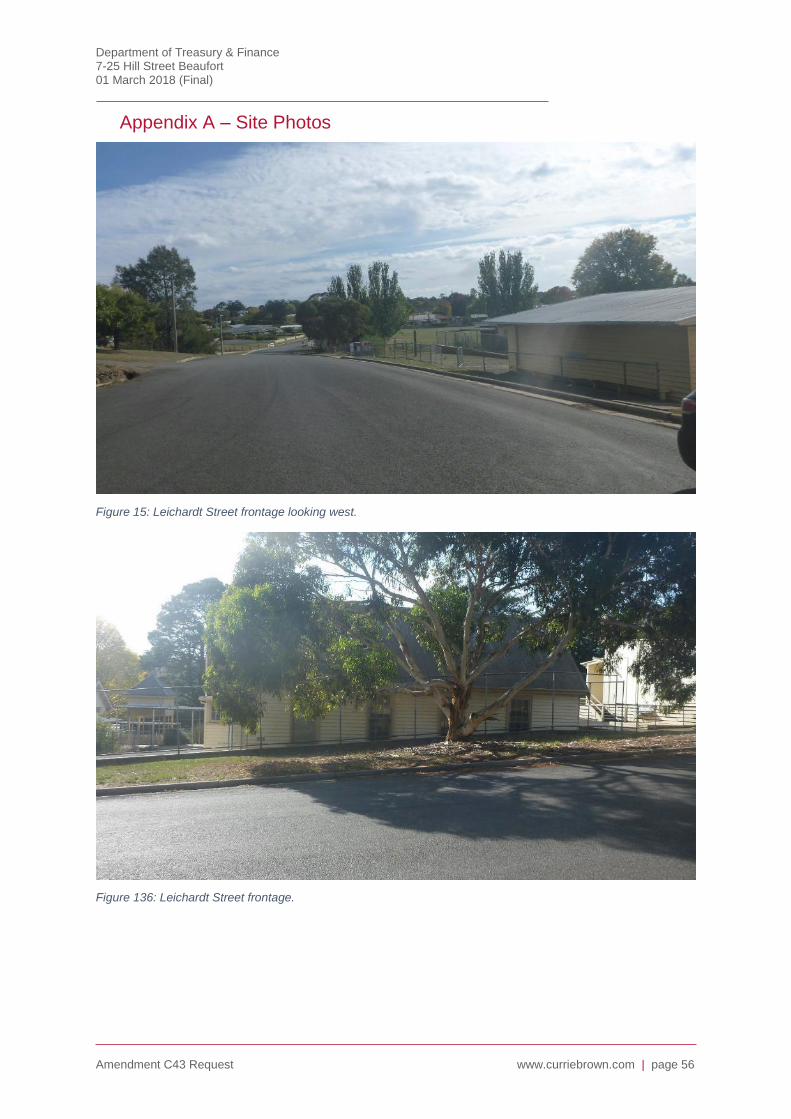
Department of Treasury & Finance 7-25 Hill Street Beaufort 01 March 2018 (Final)
Amendment C43 Request www.curriebrown.com | page 56
Appendix A – Site Photos
Figure 15: Leichardt Street frontage looking west.
Figure 136: Leichardt Street frontage.
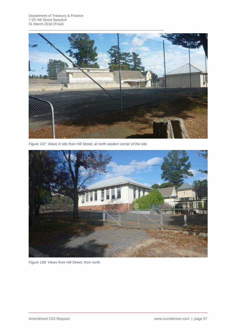
Department of Treasury & Finance 7-25 Hill Street Beaufort 01 March 2018 (Final)
Amendment C43 Request www.curriebrown.com | page 57
Figure 147: Views in site from Hill Street, at north eastern corner of the site.
Figure 158: Views from Hill Street, from north.
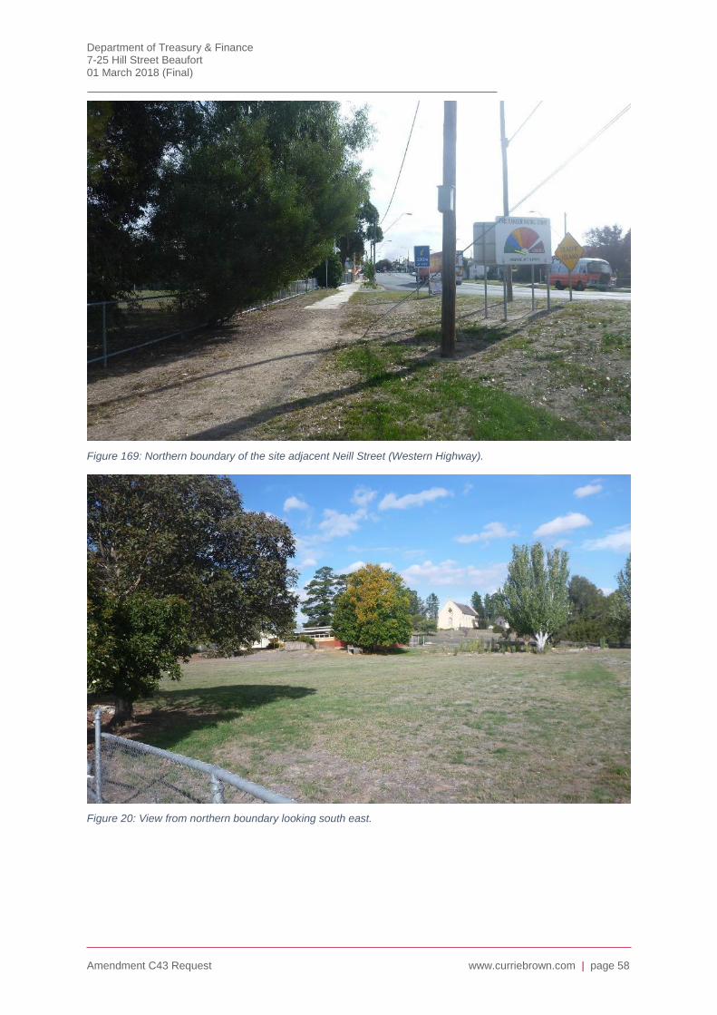
Department of Treasury & Finance 7-25 Hill Street Beaufort 01 March 2018 (Final)
Amendment C43 Request www.curriebrown.com | page 58
Figure 169: Northern boundary of the site adjacent Neill Street (Western Highway).
Figure 20: View from northern boundary looking south east.
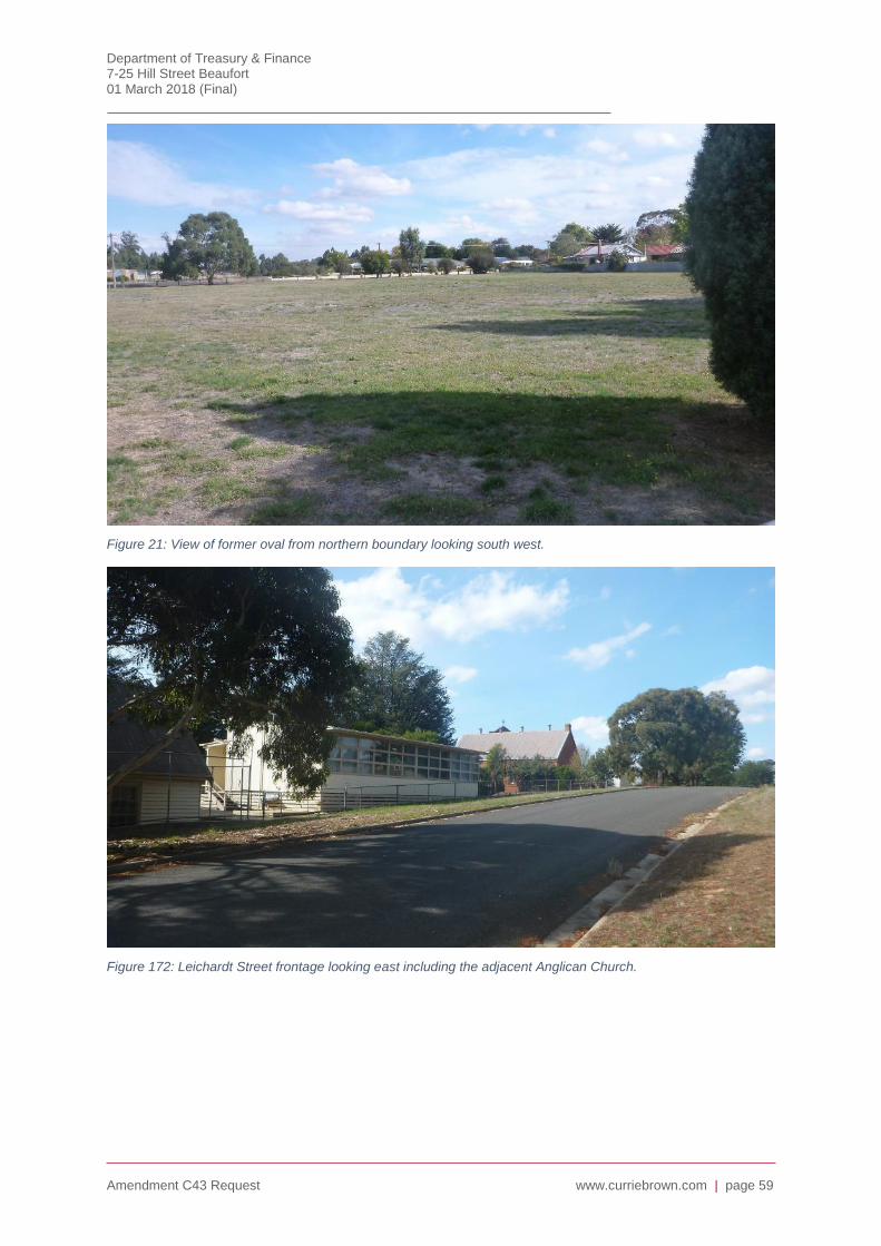
Department of Treasury & Finance 7-25 Hill Street Beaufort 01 March 2018 (Final)
Amendment C43 Request www.curriebrown.com | page 59
Figure 21: View of former oval from northern boundary looking south west.
Figure 172: Leichardt Street frontage looking east including the adjacent Anglican Church.

Department of Treasury & Finance 7-25 Hill Street Beaufort 01 March 2018 (Final)
Amendment C43 Request www.curriebrown.com | page 60
Figure 183: Internal site views of school buildings.
Figure 194: Internal views of school buildings.