Embed Size (px)
Citation preview

Department of Geography
Kazi Nazrul University
1 | P a g e
DEPARTMENT OF GEOGRAPHY KAZI NAZRUL UNIVERSITY
ASANSOL 713 340 WEST BENGAL (www.knu.ac.in)

Department of Geography
Kazi Nazrul University
2 | P a g e
Structure and Detailed Syllabus of the Post Graduate Courses
Department of Geography
Department of Geography, Kazi Nazrul University was established in 2015. Two Post
Graduate Courses in (1) Geography and (2) Geoinformatics are offered at present by the
department. Two-year M.Sc. programme in Geography was started in 2015-16 academic year
and Geoinformatics in 2017-18 academic year. The thrust areas of the department are on
Advance Geomorphology, Environmental Issues in Geography, Urban Geography, Disaster
Management along with Photogrammetry, Remote Sensing, Web Mapping and Web GIS and
application of Geographic Information System (GIS). The department is equipped with
advanced RS and GIS laboratory and seminar library. In this short period of journey, the
number of students of the department has increased almost thrice. The Department of
Geography aims to promote a balanced sense of theoretical geography and its application in
various fields among the students. Both, the students of Geoinformatics and Geography are
trained with professional ethics and scientific temper.
Courses offered in the Department
• M.Sc. in Geography (Two years)
• M.Sc. in Geoinformatics (Two years)
Mission Department of Geography, Kazi Nazrul University has a mission to develop the future
generation Geographers sensitive towards the region-specific issues of the nation with special
emphasis on the local developmental issues. The department also aims to foster this future
generation of Geographers with a systematic understanding of physical and human geography
and equip them with state-of art technology.
Vision Department of Geography, Kazi Nazrul University envisions to be a global destination for
practising Geography and Geoinformatics. Working in collaboration with government,
industry and non-governmental organization, the department upholds a vision to apply the
knowledge of Geography and technology of Geoinformatics in reducing spatial disparity,
promoting equality and social justice.
Department of Geography
Kazi Nazrul University
3 | P a g e
Programme Outcomes
Two years Post-Graduate programmes have been designed as a base for research and
application of Geography and Geoinformatics. These two years programme will enable the
students to enhance their learning after under-graduate course and to join the workforce in the
field of Geography and Geoinformatics.
Programme- specific Outcomes
Two years Post-Graduate programmes will enable the students with understanding the spatial
logic and methodology of geography. After two years, students will be able to work in the
areas of urban and regional planning, disaster management, environmental planning and
management and related areas.
Two years Post-Graduate programmes in Geoinformatics will enable the students with recent
development in the field of Remote Sensing and Geographic Information System. After two
years, students will be able to work in the areas of mapping and digital cartography,
application of GIS in the field urban planning, disaster management, web mapping and web
GIS and related areas.
Course Description Duration of Post Graduate Course of Studies in Geography will be two years with Semester I,
Semester II, Semester III and Semester IV, each of six months leading to Semester I, Semester
II, Semester III and Semester IV examinations in Geography at the end of each semester.
Semester I and III comprise ODD SEMESTER and Semester II and IV comprise EVEN
SEMESTER of each year. Syllabus for post graduate course in Geography is hereby reframed
into Choice Based Credit System (CBCS) in compliance with recent directives from the
University Grants Commission (UGC).
Scheme: Both the course of Geography and Geoinformatics consist of 88 credits with at least 20 credits
in a semester within the faculty of science. In Semester II and Semester III, students have to
choose Minor Elective papers of minimum 4 credits offered by the other Departments or their
own Department. There are Major Elective papers in Semester III and Semester IV. The
department offers a cluster of Major Elective papers and the students have to choose Major
Elective papers according to the norms decided by the Department.

Department of Geography
Kazi Nazrul University
4 | P a g e
Choice Based Credit System (CBCS) The CBCS is an effective 'Supply side Initiative' measure evolved as a process of 'Academic
Reforms' to sustain the Quality Education that focuses on the learner centric education. It
provides an opportunity for the students to choose courses from the prescribed courses
comprising core, elective/minor or skill-based courses. It allows students to choose
interdisciplinary, intra-disciplinary courses, skill-oriented papers (even from other disciplines
according to their learning needs, interests and aptitude) and more flexibility during the entire
course of studies. As a result, this not only broadens their horizons but also aims to make
students well rounded in all spheres of development. The courses can be evaluated following
the grading system, which is considered to be better than the conventional marks system.
It is also a cafeteria-type learning system in a semester pattern to foster creativity and
innovation that bridges the gap between professional and liberal education to empower the
students for meeting the challenges of Globalization with an inbuilt International acceptance of
recognition of Degrees. Syllabus for Post Graduate course in Geography and Geoinformatics
of Kazi Nazrul University, Asansol is hereby reframed into Choice Based Credit System
(CBCS) in compliance with recent directives from the University Grants Commission (UGC).
The main objective of this new curriculum is to give the students a holistic understanding of the
subject, putting equal weightage to the core content and techniques used in Geography as well
as in Geoinformatics.

Department of Geography
Kazi Nazrul University
5 | P a g e
CBCS SYLLABUS for
Post Graduate Courses in Geography
(REVISED)
With effect from Academic Session 2019-20
KAZI NAZRUL UNIVERSITY ASANSOL 713 340
WEST BENGAL (www.knu.ac.in)

Department of Geography
Kazi Nazrul University
6 | P a g e
• Semester System: terms and conditions
There shall be regular M.Sc. Course in Geography of two years duration. There shall be
semester system spreading over four semesters, each of six months duration. There shall be
1200 marks in total and each semester shall carry 300 marks. There shall be 24 courses/
modules (16 theoretical courses, 8 practical courses including Dissertation) to cover the whole
syllabus and each semester shall contain six modules. The Students shall be evaluated on the
basis of continuous (internal) assessment during the semester and End Semester Examination at
the end of the semester. Procedure of assessment/examination and evaluation of any course in a
semester will be guided by Rules and regulations pertaining to the PG courses of the
University.
• Dissertation
A Dissertation (Master's Thesis) on any branch of Geography will be a comprehensive work
based on conceptual aspects, field work and analysis of primary and secondary data. It is to be
produced individually by the students and this must be stated clearly in a certificate from the
supervisor (s) and concerned Head of the Department of Geography, Kazi Nazrul University.
Semester-wise Course Structure and Credits: M.Sc. in Geography
Semester Core Course (C) Major Elective Course (MJE) Minor Elective
Course (MIE)
Total
Credit Theory (Th) Practical (Pr) Theory (Th) Practical (Pr)
I 16 4 --- --- --- 20
II 12 6 --- --- 4 22
III 8 2 4 4 4 22
IV 12 4 4 4 --- 24
Total 48 18 8 6 8 88
• Course Credits denote the number of teaching hours allocated to the module/ week during
the course of the semester. One credit is equivalent to one hour of teaching (lecture or tutorial)
or two hours of practical work/ field work per week. Actually, assigning of credits is based on
the course content and hours of teaching.
• Core Courses: Every student will take only core courses in the Semester I. In the Semester
II, III and IV, students will take core courses along with the other courses.

Department of Geography
Kazi Nazrul University
7 | P a g e
• Major Elective Courses (Specialization): Student will opt one out of the three Major
Electives Subjects in Semester III and IV.
Option-A: Advanced Geomorphology
Option-B: Environmental Issues in Geography
Option-C: Urban Geography
Any student has to opt for total four major elective courses i.e. one theory (4 credit) and one
practical (4 credit) in Semester III and one theory (4 credit) and one practical (4 credit) in
semester IV. All these four courses have to be related to one particular subject chosen from the
above three elective subjects. Students will be submitting one dissertation based on Major
Elective course in the Semester III and IV.
• Minor Elective Courses (Interdisciplinary Course): M.Sc. Geography students will opt
two Minor Elective courses in the Semester II and Semester III offered by other allied PG
Departments or their own department. Out of these Two (2) Minor Elective courses, one must
be from any of the other disciplines across the Post Graduate courses of study.
Semester-wise Course Structure and Module Composition: M.Sc. in Geography
Semester Papers No. of Modules Total Credit Marks Total Marks
I Theory 4 16 200
300 Practical 2 4 100
II Theory 4 16 200
300 Practical 2 6 100
III Theory 4 16 200
300 Practical 2 6 100
IV Theory 4 16 200
300 Practical 2 8 100
Total Theory 16 64 800
1200 Practical 8 24 400
Academic Session: Each semester shall contain at least 16 teaching weeks.
Odd Semesters: Semester One and Three - July to December; Even Semesters: Semesters
Two and Four - January to June.

Department of Geography
Kazi Nazrul University
8 | P a g e
P.G. COURSES: FACULTY OF SCIENCE, TECHNOLOGY AND VOCATIONAL STUDIES ALL SEMESTERS
Course
of Study
Code
Discipline
Code Discipline Semester Course Name Course Type Course Code
Course
Details L - T - P
Course
Credit
Sem
Credit
Continuous
Assessment
End Sem
Exam Total
Marks
Sem
Marks Pr Th Pr Th
MSC MSCGEOG M.Sc. in
Geography
I
Geographical Thought C MSCGEOGC101 CC - 1 4 - 0 - 0 4
20
10 40 50
300
Geotectonics and Geomorphology C MSCGEOGC102 CC - 2 4 - 0 - 0 4 10 40 50
Hydrology and Oceanography C MSCGEOGC103 CC - 3 4 - 0 - 0 4 10 40 50
Geography of Resources C MSCGEOGC104 CC - 4 4 - 0 - 0 4 10 40 50
Map Projection and Surveying C MSCGEOGC105 CC - 5 0 - 0 - 4 2 30 20 50
Thematic Mapping C MSCGEOGC106 CC - 6 0 - 0 - 4 2 30 20 50
II
Climatology C MSCGEOGC201 CC - 7 4 - 0 - 0 4
22
10 40 50
300
Soil and Biogeography C MSCGEOGC202 CC - 8 4 - 0 - 0 4 10 40 50
Social, Cultural and Settlement Geography C MSCGEOGC203 CC - 9 4 - 0 - 0 4 10 40 50
Quantitative Techniques in Geography C MSCGEOGC204 CC - 10 0 - 0 - 4 2 30 20 50
Computer Basics and Field Report C MSCGEOGC205 CC - 11 0 - 0 - 8 4 30 20 50
Choose from Pool of Minor Electives MIE See Pool MIE - 1 4 - 0 - 0 4 10 40 50
III
Agricultural Geography and Landuse Planning C MSCGEOGC301 CC - 12 4 - 0 - 0 4
22
10 40 50
300
Remote Sensing & Geographic Information System - I C MSCGEOGC302 CC - 13 4 - 0 - 0 4 10 40 50
Remote Sensing & Geographic Information System - II C MSCGEOGC303 CC - 14 0 - 0 - 4 2 30 20 50
Advanced Geomorphology - I Option A
MJE (Any
one option to
be selected)
MSCGEOGMJE301 MJE - 1 4 - 0 - 0
4+4=8
10 40
50+50
=100
Advanced Geomorphology - II MSCGEOGMJE302 MJE - 2 0 - 0 - 8 30 20
Environmental Issues in Geography - I Option B
MSCGEOGMJE303 MJE - 1 4 - 0 - 0 10 40
Environmental Issues in Geography - II MSCGEOGMJE304 MJE - 2 0 - 0 - 8 30 20
Urban Geography -I Option C
MSCGEOGMJE305 MJE - 1 4 - 0 - 0 10 40
Urban Geography - II MSCGEOGMJE306 MJE - 2 0 - 0 - 8 30 20
Choose from Pool of Minor Electives MIE See Pool MIE - 1 4 - 0 - 0 4 10 40 50
IV
Historical and Political Geography C MSCGEOGC401 CC - 15 4 - 0 - 0 4
24
10 40 50
300
Contemporary Issues in Geography C MSCGEOGC402 CC - 16 4 - 0 - 0 4 10 40 50
Regional Planning and Research Methodology in Geography C MSCGEOGC403 CC - 17 4 - 0 - 0 4 10 40 50
Dissertation C MSCGEOGC404 CC - 18 0 - 2 - 4 4 30 20 50
Advanced Geomorphology - III Option A MJE (Same
option to be
continued
based on
Semester III)
MSCGEOGMJE401 MJE - 3 4 - 0 - 0
4+4=8
10 40
50+50
=100
Advanced Geomorphology - IV MSCGEOGMJE402 MJE - 4 0 - 0 - 8 30 20
Environmental Issues in Geography - III Option B
MSCGEOGMJE403 MJE - 3 4 - 0 - 0 10 40
Environmental Issues in Geography - IV MSCGEOGMJE404 MJE - 4 0 - 0 - 8 30 20
Urban Geography -III Option C
MSCGEOGMJE405 MJE - 3 4 - 0 - 0 10 40
Urban Geography - IV MSCGEOGMJE406 MJE - 4 0 - 0 - 8 30 20
88 1200
Minor Elective [Offered by the Department of Geography for all other Departments across faculties]
MSC MSCGEOG M.Sc. in
Geography
II Geospatial Science MIE MSCGEOGMIE201 MIE-1 4 - 0 - 0 4 NA 10 40 50 NA
III Geography of Tourism with Special Reference to India
MIE ( Any one) MSCGEOGMIE301
MIE - 2 4 - 0 - 0 4 NA 10 40 50 NA Disaster Management MSCGEOGMIE302
Approved by the Post Graduate Board of Studies (PGBOS) in Geography in its meeting held on 13.09.2020

Department of Geography
Kazi Nazrul University
9 | P a g e
SYLLABUS for
M.Sc. in Geography (Semester - I)

Department of Geography
Kazi Nazrul University
10 | P a g e
Semester - I
(MSCGEOGC101: Core Course-1, Theoretical)
Geographical Thought
Full Marks: 50 CA+ESE Marks: 10+40
Credit: 4 End Sem Exam Duration: 2 Hours
Course Learning Outcomes:
1. Learn the fundamentals of the evolution and the philosophical bases of geography as a
discipline.
2. Trace the development of geography in chronological phases and the debate which define the
nature of geography as multidimensional.
3. Learn uniqueness of geography as locational and spatial science.
4. Learn emerging modern concepts of geography.
Unit-1: Evolution of Geographical Thought [10 Marks]
1.1 Place of Geography in the classification of knowledge; Geography as a Social Science;
Physical and Human Geography: linkages among the sub-disciplines of Physical and Human
Geography.
1.2 The Emergence of Scientific Geography: Humboldt, Ritter and their Legacy; Conceptual
and Methodological development of Geography during 20th Century; Impact of World Wars in
the development of Geography; Progress of Geography in India.
Unit-2: Development of Geography since World War II [10 Marks]
2.1 The Hartshorne- Schaefer Debate; Exceptionalism to Generalisation and Theory;
Geography as Science of Spatial Analysis; Realism as the basis of knowing the World.
2.2 Approaches to Regional Studies; The Grigg-Bunge Debate; Man-Nature-Nurture: The
Current views on Man- Environment Relationship.
Unit-3: Dualism and Concept of Space in Geography [10 Marks]
3.1 Dichotomies in Geography: Physical and Human Geography; Idiographic and Nomothetic;
Determinism and Possibilism; Systematic and Regional.
3.2 Place, Space and Locality; Geographical Perception of Space with Special Emphasis on
Behavioural Space; Social Space, Social Problems and Processes in Spatial Analysis.
Unit-4: Modern Trends in Geography [10 Marks]
4.1 Development of Critical Geography: Critiques of Positivism, Humanistic Geography;
Concept of System; Revival of Ecological Studies in Geography.

Department of Geography
Kazi Nazrul University
11 | P a g e
4.2 Geography of Inequality and Uneven development: International, Intra-National and Intra-
Urban. Modern Geography and changeover to Post- Modern Geography.
Continuous Assessment (The department shall decide the method) [10 Marks]
Suggested Readings:
1. Adhikari, S. (1992): Fundamentals of Geographical Thought, Chaitanya Publishing House, Allahabad.
2. Banerjee-Guha, S. (2004): Space, Society and Geography, Rawat, New Delhi.
3. Broek, J.O.M. (1965): Geography: Its Scope and Spirit, Charles E. Merrill Publishing Co., Columbus, Ohio.
4. Dickinson, R.E. (1969): The Makers of Modern Geography, Routledge, London
5. Dikshit, R. (2006): Geographical Thought: A Contextual History of Ideas, Prentice Hall of India Private
Limited,
6. Dikshit, R.D. (ed.) (1994): The Art and Science of Geography: Selected Readings, Prentice Hall India Ltd.
7. Freeman, T.W. (1961): A Hundred Years of Geography, Gerald Duckworth, London.
8. Gregory, D (1978): Ideology, Science & Human Geography, Hutchinson, London.
9. Gregory, D. and Walford, R. (1988): Horizons in Human Geography, Macmillan, London.
10. Hartshorne, R. (1959): Perspective on the Nature of Geography, McNally and Co., Chicago.
11. Hartshorne, R. (1994): The Nature of Geography, Rawat, New Delhi.
12. Harvey, D. (1972): Explanations in Geography, Edward-Arnold, London.
13. Harvey, Milton E. and Brian, P. Holly (ed.) (1981): Themes in Geographical Thought, Rawat Publication,
Delhi.
14. Hussain, M. (1988): Evolution of Geographical Thought, Rawat Publications, Jaipur.
15. Johnston, R.J. (1997): Geography & Geographers, Arnold, London.
16. Lefebre, H. (1991): The Production of Space, Blackwell, Oxford.
17. Pandey, P. (1983): Modern Geographical Trends, Todays and Tomorrow Printers and Publishers, New
Delhi.
18. Peet, R. (2001): Modern Geographical Thought, Rawat, New Delhi.
19. Peet, R. (2003): Radical Geography, Rawat, New Delhi.
20. Rana, L. (2008): Geographical Thought (A Systematic Record of Evolution), Concept Publishing Company.
21. Soja, E. (2003): Postmodern Geographies, British Library Cataloguing in Publication Data, UK.
22. Stoddart, D.R. (1986): On Geography and its History, Basil Blackwell, Oxford.
23. Taylor, G. (ed.) (1953): Geography in the Twentieth Century, Methuen and Company, London.
24. Wooldridge, S.W. (1956): The Geographer as Scientist, Thomas Nelson and Sons Ltd., London.

Department of Geography
Kazi Nazrul University
12 | P a g e
Semester - I (MSCGEOGC102: Core Course-2, Theoretical)
Geotectonics and Geomorphology
Full Marks: 50 CA+ESE Marks: 10+40
Credit: 4 End Sem Exam Duration: 2 Hours
Course Learning Outcomes:
1. Students will be introduced to fundamental physical laws towards understanding the initial
phases of the early Universe with special reference to the Earth.
2. Develop understanding of the genesis of the Earth's magnetic field and palaeomagnetism
that will enhance the understanding about the Earth’s geological history and theories about
the continental drift and sea floor spreading.
3. Understanding crustal mobility and tectonics; with special emphasis on their role in
landform development.
4. Acquire knowledge on global topography and hypsometry.
5. The course is also designed to have some advanced level of understanding of the
geochronology to find the ages of geological formation.
6. Understand the nature, scope and significance of geomorphology and progress of
geomorphological researches in Europe, North America and India.
7. Understand how different scales of time and space affect geomorphological processes.
8. Understand landscape development through the help of various traditional and time
independent models.
9. The completion of this course will give impetus to the research insights for the students who
would like to pursue their future carrier in geosciences.
GROUP-A: GEOTECTONICS
Unit-1: Fundamentals of Geotectonics [10 Marks]
1.1 Origin of the Earth (monistic theories) and Universe (views of Stephen W. Hawking);
Geological Time Scale and related topographic and structural evolution; Earth's Crust and the
interior; Thermal and electric field of the Earth.
1.2 Earth's magnetic field: Origin, Geomagnetism and Paleomagnetism; Continental Drift and
Seafloor Spreading with special reference to Paleomagnetism; Basics of Earth's gravity,
Isostatic models of Airy and Pratt: adjustments and anomalies.
Unit-2: Geotectonics and Landforms [10 Marks]
2.1 Plate tectonics: landforms and tectonics of plate margins and plate interiors; Triple-Plate
Junctions: varieties, plate geometry and movements, surface expressions; Passive continental
margins with great escarpments: case of Western Ghats.
2.2 Global topography and hypsometry; Tectonic Geomorphology: principles, geomorphic
markers, rates of uplift and erosion, isostatic relations; Geochronology: concepts; absolute and
relative dating of landscapes and events.

Department of Geography
Kazi Nazrul University
13 | P a g e
GROUP-B: GEOMORPHOLOGY
Unit-3: Theoretical Geomorphology [10 Marks]
3.1 Evolution of Geomorphological Ideas: Brief Review of developments in Europe and North
America in last two centuries; Progress of geomorphological researches in India; Approaches
to Geomorphology: Static, Dynamic, Environmental and Applied.
3.2 Time and space in geomorphology; Gradualism vs Catastrophism, Neocatastrophism;
Systems approach in geomorphology: Feedback mechanisms, ideas of equilibrium, threshold,
sensitivity, connectivity, equifinality.
Unit-4: Geomorphology: Concepts and Processes [10 Marks]
4.1 Models of long-term landscape development: Traditional models (Davisian Cycle of
erosion and Penck's model), Time- independent model (Hack dynamic equilibrium model);
Responses of geomorphic systems to climate, sea level and tectonics in the Quaternary:
evidences and chronologies
4.2 Elements of slope and slope evolution models (King, Wood and Young); Denudation
processes: mechanism and controls; Processes of channel initiation and network development;
Forms of valley development and profile of equilibrium.
Continuous Assessment [10 Marks]
(The department shall decide the methods of internal assessment)
Suggested Readings:
1. Anderson, R.S. and Anderson, S.P. (2010): Geomorphology: The Mechanics and Chemistry of
Landscapes, Cambridge University Press, Cambridge.
2. Bierman, P.R. and Montgomery, D.R. (2014): Key Concepts in Geomorphology, W.H. Freeman and
Company Publishers, New York.
3. Bloom, A.L. (2002): Geomorphology: A Systematic Analysis of Late Cenozoic Landforms, Prentice Hall,
Upper Saddle River, New Jersey.
4. Brown, G.C. and Mussett, A.E. (1993): The Inaccessible Earth (An integrated view to its structure and
composition), Chapman & Hall, London.
5. Bull, W.B. (1991): Geomorphic Responses to Climatic Change, Oxford University Press, New York.
6. Bull, W.B. (2007): Tectonic Geomorphology of Mountains: A New Approach to Paleoseismology,
Blackwell Publishing Ltd., USA.
7. Burbank, D.W. and Anderson, R.S. (2001): Tectonic Geomorphology, Blackwell Publishing, USA.
8. Chorley R.J. (ed.) (1973): Introduction of Fluvial Process, Methuen & Co., London.
9. Chorley, R., Schumm, S. and Sugden, D.E. (1994): Geomorphology, Methuen, London.
10. Chorley, R.J. and Kennedy, B.A. (1971): Physical Geography: A Systems Approach, Prentice Hall, Upper
Saddle River, New Jersey.
11. Coates D.R. and Vitek J.I. (1980): Thresholds in Geomorphology, George Allen & Unwin, London.

Department of Geography
Kazi Nazrul University
14 | P a g e
12. Condie, K.C. (2003): Plate Tectonics and Crustal Evolution, Fourth Edition, Butterworth-Heinemann,
Oxford.
13. Cox, A. and Hart, R.B. (1986): Plate Tectonics: How it Works, Blackwell Scientific Publications, Oxford.
14. Fairbridge, R.W. (1968): The Encyclopedia of Geomorphology, Reinhold Book Corporation, New York.
15. Fowler, C.M.R. (2005): The Solid Earth (An introduction to Global Geophysics), Cambridge University
Press, UK.
16. Frisch, W., Meschede, M. and Blakey, R.C. (2011): Plate Tectonics: Continental Drift and Mountain
Building, Springer.
17. Fryirs, K.A. and Brierley, G.J. (2012): Geomorphic Analysis of River Systems: An Approach to Reading
the Landscape, Wiley, New York.
18. Gregory, K.J. and Lewin, J. (2014): The Basics of Geomorphology: Key Concepts, Sage.
19. Gutierrez, M. (2013): Geomorphology, CRC Press, Boca Ranton, Florida.
20. Hallam, A. (1973): A revolution in the Earth Sciences (From Continental Drift to Plate Tectonics),
Clarendon Press,Oxford.
21. Hamblin, W.K. and Christiansen, E. (2003): Earth's Dynamic Systems, Prentice Hall, Upper Saddle
River, New Jersey.
22. Hart, M.G. (1986): Geomorphology: Pure and Applied, George Allen and Unwin, London.
23. Harvey, A. (2012): Introducing Geomorphology: A Guide to Landforms and Processes, Dunedin
Academic Press.
24. Huggett, R.J. (2011): Fundamentals of Geomorphology, Routledge, New York.
25. Kale, V.S. and Gupta, A. (2001): Introduction to Geomorphology, Orient Balckswan Ltd., Hyderabad.
26. Kearey, P., Klepeis, K.A. and Vine, F.J. (2009): Global Tectonics, 3rd Edition, Wiley-Blackwell, UK.
27. Knighton, A.D. (1984): Fluvial Forms and Processes, Edward Arnold.
28. Lobeck, A.K. (1939): Geomorphology (An Introduction to the Study of Landscapes), McGraw-Hill Book
Company, New York.
29. Lowrie, W. (2007): Fundamentals of Geophysics, Second Edition, Cambridge University Press, UK.
30. Mussett, A.E. and Khan, M.A. (2009): Looking into the Earth (An introduction to geological geophysics),
Cambridge University Press, UK.
31. Ollier, C.D. (1981): Tectonics and landforms, Longman Scientific & Technical, London.
32. Pichon, X.L., Francheteau, J. and Bonnin, J. (1973): Plate Tectonics, Elsevier Scientific Publishing
Company, Amsterdam.
33. Rice, R.J. (1988): Fundamentals of Geomorphology, 2nd Edition, Longman Scientific and Technical,
London.
34. Ruhe, R.V. (1982): Geomorphology, Honghton Mifflin Company, Boston.
35. Selby, M.J. (1985): An Introduction to Geomorphology, Clarendon, Oxford.
36. Sparks, B.W. (1972): Geomorphology, Longman, London.
37. Summerfield, M.A. (1991): Global Geomorphology: An Introduction to the Study of Landforms, John
Wiley and Sons Ltd., New York.
38. Thornbury, W.D. (1969): Principles of Geomorphology, Wiley Eastern Limited, New Delhi.
39. Wirthmann, A. (1987): Geomorphology of the Tropics (Translated by Detlef Busche), Springer

Department of Geography
Kazi Nazrul University
15 | P a g e
Semester - I
(MSCGEOGC103: Core Course-3, Theoretical)
Hydrology and Oceanography Full Marks: 50 CA+ESE Marks: 10+40
Credit: 4 End Sem Exam Duration: 2 Hours
Course Learning Outcomes:
1. Learn various aspects of pure hydrology and hydrological cycle.
2. Delineate -river basin and acquire knowledge regarding Artificial rainmaking, Rainwater
harvesting; Principles of integrated basin management and water resource management
strategies with special reference to tropical cities.
3. Learn various basic concepts of Physical Oceanography such as origin of the major
structural and morphological features of the ocean floor, properties of ocean water,
Oceanic circulation etc.
4. Understand concept of costal environment and Ocean Resources.
GROUP-A: HYDROLOGY
Unit-1: Pure Hydrology [10 Marks]
1.1 Cycle and Regional Water Budget; Ground Water in the Hydrological Cycle; Significance
of the Global Hydrological Cycle.
1.2 Surface hydrology: delineation, properties and significance Hydrological Systems;
Hydrological of drainage basin as a hydrological unit; Runoff: components and cycle;
Groundwater hydrology: components, factors, processes and laws controlling movement and
storage.
Unit-2: Applied Hydrology [10 Marks]
2.1 Concept of applied hydrology; Application of hydrological knowledge in real world
scenario; Runoff estimates (curve number) and stream discharge estimates (area-velocity
method); Unit Hydrograph and Rating Curve: concept and significance, Concept of Rainfall
Run-off modelling.
2.2 Water management in tropical farmlands: techniques and approaches; Artificial
rainmaking. Water management in tropical cities: techniques and approaches; Rainwater
harvesting; Principles of Integrated Basin Management with reference to Micro-Watershed
Planning.
GROUP-B: OCEANOGRAPHY
Unit-3: Physical Oceanography [10 Marks]
3.1 Classification, characteristics and origin of the major structural and morphological features
of the ocean floor with particular reference to plate tectonics; Bottom topography of Indian
Ocean, Atlantic Ocean and Pacific Ocean.

Department of Geography
Kazi Nazrul University
16 | P a g e
3.2 Properties of Ocean Water and their nature of distribution (Temperature, Salinity and
Density); Oceanic Currents; Ocean Circulation: Thermohaline circulation and Oceanic
Conveyor Belt; Tides: generating forces, types, theories and effects; Oceanic sediments.
Unit-4: Marine Environment: Hazards and Ocean Resources [10 Marks]
4.1 Coastal Habitats: Estuaries, lagoons, salt marshes, mangrove swamps; Coral Reefs and
Atolls: types, factors and evolution; Marine Pollution and Tsunamis: types, causes and
implications.
4.2 Pelagic and Benthic Communities of the Ocean; Ocean as a resource: Anthropogenic
utilization of the oceans; Importance of EEZ and CRZ.
Continuous Assessment [10 Marks]
(The department shall decide the methods of internal assessment)
Suggested Readings:
1. Brutsaert, W. (2005): Hydrology: An Introduction, Cambridge University Press, Cambridge.
2. Carter, R.W.G. (1988): Coastal Environments: An Introduction to the Physical, Ecological and Cultural
Systems of Coastlines, Academic Press, London.
3. Chow, V.T. (1988): Applied Hydrology, McGraw-Hill Education, New York.
4. Davis, R.J.A. (1986): Oceanography - An Introduction of the Marine Environment, Win C. Brown, Iowa
5. Dingman, S.L. (2002): Physical Hydrology, 2nd Edition, Prentice Hall, Englewood Cliffs.
6. Garrison, T.S. (2007): Oceanography: An Invitation to Marine Science, 6th Edition, Brooks Cole, Chicago.
7. Keith, D. and Mays, L.W. (2004): Groundwater Hydrology, 3rd Edition, Wiley, Chichester.
8. King, C.A. (1962): Oceanography for Geographers, Edward Arnold, New York.
9. Meinzer, O.E. (1949): Hydrology, Dover Publications, Mineola, New York.
10. Pinet, P.R. (2006): Invitation to Oceanography, 4th Edition, Jones & Bartlett Pub., New York.
11. Raghunath, H.M. (2006): Hydrology: Principles, Analysis and Design, New Age International (P) Limited
Publishers.
12. Reddy, P.J.R. (2005): A Textbook of Hydrology, Firewall Media, New Delhi.
13. Sverdrup, K.A. and Armrest, E.V. (2010): An Introduction to the World Oceans, 10th Edition, McGraw Hill.
14. Thorpe, S.A., Steele, J.H. and Turekian, K.K. (eds.) (2009): Elements of Physical Oceanography, Academic
Press,London.
15. Thruman, H.V. and Trujillo, A.P. (2003): Introductory Oceanography, 10th Edition, Prentice Hall,
Englewood Cliffs.
16. Todd, D.K. (2004): Groundwater Hydrology, 3rd Edition, Wiley, Chechester.
17. Trujillo, A.P. and Thurman, H.V. (2007): Essentials of Oceanography, 9th Edition, Prentice Hall, Englewood
Cliffs.
18. Weyl, P.K. (1970): Oceanography: An Introduction of the Marine Environment, John Wiley and Sons Ltd.,
London.
19. Woodroffe, C.D. (2003): Coasts: Form, Process and Evolution, Cambridge University Press, Cambridge.

Department of Geography
Kazi Nazrul University
17 | P a g e
Semester - I
(MSCGEOGC104: Core Course-4, Theoretical)
Geography of Resources
Full Marks: 50 CA+ESE Marks: 10+40
Credit: 4 End Sem Exam Duration: 2 Hours
Course Learning Outcomes: 1. Acquire knowledge about the concepts and classification of resources.
2. Describe importance of conservation and management of resources for sustainable
development.
3. Get knowledge about water resource management along with waste water management and
water quality assessment.
4. Understand different theories of Human Resource Management and enhance the knowledge
towards understanding the debate on Automation vs Manual Labor.
Unit-1: Concept of Resources [10 Marks]
1.1 Resource: Concept and Classification; Economic and Environmental approaches of
Resource utilization; Resource depletion and resource conservation; Forrester-Meadows model
on Limits to Growth; Sustainable use of resources.
1.2 Natural Resource Economics; Markets and Natural Resource Services. Resource Scarcity:
Reuse and Recycling.
Unit-2: Conservation and Management of Resources [10 Marks]
2.1 Land and Soil as resources; and Conservation. Problems of land acquisition in developing
countries; Development of EPZ and SEZ; Land reforms in India with special reference to West
Bengal.
2.2 Bio-resource and their utilisation: Forestry, Fishing, livestock farming. Problems of
Resource Depletion: Global Scenario (Forest, Water, Fossil Fuels).
Unit-3: Water Resource Management [10 Marks]
3.1 Use, Issues and Management of River Water for Irrigation and Hydel power. Overuse of
Ground Water and measures of conservation.
3.2 Parameters of Water Quality: Sources and types of Pollution; Waste Water Management.
Unit-4: Human Resource Management [10 Marks]
4.1 Concept of Human Resource: Components, Classification and Importance. Scenario of
Human Resource in developed and developing countries. Debate on Automation vs Manual
Labor.
4.2 Human Capital: Issues related to Human Resource Management; Theories of Human
Resource Management: Gini, De Castro, Leibenstein, Schumpeter, Cole.
Continuous Assessment [10 Marks]
(The department shall decide the methods of internal assessment)

Department of Geography
Kazi Nazrul University
18 | P a g e
Suggested Readings:
1. Bagchi-Sen S. and Smith H. L., (2006): Economic Geography: Past, Present and Future, Taylor and
Francis
2. Beaujaeu-Garnier, J., (1978): Geography of Population, Longman, London.
3. Becker, G.S. (1993): Human Capital: A Theoretical and Empirical Analysis, Chicago: University of
Chicago Press.
4. Berry, B.J.L., Conklin, E.C. and Ray, M.D. (1976): The Geography of Economic Systems, Prentice Hall,
New Jersey.
5. Boyce, Ronald Reed (1974): The Bases of Economic Geography, Holt, Rine Hart and Winston Inc, New
York.
6. Bradford, M.G. and Kent, W.A. (1977): Human Geography, Theories and Applications, Oxford
University Press, Oxford.
7. Brereton, E. (1992): Resource Use and Management, Cambridge University Press, Cambridge.
8. Brock, J.O.M. and Webb, J.W. (1973): A Geography of Mankind, McGraw Hill, New York.
9. Combes, P., Mayer, T. and Thisse, J.F. (2008): Economic Geography: The Integration of Regions and
Nations, Princeton University Press.
10. Guha, J.L. and Chattaraj, P.R. (1989): A New Approach to Economic Geography: A Study of Resources,
World Press, Kolkata.
11. Hartshorn, T.A. and Alexander, J.W. (1988): Economic Geography, Prentice Hall India, New Delhi.
12. Jhingan, M.L. (1978): Economics of Development and Planning, Vikash Publishing House, New Delhi.
13. Jones, C.F. and Darkenwald, G.G. (1954): Economic Geography, Macmillan, New York.
14. Leong. G.C. and Morgan, G.C. (1975): Human and Economic Geography, Oxford University Press,
Hong Kong.
15. Mamoria, C.B. (1997): Economic and Commercial Geography of India, Shiva Lal Publications, Agra.
16. Mitchell, B. (1997): Resources and Environment Management, Addison Wesley Lon~an Ltd., Harlow.
17. Paterson, J.H. (1976): Land, Work and Resources: An Introduction to Economic Geography, Edward
Arnold, London.
18. Sadhukhan, S.K. (1986): Economic Geography, S. Chand, New Delhi.
19. Simmons, I.G. (1981): The Ecology of Natural Resources, ELBS/ Edward Arnold, London.
20. Simmons, I.G. (1991): Earth, Air and Water: Resources and Environment in the 20th Century, Edward
Arnold, London.
21. Tiwari, R.C. (2008): Geography of India, Prayag Pustak Bhawan, Allahabad.
22. Wheeler, J.O., Muller, P.O., Thrall, G.I. and Fik, T.J. (1998): Economic Geography, 3rd Edition, Wiley.
23. Willington, D.E. (2008): Economic Geography, Husband Press.
24. Wood, A. and Roberts, A. (2010): Economic Geography: Places, Networks and Flows, Routledge.
Department of Geography
Kazi Nazrul University
19 | P a g e
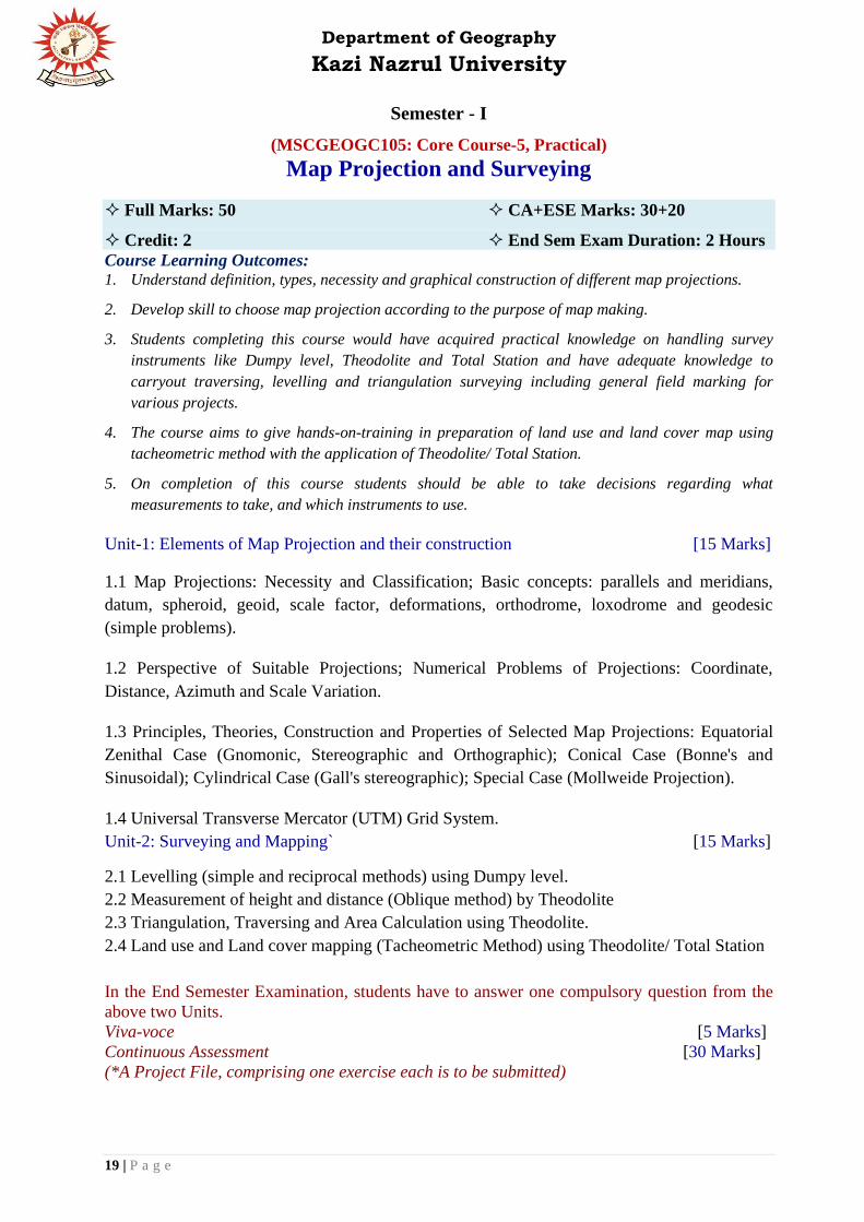
Semester - I
(MSCGEOGC105: Core Course-5, Practical)
Map Projection and Surveying
Full Marks: 50 CA+ESE Marks: 30+20
Credit: 2 End Sem Exam Duration: 2 Hours
Course Learning Outcomes: 1. Understand definition, types, necessity and graphical construction of different map projections.
2. Develop skill to choose map projection according to the purpose of map making.
3. Students completing this course would have acquired practical knowledge on handling survey
instruments like Dumpy level, Theodolite and Total Station and have adequate knowledge to
carryout traversing, levelling and triangulation surveying including general field marking for
various projects.
4. The course aims to give hands-on-training in preparation of land use and land cover map using
tacheometric method with the application of Theodolite/ Total Station.
5. On completion of this course students should be able to take decisions regarding what
measurements to take, and which instruments to use.
Unit-1: Elements of Map Projection and their construction [15 Marks]
1.1 Map Projections: Necessity and Classification; Basic concepts: parallels and meridians,
datum, spheroid, geoid, scale factor, deformations, orthodrome, loxodrome and geodesic
(simple problems).
1.2 Perspective of Suitable Projections; Numerical Problems of Projections: Coordinate,
Distance, Azimuth and Scale Variation.
1.3 Principles, Theories, Construction and Properties of Selected Map Projections: Equatorial
Zenithal Case (Gnomonic, Stereographic and Orthographic); Conical Case (Bonne's and
Sinusoidal); Cylindrical Case (Gall's stereographic); Special Case (Mollweide Projection).
1.4 Universal Transverse Mercator (UTM) Grid System.
Unit-2: Surveying and Mapping` [15 Marks]
2.1 Levelling (simple and reciprocal methods) using Dumpy level.
2.2 Measurement of height and distance (Oblique method) by Theodolite
2.3 Triangulation, Traversing and Area Calculation using Theodolite.
2.4 Land use and Land cover mapping (Tacheometric Method) using Theodolite/ Total Station
In the End Semester Examination, students have to answer one compulsory question from the
above two Units.
Viva-voce [5 Marks]
Continuous Assessment [30 Marks]
(*A Project File, comprising one exercise each is to be submitted)
Department of Geography
Kazi Nazrul University
20 | P a g e
Suggested Readings:
1. Alvi, Z. (1994): A Textbook of Practical Geography, Vikas Publishing House Pvt. Ltd., New Delhi.
2. Basak, N.N. (2008): Surveying and Levelling, Tata McGraw-Hill Publishing Company Limited, New Delhi.
3. Beaumont, J.R. and Williams, S.W. (1983): Project Work in the Geography Curriculum, Croom Helm,
London.
4. Bygott, J. (1964): Introduction to Mapwork and Practical Geography, Harper Collins Distribution Services,
London.
5. Elfic, M.H., Fryer, J.G., Brinkner, R.C. and Wolf, P.R. (1994): Elementary Surveying, 8th Edition, Harper
Collins Publishers, London.
6. Hussain, S.K. and Nagaraj, M.S. (1992): Text Book of Surveying, S. Chand & Co. Ltd., New Delhi.
7. Ishtiaq, M. (1994): Practical Geography, Jawahar Publishers & Distributors, New Delhi.
8. Kanetkar, R.P. and Kulkarni, S.V. (1988): Surveying and Levelling, Part-I, Vaidyarthi Griha Prakashani,
Pune.
9. Kellaway, G.P. (1979): Map Projections, 1st Indian Edition, B.I. Publication, Delhi.
10. Khan, Md. Z.A. (1998): Text Book of Practical Geography, Concept Publishing Company, New Delhi.
11. Kochher, C.L. (1993): A Text Book of Surveying, S.K. Katariya & Sons, Delhi.
12. Mailing, D.H. (1973): Coordinate Systems and Map Projections, George Phillip &Sons, London.
13. Mishra R.P. and Ramesh, A., (1989): Fundamentals of Cartography, Concept, New Delhi
14. Monkhouse F.J. and Wilkinson, H.R. (1971): Maps and Diagrams: Their Compilation and Construction, B.I.
Publications Private Limited, New Delhi.
15. Punmia, B.C. (1985): Surveying, Volume II, Standard Book House, Delhi.
16. Raisz, E.J. (1962): Principles of Cartography, McGraw-Hill.
17. Robinson, A.H., Sale, R.D. and Morrison, J. (1984): Elements of Cartography, Wiley, New York.
18. Saha, P.K. and Basu, P. (2009): Advanced Practical Geography, Books and Allied (P) Ltd., Kolkata.
19. Sarkar, A. (1997): Practical Geography: A Systematic Approach, Orient Longman Ltd., Hyderabad.
20. Shepherd, F.A. (1983): Engineering Surveying, Edward Arnold, London.
21. Singh, Gopal (1998): Map Work and Practical Geography, Vikas Publishing, New Delhi.
22. Singh, L.R. (2005): Fundamentals of Practical Geography, Sharda Pustak Bhawan, Allahabad.
23. Singh, R.L. and Singh, R.P.B. (1991): Elements of Practical Geography, Kalyani Pub., New Delhi.
24. Steers J.A., (1965): An Introduction to the Study of Map Projections, University of London Press, London.
25. Talukder, S. 2008): An Introduction to Map Projections, EBH Publishers (India), Guwahati.
26. Venkatramaiah, C. (1996): A Textbook of Surveying, Universities Press/Orient Longman Ltd., Hyderabad.

Department of Geography
Kazi Nazrul University
21 | P a g e
Semester - I
(MSCGEOGC106: Core Course-6, Practical)
Thematic Mapping
Full Marks: 50 CA+ESE Marks: 30+20
Credit: 2 End Sem Exam Duration: 2 Hours
Course Learning Outcomes:
1. Understand interpretation techniques of topographical maps and its application in practical.
2. Get skill of creating slope map, dissection Index map, relative relief map, absolute relief map,
altimetric frequency and hypsometric Curve.
3. Predict Soil fertility (NPK, pH) and Organic Matter.
4. Create different types of thematic maps (economic and social environment) and interpreting the
results.
Unit-1: Thematic Mapping of Physical Environment [15 Marks]
1.1 Mapping and Interpretation of Morphometric aspects (Dissection Index, Drainage Density,
Ruggedness Index, Slope by Raisz and Henry), Preparation and Interpretation of Altimetric
frequency and Hypsometric Curve from SoI (1:50000) topographical maps of plateau region.
1.2 Preparation of Geomorphic Maps of Flood-prone and Drought-prone areas and their
interpretation. Analysis and Interpretation of Geological Maps, Subsurface lithological
correlation techniques and its interpretation.
1.3 Computation, Drawing and Mapping of Pluviometric Coefficient; Equipluves, Aridity and
Moisture Index and Coefficient of Variability of Rainfall; Construction of Thiessen Polygon
from Precipitation data.
1.4 Analysis of Soil and its Mapping: NPK, pH and Organic Matter.
Unit-2: Thematic Mapping of Economic and Social Environment [15 Marks]
2.1 Test for Clustering and Regularity (Nearest Neighbour Analysis); Lorenz curve and
Determination of Gini's coefficient; Location Quotient Analysis.
2.2 Index of Disparity by Kendall's method; Preparation of Maps on Crop Combination
(Weaver and Rafiullah's methods) and Diversification of Crops (Bhatia's method).
2.3 Functional Classification of Towns by Dominant and Distinctive Functions; Applicability
of Rank Size Rule with settlement data (Normal and Log).
2.4 Network as a Graph; Alfa, Beta and Gamma Index of Connectivity; Accessibility by Detour
Index; Mapping of Sphere of Influence (Breaking Point).
In the End Semester Examination, students have to answer three compulsory questions from
the above Four Units.
Viva-voce [5 Marks]
Continuous Assessment (*A Project File, comprising one exercise each is to be submitted)
[30 Marks]

Department of Geography
Kazi Nazrul University
22 | P a g e
Suggested Readings:
1. Alvi, Z. (1995): Statistical Geography: Methods and Applications, Rawat Pub., New Delhi.
2. Campbell, J. (1993): Map Use and Analysis, Wm. C. Brown Publishers, USA.
3. Dackombe, R.V. and Gardiner, V. (1983): Geomorphological Field Manual, George Allen and Unwin,
London.
4. FitzGerald, B.P. (1974): Science in Geography (Data description and presentation), Oxford University Press.
5. Goudie, A. (1990): Geomorphological Techniques, Unwin Hyman, London.
6. Hammond, R. and McCullagh, P. (1991): Quantitative Techniques in Geography, Clarendon Press, Oxford.
7. Khan, N. (2002): Quantitative Methods in Geographical Research, Concept Publishing Company, New Delhi.
8. Liendsor, J.M. (1997): Techniques in Human Geography, Routledge.
9. Mahmood, A. (1998): Statistical Methods in Geographical Studies, Rajesh Publication.
10. Maltman, A. (1990): Geological Maps: An Introduction, Open University Press, Buckingham.
11. Monkhouse F.J. and Wilkinson, H.R. (1971): Maps and Diagrams: Their Compilation and Construction, B.I.
Publications Private Limited, New Delhi.
12. Platt, J.I. and Challinor, J. (1956): Simple Geological Structures (A Series of Notes and Map Exercises),
Thomas Murby & Co, London.
13. Raghunath, H.M. (2006): Hydrology: Principles, Analysis, Design, 3rd Edition, New Age International
Publishers.
14. Sarkar, A. (2015): Practical Geography: A Systematic Approach, 3rd Edition, Orient Blackswan Private Ltd.
15. Sarkar, A. 2013): Quantitative Geography: Techniques and Presentations, Orient BlackSwan, Hyderabad.
16. Saxena, H.M. (2005). Transport Geography, Rawat Publications.
17. Sen, A.K. (1995): Laboratory Manual of Geology, Modern Book Agency (P) Ltd., Kolkata.
18. Singh, R.L. and Singh, R.P.B. (1991): Elements of Practical Geography, Kalyani Pub., New Delhi.
19. Toyne, P. and Newby, P.T. (1971): Techniques in Human Geography, Macmillan Education, London.
20. United States Department of Agriculture (USDA) (2014): Soil Survey and Laboratory Methods Manual, Soil
Survey Investigations Report No. 51.
21. Yeates, M. (1974): An Introduction to Quantitative Analysis in Human Geography, McGraw Hill, New York.

Department of Geography
Kazi Nazrul University
23 | P a g e
SYLLABUS for
M.Sc. in Geography (Semester - II)

Department of Geography
Kazi Nazrul University
24 | P a g e
Semester - II
(MSCGEOGC201: Core Course-7, Theoretical)
Climatology Full Marks: 50 CA+ESE Marks: 10+40
Credit: 4 End Sem Exam Duration: 2 Hours
Course Learning Outcomes:
1. Learn the dynamics of climatic phenomenon and their interrelationship.
2. Get insights in occurrences and variability of extremity of weather events.
3. Apply knowledge of climate towards identification and demarcating the region of geographical
importance.
4. Predict future climatic changes through analysing the past events and current climatic scenario
Unit 1: Introduction to Climatology [10 Marks]
1.1 Concept, Nature and Scope of Climatology and its Relationship with Meteorology;
Insolation; Heat Budget of Earth; Temperature, Pressure and Winds, Precipitation.
1.2 Atmospheric Stability and Instability; Fronts and Upper Air Circulation; Cyclones and
Anticyclones (Tropical and Temperate).
Unit 2: Monsoon and Extreme Climatic Events [10 Marks]
2.1 Genesis of Indian Monsoon and its Variability: Thermal and Dynamic Theories; Role of Jet
Streams and Tibetan Plateau; El Nino, La Nina and Southern Oscillations; MONEX.
2.2 Extreme Weather Phenomena: Thunderstorms, Tornadoes and Hailstorms; Heat and Cold
waves; Drought and Cloudburst.
Unit 3: Climatic Classification and Agro-climatic Regions [10 Marks]
3.1 Classification of World Climate: Koppen, Thornthwaite, Trewartha; Classification of
Climate with special reference to India: Koppen, Thornthwaite and R.L.Singh.
3.2 Agro-climatic Regions in India: Basis of Identification and Important Characteristics; Bio-
climatic Regions with Special Reference to Tropical Climate.
Unit 4: Climate Change and Associated Phenomena [10 Marks]
4.1 Global climate change: evidences of past climatic changes and possible causes; Feedback
mechanism; Vulnerability of climate change and its impact assessment; Weather forecasting:
approaches and techniques.
4.2 Paleoclimate: concept and reconstruction; Climates of the past: Snowball Earth, Cretaceous
Hot House, Cenozoic Climate (Palaeocene-Eocene Thermal Maximum, Pleistocene Glaciation,
Maximum Holocene).

Department of Geography
Kazi Nazrul University
25 | P a g e
Continuous Assessment [10 Marks]
(The department shall decide the methods of internal assessment)
Suggested Readings:
1. Anthes, R.A. (1997): Meteorology, Prentice Hall, Upper Saddle River, N.J.
2. Barry, R.G. and Chorley R.J. (2003): Atmosphere, Weather and Climate, Routledge, London and New Work.
3. Bigg, G.R. (2003): The Ocean and Climate, Cambridge University Press, Cambridge.
4. Byers H .R. (1974): General Meteorolgy, 4th Edition, McGraw Hill, New York.
5. Chatterjee, S.B. (1953): Indian Climatology, Climostatics, Climate classification of India with special
reference to the Monsoons, Calcutta.
6. Cock, N.K.(1995) : Geohazards: Natural and Human, Prentice Hall.
7. Critchfield, J.H. (1983): General Climatology, Prentice HAll.
8. Cronin, T.M. (2009): Paleoclimates: Understanding Climate Change Past and Presen, Columbia University
Press, New Work.
9. Das, P.K. (1995): Monsoons, National Book Trust, New Delhi
10. Griffiths, J.F. (1976): Applied Climatology, Oxford University Press, London.
11. Hobbs, J.E.(1980): Applied Climatology: A Study of Atmospheric Resources, Westview Press.
12. Huntington, E. and S.S. Visher.(1922): Climatic Changes; Their Nature and Causes, Yale University Press,
New Haven.
13. Lal, D.S. (2003): Climatology, Sharda Pustak Bhavan, Allahabad.
14. Lal. M. (Eds.) (1993): Global Warming: Concern for Tomorrow, Tata McGraw Hill, New Delhi.
15. Lamb, H.H. (2011): Climate : Present, Past and Futur, Vol.1&2. Routledge.
16. Linacre, E. and Geerts, B.(1997): Climates and Weather Explained, Routledge, London.
17. Lutgens, F.K.. and Tarbuck, E.J.(2010): The Atmosphere: An Introduction to Meteorology, 11th edition,
Prentice-Hall.
18. Oliver J.E. & Hioddore J.J, (2003): Climatology: An Atmospheric Science, Prentice Hall.
19. Pant, G.B. and Kumar, R.K.(1997): Climates of South Asia, Wiley, Chichester.
20. Singh R.L (Eds.) (1971): India: A Regional Geography, National Geog. Society of India, Varanasi.
21. Singh, S. (2013): Physical Geography, Prayag Pub., Allahabad.
22. Singh, S. (2009): Climatology, Prayag Pustak Bhandar, Allahabad.
23. Trewartha,G.T. and Horn, L.A., (1980): An Introduction to Climate, McGraw Hill, New Work

Department of Geography
Kazi Nazrul University
26 | P a g e
Semester - II
(MSCGEOGC202: Core Course-8, Theoretical)
Soil and Biogeography
Full Marks: 50 CA+ESE Marks: 10+40
Credit: 4 End Sem Exam Duration: 2 Hours
Course Learning Outcomes:
1. Describe the major factors and processes governing the soil formation.
2. Get knowledge about the different issues regarding soil degradation and soil conservation.
3. Explain the major principles and processes that govern the local and global distribution of
plants and animals
4. Identify the roles of energy flow and biogeochemical cycling in ecosystems.
5. Critically assess theoretical and conceptual issues related to anthropogenic impacts on
biodiversity and its conservation.
Unit 1: Soil Geography [10 Marks]
1.1 Soil Formation: Factors and Processes; Soil Properties (Physical and Chemical); Soil
Nutrients and Organisms; Soil Profile.
1.2 Soil Taxonomy: Classification by USDA and FAO; Soil Degradation: Causes and
Consequences; Soil Conservation.
Unit 2: Plant and Animal Community [10 Marks]
2.1 Plant Community: Meaning and Concepts; Evolution and Classification of Plants; Plant
Response to Environment: Adaptation, Succession, and Climax; Dispersal and Distribution of
Plants.
2.2 Animal Community: Factor influencing the Distribution, Dispersal and Migration of
Animals; Means and Barriers; Extinction of Animal Species.
Unit 3: Ecosystem and Ecology [10 Marks]
3.1 Ecosystem: Meaning and Concepts; Components and Classification of Ecosystem;
Functions: Trophic Levels, Energy Flows, Cycles (Geo-chemical, Carbon, Nitrogen and
Oxygen), Food Chain, Food Web and Ecological Pyramid.
3.2 Ecology: Concept of Ecology; Principles of Physical and Human Ecology; Ecosystem:
Forest and Desert with Special Reference to India.
Unit 4: Biomes and Biodiversity [10 Marks]
4.1 Biomes with Special Reference to Tropical Rain Forests, Tropical Monsoon Deciduous
Forest, Tropical and Temperate Grass Lands.

Department of Geography
Kazi Nazrul University
27 | P a g e
4.2 Biodiversity: Concept, Types and Importance; Biodiversity Conservation; Biosphere
Reserve with Special Reference to Sundarbans and Western Ghats.
Continuous Assessment [10 Marks]
(The department shall decide the methods of internal assessment)
Suggested Readings:
1. Allee, W.C. & Schmidt, K.P. (1937): Ecological Animal Geography, New York.
2. Cox, C.B. and Moore, P.D. (1993): Biogeography: An Ecological and Evolutionary Approach, 5th Edition,
Blackwell, Oxford.
3. Cloudsley-Thompson, J.L.(1975): Terrestrial Environment, Wiley, New York.
4. Darlington, P. J. (1957): Zoogeography: The Geographical Distribution of Animals, Wiley, New York.
5. Dansereau, P.(1957): Biogeography: An Ecological Perspective, Ronald Press, New York
6. Good, R. (1974): Geography of the Flowering Plants, Longman, 4th Edition, Green & Co. London.
7. Haggett, R.J., (1998): Fundamentals of Biogeography, Routledge, London.
8. Illies, J. (1974): Introduction to Zoogeography, translated by W.D.Williams, Macmillan, London.
9. Jeffries, M.J. (1997): Biodiversity and Conservation, Routledge, London.
10. Jones, R.L. (1980): Biogeography: Structure, Process Pattern and Change within the Biosphere.
11. Mathur, M.S. (1988): Essentials of Biogeography, Jaipur
12. Miller, C.E. et al., (1990): Fundamentals of Soil Science, 8th edition, John Wiley and Sons, New York.
13. Newbigin, M.I.(1936): Plant and Animal Geography, Methuen & Co, London.
14. Odum, E.P. (1971): Fundamentals of Ecology, Saunders, Philadelphia.
15. Pielou, E.C.(1979) : Biogeography, John Wiley and Sons, New York.
16. Pimm,S.L.(1991) : Balance of Nature-Ecological Issues in the Conservation of Species and Communities,
University Press, Chicago.
17. Shimvell, D.W.(1971): Description and Classification of Vegetation, University of Washington Press, Seattle.
18. Simmon, I.G.(1979):Biogeography: Natural and Cultural,E. Arnold, London.
19. Singer. M.J. & Donald, N.M. (1987): Soils: An Introduction, 2nd edition, Macmillan, N.Y.
20. Singh, R.B. (2009): (Eds.) Biogeography and Biodiversity. Rawat Publication, New Delhi.
21. Watts, David. (1971): Principles of Biogeography, McGraw Hill, New York.
22. Wilson, E.O.(1992): Diversity of Life, Harvard University Press, Cambridge.

Department of Geography
Kazi Nazrul University
28 | P a g e
Semester - II
(MSCGEOGC203: Core Course-9, Theoretical)
Social, Cultural and Settlement Geography Full Marks: 50 CA+ESE Marks: 10+40
Credit: 4 End Sem Exam Duration: 2 Hours
Course Learning Outcomes: 1. Learn the components of society with varied nomenclature.
2. Get an insight to the richness of culture across spaces which give shape to the very branch of
social and cultural geography.
3. Trace the evolutionary processes of human habitation which further gives input in the emergence
of settlement patterns.
4. Locate the change in settlements in between rural to urban settings and the dynamism of human
development.
GROUP-A: SOCIAL AND CULTURAL GEOGRAPHY
Unit 1: Concepts and Elements of Social Geography [10 Marks]
1.1 Scope and Content of Social Geography; Social space, Social Structure and Social
Processes; Social Distance and Conflicts, Social Inequality, Concept of Welfare and Social
Wellbeing
1.2 Social Groups and Ethnicity, Distribution of Social Groups with Special reference to
Language, Race and Tribes in India.
Unit 2: Cultural Geography [10 Marks]
2.1 Definition, Components and Functions of Culture; Cultural Diffusion, Cultural Hearth and
Realm, Culture as a Geographical Process.
2.2 Acculturation; Metropolitan Culture and Cultural Globalization; Cultural Ecology and Folk
Geography: study on Folk Architecture, Folk Music and Dance, Folk Fairs and Festivals.
GROUP-B: SETTLEMENT GEOGRAPHY
Unit 3: Rural Settlements [10 Marks]
3.1 Evolution and Growth of Rural Settlement, Site and Situation, Patterns and Segregation of
Rural Settlements; Rural Morphology
3.2 Rural House Forms and Types in Different Geographic Environment in India; Rural-urban
Linkages with Special References to India.
Unit 4: Urban Settlements [10 Marks]
4.1 Definition of Urban: World and India, Classification of Towns based on Function, Urban
Systems and Hierarchy: Central Place, Rank Size Rule and Primacy.

Department of Geography
Kazi Nazrul University
29 | P a g e
4.2 Classical Models of Urban Land Use; Type of Urbanized Regions: Conurbation,
Metropolis, Megalopolis; Socio-environmental Problems of Urban Settlement.
Continuous Assessment [10 Marks]
(The department shall decide the methods of internal assessment)
Suggested Readings:
1. Ahmad, A. (1999): Social Geography, Rawat Publications, Jaipur and New Delhi.
2. Carter, H. (1972): The Study of Urban Geography, Edward Arnold, London.
3. Chisholm, M. (1967): Rural Settlement and Land use, John Wiley, New York.
4. Clout, H.D. (1977): Rural Geography, Pergamon, Oxford.
5. Coates, B.E., Johnston, R.J. and Knox, P.L. (1977): Geography and Inequality, Oxford University Press.
6. Doniel, P. and Hopkinson, M. (1986): The Geography of Settlement, Oliver & Boyd, Edinburgh.
7. Forde, C.D. (1934): Habitat, Economy and Society, Methuen and Company, London.
8. Gore, M.S. (1985): Social Aspects of Development, Rawat Publications, Jaipur.
9. Gregory, D. and Larry, J. (eds.) (1985): Social Relations and Spatial Structures, MacMillan, London.
10. Grover, N. (1985): Rural Settlement: A Cultural Geographical Analysis, Inter India Publication, Delhi.
11. Hudson, F.S. (1976): A Geography of Settlements, Macdonald and Evans, New York.
12. Johnson, J.H. (1976): Urban Geography: An Introductory Analysis, Pergamon Press.
13. Johnston, R.J. (1984): Urban Geography, Penguin, London.
14. Jones, E. (ed.) (1975): Readings in Social Geography, Oxford University Press, London.
15. Norton, W. (2006): Cultural Geography: Environments, Landscapes, Identities, Inequalities, Oxford
University Press.
16. Ramachandran, H. (1985): Village clusters and Rural Development, Concept Publication, New Delhi.
17. Ramachandran, R. (1989): Urbanization and Urban Systems in India, Oxford University Press, New Delhi.
18. Rao, R.N. (1986): Strategy for Integrated Rural Development, B.R. Publication, Delhi.
19. Rapoport, A. (1969): House Form and Culture, Prentice Hall, New Jersey.
20. Singh R. L. (1975): Readings in rural settlement geography, National Geographical Society of India.
21. Singh, R.Y. (2002): Geography of Settlements, Rawat Publication.
22. Smith, D. (1977): Geography: A Welfare Approach, Edward Arnold, London.
23. Sopher, D. (1980): An Exploration of India: Geographical Perspectives on Society and Culture, Cornell
University Press, Ithaca, New York.
24. Srinivas, M.N. (1968): Village India, Asia Publication House, Bombay.
25. Valentine, G. (2001): Social Geographies: Space and Society, Prentice Hall, Harlow, UK.
26. Verma, L.N. (2006): Urban Geography, Rawat Publications, Jaipur.
27. Wanmati, S. (1983): Service Centers in Rural India, B.R. Publication Corporation, Delhi

Department of Geography
Kazi Nazrul University
30 | P a g e
Semester - II
(MSCGEOGC204: Core Course-10, Practical)
Quantitative Techniques in Geography
Full Marks: 50 CA+ESE Marks: 30+20
Credit: 2 End Sem Exam Duration: 2 Hours
Course Learning Outcomes:
1. Students will learn statistics from basic level to more advanced level from this course.
2. Understand the concept of sampling and different sampling techniques focusing on quantitative
analysis of sampling design.
3. Learn to examine the relationship between two or more variables using correlation and
regression analysis techniques.
4. Students will be able to understand the concept of hypothesis testing focusing on different
measures of hypothesis test for different types of data.
5. Understanding matrix and its applicability for the analysis of geographical data.
6. They will get hands on experience on temporal data modeling through advanced statistical
techniques.
7. Overall the students will learn how to analyse real world geographical data through different
statistical techniques.
Unit 1: Probability, Sampling and Test of Confidence [15 Marks]
1.1 Concept of probability and set theory; Conditional and independent probability,
Application of Bayes' theorem; Selected distribution: Normal distribution curve and Z-score,
Binomial and Poisson.
1.2 Sampling theory and techniques; Estimation from sample; Confidence limit; Standard error
of mean.
1.3 Scaling techniques: Primary scaling techniques (Nominal, Ordinal, Ratio and Interval);
Other scaling techniques (Rank Score, Weighted Score, Likert's Opinionnaire).
1.4 Hypothesis testing and statistical decision theory: Hypothesis formulation and rejection
rule, Type I and Type II errors, One-tailed and two-tailed tests; t-test; Z-test, Analysis of
Variance (ANOVA): One-way and Two-way.
Unit 2: Correlations, Regressions and Statistical inferences [15 Marks]
2.1 Bivariate Correlation (Rank: Kendall and Spearman; Product Moment); Regression: Linear
and Curvilinear (Parabolic, Geometric and Exponential); Multiple and Partial Correlation.
2.2 Significance test of Correlation Coefficient and Regression Coefficient; Nonparametric
Hypothesis tests: 2 test, Mann-Whitney U Test and Kruskal-Wallis Test.
2.3 Elementary ideas of Matrix algebra; Determinant and Cramer's rule; Solving Multiple
Regression Equations using Matrix and Cramer's rule; Factor Analysis (Centroid Method).
Department of Geography
Kazi Nazrul University
31 | P a g e
2.4 Modeling Temporal Data: Markov Chains (Mapping Transition Matrix); Method for testing
trend of time series (Mann-Kendall test); Detection of Cycles (Autocorrelation); Principles of
ARIMA modeling.
In the End Semester Examination, students have to answer one compulsory question from the
above two Units.
Viva-voce [5 Marks]
Continuous Assessment [30 Marks]
(*A Project File, comprising one exercise each is to be submitted)
Suggested Readings:
1. Alvi, Z. (1995): Statistical Geography: Methods and Applications, Rawat Publications, New Delhi.
2. Chakravorty, J.G. and Ghosh, P.R. (2007): Advanced Higher Algebra, U.N. Dhur & Sons Private Ltd., Kolkata.
3. Chatfield, C. (1995): The Analysis of Time Series: An Introduction, Chapman & Hall, Boca Raton.
4. Clark, W.A.V and Hosking, P.L. (1986): Statistical Methods for Geographers, Wiley and Sons.
5. Cole, J.P. and King, C.A.M. (1969): Quantitative Geography (Techniques and Theories in Geography), John
Wiley & Sons Ltd., London.
6. Gun, A.M., Gupta, M.K. and Dasgupta, B. (2008): Fundamental of Statistics (Volume One and Two), The
World Press Private Limited, Kolkata.
7. Haan, C.T. (1977): Statistical methods in hydrology, The Iowa State University Press, Ames.
8. Hammond, R. and McCullagh, P. (1991): Quantitative Techniques in Geography, Clarendon Press, Oxford
9. Hayslett, H.T. (1976): Statistics: Made Simple, W.H. Allen, London.
10. Joreskog, K.G., Klovan, J.E. and Reyment, R.A. (1976): Geological Factor Analysis, Elsevier Scientific
Publishing Company, Amsterdam.
11. Khan, N. (2002): Quantitative Methods in Geographical Research, Concept Publishing Company, New Delhi.
12. Kothari, C.R. (1979): Quantitative Techniques, Vikas Publishing House Pvt. Ltd., New Delhi.
13. Kothari, C.R. (2009): Research Methodology: Methods and Techniques, New Age International Publishers,
Kolkata.
14. Kurtz, N.R. (1983): Introduction to Social Statistics, McGraw-Hill International Book Company, Auckland.
15. Lehmann, E.L. and Joseph P. Romano, J.P. (2008): Testing Statistical Hypotheses, Springer.
16. Machiwal, D. and Jha, M.K. (2012): Hydrologic Time Series Analysis: Theory and Practice, Springer.
17. Mahmood, A. (1998): Statistical Methods in Geographical Studies, Rajesh Publication.
18. Malhotra, O.P. and Gupta, S.K. (1990): Elementary Statistics, S. Chand & Company Ltd., New Delhi.
19. Mukherjee, A. (2007): Fundamental Treatise on Probability and Statistics, Sree Tara Prakashani, Kolkata.
20. Naghettini, M. (Ed.) (2017): Fundamentals of Statistical Hydrology, Springer.
21. Pal, S.K. (1999): Statistics for Geoscientists, Concept publishing Company, New Delhi.
22. Sarkar, A. (2013): Quantitative Geography: Techniques and Presentations, Orient BlackSwan, Hyderabad.
23. Silk, J. (1979): Statistical techniques in Geography, George Allen and Unwin, London.
24. Spiegel, M.R. and Stephens, L.J. (2000): Theory and Problems of Statistics, Tata McGraw-Hill Publishing
Company Limited, New Delhi.
25. Walford, P. (1995): Geographical Data Analysis, John Wiley and Sons Inc., New York.
26. Yeates, M. (1974): An introduction to Quantitative Analysis in Human Geography, McGraw-Hill.

Department of Geography
Kazi Nazrul University
32 | P a g e
Semester - II
(MSCGEOGC205 Core Course-11, Practical)
Computer Basics and Field Report
Full Marks: 50 CA+ESE Marks: 30+20
Credit: 4 End Sem Exam Duration: 2 Hours
Course Learning Outcomes:
1. Gain knowledge about computer system and its components.
2. The students will learn about computer number system and also learn how to collect
data from internet sources to arrive at a conclusion.
3. They will get hands on experience on statistical analyses using Excel spreadsheets and
statistical softwares.
4. This course also aims to present the essence of geography as a field science. Students
will develop their aptitude in observation, data generation through field survey, data
analysis with various software and advanced techniques.
5. Upon completion of this course, they will finally know how to integrate all the data for
the preparation of field report focusing on a specific problem.
Unit 1: Computer Basics and Application in Data Processing and Representation
[15+10 = 25 Marks]
1.1 Computer components: Hardware and software: CPU, Input and Output devices; Common
computer languages, System Software and Application Software.
1.2 Numbering Systems; Basic Logic Gates; Boolean Logic and Reduction Techniques; Data
mining from internet sources: preparation of an inventory.
1.3 Computation, Storing and Formatting Spreadsheets using Microsoft Excel: Computation of
Rank, Mean, Median, Mode, Standard Deviation, Moving Averages; Covariance, Correlation
(Product Moment) and Correlation Matrix, Regression (Linear, Curvilinear and Multiple),
Hypothesis testing; Graphical representation of data: Histogram, Curve fitting, Box‐plots.
1.4 Advanced Data Processing using software: Optimization Problems (Regression Modeling)
using Excel Solver; Temporal Data Modeling (Markov Chains, Mann-Kendall test, ARMA).
Continuous Assessment [15 Marks]
In the End Semester Examination, students have to answer one compulsory question from the
above unit. [10 Marks]
Unit 2: Field report on either a Rural Mouza or at least one ward of an Urban area to be
conducted during Field Excursion [15+10=25 Marks]
Guideline for field report on Rural Mouza
❖ The following methods are to be followed before the preparation of field report:
(a) Plot-to-Plot Land Use Survey
(b) Collection of Socio-Economic and Physical Data

Department of Geography
Kazi Nazrul University
33 | P a g e
(c) Classification and Tabulation of Data
(d) Preparation of Land Use Map on Cadastral Plan
(e) Preparation of Maps and Diagrams showing Physiography, Drainage, Soil, Forest,
Settlement, Irrigation, Cropping pattern, Demographic Characteristics etc.
(f) Interrelation and Analysis of Data, Maps and Diagrams
❖ The Reports is to be Prepared under the following sections:
(a) Introduction: Objective, Extent and Space Relations, Sources of Information,
Methodology etc.
(b) Physical Components: Lithology, Drainage, Surface Condition, Slope, Climate, Soil
Vegetation, etc.
(c) Population: Number, FMR, Literacy, Occupational Structure, Ethnic and Religious
Composition, Language, Mobility, Media Exposure, Per Capita Income etc.
(d) Settlement: Number of Houses, Building Materials, Number and Size of Rooms,
Amenities etc.
(e) Agriculture: Soil Properties, Irrigational Facilities, General Land Use, Cropping
Intensity, Crop- Combination, Use of Fertilisers, Production and Marketing etc.
(f) Other Economic Activities: Fishing, Horticulture, Brick-Kiln Industries
(g) Problems, Prospects, Suggestion and Conclusion.
(h) Bibliography.
Guideline for field report on Urban Area (At least One Ward)
❖ The following methods are to be followed before the preparation of Field Report:
(a) Plot – to- Plot Land Use Survey
(b) Collection of Socio-Economic Data.
(c) Classification and Tabulation of Data.
(d) Preparation of Urban Land Use Maps.
(e) Preparation of Maps and Diagrams showing Urban Morphology, Drainage and Sewage
Networks, Communication Networks, Traffic Flow and Travel- Time, Demographic
Characteristics, Cultural and Economic Zonation etc.
(f) Interrelation and Analysis of Data, Maps and Diagrams.
❖ The report is to be prepared under the following sections:
(a) Introduction: Objective, Extent and Space Relations, Sources of Information,
Methodology etc.
(b) Physical Components: Surface Conditions, Slope, Drainage, Climate etc.
(c) Demography: Spatial Analyses of Population Density, FMR, Literacy, Occupational
Structure, Ethnic and Religious Composition, Language, Mobility, Media Exposure,
etc.
(d) Town Morphology: Activity Zones, Sectors of Land Use, Linkages between different
Zones and Sectors.
(e) Economy: Economic Individuality of the Town, Production and Marketing Patterns,
Spatial differences in Occupation and Per Capita Income Characteristics etc.
(f) Urban Waste and its Management: Types of Wastes Generated, Network of Drains,
Efficiency of Waste Removal and Sewage Treatment, Peoples’ Perception of Pollution
Problem.
(g) Bibliography
• Field Reports is to be computerised.
• Text of the Report should not Exceed 4,000 words
• Maps and Diagrams Excluding Photo-Plates should not Exceed 20
Department of Geography
Kazi Nazrul University
34 | P a g e
Continuous Assessment for unit 2 will be based on field performance and preparation of the
field report and presentation of the field report. [15 Marks]
End Semester for unit 2 will be based on Field Report+ Viva-voce [5 +5= 10 Marks]
Suggested Readings:
1. Balagurusamy, E. (2009): Fundamentals of Computers, Tata McGraw-Hill Education Pvt. Ltd.
2. Bartee, T.C. (1977): Digital Computer Fundamentals, McGraw Hill.
3. Blissmer, R. (1996): Working with MS Word, Houghton Mifflin Co.
4. Chauhan, S., Saxena, A. and Gupta, K. (2006): Fundamentals of Computer, Laxmi Publications.
5. Flake, L.J., McClintock, C.E. and Turner, S. (1989): Fundamental of Computer Education, Wordsworth Pub.
Co.
6. Leach, D.P., Malvino, A.P. and Saha, G. (2011): Digital Principles and Applications, Seventh Edition, Tata
McGraw Hill Education Private Limited, New Delhi.
7. Leon, A. and Leon, M. (2009): Introduction to Computers, Vikas Publishing.
8. Leon, A. and Leon, M. (2012): Internet for Everyone, Second Edition, Vikas Publishing House
9. Mano, M.M. and Kime, C. (2014): Logic and Computer Design Fundamentals, Fourth Edition, Pearson
Education Limited.
10. Miller M. (2007): Absolute Beginner's Guide to Computer Basics, Fourth Edition, QUE.
11. Rajaraman, V. (2003): Fundamentals of Computers, Prentice Hall India Learning Private Limited
12. Rajaraman, V. (2009): Computer Primer, 2nd Edition, Prentice Hall India Learning Private Limited.
13. Sarkar, A. and Gupta, S.K. (2002): Elements of Computer Science, S Chand and Company, New Delhi.
14. Sinha, P.K. and Sinha, P. (2008): Foundations of Computing, Third Edition, BPB Publication

Department of Geography
Kazi Nazrul University
35 | P a g e
Semester - II
(MSCGEOGMIE201: Minor Elective-1, Theoretical)
Geospatial Science
Full Marks: 50 CA+ESE Marks: 10+40
Credit: 4 End Sem Exam Duration: 2 Hours
Course Learning Outcomes: After completion of this course, students will be able to –
1. Learn the conceptual foundation of Remote Sensing (RS), Geographic Information System (GIS)
and Global Positioning System (GPS).
2. Learn various data Acquisition and analysis techniques in remote sensing.
3. Learn supervised and unsupervised image classification techniques with the help of software.
4. Examine and understand the spatial data models and its applications in geography.
Unit 1: Basic Concept of Remote Sensing [10 Marks]
1.1 Physics of Remote Sensing: Electro Magnetic Radiation (EMR), Radiation Laws
(wavelength- frequency-energy relationship of EMR numerical problems).
1.2 Data Acquisition Techniques: Types of Remote Sensing data and methods of interpretation;
Analysis of data with special reference to Aerial Photographs and Satellite Images.
Unit 2: Fundamental Concept of Remote Sensing [10 Marks]
2.1 Concepts and Types of Remote Sensing: Thermal Remote Sensing, Microwave Remote
Sensing, Hyper spectral Remote Sensing; Satellite Sensors: Concept of IFOV, Resolution,
Band Combination, TCC, FCC and SFCC.
2.2 Referencing scheme of satellite system (path/row calculation); Digital image Classification:
supervised and unsupervised classification.
Unit 3: Geographic Information System [10 Marks]
3.1 Concept, Component and Data structure of GIS, Concept of Spatial data in GIS: Vector
and Raster Data.
3.2 Data Acquisition Techniques: Use of GPS and Google Earth Image.
Unit 4: Image Rectification and Vectorizations [10 Marks]
4.1 Demonstration of software (open Source)
4.2 Georeferencing, Reprojection, Vectorization and Spatial data editing; Digitization of
Points, Line and Polygons; Preparation of different Types of FCC and Map Composition.

Department of Geography
Kazi Nazrul University
36 | P a g e
Suggested Readings:
1. Agarwal, G.C. (1974): Photogrammetric Surveys, their Planning, Execution and Costing, Survey of India
Technical Publication, No. 7401.
2. Bhatta, B. (2011): Global Navigation Satellite Systems: Insights into GPS, GLONASS, Galileo, Compass and
Others, CRC Press.
3. Bhatta, B. (2011): Remote Sensing and GIS, 2nd ed., Oxford Univ. Press.
4. Campbell, J.B. (1996): Introduction to Remote Sensing, 2nd edition, Taylor and Francis, London.
5. Chaisman, N. (1992): Exploring Geographical Information Systems, John Wiley and Sons Inc., New York.
6. Curran, P.J. (1988): Principles of Remote Sensing, ELBS Edition, Longman Group Ltd., UK.
7. Heywood, D.I., Cornelius, S. and Carver, S. (2006): An Introduction to Geographical Information Systems,
Prentice Hall, Upper Saddle River, New Jersey.
8. Jensen, J.R. (2006): Remote Sensing of the Environment: An Earth Resource Perspective, Prentice Hall,
Upper Saddle River, New Jersey.
9. Joseph, G. (2003): Fundamental of Remote Sensing, University Press (India) Pvt. Ltd.
10. Joseph, G. and Jegannathan, C. (2018): Fundamentals of Remote Sensing, 3rd ed., Universities Press.
11. Lillesand, T.M. and Kiefer, R. W. (1994): Remote Sensing and Image Interpretation, 3rd edition, John Wiley
and Sons, New York.
12. Marcolongo, B. and Mantorani, F. (1997): Photogeology: Remote Sensing Application in Earth Science,
Oxford and IBH Pub. Pvt. Ltd., New Delhi

Department of Geography
Kazi Nazrul University
37 | P a g e
SYLLABUS for
M.Sc. in Geography
(Semester - III)

Department of Geography
Kazi Nazrul University
38 | P a g e
Semester - III
(MSCGEOGC301: Core Course-12, Theoretical)
Agricultural Geography and Landuse Planning
Full Marks: 50 CA+ESE Marks: 10+40
Credit: 4 End Sem Exam Duration: 2 Hours
Course Learning Outcomes: 1. Trace the dynamism and evolutionary processes of agriculture as a discipline of geography over
time.
2. Apply the knowledge of agricultural geography in identification and demarcation of region having
agricultural importance using statistics.
3. Learn to plan the best possible uses of land applying suitable techniques over varied geographical
locations
GROUP-A: AGRICULTURAL GEOGRAPHY
Unit-1: Concept of Agriculture [10 Marks]
1.1 Scope, content and its relation with other branches of Geography. History of evolution of
agriculture in India.
1.2 Theories of Agricultural location: Von-Thünen's classical theory, Sinclair's model of Peri
urban agriculture. Agricultural innovations and their diffusion.
Unit-2: Dimensions of Agriculture and Distribution [10 Marks]
2.1 Determinants of agricultural land use: Physical, Socio-economic and Technological;
Concept and techniques of delineation of Agricultural Regions, Cropping pattern, Crop
combination, Crop diversification, Agricultural productivity and efficiency.
2.2 Changing pattern of world agriculture: Tropical, Temperate and Mediterranean region.
Spatial and temporal variation of climate and their impact on agriculture.
GROUP-B: LANDUSE PLANNING
Unit-3: Landuse Techniques and Survey [10 Marks]
3.1 Principles of Land use (after Graham, Stamp and Lewis). Land Classification - Storie's
rating index, Azzi's index, Land Capability Classification by USDA.
3.2 Landuse survey - Reconnaissance, Topographical Survey, Remote Sensing, Integrated
Survey Technique.
Unit-4: Landuse Model and Perception [10 Marks]
4.1 Landuse pattern in Wetlands and suggestions for optimum use.
4.2 Landuse in Glaciated lands and suggestions for optimum use.
Continuous Assessment [10 Marks]
(The department shall decide the methods of internal assessment)

Department of Geography
Kazi Nazrul University
39 | P a g e
Suggested Readings:
1. Briggs, D. (1985): Agriculture and Environment, Longman, London.
2. De, N.K. and Jana, N.C. (1997): The Land: A Multifaceted Appraisal and Management, Sribhumi Publishing Co.
3. FAO (1974): A Framework for Land classification, Soil Bulletin No. 32, FAO, Rome.
4. Gregor, H.P. (1970): Geography of Agriculture, Prentice Hall, New York.
5. Grigg, D. (1984): An Introduction to Agricultural Geography, Hutchinson Publication, London.
6. Grigg, D.B. (1974): The Agricultural Systems of the World, Cambridge University Press, New York.
7. Hironi, K. (1991): Land use Planning and Geomorphology: A study of Swai Madhopur, Concept Pub Co.,
New Delhi.
8. Husain, M. (1996): Systematic Agricultural Geography, Rawat Pub., New Delhi.
9. Joy, T.V. (1990): Agricultural Ecology, Longman, London.
10. Lindgren, D. (2002): Land Use Planning, Springer.
11. Mandal, R.B. (1982): Land Utilization: Theory and Practice, Concept Pub. Co., New Delhi.
12. Mather, A.S. (1986): The Land, Longman Group Ltd., UK.
13. Morgan, W.B. (1978): Agriculture in the Third World: A spatial analysis, Westview Press, Boulder.
14. Morgan, W.B. and Munton, R.J.C. (1971): Agricultural Geography, Methuen, London.
15. Randolph, John. (2003): Environmental Land Use Planning and Management, Island Press.
16. Roychaudhuri, S.P. (1966): Land and Soil, National Book Trust, New Delhi.
17. Shafi, M. (2005): Agricultural Geography, Pearson.
18. Sharma, K.D. and Soni, B. (2006): Land Use Diversification for Sustainable Rainfed Agriculture, Atlantic
Publishers and Distributors.
19. Silberstein, J. and Maser, C. (2000): Landuse planning for Sustainable Development, CRC Press.
20. Singh, J. and Dhillon, S.S. (1988): Agricultural Geography, Tata McGraw-Hill, New Delhi.
21. Symons, L. (1972): Agricultural Geography, Bell and Sons, London.
22. Tarrant, J.R. (1974): Agricultural Geography: Problems in Modern Geography Series, John Wiley and
Sons.
Semester - III
(MSCGEOGC302: Core Course-13, Theoretical)
Remote Sensing and Geographic Information System-I
Full Marks: 50 CA+ESE Marks: 10+40
Credit: 4 End Sem Exam Duration: 2 Hours
Course Learning Outcomes: 1. Understanding background process of a satellite remote sensing system with physical laws and
other concepts.
2. Student will learn different types of remote sensing systems and their differential
characteristics.

Department of Geography
Kazi Nazrul University
40 | P a g e
3. Student will understand the application fields of remote sensing data and also understand the
working process of GPS and GNSS system..
4. Students will gain knowledge of GIS system and its applicability in different field of
geographical studies along with its components
5. Students will built up their knowledge regarding image enhancement techniques required for
better image analysis and also understand background theories of satellite image classification.
Unit-1: Physical Basis of Remote Sensing and Satellite Systems [10 Marks]
1.1 Physics of Remote Sensing: Electro Magnetic Radiation (EMR), Radiation laws (wave
length frequency- energy relationship of EMR); Requirements and Stages of Remote Sensing;
Satellite Platforms and Sensors: Basics, Kepler's laws, Major-Semi major axis and eccentricity,
Velocity, Period, Historical development, Launch Vehicle, Indian scenario.
1.2 Satellite Data Acquisition techniques; Interpretation and analysis of aerial photographs and
satellite images; Satellite Sensors: Concept of IFOV, Resolution, Band Combination, FCC and
SFCC; Satellite Systems: Whiskbroom Systems (LANDSAT Series), Pushbroom Systems
(SPOT, IRS series), Microwave Systems (RADARSAT), Coarse resolution/ Meteorological
Satellite systems (NOAA, INSAT), Very high-resolution satellite systems (Quickbird, Cartosat,
IKONOS, WorldView series). Referencing scheme of satellite system (path/row calculation).
Spectral signature curve.
Unit-2: Applications of Remote Sensing and Global Navigation Satellite System (GNSS)
[10 Marks]
2.1 Application of Remote Sensing: Comparative assessment of SOI toposheet; Aerial
photographs and Satellite imageries in representing geographical data. Remote Sensing in
Landuse/ Landcover applications, Soil and Agriculture applications, Geomorphic Mapping,
Watershed Management.
2.2 Principles of GNSS positioning with special reference to GPS; Sources of error in a GNSS
system; DGPS and its uses.
Unit-3: Fundamentals of Geographic Information System [10 Marks]
3.1 Basic Concepts: Definition of GIS, Components of GIS, Variables: points, lines, polygon,
Functionality of GIS, Advantage and Limitation of GIS; GIS Data: Spatial and Attribute Data,
Information Organization and Data Structures, Data file and database; Concept of Multi-criteria
Decision Making and its application.
3.2 Creating GIS Database: File organization and formats, Geo-database, Rectification,
Digitization and Map Composition. GIS Data Input: Nature and Source of data, Methods of
spatial data capture: Primary and Secondary, digitization and scanning method; Techniques and
procedure for digitizing, Errors of Digitization, Attribute data capture; Data Editing: Detecting
and correcting errors, Re-projection, Transformation and Generalization, Edge matching and
Rubber sheeting, Topology.
Unit-4: Digital Image Classifications [10 Marks]

Department of Geography
Kazi Nazrul University
41 | P a g e
4.1 Definition of Digital Image; Source of Data and Data Formats; Hardware and Software
Consideration for Digital Image Processing; Satellite Data Encoding and Decoding, Data
Loading; Image Restoration, Image Reduction and Magnification, Concept of Geometric,
Atmospheric and Radiometric correction of satellite image.
4.2 Image Enhancement Techniques: Grey Level Thresholding, Level Slicing, Contrast
Stretching - Linear and Non-Linear, Density Slicing; Image Filtering (Types and Methods),
Multiband Enhancement (Band Ratioing, RGB Transformations, Principal Component
Analysis, Image fusion); Digital image classification: supervised and unsupervised
classification.
Continuous Assessment [10 Marks]
(The department shall decide the methods of internal assessment)
Suggested Readings:
1. Bhatta, B. (2011): Global Navigation Satellite Systems: Insights into GPS, GLONASS, Galileo, Compass and
Others, CRC Press.
2. Bhatta, B. (2011): Remote Sensing and GIS, 2nd ed., Oxford Univ. Press.
3. Campbell, J.B. (1996): Introduction to Remote Sensing, 2nd edition, Taylor and Francis, London.
4. Chaisman, N. (1992): Exploring Geographical Information Systems, John Wiley and Sons Inc., New York.
5. Curran, P.J. (1988): Principles of Remote Sensing, ELBS Edition, Longman Group Ltd., UK.
6. Heywood, D.I., Cornelius, S. and Carver, S. (2006): An Introduction to Geographical Information Systems,
Prentice Hall, Upper Saddle River, New Jersey.
7. Jensen, J.R. (2006): Remote Sensing of the Environment: An Earth Resource Perspective, Prentice Hall,
Upper Saddle River, New Jersey.
8. Joseph, G. (2003): Fundamental of Remote Sensing, University Press (India) Pvt. Ltd.
9. Joseph, G. and Jegannathan, C. (2018): Fundamentals of Remote Sensing, 3rd ed., Universities Press.
10. Lillesand, T.M. and Kiefer, R. W. (1994): Remote Sensing and Image Interpretation, 3rd edition, John Wiley
and Sons, New York.
11. Marcolongo, B. and Mantorani, F. (1997): Photogeology: Remote Sensing Application in Earth Science,
Oxford and IBH Pub. Pvt. Ltd., New Delhi.
12. Martin, D. (1991): Geographical Information Systems and their Socioeconomic Applications, London,
Routledge.
13. Sabins, F.F. (1997): Remote Sensing: Principles and Applications, 3rd edition, W.H. Freeman & Company,
New York.
Semester - III
(MSCGEOGC303: Core Course-14, Practical)
Remote Sensing & Geographic Information System - II
Full Marks: 50 CA+ESE Marks: 30+20
Credit: 2 End Sem Exam Duration: 2 Hours
Course Learning Outcomes: 1. Students will able to download different satellite images from data providers and also get hands
on exercise on common satellite data analysis procedures.
2. Learners will get knowledge about different image enhancement techniques required for pre-
processing of the satellite image.
Department of Geography
Kazi Nazrul University
42 | P a g e
3. Students will learn to create LULC maps from satellite image and also they will learn to
generate different bio-physical indices from satellite image.
4. After completing this course the students will learn different georeferencing process and how to
create different thematic map from obtained data
5. Students will learn to arrive to a decision from different sources of data using Multi-criteria
Decision Analysis methods
6. Learn DEM generation and Surface Analysis including Contour, Slope, Aspects, Hill shade.
7. They will learn to generate different Morphometric parameters from DEM such as Relative
Relief, Drainage Density and Hypsometry.
Unit-1: Techniques in Remote Sensing and Digital Image Processing (DIP) [15 Marks]
1.1 Familiarization with hard copy and soft copy satellite images; Selection procedure of IRS
series satellite images; Exercise on Visual Image Interpretation: Preparation of thematic
overlays from satellite images on the basis of feature identification keys.
1.2 Downloading of different Satellite Data Products (IRS, LANDSAT and Declassified
images); File export-import/ translation, Georeferencing of scanned maps and satellite images;
Applying reference spheroids and projections; Mosaicing and layering of images and maps of
different dates and scales; Creating Region of Interest (sub setting/ clipping).
1.3 Preparation of Colour Composites using different band combinations; Extraction of
Spectral Signature of different landuse / landcover features from Satellite Data; Image
enhancement techniques: Linear and non-linear contrast enhancement, band rationing, edge
enhancement, High pass and Low pass filtering, density slicing, principal component
transformation.
1.4 Image Classification: Unsupervised and Supervised Classification. Post Classification
Filtering, Accuracy assessment, Creation of look-up table, Classification report generation;
Preparation of Iron Index map, Moisture map, Normalized Difference Vegetation Index
(NDVI) and Normalized Difference Water Index (NDWI) map.
Unit-2: GIS Data Processing and Global Positioning System & DEM Analysis [15 Marks]
2.1 Scanning, Editing and Conversion in different file format; Generation of vector layers,
buffers and attribute tables from image and/or map data; thematic maps using spatial and
attribute data. Preparation of decision layer using Multi-criteria Decision Analysis.
2.2 Querying the database; Spatial analysis and modelling in GIS: Interpolation methods (IDW
and Kriging), DEM, TIN, variance filter, surface modelling; Application of GIS modelling in
Geomorphology or emerging issues in Environment (Case Study: any one).
2.3 Conceptual Framework of GPS surveying; Techniques of GPS data collection and mapping
(using Map Source / any other GPS Software/ GIS Software) of a locality with prominent
features.
2.4 DEM generation and Surface Analysis: Contour, Slope, Aspects, Hill shade; Representation
of Morphometric aspects from DEM: Relative Relief, Drainage Density and Hypsometry.
Department of Geography
Kazi Nazrul University
43 | P a g e
In the End Semester Examination, students have to answer one compulsory question from the
above two Units.
Viva-voce [5 Marks]
Continuous Assessment [30 Marks]
(*A Project File, comprising one exercise each is to be submitted)
Suggested Readings:
1. Agarwal, G.C. (1974): Photogrammetric Surveys, their Planning, Execution and Costing, Survey of India
Technical Publication, No. 7401.
2. Bolstad, P. (2016): GIS Fundamentals: A First Text on Geographic Information Systems, 5th ed., XanEdu
Publishing.
3. Brewer, C.A. (2015): Designing Better Maps: A Guide for GIS Users, 2nd ed., ESRI Press.
4. Campbell, J.B. (1996): Introduction to Remote Sensing, 2nd edition, Taylor and Francis, London.
5. Chaisman, N. (1992): Exploring Geographical Information Systems, John Wiley and Sons Inc., New York.
6. Chang, K-t. (2015): Introduction to Geographical Information System, McGraw-Hill Education.
7. Fazal, S. (2008): GIS Basics, New Age International (P) Limited, Publishers, New Delhi
8. Harvey, F. (2015): A Primer of GIS: Fundamental Geographic and Cartographic Concepts, The Guilford
Press.
9. Jensen, J.R. (2006): Remote Sensing of the Environment: An Earth Resource Perspective, Prentice Hall,
Upper Saddle River, New Jersey.
10. Joseph, G. and Jegannathan, C. (2018): Fundamentals of Remote Sensing, 3rd ed., Universities Press.
11. Lillesand, T.M. and Kiefer, R.W. (1994): Remote Sensing and Image Interpretation, 3rd edition, John Wiley
and Sons, New York.
12. Longley, P., Goodchild, M., Maguire, D.J. and Rhind, D.W. (2011): Geographic Information Systems and
Science,John Wiley & Sons, New York.
13. Marcolongo, B. and Mantorani, F. (1997): Photogeology: Remote Sensing Application in Earth Science,
Oxford and IBH Pub. Pvt. Ltd., New Delhi.
13. Rajan, M.S. (1995): Space Today, 2nd edition, National Book Trust, New Delhi.
14. Rao, U.R. (1996): Space Technology for Sustainable Development, Tata McGraw-Hill, New Delhi.
15. Sabins, F.F. (1997): Remote Sensing: Principles and Applications, 3rd edition, W.H. Freeman & Company,
New York.
16. Sahu, K.C. (2007): Textbook of Remote Sensing and Geographical Information Systems, Atlantic Publishers,
New Delhi

Department of Geography
Kazi Nazrul University
44 | P a g e
Semester - III
(MSCGEOGMJE301: Major Elective-1, Theoretical) Advanced Geomorphology – I
Full Marks: 50 CA+ESE Marks: 10+40
Credit: 4 End Sem Exam Duration: 2 Hours
Course Learning Outcomes:
1. Understand the concept of theoretical and applied geomorphology, and their linkages with
other discipline of knowledge.
2. Develop an advanced understanding of the distinct regions of the world in relation to
morphological and climatic parameters.
3. Learn the forces resisting and driving the flow of water which has its resultant effect on the flow
patterns and sediment load.
4. Understand the fluvial dynamics and fluvial system response to external forcing during
Quaternary period.
5. Describe the dynamic and functional interrelationship between forms and processes in a
coastal region. They will get knowledge about long term and short-term development of
landforms by several processes in the coastal regions and form-process relationships in
different spatial and temporal scales.
6. Analyze geomorphological issues at global, regional and local scale and application of
geomorphological knowledge to resolve different real problems.
Unit-1: Perspectives and Models in Geomorphology [10 Marks]
1.1 Nature and scope of Geomorphology: Theoretical and Applied, its linkages with other
branches of Geography and other disciplines; Methodology and recent trends in
Geomorphological studies; Climatic Geomorphology and morphogenetic regions in the tropics.
1.2 Concepts of planation surfaces: Peneplanation, Pediplanation, Etchplanation and
Cryoplanation. Theories and models of landforms: Tors and Bornhardts, Cirque, Pediment and
Delta. Weathering processes and profiles in humid tropical environment.
Unit-2: Fluvial processes and forms [10 Marks]
2.1 River hydraulics: flow, energy and hydraulic geometry; Channel geometry (bedrock and
alluvial rivers) and the Concept of grade; Catchment processes and fluvial processes; Factors
regulating entrainment, transportation and deposition of sediments.
2.2 Adjustment of channel forms and patterns to morphodynamic variables; Fluvial landforms:
genetic classification, ordering, formation and evolution; River metamorphosis and Quaternary
fluvial systems.
Unit-3: Coastal processes and landforms [10 Marks]
3.1 Tidal and fluvial processes in Coasts; Processes and effects of Bioturbation; Bio-tidal
accretion; Coral formation and Storm surge/Tsunamis in coasts.

Department of Geography
Kazi Nazrul University
45 | P a g e
3.2 Formation, System of change and Classification of Coastal Landforms with special
reference to Rhythmic Beach Topography, Coastal Dunes and Deltas.
Unit-4: Applied and Regional Geomorphology [10 Marks]
4.1 Application of geomorphology in feasibility assessment of engineering and industrials
projects; Geomorphic approaches to hazard studies and management of Geomorphic Hazards
(Landslides and Riverbank erosion).
4.2 Sikkim-Darjeeling Himalaya: Structure, Process and Landforms; Chhotanagpur Plateau:
Delineation, Stratigraphy and Geomorphic Features; Evolution of Indian part of Ganga-
Brahmaputra delta (GBD) with reference to climate, tectonics and eustasy.
Continuous Assessment [10 Marks]
(The department shall decide the methods of internal assessment)
Suggested Readings:
1. Bierman, P.R. and Montgomery, D.R. (2014): Key Concepts in Geomorphology, W.H. Freeman and
Company Publishers, New York.
2. Bridge, J.S. (2003): Rivers and Floodplains: Forms, Processes, and Sedimentary Record, Blackwell
Publishing, Oxford.
3. Charlton, R. (2008): Fundamental of Fluvial Geomorphology, Routledge.
4. Gregory K.J. (1997): River Channel Changes, John Wiley & Sons., New York.
5. Gregory, K.J. and Goudie, A.S. (2011): The SAGE Handbook of Geomorphology, SAGE.
6. Gregory, K.J. and Lewin, J. (2014): The Basics of Geomorphology: Key Concepts, SAGE.
7. Gregory, K.J. and Walling, D.E. (1985): Drainage Basin: Forms and Process - A Geomorphological
Approach, John Wiley & Sons., New York.
8. Gupta, A. (2011): Tropical Geomorphology, Cambridge University Press, New York.
9. Kingston D. (1984): Fluvial Forms and Processes, Edward Arnold, London.
10. Leopold, L.B., Wolman, M.G. and Miller, J.P. (1964): Fluvial Processes in Geomorphology, Dover
Publications, Inc., New York.
11. Morisawa M. (1968): Streams: their dynamics and morphology, McGraw Hill, New York.
12. Pethick, J. (1984): An Introduction to Coastal Geomorphology, Edward Arnold, London.
13. Richards K. (1995): Rivers, Methuen & Co., London.
14. Robert, A. (2003): River Processes: An Introduction to Fluvial Dynamics, Arnold, London.
15. Schumm S.A. (1977): The Fluvial System, Willey Interscience Publication.
16. Sen, P.K. and Prasad, N. (2002): An Introduction to the Geomorphology of India, Allied Publishers Pvt. Ltd.,
New Delhi.
17. Thorn, C.E. (1988): An Introduction to Theoretical Geomorphology, Unwin Hyman, Boston.
18. Tinkler, K.J. (1985): A Short History of Geomorphology, Barnes & Noble.
19. Twidale, C.R. (1982): Granite Landforms, Elsevier Scientific Publishing Company, Amsterdam.
20. Woodroffe, CD. (2002): Coasts: Form, Process and Evolution. Cambridge University Press, Cambridge.

Department of Geography
Kazi Nazrul University
46 | P a g e
Semester – III
(MSCGEOGMJE302: Major Elective-2, Practical)
Advanced Geomorphology - II
Full Marks: 50 CA+ESE Marks: 30+20
Credit: 4 End Sem Exam Duration: 2 Hours
Course Learning Outcomes: 1. Represent relief features of the flood plains, plateaus, hills, foothills, valleys and through serial,
superimposed, composite, projected profiles.
2. Get skill of creating slope map, dissection Index map, relative relief map, absolute relief map,
altimetric frequency and hypsometric Curve.
3. Apply different statistical methods used in geomorphological data analysis.
4. The students will be familiarized with various fluvial and topographic metrics which are the
indicators of inherent geological and tectonic controls.
5. Develop aptitude in observation and data generation through field survey using different
instruments and techniques. The stress on-field data collection and monitoring will train the
students to develop their deep insight into the earth surface processes.
6. Students will be trained thoroughly on field method and laboratory method of sediment sampling
and analysis respectively. This will help them to understand various types of environment and
process domain under which sediments were deposited. Thus they can develop skills for
reconstructing past.
Unit-1: Measurement, Computation and Analysis in Geomorphology [15 Marks]
1.1 Profile analysis from Indian Topographical sheets (1:50,000): superimposed, projected and
composite; Areal representation of slope by Raisz and Henry (1937) method; Construction of
hypsometric curve and derivation of hypsometric integral.
1.2 Stream order (Strahler's and Horton method), Linear, areal and relief aspects of drainage
basins, their bivariate and multivariate analysis; Analysis of Drainage Network Orientation and
Topological Distinct Channel Network (TDCN).
1.3 Computation of Braiding index, Sinuosity index, Meander wavelength and Radius of
curvature; Analysis of river longitudinal profiles.
1.4 Geomorphic indices of active tectonics (Drainage basin asymmetry, Valley width-height
ratio, SL Index) and their calculations; Slope-area analysis and geomorphic interpretations.
Unit-2: Geomorphological field techniques and sediment analysis [15 Marks]
2.1 Measurement of hillslope profiles with abney's level and drawing of profiles maintaining
slope forms; Measurement of dip and strike using clinometer; Field study of the weathering
profiles/ laterite profiles; Calculation and interpretations of Si/Sesquioxide ratios and chemical
weathering indices.
2.2 Measurement of channel cross-section in the field, study of erosional and depositional
features (Creating sketch maps); Calculation of hydraulic geometry equations; Calculation of
velocity and discharge using Manning equation.

Department of Geography
Kazi Nazrul University
47 | P a g e
2.3 Study of fluvial sedimentary sequences in the field (facies and major sedimentary
structures, Mialls' facies notations/lithocodes) and interpret in terms of past and present
geomorphic processes; Use of Munsell colour chart in sedimentary sequences.
2.4 Collection and analysis of sediments using Ø-graded sieves and electronic balance;
Analysis of Pebble-grade sediments for shape and size; Measurement of suspended sediment
concentration; Microscopic identification of minerals and biogenic forms.
In the End Semester Examination, students have to answer one compulsory question from the
above two Units.
Viva-voce [5 Marks]
Continuous Assessment [30 Marks]
(*A Project File, comprising one exercise each is to be submitted)
Suggested Readings:
1. Baker, V., Craig-Kochel, R. and Patton, P.C. (1988): Flood Geomorphology, Wiley, Chichester
2. Collinson, J.D and Thompson, D.B. (1988): Sedimentary Structures, Second Edition, Unwin Hyman, London.
3. Dackombe, R.V. and Gardiner, V. (1983): Geomorphological Field Manual. George Allen and Unwin, London.
4. Doornkamp, J.C. and King, C.A.M. (1971): Numerical analysis in Geomorphology, Edward Arnold, London.
5. Goudie, A.S. et al. (2005): Geomorphological Techniques, Second Edition, Routledge (Taylor & Francis
Group), London.
6. King, C.A.M. (1966): Techniques in Geomorphology, Edward Arnold, London
7. Lindholm, R. (1986): A Practical Approach to Sedimentology, CBS Publishers and Distributors, New Delhi.
8. McLane, M (1995): Sedimentology, Oxford University Press, New York, Oxford.
9. Miall, A.D. (2006): Geology of the Fluvial Deposits: Sedimentary Facies, Basin Analysis, and Petroleum
Geology, Springer.
10. Prasad, N. and Basu, R. (eds.) (2000): Contemporary Dimensions in Geography, Academic Staff College, The
University of Burdwan.
11. Ramasamy, S.M. (2005): Remote Sensing in Geomorphology, New India Publishing Agency.
12. Reading, H.G. (1996): Sedimentary Environments: Processes, Facies and Stratigraphy, Blackwell Science.
13. Sen, P.K. (1993): Geomorphological Analysis of Drainage Basin, The University of Burdwan, Burdwan.
14. Sengupta, S.M. (2010): Introduction to Sedimentology, Second Edition, CBS Publishers & Distributors Pvt.
Ltd., New Delhi.

Department of Geography
Kazi Nazrul University
48 | P a g e
Semester - III
(MSCGEOGMJE303: Major Elective-1, Theoretical)
Environmental Issues in Geography – I
Full Marks: 50 CA+ESE Marks: 10+40
Credit: 4 End Sem Exam Duration: 2 Hours
Course Learning Outcomes:
1. Learn the philosophical base which shapes the environmental concepts and enhance their ideas
towards generating thought process.
2. Understand the dilemma over global resource crises along with sustainable solution for better
resource utilization.
3. Get insights about the physical vulnerability of a geographical place and social processes in the
context of environmental degradation.
4. Broaden the thinking towards utilization of varied technological and biological innovation in
preserving and expanding the environmental space.
Unit-1: Basic Concepts and Philosophies of Environmental Geography [10 Marks]
1.1 Scope, Content and Approaches to Environmental Studies: Environmentalist,
Holistic vs Reductionist and Deep vs. Shallow Ecology.
1.2 Philosophical bases of Environmental Studies: Gaia Hypothesis, Limits to Growth,
Spaceship Earth, Ecosystem Balance, Population Equilibrium and Stationary State Economy.
Unit-2: Issues of Environmental Resource Utilization [10 Marks]
2.1 Global Resource Crisis with special reference to Coal, Petroleum and Natural Gas.
2.2 Environmental politics regarding conflicts over water resource: Examples from World and
India.
Unit-3: Environmental Degradation [10 Marks]
3.1 Natural and quasi-natural Hazards: Risk, Vulnerability and Management of Cyclones,
Earthquake, Droughts, Floods and Landslide.
3.2 Social Hazards: Tropical Diseases, Poverty, Crime, Human Trafficking and Social
Exclusion.
Unit-4: Environmental Technology [10 Marks]
4.1 Changes in the trend of Production Technology (with special reference to Green
Technology); Role of State Control, Privatization and Out-sourcing; Environmental Audit.
4.2 Environmental microbiology: Bio-gas, Bio-remediation, Bio-transformation, Bio-
conversion.
Continuous Assessment [10 Marks]
(The department shall decide the methods of internal assessment)

Department of Geography
Kazi Nazrul University
49 | P a g e
Suggested Readings:
1. Abbasi, A., Krishnakumari, P., and Khan, F. (2000): Hot Topics: Everyday Environmental Concern, Oxford
University Press.
2. Adams, W.M. (1995): Green Development: Environmental Sustainability in the Third World, Routledge,
London.
3. Alexander, D. (1993): Natural Disasters, Research Press, New Delhi.
4. Allaby, M. (1996): Basics of Environmental Science, Routledge, London.
5. Bryant, E.A. (1991): Natural Hazards, Cambridge University Press, Cambridge.
6. Buchholz, R.A. (1993): Principles of Environmental Management, the Greening of Biosphere, Prentice Hall
Inc.,New Jersey.
7. Chary, S.N. (2008): Environmental Studies, Macmillan Publication.
8. Dasgupta, P. and Miller, K.G. (1997): The Environment and Emerging Development Issues, (Volumes I and
II), Clarendon Press, Oxford.
9. Gilpin, A. (1996): Dictionary of Environment and Sustainable Development, John Wiley and Sons Ltd.
10. Goudie, A. (1986): The Human Impact on the Natural Environment, 2nd edition, Blackwell Pub. Co., London.
11. Guha, R. (2008): Social Ecology, Oxford India Paperbacks.
12. Hardoy, J.E., Mittin, D. and Satterthwaite, D. (1992): Environment Problems in the World Cities, Earthscan
Pub. Ltd., London.
13. Johansen, B.E. (2006): Global Warming in the 21st Century, Atlantic Publication.
14. Masters, G.M. (1991): Introduction to Environmental Engineering and Sciences, Prentice Hall India Ltd.,
New Delhi.
15. Mishra, R.N. (2008): Environment and Forest Resource Management, Sonali Publication, New Delhi.
16. Park, C. (1998): The Environment: Principles and Applications, Routledge, London.
17. Pickering, K.T. and Owen, L.A. (1997): An Introduction to Global Environmental Issues, Routledge, London.
18. Santra, S.C. (2001): Environmental Science, Central Publication.
19. Shaw, R. and Krishnamurty, R.R. (2009): Disaster: Global Challenges and Local Solutions, University Press.
20. Singh, R.B. and Misra, S. (1996): Environmental Laws in .India: Issues and Responses, Rawat Pub., New
Delhi.
21. Speth, I.G. (Reprint 2005): Global Environmental Challenges - Transitions to a Sustainable World, Orient
Longman, New Delhi.
22. Whyte, I.L. (1995): Climate Change and Human Society, Arnold, London.
23. Woodward, F.I. (1992): Global Climatic Change: The Ecological Consequences, Academic Press, London.
Semester - III
(MSCGEOGMJE304: Major Elective-2, Practical)
Environmental Issues in Geography - II
Full Marks: 50 CA+ESE Marks: 30+20
Credit: 4 End Sem Exam Duration: 2 Hours
Course Learning Outcomes:
1. Enhance the skill towards identifying and analysing the environmental problems along with
modelling the environmental data.
2. Instill the quality in perceiving the ground reality through primary survey and learn the technique
in developing questionnaire schedule.
3. Learn to map and represent the environmental data for a better aerial and spatial understanding
with sound management practices.

Department of Geography
Kazi Nazrul University
50 | P a g e
Unit-1: Modelling and Techniques and Quantitative Analysis` [15Marks]
1.1 Identification and Modelling of Environmental Problems.
1.2 Regression analysis and Standard Error of the Estimate with Environmental data.
1.3 Correlation (Bivariate) analysis of Environmental Data.
1.4 Time series analysis of climatic data.
Unit-2: Environmental Survey. Mapping and Technology [15Marks]
2.1 Perception Survey Techniques; Preparation of Survey Schedule and Questionnaires for
Natural and Social Hazards.
2.2 Sources and Collection of Environmental Data; Cartographic Representation of Primary
and Secondary data with Environmental Significance.
2.3 Preparation and Interpretation of Environmental Maps: Micro levels (Area and Problem
specific); Pollution and Hazard Mapping.
2.4 Environmental Management Plan. .
In the End Semester Examination, students have to answer one compulsory question from the
above two Units.
Viva-voce [5 Marks]
Continuous Assessment [30 Marks]
(*A Project File, comprising one exercise each is to be submitted)
Suggested Readings: 1. Alvi, Z. (1995): Statistical Geography: Methods and Applications, Rawat Publications, New Delhi.
2. Chakravorty, J.G. and Ghosh, P.R. (2007): Advanced Higher Algebra, U.N. Dhur & Sons Private Ltd., Kolkata.
3. Clark, W.A.V and Hosking, P.L. (1986): Statistical Methods for Geographers, Wiley and Sons.
4. Cole, J.P. and King, C.A.M. (1969): Quantitative Geography (Techniques and Theories in Geography), John
Wiley & Sons Ltd., London.
5. Gun, A.M., Gupta, M.K. and Dasgupta, B. (2008): Fundamental of Statistics (Volume One and Two), The
World Press Private Limited, Kolkata.
6. Hammond, R. and McCullagh, P. (1991): Quantitative Techniques in Geography, Clarendon Press, Oxford
7. Hayslett, H.T. (1976): Statistics: Made Simple, W.H. Allen, London.
9. Khan, N. (2002): Quantitative Methods in Geographical Research, Concept Publishing Company, New Delhi.
10. Kothari, C.R. (2009): Research Methodology: Methods and Techniques, New Age International Publishers,
Kolkata.
11. Kothari, C.R. (1979): Quantitative Techniques, Vikas Publishing House Pvt. Ltd., New Delhi.
12. Kurtz, N.R. (1983): Introduction to Social Statistics, McGraw-Hill International Book Company, Auckland.
13. Mahmood, A. (1998): Statistical Methods in Geographical Studies, Rajesh Publication.
14. Malhotra, O.P. and Gupta, S.K. (1990): Elementary Statistics, S. Chand & Company Ltd., New Delhi.
15. Pal, S.K. (1999): Statistics for Geoscientists, Concept publishing Company, New Delhi.
17. Silk, J. 1(979): Statistical techniques in Geography, George Allen and Unwin, London.
19. Walford, P. (1995): Geographical Data Analysis, John Wiley and Sons Inc., New York.

Department of Geography
Kazi Nazrul University
51 | P a g e
Semester - III
(MSCGEOGMJE305: Major Elective-1, Theoretical) Urban Geography – I
Full Marks: 50 CA+ESE Marks: 10+40
Credit: 4 End Sem Exam Duration: 2 Hours
Course Learning Outcomes: 1. Learn the concept of urban, urban space and process of urbanization and its temporal variation
2. Learn theories of types and patterns of urban settlements.
3. Trace the spacing of urban settlement over time based on models, theories and laws.
4. Keep pace with the changing economies, production system and phases of transition and
changing pattern of urbanization
Unit-1: Urbanization: Concept and Processes [10 Marks]
1.1 Concept of urban, urbanism and urbanization; Concept of urban space; Attributes of urban
places; Approaches to the Study of urban geography: traditional, modern and post-modern
1.2 Processes of Urbanization; Urbanization in the developing and developed world, causes of
urban growth, urbanization cycles
Unit-2: Classification of Urban Settlements [10 Marks]
2.1 Classification of Urban settlements: J.M. Houston, G.Taylor , Mumford, Concepts of
Megacity, Megalopolis, Ecumenopolis, Conurbation, Counter-urbanization, Planned Towns,
New Towns, Satellite Towns, Green/ Garden cities, Sister Towns, Urban Corridor, Rural-urban
Fringe, Urban Sprawl, Urban Umland.
2.2 Concept of City Region after Dickinson; Urban Primacy; Rank-size Distribution of Towns
after Zipf and B.J.L. Berry
Unit-3: Theories and Spacing of Urban Settlements [10 Marks]
3.1 Theories of urban hierarchy and spacing of urban settlements after Christaller, Smailes and
Philbrick, Role of Urban Hierarchy in Regional Planning
3.2 The theories and Model of Urban Morphology after Burgess, Homer Hoyt, Harris and
Ullman, Mann, Sinclair with merits and demerits
Unit-4: Urban Economy and Segregation of Urban Spaces [10 Marks]
4.1 Economic Base Theory, Formal and Informal Economy; Types of Urban Linkages and its
significance, Concept of Economic Marginalization and reasons behind the proliferation of
Slums and Shanty Towns
4.2 New Production Systems and New Industrial Spaces, Deindustrialisation and Tertiarisation
of urban work force, The world city and Transnational urban systems
Continuous Assessment [10 Marks]
(The department shall decide the methods of internal assessment)
Department of Geography
Kazi Nazrul University
52 | P a g e
Suggested Readings:
1. Bhattacharya, B. (2006). Urban Development in India. New Delhi: Concept Publishing Company
2. Bird, James 1977: Centrality And Cities. Routledge, London
3. Carter, H. 1981: Urban Geography, 3rd edition Arnold-Heinemann, New Delhi.
4. Chakroborty, J., & Ghosh, P. (2007). Higher Algebra. kolkata: Un Dhur and Sons Pvt Ltd.
5. Das, A. K. (2007). Urban Planning in India. Jaipur: Rawat Publications.
6. Dave, M. (1991). Urban Ecology and Levels of Development. Jaipur: Rawat Publications .
7. Dickinson, R.E. (1968): City and Region: A Geographical Interpretation. Routledge and Kegam Paul Ltd.
London.
8. Ghosh, S. (1998): Introduction to Settlement Geography. Orient Longman Ltd., Calcutta
9. Gibbs.J(1961) : Urban Research Methods. East-West Press Pvt Ltd. New Delhi
10. Glasson,J.(1975): An Introduction to Regional Planning. Hutchinson and Co.,London
11. Hardoy, J. E., Mittin, D. & Satterthwaite, D. 1(992) : Environmental Problems in the World Cities. Earthscan
Pub. Ltd. London.
12. Hudson, F.S. (1970): Geography of Settlements, Macdonald and Evans Ltd. PlymouthHerbert, David and
Thomas, Colin, 1982: Urban Geography A First Approach,Jhon Wiley & Sons. New Delhi
13. Johnston .R.J (2000): The Dictionary of Human Geography.Blackwell. UK
14. Kaplan.D and Wheeler.J ( 2008):Urban Geography.John Wiley
15. Knox, P. (1982): Urban Social Geography. Longman Scientific and Technical, Harlow.
16. Law.N,Smith.D,(1991),Decision Making Geography. Stanley Thornes Pub. Ltd, Leckhampton
17. Mandal, R.B. (2000): Urban Geography: A Textbook. Concept Pub. Co., New Delhi.
18. Markandey, K., & Simhadri, S. (2009). Urban Environment and Geoinformatics. Jaipur: Rawat Publication.
19. Mcdonnell, M. J., Halns, A. K., & Breste, J. H. (2009). Ecology of Cities and Towns. Cambridge University
Press.
20. Misra. H. N. (ed) 1987: Contributions to Indian Geography. Volume 9: Rural Geography, Heritage Pub., New
Delhi.
21. Mohan Sudha (2005): Urban Development and New Localism. Rawat Publications, Jaipur.
22. Pacione, Micheal, (2001): Urban Geography, Routledge, London
23. Naqvi, H. K. (1971). Urbanisation and Urban Centres under the Great Mughals. Shimla: Indian Institute of
Advance Studies .
24. Raza, M., & Aggarwal, Y. (1999). Transport Geography of India. New Delhi: Concept Publishing Company.
25. Ramachandran R. (1989): Urbanisation arid Urban Systems in India. Oxford University Press, New Delhi.
26. Rao, R. Rammohan and S. Simhadri (1999): Indian Cities: Towards Next Millenium, Rawat Publications,
Jaipur.
27. Ray Chaudhuri,Jayasri(2001): An Introduction to Development and Regional Planning. Orient
Longman,Kolkata
28. Sharma, R.N. and K. Sita (2001): Issues in Urban Development. Rawat Publications, Jaipur.
29. Short, J. R. (1984). An Introduction to Urban Geography. London: Routledge and Keygen Paul.
30. Singh, A. K. (1990). Urbanisation and Administration of Urban Infrastructure. New Delhi: Inter-India
Publications.
31. Singh, R.L. et. al. (ed) (1976): Geographic Dimensions of Rural Settlements. National Geographical Society of
India, Varanasi.
32. Singh, R. Y. (1994): Geography of Settlements, Rawat Pub. Co., New Delhi.
33. Singh, Ravinder Sandhu (ed) 2003:Urbanisation in India. Sage Publications, New Delhi.
34. Taylor, Griffith (1949): Urban Geography, Methuen and Co. Ltd., London.
35. Tewari, V. Weinston, J. and Prakash Rao, V.L.S. (1986): Indian Cities: Ecological Perspectives. Concept Pub.
Co., New Delhi.
36. Thudipara, Jacob Z. (2007): Urban Community Development. Rawat Publications, Jaipur.
37. Vishwanadhan, G. (ed) 1986: Readings in Urban Structure of India. Ajanta Publications, Delhi.
38. Taafee, E. J., & Gauthier, H. L. (1973). Geography of Transportation. New Delhi: Prentice

Department of Geography
Kazi Nazrul University
53 | P a g e
Semester - III
(MSCGEOGMJE306: Major Elective-2, Practical)
Urban Geography- II
Full Marks: 50 CA+ESE Marks: 30+20
Credit: 4 End Sem Exam Duration: 2 Hours
Course Learning Outcomes: 1. Learn the techniques and tools in measuring and predicting the urban growth.
2. Make sense of identifying and analysing urban diversity in terms of regional and occupational
pattern.
3. Learn to graph the spacing of town over time and rank the size keeping pace with population
growth.
Unit-1: Analysis of Urban Growth and Urban Diversity [15 Marks]
1.1 Growth Index of Urban Population and Index of Urbanization, Urban Growth by Time
Series analysis in Least Square and Moving Mean Method
1.2 Concentration of Urban Population by Location Quotient, Measurement of Inequality by
Lorenz Curve and Ginni Co-efficient, Household Quality of Living Index (HQLI).
1.3 Urban Occupational Diversities and Specialization, Weighted Score and Combination
Analysis, Calculation of Composite index
1.4 Analysis of Regional Disparity after Sopher’s Index, Breaking point analysis
Unit-2: Analysis of Urban pattern [15 Marks]
2.1 Rank-size Distribution of Towns after Zipf (Normal and Log/log), Nearest Neighbour
Analysis
2.2 Bivariate Regression and Spatial Correspondence, Index of Dissimilarity and Similarity
In the End Semester Examination, students have to answer one compulsory question from the
above two Units.
Viva-voce [5 Marks]
Continuous Assessment [30 Marks]
(*A Project File, comprising one exercise each is to be submitted)
Suggested Readings:
1. Alvi, Z. (1995): Statistical Geography: Methods and Applications, Rawat Publications, New Delhi.
2. Cole, J.P. and King, C.A.M. (1969): Quantitative Geography (Techniques and Theories in Geography),
John Wiley & Sons Ltd., London.
3. Gibbs.J(1961) : Urban Research Methods. East-West Press Pvt Ltd. New Delhi
4. Glasson,J.(1975): An Introduction to Regional Planning. Hutchinson and Co.,London
5. Gun, A.M., Gupta, M.K. and Dasgupta, B. (2008): Fundamental of Statistics (Volume One and Two),
The World Press Private Limited, Kolkata.
6. Lillesand, T.M. and Kiefer, R. W. (1994): Remote Sensing and Image Interpretation. 3rd edition, John
Wiley and Sons, New York
7. Mahmood, A. (1998): Statistical Methods in Geographical Studies, Rajesh Publication.
8. Malhotra, O.P. and Gupta, S.K. (1990): Elementary Statistics, S. Chand & Company Ltd., New Delhi.
Department of Geography
Kazi Nazrul University
54 | P a g e
9. Mandal,R.B(1989):Staistical Techniques for Social Scientist. Concept Pub. Co., New Delhi
10. Markandey, K., & Simhadri, S. (2009). Urban Environment and Geoinformatics. Jaipur: Rawat
Publication.
11. Pacione, Micheal, (2001): Urban Geography, Routledge, London.
12. Pal, S.K. (1999): Statistics for Geoscientists, Concept publishing Company, New Delhi. Sarkar, A.
(2013): Quantitative Geography: Techniques and Presentations, Orient BlackSwan, Hyderabad
13. Raza, M., & Aggarwal, Y. (1999). Transport Geography of India. New Delhi: Concept Publishing
Company.
14. Taafee, E. J., & Gauthier, H. L. (1973). Geography of Transportation. New Delhi: Prentice
15. Toyne.P and Newby.P(1971)Techniques in Human Geography. Macmillian, London
16. Vishwanadhan, G. (ed) 1986: Readings in Urban Structure of India. Ajanta Publications, Delhi.

Department of Geography
Kazi Nazrul University
55 | P a g e
Semester - III
(MSCGEOGMIE301: Minor Elective-2, Theoretical)
Geography of Tourism: Special Reference to India
Full Marks: 50 CA+ESE Marks: 10+40
Credit: 4 End Sem Exam Duration: 2 Hours
Course Learning Outcomes: 1. Get to learn the conceptual foundation of tourism as a discipline of geography.
2. Trace the importance of a location to be a potential space for the development of tourism as an
industry.
3. It gives a sense of development when infrastructure and buildings are made to attract the tourist
and to protect the places having scenic beauties.
4. Get to learn the places having importance from tourism point of view in India and to think for
plans from management perspective.
Unit-1: Basic Concepts of Geography of Tourism [10 Marks]
1.1 Concepts, Scope, Nature and issues of Tourism, Recreation and Leisure inter-relation;
Geographical Parameters of Tourism. Factors influencing tourism: historical, natural,
sociocultural and economic.
1.2 Types of Tourism: Ecotourism, Cultural Tourism, Adventure Tourism, Medical Tourism,
pilgrimage, International, National. (Case studies from India).
Unit-2: Factors and Impact of Tourism [10 Marks]
2.1 Spatial pattern of tourism in India: Spatial affinity; areal and locational dimensions
comprising physical, cultural, historical and economic; Role of international tourist
organizations and travel agents in Indian Tourism Industry.
2.2 Motivation of Tourism; Impact of tourism: physical, economic and social and perceptive
(positive and negative impacts).
Unit-3: Infrastructure and capital in tourism Industry [10 Marks]
3.1 Tourism circuits- short and longer duration - agencies and intermediaries - Indian hotel
Industry, Infrastructure and support system- accommodation and supplementary
accommodation; other facilities and amenities.
3.2 Recent trends in tourism, role of foreign capital and impact of globalization on tourism in
India.
Unit-4: Tourist attractions in India [10 Marks]
4.1. Tourism in India: Tourism Infrastructure; Regional dimensions of tourist attraction; case
studies of Dal Lake, western Ghat, Himalaya, Desert, and coastal Areas, plateaus. Likeliness to
travel International travel destinations of Indian citizens.

Department of Geography
Kazi Nazrul University
56 | P a g e
4.2 Environmental laws and tourism: current tenders, spatial patterns and recent changes;
Promotion of Tourism- National tourism policy.
Continuous Assessment [10 Marks]
(Method of internal assessment is consisting of Term Paper on any case study. The size of the
project report may be between 15 and 20 pages)
Suggested Readings:
1. Ateljevic, I., Pritchard, A. and Morgan, N. (2007): The Critical Turn in Tourism Studies: Innovative
ResearchMethodologies, Elsevier.
2. Beeton, S. (2006): Community Development through Tourism, Landlinks Press.
3. Buckley, R. (2009): Ecotourism: Principles and Practices, CABI.
4. Butler, R. and Hinch, T. (2007): Tourism and Indigenous Peoples, Taylor and Francis.
5. Hall, C.M. and Higham, J. (2005): Tourism, Recreation and Climate Change, Channel View Publications.
6. Cooper, C. and Hall, C.M. (2008): Contemporary Tourism: An International Approach, Butterworth-
Heinemann.
7. Fennell, D.A. and Malloy, D.C. (2007): Codes of Ethics in Tourism: Practice, Theory and Synthesis, Channel
View Publications.
8. Gössling, S. and Hall, C.M. (2006): Tourism and Global Environmental Change: Ecological, Social,
Economic and Political Interrelationships, Routledge.
9. Hall, C.M. and Page, S.J. (2014): The Geography of Tourism and Recreation: Environment, Place and Space,
Taylor & Francis.
10. Hudman, L.E. and Jackson, R.H. (2003): Geography of Travel and Tourism, Thomson/Delmar Learning.
11. Jafari, J. (2003): Encyclopedia of Tourism, Routledge.
12. Jansen-Verbeke, M., Priestley, G.K. and Russo, A.P. (2008): Cultural resources for tourism: patterns,
processesand policies, Nova Science Publishers.
13. Knudsen, D.C. (2008): Landscape, Tourism, and Meaning, Ashgate Publishing.
14. Lew, A., Hall, C.M. and Timothy, D.J. (2008): World Geography of Travel and Tourism: A Regional
Approach,Elsevier Science.
15. Lew, A.A., Hall, C.M. and Williams, A.M. (2008): A Companion to Tourism, Wiley.
16. Lovelock, B. (2008): Tourism and the Consumption of Wildlife: Hunting, Shooting and Sport Fishing,
Routledge.
17. Mathur, R. (2007): International Tourism, ABD Publishers.
18. Department of Tourism (2002): National Tourism Policy, Ministry of Tourism and Culture, Govt. of India.
19. Newsome, D., Dowling, R.K. and Moore, S.A. (2005): Wildlife Tourism, Channel View Publications.
20. Pearce, D.G. and Butler, R. (1999): Contemporary Issues in Tourism Development, Routledge.
21. Scott, D., Hall, C.M. and Gossling, S. (2012): Tourism and Climate Change: Impacts, Adaptation and
Mitigation, Taylor & Francis.
22. Scott, N., Cooper, N.S.R.B.C. and Baggio, R. (2008): Network Analysis and Tourism, Channel View
Publications.
23. Sharma, K.K. (2005): Tourism and Development, Sarup & Son.
24. Spirou, C. (2011): Urban Tourism and Urban Change: Cities in a Global Economy, Taylor & Francis.
25. Tribe, J. (2009): Philosophical Issues in Tourism. Channel View Publications
26. Wearing, S. and Neil, J. (2013): Ecotourism, Taylor & Francis.
27. Williams, S. (2009): Tourism Geography: A New Synthesis, Taylor & Francis.

Department of Geography
Kazi Nazrul University
57 | P a g e
Semester - III
(MSCGEOGMIE302: Minor Elective-2, Theoretical)
Disaster Management
Full Marks: 50 CA+ESE Marks: 10+40
Credit: 4 End Sem Exam Duration: 2 Hours
Course Learning Outcomes: After completion of this course, students will be able to –
1. Understand the conceptual background of hazards, disasters and associated natural, anthropogenic
and social phenomena.
2. Develop an idea about factors, consequences and management of earthquake, landslide, flood and
riverbank erosion, drought, accidental release of toxic chemicals and nuclear fallouts.
3. Get idea about the human assistance before and after disaster.
4. Identify the role of local peoples, NGOs, police, army, paramilitary forces in disaster management
5. Acquire knowledge about Hazard/ mapping techniques and mitigation methods.
Unit-1: Understanding Disasters [10 Marks]
1.1 Definition, concept and Classification of hazards and disasters.
1.2 Risk and Vulnerability: concept, analysis and reduction.
Unit-2: Types of Disasters ` [10 Marks]
2.1 Causes, impact, Distribution, and mapping and mitigation of Natural Hazards: Earthquake
and Tsunami, Landslides.
2.2 Cause, impact, Distribution and mapping and mitigation of manmade disasters: Soil
erosion, accidental release of toxic chemicals, Nuclear Fallouts.
Unit-3: Disasters Preparedness ` [10 Marks]
3.1 Emerging approaches to Disaster Management: (a) Pre-disaster phase Preparedness. (b)
Syn- Disaster phase Training. (c) Post Disaster phase. Role of Geospatial technology in
Disaster management.
3.2 Role of NGOs and organizations (national and international) in Disaster management.
(UNDMT, NDMA and NIDM).
Unit-4: Climate Change and its impacts on Disasters in Rural-Urban Scenarios [10 Marks]
4.1 Rural Livelihood Management: case studies of Droughts in India.
4.2 Rainfall and Flood Disasters in Indian Cities.
Continuous Assessment [10 Marks]
(Method of internal assessment is consisting of Term Paper on any case study. The size of the
project report may be between 15 and 20 pages)

Department of Geography
Kazi Nazrul University
58 | P a g e
Suggested Readings:
1. Alexander, D. (1993): Natural Disasters, ULC press Ltd, London.
2. Alexander, D. (2000): Introduction in Confronting Catastrophe, Oxford University Press.
3. Carter, W.N. (1991): Disaster Management: A Disaster Management Handbook, Asian Development Bank,
Bangkok.
4. Chakrabarty, U.K. (2007): Industrial Disaster Management and Emergency Response, Asian Books Pvt. Ltd.,
New Delhi.
5. Coch, N.K. (1994): Geohazards: Natural and Human, Prentice-Hall, Englewood Cliffs.
6. David, A. (1993): Natural Disaster, UCC Press, London.
7. Mishra, A. (2012): New Dimensions of Disaster Management in India: Perspectives, Approaches and
Strategies (Set of 2 Volumes), Serials Publications, New Delhi.
8. Nasios, A.S. (1990): Disaster Mitigation and Economic Incentives. In: Colloquium on the Environment and
NaturalDisaster Management, The World Bank, Washington, D.C.
9. Nishith, R. and Singh, A.K. (2012): Disaster Management in India: perspectives, issues and strategies, New
Royal Book Company, Lucknow.
10. Parasuraman, S and Unnikrishnan, P.V. (ed.) (2000): India Disasters Report towards a policy initiative.
Oxford.
11. Sahni, P. et al. (eds.) (2002): Disaster Mitigation Experiences and Reflections, Prentice Hall of India, New
Delhi.
12. Sharma, V.K. (1999): Disaster Management, National Centre for Disaster management, IIPE, New Delhi.
13. Smith, K. (1992): Environmental Hazards: Assessing Risk and Reducing Disaster, Routledge, London.
14. Taori, K. (2005): Disaster Management through Panchayati Raj, Concept Publishing Company, New Delhi.
15. United Nations Disaster Relief Organization (1978): Disaster Prevention and Mitigation: A Compendium Of
Current Knowledge, United Nations New York.
16. Wijkman, A. and Timberlake, L. (1988): Natural Disasters: Acts of God, or Acts of Man, Earthscan, London.
Department of Geography
Kazi Nazrul University
59 | P a g e
SYLLABUS for
M.Sc. in Geography
(Semester - IV)
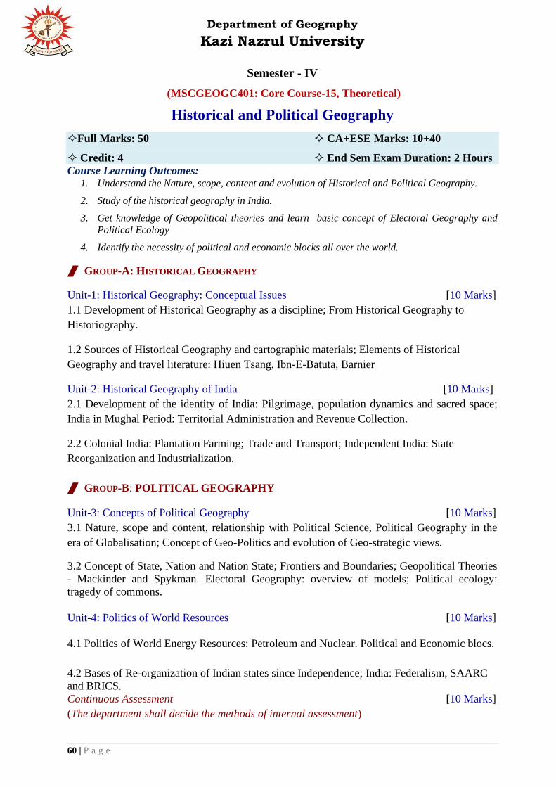
Department of Geography
Kazi Nazrul University
60 | P a g e
Semester - IV
(MSCGEOGC401: Core Course-15, Theoretical)
Historical and Political Geography
Full Marks: 50 CA+ESE Marks: 10+40
Credit: 4 End Sem Exam Duration: 2 Hours
Course Learning Outcomes: 1. Understand the Nature, scope, content and evolution of Historical and Political Geography.
2. Study of the historical geography in India.
3. Get knowledge of Geopolitical theories and learn basic concept of Electoral Geography and
Political Ecology
4. Identify the necessity of political and economic blocks all over the world.
GROUP-A: HISTORICAL GEOGRAPHY
Unit-1: Historical Geography: Conceptual Issues [10 Marks]
1.1 Development of Historical Geography as a discipline; From Historical Geography to
Historiography.
1.2 Sources of Historical Geography and cartographic materials; Elements of Historical
Geography and travel literature: Hiuen Tsang, Ibn-E-Batuta, Barnier
Unit-2: Historical Geography of India [10 Marks]
2.1 Development of the identity of India: Pilgrimage, population dynamics and sacred space;
India in Mughal Period: Territorial Administration and Revenue Collection.
2.2 Colonial India: Plantation Farming; Trade and Transport; Independent India: State
Reorganization and Industrialization.
GROUP-B: POLITICAL GEOGRAPHY
Unit-3: Concepts of Political Geography [10 Marks]
3.1 Nature, scope and content, relationship with Political Science, Political Geography in the
era of Globalisation; Concept of Geo-Politics and evolution of Geo-strategic views.
3.2 Concept of State, Nation and Nation State; Frontiers and Boundaries; Geopolitical Theories
- Mackinder and Spykman. Electoral Geography: overview of models; Political ecology:
tragedy of commons.
Unit-4: Politics of World Resources [10 Marks]
4.1 Politics of World Energy Resources: Petroleum and Nuclear. Political and Economic blocs.
4.2 Bases of Re-organization of Indian states since Independence; India: Federalism, SAARC
and BRICS.
Continuous Assessment [10 Marks]
(The department shall decide the methods of internal assessment)

Department of Geography
Kazi Nazrul University
61 | P a g e
Suggested Readings:
1. Ali, S.M. (1966): The Geography of the Puranas, People's Publishing House, Delhi.
2. Baker, A.R.H (ed.) (1972): Progress in Historical Geography, David and Charles.
3. Tamaskar, B.G. (1985): Contributions to Historical Geography of India, Inter-India Publications, New Delhi.
4. Roberts, P.E. (1995): Historical Geography of India, Vol. I and II, Printwell, Jaipur.
5. Pacione, M. (1987): Historical Geography: Progress and Prospect, Croom Helm, London.
6. Butin, R.A. (1993): Historical Geography: Through the Gates of Space and Time, Edward
Arnold, London.
7. Agnew, John (1997): Political Geography: A Reader, Arnold, London.
8. Adhikari, Sudeepta (2002): Political Geography, Rawat Publications, New Delhi.
9. Pounds, Norman J.G. (1963): Political Geography, McGraw Hill Book Company.
10. Husain Majid (1994): Political Geography, Anmol Publications Pvt. Ltd.
11. Cox, Kevin R. (2002): Political Geography: Territory, State, and Society, Blackwell Publishers, Oxford.
12. Dixit, R.D. (2000): Political Geography: The Spatiality of Politics, New Delhi, Tata McGraw Hill Publishing
Co.Ltd.
13. Johnston, R.J., Taylor, P.J. and Watts, M.J. (eds.) (1995): Geographies of Global Change: Re-mapping the
World in the Late Twentieth Century, Blackwell, Oxford.
14. Taylor, P.J. and House, J. (1984): Political Geography: Recent Advance and Future Direction, Crom Helm,
Kent.

Department of Geography
Kazi Nazrul University
62 | P a g e
Semester – IV
(MSCGEOGC402: Core Course-16, Theoretical)
Contemporary Issues in Geography
Full Marks: 50 CA+ESE Marks: 10+40
Credit: 4 End Sem Exam Duration: 2 Hours
Course Learning Outcomes: After completion of this course, students will be able to –
1. Learn the concept of Development.
2. Get familiar with the concept of GNP,GDP, Gross Happiness Index (GHI),HDI and GEM
3. Identify the constraints of Human Development and get knowledge about fertility, morbidity,
mortality and expectancy of life.
4. Acquire knowledge about some Contemporary Geographical Issues in India such as impact
assessment of big dams and mining, Joint forest management, white and green revolution etc.
5. Learn some important Contemporary Geographical Issues in West Bengal.
Unit-1: Economic Development [10 Marks]
1.1 Concept of Development and Basic indicators of economic development.
1.2 Concepts of GNP, GDP of New World and Third World. Gross Happiness Index.
Unit-2: Human Development [10 Marks]
2.1 Basic indicators of human development; Disparities in Human Development. Concept of
Gender Empowerment Ratio (GEM)
2.2 Demographic constraints: Significance of high fertility, morbidity and mortality, low
expectancy of life.
Unit-3: Contemporary Geographical Issues in India [10 Marks]
3.1 Large Scale Development Projects and Impact: (Big Dams and Mining); Forest Policies and
Forest People; Success and Failure of Forest Management.
3.2 Green Revolution and White Revolution: Social and Ecological Consequences.
Unit-4: Contemporary Geographical Issues in West Bengal [10 Marks]
4.1 Contamination of Ground Water in West Bengal: Arsenic and Fluoride; Tribal
Development in Western Plateau and its Fringe Areas of West Bengal
4.2 Conflicting Issues in Sundarban Region: Human Ecosystem vs. Natural Ecosystem;
Agriculture in Eastern Barddhaman District and Mining in Western Barddhaman District.
Continuous Assessment [10 Marks]
(The department shall decide the methods of internal assessment)

Department of Geography
Kazi Nazrul University
63 | P a g e
Suggested Readings:
1. Agarwal, A.N. (1995): Indian Economy, Problems of Development and Planning, Vishwa Prakasan, New
Delhi.
2. Misra, S.K, and Puri, V.K. (1997): Indian Economy, Himalaya Publishing House, Mumbai.
3. Adams, W.M. (1995): Green Development: Environmental Sustainability in the Third World, Routledge,
London.
4. Alexander, D. (1993): Natural Disasters, Research Press, New Delhi.
5. Acharya S.S., Singh S. and Sagar V. (2005): Sustainable Agriculture Poverty and Food Security, Rawat
Publication
6. Dasgupta P. (1996): An enquiry into Wellbeing and distribution. Clarendon Press, Oxford.
7. Raza, M. (1992): Development and Ecology, Rawat Publication.
8. Smith, D.M. (1980): Human Geography: a Welfare Approach, Edward Arnold.
9. Chandra R.G., Tribal development in India: the contemporary debate, Sage New Delhi
10. Smith. K, Environmental hazards: assessing risk and reducing disaster, Routledge London
11. Desai Vasant: Forest management in India-issues and problems, Himalaya Publishing House Bombay.
12. Swaminathan, S. (2007): Agriculture cannot wait, Academic Foundation, New Delhi.
13. Jain P.C. (2001): Globalization and tribal economy, Rawat.
14. Shaw R and Krishnamurthy R.R. (2009): Disaster: Global challenges and local solutions, University Press.
15. Newson, M. (2009): Land, Water and Development, Routledge.
16. Social forestry in India (1984): Birla Institute of Scientific Research, Radiant Publisher.
17. Sharma, T.C. and Coutinho, O. (1989): Green Revolution Gaps, Rawat.

Department of Geography
Kazi Nazrul University
64 | P a g e
Semester - IV
(MSCGEOGC403: Core Course-17, Theoretical)
Regional Planning and Research Methodology in Geography
Full Marks: 50 CA+ESE Marks: 10+40
Credit: 4 End Sem Exam Duration: 2 Hours
Course Learning Outcomes: 1. Get to learn the methodological foundation and the importance of planning at varied level.
2. Trace the linkages of planning with the regional development.
3. Come to know the conceptual and theoretical bases of doing scientific research.
4. Enhance the understanding towards framing and testing the hypothesis in producing scientific
knowledge.
GROUP-A: REGIONAL PLANNING AND DEVELOPMENT
Unit-1: Regional Planning: Concepts and Methods [10 Marks]
1.1 Concept, Scope and Approaches of Regional Development and Planning. Multi-level
planning in India. Need for regional planning in India. Metropolitan Region: Concept and
Structure; Metropolitan Regions of India. Multi-Nuclei Development and Functional Inter-
linkages.
1.2 City Region in Regional Planning. Decentralized Planning and People's Participation in
planning process. Theories and Models of Regional Development: Growth Pole, Cumulative
Causation and Core periphery.
Unit-2: Strategies for Regional Development [10 Marks]
2.1 Regional Inequality, Regional Disparity and Regional Diversity in India. State as a
Planning unit; Criteria for dividing a State into Planning Region: West Bengal as a case study.
2.2 Regional planning in India: Metropolitan planning (NCR), Tribal Regions (Bastar), River
Valley Region (Damodar Valley Region). Special Economic Zones with special reference to
West Bengal.
GROUP-B: RESEARCH METHODOLOGY
Unit-3: Introduction to Research Methodology [10 Marks]
3.1 Concepts and Significance of Research in Geography; Objectives and Types of Research.
Approaches to Research in Geography: Philosophy-Empiricist, Positivist and Post-Positivist;
Methods- Inductive and Deductive; Analysis- Descriptive and Analytical.
3.2 Nature and Sources of data; Preparation of Data - Data Recording and Coding, Treatment
of Missing Data; Types of Survey - Preparation of Questionnaires and Survey Schedule.
Identification of a Research Problem, Research Questions and Hypothesis Building.

Department of Geography
Kazi Nazrul University
65 | P a g e
Unit-4: Research Design and Findings [10 Marks]
4.1 Research Design: Need for Research Design, Important Concepts, Different Research
Design. Qualitative and Quantitative research methods, Scaling Techniques, Sampling Design.
4.2 Data Management: Collection, Reliability and Authenticity; Processing and Analysis of
Data, Hypothesis testing: t-test, z-test and χ2-test. Methods of Manuscript Writing and
Scientific Drafting of Dissertation, Methods of Citation, Referencing and Bibliography
Continuous Assessment [10 Marks]
(The department shall decide the methods of internal assessment)
Suggested Readings:
1. Agarwal, A.N. (1995): Indian Economy, Problems of Development and Planning, Vishwa Prakasan, New
Delhi.
2. Ahuja, R. (2001): Research Methodology, Rawat Publication, Kolkata.
3. Boudeville, J.R. (1966): Problems of Regional Economic Planning, Edinburgh University Press, Edinburgh.
4. Chand, M. and Puri, V.K, (1983): Regional Planning in India, Allied Publishers, New Delhi.
5. Chandrasekhara, C.S. and Sundaram, K.V. (1968): Metropolitan Centres and Regions in India, 21st
International Geographical Congress, Metropolitan Growth and Planning.
6. Chandrasekhara, C.S. and Sundaram, K.V. (1968): Planning Regions in India, Town and Country Planning
Organisation (mimeo).
7. Chitambar, J.B. (1993): Introductory Rural Sociology, Wiley Eastern, New Delhi.
8. Das, D.L. (2000): Practice of Social Research, Rawat Publication, New Delhi.
9. David, F.E. (2000): Scientific Method for Ecological Research, Cambridge, U.K.
10. Dickinson, J., Gould, B., Clarke, C., Mather, S., Prothero, M., Siddle, D., Smith, C. and Thomas-Hope, E.
(1996):A Geography of the Third World, 2nd edition, Routledge, London.
11. Dickinson. R.E. (1964): City and Region: A geographical interpretation, Routledge and Kegan Paul Ltd.,
London.
12. Goomen, M.A. and Datta, A. (1995): Panchayats and their Finance, Rawat Pub. Co., New Delhi.
13. Harper, C., and Marcus, R. (2007): Research for Development: A Practical Guide, Vistaar Publication, New
Delhi.
14. Institute of Social Sciences (1994): Decentralised Planning and Panchayati Raj, Rawat Pub. Co., New Delhi.
15. Kothari, C. (2009): Research Methodology: Methods and Techniques, New Age International Publishers,
Kolkata.
16. Mandal, R.B. (1988): Systems of Rural Settlements in Developing Counties, Concept Pub. Co., New Delhi.
17. Matthews, A. (1994): Panchayati Raj: From Legislation to Movements, Rawat Pub. Co., New Delhi.
18. Matthews, G. (editor) (1995): Status of Panchayati Raj: 1994, Institute of Social Sciences. Rawat Pub. Co.,
New Delhi.
19. Misra, H.M. (ed.) (1987): Contributions to Indian Geography, Volume 9: Rural Geography, Heritage Pub.,
New Delhi.
20. Misra, R.P. (1969): Regional Planning: Concepts, Techniques, Policies and Case Studies, Concept, New
Delhi.
21. Ray Chaudhuri, J. (2001): An Introduction to Development and Regional Planning, Orient Longman, Kolkata.
22. Singh, R.L. (editor) (1971): India: A Regional Geography, National Geographical Society of India, UBS
Pub.Distributors Ltd., New Delhi.
23. Spate, O.H.K. and Learmonth, A.T.A. (1967): India and Pakistan, 3rd edition, Munshiram Monoharlal Pub.
Pvt.Ltd., New Delhi.

Department of Geography
Kazi Nazrul University
66 | P a g e
Semester - IV
(MSCGEOGC404: Core Course-18)
Dissertation
Full Marks: 50 CA+ESE Marks: 30+20
Credit: 4
Course Learning Outcomes:
1. Learn the skill in finding and drafting a research problem.
2. Become familiar with the scientific terminologies and concepts needed for conducting a
scientific research.
3. Develop the skill of scientific writing and proficiency in presenting the research outcome.
Dissertation and Seminar Presentation
The dissertation will be evaluated based on (a) written report and (b) seminar presentation the
internal assessment for Dissertation on (a)written report will be of 20 marks and (b)seminar
presentation of 10 marks. End semester evaluation for Dissertation on (a)written report will be
of 10 marks and (b)seminar presentation of 10 marks.
1. Preparation of report mainly based on primary data and field work.
2. Seminar and presentation.
3. Evaluation of report.
4. Viva-voce on report.
The dissertation on respective special paper will be a solely individual comprehensive work
based on conceptual aspects, field work analysis of primary and secondary data in the
laboratory. It should mention the objectives, sources of information, methods and approaches.
Interrelations between different aspects of the study should be the focus of the term paper.
Text of the report should not exceed 10,000 words and should ideally be divided into the
following sections:
♦ Introduction ♦ Statement of problem (s) and Objectives ♦ Information and Analysis
♦ Results ♦ Discussions ♦ Conclusions ♦References / Bibliography and ♦ Appendices (if
any).
Maps, diagrams and sketches, excluding photographs, should not exceed 30 pages of A4 size
paper. Each of the dissertations is to be produced individually by the students and this must be
stated clearly in a certificate from the supervisor(s). Photocopying and/or bulk computer typing
are not to be allowed in any form.

Department of Geography
Kazi Nazrul University
67 | P a g e
Semester - IV
(MSCGEOGMJE401: Major Elective-3, Theoretical)
Advanced Geomorphology - III
Full Marks: 50 CA+ESE Marks: 10+40
Credit: 4 End Sem Exam Duration: 2 Hours
Course Learning Outcomes: After completion of this course, students will be able to –
1. Understand and give explanation how the endogenic and exogenic interactions shape
landforms and distinguish the mechanisms that control these processes.
2. Gain knowledge about the dating techniques of landscape and geomorphic events. This
knowledge may help in understanding landscape sensitivity and change.
3. Learn about the mechanism and working principle of geomorphic processes in details
that lead to shape present earth-surface.
4. Know geomorphic features that are not found on Earth. As a student of geomorphology,
they will know how to use landforms on Earth to understand those on other Solar System
bodies.
Unit-1: Endogenic-exogenic interactions in Geomorphology [10 Marks]
1.1 Rates of uplift and denudation. Tectonics and drainage development (active and passive
tectonic controls). Time-dependent and time-independent landforms.
1.2 Impact of Quaternary climate change on landform evolution. Sea-level change and
landform development.
Unit-2: Adjustments in Geomorphic System ` [10 Marks]
2.1 Rates and changes in surface processes: techniques for process measurement and dating of
sediment (Palaeomagnetism, Cosmogenic nuclides, Luminescence and 14C dating).
2.2 River response to climate and tectonics. Human impacts on landforms during
Anthropocene. Analyzing evolutionary trajectory of the landscapes.
Unit-3: Process Geomorphology [10 Marks]
3.1 Bedrock channels: Stream Power law and Bedrock incision process. Coastal
morphodynamic variables and their influence on evolution of coastal forms. Classification and
evolution of periglacial landforms.
3.2 The geomorphology of the World's Largest Floods. Planetary geomorphology with special
reference to Moon and Mars.
Department of Geography
Kazi Nazrul University
68 | P a g e
Unit-4: Applied Geomorphology [10 Marks]
4.1 Quantitative Geomorphology: Geomorphological mapping and geomorphometry; DEM and
digital geomorphometry, Fractals in Geomorphology.
4.2 Applied geomorphology in coastal-zone management; Urban Geomorphology: applications
of geomorphology in urban planning; Geoheritage and Geomorphosites.
Continuous Assessment [10 Marks]
(The department shall decide the methods of internal assessment)
Suggested Readings: 1. Anderson, R.S. and Anderson, S.P. (2010): Geomorphology: The Mechanics and Chemistry of Landscapes,
Cambridge University Press, Cambridge.
2. Brown, A.G. (1997): Alluvial Geoarchaeology: Floodplain Archaeology and Environment Change,
Cambridge University Press, Cambridge.
3. Chorley, R., Schumm, S. and Sugden, D.E. (1994): Geomorphology, Methuen, London.
4. French, H.M. (2007): The Periglacial Environment, Third Edition, John Wiley & Sons, Ltd.
5. Goswami, A.B. (2010): Principles of Quaternary Geology and Environment Study (Concept, Methodology
and Technique), Books Way, Kolkata.
6. Goudie, A.S. and Viles, H.A. (2016): Geomorphology in the Anthropocene, Cambridge University Press,
UK.
7. Gupta, A. (2011): Tropical Geomorphology, Cambridge University Press, New York.
8. Gutierrez, M. (2013): Geomorphology, CRC Press, Boca Ranton, Florida.
9. Kale, V.S. (eds.) (2017): Atlas of Geomorphosites in India (Glimpses of India's incredible Geodiversity and
Geoheritage, Indian Institute of Geomorphologists (IGI).
10. Kale, V.S. and Gupta, A. (2001): Introduction to Geomorphology, Orient Longman, Kolkata.
11. Ollier, C.D. (1981): Tectonics and Landforms, Longman Group Ltd., London.
12. Richards, K. (1982): Rivers: Form and processes in alluvial channels, Methuen, London.
13. Shroder, J. (eds.) (2013): Treatise on Geomorphology, Elsevier.
14. Summerfield, M.A. (1991): Global Geomorphology: An Introduction to the Study of Landforms, Longman,
London.
15. Wallace-Murray, CV. and Woodroffe (2014): Quaternary Sea-Level Changes: A Global Perspective,
CambridgeUniversity Press, New York.

Department of Geography
Kazi Nazrul University
69 | P a g e
Semester - IV
(MSCGEOGMJE402: Major Elective-4, Practical)
Advanced Geomorphology - IV
Full Marks: 50 CA+ESE Marks: 30+20
Credit: 4 End Sem Exam Duration: 2 Hours
Course Learning Outcomes: 1. Acquire knowledge of spatial statistics and time series analysis of hydrology data for basin-
scale management.
2. Understand the importance of logistic regression for estimating various geomorphic attributes.
They will also learn the allometric change of landforms.
3. Learn selected quantitative techniques such as trend surface analysis, interpolation and
extrapolation for analyzing geomorphic data.
4. Develop the capability of analyzing geomorphic data using advanced multivariate techniques
like Principal Component Analysis, Discriminant Analysis, Cluster analysis and Canonical
Correlation analysis.
5. Develop skills in application of theoretical knowledge of hydrology for estimating different
hydrological attributes in formulating various hydro-geomorphological projects and their
successful management.
6. Learn how to apply flood frequency-magnitude analysis in wide range of engineering and
management problems ranging from drainage basin management to hazard management.
7. Develop skill of map making using software and foster their abilities in showing the spatial
distribution of various geologic and geomorphic elements and their proper interpretation.
8. Learn techniques regarding extraction of drainage network from DEM
9. Identify coastal features using topographical maps/ satellite images.
10. Students can find career opportunities as Environmental Consultant and Research Scientist in
engineering consulting firms and government agencies like NIO, INCOIS, ESSO (MoES) etc.
Unit 1: Advanced Statistical Techniques in Geomorphology [15 Marks]
1.1 Spatial Statistics: Spatial Autocorrelation (Computation of Moran's I), Hot Spot Analysis
using Getis-Ord Gi statistic; Methods for detecting changes in hydrological series.
1.2 Use of dummy variable and Logistic Regression; Allometric change in Geomorphology.
1.3 Trend Surface Analysis (TSA): computation of linear trend; Interpolation and
Extrapolation: Newton, Lagrange and Binomial Method
1.4 Mapping and Clustering through Principal Component Analysis (PCA); Discriminant and
Cluster analysis; Introduction of Canonical Correlation.
Unit 2: Flood analysis and Mapping techniques in Geomorphology [15 Marks]
2.1 Computation and preparation of Annual hydrograph; Computation of Runoff Co-efficient;
Flow Duration Curves; Rating curves.

Department of Geography
Kazi Nazrul University
70 | P a g e
2.2 Estimation of shear stress and unit stream power; Analysis of Flood Frequency and
Recurrence Interval: Weibull (1939) and Gumbel (1941) methods.
2.3 Interpretation of geological maps of India (Scale: 1:250,000). Preparation of geomorphic
maps of fluvial features from field data and satellite images using standard symbols and colours
and their interpretation. Flood hazard mapping using satellite images and interpretation (using
Software).
2.4 Extraction of drainage network from DEM, catchment demarcation and stream ordering,
extraction and mapping of morphometric parameters. Temporal analysis of channel shifting
and planform dynamics using geoinformatics (using Software). Identification of coastal
features using topographical maps/ satellite images and geomorphic mapping of coastal
features (using Software).
In the End Semester Examination, students have to answer one compulsory question from the
above two Units.
Viva-voce [5 Marks]
Continuous Assessment [30 Marks]
(*A Project File, comprising one exercise each is to be submitted)
Suggested Readings:
1. Doornkamp. J.C. and King C.A.M. (1971): Numerical Analysis in Geomorphology: An Introduction, St.
Martin's Press, New York.
2. Dackombe, R.V. and Gardiner, V. (1983): Geomorphological Field Manual. George Allen and Unwin,
London.
3. King, C.A.M. (1966): Techniques in Geomorphology, Edward Arnold, London.
4. Miall, A.D. (2006): The Geology of Fluvial Deposits (Sedimentary Facies, Basin Analysis, and Petroleum
Geology), Springer.
5. Sengupta, S.M. (2010): Introduction to Sedimentology, Second Edition, CBS Publishers & Distributors Pvt.
Ltd., New Delhi.
Department of Geography
Kazi Nazrul University
71 | P a g e
Semester – IV
(MSCGEOGMJE403: Major Elective-3, Theoretical)
Environmental Issues in Geography - III
Full Marks: 50 CA+ESE Marks: 10+40
Credit: 4 End Sem Exam Duration: 2 Hours
Course Learning Outcomes: 1. Enhance the knowledge towards understanding the global debate on SDGs and climate change.
2. Learn the significance behind the environmental movements in India towards preserving the
natural resources and to protect the ecological stability.
3. Introduce them to the legal understanding of the existing policies, laws and protocol and to instil
moral values, ethical practices to save the environment.
Unit-1: Global Environmental Issues, Assessment and Management [10 Marks]
1.1 Environmental study of ecological history of human civilization. Concept of Sustainable
Development. Environmental policies and laws with reference to Climate change, Earth
summit, and Protocols (Kyoto and Montreal).
1.2 Environmental Impact Assessment (EIA); Case study of Big Dams and Environmental
Management Plan (EMP); Case study of Chilka.
Unit-2: Environment and Development debate in India ` [10 Marks]
2.1 Environmental Movement: Objectives, Dynamics, Importance and Ecological foundation of
Chipko Movement, Silent Valley Project and Narmada Bachao Andolan (NBA).
2.2 Anthropogenic Intervention on River Valley Planning: Case Study of Damodar River
Valley (DVC); Mining Activities and Developmental Issues: Taking Cases from India.
Unit-3: Environmental Laws and Policies in India` and West Bengal [10 Marks]
3.1 Environmental Ethics, Policies and Laws in India (Forest Policies): Social Forestry and
Participatory Forest Management; Case Studies of JFM and Urban Forestry in India.
3.2 Policies and management of Wasteland –Case Studies from India. Wetland and Micro
Watershed Management: Case Studies from West Bengal
Unit-4: Urbanization and Environmental Issues in India [10 Marks]
4.1 Impact of Industrialization and Urbanization on Air, Water, Land and Forests and
associated management plans.
4.2 Loss of Biodiversity with special reference to Eastern Himalayas, Western Ghats.
Continuous Assessment [10 Marks]
(The department shall decide the methods of internal assessment)
Department of Geography
Kazi Nazrul University
72 | P a g e
Suggested Readings:
1. Adams, W.M. (1995): Green Development: Environmental Sustainability in the Third World, Routledge,
London.
2. Alexander, D. (1993): Natural Disasters, Research Press, New Delhi.
3. Allaby, M. (1996): Basics of Environmental Science, Routledge, London.
4. Baarrsches, W.H. (1996): Eco-facts and Eco-fiction: Understanding the Environmental Debate, Routledge,
London.
5. Blaikie, P., Cannon, T, Davis, I. and Wisener, (1994): At Risk: Natural Hazards, People's Vulnerability and
Disasters, Routledge, London: 320p.
6. Bryant, E.A. (1991): Natural Hazards, Cambridge University Press, Cambridge.
7. Canter, L. W. (1996): Environmental Impact Assessment, 2nd edition, McGraw Hill, New York.
8. Chapman, D. (1994): Natural Hazards, Oxford University Press, Melbourne.
9. Chhatwal, G.R., Mensa, M.C., Satke, M., Katyal, T., Katyal, M., and Nagahiro, T. (1989): Environmental
NoisePollution and its Control, Anmol Pub. Pvt. Ltd., New Delhi.
10. Colls, J. (1997): Air Pollution: An Introduction, E & FN Spon / Chapman and Hall, London.
11. Dasgupta, P. and Miller, K.G. (1997): The Environment and Emerging Development Issues, Volumes I and 2,
Clarendon Press, Oxford.
12. Elsom, D.M. (1992): Atmospheric Pollution: A Global Problem, 2nd edition, Blackwell Pub. Co., London.
13. Falconer, R.A. and Goodwin, P. (editor) (1994): Wet and Management, Thomas Telford, London.
14. Farmer, A. (1997): Managing Environmental Pollution, Routledge, London.
15. Gilpin, A. (1996): Dictionary of Environment and Sustainable Development, John Wiley and Sons Ltd.,
Chichester.
16. Gilpin, A. (1997): Environmental Impact Assessment: Culling Edge for the Twenty-first Century, Cambridge
University Press, Cambridge.
17. Goel, P.K. (1997): Water Pollution: Causes, Effects and Controls, New Age International (P) Ltd. Pub. New
Delhi.
18. Goudie, A. (1986): The Human Impact on the Natural Environment, 2nd edition, Blackwell Pub. Co.,
London.
19. Marsh, W.M. and Grossa, J.M. (1996): Environmental Geography: Science, Landuse and Earth Systems, John
Wiley and Sons Inc., New York.
20. Masters, G .M. (1991): Introduction to Environmental Engineering and Sciences, Prentice Hall India Ltd.
New Delhi.
21. Middleton N. (1995): The Global Casino: An Introduction to Environmental Issues, John Wiley and Sons
Inc., New York.
22. Park, C. (1998): The Environment: Principles and Applications, Routledge, London.
23. Pickering, K. and Owen, L.A. (1997): An Introduction to Global Environmental Issues, 2nd edition,
Routledge, London.
24. Prabhakar, V.R. (1998): Social and Community Forestry, Indian Pub. Distribution, New Delhi.
25. Roberts, N. (editor) (1994): The Changing Global Environment, 3rd edition, Blackwell Pub. Co., London.
26. Singh, R.B. and Misra, S. (1996): Environmental Laws in India: Issues and Responses, Rawat Pub., New
Delhi.
27. Valancy, F. and Bronstein, D.A. (1995): Environmental and Social Impact Assessment, John Wiley and Sons
inc., New York.
28. Vogler, J. (1995): The Global Commons: A Regime Analysis, John Wiley and Sons Ltd., Chichester.
29. Wall, D. (1994): Green History: A Reader in Environmental literature, Philosophy and Politics,
Routledge,London.
30. Wathern, P. (editor) (1988): Environmental Impact Assessment: Theory and Practice, Routledge, London.

Department of Geography
Kazi Nazrul University
73 | P a g e
Semester - IV
(MSCGEOGMJE404: Major Elective-4, Practical)
Environmental Issues in Geography - IV
Full Marks: 50 CA+ESE Marks: 30+20
Credit: 4 End Sem Exam Duration: 2 Hours
Course Learning Outcomes: 1. Enhance the knowledge of mapping the physio-cultural environment, pollution zonation and soil
quality estimation.
2. Get insights to map the local area and instill the skill of GIS and Statistics towards
environmental monitoring and surveying.
Unit 1: Multivariate Statistics and Advanced Statistical Techniques in Environmental Issues in
Geography [15 Marks]
Unit 1: Advanced Statistical Techniques in Environmental Issues in Geography [15 Marks]
1.1 Use of dummy variable and Logistic Regression; System Component Growth.
1.2 Interpolation and Extrapolation: Newton, Lagrange and Binomial Method; Mean centre of
population and its shift over time; Population Potential by Gravity model.
1.3 Shortest Path Analysis: Transport and Allocation Problems; Trend Surface Analysis (TSA):
computation of linear trend.
1.4 Mapping and Clustering through Principal Component Analysis (PCA); Discriminant and
Cluster analysis; Introduction of Canonical Correlation.
Unit-2: Estimation, Environmental Survey and Mapping of Environmental Data [15 Marks]
2.1 Methods of studying the Physical and Cultural Environment; Multivariate Estimation of
environment from Geographical Data with t-test and χ2 test; Mapping of Pollution Zones.
2.2 Estimation of Soil pH, organic carbon and nutrient concentration in soil (N, P, K).
2.3 Preparation and Interpretation of Environmental Maps: Cadastral Map/ Ward map;
Mapping Spatial variation in Crime and Disease.
2.4 Environmental Mapping Techniques: Landuse and Land Cover Classification; Mapping to
correlate Physical and Social Environmental elements using GIS. Mapping of Pollution Zones.
In the End Semester Examination, students have to answer one compulsory question from the
above two Units.
Viva-voce [5 Marks]
Continuous Assessment [30 Marks]
(*A Project File, comprising one exercise each is to be submitted)

Department of Geography
Kazi Nazrul University
74 | P a g e
Suggested Readings:
1. Hammond, R. and McCullagh, P. (1991): Quantitative Techniques in Geography, Clarendon Press, Oxford
2. Mahmood, A. (1998): Statistical Methods in Geographical Studies, Rajesh Publication.
3. Monkhouse F.J. and Wilkinson, H.R. (1971): Maps and Diagrams: Their Compilation and Construction, B.I.
Publications Private Limited, New Delhi.
4. Pal, S.K. (1999): Statistics for Geoscientists, Concept publishing Company, New Delhi.
5. Sarkar, A. (2015): Practical Geography: A Systematic Approach, 3rd Edition, Orient Blackswan Private Ltd.
6. Sarkar, A. 2013): Quantitative Geography: Techniques and Presentations, Orient BlackSwan, Hyderabad.
7. Sen, A.K. (1995): Laboratory Manual of Geology, Modern Book Agency (P) Ltd., Kolkata.
8. Silk, J. 1(979): Statistical techniques in Geography, George Allen and Unwin, London.
9. United States Department of Agriculture (USDA) (2014): Soil Survey and Laboratory Methods Manual, Soil
Survey Investigations Report No. 51.

Department of Geography
Kazi Nazrul University
75 | P a g e
Semester - IV
(MSCGEOGMJE405: Major Elective-3, Theoretical)
Urban Geography- III
Full Marks: 50 CA+ESE Marks: 10+40
Credit: 4 End Sem Exam Duration: 2 Hours
Course Learning Outcomes: After completion of this course, students will be able to –
1. Trace the trend in the migration pattern of population and societal changes over time.
2. Learn to live and counter the problems emerged while be in an urban setting.
3. Get an insight over the historical emergence of Indian cities and the phases of transition
over time.
4. Come to know the strategies and challenges of the policies and programme implemented
for urban planning in India.
Unit-1: Migration and Urban change [10 Marks]
1.1 Impact of Rural to Urban, Urban to Rural and Urban to Urban migration on the socio-
economic structure of a specific urban area; Gentrification-Concept and its impact, Typologies,
and Theories
1.2 Social area analysis after Shevky and Bell, Residential Segregation and Factorial Ecology
Unit-2: Urban Infrastructure and Urban Liveability [10 Marks]
2.1 Urban Housing and housing markets, Urban Transport and associated problems, Issues
related to urban transport planning
2.2 Urban water crisis, sanitation and sewerage related problems in cities, Impact of air
pollution and water pollution on urban health, Urban Crime,Urban green space, Emerging
urban flood.
Unit-3: Urbanization in India [10 Marks]
3.1. Histogenesis of Urbanization with special reference to India –Ancient, Medieval, Colonial
Phases, Regional pattern of Urbanization in Post-colonial India
3.2 Functional classification of Indian cities, rural-urban transformation in India
Unit-4: Urban Planning in India [10 Marks]
4.1 Urban planning in Five Year Plans of India with special reference to IDSMT, Urban
poverty alleviation programmes in India
4.2. Analysis on Urban Housing Policies in India-its Problems and Prospects; Urban Renewal
and Urban Redevelopment in India - Role of JNNURM; Smart cities and AMRUT.
Continuous Assessment [10 Marks]
(The department shall decide the methods of internal assessment)

Department of Geography
Kazi Nazrul University
76 | P a g e
Suggested Readings:
1. Bhattacharya, B. (2006). Urban Development in India. New Delhi: Concept Publishing Company
2. Bird, James 1977: Centrality And Cities. Routledge, London
3. Carter, H. 1981: Urban Geography, 3rd edition Arnold-Heinemann, New Delhi.
4. Chakroborty, J., & Ghosh, P. (2007). Higher Algebra. kolkata: Un Dhur and Sons Pvt Ltd.
5. Das, A. K. (2007). Urban Planning in India. Jaipur: Rawat Publications.
6. Dave, M. (1991). Urban Ecology and Levels of Development. Jaipur: Rawat Publications .
7. Dickinson, R.E. (1968): City and Region: A Geographical Interpretation. Routledge and Kegam Paul Ltd.
London.
8. Diddee, Jaymala (1997): Indian Medium Towns. Rawat Publications, Jaipur.
9. Ghosh, S. (1998): Introduction to Settlement Geography. Orient Longman Ltd., Calcutta
10. Gibbs.J(1961) : Urban Research Methods. East-West Press Pvt Ltd. New Delhi
11. Glasson,J.(1975): An Introduction to Regional Planning. Hutchinson and Co.,London
12. Hardoy, J. E., Mittin, D. & Satterthwaite, D. 1(992) : Environmental Problems in the World Cities.
Earthscan Pub. Ltd. London.
13. Hudson, F.S. (1970): Geography of Settlements, Macdonald and Evans Ltd. PlymouthHerbert, David and
Thomas, Colin, 1982: Urban Geography A First Approach,Jhon Wiley & Sons. New Delhi
14. Johnston .R.J (2000): The Dictionary of Human Geography.Blackwell. UK
15. Kaplan.D and Wheeler.J ( 2008):Urban Geography.John Wiley
16. Knox, P. (1982): Urban Social Geography. Longman Scientific and Technical, Harlow.
17. Law.N,Smith.D,(1991),Decision Making Geography. Stanley Thornes Pub. Ltd, Leckhampton
18. Lillesand, T.M. and Kiefer, R. W. (1994): Remote Sensing and Image Interpretation. 3rd edition, John
Wiley and Sons, New York
19. Mandal, R.B. (2000): Urban Geography: A Textbook. Concept Pub. Co., New Delhi.
20. Mandal,R.B(1989):Staistical Techniques for Social Scientist. Concept Pub. Co., New Delhi
21. Markandey, K., & Simhadri, S. (2009). Urban Environment and Geoinformatics. Jaipur: Rawat
Publication.
22. Mcdonnell, M. J., Halns, A. K., & Breste, J. H. (2009). Ecology of Cities and Towns. Cambridge
University Press.
23. Misra. H. N. (ed) 1987: Contributions to Indian Geography. Volume 9: Rural Geography, Heritage Pub.,
New Delhi.
24. Mohan Sudha (2005): Urban Development and New Localism. Rawat Publications, Jaipur.
25. Pacione, Micheal, (2001): Urban Geography, Routledge, London
26. Naqvi, H. K. (1971). Urbanisation and UrbanCentres under the Great Mughals. Shimla: Indian Institute
of Advance Studies .
27. Raza, M., & Aggarwal, Y. (1999). Transport Geography of India. New Delhi: Concept Publishing
Company.
28. Ramachandran R. (1989): Urbanisation arid Urban Systems in India. Oxford University Press, New
Delhi.
29. Rao, R. Rammohan and S. Simhadri (1999): Indian Cities: Towards Next Millenium, Rawat Publications,
Jaipur.
30. Ray Chaudhuri,Jayasri(2001): An Introduction to Development and Regional Planning. Orient
Longman,Kolkata
31. Sharma, R.N. and K. Sita (2001): Issues in Urban Development. Rawat Publications, Jaipur.
32. Short, J. R. (1984). An Introduction to Urban Geography. London: Routledge and Keygen Paul.
33. Singh, A. K. (1990). Urbanisation and Administration of Urban Infrastructure. New Delhi: Inter-India
Publications.
34. Singh, R.L. et. al. (ed) (1976): Geographic Dimensions of Rural Settlements. National Geographical
Society of India, Varanasi.
35. Singh, R. Y. (1994): Geography of Settlements, Rawat Pub. Co., New Delhi.
36. Singh, Ravinder Sandhu (ed) 2003:Urbanisation in India. Sage Publications, New Delhi.
37. Taylor, Griffith (1949): Urban Geography, Methuen and Co. Ltd., London.
38. Tewari, V. Weinston, J. and Prakash Rao, V.L.S. (1986): Indian Cities: Ecological Perspectives. Concept
Pub. Co., New Delhi.
39. Thudipara, Jacob Z. (2007): Urban Community Development. Rawat Publications, Jaipur.
40. Toyne.P and Newby.P(1971)Techniques in Human Geography. Macmillian, London
41. Vishwanadhan, G. (ed) 1986: Readings in Urban Structure of India. Ajanta Publications, Delhi.
42. Taafee, E. J., & Gauthier, H. L. (1973). Geography of Transportation. New Delhi: Prentice

Department of Geography
Kazi Nazrul University
77 | P a g e
Semester – IV
(MSCGEOGMJE406: Major Elective-4, Practical)
Urban Geography- IV
Full Marks: 50 CA+ESE Marks: 30+20
Credit: 4 End Sem Exam Duration: 2 Hours
Course Learning Outcomes:
1. Become familiar with the field techniques while conducting a study over urban setting.
2. Learn the tools and methods of mapping the urban neighbourhood through primary
survey.
3. Enhance the knowledge of using satellite data for a spatial analysis of urban areas.
Unit 1: Advanced Statistical Techniques in Urban Geography [15 Marks]
1.1 Use of dummy variable and Logistic Regression; System Component Growth.
1.2 Interpolation and Extrapolation: Newton, Lagrange and Binomial Method; Mean centre of
population and its shift over time; Population Potential by Gravity model.
1.3 Shortest Path Analysis: Transport and Allocation Problems; Trend Surface Analysis (TSA):
computation of linear trend.
1.4 Mapping and Clustering through Principal Component Analysis (PCA); Discriminant and
Cluster analysis; Introduction of Canonical Correlation.
Unit-2: Application of Satellite Remote Sensing and Field Techniques in Urban Geography
[15 Marks]
2.1 Extraction of Built up Areas from Coarse to High Resolution Satellite Images. Assessment
of Urban Growth Types: Infilling, Edge Growth and Leap frog.
2.2 Identification of Urban Sprawl from LULC Map using Spatial Landscape Matrices.
2.3 Urban Growth Prediction Using Cellular Automata Model.
2.4 Mapping of Urban Environment: Case Studies of Air, Water and Noise.
In the End Semester Examination, students have to answer one compulsory question from the
above two Units.
Viva-voce [5 Marks]
Continuous Assessment [30 Marks]
(*A Project File, comprising one exercise each is to be submitted)
Suggested Readings: 1. Alvi, Z. (1995): Statistical Geography: Methods and Applications, Rawat Publications, New Delhi.
2. Cole, J.P. and King, C.A.M. (1969): Quantitative Geography (Techniques and Theories in Geography),
John Wiley & Sons Ltd., London.
3. Gibbs.J(1961) : Urban Research Methods. East-West Press Pvt Ltd. New Delhi
4. Glasson,J.(1975): An Introduction to Regional Planning. Hutchinson and Co.,London

Department of Geography
Kazi Nazrul University
78 | P a g e
5. Gun, A.M., Gupta, M.K. and Dasgupta, B. (2008): Fundamental of Statistics (Volume One and Two),
The World Press Private Limited, Kolkata.
6. Lillesand, T.M. and Kiefer, R. W. (1994): Remote Sensing and Image Interpretation. 3rd edition, John
Wiley and Sons, New York
7. Mahmood, A. (1998): Statistical Methods in Geographical Studies, Rajesh Publication.
8. Malhotra, O.P. and Gupta, S.K. (1990): Elementary Statistics, S. Chand & Company Ltd., New Delhi.
9. Mandal,R.B(1989):Staistical Techniques for Social Scientist. Concept Pub. Co., New Delhi
10. Markandey, K., & Simhadri, S. (2009). Urban Environment and Geoinformatics. Jaipur: Rawat
Publication.
11. Pacione, Micheal, (2001): Urban Geography, Routledge, London.
12. Pal, S.K. (1999): Statistics for Geoscientists, Concept publishing Company, New Delhi. Sarkar, A.
(2013): Quantitative Geography: Techniques and Presentations, Orient BlackSwan, Hyderabad
13. Raza, M., & Aggarwal, Y. (1999). Transport Geography of India. New Delhi: Concept Publishing
Company.
14. Taafee, E. J., & Gauthier, H. L. (1973). Geography of Transportation. New Delhi: Prentice
15. Toyne.P and Newby.P(1971)Techniques in Human Geography. Macmillian, London
16. Vishwanadhan, G. (ed) 1986: Readings in Urban Structure of India. Ajanta Publications, Delhi.


![[Amarboi.com] Agni Bina Kazi Nazrul Islam 2nd Ed](https://img.dokumen.tips/doc/110x75/545fcd80b1af9f04598b4f3a/amarboicom-agni-bina-kazi-nazrul-islam-2nd-ed.jpg)