Embed Size (px)
Citation preview
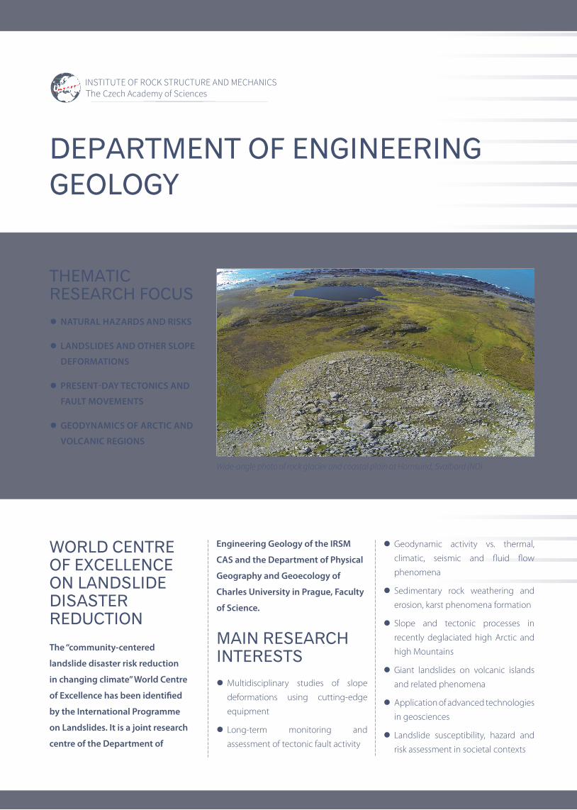
l Multidisciplinary studies of slope
deformations using cutting-edge
equipment
lLong-term monitoring and
assessment of tectonic fault activity
lGeodynamic activity vs. thermal,
climatic, seismic and fluid flow
phenomena
lSedimentary rock weathering and
erosion, karst phenomena formation
lSlope and tectonic processes in
recently deglaciated high Arctic and
high Mountains
lGiant landslides on volcanic islands
and related phenomena
lApplication of advanced technologies
in geosciences
lLandslide susceptibility, hazard and
risk assessment in societal contexts
DEPARTMENT OF ENGINEERING GEOLOGY
WORLD CENTRE OF EXCELLENCE ON LANDSLIDE DISASTER REDUCTION
MAIN RESEARCH INTERESTS
THEMATIC RESEARCH FOCUS
Wide-angle photo of rock glacier and coastal plain at Hornsund, Svalbard (NO)
l NATURAL HAZARDS AND RISKS
lLANDSLIDES AND OTHER SLOPE
DEFORMATIONS
lPRESENT-DAY TECTONICS AND
FAULT MOVEMENTS
lGEODYNAMICS OF ARCTIC AND
VOLCANIC REGIONS
The “community-centered
landslide disaster risk reduction
in changing climate” World Centre
of Excellence has been identified
by the International Programme
on Landslides. It is a joint research
centre of the Department of
Engineering Geology of the IRSM
CAS and the Department of Physical
Geography and Geoecology of
Charles University in Prague, Faculty
of Science.

MONITORING NETWORKS
KEY RESEARCH EQUIPMENT
l TecNet – world-wide monitoring
network using TM-71 on tectonic
faults
l SlopeNet – slope deformation activity
monitoring network using various
devices
l Rocktherm – network monitoring
thermal conditions inside the rock
together with block movements and
environmental parameters
l Geonas – GNSS permanent
monitoring network (CR, Svalbard)
l Monitoring
TM-71 crack gauges with automatic reading and connection unit
HOLLE portable dilatometers
Gefran crackmeters with Tertium dataloggers
Trimble GNSS permanent stations
Fiedler automatic climatic stations
DMS multiparametric inclinometer by CSG
lField measurements and sampling
HVS 125 drilling rig
ARES and ARES II ERT devices
Flir E95 IR camera
lLab equipment
CTC 256 Memmert climatic test chamber
Quanta 450 (SEM) scanning electron microscope
Průša 3MK and Felix 3.1 3D printers
lSurveying and geodesy
DJI Phantom UAV with RGB camera
DJI Inspire UAV with RGB and IR cameras
Polaris (long-range) and ILRIS 3D terrestrial laser scanners
Sokkia and Topcon total stations
Topcon HiPer DGNSS
Printing of parts of automatic reading unit for TM-71 dilatometers on a 3D printer
Installation of a DMS multiparametric inclinometer by CSG at the Čeřeniště landslide site (CZ)
Installation of automatic climatic and environment monitoring station (CZ)
ARES ERT device measuring on the rockfall accumulation in Hornsund, Svalbard (NO)
Newly installed current version of the TM-71 automatized 3D dilatometer inside the Horka lake dam (CZ)

ACHIEVEMENTS
lMultidisciplinary studies of slope deformations
Klimeš J., Novotný J., Novotná I., Jordán de Urries B., Vilímek V., Emmer A., Strozzi T., Kusák M., Rapre A.C., Hartvich F., Frey H. (2016): Landslides in moraines as triggers of glacial lake outburst floods: example of the Palcacocha Lake (Cordillera Blanca, Peru). Landslides 13, 1461–1477.
Chalupa V., Pánek T., Tábořík P., Klimeš J., Hartvich F., Grygar R. (2018): Deep-seated gravitational slope deformations controlled by the structure of flysch nappe outlier: insights from large scale electrical resistivity tomography survey and LiDAR mapping. Geomorphology 321, 174–187.
Pánek T, Klimeš J, (2016): Temporal behavior of deep-seated gravitational slope deformations: A review. Earth-Science Reviews 156, 14–38.
l Long-term monitoring of tectonic fault activity
Briestenský M., Rowberry M. D., Stemberk J., Stefanov P., Vozár J., Šebela S., Petro Ľ., Bella P., Gaal Ľ., Ormukov Ch. (2015): Evidence of a plate-wide tectonic pressure pulse provided by extensometric monitoring in the Balkan Mountains (Bulgaria). Geologica Carpathica 66 (5), 427–438.
Baroň I., Plan L., Sokol L., Grasemann B., Melichar R., Mitrovic I., Stemberk J. (2019): Present-day kinematic behaviour of active faults in the Eastern Alps. Tectonophysics 752, 1–23.
l Geodynamic activity vs. thermal, climatic, seismic and fluid flow phenomena
Blahůt J., Baroň I., Sokoľ L., Meletlidis S., Klimeš J., Rowberry M., Melichar R., García-Cañada L., Martí X. (2018): Large landslide stress states calculated following extreme climatic and tectonic events on El Hierro, Canary Islands. Landslides 15, 1801–1814.
Baroň I., Sokol L., Melichar R., Plan L. (2019): Gravitational and tectonic stress states within a deep-seated gravitational slope deformation near the seismogenic Periadriatic Line fault. Engineering Geology 261 (11), 105284.
Stemberk J., Hartvich F., Blahůt J., Rybář J., Krejčí O. (2017): Tectonic strain changes affecting the development of deep seated gravitational slope deformations in the Bohemian Massif and Outer Western Carpathians. Geomorphology 289, 3–17.
l Sedimentary rock weathering and erosion
Dubois C., Deceuster J., Kaufmann O., Rowberry M. (2015): A new method to quantify carbonate rock weathering. Mathematical Geosciences 47, 889–935.
Kůrková I., Bruthans J., Balák F., Slavík M., Schweigstillová J., Bruthansová J., Mikuš P., Vojtíšek J., Grundloch J. (2019): Factors controlling evolution of karst conduits in sandy limestone and calcareous sandstone (Turnov area, Czech Republic). Journal of Hydrology 574, 1062–1073.
l Geodynamic processes in high Arctic and high mountains
Hartvich F., Blahůt J., Stemberk J. (2017): Rock avalanche and rock glacier: A compound landform study from Hornsund, Svalbard. Geomorphology 276 (1), 244–256.
Alterite and microcrystalline or amor-phous silica in the Illusion Cave. a) Micro-CT section via original rock–alteri-te transition, b) Alterite in detail, c) Rims of microcrystalline or amorphous silica cemen-ting sand grains in polished section
Installation of vertical wind turbine for powering TM-71 automatic monitoring station in Svalbard (NO)
Klimeš J., Novotný J., Novotná I., Jordán de Urries B., Vilímek V., Emmer A., Strozzi T., Kusák M., Rapre A.C., Hartvich F., Frey H. (2016): Landslides in moraines as triggers of glacial lake outburst floods: example of the Palcacocha Lake (Cordillera Blanca, Peru). Landslides 13, 1461–1477.
l Giant landslides on volcanic islands
Blahůt J., Mitrovic-Woodell I., Baroň I., René M., Rowberry M., Blard P.-H., Hartvich F., Balek J., Meletlidis S. (2020): Volcanic edifice slip events recorded on the fault plane of the San Andrés Landslide, El Hierro, Canary Islands. Tectonophysics 776, 228317.
Maintenance and upgrading of TM-71 moni-toring in a gallery at Hierro Is. (E)
Klimeš J., Yepes J., Becerril L., Kusák M., Galindo I., Blahůt J. (2016): Development and recent activity of the San Andrés landslide on El Hierro, Canary Islands, Spain. Geomorphology 261, 119–131.
Blahůt J., Balek J., Klimeš J., Rowberry M., Kusák M., Kalina J. (2019): A comprehensive global database of giant landslides on volcanic islands. Landslides 16 (10), 2045–2052.

MAIN COLLABORATING PARTNERS
l Charles University in Prague (Prague, CZ)
lOstrava University (Ostrava, CZ)
lUniversity of Jan Evangelista Purkyně (Ústí nad Labem, CZ)
lCzech Technical University (Prague, CZ)
lSÚRAO (Prague, CZ)
lMuseum of Natural History (Vienna, Austria)
lUniversity of Liège (Belgium)
lGeological Institute of the BAS (Bulgaria)
lJohannes Guttenberg University (Germany)
lKarlsruhe Institute of Technology (Germany)
lTU Darmstadt (Germany)
lPolish Polar Station Hornsund (Svalbard, Norway)
lInstitute of Geophysics, Polish Academy of Sciences (Warsaw, Poland)
lUniversity of Environmental and Life Sciences (Wroclaw, Poland)
lWroclaw University (Poland)
lNational Research Institute of Glaciers and Mountain Ecosystems of Peru (Peru)
lNational Archaeological Park of Machupicchu (Peru)
lComenius University in Bratislava (Slovakia)
lSlovak Geological Survey – GÚDŠ (Slovakia)
lKarst Research Institute (Slovenia)
lUniversity of Bern (Switzerland)
lNAGRA (Switzerland)
lInstituto Geográfico Nacional (Tenerife, Spain)
lUniversity of Strathclyde (Scotland, UK)
V Holešovičkách 94/41, 182 09 Praha 8, Czech Republicwww.irsm.cas.cz
RNDr. Filip Hartvich, Ph.D. Head of Department Phone: +420 266 009233; E-mail: [email protected]
ERT measurement of landslide-dammed lake sedimentary infill across Mladotice lake (CZ)
3D models of rock towers “Cukrová homole” (“Sugar Cone”, Adršpach rocks) and “Kobyla” (“Mare”, Příhrazy) based on a 3D laser scan
Modelled depth of the 2013 landslide during the D8 highway construction (Prackovice, CZ)
Time-lapse monitoring of the rock surface temperature at Branická skála using an IR camera (Prague, CZ)
Svitávka rockfall accumulation - hypsographic map placed over a 3D model created using UAV photogrammetry (CZ)
Poláky landslide: The scarp and damaged house at the village of Poláky landslide (2014, CZ)
l Application of advanced technologies in geosciences
Hartvich F., Tábořík P., Šobr M., Janský B., Kliment Z., Langhammer J. (2020): Landslide-dammed lake sediment volume calculation using waterborne ERT and SONAR profiling. Earth Surf. Process. Landforms 45 (14), 3463–3474.
Langhammer J., Lendzioch T., Miřijovský J., Hartvich F. (2017): UAV-Based Optical Granulometry as Tool for Detecting Changes in Structure of Flood Depositions. Remote Sensing 9 (3), AN 240. DOI: 10.3390/rs9030240
l Landslide susceptibility, hazard and risk assessment in societal contexts
Klimeš J., Stemberk J., Blahůt J., Krejčí V., Krejčí O., Hartvich F., Kycl P. (2017): Challenges for landslide hazard and risk management in ‘low-risk’ regions, Czech Republic – landslide occurrences and related costs (IPL project no. 197). Landslides 14, 771–780.
Klimeš J., Hartvich F., Tábořík P., Blahut J., Briestensky M., Stemberk J., Emmer A., Vargas R., Balek J. (2017): Studies on selected landslides and their societal impacts: activity report of the Prague World Centre of Excellence, Czech Republic. Landslides, 14, 1547–1553.