Embed Size (px)
Citation preview

DEPARTMENT OF CITY PLANNING
RECOMMENDATION REPORT
LOS ANGELES CITY PLANNING COMMISSION Case No.: CPC-2010-581-CA
CEQA No.: ENV-2010-582-ND
Incidental Cases: CPC-2007-106-CA CPC-2008-4683-CA
Related Cases: None
Council District: Citywide (All)
Plan Area: Citywide (All)
Specific Plan: Citywide (All)
Certified NC: Citywide (All)
GPLU: Minimum, Very Low I, Very Low II, and Low Density Residential
Zone: R1, RS, RE9, RE15, RE20, RE40, and RA
Applicant: City of Los Angeles
Representative: City of Los Angeles
Date: April 22, 2010
Time: After 8:30 a.m.
Place: Van Nuys Hall 14410 Sylvan St., Council Chamber 2nd Floor Van Nuys, CA 91401
Public Hearing: April 5, 2010 and April 8, 2010
PROJECT LOCATION:
All properties zoned single-family residential (R1, RS, RE9, RE15, RE20, RE40, and RA) which are designated as Hillside Area on the Department of City Planning Hillside Area Map.
PROPOSED PROJECT:
Baseline Hillside Ordinance – Citywide code amendment to the Los Angeles Municipal Code (LAMC) as described below.
REQUESTED ACTIONS:
Proposed amendments to the LAMC to establish new regulations for single-family zoned properties which are designated as Hillside Area. The amendments would result in: a reduction to the existing Floor Area Ratio (FAR); amendments to the existing Single-Family Residential Floor Area definition; changes to the height limits and how they are calculated; creation of new grading regulations; creation of a Hillside Standards Overlay District that would allow individual neighborhoods to adjust the baseline limits to better fit their community’s character and scale; and establishment of, or revisions to existing discretionary review processes for projects that deviate from the proposed FAR, height, and grading regulations.
RECOMMENDED ACTIONS:
1. Approve and Recommend that the City Council Adopt the amendments to the LAMC as detailed in the proposed Ordinance provisions (Exhibit A).
2. Adopt the attached Findings.
3. Approve and Recommend that the City Council Adopt Negative Declaration No. ENV-2010-582-ND
(Exhibit B).


CPC-2010-581-CA
TABLE OF CONTENTS
Project Analysis .................................................................................................................... A-1
Project Summary A-1 Background A-2
Summary of Hillside Legislative History …………………………………………………………... A-3 Recently Adopted Hillside Regulations …………………………………………………………… A-5 Analysis of Single-Family Zoned Lots ………………………………………….......................... A-8
Issues A-11 Subdivision 1: Setback Requirements …………………………………………......................... A-11 Subdivision 2: Maximum Residential Floor Area ………………………………………………… A-11 Residential Floor Area Definition …………………………………………………………………... A-25 Subdivision 3: Verification of Existing Residential Floor Area ………………......................... A-27 Subdivision 4: Height Limits ………………………………………………………………………... A-28 Subdivision 5: Lot Coverage …………………………………………………….......................... A-30 Subdivision 6: Grading ……………………………………………………………………………… A-30 Subdivision 7: Off-Street Parking Requirements ………………………………………………… A-33 Subdivision 8: Fire Protection ……………………………………………………………………… A-34 Subdivision 9: Street Access ………………………………………………………………………. A-34 Subdivision 10: Sewer Connection ………………………………………………………………... A-34 Subdivision 12: Exceptions ………………………………………………………………………… A-34 Hillside Standards Overlay District (also Subdivision 11) ………………………………………. A-35 Nonconforming Rights (Section 12.23 A.1 of the LAMC) ……………………………………….. A-36 Zoning Administrator Determinations (Section 12.24 X of the LAMC) ………………………… A-36 Best Practices: Review of Other Jurisdictions ……………………………………………………. A-36
Conclusion A-37 Findings ................................................................................................................................. F-1
General Plan/Charter Findings F-1 CEQA Findings F-9 Public Hearings and Communications ................................................................................ P-1
Public Outreach …………………………………………............................................................ P-2 Public Hearings ……………………………………………………………………………………… P-3 Additional Comments Received by Mail and Email ……………………………………………… P-8 CEQA Comments …………………………………………………………………………………… P-9
Exhibits:
A – Proposed Ordinance Provisions (as presented at Public Hearing)
B – Negative Declaration ENV-2010-582-ND
C – Affected Area Map
D – Council Motion, CF No. 06-1293 Appendices:
A – Single-Family Hillside Development Regulations: Summary & Comparison
B – Breakdown of Hillside Lots by Single-Family Zone
C – Citywide Test Areas
D – Summary of Kick-Off Meeting Public Comments
E – Summary of Public Workshop Comments

CPC-2010-581-CA A-1
PROJECT ANALYSIS
Project Summary The Baseline Hillside Ordinance will be the third step in preventing out-of-scale single-family development in the City of Los Angeles. The first step was the adoption of the Baseline Mansionization Ordinance (BMO), effective on June 29, 2008, which provides regulations for the non-hillside areas of the City. BMO regulations focus on Floor Area Ratios (FAR) and height. The second step was the verification and necessary revisions to the Hillside Area designations to more accurately reflect the actual topography of the City’s hillside regions. The new Hillside Area definition and Department of City Planning Hillside Area Map will become effective on May 3, 2010. To ensure that the proposed Baseline Hillside Ordinance reflected the major concerns of hillside residents, this project involved extensive outreach to obtain as much input as feasible. Staff has developed a project interest list made up of approximately 600 individuals (and growing) which was used to send out regular updates for this project. Five kick-off meetings were held in different areas of the City in early 2009 to gather input on the issues related to Hillside Mansionization. A preliminary proposal was drafted in response to the principal concerns heard at these outreach meetings. Six public workshops were then conducted throughout the City in February 2010 to receive comments which were ultimately taken into consideration in the development of the current proposed provisions. Finally, two separate Open House and Public Hearings were conducted on April 5, 2010 in Van Nuys and on April 8, 2010 in Hollywood to answer any specific questions regarding the proposed Ordinance provisions and then to take official public testimony. In order to diminish out-of-scale development in the City’s hillside neighborhoods, the proposed hillside regulations, which are summarized below, focus primarily on Floor Area Ratios (FAR), Height, and Grading. Like the BMO, this Ordinance would also allow individual neighborhoods to adjust the baseline limits to better fit their community’s character and scale through an overlay option. Floor Area Ratio The proposed FAR (building size to lot size ratio) is based on lot size, zone, and steepness of slopes on a property. Homes would adhere to size limits computed by a formula that gradually reduces the FAR for the steeper areas of the lot. The premise is that steepness should be one of the variables used when determining the amount of development that can occur on a property. The portions of a lot that are 0% to 15% slope would be treated the same as they are in the Baseline Mansionization Ordinance. This approach takes into account that there are many differences in hillside lots, and that the Code needs to consider the varying hillside conditions when determining house size limits. Residential Floor Area bonuses are also provided for, as in the Baseline Mansionization Ordinance, with additional options related to hillside massing and grading. Height The current method of calculating height incentivizes large and tall box-like structures, which many communities have specifically identified as a problem. These regulations discourage terracing of structures up and down the slope which helps to visually break up the mass of buildings. The proposed regulations utilize a method of calculating height which follows the slope of a lot, referred to in these provisions as “envelope” height, which encourages buildings to step up/down a hillside and result in more aesthetically pleasing development.

CPC-2010-581-CA A-2
Grading Currently, there are no limits to the quantities of grading which can occur on any lot. The proposed regulations recommend a new limit which utilizes a base quantity of grading plus a percentage of the lot size, with a maximum of 1,000 cubic-yards in most situations. Projects which involve more than 1,000 cubic yards of grading will be required to utilize landform grading methods (meant to mimic existing terrain). The proposed provisions also relate limits on the amount of import/export of earth materials to the level of existing street improvement. This helps to address the issue of impacts on streets in hillside neighborhoods during construction, and ensures that any activity beyond these limits are reviewed and conditioned accordingly. Hillside Standards Overlay Similar to the Residential Floor Area District established by the Baseline Mansionization Ordinance, the Hillside Standards Overlay is a tool that will allow individual neighborhoods to tailor the size limits as well as the other regulations covered by this Ordinance by a separate council action/ordinance. Additional Hillside Regulations The proposed Baseline Hillside Ordinance would not make policy changes to other existing hillside development standards not mentioned above. However, it is anticipated that through the passage of this ordinance, all single-family hillside regulations will be consolidated, made more accessible and easier to understand. Staff is attempting to make minor revisions to format and possible clarification of existing language as part of the final draft proposal of the Ordinance. Each Specific Plan has language in the plan on its relationship to the Municipal Code. The regulations established in Specific Plans are usually intended to supersede the planning and zoning provisions of Chapter I of the Los Angeles Municipal Code (the Zoning Code) and any other relevant Ordinance. They also typically establish whether a more restrictive provision would apply, and in what scenarios the least restrictive would apply. The application of the proposed regulations will be done so according to the applicability provisions established in each existing Specific Plan. Background As with the Baseline Mansionization Ordinance (BMO, aka “the flats ordinance”), the proposed Baseline Hillside Ordinance is a part of a long-term response to the significant number of public requests in early 2005 for Interim Control Ordinances (ICOs) regarding out-of-scale single-family development. The intent of this ordinance was to develop a citywide proposal that would address key issues raised by various communities with regards to out-of-scale development permitted by the current zoning regulations in the City’s hillside neighborhoods. On June 6, 2006, the City Council adopted a motion directing the DCP to prepare an ordinance amending the LAMC in order to establish the appropriate size of single-family dwellings in both the flats and hillside areas (Exhibit E). On June 29, 2008 the Baseline Mansionization Ordinance was adopted to address single-family development in the “flats”. This proposed ordinance addresses single-family development in the Hillside Area.
CPC-2010-581-CA A-3
SUMMARY OF HILLSIDE LEGISLATIVE HISTORY For more than half a century, Los Angeles has issued and revised ordinances attempting to control the development of this sensitive hillside region, focusing on issues such as lot sizes, grading, density, street access, and the preservation of the natural terrain. The motivating force behind this legislative activity has been the belief that our City’s hills and mountains are a valuable asset for those that live in them, and for those that view them from below, and should be preserved for the public. In the late 1950’s, demand to subdivide tracts in the city’s mountainous areas grew as most of the flat land was already nearly completely subdivided. However, many of these hillside areas were zoned as R1, which allowed for lot sizes as small as 5,000 square feet. In response, the City passed an urgency ordinance to protect the hills in 1960, designating certain areas as “H” Hillside or Mountainous Areas. This appears to be the first time a hillside regulation was placed in the Zoning Code. At the time, the “H” designation mandated the minimum size for lots in future subdivisions to be 15,000 square feet. This resulted in lower density, as it reduced the number of dwelling lots permitted in the mountains. However, some lots were allowed to be as small as 9,000 square feet if the average size for all lots in a tract was 15,000. (For more information on this action see Ordinance No. 17,155) In 1964, the “H” designation was permitted to be added to RA and RE zones in addition to R1. However, problems arose as the Advisory Agency approved reduced lot areas with limited concerns other than traffic access, topography, and drainage conditions did not take into consideration the smaller size. This allowance was made because in certain circumstances, smaller lot sizes could help maintain natural terrain and minimize grading by clustering the dwelling units into a smaller area of development. In reality, the ordinance was interpreted as a means of attaining the maximum number of lots mathematically possible in a subdivision. In 1967, the City reduced flexibility regarding lot averaging: below average lots could only be no more than 20% of the total, and only if the reduced size resulted in less grading, improved lot design, or other environmental benefits. Limits were put in place to encourage higher quality development and reduce density. (For more information on these actions see Ordinance No. 10,258 and 15,558) In 1968, residents of the Benedict Canyon area objected to the extensive trucking of earth and other materials as a result of a subdivision occurring in their neighborhood. In response, regulations on the export and import of earth materials were created for hillside areas to protect public health and safety. In 1970, it was decided that these regulations should apply city-wide, not just in hillside areas. Now known as the Haul Route Approval process, grading plans had to be submitted for review, and if the difference between export and import quantities was greater than 1,000 cubic yards, applicants had to submit other information as well, such as the proposed haul route, total weight, and disposal site. Applications could then be approved, disapproved, or required to abide by conditions of approval designed to mitigate negative effects of the haul routes. Conditions could include limits on truck length, weight, or speed, as well as limits on the time of day trucks could access roads so as to minimize conflicts with peak-hour traffic and children walking to and from school. (For more information on this action see Ordinance No. 22,694) In the early 1970’s, the Mayor’s Ad Hoc Landslide Committee issued recommendations to increase safety-related to grading for subdivisions in hillside areas. In addition to ensuring that individual sites can be graded safely, this ordinance also required that geologic and soils engineer reports be submitted that listed all relevant geologic data and solutions to possible hazards. If any parcel contained existing or potential geologic hazards without effective solutions, the preliminary Tract or Parcel Map could be disapproved. (For more information on this action see Ordinance No. 11,465)

CPC-2010-581-CA A-4
The City passed its first Slope Density Ordinance in mid-1970s, with the intent to limit construction where slopes were steepest. This action established a relationship between density, slope and a variety of factors, including grading, erosion, flooding, added cost of public services, stability of land, inadequate access, and the aesthetic impact of development. Initially, the ordinance only applied to areas designated “Minimum Density” Housing on an adopted Community Plan. Developers filed two unsuccessful lawsuits against the City, hoping the courts would declare slope density invalid. In 1986, the ordinance was expanded and made applicable city-wide. (For more information on this action see Ordinance No. 25,652) In 1989, the City Planning Commission instructed staff to prepare an ordinance to regulate development on substandard lots, specifically those located in the hillside areas of the City. In response, the Planning Department formed an in-house hillside committee to identify common problems and recommend solutions to these concerns. After these were presented to the Commission in 1990, it was determined that a more comprehensive measure, covering standard lots in addition to substandard lots, was necessary to better address the problems of inappropriate development in hillside areas. The current hillside regulations (Section 12.21 A.17) were passed in 1992. That action focused primarily on tailoring development more appropriately for hillside areas with narrow streets and established more restrictive development standards, as well as address fire and safety problems for properties fronting onto these streets. The city-wide ordinance replaced many individual Interim Control Ordinances that temporarily regulated development in various specific hillside communities until the official ordinance passed. The ICO’s were a temporary solution to the problems that resulted from out-of-scale development on “in-fill” lots. Such lots became a problem as technology advanced and allowed construction to occur in particularly steep areas that were originally deemed unbuildable and left undeveloped at the time the land was subdivided. The previous Hillside Ordinance established regulations for height, front and side yards, lot coverage, parking, fire protection, street access, sewer connection and grading related to required parking. Uniform setbacks were established in order to provide a necessary visual safety zone for incoming emergency equipment, as well as improving access to light and air for new development sites and adjacent properties. Maximum lot coverage was determined in order to minimize excessive grading and allow for more usable open space. Heights limits were established to protect the views provided by ridgelines and vistas for residents of both the hillsides and entire Los Angeles region. Sewer connection became a requirement for new construction to provide uniform methods of waste disposal, and help to protect and help preserve the water table from possible contamination by antiquated disposal systems. Automatic sprinkler systems were made a requirement for properties located more than 1.5 miles from fire fighting facilities for several reasons. First, many hillside homes are constructed to existing property lines and have reduced side yard setbacks, thereby increasing the likelihood of fires spreading quickly to neighboring dwellings. Also, hillside areas are characterized by substandard streets which impede the passage of fire trucks and other emergency equipment. Off-street parking was required for certain dwellings with larger floor areas in order to help relieve an already overtaxed street system and allow for better traffic movement in hillside areas, particularly the safer passage of emergency vehicles. (For more information on this action see Ordinance No. 168159)

CPC-2010-581-CA A-5
RECENTLY ADOPTED HILLSIDE REGULATIONS The City Planning Commission and the City Council have already adopted similar provisions which revise and replace the existing hillside regulations in the Northeast Los Angeles area and in the Hollywood area using a combination of Permanent [Q] Qualified Conditions1 and [D] Development Limitations2 established through Zone Changes. Northeast Los Angeles Hillside Ordinance (CPC-2008-1182-ZC; Ordinance No. 180,403) The Northeast Los Angeles Hillside Ordinance (“NELA Ordinance”) consists of a Zone Change Ordinance that addressed the issues of out-of-scale development and environmental impacts associated with hillside development, emergency access, and inadequate infrastructure. The boundaries of the Ordinance contain approximately 11,000 parcels located in the Northeast Los Angeles Community Plan and in the area generally bounded by the 110 freeway on the west/northwest, the city limits adjacent to the Cities of South Pasadena and Alhambra on the east, and Interstate 10 on the south. The staff working on the NELA Ordinance consulted with staff working on the Baseline Mansionization Ordinance in an effort to be as consistent with the early concepts for the citywide Baseline Hillside Ordinance as possible. As a result, the approaches in FAR, Height, and Grading will be similar. However, this project applied to more than just single-family zones and included the following Zones: RD1.5, RD2, RD3, RD4, RD5, RD6, R1, RS, RE9, RE20, RE40, and A1. The permanent [Q] conditions and [D] limitations changed the hillside development regulations to promote increased geological stability, minimal disruption of the natural terrain, vegetation, and wildlife, as well as promoting an appropriate scale of development and protection of natural resources that complements the surrounding community of this proposal. Floor Area Ratios The NELA Ordinance established a similar Slope Band method of determining the maximum development potential, as shown below:
Multiplying Factors by Zone and Slope Interval
Slope Interval
(%)
RD1.5, RD2
R2, RD3, RD4,
RD5, RD6
R1 RS RE9 RE20 RE40 A1
0-15 1.00 0.75 0.50 0.45 0.40 0.35 0.35 0.25
15-30 0.90 0.65 0.45 0.40 0.35 0.30 0.30 0.20
30-45 0.80 0.55 0.40 0.35 0.30 0.25 0.25 0.15
45-60 0.70 0.45 0.35 0.30 0.25 0.20 0.20 0.10
60-100 0.60 0.35 0.30 0.25 0.20 0.15 0.15 0.05
100+ 0.50 0.25 0.00 0.00 0.00 0.00 0.00 0.00
1 Q Qualified Conditions allow for more restrictive limits on uses and/or development standards for a property than those found in the Code. On single-family zoned properties, Q Conditions are permitted when mitigating environmental effects identified in a Mitigated Negative Declaration or Environmental Impact Report. Please refer to Section 12.32 G of the LAMC for further details.
2 D Development Limitations allow for more restrictive floor area ratio, height, lot coverage, or setback regulations than those found in the Code. Please refer to Section 12.32 G of the LAMC for further details.

CPC-2010-581-CA A-6
Unlike the proposed Baseline Hillside Ordinance, the NELA Ordinance requires a property owner to utilize either the Proportional Stories or Front Facade Stepback methods established by the BMO. In the single-family zones, it does however allow for an additional 20% of the maximum Residential Floor Area for a lot when a project is in substantial compliance with the requirements for the U.S. Green Building Council’s (USGBC) Leadership in Energy and Environmental Design (LEED®) for Homes program at the “Certified” level or higher. Height Limits The NELA regulations utilize the envelope method of calculating height (following the slope of a lot), with a maximum height of 30 feet for structures with a roof slope of 25% or greater and 26 feet for structures with a roof slope less than 25%. This limit was combined with the existing overall height limits of 36 feet, and 45 feet for lots with an average slope of 66% or greater, which is determined by measuring the highest and lowest points of the structure. Grading Limits The NELA regulations restrict grading on each lot to a maximum of 500 cubic yards plus 5% of the total lot size, up to a maximum of 1,000 cubic yards. It also requires that all grading be done in accordance with the Planning Guidelines Landform Grading Manual adopted by City Council. Other Regulations The NELA Ordinance also established the regulations to address area specific concerns: Construction Activity, Building Design and Materials, Retaining Walls, Landscaping, and Permeable Surfaces.
The Oaks Hillside Ordinance (CPC-2009-2949-HD; Ordinance No. 181,136) The Oaks Hillside Ordinance (“Oaks Ordinance”) also involved a Zone Change Ordinance, but focused primarily on the issues of out-of-scale development. The boundaries of the Ordinance contain approximately 1,200 single-family zoned parcels located in the Hollywood Community Plan and in the area generally bounded by Griffith Park on the north/northeast, Franklin Avenue on the south and Canyon Drive on the west. The staff working on the Oaks Ordinance consulted with staff that worked on the BMO in order to coordinate our efforts in addressing this particular neighborhood’s concerns. The regulations in place in this community are intended to supersede the FAR, Height and Lot Coverage requirements of the proposed Baseline Hillside Ordinance and apply the rest of the provisions. Floor Area Ratios The Oaks Ordinance uses an incremental lot area FAR method and has two different formulas that are based on the average slope of a lot. The zone of the lot does not factor in on the calculation of the maximum development potential. The area of each portion of a lot within a Lot Size Interval is multiplied by the corresponding FAR multiplier; the products of these
Staff Recommended Change: The official draft provisions released for the Public Hearing without language specifically exempting the provisions established by the NELA Ordinance. Staff recommends that Subdivision 12 of the proposal be amended to add a Paragraph c which reads: c. Northeast Los Angeles Hillside Ordinance. Properties subject to the Northeast Los
Angeles Hillside Ordinance established by Ordinance No. 180,403, shall be exempted from Subdivisions 2, 4, and 6 of this Subsection.
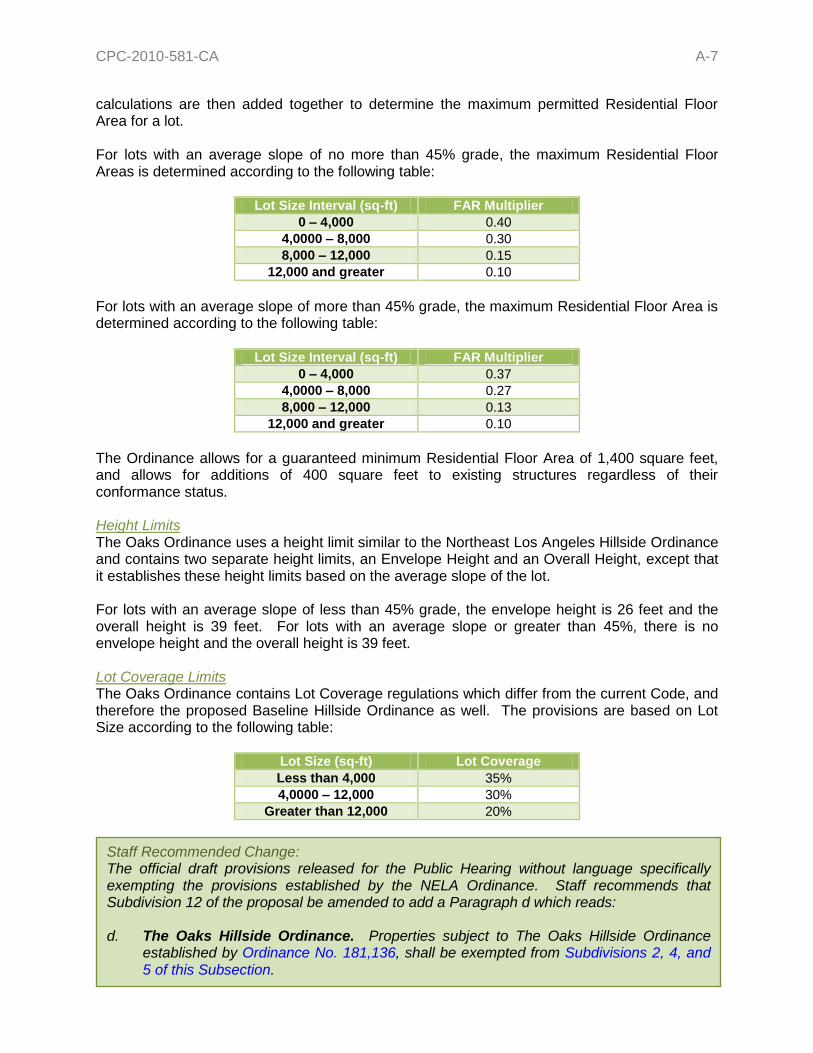
CPC-2010-581-CA A-7
calculations are then added together to determine the maximum permitted Residential Floor Area for a lot. For lots with an average slope of no more than 45% grade, the maximum Residential Floor Areas is determined according to the following table:
Lot Size Interval (sq-ft) FAR Multiplier
0 – 4,000 0.40
4,0000 – 8,000 0.30
8,000 – 12,000 0.15
12,000 and greater 0.10
For lots with an average slope of more than 45% grade, the maximum Residential Floor Area is determined according to the following table:
Lot Size Interval (sq-ft) FAR Multiplier
0 – 4,000 0.37
4,0000 – 8,000 0.27
8,000 – 12,000 0.13
12,000 and greater 0.10
The Ordinance allows for a guaranteed minimum Residential Floor Area of 1,400 square feet, and allows for additions of 400 square feet to existing structures regardless of their conformance status. Height Limits The Oaks Ordinance uses a height limit similar to the Northeast Los Angeles Hillside Ordinance and contains two separate height limits, an Envelope Height and an Overall Height, except that it establishes these height limits based on the average slope of the lot. For lots with an average slope of less than 45% grade, the envelope height is 26 feet and the overall height is 39 feet. For lots with an average slope or greater than 45%, there is no envelope height and the overall height is 39 feet. Lot Coverage Limits The Oaks Ordinance contains Lot Coverage regulations which differ from the current Code, and therefore the proposed Baseline Hillside Ordinance as well. The provisions are based on Lot Size according to the following table:
Lot Size (sq-ft) Lot Coverage
Less than 4,000 35%
4,0000 – 12,000 30%
Greater than 12,000 20%
Staff Recommended Change: The official draft provisions released for the Public Hearing without language specifically exempting the provisions established by the NELA Ordinance. Staff recommends that Subdivision 12 of the proposal be amended to add a Paragraph d which reads: d. The Oaks Hillside Ordinance. Properties subject to The Oaks Hillside Ordinance
established by Ordinance No. 181,136, shall be exempted from Subdivisions 2, 4, and 5 of this Subsection.

CPC-2010-581-CA A-8
R164,669 49%
RE1112,168
9%
RE1524,182 18%
RA9,1007%
RE205,740 4%
RE4011,136
8%
RE92,496 2%
RS4,182 3%
Figure 1 – Citywide Percentage of Lots by Zone Lots by Zone in Hillside Area
ANALYSIS OF SINGLE-FAMILY ZONED LOTS
Single-Family Lots by Zone The proposed Baseline Hillside Ordinance will apply only to properties that are zoned single-family residential (R1, RS, RE9, RE11, RE15, RA, RE20, and RE40) that are located in a Hillside Area, as defined in Section 12.03 of the LAMC. The total number of lots to which this Ordinance would apply is approximately 133,618. As the figure to the right illustrates, an overwhelming majority of the properties being affected are zoned R1 (64,669; 49%), and the next most frequent zone is RE15 (24,182; 18%). The other zones that appear in any significant numbers are the RE11 and RE40 zones, each at 9% and 8% respectively of the total number of lots. Only approximately 26% of all the lots have a lot area between 100%- 125% of the required lot area and 10% of the lots could be considered too large for the zone with lot area at least 175% of the required minimum lot area. For more specific numbers please refer to Appendix B.
Key:
Zone Number of Lots
Percentage
CPC-2010-581-CA A-9
64,010 48%
69,608 52%
Substandard Lot
Conforming Lot
R1 RS RE9 RE11 RE15 RA RE20 RE40
59%
39%
22%
14% 14%
67%
45%
15%
41%
61%
78%
86% 86%
33%
55%
85%
Percent Equal to or Greater than Minimum Lot Size for the Zone
Percent of Lots with the Same Zone with Less than the Minimum Lot Size
Figure 3 – Citywide Percentage of Conforming and Nonconforming
Lots by Zone in Hillside Area
Figure 2 – Citywide Percentage of Conforming and Non-Conforming
Lots by Zone in Hillside Area
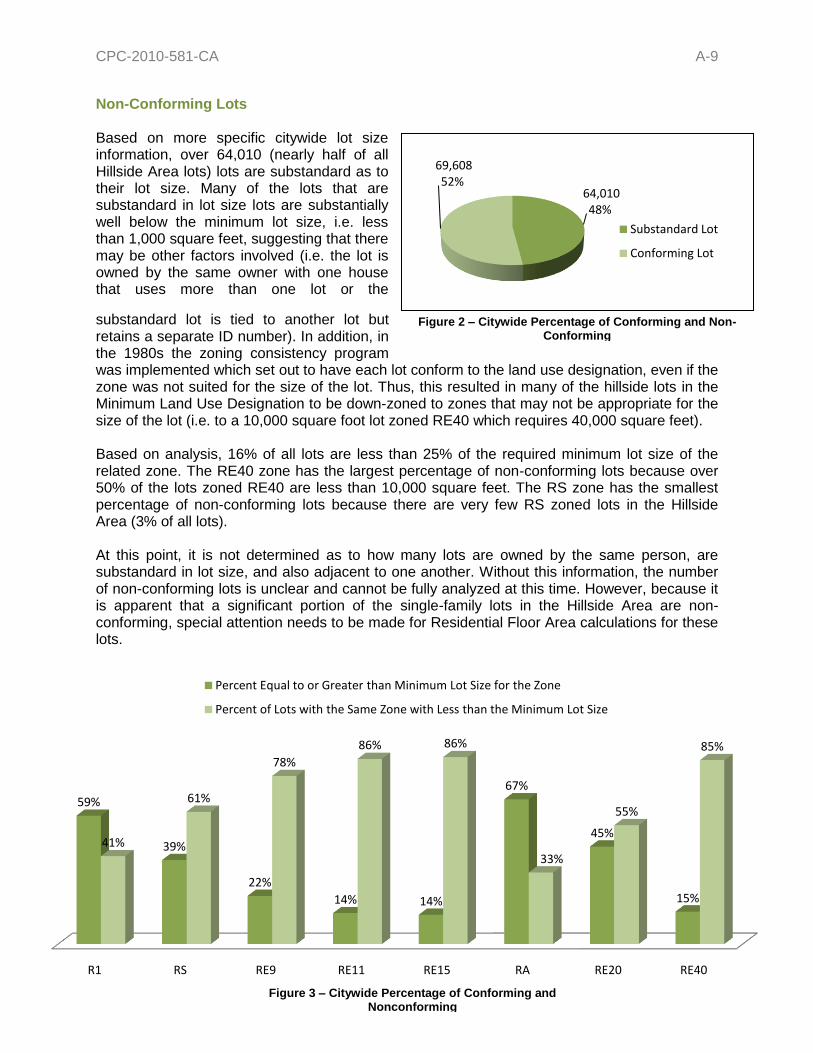
Non-Conforming Lots Based on more specific citywide lot size information, over 64,010 (nearly half of all Hillside Area lots) lots are substandard as to their lot size. Many of the lots that are substandard in lot size lots are substantially well below the minimum lot size, i.e. less than 1,000 square feet, suggesting that there may be other factors involved (i.e. the lot is owned by the same owner with one house that uses more than one lot or the
substandard lot is tied to another lot but retains a separate ID number). In addition, in the 1980s the zoning consistency program was implemented which set out to have each lot conform to the land use designation, even if the zone was not suited for the size of the lot. Thus, this resulted in many of the hillside lots in the Minimum Land Use Designation to be down-zoned to zones that may not be appropriate for the size of the lot (i.e. to a 10,000 square foot lot zoned RE40 which requires 40,000 square feet). Based on analysis, 16% of all lots are less than 25% of the required minimum lot size of the related zone. The RE40 zone has the largest percentage of non-conforming lots because over 50% of the lots zoned RE40 are less than 10,000 square feet. The RS zone has the smallest percentage of non-conforming lots because there are very few RS zoned lots in the Hillside Area (3% of all lots). At this point, it is not determined as to how many lots are owned by the same person, are substandard in lot size, and also adjacent to one another. Without this information, the number of non-conforming lots is unclear and cannot be fully analyzed at this time. However, because it is apparent that a significant portion of the single-family lots in the Hillside Area are non-conforming, special attention needs to be made for Residential Floor Area calculations for these lots.

CPC-2010-581-CA A-10
For more specific numbers please refer to Appendix B. Breakdown of Each Single-Family Zone The following is a summarized analysis of the affected properties by zone; for more specific numbers, please refer to Appendix B of this report:
R1 Roughly 37% of the properties in this zone have a lot size that are in the 5,000 and 8,000 sq-ft ranges (100% - 150% of the minimum lot size of 5,000 square feet). Roughly 41% are less than the 5,000 square foot minimum lot size and 15% are substantially substandard in size (i.e. less than 50% of the required lot size). Only 9% of the properties in this zone are greater than 200% the required lot size.
RS Over half of the properties in this zone are in the 7,500 and 9,000 sq-ft ranges (100%
-125% of the minimum lot size of 7,500 square feet). 11% of the lots in this zone are less than the 7,500 sq-ft minimum lot size, and 3% of the lots are severely undersized (less than 50% of the required lot size). 8% of the lots in this zone could be considered too big for the zone, or greater than 200% of the required lot size.
RE9 Approximately 44% of the properties in this zone are between 9,000 and 13,500
square feet (100% – 150% of the required lot size of 9,000). 39% of the lots in this zone are less than the 9,000 sq-ft minimum lot size, and 12% of the lots are severely undersized (less than 50% of the required lot size). 9% of the lots in this zone could be considered too big for the zone, or greater than 200% of the required lot size.
RE11 Approximately 45% of the properties in this zone are between 11,000 and 17,000 sq-
ft (100% - 150% of the minimum lot size of 11,000 square feet); a large majority of these are in the 11,000 sq-ft range just under 14,000 square feet (35%). 41% of the properties are less than 11,000 square feet and approximately 14% are considered significantly substandard in size (less than 50% of the required lot size). 6% of the lots in this zone are considered too big for the zone or greater than 200% of the required lot size.
RE15 Approximately 20% of the properties in this zone are between 15,000 and 23,000 sq-
ft (100% - 150% of the minimum lot size of 15,000 square feet); a large majority of these are in the 15,000 sq-ft range just under 19,000 square feet (13%). A large percentage of the properties in this zone are substandard as to the minimum lot size of 15,000 as 67% of the properties are less than 15,000 square feet and approximately 32% are considered significantly substandard in size (less than 50% of the required lot size). 7% of the lots in this zone are considered too big for the zone or greater than 200% of the required lot size.
RA Approximately 51% of the properties in this zone are between 17,500 and 26,000 sq-
ft (100% - 150% of the minimum lot size of 17,500 square feet); a large majority of these are in the 17,500 sq-ft range just under 22,000 square feet (42% of lots in this zone). 33% of the properties are less than 17,500 square feet and approximately 9% are considered significantly substandard in size (less than 50% of the required lot size). 8% of the lots in this zone are considered too big for the zone or greater than 200% of the required lot size.
RE20 Approximately 19% of the properties in this zone are between 20,000 and 30,000 sq-
ft (100% - 150% of the minimum lot size of 20,000 square feet); a majority of these are in the 20,000 sq-ft range just under 25,000 square feet (11% of the lots in this zone). Over half of the properties are less than 20,000 square feet (56% of the

CPC-2010-581-CA A-11
properties in this zone) and approximately 36% are considered significantly substandard in size (less than 50% of the required lot size). 14% of the lots in this zone are considered too big for the zone or greater than 200% of the required lot size. Several of the properties that are over 200% of the required lot size are publically owned by such entities as the Santa Monica Mountain Conservancy or the State of California Conservancy.
RE40 Approximately 6% of the properties in this zone are between 40,000 and 60,000 sq-ft
(100% - 150% of the minimum lot size of 20,000 square feet). Over half of the properties are less than 40,000 square feet (82% of the properties in this zone) and approximately 70% are considered significantly substandard in size (less than 50% of the required lot size). 9% of the lots in this zone are considered too big for the zone or greater than 200% of the required lot size. Several of the properties that are over 200% of the required lot size are publically owned by such entities as the Santa Monica Mountain Conservancy or the State of California Conservancy.
Issues The current hillside development regulations in the Municipal Code for single-family residential zones (R1, RS, RE9, RE11, RE15, RE20, RE40, and RA) allow for development which is generally considered incompatible with the surrounding neighborhoods, topography, and/or existing infrastructure. Moreover, the provisions are applied based on the level of street improvement and are completely exempted if the public right-of-way is 30 feet wide and paved to a width of at least 28 feet. The proposed Baseline Hillside Ordinance provisions will directly address both issues by establishing regulations that address the issue of out-of-scale development and applying key development standards regardless of the paved road-width (the current hillside regulations are triggered on substandard road-widths). It is important to note that some of the existing regulations will be maintained, and some of which will continue to be applied based on street improvement. SUBDIVISION 1: SETBACK REQUIREMENTS The proposed Baseline Hillside Ordinance will carry forward the existing Setback provisions with no changes to the current requirements. However, it has consolidated various provisions located in different parts of the Code and simplifies the language by arranging the basic requirements into a table format and arranging the special provisions by topic. Some changes to the wording are being made in order to accommodate the new location, but no changes in policies will result from them. SUBDIVISION 2: MAXIMUM RESIDENTIAL FLOOR AREA FAR establishes a relationship between a property and the amount of development permitted for that property, and is expressed as a percentage or a ratio. The current Floor Area Ratio (FAR) for Single-Family Zones in the Hillside Area is still 3 times the Buildable Area (Lot Size minus Setbacks). This allows for the construction of homes that are out-of-scale with the surrounding neighborhood, a phenomenon commonly referred to as “mansionization.” For example, a 5,000 sq-ft, R1-1 zoned lot has a current development potential of over 7,000

CPC-2010-581-CA A-12
square-feet (not including the garage); essentially permitting structures which are significantly larger than the lot itself.
The Baseline Mansionization Ordinance (BMO) has already addressed this phenomenon for the City’s non-hillside neighborhoods, and the FAR proposal in the Baseline Hillside Ordinance, outlined below, is expected to do the same for single-family construction in the hillsides. The current FAR regulations which apply in the Hillside Area continue to limit the size of structures based on a percentage of the Buildable Area (lot size minus required setbacks) to determine how much development is permitted on a lot. The problem with this current method is that the required setbacks do not increase proportionally as the lot gets bigger, and the lot configuration (narrow & deep vs. wide & shallow) also results in varying Buildable Areas on same-sized lots. This results in disproportionately larger Buildable Areas for larger and/or narrow lots, and if the current FAR method is maintained it will continue to result in disproportionately larger homes. The BMO addressed this problem by changing the FAR from a percentage of Buildable Area to a percentage of Lot Size, and now the proposed Baseline Hillside Ordinance will do the same for the City’s Hillside Area. Like the BMO, the proposal would give each zone a specific FAR, thereby establishing a specific scale for each zone. Proposed FARs Similar to the BMO, the Baseline Hillside Ordinance uses specified Floor Area Ratios for each Single-Family Zone based on both the size of the lot and a property’s unique hillside terrain (or topography). Homes would adhere to size limits computed by a formula that gradually reduces the FAR for the steeper areas of the lot. The premise is that steepness should be one of the variables used when determining the amount of development that can occur on a property. The starting point for each zone is the base FAR established in the BMO: R1 RS RE9 RE11 RE15 RE20 RE40 RA
50% 45% 40% 40% 35% 35% 35% 25%
Next, the topography of a lot is addressed by identifying the following slope intervals, called Slope Bands, which each have an FAR value that decreases as they get steeper:
Slope Band Angle (in degrees) Description
0% - 15% 0° – 8.5° Flat to Moderate Slope
15% - 30% 8.5° – 16.7° Strong Slopes (true hillside)
30% - 45% 16.7° – 24.2° Very Strong Slopes
45% - 60% 24.2° – 31° Moderately Severe Slopes
60% - 100% 31° – 45° Severe Slopes
100% or greater 45° or greater Extreme Slopes

CPC-2010-581-CA A-13
The proposed FAR would be based on zone, lot size, and steepness of slopes on a hillside property, rather than lot size alone. This approach takes into account that there are many differences in hillside lots, and that the Code needs to consider the varying hillside conditions when determining Residential Floor Area limits. Residential Floor Area bonuses are also provided, as in the BMO, with additional options related to grading. A lot that is considered “flat” (entirely made up of 0% to 15% slopes) would essentially be treated the same as it would currently under BMO provisions, in terms of the allowable square footage.
Single-Family Zone Hillside Area Residential Floor Area Ratios (FAR)
Slope Bands (%) R1 RS RE9 RE11 RE15 RE20 RE40 RA
0 – 14.99 0.50 0.45 0.40 0.40 0.35 0.35 0.35 0.25
15 – 29.99 0.45 0.40 0.35 0.35 0.30 0.30 0.30 0.20
30 – 44.99 0.40 0.35 0.30 0.30 0.25 0.25 0.25 0.15
45 – 59.99 0.35 0.30 0.25 0.25 0.20 0.20 0.20 0.10
60 – 99.99 0.30 0.25 0.20 0.20 0.15 0.15 0.15 0.05
100 + 0.00 0.00 0.00 0.00 0.00 0.00 0.00 0.00
The concept for this approach is that not all properties in the Hillside Area are the same, and that the citywide baseline formula would address the unique topography of individual hillside properties. Slope Analysis The Department of Building and Safety currently requires a licensed surveyor to prepare a topographic map of a property for the issuance of a building permit within a Hillside Area. The proposed Ordinance would require that the survey be prepared using one-foot contours. The same surveyor would also prepare a Slope Analysis Map, based on the natural/existing topography, which delineates the portions of a property which fall under each Slope Band and include a tabulation of the total area of the lot (in square feet) within each band. Those values
Slope Definition An inclined ground surface the inclination of which is expressed as a ratio of horizontal distance to vertical distance (i.e. 2:1 or 1:1) or as a percentage. Note: slopes may also be referred to as degrees, but is not common practice in the field of development. Slope Percentage ((rise ÷ run) × 100 = slope percent) Slope Ratio Expressed as Rise/Run or Rise:Run, where Rise equals one foot.
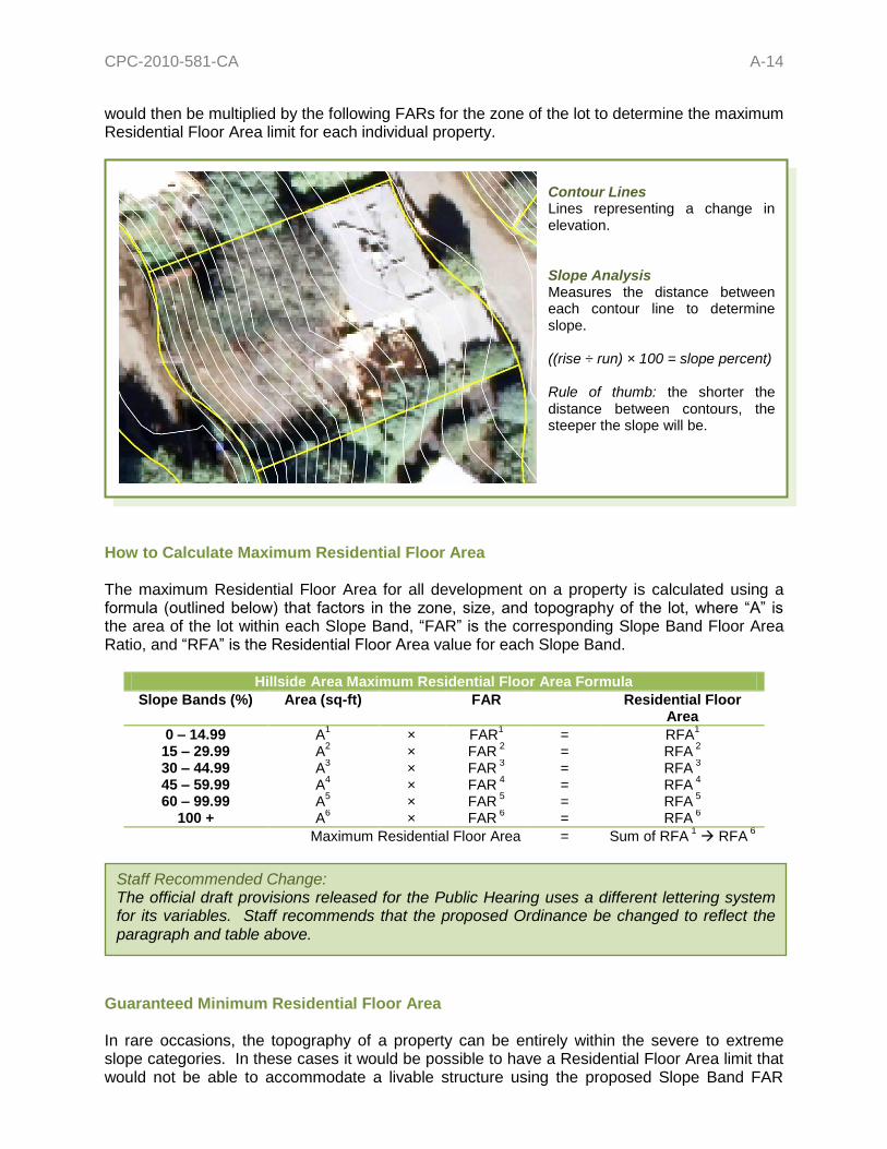
CPC-2010-581-CA A-14
would then be multiplied by the following FARs for the zone of the lot to determine the maximum Residential Floor Area limit for each individual property.
How to Calculate Maximum Residential Floor Area The maximum Residential Floor Area for all development on a property is calculated using a formula (outlined below) that factors in the zone, size, and topography of the lot, where “A” is the area of the lot within each Slope Band, “FAR” is the corresponding Slope Band Floor Area Ratio, and “RFA” is the Residential Floor Area value for each Slope Band.
Hillside Area Maximum Residential Floor Area Formula
Slope Bands (%) Area (sq-ft) FAR Residential Floor Area
0 – 14.99 A1 × FAR
1 = RFA
1
15 – 29.99 A2 × FAR
2 = RFA
2
30 – 44.99 A3 × FAR
3 = RFA
3
45 – 59.99 A4 × FAR
4 = RFA
4
60 – 99.99 A5 × FAR
5 = RFA
5
100 + A6 × FAR
6 = RFA
6
Maximum Residential Floor Area = Sum of RFA 1 RFA
6
Guaranteed Minimum Residential Floor Area In rare occasions, the topography of a property can be entirely within the severe to extreme slope categories. In these cases it would be possible to have a Residential Floor Area limit that would not be able to accommodate a livable structure using the proposed Slope Band FAR
Staff Recommended Change: The official draft provisions released for the Public Hearing uses a different lettering system for its variables. Staff recommends that the proposed Ordinance be changed to reflect the paragraph and table above.
Contour Lines Lines representing a change in elevation. Slope Analysis Measures the distance between each contour line to determine slope. ((rise ÷ run) × 100 = slope percent)
Rule of thumb: the shorter the distance between contours, the steeper the slope will be.

CPC-2010-581-CA A-15
method. In order to make sure that this does not occur, the proposed Baseline Hillside Ordinance would include a Guaranteed Minimum Residential Floor Area. The provision guarantees that a lot conforming to minimum lot size would at least be allowed to build 50% of the size that the Baseline Mansionization Ordinance (BMO) would give for a minimum-sized lot regardless of the topography.
R1 5,000 sq-ft
min lot
RS 7,500 sq-ft
min lot
RE9 9,000 sq-ft
min lot
RE11 11,000 sq-ft
min lot
RE15 15,000 sq-ft min lot
RE20 20,000 sq-ft min lot
RE40 40,000 sq-ft min lot
RA 17,500 sq-ft min lot
1,250 sq-ft 1,688 sq-ft 1,800 sq-ft 2,200 sq-ft 2,625 sq-ft 3,500 sq-ft 7,000 sq-ft 2,188 sq-ft
The guaranteed minimum is increased for the larger Zones, and carries on the basic scales for each established by the City under the BMO. The RA Zone has a smaller guaranteed minimum, in spite of its lot size, because it is intended to have the smallest house to lot ratio, in order to accommodate the animal-keeping uses.
In the City’s hillside neighborhoods, there are scenarios where a lot which was once conforming to one zone’s lot size requirements and, for whatever reason, was rezoned to another with larger minimum lot size thereby making it nonconforming. In order to ensure that these properties are not disproportionately penalized due to these actions, the proposed Ordinance has included a provision which allows for these properties to utilize the guaranteed minimum of the previous zone. For all other lots which are nonconforming as to lot size, the proposed Ordinance guarantees at least 750 square feet of Residential Floor Area. Currently hillside regulations exempt 750 square feet of floor area before compliance with hillside regulations is required. This value was determined by carrying forward this current hillside regulation. 20% Residential Floor Area Bonus Similar to the BMO, the Baseline Hillside Ordinance would allow for a 20% Residential Floor Area Bonus if the project meets certain design criteria that reduces the project’s environmental or visual impact. The following standards are intended to act as incentives for better design and to offer a variety of options for property owners, architects, etc. Proportional Stories Option The proposed Ordinance will carry forward this option from the BMO, but only for sites where the building pad is “flat”, or less than 15% grade. The total Residential Floor Area of each story other than the Base Floor, as currently defined in Section 12.03 of the LAMC, in a multi-story building does not exceed 75% of the Base Floor area; this option in only available for buildings on a natural/existing “flat” (less than 15% slope) pad. It is important to note that this provision is not a fixed step-back requirement, but a ratio that allows for maximum design flexibility. This option is a simple way to incentivize articulated
Staff Recommended Change: Staff recommends that the Guaranteed Minimum Residential Floor Area values be listed in an easier to read table format similar to the one used above.

CPC-2010-581-CA A-16
homes by breaking up a structure’s vertical mass, encourage quality design, and prohibit large box-like structures. Front Facade Stepback Option The proposed Ordinance will carry forward this option from the BMO, but only for sites where the building pad is “flat”, or less than 15% grade. At least 25% of the front facade of a building is stepped-back a distance of at least 20% of the building depth; this option in only available for buildings on a natural/existing “flat” (less than 15% slope) pad. However, per comments received during the Public Workshops, the proposal does not include exterior walls which are part of a garage; the intent is to discourage development where the garage is the prominent feature when viewed from street. It is important to note that this provision is not a fixed stepback requirement, but a ratio that allows for maximum design flexibility. This option is a simple way to incentivize articulated homes by breaking up a structure’s vertical mass, encourage quality design, and prohibit large box-like structures. Cumulative Side Yard Setback Option This option will require development on a property to provide side yard setbacks that add up to cumulative total of at least 25% of the total Lot Width, but in no event can a single side yard setback be less than 10% of the Lot Width or the minimum required side yard for the zone, whichever is greater. This provision is intended to encourage the “staggering” of structures, reduce the “building wall” effect, and increase the opportunity for more visually permeability along our hillside streets. This provision will also allow for greater opportunity to preserve existing trees, as the larger setbacks will allow for mature trees to remain in place with a reduced impact on their root systems.
18-Foot Envelope Height Option This option will require structures to stay below an 18-foot maximum envelope height, and will only be available for properties which are not already in the “1SS” Single-Story Height District. This provision will give one-story structures an additional bonus option to which it can comply and encourage low-rise structures. Multiple Structures Option This option will set the maximum lot coverage, or “footprint”, for any one structure to no more than 20% of the lot. Combined with the existing 40% lot coverage limit, this provision will ensure that there are at least two separate building masses on a lot or a single structure with a small footprint. However, the proposed Ordinance will allow for these structures to be
Staff Recommended Change: The official draft provisions released for the Public Hearing unintentionally omitted the existing requirement for an increase to the minimum side yard of 1 foot for every 10 feet, or portion thereof, above the first 18 feet in height. Similarly, staff would recommend that the City Planning Commission consider increasing the cumulative value to 30% in order to increase the effectiveness of this provision and prevent an automatic-bonus scenario. It was not staff’s intention for this option to result in side yard setbacks which are the same or smaller than is currently required.

CPC-2010-581-CA A-17
connected by one breezeway, fully enclosed walkway, elevator, or combination thereof of not more than 5 feet in width. The intent of this option is to produce smaller building masses which tend to be more visually appealing than one larger mass. Minimal Grading Option This option will cap the total grading on a lot (including exempted grading such as foundations, driveways, or remedial grading) does not exceed 10% of the lot size in cubic yards or 1,000 cubic yards, whichever is less. Example: a project involving 500 cubic-yards of non-exempt grading on a 5,000 square-foot lot will be eligible for this bonus option. This provision only applies to properties where at least 60% of the lot is comprised of slopes which are 30% or greater, as determined by a Slope Analysis Map. Landform Grading Option This option will only apply when the total quantities of non-exempted grading on the site does not exceed 1,000 cubic yards and landform grading methods, as outlined in the Department of City Planning – Planning Guidelines Landform Grading Manual, are utilized to reflect original landform and result in minimum disturbance to natural terrain. This provision only applies to properties where at least 60% of the lot is comprised of slopes which are 30% or greater, as determined by a Slope Analysis Map. Green Building Option 1 The proposed Ordinance will carry forward this option from the BMO, but will instead require that new single-family dwellings be in substantial compliance with the requirements for the USGBC LEED® for Homes program at the “Silver” level or higher. This is due to the changes to the State Building Codes that will make complying with its requirement the equivalent to meeting the LEED® for Homes program’s requirements for the “Certified” level. Green Building Option 2 The proposed Ordinance will also introduce a non-LEED® green option. This option will apply when a project exceeds the energy efficiency performance of a home built to the Title-24 requirements by at least 15%. Projects can minimize the amount of energy used by installing energy-efficient systems, as well as by minimizing the amount of energy lost as a result of the building envelope. This is due to the changes to the State Building Codes that will make complying with its requirement the equivalent to meeting the LEED® for Homes program’s requirements for the “Certified” level. Zoning Administrator Adjustment The Zoning Administrator will continue to have the authority to grant an Adjustment of no more than 10% to the maximum Residential Floor Area limits for a property; any increase larger than 10% would require a Variance. The proposed Ordinance will carry over the existing hillside provision, which allows for additions to existing structures of no more than 750 square feet, but will make it a discretionary action if adding to a structure that exceeds the proposed maximum RFA. The Zoning Administrator would have the authority to approve any additions made after August 1, 2010 to a one-family dwelling existing prior to that date which exceed the proposed maximum Residential Floor Area limits. These additions would be required to maintain the height of the existing structure or comply with the proposed height limits, whichever is greater.

CPC-2010-581-CA A-18
Theoretical Examples The following are 3 theoretical examples (a “Flat” Lot, Sloped Lot, and Very Sloped Lot) of calculations for a 5,000 sq-ft R1 Zoned property in different slope scenarios using the formula above: Scenario 1 – “Flat” Lot As you can see by the results of the proposed formula below, a “flat” to moderately sloped lot in the Hillside Area would be allowed to build the same amount as a property where the BMO is applied today.
Hillside Area Maximum Residential Floor Area Formula
Slope Bands (%) Area (sq-ft) FAR Residential Floor Area
0 – 14.99 5,000 × 0.50 = 2,500 15 – 29.99 0 × 0.45 = 0 30 – 44.99 0 × 0.40 = 0 45 – 59.99 0 × 0.35 = 0 60 – 99.99 0 × 0.30 = 0
100 + 0 × 0.0 = 0
Maximum Residential Floor Area = 2,500 sq-ft
Scenario 2 – Sloped Lot A property that is mostly “flat” to moderately sloped, but does have a little more steep terrain would see a slight decrease in the maximum Residential Floor Area. As you can see from the results of the formula below, the property has a moderate reduction in the size limits when compared to a “flatter” lot. The rationale here is that this lot can accommodate slightly less development than the last example.
Hillside Area Maximum Residential Floor Area Formula
Slope Bands (%) Area (sq-ft) FAR Residential Floor Area
0 – 14.99 2,500 × 0.50 = 1,250 15 – 29.99 1,000 × 0.45 = 450 30 – 44.99 950 × 0.40 = 380 45 – 59.99 400 × 0.35 = 140 60 – 99.99 100 × 0.30 = 30
100 + 50 × 0.0 = 0
Maximum Residential Floor Area = 2,250 sq-ft
Proposed Findings: 10% Adjustment No change from existing. 750 sq-ft Additions That the increase in Residential Floor Area will result in a building or structure which is compatible in scale with existing structures in the vicinity; and that the approval is necessary for the preservation and enjoyment of a substantial property right possessed by other property in the vicinity.

CPC-2010-581-CA A-19
Slope BandArea within Slope Band
< 15% 15,977.3 sq-ft
15% - 30% 3,342.4 sq-ft
30% - 45% 5,113.0 sq-ft
45% - 60% 6,726.5 sq-ft
60% - 100% 7,802.4 sq-ft
>100% 1,605.1 sq-ft
Scenario 3 – Very Sloped Lot A property comprised of steeper slopes would see a more significant decrease in the maximum Residential Floor Area, as illustrated by the result of the formula below. A majority of this property is in the very strong to moderately severe slope categories, and therefore cannot accommodate the same amount of development as the other examples.
Hillside Area Maximum Residential Floor Area Formula
Slope Bands (%) Area (sq-ft) FAR Residential Floor Area
0 – 14.99 500 × 0.50 = 250 15 – 29.99 600 × 0.45 = 270 30 – 44.99 1,000 × 0.40 = 400 45 – 59.99 2,000 × 0.35 = 700 60 – 99.99 500 × 0.30 = 150
100 + 400 × 0.0 = 0
Maximum Residential Floor Area = 1,770 sq-ft
Real World Examples The following example is of a real 40,567 square-foot lot zoned RE20-1-H in the City of Los Angeles. Using 2-foot contours, our Geographic Information Systems staff analyzed the slopes of the property and gave us the total area within each of the proposed Slope Bands.
Using the Area values above along with the corresponding slope band FARs for the RE20 Zone we can now determine what the base maximum Residential Floor Area for this property will be 10,388.69 sq-ft.
Hillside Area Maximum Residential Floor Area Formula
Slope Bands (%) Area (sq-ft) FAR Residential Floor Area
0 – 14.99 15,977.3 × 0.35 = 5,592.05 15 – 29.99 3,342.4 × 0.30 = 1,002.73 30 – 44.99 5,113.0 × 0.25 = 1,278.25 45 – 59.99 6,726.5 × 0.20 = 1,345.30 60 – 99.99 7,802.4 × 0.15 = 1,170.36
100 + 1,605.1 × 0.00 = 0.00
Maximum Residential Floor Area = 10,388.69 sq-ft

CPC-2010-581-CA A-20
The next 3 examples comes to us courtesy of Urban Studio, a local architecture firm hired by a neighborhood association to analyze how the proposed Residential Floor Area limits would be applied to properties within their neighborhood. They utilized 4-foot contour information currently available on our City’s NavigateLA website (http://navigatela.lacity.org/) in order to prepare an estimated slope analysis for the following properties: Property No. 1
This particular property is 35,100 square-feet and is zoned RE20-1-H. As the slope analysis above indicates, the base maximum Residential Floor Area for this property is 8,540 square-feet and with the 20% bonus the maximum would be 10,248 square-feet. The firm also did some further analysis for this property and illustrated some of the other provisions and how they applied to this particular property, shown below.
Courtesy of

CPC-2010-581-CA A-21
Property No. 2
Lot Size: 62,085 square feet Zone: RE20-1 Base Residential Floor Area Limit 21,098 square feet Residential Floor Area Limit w/ 20% Bonus 25,318 square feet
Courtesy of
Courtesy of
CPC-2010-581-CA A-22
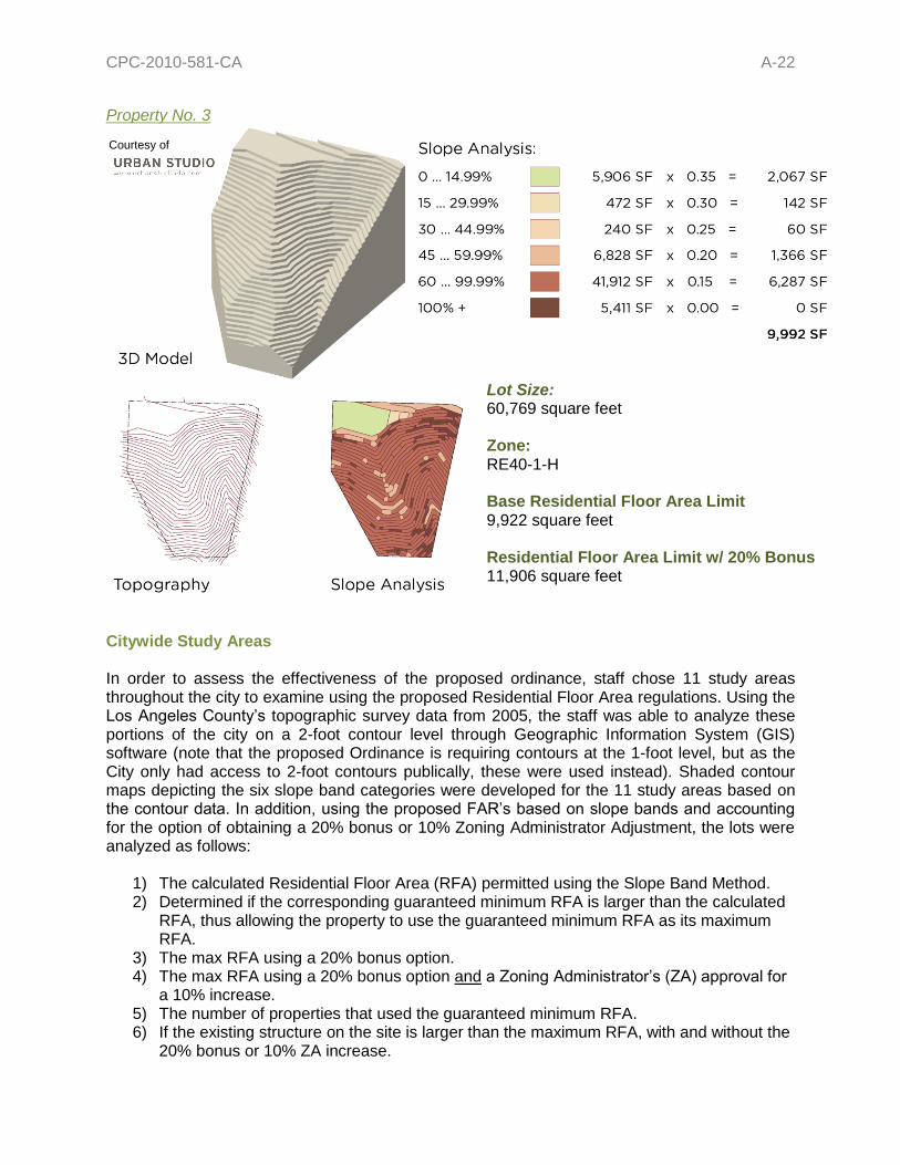
Property No. 3
Citywide Study Areas In order to assess the effectiveness of the proposed ordinance, staff chose 11 study areas throughout the city to examine using the proposed Residential Floor Area regulations. Using the Los Angeles County’s topographic survey data from 2005, the staff was able to analyze these portions of the city on a 2-foot contour level through Geographic Information System (GIS) software (note that the proposed Ordinance is requiring contours at the 1-foot level, but as the City only had access to 2-foot contours publically, these were used instead). Shaded contour maps depicting the six slope band categories were developed for the 11 study areas based on the contour data. In addition, using the proposed FAR’s based on slope bands and accounting for the option of obtaining a 20% bonus or 10% Zoning Administrator Adjustment, the lots were analyzed as follows:
1) The calculated Residential Floor Area (RFA) permitted using the Slope Band Method. 2) Determined if the corresponding guaranteed minimum RFA is larger than the calculated
RFA, thus allowing the property to use the guaranteed minimum RFA as its maximum RFA.
3) The max RFA using a 20% bonus option. 4) The max RFA using a 20% bonus option and a Zoning Administrator’s (ZA) approval for
a 10% increase. 5) The number of properties that used the guaranteed minimum RFA. 6) If the existing structure on the site is larger than the maximum RFA, with and without the
20% bonus or 10% ZA increase.
Lot Size: 60,769 square feet Zone: RE40-1-H Base Residential Floor Area Limit 9,922 square feet Residential Floor Area Limit w/ 20% Bonus 11,906 square feet
Courtesy of

CPC-2010-581-CA A-23
The Study Areas include:
1. The Oaks 2. Silverlake 3. Northeast Los Angeles 4. Montecito Heights 5. Laurel Canyon 6. Coldwater Canyon
7. Brentwood 8. Woodland Hills 9. Porter Ranch 10. Tujunga 11. San Pedro
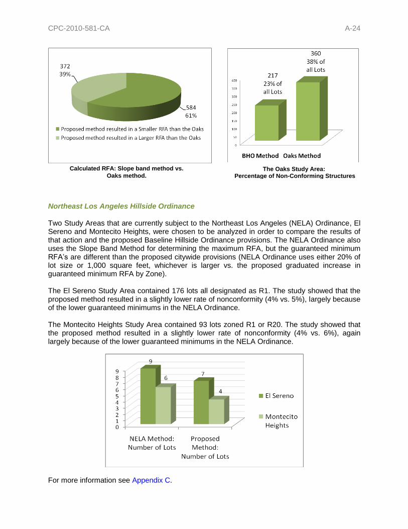
The study areas were chosen based on their variation in zones, lot size, topography and cohesiveness as a neighborhood as generally bounded by streets. The Oaks area was chosen to be studied in its entirety as an information tool to show how the current proposal relates to the recently adopted Oaks Hillside Ordinance (CPC-2009-2949-HD; Ordinance No. 181,136). Two portions of the area covered by the Northeast Los Angeles Hillside Ordinance (CPC-2008-1182-ZC; Ordinance No. 180,403) were chosen to show how the proposal relates to the Ordinance as well. Each study area analyzed between 90 and 240 lots, and 956 lots for the Oaks study. A total of 2,473 lots were studied all together in all 11 study areas. When all the test areas were viewed as a whole, the analysis showed that only 15% of the structures were nonconforming as to the proposed size limits, meaning that the existing house is larger than what would be permitted using either the Slope Band method or the guaranteed minimum RFA. In addition, when including the 20% bonus, only 9% of all the lots would have existing structures larger than what would be permitted. Furthermore, when including the 10% ZA increase on top of the 20% bonus, only 7% of all lots would be nonconforming. Many of lots that resulted in a nonconforming structure may be sited on a lot that is either substandard in lot size, inappropriately zoned, or tied to another property through ownership. Of those lots that resulted in calculated RFA larger than then the existing structure, most properties could still add on to the structure with a sizable addition (i.e. over 1,000 square feet). Moreover, only 25% of the lots (618 lots) required the use of the guaranteed minimum since the slope band method of calculating RFA resulted in a square footage that is what some would consider uninhabitable. This shows that the proposed method of calculating Residential Floor Area is consistent with current development standards will not prevent development which is in scale with the existing neighborhoods, but will instead effectively curb out-of-scale development. For a breakdown of a 5 of the 11 Study Areas please refer to Appendix C. The Oaks The Oaks Study Area has a total of 956 lots all designated R1, RE9, RE11 or RE15 zone. The maximum Residential Floor Area was calculated using both the proposed Slope Band method and the Oaks method based on lot size and the average slope. Both sets of RFA’s were evaluated as to whether they produced structure sizes that could accommodate existing structures on site (or additions). The study showed that the proposed Slope Band method resulted in a lower rate of existing nonconforming structures than the method used in the Oaks Ordinance (23% vs. 38%). Generally speaking, while the Slope Band method resulted in slightly smaller structures on lots with steeper terrain than through the Oaks method of calculating RFA, the proposed method resulted in a higher structure conformance rate than the Oaks method (see the charts below and Appendix C for more information).
CPC-2010-581-CA A-24
The Oaks Study Area: Percentage of Non-Conforming Structures
Lots by Zone in Hillside Area
Northeast Los Angeles Hillside Ordinance Two Study Areas that are currently subject to the Northeast Los Angeles (NELA) Ordinance, El Sereno and Montecito Heights, were chosen to be analyzed in order to compare the results of that action and the proposed Baseline Hillside Ordinance provisions. The NELA Ordinance also uses the Slope Band Method for determining the maximum RFA, but the guaranteed minimum RFA’s are different than the proposed citywide provisions (NELA Ordinance uses either 20% of lot size or 1,000 square feet, whichever is larger vs. the proposed graduated increase in guaranteed minimum RFA by Zone). The El Sereno Study Area contained 176 lots all designated as R1. The study showed that the proposed method resulted in a slightly lower rate of nonconformity (4% vs. 5%), largely because of the lower guaranteed minimums in the NELA Ordinance. The Montecito Heights Study Area contained 93 lots zoned R1 or R20. The study showed that the proposed method resulted in a slightly lower rate of nonconformity (4% vs. 6%), again largely because of the lower guaranteed minimums in the NELA Ordinance.
For more information see Appendix C.
Calculated RFA: Slope band method vs.
Oaks method.

CPC-2010-581-CA A-25
RESIDENTIAL FLOOR AREA DEFINITION The current Floor Area definition, which currently applies to single-family zoned lots in the Hillside Area, is inadequate because it is geared to commercial and industrial structures and does not include portions of a building that add significantly to the mass and bulk of residential structures. The BMO created a new Residential Floor Area definition as a method of calculating floor area specifically crafted for residential development. The definition is balanced to include most portions of a building or structure that add to the mass and bulk of homes and are currently excluded from the calculation of maximum square footage of development on a lot. The Baseline Hillside Ordinance is proposing to amend the Residential Floor Area definition, by adding language specific to hillside development. The desired objective is to maintain a uniform definition for all development within the Single-Family Zones. The following areas would be counted towards the total Residential Floor Area for a hillside lot: Interior/Enclosed Spaces (No Change from BMO Definition) The area within the exterior walls of all structures on a lot, except as stated below; this area does not include the actual thickness of the walls. Vaulted Ceilings (No Change from BMO Definition) Portions of building with ceiling height greater than 14 feet shall count as twice the area, except as exempted below. Stairwells (No Change from BMO Definition) Area of stairwells shall only be counted once. Potentially Habitable Attics (No change from BMO definition) Any attic, or portion thereof, with ceiling height more than 7 feet.
The following areas would not be counted towards the total Residential Floor Area for a lot in the Hillside Area: Covered Parking (Proposed Change) For lots in the Hillside Area, a ratio of 200 square-feet per required covered parking area will be exempted. This is different because all areas where the BMO applies only require 2 parking spaces and there are scenarios where hillside projects are required to provide up to 5 off-street parking spaces, only 2 of which have to be covered. This will have no change to the current effective exemption of 400 square feet, but it would allow for the automatic adjustment of exempted covered parking should the requirement ever be modified citywide or by a particular community in the Hillside Area.
Staff Recommended Change: Staff recommends that the Covered Parking exemption be based on a ratio of 200 square feet per required covered parking area. This will have no change to the current effective exemption of 400 square feet since the number of required covered parking is currently 2 in both the Hillside Area and non-Hillside Area. This change would allow for the automatic adjustment of exempted covered parking should the requirement ever be modified in the “flats” as well.

CPC-2010-581-CA A-26
Small Accessory Buildings (No Change from BMO Definition) Detached accessory buildings, no greater than 200 square-feet; the total combined area not to exceed 400 square-feet. When a detached accessory building exceeds 200 square-feet, the area of the entire structure shall be counted; in other words a structure that is 250 square-feet will count as 250 square-feet of Residential Floor Area. A 400 square-foot detached covered parking is not subject to this 200 square-feet limit, and would not be counted against this provision. Small Covered Porches (Proposed Change) First 250 square-feet, of porches, patios, and breeze-ways with a solid roof open on at least 2 sides. The proposed Ordinance will modify this exemption for Downhill Lots in the Hillside Area to allow for porches or patios with solid roofs to be open on only one side if two of the other sides are retaining walls. This is being done in order to encourage buildings to be notched into the hillside and discourage additional grading in order to comply with the original BMO requirement. The proposed revised definition will also allow for the exemption of breezeways no wider than 5 feet and no longer than 25 feet connecting a garage at the street level to a dwelling, either directly or through a stairway or elevator on Downhill Lots without counting against the 250 square-foot exemption. Open Roof Porches (No Change from BMO Definition) Porches, patios, and breeze-ways that have an open Lattice Roof. Vaulted Ceilings (Proposed Change) The first 100 square feet of any portion of a building with a ceiling height greater than 14 feet shall be counted only once. The proposed Ordinance will modify this exemption for lots in the Hillside Area to allow for a room or portion of a room which has a floor height below the exterior grade (or “sunken rooms”), when the ceiling height as measured from the exterior natural or finished grade, whichever is lower, is not greater than 14 feet it shall only be counted once. Basements (Proposed Change) Basements when the elevation of the upper surface of the floor or roof above does not exceed 2 feet in height above the finished or natural grade, whichever is lower. In order to accommodate most hillside conditions, the proposed Ordinance will modify this exemption for lots in the Hillside Area so that the upper surface of the floor or roof above does not exceed 3 feet for at least 60% of the perimeter length of the exterior basement walls.
CPC-2010-581-CA A-27
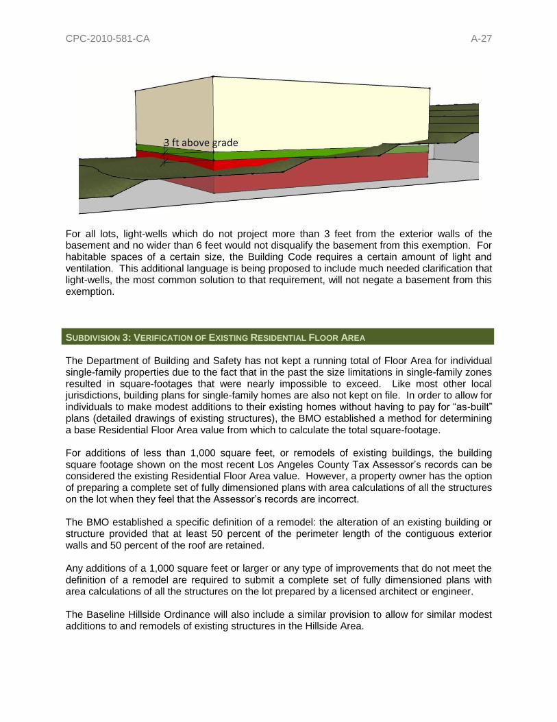
For all lots, light-wells which do not project more than 3 feet from the exterior walls of the basement and no wider than 6 feet would not disqualify the basement from this exemption. For habitable spaces of a certain size, the Building Code requires a certain amount of light and ventilation. This additional language is being proposed to include much needed clarification that light-wells, the most common solution to that requirement, will not negate a basement from this exemption. SUBDIVISION 3: VERIFICATION OF EXISTING RESIDENTIAL FLOOR AREA The Department of Building and Safety has not kept a running total of Floor Area for individual single-family properties due to the fact that in the past the size limitations in single-family zones resulted in square-footages that were nearly impossible to exceed. Like most other local jurisdictions, building plans for single-family homes are also not kept on file. In order to allow for individuals to make modest additions to their existing homes without having to pay for “as-built” plans (detailed drawings of existing structures), the BMO established a method for determining a base Residential Floor Area value from which to calculate the total square-footage. For additions of less than 1,000 square feet, or remodels of existing buildings, the building square footage shown on the most recent Los Angeles County Tax Assessor’s records can be considered the existing Residential Floor Area value. However, a property owner has the option of preparing a complete set of fully dimensioned plans with area calculations of all the structures on the lot when they feel that the Assessor’s records are incorrect. The BMO established a specific definition of a remodel: the alteration of an existing building or structure provided that at least 50 percent of the perimeter length of the contiguous exterior walls and 50 percent of the roof are retained. Any additions of a 1,000 square feet or larger or any type of improvements that do not meet the definition of a remodel are required to submit a complete set of fully dimensioned plans with area calculations of all the structures on the lot prepared by a licensed architect or engineer. The Baseline Hillside Ordinance will also include a similar provision to allow for similar modest additions to and remodels of existing structures in the Hillside Area.

CPC-2010-581-CA A-28
SUBDIVISION 4: HEIGHT LIMITS Currently, flat and sloped roofs have the same height limits. Even with the decreases in the allowable FAR described above and the use of the design alternatives which make up the 20% Residential Floor Area Bonus, there may still be concern about visual bulk as seen from the street. The BMO reduced this effect by changing the height provisions and tying the maximum height of a building to the slope of a roof. The proposed Baseline Hillside Ordinance will carry forward the same provisions, but will adapt the measurement of these heights to address hillside conditions.
The proposed provisions help to ensure that the mass of buildings is broken up, and that box-like structures have a lower height thereby further reducing the “looming” factor which has been brought up by the public on several occasions. With a varied roofline, structures would allow more light and air to reach neighboring properties, add visual interest, and enhance transitions between properties. The method of calculating height in the current hillside regulations incentivizes large and tall box-like structures, which the community has specifically identified as a problem, and discourages the terracing of structures which helps to visually break up mass. The proposed regulations utilize a new method of calculating height which would follow the slope of a lot. This is referred to in the proposed provisions as Envelope Height.
What is an Envelope Height? Envelope height (otherwise known as vertical height or “plumb line” height) would be the vertical distance from the grade of the site to a projected plane at the roof structure or parapet wall located directly above and parallel to the grade as illustrated in the figure to the right.
Measurement of the envelope height would originate at the lowest grade within 5 horizontal feet of the exterior walls of a building or structure and terminate at the highest elevation of the building pad. At no point shall any given section of any part of the proposed building or structure exceed the maximum envelope height.
Current Code 25% Slope Roof
Less Than 25% Slope Roof

CPC-2010-581-CA A-29
Height Limits For buildings with a roof slope of 25% or greater, the most common roof slope in Southern California and what the City currently considers to be a sloped roof, the proposed Envelope Height are as shown on the table below.
Maximum Height of Structures (in feet)
Height Districts R1 RS RE9 RE11 RE15 RE20 RE40 RA
1, 1L, & 1VL 33 33 33 36 36 36 36 36
1XL 30 30 30 30 30 30 30 30
1SS 22 22 22 22 22 22 22 22
For buildings with a roof slope of less than 25%, what the City currently considers the threshold for a “flat” roof, the Envelope Height are as shown on the table below.
Maximum Height of Structures (in feet)
Height Districts R1 RS RE9 RE11 RE15 RE20 RE40 RA
1, 1L, & 1VL 28 28 28 30 30 30 30 30
1XL 28 28 28 30 30 30 30 30
1SS 18 18 18 18 18 18 18 18
The proposed Baseline Hillside Ordinance will carry forward the existing height provisions dealing with Prevailing Height, Single-Story Height District one-story limit, lots fronting onto Substandard Hillside Limited Streets, Roof Structures, and Specific Plans, Historic Preservation Overlay Zones or Subdivision Approvals with no changes to the current requirements. However, as part of the Ordinance various provisions located in different parts of the Code have been consolidated and simplified the language, such as by arranging the Roof Structures provisions into a table format and arranging the special provisions by topic. Some changes to the wording are being made in order to accommodate the new location, but no changes in policies will result from them. Unenclosed/Uncovered Rooftop Decks and Cantilevered Balconies Private open space can be scarce in the City’s hillside neighborhoods; this is especially the case in some of our more challenging topography. It was made clear during the Public Workshops that special allowances for decks and balconies would be needed. Moreover, rooftop decks and cantilevered balconies are a superior alternative to the amount of grading that might be needed to create a pad for more traditional forms of open space. The proposed Ordinance is proposing to allow unenclosed/uncovered rooftop decks, cantilevered balconies and 42-inch high “visually permeable railing” to project beyond the maximum Envelope Height no more than 5 horizontal feet. For the purposes of these projections, “visually permeable railing” means railing constructed of material that is transparent, such as glass or plastic panels, or wrought iron or other solid material which is 80% open to light and air.
CPC-2010-581-CA A-30
Zoning Administrator Authority A Zoning Administrator would continue to have the authority to allow buildings or structures to exceed the maximum height requirements, except that it would apply to Envelope Height. However, the increase in height may not result in a building or structure which exceeds an overall height of 45 feet (measured from the lowest and highest points of a structure); any increase greater than that would require a Variance.
SUBDIVISION 5: LOT COVERAGE The proposed Baseline Hillside Ordinance will carry forward the existing Lot Coverage provisions, including Zoning Administrator authority, with no changes to the current requirements. However, some changes to the wording are being made in order to accommodate the new location, but no changes in policies will result from them. SUBDIVISION 6: GRADING Currently, there are no limits to the quantity of grading or to the amount of earth one can import or export from a property, resulting in major alterations of the City’s natural terrain, the loss of natural on-site drainage courses, increased drainage impacts to the community, off-site impacts, and increased loads on under-improved hillside streets during construction. In order to address these issues, while still allowing for reasonable construction and grading activity, the Baseline Hillside Ordinance proposes to link the amount of grading allowed on a property to the size of the lot, and restrict the volume of earth allowed to be imported and exported from a property. Maximum Cut & Fill Quantities The total quantities of grading, both Cut and Fill would be limited to a maximum of 500 cubic yards plus the numeric value equal to 5% of the total lot size in cubic yards, up to a maximum of 1,000 cubic yards total. For example, a 5,000 square-foot lot would have a maximum grading amount of 750 cubic yards (500 cubic yards for the base amount + 250 cubic yards for the 5% calculation).
What is Cut? A portion of land surface or areas from which earth has been removed or will be removed by excavation; the depth below the original ground surface or excavating surface. What is Fill? The depositing of soil, rock or other earth materials by artificial means.
Proposed Findings: That the increase in height will result in a building or structure which is compatible in scale with existing structures in the vicinity; and that the approval is necessary for the preservation and enjoyment of a substantial property right possessed by other property in the area vicinity.

CPC-2010-581-CA A-31
However, the following land alteration activities would not be counted towards the maximum grading quantities: Foundations Cut and/or fill for foundations, required animal keeping site development, understructures including basements, pools, water storage tanks, or other completely subterranean spaces that do not involve the construction of any retaining walls. Driveways Cut and/or fill, up to 500 cubic yards, for driveways to the required parking or fire department turnaround closest to the accessible street for which a lot has ingress/egress rights. Remedial Grading Remedial Grading necessary to mitigate a geotechnical hazard on a site, such as repair of a landslide, expansive or compressible soils, and/or site stability. Such grading would need to be recommended in a Geotechnical Investigation Report and approved by the Department of Building & Safety Grading Division.
Staff Recommendation: Concerns were raised regarding the 1,000 cubic yard cap for the maximum “by-right” amount of grading for the larger zones/lots and that it was too restrictive. Should the City Planning Commission choose to directly address this issue, staff would recommend that the Maximum Cut & Fill Quantities be amended to read as follows:
a. Maximum Grading Quantities. The cumulative quantity of grading, or the total combined value of both cut and fill or incremental cut and fill, for any one property shall be limited to a maximum of 500 cubic yards plus the numeric value equal to 5% of the total lot size in cubic yards. Example: a 5,000 square-foot lot would have a maximum grading amount of 750 cubic yards (500 cubic yards for the base amount + 250 cubic yards for the 5% calculation). However, the cumulative quantity of grading shall not exceed the following maximums by Zone:
Zone Maximum Grading Quantities (cubic yards)
R1 1,000
RS 1,100
RE9 1,200
RE11 1,400
RE15 1,600
RE20 2,000
RE40 3,300
RA 1,800
The change uses the base formula maximum grading quantity for a 5,000 square-foot R1 lot, which is 750 cubic yards and the absolute cap of 1,000 cubic yards to establish a ratio. This ratio was then applied to the base formula maximum grading quantity for a minimum sized lot for each zone and determined the absolute maximum for each zone.
CPC-2010-581-CA A-32
Maximum Import/Export Quantities The amount of earth being brought into and out of a property is a concern that was raised repeatedly throughout every public meeting the Department conducted. These concerns were largely focused on the issues of the impacts of the size or the trucks hauling the earth on the local streets both in terms of physical damage and traffic, but also on the issue of safety. When not coordinated properly, this hauling activity has been known to severely impede the access to local residents as well as our City’s first responders. Street improvement is a major factor in determining the possible impacts on local streets, and the proposed Ordinance will tie the maximum quantity of earth being imported and exported to the level of street improvement. Standard Hillside Limited Street (right of way ≥36 feet; paved roadway ≥28 feet) For properties which front onto a Standard Hillside Limited Street, the maximum quantity of import would be limited to no more than 500 cubic yards, and the maximum quantity of export would be no more than 1,000 cubic yards. Substandard Hillside Limited Street (right of way <36 feet; paved roadway <28 feet) For properties which front onto a Substandard Hillside Limited Street, the maximum quantity of import would be limited to no more than 375 cubic yards, and the maximum quantity of export would be no more than 750 cubic yards. Grading on Extreme Slopes Grading on slopes greater than or equal to 100% would not be allowed unless recommended by a full site Geotechnical Investigation Report and approved by the Department of Building & Safety Grading Division in order to mitigate previously existing unsafe conditions. However, in order to avoid applying this restriction when the 100% slope is an anomaly or “blip” on the Slope Analysis Map, the proposed provision would not apply when the portions of a slope that are greater than or equal to 100% is no more than 100 square feet. Landform Grading Requirement Any project that is allowed 1,000 cubic yards or more of grading, due to Remedial Grading, a Zoning Administrator Determination, or a Variance, would be required to utilize the landform grading methods as outlined in the Department of City Planning – Planning Guidelines Landform Grading Manual3. The purpose of this requirement is to better reflect the original landform and result in minimum disturbance to natural terrain. Notching into hillsides would be encouraged so that projects are built into natural terrain as much as possible. Grading Permits In order to better tie grading activity to construction, it is proposed that a grading permit could not be issued on single-family properties in the Hillside Area until a building permit is approved.
3 The Planning Guidelines Landform Grading Manual, adopted by the City Council on June 1983, is currently used for subdivision projects. However, it contains a lot of guidelines which, if applied to individual properties where large quantities of grading are involved, can be very effective at achieving the objectives for this Ordinance.

CPC-2010-581-CA A-33
This is intended to reduce instances where grading is done in advance of the actual construction of a building or structure, but then stops at that stage due to financial, entitlement, or other issues. Zoning Administrator Authority A Zoning Administrator would have the authority to grant the following limited deviations from the grading requirements; any deviations not included below would require a Variance:
Grading in excess of 1,000 cubic yards, if the quantity does not exceed the true value of 500 cubic yards plus the numeric value equal to 5% of the total lot size in cubic yards.
Import of more than 500 cubic yards or more than 1,000 cubic yards of export for lots fronting on a Standard Hillside Limited Street, and import of more than 375 cubic yards or more than 750 cubic yards of export for lots fronting on a Substandard Hillside Limited Street.
SUBDIVISION 7: OFF-STREET PARKING REQUIREMENTS The proposed Baseline Hillside Ordinance will carry forward the existing Off-Street Parking provisions with no changes to the current requirements. However, it has consolidated various provisions located in different parts of the Code and arranging the special provisions by topic. Some changes to the wording are being made in order to accommodate the new location, but no changes in policies will result from them.
Staff Recommended Change: Should the City Planning Commission decide to create a larger Maximum Cut & Fill Quantity cap based on the Zone Subparagraph (i) above should be revised to reflect the change.
Proposed Findings: (i) That grading in excess of 1,000 cubic yards is done in accordance with the Department
of City Planning – Planning Guidelines Landform Grading Manual (adopted by the City Council on June 1983), and is used to reflect original landform and result in minimum disturbance to natural terrain. Notching into hillsides is encouraged so that projects are built into natural terrain as much as possible.
(ii) That the increase the maximum quantity of earth import or exported will not lead to the
significant alteration of the existing natural terrain, that the hauling of earth is being done in a manner that does not significantly affect the existing conditions of the street improvements and traffic of the streets along the haul route, and that potentially significant impacts to the public health, safety, and welfare of the surrounding community are being mitigated to the fullest extent feasible.
Staff Recommended Change: Should the City Planning Commission decide to create a larger Maximum Cut & Fill Quantity cap based on the Zone the provision above should be revised to reflect the change.
CPC-2010-581-CA A-34
SUBDIVISION 8: FIRE PROTECTION The proposed Baseline Hillside Ordinance will carry forward the existing Fire Protection provisions with no changes to the current requirements. However, some changes to the wording are being made in order to accommodate the new location, but no changes in policies will result from them. SUBDIVISION 9: STREET ACCESS The proposed Baseline Hillside Ordinance will carry forward the existing Street Access provisions with no changes to the current requirements. However, some changes to the wording are being made in order to accommodate the new location, but no changes in policies will result from them. SUBDIVISION 10: SEWER CONNECTION The proposed Baseline Hillside Ordinance will carry forward the existing Sewer Connection provisions with no changes to the current requirements. However, some changes to the wording are being made in order to accommodate the new location, but no changes in policies will result from them. SUBDIVISION 12: EXCEPTIONS The proposed Baseline Hillside Ordinance will carry forward the provision regarding single-family Tracts with CC&Rs approved after February 1, 1985. These Covenants, Conditions, and Restrictions establish their own building height, yards, open space or lot coverage that create and maintain a specific neighborhood scale for those developments. Several existing Tracts have been adopted since this provision came into effect. The proposed Ordinance will also continue to maintain the exemption for major hillside remodels. This provision allows for the remodel of existing buildings when the project does not add square-footage and does not exceed 50% of the replacement cost of the main building. The proposed Ordinance will remove the provision that exempts properties fronting onto a Standard Hillside Limited Street (minimum roadway width of 28 feet). The regulations established by this proposal are intended to apply regardless of street improvement, as they address issues regarding development in the Hillside Area. It is important to note that provisions which should be based on the level of street improvement have been revised accordingly. The exemption related to additions of no more than 750 square feet to dwellings built prior to September 14, 1992 has also been revised to be part of the Zoning Administrator’s authority in the maximum Residential Floor Area section.

CPC-2010-581-CA A-35
Finally, the language pertaining to Vested Development Plans will also be removed because it is redundant language and is already covered in Section 12.26 A.3 of the LAMC that applies to all properties, regardless of Zone. HILLSIDE STANDARDS OVERLAY DISTRICT (ALSO SUBDIVISION 11) Similar to the Residential Floor Area District established by the BMO, the proposed Baseline Hillside Ordinance will establish a “HS” Hillside Standards Overlay District that will allow individual single-family residential hillside neighborhoods to adjust the baseline regulations established by the provisions. The purpose of the Overlay District is to permit Residential Floor Area, Height, and Grading limits in the R1, RS, RE, and RA zones to be higher or lower than normally permitted by the proposed regulations. In order to enable these overlays to be administered by the Department of Building and Safety, proposed overlays would be limited to changes in the numerical values (percentages, feet, cubic yards, ratios etc.) of the Residential Floor Area, height, and grading limits established by the proposed Ordinance, and cannot result in a substantial deviation in approach, method of calculation, or measurement from the corresponding language already in place. The proposed overlay would also need to be consistent with the policies and objectives in the applicable Community Plan. Requirements for Establishment of an “HS” Hillside Standards Overlay District
Properties must be zoned RA, RE, RS, or R1.
Precise boundaries are required at the time of application for or initiation of an individual overlay.
The proposed boundaries need to be at least 100 acres (roughly a quarter-mile radius); however, the 100 acres do not need to be within one contiguous boundary as long as no one subarea is less than 25 acres in area, and that the entire 100 acres is located within an overall area of 200 contiguous acres.
Staff Recommended Change: Comments received during the Public Hearings indicate that there is an interest to maintain this provision for minor additions. Should the City Planning Commission determine that this is a concern they would like to address, staff recommends that the exemption be left in, but with a maximum of 500 square feet of Residential Floor Area, and that the addition comply with the setback requirements as well as the proposed height and grading regulations. c. Additions to Dwellings Built Prior to September 14, 1992 August 1, 2010. Any
additions made after September 14, 1992 August 1, 2010, to a one-family dwelling existing prior to that date, provided: [12.21 A.17(i)(3)]
(1) the total cumulative floor area of all such additions does not exceed 750500 square
feet (excluded from calculations of this 750500 square foot limitations is floor area devoted to required covered parking); and [12.21 A.17(i)(3)(a)]
(2) the resulting building does not exceed the height of the original building or the height
permitted in Subdivision 4 of this Subsection whichever is greater complies with the requirements of Subdivision 1, 4, and 6 of this Subsection; and [12.21 A.17(i)(3)(b)]
CPC-2010-581-CA A-36
The proposed overlay can only include contiguous parcels, which may only be separated by public streets, ways or alleys or other physical features.
An “HS” Hillside Standards Overlay District may encompass an area, which is designated, in whole or in part, as a Historic Preservation Overlay Zone and/or Specific Plan.
Initiation Scenario 1 – Application by Individual Property Owners
One or more of the owners or lessees of property within the boundaries of the proposed district can submit an application for the establishment of an overlay.
o An application for the establishment of an overlay requires the signatures of at least 75% of the owners or lessees of property within the proposed boundaries.
o An application must be accompanied by any information deemed necessary by the Department.
Initiation Scenario 2 – City Action
Establishment of a district could also be initiated by the City Council, City Planning Commission, or Director of Planning. In this scenario the signatures of the property owners or lessees are not required.
NONCONFORMING RIGHTS (SECTION 12.23 A.1 OF THE LAMC) The proposed Baseline Hillside Ordinance will amend the existing language for buildings which are nonconforming as to the Residential Floor Area regulations so that it will also apply to properties which are designated as Hillside Area. ZONING ADMINISTRATOR DETERMINATIONS (SECTION 12.24 X OF THE LAMC) In addition to the new authorities granted to the Zoning Administrator by the proposed Baseline Hillside Ordinance, the various authorities regarding to provisions covered by this proposal will be consolidated into a single Subdivision 28 in Section 12.24 X of the LAMC for easier use. BEST PRACTICES: REVIEW OF OTHER JURSIDICTIONS In developing the proposed Baseline Hillside Ordinance provisions, staff conducted a review and comparison of other City adopted hillside legislation as well as a few other jurisdictions in the Los Angeles Metropolitan Region. For a detailed summary comparison of the three core changes of the proposed Baseline Hillside Ordinance provisions (Floor Area Ration, Height, and Grading) with the other similar hillside regulations please see Appendix A.
CPC-2010-581-CA A-37
Conclusion The proposed Baseline Hillside Ordinance will be the final component in the over Baseline Project which was started in order to preventing out-of-scale single-family development throughout the City of Los Angeles. It builds from the provisions that were adopted by the Baseline Mansionization Ordinance (BMO), which became effective on June 29, 2008, and maintains a certain level of consistency between both the Hillside Area and non-hillside/coastal single-family lots. In the “flats”, site conditions are generally the same on a 5,000 square-foot lot are the same regardless of its location. However, in the Hillside Area the site conditions of a 5,000 square-foot lot are completely different from another lot of the same due to topography and existing infrastructure. This fact highlights the need for our City’s hillside regulations to take into consideration the slope conditions and infrastructure of each lot. In order to diminish out-of-scale development in the City’s hillside neighborhoods in the simplest and most effective way possible, the proposed hillside regulations focus primarily on Floor Area Ratios (FAR), Height, and Grading. The proposed FAR is based on lot size, zone, and steepness of slopes on a property. Homes would adhere to size limits computed by a formula that gradually reduces the FAR for the steeper areas of the lot. The proposed Slope Band FAR Method addresses the need to consider the topography of a property when determining the amount of development that can occur on a property, and takes into account the fact that every hillside lot is different. As in the BMO, the Baseline Hillside Ordinance contains a 20% Residential Floor Area Bonus that creates incentives for good design practices that directly address the issues of building mass and scale, as well as the retention of the existing topography. The proposed Ordinance will directly address the current method of calculating height that typically results in large and tall box-like structures, which many communities have specifically identified as a problem. The proposed regulations utilize a method of calculating height which follows the slope of a lot, or Envelope Height, which allows for buildings to terrace up/down a hillside and result in more aesthetically pleasing development, thereby helping to break up the visual mass of buildings. The proposed provisions also establish a set of grading regulations, which have been noticeably absent from the City’s Zoning Code; currently there are no limits to the quantities of grading which can occur on any lot. The proposed regulations are based on a new limit which utilizes a base quantity of grading plus a percentage of the lot size, with an absolute maximum of 1,000 cubic-yards. Projects which involve more than 1,000 cubic yards of grading can be approved through a discretionary review process, but would be subject to findings, environmental review and conditions of approval. The proposed Ordinance also ensures that any grading over 1,000 cubic yards will be done using landform grading methods which are meant to mimic existing terrain. The proposed provisions also limit the amount of import/export of earth materials based on the level of street improvement. This helps to address the issue of impacts on streets in hillside neighborhoods during construction, and ensures that any activity beyond these limits are reviewed and conditioned accordingly. Similar to the BMO’s Residential Floor Area District, the Baseline Hillside Ordinance establishes a Hillside Standards Overlay that would allow individual neighborhoods to tailor the size limits as well as the other regulations covered by this Ordinance. This provision puts the power to determine the scale of existing neighborhoods directly into the community’s hands and will no longer be established in a piecemeal, project-by-project manner as is currently the case.

CPC-2010-581-CA A-38
The proposed Ordinance will also consolidate as many of the various provisions in the Zoning Code pertaining to hillside development into one centralized location. In order to make all single-family hillside regulations more accessible and easier to understand, staff is attempting to make minor revisions to format and clarification of existing language. This new section will organize the provisions by topic, utilizing tables, charts and graphics wherever possible. It is important to note that these other provisions being migrated to this new location are not intended to result in policy changes. The proposed Baseline Hillside Ordinance reflects the major concerns of the many hillside residents that have participated in this project’s extensive outreach efforts. More importantly, the proposed provisions have been drafted in a manner that helps to implement the goals and policies of the General Plan and Community Plans related to single-family development. The proposed Ordinance would help to:
Ensure that the character and scale of stable single-family residential neighborhoods is maintained.
Consider the steepness of the topography and suitability of the geology in any proposal for development.
To limit the intensity of development in Hillside Areas.
Allow for infill development provided that it is compatible with and maintains the scale and character of existing development.
Limit development according to the adequacy of the existing and assured street circulation system within the surrounding areas.
Require that grading be minimized to reduce the effects on environmentally sensitive areas.
Preserved, enhanced and restore natural land forms. The proposed Baseline Hillside Ordinance is intended to prevent out-of-scale development while balancing individual needs and property rights. While the proposed Ordinance will not solve the problems in every hillside neighborhood, it is intended to a one-size-fits-most solution that provides real protection for approximately 130,000 single-family properties. For those neighborhoods that feel the baseline regulations are either too restrictive or permissive for their community, the “HS” Hillside Standards Overlay District will provide a process for establishing their own limits; thereby honoring the City’s baseline approach to addressing “mansionization”.

CPC-2010-581-CA F-1
FINDINGS
General Plan/Charter Findings 1. General Plan Findings
In accordance with Charter Section 556, the proposed code amendments are in substantial conformance with the purposes, intent, and provisions of the General Plan in that they establish regulations that would reduce the development potential of single-family residential structures, in terms of size, mass, and land alteration on single-family zoned lots located in Hillside Areas. The proposed code amendments are consistent with, and help to further accomplish the following goals, objectives, and policies of the General Plan Framework, in addition to several similar provisions echoed in most of the Community Plans that make up the Land Use Element of the General Plan:
Goal 3B Preservation of the City’s stable single-family residential neighborhoods. Objective 3.5 Ensure that the character and scale of stable single-family residential
neighborhoods is maintained, allowing for infill development provided that it is compatible with and maintains the scale and character of existing development.
Policy 3.5.2 Require that new development in single-family neighborhoods maintains
its predominant and distinguishing characteristics such as property setbacks and building scale.
Policy 3.5.4 Require new development in special use neighborhoods such as water-
oriented, rural/agricultural, and equestrian communities to maintain their predominant and distinguishing characteristics.
Objective 5.5 Enhance the livability of all neighborhoods by upgrading the quality of
development and improving the quality of the public realm.
In order to preserve and maintain the scale of existing single-family neighborhoods and ensure that future development is more compatible, the proposed Residential Floor Area reduction is necessary. The proposal establishes a reduced sliding Residential Floor Area scale based on zone, lot size and slope, creating a tailored Residential Floor Area that takes into account the terrain conditions of each hillside lot. The proposed Residential Floor Area calculation takes into consideration the varying topography and lot sizes within each zone in order to achieve compatibility and reflect the scale and identity of both the zone classification and existing hillside development. The proposed Residential Floor Area calculation also coincides with the methodology and base Residential Floor Areas put forth in the recently adopted Baseline Mansionization Ordinance (BMO). The proposed code amendment promotes development that will further limit the intensity of development in hillside areas through reduced Residential Floor Areas, massing and articulation, additional new height requirements, and new grading limits while providing the allowable density. For example, building a 3:1 Floor Area Ratio residential box-like structure which could potentially be larger in area than the lot that it sits on will no longer be permitted due to the code amendment’s reduced Residential Floor Area requirement which will not

CPC-2010-581-CA F-2
only provide a smaller building envelope but promote compatibility with existing hillside neighborhood character, identity and scale.
2. Community Plans.
The Code Amendment will promote the objectives, polices and goals of the various Community Plans that contain Hillside Area by continuing to protect the character of the existing single-family neighborhood. By instituting more restrictive development regulations, the proposed provisions require new development to be compatible with the existing site conditions and overall neighborhood character, while at the same time providing some environmental benefits. As new houses are developed in conformance with the proposed regulations, and are built with more appropriate floor area, new grading limitations and a new way to calculate height which encourages terracing rather than tall boxy structures, impacts related to grading, aesthetics and the natural landscape and vegetation could be lessened.
The City of Los Angeles General Plan Land Use Element is subdivided into 35 community plans. The proposed Ordinance helps to accomplish the following objectives, and policies of various Community Plans which appeared consistently throughout the Community Plans that contain hillside areas:
Objective 1-5 To limit the intensity and density in hillside areas.
Policy 1-5.3 Consider the steepness of the topography and suitability of the
geology in any proposal for development within the Plan Area.
Objective 1-5 To limit the intensity and density of development in hillside areas.
Policy 1-5.1 Limit development according to the adequacy of the existing and assured street circulation system within the Plan Area and surrounding areas.
Policy 1-5.2 Ensure the availability of paved streets, adequate sewers,
drainage facilities, fire protection services and facilities, and other emergency services and public utilities to support development in hillside areas.
Objective 9-1 Ensure that fire facilities and protective services are sufficient for the
existing and future population and land uses.
Policy 9-1.1 Promote land use policies that enhance accessibility for firefighting equipment and are compatible with effective levels of service.
Objective 1-6 To limit residential density and minimize grading in hillside areas.
Policy 1-6.3 Require that grading be minimized to reduce the effects on
environmentally sensitive areas.
Objective 1-6 To limit the intensity and density in hillside areas to that which can reasonably be accommodated by infrastructure and natural topography.
CPC-2010-581-CA F-3
Policy 1-6.6 The scenic value of natural land forms should be preserved, enhanced and restored. Wherever feasible, development should be integrated with and be visually subordinate to natural features and terrain. Structures should be located to minimize intrusion into scenic open spaces by being clustered near other natural and manmade features such as tree masses, rock outcrops and existing structures.
Objective 1-3 Preserve and enhance the character and integrity of existing single
and multifamily neighborhoods.
Policy 1-3.3 Preserve existing views in hillside areas. The current FAR of 3:1 allows large, box-like structures that compromise the character of established neighborhoods. In order to address this problem the proposed Baseline Hillside Ordinance changes the FAR so it is based on zone, lot size, and steepness of slopes on a hillside property, rather than lot size alone. This approach takes into account that there are many differences in hillside lots, and that the Code needs to consider the varying hillside conditions when determining Residential Floor Area limits. The citywide FAR reduction is necessary in order to preserve and maintain the scale of existing single-family neighborhoods and ensure that future development is more compatible. The proposed Ordinance includes 20% Residential Floor Area bonuses that incentivize better design, as in the BMO, with additional options related to grading practices intended to mimic natural terrain or to further reducing the quantities of grading. A lot that is considered “flat” (entirely made up of 0% to 15% slopes) would essentially be treated the same as it would in the BMO, in terms of the amount of development. Furthermore, the code amendment addresses the issue of building mass from the public right-of-way and neighboring properties and discourages large and tall box-like structures, which the community has specifically identified as a problem. The proposed ordinance includes the BMO height provision that ties the maximum height of a building to the slope of the roof but also introduces a new way to calculate height which follows the slope of the lot. As currently proposed, when a building or structure has a sloped roof (25% slope or greater) the current height limits apply: 33 feet for the R1, RS, and RE9 zones, and 36 feet for the RE11, RE15, RS, RE20, and RE40 zones. However, when a structure has a flat roof (less than 25% slope) the maximum height is lower: 28 feet for the R1, RS, and RE9 zones, and 30 feet for the RE11, RE15, RS, RE20, and RE40 zones. In addition, depending on the zone and height district a unique envelope height limit is applied, which encourages the terracing of structures up and down a hillside. Thus, with a varied roofline, structures would allow more light and air to reach neighboring properties, add visual interest, and enhance transitions between properties. The proposed provisions help to ensure that the mass of buildings is broken up, and that box-like structures have a lower height thereby further reducing the “looming” factor which has been brought up by the public on several occasions.
The current Floor Area definition, which currently applies to single-family zoned lots in the Hillside Area, is inadequate because it is geared to commercial and industrial structures and does not include portions of a building that add significantly to the mass and bulk of residential structures. The BMO created a new Residential Floor Area definition as a method of calculating floor area specifically crafted for residential development. With the amendments to the existing definition to accommodate hillside conditions, the revised definition will continue to effectively address the portions of a building or structure that add to the mass and bulk of homes and are currently excluded from the calculation of maximum square footage of development on a lot for both the “flats” and the Hillside Area.

CPC-2010-581-CA F-4
Currently, there are no limits to the quantity of grading or to the amount of earth one can import or export from a property, resulting in major alterations of the City’s natural terrain, the loss of natural on-site drainage courses, increased drainage impacts to the community, off-site impacts, and increased loads on under-improved hillside streets during construction. In order to address these issues, while still allowing for reasonable construction and grading activity, the Baseline Hillside Ordinance proposes to link the amount of grading allowed on a property to the size of the lot, and restrict the volume of earth allowed to be imported and exported from a property. The proposed regulations are based on a new limit which utilizes a base quantity of grading plus a percentage of the lot size, with an absolute maximum of 1,000 cubic-yards. Projects which involve more than 1,000 cubic yards of grading can be approved through a discretionary review process, but would be subject to findings, environmental review and conditions of approval. The proposed Ordinance also ensures that any grading over 1,000 cubic yards will be done using landform grading methods which are meant to mimic existing terrain. Similar to the BMO’s Residential Floor Area District, the Baseline Hillside Ordinance establishes a Hillside Standards Overlay that would allow individual neighborhoods that have determined they have unique characteristics to tailor the size limits as well as the other regulations covered by this Ordinance in order to preserve the existing character. This provision puts the power to determine the scale of existing neighborhoods directly into the community’s hands and will no longer be established in a piecemeal, project-by-project manner as is currently the case. Lastly, the proposed Ordinance will also consolidate as many of the various provisions in the Zoning Code pertaining to hillside development into one centralized location. In order to make all single-family hillside regulations more accessible and easier to understand, staff is attempting to make minor revisions to format and clarification of existing language. This new section will organize the provisions by topic, utilizing tables, charts and graphics wherever possible. It is important to note that these other provisions being migrated to this new location are not intended to result in policy changes.
2. In accordance with Charter Section 558(b)(2), the adoption of the proposed ordinance will
be in conformity with public necessity, convenience, general welfare and good zoning practice because the proposed measures are needed to regulate single-family residential development in the Hillside Area in order to avoid the further degrading effects of out-of-scale development in the various hillside neighborhoods throughout the City of Los Angeles as a result of the current FAR of 3:1, restrictive height limits and the lack of grading limits.
a) Reduction of Existing FAR for Single-Family Zones and 20% RFA Bonus Baseline FAR Reduction The current FAR of 3:1 for single-family residential zones is extremely permissive and has resulted in the construction of large structures that are incompatible with the existing surrounding neighborhoods. The proposed reduction in FAR is necessary in order to directly address the issue of house size, prevent the worst case scenarios, establish a new base from which to work for future code amendments and/or overlays dealing with mansionization, and for the protection of neighborhood character. In order to calculate the maximum Residential Floor Area permitted, a site survey showing 1-foot contours must be prepared by a licensed surveyor. The survey shall identify the total area of the lot, in square feet, according to the following slope intervals:
1. Slope less than 15 percent; 2. Slope at least 15 percent, but less than 30 percent;
CPC-2010-581-CA F-5
3. Slope at least 30 percent, but less than 45 percent; 4. Slope at least 45 percent, but less than 60 percent; 5. Slope at least 60 percent, but less than 100 percent; 6. Slope greater than 100 percent.
The maximum Residential Floor Area contained in all buildings and accessory structures shall be determined by multiplying the portion of the lot in each slope interval by the corresponding FAR for the slope band to obtain the RFA for the slope band, then adding all RFA values together to reach the total RFA. The proposed Slope Band FAR Method addresses the need to consider the topography of a property when determining the amount of development that can occur on a property, and takes into account the fact that every hillside lot is different. Another reason for the proliferation of out-of-scale structure is the use of Buildable Area to determine maximum development potential on a single-family zoned lot. As is the case for the BMO, the proposed Ordinance utilizes the lot area as a base from which FAR is determined, rather than the Buildable Area currently used in the Municipal Code. By tying development potential directly to lot size and to individual zones, the ratio of house size to lot size is maintained proportionally across different lot sizes within each zone, and the development standards for each of the eight zones are further distinguished. New Floor Area Ratios for Each Single-Family Zone There are eight distinct single-family zones affected by the proposed ordinance. The proposed solution reflects the differences in the eight zone designations and establishes a base floor area ratio for each zone, based on lot size. As a direct result, two-story structures will automatically have larger setbacks than single-story structures of the same floor area. The starting point for each zone in the proposal is the base FAR established in the BMO. Then, as the topography gets steeper, a FAR value that decreases applies. The new base Floor Area Ratios for the portions of the lot with slope less than 15% range from 0.25:1 on RA lots to 0.5:1 on R1 lots and decrease to 0:1 for those portions with slope greater than 100%. 20% RFA Bonus The code amendment proposes nine 20% Residential Floor Area Bonus Options, which aim to enhance the articulation of the structure and reduce the environmental impacts on the land itself. The purpose of the Bonuses is to incentivize quality design in single-family development. The Bonuses include:
1) Proportional Stories Option 2) Front Facade Stepback Option 3) Cumulative Side Yard Setback Option 4) 18-Foot Envelope Height Option 5) Multiple Structures Option
6) Minimal Grading Option 7) Landform Grading Option 8) Green Building Option 1 9) Green Building Option 2
Several of the bonus options are directed to lots that are more sloped (i.e. more than 30% grade) whereas some are focused on lots that are generally flat (i.e. less than 15% grade). The Proportional Stories, Front Façade Stepback and Green Building Options were established under the Baseline Mansionization Ordinance, but have been modified or expanded in this code amendment to directly relate to hillside development. In

CPC-2010-581-CA F-6
addition, there are a several options that directly relate to grading for structures that will incentivize minimal footprints or excavation of the hillside. These options will also help improve public safety as it relates to hauling earth on the local streets to and from the site.
b) Amend Height Limits for Single-Family Zones in the Hillside Area
Currently, flat and sloped roofs have the same height limits. Even with the decreases in the allowable FAR and the use of the design alternatives which make up the 20% Residential Floor Area Bonus, there may still be concern about visual bulk as seen from the street. The BMO reduced this effect by changing the height provisions and tying the maximum height of a building to the slope of a roof. The proposed Baseline Hillside Ordinance will carry forward the same provisions, but will adapt the measurement of these heights to address hillside conditions by including a new method of measuring height, the Envelope Height. The new Envelope height would be the vertical distance from the grade of the site to a projected plane at the roof structure or parapet wall located directly above and parallel to the grade. The proposed regulations utilize a new method of calculating height which would follow the slope of a lot and encourages the terracing of structures up and down a slope, which helps to visually break up mass, and discourages large and tall box-like structures.
c) Amend the Single-Family Residential Floor Area Definition
Single-Family Residential Floor Area The existing Floor Area definition does not differentiate between the various building types and zones, and is applied to all development in the same manner, unless otherwise stated. This means that the floor area of a single-family home is calculated in the same manner as a commercial shopping center or an industrial park, yet the structures are very different. The existing Floor Area definition also excludes areas such as garage space, atriums, and stairwells that contribute significantly to the mass and scale of residential structures. The Baseline Mansionization Ordinance established a new Residential Floor Area definition as a method of calculating floor area specifically crafted for residential development. The definition is balanced to include most portions of a building or structure that add to the mass and bulk of homes and are currently excluded from the calculation of maximum square footage of development on a lot. However, the Baseline Hillside Ordinance is proposing to amend the Residential Floor Area definition, by adding language specific to hillside development. The desired objective is to maintain a uniform definition for all development within the Single-Family Zones. The proposal changes the method to exempt covered parking so it is based on a ratio of required covered parking, includes provisions for porches on downhill lots enclosed by retaining walls, allows rooms with ceilings taller than 14 feet to be exempted so long as the exterior wall is only 14 feet and exempts basements as BMO did, but accounts for the varied topography in the hillside areas so now not all of the basement walls need to exceed 2 feet in height above the finished or natural grade. These changes make the Residential Floor Area definition more relevant to the hillside topography and address the concerns of the public.
CPC-2010-581-CA F-7
d) Establish New Grading Limits for Single-Family Zones in the Hillside Area Currently, there are no limits to the quantity of grading or to the amount of earth one can import or export from a property, resulting in major alterations of the City’s natural terrain, the loss of natural on-site drainage courses, increased drainage impacts to the community, off-site impacts, and increased loads on under-improved hillside streets during construction. In order to address these issues, while still allowing for reasonable construction and grading activity, the Baseline Hillside Ordinance proposes to link the amount of grading allowed on a property to the size of the lot, and restrict the volume of earth allowed to be imported and exported from a property.
The total quantities of grading, both Cut and Fill would be limited to a maximum of 500 cubic yards plus the numeric value equal to 5% of the total lot size in cubic yards, up to a maximum of 1,000 cubic yards total. The proposal was included to address the concern raised by community stakeholders that current grading practices were contributing to slope instability and the deterioration of the City’s hillsides. In addition, for any grading over 1,000 cubic yards would require the grading to be done in conformance with the Planning Guidelines Landform Grading Manuel. The purpose of this requirement is to better reflect the original landform and result in minimum disturbance to natural terrain. Notching into hillsides would be encouraged so that projects are built into natural terrain as much as possible. This requirement was imposed in order to address the potential adverse environmental impacts on the natural terrain
e) Consolidation of Single-Family Residential Hillside Code Provisions. The proposed Ordinance will also consolidate as many of the various provisions in the Zoning Code pertaining to hillside development into one centralized location. In order to make all single-family hillside regulations more accessible and easier to understand, the proposed amendments will make minor revisions to format and clarification of existing language. This new section will organize the provisions by topic, utilizing tables, charts and graphics wherever possible. It is important to note that these other provisions being migrated to this new location are not intended to result in policy changes.
f) Amending the Zoning Administrator’s Authority to Include Adjustments to Single-
Family Residential Floor Area, Height and Grading Limits
Residential Floor Area The proposed Code Amendment would clarify that the Zoning Administrator can grant adjustments to the Single-Family Residential Floor Area in the Hillside Area. While the proposed provisions already allow for two primary ways for a property owner to increase the amount of habitable square-footage: the 20% RFA Bonus and the exemption of habitable Basements that meet the qualifications, and because the existing Hillside regulations currently allow for a 750 square foot addition which will no longer be available by right, additional provisions need to be established. The Zoning Administrator will continue to have the authority to grant an Adjustment of no more than 10% to the maximum Residential Floor Area limits for a property; any increase larger than 10% would require a Variance. The proposed Ordinance will carry over the existing provision which allows for additions to existing structures of no more than 750 square feet, but will make it a discretionary action. The Zoning Administrator would have the authority to approve any additions

CPC-2010-581-CA F-8
made after August 1, 2010 to a one-family dwelling existing prior to that date which exceed the proposed maximum Residential Floor Area limits. These additions would be required to maintain the height of the existing structure or comply with the proposed height limits, whichever is greater. Height Currently the Zoning Administrator has the authority to grant adjustments of height up to a 20% increase based on the current method of measuring height, which measures from the highest point of the roof structure to the lowest point of the structure within five feet from the structure. The new proposal would continue to permit the Zoning Administrator to have the authority to allow buildings or structures to exceed the maximum height requirements, except that it would apply to Envelope Height. However, the increase in height may not result in a building or structure which exceeds an overall height of 45 feet (measured from the lowest and highest points of a structure); any increase greater than that would require a Variance. In addition, the Zoning Administrator must make the finding that the increase in height will result in a building or structure which is compatible in scale with existing structures in the vicinity; and that the approval is necessary for the preservation and enjoyment of a substantial property right possessed by other property in the area vicinity. Grading Because there are no grading limits in the current code, the Zoning Administrator has not had authority to grant deviations from grading limits. This proposal gives the Zoning Administrator the authority to grant limited deviations from the grading requirements such as granting the true value of the grading maximum (i.e. grading in excess of 1,000 cubic yards, if the quantity does not exceed the true value of 500 cubic yards plus the numeric value equal to 5% of the total lot size in cubic yards) or deviations in the amount of import and export. The proposal includes additional findings to protect the natural terrain.
Although the measures in this ordinance are not tailored to any specific neighborhood and are instead a citywide approach, they are needed to avoid the continuing negative impacts upon established hillside neighborhoods around the City created by the current development standards. The proposed code amendments substantially advance a legitimate public interest in that they would further protect single-family residential neighborhoods from economic forces, such as periodic real estate market “booms”, which often leads to structures that are built-out to the maximum size allowed in the LAMC. Good zoning practice requires new hillside development standards for single-family residential zones as the housing stock is updated and replaced. This proposed ordinance accomplishes this requirement. The proposed code amendments are not arbitrary as Department staff has thoroughly analyzed various approaches and best practices, as well as public input/testimony, and determined that the proposed amendments are the simplest and most direct way of dealing with the issue of out-of-scale single-family development in the City’s Hillside Areas in a way that is both equitable and meaningful. There is a reasonable relationship between a legitimate public purpose which is maintaining existing single-family residential neighborhood character and the means to effectuate that purpose. Delaying the implementation of these code amendments could result in the continuation of over-sized development of single-family residential hillside neighborhoods which is inconsistent with the
CPC-2010-581-CA F-9
objectives of the General Plan and would create an irreversible negative impact on the quality of life in the communities within the City of Los Angeles.
3. In accordance with Charter Sections Charter 559, and in order to insure the timely
processing of this ordinance, the City Planning Commission authorizes the Director of Planning to approve or disapprove for the Commission any modification to the subject ordinance as deemed necessary by the Department of Building and Safety and/or the City Attorney’s Office. In exercising that authority, the Director must make the same findings as would have been required for the City Planning Commission to act on the same matter. The Director’s action under this authority shall be subject to the same time limits and shall have the same effect as if the City Planning Commission had acted directly.
4. California Environmental Quality Act (CEQA). The Department of City Planning on
Friday, March 12, 2010, determined that the proposed code amendments would not have a significant impact on the environment. A Negative Declaration (ENV-2010-582-ND, Exhibit B) was prepared for the ordinance after a review of the proposed ordinance for any potential impacts on the physical environment.
On the basis of the whole of the record before the lead agency, including any comments received, the lead agency finds that there is no substantial evidence that the proposed project will have a negative effect on the environment. The attached Negative Declaration was published in the Los Angeles Times on Thursday, March 18, 2010, and reflects the lead agency’s independent judgment and analysis. The records upon which this decision is based are located at the Community Planning Bureau of the Planning Department in Room 621, 200 North Spring Street.
Based upon the above findings, the proposed code amendment is deemed consistent with public necessity, convenience, general welfare, and good zoning practice.

CPC-2010-581-CA P-1
PUBLIC HEARINGS AND COMMUNICATIONS Per Section 12.32 E of the Los Angeles Municipal Code, Code Amendments do not require any public notice or a Public Hearing. A project such as this one would normally go straight to the City Planning Commission and then to the City Council. In the hopes of gathering a bigger and more varied source of input, the Department decided to go above and beyond the legal requirements and standard practices for the proposed Baseline Hillside Ordinance. The Department has done its best to be as open and transparent as possible with the available resources. Several courtesy public meetings were held throughout the City of Los Angeles; five Kick-Off Meetings in February 2009 to obtain early input to develop a preliminary proposal, and six Public Workshops this February to obtain input on the preliminary proposal. The materials and presentations for both of those sets of meetings and workshops were distributed and made available to the general public. Each phase of the outreach efforts included extended comment periods to allow those individuals who could not attend to provide their input. Most recently, the Department conducted two separate open house/public hearings for this project. Although not required, a courtesy notice was published in the Daily Journal for the Public Workshops and Public Hearings. Local newspapers, various neighborhood newsletters, and online blogs have written articles or opinion pieces regarding the proposed Baseline Hillside Ordinance. In 2008, the Los Angeles Times published rather lengthy and in-depth article regarding the Baseline Mansionization Ordinance that also clearly stated that a hillside version was in the works, and an article was featured in The Economist discussing the City of Los Angeles’ efforts to address the issue of mansionization. Project staff has taken every measure possible to make themselves available to the public at each step, and have had conversations with hundreds of individuals over the last two years explaining the hillside concepts/provisions and going over their specific concerns. A public interest list was created and maintained for this project that has grown to over 600 email addresses (and still growing) which contains individual property owners, architects, engineers, developers, Neighborhood Councils, and Homeowners Associations, as well as professional organizations such as the Los Angeles Chapter and San Fernando Valley Chapter of the American Institute of Architects, the Los Angeles/Ventura Chapter of the Building Industry Association, the Consulting Structural Engineers Society, the Beverly Hills/Greater Los Angeles Association of Realtors. Each of these various organizations have distributed information to their membership as it became available.
Official documents for the proposed Baseline Hillside Ordinance have been available for download in our Department's website in Proposed Ordinances section; this is the place to go if anyone wants to know what changes to the Code are in the works. A facebook page was also created for the project (http://www.facebook.com/profile.php?id=733795140#!/pages/Baseline-Hillside-Ordinance/287956893816) where staff posts status updates and inform subscribers where to find important documents as they became available.
The interest list will remain open until the completion of this project. Anyone who wants to obtain updates directly from the Department can email [email protected]. Please type "Add Me To Hillside Notification List" in the subject line and provide contact information (or at least a ZIP Code) and, if applicable, group/organization/company affiliations.

CPC-2010-581-CA P-2
Finally, the Baseline Hillside Ordinance has been a topic of discussion during the adoption process for both the Baseline Mansionization Ordinance and the Hillside Area Amendment Ordinance, as well as both Brentwood Park Zone Changes, the Northeast Los Angeles Hillside Ordinance, and The Oaks Hillside Ordinance. Each of these included several public meetings/hearings as well. Public Outreach Below is a summary of the Department’s public outreach efforts: Hillside Kick-Off Meetings In February 2009 the Department of City Planning conducted five Hillside Kick-Off Meetings throughout the City of Los Angeles in order to hear public comments, and discuss issues related to development in hillside neighborhoods.
Harbor Area Meeting Tuesday, February 17, 2009 Peck Park Gymnasium 560 N. Western Ave. San Pedro, CA 90732
South Valley Meeting Monday, February 23, 2009 Marvin Braude Building 6262 Van Nuys Blvd., Room 1A Van Nuys, CA 91401
Westside Meeting Thursday, February 19, 2009 Henry Medina Parking Enforcement Facility 11214 W. Exposition Blvd., 2nd Floor Los Angeles, CA 90064
North Valley Meeting Tuesday, February 24, 2009 Council District Two Field Office 7747 Foothill Blvd. Tujunga, CA 91042
Metro/Eastside Meeting Thursday, February 26, 2009 City Hall, Room 1010 200 N. Spring St. Los Angeles CA 90012
The intent was to obtain early public input in order to help staff identify concerns, and influence the scope of the proposed Baseline Hillside Ordinance. Department staff compiled a list of comments and concerns received from the public prior to the meetings and presented them to those in attendance. As part of a prioritization exercise, each person was given a limited number of stickers to add next to each comment under a “agree” or “disagree” comment. Staff also wrote down any new comments given each of the meetings that were not already presented. The results of these meetings were then put together into a document which was released to the public during the extended comment period for those individuals who could not attend. Similarly, the comments received during the comment period were compiled and released to the public. A comprehensive summary of the public comments received at the Kick-Off Meetings and the subsequent comment period can be found in Appendix D. These efforts ultimately resulted in a set of goals and objective for the development of the proposed Code Amendments.

CPC-2010-581-CA P-3
Public Workshops A preliminary proposal was drafted in response to the principal concerns heard at the Kick-Off Meetings, and in February 2010 the Department of City Planning conducted six Public Workshops throughout the City of Los Angeles in order to hear public comments and suggestions for changes to the preliminary proposals.
South Valley Meeting Wednesday, February 17, 2010 Braemar Country Club, Sierra Room 4001 Reseda Blvd. Tarzana, CA 91356San Pedro, CA 90732
North Valley Meeting Tuesday, February 23, 2010 Council District Two Field Office 7747 Foothill Blvd. Tujunga, CA 91042
Westside Meeting: Thursday, February 18, 2010 Mirman School, Ross Family Auditorium 16180 Mulholland Drive Los Angeles, CA 90049
Harbor Area Meeting Wednesday, February 24, 2010 Peck Park Gymnasium 560 N. Western Ave. San Pedro, CA 90732
Hollywood Meeting Monday, February 22, 2010 Hollywood United Methodist Church 6817 Franklin Avenue Los Angeles, CA 90028
Metro/Eastside Meeting Thursday, February 25, 2010 Council District 13 Field Office 3750 Verdugo Road Los Angeles, CA 90065
The intent was to obtain public input in order to introduce the public to the concepts being explored by staff, as well as hear public comments on, and suggestions for changes to the preliminary proposals. Prior to the meetings, Department staff developed summaries of each concept and released them to the public. A comprehensive presentation was given at each meeting which provided more details. In order to ensure a collaborative environment, questions and comments were accepted during these presentations resulting in a very constructive public discussion. The majority of those who attended indicated a general agreement with the concepts of the preliminary proposal. There were those who agreed with the concepts, but wanted to wait until proposed code language was released before they gave their support. A majority of those who expressed concerns regarding the proposals seemed to agree with the idea that the current hillside regulations needed to be revised, but disagreed with the approach of the preliminary proposals; some gave specific suggestions for changes. Very few of those who attended believed that the current regulations did not need to be revised and should be left alone. Staff incorporated as many of the actionable suggestions for changes as possible, but there were some that were inconsistent with the goals and objects for, and beyond the scope of the project. The handouts and presentation for the workshops were distributed and made available to the general public, and an extended comment period was also provided to allow those individuals who could not attend to provide their input. The input given at these meetings ultimately resulted in the proposed Baseline Hillside Ordinance provisions shown in Exhibit A. A summary of the public comments received at the Public Workshops and the subsequent comment period can be found in Appendix E. Public Hearings In the first week of April 2010, the Department of City Planning conducted two Public Hearings preceded by an Open House/Questions & Answer Session.

CPC-2010-581-CA P-4
Monday, April 5, 2010
Marvin Marvin Braude Building 6262 Van Nuys Blvd., Room 1A and 1B Van Nuys, CA 91401 Open House: 5:00 – 6:00 PM Public Hearing: 6:30 – 8:00 PM
Thursday, April 8, 2010 Hollywood United Methodist Church 6817 Franklin Avenue Los Angeles, CA 90028 Open House: 5:00 – 6:00 PM Public Hearing: 6:30 – 8:00 PM
Below is a summary of the public testimony received at the Public Hearings conducted for the proposed Baseline Hillside Ordinance:
Total Attendance (based on sign-in sheets): 91
Van Nuys Hearing: 46 Hollywood Hearing: 45
Provided Testimony: 19 25
Support: 11 21
Only Proposed Changes: 7 0
Opposed: 1 4
Support Of those individuals who provided testimony at the Public Hearings, almost three-quarters of them were in support of the proposed Baseline Hillside Ordinance. However, a good number of them had suggestions for changes or outstanding concerns they would like to see addressed. Their general comments are summarized below: Maximum Residential Floor Area
Address the issue of mass through the use of a volume (cubic-foot) limit/ratio, transitional heights.
Guaranteed minimum needs to be raised from the proposed 1,250 square feet to 2,500 square feet.
Use the slope and size of a building pad to determine maximum Residential Floor Area instead of the proposed Slope Band method.
Slopes need to be taken into account in determining allowable development; a 10,000 square-foot lot is different in the hillsides than it is in the flats.
Steeper lots should have smaller structure size.
Consider giving the 100% + Slope Band a ratio (i.e. 0.05 or 5%)
Drop restrictions on parking in hillsides. [Coincidentally, there is also a large group of individuals that feel that all parking should count in the hillsides.]
There should be a 20% Bonus for one-story homes. [Already in the proposal.]
There should be an alternative to the LEED for Homes Program. [Already in the proposal.]
FAR does not work on smaller lot sizes.
FARs are too restrictive on extreme nonconforming lots [50% or 60% of the minimum lot size], these lots should be able to use a prevailing FAR within a certain distance of the project sit.
The 20% Bonus should be removed from the proposed Ordinance.
The 10% Zoning Administrator Adjustment should be removed from the proposed Ordinance.
If a property owner feels that the FARs are too restricting they can always apply for a discretionary action or lobby their neighbors to establish an Overlay.
Not everyone wants to live in a larger home; bigger is not always better; people need to think more creatively about the use of their space.
The proposed limits may not be going far enough.
CPC-2010-581-CA P-5
Need to clarify that 1-foot contours are required for surveys and slope analysis. Grading Limits
Absolute grading cap should increase with the lot size or zone without the need for a Zoning Administrator Determination; 1,000 cubic yards is too restrictive in larger lots; should be able to build at least what is allowed by the other provisions.
Site of construction should be limited to the flat portions of a lot.
The grading restriction on 100% slopes is too restrictive, should at least exempt grading for driveways.
The LEED for Homes 20% Bonus Option is counter-intuitive; a larger home is less “green”.
“HS” Hillsides Standards Overlay District
The minimum 100 acres in the “HS” Hillsides Standard Overlay District is too restrictive, and needs more flexibility. [Already in the proposal.]
The 75% property owner approval to establish a “HS” Hillsides Standard Overlay District may be too restrictive.
More advance notice should be given to property owners within a proposed Overlay; perhaps an official Department policy should ensure that notice occurs prior to the development of the official proposal or at least more time between the Public Hearing and the City Planning Commission meeting.
The proposed regulations are too generous and would still disrupt the neighborhood. Neighborhoods should be able to work out their own scale.
Other Existing Hillside Regulations
Concern regarding the existing Projections Into Front Yards provisions; prevents steps to front door or platform.
Revisions need to be made to the existing Retaining Wall provisions: address issue of length of walls, retaining walls as part of structure, eliminate the limit on the number of walls.
Concern that the wording of the Additional Parking requirement will exempt more than is intended.
Public Hearings for Zoning Administrator actions should not be waived. [Already in the proposal.]
Outstanding Concerns
Ridgeline Protection provisions need to be added to the proposed Ordinance.
Need to address the issue of inappropriate Zone designations; some RA lots need to be changed to RE, and some RE20 and RE40 lots need to be changed to R1, RS, RE9, or RE11.
The two issues listed above should be addressed, but not at the expense of the Baseline Hillside Ordinance; perhaps they should be done under a separate follow-up Ordinance.
Want to make sure that the Northeast Los Angeles and Oaks Hillside Ordinances are not superseded by the proposed Ordinance.
Unfinished projects are unsightly; we need a better bonding system.
Would like the proposed Ordinance to apply to A Zones. General Comments
The State Conservancy supports the proposed Ordinance.
Proposed Ordinance helps to implement the City’s Community Plans.
Hillsides are our treasures as well as the most fragile part of the City and should be protected.
CPC-2010-581-CA P-6
Other similar Ordinance have been passed for individual communities, it’s time for the rest of the City to receive the same protections.
Emphasized the need to protect light & air access.
There is no money in the City budget to maintain public infrastructure and as a result, overbuilding makes conditions more dangerous in the hillsides.
Project in the approval process should not be exempted from the proposed Ordinance. [Coincidentally, there is also a large group of individuals that want to have this exemption continued.]
Wildlife should be considered when developing in the hillsides.
Concerned about the deterioration of public safety and the existing infrastructure; more construction results in more negative impacts.
Fighting urban fires is made more difficult by substandard streets.
Neighboring Cities already have these regulations in place and their property values have not collapsed, in fact their property values have managed to be maintained in spite of the current economic conditions.
Technology has a tendency to outpace zoning regulations; the structures being built now were never envisioned when the current provisions were put in place.
The proposed Ordinance is a reasonable compromise.
Property taxes are not affected by the proposal as much as people complain; they are based on the price you paid for a lot and Proposition 13 locks essentially locks in the amounts.
The general economy is what has negative impacts on property values and development.
No one can afford large houses.
A lot of hillside neighborhoods were originally summer vacation spots and were not intended to be lived in year-round.
The City should be focusing on job creation through industry and businesses, and not through the construction of homes.
Charm and nature should count for something. Only Proposed Changes (No Clear Position) Of those individuals who provided testimony at the Public Hearings, seven speakers did not have a clear position on the proposed Baseline Hillside Ordinance, but made general comments and/or suggested changes. Their general comments are summarized below: Maximum Residential Floor Area
A flatter lot should be able to have a bigger home than on a steeper one. [Already in the proposal.]
The RA Zone is too restrictive and should be more like the RE Zones.
Force better design on larger buildings. Height Limits
A single-story home is not a McMansion and should be exempted.
Proposed Envelope Height is a good proposal. Grading Limits
The 1,000 cubic yard limit is too small and will not work on large lots.
Haul Route Hearings are already in place, why do we need a Zoning Administrator Determination?
Shouldn’t double-count cut and fill; this encourages export.
Grading limits eliminates the possibility of single-story homes.
CPC-2010-581-CA P-7
Need to talk to more engineers regarding the proposed grading limits.
Grading should be allowed to better utilize backyards. “HS” Hillsides Standards Overlay District
Lower the number of required signatures to a simple-majority. Other Existing Hillside Regulations
The Variances is too expensive and takes too long. Outstanding Concerns
More relief is needed on Substandard Hillside Streets. General Comments
The Hillside Area designations need to be revisited.
This is the wrong economic climate to be passing this Ordinance; the proposal should include an effective date delay for the economy to recover.
The proposed Ordinance will have a negative impact on construction jobs.
Do not apply the proposed regulations on a citywide-basis, but should instead consider an “opt-in” approach instead of making neighborhoods “opt-out”.
The Overlay option is a great “opt-out” system, the proposal should not be based on an “opt-in” basis.
Neighborhoods are different and a “one-size-fits-all” approach doesn’t work, so FAR should be based on the scale of the neighborhood.
Additional regulations will lead to corruption.
The proposed Ordinance has the potential to a long-term loss of revenue.
Need more input from the professional community: builders and designers.
Concerned that this proposal would have a negative impact on property values.
Concerned that this proposal would overwhelm the Zoning Administrator’s Office.
We need more carrots and less stick. Opposed Of those individuals who provided testimony at the Public Hearings, five speakers clearly opposed the proposed Baseline Hillside Ordinance. Their comments are summarized below: Maximum Residential Floor Area
The proposed FAR provisions are not effective in curbing mass and bulk issues.
FAR is not a good tool; neighborhoods will be asking for even more restrictions after this is adopted.
The proposed FARs will make a significant number of homes immediately nonconforming, and many would have to get discretionary actions to expand.
Proposed FARs are too restrictive.
Why do steeper lots get a lower FAR? Doesn’t make sense.
The Slope Band FARs are in reverse order. Steeper lots should have larger houses.
1,250 square feet is not enough, the guaranteed minimums are not cost effective and are not worth building.
Grading Limits
The proposed grading regulations are too restrictive; can’t build required fire access and turnarounds.

CPC-2010-581-CA P-8
Outstanding Concerns
The approval process is too difficult and takes too long. General Comments
The proposed provisions will tear neighborhoods apart through the discretionary review process.
The proposed provisions will result in a large number of discretionary applications/cases.
There is a need to accommodate aging family members and growing families.
Not enough outreach or notice to property owners; the City should notify the 120,000 property owners within the Hillside Area; “I’m worth a 44 cent stamp”.
Consider that sometimes “big, bad, and ugly is okay.”
How many vacant lots are involved?
There are enough problems with the current regulations, so why would you add more?
People in the hillsides don’t get to have a yard and need usable open space. Why can’t I have a pool?
This is the first time the City is bringing this to the community’s attention.
The proposal should be phased in over time.
This is the wrong economic climate to be passing this Ordinance; the proposal should include an effective date delay for the economy to recover.
The proposed Ordinance will have a negative impact on construction jobs; the City should focus on creating jobs.
The proposal will have a negative impact on property values and property taxes.
“My civil engineer told me this Ordinance would prohibit my development.”
The proposed Ordinance is too restrictive. Most of the individuals who expressed concerns regarding the proposals seemed to agree with the idea that the current hillside regulations needed to be revised, but disagreed with the approach of the proposed; as indicated by the comments above, some gave specific suggestions for changes. Very few of those who attended believed that the current regulations did not need to be revised and should be left alone. Additional Comments Received by Mail and Email The Hearing Officer left the public comment period open to any written communication received prior to the hearing and up until Friday, April 9, 2010. A total of 52 email messages and 2 letters were received from the general public regarding the proposed ordinance. Below is a summary of the public comments received outside of the Public Hearings for the proposed Baseline Hillside Ordinance (April 9, 2010 deadline):
Total Correspondence: 91
Email: 52 Letters: 2
Support: 41 0
Only Proposed Changes: 3 1
Opposed: 6 1
Inconclusive (no attachment): 2 0
The correspondence received outside of the Public Hearing echoed the public testimony summarized in the section above. The only new and unique comment identified was that some properties are unfairly included in the Baseline Hillside Ordinance, and that they should be excluded, either because they are accessed via a major street and/or their topography is similar to the flatlands.
CPC-2010-581-CA P-9
CEQA Comments On April 8, 2010, a Mr. Jeffrey Kaplan submitted comments regarding the proposed Negative Declaration (ENV-2010-582-ND) for the proposed Baseline Hillside Ordinance. The following is a list of the comments followed by the Department response.
CEQA Comment (verbatim)
I. Aesthetics: Potentially Significant Impact. The proposed ordinance would potentially degrade the existing visual character and quality of LA City hillside properties and surroundings areas as, for example, certain undeveloped lots and portions of lots will be required to remain in its “natural state” as opposed to being improved with new landscaping and development appropriate and consistent with currently existing area homes and properties. By way of example, currently graded or ungraded lots (i.e., fenced and unfenced vacant lots consisting of little more than dirt and weeds) would potentially remain in a blighted condition as compared to being beautified, utilized and developed.
Department Response
The proposed Ordinance will not restrict any property from being developed, and are intended to revise the provisions pertaining to the size/scale of structures in the City’s Hillside Areas through more effective Floor Area Ratio, height, and grading regulations. The proposal will result in development which is more compatible than the existing regulations with the hillside environment. Safeguards have been included in the language to ensure that development is allowed to occur on legal lots.
Section I. Aesthetics is intended to be a review of potential impacts to:
scenic vistas;
scenic resources, including, but not limited to, trees, rock outcroppings, and historic buildings, or other locally recognized desirable aesthetic natural feature within a city-designated scenic highway;
the existing visual character or quality of the site and its surroundings; and
day or nighttime views in the area as a result of new sources of substantial light or glare.
It is staff’s determination that the responses in the Environmental Assessment Form are appropriate for these environmental concerns and do not need to be reconsidered or revised, and that the existing determination of “Less Than Significant Impact” for each of these categories are correct.
CEQA Comment (verbatim)
XII. Population and Housing, etc. Potentially Significant Impact. The proposed ordinance would potentially displace numbers of people necessitating the construction of replacement housing elsewhere due to the cumulative effect of grading and residential floor area (RFA) restrictions. For example, certain families living in LA City hillside properties will not be able to add to existing homes in order to accommodate elderly parents, newborn children, older children returning home and other members of the immediate or extended family of the homeowners, which would resultantly increase the need to construct housing and accommodations elsewhere. Further, LA City hillside homeowners who desire to accommodate large families would potentially need to move to other areas (where they can provide higher quality of life for their family through the use of their land for pools, play yards, etc. that would
CPC-2010-581-CA P-10
potentially be prohibited by the proposed ordinance through grading and other development restrictions), thereby causing a shortage of adequate housing opportunities and the increase of population density in such other areas.
Department Response
The proposed Ordinance would not:
change any existing general plan land use designations;
result in any change in the circulation element of the general plan that might indirectly lead to an increase in new home construction beyond the existing capacity;
directly result in a zone change or change of land use;
inhibit the construction of new housing, or result in the demolition of existing housing that would necessitate replacement housing elsewhere; or
change population density and is unlikely that people would be displaced or that the construction of replacement housing elsewhere would be required.
The proposed Ordinance and related code amendments would neither induce nor prevent population growth, and it would not direct population growth to new areas. The proposed Code Amendments are limited to regulating the massing and scale of buildings and land alteration not involving the foundations of structures on lots zoned for single-family residential use. Moreover, the proposed Ordinance includes provisions which establish an avenue to allow for modest additions to existing dwellings regardless of their conforming status.
It is staff’s determination that the responses in the Environmental Assessment Form are appropriate for these environmental concerns and do not need to be reconsidered or revised, and that the existing determination of “No Impact” for each of these categories are correct.
CEQA Comment (verbatim)
XIII. Public Services and XIV Recreation: Potentially Significant Impact. The proposed ordinance will potentially and significantly limit development on all hillside properties in the City of private pools, play yards, recreation areas, etc., thereby potentially significantly increasing the burden on public schools, parks and recreation areas. Moreover, the proposed ordinance would potentially create a greater burden on schools and parks in the City’s non-hillside areas as people with large families move out of the hillsides that would no longer accommodate their desired quality of life.
Department Response
The proposed Ordinance would not increase the number of dwelling units permitted on a given lot as the proposal does not involve any zone changes, and the proposed code amendments would apply only to properties zoned single-family residential. Consequently, the changes are not expected to substantially increase the number of residents in any given neighborhood and therefore, it is not expected to result in an increased demand for schools or parks.
Moreover, private pools, play yards, recreation areas, etc. are not considered to be public recreation resources and therefore have no bearing in the analysis of impacts to public services.
It is staff’s determination that the responses in the Environmental Assessment Form are appropriate for these environmental concerns and do not need to be reconsidered or revised, and that the existing determination of “No Impact” for each of these categories are correct.
CPC-2010-581-CA P-11
CEQA Comment (verbatim)
XV. Transportation / Circulation: Potentially Significant Impact. The proposed ordinance will reduce usable land area in the hillside areas (through both the grading and RFA restrictions) that will potentially result in fewer families being willing or able to buy homes in close-in hillside neighborhoods. These families will then potentially live in other areas further from their work and desired transportation destinations resulting in longer commutes and a generally increased traffic burden throughout the City.
Department Response
The proposed Ordinance would not increase the number of dwelling units permitted on a given lot as the proposal does not involve any zone changes or changes to existing land use designations which would increase population density in single-family neighborhoods. Consequently, the changes are not expected to substantially increase the number of residents The proposal is not likely to exacerbate congestion at intersections or result in an increase in the number of vehicle trips, or exceed the level of service standard for the existing street system. No direct or indirect impacts are expected on existing traffic patterns and road capacity.
It is staff’s determination that the responses in the Environmental Assessment Form are appropriate for these environmental concerns and do not need to be reconsidered or revised, and that the existing determination of “No Impact” for each of these categories are correct.
Public Comment (verbatim)
XVII. Mandatory Findings of Significance: Potentially Significant Impact. The proposed ordinance will potentially have the cumulative impact through application of RFA, grading and other restrictions of causing certain families to not be able to live together due to limits on remodeling, additions and quality of life improvements (such as restrictions limiting development of pools, play yards, recreational areas, etc.).
Moreover, as the proposed ordinance will apply to all existing hillside properties, expectations of existing homeowners that desire families and children will be practically frustrated due to their potential inability to redevelop and expand their home to appropriately accommodate these desires.
Department Response
The proposed Ordinance will not restrict any property from being developed, and are intended to revise the provisions pertaining to the size/scale of structures in the City’s Hillside Areas through more effective Floor Area Ratio, height, and grading regulations. The proposal will result in development which is more compatible than the existing regulations with the hillside environment. Safeguards have been included in the language to ensure that development is allowed to occur on legal lots. Moreover, the proposed Ordinance includes provisions which establish an avenue to allow for modest additions to existing dwellings regardless of their conforming status.
It is staff’s determination that the responses in the Environmental Assessment Form are appropriate for these environmental concerns and do not need to be reconsidered or revised, and that the existing determination of “Less Than Significant Impact” for each of these categories are correct.

CPC-2010-581-CA Page 1
EXHIBIT A
PROPOSED ORDINANCE PROVISIONS (as released for Public Hearing)
The following language is intended to be a depiction of the proposed Code provisions that may comprise the Baseline Hillside Ordinance. These provisions attempt to consolidate as many relevant Zoning Code provisions related to single-family hillside development as possible into one simplified Code section. The final Baseline Hillside Ordinance, containing legal description of the proposed Code Amendments, will be prepared at a later date by the City Attorney’s Office with the assistance of Department of City Planning staff.
LLEEGGEENNDD:: Language being migrated to the new consolidated location is generally indicated by a Code Section in brackets that is highlighted in green (when viewed or printed in color); example: [12.21 A.17]. In general, except for the Hillside Area Development Standards section, new language is indicated by underlined text (“text”) and proposed language removal is indicated by strikeout text (“text”). Language in blue (when viewed or printed in color) generally indicates references to other provisions of the Municipal Code or other relevant regulations or policies. Since the location of the Baseline Hillside Ordinance has not yet been determined the current proposal uses “<<BHO>>” in lieu of the final Section number.
DDEEFFIINNIITTIIOONNSS ((1122..0033)) COMPACTION. The densification of a fill by mechanical means. CUT. A portion of land surface or areas from which earth has been removed or will be removed by excavation; the depth below the original ground surface or excavating surface. Also referred to as EXCAVATION in Division 70 of Chapter IX of this Code. ELEVATION. Vertical distance in feet above sea level. FILL. The depositing of soil, rock or other earth materials by artificial means. FLOOR AREA. The area in square feet confined within the exterior walls of a building, but not including the area of the following: exterior walls, stairways, shafts, rooms housing building-operating equipment or machinery, parking areas with associated driveways and ramps, space for the landing and storage of helicopters, and basement storage areas. Buildings on properties zoned RA, RE, RS, and R1, not including properties in the Coastal Zone which are not designated as Hillside Area, are subject to the definition of Residential Floor Area. FLOOR AREA, RESIDENTIAL. The area in square feet confined within the exterior walls of a building or accessory building on a lot in an RA, RE, RS, or R1 Zone. Any floor or portion of a floor with a ceiling
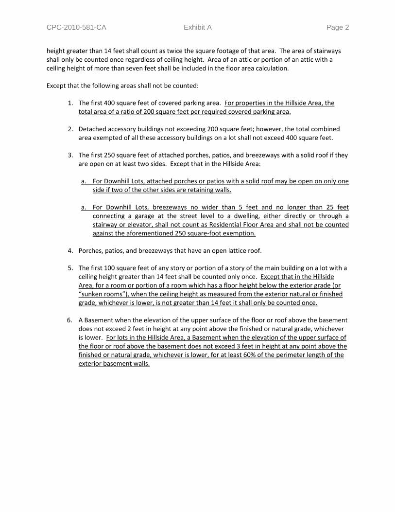
CPC-2010-581-CA Exhibit A Page 2
height greater than 14 feet shall count as twice the square footage of that area. The area of stairways shall only be counted once regardless of ceiling height. Area of an attic or portion of an attic with a ceiling height of more than seven feet shall be included in the floor area calculation. Except that the following areas shall not be counted:
1. The first 400 square feet of covered parking area. For properties in the Hillside Area, the
total area of a ratio of 200 square feet per required covered parking area. 2. Detached accessory buildings not exceeding 200 square feet; however, the total combined
area exempted of all these accessory buildings on a lot shall not exceed 400 square feet. 3. The first 250 square feet of attached porches, patios, and breezeways with a solid roof if they
are open on at least two sides. Except that in the Hillside Area:
a. For Downhill Lots, attached porches or patios with a solid roof may be open on only one side if two of the other sides are retaining walls.
a. For Downhill Lots, breezeways no wider than 5 feet and no longer than 25 feet
connecting a garage at the street level to a dwelling, either directly or through a stairway or elevator, shall not count as Residential Floor Area and shall not be counted against the aforementioned 250 square-foot exemption.
4. Porches, patios, and breezeways that have an open lattice roof. 5. The first 100 square feet of any story or portion of a story of the main building on a lot with a
ceiling height greater than 14 feet shall be counted only once. Except that in the Hillside Area, for a room or portion of a room which has a floor height below the exterior grade (or “sunken rooms”), when the ceiling height as measured from the exterior natural or finished grade, whichever is lower, is not greater than 14 feet it shall only be counted once.
6. A Basement when the elevation of the upper surface of the floor or roof above the basement
does not exceed 2 feet in height at any point above the finished or natural grade, whichever is lower. For lots in the Hillside Area, a Basement when the elevation of the upper surface of the floor or roof above the basement does not exceed 3 feet in height at any point above the finished or natural grade, whichever is lower, for at least 60% of the perimeter length of the exterior basement walls.

CPC-2010-581-CA Exhibit A Page 3
For all lots, a maximum of 2 light-wells which are not visible from a public right-of-way and do not project more than 3 feet from the exterior walls of the basement and no wider than 6 feet shall not disqualify said basement from this exemption.
FLOOR AREA RATIO (FAR). A ratio establishing relationship between a property and the amount of development permitted for that property, and is expressed as a percentage or a ratio (example: “3 times the Buildable Area” or “3:1”). In the R1, RS, RE, and RA Zones not located in a Coastal Zone, the FAR is a percentage of the lot size. For all other Zones, unless otherwise specified, the FAR is a ratio based on the Buildable Area for a lot. GRADE, HILLSIDE AREA. For the purpose of measuring height on an R1, RS, RE, or RA zoned lot in the Hillside Area, pursuant to <<BHO>> of this Article, hillside area grade shall be defined as the elevation of the finished or natural surface of the ground, whichever is lower, or the finished surface of the ground established in conformance with a grading plan approved pursuant to a recorded tract or parcel map action. Retaining walls shall not raise the effective elevation of grade for purposes of measuring height of a building or structure. [12.21 A.17(c)(5)] GRADING. Any cut or fill, or combination thereof, or recompaction of soil, rock or other earth materials. GRADING, LANDFORM. A contour grading method which creates artificial slopes with curves and varying slope rations in the horizontal plane designed to simulate the appearance of surrounding natural terrain. The graded slopes are non-linear in plan view, have varying slope gradients, and significant transition zones between human-made and natural slopes resulting in pad configurations that are irregular. The concept of landform grading incorporates the created ravine and ridge shapes with protective drainage control systems and integrated landscaping designs. GRADING, REMEDIAL. For the purposes of <<BHO>> of this Article, Remedial Grading shall mean grading recommended by a California Licensed Geologist, and approved by the Department of Building and Safety Grading Division, that is necessary to mitigate a geotechnical hazard on a site (including for access driveways), such as: 1) repair of a landslide, 2) over-excavation of a building site to remediate expansive or compressible soils, and/or 3) altering a building pad to improve site stability (usually by removing materials and lowering finish grade). LOT, DOWNHILL. A lot for which the Front Lot Line, or street from which serves as the primary vehicular access point for the required parking, is at a higher elevation than the Rear Lot Line.
Elevation A Elevation C
Elevation B Elevation D
Elevation A
Elevation C
Ele
vati
on
B
Ele
vati
on
D
CPC-2010-581-CA Exhibit A Page 4
LOT, UPHILL. A lot for which the Front Lot Line, or street from which serves as the primary vehicular access point for the required parking, is at a lower elevation than the Rear Lot Line. ROOF, LATTICE. A roof covering constructed as an Open Egg-Crate Roof or Spaced Roof. An Open Egg-Crate roof is constructed of lattice members so that a sphere of 10 inches minimum in diameter can pass through. All lattice members must have a minimum nominal width of 2 inches. A Spaced Roof is constructed of members running in one direction only with a minimum clear spacing between the members of not less than 4 inches. In addition beams supporting and placed perpendicular to the members shall be spaced not less than 24” on center. All members or beams must have a minimum nominal width of 2 inches. SLOPE. An inclined ground surface the inclination of which is expressed as a ratio of horizontal distance to vertical distance (i.e. 2:1 or 1:1) or as a percentage (i.e. 50% or 100%). SLOPE BAND. The area of a property contained within a defined slope interval as identified in <<BHO>> of this Article and shown on a Slope Analysis Map prepared by a licensed surveyor based on a survey of the natural/existing topography. Slope bands need not necessarily be located in a contiguous manner and can be one or more areas as small or as large as they exist on said property. SUBSTANDARD HILLSIDE LIMITED STREET. A street which does not meet the minimum requirements of a Standard Hillside Limited Street as defined in Section 12.03 (public or private) with a width less than 36 feet and paved to a roadway width of less than 28 feet, as determined by the Bureau of Engineering. [12.03]

CPC-2010-581-CA Exhibit A Page 5
HHIILLLLSSIIDDEE AARREEAA DDEEVVEELLOOPPMMEENNTT SSTTAANNDDAARRDDSS ((LLOOCCAATTIIOONN TTBBDD)) Hillside Area Development Standards. For a lot located in a Hillside Area, no building or structure nor the enlargement of any building or structure shall be erected or maintained unless the following development standards are provided and maintained in connection with the building, structure, or enlargement:
1. Setback Requirements. No building or structure nor the enlargement of any building or structure shall be erected or maintained unless the setbacks as outlined in Table <<BHO>>-1 are provided and maintained in connection with the building, structure, or enlargement.
Table <<BHO>>-1 Single-Family Zone Hillside Area Setback Requirements
R1 RS RE9 RE11 RE15 RE20 RE40 RA
Front Yard
Not less than: 20% of Lot Depth
Need not exceed: 20 ft 25 ft
Side Yard
Not less than: 5 ft 7ft 10% of lot width, but not less than
5 ft
10 ft
Need not exceed: n/a 10 ft n/a
The required side yard may be reduced to 10% of the Lot Width, but in no event to less than 3 ft, where the lot is less than the following widths:
50 ft 70 ft n/a 70 ft*
For buildings or structures with a height larger than 18 feet:
One additional foot shall be added to each required side yard for each increment of 10 feet or fraction thereof above the first 18 feet. [12.21 A.17(b)(2)]
Rear Yard
Not less than: 15 ft 20 ft 25% of lot depth
Need not exceed: n/a 25 ft
ft – feet n/a – the provision is not applicable Lot Depth – as defined in Section 12.03 of this Code Lot Width – as defined in Section 12.03 of this Code
Notes: * Only applicable for lots which are of record prior to July 1, 1966.
Notwithstanding the required yards, or setbacks, outlined in Table <<BHO>>-1 above, or those exceptions found in Section 12.22 of this Chapter, the following provisions shall apply:

CPC-2010-581-CA Exhibit A Page 6
a. Prevailing Front Yard Setbacks. Where all of the developed lots which have front yards
that vary in depth by not more than 10 feet comprise 40% or more of the frontage, the minimum front yard depth shall be the average depth of the front yards of such lots. Where there are two or more possible combinations of developed lots comprising 40% or more of the frontage each of which has front yards that vary in depth by not more than 10 feet, the minimum front yard depth shall be the average depth of the front yards of that combination which has the shallowest average depth. In determining the required front yard, buildings located on key lots, entirely on the rear half of lots, or on lots in the “C” or “M” Zones, shall not be counted, provided, however, that nothing contained in this paragraph shall be deemed to require front yards which exceed 40 feet in depth.
b. Front Yards on Lots Fronting on Substandard Hillside Limited Street. For any lot that
fronts on a Substandard Hillside Limited Street, there shall be a minimum front yard of at least five feet. For lots having a zoning classification that contains a provision calling for observance of the prevailing setback, The prevailing setback regulations, as outlined in Paragraph a of this Subdivision, shall apply, so long as a front yard of no less than five feet is provided. [12.21 A.17(a)(1)]
(1) Zoning Administrator’s Authority. A Zoning Administrator may grant limited
deviations from the requirements of Paragraph b of this Subdivision, pursuant to the authority and procedures established in Subdivision 28 of Subsection X of Section 12.24 of this Article.
c. Front Yard Setbacks on Key Lots. On key lots the minimum front yard may be the
average of the required front yard for the adjoining interior lot and the required side yard along the street side of a reversed corner lot, but such minimum front yard may apply for a distance or not more than 85 feet from the rear lot line of the reversed corner lot, beyond which point the front yard specified in Paragraph a of this Subdivision shall apply. Where existing buildings on either or both of said adjoining lots are located nearer to the front or side lot lines than the yard required by this Article, the yards established by such existing buildings may be used in computing the required front yard for a key lot.
d. Front Yards on Through Lots. At each end of a through lot there shall be a front yard of
the depth required by this Subsection for the zone in which each street frontage is located, except that only one front yard need be provided on those through lots which abut on a primary, major or secondary highway, as such highways are shown on the “Highways and Freeways Element of the General Plan”, when the rights to vehicular ingress and egress from such through lots to the highways have been abandoned or prohibited by a tract restriction as a condition precedent to the approval of the recordation of the subdivision in which such through lots are included. Where only one front yard is required on a through lot, as provided herein, the rear yard shall be located on the portion of such lot adjacent to the highway Where a through lot is less than 150 feet in depth or is developed as a single building site, and the two required front yards are provided, no rear yard is required. [12.21 C.1(h)]
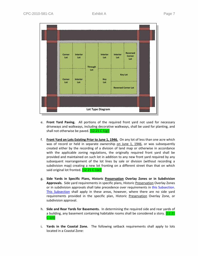
CPC-2010-581-CA Exhibit A Page 7
e. Front Yard Paving. All portions of the required front yard not used for necessary driveways and walkways, including decorative walkways, shall be used for planting, and shall not otherwise be paved. [12.21 C.1(g)]
f. Front Yard on Lots Existing Prior to June 1, 1946. On any lot of less than one acre which
was of record or held in separate ownership on June 1, 1946, or was subsequently created either by the recording of a division of land map or otherwise in accordance with the applicable zoning regulations, the originally required front yard shall be provided and maintained on such lot in addition to any new front yard required by any subsequent rearrangement of the lot lines by sale or division (without recording a subdivision map) creating a new lot fronting on a different street than that on which said original lot fronted. [12.21 C.1(e)]
g. Side Yards in Specific Plans, Historic Preservation Overlay Zones or in Subdivision
Approvals. Side yard requirements in specific plans, Historic Preservation Overlay Zones or in subdivision approvals shall take precedence over requirements in this Subsection. This Subsection shall apply in these areas, however, where there are no side yard requirements provided in the specific plan, Historic Preservation Overlay Zone, or subdivision approval.
h. Side and Rear Yards for Basements. In determining the required side and rear yards of
a building, any basement containing habitable rooms shall be considered a story. [12.21 C.1(l)]
i. Yards in the Coastal Zone. The following setback requirements shall apply to lots
located in a Coastal Zone:
Lot Type Diagram
Corner Lot
Corner Lot
Reversed Corner
Lot
Interior Lot
Interior Lot
Interior Lot
Interior Lot
Key Lot
Key Lot
Reversed Corner Lot
Through Lot

CPC-2010-581-CA Exhibit A Page 8
(1) On a lot in the RE9 or RE11 Zone, there shall be a side yard on each side of a main building of not less than 5 feet, except that, where the lot is less than 50 feet in width, the side yard may be reduced to 10% of the width of the lot, but in no event less than 3 feet.
(2) In lieu of the additional side yard requirement in Table <<BHO>>-1, for a building
more than two-stories in height on lots in the R1, RS, or RE Zone, one foot shall be added to the width of each required side yard for each additional story above the second story.
(3) On a lot in the RA Zone, where a side yard is less than 10 feet in width, and the
building erected on the lot is three or more stories in height, one foot shall be added to such side yard.
j. Projections Encroachments Into Required Yards. Notwithstanding those exceptions
found in Section 12.22 of this Chapter, every required front, side and rear yard shall be open and unobstructed from the ground to the sky except for the following: [12.21 C.1(g)]
(1) Garages in Front Yards. A private garage may be located on the required front yard
of a lot having a slope conforming to that specified in Section 12.22-C.6, provided every portion of the garage building is al least 5 feet from the front lot line. Where the wall of such garage is two-thirds below natural or finished grade of the lot, whichever is lower, said wall may extend to the adjacent side lot line; in all other cases, said garage shall not be nearer to the side lot line than the width of the side yard required for a main building of the same height. [12.21 C.5 (l)]
(2) Open, Unenclosed Stairways or Balconies. Notwithstanding any other provisions of this Code, on lots fronting onto a Substandard Hillside Limited Street, open unenclosed stairways, porches, platforms and landing places not covered by a roof or canopy shall not project or extend into the front yard. Balconies with 10 feet of vertical clearance beneath them may project or extend no more than 30 inches into a front yard. [12.21 A.17(a)(3)]
(3) Open, Unenclosed Porches, Platforms, or Landing Places. Notwithstanding any other provisions of this Code, on lots fronting onto a Substandard Hillside Limited Street, open unenclosed stairways, porches, platforms and landing places not covered by a roof or canopy shall not project or extend into the front yard. Balconies with 10 feet of vertical clearance beneath them may project or extend no more than 30 inches into a front yard. [12.21 A.17(a)(3)]
k. Pools, Ponds, or Body of Water in Required Yards. No swimming pool, fish pond or
other body of water which is designed or used to contain water 18 inches or more in depth shall be permitted in any required yard space in which fences over 42 inches in height are prohibited, even though the pool, pond or body of water extends below the adjacent natural ground level. [12.21 C.1(g)]
2. Maximum Residential Floor Area. The maximum Residential Floor Area contained in all
buildings and accessory buildings shall not exceed the sum of the square footage of each Slope Band multiplied by the corresponding Floor Area Ratio (FAR) for the zone of the lot, as outlined

CPC-2010-581-CA Exhibit A Page 9
in Table <<BHO>>-2. This formula can be found in Figure <<BHO>>-1, where “A” is the area of the lot within each slope band, “M” is the FAR of the corresponding slope band, “V” is the sum of the residential floor area of each slope band.
Table <<BHO>>-2 Single-Family Zone Hillside Area Residential Floor Area Ratios (FAR)
Slope Bands (%) R1 RS RE9 RE11 RE15 RE20 RE40 RA
0 – 14.99 0.50 0.45 0.40 0.40 0.35 0.35 0.35 0.25
15 – 29.99 0.45 0.40 0.35 0.35 0.30 0.30 0.30 0.20
30 – 44.99 0.40 0.35 0.30 0.30 0.25 0.25 0.25 0.15
45 – 59.99 0.35 0.30 0.25 0.25 0.20 0.20 0.20 0.10
60 – 99.99 0.30 0.25 0.20 0.20 0.15 0.15 0.15 0.05
100 + 0.00 0.00 0.00 0.00 0.00 0.00 0.00 0.00
Figure <<BHO>>-1 Hillside Area Maximum Residential Floor Area Formula
Slope Bands (%) Area (sq-ft) FAR Residential Floor Area
0 – 14.99 A1 X M1 = V1 15 – 29.99 A2 X M2 = V2 30 – 44.99 A3 X M3 = V3 45 – 59.99 A4 X M4 = V4 60 – 99.99 A5 X M5 = V5
100 + A6 X M
6 = V
6
Maximum Residential Floor Area = Sum of V1 through V
6
a. Slope Analysis Map. As part of an application for a permit to the Department of
Building & Safety, or for a Discretionary Approval as defined in Section 16.05 B of this Code to the Department of City Planning the applicant shall submit a Slope Analysis Map based on a survey of the natural/existing topography, prepared and signed by a registered civil engineer or licensed land surveyor, to verify the total area (in square-feet) of the portions a property within each slope band identified in Table <<BHO>>-2 of this Subsection. The map shall have a scale of not less than 1 inch to 100 feet and a contour interval of not more than 10 feet with one-foot intermediates. The Slope Analysis Map shall delineate the slope bands, with contrasting colors, and shall include a tabulation of the total area in square-feet within each slope band, as well as the FAR and Residential Floor Area value of each corresponding slope band. The Slope Analysis Map shall be prepared using CAD-based or GIS-based software specifically designed for such purpose and approved for such use by the Department of Public Works, Bureau of Engineering. The Slope Analysis Map shall be stamped and signed by a registered civil engineer or licensed land surveyor, indicating the datum, source, and scale of topographic data used in the slope analysis, and attesting to the fact that the slope analysis has been accurately calculated.

CPC-2010-581-CA Exhibit A Page 10
b. Guaranteed Minimum Residential Floor Area. Notwithstanding the above, if a property
meets the current minimum lot size requirements, the maximum Residential Floor Area for all buildings and accessory buildings on any lot need not be less than 1,250 square feet in the R1 Zone, 1,688 square feet in the RS Zone, 1,800 square feet in the RE9 Zone, 2,200 square feet in the RE11 Zone, 2,625 square feet in the RE15 Zone, 3,500 square feet in the RE20 Zone, 7,000 square feet in the RE40 Zone, and 2,188 square feet in the RA Zone. For lots which were made nonconforming in lot size as a result of an adopted zone change or code amendment changing the minimum lot size and met the minimum lot size requirements of the original zone, the guaranteed minimum for the original zone as stated in the paragraph above shall apply. For all other lots which are nonconforming in lot size, the maximum Residential Floor Area for all buildings and accessory buildings need not be less than 750 square-feet.
c. Residential Floor Area Bonus. An additional 20% of the maximum Residential Floor
Area, as determined by Table <<BHO>>-2 or by Paragraph b of this Subdivision, for that lot shall be allowed if any of the options listed below is utilized. Only one 20% bonus per property is allowed.
(1) Proportional Stories Option. The total residential floor area of each story other
than the Base Floor in a multi-story building does not exceed 75% of the base floor area. This option shall only apply where the slope of the building pad area prior to any grading, as measured from the highest point of the existing grade within 5 horizontal feet of the exterior wall of the proposed building or structure to the lowest point of the existing grade within 5 horizontal feet, is less than 15%; or
(2) Front Facade Stepback Option. The cumulative length of the exterior walls which
are not a part of a garage facing the front lot line, equal to a minimum of 25% of the building width shall be stepped-back a distance of at least 20% of the building depth from a plane parallel to the lot width established at the point of the building closest to the front lot line, as illustrated in Figure <<BHO>>-2. When the front lot line is not straight, a line connecting the points where the side lot lines and the front lot line intersect shall be used, as illustrated in Figure <<BHO>>-3. When through-lots have two front yards, the step-back shall be provided along both front lot lines. For the purposes of this provision, all exterior walls that intersect a plane parallel to the front lot line at 45 degrees or less shall be considered to be facing the front lot line. The building width shall be the greatest distance between the exterior walls of the building measured parallel to the lot width. The building depth shall be the greatest distance between the exterior walls of the building measured parallel to the lot depth. This option shall only apply where the slope of the building pad prior to any grading, as measured from the highest point of the existing grade within 5 horizontal feet of the exterior wall of the proposed building or structure to the lowest point of the existing natural grade within 5 horizontal feet, is less than 15%; or

CPC-2010-581-CA Exhibit A Page 11
(3) Cumulative Side Yard Setbacks Option. Side yard setbacks shall be cumulatively at least 25% of the total Lot Width, as defined in Section 12.03, but in no event shall a single side yard setback be less than 10% of the Lot Width or the minimum required by Subdivision 1 of this Subsection, whichever is greater; or
(4) 18-Foot Envelope Height Option. For properties which are not in the “1SS” Single-Story Height District, the maximum envelope height, measured pursuant to Paragraph a of Subdivision 4 of this Subsection, shall be no more than 18 feet; or
(5) Multiple Structures Option. In addition to the lot coverage requirements in Subdivision 5 of this Subsection, any one building and structure extending more than 6 feet above natural ground level shall cover no more than 20% of the area of a lot. For the purposes of this provision, these structures may only be connected by one breezeway, fully enclosed walkway, elevator, or combination thereof of not more than 5 feet in width; or
(6) Minimal Grading Option. For properties where at least 60% of the lot is comprised
of slopes which are 30% or greater, as determined by the Slope Analysis Map, the total grading on the site, including exempted grading, as outlined in Subdivision 6 of this Subsection, does not exceed the numeric value of 10% of the total lot size in cubic yards or 1,000 cubic yards, whichever is less (example: a project involving 500 cubic-yards of non-exempt grading on a 5,000 square-foot lot will eligible for this bonus option); or
(7) Landform Grading Option. For properties where at least 60% of the lot is comprised of slopes which are 30% or greater, as determined by the Slope Analysis Map, the total quantities of non-exempted grading, as outlined in Subdivision 6 of this Subsection, on the site does not exceed 1,000 cubic yard and landform grading, as outlined in the Department of City Planning – Planning Guidelines Landform Grading Manual, is used to reflect original landform and result in minimum disturbance to natural terrain; or
Figure <<BHO>>-2 Front Facade Stepback
Building Width
Bu
ildin
g
Dep
th
20
%
20% Stepback Plane
Front Yard Parallel
Plane Facing Front Lot
Line
Building Width
25%
Bu
ildin
g
Dep
th
20
%
Figure <<BHO>>-3 Front Facade Stepback
CPC-2010-581-CA Exhibit A Page 12
(8) Green Building Option 1. For new single family dwelling construction only, the new construction shall be in substantial compliance with the requirements for the U.S. Green Building Council’s (USGBC) Leadership in Energy and Environmental Design (LEED®) for Homes program at the “Silver” level or higher. Prior to submitting an application to the Department of Building and Safety for a building permit, the applicant shall be required to obtain an authorization to submit for plan check from the Department of City Planning. In order to obtain this authorization, the applicant shall provide: (i) Documentation that the project has been registered with the USGBC’s LEED® for
Homes Program, and that the required fees have been paid; (ii) A preliminary checklist from a USGBC-contracted LEED® for Homes Provider,
which demonstrates that the project can be registered with the LEED® for Homes Program with a target of certification at the “Silver” or higher level;
(iii) A signed declaration from the USGBC-contracted LEED® for Homes Provider
stating that the plans and plan details have been reviewed, and confirms that the project can be registered with the LEED® for Homes Program with a target certification at the “Silver” or higher level; and
(iv) A complete set of plans stamped and signed by a licensed architect or engineer
that include a copy of the preliminary checklist and signed declaration identified in Subparagraphs (2) and (3) of this paragraph and identify the measures being provided for LEED® Certification at the “Silver” level. Each plan sheet must also be signed by a USGBC-contracted LEED® for Homes Provider verifying that the plans are consistent with the submitted preliminary checklist.
The Department of Building and Safety shall refer applicants to the Department of City Planning prior to issuance of a building permit to obtain a clearance to verify the project compliance with the originally approved plans. If changes are made to the project, the applicant shall be required to submit a revised set of plans, including the four requirements listed above, with all revisions necessary to make the project in substantial compliance with the requirements for LEED® Certification at the “Silver” level.
(9) Green Building Option 2. Project exceeds the energy efficiency performance of a
home built to the Title-24 requirements by at least 15%. Projects can minimize the amount of energy used by installing energy-efficient systems, such as Energy Star appliances, as well as by minimizing the amount of energy lost as a result of the building envelope. All projects should have an Energy Usage Plan and should document in detail which features/measures will be implemented in order to limit energy usage. Energy Usage Plans should correspond to the requirements of Title-24.
e. Zoning Administrator’s Authority.

CPC-2010-581-CA Exhibit A Page 13
(1) 10% Adjustments. The Zoning Administrator has the authority to grant adjustments from the requirements of Paragraphs a and c of this Subdivision of not more than 10%, pursuant to the authority and procedures established in Subsection A of Section 12.28 of this Article.
(2) Additions to Structures Existing Prior to August 1, 2010. The Zoning Administrator
has the authority to approve any additions made after August 1, 2010 to a one-family dwelling existing prior to that date with the benefit of permits which exceed the requirements of Paragraphs a and c of this Subdivision, provided: [12.21 A.17(i)(3)]
(i) the total cumulative Residential Floor Area of all such additions does not exceed
750 square feet (excluded from calculations of this 750 square foot limitation is floor area devoted to required parking); and [12.21 A.17(i)(3)(a)]
(ii) the resulting building does not exceed the height of the original building or the
height permitted in Subdivision 4 of this Subsection, whichever is greater; and [12.21 A.17(i)(3)(b)]
(iii) at least two off-street parking spaces are provided. [12.21 A.17(i)(3)(c)]
3. Verification of Existing Residential Floor Area. For additions with cumulative Residential Floor
Area of less than 1,000 square feet constructed after August 1, 2010, or remodels of buildings built prior to August 1, 2010, the existing residential floor area shall be the same as the building square footage shown on the most recent Los Angeles County Tax Assessor’s records at the time the plans are submitted to the Department of Building and Safety and a plan check fee is paid. Except that residential floor area may be calculated as defined in Section 12.03 of this Code when a complete set of fully dimensioned plans with area calculations of all the structures on the lot, prepared by a licensed architect or engineer, is submitted by the applicant. Any work that does not qualify as a remodel, as defined in the paragraph below, or additions that are 1,000 square feet or larger shall require a complete set of fully dimensioned plans with area calculations of all the structures on the lot prepared by a licensed architect or engineer. For the purposes of implementing this Subdivision, a remodel shall mean the alteration of an existing building or structure provided that at least 50 percent of the perimeter length of the contiguous exterior walls and 50 percent of the roof are retained.
4. Height Limits. No portion of a building or structure shall be erected or enlarged which exceeds
the envelope height limits as outlined in Table <<BHO>>-3, or as otherwise stated in the paragraphs below.
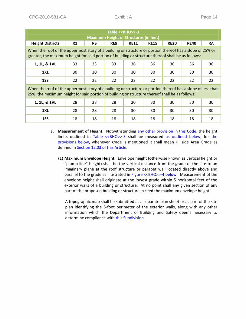
CPC-2010-581-CA Exhibit A Page 14
Table <<BHO>>-3 Maximum Height of Structures (in feet)
Height Districts R1 RS RE9 RE11 RE15 RE20 RE40 RA
When the roof of the uppermost story of a building or structure or portion thereof has a slope of 25% or greater, the maximum height for said portion of building or structure thereof shall be as follows:
1, 1L, & 1VL 33 33 33 36 36 36 36 36
1XL 30 30 30 30 30 30 30 30
1SS 22 22 22 22 22 22 22 22
When the roof of the uppermost story of a building or structure or portion thereof has a slope of less than 25%, the maximum height for said portion of building or structure thereof shall be as follows:
1, 1L, & 1VL 28 28 28 30 30 30 30 30
1XL 28 28 28 30 30 30 30 30
1SS 18 18 18 18 18 18 18 18
a. Measurement of Height. Notwithstanding any other provision in this Code, the height
limits outlined in Table <<BHO>>-3 shall be measured as outlined below; for the provisions below, whenever grade is mentioned it shall mean Hillside Area Grade as defined in Section 12.03 of this Article.
(1) Maximum Envelope Height. Envelope height (otherwise known as vertical height or
“plumb line” height) shall be the vertical distance from the grade of the site to an imaginary plane at the roof structure or parapet wall located directly above and parallel to the grade as illustrated in Figure <<BHO>>-4 below. Measurement of the envelope height shall originate at the lowest grade within 5 horizontal feet of the exterior walls of a building or structure. At no point shall any given section of any part of the proposed building or structure exceed the maximum envelope height. A topographic map shall be submitted as a separate plan sheet or as part of the site plan identifying the 5-foot perimeter of the exterior walls, along with any other information which the Department of Building and Safety deems necessary to determine compliance with this Subdivision.

CPC-2010-581-CA Exhibit A Page 15
b. Zoning Administrator’s Authority. A Zoning Administrator may grant limited deviations from the requirements of Paragraph a of this Subdivision, pursuant to the authority and procedures established in Subdivision 28 of Subsection X of Section 12.24 of this Article.
c. Prevailing Height. Notwithstanding Paragraph a of this Subdivision, when 40% or more
of the existing one-family dwellings with frontage on both sides of the block have building heights exceeding these limits, the maximum envelope height for any building on that block may be the average height of the dwellings exceeding these limits.
d. Lots in a Single-Story Height District. As enabled by Section 12.21.1 A. 1 of this Article,
on lots in a “SS” Single Story Height District, shown as “1SS” on a Zoning Map, no building or structure shall be erected or enlarged which exceed one story. Notwithstanding the provision in Section 12.21.1 A.8, in determining the number of stories, any basement which is exempt from the Residential Floor Area calculation, as outlined in Section 12.03 of this Code, shall not be considered a story.
e. Lots Fronting on Substandard Hillside Limited Streets. For any lot, where the elevation
of the ground at a point 50 feet from the front lot line and midway between the side lot lines is 33 feet or more higher than the lowest point of the front lot line, fronting onto a Substandard Hillside Limited Street, as defined in Section 12.03, and subject to the 5-foot front yard setback, no portion of a building or structure within 20 feet of the front lot line shall exceed 24 feet in height. The 24 foot maximum building and structure height shall be measured from the elevation at the centerline or midpoint of the street on which the lot fronts. Portions of a building or structure beyond the front yards setback of the base zone, structures would be allowed those heights permitted under Paragraph a of this Subdivision. [12.21 A.17(c)(4)]
f. Unenclosed/Uncovered Rooftop Decks and Cantilevered Balconies.
Unenclosed/uncovered rooftop decks, cantilevered balconies and “visually permeable railing” no more than 42 inches in height, may project beyond the maximum envelope height, as limited and measured in Paragraph a of this Subdivision, no more than 5 horizontal feet.
Figure <<BHO>>-4 Envelope Height Concept

CPC-2010-581-CA Exhibit A Page 16
For the purposes of this Paragraph, “visually permeable railing” means railing constructed of material that is transparent, such as glass or plastic panels, or wrought iron or other solid material which is 80% open to light and air.
g. Roof Structures. Roof structures as outlined in Table <<BHO>>-4 below, or similar
structures, may be erected above the height limit specified in Table <<BHO>>-3.
Table <<BHO>>-4 Projecting Roof Structures
Roof Structures Projection Above Height Limit
Setback from Roof Perimeter
Elevator Housing
No more than 5 feet.
Not less than 5 feet.
Tanks
Ventilating Fans or similar equipment required to operate and maintain the building.
Towers
Steeples
Flagpoles
Smokestacks
Wireless Masts
Water Tanks
Silos
Solar Energy Devices
Chimneys
None.
Exhaust Ducts/Ventilation Shafts
Stairway Housing, no larger than 36 square-feet.
Skylights, covering more than 33 1/3% of the roof area upon which the skylight is constructed.
No more than 30 inches.
No roof structure or any other space above the height limit specified in Table <<BHO>>-3 shall be allowed for the purpose of providing additional floor space.
h. Specific Plans, Historic Preservation Overlay Zones or Subdivision Approvals. Height
limitations in specific plans, Historic Preservation Overlay Zones or in subdivision approvals shall take precedence over the requirements of this section. This section shall apply when there are no height limitations imposed on lots by a specific plan or a Historic Overlay Zone or created by a subdivision approval.
5. Lot Coverage. Buildings and structures extending more than 6 feet above natural ground level
shall cover no more than 40% of the area of a lot. [12.21 A.17(f)(1)]
a. Lot Coverage on Substandard Lots. Notwithstanding the paragraph above, for a lot which is substandard as to width (less than 50 feet) and as to area (less than 5,000 square feet), buildings and structures shall cover no more than 45% of the area of a lot. [12.21 A.17(f)(2)]

CPC-2010-581-CA Exhibit A Page 17
b. Zoning Administrator’s Authority. A Zoning Administrator may grant limited deviations from these requirements, pursuant to the authority and procedures established in Subdivision 28 of Subsection X of Section 12.24 of this Article.
6. Grading. Notwithstanding any other provisions of the Municipal Code, total grading (cut and
fill) on a lot shall be limited as outlined below. No grading permits shall be issued until a building permit is approved.
a. Maximum Grading Quantities. The maximum cumulative quantity of grading, or the
total combined value of both cut and fill or incremental cut and fill, for any one property shall be limited to a maximum of 500 cubic yards plus the numeric value equal to 5% of the total lot size in cubic yards, up to a maximum of 1,000 cubic yards total. Example: a 5,000 square-foot lot would have a maximum grading amount of 750 cubic yards (500 cubic yards for the base amount + 250 cubic yards for the 5% calculation).
b. Import/Export Limits. The maximum quantity of earth import shall be no more than
500 cubic yards, where additional grading on-site does not exceed 500 cubic yards in conjunction with any landform alteration so that the maximum amount of grading is no greater than 1,000 cubic yards. The maximum quantity of earth export shall be no more than 1,000 cubic yards. However, for a property which fronts onto a Substandard Hillside Limited Street, as defined in Section 12.03, the maximum quantity of earth import shall be no more than 375 cubic yards, where additional grading on-site does not exceed 625 cubic yards in conjunction with any landform alteration so that the maximum amount of grading is no greater than 1,000 cubic yards. The maximum quantity of earth export shall be no more than 750 cubic yards.
c. Zoning Administrator’s Authority. A Zoning Administrator may grant limited deviations from the requirements of Paragraphs a and b of this Subdivision, pursuant to the authority and procedures established in Subdivision 28 of Subsection X of Section 12.24 of this Article.
d. Grading on Extreme Slopes. Grading, excepted as otherwise noted in this Paragraph, on
slopes greater than or equal to 100% shall be done only when recommended by a full site Geotechnical Investigation Report and approved by the Department of Building & Safety Grading Division in order to mitigate previously existing unsafe conditions. Except that grading activity exempted by Subparagraphs (1) and (2) of Paragraph g of this Subdivision shall not be prohibited as a result of this provision when the portions of a slope that are greater than or equal to 100% is no more than 100 square feet.
e. Landform Grading Requirement. For any project, including remedial grading, involving
1,000 cubic yards or more of grading, landform grading, as outlined in the Department of City Planning – Planning Guidelines Landform Grading Manual, shall be used to reflect original landform and result in minimum disturbance to natural terrain. Notching into hillsides is encouraged so that projects are built into natural terrain as much as possible.
CPC-2010-581-CA Exhibit A Page 18
f. New Graded Slopes. All new graded slopes shall be no steeper than 2:1 (rise:run), except when the Grading Division has determined that slopes may exceed 2:1 pursuant to Section 91.105 of Division 1 of Chapter IX of this Code.
g. Exceptions. The following grading activity shall be exempt from the grading limitations
established in Paragraph a of this Subdivision:
(1) Cut for foundations, required animal keeping site development, understructures including basements, pools, water storage tanks, or other completely subterranean spaces that do not involve the construction of any retaining walls.
(2) Cut and/or fill, up to 500 cubic yards, for driveways to the required parking or fire
department turnaround closest to the accessible street for which a lot has ingress/egress rights.
(3) Remedial Grading as defined in Section 12.03 of this Article as recommended in a
Geotechnical Investigation Report, prepared in accordance with Paragraph h of this Subdivision, and approved by the Department of Building and Safety Grading Division shall be excluded from grading limitations.
However, any excavation being used as fill, outside of a 5-foot perimeter from the exterior walls of a building, structure, required animal keeping site development, driveway, or fire department turnaround, for any other on-site purpose shall be counted towards the limits established in Paragraph a of this Subdivision.
h. Geotechnical Investigation Report. Notwithstanding the provisions in Sections
91.7006.2, 91.7006.3, and 91.7006.4 of Division 70 of Chapter IX of this Code, a Geotechnical Investigation Report (also referred to as a soils and/or geological report) that evaluates the proposed project’s soil and grading shall be submitted to the LADBS Grading Division for review. This report shall be prepared by a registered geotechnical (or soils) engineer, as defined in Section 91.7003 of Division 70 or Chapter IX of this Code, and in sufficient detail to substantiate and support the design concepts being proposed. In addition to the requirements in Sections 91.7006.2, 91.7006.3, and 91.7006.4 of Division 70 of Chapter IX of this Code this report shall include:
(1) A Phase I Geotechnical Analysis involving a records search and detailed assessment
of any other report on file for any property within 1,000 feet of the subject property, with a minimum of 5 separate reports for 5 individual properties; and
(2) A Phase II Geotechnical Analysis involving physical investigation of soils identifying
any hazards present on the property. An approved Soils & Grading Report letter from LADBS – Grading Division shall be required prior to approval of a grading, foundation or building permit.
i. Grading Plancheck Criteria. Grading plans and reports shall be submitted for approval
with building plans, and shall include those items required by Section 91.7006 of Division 70 of Chapter IX of this Code.

CPC-2010-581-CA Exhibit A Page 19
7. Off-Street Parking Requirements. No building or grading permit shall be issued for the construction of any one-family dwelling, accessory building, Major Remodel-Hillside, or addition thereto located on a lot which fronts on a Substandard Hillside Limited Street, unless the following requirements are met. [12.21 A.17(h)]
a. Number of Required Spaces. There shall be at least two automobile parking spaces on
the same lot with each one-family dwelling thereon. These required parking spaces shall be provided within a private garage. [12.21 A.4(a)] No automobile These required parking spaces shall not be provided or maintained within a required front yard. [12.21 C.1(g)]
(1) Exception for Dwelling on Narrow Lot. Where only one single-family dwelling is
located on a nonconforming lot 40 feet or less in width and not abutting an alley, only one automobile parking space need be provided. This exception shall not apply to any lot in the A1, RA, RE, RS, R1 or RD Zones which fronts on a Substandard Hillside Limited Street.. [12.21 A.4(q)]
b. Additional Required Spaces. For a main building and any accessory building located on
a lot which fronts on a Substandard Hillside Limited Street, excluding floor area devoted to required parking, which exceed a combined residential floor area of 2,400 square feet, there shall be one additional parking space provided for each additional increment of 1,000 square feet or fraction thereof of floor area for a maximum of 5 total on-site spaces. [12.21 A.17(h)(1)] These additional required parking spaces may be uncovered and in tandem. Notwithstanding the provisions of Section 12.21 C.1(g) of this Code to the contrary, when a lot fronts onto a Substandard Hillside Limited Street, the additional parking spaces required by this Subdivision may be uncovered and in tandem, and may be located within the required 5-foot front yard. [12.21 A.17(h)(2)]
(1) Zoning Administrator’s Authority. A Zoning Administrator may grant limited
deviations from the requirements of Paragraphs b of this Subdivision, pursuant to the authority and procedures established in Subdivision 28 of Subsection X of Section 12.24 of this Article.
(1) Grading for Additional Required Parking. If the requirements in this Paragraph
require the grading of 1,000 cubic yards or more of earth, then no building or grading permit shall be issued for a new one-family dwelling, accessory building, Major Remodel-Hillside, or addition to the above on a lot which fronts on a Substandard Hillside Limited Street unless the Zoning Administrator has issued an approval pursuant to Section 12.24 X.2128 of this Code. [12.21 A.17(h)(3)]
d. Parking Stall Dimensions. In each parking area or garage devoted to parking for
dwelling uses, all parking stalls in excess of one parking stalls per dwelling unit may be designed as compact stalls to accommodate parking cars. Every standard parking stall provided for dwelling units shall be at least 8 feet 6 inches in width and 18 feet in length, every compact stall shall be at least 7 feet 6 inches in width and 15 feet in length. [12.21 A.5(a)] [12.21 A.5(c)]
CPC-2010-581-CA Exhibit A Page 20
e. Tandem Parking. Automobile parking may be parked in tandem in a private parking garage or private parking area serving a one-family dwelling where the tandem parking is not more than two cars in depth. Each required parking stall within a parking area or garage shall be accessible. Tandem parking shall not be allowed in parking areas for recreational vehicles or guest parking. [12.21 A.5(h)]
f. Garage Doors. Any door or doors installed at the automobile entry to a garage serving a
one-family dwelling where the required parking spaces are located shall be of conventional design constructed so as to permit the simultaneous entry of automobiles in each required parking space without damaging the door or door frame and constructed so as to permit the flow of air through the automobile entry when the door is in the fully closed position. [12.21 A.4(a)]
g. Driveway Width. Every access driveway shall be at least 9 feet in width. [12.21 A.5(f)]
h. Garages in Front Yards. A private garage may be located in the required front yard of a
lot having a slope conforming to that specified in Section 12.22-C.6, provided every portion of the garage building is at least 5 feet from the front lot line. Where the wall of such garage is two-thirds below natural or finished grade of the lot, whichever is lower, said wall may extend to the adjacent side lot line; in all other cases, said garage shall not be nearer to the side lot line than the width of the side yard required for a main building of the same height. [12.21 C.5 (l)]
i. Mechanical Automobile Lifts and Robotic Parking Structures. The stacking of two or
more automobiles via a mechanical car lift or computerized parking structure is permitted. The platform of the mechanical lift on which the automobile is first place shall be individually and easily accessible and shall be placed so that the location of the platform and vehicular access to the platform meet the requirements of paragraphs (a), (b), and (i) of Subdivision 5 of Subsection A of Section 12.21 of this Article. The lift equipment or computerized parking structure shall meet any applicable building, mechanical and electrical code requirements as approved by the Department of Building and Safety. [12.21 A.4(m)]
8. Fire Protection. Notwithstanding any other provisions of this Code to the contrary, any new construction of a one-family dwelling or detached accessory building, on a lot fronting onto a Substandard Hillside Limited Street, or on any lot located either more than 2 miles from a fire station housing a Los Angeles City Fire Department Truck Company or more than 1½ miles from a fire station housing a Los Angeles Fire Department Engine Company, shall be protected throughout with an approved automatic fire sprinkler system, in compliance with the Los Angeles Plumbing Code. [12.21 A.17(d)(1)]
a. Existing Buildings or Structures. An approved automatic fire sprinkler system in
compliance with the Los Angeles Plumbing Code shall be installed: [12.21 A.17(d)(2)] (1) whenever an addition to an existing one-family dwelling or accessory building
increases in residential floor area by 50% or more of the area of the existing dwelling or building; or [12.21 A.17(d)(2)(i)]
(2) whenever the aggregate value of Major Remodels within a one-year period exceeds
50% of the replacement cost of the dwelling or accessory building; and the dwelling

CPC-2010-581-CA Exhibit A Page 21
or accessory building is on a lot located on a Substandard Hillside Limited Street and located either more than 2 miles from a fire station housing a Los Angeles City Fire Department Truck Company or more than 1½ miles from a fire station housing a Los Angeles Fire Department Engine Company. [12.21 A.17(d)(2)(ii)]
b. Fire Sprinkler Coverage. The sprinkler systems required in this Subdivision shall be
sufficient to cover the entire dwelling or building, unless otherwise determined by the Department of Building and Safety, and shall be installed in compliance with all Codes. [12.21 A.17(d)(3)]
c. Exempt Accessory Structures. The provisions of this Subdivision shall not apply to
accessory structures such as gazebos, pergolas, or storage sheds provided these structures are not supported by or attached to any portion of a dwelling or accessory building and do not exceed 200 square feet in floor area. [12.21 A.17(d)(4)]
9. Street Access.
a. Street Dedication. For any new construction of, or addition to, a one-family dwelling on a lot fronting on a Substandard Hillside Limited Street, no building permit or grading permit shall be issued unless at least one-half of the width of the street(s) has been dedicated for the full width of the frontage of the lot to Standard Hillside Limited Street dimensions or to a lesser width as determined by the City Engineer. The appellate procedures provided in Section 12.37 I of this Code shall be available for relief from this paragraph. [12.21 A.17(e)(1)]
b. Minimum Roadway Width. For any new construction of, or addition to a one-family
dwelling on a lot fronting on a Substandard Hillside Limited Street that is improved with a roadway width of less than 20 feet, no building permit or grading permit shall be issued unless the construction or addition has be approved pursuant to Section 12.24 X.2128 of this Code. [12.21 A.17(e)(2)]
c. Minimum Roadway Width. For any new construction of, or addition to a one-family
dwelling on a lot that does not have a vehicular access route from a street improved with a minimum 20-foot wide continues paved roadway from the driveway apron that provides access to the main residence to the boundary of the Hillside Area, no building permit or grading permit shall be issued unless the construction or addition meets the requirements of this Subsection or has been approved by a Zoning Administrator pursuant to Section 12.24 X.2128 of this Code. [12.21 A.17(e)(3)]
10. Sewer Connection. No building permit shall be issued for the construction of any new one-family dwelling on a lot located 200 feet or less from a sewer mainline unless a sewer connection is provided to the satisfaction of the City Engineer. [12.21 A.17(g)]
11. Hillside Neighborhood Overlay. The provisions of Subdivisions 2, 4 and 6 of this Subsection may be superseded by a Hillside Neighborhood Overlay adopted pursuant to Section 13.## of this Code.

CPC-2010-581-CA Exhibit A Page 22
12. Exceptions. The provision of this Subsection shall not apply to: [12.21 A.17(i)]
a. Tracts With CC&Rs Approved After February 1, 1985. One-family dwellings, accessory buildings and additions thereto within a subdivision for which a tentative or final tract map was approved by the City of Los Angeles after February 1, 1985, and is still valid, provided that the map resulted in the establishment of covenants, conditions and restrictions governing building height, yards, open space or lot coverage, and provided, further, that such covenants, conditions and restrictions were recorded on or after February 1, 1985. [12.21 A.17(i)(1)]
x. Streets With Minimum Width of 28 Feet. Any construction on a lot with a vehicular
access from a street improved with a minimum 28-foot wide continuous paved roadway within the Hillside Area, provided: [12.21 A.17(i)(2)] (1) the roadway begins at the driveway apron which provides access to the main
residence and ends where the roadway intersects a designated collector street, or a secondary or major highway where the collector, major or secondary highway roadway also has a minimum continuous paved roadway width of 28 feet from the apron to the edge of the Hillside Area boundaries. [12.21 A.17(i)(2)(i)]
(2) the area within the vehicular access does not contain any encroachment which
would prohibit the passage of emergency vehicles. [12.21 A.17(i)(2)(ii)]
x. Additions to Dwellings Built Prior to September 14, 1992. Any additions made after September 14, 1992, to a one-family dwelling existing prior to that date, provided: [12.21 A.17(i)(3)] (1) the total cumulative floor area of all such additions does not exceed 750 square feet
(excluded from calculations of this 750 square foot limitations is floor area devoted to required parking); and [12.21 A.17(i)(3)(a)]
(2) the resulting building does not exceed the height of the original building or the
height permitted in Subdivision 4 of this Subsection whichever is greater; and [12.21 A.17(i)(3)(b)]
(3) at least 2 off-street parking spaces are provided. [12.21 A.17(i)(3)(c)]
b. Hillside Major Remodel. As defined in Section 12.03, Any remodeling of a main building
on a lot in the Hillside Area, as defined in Section 12.03, which does not add square-footage and for which the aggregate value of all the alterations which a one-year period does not exceed 50% of the replacement cost of the main building. [12.21 A.17(i)(4)]
x. Vested Development Plan. Where architectural and structural plans sufficient for a
complete plan check for a building permit for a building or structure were accepted by the Department of Building and Safety and for which a plan check fee was collected on or before the effective date of this Subdivision, and for which no subsequent changes are made to those plans which increase the height or reduce front or side yards. However, any building permit shall become invalid if construction pursuant to the

CPC-2010-581-CA Exhibit A Page 23
permit is not commenced within 18 months of the date the plan check fee was collected. [12.21 A.17(i)(5)]
NNOONNCCOONNFFOORRMMIINNGG RRIIGGHHTTSS ((1122..2233 AA..11))
(c) A building, nonconforming as to the residential floor area regulations on properties zoned RA, RE, RS, and R1, not including properties in the Coastal Zone which are not designated as Hillside Area and not located in the Hillside Area or Coastal Zone, shall not be added to or enlarged in any manner, except as may be approved or permitted pursuant to a discretionary approval, as that term is defined in Section 16.05 B. of this Code. However, alterations, other than additions or enlargements, may be made provided that at least 50 percent of the perimeter length of the contiguous exterior walls and 50 percent of the roof are retained. [12.23 A.1(c)]
ZZOONNIINNGG AADDMMIINNIISSTTRRAATTOORR DDEETTEERRMMIINNAATTIIOONNSS ((1122..2244 XX))
28. Single-Family Zones in Hillside Area. A Zoning Administrator may, upon application, grant the deviations outlined in Paragraph a of this Subdivision on lots in the R1, RS, RE, and RA Zones which are located in a Hillside Area as defined in Section 12.03.
a. Zoning Administrator Authority. If an owner seeks relief, a Zoning Administrator has
the authority to grant the following deviations:
(1) Setback Requirements. A reduction of the front and side yard setback requirements outlined in Subdivision 1 of <<BHO>> of this Article for lots fronting on a Substandard Hillside Limited Street; however, in no event shall the side yard be less than 4 feet. [12.24 X.11(2)] [12.24 X.11(b)]
(2) Additions to Structures Existing Prior to August 1, 2010. The Zoning Administrator
has the authority to approve any additions made after August 1, 2010 to a one-family dwelling existing prior to that date with the benefit of permits which exceed the requirements of Paragraphs a and c of Subdivision 2 of <<BHO>> of this Article, provided: [12.21 A.17(i)(3)]
(i) the total cumulative Residential Floor Area of all such additions does not exceed
750 square feet (excluded from calculations of this 750 square foot limitation is floor area devoted to required parking); and [12.21 A.17(i)(3)(a)]
(ii) the resulting building does not exceed the height of the original building or the
height permitted in Subdivision 4 of <<BHO>> of this Article, whichever is greater; and [12.21 A.17(i)(3)(b)]
(iii) at least two off-street parking spaces are provided. [12.21 A.17(i)(3)(c)]
(3) Height. Exceed the maximum envelope height requirements required by
Subdivision 4 of <<BHO>> of this Article; however, the increase in height will may not result in a building or structure which exceeds an overall height of 45 feet. The

CPC-2010-581-CA Exhibit A Page 24
overall height shall be measured from the lowest elevation point within 5 horizontal feet of the exterior walls of a building or structure, to the highest elevation point of the roof structure or parapet wall. [12.24 X.11(1)] [12.24 X.11(a)(1)]
(4) Lot Coverage. Increase the maximum lot coverage limitations as outlined in
Subdivision 5 of <<BHO>> of this Article, up to a maximum of 50% of the lot area. [12.24 X.11(3)] [12.24 X.11(c)]
(5) Grading. [12.24 X.21(a)(3) NO LONGER NECESSARY]
(i) Grading in excess of 1,000 cubic yards, but in no event shall the quantities
exceed the true value of 500 cubic yards plus the numeric value equal to 5% of the total lot size in cubic yards.
(ii) Increase the maximum quantity of earth import greater than 500 cubic yards,
and increase the maximum quantity of export greater than 1,000 cubic yards. For a property which fronts onto a Substandard Hillside Limited Street, as defined in Section 12.03, increase the maximum quantity of earth import greater than 375 cubic yards, and increase the maximum quantity of earth export greater than 750 cubic yards.
(8) Off-Street Parking. Reduce the number of off-street parking spaces required by
Paragraph b of Subdivision 7 of <<BHO>> of this Article. [12.24 X.11(4)] [12.24 X.11(d)]
(9) Substandard Hillside Street, or Street Access or Grading for Parking in Hillsides. If
an owner seeks relief, a Zoning Administrator may permit the grading and construction of buildings and structures on lots in the R1, RS, RE, and RA Zones which: [12.24 X.21(a)
(i) Do not meeting the requirements of Paragraph b of Subdivision 9 of <<BHO>> of
this Article because they front on a Substandard Hillside Limited Street improved to a roadway width of less than 20 feet. [12.24 X.21(a)(1)
(ii) Do not meeting the requirements of Paragraph c of Subdivision 9 of <<BHO>> of
this Article because they do not have vehicular access from streets improved with a minimum 20-foot wide continuous paved roadway from the driveway apron that provides access to the main residence to the boundary of the Hillside Area. [12.24 X.21(a)(2)
(iii) Grading in excess of 1,000 cubic yards, in order to accommodate the additional
parking requirements in Paragraph b of Subdivision 6 of <<BHO>> of this Article for a new one-family dwelling, accessory building, Major Remodel-Hillside, or additions on a lot which fronts on a Substandard Hillside Limited Street, but in no event shall the quantities exceed the true value of 500 cubic yards plus the numeric value equal to 5% of the total lot size in cubic yards. [12.24 X.21(a)(3)]
b. Findings. The Zoning Administrator shall find that approval of any use in this Subsection
is in conformity with the public necessity, convenience, general welfare and good zoning

CPC-2010-581-CA Exhibit A Page 25
practice and that the action will be in substantial conformance with the various elements and objectives of the General Plan., and that the approval is consistent with following applicable findings: [12.24 X]
(1) Setback Requirements. That the reduction in yards will not be materially
detrimental to the public welfare or injurious to the adjacent property or improvements. [12.24 X.11(b)]
(2) Additions to Structures Existing Prior to August 1, 2010. That the increase in
Residential Floor Area will result in a building or structure which is compatible in scale with existing structures in the vicinity; and that the approval is necessary for the preservation and enjoyment of a substantial property right possessed by other property in the vicinity.
(3) Height. That the increase in height will result in a building or structure which is
compatible in scale with existing structures in the vicinity; and that the approval is necessary for the preservation and enjoyment of a substantial property right possessed by other property in the area vicinity. [12.24 X.11(a)(2)] [12.24 X.11(a)(3)]
(4) Lot Coverage. That the increase in lot coverage will result in a development which is
compatible in size and scale with other improvements in the immediate neighborhood; and that the increase will not result in a los of privacy or access to light enjoyed by adjacent properties. [12.24 X.11(c)]
(5) Grading. [12.24 X.21(a)(3) NO LONGER NECESSARY]
(i) That grading in excess of 1,000 cubic yards is done in accordance with the
Department of City Planning – Planning Guidelines Landform Grading Manual (adopted by the City Council on June 1983), and is used to reflect original landform and result in minimum disturbance to natural terrain. Notching into hillsides is encouraged so that projects are built into natural terrain as much as possible.
(ii) That the increase the maximum quantity of earth import or exported will not
lead to the significant alteration of the existing natural terrain, that the hauling of earth is being done in a manner that does not significantly affect the existing conditions of the street improvements and traffic of the streets along the haul route, and that potentially significant impacts to the public health, safety, and welfare of the surrounding community are being mitigated to the fullest extent feasible.
(6) Off-Street Parking. That the reduction of the parking requirements will not create
an adverse impact on street access or circulation in the surrounding neighborhood; and that the reduction will not be materially detrimental or injurious to the property or improvements in the vicinity in which the lot is located. [12.24 X.11(d)]
CPC-2010-581-CA Exhibit A Page 26
(8) Substandard Hillside Street, or Street Access or Grading for Parking in Hillsides.
(i) That the vehicular traffic associated with the building or structure will not create an adverse impact on street access or circulation in the surrounding neighborhood; and [12.24 X.21(b)(1)
(ii) That the building or structure will not be materially detrimental or injurious to
the adjacent property or improvements; and [12.24 X.21(b)(2)
(iii) That the building or structure will not have a materially adverse safety impact on the surrounding neighborhood. [12.24 X.21(b)(3)
(iii) That the site and/or existing improvements make strict adherence to
Subdivision 7 or 9 of <<BHO>> of this Article impractical or infeasible. [12.24 X.21(b)(4)
c. Procedures. An application for permissions pursuant to this Subdivision shall follow the
procedures for slight modifications set forth in Section 12.28 C.1, 2 and 3. Except that for public hearings for fences, walls, and retaining walls within required yards may not be required if the applicant submits with the application the written approval of the owners of all properties abutting, across the street or alley from, or having a common corner with the subject property. However, for requests for fences in the required front yard, (except for game court fences) only the written approval of the owners of the properties abutting on the side or across the street from the subject property need be submitted. [12.24 X.7(b)] [12.24 X.11(e)] [12.24 X.21(c)] [12.24 X.26(b)]
d. Conditions for Approval. In approving an adjustment or slight modification the uses
and activities authorized in this Subdivision, the Zoning Administrator may impose those conditions he or she deems necessary to remedy a disparity of privileges and that are necessary to protect the public health, safety or welfare and assure compliance with the objectives of the General Plan and the purpose and intent of the zoning. [12.24 X.26(b)] [12.28 C.4(a) by reference]
ZZOONNIINNGG AADDMMIINNIISSTTRRAATTOORR AADDJJUUSSTTMMEENNTTSS ((1122..2288)) A. Adjustments. The Zoning Administrator shall have the authority to grant adjustments in the yard, area, building line and height requirements of Chapter I of this Code. An adjustment shall not be permitted for relief from a density (lot area per unit) or height requirement, excluding fences and hedges, if the request represents an increase of 20 percent or more than what is otherwise permitted by this Code. A request for an increase of 20 percent or more shall be made as an application for a variance pursuant to Section 12.27 of this Code, except as may be permitted by other provisions of Chapter I of this Code. The Zoning Administrator shall also have the authority to grant adjustments in Residential Floor Area of no more than a ten percent increase beyond what is otherwise permitted by Chapter I of this Code. A request for an increase in Residential Floor Area greater than ten percent shall be made as an application for a variance pursuant to Section 12.27 of this Code, except as may be permitted by other provisions of Chapter I of this Code.
CPC-2010-581-CA Exhibit A Page 27
ADD PARAGRAPH (d) TO SUBDIVISION 2 OF SUBSECTION C:
(d) For R1, RS, RE, and RA Zoned properties in the Hillside Area, as defined in Section 12.03 of this Article, the Zoning Administrator must conduct a public hearing for any Adjustment or Slight Modification requests.
““HHNN”” HHIILLLLSSIIDDEE SSTTAANNDDAARRDDSS OOVVEERRLLAAYY DDIISSTTRRIICCTTSS ((1133..####)) A. Purpose. This section sets forth procedures and guidelines for the establishment of “HS” Hillside Standards Overlay in single-family residential neighborhoods in designated Hillside Areas, as defined in Section 12.03 of this Chapter, throughout the City. The purpose of the “HS” Hillside Standards Overlay is to permit Residential Floor Area, height, and grading limits in the R1, RS, RE, and RA zones to be higher or lower than normally permitted by this Code in areas where the proposed overlay will further enhance the existing scale of homes and/or help to preserve the existing character of the neighborhood as effectively as the limitations or requirements otherwise established in this Code; and where these changes will be consistent with the policies and objectives set forth in the applicable Community Plan. B. Establishment of the District. The procedures set forth in Section 12.32 S of this Code shall be followed, however each “HS” Hillside Standards Overlay shall include only properties in the RA, RE, RS, or R1 zones. The overlay shall not generally be less than 100 acres in area; however, the 100 acres do not need to be within one contiguous boundary as long as no one subarea is less than 25 acres in area, and that the entire 100 acres is located within an overall area of 200 contiguous acres. The precise boundary of a district may be adjusted for urban features such as topography, freeways or streets/highways. Boundaries shall be along street frontages and shall not split parcels. An “HS” Hillside Standards Overlay may encompass an area, which is designated, in whole or in part, as a Historic Preservation Overlay Zone and/or Specific Plan. The “HS” Hillside Standards Overlay shall include contiguous parcels, which may only be separated by public streets, ways or alleys or other physical features, or as set forth in the rules approved by the Director of Planning. Precise boundaries are required at the time of application for or initiation of an individual overlay. C. Development Regulations. The Department of Building and Safety shall not issue a building permit for a residential structure within an “HS” Hillside Standards Overlay unless the residential structure conforms to the regulations set forth in a specific “HS” Hillside Standards Overlay. The development regulations for each “HS” Hillside Standards Overlay shall be limited to changes in the numerical values of the Residential Floor Area, height, and grading limits in the R1, RS, RE, and RA zones stated in this Chapter, and shall not result in a substantial deviation in approach, method of calculation, or measurement from the corresponding language already in place in this Chapter. The development regulations shall be determined at the time the overlay is established. The development regulations shall serve to enhance the existing or envisioned character of the overlay.
SUBSECTION D OF SECTION 12.04 AMENDED TO READ: D. Certain portions of the City are also designated as being in one or more of the following districts, by the provision of Article 3 of this Chapter:

CPC-2010-581-CA Exhibit A Page 28
“O” Oil Drilling District “S” Animal Slaughtering “G” Surface Mining District “RPD” Residential Planned Development District “K” Equinekeeping District “CA” Commercial and Artcraft District “POD” Pedestrian Oriented District “CDO” Community Design Overlay District “MU” Mixed Use District “FH” Fence Height District “SN” Sign District “RFA” Residential Floor Area District “HS” Hillside Standards Overlay The “Zoning Map” is amended to indicate these districts and the boundaries of each district. Land classified in an “O” Oil Drilling District, “S” Animal Slaughtering District, “G” Surface Mining District, “RPD“ Residential Planned Development District, “K“ Equinekeeping District, “CA“ Commercial and Artcraft District, “POD“ Pedestrian Oriented District, “CDO“ Community Design Overlay District, “MU“ Mixed Use District, “FH“ Fence Height District, “SN“ Sign District, “RFA“ Residential Floor Area District or “HS” Hillside Standards Overlay is also classified in one or more zones, and land classified in the “P” Automobile Parking Zone may also be classified in an “A“ or “R“ Zone. These classifications are indicated on the “Zoning Map“ with a combination of symbols, e.g., R2-2-O, C2-4-S, M1-3-G, M1-1-P and R2-O, C2-G, etc., where height districts have not been established.
SUBPARAGRAPH (2) OF PARAGRAPH (C) OF SUBDIVISION 1 OF SUBSECTION S OF SECTION 12.32
AMENDED TO READ: (2) Additional Requirements for Application. One or more of the owners or lessees of property within the boundaries of the proposed district may submit a verified application for the establishment of a district. An application for the establishment of a Commercial and Artcraft District, a Pedestrian Oriented District, an Equinekeeping District, a Community Design Overlay District, a Mixed Use District, a Sign District, a Residential Floor Area District or a Hillside Standards Overlay shall contain the signatures of at least 75 percent of the owners or lessees of property within the proposed district. An application for the establishment of a Fence Height District shall contain the signatures of at least 50 percent of the owners or lessees of property within the proposed district. An application shall be accompanied by any information deemed necessary by the Department. If establishment of a district is initiated by the City Council, City Planning Commission, or Director of Planning, the signatures of the property owners or lessees shall not be required.

CPC-2010-581-CA Page 1
EXHIBIT B
NEGATIVE DECLARATION
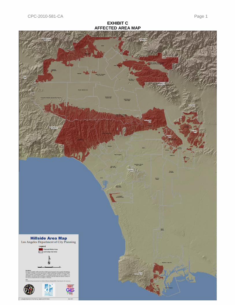
CPC-2010-581-CA Page 1
EXHIBIT C AFFECTED AREA MAP
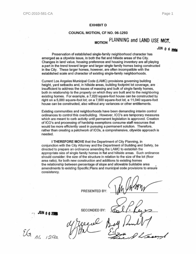
CPC-2010-581-CA Page 1
EXHIBIT D
COUNCIL MOTION, CF NO. 06-1293

CPC-2010-581-CA
APRIL 22, 2010 STAFF REPORT APPENDICES

CPC-2010-581-CA Page 1
Appendix A – Single-Family Hillside Development Regulations: Summary & Comparison
Jurisdiction Floor Area Ratio Height Limits Grading Misc.
City of Los Angeles (Current)
3 times the Buildable Area (Lot Size minus Setbacks) for all zones. 36 feet if average slope of lot or building pad is 66% or less.
45 feet if average slope of lot is greater than 66%.
24 feet within first 20 feet of front lot line if lot is 33 feet higher than the front lot line at a midpoint 50 feet back in the lot.
Note: Height measured 5 feet from lowest point to highest point of building or structure.
No limit to Cut or Fill (on-site land alterations).
Haul Route Approval (LADBS) required for import/export greater than 1,000 cubic yards; no particular limit to quantities.
Other Related Regulations:
Setbacks, Lot Coverage, Parking, Fire Protection (Sprinklers), Street Access (Improvements), Sewer Connections, and Retaining Walls.
City of Los Angeles (Proposed)
Formula based on Slope Bands (topography) and Lot Size for each zone.
Table <<BHO>>-2 Single-Family Zone Hillside Area Residential Floor Area Ratios (FAR)
Slope Bands (%) R1 RS RE9 RE11 RE15 RE20 RE40 RA
0 – 14.99 0.50 0.45 0.40 0.40 0.35 0.35 0.35 0.25
15 – 29.99 0.45 0.40 0.35 0.35 0.30 0.30 0.30 0.20
30 – 44.99 0.40 0.35 0.30 0.30 0.25 0.25 0.25 0.15
45 – 59.99 0.35 0.30 0.25 0.25 0.20 0.20 0.20 0.10
60 – 99.99 0.30 0.25 0.20 0.20 0.15 0.15 0.15 0.05
100 + 0.00 0.00 0.00 0.00 0.00 0.00 0.00 0.00
Allows for 20% Bonus when one of nine pre-designated design options utilized.
Guaranteed Minimum Residential Floor Areas:
R1 Zone - 1,250 sq-ft; RS Zone - 1,688 sq-ft; RE9 Zone - 1,800 sq-ft; RE11 Zone - 2,200 sq-ft; RE15 - 2,625 sq-ft; RE20 - 3,500 sq-ft; RE40 - 7,000 sq-ft; RA Zone - 2,188 sq-ft.
Envelope Height (follows topography) based on Height District and roof slope.
Table <<BHO>>-3 Maximum Height of Structures (in feet)
Height Districts R1 RS RE9 RE11 RE15 RE20 RE40 RA
When the roof of the uppermost story of a building or structure or portion thereof has a slope of 25% or greater, the maximum height for said portion of building or structure thereof shall be as follows:
1, 1L, & 1VL 33 33 33 36 36 36 36 36
1XL 30 30 30 30 30 30 30 30
1SS 22 22 22 22 22 22 22 22
When the roof of the uppermost story of a building or structure or portion thereof has a slope of less than 25%, the maximum height for said portion of building or structure thereof shall be as follows:
1, 1L, & 1VL 28 28 28 30 30 30 30 30
1XL 28 28 28 30 30 30 30 30
1SS 18 18 18 18 18 18 18 18
Note: Height measured 5 feet from lowest point to highest point of building or structure.
Maximum grading (cut & fill) limited to 500 cubic yards plus 5% of the total lot size in cubic yards, up to a maximum of 1,000 cubic yards.
Grading for foundations, driveways to required parking (up to 500 cubic yards), remedial grading, and other activities listed are not counted toward the maximum grading quantities.
Any project involving 1,000 cubic yards or more of any grading would be required to utilize landform grading techniques.
Maximum import of 500 cubic yards and maximum export of 1,000 cubic yards. For lots fronting onto Substandard Hillside Limited Streets (< 28 feet of paved roadway), maximum import of 375 cubic yards and maximum export of 750 cubic yards.
The ―HS‖ Hillside Standards Overlay District would allow individual hillside neighborhoods to adjust FAR, Height, and Grading limit numeric values.
Other Related Regulations:
Existing regulations related to Setbacks, Lot Coverage, Parking, Fire Protection (Sprinklers), Street Access (Improvements), Sewer Connections, and Retaining Walls will remain in place.
Northeast Los Angeles Ordinance
Formula based on Slope Bands (topography) and Lot Size for each zone.
Multiplying Factors by Zone and Slope Interval
Slope Interval (%)
RD1.5, RD2 R2, RD3, RD4, RD5,
RD6
R1 RS RE9 RE20 RE40 A1
0-15 1.00 0.75 0.50 0.45 0.40 0.35 0.35 0.25
15-30 0.90 0.65 0.45 0.40 0.35 0.30 0.30 0.20
30-45 0.80 0.55 0.40 0.35 0.30 0.25 0.25 0.15
45-60 0.70 0.45 0.35 0.30 0.25 0.20 0.20 0.10
60-100 0.60 0.35 0.30 0.25 0.20 0.15 0.15 0.05
100+ 0.50 0.25 0.00 0.00 0.00 0.00 0.00 0.00
Allows for 20% Bonus for new construction which meets LEED for Homes ―Certified‖ level.
Guaranteed Minimum Residential Floor Areas:
RD1.5 & RD2 Zones - 3,000 sq-ft; R2, RD3, RD4, RD5, and RD6 Zones - 2,200 sq-ft; R1 Zone – 20% of Lot Size or 1,100 sq-ft, whichever is greater; RS, RE9, RE20, RE40, and A1 Zones – 20% of Lot Size or 1,000 sq-ft, whichever is greater.
Maximum Envelope Height of 30 feet for structures with a roof slope of 25% or greater and 26 feet for structures with a roof slope less than 25%. Combined with existing Overall Height of 36 feet, and 45 feet for lots with an average slope of 66% or greater, determined by measuring the highest and lowest points of structure.
Restricts grading on each lot to a maximum of 500 cubic yards plus 5% of the total lot size, up to a maximum of 1,000 cubic yards.
Also requires that all grading be done in accordance with Planning Guidelines Landform Grading Manual adopted by City Council.
Proportional Stories and Front Façade Articulation mandatory.
Other Related Regulations:
New Construction Activity, Building Design and Materials, Retaining Walls, Landscaping, and Permeable Surfaces Regulations.
Existing LAMC regulations related to Setbacks, Lot Coverage, Parking, Fire Protection (Sprinklers), Street Access (Improvements), Sewer Connections, and Retaining Walls will remain in place.
The Oaks Ordinance
Formula based on increments of Lot Area; two different formulas based on average slope of lot.
Zone of lot has no bearing on FAR.
Lots with average slope ≤45% grade:
Lot Size Interval (sq-ft) FAR Multiplier
0 – 4,000 0.40
4,0000 – 8,000 0.30
8,000 – 12,000 0.15
12,000 and greater 0.10
Lots with average slope >45% grade:
Lot Size Interval (sq-ft) FAR Multiplier
0 – 4,000 0.37
4,0000 – 8,000 0.27
8,000 – 12,000 0.13
12,000 and greater 0.10
Guaranteed Minimum Residential Floor Area of 1,400 square feet, and allows for additions of 400 square feet to existing structures regardless of conformance status.
For lots with average slope of <45% grade, Envelope Height is 26 feet and Overall Height is 39 feet.
For lots with average slope of >45%, no Envelope Height and Overall Height is 39 feet.
Intended to be the same as Baseline Hillside Ordinance.
Lot Coverage regulations differ by Lot Size according to the following table:
Lot Size (sq-ft) Lot Coverage
Less than 4,000 35%
4,0000 – 12,000 30%
Greater than 12,000 20%
Other Related Regulations:
Existing LAMC regulations related to Setbacks, Parking, Fire Protection (Sprinklers), Street Access (Improvements), Sewer Connections, and Retaining Walls will remain in place.

CPC-2010-581-CA Appendix A - Page 2
Appendix A – Single-Family Hillside Development Regulations: Summary & Comparison Jurisdiction Floor Area Ratio Height Limits Grading Misc.
City of Brea Formula based on average slope to determine ―maximum allowable density‖.
Varies from 0.40 to 0.7 (e.g., 17% slope can yield max 1.6 DU/acre, so SFD would be 62.5% of the max yield, which corresponds to a max FAR of 0.7:1.
35 feet, measured as vertical distance from the existing or planned grade of the pad at the point of the building foundation to the mid-point of the roof. For split-level construction, each building component measured from its own site pad area.
Grading is prohibited within 100 feet of a recognized ridgeline, and on lots that exceed 30% slope, over an acre in area, with an horizontal dimension of 50 feet. No specified maximum, but grading should be sensitive to natural terrain.
Code has special zone (R1-H) for hillside lots with stricter development requirements.
Other Related Regulations:
Lot Coverage and Retaining Walls.
Large, continuous front and rear facades are prohibited. Articulation and roof forms must be implements to create diverse massing.
Requires measures for water quality and water recharge.
Parkways on public streets are required; City has authority to ensure developers pay for them.
City of Beverly Hills
Formula based on size of level pad and average slope.
Varies from 0.20 (lots with no level pad) to total of (0.40 of the area of level pad) + (0.10 of area of slope). Calculated based on finished grade of site. Also includes minimum main structure size of 1,600 sq-ft, but minim that City may restrict a lot to 4,600 sq-ft.
26 feet.
May exceed this height if structure does not exceed 22 feet at the front setback line, increasing toward rear of site at 33 degree slope to a maximum height of 30 feet. Also portion of structure located more than 40 feet from front setback line, max height is 22 feet.
Special height rules apply for uphill lots, construction over fill, construction over slope, and small pad lots.
Formula used to determine max cut and fill for any site (including basements) over a 5-year period, with overall max of 3,000 cubic yards.
Other Related Regulations:
Side Yards for Structures Built Into Uphill Slopes: If a building is built into an uphill slope located between the level pad and a rear property line, then the sum of the side setbacks for the portion of the building built into the uphill slope shall be the setbacks otherwise required plus 30% of the lot width. In no case shall any side yard setback be less than the setback otherwise required.
City of Pasadena Formula based on zoning and average slope, excluding area of lot with slope >50%. Resulting base FAR ranges from 0.20 to 0.275 + 5000 sq-ft extra, for lots with slope <15%. Maximum FAR for a lot under 10,000 sq-ft in the RS-1-HD, RS-2-HD or RS-4-HD zoning districts shall be 0.30 + 500 sq-ft. For lots with slope >15%, max FAR = base FAR x [(1-(Avg. Slope – 0.15))/2)]. For lots over 10,000 sq-ft, where the resulting max allowable gross floor area is <3,000 sq-ft, 3,000 sq-ft max is still permitted.
28 feet (for any point on the site), with 35 foot max when measured from the lowest elevation on the site where the structure touches the grade to the highest point of the roof. No max height for tope plate if general height limit is met.
Hillside Development Permit required for projects that propose to match existing structure height that exceeds the general height limit if the existing structure was constructed before May 3, 2004.
Max height measured as the vertical distance from the existing grade to an imaginary plane located the allowed number of feet above and parallel to the grade.
Also max 6 feet vertical distance between lowest point where the foundation meets grade and the lowest floor line of structure.
Cut slopes limited to max 20 feet in height, with height of retaining walls included.
Drainage and terracing required.
Vertical height of any finished cut slope created to develop a residential pad limited to height of proposed dwelling, or 20 feet, whichever is less.
If total aggregate height of structure >20 feet, separate cuts, set back as required must be made.
Aggregate length of finished cut slope for a dwelling shall not exceed max width of dwelling by 20 feet.
(Intent is the max concealment of cut slopes by the proposed structure.)
Same for accessory structures, but sports courts may have max vertical height of 8 feet and lateral extension of 60 feet overall, or 12 feet greater than width of accessory structure, exclusive of the residence and garage.
All cut slopes contoured to meet upper, lower and side slopes.
Max 50 foot width for finished horizontal slope plane.
Must undulate in a manner similar to natural topography in the vicinity of the site.
―Neighborhood Compatibility‖ requirement to ensure house size is consistent with surrounding area – applies to new homes and proposed additions that require permit – based on size of dwellings within 500-foot radius of property. Rules allow proposal to exceed MEDIAN dwelling size (not average) within 500-foot radius by up to 35% through discretionary action.
No part of a proposed structure shall appear silhouetted against the sky above the nearest ridge when viewed from a public street or park. Topmost point of proposed structure and all site grading shall be 30 feet below the top of the nearest ridge or knoll.
Structures to be located in the most accessible, least visually prominent, most geologically stable portion or portions of the site, and at lowest feasible elevation, and aligned with natural contours of the site, especially on open hillsides where structures should be screened by existing vegetation, depressions in topography, or other natural features.
Other Related Regulations:
Retaining Wall and Lot Coverage limits.
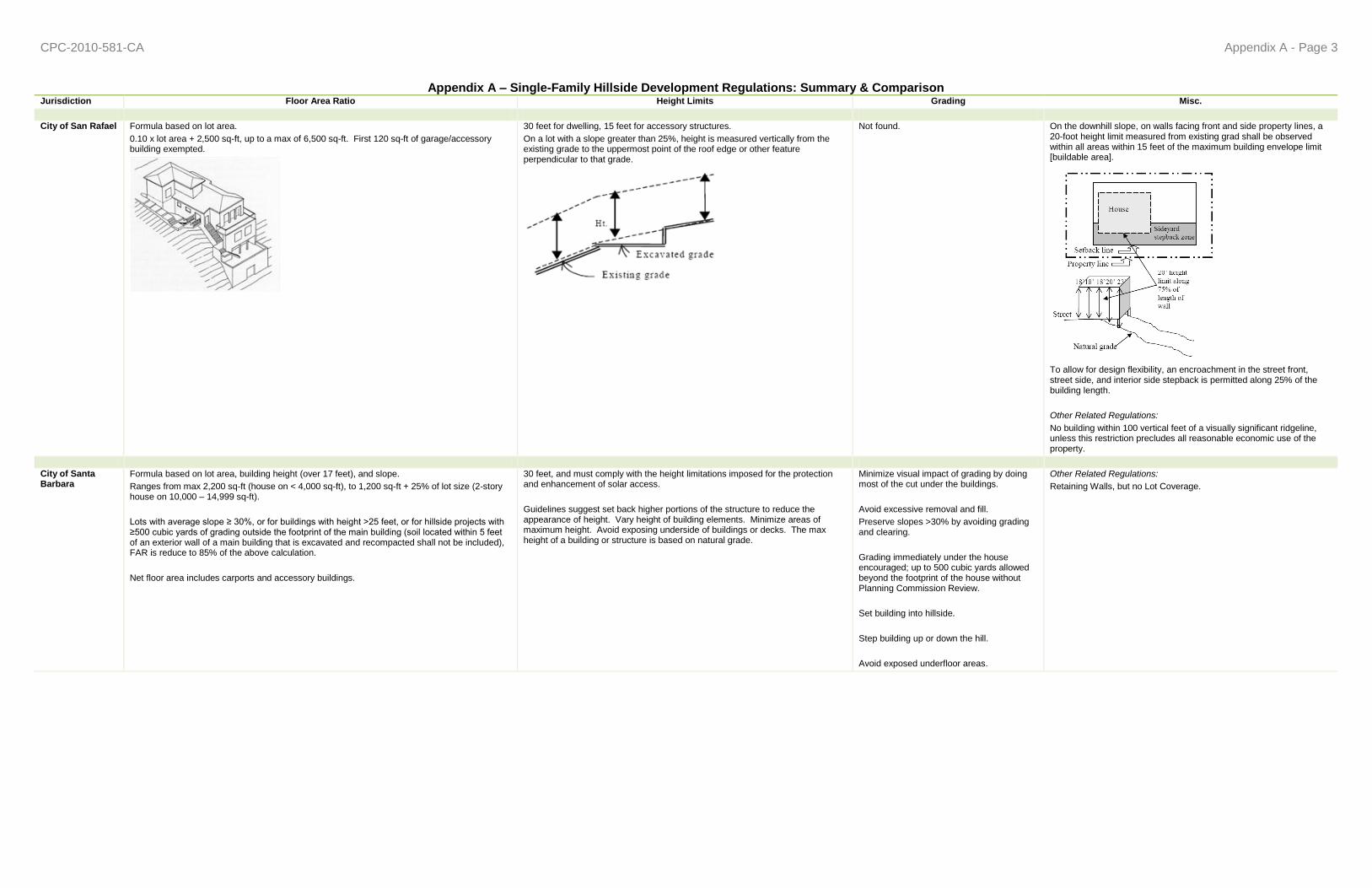
CPC-2010-581-CA Appendix A - Page 3
Appendix A – Single-Family Hillside Development Regulations: Summary & Comparison Jurisdiction Floor Area Ratio Height Limits Grading Misc.
City of San Rafael Formula based on lot area.
0.10 x lot area + 2,500 sq-ft, up to a max of 6,500 sq-ft. First 120 sq-ft of garage/accessory building exempted.
30 feet for dwelling, 15 feet for accessory structures.
On a lot with a slope greater than 25%, height is measured vertically from the existing grade to the uppermost point of the roof edge or other feature perpendicular to that grade.
Not found. On the downhill slope, on walls facing front and side property lines, a 20-foot height limit measured from existing grad shall be observed within all areas within 15 feet of the maximum building envelope limit [buildable area].
To allow for design flexibility, an encroachment in the street front, street side, and interior side stepback is permitted along 25% of the building length.
Other Related Regulations:
No building within 100 vertical feet of a visually significant ridgeline, unless this restriction precludes all reasonable economic use of the property.
City of Santa Barbara
Formula based on lot area, building height (over 17 feet), and slope.
Ranges from max 2,200 sq-ft (house on < 4,000 sq-ft), to 1,200 sq-ft + 25% of lot size (2-story house on 10,000 – 14,999 sq-ft).
Lots with average slope ≥ 30%, or for buildings with height >25 feet, or for hillside projects with ≥500 cubic yards of grading outside the footprint of the main building (soil located within 5 feet of an exterior wall of a main building that is excavated and recompacted shall not be included), FAR is reduce to 85% of the above calculation.
Net floor area includes carports and accessory buildings.
30 feet, and must comply with the height limitations imposed for the protection and enhancement of solar access.
Guidelines suggest set back higher portions of the structure to reduce the appearance of height. Vary height of building elements. Minimize areas of maximum height. Avoid exposing underside of buildings or decks. The max height of a building or structure is based on natural grade.
Minimize visual impact of grading by doing most of the cut under the buildings.
Avoid excessive removal and fill.
Preserve slopes >30% by avoiding grading and clearing.
Grading immediately under the house encouraged; up to 500 cubic yards allowed beyond the footprint of the house without Planning Commission Review.
Set building into hillside.
Step building up or down the hill.
Avoid exposed underfloor areas.
Other Related Regulations:
Retaining Walls, but no Lot Coverage.

CPC-2010-581-CA Appendix A - Page 4
Appendix A – Single-Family Hillside Development Regulations: Summary & Comparison Jurisdiction Floor Area Ratio Height Limits Grading Misc.
City of South Pasadena
Formula based on lot area.
0.35:1, excluding a garage of no more than 500 sq-ft, or a carport of no more than 400 sq-ft.
28 feet for structures with a roof pitch of 3:12 [25%] or greater; 24 feet for structures with a roof pitch less than 3:12 [25%].
To reduce the overall height, mass, and bulk, and avoid visual impacts, roof pitches should be kept to slopes at or below 6:12 [50%].
No portion of a structure shall encroach through a 45 degree angle projected perpendicularly from the front property line toward the rear property line.
Vertical building walls should be max 15 feet above grade. Any vertical walls above 15 feet should be stepped back from the adjacent lower walls by a min distance of 10 feet. Flat building walls over 1 story in height and over 25 feet in horizontal dimension discouraged to minimize unarticulated wall mass.
No portion of walking surface of a deck with visible underpinnings should exceed a height of 6 feet above grade.
Not found. Massing should be stepped with the slope to avoid large expanses of tall walls. The wall planes at various levels should be articulated and have a variety of solid and void elements.
To minimize the visual impact of the tall wall at downslope sides of a building, landscaping should be used to mask the wall plane and add interest.
Dividing a structure into separate structures or ―modules‖ that step down a slope also reduces the massing at the street level and when viewed from below.
Other Related Regulations:
Lot Coverage limits..
City of Torrance Formula based on lot area.
0.5:1, and FAR includes garage; for flag lots, the lot area to be used in the calculation includes only the buildable lot area, but not the access easement.
14 feet, measured from the ground at finished grade, but not including any berm. Not found. Other Related Regulations:
Lot Coverage limits.
City of Rancho Palos Verdes
No fixed percentage of lot area or explicit square footage cap. Maximum building size is regulated through combination of height and lot coverage limitations.
16 feet.
Height Variation Permit process to consider taller structures.
Projects may be referred to the Planning Commission if they propose to exceed this height in any of the following ways: 1) if portion of structure exceeding 16 feet in height is closer than 25 feet from the front or street-side property line; 2) if area of the structure which exceeds 16 feet in height is less than 75% of the first story footprint area (residence and garage); 3) if ≥60% of an existing garage footprint is covered by a structure that exceed 16 feet in height (a second story); 4) the portion of a structure that exceeds 16 feet in height is being constructed as a new SFD; or 5) if, based on site visit, Director determines that any portion of a structure which is proposed to exceed 16 feet in height may significantly impair a view (specifically defined).
Height Variation Permit may allow up to 26 feet, but variance is needed to allow additional height. Height measured based on lot typology (upslope/downslope) and the extent to which a structure slopes with the lot.
Referred to Planning Commission if grading involves more than 1,000 cubic yards of combined cut and fill. No construction shall be allowed on any extreme slope (35% grade or higher), except for: 1) trash enclosures, enclosed mechanical equipment or poor equipment located within an area of less than 50 sq-ft, provided not located more than 6 feet from the top or toe of slope and adequately screened from view from adjacent properties and the public right-of-way to the satisfaction of the Director; 2) structures and improvements allowed by an ―extreme slope permit‖; 3) satellite dish antennas; 4) grading and retaining walls allowed by a grading permit; or, 5) allowable fences, walls and hedges, or at-grade stairs less than 6 inches in height, measured from adjacent existing grade.
On natural sloping lots, the number of stories proposed should be based on the natural as much as possible, so as to minimize grading.
A second story façade should be setback farther than the first floor in effort to reduce the apparent mass of the structure.
Other Related Regulations:
Retaining Wall and Lot Coverage limits.

CPC-2010-581-CA Page 1
APPENDIX B
BREAKDOWN OF HILLSIDE LOTS BY SINGLE-FAMILY ZONE Citywide Single-Family Zoned Hillside Lots
Zone No. of Lots
R1 65,496
RS 4,174
RE9 2,496
RE11 12,155
RE15 24,182
RA 9,100
RE20 4,885
RE40 11,130
Total 133,618
R165,496 49%
RA9,097 7%
RE1112,155
9%
RE1524,182 18%
RE204,885 4%
RE4011,130
8%
RE92,496 2%
RS4,174 3%

CPC-2010-581-CA Appendix B - Page 2
4,651 7% 5,117
8% 6,668 10%
10,186 16%
13,603 21%
10,537 16%
5,856 9%
2,952 4%
5,926 9%
Number of Lots
Less than 25% of lot size (< 1,250 sq-ft)
4,651
25-49.99% of Min Lot Size (1,250-2,499 sq-ft)
5,117
50-74.99% of Min Lot Size (2,500 - 3,749 sq-ft)
6,668
75-99.99% of Min Lot Size (3,750 - 4,999 sq-ft)
10,186
100 -124.99% of Min Lot Size (5,000 -6,249 sq-ft)
13,603
125-149.99% of Min Lot Size (6,250 - 7,499 sq-ft)
10,537
150-174.99% of Min Lot Size (7,500 - 8,749 sq-ft)
5,856
175-199.99% of Min Lot Size (8,750 - 9,999 sq-ft)
2,952
Greater than 200% of Min Lot Size (>10,000 sq-ft)
5,926
Total 65,496
92 2%
45 1%
36 1%
247 6%
2,054 52%
716 18%
325 8%
169 4%
293 8%
Number of Lots
Less than 25% of lot size (< 1,875 sq-ft)
97
25-49.99% of Min Lot Size (1,875 -3,749 sq-ft)
47
50-74.99% of Min Lot Size (3,750 - 5,624 sq-ft)
36
75-99.99% of Min Lot Size (5625 - 7,499 sq-ft)
256
100 -124.99% of Min Lot Size (7,500 - 9,374 sq-ft)
2,117
125-149.99% of Min Lot Size (9,375 - 11,249 sq-ft)
763
150-174.99% of Min Lot Size (11,250 - 13,124 sq-ft)
358
175-199.99% of Min Lot Size (13,125 - 14,999 sq-ft)
186
Greater than 200% of Min Lot Size (>15,000 sq-ft)
314
Total 4,174
Breakdown of Citywide Hillside Lots by Single-Family Zone Breakdown of R1-Zoned Lots
Breakdown of RS-Zoned Lots
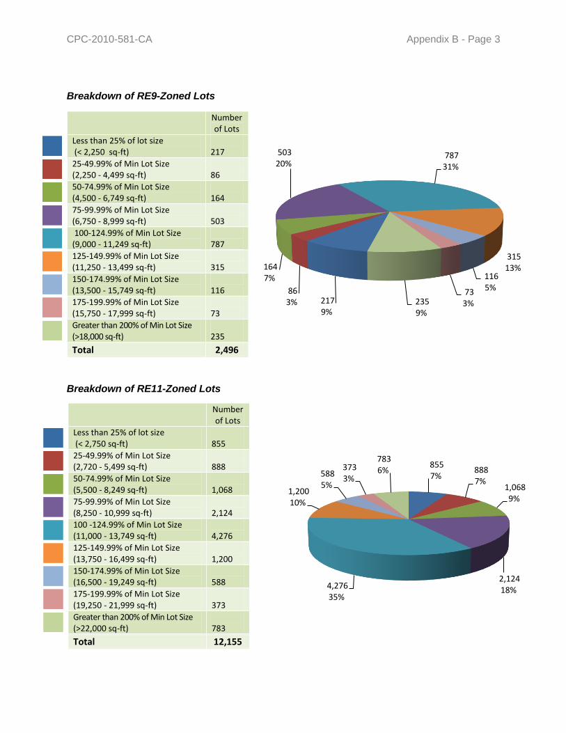
CPC-2010-581-CA Appendix B - Page 3
Breakdown of RE9-Zoned Lots Breakdown of RE11-Zoned Lots
Number of Lots
Less than 25% of lot size (< 2,250 sq-ft)
217
25-49.99% of Min Lot Size (2,250 - 4,499 sq-ft)
86
50-74.99% of Min Lot Size (4,500 - 6,749 sq-ft)
164
75-99.99% of Min Lot Size (6,750 - 8,999 sq-ft)
503
100-124.99% of Min Lot Size (9,000 - 11,249 sq-ft)
787
125-149.99% of Min Lot Size (11,250 - 13,499 sq-ft)
315
150-174.99% of Min Lot Size (13,500 - 15,749 sq-ft)
116
175-199.99% of Min Lot Size (15,750 - 17,999 sq-ft)
73
Greater than 200% of Min Lot Size (>18,000 sq-ft)
235
Total 2,496
217 9%
86 3%
164 7%
503 20%
787 31%
315 13%
116 5%73
3%235 9%
Number of Lots
Less than 25% of lot size (< 2,750 sq-ft)
855
25-49.99% of Min Lot Size (2,720 - 5,499 sq-ft)
888
50-74.99% of Min Lot Size (5,500 - 8,249 sq-ft)
1,068
75-99.99% of Min Lot Size (8,250 - 10,999 sq-ft)
2,124
100 -124.99% of Min Lot Size (11,000 - 13,749 sq-ft)
4,276
125-149.99% of Min Lot Size (13,750 - 16,499 sq-ft)
1,200
150-174.99% of Min Lot Size (16,500 - 19,249 sq-ft)
588
175-199.99% of Min Lot Size (19,250 - 21,999 sq-ft)
373
Greater than 200% of Min Lot Size (>22,000 sq-ft)
783
Total 12,155
855 7%
888 7%
1,068 9%
2,124 18%4,276
35%
1,200 10%
588 5%
373 3%
783 6%

CPC-2010-581-CA Appendix B - Page 4
Number of Lots
Less than 25% of lot size (<4,375 sq-ft)
636
25-49.99% of Min Lot Size (4,375 - 8,749 sq-ft)
220
50-74.99% of Min Lot Size (8,750 - 13,124 sq-ft)
275
75-99.99% of Min Lot Size (13,125 - 17,499 sq-ft)
1,879
100 -124.99% of Min Lot Size (17,500 - 21,874 sq-ft)
3,799
125-149.99% of Min Lot Size (21,875 - 26,249 sq-ft)
835
150-174.99% of Min Lot Size (26,250 - 30,624 sq-ft)
450
175-199.99% of Min Lot Size (30,625 -34,999 sq-ft)
234
Greater than 200% of Min Lot Size (>35,000 sq-ft)
772
Total 9,100
Breakdown of RE15-Zoned Lots Breakdown of RA-Zoned Lots
Number of Lots
Less than 25% of lot size (< 3,750 sq-ft)
5,525
25-49.99% of Min Lot Size (3,750 - 7,499 sq-ft)
2,081
50-74.99% of Min Lot Size (7,500 - 11,249 sq-ft)
4,401
75-99.99% of Min Lot Size (11,250 - 14,999 sq-ft)
4,218
100 -124.99% of Min Lot Size (15,000 - 18,749 sq-ft)
3,058
125-149.99% of Min Lot Size (18,750 - 22,499 sq-ft)
1,626
150-174.99% of Min Lot Size (22,500 - 26,249 sq-ft)
950
175-199.99% of Min Lot Size (26,500 - 29,999 sq-ft)
560
Greater than 200% of Min Lot Size (>30,000 sq-ft)
1,763
Total 24,182
855 7%
888 7%
1,068 9%
2,124 18%4,276
35%
1,200 10%
588 5%
373 3%
783 6%
636 7%
220 2%
275 3%
1,879 21%
3,79942%
835 9%450
5%234 3%772
8%

CPC-2010-581-CA Appendix B - Page 5
Breakdown of RE20-Zoned Lots Breakdown of RE40-Zoned Lots
Number of Lots
Less than 25% of lot size (<5,000 sq-ft)
909
25-49.99% of Min Lot Size (5,000 - 9,999 sq-ft)
855
50-74.99% of Min Lot Size (10,000 - 14,999 sq-ft)
436
75-99.99% of Min Lot Size (15,000 - 19,999 sq-ft)
536
100 -124.99% of Min Lot Size (20,000 - 24,999 sq-ft)
537
125-149.99% of Min Lot Size (25,000 - 29,999 sq-ft)
382
150-174.99% of Min Lot Size (30,000 - 34,999 sq-ft)
290
175-199.99% of Min Lot Size (35,000 - 39,999 sq-ft)
227
Greater than 200% of Min Lot Size (>40,000 sq-ft)
713
Total 4,885
909 19%
855 17%
436 9%
536 11%
537 11%
382 8%
290 6%
227 5%
713 14%
Number of Lots
Less than 25% of lot size (< 10,000 sq-ft)
5,974
25-49.99% of Min Lot Size (10,000 -19,999 sq-ft)
1,747
50-74.99% of Min Lot Size (20,000 - 29,999 sq-ft)
893
75-99.99% of Min Lot Size (30,000 - 39,999 sq-ft)
462
100 -124.99% of Min Lot Size (40,000 -49,999 sq-ft)
483
125-149.99% of Min Lot Size (50,000 - 59,999 sq-ft)
253
150-174.99% of Min Lot Size (60,000 - 69,999 sq-ft)
197
175-199.99% of Min Lot Size (70,000 - 79,999 sq-ft)
124
Greater than 200% of Min Lot Size (>80,000 sq-ft)
997
Total 11,130
5,974 54%
1,747 16%
893 8%
462 4%
483 4%
253 2%197
2%
124 1%
997 9%

CPC-2010-581-CA Appendix B - Page 6
Number of Lots Non-Conforming as to Lot Size by Council District
CD 1 CD 2 CD 3 CD 4 CD 5 CD 7 CD 11 CD 12 CD 13 CD 14 CD 15 Total
R1 3,355 1,175 1,720 5,078 3,610 16 1,126 - 1,010 7,887 882 25,859
RA - 355 1,242 - 596 111 72 617 - - - 2,993
RE11 13 596 20 1,373 658 95 318 1,335 - 517 - 4,925
RE15 - 1,204 298 1,681 10,760 28 2,097 129 - 26 - 16,223
RE20 833 30 5 3 1,392 - 471 139 - 689 - 3,562
RE40 5 2,386 1,298 298 3,706 1 988 289 - 110 - 9,081
RE9 - - 10 505 129 - 19 270 - 35 - 968
RS 8 49 20 42 - 37 62 170 - 11 - 399
Total 4,214 5,795 4,613 8,980 20,930 288 5,153 2,949 1,001 9,275 882 64,010
R125,859 40%
RA2,993 5%
RE114,925 8%
RE1516,223 25%
RE203,562 6%
RE409,081 14%
RE9968 1%
RS399 1%
R1
RA
RE11
RE15
RE20
RE40
RE9
RS
Breakdown of all Non-Conforming Lots by Zone in Hillside Area
Breakdown of Lots Substandard as to Lot Size By Council District
By Zone R1 Zone
3,93015%
3,17112%
5,39821%5,247
20%
8,18332%
less than 1,000 sq-ft
1,000 - 1,999 sq-ft
2,000 - 2,999 sq-ft
3,000 - 3,999 sq-ft
4,000-4,999 sq-ft

CPC-2010-581-CA Appendix B - Page 7
11830%
307%
246%31
8%
19649%
less than 2,500 sq-ft
2,500 - 3,749 sq-ft
3,750 - 4,999 sq-ft
5,000 - 6,249 sq-ft
6,250 - 7,499 sq-ft
25126%
525%
10211%127
13%
43645%
less than 3,000 sq-ft
3,000 - 4,499 sq-ft
4,500 - 5,999 sq-ft
6,000 - 7,499 sq-ft
7,500 - 8,999 sq-ft
1,003 20%
469 10%
682 14%531
11%
994 20%
1,246 25%
less than 3,500 sq-ft
3,500 - 4,999 sq-ft
5,000 - 6,499 sq-ft
6,500 - 7,999 sq-ft
8,000 - 9,499 sq-ft
9,500 - 10,999 sq-ft
RS Zone RE9 Zone
RE11 Zone

CPC-2010-581-CA Appendix B - Page 8
79627%
883%
983%
1946%
51417%
1,30344%
less than 7,500 sq-ft
7,500 - 9,499 sq-ft
9,500 - 11,499 sq-ft
11,500 - 13,499 sq-ft
13,500 - 15,499 sq-ft
15,500 - 17,499 sq-ft
6,108 38%
1,141 7%1,956
12%
2,466 15%
2,412 15%
2,140 13%
less than 5,000 sq-ft
5,000 - 6,999 sq-ft
7,000 - 8,999 sq-ft
9,000 - 10,999 sq-ft
11,000 - 12,999 sq-ft
13,000 - 14,999 sq-ft
1,973 55%
538 15%
229 6%
272 8%
314 9%
236 7%
less than 7,500 sq-ft
7,500 - 12,499 sq-ft
10,000 - 12,499 sq-ft
12,500 - 14,999 sq-ft
15,000 - 17,499 sq-ft
17,500 - 19,999 sq-ft
RE15 Zone
RA Zone RE20 Zone
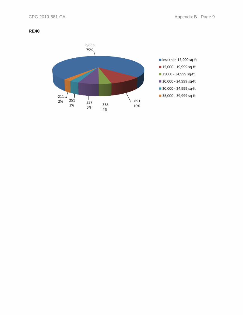
CPC-2010-581-CA Appendix B - Page 9
6,833 75%
891 10%338
4%
557 6%
251 3%
211 2%
less than 15,000 sq-ft
15,000 - 19,999 sq-ft
25000 - 34,999 sq-ft
20,000 - 24,999 sq-ft
30,000 - 34,999 sq-ft
35,000 - 39,999 sq-ft
RE40
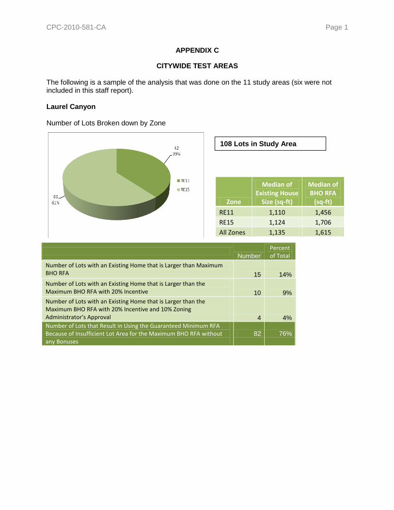
CPC-2010-581-CA Page 1
APPENDIX C
CITYWIDE TEST AREAS The following is a sample of the analysis that was done on the 11 study areas (six were not included in this staff report). Laurel Canyon Number of Lots Broken down by Zone
Zone
Median of Existing House
Size (sq-ft)
Median of BHO RFA
(sq-ft)
RE11 1,110 1,456
RE15 1,124 1,706
All Zones 1,135 1,615
Number
Percent of Total
Number of Lots with an Existing Home that is Larger than Maximum BHO RFA 15 14%
Number of Lots with an Existing Home that is Larger than the Maximum BHO RFA with 20% Incentive 10 9%
Number of Lots with an Existing Home that is Larger than the Maximum BHO RFA with 20% Incentive and 10% Zoning Administrator's Approval 4 4%
Number of Lots that Result in Using the Guaranteed Minimum RFA Because of Insufficient Lot Area for the Maximum BHO RFA without any Bonuses
82 76%
108 Lots in Study Area

CPC-2010-581-CA Appendix C - Page 2
Brentwood Number of Lots Broken down by Zone
Number
Percent of Total
Number of Lots with an Existing Home that is Larger than Maximum BHO RFA 29 17%
Number of Lots with an Existing Home that is Larger than the Maximum BHO RFA with 20% Incentive 23 13%
Number of Lots with an Existing Home that is Larger than the Maximum BHO RFA with 20% Incentive and 10% Zoning Administrator's Approval 17 10%
Number of Lots that Result in Using the Guaranteed Minimum RFA Because of Insufficient Lot Area for the Maximum BHO RFA without any Bonuses
81 47%
Zone
Median of Existing House
Size (sq-ft) Median of BHO
RFA (sq-ft)
RE15 2,792 4,557
RE20 3,337 4,089
RE40 3,211 2,347
All Zones 3,315 4,264
171 Lots in Study Area
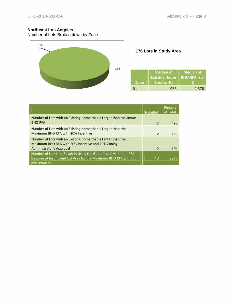
CPC-2010-581-CA Appendix C - Page 3
Northeast Los Angeles Number of Lots Broken down by Zone
Number
Percent of Total
Number of Lots with an Existing Home that is Larger than Maximum BHO RFA 7 4%
Number of Lots with an Existing Home that is Larger than the Maximum BHO RFA with 20% Incentive 2 1%
Number of Lots with an Existing Home that is Larger than the Maximum BHO RFA with 20% Incentive and 10% Zoning Administrator's Approval 2 1%
Number of Lots that Result in Using the Guaranteed Minimum RFA Because of Insufficient Lot Area for the Maximum BHO RFA without any Bonuses
40 23%
Zone
Median of Existing House
Size (sq-ft)
Median of BHO RFA (sq-
ft)
R1 953 2,570
176 Lots in Study Area

CPC-2010-581-CA Appendix C - Page 4
Number
Percent of Total
Number of Lots with an Existing Home that is Larger than Maximum BHO RFA 2 1%
Number of Lots with an Existing Home that is Larger than the Maximum BHO RFA with 20% Incentive 1 1%
Number of Lots with an Existing Home that is Larger than the Maximum BHO RFA with 20% Incentive and 10% Zoning Administrator's Approval 0 0%
Number of Lots that Result in Using the Guaranteed Minimum RFA Because of Insufficient Lot Area for the Maximum BHO RFA without any Bonuses
61 35%
Montecito Heights Number of Lots Broken down by Zone
Zone
Median of Existing House
Size (sq-ft)
Median of BHO RFA
(sq-ft)
R1 622 1,906
RE20 1,104 1,104
All Zones - 1,629
93 Lots in Study Area

CPC-2010-581-CA Appendix C - Page 5
The Oaks Number of Lots Broken down by Zone
Number of Lots
Percent of Total
Number of Lots
Percent of Total
Number of Lots with an Existing Home that is Larger than Maximum BHO RFA 200 21% 360 38%
Number of Lots with an Existing Home that is Larger than the Maximum BHO RFA with 20% Incentive 112 12% n/a n/a
Number of Lots with an Existing Home that is Larger than the Maximum BHO RFA with 20% Incentive and 10% Zoning Administrator's Approval 81 8% n/a n/a
Number of Lots that Result in Using the Guaranteed Minimum RFA Because of Insufficient Lot Area for the Maximum BHO RFA without any Bonuses
217 23% n/a n/a
Zone
Median of Existing
House Size (sq-ft)
Median of BHO
RFA (sq-ft)
Median of Oaks
RFA (sq ft)
R1 1,792 1,985 2,017
RE9 2,071 3,185 3,726
RE11 2,413 2,967 3,646
RE15 2,378 3,832 5,061
All Zones 2,069 2,682 3,116
956 Lots in Study Area

CPC-2010-581-CA Page 1 APPENDIX D
SUMMARY OF HILLSIDE KICK-OFF MEETING PUBLIC COMMENTS
In February 2009 the City of Los Angeles Department of City Planning conducted a series of public meetings throughout the City of Los Angeles in order to hear public comments, and discuss issues related to development in Los Angeles hillside neighborhoods.
Harbor Area Meeting Tuesday, February 17, 2009
Peck Park Gymnasium 560 N. Western Ave. San Pedro, CA 90732
South Valley Meeting Monday, February 23, 2009
Marvin Braude Building 6262 Van Nuys Blvd., Room 1A
Van Nuys, CA 91401
Westside Meeting Thursday, February 19, 2009
Henry Medina Parking Enforcement Facility 11214 W. Exposition Blvd., 2nd Floor
Los Angeles, CA 90064
North Valley Meeting Tuesday, February 24, 2009
Council District Two Field Office 7747 Foothill Blvd. Tujunga, CA 91042
Metro/Eastside Meeting Thursday, February 26, 2009
City Hall, Room 1010 200 N. Spring St.
Los Angeles CA 90012
The intent was to obtain early public input in order to help staff identify concerns, and influence the scope of the Baseline Hillside Project. These efforts will ultimately result in proposed Code Amendments affecting single-family development in the City’s Hillside Areas. This document provides a summary of the public comments received regarding development in the City of Los Angeles’ hillside neighborhoods, as of February 27, 2009. The statements presented in this document are those received from the general public and not necessarily those of the Department of City Planning. These comments will be used in order to determine a list of objectives for the Baseline Hillside Ordinance which is currently being developed by the Department in close cooperation with various stakeholders. These objectives will be used to develop preliminary proposals for hillside regulations.

CPC-2010-581-CA Appendix D - Page 2
The information presented and received at the Kick-Off Meetings will be broken down by major topics the in the following layout:
MMAAJJOORR TTOOPPIICC
Agree Disagree
SUB-TOPIC
“Public comments received regarding hillside development prior to and presented at Kick-Off Meetings will be in bold." These comments were compiled, summarized, and broken down by their major topics by staff and presented to the public in order to stimulate early discussion. The attendees of the meetings participated in a prioritization exercise, the result of which is shown to the right of the comment. Staff notes, corrections, and comments are found in brackets: [text]. Notes: (X) Notes written directly on the sheets presented under a specific comment will be shown verbatim directly below this
heading. A single letter in parenthesis will indicate which meeting the comment was received; please refer to the key below.
H: # W: # S: # N: # E: # Total: #
H: # W: # S: # N: # E: # Total: #
Additional Comments Received
These will be additional comments that either elaborated on information presented or are entirely new issues which were expressed at the meetings that were taken down as notes by Planning staff.
Key
H – Harbor Area Meeting N – North Valley Meeting W – Westside Meeting E – Metro/Eastside Meeting S – South Valley Meeting
Total is circled when input was conclusive.
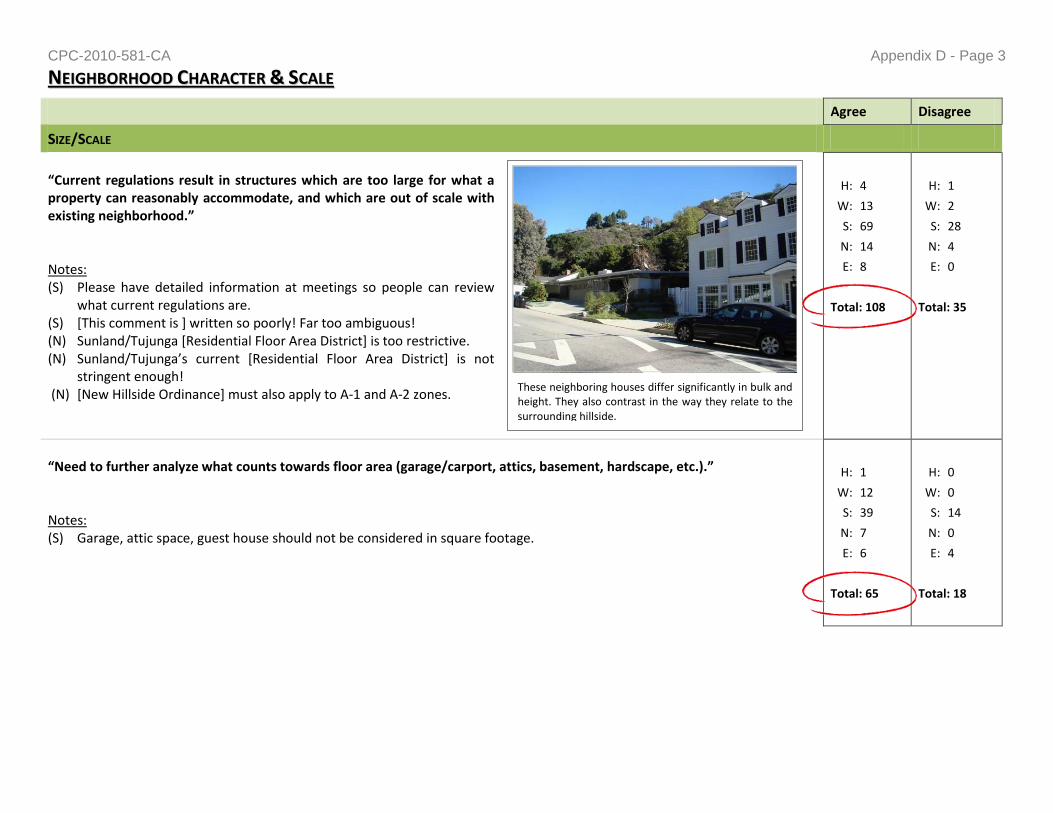
CPC-2010-581-CA Appendix D - Page 3
These neighboring houses differ significantly in bulk and height. They also contrast in the way they relate to the surrounding hillside.
NNEEIIGGHHBBOORRHHOOOODD CCHHAARRAACCTTEERR && SSCCAALLEE
Agree Disagree
SIZE/SCALE
“Current regulations result in structures which are too large for what a property can reasonably accommodate, and which are out of scale with existing neighborhood.” Notes: (S) Please have detailed information at meetings so people can review
what current regulations are. (S) [This comment is ] written so poorly! Far too ambiguous! (N) Sunland/Tujunga [Residential Floor Area District] is too restrictive. (N) Sunland/Tujunga’s current *Residential Floor Area District+ is not
stringent enough! (N) [New Hillside Ordinance] must also apply to A-1 and A-2 zones.
H: 4
W: 13
S: 69
N: 14
E: 8
Total: 108
H: 1
W: 2
S: 28
N: 4
E: 0
Total: 35
“Need to further analyze what counts towards floor area (garage/carport, attics, basement, hardscape, etc.).” Notes: (S) Garage, attic space, guest house should not be considered in square footage.
H: 1
W: 12
S: 39
N: 7
E: 6
Total: 65
H: 0
W: 0
S: 14
N: 0
E: 4
Total: 18

CPC-2010-581-CA Appendix D - Page 4
Agree Disagree
“Minimum lot sizes may be too small and should be larger; may be a need to consider slopes when determining minimum lot sizes.” Notes: (N) The recently revised Slope [Density] Ordinance may be helpful. (N) Slope Density Ordinances should apply regardless of zone.
H: 2
W: 11
S: 15
N: 14
E: 3
Total: 45
H: 0
W: 13
S: 4
N: 2
E: 2
Total: 23
BULK
“Tall box-like homes not reflective of neighborhood character and scale.” Notes: (N) FAR should not exclude garage area and should not
exclude 2,000 Square foot equine pad and 296 square-foot touch house.
H: 6
W: 8
S: 24
N: 10
E: 9
Total: 57
H: 0
W: 4
S: 6
N: 0
E: 0
Total: 10
“Current regulations lack urban design requirements that address aspects such as modulation/articulation, roof-lines, and landscaping.”
H: 2
W: 8
S: 12
N: 12
E: 7
Total: 41
H: 0
W: 3
S: 0
N: 0
E: 0
Total: 3
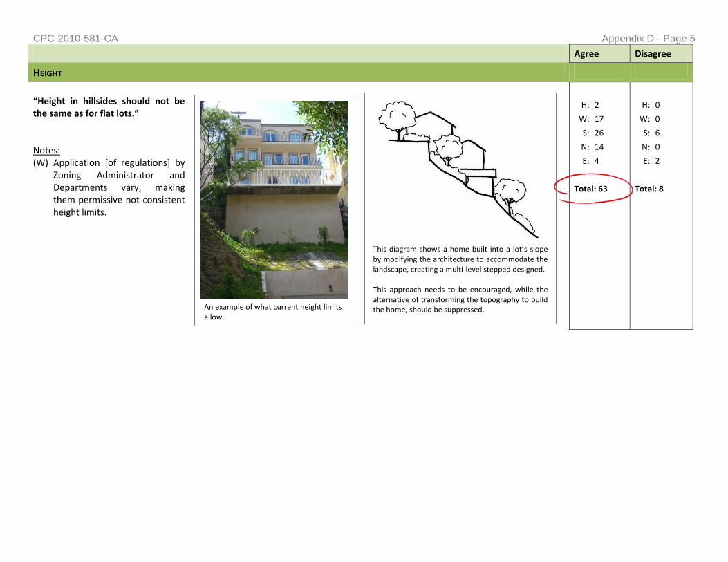
CPC-2010-581-CA Appendix D - Page 5
An example of what current height limits allow.
This diagram shows a home built into a lot’s slope by modifying the architecture to accommodate the landscape, creating a multi-level stepped designed. This approach needs to be encouraged, while the alternative of transforming the topography to build the home, should be suppressed.
Agree Disagree
HEIGHT
“Height in hillsides should not be the same as for flat lots.” Notes: (W) Application [of regulations] by
Zoning Administrator and Departments vary, making them permissive not consistent height limits.
H: 2
W: 17
S: 26
N: 14
E: 4
Total: 63
H: 0
W: 0
S: 6
N: 0
E: 2
Total: 8

CPC-2010-581-CA Appendix D - Page 6
Agree Disagree
CURRENT “ONE-SIZE-FITS-ALL” APPROACH
“Regulations need to vary by “lot typology” (upslope vs. downslope) to create more compatible development in various hillside types.”
Notes: (N) [Hillside Regulations] should apply not just to residences but also non residential projects – churches, schools, etc.
H: 1
W: 11
S: 18
N: 7
E: 8
Total: 44
H: 1
W: 0
S: 0
N: 0
E: 0
Total: 1
“Create clustering of appropriately styled buildings.” Notes: (S) Define elements of “neighborhood character”. (S) Clustering can [create] a visually compatible effect.
H: 1
W: 8
S: 5
N: 1
E: 1
Total: 16
H: 0
W: 6
S: 1
N: 1
E: 2
Total: 10
15% Average Slope
45% Average Slope
66% Average Slope
Each of these lots are of the same size and dimensions, but have different slopes. Under current regulations the same size house can be built on each of these lots, despite topographical differences.

CPC-2010-581-CA Appendix D - Page 7
Agree Disagree
“Citywide regulations may not work for all neighborhoods – Baseline Regulations with Optional Overlay approach is needed.” Notes: (W) Overlay approach may be difficult to implement.
H: 2
W: 11
S: 14
N: 7
E: 9
Total: 43
H: 0
W: 0
S: 1
N: 1
E: 0
Total: 2
SITE LOCATION
“Development should be encouraged to take place on flatter portions of lot, and discouraged on steeper portions.” Notes: (N) There should be no building in slopes exceeding specific slope.
H: 2
W: 7
S: 20
N: 6
E: 0
Total: 35
H: 0
W: 3
S: 8
N: 1
E: 6
Total: 18

CPC-2010-581-CA Appendix D - Page 8
Agree Disagree
“Ridgelines should be protected by lowering height limits on developed ridgelines, and prevented on undeveloped ridgelines.”
Notes: (S) Increases info[?] on side of hill. (N) See Verdugo San Rafael Scenic Corridor Ordinance.
H: 2
W: 14
S: 20
N: 15
E: 5
Total: 56
H: 0
W: 0
S: 3
N: 0
E: 0
Total: 3
Additional Comments Received
Should include garage in square footage calculation since it contributes to the massing.
Garages are exempt from residential floor area in the flat zones; they should count towards RFA in the Hillside areas because it can further limit off-street parking.
Garage shouldn’t be included since we need to have garages to keep cars off the streets.
Slope Density Calculation: just do average on a five foot contour line.
The slope of the hillside should be the key point—not the zone or the size of the lot.
Look into minimum setbacks.
Concerned that the possible minimum square-footage (or guaranteed size) mentioned at the meetings for houses is too low – 1,000 or 1,500 square-feet. [This number is not an official proposal, and was just used for discussion purposes]
Architectural creativity should not be burdened.
Hillside neighborhoods throughout the City of Los Angeles different, and regulations should be crafted that meet the demands of the each area.
Relative size and scale is needed.
We don’t want people to take down what exists, to build a structure twice the size of what was there.
We need better view regulation.
A Design Review Board should help determine the scope of a project.

CPC-2010-581-CA Appendix D - Page 9
While grading this site, the weight of this excavator cause it to partially sink into an underground aquifer not identified through the environmental review process.
Agree Disagree
Sizeable homes can be built on steep slopes in a sustainable fashion with good design.
Too many regulations wouldn’t allow for architectural marvels.
Planning regulations should deal with bulk vs. height in specific detail.
EENNVVIIRROONNMMEENNTTAALL IIMMPPAACCTTSS
Agree Disagree
“Environmental studies are not sufficiently identifying and disclosing existing major environmental conditions.” Notes: (S) Environmental studies are not required [received 4 dots in
agreement and 2 in disagreement].
H: 2
W: 8
S: 23
N: 10
E: 7
Total: 50
H: 0
W: 0
S: 3
N: 2
E: 0
Total: 5
“Hillsides are extremely delicate and fragile ecosystem; new building can have drastic and unexpected effects.” Notes: (H) Environmental impacts beyond the immediate development should be considered [received 4 dots in agreement].
H: 1
W: 9
S: 11
N: 9
E: 7
Total: 37
H: 0
W: 0
S: 2
N: 0
E: 0
Total: 2

CPC-2010-581-CA Appendix D - Page 10
Agree Disagree
“Excessive grading negatively impacts aesthetics.”
H: 2
W: 10
S: 11
N: 8
E: 6
Total: 37
H: 0
W: 0
S: 0
N: 0
E: 6
Total: 6
“Wildlife corridors and streams should be protected.”
H: 2
W: 8
S: 19
N: 15
E: 6
Total: 40
H: 0
W: 0
S: 1
N: 0
E: 6
Total: 7
Additional Comments Received
NO ADDITIONAL COMMENTS RECEIVED

CPC-2010-581-CA Appendix D - Page 11
GGRRAADDIINNGG && SSLLOOPPEE SSTTAABBIILLIITTYY
Agree Disagree
CURRENT GRADING REGULATIONS
“Lack of grading limits allow for the destruction of the City’s hillsides.” Notes: (H) Create better consistency with LAFD requirements. (N) Must include analysis of Equine K-1 zone and
requirement for 2,000 square foot flat land plus 296 square feet “touch”*?+ house.
H: 2
W: 16
S: 21
N: 10
E: 12
Total: 61
H: 0
W: 0
S: 5
N: 0
E: 8
Total: 8
“Lack of landscaping contributes to slope instability in new development.”
H: 2
W: 11
S: 12
N: 7
E: 6
Total: 38
H: 0
W: 0
S: 0
N: 0
E: 0
Total: 0

CPC-2010-581-CA Appendix D - Page 12
Real example of hillside formation in Eagle Rock.
No regulations are in place to prevent the tops of these hills from being cut and the valley between them being filled in.
Real example of hillside in which substantial grading has been proposed. The top of the hill shown on the right of the photo would be filled into the space highlighted in orange. This would currently be allowed without the need for a variance or other type of discretionary action.
Agree Disagree
IMPACTS OF EXCESSIVE GRADING
“Has negative impact on aesthetics and destabilizes hillsides.” Notes: (H) Grading should
always include aesthetics—why have ugly location?
(S) Safety issues with grading.
H: 2
W: 13
S: 12
N: 6
E: 9
Total: 42
H: 0
W: 0
S: 3
N: 0
E: 0
Total: 3
“Negatively impacts aesthetics.” Notes: (S) Ridgelines should not be interfered with by grading or any hardscape visible near top.
H: 1
W: 9
S: 11
N: 7
E: 8
Total: 36
H: 0
W: 0
S: 1
N: 0
E: 0
Total: 1
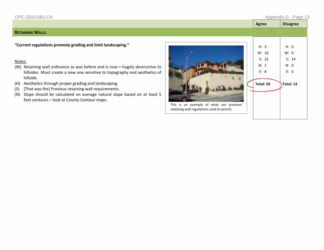
CPC-2010-581-CA Appendix D - Page 13
This is an example of what our previous retaining wall regulations used to permit.
Agree Disagree
RETAINING WALLS
“Current regulations promote grading and limit landscaping.” Notes: (W) Retaining wall ordinance as was before and is now = hugely destructive to
hillsides. Must create a new one sensitive to topography and aesthetics of hillside.
(H) Aesthetics through proper grading and landscaping. (S) [That was the] Previous retaining wall requirements. (N) Slope should be calculated on average natural slope based on at least 5
feet contours – look at County Contour maps.
H: 3
W: 16
S: 22
N: 1
E: 8
Total: 50
H: 0
W: 0
S: 14
N: 0
E: 0
Total: 14

CPC-2010-581-CA Appendix D - Page 14
This is an example of what our current retaining wall regulations permit, after a recent code revision.
Agree Disagree
“Need to be broken-up/staggered and be camouflaged with landscaping or use natural/neutral colors.”
Notes: (N) No building should be permitted on slope exceeding specified slope. (N) No exceptions [variances] to retaining wall ordinance should be granted. (N) This [photo of code revised wall] is ugly!
H: 1
W: 14
S: 17
N: 8
E: 0
Total: 40
H: 0
W: 0
S: 9
N: 0
E: 0
Total: 9
Additional Comments Received
Currently, the fines for illegal grading do not match the crime, meaning it makes more sense financially to do grading work without permits.
Current lack of limit to on-site movement of earth increases the risk of liquefaction.
Grading limit should be 500 cubic yards multiplied by some percent of the lot.
Make contour grading stricter.
This is a diagram of the retaining wall provisions (including landscaping requirements) currently in place in parts of the City.

CPC-2010-581-CA Appendix D - Page 15
Agree Disagree
Control remedial grading.
Remedial grading should be included in the total grading calculation.
Grading Permits need to be tied to a Building Permit whenever possible.
Can we completely stop carving mountains to put in a house?
Why degrade a steep sloped lot? Good design can provide for sustainable, yet sizeable homes on steep lots.
Aesthetics through proper grading and landscaping.
Lower retaining walls—max of 8 feet is good.
The Department of Building & Safety requires retaining walls for the safety of certain structures, while the Department of City Planning limits the number of retaining walls.
There is a misinterpretation in how retaining walls count and a lack of communication between the departments with regard to this issue.
Inter-agency cooperation is very poor, especially w/ regard to retaining walls.
Pre/post grading—what if people grade and then apply with less steep lots.
Landscape all retaining walls—regardless of size.
FAR & garages: do they count? We want off-street parking but we don’t grading.
It is difficult to balance our desire for less grading and more parking.
Determining finished vs. natural grade proves to be an administrative nightmare.
The base grade should be based on whichever is lesser, natural or finished.
Soil safety should be checked throughout the lot.
RRUUNN--OOFFFF && DDRRAAIINNAAGGEE
Agree Disagree
“More effective erosion control methods are needed to help slope stability.”
H: 2
W: 12
S: 13
N: 8
E: 5
Total: 42
H: 0
W: 0
S: 6
N: 0
E: 0
Total: 6
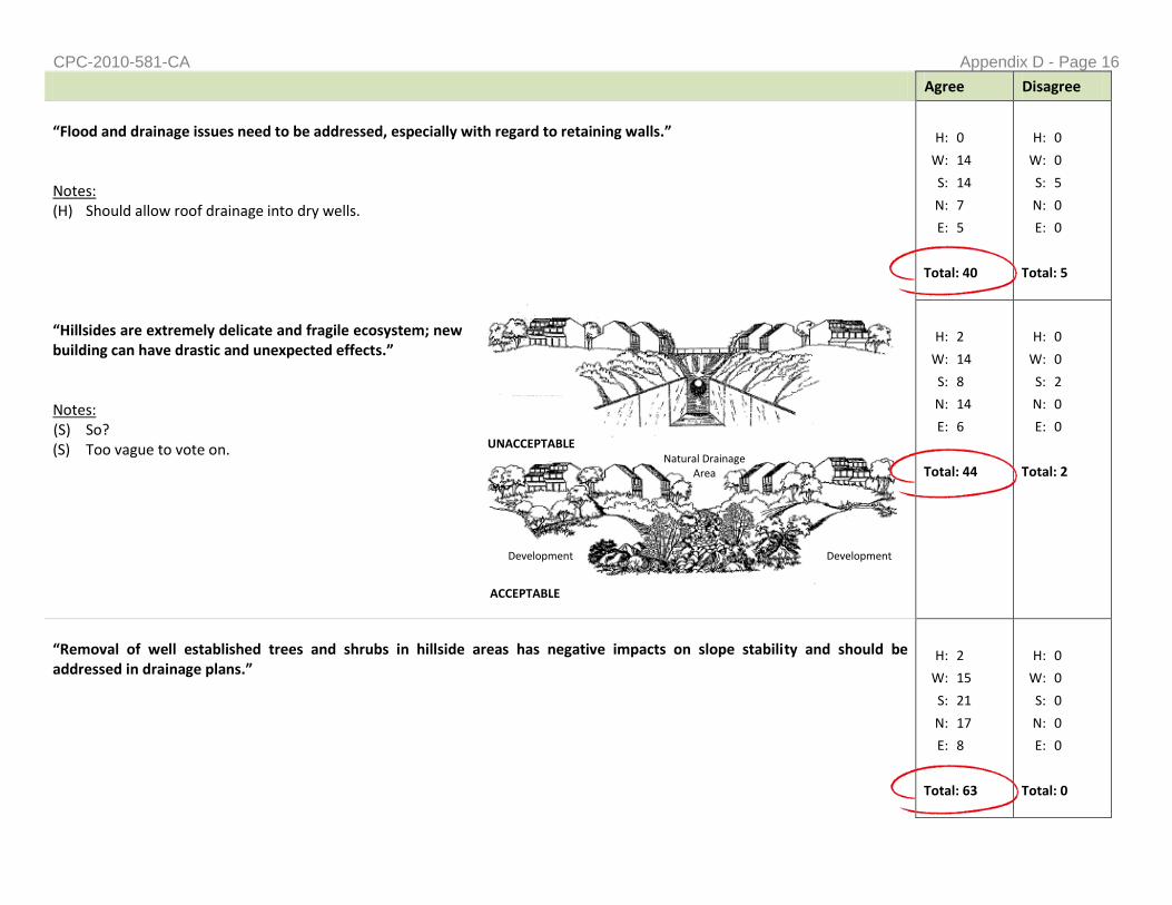
CPC-2010-581-CA Appendix D - Page 16
UNACCEPTABLE Natural Drainage
Area
ACCEPTABLE
Development Development
Agree Disagree
“Flood and drainage issues need to be addressed, especially with regard to retaining walls.” Notes: (H) Should allow roof drainage into dry wells.
H: 0
W: 14
S: 14
N: 7
E: 5
Total: 40
H: 0
W: 0
S: 5
N: 0
E: 0
Total: 5
“Hillsides are extremely delicate and fragile ecosystem; new building can have drastic and unexpected effects.” Notes: (S) So? (S) Too vague to vote on.
H: 2
W: 14
S: 8
N: 14
E: 6
Total: 44
H: 0
W: 0
S: 2
N: 0
E: 0
Total: 2
“Removal of well established trees and shrubs in hillside areas has negative impacts on slope stability and should be addressed in drainage plans.”
H: 2
W: 15
S: 21
N: 17
E: 8
Total: 63
H: 0
W: 0
S: 0
N: 0
E: 0
Total: 0

CPC-2010-581-CA Appendix D - Page 17
Additional Comments Received
Catch basins need to be in place to monitor drainage and should be required. Should drain equal to what was there prior to construction
Additional drainage issues: o Soil stability: sand vs. rock o Erosion, run off mitigation
Standard Urban Storm Water Mitigation Plan (SUSMP): should be better integrated with Planning hillside regulations
Additional storm water management comments: o Look at Malibu and Santa Monica as examples. o Need to look at regulations to make sure it doesn’t prevent any development. o Need to make sure all projects in the hillsides comply with SUSMP. o SUSMP requirements should be known at the planning level since they [SUSMP] can stop projects in mid-
construction — property owners want to know what they need to do beforehand.
The velocity of water coming down streets is under-estimated and poses threats to our drainage system.
What does SUSMP require and how does it impact hillside development?
LLAANNDDSSCCAAPPIINNGG && OOPPEENN SSPPAACCEE
Agree Disagree
“Protected Tree Ordinance needs better enforcement.” Notes: (S) Specific migration moth and butterfly larvae feed on native vegetation and are crucial in the food chain of native migrating
and non-migrating birds and other animals. (S) The native oak forest and black walnut forests need more enforced protection. (S) Mature native trees cannot be replaced.
H: 2
W: 11
S: 16
N: 14
E: 5
Total: 48
H: 0
W: 0
S: 4
N: 4
E: 0
Total: 8
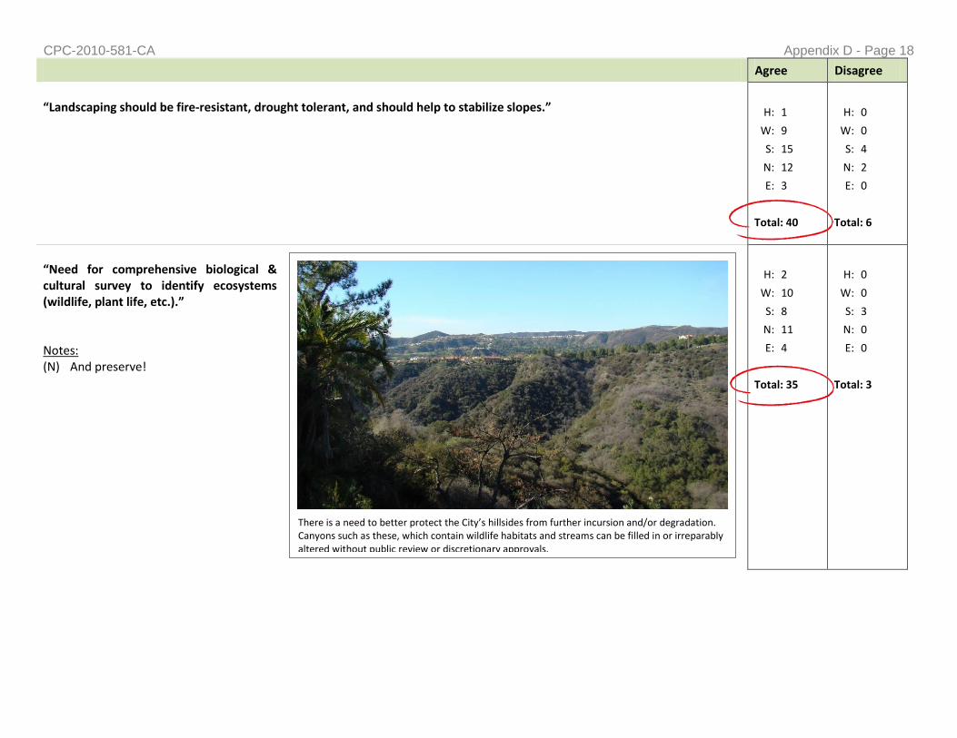
CPC-2010-581-CA Appendix D - Page 18
There is a need to better protect the City’s hillsides from further incursion and/or degradation. Canyons such as these, which contain wildlife habitats and streams can be filled in or irreparably altered without public review or discretionary approvals.
Agree Disagree
“Landscaping should be fire-resistant, drought tolerant, and should help to stabilize slopes.”
H: 1
W: 9
S: 15
N: 12
E: 3
Total: 40
H: 0
W: 0
S: 4
N: 2
E: 0
Total: 6
“Need for comprehensive biological & cultural survey to identify ecosystems (wildlife, plant life, etc.).” Notes: (N) And preserve!
H: 2
W: 10
S: 8
N: 11
E: 4
Total: 35
H: 0
W: 0
S: 3
N: 0
E: 0
Total: 3
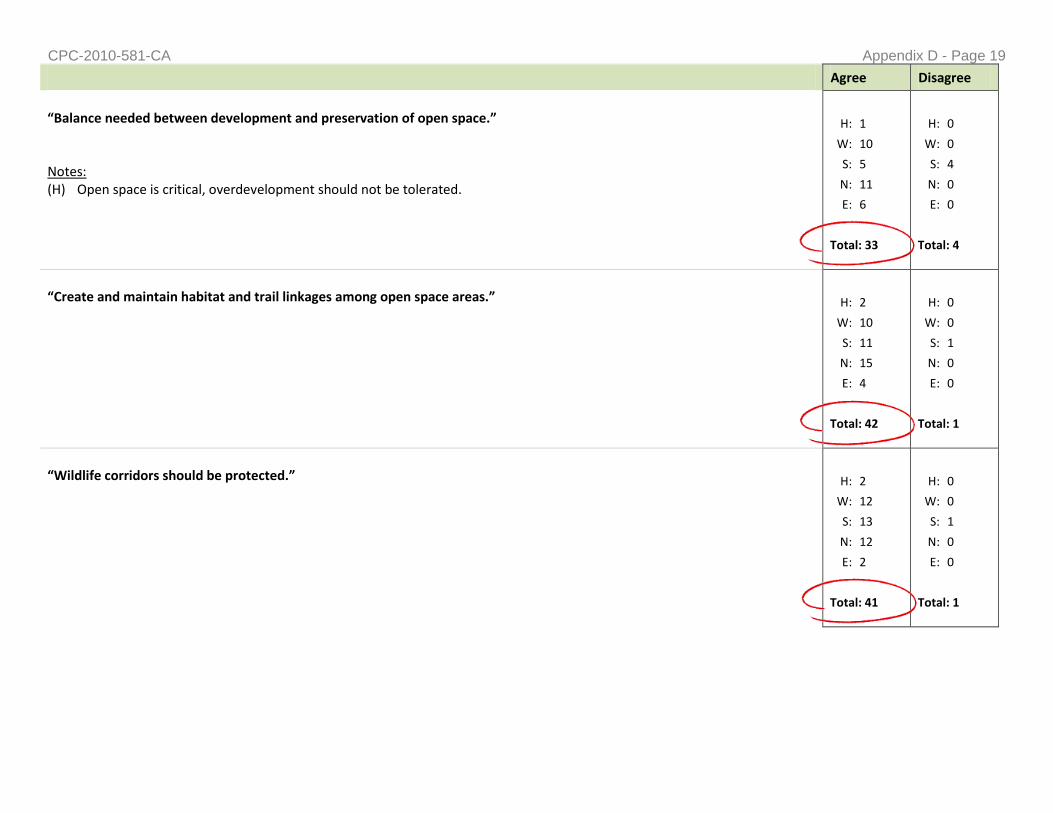
CPC-2010-581-CA Appendix D - Page 19
Agree Disagree
“Balance needed between development and preservation of open space.” Notes: (H) Open space is critical, overdevelopment should not be tolerated.
H: 1
W: 10
S: 5
N: 11
E: 6
Total: 33
H: 0
W: 0
S: 4
N: 0
E: 0
Total: 4
“Create and maintain habitat and trail linkages among open space areas.”
H: 2
W: 10
S: 11
N: 15
E: 4
Total: 42
H: 0
W: 0
S: 1
N: 0
E: 0
Total: 1
“Wildlife corridors should be protected.”
H: 2
W: 12
S: 13
N: 12
E: 2
Total: 41
H: 0
W: 0
S: 1
N: 0
E: 0
Total: 1
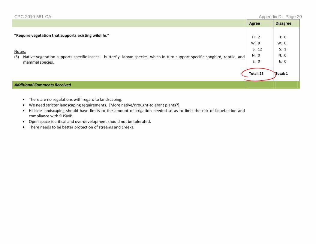
CPC-2010-581-CA Appendix D - Page 20
Agree Disagree
“Require vegetation that supports existing wildlife.” Notes: (S) Native vegetation supports specific insect – butterfly- larvae species, which in turn support specific songbird, reptile, and
mammal species.
H: 2
W: 9
S: 12
N: 0
E: 0
Total: 23
H: 0
W: 0
S: 1
N: 0
E: 0
Total: 1
Additional Comments Received
There are no regulations with regard to landscaping.
We need stricter landscaping requirements. [More native/drought-tolerant plants?]
Hillside landscaping should have limits to the amount of irrigation needed so as to limit the risk of liquefaction and compliance with SUSMP.
Open space is critical and overdevelopment should not be tolerated.
There needs to be better protection of streams and creeks.

CPC-2010-581-CA Appendix D - Page 21
IINNFFRRAASSTTRRUUCCTTUURREE
Agree Disagree
STREET IMPROVEMENTS
“Insufficient to support new development in many parts of City’s hillsides.” Notes: (W) Adequate parking critical otherwise illegal parking will occur, creating fire
hazards. Police in turn need to be called, when they could be used elsewhere.
(H) Alleys are not repaired by city [and should be]. (S) Need to study nexus with “taking” and concept of “fairness” if self
imposed hardship [when requiring street improvements]. (S) Development destroys streets. (N) Are Water and Power involved [in the development of new hillside regulations]? Current infrastructure cannot support
current use, much less additional development. My water pressure has been impacted by last nearby development on [street name omitted for privacy].
(N) Need to enforce the Hillside Ordinance which requires street improvement to nearest main / legal street i.e. get a new city attorney opinion from new city attorney!
H: 1
W: 9
S: 16
N: 10
E: 6
Total: 42
H: 0
W: 0
S: 0
N: 0
E: 0
Total: 0

CPC-2010-581-CA Appendix D - Page 22
Agree Disagree
“Road construction which is insensitive and inappropriate to the natural hillside; should be avoided whenever possible.”
H: 2
W: 10
S: 14
N: 4
E: 9
Total: 39
H: 0
W: 0
S: 2
N: 0
E: 0
Total: 2
“Large numbers of City’s hillside streets do not allow for adequate street parking; new regulations should result in less off-street parking, whenever possible.” *Special Note: “off-street parking” changed to “on-street parking” at the Harbor, Westside, North Valley, and Metro-Eastside Meetings. When these change were taken into account, the majority of people thought that we needed more off-street parking.] Notes: (H) Any and all development should be tailored to size of street and pedestrian needs. (S) That’s why you need garages NOT counted in square footage of house! (N) MORE off-street parking! (Less on street) (E) MORE off-street parking!
H: 2
W: 8
S: 13
N: 8
E: 9
Total: 40
H: 0
W: 3
S: 28
N: 0
E: 0
Total: 31
Landform Grading
ACCEPTABLE
Natural Contouring
Cut Contouring
Standard Cut and Fill Grading
UNACCEPTABLE

CPC-2010-581-CA Appendix D - Page 23
Agree Disagree
PARKING
“Narrow hillside streets cannot safely support large equipment normally used in development of non-hillside lots.”
H: 1
W: 9
S: 17
N: 5
E: 2
Total: 34
H: 0
W: 0
S: 0
N: 0
E: 0
Total: 0
OTHER
“Pedestrian linkages need to be preserved and expanded.”
H: 2
W: 9
S: 9
N: 7
E: 5
Total: 32
H: 0
W: 0
S: 0
N: 0
E: 0
Total: 0
Additional Comments Received
Keep the street conditions consistent with neighborhood character (i.e. areas with no curb and gutter should be kept that way).
Not all streets need to have sidewalks.
Clarify street improvements/topography. [?]
Need to get city attorney’s office behind regulating the required full street improvements.
New development exceeds the capacity of the current infrastructure.
Additional off-street parking is needed to reduce strain on sub-standard streets.
Catch basins should be required in the public right-of-way.
Infrastructure needs to be upgraded in order to support new development coming in.
Any and all development should be tailored to size of street and pedestrian needs.

CPC-2010-581-CA Appendix D - Page 24
EEMMEERRGGEENNCCYY AACCCCEESSSS
Agree Disagree
“Emergency services are compromised by unimproved roads.” Notes: (N) City should enforce the rule requiring improvement all the way to next street.
H: 3
W: 10
S: 17
N: 6
E: 0
Total: 36
H: 0
W: 1
S: 0
N: 1
E: 0
Total: 2
“Emergency vehicle delays due to street congestion has potential to result in longer and life-threatening response times.”
H: 1
W: 12
S: 12
N: 8
E: 5
Total: 38
H: 0
W: 0
S: 0
N: 0
E: 0
Total: 0
“Require more off-street guest parking on substandard streets, where found that excess street parking and/or narrow roads is likely to impede emergency vehicle access.”
H: 1
W: 11
S: 15
N: 9
E: 8
Total: 44
H: 0
W: 0
S: 1
N: 2
E: 1
Total: 3
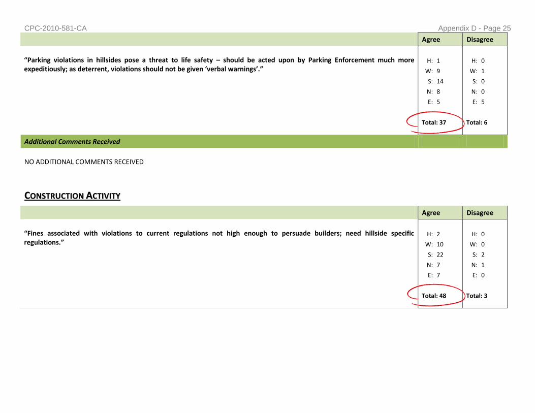
CPC-2010-581-CA Appendix D - Page 25
Agree Disagree
“Parking violations in hillsides pose a threat to life safety – should be acted upon by Parking Enforcement much more expeditiously; as deterrent, violations should not be given ‘verbal warnings’.”
H: 1
W: 9
S: 14
N: 8
E: 5
Total: 37
H: 0
W: 1
S: 0
N: 0
E: 5
Total: 6
Additional Comments Received
NO ADDITIONAL COMMENTS RECEIVED
CCOONNSSTTRRUUCCTTIIOONN AACCTTIIVVIITTYY
Agree Disagree
“Fines associated with violations to current regulations not high enough to persuade builders; need hillside specific regulations.”
H: 2
W: 10
S: 22
N: 7
E: 7
Total: 48
H: 0
W: 0
S: 2
N: 1
E: 0
Total: 3

CPC-2010-581-CA Appendix D - Page 26
Agree Disagree
“Construction activity should be limited on narrow hillside streets – permits should be issued in manner that limits number of projects being built at same time – better and more equitable coordination of available resources.”
H: 1
W: 11
S: 24
N: 7
E: 5
Total: 48
H: 0
W: 3
S: 4
N: 3
E: 0
Total: 10
“Limit amount of traffic generated by individual construction sites – example: requiring more effective coordination of construction vehicles and delivery of materials.”
H: 1
W: 9
S: 18
N: 1
E: 4
Total: 33
H: 0
W: 3
S: 4
N: 2
E: 0
Total: 9
“Hills have resonance factor which bounces noise and carries it along canyons - construction and grading-related noise can go on for months at a time.”
H: 1
W: 9
S: 11
N: 6
E: 6
Total: 33
H: 0
W: 0
S: 3
N: 0
E: 0
Total: 3

CPC-2010-581-CA Appendix D - Page 27
Additional Comments Received
NO ADDITIONAL COMMENTS RECEIVED
PPRROOJJEECCTT RREEVVIIEEWW PPRROOCCEESSSS
Agree Disagree
“Public hearings should never be waived in hillside areas.” Notes: (N) Notice provisions too short. All material in the file should be available on the internet 10 days before hearing. If not
available the hearing should be automatically continued!
H: 3
W: 11
S: 19
N: 5
E: 4
Total: 42
H: 0
W: 4
S: 2
N: 1
E: 7
Total: 14
“Frequent approval of waivers and Variances to hillside regulations has limited their effectiveness and ability to protect residents.” Notes: (W) Miss application of the 5 factor is cause. [?] (N) No kidding.
H: 0
W: 13
S: 16
N: 7
E: 8
Total: 44
H: 0
W: 2
S: 4
N: 1
E: 0
Total: 7
“Conditions of approval not applied consistently among different projects, and are not enforced properly.”
H: 0
W: 8
S: 13
N: 6
E: 3
Total: 30
H: 0
W: 0
S: 1
N: 0
E: 0
Total: 1

CPC-2010-581-CA Appendix D - Page 28
Agree Disagree
“Time period to review Zoning Administrator cases too short to adequately understand the many negative impacts that further building in hillsides creates.”
H: 0
W: 8
S: 9
N: 5
E: 4
Total: 26
H: 0
W: 0
S: 6
N: 1
E: 2
Total: 9
“Complicated and long permit processes may deter many of the long-time residents from building and cause shift in historic neighborhood identity.”
H: 1
W: 10
S: 14
N: 5
E: 4
Total: 34
H: 0
W: 1
S: 5
N: 2
E: 0
Total: 8
Additional Comments Received
Increase mailing radius for notification of hearings [not just abutting].
Tract maps—look into strengthening (i.e. the clustering language).
Consider grading that’s approved in a subdivision.
It is very difficult to understand what code provisions apply from the get-go – code simplification is necessary.
Hillside regulations need to be easier to find, there is a desire to know all the regulations that will apply to a project up-front.
Inter agency cooperation needs to better.
How would the new Hillside regulations mesh with current Specific Plans & Overlays? Which supersedes? We need consistency with these plans.
Consistency with other regulations governing hillside development is necessary.
Accountability issues: o The fee collection process is not internally-consistent. o Fee generations are bad. o Streamline the departments because they are so bad, people don’t want to follow regulations.

CPC-2010-581-CA Appendix D - Page 29
Agree Disagree
o Departments need to be accountable.
A workshop should be carried to teach how to establish the various overlay districts available.
Look at other plans and see what works and what doesn’t.
Rotations and site visits should be mandatory to truly understand the site and area staff is working with.
MMIISSCCEELLLLAANNEEOOUUSS
Agree Disagree
“Large homes in hills often become party houses – result in noise and traffic issues.” Notes: (S) How to solve noxious uses and non conforming uses? (S) “Party houses” are not to be allowed. We just had a shooting death- ENFORCE!
H: 0
W: 6
S: 11
N: 1
E: 6
Total: 24
H: 0
W: 6
S: 4
N: 10
E: 3
Total: 23
“Enforcement of regulations not strong enough and is key to successful implementation.”
H: 0
W: 10
S: 22
N: 5
E: 6
Total: 43
H: 0
W: 1
S: 1
N: 1
E: 0
Total: 3

CPC-2010-581-CA Appendix D - Page 30
Agree Disagree
“Better interdepartmental coordination is needed to effectively enforce regulations.” Notes: (S) How to? [?]
H: 0
W: 11
S: 27
N: 11
E: 5
Total: 54
H: 0
W: 1
S: 1
N: 0
E: 1
Total: 3
“Hillside regulations are not clear and do not offer descriptions, definitions, and diagrams that help shed light on how to implement them.” Notes: (H) Restrict development along bluff. (H) Cell towers need regulation! They are ugly and obstruct views.
H: 1
W: 12
S: 13
N: 5
E: 4
Total: 35
H: 0
W: 1
S: 2
N: 3
E: 1
Total: 7
Additional Comments Received
Agriculture zones are not subject to this zone—they should be. Want limits because can build as big of a house as you want on 5 acres.
The coastal zones are not being impacted by this initiative and that is not good.
Coastal zones should be included.
Auctioning off lots that are in bad condition
Is there pressure to increase density?
We need to increase.
This project should incorporate information from hillside issues previous addressed—such as slope density, preservation
There is a need to protect K [horse keeping] District lots, and have provisions focused on K Properties.
Equine setback constraint already limits buildable areas—how are we going to account for this.
When can you regulate other Zones [i.e. Commercial and Multi-Family] in the hillside?
Why are these regulations only applying to single family when multi-family has the heaviest impact on the area.
Converted 2nd dwelling units are a constant issue.
Owners need to be fined for garages not being used for car storage.
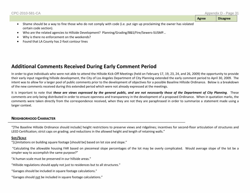
CPC-2010-581-CA Appendix D - Page 31
Agree Disagree
Shame should be a way to fine those who do not comply with code (i.e. put sign up proclaiming the owner has violated certain code section).
Who are the related agencies to Hillside Development? Planning/Grading/B&S/Fire/Sewers-SUSMP…
Why is there no enforcement on the weekends?
Found that LA County has 2-foot contour lines
Additional Comments Received During Early Comment Period In order to give individuals who were not able to attend the Hillside Kick-Off Meetings (held on February 17, 19, 23, 24, and 26, 2009) the opportunity to provide their early input regarding hillside development, the City of Los Angeles Department of City Planning extended the early comment period to April 30, 2009. The intent was to allow for a larger pool of public comments prior to the development of objectives for a possible Baseline Hillside Ordinance. Below is a breakdown of the new comments received during this extended period which were not already expressed at the meetings.
It is important to note that these are views expressed by the general public, and are not necessarily those of the Department of City Planning. These comments are only being distributed in order to ensure openness and transparency in the development of a proposed Ordinance. When in quotation marks, the comments were taken directly from the correspondence received, when they are not they are paraphrased in order to summarize a statement made using a larger context.
NNEEIIGGHHBBOORRHHOOOODD CCHHAARRAACCTTEERR
“*The Baseline Hillside Ordinance should include] height restrictions to preserve views and ridgelines; incentives for second-floor articulation of structures and LEED Certification; strict caps on grading; and reductions in the allowed height and length of retaining walls.”
SIZE/SCALE “*L+imitations on building square footage *should be+ based on lot size and slope.”
“Calculating the allowable housing FAR based on piecemeal slope percentages of the lot may be overly complicated. Would average slope of the lot be a simpler way to accomplish the same purpose?”
“A human scale must be preserved in our hillside areas.”
“Hillside regulations should apply not just to residences but to all structures.”
“Garages should be included in square footage calculations.”
“Garages should not be included in square footage calculations.”
CPC-2010-581-CA Appendix D - Page 32 “*The+ inclusion or exclusion of the first 400 square feet of covered parking area in the floor area calculations is a very contentious issue. [T]he Department [should devote] special attention to this issue, including perhaps a separate, single public meeting on this topic alone.”
“Garage, attic spaces, ceiling heights, guest houses, porches, and or hardscape should NOT BE COUNTED AS LIVING SPACE.”
“SOME ‘Tall box-like homes ARE reflective of neighborhood character’”
“Some large homes on smaller lots are an improvement over the older less energy efficient house next door and some are not.”
“We strongly caution that these topics might somehow be used to increase *the current+ maximum floor areas.”
“*C+alculation methods [for determining maximum size limits] in the future Hillside Ordinance [should] be as simple and transparent to users as possible.”
“Consider combining the Average Natural Slope calculation method in Section 17.02 of the Municipal Code with the more detailed topography maps now available.”
The FAR calculation should be simple to calculate and cross check.
“*T+he Department *should+ strongly consider the minimum square footages allowed, and further consider that some hillside lots are simply too challenging to build upon.”
“Create a neighborhood character bell curve that would govern the size of new dwellings. To correct past inequities, the very lowest and highest square footage homes should not be included in the curve. Count abutting homes as double to account for air light, view and solar access issues.”
BULK “*P+atios generally should be included in the FAR calculation with an exception for patios that have only a single-plane coterminous wall with the dwelling.”
HEIGHT “The width of the road should be considered in determining the height of the building.”
“*T+he advantages of less grading should be rewarded by permitting a height bonus when a dwelling is “stepped” up or down a hillside.”
CURRENT “ONE-SIZE-FITS-ALL” APPROACH Individual areas should be able to subsequently create overlay areas.
Any hillside restriction ordinance should contain an “opt-in” not an “opt-out” provision, and any restrictions should only be adopted on an opt-in basis only after full and objective disclosure of the likely reduction in value of such restrictions on the community involved.
SITE LOCATION “There should be no building on slopes exceeding a specified grade.”
“Since hillside construction is generally in fire zones, greater setbacks to provide more separation between buildings should be required.”
“Project must be place or constructed to preclude silhouettes against the skyline above the ridgeline.”
“*The Baseline Hillside Ordinance should+ include a prohibition on building within 50 feet (in any direction) of a ridgeline.”

CPC-2010-581-CA Appendix D - Page 33
EENNVVIIRROONNMMEENNTTAALL IIMMPPAACCTTSS
“All projects for development in Hillside Areas to have, at the least, and Environmental Assessment from the Planning Department to ascertain the need for possible mitigation and to insure compliance with the Hillside Ordinance; Retaining Wall Ordinance; Protected Tree Ordinance, etc.”
GGRRAADDIINNGG && SSLLOOPPEE SSTTAABBIILLIITTYY
GRADING REGULATIONS “Application of all soils, geo and grading reports not to exceed two years prior to permit approval, and a one year limit to begin without update and review.”
“… avoids the use of out of date and inaccurate information in the planning and approval process.”
“All grading approvals must retain the existing ridgelines.”
“All primary and secondary ridgelines must be identified, defined and catalogued.
“All grading amounts over 1,000 cubic yards of cut and fill (total combined) should require either a conditional use permit or a variance.”
“Prior to issuance of a haul route *approval+ in excess of 500 cu yds, all properties along the proposed route shall receive adequate individual notice with appropriate time for public review and comment.
“Copy of notice to the Council person office in the area of the subject haul route with copies to the relevant Neighborhood Council.”
“Prior to commencement of hauling, a bond or equivalent shall be provided in an amount adequate for restoration of private and public property including road ways and appurtenances, deterioration and damage.”
“The current $50,000 amount is significantly inadequate and should be increased to reflect the size of the project.”
“Hauling only be properly licensed vehicles of no more than 6,000 pound weight shall be permitted in the Hillside Area.”
“License through Bureau of Street Services with power to fine violators.”
“Grading times need to *be+ defined and enforced as well as issues related to litter, dust, debris, and rainy season protection.”
“Graded slopes shall conform as closely as possible to the surrounding natural hillsides and grading on slopes greater than 2.5:1 or steeper shall not be allowed without findings and justification as required under discretionary review actions such as Variance or Conditional Use Permit.”
“Retain existing ridgeline by limiting the highest point of structure, including towers, chimneys etc. to 50 feet from the ridge in both vertical and horizontal directions except in cases of extreme hardship.”
“No grading shall occur that alters the ridgeline.”
“A large swimming pool requires over 100 cubic yards of dirt to be excavated. Say goodbye to basements, structurally important foundations and subterranean garages.”
CPC-2010-581-CA Appendix D - Page 34 “Based on a neighborhood’s existing density and access road issues, create incoming haul routes that will put limits on construction vehicles and incoming building materials.”
“*T+he Hillside Ordinance [should] specifically provide that (1) lot slope areas used to calculate Floor Area Ratio (FAR) limitations, and (2) baseline grade elevations used to determine building height limitations be measured, verified, and approved [in writing] prior to any grading, excavation, soil importation, or other type of soil movement or displacement.
“*T+he Ordinance should include provisions for ensuring that such measurements are made properly in situations where: (1) a lot has experienced some prior grading (especially where the exact original baseline grade elevation cannot be determined); and (2) a remodel may include additional planned grading, excavation, soil importation, or soil movement.”
RETAINING WALLS “Reexamine the retaining wall ordinance to lower the retaining wall height with a limit of eight feet and conformance to the then modified Retaining Wall Ordinance.”
“Retaining walls must be limited in length as well as height.”
“*E+xcessive grading as measure by trips and cubic yards should be defined and limited.”
“Requirement of mature vine type vegetation on all retaining walls exposed to the street, including those in the rear yard that are visible from the street.”
“Landscaping of retaining walls should apply to all retaining walls.”
“Retaining walls over a certain height (to be determined by building department) should have a requirement to be landscaped.”
Variances for retaining walls should require that they be landscaped as soon as they are built.
RRUUNN--OOFFFF && DDRRAAIINNAAGGEE
“Preference is to have as much drainage be put in French drain or other on-site drainage system to minimize stormwater runoff, potentially ex-filtration and others.
“Requirement of erosion control measures on all projects, need specific review of SWSMP but minimally to include 2-3’ of erosion control fabric, plastic tarping over excavated hillsides for rain periods etc.”
“Frequently, drainage systems are approved which require continuous maintenance in order to work and just as frequently the maintenance either is not performed or is not properly or timely performed resulting in water on the property percolating into the ground water which results in slope slippage and landslides.”
“The only drainage systems that should be approved are systems which require no maintenance or human intervention to ensure proper operation.”
CPC-2010-581-CA Appendix D - Page 35
LLAANNDDSSCCAAPPIINNGG && OOPPEENN SSPPAACCEE
“Landscape plans must be approved prior to grading.”
“A list of fire retardant plants suitable for hillsides could be given to the owner with the grading permit.”
Homes look large when they haven’t been landscaped.
“Landscaping plan should be a part of the Building Permit process to mitigate the looming affect of larger homes and to maintain the green spaces and air quality throughout our neighborhoods.”
“*T+here should be a landscaping component to plan check as in Santa Monica where promised landscaping must be installed before a Certificate of Occupancy is issued.”
“Native and drought tolerant plantings should be encouraged consistent with fire safety concerns as some native plants are highly flammable.”
“On large properties, I believe much of the property should be landscaped.”
“On lots that contain protected trees, determine how much open space needs to surround each tree for its continued health. Subtract that area from the lot size before determining the home-to-lot ratio. Double the area if trees must be removed and therefore replaced 2:1.”
“Lots not suitable for building might make mini playgrounds or dog runs.”
“When organizations such as the SMMC ,Santa Monica Mountains Conservancy] designate land as requiring protection for ecological or historic reasons, subtract that item’s square footage from the lot size before determining the home-to-lot ratio. Create a civic mechanism that safeguards the designation in perpetuity.”
IINNFFRRAASSTTRRUUCCTTUURREE
STREET IMPROVEMENTS “A plan needs to be developed to renew our roads and access to utilities, as we fill the empty lots and remodel houses in the hills.”
The issue of the continuing degradation of the public infrastructure should be refocused by the Baseline Hillside Ordinance.
“Sidewalks, curbs and gutters should be required along with storm drains.”
PARKING “Lots *which are+ too small for building might be developed for parking.”
“Removal of 5 space maximum for parking and requirement of additional on-site parking for larger homes in the hillside.”
“*O+ff-street parking should be encouraged and such areas should be green and organic, e.g., grasscrete, decomposed granite (dg), or other natural appearing surfaces.”
CPC-2010-581-CA Appendix D - Page 36
EEMMEERRGGEENNCCYY AACCCCEESSSS
“Written approval from LAFD shall require adequate access and egress.”
CCOONNSSTTRRUUCCTTIIOONN AACCTTIIVVIITTYY
“Enforce van pool compliance in Hillside Areas, if required under the applicant’s approval.”
“*M+ore protection of directly affected neighbors needs to be considered *during the construction phase+.”
There should be a set construction timeline/window/period under which projects must be completed.
“Please consider factors such as noise, permitted hours of construction, dirt, refuse left overnight, unnecessary delays.”
“*S+ome of these issues are already covered by existing ordinances, but there is littler or no enforcement.”
“For properties developed that front the major canyon roads (i.e. Beverly Glen, Benedict Canyon, etc.), believe mostly classified secondary highways, requirement of flagmen during entirety of construction.”
“*D+eliveries of materials or equipment to be done during non-peak hours for that street per LADOT.”
PPRROOJJEECCTT RREEVVIIEEWW PPRROOCCEESSSS
“Notification *should be+ required to Council Office and Neighborhood Council of the area of any filing for permits and approvals including remodels.”
“Require any Zoning Administrator hearing notice to be sent to residents within one hundred feet (100’), at the minimum.”
“Submissions and permit requests shall be made only to a *Building & Safety+ department office in the Council District of the subject property.”
“Approval shall require a schedule of performance along with adequate bonding or financial guarantees to complete the project as approved.”
“Require any new construction to provide completion bond to avoid stalled projects that become erosion control and drainage hazards.”
“Require peer review for any walls that require building or grading permits, either retaining or house walls used for retaining soil. Peer review to be done by California licensed Civil or Structural Engineer with stamped letter by said engineer.”
“If no discretionary permit is involved the public does not have any opportunity to examine the geology reports until after the grading and/or building permits are issued.”
“Adding to the problem is that even the building plans are not available for public inspection until after the bulding permit is issued.”

CPC-2010-581-CA Appendix D - Page 37 “A 30 day public notice of an application for building, grading, and excavation permits should be given and all plans and geologic and soils reports made available to the public.”
“*T+he Hillside Ordinance *should+ not give such authority to the Zoning Administrator *to grant adjustments to floor area+.”
MMIISSCCEELLLLAANNEEOOUUSS
A financial impact study of any proposed ordinance should be done before proceeding.
“View protection should be an important part of the baseline hillside regulations.”
“Coastal zones should be included.”
“The slope density limitations provided in Municipal Code Sections 17.02 and 17.05, and the Slope Density Ordinances that invoked these provisions (179,035 in 1987 and 162,144 in 2007) MUST BE UPHELD, i.e., NOT DILUTED OR SUBJECTED TO POTENTIAL FUTURE LEGAL CHALLENGE IN ANY MANNER.”
“*T+he slope density limitations *should+ be specifically referenced within the Hillside Ordinance, and the Average Natural Slope calculation method in Section 17.02 [should] be modified to require use of the same, reduced contour spacing that would be employed in the Hillside Ordinance slope area calculations.”
“*T+he Department *should+ consider providing means within the Hillside Ordinance to further reduce hillside slope density limitations, possibly based on guidelines related to the ten topics [outlined at the Kick-Off Meetings+.”
The consistencies between the Baseline Mansionization Ordinance (179,883) and the Northeast Los Angeles Ordinance (180,403) should be retained in the Baseline Hillside Ordinance.
“*T+he Hillside Ordinance *should+ incorporate provisions that would prohibit building on a lot if specific safety, stability, erosion, and other challenging limitations cannot be met.”

CPC-2010-581-CA Page 1
APPENDIX E
SUMMARY OF PUBLIC WORKSHOP COMMENTS South Valley Public Workshop (February 17, 2010)
Should include slope density in ordinance.
Substandard lots concern.
o Girard tract
Why do we want to reduce tax revenue?
What if my house is destroyed by a fire or natural disaster?
Look into changing retaining walls.
o Too restrictive now.
Don’t want long snaking retaining walls.
What is a remodel? Same as BMO?
How does green incentive get verified?
Make it clear 20% is a onetime bonus.
Don’t want to have covered parking counted
What is an accessory building? How is it different than an Accessory Dwelling Unit?
Light wells—what about quantity?
Do we need an overall height? Lot coverage is enough to limit overall height.
Terracing of structures is ideal.
Lots of limits now--- too confusing
What about combination of sloped/flat roof? How do you measure heights?
Why not have a Design Review Board since so many projects will have discretionary actions with the
ordinance?
What about existing exempt structures—do they still get exemptions? (i.e. add on to existing accessory
structures or lofted spaces do you get our exempted 250 square feet on top of existing SF)?
What about discretionary applications, for instance, if DRB is approved—and not in plan check—do
they get approval or only if in plan check?
Need to have more grading as lots get bigger. 1,000 cubic yards is too small.
What is remedial grading?
Is grading counted as insitu or loose? (compact or dug up)
What about if geotechnical report says on-site soil isn’t suitable (expansive) and required to import it in.
Does that count? Can you ―grade the entire site‖? What rules do we have to comply with?
Discretionary actions cost too much money and take too long.
100% slope isn’t that steep … need to increase % from 0 FAR.
Grading for a basement on a 100% slope shouldn’t need a variance.
Grading permit timing—grading bond takes care of linking building and grading permits.
Developers not happy with linking of grading and building permits—this idea does not solve problem
because you may not ever pull the building permit and just grade and have the bldg permits filed
Paper street access. Do our restrictions apply to public street access?
How much does haul route create a discretionary action?
Conflict on 1,000 c.y. --- both sides….too much too little.
Need limitation of # trucks put into ordinance…
Cumulative effects of construction need to be accounted for.
Import/export limit needs to be tied to size of lot.
CPC-2010-581-CA Appendix E - Page 2
Larger lots have too restrictive FARs—think RA’s are different in the hills than they are in the flats.
o No animal keeping in hillsides
Why do lessees count in ―HS‖ Hillside Standards Overlay District?
75% support too high?
RA FARs too restrictive?
Overlays should allow the RFA definition to be can be changed.
1 story can’t get bonus if built to setbacks—what incentive do they have?
Ridgeline protection needed.
Where is height calc from if subterranean garage?
o What about a 10-car subterranean garage? Exempt?
o Width of garage door can be wider than 20 feet—hammerheads? We need to account for fire
access in access exemption.
Green building code—maybe go above and beyond new code—put it in now and don’t even mention
LEED.
o Calabasas has already done this.
What about lots nonconforming that are closer to conformance with other zones?
South Valley Public Workshop (February 18, 2010)
Need to define age of geology report.
Grade plane as it relates to grading.
How do you deal with previously graded lots? From what point do we start from or verify from?
People complained that ZAD’s take too long and we would require too many with this proposal.
Does it make sense to have a smaller house on a steeper lot if you can conceal it from public view?
In guaranteed Min’s why is RE15 lumped with RE20 and not RA or the RE11?
What about substandard lots and their guaranteed minimums?
What about an overlay that includes vacant properties that don’t conform to lot size—could you set new
minimums?
With the guaranteed minimum, what if to build it, you require variances—i.e. grading, heights etc.
Would you then be guaranteed the minimum?
Flag lots brought up and the need to change setback rules.
Need to it make clear that bonuses are not cumulative.
Why are porches with only 1 opening not exempted? Still could articulate…
Need to consider a limit on number of light wells—could ultimately defeat our intent if the entire
basement has light wells around it and you can see into the structure below. Maybe only exempt those
required by code for light and ventilation—but still need a cap since they are required to make any room
habitable. Maybe cap square feet of habitable basement space? Or require a grate to be placed above
light well to reduce visual impact?
For flat lots, it would be very hard to achieve the overall height, but very easy to use the envelope
height.
For the envelope height, how do you account for site anomalies like sink holes? Maybe an averaging
technique?
For envelope height ZAD requests, why is the permitted height limited to overall height? Should it be a
percent of envelope height? Currently ZAD’s have no limit.
Need to specify age of soils and geology reports.
Need to have accountability for reports—public asked if we could require current drilling for each report.

CPC-2010-581-CA Appendix E - Page 3
Need to include retaining walls in the ordinance.
Need to differentiate between story and level.
Issue with setbacks: If you already are built up to the property line does addition need to conform to
current standards? What bonuses can you use?
Limits on grading push a building up and doesn’t encourage notching in.
Why do we have the same amount of grading on different sized lots—cap should be based on lot size.
In order to reduce the ZA case load, need to tailor grading caps to the zone.
Proposed idea for calc RFA—like Mulholland—neighborhood calculation
Need to include stream protection
Need to cap length of retaining walls.
Need ridgeline protection. Northeast got it and we deserve it. If not in this ordinance, when?
Haul Routes: limits on number of trucks needs to be stricter.
Are contour maps available to start imagining what this ordinance will limit?
How does this compare to other city’s hillside ordinances?
Proposed Idea: what about prevailing square feet?
Does this apply to coastal lots?
What about major hillside remodels and setback requirements? What about nonconforming RFA, can
you change 50% under major hillside remodels? Do we want to encourage tear downs or retention of
older housing stock?
People were worried about the sunset clause.
Need to include retaining walls in order to prevent the back of the house to be used as a retaining wall.
Who enforces this code? What about illegal grading? Need to punish illegal grading with a penalty of
not issuing the building permit until the earth is put back.
Bonuses should be only 10%. 20% is too much for a steep lot, but 20% could work for a flat lot.
We have lost perspective on height. We are supposed to protect the hillsides which are a city wide
asset. 45 feet should only be used for extreme situations. Overall should never exceed 45 feet.
Why are we exempting grading for foundations?
Need to address bonding for permits.
Ridges have to be put into this program.
Public works need to link street improvements to haul routes.
Pointed out Malibu’s ordinance and 15% threshold to preserve the rural character
Need to increase notification requirements of ZAD’s. Maybe set a min number of lots or increase
radius. Neighborhood councils don’t get notified in a timely manner.
Comment that the landform grading bonus may be a ―gimmee‖ or automatic bonus.
How do exterior stairs factor into height of building?
Green building code will trump our LEED bonus. We need to consider how to build upon the new
building code.
Hollywood Public Workshop (February 22, 2010)
Need to have building permit appeal process easier.
What about private roads? To multiple homes? Can they grade without limits? We need to analyze
access exemption some more.
For substandard lots, are the ratios applied the same for RFA? What about lots that are much bigger or
smaller than required lot size (i.e. Girard Tract or Beverly Park).

CPC-2010-581-CA Appendix E - Page 4
Need to have ridgeline protection.
Minimal grading options is an automatic bonus.
With regard to guaranteed minimums, have we thought how that would be built on a steep lot? Does it
matter since the slope of the lot would ultimately dictate the size and location of the house? Min does
require you to build to the min level, could be less.
Maybe the guaranteed minimums should be based on the slope.
75% for the overlay is too many signatures. Would be impossible. Need to reduce %
Can’t treat the hillsides like the flats. Can’t dwarf the street with structures or have out-of-scale
construction.
Should have import/export limits tied to street improvements.
ZA notification requirements not sufficient. Need to notify Neighborhood Councils, HOA’s and abutting
neighbors.
What about adding an addition to a nonconforming structure? Should be able to do something.
For nonconforming structures, would you be able to convert covered porch to habitable?
Need to have a % of addition for nonconforming structures, not just a lump sum.
Need to have ridgeline protection.
Why is the basement exempt? Aren’t they grading? Flats are different than hills.
Should count basement towards parking requirements.
All covered parking should count towards parking requirement.
How are we going to stagger permits on a street?
For unbuildable land (or too expensive to build), why don’t we give a tax break and then donate it to
public land.
How do we deal with street repair during and after construction activity? Need to have a bond to repair
or require smaller vehicles on substandard streets.
Who enforces grading? What good are regulations if not enforced?
Will these regulations affect specific plans etc?
North Valley Public Workshop (February 23, 2010)
Need to include landscaping in ordinance.
Need to look closer at minimum grading option.
K areas need to be addressed. What about grading for foundations of accessory structures that are
required for K used properties?
A Zones should have the same FAR as the RA Zone.
Need to require developers to submit and show how they calculated contour lines. Big problem with
slope density calcs since they don’t like to show how they get the numbers.
Proposed option for a bonus: include local native plants…
How do you secure LEED compliance when you verify that after construction? Inspectors need to
check for compliance better.
The issue with parking is that whether it is covered or uncovered, grading is still required. Should
include uncovered parking as part of the RFA.
If we remove the overall height, maybe we should reduce the envelope height.
What about multiple structures—how is overall height measured? Singularly or combined? Visually
should be combined…
Roof top equipment shouldn’t be exempted except chimney. Parapets just extend the massing of
buildings or just ugly. For Elevator shafts, how do you ensure that it won’t be converted?
CPC-2010-581-CA Appendix E - Page 5
How tall can antennas go?
Why are foundations, driveways etc exempt? Should have regulations or caps
Explore option of tying import/export to street improvement.
City needs to enforce improving streets to edge of boundary.
Landscaping should be included in overlay district regulations.
Need ridgeline protection. Maybe include it in the overlay?
Need to reduce the slope band ranges. Too large.
San Pedro Public Workshop (February 23, 2010)
Concern regarding San Pedro’s SP method of calculating height. They don’t want to undo this.
Want BHO in coastal hillsides.
What about preventing roads along ridges?
Viewshed preservation.
Need to downsize homes.
Natural terrain better protected by stilt construction.
Preferred envelope height only approach.
Would like the proposals to be expanded to multi-family.
Height and daylighting side. Does it count? Look at Pacific Palisades Civic Association or HOA
Elevators square-footage vs. stairwell square-footage?
Metro/East Public Workshop (February 25, 2010)
Why is RFA for severe slopes severely reduced? Why are we penalizing steep slopes?
We are making it too restrictive to build.
5,000 square-foot house is not unreasonable for larger lots. Need to increase minimum RFAs.
75% is too much for signature requirements to establish an overlay.
Northeast LA has R1 zones changing to RD1.5 through small lots—this ordinance needs to cover small
lot subdivisions too.
What are the guaranteed minimums for substandard lots?
If nonconforming to area then you should be based on another appropriate zone.
RE15 and RE40 are not comparable for guaranteed minimums; 4,000 square feet is too small for a
RE40 lot.
What about grading before construction for access?
Need to establish a process to detect illegal grading.
For the >60% band, 0.15 is too small! So many lots have that in its entirety .
Should measure the 14-foot height threshold from exterior not from interior (i.e. if sunken room).
Look at how Malibu does RFA calcs (liked working with this method).
Extra covered parking isn’t the same as an extra bedroom. Shouldn’t count or should count
proportionately less.
Basements and fire escape access.
Should increase basement height to 3 feet to account for floor and to permit a 1 foot window.
Need to have access to house or basement exempted from grading.
Why does the patio have to be open on 2 sides? Why not just one? What if surrounded by retaining
walls?
CPC-2010-581-CA Appendix E - Page 6
Why are we keeping the 5 foot out rule for height?
Liked idea of getting rid of overall height.
Need to clarify difference between floors and stories—anything more than 4 feet difference counts as a
story. Maybe look at Malibu.
Terracing and story limits: how stories are calculated (see above) limits the ability of terracing.
Need to have the basement in the exempt grading category.
Need to determine what natural grade is.
Retaining wall regulations are too restrictive.
Why prevent building on 100% slope? There are many lots where it would be impossible to build with
this provision. Should be able to tuck into the hillside when there is a 100% slope. Should be able to
build on a portion of a site that is 100% slope without ZA action .
No one is going to buy properties with these regulations. They will leave LA.
Changing rules changes property values.
If grading and you come upon a 100% portion, are you required to stop and skip to the next portion less
than 100%? What about when doing landform grading?
Should we exempt grading for required fire department turnarounds (i.e. hammerheads)?
Don’t want to stop grading without building permits.
What if grading to create a road that would use earth from the lot. Why do we have to have building
plans approved for grading for access (private road or street improvement)?
Is grading as is required for tracts exempt?
Make sure it is clear that remedial grading and building permit tie doesn’t exist. Can do remedial
grading without building.
Commented that B & S already does linking of grading and building permits—(not everywhere though,
just certain plan checkers).
What about street dedication and street improvements and grading that happens as a result?
What about existing addition exemption? Need to have something by right.
With regards to overlays, why should we allow others to dictate our property rights?
Why do lessees get the same vote as owners?
Don’t want to have overlays at all—75% is too easy to get.
What if 75% of the lots have been developed---they would dictate to the other vacant 25% what they
can do. This is a problem.
Specific Plans already account for compatibility.
If we know that disparities exist between neighborhoods, we should account for that now, not through
an Overlay. What about developing a neighborhood strategy to calc RFA?
On substandard lots, we should increase bonus to 30%, like in BMO.
Don’t require building height to be from exposed basement. Height definition needs to carry over from
flats (there is a stipulation that in hillsides you measure it differently than in flats).
Why should steep slopes have smaller homes?
Need to have some value to 100% Slope Band in calculating RFA.
Not enough value for 60-99% Slope Band.
Make FARs decrease less dramatically (say 2% instead of 5%).
There appears to be a conflict between grading and encouraging nestling into hillside—can’t nestle
without grading.