Embed Size (px)
Citation preview

Chapter 2. Denudation: Rivers and Ice
DENUDATION: process that lowers level of
land
- caused by rivers, glaciers, waves & wind
- involves processes of WEATHERING &
EROSION

Weathering
Def: breakdown of rock and minerals by
physical pressures and chemical reactions
2 types: 1. Physical 2. Chemical
1. Physical Weathering
- also known as Mechanical Weathering
- rocks broken into smaller fragments
- involves forces in physical environment

Types of Physical Weathering
I. Expansion/Contraction
- rock expands when heated suddenly
- contracts when cooled quickly
- results in cracking of rock

Types of Physical Weathering (cont)
II. Exfoliation
- associated with release of internal pressure within
rock
- caused by erosion of overlying material
and heating and cooling
- outer layers of rock “peel away” like layers of
an onion

Exfoliation

Types of Physical Weathering (cont)
III. Frost Fracture
- in climates experiencing temp fluctuations
- extreme heat and cold causes cracks in rocks
- water seeps into cracks and freezes
- water expands during freezing
- cracks widen until rock splits apart

Frost Fracture: Talus Slope

Frost Fracturing
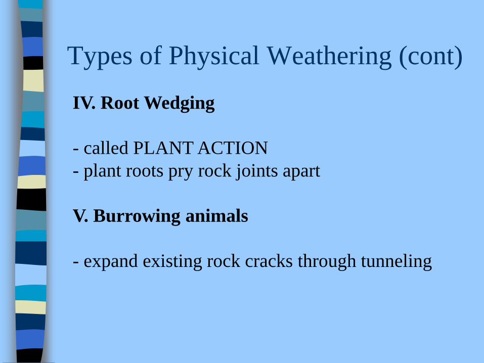
Types of Physical Weathering (cont)
IV. Root Wedging
- called PLANT ACTION
- plant roots pry rock joints apart
V. Burrowing animals
- expand existing rock cracks through tunneling

Root Wedging
Root Wedging

Chemical Weathering
Def: breakdown of rock minerals by
chemical reaction
- usu related to action of rainwater when
it comes into contact with rocks
- 3 main processes occur:
i. Solution
ii. Hydrolysis
iii. Oxidation

Chemical Weathering (cont)
I. Solution
- contaminants in rainwater create
carbonic acid
- erodes minerals in rock causing it to decompose
- ex limestone
- called CARBONATION

Carbonation: This form of weathering occurs wherever seeping ground
water circulating through the sandstone dissolves the calcium-carbonate
cement between the individual grains, causing the rock to crumble to sand.

Chemical Weathering (cont)
II. Hydrolysis
- carbonic acid in water dissolves silicates
in rock producing soft clay
- clay turns to soil

Hydrolysis: iron-bearing silicate minerals weather to
form clay

Chemical Weathering (cont)
III. Oxidation
- oxygen in water reacts with metallic
minerals in rock
- reaction produces new minerals called
oxides
- reddish-brown stains on rocks are iron oxides
or RUST
- pale-greenish stains are copper oxides

Oxidation

Erosion
Def: the breakdown of rock into smaller fragments
and the movement of these fragments to other
locations.
- moved by wind, water, ice, gravity
- running water a main agent of erosion
- rain water flows over Earth’s topography
- collects in RIVERS

Erosion and Gravity

Erosion (cont)
- land area from which a river receives its water
called DRAINAGE BASIN
- basins of different rivers separated by heights
of land called DIVIDES

Drainage Basin

Example of a Watershed

River Erosion
- river system erodes high land and carries
material to fill lower land
- rate at which area is lowered or eroded depends
on a # of factors:
1. Resistance of underlying rock
2. Volume of water
3. Vegetative cover
4. Gradient of river bed

River Erosion (cont)
- rivers concentrate energy and erode river bed
both vertically and laterally
-VERTICAL EROSION: river erodes bottom of
river channel
- LATERAL EROSION: erosion of the river banks
- this produces MEANDERS in river channel

River Erosion (cont)
- erosional processes include:
1. Hydraulic Pressure -- water pressure
2. Corrosion -- erosion of rock by solution
3. Abrasion -- grinding away of rock by rock
fragments and particles carried in water

Life Cycle of a River
- as rivers erode and lower the landscape, its
drainage pattern and channel shape change
- rivers are thought to pass through stages
- Youth, Maturity and Old Age
- at each stage, river has certain characteristics

Youth Stage
- youthful rivers typically found in highland
or mountainous areas
- steep, V-shaped valley
- straight channel & uneven riverbed
- fast, turbulent flow; high erosional force
- rapids & waterfalls common

Mature Stage
- high relief has been lowered
- river bed has gentler slope, slower river flow
- river may have many branches or TRIBUTARIES
- river valley broad, flat with well-developed
FLOODPLAIN
- valley widens and MEANDERS more evident

Floodplain

Risks of Living on a Floodplain

Old Age Stage
- relief around river extremely flat, valley very broad
- river bed has almost no slope, slow flow
- muddy water due to poor drainage
- meanders very pronounced
- OXBOW LAKES form

Formation of Oxbow Lakes

Formation of Oxbow

Depositional Features of Rivers
- As agents of erosion, rivers transport weathered material
- silt, sediment, sand, gravel, rocks carried along
- this material eventually gets deposited
- Where?
- along river bed, banks and at mouth of river
- DELTA is depositional land form

Delta Formation
- every river carries its STREAM LOAD
- materials it transports
- when energy of river lessens, materials get dropped
- energy greatly reduces at mouth of river
- this is where river enters its reservoir (lake, sea, ocean, etc.)
- sediments build up here -- form DELTA
- pattern of sediments-- big items deposited first

Conditions That Favour Delta Formation
- large load of sediment
- shallow sea at river mouth
- sheltered coasts with weak tides and currents
- absence of large lakes along the course of the river
which will siphon off the load

Types of Deltas
3 types:
1. Arcuate Delta
- symmetrical, fan-shaped
ex. Nile River Delta
2. Digitate Delta
- asymmetrical; bird’s foot shape
ex. Mississippi River Delta
3. Estuarine Delta
- no particular shape
- seen as tidal mud flats at low tide

Nile Delta: Arcuate
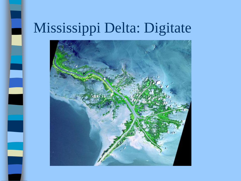
Mississippi Delta: Digitate

Rio de la Plata Estuary in South America

Rio de la Plata Estuary in Argentina and
Uruguay looking west - east

River Erosion Slide Show
Geography - River Erosion » SlideShare (share powerpoint presentations online, slideshows, slide shows, download presentations,.url

Glaciation
- ~ 1 million years ago, earth experienced drop
in average temperature
- no agreement on how or why temperatures changed
possible reasons include:
1. Change in earth’s orbit
2. Decreased output from sun
3. Volcanic dust blocking out sun

Glaciation (cont’d)
- as earth temps decreased, water cycle changed
- more water trapped on Earth as snow
- snow built up over time and formed ice
- called GLACIERS
- 2 types: 1. Continental 2. Alpine

Glacier
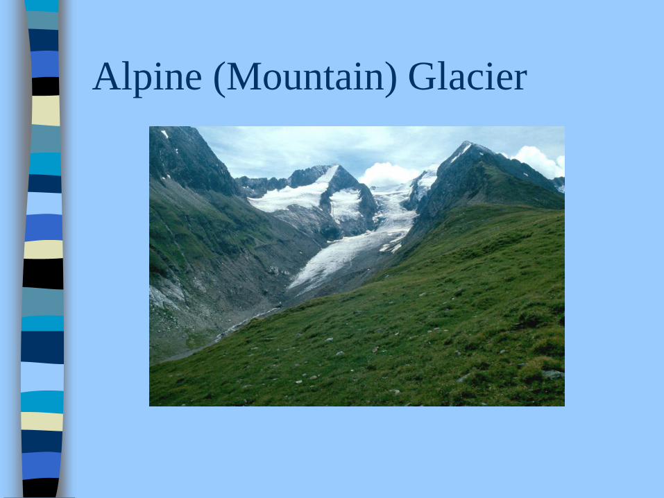
Alpine (Mountain) Glacier

Continental Glacier

Continental Glaciation
- large sheets of ice cover large land areas in
high latitudes during cooling periods
- called glaciers ADVANCING
- when temp on earth warm, ice sheets melt
- called RETREATING
-exs. Greenland and Antarctica
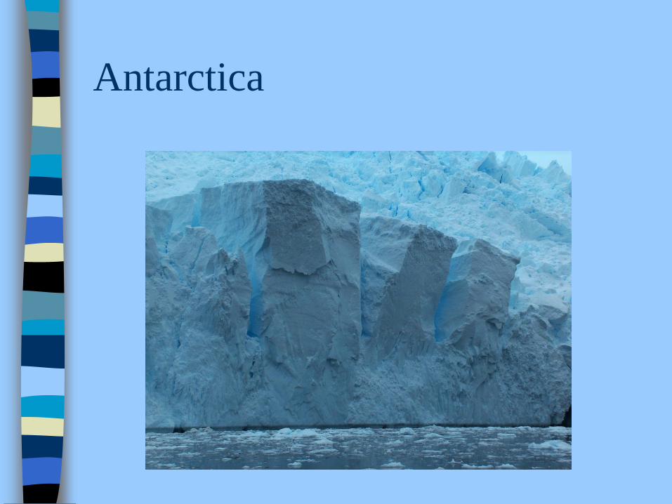
Antarctica

Greenland

Greenland From the Air

Continental Glaciers (cont’d)
-as glaciers retreat, depositional landform features
created by meltwater
- these features include:
- outwash plain
- terminal moraine
- erratic
- drumlin
- esker

Outwash Plain

Outwash Plain

Outwash Plain

Terminal Moraine

Erratics
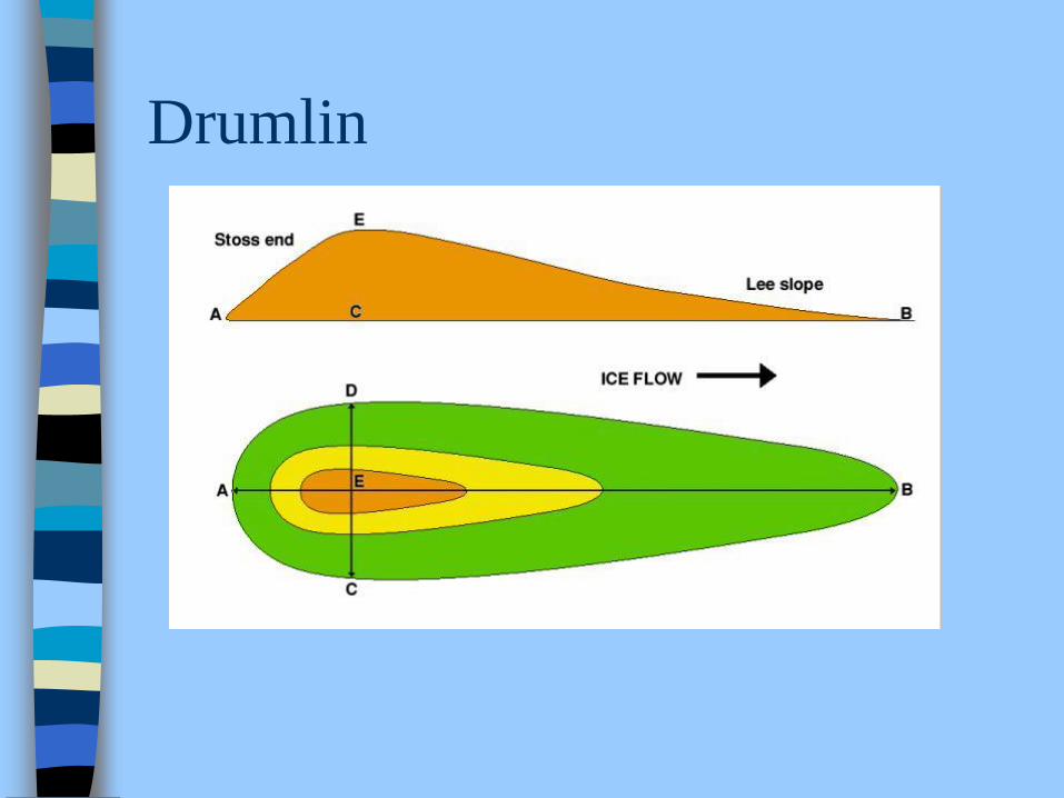
Drumlin

Drumlin

Esker

Esker

Alpine Glaciation
- occurs in high elevations
- glaciers grow on side of mountain
- gravity pulls glacier down through valleys
- creates U-shaped valley and other features:
lateral, medial, terminal moraine
cirque
arete
hanging valley
fiord

Alpine Glaciation

Lateral Moraine

Lateral Moraine

Medial Moraine

Terminal Moraine

Cirque

Cirque

Cirque and Tarn

Arete

Hanging Valley

Hanging Valley

Hanging Valley

Fiord

Western Brook Fiord
Gros Morne

Western Brook Fiord