Embed Size (px)
Citation preview

Milton Keynes Council Democratic Services Division, Civic Offices, 1 Saxon Gate East, Milton Keynes, MK9 3EJ Tel: Milton Keynes (01908) 691691 Fax: (01908) 252511 Hays DX 31406 Milton Keynes 1
Democratic Services
http://cmis.milton-keynes.gov.uk/CmisWebPublic
Membership: Chair: Councillor A Geary Vice Chairs: Councillors Exon and White Councillors: Baume, Bint, Buckley, Gowans, Green, Lewis, Morla, C
Williams and P Williams
Agenda can be accessed at: http://cmis.milton-keynes.gov.uk/cmiswebpublic/
COUNCIL CHAMBER CIVIC OFFICES, CENTRAL MILTON KEYNES
DEADLINE FOR REQUESTS TO SPEAK IN OBJECTION TO PLANNING
APPLICATIONS ON THIS AGENDA: 12 NOON MONDAY 30 NOVEMBER 2015
Requests to speak in objection to an application, or on another item on the Agenda, or any written representations, please e-mail:
E-mail: [email protected]
Written Representations to be received no later than 12:00noon Wednesday 2 DECEMBER 2015
Any other enquires about this meeting please contact:
Tina Milner, Committee Manager (Tel: 01908 254737).
PLEASE NOTE PARTS OF THIS MEETING MAY BE RECORDED
THURSDAY 3 DECEMBER 2015 7.00pm
MEETING OF THE DEVELOPMENT
CONTROL COMMITTEE - AGENDA
(1)

Health and Safety Please take a few moments to familiarise yourself with the nearest available fire exit, indicated by the fire evacuation signs. In the event of an alarm sounding during the meeting you must evacuate the building immediately and follow all instructions provided by the fire evacuation officer who will identify him/herself should the alarm sound. You will be assisted to the nearest designated assembly point until it is safe to return to the building.
Mobile Phones Please ensure that your mobile phone is switched to silent or is switched off completely during the meeting.
Agenda Agendas and reports for the majority of the Council’s public meetings can be accessed via the Internet at: http://cmis.milton-keynes.gov.uk/cmiswebpublic/ Wi Fi access is available in the Council’s meeting rooms.
Recording of Meetings The proceedings at this meeting may be recorded for the purpose of preparing the minutes of the meeting.
In accordance with the Openness of Local Government Bodies Regulations 2014, you can film, photograph, record or use social media at any Council meetings that are open to the public. If you are reporting the proceedings, please respect other members of the public at the meeting who do not want to be filmed. You should also not conduct the reporting so that it disrupts the good order and conduct of the meeting. While you do not need permission, you can contact the Council’s staff in advance of the meeting to discuss facilities for reporting the proceedings and a contact is included on the front of the agenda, or you can liaise with staff at the meeting
Comments, Complaints and ComplimentMilton Keynes Council welcomes comments, complaints and compliments from members of the public in order to make its services as efficient and effective as possible. We would appreciate any suggestions regarding the usefulness of the paperwork for this meeting, or the conduct of the meeting you have attended. Please use the slip overleaf by detaching it and passing it to the Committee Manager. Alternatively the slip can be returned by post to Democratic Services, Milton Keynes Council, Civic Offices, 1 Saxon Gate East, Milton Keynes, MK9 3EJ, or you can e-mail your comments to [email protected] If you require a response please leave contact details, ideally including an e-mail address.A formal complaints / compliments form is available online at http://www.milton-keynes.gov.uk/complaints/
(2)

---------------------------------------------------------------------------------------------------------------- Meeting Attended: Development Control Committee Date of Meeting: 3 DECEMBER 2015 Comments:…………………………………………………………………………………….
………………………………………………………………………………………………….
………………………………………………………………………………………………….
………………………………………………………………………………………………….
………………………………………………………………………………………………….
………………………………………………………………………………………………….
………………………………………………………………………………………………….
............................................................................................................................
Contact details:…..……………………………………………………………………………
(3)

AGENDA
1. Welcome and Introductions.
2. Apologies.
3. Minutes.
To approve, and the Chair to sign as a correct record, the Minutes of the meetings of the Development Control Committee on 5 NOVEMBER 2015 (Item 3) (Pages 6 to 13)
4. Declaration of Interests.
Members to declare any disclosable pecuniary interests, or personal interests (including other pecuniary interests), they may have in the business to be transacted, and officers to disclose any interests they may have in any contract to be considered.
5. Public Participation: Questions, Deputations and Petitions.
To consider the following items in accordance with the written Rules of Procedure for Public Participation in the Determination of Planning Applications:
(a) Questions:
To receive questions from members of the public, in accordance with Standing Orders, not related to planning applications.
(b) Deputations:
Any deputations will be reported to the Committee.
(c) Petitions:
Any petitions will be reported to the Committee.
6. Planning Applications.
To consider Planning Applications and receive representations from objectors, of which notice has been given, and replies from applicants in accordance with the Council’s Procedure Rules. The deadline for requests to speak in objection to a planning application and for Ward Councillor requests to speak, either in favour or in objection to a planning application is 12.00 noon on MONDAY 30 NOVEMBER 2015. Any additional written representations must be received by 12:00 noon on WEDNESDAY 2 DECEMBER 2015.
7. Pineham Draft Development Brief
To consider Item 7 (Pages 112 to 136)
INDEX OF PLANNING APPLICATIONS TO BE CONSIDERED AT THIS MEETING:
(4)

Item Reference Address Ward Town/Parish Report Page
Plan Page
Appendix Page
App01
14/02799/FUL Major
North Crawley Road, Newport Pagnell
Newport Pagnell South
Newport Pagnell Town Council
26 43 46
App 02
15/00827/FUL Site B1 1, Grafton Gate H5 To H6, Central Milton Keynes
Central Milton Keynes
Central Milton Keynes Town Council
62 74 82
App 03
15/2293/FUL Walton Manor, Brickhill Street H9 To H10, Milton Keynes
Monkston Walton Community Council
90 99 103

DEVELOPMENT CONTROL 05 NOVEMBER 2015 PAGE 1 COMMITTEE
CHAIR’S INITIALS …………….
ITEM 3
Minutes of the DEVELOPMENT CONTROL COMMITTEE held on THURSDAY 05 NOVEMBER 2015 at 7.00 pm. Present: Councillor A Geary (Chair) Councillors: Baume, Bint, Buckley, Gowans, Green, Lewis, Morla,
White and C Williams. Officers: A Rose (Service Director - Planning and Transport), S Manley (Head
of Development Management), N Wheatcroft (Team Leader Strategic Applications Team), S Hine (Senior Planning Officer), A Smith (Senior Planning Officer), A Swannell (Senior Engineer - Development Management [Highways]), N Sainsbury (Head of Urban Design and Landscape Architecture), N Ahmad (Solicitor - Planning) and D Imbimbo (Committee Manager).
Apologies: Councillors Exon and P Williams. Also Present: Councillors Brunning and R Gifford Number of Public Present: 16
DCC42 CHAIRMANS WELCOME
The Chair welcomed Members of The Committee, Officers and Public to the meeting.
DCC43 MINUTES
That the Minutes of the meetings of the Development Control Committee held on 08 September 2015 and 01 October 2015 and the meetings of the Development Control Panel on 17 September 2015 and 15 October 2015 be approved as accurate records and signed by the Chair as such.
DCC44 DECLARATION OF INTERESTS
Councillor White asked that it be noted that he was a member of the Milton Keynes Development Board and would therefore stand down from the Committee during consideration of Item 7, Pasqual Drive, Medbourne - Draft Development Brief.
(6)

DEVELOPMENT CONTROL 05 NOVEMBER 2015 PAGE 2 COMMITTEE
CHAIR’S INITIALS …………….
DCC45 PUBLIC PARTICIPATION
The Committee received a petition with 5237 names appended from Mr D Isaacs, in respect of the ongoing enforcement action against the ‘Smoke Shack’ in the terms;
‘Please stop your excessive actions against original smoke shack and its owners
I believe Smoke Shack should remain open and not be forced to reinstate works that would bring about its closure. What they have done and achieved is of far greater benefit to the community, and the local area, so as a tax payer that you represent I ask you to cease your negative actions and enable them to remain trading.
You should be supporting and working with local businesses, not forcing their closure’
Mr Isaacs explained the reasoning for the petition.
The Chair advised the Committee that as the matter related to an ongoing court action he would not invite debate and that the details of the petition would be passed to relevant officers in Legal Services.
DCC46 REPRESENTATIONS ON APPLICATIONS
Councillor Brunning (Ward Councillor), spoke in support of Applications 15/00670/FUL and 15/00671/LBC, Demolition of existing residential care home and erection of Assisted Living (Extra Care) accommodation for the elderly and conversion and extension of The Stables into a pre-school nursery facility with associated car parking at . St Giles Residential Home, St Giles Mews, Stony Stratford for Yourlife Management Services.
DCC47 PLANNING APPLICATIONS
14/02212/FUL FOOD STORE (USE CLASS A1) AND PETROL FILLING STATION, RECYCLING FACILITIES AND ASSOCIATED PARKING, SERVICING, DRAINAGE, LANDSCAPING, ACCESS AND HIGHWAY WORKS AT LAND AT CORNER OF LAVENDON ROAD AND, WARRINGTON ROAD, OLNEY FOR SAINSBURY'S SUPERMARKETS LTD
The Senior Planning Officer told the Committee that as a result of late representations in respect of highways matters that required assessment the recommendation was that the determination of the application be deferred to allow full reassessment of the highways arrangements.
Councillor A Geary proposed that the Officer recommendation be agreed, this was seconded by
(7)

DEVELOPMENT CONTROL 05 NOVEMBER 2015 PAGE 3 COMMITTEE
CHAIR’S INITIALS …………….
Councillor White.
The Committee heard representations from Mr L Lean in respect of the proposal to defer the application.
On being put to the vote the proposal to defer determination of the application was agreed unanimously, and it was;
RESOLVED –
That determination of the application be deferred to allow an assessment of late representations in respect of highways.
15/00670/FUL DEMOLITION OF EXISTING RESIDENTIAL CARE HOME AND ERECTION OF ASSISTED LIVING (EXTRA CARE) ACCOMMODATION FOR THE ELDERLY AND CONVERSION AND EXTENSION OF THE STABLES INTO A PRE-SCHOOL NURSERY FACILITY WITH ASSOCIATED CAR PARKING AT ST GILES RESIDENTIAL HOME, ST GILES MEWS, STONY STRATFORD FOR YOURLIFE MANAGEMENT SERVICES
The Committee heard from the Ward Councillor who spoke in support of the application. The Senior Planning Officer told the Committee that a update report had been published which detailed amendments to conditions and the addition of three further conditions in respect of Highway Safety and Crime Prevention, and that the recommendation remained to approve the application subject to the revised conditions. The Committee was reminded that should it be minded to approve the application there would be a need for it to be referred to the National Planning Casework Unit due to the outstanding objection by Sport England. Councillor A Geary proposed that the application be approved subject to the conditions as detailed in the published update report, this was seconded by Councillor White. The Committee noted the amount of work and commitment of the applicants in achieving an
(8)

DEVELOPMENT CONTROL 05 NOVEMBER 2015 PAGE 4 COMMITTEE
CHAIR’S INITIALS …………….
application that was designed to meet the aspirations of the Community and commended that resolve. On being put to the vote the proposal to approve the officer recommendation subject to the revised and additional conditions was carried unanimously, and it was; RESOLVED – That the application be approved subject to the amended and additional conditions as detailed in the Committee update report.
15/00671/LBC LISTED BUILDING CONSENT FOR THE EXTENSION AND ALTERATION OF THE STABLES TO FACILITATE CONVERSION TO PRE-SCHOOL NURSERY FACILITY AT ST GILES RESIDENTIAL HOME, ST GILES MEWS, STONY STRATFORD FOR YOURLIFE MANAGEMENT SERVICES
The Officer reported that there was no update on the Committee report and that the recommendation remained to grant the application subject to the conditions detailed therein.
Councillor A Geary proposed that the officer recommendation be agreed this was seconded by Councillor White.
On being put to the vote the proposal to grant the application was carried unanimously, and it was;
RESOLVED –
That planning permission be granted subject to the conditions as detailed in the Committee report.
15/01025/REM RESERVED MATTERS APPLICATION PURSUANT TO OUTLINE PLANNING PERMISSION 13/02382/OUTEIS FOR ACCESS AND LAYOUT - FIRST PHASE INFRASTRUCTURE WORKS COMPRISING ROADS, ATTENUATION PONDS, FOUL AND SURFACE WATER DRAINAGE INCLUDING DITCH DIVERSIONS AND ASSOCIATED EARTHWORKS AT LAND AT GLEBE FARM,
(9)

DEVELOPMENT CONTROL 05 NOVEMBER 2015 PAGE 5 COMMITTEE
CHAIR’S INITIALS …………….
SOUTH OF A421, NEWPORT ROAD FOR GALLAGHER ESTATES
The Officer reported that since the publication of the report the applicant had submitted addition plans in respect of highways, these had been reviewed by the Highways Engineer and deemed acceptable and therefore amendments to the conditions had been published in the additional Committee Report, it was therefore recommended that the application be granted subject to the conditions as detailed in the additional Committee report as amended and detailed in the published additional report.
Councillor A Geary proposed that the Officer recommendation be agreed this was seconded by Councillor White.
The Senior Highways Engineer explained that the plans related to an early reserved matters application and as such it was not at this stage possible to establish what proposals in respect of parking arrangements would be forthcoming, however there was at this time no suggestion that the plans as submitted would necessarily require tandem parking to be adopted.
It was noted that the draft design codes had been submitted for consultation and Councillors comments in respect of them would be welcomed.
Councillor White expressed some concern that there was a reference to traffic lights at the junction of the Glebe Farm access road with Newport Road in the reports, the officer advised the committee that the outline application had traffic lights as a condition Councillor Geary commented that the layout should make provision for an underpass at some future point where the roads are to be dual carriageways due to the need to access schools from the housing areas, and that some consideration needed to be made to provide for funding for this facility.
On being put to the vote the proposal to grant the application subject to the conditions as set out in the committee report as amended by the update report was carried unanimously, and it was;
RESOLVED –
1. That planning permission be granted subject to the conditions set out in the committee reports.
(10)

DEVELOPMENT CONTROL 05 NOVEMBER 2015 PAGE 6 COMMITTEE
CHAIR’S INITIALS …………….
2. That the Director of Highways be reminded of the need to consider measures to make provision for an underpass in advance of the dualling of the highway.
14/02799/FUL REDEVELOPMENT OF SITE TO PROVIDE 73 DWELLING UNITS WITH ASSOCIATED CAR PARKING AND NEW ACCESS FROM NORTH CRAWLEY ROAD (AMENDED) AT NORTH CRAWLEY ROAD, NEWPORT PAGNELL FOR BELLWAY HOMES LTD (NORTH HOME COUNTIES)
The Officer reported that following a review of the application it was considered necessary to undertake a further investigation into the issue of dust and odour and therefore it was recommended that determination of the application be deferred to allow this to be conducted.
Councillor A Geary proposed that the Officer recommendation be agreed, this was seconded by Councillor White.
On being put to the vote the proposal to defer determination of the application was carried unanimously, and it was;
RESOLVED –
That determination of the application be deferred to allow further consideration of dust and odour concerns to be undertaken..
DCC48 DRAFT PASCAL DRIVE, MEDBOURNE DEVELOPMENT BRIEF
Councillor White stepped down from the Committee for this Item and left the room.
The Committee considered a report in respect of two sites off Pascal Drive, Medbourne. The Head of Urban Design and Landscape Architecture, outlined the main features of the brief. It was noted that whilst one of the sites was allocated for commercial use this was no longer deemed necessary and as such it was proposed for residential use, this would be a decision to be taken at a later stage. Whilst the brief primarily referred to 2 or 3 storey development as there was some 4 storey development in the area there was some scope for this on these sites if designed in an appropriate and acceptable manner.
The Council has adopted a protocol for the preparation of development briefs, which sets out a process for stakeholder engagement. The protocol included the Development Control Committee as a consultee
(11)

DEVELOPMENT CONTROL 05 NOVEMBER 2015 PAGE 7 COMMITTEE
CHAIR’S INITIALS …………….
at the formal consultation stage and the report was before the Committee for that purpose.
The Chair advised the Committee that it was proposed that in future the development brief would be presented to the Committee after it had been out for public consultation, thereby providing for a more current document for consideration before it was presented to Cabinet, this was supported by the Committee.
Members of the Committee were invited to comment on the Development Brief. Members were reminded that they could still respond to the consultation on an individual basis.
Members of the Committee commented;
That the draft brief had various spelling and grammatical errors that would need to be corrected.
That the plans had errors in respect of street naming on the plans.
The Plans do not appear to extend the grid roads into the development area, this would not be acceptable to the Committee.
The Draft Development Brief was inconsistent in so far as under some headers the words ‘will’ and ‘must’ are used whereas in other sections the words, ‘could’ or ‘should’ replaces them. Where these inconsistences relate to policy the requirement is for there to be an unequivocal requirement to comply.
There should, however, be a provision for flexibility in terms of materials and design to allow for innovative development.
Four Storey Development will look out of place in respect of surrounding development and any development should be in keeping with the surrounding development.
Swan’s Way needs to be protected at all costs without deviation
The separation of the Secondary and Primary schools by a road is likely to result in additional congestion, whereas one site combining both schools could lessen congestion problems.
There appeared to be drift towards proposing land designated as employment land for residential use within development briefs, how was need for the latter over the former assessed, in the face of other suggestions that more employment land was required.
Assurances were required that streets would be designed in accordance with the Councils Street Hierarchy.
The Development Briefs are produced on behalf of MKDP however there is no independent input in respect of considerations from the Councils perspective and therefore
(12)
DEVELOPMENT CONTROL 05 NOVEMBER 2015 PAGE 8 COMMITTEE
CHAIR’S INITIALS …………….
development brief does not take account of the most pressing needs of Milton Keynes from the Councils perspective.
The Head of Urban Design and Landscape Architecture clarified that the land was allocated as Commercial land not employment land.
RESOLVED –
1. That the report and Development Brief be noted
2. That the Comments passed by the Committee be considered by the Development Control Committee prior to a final decision being made to approve the Development Brief by Cabinet.
DC49 UPDATE ON THE PARKING STANDARDS SUPPLEMENTARY PLANNING DOCUMENT
The Service Director - Planning and Transport, told the Committee that due to a change of Cabinet schedule of the work programme, the Parking Standards Supplementary Planning Document would now have to be taken to the January meeting of the Cabinet rather than the December meeting for adoption. Whilst this delay was disappointing it was due to December meeting now being designated the budget meeting.
Members of the Committee expressed concern and dissappointment at the delay and asked that the Chair write to the Leader and responsible Cabinet Member to express the Committees concerns and disappointment, The Service Director - Planning and Transport, reminded the Committee that the issue had been brought about as a result of the Governments timing in respect of the budget.
RESOLVED –
That the Chair be asked to write to the Leader and Cabinet Member expressing the concerns and disappointment of the Committee.
THE CHAIR CLOSED THE MEETING AT 8:00PM
(13)

A Guide to Application Reports
Introduction The following reports have been prepared by case officers from the Development Management Section of the Council’s Planning and Transport Department. In preparing the reports the case officers have taken into account all the planning issues relating to the application including:
All National and Local planning policies and legislation.
All other relevant National and local policies and legislation.
Relevant case law
All comments received from statutory and non statutory consultees (including neighbours and other local people).
The physical features of the property/site.
The details of the proposal. Clearly there is a lot of information to be considered. To keep reports to a readable length and to make sure that the important issues are fully covered, some of the more generic considerations are not explicitly referred to in the report or are only mentioned briefly. However, all the Councillors who sit on the Development Control Committee have been trained in all aspects of considering planning applications and are aware of the underlying issues which may not have been referred to directly in the report. What is in the report? In respect of policies, legislation and case law, those which provide the most important advice/guidance on the issues under consideration are referred to in the report. In respect of comments from statutory and non statutory consultees, these are not normally reported in full. Although all relevant comments received are reported, they are usually summarised. Comments that have been received relating to matters which are not material planning issues are not normally reported. If they are reported for any reason, the fact that they are not material planning issues is clearly stated in the report. In respect of the physical features of the site and the details of the proposal, the most significant features/details and those which can not easily be seen in the plans attached to the report are described in the report. In the Considerations section of the report, the Case officer sets out the pros and cons of the application in relation to the relevant polices, legislation and case law and the comments received from everyone who has responded to the application.
(14)
The importance of planning policy The most important factor that the Committee must consider is the relevant planning policies. Firstly there is the National Planning Policy Framework (NPPF) produced by the Government, which sets out the Government’s planning policies for England and how these are expected to be applied. Secondly there are the Council's own planning policies, particularly the policies in the Council’s Adopted Core Strategy and Adopted Local Plan, but including other policy documents such as Supplementary Planning Guidance (SPG). Planning legislation requires that all planning decisions should be in line with the relevant policies. Further Information You can find all the information submitted with the application, together with all the comments that the Council received at www.milton-keynes.gov.uk/publicaccess. You can find all the Council’s planning policies at www.milton-keynes.gov.uk/planning-and-building/planning-policy. You can find national planning legislation, guidance and advice at www.communities.gov.uk/planningandbuilding.
(15)

AMENDED PLANNING USE CLASSES
Class A1. Shops
Use for all or any of the following purposes: (a) for the retail sale of goods other than hot food. (b) as a post office. (c) for the sale of tickets or as a travel agency. (d) for the sale of sandwiches or other cold food for consumption off the premises. (e) for hairdressing. (f) for the direction of funerals. (g) for the display of goods for sale. (h) for the hiring out of domestic or other personal goods or articles. (i) for the washing or cleaning of clothes and fabrics on the premises. (j) for the reception of goods to be washed, cleaned or repaired. (k) as an internet café; where the primary purpose of the premises is to provide
facilities for enabling members of the public to access the internet where the sale, display or service is to visiting members of the public.
Class A2. Financial & Professional Services
Use the provision of: (a) financial services. (b) professional services (other than health or medical services). (c) any other services (including use as a betting office) which it is appropriate to
provide in a shopping area, where the services are provided principally to visiting members of the public.
Class A3. Restaurants & Cafes
Use for the sale of food and drink for consumption on the premises. Class A4. Drinking Establishments
Use as a public house, wine-bar or other drinking establishment. Class A5. Hot Food Takeaways
Use for the sale of hot food for consumption off the premises. Class B1. Business
Use for all or any of the following purposes: (a) as an office other than a use within Class A2 (financial and professional
services). (b) for research and development of products or processes. (c) for any industrial process, being a use which can be carried out in any residential
area without detriment to the amenity of that area by reason of noise, vibration, smell, fumes, smoke, soot, ash, dust or grit.
Class B2. General Industrial
Use for the carrying on of an industrial process other than one falling within class B1 above. Class B8. Storage or Distribution
Use for storage or as a distribution centre. Class C1. Hotels
Use as a hotel or as a boarding or guesthouse where, in each case, no significant element of care is provided.
(REVISED 25.05.10) (16)
Class C2. Residential Institutions
Use for the provision of residential accommodation and care to people in need of care (other than a use within Class C3 (dwelling houses). Use as:
(a) a hospital or nursing home (b) a residential school, college or training centre
Class C2A. Secure Residential Institutions
Use for the provision of secure residential accommodation, including use as a prison, young offenders institution, detention centre, secure training centre, custody centre, short-term holding centre, secure hospital, secure local authority accommodation or use as military barracks. Class C3. Dwellinghouses
Use as a dwellinghouse (whether or not as a sole or main residence) by: (a) a single person or by people to be regarded as forming a single household; (b) not more than six residents living together as a single household where care is
provided for residents; or (c) not more than six residents living together as a single household where no care is
provided to residents (other than a Use within Class C4)
For the purposes of Class C3(a) “single household” shall be construed in accordance with section 258 of the Housing Act 2004(3).” Class C4. Houses in Multiple Occupation
Use of a dwellinghouse by not more than six residents as a ‘house in multiple occupation”.
For the purposes of Class C4 a “house in multiple occupation” does not include a converted block of flats to which section 257 of the Housing Act 2004 applies but otherwise has the same meaning as in section 254 of the Housing Act 2004.”. Class D1. Non-Residential Institutions
Any use not including a residential use: (a) for the provision of any medical or health services except the use of premises
attached to the residence of the consultant or practitioner. (b) as a crèche, day nursery or day centre. (c) for the provision of education. (d) for the display of works of art (otherwise than for sale or hire). (e) as a museum. (f) as a public library or public reading room. (g) as a public hall or exhibition hall. (h) for, or in connection with, public worship or religious instruction.
Class D2. Assembly & Leisure
Use as: (a) a cinema. (b) a concert hall. (c) a bingo hall (d) a dance hall. (e) a swimming bath, skating rink, gymnasium or area for other indoor or outdoor
sports or recreations, not involving motorised vehicles or firearms. Sui Generis
Any use which does not fall within the definition of one of the classes as specified in the Use Classes Order.
(REVISED 25.05.10) (17)

DEVELOPMENT CONTROL COMMITTEE CODE OF GOOD PRACTICE FOR PLANNING MATTERS - GUIDANCE SUMMARY This Code applies to all Members but particularly members of the Development Control Committee, their substitutes, and officers associated with planning cases. GENERAL 1 The Development Control Committee (DCC) is a quasi-judicial body. 2 DCC members must therefore act totally impartially at all times from as soon
as they first become acquainted with a planning application or potential planning application until the final decision is taken.
3 They must declare the nature and extent of any personal interest they have in
any planning matter and must cease to be involved in any planning matter in which they have a prejudicial interest as soon as they realise that they have such an interest.
4 Insofar as possible DCC members should avoid contact with applicants,
agents, objectors, and - in particular - decline all offers of gifts and hospitality. Before an application is made they should have an officer present if possible when meeting any of the above and keep a record of the meeting.
5 They should take their decisions in accordance with the Council's planning
policies unless there are clear and compelling planning reasons for not doing so.
6 All Members must not disclose or use to their own advantage any confidential
information. 7 Members of the DCC should not become associated in the public mind with
any vested interest in planning matters. OUTSIDE THE COMMITTEE BEFORE OR AFTER RECEIPT OF A PLANNING APPLICATION 8 DCC members should not offer any opinion on a planning application until it
has come to Committee and they are satisfied that they have all the relevant planning information.
9 This includes all applications arising within their wards - which should be
handled by other councillors. 10 DCC members are advised not to allow themselves to be lobbied but, when
they are, they must give equal time and opportunity to both applicant and objector.
REVISED VERSION ADOPTED BY COUNCIL - 14 JANUARY 2005 L:\Committee\2012-13\DEVELOPMENT CONTROL COMMITTEE\ADMIN\AGENDA PROCEDURE PACK\3. Guidance Summary.doc (18)

11 DCC members should normally only meet applicants and objectors with a Council officer present.
12 All such contacts must be reported to the assistant Director (Planning,
Economy and Development). 13 All Members must not put pressure on any officer associated with planning
matters in order to influence their recommendations on a particular application one way or the other (see 19 below)
14 All Members must follow the Council's guidelines on procedure at site visits. IN COMMITTEE OR CABINET 15 Members must base their decisions only on material planning considerations.
No others are permitted. 16 Members must not speak or vote on any planning matter in which they have a
conflict of interest. A conflict of interest could be a disclosable pecuniary interest, or a personal interest which a member of the public, looking on may consider so significant that it would prejudice their judgement in carrying out their role as a Member.
However, where a Member holds a conflict of interest described above, before retiring he or she may first exercise the ability to address the meeting as a member of the public in accordance with the Access to Information Procedure Rules.
17 They must declare if they have any relevant information on a planning
application or have been lobbied in respect of it. 18 They must list their planning reasons for any departure from the Council's
planning policies (see 5 above); and take a recorded vote on any such decision.
OFFICERS 19 Officers are required at all times to give objective, professional and non-
political advice on all planning matters. 20 Additionally the guidelines above apply as appropriate to all officers associated
with planning matters.
REVISED VERSION ADOPTED BY COUNCIL - 14 JANUARY 2005 L:\Committee\2012-13\DEVELOPMENT CONTROL COMMITTEE\ADMIN\AGENDA PROCEDURE PACK\3. Guidance Summary.doc (19)

1
ANNEX A
PROCEDURE FOR THE DETERMINATION OF PLANNING APPLICATIONS - PUBLIC PARTICIPATION
(a) Council Procedure Rule 9 does not apply to the Development Control
Committee and the Development Control Panel when determining planning
applications.
(b) Members of the public may request the right to speak at any meeting of the
Development Control Committee and the Development Control Panel to
object to a planning application. The number of requests to speak will be
limited to three per application (not including any right of reply). A single
objector will be allowed to speak for a maximum of 3 minutes. Where there is
more than one objector representing a group or organisation, they will be
limited to 3 minutes to present the group or organisation’s objection, but more
than one representative may speak on behalf of the group or organisation.
Both the number of speakers and the time limit may be extended at the
Chair’s discretion.
(c) If an application is deferred any speaker heard by the Committee when an
application was first received will not be precluded from being heard again
when the application is reconsidered, subject to the speaker submitting a
further request to speak in accordance with paragraphs (b) and (g) of this
Annex.
(d) Ward Councillors may comment on any application either within their Ward, or
which has a significant impact on the residents of their Ward. If a Ward
Councillor is objecting to a planning application he/she must advise the
Assistant Director (Democratic Services), in order that the applicant can be
offered a right of reply. Any request to speak must be submitted in
accordance with paragraph (h) of this Annex.
(e) A representative of a Town or Parish Council, nominated by either the Chair
or the Clerk of the Town or Parish Council, will be allowed to address the
Development Control Committee, or Panel, for a maximum of 3 minutes when
an application for a development within that Parish or where at the discretion
of the Chair there is a significant impact on another Parish, is to be
considered. Any representation will be in addition to the limit on the number of
public speakers. If the Town or Parish Council is to speak in objection to, or in
favour of, the application the Service Director (Law and Democratic Services)
must be advised when submitting the speaking request, and in all cases no
less than two clear working days before the meeting, in order that the
applicant can be offered the right of reply.
(20)

2
(f) Applicants will be entitled to speak in favour of a planning application where
the planning officer has recommended refusal and there have been no
requests from members of the public to speak in objection. Any speech in
favour will last no longer than 3 minutes.
(g) Any applicants, or their agents, will be informed when a request to speak in
objection has been received and will be invited to exercise a right of reply
either in writing or orally at the meeting. Any right of reply will not exceed the
cumulative time given to objectors to the specific planning application.
Applicants, or their agents, may invite witnesses to give evidence within the
allocated time available.
(h) Any request to speak (other than exercising the right of reply) must be
received by the Assistant Director (Democratic Services) by noon, two clear
working days before the meeting.
(i) Depending on the volume of representations the Committee / Panel may wish
to either:
(i) receive all representations and consider the related applications at the
commencement of the meeting; or
(ii) follow the agenda and receive all representations as the applications
are considered; or
(iii) take all representations at the commencement of the meeting and then
follow the order of the agenda.
(j) Members of the Development Control Committee and the Development
Control Panel may, with the consent of the Chair of the meeting, ask
questions of objectors and applicants to clarify matters of fact.
(k) Deputations and Petitions under Council Procedure Rule 9.12 and Public
Questions under Council Procedure Rules 9.1 to 9.10 will operate as set out
in these Rules, for matters of general policy and issues not directly related to
promoting, or objecting to a particular planning application, and will form part
of the 30 minutes allocated for public participation.
(21)

National Planning Policy Framework (NPPF)
The Impact of the NPPF of the Council's Planning Policies
On the 27th March 2012 the Government's National Planning Policy Framework (NPPF) was published and came into force. The NPPF sets out the Government's planning policies for England and replaces the majority of the Planning Policy Statements (PPSs) and Planning Policy Guidance (PPGs) produced by the Government together with some ministerial advice given in Letters to Chief Planning Officers and a few Circulars, including Circular 05/2005: Planning Obligations. All Local Planning Authorities must take the NPPF into account in plan preparation and it is a material consideration in planning decisions.
Like most Local Planning Authorities (LPA), Milton Keynes Council (MKC) has an Adopted Local Plan and a number of other planning policy documents which pre date the NPPF. The Government recognised that this situation would arise and therefore the NPPF contains guidance on how planning authorities should attribute weighting to their existing policies against the policies of the NPPF until such time as the LPA produces revised policies to take into account the policies in the NPPF. The NPPF advocates progressing revision of plans as quickly as possible.
The weight to be given to Local Plan Policies
In respect of the adoption of the policies of the Milton Keynes Local Plan 2001-2011, MKC relied on the transitional arrangements in the Planning and Compulsory Purchase Act 2004, it adopted its local plan under the Town and Country Planning Act 1990 ( the 1990 Act) and paragraph 215 of the NPPF applies. Therefore when considering planning applications MKC must:
(a) take the policies contained in the NPPF into account as a material consideration; and
(b) only give weight to MKC’s existing planning policies to the extent and the degree with which they conform with the policies in the NPPF; and
MKC may give weight to relevant policies in emerging plans to the extent and degree with which they also conform with the policies in the NPPF, the stage of preparation of the emerging plan and the extent to which there are unresolved objections to relevant policies
The weight to be given to Mineral Plan Policies
The MKC’s Mineral Local Plan was also adopted under the Town and Country Planning Act 1990 and so the same paragraph 215 position applies to the determination of mineral plan applications as set out above.
On the 27th March 2012 the Government also published Technical Guidance to the National Planning Policy Framework. This technical guidance is intended to ensure the effective implementation of the Framework policies in (a) areas at risk of flooding and (b) in relation to mineral extraction. In relation to mineral extraction, the guidance deals with issues such as dust emission, noise and restoration.
(22)

Supplementary Planning Guidance and Supplementary Planning Documents
In respect of the Council's Supplementary Planning Guidance (SPG) and Supplementary Planning Documents (SPD), the Council must apply the same weighting and balancing considerations to these documents as to the policies they relate to. Therefore SPG or SPD documents that relate to policies in the Local Plan and the Minerals Plan should be considered in accordance with the approach set out in 215 of the NPPF
Planning Obligations S106 agreements
In addition to these changes the NPPF replaces the previous 5 part test for planning obligations contained in Circular 05/2005. The NPPF test requires that planning obligations/S106 agreements should only be sought where the requirements are:
1) Necessary to make the development acceptable in planning terms.
2) Directly related to the development.
3) Fairly and reasonably related in scale and kind to the development.
Reports to Development Control Committee and Panel
Officers are currently reviewing the NPPF and assessing the conformity of the policies contained in the Council's Local Plan and Mineral Plan with those contained in the NPPF. When this review is complete a comprehensive guide to the weight to be given to the Council's policies will be produced. However, until this can be done each report deals with the issue as far as it relates to the considerations relevant to that particular application.
(23)

(24)


ITEM 6
DEVELOPMENT CONTROL COMMITTEE
3 DECEMBER 2015
DEVELOPMENT CONTROL
MAJOR APPLICATIONS Major Applications – Major applications are those proposing 10 dwellings or more and for all other types of development those proposing 1000 square metres or more of additional floor space.
MINOR APPLICATIONS
Minor Applications – Minor applications are proposed residential dwellings of less than 10 dwellings or other new commercial, industrial, retail office or warehouse proposals of less than 1000 square metres of new floor space.
OTHER APPLICATIONS
Other Applications – Other applications include most changes of use, all householder development, Listed Buildings and Conservation Area Consent applications and a variety of other types of generally small-scale development proposals
(25)


APP 01
Application Number: 14/02799/FUL
Redevelopment of site to provide 73 dwelling units with associated car parking and new access from North Crawley Road (amended) AT North Crawley Road, Newport Pagnell, MK16 9TG FOR Bellway Homes Ltd (North Home Counties) Target: 18th March 2015 Ward: Newport Pagnell South
Parish: Newport Pagnell Town Council
Report Author/Case Officer: Nicola Wheatcroft Contact Details: 01908 253238 [email protected] Team Leader: Sarah Evans Team Leader Strategic Applications Team Contact Details: 01908 253326 [email protected] 1.0 INTRODUCTION
(A brief explanation of what the application is about)
1.1 1.2 1.3
The main section of the report set out below draws together the core issues in relation to the application including policy and other key material considerations. This is supplemented by an appendix which brings together planning history, additional matters and summaries of consultee responses and public representations. Full details of the application, including plans, supplementary documents, consultee responses and public representations are available on the Council’s Public Access system www.milton-keynes.gov.uk/publicaccess. All matters have been taken into account in writing this report and recommendation. The Site The site comprises 1.98 hectares of employment land on a small commercial estate on the eastern edge of Newport Pagnell. The site, now cleared, consisted of a group of warehouse buildings and a brick office block (Newport House) all with on-site parking, served from a shared access to North Crawley Road adjacent to its junction with Tickford Street. The site lies in a mixed use area of residential and commercial/employment uses. The site is a distorted rectangle in shape and adjoins the Newport Pagnell household and commercial waste site to the eastern boundary; the northern boundary adjoins farmland whilst the western boundary adjoins two storey commercial buildings located within Vantage Court behind whilst the northern section of the western boundary adjoins residential bungalows in The Canons. To the southern boundary the site fronts North Crawley Road extending along the junction, for a short length with Tickford Street. The junction of these two
(26)

1.4 1.5 1.6 1.7
roads is controlled by a mini-roundabout with an uncontrolled pedestrian crossing to the front of the site. Opposite are two storey dwellings, whilst Renny Park Estate is located opposite the site on North Crawley Road. An electricity sub-station is located on the site, accessed from Tickford Street and a footpath straddles the northern boundary. All boundaries are planted with trees and other planting with a more extensive treed area on the northern boundary with the adjoining farmland. The eastern boundary with the adjacent recycling centre is planted with mature trees and the western boundary comprises of mesh fencing inter-planted through to the first section of the boundary after which it converts to fencing and conifer planting. The Proposal This application seeks the redevelopment of the site for residential use with a total of 73 dwellings proposed (at a density of 37 dwellings per hectare) with a combination of apartments and a mix of house types and sizes, including terraced through to detached dwellings, with 30% affordable housing being proposed. Access is proposed to be taken off the North Crawley Road/Renny Park Road roundabout and comprises a single major street which serves the development and terminates at the northern end of the site in a turning head. This road is sized to accommodate a bus route. A redway is proposed along the site frontage but without being connected beyond the site boundaries. Internally the site is laid out in a series of cul-de-sacs and dwellings and apartments are located to front the main road and side streets. Dwellings and apartments front or are positioned side on to Tickford Street and North Crawley Road and are set behind a planted verged area with footpath links through to the development from the main roads. Within the site the houses extend to the side boundaries with a planted and treed buffer to the eastern boundary separating the site from the recycling facility adjacent. The apartments and dwellings range between two and three storeys in height, including rooms in the roof space and are proposed to be constructed in brick and rendered or painted elevations under pitched tiled or fibre-cement slate roofs. Parking takes the form of predominantly on-plot parking with some grouped parking and a small element of grouped tandem parking. A 4 -4.5 metre high acoustic fence is proposed to separate the development from the recycling facility.
2.0 RELEVANT POLICIES
(The most important policy considerations relating to this application)
2.1 National Policy National Planning Policy Framework paragraphs: Paragraph 4: Accordance with Development Plan Paragraph 14: Presumption in Favour of Sustainable Development
(27)

Paragraph 17: Core Planning Principles Paragraph 22: Employment Sites Paragraph 29: Promoting Sustainable Transport Paragraph 37: Policies should aim for a balance of land uses in an area Paragraph 48: Windfall Sites Paragraph 50: Affordable Housing Paragraph 58: Design Paragraph 60: Planning should not impose architectural styles or tastes Paragraph 69: Creating healthy and inclusive environments Paragraph 93, 99-103: Meeting the challenge of climate change and flooding Paragraph 98: Sustainability Paragraphs 109 & 118: Natural Environment Paragraphs 120 -124: Pollution and Contamination
2.2 Local Policy Core Strategy CSA: Presumption in Favour of Sustainable Development CS1: Development Strategy CS2: Housing Land Supply CS8: Other Areas of Change CS9: Strategy for the Rural Areas CS11: A Well Connected Milton Keynes CS12: Developing Successful Neighbourhoods CS13: Ensuring High Quality, Well Designed Places CS18: Healthier and Safer Communities CS21: Delivering Infrastructure Adopted Milton Keynes Local Plan 2001-2011(Saved Policies) S1: General Principles D1: Impact of Development Proposals on Locality D2a Urban Design Aspects of New Development D2: Design of Buildings D4: Sustainable Construction NE3: Biodiversity and Geological Enhancement T1: Transport User Hierarchy T3 & T4: Pedestrians and Cyclists T5: Public Transport T9: The Road Hierarchy T10: Traffic T15: Parking Provision T17: Traffic Calming EA4A: New Strategic Reserves H2: Priority Housing Requirements H3 & H4: Affordable Housing incl Thresholds H7: Housing on Unidentified Sites H8 & H9: Housing Density and Mix E1: Protection of Existing Employment land L3: Standards of Provision PO1: General Policies
(28)

PO4: Percent for Art Supplementary Planning Guidance Parking Standards (Jan 2005) and Addendum (2009) Education Facilities SPG (2004) Leisure, Recreation and Sports Facilities (2004) Supplementary Planning Document Sustainable Construction (April 2007) Affordable Housing (March 2013) Social Infrastructure (2005) New Residential Development Design Guide (April 2012) Newport Pagnell Neighbourhood Plan Newport Pagnell Neighbourhood Plan is an emerging Neighbourhood Plan which has been submitted to the Council (July 30) for publication. The publicity period closed on 18th November 2015 and Examination is expected early in the New Year. The Neighbourhood Plan is afforded significant weight as it has been through the publicity period. The emerging Neighbourhood Plan identifies the application site and adjacent land, including the recycling facility and farmland to the rear, Tickford Fields Farm Strategic Reserve Site and Tickford Fields Farm East as a potential large Scale housing development area.
3.0 MAIN ISSUES
(The issues which have the greatest bearing on the decision)
3.1 1. The acceptability of the principle of development in terms of sustainable location of the site, and the need for housing as a result of the need to consolidate the Councils five year land supply. Also in relation to the loss of employment land. The site is located within the urban area of Newport Pagnell and Saved Policy H7 (Housing on Unidentified sites) of the Milton Keynes Local Plan 2001 - 2011 is of relevance. Furthermore the site is part of the allocated strategic reserves in the Local Plan (Policy EA4A). 2. The acceptability of the design and layout, in relation to urban design matters and the context of the locality. The layout complies with the requirements of Policy CS13 of the Core Strategy, policies D2, D2A of the Milton Keynes Local Plan 2001 - 2011 and the New Residential Development Design Guide Supplementary Planning Document. 3. The relationship of the proposed development to neighbouring uses, the recycling facility and office block and sub-station and whether an acceptable standard of residential amenity can be achieved for future occupiers. Careful consideration has been given to the relationship of
(29)

the application site and the adjoining Household Waste Site. On balance it is concluded that whilst the relationship between the two uses is not ideal however the mitigation measures proposed are adequate to ensure that the residential amenity of the proposed dwellings will not be adversely affected to a significant degree. 4. Highways and parking matters, including the provision of a redway to the site frontage, retention of a footpath link at the rear of the site, access into and through the site, with potential to link through to the land to the rear of the site (Strategic Reserve land). Proposed alterations may also be required to the existing roundabout to the front of the site. 5. S106 obligations including affordable housing and off-site contributions. 6. Status of the emerging neighbourhood plan in relation to the proposed development site.
4.0 RECOMMENDATION
(The decision that officers recommend to the Committee)
4.1 It is recommended that planning permission be approved subject to the
completion of a S.106 legal agreement to secure the contributions set out in Paragraphs 5.25-5.28 and subject to the conditions at section 6 of this report.
5.0 CONSIDERATIONS
(An explanation of the main issues that have lead to the officer Recommendation)
5.1 5.2
The National Planning Policy Framework and Housing Supply In respect of strategic housing land supply within the Authority Paragraph 49 of the NPPF states that:
‘Relevant policies for the supply of housing should not be considered up-to-date if the local planning authority cannot demonstrate a five-year supply of deliverable housing sites.’
In this regard, it has been accepted by the Council that it is unable to meet this requirement and for this reason the Council must rely upon the provisions of Paragraph 14 of the Framework to consider the submitted application. This states that:
“… at the heart of the National Planning Policy Framework is a presumption in favour of sustainable development…. Where the development plan is absent, silent or relevant policies are out-of-date” the Council must grant permission unless:
“any adverse impacts of doing so would significantly and demonstrably outweigh the benefits, when assessed against the policies in this Framework taken as a whole; or
(30)

5.3 5.4 5.5 5.6 5.7 5.8
specific policies in this Framework indicate development should be restricted.”
The starting point for the determination of this application is the fact that Authority does not have a 5 year housing land supply, and the proposed development would contribute towards meeting the housing needs of present and future generations. An assessment must therefore be made as to whether the proposal can be considered to be sustainable development in terms of the economic, social and environmental roles as set out in the NPPF. The Council’s Housing Trajectory assumes housing could be delivered on this site from 2016/17 based on developer intelligence. Sustainable development The site is located within the built up area boundary of Newport Pagnell, within an area indicated for large scale residential development in the future as part of the Strategic Reserve designation in the Local Plan. The site is close to public transport links, and facilities and services within the town, and therefore occupies a sustainable location. As will be elaborated on later in this report, in terms of social issues, the development would provide additional dwellings to meet a recognised authority wide need as well as providing a contribution towards enhancing and improving the appearance of vacant employment site, for the benefit of the whole community. In terms of economic issues, the construction activities associated with the development would potentially generate employment opportunities for the local community, and have associated benefits for local services and suppliers. In the longer term the development would also support the local economy in terms of the use of local shops, services and facilities, and potentially result in a significant level of new investment in the town. Overall, having weighed these matters, it is considered that the development would meet to the definition of sustainable development and therefore would comply with the provisions of paragraph 14 of the NPPF as the adverse impacts of the development would not significantly and demonstrably outweigh the benefits. The reasons for this conclusion are set out in more detail in the remainder of the key issues in this committee report. The site is also a brownfield one and is in line with the strategic housing policies of the Local Plan Review. It is nevertheless necessary to have regard to the provisions of the NPPF and other material considerations before reaching a conclusion on the principle of development. In particular Members need to be mindful of the following: The presumption in favour of sustainable development as set out in the
NPPF which represents the most up to date Government policy on
(31)

5.9 5.10 5.11 5.12
housing development. The conclusions reached regarding the sustainability of the site as set
out in this report.The proposal is not considered to be premature. Having regard to all the above matters in this section of the report and after balancing the weight to be attributed to each matter, I am satisfied that the principle of residential development on this site should be supported. Loss of the Employment Use The site is identified on the Milton Keynes Local Plan 2001 – 2011 Proposals Map as employment land and is therefore considered under saved Policy E1 of the Milton Keynes Local Plan 2001 - 2011 which seeks to protect and retain employment land in the Milton Keynes administrative area unless there would be no conflict with existing or potential neighbouring uses and the use would not significantly reduce the provision of local employment opportunities. The site prior to clearance contained an office building and freestanding warehouse units all of which have been removed. The locality comprises commercial and residential development. The application is supported by a Marketing Exercise which seeks to demonstrate that the loss of the site for employment purposes will not adversely affect the overall supply of employment land in Milton Keynes. The Council has assessed report and is satisfied that the redevelopment of this site would not result in the loss of important employment land nor would compromise the Council’s economic development policies. The principle of development is not considered to raise any Local Plan Policy issues and is accepted. Saved policy H7 of the Milton Keynes Local Plan 2001 – 2011 states that housing on unidentified sites are assessed against the following criteria: i) Whether the site has been previously developed ii) Whether any buildings on the site are empty or under-used and suitable for conversion to residential use iii) The location and accessibility of the site to jobs, shops and services by means other than the car, and the potential for improving such accessibility. iv) The compatibility of housing development with existing land uses in the surrounding area v) Whether there is sufficient capacity in existing infrastructure, including water supply, drainage and other utilities, and community facilities (such as schools and health facilities) to serve the proposed development vi) Whether there are any physical and environmental constraints, such as contamination, noise and flood risk, affecting the site.
The application site has been previously developed and is currently cleared so there are no buildings suitable for conversion. It is located within a mixed area with some residential properties, commercial activities, schools
(32)

5.13 5.14 5.15
and a swimming pool within the immediate vicinity. Together with a range of shops in the High Street within walking distance. There has sufficient capacity in existing infrastructure to accommodate the proposal and S.106 contributions will be made to mitigate the impact of the development in terms of school places and health facilities. The site is located adjacent to a household waste site, which can be a noisy activity. The applicant has undertaken noise surveys and proposed mitigation measures which will help to minimise any noise issues on residents of the proposed development. This matter is discussed in more detail in paragraphs 5.16 – 5.19 below. Overall it is considered that the proposed development complies with the requirements of saved Policy H7 of the Milton Keynes Local Plan 2001 – 2011. The acceptability of the design and layout, in relation to urban design matters and the context of the locality. The proposed layout has been the subject of detailed discussion and is predicated on the Town Council’s view that access into the site should extend into the rear of the site to enable access onto the strategic reserve area to the rear. The layout has been derived from this with the highway sized to accommodate a potential bus route in the future. Within the development are a series of shared surface cul-de-sac mews streets. A planted buffer area is proposed along the eastern boundary separating the site from the adjacent waste facility. Car parking is provided either on-plot or grouped and bike stores are also proposed. The buildings are shown up to three storeys in height with front corners positioned with 3 storey key buildings fronting North Crawley Road and wrapping round into Tickford Street. The size of the units varies from 1 and 2 bed apartments and ‘flats over garages’ (FOG’s) to two –four bed houses in detached and terraced arrangements. The design of the dwellings is traditional with brick and small areas of render with more contemporary design fronting North Crawley Road reflecting the modern development opposite whilst within the site a more traditional approach to house design is introduced. Dormer windows and chimney stacks/pots are provided on the dwellings. The majority of the development is two or two and a half storey in height with the apartment blocks three storey and a limited number of three storey dwellings. The overall design of the houses is considered reflective of the traditional Victorian and Edwardian appearance of development in Newport Pagnell and the affordable housing does not differentiate from the market housing in appearance. The layout to North Crawley Road and which laps around Tickford Street is arranged as three storey key buildings either end of the frontage interspersed with detached dwellings. Within the site a traditional layout arrangement approach has been undertaken with houses fronting the roads with minimal set backs and laid out in pairs of dwellings with linked garages/carports to provide a continuous frontage to the street. Houses positioned to the eastern side of the site are separated from the waste facility by a road and planted buffer to the front of a 4 -4.5 metre high
(33)
5.16 5.17 5.18
acoustic fence. The overall design of the layout and built development design is considered acceptable in urban design terms and is considered to provide a reasonable frontage to North Crawley Road which is varied in terms of its appearance and the scale of adjacent buildings both residential and commercial. There is therefore no over-riding defining design character to this part of North Crawley Road. It is considered that the proposal would respect the requirements of both the Core Strategy policy CS13 and saved Milton Keynes Local Plan 2001 – 2011 policy D2A together with the New Residential Development Design Guide Supplementary Planning Document. The relationship of the proposed development to neighbouring uses, the recycling facility and office block and sub-station and whether an acceptable standard of residential amenity is achieved for future occupiers. The site is located adjacent to a household waste site, which has potential noise implications for the residents of the eastern part of the site. The application is supported by a noise assessment and the Environmental Health Officer (noise) has analysed the assessment in depth. He has raised concerns that activities at the recycling which include the use of noisy equipment could have an adverse impact on the amenities of the residents of the development. The noise levels could potentially be significant and up to 7 days a week. The National Planning Policy Guidance (NPPG) states: ‘The potential effect of a new residential development being located close to an existing business that gives rise to noise should be carefully considered. This is because existing noise levels from the business even if intermittent (for example, a live music venue) may be regarded as unacceptable by the new residents and subject to enforcement action. To help avoid such instances, appropriate mitigation should be considered, including optimising the sound insulation provided by the new development’s building envelope.’ Following detailed discussions with the applicants, the noise assessment has been updated and the scheme amended. The alterations include moving the housing away from the east boundary by relocating the road to adjacent to the boundary. Also minimising windows and opening is the houses and flats facing the eastern boundary. A 4 - 4.5 metre high acoustic fence will extend along the boundary, this will help to substantially reduce the transfer of noise from the waste site to the housing development. In addition all properties with elevations facing the eastern boundary will have mechanical ventilation, thereby reducing the need for windows to be open. There may be a degree of noise disturbance to users of the rear gardens of these houses but houses themselves act as a buffer helping to reduce noise levels. The Environmental Health Officer has confirmed that following the amendments to the scheme there will be no statutory noise nuisance issues for the residents of the development.
(34)

5.19 5.20 5.21 5.22 5.23
The application was deferred from the last Development Control Meeting in November in order that an odour report could be submitted. The purpose of the document was to ensure that that there would be no adverse impact on the amenity of the residents of the proposed development as a result of the activities of the adjacent recycling site from smell. This has subsequently been submitted and the Environmental Health Officer has assessed it. He notes that no predictive modelling has been done but agrees with the conclusion that the Civic Amenity site presents a low odour risk. Overall, the introduction of a new housing development adjacent to a waste recycling is not ideal because of the potential for noise and odour problems. The applicant has attempted to mitigate potential noise problems and conflicts. It is considered that the mitigation measures are acceptable in principle and more details will be sought through the imposition of a condition on any planning permission. With regard to odour related issues, this is considered to be a low risk matter and therefore there is unlikely to be any significant impact on the residents of the development. It is therefore considered that on balance the scheme is acceptable from the noise and odour perspectives. Highway Matters The Highways Engineer has accepted that the traffic arising from the proposed development can be accommodated on the local highway network when considered as a standalone site. This has been resolved as the applicant has verified that the existing roundabout can accommodate circa 1200 dwellings on the Tickford Fields site. Members are advised that the current application needs to be considered on its merits at the present time. The application has allowed for some future proofing as the application has an access road which enters the site and could be extended in due course to allow access to Tickford Field. The applicant has agreed to transfer over the land at the end of the access road to the Council to ensure access can be provided to the adjacent site in due course if needed, this will be covered in the S.106 legal agreement. The existing roundabout and access off it into the site has been the subject of a stage 1 road safety audit. As a result changes to the roundabout will be required as part of the development and the applicant has agreed these in principle. The proposed parking provision for the development is in line with the Addendum to the Parking Standards For Milton Keynes Supplementary Planning Guidance. The layout of the parking area to the rear of flats 55-65 is not ideal in terms of the location of spaces and surveillance. A condition should be imposed on any planning permission to require more details on this to ensure an optimum layout is provided. A redway is now proposed along the frontage of the site to the north of North Crawley Road. This is in line with the Highway Engineers and Town
(35)

5.24
Councils requirements to ensure that the site is integrated fully into the local area. This matter will be secured by a legal agreement. S106 Matters Following detailed discussions during the consideration of the planning application, an acceptable S.106 package has been agreed consisting of: 30% Affordable Housing (25% Affordable Rent (22 units) of which 5% is at a level broadly equivalent to Social Rent and 5% Shared Ownership). This is in line with the Councils Supplementary Planning Guidance on Affordable Housing. In addition the following contributions have been agreed with the applicant which are also SPD Compliant:
Social Infrastructure Contribution
Library £19,694.07
Adult Continuing Education £9,349.71
Crematorium/Burial Grounds £7,957.20
Health Facilities £136,267.05
Waste Management £22,479.09
Social Care - Day Care £4,774.32
Social Care - Older Persons Housing £29,242.71
Emergency Services £4,376.46
Voluntary Sector £16,511.19
Inward Investment £16,511.19
Public Art - 1% rest of Borough £67,220.00
Waste Receptacles £7,300.00
Leisure Recreation & Sports Contribution
Playing Fields Provision & Maintenance £270,434.87
Local Play £62,662.95
Local Play Maintenance £44,560.32
Neighbourhood Play £59,679.00
Neighbourhood Play Maintenance £76,389.12
Swimming Pool £25,222.99
Education Contribution
Early Years £47,466.46
Primary pupils £234,540.15
Secondary pupils £252,434.29
Post 16 pupils £54,754.01
This gives a total contribution of £1,469,827.15 which equates to £20,134.62 per dwelling (plus carbon offsetting).
(36)

5.25 5.26 5.28
On top of the contributions listed above:
The applicant has agreed to the provision of a redway link to the front of the will be provided and
The securing of a highway reserve to the north of the site to provide access to Tickford Fields if needed at nil cost to the Council.
The above S.106 provisions are in line with the Councils Supplementary Planning Guidance/Documents on Planning Obligations and will mitigate the impact of the development on the local environment. The provisions are all considered to be CIL Regulation 122 compliant and meet the Statutory Tests for Planning Obligations, and Regulation 123 compliant as no other obligations have been entered into in Newport Pagnell for the infrastructure projects identified since April 2010. Neighbourhood Plan The Newport Pagnell Neighbourhood Plan was submitted in July 2015. The policies of the emerging plan it has significant weight as it has passed the Local Authority publicity period. In this instance the main issue appears to be whether the proposed development should be brought forward later concurrently with the Tickford Fields Site. As the site will function as a stand alone development of 73 houses served from Tickford Street. But also has the potential to link to the wider Tickford Fields development area at a later stage through a vehicular/pedestrian link via the reserved strip of land to the north of the site. The key policy in the emerging Neighbourhood Plan in respect of this application is NP2 which gives detailed policy advice for the development of the site. The aim of Policy NP2 and the Neighbourhood Plan as a whole is to develop the Tickford Fields development. This would not be prejudiced by the approval of the current Bellway Application. It is considered that there would be no fundamental harm to the to the Neighbourhood Plan as a result of the current application.
6.0 CONDITIONS 1 The development hereby permitted shall be begun before the expiration
of three years from the date of this permission. Reason: To prevent the accumulation of planning permissions; to enable
the Local Planning Authority to review the suitability of the development in the light of altered circumstances; and to comply with section 51 of the Planning and Compulsory Purchase Act 2004. (D11)
2 The external materials to be used in the development shall be in
accordance with samples to be submitted to and approved in writing by the Local Planning Authority before any work is commenced.
Reason: To ensure that the development does not detract from the
(37)

appearance of the locality. 3 Prior to any development taking place, the developer shall carry out a
post demolition assessment of ground conditions, in the previously inaccessible areas of the site, as recommended in the preliminary ground investigation report reference Hydrock:R/11367/001. The developer shall also complete the gas monitoring survey as recommended in the same report to determine the likelihood of any ground, groundwater or gas contamination of the site.
The results of this survey detailing the nature and extent of any contamination, together with a strategy for any remedial action deemed necessary to bring the site to a condition suitable for its intended use, shall be submitted to and approved by the Local Planning Authority before construction works commence. Any remedial works shall be carried out in accordance with the approved strategy and validated by submission of an appropriate verification report prior to first occupation of the development. Should any unforeseen contamination be encountered the Local Planning Authority shall be informed immediately. Any additional site investigation and remedial work that is required as a result of unforeseen contamination will also be carried out to the written satisfaction of the Local Planning Authority.
Reason: To ensure that the site is fit for its proposed purposed and any
potential risks to human health, property, and the natural and historical environment, are appropriately investigated and minimised.
4 Prior to the commencement of development above slab level , details of
a scheme that demonstrates that 10% of the total energy to be offset by the on-site renewable sources The details of which shall be be submitted to and approved by the LPA. The development shall be carried out in accordance with the approved details.
Reason: To ensure the proposal is energy efficient and meets the
requirements of Policy D4 of the Local Plan 5 Prior to work commencing above slab level, details of how at least 10%
of the total value of building materials would be derived from recycled or reused content shall be submitted to and approved by the LPA. The development shall be carried out in accordance with the approved details.
Reason: To ensure the proposal is energy efficient and meets the
requirements of Policy D4 of the Local Plan 6 A landscaping scheme, which shall include provision for the planting of
trees and shrubs, shall be submitted to and approved by the Local Planning Authority before any part of the development is commenced. The scheme shall show the numbers, types and sizes of trees and shrubs to be planted and their location in relation to proposed buildings, roads, footpaths and drains. All planting in accordance with the scheme
(38)

shall be carried out within twelve months of commencement of development. Any trees or shrubs removed, dying, severely damaged or diseased within two years of planting shall be replaced in the next planting season with trees or shrubs of such size and species as may be agreed by the Local Planning Authority. (L01)
Reason: To protect the appearance and character of the area and to
minimise the effect of development on the area. 7 Details of the proposed finished floor levels of all buildings and the
finished ground levels of the site, in relation to existing site levels of surrounding property, shall be submitted to and approved by the Local Planning Authority before any work commences. The development shall be carried out in accordance with the approved levels. (G03)
Reason: To ensure that construction is carried out at suitable levels
having regard to drainage, access, the appearance of the development and the amenities of neighbouring properties.
8 All existing trees and hedgerows to be retained shall be protected in
accordance with the provisions of BS 5837:2012 'Trees in relation to design, demolition and construction-Recommendations'. All protective measures especially the fencing and ground protection must be in place prior to the commencement of any building operations
Reason: To ensure all existing vegetation is protected during
construction 9 Prior to the commencement of construction of any dwellings hereby
permitted, a Sustainability Assessment outlining how the proposed development will meet as a minimum details required by saved Policy D4 of the Local Plan 2001-2011 and accompanying Supplementary Planning Document Sustainable Construction Guide shall be submitted to and approved by the Local Planning Authority. The approved details shall be completed for each dwelling prior to the occupation of that dwelling.
Reason: To ensure the development complies with saved Policy D4 of
the Milton Keynes Local Plan. 10 Prior to the commencement of construction of any part of the
development hereby permitted, details of the hard landscaping including the proposed surface treatments to all adoptable and non-adoptable roads, footways, cycleways, parking courts and private driveways shall be submitted to and approved in writing by the Local Planning Authority. The development shall be completed in accordance with the approved details prior to the occupation of any dwelling served by that road, footway, cycleway, parking court of private driveway and maintained thereafter.
(39)
Reason: In the interests of the visual amenities of the locality in accordance with saved Policy D2 of the Milton Keynes Local Plan.
11 Prior to the commencement of construction of any part of the
development hereby permitted, details of the proposed boundary treatments to all dwellings shall be submitted to and approved in writing by the Local Planning Authority. The details shall include the type and height of fences, hedges, walls, gates and other means of enclosure and shall be provided in accordance with the approved details for each dwelling prior to the occupation of that dwelling.
Reason: To protect the appearance of the locality and safeguard the
privacy of neighbours. 12 Prior to the commencement of construction of the apartments hereby
permitted, details of the proposed storage of refuse and materials for recycling for all apartments shall be submitted to and approved in writing by the Local Planning Authority. The approved storage facilities for each apartment shall be provided in accordance with the approved details prior to the occupation of that apartment and shall thereafter be maintained for the purpose or refuse and recycling storage and used for no other purpose.
Reason: In the interests of amenity and to secure a satisfactory standard
of development in accordance with saved Policy D4 of the Milton Keynes Local Plan.
13 Prior to the commencement of construction of the apartments hereby
permitted, details of the proposed cycle storage for all apartments shall be submitted to and approved in writing by the Local Planning Authority. The approved cycle storage for each apartment shall be provided in accordance with the approved details prior to the occupation of that apartment and shall thereafter be maintained for the purpose or cycle storage and used for no other purpose.
Reason: To ensure that adequate cycle storage facilities are provided to
serve the development in accordance with saved Policy T3 of the Milton Keynes Local Plan.
14 Prior to the commencement of construction of any private drive or
parking court, a lighting scheme to demonstrate how that private drive or parking court will be lit to the BS5489 standard shall be submitted to and approved in writing by the Local Planning Authority. The lighting scheme shall include details of what lamps are being proposed, a lux plan showing maximum, minimum, average and uniformity levels, details of means of electricity supply to each lamp and how the lamps will be managed and maintained in the future. The approved lighting scheme for each private drive or parking court shall be fully implemented prior to the first occupation of any dwelling served by that private drive or parking court and maintained thereafter.
(40)
Reason: In the interests of safety and amenity and in accordance with
saved Policy D1 of the Milton Keynes Local Plan. 15 All dwellings shall achieve Secured by Design accreditation. Prior to the
occupation of each dwelling, a copy of the certificate confirming the achievement of Secured by Design accreditation for that dwelling shall be submitted to and approved in writing by the Local Planning Authority.
Reason: In the interests of reducing crime and disorder and in
accordance with saved Policy D1 of the Milton Keynes Local Plan. 16 Prior the commencement of construction of any part of the development
hereby permitted, details of how superfast broadband infrastructures will be delivered to every household in the development, subject to network capacity being available, shall be submitted to and approved in writing by the Local Planning Authority. The approved superfast broadband infrastructures for each dwelling shall be installed prior to the occupation of that dwelling.
Reason: To ensure that residents have access to high quality
telecommunications and ICT networks in accordance with Policy CS5(8) of the Core Strategy.
17 Prior to the commencement of any building operations (including any
structural alterations, construction, rebuilding, demolition and site clearance, removal of any trees or hedgerows, engineering operations, groundworks, vehicle movements or any other operations normally undertaken by a person carrying on a business as a builder), a Construction Environmental Management Plan (CEMP) shall be submitted to and approved in writing by the Local Planning Authority. The CEMP shall include details of site procedures to be adopted during the course of all building operations including working hours, intended routes for construction traffic, vehicle wheel washing facilities, location of site compound, lighting and security and how dust and other emissions will be controlled. All building operations shall be carried out in accordance with the approved CEMP.
Reason: To ensure that there are adequate mitigation measures in place
and in the interests of existing and future residents. 18 No development shall commence above slab level until full details of a
noise mitigation scheme to protect the residential amenity of the occupiers of the proposed development have been submitted to and approved by the Local Planning Authority. The development shall be carried out in accordance with the proposed details.
Reason: To protect residential amenity. 19 Notwithstanding the submitted details, no development shall occur
(41)

above slab level until details of the parking arrangement to serve units 40-45 have been submitted to and approved by the Local Planning Authority. The development shall be carried out in accordance with the approved details.
Reason: To ensure that the development has adequate, usable parking
spaces and in the interest of avoiding traffic congestion. 20 The development shall not begin until details of the disposal of surface
water from the highway has been approved in writing by the local planning authority and no dwelling shall be occupied until the works for the disposal of surface water have been constructed in accordance with the approved details.
Reason: To minimise danger and inconvenience to highway users. 21 No other part of the development shall commence until such time that
details of the improvements to the existing roundabout at the junction of North Crawley Road and Renny Park Road that gives access to the site have been approved by the Local Planning Authority. The access to the site shall not be brought into use until such time that the roundabout improvements have been laid out and constructed in accordance with the approved details.
Reason: In order to minimise danger, obstruction and inconvenience to users of the highway and of the development.
22 The scheme for parking indicated on the submitted plans shall be laid
out prior to the initial occupation of the development hereby permitted and that area shall not thereafter be used for any other purpose.
Reason: To enable vehicles to draw off and park clear of the highway to
minimise danger, obstruction and inconvenience to users of the adjoining highway in accordance with the provisions of Policy T15 of the Milton Keynes Local Plan Adopted 2005.
23 The development shall not begin until details of the adoptable estate
road have been approved in writing by the local planning authority and no dwelling shall be occupied until the estate road which provides access to it from the existing highway has been laid out and constructed in accordance with the approved details.
Reason: In order to minimise danger, obstruction and inconvenience to
users of the highway and of the development.
(42)

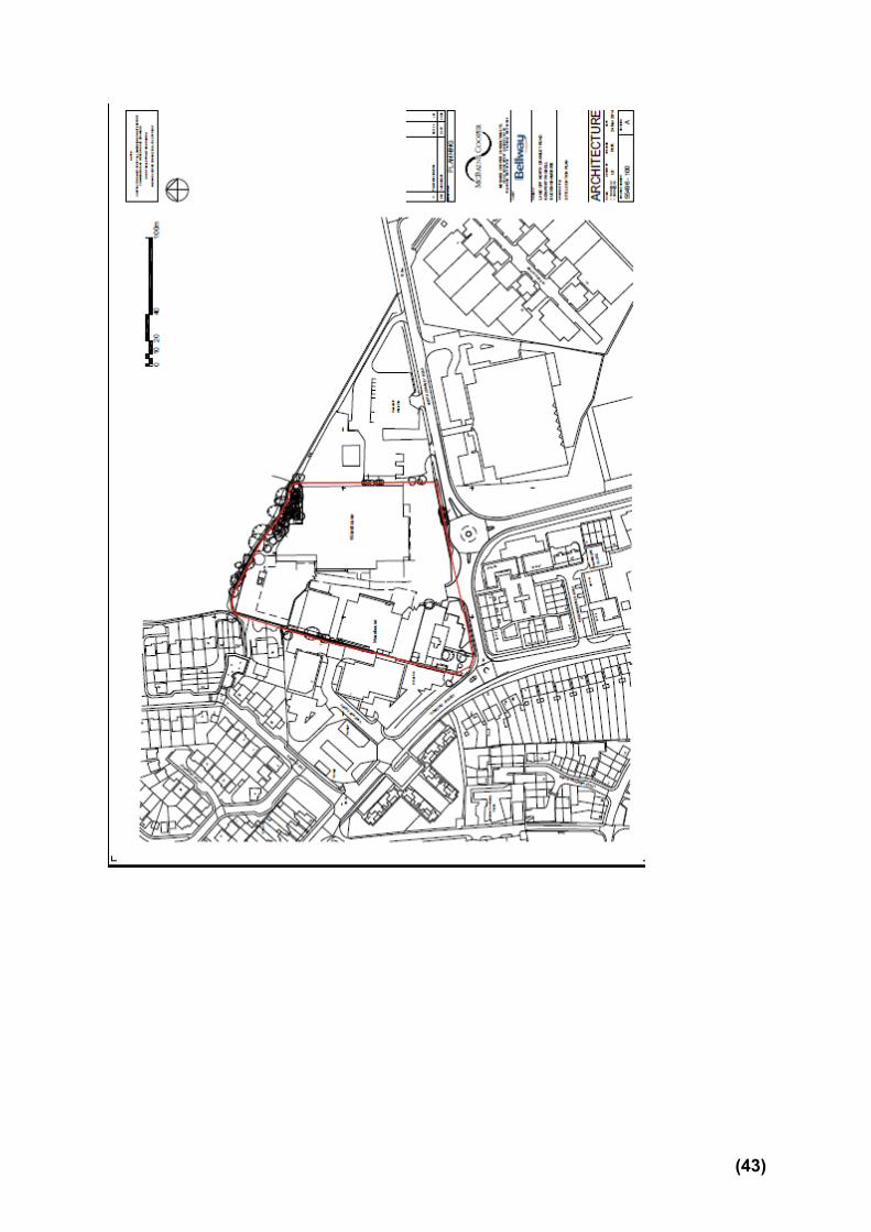
(43)

(44)
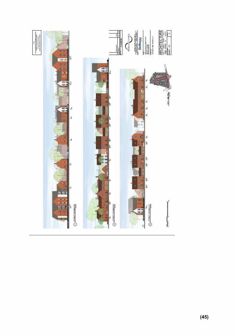
(45)

Appendix to 14/02799/FUL A1.0 RELEVANT PLANNING HISTORY
(A brief outline of previous planning decisions affecting the site – this may not include every planning application relating to this site, only those that have a bearing on this particular case)
A1.1 97/00885/MK Ground floor extension to offices Permitted 10.10.1997 98/00215/MK Construction of additional car parking spaces Permitted 31.03.1998 04/00337/FUL Infill of open area under main structure to form tyre fitting bay Permitted 26.04.2004
A2.0 ADDITIONAL MATTERS
(Matters which were also considered in producing the Recommendation)
A2.1 None
(46)
A3.0 CONSULTATIONS AND REPRESENTATIONS (Who has been consulted on the application and the responses received. The following are a brief description of the comments made. The full comments can be read via the Council’s web site)
Comments
A3.1
Parish - Newport Pagnell Our main concern with this application is that there is adequate provision for a redway along the North Crawley Road. Our Sustainable Transport Plan is an appendix to our Neighbourhood Plan and states that The development of Tickford Fields Farm and industrial sites for housing will be required to provide a redway network within the site, and redway connections along North Crawley Road to Tickford Street and London Road, and also to Chicheley Street. Our Neighbourhood Plan also includes a Development Brief for the four sites in the Tickford Fields Farm area, which includes this site, and it states the following: The development shall provide a redway along the North Crawley Road, extending from London Road to the A509 over-bridge, and within the site linking from the North Crawley Road to both Chicheley Street and Keynes Close. Developers should also seek to negotiate with Anglian Water a redway route through the lakeside land to link with Priory Street. A redway should be provided to link between Sites A,C, D, and E as part of a phased but comprehensive route. Final Comments I am pleased to confirm that subject to the following conditions the Town Council is prepared to withdraw its objection to planning application 14/02799/FUL:
1. Bellway Homes agrees to unconditionally gift to Milton Keynes Council the piece of land between the northern end of the main access road and the site boundary with the Tickford Fields Estate, thereby avoiding any ransom strip at this vital link to the main TFE site.
2. The S106 Agreement requires Bellway Homes to provide funding for the redway along the North Crawley Road as shown, either at the cost stated or, if they prefer, to build it themselves at a cheaper price.
(47)

A3.2 A3.3 A3.4 A3.5
Ward - Newport Pagnell South - Cllr McCall No response received.
(48)
Ward - Newport Pagnell South - Cllr Alexander No response received.
Ward - Newport Pagnell South - Cllr Eastman I have no comments at this stage, although I understand Mr Bowley has e-mailed concerns relating to development. I concur with his comments. Highways Development Control Whilst it is accepted that the traffic arising from the proposed development can be accommodated on the local network when considered as a standalone site, I am aware of the possible development of the Tickford Fields Farm which could accommodate up to 1200 residential units together with Educational Facilities. Therefore it is essential that the existing North Crawley Road/Renny Park Road Roundabout as modified has the capacity to accommodate traffic flows to/from this development and those going to/from the Tickford Fields Site. Unfortunately such analysis is not incorporated in the submitted Transport Assessment. The current 3-arm roundabout is “off-set” from the east/west alignment of the North Crawley Road and in an ideal world, would be re-designed to be centred on the North Crawley Road to create a 4-arm roundabout. However the applicant has not chosen to do this and has simply added a fourth arm to the existing layout. The proposed design has been subject to a Stage 1 Road Safety Audit. Comments were made (by the Audit Team) on the absence of longitudinal or cross sections with the proposed layout, the absence of surface water drainage and other services details, the absence of swept path analyses, the potential for visibility being obstructed by vegetation/foliage adjacent to the proposed access and the absence of road signage details, carriageway markings and street lighting.
(49)

The designer’s response indicates that some of these matters will be dealt with at the detailed design stage. However the swept path analysis has subsequently been undertaken and assurances given that the existing foliage/vegetation will be cleared to ensure adequate visibility. However the Road Safety Audit Team raised no concerns in respect of the local alignment. Therefore a second opinion was sought from a member of our design office and his views are précised below:
From inspection of the drawing submitted with the application it would appear that the existing roundabout has an inscribed circle diameter of approximately 29.5 m with a kerbed central island of 4 m in diameter. In terms of the relevant standards – i.e. TD 16/07 "Geometric Design of Roundabouts" - the existing roundabout is a "Normal Roundabout", with flared entries and exits to allow two vehicles to enter or leave the roundabout on a given arm at the same time.
In reviewing the applicant’s chosen design, the point at which the entry radius (approach from the west) meets the exit radius (into the proposed development site) is positioned outside the inscribed circle of the existing roundabout. As such, vehicles entering the roundabout from the west and continuing east or south, could follow the line of the entry radius but would then have to alter course to avoid the splitter island on the proposed access.
It is considered that an inscribed circle diameter of approximately 32 m could more readily facilitate the proposed 4th arm and entry radii and exit radii on the north side of the roundabout would be 10 m and 20 m respectively. It might also be possible to increase the diameter of the central kerbed island to 12 m, thereby reducing the entry path radii.
A request has also been made to the Council’s Road Safety Team for their views and I am awaiting their response. Whilst the minor modification suggested above can be achieved with only minimal impact on the proposed site layout, the same cannot be said if a larger roundabout is needed to accommodate the traffic generated by the Tickford Fields Farm development. Hence my view that it is necessary to ensure that the existing North Crawley Road/Renny Park Road Roundabout as modified has the capacity to accommodate traffic flows to/from this development and those going to/from the Tickford Fields Site before planning permission is
(50)

A3.6 A3.7
granted to this proposal.
In terms of access to the Tickford Field Farm site, it is understood that vehicular access through this site will be limited to buses only. Therefore the proposed internal access road, at 6.2m in width, can be considered acceptable. The remainder of the proposed residential access roads can also be considered acceptable in highway design terms. The proposed parking provision on the site accords with the Council’s parking standards for a Zone 3 area and for the majority of the site can be considered acceptable in terms of its location. However the allocated parking in the courtyard to the rear of Nos. 55 to 65 needs re-planning/re-allocating such that the parking spaces are closer and more readily overlooked by the properties they are intended to serve. It is understood that discussions have taken place with regard to the provision of Redway routes in the vicinity of the site. It is also understood that although a route through this site is no longer required, one will be required on the northern side of North Crawley Road. Therefore the proposed development should provide or make allowance for the provision of a Redway along the North Crawley Road frontage. MKC will consider as part of any planning obligation package (S106) whether the development site shall provide all or part of the Redway. The provision of such a Redway will impact on the proposed layout and may affect the siting of Plots 1 – 8. However the “turning area” in front of Plots 74 and 75 and the two visitor spaces will need to be realigned /relocated. In a highway context I would advise that the application needs amending and / or further information is required. Public Transport Officer The Transport Assessment contains incorrect information regarding bus services (page 10 – table 3.15), in
(51)

particular service 2 which does not provide a 15 minute frequency along Tickford Street. Service 2 only serves Tickford Street in the evening and on Sunday. It would be helpful if the consultant made reference to the fact that although there is at present 3 buses per hour Central Milton Keynes the service is split between the two bus stops:
a. Northbound stop = 2 to CMK (Evening & Sunday), 24 and C10 towards CMK, 40 towards Bedford
b. Southbound stop = 2 to Renny Lodge (Evening & Sunday), 25 towards Coachway & Kingston/Bletchley and C10 towards Bedford, 40 towards CMK
The Councils budget proposals for 2015/16 mean that is likely that there will be changes (reductions) to this level of service. The size of the development means that we cannot ask for the substantial public transport contribution needed to maintain an hourly daytime service but I would be looking for the two nearest bus stops to be upgraded to the current MKC standard, including the provision of RTPI displays. This would amount to £60,000 in total. In addition to this the developer should provide a travel information pack for each household, the opportunity for an annual all operator bus pass for Milton Keynes (£550 per household at current prices). Travel Plan Officer
There are a number of positive actions outlined in the residential travel plan for the proposed site.
There is a good amount of engagement activities with resident planned.
As noted by Andrew Coleman travel packs (also included as an action in the Travel Plan) should be distributed to residents.
The number of cycle parking spaces should be in line with Milton Keynes Council’s parking standards.
The variety of sustainable travel initiatives included in the Travel Plan is good, ensuring all types of sustainable travel are catered for.
It is excellent to see that the report considers reducing the need to travel and lists the nearest local services available.
Targets
As mentioned in the travel plan targets must be reviewed once the initial baseline survey has been carried out to ensure targets are realistic and challenging. The indicative targets (based on census data baselines) do not suggest targets which are overly challenging considering the amount of travel planning measures which will be promoted on an ongoing basis to residents. Baseline figures for the
(52)

A3.8 A3.8 A3.9 A3.10
initial travel plan survey must be communicated with MKC and targets agreed at this point. The survey should be carried out within3 months of occupation (rather than 6). The document and targets should then be reviewed within 3 months of the baseline travel survey being undertaken.
Action plan
All actions, including monitoring actions must be included in the action plan. This means any activities which are mentioned throughout the Travel Plan must be included as an action in the action plan so they are not overlooked. The action plan must be updated as the Travel Plan evolves and given definite dates of which actions will be undertaken. The updated documents must be shared with Milton Keynes Council’s Smarter Choice Transport Planners.
It would be a good idea to assign costs in the action plan so there are sufficient funds for the given Travel Planning activities.
Ongoing monitoring
Consideration has been given to ongoing monitoring of the plan. As noted the travel plan co-ordinator should be in place prior to occupation of development. The travel plan co-ordinator details must be given to MKC as soon as a travel plan co-ordinator is appointed. These details can be sent to [email protected] . It is good to hear that he details of the co-ordinator will also be available to the residents.
The travel plan must be updated (with surveys undertaken) annually for the first 5 year and bi-annually thereafter. This information must be included in the Travel Plan. The current dates of review for the Travel Plan do not reflect these dates (they show reporting only after years 1, 3 and 5). This must be amended.
As noted in the document, the travel plan must be updated within 3 months of the initial baseline survey being undertaken.
The travel survey should be undertaken within 3 months of occupation rather than 6 months of occupation.
Funding
The Travel Plan outlines that the Travel plan co-ordinator will be provided with sufficient funds to undertake the work. Amounts must be outlines in the Travel Plan to ensure that enough funding has been set aside for travel planning measures.
(53)

Environment Agency No objection Conservation Officer No observations on the application the proposed development is not regarded as being of significant potential archaeological impact. As such it is, in my view, unnecessary to conduct any pre-determination archaeological investigation nor do I wish to recommend any archaeological condition in respect of the site. Environmental Health Manager (Contamination) Recommends the introduction of a condition re. contamination of the site. Environmental Health Manager (Noise) I do not believe that the proposed measures are adequate to protect the properties from excessive noise disturbance from the activities of the Commercial and Community Waste site, particularly those abutting the site boundary line. There is a potential for statutory nuisance for prospective occupants of properties on the site from the activities of the Waste Site. Section 4.2.5 of the acoustic report indicates – ‘the most significant night-time noise events associated with the recycling centre were early in the morning on Thursday 25/09/14, from about 3am’. I do not know the regularity of activity on the waste site circa 3am, but I consider noisy activity at this time of day would constitute an unacceptable interference to residents on the proposed development site. From discussions with staff members on the waste site, operations regularly commence from 05.30hrs-06.00hrs for loading and unloading the waste storage bins, which is a noisy activity. This is before the site opens for use in taking receipt of commercial waste loads and waste from members of the public.
(54)

A3.11
In section 5.3 of the acoustic report – the assumption ‘that the elevation of the gardens is similar to the elevation of the recycling centre’ is incorrect. The waste transfer site is multileveled; at present the highest elevation is the built up section of the commercial waste loading area to the front left of waste site on the site boundary. The loading height of the skip is 3 metres higher than the lower ground level – the lower ground level on the waste site having the same elevation as the warehouse on the proposed development site boundary. The floor level at the commercial waste loading area is c. 2metres higher than the development site floor level. The activity of the excavators’ mechanical grabber boom will be in excess of 6 metres from the lower ground level of the waste site – they do not operate on the elevated section. A 2 metre high acoustic screen will be an ineffective noise barrier and line of sight to noise sources on the waste site will still exist, at multiple locations on the proposed development site. Although there has been no frequency analysis undertaken of noise from the waste site, I strongly suspect from my observations that there is a prominence of low frequency noise from onsite activities. A 2 metre high close boarded fence (mass of ≥10kg/m2) will not be effective in reducing the impact of low frequency noise from activities on the waste site; namely bin movements, bin loading and unloading, excavator movements, crushing /grappling arm actions – impact noise, commercial vehicle movements. The scrap metal deposit / storage bin is to the front left of the waste facility and directly abuts the site boundary, with further 5 waste bins in alignment away from the site boundary. Accumulated waste metal objects are thrown into the skip by hand and the mechanical grabbing arm of the excavator moves and crushes the metal in the skip to maximise the space in the skip. The commercial waste weigh bridge directly abuts the site boundary – commercial vehicle movements. The ‘bin park’ and lorry parking area directly abuts the site boundary to the rear of the site and is operational from 05.30hrs – 06.00hrs, with vehicles loading and unloading bins. Large vehicle movements including bin loading activities are not time restricted. The community recycling facility is open to the general public between 08.00hrs to 20.00hrs during the months of April to September and between 08.00hrs to 17.00hrs during the months of October to March.
(55)

A3.12 A3.13
The report does not include a BS4142 assessment of the noise from the waste site (methods for rating and assessing industrial and commercial sound), which I think should be included in the assessment of noise impact on the development site. I suspect that the outcome of such an assessment would conclude that there would be a significant adverse impact – i.e. complaints of noise from the waste site being likely. I would suggest that consideration of the inclusion of an acoustic buffer zone on the development site should be made to mitigate noise impact of the waste site operation. Although not related to noise, but relating to nuisance (complaints of which are investigated by Environmental Health under the Environmental Protection Act 1990), unless I missed it in the documentation, I do not believe that there has been any consideration of dust / odour from the waste site affecting prospective residents of the proposed development site. Rubble and hard-core can be disposed of at the site, both of these have the potential to create fugitive dust which could affect residential dwellings. Environmental Health Officer (Odour) I’ve looked at the odour report from Robert Sneath, Silsoe Odours Ltd. and accept the conclusions of his report; the Civic Amenity site presents a low odour risk, any complaints will be investigated and actioned by the regulator, the Environment Agency. The proximity of housing to the waste site will obviously have a bearing on the likelihood of complaints being made, however the report does not include any predictive modelling or detail as it is based on a site visit.
Development Plans Manager (Sustainability) have checked the submitted sustainability statement and I am happy with the information provided. The proposal would meet the requirements of policy D4 subject to conditions on:
1) 10% of the total energy to be offset by the on-site renewable sources; details of which should be submitted to and approved by the Local Planning Authority
2) Details of how at least 10% of the total value of building materials would be derived from recycled or
(56)

A3.14
reused content to be submitted to and agreed by the Local Planning Authority
Development Plans Manager (Policy) The issues at hand are not concerned with prematurity and this is should not be a material consideration
in determining the application anyway (NPPG: 21b-014-20140306).
The policies of the emerging plan can be a material consideration but it is for the decision-maker to
determine whether this is the case and to what extent (NPPG: 41-007-20140306).
The stage of preparation is one factor that influences the weight that can be afforded to the plan (NPPF:
para 216). I consider that the move from pre-submission consultation to submission should result in a
corresponding increase in material weight although this increment is logically not as significant as the plan
being successfully examined or passing referendum.
The key policy in the emerging Neighbourhood Plan in respect of this application is NP2 and specifically
NP2(e):
“Vehicular access shall be taken solely from North Crawley Road through a minimum of three junctions one of which shall be through the North Crawley Road Industrial Land. No access other than for pedestrians and cyclists will be allowed from Chicheley Street.”
This policy cannot be considered inviolate given the plan’s limited weight. I do not consider that the move
from pre-submission consultation to submission alters the individual weight of this specific policy.
Therefore the issue rests on a balance of the Council’s Highways advice against Policy NP2(e).
If the highways advice does not actively preclude the general land-assembly principle of Policy NP2 (i.e.
the delivery of the wider Tickford Fields development area) then I consider it a fair balance to give greater
weight to that advice than the specific elements of Policy NP2 such as NP2(e). Indeed this is reflected on
page 9 of the applicant’s planning statement where the conclusion of community consultation was that the
proposals were acceptable provided they did not prejudice land to the rear.
If based on concerns rather than uncertainty the highways advice may also constitute an unresolved
objection to the emerging plan. Paragraph 216 of the NPPF indicates that greater weight may only be
(57)

A3.15 A3.16 A3.17
given to emerging policies where unresolved objections are less significant.
Notably, part of the application site and the area directly to the north are both covered by a Strategic
Reserve (SR5), as per Policy EA4A of the Local Plan. This could lend weight to the argument that the
application site and access the area to the north should be considered concurrently. However, Policy
EA4A does not cover the details of delivery and simply identifies broad areas that have potential for
development.
Housing Strategy (Affordable Housing)
1) The site requires 30% Affordable Housing as per the Affordable Housing SPD 2013(25% Affordable Rent -5% at a level broadly equivalent to Social Rent - and 5% Shared Ownership). The applicant proposed 22 Affordable out of 73 total units (18 (25%) Affordable Rent & 4 (5%) Shared Ownership) - I could not see the confirmation in the amended plans but this mix is acceptable and complies with policy.
2) The proposed Affordable Housing house size mix is predominantly 2bed, and then 1bed with some 3 bed in line with current affordable housing need and policy.
3) The Council needs Affordable housing for Rent to house people in housing need – it had 120 households placed in B & B accommodation as of 19July 2015.
Landscape Architect Initially raised concerns about the lack of a play area and details of the landscaping strategy. Following discussions with the applicant confirmed Further to the comments made previously I am satisfied that sufficient space has been allocated for planting and trees and the detail of this can be submitted as a landscape condition. Waste Disposal MKC Urban Design Flats for each 8 flats we recommend 1x1100 Black euro bins, 1x1100 Pink euro bin, 240 Blue bin, and a 240 green for food waste. Perimeter fence adjacent to the Community Recycling Centre Height consideration for screening.
(58)

A3.18 A.3.19
Bedford Group of Drainage Boards No Comments
Public Realm Officer (Play Areas) Local Plan sets out 300m as the catchment for a Local Play Area, and they should be set at 500m intervals. There is another play area of this type that is around 300m away although it does involve crossing a road to get to it (foot note to appendix L3 also points out the need for a flexible approach) From my discussion with NPTC over many year they had always supported the idea that fewer but better play sites was more important than numerous sites with limited potential. This approach has also been agreed through the Play area Action plan that was adopted in 2013. Also given potential issues with viability Public Realm would be concerned about adopting play areas and open space where there may be insufficient maintenance contribution-. Thames Valley Police Request contributions towards additional policy costs to fund the new development.
A3.20
Local Residents The occupiers of the following properties were notified of the application: 75 Wordsworth Avenue Newport Pagnell Newport Pagnell 32 The Canons Newport Pagnell MK16 9GF 31 The Canons Newport Pagnell MK16 9GF 28 The Canons Newport Pagnell MK16 9GF 2 Vantage Court Tickford Street Newport Pagnell 30 The Canons Newport Pagnell MK16 9GF Vantage Court Tickford Street Newport Pagnell 33 The Canons Newport Pagnell MK16 9GF 29 The Canons Newport Pagnell MK16 9GF 1 Vantage Court Tickford Street Newport Pagnell 178 Tickford Street Newport Pagnell MK16 9BG
(59)

A3.20
182 Tickford Street Newport Pagnell MK16 9BG 186 Tickford Street Newport Pagnell MK16 9BG 176 Tickford Street Newport Pagnell MK16 9BG 184 Tickford Street Newport Pagnell MK16 9BG 14 North Crawley Road Newport Pagnell MK16 9FE 33 Addenbrookes Road Newport Pagnell MK16 9FD 8 North Crawley Road Newport Pagnell MK16 9FE 2 North Crawley Road Newport Pagnell MK16 9FE 16 North Crawley Road Newport Pagnell MK16 9FE 10 North Crawley Road Newport Pagnell MK16 9FE 4 North Crawley Road Newport Pagnell MK16 9FE 23 Addenbrookes Road Newport Pagnell MK16 9FD 18 North Crawley Road Newport Pagnell MK16 9FE 31 Addenbrookes Road Newport Pagnell MK16 9FD 25 Addenbrookes Road Newport Pagnell MK16 9FD Jenna House North Crawley Road Newport Pagnell The following five observations were received:
Increase in traffic noise and congestion
Increased pressure on facilities such as doctors and schools
Affect on house value
Failure to address deficiencies in local infrastructure: 1. Pedestrians have great difficulty crossing North Crawley Road between the two roundabouts and there should be a local widening of the carriageway, a central refuge and wider pavement/cycleway adjacent to the development site for its whole extent. 2. It is important to plan for cyclists at this location where a potential redway would link across Tickford Street and into North Crawley Road and the Tickford Fields Development Sites further east. Potential for a pelican/toucan crossing. 3. A bus shelter on London Road southbound is necessary.
This site is an integral part of the Strategic Reserve Site and the first
(60)

phase of a major new estate development, which must be properly considered and planned to provide the full range of facilities needed to make it sustainable. This requires a comprehensive development brief to be prepared in advance of any planning application decision.
This is a key gateway site, the development of which will set a precedent and character for the rest of the larger development. The current proposed development does not adequately consider these wider implications, is poorly designed and laid out, and seeks to maximise the capacity of the site to the detriment of proper planning of the area.
This application should be refused for the reasons given above, and a design brief prepared prior to the consideration of any further application.
A TPO should be made on T1 Lime, as matter of urgency. The amended plans continue to show an over intensive development with a very
poor outlook and privacy for dwellings at two edges of the site. The infrastructure requirements for the wider area of a total of c1400 houses are not addressed. There should not be a ransom strip where the spine road anticipated in the NP Neighbourhood Plan (final consultation document) meets the site boundary. The width of pavement on North Crawley Road remains inadequate for the anticipated cycle facility and the needs of pedestrians crossing N C Road
(61)


APP 02
Application Number: 15/00827/FUL
Construction of 5 storey building containing 24 x residential apartments, parking, covered walkway and substation. AT Site B1 1, Grafton Gate H5 To H6, Central Milton Keynes FOR Abbeygate Developments Ltd Target: 8th July 2015 Ward: Central Milton Keynes
Parish: Central Milton Keynes Town Council
Report Author/Case Officer: Nicola Wheatcroft Contact Details: 01908 252274 [email protected] Team Leader: Sarah Evans Team Leader Strategic Applications Team Contact Details: 01908 253326 [email protected] 1.0 INTRODUCTION
(A brief explanation of what the application is about)
The main section of the report set out below draws together the core issues in relation to the application including policy and other key material considerations. This is supplemented by an appendix which brings together planning history, additional matters and summaries of consultee responses and public representations. Full details of the application, including plans, supplementary documents, consultee responses and public representations are available on the Council’s Public Access System www.milton-keynes.gov.uk/publicaccess. All matters have been taken into account in writing this report and recommendation.
1.1 The Site The application site is located within Block B1.1 South on the corner of North Second Street and North Third Street in Central Milton Keynes. It is accessed via Grafton Gate and Silbury Boulevard and lies adjacent to the rear elevations of the Travelodge Hotel and the restaurant and retail units along the Grafton Gate frontage. The site currently comprises a 52-space parking area that serves the adjacent hotel, restaurant and retail units.
1.2 The Proposal This application seeks to erect a 5 storey building containing 24 apartments on an existing private car park. The building would front North Second Street and be arranged in 3 bays. It would have a central glazed entrance bay on the frontage with apartments and balconies either side of this. At ground floor the
(62)

building would accommodate an entrance, bin store, substation and undercroft parking. It would include a covered walkway. The ground floor either side of the glazed entrance bay would have coloured panels and horizontal slatted timber screening.
1.3 The building would be constructed mainly of brick with the recesses in the balconies being cedar clad. The balconies would have coloured glazing.
1.4 Details of the proposal as described above can be seen in the plans appended to this report.
2.0 RELEVANT POLICIES
(The most important policy considerations relating to this application)
2.1 Local Policy The CMK Alliance Plan 2026 (Final version) G1 – Public Realm Infrastructure G3 – Landscaping and Open Space G6 – Mixed Uses G7 – Active Frontages G8 – Development Blocks G9 – Design and Height of Buildings G10- Residential Development G12 – Planning Obligations T1 – Access and Design T3 - Cycling T14 – Parking Core Strategy (2013) CS 1 Milton Keynes Development Strategy CS 2 Housing Land Supply CS 7 Central Milton Keynes CS 10 Housing CS 13 Ensuring High Quality, Well Designed Places Adopted Milton Keynes Local Plan 2001-2011 saved policies S5: Central Milton Keynes D1: Impact of Development Proposals on Locality D2a: Design of New Development D2: Design of Buildings D4: Sustainable Construction T15: Parking Provision H3 – H5: Affordable Housing CC3: CMK Development Framework CC7a: Key Transport Principles CC7c: Key Principles for Parking CC8: Design and Layout CC9: Design of New Buildings CC10: Planning Obligation Policies in CMK
(63)

CC11: Central Business District
2.2 National Policy National Planning Policy Framework (2012) paragraphs: 7: Sustainable Development 14: Presumption in Favour of Sustainable Development 17: Core planning Principles 23: Vitality of Town Centres 40: Town centre parking 47: Housing Supply 50: Affordable Housing 56-57: Good Design 58: Design 60: Design 64: Refusal of poor design 100: Flood Risk 111: Effective use of land 109 and 118: Biodiversity 123: Noise
2.3 2.4
Supplementary Planning Guidance Planning Obligations for CMK SPG (2003) Parking Standards for Milton Keynes SPG (2005) and Addendum 2009 Supplementary Planning Document CMK Development Framework SPD (2013) Sustainable Construction SPD (2007) Affordable Housing SPD (2013)
2.5 Neighbourhood Plan Once a Neighbourhood Plan has been agreed at a referendum and is made (brought into legal force) by the Local Planning Authority, it becomes part of the local planning authority’s development plan as an official development plan document which carries statutory weight. Applications for planning permission must be determined in accordance with the development plan, unless material considerations indicate otherwise. If a policy contained in the development plan for an area conflicts with another policy in a development plan, the conflict must be resolved by the decision maker in favour of the policy which is contained in the latest document to become part of the development plan. Any non-compliance with a policy in the Neighbourhood Plan may not mean a proposal fails to comply with the development plan as a whole, or that having regard to all material considerations, planning permission cannot be granted.
2.6 Neighbourhood Plans therefore form part of the development plan for the relevant area. They will necessarily be in general conformity with the strategic polices contained in the development plan for the area. If they are the most recent document to become part of the development plan, they will attract statutory priority and will take precedence over non-strategic development plan policies.
(64)

3.0 MAIN ISSUES (The issues which have the greatest bearing on the decision)
3.1 Principle The Business Neighbourhood Plan does not set out any specific appropriate uses for the application site however it provides general support for residential development in suitable locations. The development would contribute towards a mix of uses within Blocklet B1.1 in accordance with policy G6 of the Business Neighbourhood Plan therefore is considered to be acceptable in principle.
3.2 Impact on Character and Appearance of the Area The building would provide activity, surveillance and continuity to a street frontage that is currently characterised by views of a servicing yard and car park. The presence of an existing substation on the site and the need to provide on plot parking has led to some compromises in the design, notably the reduction in width of the covered walkway and the lack of activated frontage at ground level, however overall the development is considered to be acceptable and in accordance with Policies G9 and G7 of Business Neighbourhood Plan, Policy CS13 of the Core Strategy and advice on design in Chapter 7 of the National Planning Policy Framework (NPPF) on Design.
3.3 Parking and Access The proposed development would include the provision of 18 spaces for the hotel, 15 shared spaces for the use of the hotel, retail and restaurant unit, and 24 spaces for the residential flats. The provision of parking spaces for the flats is in accordance with the standards. The parking provision for the hotel (80 beds), retail and leisure units would be below the maximum parking standards however the Highway Engineer has raised no objection to this given the location of the site, the shared spaces and the availability of parking in the locality. It is also noted that the existing restaurant unit and retail units face onto Grafton Gate and so in reality users of these units are already likely to use the public parking around the site rather than the parking to the rear. A refusal based on the shortfall of parking provision would be unlikely to be successfully defended at appeal.
3.4 Affordable Housing The proposal does not include any provision for Affordable Housing as the applicant claims this would make the development unviable. The Council commissioned an independent review of the Viability Assessment (dated 19th October 2015) submitted by the applicant which concluded that a scheme with 30% affordable, S.106 contributions of circa £78,000 and a profit level of 20% shows a negative land value and is not viable. The review also concluded that an all private scheme comprising 24 apartments with a developer’s profit of 20% and S.106 contributions of circa £78,000 is also unviable. On the basis of the advice issued by the independent assessor, the scheme is considered to be acceptable on the basis of the information submitted and therefore it is proposed that no affordable housing should be secured on the application site and planning permission should be granted to 100% market value properties.
(65)
4.0 RECOMMENDATION (The decision that officers recommend to the Committee)
4.1 It is recommended that planning permission is granted subject to the conditions
set out in Section 6 of this report and the completion of a S106 Agreement to secure financial contributions as detailed in paragraph 5.19 of this report.
5.0 CONSIDERATIONS
(An explanation of the main issues that have lead to the officer Recommendation)
5.1 Principle In respect of strategic housing land supply within the Authority, Paragraph 49 of the National Planning Policy Framework states that:
‘Relevant policies for the supply of housing should not be considered up-to-date if the local planning authority cannot demonstrate a five-year supply of deliverable housing sites.’
In this regard, it has been accepted by the Council that it is unable to meet this requirement (as detailed within the Housing Land Supply - Information sheet attached as Appendix 1 to this report) and for this reason the Council must rely upon the provisions of Paragraph 14 of the National Planning Policy Framework to consider the submitted application. This states that: “… at the heart of the National Planning Policy Framework is a presumption
in favour of sustainable development”. Where the development plan is absent, silent or relevant policies are out-of-date the Council grant permission unless:
• any adverse impacts of doing so would significantly and demonstrably outweigh the benefits, when assessed against the policies in this Framework taken as a whole; or
• specific policies in this Framework indicate development should be restricted.”
The starting point for the determination of this application is the fact that Authority does not have a 5 year housing land supply, and the proposed development would contribute towards meeting the identified shortfall. An assessment must therefore be made as to whether the proposal can be considered to be sustainable development in terms of the economic, social and environmental roles as set out in the National Planning Policy Framework.
In 2006 planning permission was granted for the erection of a 25 bedroom extension to the hotel and the erection of 24 apartments with associated parking on the application site. An extension of time for the implementation of that permission was subsequently approved by the Development Control Committee in 2010. These permissions have since lapsed and are no longer capable of being implemented however they do establish the principle of
(66)

development on the site and are material considerations to the application hereby considered albeit within an updated planning policy context.
5.2 The CMK Alliance Plan is the most up-to-date document within the development plan for the application site. Policy SS4 of the Business Neighbourhood Plan and the indicative proposals plan (figure 16) do not identify any specific uses for the site, however the plan does seek to ensure that mixed use is encouraged in all developments across Central Milton Keynes. Although the proposal itself does not offer a mix of uses, it would contribute towards a mix within Blocklet B1.1 as it would add a residential element to the existing hotel, retail and restaurant offer. The supporting text of the Business Neighbourhood Plan also encourages residential development on the quieter back parts of blocklets away from gates and boulevards (para 8.56) and the NPPF is supportive of residential developments in Town Centres. Overall, the principle of developing the site for residential purposes is considered to be acceptable.
5.3 Impact on Character and Appearance of the Area Paragraph 58 of the NPPF advises that local and neighbourhood plans should set out the quality of development that is expected for an area and this aim is supported by policies CS7 and CS13 of the Core Strategy. The Business Neighbourhood Plan contains a number of detailed design policies that are applicable to the application site, including policies G8, G9 and G10 which collectively seek to encourage perimeter block development with active frontages facing the public realm and servicing and parking within the core. The expected densities and heights of buildings are governed by policy G10 which states that residential development between Station End and Marlborough Gate should generally be 250 dwellings per hectare (dph) and that buildings of up to 8 stories in height are supported.
5.5 The siting of the proposed development respects the block structure and provides parking which is largely screened from the public domain at the core of the site. The height of the building is taller than the surrounding buildings however this is considered acceptable based on the site’s location within Central Milton Keynes (CMK) where a mix of building heights exists and support for taller buildings is given in the Business Neighbourhood Plan. Based on the site area provided by the applicant, the proposed development would represent a density of 185dph which is broadly in line with the detailed policy requirement. Overall, the proposal for a 5 storey building on the site is considered acceptable.
5.6 Policy G9 of the CMK Alliance Plan states that the building’s form, details and materials should be well considered and the design should demonstrate an appreciation of the wider context of the site. The proposed development is broken into 3 bays with a strong linear rhythm which is consistent with other buildings in CMK. During the course of the application, the proposed external materials have been altered in response to concerns raised during the consultation process such that the building would be characterised through the predominant use of brick rather than cedar cladding as originally proposed. The amendment is considered to be a positive one as it better
(67)
reflects surrounding buildings and the urban context of the site. The use of cedar cladding is restricted to the recessed of the balconies.
5.7 There remain some concerns over the lack of fenestration in the northern elevation of the building which faces onto the private road which exists between the application site and the building which is occupied by Staples. The applicant has stated due to relationship with the service yard of Staples and the fact that the land immediately to the north of the building may be developed in the future it would not be desirable to have windows in this elevation. Whilst this is not considered to be ideal the applicant has proposed to provide interest to this elevation by providing a series of different brick bonding and brickwork which will give some texture and interest to the elevation and on balance, given the constraints of the site is considered to be acceptable.
5.8 Policy G7 and Figure 10 of the Business Neighbourhood Plan seek to ensure that development facing onto North Second Street has an active frontage and provides continuous weather protection and shelter along the frontage with a depth of at least two metres at the same level as the pavement. Amended plans show the provision of a 2 metre deep covered walkway to the frontage of the site with the exception of a small area at the north of the frontage where the depth is reduced to 0.9 metres to allow for the existing substation, which is considered acceptable in this instance. However, whilst the proposed building does have a partially active frontage with the glazed entrance, the remainder of the ground floor frontage consists of timber screening and does not provide activity at ground floor level. This is not considered to be ideal however the central entrance feature is a strong feature and the balconies and arrangement of glazing on upper floor does provide more activity to the street and on balance this is considered to be acceptable.
5.9 Overall in design terms the building is considered to be acceptable. The building will provide activity, surveillance and frontage to part of the street that does not currently benefit from it and would positively contribute to the area in this regard. There are constraints to the site, given that it is part of an existing development, which lead to some shortcomings in the design. However overall the development is considered to be acceptable and is considered to comply with Policies G9 and G7 of Business Neighbourhood Plan, Policy CS13 of the Core Strategy and advice on design in Chapter 7 of the NPPF on Design.
5.10 Parking and Access Policy T1 of the Business Neighbourhood Plan seeks to ensure parking demand generated by proposed development should be considered. Policy T4 states that the parking standards shown in Table 3 of the plan are maximum standards and that developments are expected to meet the parking standards through on-plot parking. Policy T3 states proposed development should provide safe and secure storage for cycles on site.
5.11 The current application would result in construction of a new development on the existing car park. The enclosed car park currently has 49 parking spaces
(68)

and is shared between the hotel, retail and restaurant units. There are a further 17 spaces to the adjacent to North Second Street which are in the control of the applicant.
5.12 The proposed development would include the provision of 18 spaces for the hotel, 15 shared spaces for the use of the hotel, retail and restaurant unit, and 24 spaces for the residential flats. The provision of parking spaces for the flats is in accordance with the standards. The parking provision for the hotel (80 beds) would be below the maximum parking standards however the Highway Engineer has raised no objection to this given the location of the site, the shared spaces and the availability of parking in the locality. It is also noted that the existing restaurant unit and retail units face onto Grafton Gate and so in reality users of these units are already likely to use the public parking around the site rather than the parking to the rear. A number of smaller issues have been raised by the Highway Engineer however this could be addressed through the imposition of a condition if the development were to be regarded as acceptable in other regards. A refusal based on the shortfall of parking provision would be unlikely to be successfully defended at appeal.
5.13 The proposal provides cycle parking in accordance with Policy T13 of the Business Neighbourhood Plan.
5.14 Affordable Housing Policy G10 of the Business Neighbourhood Plan states that residential development will contribute to the provision of affordable housing in line with the Core Strategy and Supplementary Planning Document (SPD). Under the current Affordable Housing SPD the applicant is required to provide 30% affordable housing consisting of 25% affordable rent (with 5% at a level broadly equivalent to social rent) and 5% shared ownership. In the current application the applicant is stating that the development is not financially viable and cannot support the provision of any affordable housing on site. Viability Assessments have been submitted with the application documents to demonstrate this statement.
5.15 Paragraph 173 of the NPPF states pursuing sustainable development requires careful attention to viability and costs in decision-taking. Paragraph 205 states that where obligations are being sought, local planning authorities should take account of changes in market conditions over time and wherever appropriate be sufficiently flexible to prevent planned development being stalled.
5.16 The National Planning Guidance states: In making decisions, the local planning authority will need to understand the impact of planning obligations on the proposal. Where an applicant is able to demonstrate to the satisfaction of the local planning authority that the planning obligation would cause the development to be unviable, the local planning authority should be flexible in seeking planning obligations.
(69)
This is particularly relevant for affordable housing contributions which are often the largest single item sought on housing developments. These contributions should not be sought without regard to individual scheme viability. The financial viability of the individual scheme should be carefully considered in line with the principles in this guidance. (Paragraph: 019 Reference ID: 10-019-20140306)
5.17 The Council commissioned an independent review of the Viability Assessment submitted by the applicant, received on 19th October 2015. The review concluded that a scheme with 30% affordable housing, S.106 contributions of circa £78,000 and a profit level of 20% shows a negative land value and is not viable. The review also concluded that an all private scheme comprising 24 apartments with a developer’s profit of 20% and S.106 contributions of circa £78,000 is also unviable. The report suggests that a scheme is not viable with any on site affordable housing and it is recommended that the Council gives serious consideration to permitting the scheme on the basis of the submitted proposal.
5.18 Having given consideration to the independent assessment, it is concluded that the scheme would be unviable if Affordable Housing was provided on the site therefore, in accordance with national policy and guidance it is recommended that the scheme be approved on the basis of 100% private housing with no affordable provision.
5.19 Planning obligations The proposed development will create demand for new infrastructure and in accordance with Policy CS21 and the Planning Obligations for CMK SPD. After consultation with the relevant service department the following contributions are sought:
Education – £42,346.84
Public Transport – £9,936
Highways Network – £3,864
Public Art – ¼% of gross development cost excluding land estimated £9,500 payable
Community Facilities - £16,080.
Carbon Offsetting - £200 per tonne equates to £9,000 approx. Total £90,726.84 approx
5.20 The Planning Obligations Officer considers these contributions meet the tests
as outlined at paragraph 204 of the NPPF. They are also CIL regulations 122 and 123 compliant. The Policy Officer has also reviewed the Sustainable Construction Statement and considers the proposals are acceptable with regard to saved Policy D4 of the Milton Keynes Local Plan 2001-2011 and the Sustainable Construction SPD.
5.21
Although the independent review of the viability assessment concluded that the scheme would be unviable with the developer contributions sought, the applicant has not contested the payments on viability grounds therefore they
(70)
5.22 5.23
remain part of the recommendation to the Development Control Committee. Amenity The Environmental Health Officer has raised concerns about potential noise problems from the surrounding commercial units, in particular the nearby restaurant unit. And has requested a noise survey to be carried out. In this instance as the site has the potential for noise due to its central location, it has been agreed that a better way to deal with this matter would be through the imposition of a condition requiring noise levels in the flats to be below the British Standard BS8233:2014 for the flats. Conclusion The proposed development respects the principles of the CMK neighbourhood Plan and requirements of the Milton Keynes Local Plan 2001-2011. The proposal will assist in meeting the 5 year housing land supply and will comply with the principles of the NPPF. The scheme introduces housing into Blocklet B1.1providing a mix of uses in this area. Activity, surveillance and continuity to the street frontage is provided by the building. A total of 18 spaces are proposed for the hotel, 15 spaces for the hotel, retail and restaurant units and 24 spaces for the flats. The parking provision for the hotel is below hotel is below the maximum standards parking standards. No objection to parking is raised by the Highway Engineer. The application is accompanied by a viability assessment which demonstrates that the scheme is not viable and therefore does not provide affordable housing. Contributions are proposed in line with the SPG on S.106 contributions in CMK.
6.0 CONDITIONS
(The conditions that need to be imposed on any planning permission for this development to ensure that the development is satisfactory. To meet legal requirements all conditions must be Necessary, Relevant, Enforceable, Precise and Reasonable)
1 The development hereby permitted shall be begun before the expiration of three years from the date of this permission.
Reason: To prevent the accumulation of planning permissions; to enable
the Local Planning Authority to review the suitability of the development in the light of altered circumstances; and to comply with section 51 of the Planning and Compulsory Purchase Act 2004. (D11)
2 The external materials to be used in the development shall be in
accordance with samples to be submitted to and approved in writing by the Local Planning Authority before any work is commenced above slab level.
Reason: To ensure that the development does not detract from the
appearance of the locality. 3 Details of the proposed finished floor levels of all buildings and the
finished ground levels of the site, in relation to existing site levels of surrounding property, shall be submitted to and approved by the Local Planning Authority before any work commences. The development shall be carried out in accordance with the approved levels. (G03)
(71)
Reason: To ensure that construction is carried out at suitable levels
having regard to drainage, access, the appearance of the development and the amenities of neighbouring properties.
4 Before any demolition, clearance, building or other works commence on
site details shall be submitted to and approved by the Local Planning Authority specifying the parts of the site to be used for site huts, storage of materials and plant and parking of employees cars during the construction period, and any proposal for fencing of a site compound.
Reason: To ensure satisfactory provision in relation to adjoining property
and circulation within the site. 5 Neither demolition nor any other site works shall commence until the
frontage of the site has been enclosed by a continuous solid fence in accordance with details to be agreed in writing by the Local Planning Authority. Such fencing shall remain until clearance and building works have been completed.(S01)
Reason: To protect the amenities of the locality. 6 No development shall commence until details of the detailed design and
associated management and maintenance plan for a surface water drainage scheme has been submitted to and approved by the local Planning Authority. The development shall be carried out in accordance with the approved details.
Reason: To ensure the surface water drainage details are acceptable. 7 Prior to any development taking place, the developer shall carry out an
assessment of ground conditions to determine the likelihood of any ground, groundwater or gas contamination of the site in accordance with BS 10175:2001 Investigation of Potentially Contaminated Sites - Code of Practice. The results of this survey, together with any remedial action deemed necessary, shall be submitted to and approved by the Local Planning Authority before works commence. Any remedial works shall be carried out in accordance with the approved strategy and validated by submission of an appropriate verification report prior to the first occupation of the development. Should any unforeseen contamination be encountered during site works, the Local Planning Authority shall be informed immediately.
Reason: To ensure that the site is safe and suitable for its proposed use. 8 The internal noise levels shall be below those stated in BS 8233: 2014
and World Health Organisation Guidelines For Community Noise.at all times.
Reason: To protect the amenity of the residents.
(72)

9. The flats hereby permitted shall not be occupied until the parking
provision for the development has been provided in line with the approved plans. The car parking provided shall be used for no other purpose thereafter.
Reason: To ensure that the development is served by adequate and
usable parking provision in line with Parking Standards in the Central Milton Keynes Neighbourhood Plan.
10. No development above slab level shall occur until details of cycle parking
have been submitted to and approved by the Local Planning Authority. The cycle parking shall be provided in line with the approved details prior to occupation of the flats and retained for that purpose as such.
Reason: To ensure that the development is served by adequate and
usable cycle parking.
(73)
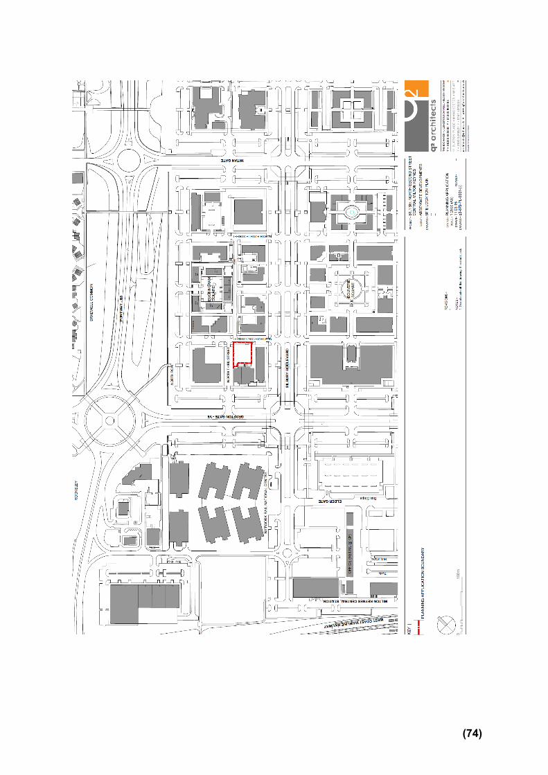
(74)
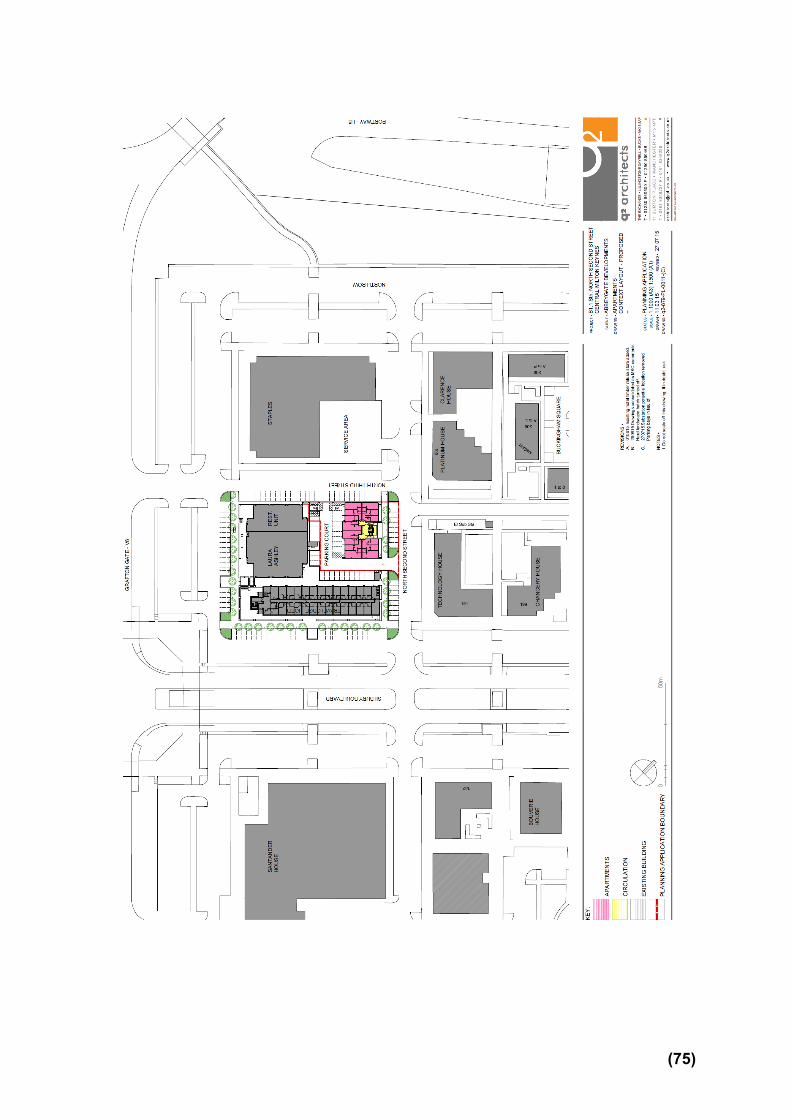
(75)
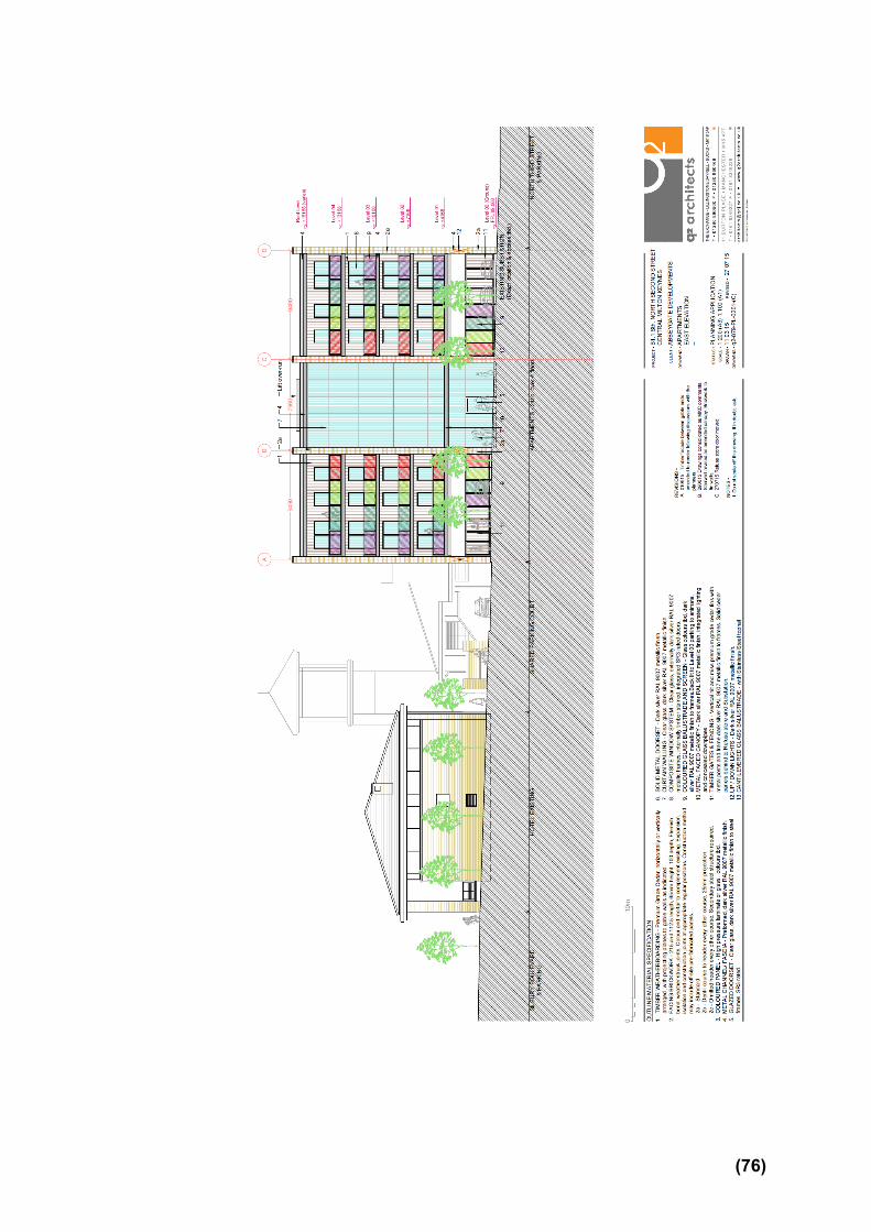
(76)
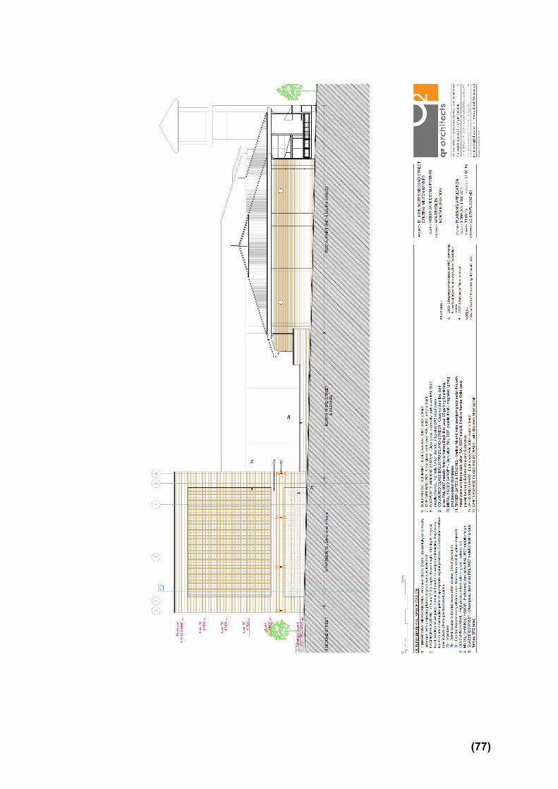
(77)

(78)

(79)

(80)
(81)
Appendix to 15/00827/FUL A1.0 RELEVANT PLANNING HISTORY
(A brief outline of previous planning decisions affecting the site – this may not include every planning application relating to this site, only those that have a bearing on this particular case)
A1.1 06/00270/FUL – Redevelopment of existing private car park for 25 bedroom redevelopment of existing private car for 25 bedroom extension to hotel and addition of 14 one and two bedroom apartments with associated car parking. Permitted July 2007. This permission was not implemented and has lapsed.
A2.0 ADDITIONAL MATTERS
(Matters which were also considered in producing the Recommendation)
A2.1 None
(82)


A3.0 CONSULTATIONS AND REPRESENTATIONS
(Who has been consulted on the application and the responses received. The following are a brief description of the comments made. The full comments can be read via the Council’s web site)
Comments Officer Response
Central Milton Keynes Town Council The Town Council neither objects to nor supports the planning application. The Town Council wishes to understand whether the applicant has considered the provision of a colonnade to the frontage of the building in accordance with the Business Neighbourhood Plan.
The scheme has been amended to include a covered walkway to the frontage.
Housing Strategy (Affordable Housing) 1. The site requires 30% affordable housing as per the
Affordable Housing SPD 2013. 2. The Tenure Mix should be 25% Affordable Rent (5%
at a level broadly equivalent to Social Rent) and 5% Shared Ownership. This breaks down to 6 Affordable Rent and 1 Shared Ownership.
3. An Affordable Housing house size mix of 1 beds and 2 beds would be in line with current affordable housing need and policy.
4. The Council needs Affordable Housing for Rent to house people in housing need – it had 119 households placed in B&B accommodation as of 12th April 2015.
The previous approved scheme on this site required no Affordable Housing based on a viability assessment in 2010 and for a different development layout. The applicant is proposing no affordable housing in the current application
Noted. Please see paragraphs 5.14-5.18 of this report.
(83)

based on the previous viability assessment of 5 years ago for a different scheme. This is a new full application which falls under current MKC Affordable Housing policy, and with a minimum threshold of 15 dwellings for an Affordable Housing contribution. It may be that the scheme is still unviable, despite the upturn in the housing market since 2010, unless there is a reduction in or no Affordable Housing but policy requires an up to date viability assessment agreed by the Council’s valuer to evidence this.
Highways Development Control
Under the Council’s parking standards each apartment would require 1 car parking space. The applicant has provided 24 car parking spaces (acceptable).
For the existing hotel/retail and restaurant the applicant has allocated 32 car parking spaces, an increase of 2 car parking spaces from the previous approved application (acceptable – the site is in a sustainable location).
In accordance with MK parking standards the applicant is providing 1 cycle parking space per apartment (24 cycle parking spaces) (acceptable).
The site is well located within Central Milton Keynes with various parking tariffs. Granting planning permission will not harm the highway network or create significant parking pressures considering the large parking stock in the vicinity of the site and across CMK as a whole.
The existing vehicular access for the hotel is to be
Noted.
(84)

retained and the same access is to be used for the proposed apartments (acceptable).
The car park layout for the hotel/retail and restaurant has been modified (acceptable)
The proposed layout shows 24 car parking spaces for the proposed residential element (acceptable)
At present there are on-going discussions with Central Networks with regards to the location of the sub-station
Motor cycle parking – access to the 2 motorcycle spaces appears to be very tight, min 1m to be provided opposite bay R11 and R12
Footpath fronting the cycle store and refuse recycling store should be a minimum width of 1.5m (to be revised)
Tracking of refuse vehicles within the site to be provided, the carry distance for refuse operatives should be taken into consideration and should be the standards i.e carry distances (applicant to provide).
In conclusion I have no objection to the proposed development subject to the revisions requested above and a condition requiring parking to be provided prior to the occupation of the development and requiring details of the bicycle parking to be submitted prior to occupation.
See Section 6 and condition 9.
Landscape Architect This application should show a set back and landscaping to the side of the building – I refer to urban design. A landscape proposals drawing will be required to show planting to the building frontage to replace what has been removed.
Noted.
(85)
Senior Planning Officer – Strategic Flood Management
I am happy with the details submitted by the applicants in relation to surface water for the above application, subject to Anglian Water approval. I would ask that a condition is added to the permission requiring the submission for approval of a detailed design and associated management and maintenance plan for a surface water drainage scheme.
Noted, dealt with through condition 6
Anglian Water
1. Our records show that there are no assets owned by Anglian Water or those subject to an adoption agreement within the development site boundary;
2. The foul drainage from this development is in the catchment of Cotton Valley Water Recycling Centre that will have available capacity for these flows;
3. The sewerage system at present has available capacity for these flows. If the developer wishes to connect to our sewerage network they should serve notice under Section 106 of the Water Industry Act 1991. We will then advise them of the most suitable point of connection.
4. The preferred method of surface water disposal would be to a sustainable drainage system (SUDS) with connection to sewer seen as the last option. Building Regulations (Part H) on Drainage and Waste Disposal for England includes a surface water drainage hierarchy, with infiltration on site as the preferred disposal option, followed by discharge to watercourse and then connection to sewer.
5. The surface water drainage strategy/flood risk
Noted.
(86)

assessment submitted with the planning application relevant to Anglian Water is acceptable in principle, the maximum permitted discharge rate will be 5l/s. We request that the agreed strategy is reflected in the planning approval.
Environmental Health Officer
In accordance with the NPPF, as the proposal is particularly vulnerable to the presence of contamination I recommend that a condition be applied to any grant of planning permission for this site to require the developer to carry out an assessment of ground conditions and to detail remediation works if necessary. The proposed development backs onto the ‘B-Town’ Indian restaurant and other commercial buildings, concerns re plant noise affecting occupants of the residential development and potentially cooking odours. Recommend a noise assessment to consider the impact of plant noise in the vicinity on the proposed development.
Noted, see condition 7.
Have agreed with the Environmental Health Officer that as no noise assessment has been submitted a condition requiring noise levels to below BS8233:2014 for the flats is proposed (condition 8)
Urban Design Officer The Urban Design Officer initially raised some concerns regarding the amount of inactive frontage facing North Second Street and weather protection in accordance with the Business Neighbourhood Plan as well as amenity space, landscaping and the use of cedar cladding. Following amendments to the scheme, the Officer has concerned that most concerns have been addressed, but that windows in the south side elevation should be should be reflected in the north elevation fronting North third street. Whilst it is appreciated that the windows would overlook an existing service area, they would
Noted.
(87)

provide additional surveillance of the street and help break up a largely blank elevation.
Policy Officer (Policy D4)
The submitted Sustainability Statement sets out the anticipated sustainability performance of the proposed residential development. While it attempts to cover all the requirements of policy D4 the Statement often accepts the need for further work as part of detailed design e.g. to confirm the performance of the development in respect to checklist items concerning CO2 reduction, energy efficiency measures’, renewable energy and remaining CO2 emissions. Before I confirm that the proposal is acceptable I would like the applicant to provide some additional information on two areas of policy D4. First, can they confirm that the proposed roof structure is capable of accommodating an approximately 10kWp PV array (c100 m2). Since the Statement provides no SAP calculations I made a crude assumption on how much total CO2 emissions are likely to be from this development. I assumed that the emissions (both regulated and unregulated) are likely to be 25kg of CO2/m2. Secondly, I would like the applicant to bear in mind that the carbon offset payment (based on the above CO2 emissions figure, which in due course will have to be confirmed by SAP calculations) may be approximately £9,000.
No comments were received from the Crime Prevention Design Advisor, EON - Central Networks, Ward Members Cllr Betteley and Cllr Wallis. Cllr Paul Williams is a Member of the Development Control Committee.
Local Residents The occupiers of the following properties were notified of the application:
(88)

151 Silbury Boulevard Clarence House,152 North Row Platinum House, 199 North Second Street 163-175 Grafton Gate 151 Grafton Gate 1 Grafton Gate Travelodge, Grafton Gate Staples UK 1 Grafton Gate East Laura Ashley At Home Grafton Gate East Maharajas Restaurant Grafton Gate No observations received.
(89)

APP 03
Application Number: 15/02293/FUL
Development of a process and packaging facility and associated works, including car parking, engineering works and landscaping AT Walton Manor, Brickhill Street H9 To H10, Milton Keynes FOR Intervet UK Production Ltd Target: 11th December 2015 Ward: Monkston
Parish: Walton Community Council
Report Author/Case Officer: Katy Lycett Contact Details: 01908 252313 [email protected] Team Leader: Sarah Evans Team Leader Strategic Applications Team Contact Details: 01908 253326 [email protected] 1.0 INTRODUCTION
(A brief explanation of what the application is about)
1.1 The main section of the report set out below draws together the core issues in relation to the application including policy and other key material considerations. This is supplemented by an appendix which brings together planning history, additional matters and summaries of consultees’ responses and public representations. Full details of the application including plans, supplementary documents, consultee responses and public representations are available on the Council’s Public Access System www.milton-keynes.gov.uk/publicaccess . All matters have been taken into account in writing this report and recommendation.
1.2 The Site The application site is a parcel of land contained within the Intervet, Walton Manor Campus. The application site lies adjacent to another parcel of land which was recently granted planning permission for a waste water treatment works under reference15/00385/FUL. The site contains a variety of uses including light industry, office, storage and production. Intervet UK operates as MSD and has been located at Walton Manor for over 40 years.
1.3 The Campus has a variety of buildings on site, some historic associated with the original stud farm and many developed over time. There are a large number of more modern additions throughout the campus and the layout includes various parking compounds, areas of landscaping and communal external spaces. The site has security which is controlled via a gatehouse at the main entrance. Vehicles are not able to enter or exit the site freely without authorisation.
(90)

1.4 In recent years part of the Walton Manor site has been redeveloped for residential use with a shared vehicle access for both functions from Brickhill Street (V10) onto Hullwell Gate. The closest dwellings to the application site are apartments which have some windows facing towards the Campus. The elevations which face towards the Campus mainly serve stairwells, landings and corridors. Details of the location of the site and its relationship to surrounding properties can be seen in the plans attached to this report.
1.5 The Proposal This application seeks consent for the creation of one stand-alone process and packaging (P&P) facility (B1(c) Use) with associated works including the creation of additional car parking spaces and landscaping. The building proposed as part of this application is for a replacement of a secondary operation based in Hertfordshire.
1.6 The building comprises of 1766 square metres of floor space across the ground and mezzanine floors. The facility measures 47metres x 38metres and due to the natural slope of the site some excavation will be required. The result is that the floor level will lower the overall height of the building to 13.3 metres.
1.7 A new landscape mound will be created as a result of the excavations. This planted bank is to be located towards the front of the site closest to the gatehouse with the construction compound to the rear and the P&P plant adjacent to existing building 43.
1.8 Additional vehicle parking is to be provided on site to accommodate additional vehicle activity. An associated Transport Statement has been submitted with examines parking provision, potential trip generation and servicing arrangements and also provides information on the accessibility of the site via public transport, foot and cycle.
1.9 A Phase 1 Ecology Assessment and Sustainability Statement has also been submitted to accompany the application. Details of the proposal as described above can be seen in the plans appended to this report.
2.0 RELEVANT POLICIES
(The most important policy considerations relating to this application)
2.1 National Policy National Planning Policy Framework 2012 paragraphs: 11, 12, 13, 14 The Presumption in favour of sustainable development 17 Core Planning Principles 19, 22 Economic Growth 35 Promoting sustainable transport 99 and 103 Meeting the challenge of climate change, flooding and coastal change 109, 111 and 112. Conserving and enhancing the natural environment 118 Biodiversity 120 Suitability of Land
(91)

123 Noise
2.2 Local Policy Core Strategy (2013) CS1 (Milton Keynes Development Strategy) CS13 (Ensuring High Quality, Well Designed Places) CS19 (Healthier and Safer Communities) CS20 (The Historic and Natural Environment)
2.3 Adopted Milton Keynes Local Plan 2001-2011 D1 (Impact of Development Proposals on Locality) D2 Design of Buildings D2A Urban Design Aspects of New Development D4 Sustainable Construction NE2 Protected Species T10 (Traffic) T15 (Parking Provision)
2.4 Supplementary Planning Guidance Documents Parking Standards for Milton Keynes (2005) Sustainable Construction (2007)
3.0 MAIN ISSUES (The issues which have the greatest bearing on the decision)
3.1 Impact on character and appearance of area. Given the mixed character and appearance of the area and the additional landscaping mound the proposed development is considered to be acceptable in design terms.
3.2 Impact of the development on the amenity of neighbouring properties. Given the activities undertaken at the site the proposed development is not considered to result in an unacceptable level of noise or odour, subject to imposition of conditions controlling hours of operation and noise restrictions.
3.3 Impact on highway safety and parking. The submitted information has been assessed and subject to imposition of conditions for car parking, wheel cleansing and the requirement of a Travel Plan no objections are raised.
3.4 Sustainable Construction and s106 Contributions The applicant has agreed to enter into a S106 Legal Agreement to make a financial contribution to offset the amount of carbon produced by the development in the first year.
4.0 RECOMMENDATION
(The decision that officers recommend to the Committee)
4.1 It is recommended that planning permission be granted subject to the
conditions set out in Section 6 of this report.
(92)

5.0 CONSIDERATIONS (An explanation of the main issues that have lead to the officer Recommendation)
5.1 Principle of Development This site has an established use with a combination of offices, research, development and production facilities and has been in operation for many years. Further developments to continue and progress this enterprise can be supported subject to the details and specifics of the proposal.
5.2 Impact on Character and Appearance of Area Saved Policy D2 of the Milton Keynes Local Plan 2001-2011 and Policy CS13 of the Core Strategy seek to ensure that development proposals relate well to the surrounding environment in terms of scale, appearance and detailing. In this current application the proposed development is located in an area with a mixed character. The existing buildings on the application site have a strong commercial character and reflect the activities being undertaken at the site. However the introduction of the new housing to the south has led to a rather awkward interface between industrial and residential character in terms of the two uses. Whilst this relationship is not ideal, the development connection has been established and over time the landscaping will help to improve the appearance of the public realm.
5.3 The design of the proposed building has utilised the change in levels in order to create a structure which will not exceed the height of the closest existing structure. Furthermore, there is currently, under construction a waste water treatment plant which is set to the front of the proposed development. As a result the new building will not be constructed closer to the highway than the works currently under development and visually will have a lesser impact overall.
5.4 The site forms a self-contained campus with restricted vehicle and pedestrian access into and from the site. From the wider public realm the site is not highly visible from viewpoints outside the site. From the H9 the site is concealed by established landscaping along the dual carriageway. The site is not visible from residential dwelling houses within Walnut Tree due to the separation distance between them and the established landscaping.
5.5 Along Simpson Road the site can be seen at various points, however the proposed development will not exceed the height of any building nearby so is not expected to cause significant visual impact. In addition, there is established landscaping along Simpson Road and the recently constructed apartments are much larger and more prominent than the proposed processing and packing plant building.
5.6 Overall the impact of the development proposals on the character and appearance of the area is considered to be acceptable and the proposal is considered to comply with saved policy D2 of the Milton Keynes Local Plan 2001-2011and Policy CS13 of the Core Strategy and advice in the National
(93)

Planning Policy Framework.
5.7 Ecology The application includes an awareness of both existing landscaping features and the requirement for further planting in the future. The submission included a Phase 1 Ecology Assessment and a detailed landscaping scheme. Further information regarding both of these documents was required and duly submitted. Formal written comments from the Countryside Officer are expected confirming the acceptability of this information.
5.8 Noise and Odour The applicant submitted a Noise Impact Assessment which was assessed by the Environmental Health Officer who has confirmed there are no objections to the scheme subject to the imposition of conditions relating to the hours of operation and noise levels from fixed plant not exceeding a rating of 5dB below prevailing background level at the nearest noise sensitive boundary. On this basis, no other concerns are raised regarding noise. In addition, no objections have been raised with reference to potential odour, as the proposed development is a closed system so odour should not be a problem.
5.9 Amenity The residential properties closest to the application site are those located along Harley Drive. These are recently constructed dwellings set over 100 metres from the closest elevation of the proposed development. Between the two would be a previously approved waste water treatment plant and a large landscaping area which would create a positive contribution to the amenity value of the local area. The proposed landscaping bund would provide a buffer of approximately 20 metres of planting and landscaping adjacent to the highway. This is deemed to be sufficient to ensuring the amenity of nearby residents is not significantly affected. The landscaping bund will provide a visual break between the proposed construction site and the views of the site from the wider area to the benefit of nearby occupiers.
5.10 The proposed development is situated in an area with a mixed character. The design of the building would be industrial in nature but given the other buildings on the site and their location within the fenced site, this is considered to be acceptable. The proposed development is not considered to have any significant impact on neighbouring properties amenity and would comply with saved policy D1 (iii) of the Milton Keynes Local Plan 2001-2011.
5.11 Highway Safety and Parking This site is very much a self-contained ‘Campus’ with employees benefitting from on-site facilities including dedicated parking areas. The site is very tightly regulated in terms of vehicle movements entering and departing from the site. It has been confirmed by the Highway Engineer that the submitted Transport Statement is acceptable for this proposal.
(94)

5.12 Due to the operations of facility producing and processing small items, large vehicular drop off facilities are not required. Most of the deliveries to and from the site will be from existing facilities on the Campus, such as Building 61, which comprises the main Campus’ onsite cold storage. Only occasional additional external vehicles will enter the site.
5.13 Two additional areas of car parking will be created as part of this application providing additional parking areas for the whole Campus. The two additional parking areas included within this proposal are located to the east of the Campus, adjacent to the site boundary. An additional 45 car parking spaces will be provided through an extension to the current Eastern Car Park. These spaces will be provided on the site of the former Building 70 once it is demolished, and utilise the existing staff entrance from Hulwell Gate. A further 9 spaces will be provided in Car Park ‘A’ (furthest car park to the east of the Campus and East of Building 50) on land which is currently amenity grassland.
5.14 No disabled parking is proposed to be provided in the East Car Park as it is considered too far from the main centres of activity on the campus. The response to the provision of disabled parking is to locate these spaces adjacent to buildings throughout the campus as agreed by the Car Parking Strategy. Space for three additional disabled vehicles will be made available opposite the Walton Manor building as part of these proposals. Cycle parking is to be provided as part of the development. The proposed development would comply with saved policy T15 of the Milton Keynes Local Plan 2001-2011.
5.15 Sustainable Construction Under the criteria (viii) of Policy D4 of the Milton Keynes Local Plan 2001-2011 the applicant has agreed to make a financial contribution through a S106 Legal Agreement in order to offset carbon emissions produced by the development in the first year.
5.16 This application was accompanied by a Sustainability Statement which contains relevant information relating to the identification of opportunities and constraints for sustainable development. The Policy Officer has confirmed that the submitted sustainability statement is acceptable and would comply with saved policy D4 (i-vii) of the Milton Keynes Local Plan 2001-2011 and guidance set out in the Sustainable Construction Supplementary Planning Document.
5.17 Conclusion It is recommended that planning permission is granted subject to the completion of a S106 Agreement for a financial contribution towards the carbon offset fund and conditions set out in Section 6 of this report.
(95)

6.0 CONDITIONS (The conditions that need to be imposed on any planning permission for this development to ensure that the development is satisfactory. To meet legal requirements all conditions must be Necessary, Relevant, Enforceable, Precise and Reasonable )
1. The development hereby permitted shall be begun before the expiration of three years from the date of this permission. Reason: To prevent the accumulation of planning permissions; to enable the Local Planning Authority to review the suitability of the development in the light of altered circumstances; and to comply with section 51 of the Planning and Compulsory Purchase Act 2004. (D11) 2. Prior to the occupation of the development hereby permitted the car parking area shown on the approved drawings shall be constructed, surfaced and permanently marked out. The car parking area so provided shall be maintained as a permanent ancillary to the development and shall be used for no other purpose thereafter. Reason: To ensure adequate parking provision at all times so that the development does not prejudice the free flow of traffic or the safety on the neighbouring highway in accordance with saved Policy T15 of the Milton Keynes Local Plan 2001-2011. 3. Prior to the commencement of the development hereby permitted vehicle wheel cleansing facilities shall be provided on the site to ensure that mud is not transferred onto the highway. Such facilities shall be used by all vehicles leaving the site and shall be permanently maintained in working order throughout the construction period. Reason: To ensure that construction works do not prejudice conditions of safety and cleanliness along the neighbouring highway. 4. Prior to the commencement of the development hereby permitted details shall be submitted to and approved in writing by the Local Planning Authority specifying the parts of the site to be used for site huts, storage of materials and plant and parking of employees cars during the construction period, and any proposal for fencing of a site compound. During the period of construction of the development hereby permitted the site shall be laid out in accordance with these approved details. Reason: To minimise danger, obstruction and inconvenience to users of the adjoining highway. 5. The new building hereby approved shall not be operated outside of the hours of 08:30 to 18:00 Monday to Friday. Reason: To restrict any noise and disturbance to nearby properties and occupiers in accordance with saved Policy D1 (iv) of the Milton Keynes Local Plan 2001-2011. 6. Noise generated by the fixed plant associated with the development (e.g., chillers, AHU’s, air compressors and boilers) shall not exceed a rating level of 5dB
(96)
below the prevailing background level as assessed at the boundary of the nearest noise sensitive boundary. Reason: To restrict any noise and disturbance to nearby properties and occupiers in accordance with Policy D1 of the Milton Keynes Local Plan 2001-2011.
7. Construction of the new building shall not take place outside of the hours of 08:00 – 18:00 Monday to Friday and 8:00 – 13:00 on Saturdays and at no time on Sundays or Bank Holidays.
Reason: To restrict any noise and disturbance to nearby properties and occupiers in accordance with Policy D1 (iv) of the Milton Keynes Local Plan 2001-2011. 8. Notwithstanding the submitted details contained within this application, prior to the commencement of any development on site, a revised landscaping scheme shall be submitted including the following details: - planting layout adjacent to the gabion wall. - A 5 metre buffer of grassland to the hawthorn hedge. - Wildflower meadow mix details. - A management plan to demonstrate the specification of these details. - Tree survey, root protection and tree removal overlaid to the development shown on hatched plans. - Planting details for the West boundary. - Layout and levels of the external works adjustments to accommodate root protection areas. These details, once approved shall be implemented during the first planting season following the completion of the development. Any trees or shrubs removed, dying, severely damaged or diseased within five years of planting shall be replaced in the next planting season with trees or shrubs of such size and species as may be agreed by the Local Planning Authority. Reason: To ensure that the scheme overall positively to the appearance of the local area in accordance with saved Policy D1 (v) of the Milton Keynes Local Plan 2001-2011. 9. No part of the development shall be occupied until a Framework Travel Plan has been submitted to and approved by the Local Planning Authority including the nomination of a site co-ordinator whose (details must be forwarded to [email protected].) A Travel Plan and a Site Audit and Staff Travel Surveys, shall be conducted leading to the submission of a site-wide Travel Plan report by no later than three months after first occupation. The Plan shall either be produced utilising the iTRACE Travel Plan management software or mirror its outputs in a format that is first agreed with the Local Planning Authority and shall include agreed Targets for modal shift to achieve a reduction in single occupancy vehicle usage. The approved full Travel Plan shall be implemented in accordance with the timetable and targets contained within, and
(97)
shall continue to be implemented as long as any part of the development is occupied with a minimum of annual reporting for the first five years from its first implementation, biannually thereafter. Reason: In order to reduce the generation of single occupancy vehicle trips to and to restrict the use of large articulated vehicles onto this constrained site. This will actively promote and encourage the use of more sustainable alternatives, in accordance with saved policy T11 of the Milton Keynes Local Plan 2001 - 2011. 10. Prior to the commencement of the development a 'Construction Vehicle Management Plan' shall be submitted to and approved in writing by the Local Planning Authority. Details of the plan shall include such information as routing of vehicles to and away from the proposed development site, the number of deliveries to the site and the timing of construction vehicle deliveries to avoid the hours of 08.00-08.35 and 14.55 - 15.35 during term time only. The approved Construction Vehicle Management Plan shall be complied with during the period of construction of the development hereby permitted. Reason: In the interests of the amenities if the area.
(98)


(99)
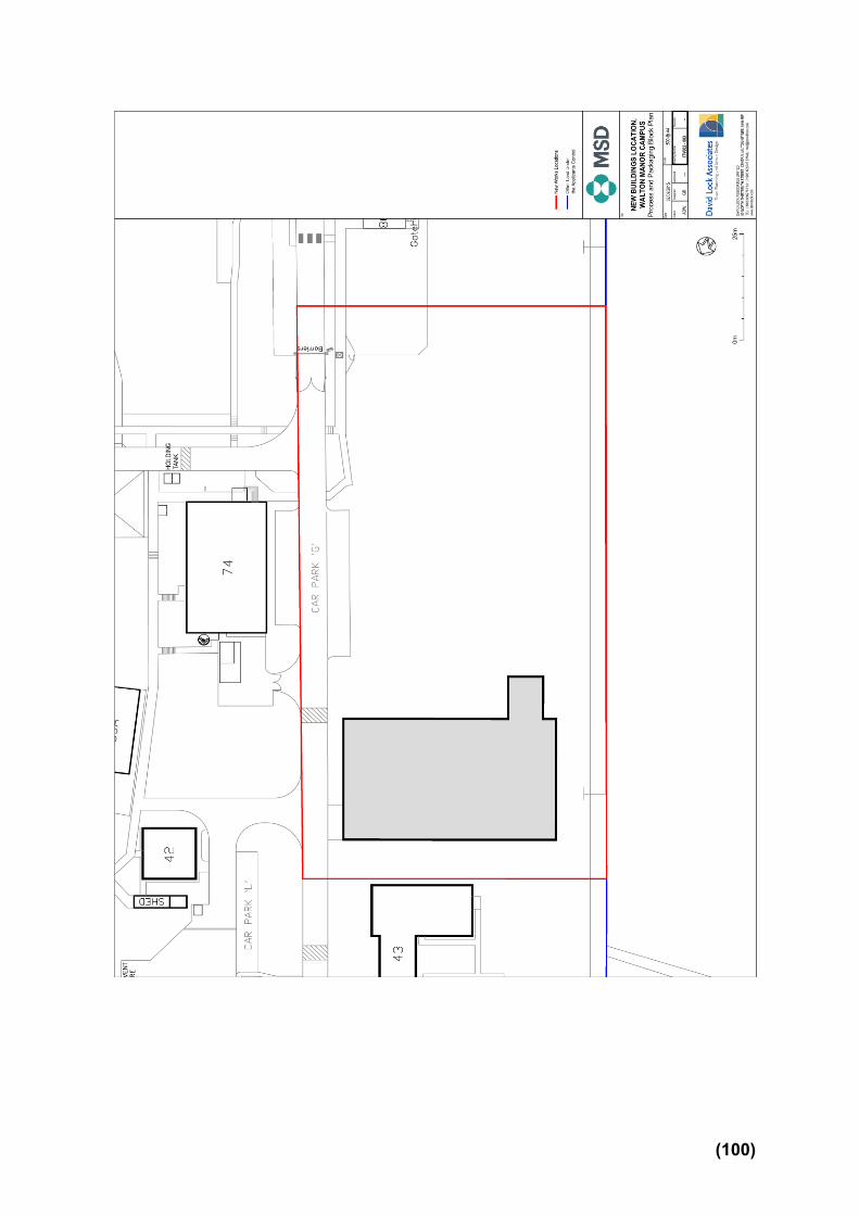
(100)

(101)
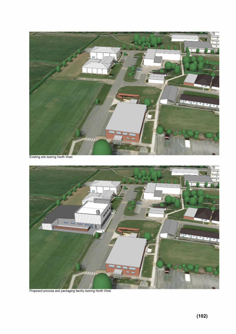
(102)
Appendix to 15/02293/FUL A1.0 RELEVANT PLANNING HISTORY
(A brief outline of previous planning decisions affecting the site – this may not include every planning application relating to this site, only those that have a bearing on this particular case)
A1.1 09/01598/FUL Erection Of Two Storey Extension To Office Building Permitted 30.10.2009 09/02198/FUL Erection of two storey warehouse with ancillary offices Permitted 08.03.2010 10/02181/FUL The erection of a perimeter security fence and the formation of a new car and cycle park with controlled access barriers, associated ground works, drainage and landscaping with access to spur road off Groveway. Permitted 08.12.2011 11/00295/FUL Erection of a single storey temporary building to be used as an operations store Permitted 11.04.2011 15/00385/FUL New waste water treatment plant, two brine tanks and one glass crusher, each with bunded enclosures and canopies; associated access roads and service yards Permitted 19.06.2015 15/00635/CLUP Certificate of lawfulness for the proposed minor extension replacement plant material and new roof CLUPL 13.05.2015 15/02359/DISCON Details submitted pursuant to discharge of conditions 3 (materials) and 6 (noise) attached to planning permission 15/00385/FUL Pending Consideration
A2.0 ADDITIONAL MATTERS
(Matters which were also considered in producing the Recommendation)
A2.1 N/A
(103)

A3.0 CONSULTATIONS AND REPRESENTATIONS
(Who has been consulted on the application and the responses received. The following are a brief description of the comments made. The full comments can be read via the Council’s web site)
Comments Officer Response
A3.1 Walton Community Council Walton Community Council considered this application on the 7th of October and are supportive of the application subject to the following conditions: 1 - That the proposed development is in keeping with the existing buildings. 2 - That landscaping is put in place in order to screen adequately the development from surrounding residential areas. 3 - That the height of the proposed development is no taller than the tallest building currently on the site. 4 - That an adequate traffic management plan is put in place to reduce the impact of site traffic on Brickhill Street. 5 - That site traffic will not be permitted to enter or exit the site during school drop off and pick up times.
Noted. It is concluded that the proposed development is in keeping with the existing buildings and landscaping proposed will screen much of the development from the surrounding residential area. The height of the proposed development does not exceed that of others on the site. The site has a compound arranged for construction vehicles to be stored away from the public highway so it is anticipated that the impact should be limited. An accompanying Construction Management Plan contains detailed information regarding contractor access routes into the site. This document states that no parking of contractor vehicles will be permitted on Hulwell Gate.
A3.2 Cllr. Ferrans 1. I endorse the comments and requests for conditions made by Walton Community Council 2. I note that the noise assessment indicates that the noise should be no more than background levels, and that the system is a closed system so there should be no odour.
Noted and see Section 6 and relevant attached conditions 2, 3, 4 and 9 and the paragraph response 5.12 above relating to construction vehicle access and storage.
(104)

3. I note that the landscaping has changed from the original plans, and that no bushes or trees are now proposed on top of the small ridge. If something could be planted on top that would obviously increase the visual screening for residents and I would welcome that. 4. I note from information supplied by the applicants separately that they are intending to submit a further application which would include opening up access from the H9. I request a condition that, if and when that access opens for construction traffic, construction traffic for this part of the site should enter and leave by the H9 exit from then on. 5. I request a condition that a. all construction and contractors vehicles should park on site throughout the development, and not in the roads around and b. that all materials or equipment should be stored on site and not on the roads around. I understand that this is the intention, but I request the condition to clarify the position in case enforcement is needed as we already have one lot of construction traffic sharing Hulwell Gate with the residents! 6. I request that the additional waiting area for HGV traffic at the entrance from Hulwell Gate be completed as soon as possible, to reduce the disruption caused by the arrival of construction vehicles.
A3.3 Cllr. McPake Walton Community Council and I also felt that due to the difficult pedestrian access Hulwell Drive that we wanted to ensure that wherever possible, no construction lorries would be entering, or queuing up, during school drop off and collect times. This was a big issue for the residents who
Noted and see Officer Response A3.1
(105)

were at the presentation.
A3.4 Environmental Health Officer I refer to the supporting noise impact assessment of Hann Tucker Associates dated 10th September 2015. Based on the findings of the assessment I would recommend the following conditions be applied to any consent:-
1. The new building to operate during the hours of 08:30 to 18:00 Monday to Friday
Noted and see Section 6 condition 5.
A3.5 2. Noise generated by the fixed plant associated with the development (e.g., chillers, AHU’s, air compressors and boilers) shall not exceed a rating level of 5dB below the prevailing background level as assessed at the boundary of the nearest noise sensitive boundary.
Noted and see Section 6 condition 6.
A3.6 Senior Planning Officer – Strategic Flood Management Additional information has been requested regarding surface water drainage and flood prevention. This has been submitted and any subsequent comments and/or conditions will be distributed via the late papers prior to the Development Control Committee.
Noted.
A3.7 Landscape Architect Revised plans were submitted showing more detailed landscaping plans following a site meeting. These revisions provide a more extensive schedule of planting. Comments
(106)

are as follows:
A3.8 Dialogue has helped to explain the landscape design strategy for the site as well as what is expected as part of the landscape proposals for any approved planning application.
A3.9 Revised landscape proposals shown on Plans: D-900-rev.A (09.11.15) and D-910-Rev.A (09.11.15) now include the following: Changes to the tree planting (and removal of the bund) along the south-east side will help over time to screen adequately the development from the residential area opposite and address loss of visual amenity. More variety is shown in the planting proposed: new trees are a mix including native species, and there is more variety in the wetland tolerant planting to the soakaway along the gabion wall (see comments below).
A3.10 The landscape plan should be re-submitted (under condition if necessary), to include the following details: Planting located beside the gabion wall includes more variety, however adjust the 140 Carex comans (New Zealand hair sedge) to include some native grasses for biodiversity. The loss of grassland in Areas A, B and C (land south of building 43) will remove foraging habitat for a range of birds including amber listed birds of conservation concern, therefore a buffer of at least 5m of grassland should be retained between the construction footprint (including any stored materials) and the hawthorn hedgerow
Noted and see Section 6 Condition 8
(107)

so that this resource remains available to birds. This requirement is part of the landscape principles and should be marked on the landscape plan.
A3.11 A specification of how the native wildflower meadow mix and species rich grassland will be created including details of the mix should be submitted. This will need to be appropriately maintained to ensure its sustainability; therefore a simple management plan is required to be submitted. The planting plan should also include the information from the tree survey, root protection areas and any trees/vegetation proposed for removal shown accurately overlaid in a contrasting colour or hatch (this is a standard requirement) along with the development proposals for the process and packaging facility, associated works including car parking.
A3.12 The Hawthorn hedge is either a double or triple staggered row (different between the plan/details sheets) a double row should be sufficient but I would recommend it is set back from the fence to aid maintenance of the hedge and the fence and to keep the prickly hedge away from the adjacent path. Dialogue has taken place regarding tree planting along the west boundary with appropriate measures included to protect drainage with the use of root barriers.
A3.13 There is an Oak tree south of the existing car park ‘A’ in area G (proposed to be extended); trees in and adjacent to Area A (proposed processing and packaging buildings and plant), area F (proposed parking); trees adjacent to Area B (proposed construction compound), area D (proposed site for plant) and West of area E (construction site offices).
(108)

A3.14 The proposals will have an impact on amenity and trees
on/adjacent the application site and a tree survey plan and schedule has been submitted showing the extent of the root protection areas. This should be overlaid on the landscape plan along with the development proposals for the process and packaging facility, associated works including car parking. In addition details of the tree protection fencing along the root protection area margin adjacent construction works should be shown in accordance with BS 5837:2012.
A3.15 Layout and levels of the external works should be adjusted as necessary to accommodate the root protection areas without root damage. As trees are proposed for removal to make way for the development the Council’s Arboricultural Officer should be consulted on this application and the findings of the tree survey report, preferably prior to determination as tree related conditions may be recommended.
A3.16 Countryside Officer Commented that the revised information as set out in the Landscape plans D-900 revision A, regarding tree planting (species and locations) and Hawthorn hedge is acceptable. Any additional conditions will be added to the Late Papers.
Noted.
A3.17 Sustainability Officer I confirm that the proposal addresses the requirements of policy D4.
Noted and Section 5.15 and 5.16
(109)

A3.18 Highway Engineer I have no highways objection to the proposed development. My comments below are based the Transport Assessment, Design and Access Statement and the site layout plan GB0910207-48-DR-0104 plus other plans accompanying this planning application. Parking is acceptable, since a recent site visit confirmed the car park was not at full capacity. 12 cycle parking spaces to be provided (maximum), the applicant has provided 8 cycle parking spaces – acceptable in this instance.
Noted and see Section 6 and Conditions 2, 3, 4, 5 and 9
A3.19 Local Residents The occupiers of the 305 properties were notified of the application in the following streets: Holland Way Harley Drive Norden Mead Brailsford Way Abells Close Tamworth Stubb Cinnamon Grove Cloudberry Walton Road
A3.20 A total of six public representations were received from the following properties relating to this application;
- 23 Harley Drive - 26 Harley Drive - 43 Norden Mead - 20 Cinnamon Grove - 20 Abells Close
(110)

- 18 Abells Close The issues raised are as follows:
- Query about the length of time it is taking to complete roads on the new Walton development.
Noted however this application has not a relevant material consideration to this proposal.
- Impact from increased noise. See Section 6 and Conditions 5 and 6. - Effect of construction traffic. Noted and see paragraphs 5.9 to 5.12 and Section 6 and
conditions 2, 3, 4 and 9 - Impact from the Water Treatment Plant. Noted however this application has been determined
previously. - Visual impact of the development. Noted and see paragraphs 5.1 to 5.5 - Impact upon wildlife. Noted and see Section 6 and condition 8
(111)

ITEM 7
DEVELOPMENT CONTROL COMMITTEE
3 DECEMBER 2015 PINEHAM DRAFT DEVELOPMENT BRIEF Contact: David Blandamer, Urban Designer
(01908 254836, e-mail: [email protected]) 1.0 INTRODUCTION 1.1 Land at Pineham is one of the sites that transferred from the Homes and Communities Agency (HCA) to the Milton Keynes Development Partnership (MKDP). MKDP is required to initiate the preparation of a Development Brief prior to marketing or disposing of any of its larger sites. 1.2 The Council has adopted a protocol for the preparation of development briefs, which sets out a process for stakeholder engagement. The protocol includes the Development Control Committee as a consultee at the formal consultation stage. 1.3 The formal consultation period for this Development Brief runs from the 23 November to 18 January.
1.4 The aim of this report is to summarise the key content contained within the draft Brief. 2.0 AIM / PURPOSE OF DEVELOPMENT BRIEF 2.1 The aim of the Development Brief is to provide clear planning and design guidance for this key development site, so that selected developer/s have a degree of clarity and confidence in preparing planning applications regarding local stakeholder expectations for the site.
2.2 The development brief will also be used to help determine planning applications.
3.0 SCOPE OF BRIEF 3.1 The Development Brief has been informed by the site context and reflects best practice, MKC Corporate Aims as well as the aspirations of the landowner (Milton Keynes Development Partnership) and other local stakeholders.
3.2 The Brief focusses on what is permissible within the existing policy context and provides strategic guidance that is important to any eventual detailed planning application. It is not intended to stifle the creativity of developers but rather provide clarity on what the key elements of any schemes should be. 4.0 CONTENT OF BRIEF Planning Policy 4.1 The site is identified in the Local Plan as part of the Eastern Expansion
(112)

Area (Policy EA3). The majority of the site is allocated for mixed uses, which
includes B1/B2/B8 employment uses. The area of the site alongside the
Broughton Brook is part of a linear park (policy S12).
Site Context Topography and Landscape 4.3 The land slopes down from the east to the west of the site. There is a 5 metre difference in height between the site’s highest and lowest points. 4.4 The site is screened with planting from the M1 motorway. There is also a strong landscape belt to the south-west of the site along Portway (H5). Flood Risk 4.5 Site primarily lies within flood zone 1. However, the south-east corner of the site lies within flood zone 3, with a small part in flood zone 2. Development within flood zones 2 and 3 should be avoided.
Access
4.6 There is an existing vehicular access to the Cotton Valley Sewage Works from Portway (H5). This is the preferred access point and route into the site for vehicles.
4.7 There is potential to create a pedestrian/cycle access underneath the A509 from the Coachway. This access point is also an option as an alternative vehicular access.
Key Planning and Design Principles Development Proposals
4.7 The site is located adjacent to the Cotton Valley Sewage Works, and
junction 14 of the M1. Given this context, it is considered that a B2/B8
employment development would best fulfil the planning requirements for this
site.
4.8 An area of land adjacent to Broughton Brook should be set aside to create
an extension of the linear park.
Layout
4.9 Layout should ensure that there is a clear distinction between public and private space. Flood Risk Mitigation 4.10 Developers will need to submit a detailed Flood Risk Assessment with any planning application for development of the site.
(113)

4.11 Sustainable drainage will be required to deal with surface water run-off on site. Landmarks and Frontages
4.12 The southern entry to the site where the vehicular access crosses Broughton Brook forms the logical gateway into the site. The massing and detailed design of the buildings adjacent to this entrance needs to be appropriate.
4.13 The key frontage which requires an appropriate design response is that fronting onto the linear park.
Detailed Design Appearance and Sustainable Construction & Energy Efficiency 4.14 There is little in the way of context to inform the detailed design appearance of the buildings. Consequently, there is greater freedom for developers in terms of architectural approach. 4.15 The development will need to meet the sustainability standards set out in policy D4 of the Local Plan. Access and Movement and Parking
4.16 Vehicular access into the site will be taken off Portway (H5). This will require the construction of a road through land outside of the site boundary, which is in the ownership of the Parks Trust.
4.17 Pedestrian/cycle links should be provided from the development into the redway that connects the Coachway and the A5130. A leisure route footpath/cycleway should be provided through the linear park.
4.18 Car and cycle parking will be provided in accordance with the Council’s adopted Parking Standards.
4.19 Car parking should be carefully integrated to ensure that the fronts of buildings are not dominated by large areas of surface car parking.
Public Realm and Landscaping
4.20 The landscape structure should provide a transition between the built development and linear park to the west. 5.0 RECOMMENDATIONS 5.1 That DCC note the contents of the draft Brief and offer any informal comment that they may have on it 5.2 That DCC review the outcome of the consultation prior to consideration by Cabinet ANNEX Pineham Development Brief
(114)

Pineham Development Brief
CONSULTATION DRAFT
www.milton-keynes.gov.uk/udla
Urban Design & Landscape Architecture
November 2015
ANNEX A
(115)

Pineham Development Brief
2
This document has been prepared by Milton Keynes Council’s Urban Design and Landscape Architecture Team. For further information please contact:
David BlandamerUrban Design and Landscape ArchitecturePlanning and Transport GroupMilton Keynes CouncilCivic Offices1 Saxon Gate EastMilton Keynes MK9 3EJ
T +44 (0) 1908 254836F +44 (0) 1908 252329E [email protected]
(116)

Urban Design & Landscape Architecture
3www.milton-keynes.gov.uk/udla
SECTION 1
INTRODUCTION
1.1 Location and Ownership 4
1.2 Purpose of the Development Brief 4
1.3 Structure of Brief 7
SECTION 2
POLICY CONTEXT
2.1 National Planning Policy Framework 8
2.2 Milton Keynes Local Plan 8
2.3 Core Strategy 9
2.4 SPG/SPDs 9
2.5 Corporate Plan 9
2.6 Planning Summary 9
SECTION 3
CONTEXTUAL ANALYSIS
3.1 Introduction 10
3.2 Surrounding Area 10
3.3 The Site 12
3.4 Opportunities and Constraints 14
SECTION 4
DEVELOPMENT OPPORTUNITIES
4.1 Development Opportunities 16
SECTION 5
PLANNING & DESIGN PRINCIPLES
5.1 Introduction 18
5.2 Layout 18
5.3 Flood Risk Mitigation 18
5.4 Gateways and Frontages 18
5.5 Detailed Design Appearance 18
5.6 Sustainable Construction and Energy Efficiency 19
5.7 Access and Movement 20
5.8 Parking 20
5.9 Public Realm and Landscaping 20
5.10 General Planning Requirements 21
Contents
(117)

Pineham Development Brief
4
1.1 Location and Ownership
1.1.1 The site extends to approximately 10.9 ha (26.9 acres) and is located within Pineham grid square. The site is strategically located on the A509 adjacent to junction 14 of the M1 (see figure 1).
1.1.2 The site is in the ownership of Milton Keynes Development Partnership* (MKDP).
1.2 Purpose of the Development Brief
1.2.1 The purpose of this document is to provide planning and design guidance for the development of this site in CMK. This will aid the development process, by allowing developers to submit informed proposals that respond to Council (MKC), landowner and other local stakeholder expectations for the site, and respect the requirements of MKC planning policy.
1.2.2 The Brief has been prepared to help deliver the Council’s Corporate Plan Themes and Outcomes as well as the Core Strategy.
1.2.3 The consultation process associated with the preparation of this development brief is intended to give all interested parties full opportunities to set out their aspirations for the site and to identify constraints that need to be accommodated.
SECTION 1: INTRODUCTION
Vision Statement:
“To create a high quality development that helps meet Milton Keynes employment needs, and provide an extension to the Broughton Brook linear park.”
*MKDP is a limited liability partnership set up by Milton Keynes Council to facilitate Milton Keynes’s continued growth and economic success by promoting the development of land assets acquired by the Council from the Homes and Communities Agency, in line with the Council’s Corporate Plan and Economic Development Strategy. MKDP take a commercial and entrepreneurial approach to sell and develop these assets with third party developers and investors, whilst ensuring full community and stakeholder engagement in the preparation of development briefs for the sites.
It is a requirement on the MKDP that an adopted Development Brief must be in place before they commence marketing or developing any of their larger sites. This is intended to enable the Council, following consultation with all interested parties, to set clear expectations for the nature of any future development on the site; but also to assist the MKDP in marketing the site and to give potential bidders/development partners a degree of confidence about the parameters within which they should develop their proposals.
(118)

Urban Design & Landscape Architecture
5www.milton-keynes.gov.uk/udla
BLETCHLEY
WOLVERTON
Greenleys
Kiln Farm
Two Mile Ash
Wymbush
Bradwell
Linford Wood
Stantonbury
Redhouse Park
Blakelands
Tongwell
WillenWillen Park
DownheadPark
Bolbeck Park
Pennyland
NewlandsDowns Barn
Neath Hill
Conniburrow
BradwellCommon
Rooksley
OakridgePark
Bradwell Abbey
LoughtonLodge
Great Holm
LoughtonOldbrook
BleakHall
Hall
Leadenhall
Eaglestone Woughton on-the-green
MonkstonPark
Monkston
Kents Hill
Walton Hall
Woughton Park
Beanhill
Ashland
Redmore
Granby
West Bletchley
DenbighHall
FennyStratford
Far Bletchley
Fishermead
Woolstone
Oakgrove
Middleton
Pineham
Brooklands
Broughton
BroughtonGate
Kingston
Brinklow
WalnutTree
Caldecotte
Mount Farm
DenbighEast
FennyLock
DenbighNorth
Walton Park
Simpson
Crownhill
Grange Farm
Hazeley
Oakhill
Woodhill
Oxley Park
Shenley Church End
Medbourne
Shenley Woods
Shenley Brook End
Emerson Valley
Furzton
Tattenhoe
ShenleyLodge
Knowlhill
Winterhill
The Bowl
Westcroft
Kingsmead
TattenhoePark
FullersSlade
Wolverton Mill
Old Wolverton
Bradville
Heelands
Bancroft
Stonebridge
Blue Bridge
Stacey Bushes
HodgeLea
New Bradwell
Old Stony Stratford
A508A5
Magna Park
Water Eaton
Newton Leys
A421
Pineham
Great Linford
Walton
Tilbrook
Browns Wood
Old FarmPark
WavendonGate
Figure 1: Site Location(119)

Pineham Development Brief
6
Junction 14
A50
9
Portway H5
M1
Coachway
Cotton ValleySewage Works
N
LAND OWNERSHIP PLAN
Site Boundary
MKDP Ownership
Parks Trust Ownership
Figure 2: Land Ownership(120)

Urban Design & Landscape Architecture
7www.milton-keynes.gov.uk/udla
1.2.4 The Development Brief has been prepared to accord with current Planning Policy – a key aim though is to contextualise the policy for the site covered by the Brief. The Brief cannot formally change current policy, however there may be material considerations that suggest variations of current policy may be appropriate. Where this is the case, the Brief will state what they are and what the preferred use and/or variation in policy is. This will be weighed against the current policy when determining a planning application for the site.
1.2.5 Once approved by Milton Keynes Council Cabinet, the guidance contained within the Brief will be a material consideration in helping determine planning applications for the site.
1.3 Structure of Brief
The Brief is divided into five sections:
Section 1 outlines the purpose of the brief, its location and ownership and other administrative information for developers.
Section 2 describes the planning policy context of the site.
Section 3 provides an analysis of the site itself and the surrounding area. A thorough understanding of this will have an important bearing on the key design principles and parameters.
Section 4 outlines what the Brief is seeking to deliver in terms of land uses
Section 5 represents the Key Design and Development Principles, that should inform any development proposals. The accompanying Parameters Plan spatially illustrates the design principles.
(121)

Pineham Development Brief
8
2.2.2 The site is part of the Eastern Expansion Area (EEA). Local Plan Policy EA3 sets out proposals for development of the EEA. The majority of the site is allocated for mixed uses (including B1/B2/B8 employment uses).
2.2.3 The area of the site alongside the Broughton Brook is part of a linear park (policy S12). Land alongside the M1 motorway and Broughton Brook are identified as wildlife corridors in the Local Plan (policy NE1).
2.2.4 Land adjacent to Broughton Brook is identified as an area which is liable to flooding (policy S13).
2.2.5 Policy D4 of the Local Plan sets out the Council’s requirements with regard to sustainable construction.
2.2.6 Policies D1 and D2 are general design policies that apply borough-wide. They look at the impact of development proposals on locality and the design of buildings. Policies T10 and T15 take account of traffic and parking provision respectively, while Policy T11 sets out the Council thresholds regarding whether or not a Transport Assessment/Travel Plan is required.
2.1 National Planning Policy Framework
2.1.1 The National Planning Policy Framework (NPPF) was published in 2012. At the heart of the NPPF is a presumption in favour of sustainable development.
2.1.2 The following sections of the NPPF are of particular relevance to the development of this site:
• Building a strong, competitive economy• Requiring good design
2.1.3 As of 6 April 2015, National Planning Policy has been strengthened to make it clear that the Government’s expectation is that Sustainable Drainage Systems (SuDS) will be provided in new developments. To this effect it is expected that, where planning applications are for major development, the Local Planning Authority must ensure that SuDS are put in place, unless demonstrated to be inappropriate. Milton Keynes Council will therefore determine planning applications in accordance with national standards and local policy, whilst taking into account technical advice provided by the Lead Local Flood Authority.
2.2 Milton Keynes Local Plan
2.2.1 The Milton Keynes Local Plan was adopted in December 2005. The following Local Plan policies have been ‘saved’ by the Secretary of State. They remain in force until superseded by policies in other development plan documents, e.g. Plan:MK*.
SECTION 2: POLICY CONTEXT
*Plan: MK is the new local plan for Milton Keynes. It will eventually replace the Core Strategy and the remaining saved
policies in the Milton Keynes Local Plan. (122)

Urban Design & Landscape Architecture
9www.milton-keynes.gov.uk/udla
2.3 Core Strategy
2.3.1 The Core Strategy was adopted in July 2013 and forms part of the development plan for Milton Keynes.
2.3.2 Relevant Core Strategy policies include:• Policy CSA National Planning Policy Framework
- Presumption in favour of sustainable development
• Policy CS11 A Well Connected Milton Keynes• Policy CS12 Developing Successful
Neighbourhoods• Policy CS13 Ensuring High Quality, New
Designed Places• Policy CS18 Healthier and Safer Communities• Policy CS19 The Historic and Natural
Environment•
2.3.3 Milton Keynes benefits from an innovative and strategic approach to open space provision and surface water management. In line with local policy contained within the Core Strategy, all new developments will be required to ensure that flood management is planned at the largest appropriate scale, providing sustainable and strategic surface water drainage as part of a network of multi-purpose open spaces.
2.4 Supplementary Planning Guidance (SPG)/Documents (SPDs)
2.4.1 The Eastern Expansion Area Development Framework was adopted in October 2005. It identifies the area around M1 junction 14 as a mixed use gateway. It identifies the site as a suitable location for a lorry park.
2.4.2 The following Supplementary Planning Guidance/Documents (SPG/SPDs) should also be considered as material considerations when preparing any planning application for the site:
• Milton Keynes Drainage Strategy – Development and Flood Risk SPG (2004)
• Sustainable Construction SPD(2007)• Parking Standards SPG* (2005; Addendum
2009)• A suite of Supplementary Planning Documents
and Guidance relating to Developer Contributions
2.5 Corporate Plan
2.5.1 This Brief will, in particular, support the Themes of “Working in MK” and “Cleaner, Greener, Safer, Healthier MK”.
2.6 Planning Summary
2.6.1 Planning policy supports employment development, together with an extension to the Broughton Brook linear park.
*A revised SPD is under preparation, with public consultation planned through to early October and likely adoption in
December 2015. The new SPD will be relevant to future planning applications on the site. (123)

Pineham Development Brief
10
SECTION 3: CONTEXTUAL ANALYSIS
3.1 Introduction
3.1.1 It is important to understand the existing site and surrounding area and their features, as this informs the layout and design principles for any development of the site. Figures 3 and 4 provide an analysis of the site and its context.
3.2 Surrounding Area
Land Uses
3.2.1 Immediately to the west and south of the site is the Broughton Brook Linear Park. Cotton Valley Sewage Works lies 100m further to the west.
3.2.2 To the north and north-east of the site is the M1 motorway, and junction 14. To the east of the site lies the Coachway coach station and park and ride facility.
Public Transport Access
3.2.3 The nearest bus stops are on the A509 and at the Coachway (see figure 2). The Coachway provides frequent links to London and the north and a frequent bus service to CMK and the railway station.
Cycle/Pedestrian Access
3.2.4 There is an existing redway which runs along from the A5130 to the Coachway along the edge of Broughton Brook. This provides pedestrian/cycle access to the site from Broughton Gate Broughton, and Brooklands.
3.2.5 Pedestrian/cycle access from the north (Willen) and the west is poor.
Coachway Redway along edge of Broughton Brook
(124)

Urban Design & Landscape Architecture
11www.milton-keynes.gov.uk/udla
M1
Portway (H9)
A509
Child
s Way
(H6)
Tongwell Street (V11)
Newport Road
Willen Lake
400m
800m
N
A509
HOUSING
EMPLOYMENT
EDUCATION
SEWAGE WORKS
LINEAR PARK
COACHWAY
HOTEL
BUS STOP
REDWAY
SITE BOUNDARY
Figure 3: Surrounding Area
(125)

Pineham Development Brief
12
3.3 The Site
Topography and Landscape
3.3.1 The land slopes down from the east to the west of the site. There is a 5 metre difference in height between the site’s highest and lowest points.
3.3.2 The site is screened with planting from the M1
motorway. There is also a strong landscape belt to the south-west of the site along Portway (H5).
Flood Risk
3.3.3 The site primarily lies within flood zone 1. However, the south-east corner of the site is within flood zone 3, with a small part in flood zone 2. Development within flood zones 2 and 3 should be avoided.
Access
3.3.4 There is an existing vehicular access to the Cotton Valley Sewage Works from Portway (H5). This is the preferred access point and route into the site for vehicles.
3.3.5 There is potential to create a pedestrian/cycle access underneath the A509 from the Coachway. This would link into the existing redway network. This access point is also an option for gaining vehicular access to the site.
View of the site looking north
Existing tree planting within site.
Existing vehicular access to sewage works.
(126)

Urban Design & Landscape Architecture
13www.milton-keynes.gov.uk/udla
BROUGHTON BROOK
PORTWAY H5
M1
JUNCTION 14
COACHWAY
NORTHFIELD
COTTON VALLEYSEWAGE WORKS
63m
62m
61m
60m
59m
58m
58m
SITE ANALYSIS PLAN
Site Boundary
Linear Park
Existing Vehicular Access toSewage Works
Existing Tree Planting
Flood Risk Zone 2
Flood Risk Zone 3
Contour
Existing Redway
Potential Pedestrian/Cycle/Vehicular Access
N
Figure 4: Site Analysis (127)

Pineham Development Brief
14
3.4 Opportunities and Constraints
3.4.1 The preceding sections of the development brief provide an appraisal of the site’s existing character and context.
Opportunities
• Site is well located in terms of national road network.
• Site is accessible by public transport and car.• Provide extension to linear park, incorporating
public access, biodiversity enhancement and flood mitigation.
• Potential to connect to existing redway, which serves Broughton, Broughton Gate and Brooklands.
• Site is adjacent to Coachway park and ride and coach station.
Constraints
• Impact of development on biodiversity will need to be mitigated.
• Part of the site lies within flood risk zones 2 and 3, where development should be avoided.
• Flood mitigation measures required within part of the site.
• Existing pedestrian and cycle access to the site from the north and west is poor.
View of elevated A509 looking south from within site
Cotton Valley Sewage Works
3.4.2 The opportunities and constraints have served to underpin the rationale behind the approach and principles of this Brief and the Parameters Plan, outlined in section 5.
(128)

Urban Design & Landscape Architecture
15www.milton-keynes.gov.uk/udla
(129)

Pineham Development Brief
16
SECTION 4: DEVELOPMENT OPPORTUNITIES
4.1 Development Opportunities
4.1.1 The planning policy context as outlined
in Section 2 highlights that employment development and extension of the Broughton Brook linear park are appropriate uses for this site.
Employment
4.1.2 Given the context of the site, adjacent to Cotton Valley Sewage Works and Junction 14 of the M1, it is considered that a B2/B8 employment development would best fulfil the planning requirements for this site.
Linear Park
4.1.3 An area of land adjacent to Broughton Brook should be set aside to create an extension of the linear park.
4.1.4 Development proposals for the linear park should meet the objectives of:
• protection and enhancement of biodiversity and landscape features
• improvement of public access• flood control• protection and interpretation of archaeological
interest
4.1.5 The completed linear park should be transferred to the Parks Trust on completion, together with the necessary endowment to cover future maintenance costs.
(130)

Urban Design & Landscape Architecture
17www.milton-keynes.gov.uk/udla
M1
Portway (H5)
Newport Road
Junction 14
(131)

Pineham Development Brief
18
SECTION 5: PLANNING & DESIGN PRINCIPLES
5.1 Introduction
5.1.1 This section outlines the principles relevant to the design and development of the site. A Parameters Plan serves to spatially represent the key design principles.
5.1.2 Development proposals should be based on a thorough appraisal of the site’s context.
5.2 Layout
5.2.1 It is essential that there is a clear distinction between public and private space so that all publicly accessible parts of the development are fronted by animated frontages and private areas (such as service yards) are inaccessible to the public.
5.3 Flood Risk Mitigation
5.3.1 Developers will need to submit a detailed Flood Risk Assessment (FRA) with any planning application for development of the site.
5.3.2 Sustainable drainage will be required to deal with surface water run-off on site. Measures that could be incorporated include green/brown roofs, rainwater harvesting systems, permeable pavements, and filter strips and swales.
5.3.3 When making planning applications it is essential that, to get the best results, the integration of water and SuDS options are considered early in the site evaluation and planning process, not just at the detailed design stage. Full consideration of SuDS at the pre-application and outline stage is important to
ensuring surface water management is fully integrated into the development, leading to an effective drainage design, providing multiple benefits and with costs considered from the outset. Further guidance and information can be found in the “Milton Keynes Council Surface Water Drainage; Local Guidance for Planning Applications”, which is available on the Council’s website.
5.4 Gateways and Frontages
Gateways
5.4.1 The logical gateway into the site is at the southern entry where the vehicular access crosses Broughton Brook. This is where the site will be most visible and the massing of development and detailed design of the buildings adjacent to this entrance needs to be appropriate.
Frontages
5.4.2 The key frontage which requires an appropriate design response is that fronting onto the linear park.
5.5 Detailed Design Appearance
5.5.1 There is little in the way of context to inform the detailed design appearance of the buildings. Consequently, there is greater freedom for developers in terms of the architectural approach, as there are no clear contextual design cues that need to be considered.
(132)

Urban Design & Landscape Architecture
19www.milton-keynes.gov.uk/udla
Junction 14
A50
9
Portway H5
M1
Coachway
Cotton ValleySewage Works
NPARAMETERS PLAN
Site Boundary
Developable Area
Linear Park
Preferred Vehicular Access to Site
Alternative Vehicular Access to Site
Tree Belt to be Retained
Key Frontage
Gateway
Proposed Pedestrian/Cycle Access to Site
Existing Redway
Existing Leisure Route
Proposed Leisure Route
Figure 5: Parameters Plan (133)

Pineham Development Brief
20
5.6 Sustainable Construction and Energy Efficiency
5.6.1 The Council’s Local Plan Policy D4 and its supplementary Sustainable Construction SPD sets sustainability standards that will have to be considered as part of the overall design process.
5.6.2 To satisfy policy D4, developers will either need to produce a sustainability statement showing how the requirements of the relevant checklist in the SPD will be satisfied, or carry out a BREEAM assessment demonstrating how an excellent standard will be achieved.
5.7 Access and Movement
5.7.1 Vehicular access into the site will be taken off Portway (H5). This will require the construction of a road through land outside of the site boundary, which is in the ownership of the Parks Trust.
5.7.2 Pedestrian/cycle links should be provided from the development into the redway that connects the Coachway and the A5130. A leisure route footpath/cycle way should be provided through the linear park. This route should connect the Coachway area to the existing redway on Tongwell Street (V11).
5.7.3 Planning applications for proposals must include a Transport Assessment and a Travel Plan, produced in consultation with local transport providers and agreed with the Council. A Transport Assessment identifies what measures will be taken to deal with the anticipated
transport impacts of the scheme and to improve accessibility and safety for all modes of travel, particularly for alternatives to the car such as walking, cycling and public transport. It will also indicate what enhancements, if any, are required to the local cycleway and footpath network.
5.8 Parking
5.8.1 Car and cycle parking must be in accordance with Milton Keynes Council’s Parking Standards.
5.8.2 Car parking should be carefully integrated to ensure that the fronts of buildings are not dominated by large areas of surface car parking. Car parking areas should be broken up with landscape and tree planting.
5.9 Public Realm and Landscaping
5.9.1 The landscape design should help to tie buildings together and create a coherent and unified structure for the site. The landscape structure should provide a transition between the built development and the linear park to the west.
5.9.2 Development proposals should be accompanied by a plan illustrating indicative landscape principles for the site.
(134)

Urban Design & Landscape Architecture
21www.milton-keynes.gov.uk/udla
5.10 General Planning Requirements Archaeology
5.10.1 The site contains a cropmark enclosure of probable late prehistoric to Romano-British date. Excavation on the adjacent sewage works site revealed the remains of a Bronze Age burial mound from which two cremations were recovered, in addition to Iron Age and Romano-British settlement. As such, there is high potential for buried archaeological remains to be revealed and impacted on by future development in this area.
5.10.2 Prior to a planning application being submitted
the area should be subject to an archaeological field evaluation comprising trial trenching to a pattern and density agreed with the Council. This will enable any necessary mitigation (excavation or avoidance of significant archaeology) to be agreed and enforced via a condition on the eventual planning permission.
Nature Conservation
5.10.3 The site encroaches on to land designated in the Local Plan as Wildlife Corridor. The site habitats and adjacent land habitats include rough grassland, scrub, plantation woodland, riverside trees and river. These habitats along with local records, suggest that the site could support the presence of otter, water vole, nesting birds (including Wildlife and Countryside Act 1981 Schedule 1 species), bats, reptiles and amphibians.
5.10.4 Any proposals for development would require an Extended Phase One Habitat Survey. Proposals should also be subject to DEFRA Impact Assessment Biodiversity Calculator methodology to inform avoidance, mitigation and compensation actions that could include biodiversity offsetting.
Safety and Security
5.10.5 The developer must consult with the Crime Prevention Design Advisor at an early stage in the design process: initially, regarding design and layout and subsequently, regarding any additional physical security or community safety requirements.
5.10.6 Most importantly, the layout of the development should avoid the creation of areas of public realm that are ‘leftover’ and not overlooked by any development, as they can become areas of anti-social behaviour. Furthermore, there should be no ambiguous space in terms of ownership.
(135)

www.milton-keynes.gov.uk/udla
Available in audio, large print, braille and other languages
01908 254836
Urban Design & Landscape Architecture Planning and Transport GroupMilton Keynes CouncilCivic Offices1 Saxon Gate EastMilton Keynes MK9 3EJT +44 (0) 1908 252708F +44 (0) 1908 252329E [email protected]
(136)