Embed Size (px)
Citation preview

Delivering independent intelligence for health and wellbeingDelivering independent intelligence for health and wellbeing
NEPHO PH&I Training Day Using GIS to Visualise Data
Part 28th December, 2009
Alison Copeland

Delivering independent intelligence for health and wellbeing
London Underground
http://www.propertyinvesting.net/cgi-script/csNews/image_upload/specialreports_2edb.London%20Tube%20Map.gif

Delivering independent intelligence for health and wellbeing
Google Earth Arial Maps

Delivering independent intelligence for health and wellbeing
Hand Drawn Maps

Delivering independent intelligence for health and wellbeing
What is a GIS for Health?
• Part of the power of a GIS system, is in the ability of spatial analysis to reveal health patterns of which managers were not previously aware.
• Spatial analysis offers an alternative 'picture' to that of a spreadsheet, chart or report summary. A GIS system may assist Health Authorities, PCT's, Trusts and healthcare commissioners, for example, to better understand issues surrounding access to, and the delivery of health services.

Delivering independent intelligence for health and wellbeing
• It can help improve the understanding of the spatial incidence of disease or ill health.
• It can help make better and more informed use of existing data sources and knowledge.
• A wide range of analysis may be carried out using a GIS approach. Typical areas in which a GIS can be of benefit include the point mapping of patients, aggregated analyses within different geographical areas, and the modelling of potential service delivery options.
What is a GIS for Health?

Delivering independent intelligence for health and wellbeing
John Snow (1813-1858)

Delivering independent intelligence for health and wellbeing
Marks Choleradeaths
Fragment of John Snow’s Map from1854 Cholera Epidemic
Pump

Delivering independent intelligence for health and wellbeing
A GIS may be defined in a numberof ways
• A system for storing, checking, manipulating, analysing and displaying data which are spatially referenced
• A GIS is an information system where the data has a geographical dimension (you could ignore the G, hence an IS)
• A Management Information System (MIS) which enables map displays of information
• ‘Spatial analysis’ systems concerned with quantitative procedures applied to locational problems

Delivering independent intelligence for health and wellbeing
A GIS may be defined in a numberof ways
• An integrated system distinguished by high levels of mapping capability and spatial analysis
• Data storage, input, retrieval, mapping and spatial analysis … to support the decision making activities of an organisation (A GIS integrates data from a variety of sources and presents information to decision makers). A GIS may become a spatial decision support system (SDSS).

Delivering independent intelligence for health and wellbeing
Applications

Delivering independent intelligence for health and wellbeing

Delivering independent intelligence for health and wellbeing
Effective use of GIS to analyse deprivation hotspots
Directly standardised
rate per 100,000 resident
population
Mortality from Cancer in under 75s, 1996–2000
Spatially smoothed directly standardised rates
Source: Doncaster Public Health Intelligence Unit
© Ordnance Survey 2002
This solution provides evidence based decision making, and helps avoid misdirection of funding.
Addressing health inequalities is a key element in the NHS 10 year plan. GIS is being used in Doncaster to analyse deprivation hotspots and areas with specific health issues. As a result, the village of Stainsforth has been identified as an extremely deprived area within an otherwise affluent ward. This exercise has helped in overcoming ward based statistics, and the visual nature of presenting information using geography has helped in communicating this information.
Paul Fryers, Doncaster East PCT.
Delivering independent intelligence for health and wellbeing
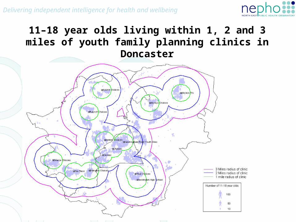
11–18 year olds living within 1, 2 and 3 miles of youth family planning clinics in Doncaster

Delivering independent intelligence for health and wellbeing
Spatial Smoothing:Deaths from Circulatory Disease

Delivering independent intelligence for health and wellbeing
Potential Centres for Dialysis