Embed Size (px)
Citation preview
Vol. 7(9), pp. 180-192, September, 2015
DOI: 10.5897/AJHC2015.0279
Article Number: 58F548754869
ISSN 2141-6672
Copyright © 2015
Author(s) retain the copyright of this article
http://www.academicjournals.org/AJHC
African Journal of History and Culture
Review
Decolonizing place-names: Strategic imperative for preserving indigenous cartography in post-colonial
Africa
Nna O. Uluocha
Department of Geography, University of Lagos, Lagos, Nigeria.
Received 26 June, 2015; Accepted 8 August, 2015
Indigenous cartography existed in various forms in pre-colonial Africa. Unfortunately, the indigenous cartographic heritage of the continent suffered a major setback during the period of imperialism and colonialism. A foremost threat to the traditional cartographies of the African people has been the colonization and deformation of original local geographical names. As an enduring legacy, toponyms are revered by the people for their cartographic, cultural, ethnographic, social, historical, linguistic, economic, political, spiritual, intellectual, scientific and geographical significance. The distortion of the toponyms is a serious threat to the indigenous cartographic heritage and cultural identity of the people. This paper, therefore, x-rays the importance and indigenous cartographic role of African toponyms. The processes of place-name deformation in Africa and the cartographic implications of such deformation are discussed. The paper equally identifies place name decolonization, which is currently going on in some African counties, as an essential strategy for reinstating, preserving and promoting the indigenous cartographies of Africa. Some probable challenges to the decolonization process are also identified. The paper charts the way forward by outlining a number of steps that could be taken to restore the continent’s distorted place-names to their original form, for the preservation of indigenous cartography in post-colonial Africa. Key words: Indigenous cartography, toponym, Africa, place-name distortion, decolonization.
INTRODUCTION
A good name is rather to be chosen than great riches … A good name is better than precious ointment … (Proverbs 22:1 and Ecclesiastes 7:1 – The Holy Bible) Pre-colonial Africa had a rich indigenous cartographic culture. Although map making as we know it today was
not so common, the people of Africa, nonetheless, displayed their cartographic dexterity and geographical knowledge mostly through oral cartography and performance cartography. One potent means by which they effectively encoded and communicated cartographic and geographic information was by the use of toponyms
E-mail: [email protected], [email protected]
Author agree that this article remain permanently open access under the terms of the Creative Commons
Attribution License 4.0 International License
(names of places and other geographical features). Thus in vintage African societies place-names were not just chosen arbitrarily; they were carefully chosen to convey specific and useful meanings to the people. This explains why Africans still cherish and attach much significance to local toponyms. Toponyms are an integral component of the cultural identity of a people.
Over a considerable length of time, a good number of African geographical names were deformed. Some were replaced with alien names, while some others became victims of a wave of Romanization and linguistic mutilation perpetrated by some extraneous forces and characterized by orthographical and pronunciation deformations. In particular, the balkanization and eventual colonization of Africa seriously affected local geographical names (Roden, 1974; Okpala-Okaka, 1995; Mbenzi, 2009; Snodia et al., 2014), as well as the indigenous cartographic traditions of the people. By colonizing African indigenous toponyms they were consequently stripped of their original linguistic meanings and value, as well as their cartographic, historical, cultural and scientific significance and functions.
The large-scale deformation or corruption of local African place-names by extraneous forces, especially during the eras of voyage/exploration and colonization, has been widely acknowledged and reported in literature. Thus far, however, little or no effort has been spared to x-ray the indigenous cartographic role of African toponyms, the cartographic implications of the deformation of indigenous African place-names, and hence, the cartographic imperativeness of decolonizing the names. These are, therefore, the intellectual lacunas this research endeavour set out to address.
Generally, this paper is a modest attempt to lend a scholarly voice to the increasing global call for due recognition and preservation of indigenous cartographic heritage. Basically, the paper argues that place-name decolonization is a most potent strategy for restoring and preserving indigenous cartographies in post-colonial Africa. The discussion on place-name decolonization as presented in this paper is an unpretentious contribution to the broader contemporary decolonization or post-colonial discourse on the African continent (Yai 1984; Pissarra 2009; Jimoh (URL)). The discussions presented in this paper are mostly hinged on four premises namely, (i) African indigenous place-names have been significantly distorted, especially during the colonial era; (ii) African local toponyms bear and convey indigenous cartography of the people; (iii) the distortion or „colonization‟ of African indigenous toponyms is tantamount to deformation or erosion of a significant part of the indigenous cartography of various African traditional societies; and (iv) the decolonization and restoration of deformed indigenous African toponyms will invariably result in the restoration, preservation and promotion of the rich indigenous cartographic legacy of Africa and Africans.
In particular, the paper gives a general overview of the
Uluocha 181 importance of toponyms. With some examples, the paper equally draws attention to the processes leading up to the ruination of African toponyms; it also stresses the indigenous cartographic implications of such ruination. Efforts by various African countries at restoring their indigenous place-names are also briefly discussed citing some examples. Importantly, the paper highlights the need for the restoration and preservation of Africa‟s indigenous cartographic culture, and underlines place-name decolonization as a strategic imperative for achieving this goal. Some potential challenges to effective toponym decolonization in the continent are examined; suggestions on how to possibly circumvent the challenges and install lasting structures for preserving indigenous cartography are also proffered.
Significance of toponyms Generally, names are of immense significance in African societies. Toponyms fulfill the task of identifying localities thereby distinguishing them from one another (Ormeling, 2007). Although the basic function of names has been that of providing a useful label to things so that they can be differentiated, they however also have sentimental, literary, religious and cultural significance (Snodia et al., 2010). Place-names are required in everyday business. On a daily basis, we use them to describe our surroundings and to tell others where we have been or where we plan to go. Geographical names are used to explain places and events. They are also useful as brand names, as symbols, for educational purposes, for transportation, as a symbol for sovereignty (if the names are in your language, the area should be yours). More so, they serve as cartographic labels that can be used for orientation, navigation, recreation, and reference points. Besides, place-names link us to the landscape, and by so doing give useful insight into a people‟s traditional way of life.
Geographical names are in several ways very crucial to the sustenance of national cultural identity as well as socio-economic development. Hardly can one find any human spatial activity that does not involve the use of place-names. Like other types of name, place-names are part of the oral literature of the local people. Linguistically, they aid pronunciation and also serve as important links to some other documents and information.
Geographical names are equally a great repository of knowledge; invaluable geographical, historical, socio-cultural and scientific knowledge is stored in them. Knowledge of the origin of place-names can shed light on the history and settlement of a country. In other words, place-names have the propensity of revealing the identity of those who settled in a place and when they did. The study of toponyms, therefore, can unveil important facts about the past, thereby yielding information concerning the history, religion and civilization of the first occupants
182 Afr. J. Hist. Cult. of the places concerned (Fasi, 1984). For instance, by leaning heavily on oral traditions and an understanding of the meaning and functions of place names, Nast (2005) was able to determine the nature and extent of power and activities of royal concubines in pre-colonial Kano society in Nigeria between the 16th and 20th century. Furthermore, as noted by Lawal (1992, 17), “Place names that are used in the lore of Nigerian society have historical significance. They do remind people of the places passed through during the period of migration. They … signify important historical events. In land disputes, place names have been very useful in finding solutions to entitlement to land and have offered some explanations to the course of migration. Place names could be used as a source of information about the demographic structure of the past.”
A place-name imparts a certain character on a place. Thus, place-names can also provide a glimpse of the lifestyle led by the people. For instance, geographical names can suggest that a people were “settlers rather than ferocious raiders”. In other words, place-names could be used to judge the way of life associated with a people – sedentary or nomadic. Those who led a sedentary life more than those who lived a nomadic life established settlements and gave them enduring names.
Local place-names could act as primordial evidence of the language of a people; and thus help to preserve the language and culture of such people. Ancient place-names can equally give an idea of the political or administrative influence an area once had on some other areas. It was commonly the practice in the days of yore that the subordinate or servile regions would give names to some places in the language of the ruling (feudal) or overseeing state. Similarly, place-names could serve as a reflection of the geographical spread or extent of settlements founded by invading powers, since such settlements bear names in the language of the invaders.
Toponyms are also necessary for other purposes such as trade and commerce, transportation, communication, regional and environmental planning, science and tech-nology, successful conduct of elections and censuses, provision of social amenities and services, tourism, disaster management, search and rescue operations, etc. (SAGNC, 2002). A list of place-names is quite useful to telecommunication outfits and indeed other public and private organizations engaged in location-based or logistics/distributive business ventures and services.
Since the history of mankind began toponyms have always played crucial roles in effective state admini-stration and military expedition. There is a strong link between place-names and environmental/landscape knowledge. Historically, a study of the names of places and topographical features can reveal much about how people viewed and related with the land. In the literary world, novelists and playwrights are often ably aided by geographical names to create the effect of realism in their works.
Indigenous cartography and toponyms
In their Introduction to Volume 2, Book 3 of the History of Cartography, which they edited, David Woodward and Malcolm Lewis declared that “Maps are seen through many different eyes.” As a consequence, therefore, they went further to identify three broad yet overlapping categories of cartography: "cognitive or mental cartography", "performance or ritual cartography", and "material or artifactual cartography". A look at the indigenous cartographic landscape of Africa reveals the fact that the continent has always been involved in all three categories of cartographic endeavour; the emphasis, though, has more often been on cognitive and performance (social) cartography, rather than material cartography. Various indigenous communities both within and outside Africa have their own cartographic traditions, which are frequently stored within songs, stories and rituals; thus they are generally performative and process in nature (Johnson et al., 2006).
Indigenous cartography is a form of knowledge. It is that aspect of indigenous knowledge system (IKS) that deals with the identification of landscape places, features and events, including their form and spatial location, distribution, relationship and pattern. At least within the African context, indigenous cartography is frequently verbalized. The indigenous peoples of Africa largely practiced oral cartography rather than the contemporary hard copy or digital cartography we are so used to. Nonetheless, the deftness with which the indigenous people verbalized their cartographic or geographic knowledge created an incredible and indelible mental map in the minds of recipients of such information.
Pre-colonial Africa had flourishing traditional carto-graphies, the legacies of which still endure till date. In their separate works, Bassett (1998), Maggs (1998), and Uluocha (2010) have tried to draw attention to the various indigenous ways by which Africans mapped their worlds. Although it is hardly acknowledged on maps, academic literature, or some other official documents, the fact, however, remains that indigenous knowledge generally, and indigenous cartographies in particular, played a vital role in the various efforts of imperialists to map their newly acquired African territories. European and Arab explorers and colonial governments in Africa relied heavily on local informants and some other local sources for their acquisition of geospatial information eventually used in producing territorial maps of Africa. In particular, European travelers and explorers in Africa solicited and used both ephemeral and permanent maps constructed by the local residents (Bassett, 1998).
Toponyms are particularly key components of indigenous cartography. Generally, place names are very important in mapmaking, especially the production of topographical, administrative (geopolitical), physical, township, tourist, geological and other general maps. No map is complete without place-names. Map makers use
toponyms and their lettering for various purposes (Robinson et al., 1995, 406-407). Such functions include encoding the sounds that are the names of the features shown on the map; identifying landscape features and localities and thus distinguish them from one another; indicating the location of points (e.g. cities); showing the hierarchical order of geographical features; etc. Similarly, local place-names are essential components of indigenous cartography. They are used in oral, graphical and performance cartographies. As in the case of the Hawaiians, for instance, indigenous people use place-names as mnemonic symbols to encode their knowledge of the environment; the use of place-names in daily ritual performances like stories, chant, song and dance by the Hawaiians is considered a conscious act of re-emplacing genealogical connections, re-creating cultural landscapes, and re-generating cultural mores (Louis, 2004).
In topographic cartography all toponyms tend to be interpreted as symbols of physiognomic objects presented on topo maps. Physiognomic objects comprise natural and artificial physical objects, such as relief forms, water bodies, forests and other vegetation types, buildings, settlements, roads and so on. Naming a place or a geographical object is a powerful way of individualizing that place or object. Toponyms are also used to identify social and cultural objects. Hence, indigenous place-names equally denote a sense of culture.
Place names are widely recognized as essential in consistently and accurately referring to a place to prevent confusion; they are also commonly regarded as providing the most useful geographical reference system in the world. In the oldest pre-cartographic and pre-geodetic land documentation, toponyms were used as symbols of the place occupied by an object on the Earth‟s surface (Golaski, 2002). Thus, they defined, by description, where state frontiers and estate borders ran, as well as the position of different objects on land. Toponyms that have inherent geographical connotations are, in a sense, linguistic maps.
That toponyms play a very significant role in cartographic representations is indeed an age-long fact that is never in doubt. As noted by Golaski (2002, 4), “Toponyms used as symbols of the place occupied by an object on the Earth‟s surface, were used in the oldest pre-cartographic and pre-geodetic land documentation. They defined, by description, where state frontiers and estate borders ran, as well as the position of different objects on land. In this manner objects were identified many times over down the centuries.” Cartographically, toponyms constitute fixed points of reference on maps; they are therefore, vitally important in the cartographic construction of landscape. The power of place naming in the construction of historical and contemporary geopolitical landscapes has been explored. Their classical work in this area has led Vuolteenaho and Berg (2009, 4) to submit that “In essence, … the mapping of toponyms has formed an ancillary form of knowledge-
Uluocha 183 production in the service of a wider scientific-geopolitical project of knowing the world as accurately as possible as part of the process of controlling its spaces.”
Indigenous African place-names have an enormous treasure of geographical information and knowledge inherent in them. In a typical traditional African society, place-names are used to succinctly describe geographical phenomena. Roden (1974)‟s account of the use of place-names to identify various geographical conditions and features in Uganda typifies what is obtainable in a classic African society. As observed by Roden (1974, 82):
“A very prominent group of Ugandan place-names are those which describe or imply the physical characteristics of an area. Relief, climate, soils, hydrology, flora and fauna all feature in names throughout the country. Often the description is in terms of the suitability of an area for human activity – the fertility of the soil, the presence of water, reliability of rainfall, suitability for a particular crop, a river or swamp which endangers life, the occurrence of a tree or grass species of value for house building, tool making and handicrafts, and the presence of clay for pottery are all frequent examples. Other names suggest the type of land use, describing a prominent crop, the presence of grazing land and so on.”
Geographical names are present in every map; although their role is largely complementary in nature. Toponyms play an even greater role in indigenous or performance cartography. Toponyms are vitally important elements of the verbal maps (or oral cartography) of the indigenous peoples of Africa. In Africa places are named descriptively either to give an idea of the nature of the topography or geographical setting, inform about the location, topology, hierarchy, orientation and spatial relationship of landscape features, or to indicate ownership, commemorate a community hero or notable event. In other words, embedded in every indigenous African toponym is also an indigenous cartographic sense. Simply put, place naming is a form of indigenous cartography, at least within the African context. The local people used toponyms to give verbal graphic descriptions and illustrations of the location of local resources as well as the history, geography and ethnic settlement patterns of their place.
Moreover, place-names are used to literally communicate vital spatio-temporal information on identity or description of geographical phenomena, location, direction/orientation (both spatial and temporal), relationships, forms and shapes, patterns, magnitude (size), hierarchy, numerical values, proximity, apparent height or depth, temporal dimensions, and so on.
Given the central role toponyms play in indigenous cartography, therefore, any significant distortion of the indigenous geographical names is tantamount to a mutilation of the unique indigenous cartography of the affected local people. The destruction or deformation of local place-names is a spatial and cartographic injustice; it amounts to tampering with the geographic knowledge
184 Afr. J. Hist. Cult. and cartographic heritage of the indigenous people. When indigenous place-names are deformed, the namescape component, which is a key element of the oral cartography of native people, is tainted. Arguably, when a local toponym is corrupted, deformed or replaced, it loses its meaning partially or totally, and its cartographic and other functions will be significantly affected. ALTERATION OF AFRICAN LOCAL PLACE-NAMES Early European and Arab explorers and settlers in Africa relied so much on maps, local histories, and interviews with local residents to get their linguistic information on local place-names. In the process, some of the indigenous place-names were significantly transformed – some were truncated while some were replaced outright. For example, writing specifically on hydronyms, Hudson (2013, 85) notes:
“When David Livingstone named Victoria Falls after his queen, he was well aware that the mighty cataract on the Zambezi already had a name. The Scottish explorer recorded in his journal that the African people who lived in the region called the waterfall Mosi-oa-Tunya, translated as „The Smoke That Thunders‟. No doubt, the falls had long been known by a name, the surrounding area having been occupied by humans since the Palaeolithic era. Like Livingstone, some explorers recorded local names for waterfalls seen on their travels. Sometimes these names were retained, …; more often they were replaced by European names.”
Obviously, some of the currently existing toponyms in Africa are but foreign misnomers for some indigenous African monikers. Even a cursory look at any admini-strative or physical map of Africa will reveal the fact that several of the place names of African countries, cities and physical features “are of non-African origin” (Yai, 1984, 40). For example, country names such as Nigeria, Central African Republic, South Africa, Sierra Leone, Liberia, Cameroon, Swaziland, etc., as well as city names like Lagos, Freetown, Monrovia, Libreville, etc., and names of physical features such as Victoria.
Lake, River Nile, Mount Kilimanjaro, etc., are all of foreign origin. Unfortunately, most of the foreign toponyms that places and features bear in Africa today are locally and linguistically incomprehensible – the local people simply do not know or understand what those non-indigenous place names mean.
Certain processes were involved in the deformation of the indigenous namescape of African communities. Löfström and Pansini (2011) identify essentially two situations that have often led to a large process of naming: colonization and revolution. In both cases there is usually a new power which needs to establish itself; and giving new names to places is one of the practices by which this new power asserts itself and gives visibility to its establishment.
Undoubtedly, colonialism played a very major role in the deformation of African indigenous place-names. According to Batoma (2006, 3), “Some of the names bestowed by European or Arab colonialists on African people and places tell more about the colonial mind of the namers and of their intentions than about the named African reality. This has been the case for example with European eponyms given to African places. Famous examples of toponyms are country names such as Ivory Coast [now Cote D‟Ivoire], Rhodesia [now Zimbabwe], Sierra Leone and Upper Volta [now Burkina Faso], and city names such as Brazzaville, Dar-es-Salaam, Freetown and Leopoldville [now Kinshasa]. Another less brutal but more insidious means of colonial acculturation was the imposition of foreign spelling or orthography on African names.”
The cultural and language contact between Africans on one hand and the Arabs and Europeans on the other, is reflected in the place names of the African countries. Raper (2005) particularly identifies some of the effects the contact between Southern Africans and Portuguese, Dutch, English, French, and German had on South Africa‟s toponyms, such as: (i) older names were altered, adapted, translated (wholly or in part), and supplanted; (ii) hybrid forms, with part of the name in one language and another part in a different language, came into being; (iii) many names were spelt in different ways by different people and at different times; (iv) some individual places came to bear more than one name, bestowed by different language groups. The variety of forms and spellings resulted in a measure of confusion and some problems in communication, with a concomitant wastage of time, expense and energy.
The North African region was equally not spared by the wave of local toponym deformation during the colonial epoch. Weghlis (1998) alludes to the corruption of a large number of Amazigh place-names by the French and the Spaniards during their colonization of Algeria and Morocco. Furthermore, and rather curiously, “In the post-independence era, … the governments of these [North African] countries … gradually have been replacing Amazigh names by Arabic ones. They also have altered the spelling and the phonetics of some Amazigh names to conform to the Arabic language. In some other cases, the alterations went so far as to derive Arabic names from Amazigh ones, resulting in names with absurd meanings. Perhaps a formidable example of this type of alteration is the case of "Amechras," name of a Kabyle village, which was deformed to give "Mecht Arras," meaning "head-comb" in Arabic” (Weghlis, 1998, 12).
The distortion or replacement of indigenous place-names in Africa was not only done through the instrumentality of imperial political administration but also through missionary activity by both the Muslim and Christian missionaries. In Northern Africa many local names were replaced with Arabic ones (Weghlis, 1998). Similarly, in some districts in Uganda (Roden, 1974) and
several other places across Africa proselytized by White Christian Fathers, numerous existing place-names were simply replaced by more “Christian” alternatives.
Arguably, the Romanization of indigenous African toponyms equally played a major role in the deformation of some of the names. The term „Romanization‟ as used in this paper, is a method of transliteration or transcribing of names (personal names and/or place-names) in the characters of the Roman alphabet. In simple terms, Romanization is a phonetic spelling system that involves writing names (or some other words) the way they sounded (to the hearer), using the Roman alphabet. Unfortunately, Romanization of local place-names by non-indigenes hardly conforms with or observes the orthography and diacritic symbols as would normally be used by the indigenes to alphabetize the names. As a result, the names are deformed or corrupted.
Through the process of Romanization, several African colonial place-names were transferred from native African languages to certain European languages by phonetically rendering the place-name in their own language, creating at best a close approximation. The African colonizers simply wrote down African toponyms using their own (the colonizers‟ language) spelling for the sounds. For instance, the British colonizers anglicized names of towns and cities in colonies by penning down local African place-names using English language spelling for the sounds; and this was how, for instance, Ọka (in Anambra State, Nigeria) became Awka, and Kadoma (in Zimbabwe) became Gatooma. Similarly, Mputu (Mozambique) was corrupted to Maputo (Portuguese); Coomasie (Ghana) was anglicized to Kumasi, same for Muqdisho (Somali) which was changed to Mogadishu (English), while Siteki (Swaziland) was deformed to become Stegi. In fact, the name Swaziland itself was a colonial rendition of the original name Bakamswati (which means „the people of Mswati‟).
Toponymical deformation has often been a characteristic feature of imperialism. Cornevin (1984, 77) alludes to the fact that “The colonial powers gave names to places on maps and in official gazettes which were not always the same as the indigenous names.” Unscrupulous deformation of indigenous toponyms by the colonial powers seemed to be a naked display of their pseudo psychological sense of superiority over the colonized people. The colonialists believed that their advantageous position conferred on them what J. L. Calvet (cited in Yai 1984) called “the right to give a name”. More so, their aboriginal name changing inclination seemed to have been further bolstered by Winston Churchill‟s one time declaration that “Everybody has a right to pronounce foreign names as he chooses”. The corruption or outright replacement of local names by the invaders was conceivably a reflection of what Pongweni (1983, 87) cited in Snodia et al. (2010, 26) rightly describe as the “linguistic prejudices and cultural chauvinism of the colonizers”.
Uluocha 185
Similarly, the colonizers used the place-name changing process to send a strong political message to the indigenous people, namely that they (the colonizers) were fully in charge. Apparently subscribing to this line of thought Snodia et al. (2010, 23) while reflecting on the situation in colonial Zimbabwe (formerly Southern Rhodesia) note:
“For the [British] settlers, the [English] names were a very effective way of entrenching and perpetuating white hegemony in the country [Southern Rhodesia]. .. This was a clear message that as a defeated people, the locals had lost all freedoms, including the freedom to an identity that the local names represented… The settlers used names for subordinating and assimilating the indigenous people, by undermining the use of their culture bound African names and thereby eroding the African value system, identity and self esteem.”
The alteration of African toponyms during the colonial time followed certain identifiable common processes. For instance, reflecting on the changes in geographical names in some parts of Igbo-speaking South-Eastern Nigeria, Okpala-Okaka (1995) identified three forms of place-names deformation during the era of colonization. These are:
i) Anglicization – this has to do with wrong transcription of local names into English spellings for easier pronunciation, e.g. Nawfia from Nne-Ọfia, Awka instead of Ọka, Nawgu instead of Nọgu, Orifite from Ọra-Ifite. ii) Corruption – this is a deliberate change of a name to a nickname, or dropping of a letter (alphabet) from the spelling of the original name and replacing or not replacing the dropped alphabet with another, for easier pronunciation. Examples include Ozubulu from Ozo-Ubulu, Abagana from Mba-Agana. iii) Truncation (or contraction) – this is the cutting of a single or compound name into two parts and retaining (using) the first part and dropping the rest, for shorter pronunciation. For example, Ibeku from Ibekume- Nwaonyeozo, Utuh from Utuh-Mbadike, Opi from Opinato, Leja from Leja-Ugwoke, Aba from Aba-Ngwa.
Colonial rule in Africa equally meant that certain European language(s) such as English, French, or Portuguese, etc., also became the official language of administration, education and communication in each of the affected countries. This development seriously affected African toponyms and by extension indigenous cartography in Africa. As rightly observed by Ormeling (2007, 121), “It is obvious that maps as part of the language of administrative infrastructure constructed [by the colonizers] will tend to be carried along with this trend [i.e. adoption of a foreign lingua franca], and that toponyms will suffer in this process. This introduction of official national unitary languages in multilingual countries [such as most African countries] poses a severe threat for the survival of many toponyms of minority language areas, as it will also affect existing names.”
186 Afr. J. Hist. Cult.
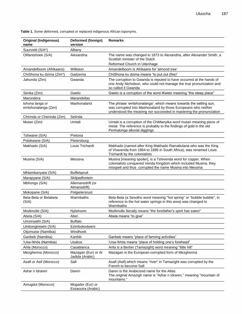
The current versions of several place-names in the African continent are quite alien to the people. Since the names lost their original spelling and pronunciation, they also lost their original meaning and, hence, a vital aspect of their cartographic function. Table 1 contains few examples of indigenous African place-names that were deformed, corrupted, or replaced by foreigners. Efforts at Restoring African Indigenous Toponyms Across Africa the corruption of local toponyms is considered an act of injustice. There is, therefore, a generally felt dire need to correct the past injustices with regard to place names (Mbenzi, 2009, 1). In several post-colonial African countries, efforts have persistently been made to restore some place names to their pre-colonial indigenous names. In reality, there are only a few countries in post-colonial Africa that still retain their colonial names. The place-name restoration attempts in Africa are aimed at recording and promoting the use of indigenous names in lieu of their foreign or corrupted versions. Consequently, naming and renaming of places have continued to feature prominently in several African countries after independence. According to Batoma (2006, 3),
“During the period following the colonial era many leaders of the newly independent African countries started a process [sic] of de-nomination and/or re-nomination destined to restore to Africa its authentic identity. This process consisted of a restitution of original names to African places and people or the bestowing on these social entities of new African names. Although in most cases the name change was the result of the implementation of a top-down decision taken on behalf of the people, there have been some countries such as South Africa where some name changes have occurred as the result of a democratic process.”
In Namibia, the municipal authorities and various communities after independence began renaming places that bore colonial names after the national leaders (Mbenzi, 2009). Similarly, some towns in Zimbabwe which had retained local names but in corrupted form during the colonial era had these corrected to reflect the correct Shona pronunciation and to also restore their historical significance (Snodia et al., 2014). Most of the places named by the Belgians in the Democratic Republic of Congo have been reverted to their original indigenous names (Cornevin, 1984). Similarly, in post-apartheid (i.e. post 1994) South Africa intensive efforts are still being made to reinstate geographical names to their aboriginal forms; this is part of the broad decolonization process initiated in the country (Guyot and Seethal, 2007; Koopman, 2012; Duminy, 2014).
In Nigeria there have been persistent calls from various quarters since independence in 1960 for the country‟s name as well as those of cities, towns, streets, and some
other infrastructure, which are of foreign origins, to be changed. The debate on the renaming of the country took a rather dramatic turn lately when the issue was introduced and strongly canvassed at the country‟s recently concluded three-month National Conference organized by the federal government. Interestingly, of all the avalanche of new indigenous names so far proposed for the country, the one that seems to enjoy the nod of most advocates is “Republic of Songhai” or “United States of Songhai”, after the ancient Songhai Kingdom in West Africa. Municipal authorities in several Nigerian cities have been embarking on the renaming of some streets and other facilities bearing colonial appellations. For instance, in 2010 the authorities of Calabar South Local Council in Cross River State embarked on a street renaming project. Some of the streets in the area bearing foreign names were rechristened after some indigenes as a token of recognition and acknowledgement of their contributions to the development of the area. Justifying why the project was initiated, the Chairman of the Council stated that “the renaming of some of the streets in the area became necessary as some were named after colonial masters and had long lost their meanings while some had no meaning or bearing whatsoever” (www.thewillnigeria.com). Renaming of streets and some other public infrastructure bearing foreign designations is also common in Lagos, the largest city in Nigeria (Adebanwi, 2012).
The indigenous place-name restoration story is virtually the same in every post-colonial country in Africa. Table 2 contains a list of some foreign place-names in various African countries that were either restored to their original (indigenous) versions or replaced by new indigenous names, thus reflecting the widespread attempts made across the continent to restore, preserve, promote and use local toponyms. Cartographic Imperativeness of Decolonizing Indigenous Place-Names Indigenous place name restoration is quite significant from a cartographic perspective. If the indigenous cartography of once colonized territories is to be restored and preserved, then their deformed local toponyms must necessarily be decolonized. In a sense, place-name decolonization is a renaming process that involves returning adulterated native toponyms to their original form. In other words, place-name decolonization is an attempt to eliminate garbled, derogatory or erroneous names and, by so doing, restore the indigenous cartography of the natives. Cartography and toponyms are inseparable.
Cartography – be it cognitive, performance, or material – is a powerful tool for conferring uniqueness, legitimacy and a sense of dignity on any society, and the most potent force by which cartography achieves this feat is
Uluocha 187
Table 1. Some deformed, corrupted or replaced indigenous African toponyms.
Original (Indigenous) name
Deformed (foreign) version
Remarks
Suurveld (S/A*) Albany
Olifantshoek (S/A) Alexandria The name was changed in 1873 to Alexandria, after Alexander Smith, a Scottish minister of the Dutch
Reformed Church in Uitenhage
Amandelboom (Afrikaans) Williston Amandelboom is Afrikaans for 'almond tree'
ChiShona ku dzima (Zim*) Gadzema ChiShona ku dzima means “to put out (fire)”
Jahunda (Zim) Gwanda The corruption to Gwanda is reputed to have occurred at the hands of one Andy Nicholson, who could not manage the true pronunciation and so called it Gwanda
Senka (Zim) Gwelo Gwelo is a corruption of the word iKwelo meaning “the steep place”
Marondera Marandellas
tshona langa or emtshonalanga (Zim)
Mashonaland The phrase „emtshonalanga‟, which means towards the setting sun, was corrupted into Mashonaland by those Europeans who neither understood the meaning nor succeeded in mastering the pronunciation
Chirinda or Cherinda (Zim) Selinda
Mutari (Zim) Umtali Umtali is a corruption of the ChiManyika word mutari meaning piece of metal. The reference is probably to the findings of gold in the old Penhalonga alluvial diggings
Tshwane (S/A) Pretoria
Polokwane (S/A) Pietersburg
Makhado (S/A) Louis Trichardt Makhado (named after King Makhado Ramabulana who was the King of Vhavenda from 1864 to 1895 in South Africa), was renamed Louis Trichardt by the colonialists
Musina (S/A) Messina Musina [meaning spoiler], is a Tshivenda word for copper. When colonialists conquered Venda Kingdom which included Musina, they misspelt and thus corrupted the name Musina into Messina
Mhlambanyatsi (S/A) Buffelspruit
Marapyane (S/A) Skilpadfontein
Mbhongo (S/A) Allemansdrift (or Almansdrift)
Mokopane (S/A) Potgietersrust
Bela-Bela or Belabela (S/A)
Warmbaths Bela-Bela (a Sesotho word meaning "hot spring" or "bubble bubble", in reference to the hot water springs in this area) was changed to Warmbaths
Modimolle (S/A) Nylstroom Modimolle literally means "the forefather's spirit has eaten"
Abela (S/A) Abel Abela means “to give”
Umzinyathi (S/A) Buffalo
Umbongintwini (S/A) Ezimbokodweni
Otjomuise (Namibia) Windhoek
Garibeb (Namibia) Karibib Garibeb means “place of farming activities”
!Usa-!khōs (Namibia) Usakos !Usa-!khōs means “place of holding one‟s forehead”
Anfa (Morocco) Casablanca Anfa is a Berber (Tamazight) word meaning "little hill"
Mezghenna (Morocco) Mazagan (Eur) or Al Jadida (Arabic)
Mazagan is the European-corrupted form of Mezghenna
Asafi or Asif (Morocco) Safi Asafi (Asif),which means "river" in Tamazight was corrupted by the French to become Safi
Adrar n Idraren Daren Daren is the Arabicized name for the Atlas. The original Amazigh name is "Adrar n Idraren," meaning "mountain of mountains."
Amugdul (Morocco) Mogador (Eur) or Essaouira (Arabic)
188 Afr. J. Hist. Cult.
Table 1. Contd.
Fas or Saf or isaffen Fez or Fes (Eur) Isaffen means rivers
Tagourart (Algeria) Gourara Tagourart means "castle"
Louata (Algeria) Laghouat Laghouat derives from "Laguanta," which is a Latin deformation of "Louata."
Asif n Isaffen (Morocco) Oum Rbia (Arabic) Asif n Isaffenmeans "river of rivers"
Sala Sale (French) Sala means “rock”
Tiniri (Algeria) Tenere (French) Tiniri means "desert."
Tin n rif (Canary Island) Tenerife (Spanish) Tin n rif means "that of the rif"
Titawin Tetuan (Spanish) Titawin means "springs" in Tamazight
Tanga (Tunisia) Tinja Tanga means “wave” in Tamazight
Tilmas (Algeria) Tlemcen (French) Tilmas means "water holes"
Taggurt (Algeria) Touggourt Taggurt means "door"
Dahomey Benin Republic
Al-Araish (Morocco) Larache (Spanish)
Ar-Ribat Rabat (French) Ar-Ribat means “the camp”
Talmist (Algeria) Tlemcen (French)
Asif wansifen (Morocco) Oumm Arrabi (Arabic)
Asif wansifen is a Berber name meaning “river of rivers”
Ar-Rommani (Morocco) Camp Marchand (French)
Ar-Romman means “pomegranate tree”
Tiffelt (Morocco) Tiflet (French) Tiffelt is a Berber term for “pepper”
Tittawin (Morocco) Tetuan (Spanish) Tittawin is a Berber name meaning “the springs”
Walili (Morocco) Volubilis Walili means “bay tree” in Berber
Ìlú Ẹ̀bá-Ọ̀dàn (Nigeria) Ibadan Ìlú Ẹ̀bá-Ọ̀dàn means the town at the junction of the savannah and the forest vegetation in Yoruba
Kanaba (Nigeria) Calabar Kanaba in Efik means survival of the fittest, or only the strong survive and live in the land of promise
Àkún mi rę (Nigeria) Akure Àkún mi rę in Yoruba means my string of beads has snapped
Agbadagreme (also Ogbaglee, Gbagleme or Gbagle), Nigeria
Badagry Agbadagreme is a Yoruba term which refers to farm of Agbede, or a farmland near the swamp
Eko (Nigeria) Lagos Eko is a Bini name meaning war or military camp
Ubinu (Nigeria) Benin City Ubinu in Bini means land of inexhaustible resources
Igwe-Ocha (Nigeria) Port Harcourt Igwe-Ocha in Igbo means bright skyline
Ibani or Ubani (Nigeria) Bonny (Portuguese)
place-names. Since toponyms are more or less indispensable elements of cartography, restoring the indigenous toponyms of the once colonized African people equally means restoring their indigenous cartography and unique identity.
When local toponyms are defaced, the indigenous cartography of the affected society is directly inflicted a lasting injury. Hence, restoring indigenous place-names is about healing the injured cartographic culture of the local people. In other words, by decolonizing local toponyms the indigenous cartographic heritage of the people is restored and preserved.
Returning to original place-names goes a long way to preserving cartographic cultures and fixing wrongs. As rightly observed by Johnson (2007, 111), “Recovering
and using Natives‟ practices of mapping … promote cultural survival and sovereignty.” Potential Challenges Decolonizing indigenous African place-names is not an exercise conceived to be without some challenges. Nowhere in the world has reconstruction of former namescapes ever enjoyed a hitch-free, smooth ride; there are always some hiccups to contend with. The formal process of reclaiming the indigenous place-names may face some political, social, practical and financial obstacles. The programme could prove to be complicated and costly. The following are some of the potential
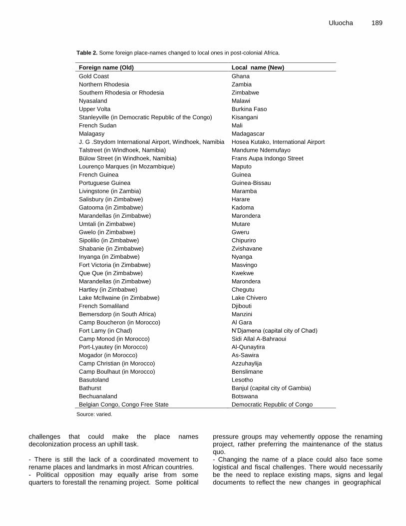
Uluocha 189
Table 2. Some foreign place-names changed to local ones in post-colonial Africa.
Foreign name (Old) Local name (New)
Gold Coast Ghana
Northern Rhodesia Zambia
Southern Rhodesia or Rhodesia Zimbabwe
Nyasaland Malawi
Upper Volta Burkina Faso
Stanleyville (in Democratic Republic of the Congo) Kisangani
French Sudan Mali
Malagasy Madagascar
J. G .Strydom International Airport, Windhoek, Namibia Hosea Kutako, International Airport
Talstreet (in Windhoek, Namibia) Mandume Ndemufayo
Bülow Street (in Windhoek, Namibia) Frans Aupa Indongo Street
Lourenço Marques (in Mozambique) Maputo
French Guinea Guinea
Portuguese Guinea Guinea-Bissau
Livingstone (in Zambia) Maramba
Salisbury (in Zimbabwe) Harare
Gatooma (in Zimbabwe) Kadoma
Marandellas (in Zimbabwe) Marondera
Umtali (in Zimbabwe) Mutare
Gwelo (in Zimbabwe) Gweru
Sipolilio (in Zimbabwe) Chipuriro
Shabanie (in Zimbabwe) Zvishavane
Inyanga (in Zimbabwe) Nyanga
Fort Victoria (in Zimbabwe) Masvingo
Que Que (in Zimbabwe) Kwekwe
Marandellas (in Zimbabwe) Marondera
Hartley (in Zimbabwe) Chegutu
Lake McIlwaine (in Zimbabwe) Lake Chivero
French Somaliland Djibouti
Bemersdorp (in South Africa) Manzini
Camp Boucheron (in Morocco) Al Gara
Fort Lamy (in Chad) N‟Djamena (capital city of Chad)
Camp Monod (in Morocco) Sidi Allal A-Bahraoui
Port-Lyautey (in Morocco) Al-Qunaytira
Mogador (in Morocco) As-Sawira
Camp Christian (in Morocco) Azzuhaylija
Camp Boulhaut (in Morocco) Benslimane
Basutoland Lesotho
Bathurst Banjul (capital city of Gambia)
Bechuanaland Botswana
Belgian Congo, Congo Free State Democratic Republic of Congo
Source: varied. challenges that could make the place names decolonization process an uphill task. - There is still the lack of a coordinated movement to rename places and landmarks in most African countries. - Political opposition may equally arise from some quarters to forestall the renaming project. Some political
pressure groups may vehemently oppose the renaming project, rather preferring the maintenance of the status quo. - Changing the name of a place could also face some logistical and fiscal challenges. There would necessarily be the need to replace existing maps, signs and legal documents to reflect the new changes in geographical
190 Afr. J. Hist. Cult. names. New cartographic documents are needed to record the change. The drawing of a new map corresponds to the production of a new spatial knowledge in which toponyms are included and by which toponyms can be modified (Löfström and Pansini, 2011). Such a replacement may require significant financial outlay. - The renaming exercise has the potency of engendering public confusion. A cross-section of the public may not readily or easily adapt to the new changes in place-names. Some others, including the international community, may be in a dilemma as to which of the names to use in official papers. - There is also the possibility of the name-change phenomenon suffering a major setback owing to outright rejection or apathy on the part of a cross-section of the society who may not readily see any justification for such a programme. The Way Forward Admittedly, over the years some form of decolonization of place-names has been taking place in various countries of post-colonial Africa. Nevertheless, the rechristening of some places and features in some African countries, particularly urban centres, is largely sporadic, un-coordinated and ad hoc in nature. A robust, synchronized and comprehensive place-name decolonization process would necessarily be required. Each affected country needs a well-articulated national toponymical policy and a corresponding institution fully backed with appropriate legislation and charged with the responsibility of restoring and maintaining the integrity of native geographical names. Besides, national projects to research, reinstate, document, disseminate and preserve indigenous place-names should be initiated by each country.
Various stakeholders including the native people should, as much as possible, be consulted and carried along in the decolonization exercise, to drastically reduce potential frictions and hence ensure success. As noted earlier some people might be in doubt, dilemma or confusion as per which name to use in official documentation. A conceivable way out of this confusion could be to write the local names alongside their foreign versions on maps, signs and other official documents. New place names maps of various African communities, similar to the Menominee Place Names Map (Vine, 2013, cited in Ripp, 2014), should be created to show the names, places and landforms in both the foreign and original local languages. Local place names are place-based knowledge, an aspect of traditional knowledge, which must be recognized, respected, promoted, protected, preserved, and transmitted. One sure way of achieving all this is to map the indigenous place names in their original form.
A formidable research team of experts comprising geographers, topographers, toponymists, historians,
cartographers, linguists, onomasticians, etymologists, ethnologists, sociologists, anthropologists, and tran-scribers would be needed to restore the places renamed or imposed by the imperialists to their original African names. The team should identify, collect, record and preserve the aboriginal geographical names. Moreover, the team would be expected to unearth the etymology of the local toponyms and also resolve the several inconsistencies that dog the continent‟s place-name orthography. Indigenous communities should have the right to decide on their toponyms. This would be in line with recommendation 4b of the United Nations (1968) article 4d, which provides that geographical names should be recorded in the form in which they are known locally, together with the locally accepted generic names, with their correct orthography and pronunciation. Without a doubt, given the sheer size and linguistic diversity of many African countries, the task is quite enormous and promises to be a most daunting one; yet it is doable. Clear-cut guidelines for the recording and use of aboriginal place-names would need to be worked out.
A National Geospatial Data Infrastructure (NGDI) should be established by each African country, and a standardized geographical names databank should be a major component of the NGDI. To this end, the government of each nation should set up a Geographical Names steering committee whose sole responsibility it would be to collate, indigenize (where necessary), sort, standardize, manage, and publish a comprehensive, up-to-date and authentic digital multisensory list of the indigenous place-names of all the extant place-names in their country. No documents act as much a repository of toponyms as geographical gazetteers, name indexes, maps and atlases. Consequently, geographical gazetteers containing the comprehensive name lists for a country in which each name is accompanied primarily by information on location, and also by data on variant names, the etymology (history) of name or of place, orthographies of the names and possibly other items should be published. Moreover, new series of large-scale topographical maps as well as atlases of each country detailing the restored original names alongside their foreign versions should be compiled.
The restored indigenous place names should also be enshrined in official documents and added to school curricular and school atlases. More so, a Dictionary of Indigenous African Place Names would need to be compiled. Conclusion When place-names are despoiled they lose their original cartographical, geographical, historical, linguistic, and socio-political meanings, significance and functions. And this is exactly what has happened to many African indigenous place-names. The call for decolonizing the
continent‟s native geographical names as espoused in this paper is in tandem with the spirit and doctrine of African renaissance currently pervading the entire continent. The benefits of place-names are quite legion. By and large, place-names are essential to asserting and maintaining a people‟s socio-cultural and historical heritage, expressing their indigenous geographic and cartographic knowledge, stamping their peculiar identity as well as ensuring socio-economic development. The defaced or foreign toponyms are a symbol of imperial imposition which tends to whittle down the richness of the African peoples‟ culture and heritage. It is still possible to right the wrong; the indigenous cartography of Africa and Africans must be preserved; and this can be effectively achieved by reverting to the original place-names. Decolonizing and mapping indigenous place names will not only help in preserving the indigenous place names and cartography of Africa, but also the languages and traditional cultures of various native African societies.
Conflict of Interests
The author has not declared any conflict of interests. REFERENCES
Adebanwi W (2012). “Glocal naming and shaming: Toponymic (inter) national relations on Lagos and New York's streets”. Afr. Affairs 111(445):640-661.
Bassett TJ (1998). “Indigenous Mapmaking in Intertropical Africa.” edited by David Woodward and G. Malcolm Lewis, Chicago: University of Chicago Press. In The History of Cartography Volume Two, Book Three: Cartography in the Traditional African, American, Arctic, Australian, and Pacific Societies, pp.24-48.
Batoma A (2006). “African Ethnonyms and Toponyms: An Annotated Bibliography”. Iowa Research Online. Accessed October 13, 2014. http://ir.uiowa.edu/ejab/vol10/iss1/1. Electronic J. Africana Bibliography, Vol. 10.
Cornevin R (1984). “The Standardization of the Spelling of African Names: toponyms and ethnonyms.” Paris: UNESCO. In African Ethnonyms and Toponyms pp.68-79.
Duminy J (2014). "Street renaming, symbolic capital, and resistance in Durban, South Africa". Environment and Planning D: Soc. Space 32(2):310-328.
Fasi ME (1984). “Toponymy and Ethnonymy as Scientific Aids to History.” Paris: UNESCO. In African Ethnonyms and Toponyms pp.18-22.
Golaski J (2002). “Characteristic features of toponym objects and their dynamics.” Paper presented at the Eighth United Nations Conference on the Standardization of Geographical Names, Berlin, 27 August-5 September 2002.
Guyot S, Seethal C (2007). “Identity of place, places of identities, change of place names in post-apartheid South Africa.” South Afr. Geogr. J. 89(1):55-63.
Hudson BJ (2013). “The Naming of Waterfalls.” Geogr. Res. 51(1):85–93.
Jimoh BO (2014). “Decolonizing the disciplines: a historical study of revolutions and paradigm shifts in ifa as a divination theory of knowledge.” Accessed July 19. http://www.cbaac77.com/6_international_conference/Balogun%20Oladapo%20Jimoh.pdf
Johnson JT, Louis RP, Pramono AH (2006). “Facing the Future: Encouraging Critical Cartographic Literacies In Indigenous Communities.” ACME: An International E-Journal for Critical
Uluocha 191
Geographies 4(1):80-98. Johnson KL (2007). “Writing Deeper Maps: Mapmaking, Local
Indigenous Knowledges, and Literary Nationalism in Native Women‟s Writing.” Stud. Am. Indian Literatures 19(4):103-120.
Koopman A (2012). “The post-colonial identity of Durban.” In Names and Identities, 133-159, edited by B. Helleland, C.-E. Ore and S. Wikstrøm, Oslo Stud. Lang. 4(2).
Lawal AA (1992). “The Traditional Methods of Preserving History and Culture.” Lagos: Nigerian National Commission for UNESCO. In Popular Traditions of Nigeria, pp.10-22.
Löfström J, Pansini V (2011). Toponyms and Cartography: Historical Perspective and Linguistic Challenges. Accessed August 25, 2014. http://icaci.org/files/documents/ICC_proceedings/ICC2011/Oral PresentationsPDF/D4-Toponyms on maps and on GeoDB/CO-374.pdf
Louis RP (2004). “Indigenous Hawaiian Cartography in Search of Common Ground.” Cartographic Perspectives 48:7-23.
Maggs T (1998). “Cartographic Content of Rock Art in Southern Africa.” In The History of Cartography Volume Two, Book Three: Cartography in the Traditional African, American, Arctic, Australian, and Pacific Societies, 13-23, edited by David Woodward and G. Malcolm Lewis, Chicago: University of Chicago Press.
Mbenzi PA (2009). The Management of Place Names in the Post-Colonial Period in Namibia, United Nations Group of Experts on Geographical Names, Working Paper No. 67.
Nast HJ (2005). Concubines and Power: Five Hundred Years in a Northern Nigerian Palace. Minneapolis/London: University of Minnesota Press.
Okpala-Okaka C (1995). “Changes in Geographical Names: a case study of some Local Government Areas in South-Eastern Nigeria (Part 1)” In Proceedings of the 17
th Annual Conference, Minna,
October 31 – November 4, pp.84-88. Lagos: Nigerian Cartographic Association.
Ormeling F (2007). “Minority Toponyms – the Western Europe Experience.” In Ormeling‟s Cartography, edited by E. Heere and M. Storms, 117-124. Netherlands Geographical Studies.
Pissarra M (2009). “Decolonizing art in Africa: some preliminary thoughts on the relevance of the discourse on decolonization for contemporary African art, with particular reference to post-apartheid South Africa.” (Accessed July 19, 2014). http://www.asai.co.za/forum.php?id=73.
Raper PE (2005). New Dictionary of Southern African Place Names, 3rd
Edition. Johannesburg: Jonathan Ball Publishers. Ripp M (2014). “Mapping Menominee Culture: the process of ethically
recording language.” (Accessed September 2, 2014). http://blogs.nelson.wisc.edu/badrivercapstone/wp-content/uploads/sites/112/2014/04/Ripp_MappingMenomineeCulture.pdf
Robinson AH, Morrison JL, Muehrcke PC, Kimerling AJ, Guptill SC (1995). Elements of Cartography, 6
th Edition. New York: John Wiley &
Sons. Roden D (1974). “Some Geographical Implications from the Study of
Ugandan Place-names”. East Afr. Geogr. Rev. 12:77-86. SAGNC (South African Geographical Names Council) (2002).
Handbook on Geographical Names, Pretoria: Department of Arts, Culture, Science and Technology.
Snodia M, Muguti T, Mutami N (2010). “Political Dialoguing Through the Naming Process: The Case of Colonial Zimbabwe (1890-1980).” J. Pan African Stud. 3(10).
Snodia M, Tasara M, Nicholas M (2014). “Deconstructing the Colonial Legacy through the Naming Process in Independent Zimbabwe”. J. Stud. Soc. Sci. 6(1):71-85.
Uluocha NO (2010). “A Synopsis of Nigeria‟s Indigenous Cartographic Heritage.” Cartographic J. 47(2):164-172.
United Nations (1968). Report of the UN Conference on the Standardization of Geographical Names, London (1967).
Vuolteenaho J, Berg LD (2009). “Towards Critical Toponymies”. In Critical Toponymies: the contested politics of place naming, 1-18, edited by Lawrence D. Berg and Jani Vuolteenaho, Surrey: Ashgate Publishing Ltd.
Weghlis A (1998). “Amazigh Toponymy”. The Amazigh Voice, 7(2):12-15.

192 Afr. J. Hist. Cult. Yai O (1984). “African Ethnonymy and Toponymy: reflections on
decolonization.” Paris: UNESCO. In African Ethnonyms and Toponyms, pp.39-50.