Embed Size (px)
Citation preview
DEAPS 2013: Geology of the Mt. Washington area, New Hampshire, a glimpse into the evolution of the Appalachian Mountains By R. Buchwaldt and F. Dudas
The Appalachian Chain is the most elegant on Earth, so regularly arranged that its belts of formations and structures persist virtually from one end to the other. [...] But the apparent simplicity is deceiving; actually it is full of guile, and its geology has aroused controversies as acrimonious as any of those in our science.
(Philip B King, 1970)
This trip to Mt. Washington will travel through the spectacular scenery of Pinkham, Crawford, and Franconia Notches in the White Mountains of New Hampshire. These ranges include the highest peaks in the northeastern United States as well as many famous landforms such as The Old Man of the Mountain and Tuckerman Ravine near Jackson NH. Hopefully we will examine some parts of the rich geologic history exposed here, from the Silurian (~450Ma) to the Holocene (today), including the nature of sedimentation, deformation, metamorphism, and magmatism during these fascinating mountains had been formed.
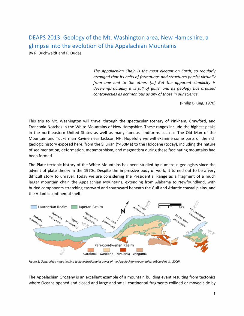
The Plate tectonic history of the White Mountains has been studied by numerous geologists since the advent of plate theory in the 1970s. Despite the impressive body of work, it turned out to be a very difficult story to unravel. Today we are considering the Presidential Range as a fragment of a much larger mountain chain the Appalachian Mountains, extending from Alabama to Newfoundland, with buried components stretching eastward and southward beneath the Gulf and Atlantic coastal plains, and the Atlantic continental shelf.
Figure 1: Generalized map showing tectonostratigraphic zones of the Appalachian orogen (after Hibbard et al., 2006).
The Appalachian Orogeny is an excellent example of a mountain building event resulting from tectonics where Oceans opened and closed and large and small continental fragments collided or moved side by
1

side, an overall process which we call ‘Wilson cycle.’ It all started where a supercontinent Rodina rifted apart to create new ocean basins with many smaller plates within them. Ultimately smaller plates collided, ocean closed, and a new supercontinent, Pangea was created. Pangea in turn rifted apart again to create the Atlantic Ocean and many smaller plates. In more detail we can find within Appalachian three separate continental collisions which formed the Appalachian Mountains and Allegheny Mountains at the end of the Paleozoic (~450‐250 Ma). The combined continents of Europe and Africa (Gondwana) collided with North America to form the supercontinent of Pangaea approximately 350 million to 300 million years ago during the Carboniferous period. The collision exerted enormous stress on what today is eastern North America, and causing an enormous upward thrusting of the entire region. The tectonic stresses also metamorphosized of the rock from igneous and sedimentary rock into metamorphic rock. These stresses concurrently caused faults (mostly thrust faults and some strike‐slip faults) as well as folding. It is believed that the Appalachians once could have risen as high as or even higher than the Himalaya (i.e., more than 4 ½ miles high). These mountains, while still impressive in places, are mere remnants of their glory days during the Paleozoic. They have been worn away by the relentless forces of erosion, forming vast amount of sediments in the process. Carbonates and sediments from mountains formed in the Appalachian Orogeny were transported away to form limey rocks in a shallow sea that was later uplifted and now forms the majority of Tennessee, Kentucky, Indiana and Ohio.
Figure 2: Reconstruction of continental configurations of the Earth's landmasses during the Phanerozoic Eon
Most of the rocks around Mt Washington were once sediments on the eastern Margin of North America in the late Silurian and early Devonian periods (~400 Ma). These sediments where caught up in the collision between North America and a micro‐continent called Avalonia, an event known as the Taconic Orogeny. These rocks then where folded and faulted, re‐folded and re‐faulted and subjected to intense pressure and heat which modified the original sedimentary minerals into different mineral
2
compositions. Associated with this metamorphism, there was sufficient heat to melt some of the rocks, producing granites which emplaced in the Presidential range region.
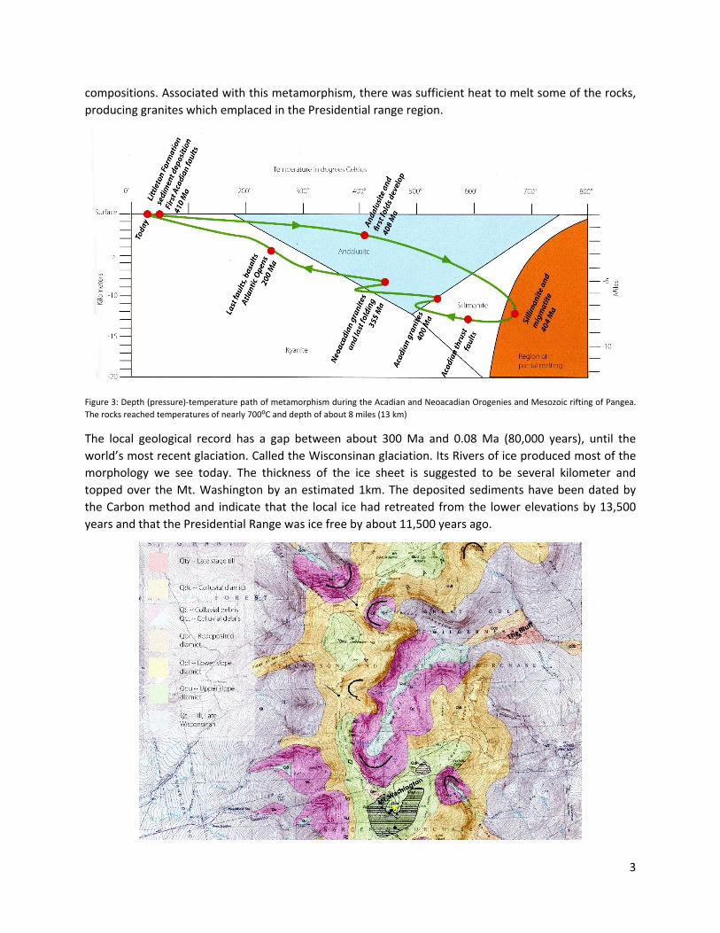
Figure 3: Depth (pressure)‐temperature path of metamorphism during the Acadian and Neoacadian Orogenies and Mesozoic rifting of Pangea. The rocks reached temperatures of nearly 700⁰C and depth of about 8 miles (13 km)
The local geological record has a gap between about 300 Ma and 0.08 Ma (80,000 years), until the world’s most recent glaciation. Called the Wisconsinan glaciation. Its Rivers of ice produced most of the morphology we see today. The thickness of the ice sheet is suggested to be several kilometer and topped over the Mt. Washington by an estimated 1km. The deposited sediments have been dated by the Carbon method and indicate that the local ice had retreated from the lower elevations by 13,500 years and that the Presidential Range was ice free by about 11,500 years ago.
3
Figure 4: The Mount Washington and Great Gulf region surficial map of the Presidential Range showing the location of cirques as well as various glacial and post glacial deposits
Also major tectonic activities are today ceased in the White Mountains, the Presidential range is still not at rest and it is an ever changing environment in which rain wind and snow are eroding seemingly indestructible rocks and Rivers are transporting the sediments towards lower elevations, producing landscapes and spaces for plant and wildlife and creating fragile ecosystems.
Rock Glossary Rock Types
• Igneous rocks: rocks formed by solidification from a high temperature melt o Plutonic (Intrusive) rocks: coarse grained igneous rocks, with grains sizes usually larger
then 2mm; these rocks cooled rapidly near the surface after eruption. o Volcanic (Extrusive) rocks: fine‐grained igneous rocks, with grain sizes usually less than
2mm; these rocks cooled rapidly near the surface after eruption. • Sedimentary rocks: rocks formed by deposition from a fluid (usually water, but sometimes air) at
low temperatures o Clastic sedimentary rocks: rocks formed from brocken fragments of pre‐existing
minerals or rocks o Chemical sedimentary rocks: rocks formed by precipitation from fluids o Organic Sedimentary rocks: rocks formed by accumulations of organic matter (e.g. the
coal family). • Metamorphic rocks: rocks formed by modification of pre‐existing rocks through the action of
circulating fluids, elevated temperatures, elevated pressures, or a combination of all three. o Regional metamorphic rocks: rocks affected by metamorphism that is regional in scale,
unrelated to coexisting igneous rocks. o Contact metamorphic rocks: rocks modified by interaction with igneous rocks. These
rocks usually have complex mineralogy.
Major rock types in the Mt. Washington area
• Schist: a metamorphic rock, usually formed during regional metamorphism, showing distinctive layering due to orientation of platy minerals.
• Gneiss: a metamorphic rock, usually formed during regional metamorphism, showing distinctive compositional variation, but usually no orientation of mineral grains.
• Migmatite: a metamorphic rock characterized by pods of partial melt suspending unmelted fragments of the original host rock.
• Granite: a plutonic igneous rock consisting predominantly of quartz and feldspar, with minor other constituents including micas
• Pegmatite: a plutonic igneous rock, usually granitic composition, characterized by very large grain size (>2cm), and commonly containing unusual minerals.
4

5

Geologic Time Scale
6

7
Selected Literature Cwynar, L. C. and Spear, R. W., 2001: Late glacial climate change in the White Mountains of New Hampshire.‐ Quaternary Science Reviews, 20, 1265‐1274.
Davis, P.T., 1999: Cirques of the Presidential Range, New Hampshire, and surrounding alpine areas in the northeastern United States. Geographique physique et Quaternaire, 53, 25‐45.
Eusden, J.D., Jr, Thompson, W.B., Fowler, B.K., Davis, P.T., Bothner, W.A., Boisvert, R.A., Creasy, J.W., 2013: The Geology of New Hampshire’s White Mountains.‐ Durand Press, Lyme, New Hampshire, pp. 175.
Eusden, J.D., Jr. 2010: The Presidential Range, Its Geologic History and Plate Rectonics.‐ Durand Press, Lyme, New Hampshire, pp. 62
Eusden, J.D., Jr., Guzofski, C.A., Robinson, A.C., Tucker, R.D., 2000: Timing of the Acadian orogeny in northern New Hampshire. Journal of Geology, 108, 219‐232.
Eusden, J.D., Jr., Garesche, J.M., Johnson, A.H., Maconochie, J.‐M., Peters, S. P., O’Brien, J. B., and Widmann, B. L., 1996: Stratigraphy and ductile structure of the Presidential Range of: Tectonic implications of the Acadian orogeny.‐ Geological Society of America Bullitin, 108, 417‐436.
Eusden, J.D., Jr., Lux, D.R., 1994: Slow late Paleozoic exhumation in the Presidential Range of New Hampshireas determined by the 40Ar/39Ar relief method.‐ Geology, 22, 909‐912.
Fowler, B.K., 2010: Surficial Geology of Mount Washington and the Presidential Range, New Hampshire.‐ Durand Press, Lyme, New Hampshire.
Gerath, R.F., Fowler, B.K., Haselton, G.M., 1985: The deglaciation of the northern White mountains of New Hampshire. In Borns, H.W., Jr., LaSalle, P., Thompson, W.B., eds. Late Pleistocenen History of Northeastern New England and Adjacent Quebec, Geological Society of America Special Papers 197, 21‐28.
Goldweit, R.P, Billings, M.P., Creasy, J.W. 1987: Mount Washington‐Crawford Notch area, New Hampshire. Geological Society of America Centennial Field Guide‐Norhteastern Section, 257‐262.
Miller, N.G., Spear, R.W., 1999: Late‐Quaternary history of the alpine flora of New Hampshire Whit Mountains.‐ Geographie physique et Quaternaire, 53, 137‐157.
Sarderino, S., 2000: Classification of ordination of plant communities along an altitudinal gradient on the presidential Range, New Hampshire, USA. Plant Ecology, 148, 81‐103.
Smith, G.W., 1985: Chronology of Late Wisconsinian deglaciation of costal Maine. In Borns, H.W., Jr., LaSalle, P., Thompson, W.B., eds. Late Pleistocenen History of Northeastern New England and Adjacent Quebec, Geological Society of America Special Papers 197, 29ff.
Spear, R.W., Davis, M.B., Shane, L.C.K., 1994: Late Quaternary history of low‐ and mid‐elevation vegetation in the White Mountains of New Hampshire. Ecological Monographs, 64, 85‐109.
Thompson, D.J., 1999: Talus fabric in Tuckerman Ravine, New Hampshire: Evidence for a tongue shaped rock glacier.‐ Geographie physique et Quaternaire, 53, 47‐57.
Thompson, W.B., 1999: History of research on glaciation in the White Mountains, New Hampshire (U.S.A.).‐ Geographie physique et Quaternaire, 53, 7‐24
Waitt, R.B., Davis, P.T. 1988: No evidence for pos‐icesheet cirque glaciation in New England. American Journal of Science, 288, 495‐533.