Embed Size (px)
Citation preview
DBpedia Mobile:A Location-Aware Semantic Web Client
Christian Becker and Christian Bizer
Freie Universitat Berlin, [email protected],[email protected]
Abstract. DBpedia Mobile is a location-aware client for the SemanticWeb that can be used on an iPhone and other mobile devices. Based onthe current GPS position of a mobile device, DBpedia Mobile rendersa map indicating nearby locations from the DBpedia dataset. Startingfrom this map, the user can explore background information about hissurroundings by navigating along data links into other Web data sources.DBpedia Mobile has been designed for the use case of a tourist exploringa city. As the application is not restricted to a fixed set of data sources butcan retrieve and display data from arbitrary Web data sources, DBpediaMobile can also be employed within other use cases, including ones un-foreseen by its developers. Besides accessing Web data, DBpedia Mobilealso enables users to publish their current location, pictures and reviewsto the Semantic Web so that they can be used by other Semantic Webapplications. Instead of simply being tagged with geographical coordi-nates, published content is interlinked with a nearby DBpedia resourceand thus contributes to the overall richness of the Geospatial SemanticWeb.
Key words: Semantic Web, Linked Data, Geospatial Web, DBpedia,Location-Aware Applications
1 Introduction
Mobile phones feature increasingly powerful hardware, software and data con-nectivity, and more and more phones such as the iPhone 3G are shipped withbuilt-in GPS receivers, whose positioning capabilities are exposed to third partyapplications. In parallel, the Semantic Web is growing rapidly, and contains alarge amount of location-related data.
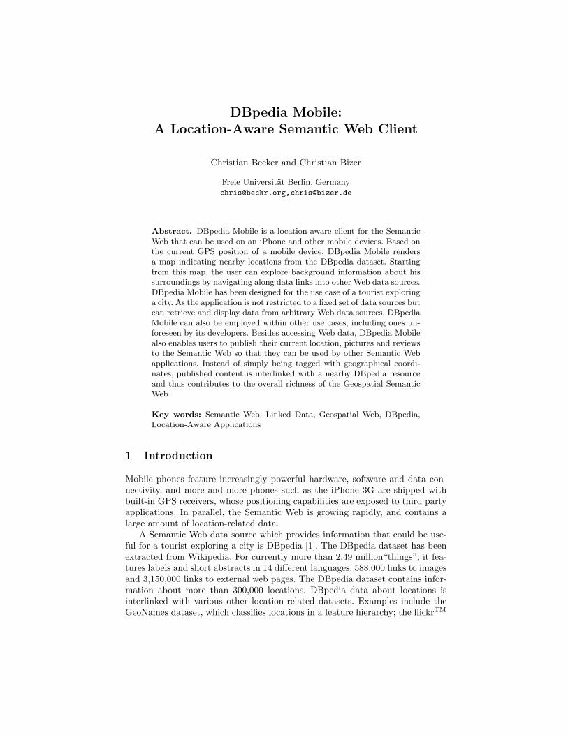
A Semantic Web data source which provides information that could be use-ful for a tourist exploring a city is DBpedia [1]. The DBpedia dataset has beenextracted from Wikipedia. For currently more than 2.49 million“things”, it fea-tures labels and short abstracts in 14 different languages, 588,000 links to imagesand 3,150,000 links to external web pages. The DBpedia dataset contains infor-mation about more than 300,000 locations. DBpedia data about locations isinterlinked with various other location-related datasets. Examples include theGeoNames dataset, which classifies locations in a feature hierarchy; the flickrTM
2 Christian Becker and Christian Bizer
wrappr, which provides images depicting locations; the EuroStat, Riese, US Cen-sus and CIA Factbook datasets, which provide statistical information about loca-tions; Revyu, which might provide reviews about a location; the YAGO dataset,which provides type information for locations such as museums, train stationsor monuments; and FOAF profiles by individuals that state that they are basednear, work at or were born at DBpedia locations. Altogether there are around2,180,000 data links pointing from DBpedia into other RDF data sources on theSemantic Web. Figure 1 gives an overview of all Web data sources that are cur-rently interlinked with DBpedia. The data sources that can be reached directlyfrom DBpedia by following outgoing data links are highlighted in the figure.
SWConference
Corpus
RDF Book Mashup
Revyu
Project Guten-berg
Music-brainz
Magna-tune
Jamendo
DBLPHannover
SIOCprofiles
Sem-Web-
Central
ECS South-ampton
BBCLater +TOTP
Doap-space
Open-Guides
Gov-Track
US Census Data
W3CWordNet
Wiki-company Open
Cyc
BBCJohnPeel
FlickrexporterQDOS
RKB Explorer
riese
UMBEL
Pub Guide
FOAFprofiles
Geo-Names
flickrwrappr
Yago
World Fact-book
SemanticWeb.org
BBCPlaycount Data
SurgeRadio
MySpaceWrapper
Audio-Scrobbler
CrunchBase
As of September 2008
LinkedMDB DBLP
Berlin
DBpedia
Euro-stat
BBCProgrammes
lingvoj
foaf:based_near
foaf:depiction
rev:hasReview
Fig. 1. Data links pointing from DBpedia into other data sources on the Seman-tic Web and links provided by DBpedia Mobile.
2 DBpedia Mobile
DBpedia Mobile1 allows users to discover, search and publish Linked Data per-taining to their current physical environment using their mobile phones as well asstandard web browsers. The application consists of a map view and a Fresnel [2]-based Linked Data browser. Starting from this map, users can explore back-ground information about their surroundings by navigating along data links into1 http://beckr.org/DBpediaMobile
DBpedia Mobile: A Location-Aware Semantic Web Client 3
other Web data sources. Besides accessing Web data, DBpedia Mobile also en-ables users to publish their current location, pictures and reviews to the SemanticWeb. Instead of simply being tagged with geographical coordinates, publisheddata is interlinked with a nearby DBpedia location. In Figure 1, user-generatedcontent that is published using DBpedia Mobile is depicted by the three outerright items.
2.1 Browsing the Geospatial Semantic Web
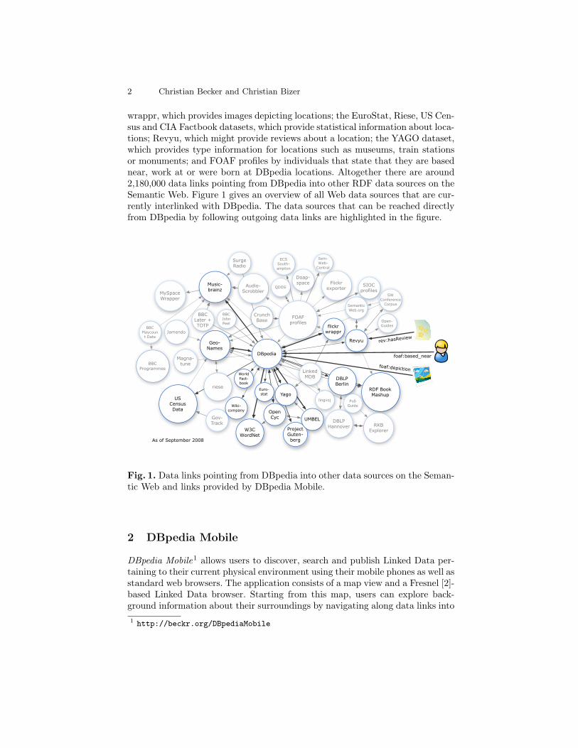
DBpedia Mobile’s initial view is a map display that indicates the user’s positionand nearby DBpedia resources, using appropriate labels and icons. Figure 2shows DBpedia Mobile’s initial view on an iPhone. The map can be moved bydragging it on the touch screen. It can be zoomed using a pinch gesture or theprovided controls.
Fig. 2. DBpedia Mobile running on an iPhone 3G and showing a map view ofresources in the user’s proximity.
Locations are depicted with adequate icons based on a mapping of selectedYAGO categories [3]. DBpedia Mobile allows users to switch between 14 lan-guages to be used for labels and summary texts (English, German, French,Dutch, Polish, Italian, Spanish, Japanese, Portuguese, Swedish, and Chinese).
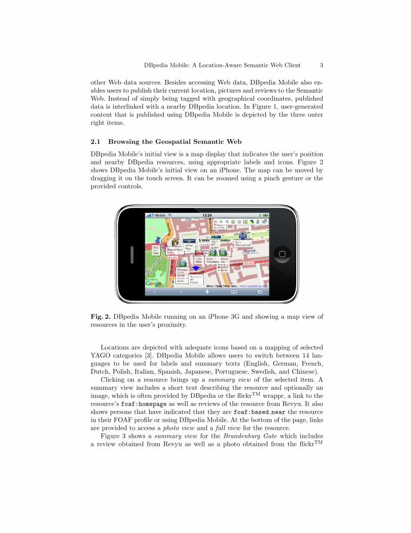
Clicking on a resource brings up a summary view of the selected item. Asummary view includes a short text describing the resource and optionally animage, which is often provided by DBpedia or the flickrTM wrappr, a link to theresource’s foaf:homepage as well as reviews of the resource from Revyu. It alsoshows persons that have indicated that they are foaf:based near the resourcein their FOAF profile or using DBpedia Mobile. At the bottom of the page, linksare provided to access a photo view and a full view for the resource.
Figure 3 shows a summary view for the Brandenburg Gate which includesa review obtained from Revyu as well as a photo obtained from the flickrTM
4 Christian Becker and Christian Bizer
wrappr, and lists nearby DBpedia Mobile users. Specific site icons (such as ablue star for Revyu) are used to indicate the provenance of displayed data.
The photo view displays further depictions of the resource, obtained fromDBpedia and the flickrTM wrappr.
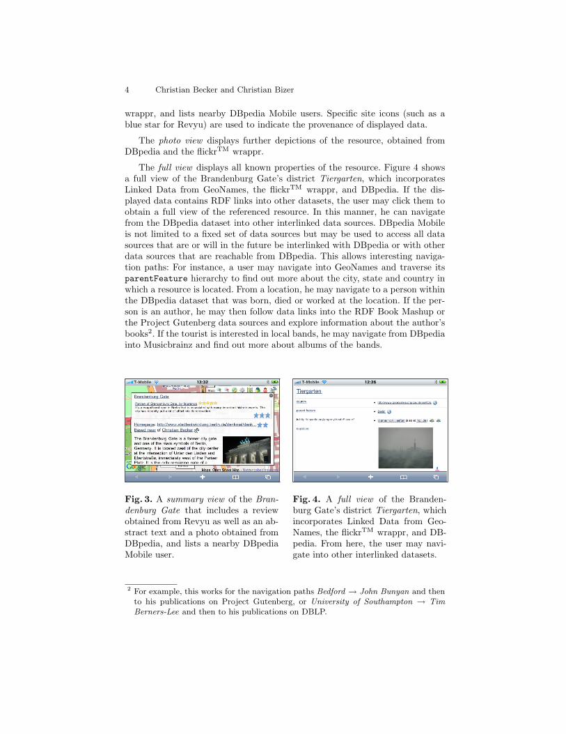
The full view displays all known properties of the resource. Figure 4 showsa full view of the Brandenburg Gate’s district Tiergarten, which incorporatesLinked Data from GeoNames, the flickrTM wrappr, and DBpedia. If the dis-played data contains RDF links into other datasets, the user may click them toobtain a full view of the referenced resource. In this manner, he can navigatefrom the DBpedia dataset into other interlinked data sources. DBpedia Mobileis not limited to a fixed set of data sources but may be used to access all datasources that are or will in the future be interlinked with DBpedia or with otherdata sources that are reachable from DBpedia. This allows interesting naviga-tion paths: For instance, a user may navigate into GeoNames and traverse itsparentFeature hierarchy to find out more about the city, state and country inwhich a resource is located. From a location, he may navigate to a person withinthe DBpedia dataset that was born, died or worked at the location. If the per-son is an author, he may then follow data links into the RDF Book Mashup orthe Project Gutenberg data sources and explore information about the author’sbooks2. If the tourist is interested in local bands, he may navigate from DBpediainto Musicbrainz and find out more about albums of the bands.
Fig. 3. A summary view of the Bran-denburg Gate that includes a reviewobtained from Revyu as well as an ab-stract text and a photo obtained fromDBpedia, and lists a nearby DBpediaMobile user.
Fig. 4. A full view of the Branden-burg Gate’s district Tiergarten, whichincorporates Linked Data from Geo-Names, the flickrTM wrappr, and DB-pedia. From here, the user may navi-gate into other interlinked datasets.
2 For example, this works for the navigation paths Bedford → John Bunyan and thento his publications on Project Gutenberg, or University of Southampton → TimBerners-Lee and then to his publications on DBLP.
DBpedia Mobile: A Location-Aware Semantic Web Client 5
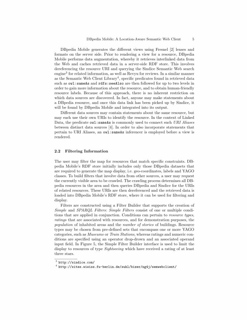
DBpedia Mobile generates the different views using Fresnel [2] lenses andformats on the server side. Prior to rendering a view for a resource, DBpediaMobile performs data augmentation, whereby it retrieves interlinked data fromthe Web and caches retrieved data in a server-side RDF store. This involvesdereferencing the resource URI and querying the Sindice Semantic Web searchengine3 for related information, as well as Revyu for reviews. In a similar manneras the Semantic Web Client Library4, specific predicates found in retrieved datasuch as owl:sameAs and rdfs:seeAlso are then followed for up to two levels inorder to gain more information about the resource, and to obtain human-friendlyresource labels. Because of this approach, there is no inherent restriction onwhich data sources are discovered. In fact, anyone may make statements abouta DBpedia resource, and once this data link has been picked up by Sindice, itwill be found by DBpedia Mobile and integrated into its output.
Different data sources may contain statements about the same resource, butmay each use their own URIs to identify the resource. In the context of LinkedData, the predicate owl:sameAs is commonly used to connect such URI Aliasesbetween distinct data sources [4]. In order to also incorporate statements thatpertain to URI Aliases, an owl:sameAs inferencer is employed before a view isrendered.
2.2 Filtering Information
The user may filter the map for resources that match specific constraints. DB-pedia Mobile’s RDF store initially includes only those DBpedia datasets thatare required to generate the map display, i.e. geo-coordinates, labels and YAGOclasses. To build filters that involve data from other sources, a user may requestthe currently visible area to be crawled. The crawling process determines all DB-pedia resources in the area and then queries DBpedia and Sindice for the URIsof related resources. These URIs are then dereferenced and the retrieved data isloaded into DBpedia Mobile’s RDF store, where it can be used for filtering anddisplay.
Filters are constructed using a Filter Builder that supports the creation ofSimple and SPARQL Filters: Simple Filters consist of one or multiple condi-tions that are applied in conjunction. Conditions can pertain to resource types,ratings that are associated with resources, and for demonstration purposes, thepopulation of inhabited areas and the number of stories of buildings. Resourcetypes may be chosen from pre-defined sets that encompass one or more YAGOcategories, such as Museums or Train Stations, whereas ratings and numeric con-ditions are specified using an operator drop-drown and an associated operandinput field. In Figure 5, the Simple Filter Builder interface is used to limit thedisplay to resources of type Sightseeing which have received a rating of at leastthree stars.
3 http://sindice.com/4 http://sites.wiwiss.fu-berlin.de/suhl/bizer/ng4j/semwebclient/

6 Christian Becker and Christian Bizer
SPARQL Filters are SPARQL CONSTRUCT queries which are evaluated againstthe RDF store. The resulting RDF graph is then used to generate the map dis-play. For example, the filter “Stations of Berlin’s U7 train line” restricts thedisplay to resources that have the DBpedia infobox properties system and lineequal to “BVG”, Berlin’s transportation company, and “U7”, respectively. Fig-ure 6 shows the resulting map display.
Fig. 5. The Simple Filter Builder In-terface.
Fig. 6. Specific train lines plotted us-ing the filter “Stations of Berlin’s U7train line”.
2.3 Publishing Linked Data to the Web
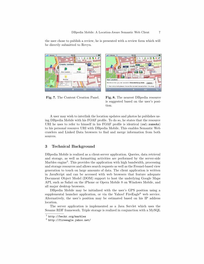
DBpedia Mobile facilitates the publication of content with attached location in-formation to the Semantic Web, directly from the mobile device. A user maypublish his current location as well as photos and reviews, interlinked with DB-pedia resources.
Tim Berners-Lee et al. discuss the publication of RDF statements by users in[5]. Specifically, they introduce graphs that anyone may edit. Contrarily, DBpe-dia Mobile assigns each user an individual RDF graph that only he can updateand which is Web-accessible via the URI http://beckr.org/DBpediaMobile/graphs/username.
DBpedia Mobile wraps the triple generation process in user interface dialogs,which dramatically reduces the technical expertise required to publish content.To publish content, the user logs in and opens the Content Creation Panel (de-picted in Figure 7). He then selects the type of information to publish (i.e.position, photo or review) and chooses a DBpedia location to be used to tagthe published content. Based on his location, the nearest DBpedia resource isautomatically suggested, as shown in Figure 8.
A location update is automatically reflected in his user graph as a triplestating that he is foaf:based near the selected resource. In the case of a photo,he is prompted to upload the image, which is then stored on the server and ispublished in his User Graph as a foaf:depiction of the selected resource. If
DBpedia Mobile: A Location-Aware Semantic Web Client 7
the user chose to publish a review, he is presented with a review form which willbe directly submitted to Revyu.
Fig. 7. The Content Creation Panel. Fig. 8. The nearest DBpedia resourceis suggested based on the user’s posi-tion.
A user may wish to interlink the location updates and photos he publishes us-ing DBpedia Mobile with his FOAF profile. To do so, he states that the resourceURI he uses to refer to himself in his FOAF profile is identical (owl:sameAs)to his personal resource URI with DBpedia Mobile. This enables Semantic Webcrawlers and Linked Data browsers to find and merge information from bothsources.
3 Technical Background
DBpedia Mobile is realized as a client-server application. Queries, data retrievaland storage, as well as formatting activities are performed by the server-sideMarbles engine5. This provides the application with high bandwidth, processingand storage resources and allows search requests as well as the Fresnel-based viewgeneration to touch on large amounts of data. The client application is writtenin JavaScript and can be accessed with web browsers that feature adequateDocument Object Model (DOM) support to host the underlying Google MapsAPI, such as Safari on the iPhone or Opera Mobile 8 on Windows Mobile, andall major desktop browsers.
DBpedia Mobile may be initialized with the user’s GPS position using asupplemental launcher application, or via the Yahoo! FireEagle6 web service.Alternatively, the user’s position may be estimated based on his IP addresslocation.
The server application is implemented as a Java Servlet which uses theSesame RDF framework. Triple storage is realized in conjunction with a MySQL5 http://beckr.org/marbles6 http://fireeagle.yahoo.net/
8 Christian Becker and Christian Bizer
database, whereby Sesame’s RDBMS storage capabilities were enhanced to sup-port inference, as well as storage and filtering of geospatial points using MySQLSpatial Extensions. The SIMILE Fresnel Engine and the Saxon XSLT processorare used for the generation of resource views.
4 Conclusions
DBpedia Mobile allows users to discover, search and publish Linked Data onthe Semantic Web using their mobile devices. The application is not restrictedto a fixed set of data sources but may retrieve and display data from arbitraryWeb data sources. This enables DBpedia Mobile to be employed within unfore-seen use cases. Realized and proposed use cases include tourism7, nearby events8
and personal recommendations9. DBpedia Mobile publishes user-generated con-tent with attached location information to the Semantic Web. This advances“geo-tagging” to “resource-tagging” and allows users to contribute to the over-all richness of the Geospatial Semantic Web.
More information about DBpedia Mobile is available at http://wiki.dbpedia.org/DBpediaMobile.
References
1. S. Auer, C. Bizer, J. Lehmann, G. Kobilarov, R. Cyganiak, and Z. Ives. DBpedia:A nucleus for a web of open data. In Proceedings of the 6th International SemanticWeb Conference and 2nd Asian Semantic Web Conference (ISWC/ASWC2007),volume 4825 of LNCS, pages 715–728, Springer, 2007.
2. E. Pietriga, C. Bizer, D. Karger, and R. Lee. Fresnel: A browser-independentpresentation vocabulary for RDF. In International Semantic Web Conference(ISWC2006), volume 4273 of of LNCS, pages 158–171, Springer, 2006.
3. F. M. Suchanek, G. Kasneci, and G. Weikum. Yago: A core of semantic knowledge.In WWW ’07: Proceedings of the 16th international conference on World Wide Web,pages 697–706, ACM, 2007.
4. Bizer, C., Cyganiak, R., Heath, T.: How to Publish Linked Data on the Web.URL: http://www4.wiwiss.fu-berlin.de/bizer/pub/LinkedDataTutorial/,02/18/2008.
5. Berners-Lee, T., Hollenbach, J., Lu, K., Presbrey, J., Prud’ommeaux,E., Schraefel, M.: Tabulator Redux: Browsing and Writing LinkedData. In: 1st Workshop about Linked Data on the Web (LDOW 2008),April 2008. URL: http://events.linkeddata.org/ldow2008/papers/
11-berners-lee-hollenbach-tabulator-redux.pdf, 03/02/2008.
7 http://tomheath.com/slides/2008-09-graz-triplei.pdf8 http://blog.dbtune.org/post/2008/07/30/Lastfm-events-and-DBpedia-mobile9 http://apassant.net/blog/2008/04/24/social-mobile-semantic/


![Chapter 3 - odbms.org...tent way. DBpedia Mobile [74] is a location-aware client for mobile phones which displays nearby locations taken from DBpedia. As a related project, LinkedGeoData](https://img.dokumen.tips/doc/110x75/5feb897ec02b6831b35b5d36/chapter-3-odbms-tent-way-dbpedia-mobile-74-is-a-location-aware-client.jpg)