Embed Size (px)
Citation preview

David Magney Environmental Consulting
SIGNIFICANT ECOLOGICAL AREAS BIOLOGICAL CONSTRAINTS ANALYSIS
FOR LYONS CANYON RANCH, NEWHALL, CALIFORNIA
Prepared for:
COUNTY OF LOS ANGELES
On Behalf of:
D.R. HORTON (WESTERN PACIFIC SERIES)
DMEC Mission Statement:
To provide quality environmental consulting services with integrity that protect and enhance the human and natural environment.
September 2005

DMEC Significant Ecological Areas
Biological Constraints Analysis for Lyons Canyon Ranch, Newhall, California
Prepared for:
County of Los Angeles Department of Regional Planning
Hall of Records (13th Floor), Room 1351 320 West Temple Street
Los Angeles, California 90012 Contact: Daryl Koutnik,
Supervising Regional Planner 213/974-6411
On Behalf of:
D.R. Horton (Western Pacific Series)
21300 Victory Blvd., Suite 700 Woodland Hills, California 91367
Contact: Eric Taylor 310/665-3700
Prepared by:
David Magney Environmental Consulting P.O. Box 1346
Ojai, California 93024-1346
14 September 2005

This document should be cited as: David Magney Environmental Consulting. 2005. Significant Ecological Areas Biological Constraints Analysis for
Lyons Canyon Ranch, Newhall, California. 14 September 2005. (PN 03-0213.) Ojai, California. Prepared for the County of Los Angeles, Los Angeles, California, on behalf of D.R. Horton (Western Pacific Series), Woodland Hills, California.

Significant Ecological Areas Biological Constraints Analysis for Lyons Canyon Ranch 14 September 2005
C:\DMEC\Jobs\LosAngeles\DalyOwens\LyonsCynRanch\Lyons Bio Constraints\LyonsCynRanch-BioConstraintsAnalysis-DMEC.doc Page i
DMEC TABLE OF CONTENTS
PAGE
SECTION 1. INTRODUCTION.............................................................. 1 CONSULTANT............................................................................................................... 1 PROJECT LOCATION ................................................................................................... 1 FIELD WORK ................................................................................................................. 5
WEATHER ...................................................................................................................... 6 METHODS ...................................................................................................................... 7
PLANT AND WILDLIFE SURVEYS........................................................................... 7 WETLAND DELINEATION METHODS..................................................................... 8 OAK TREE ASSESSMENT METHODS....................................................................... 10 VEGETATION MAPPING METHODS........................................................................ 11
Mapping Upland Habitats........................................................................................ 11 Mapping Wetland Habitats...................................................................................... 11
LITERATURE SEARCH ................................................................................................ 12
SECTION 2. CHARACTERISTICS OF THE SITE............................... 13 SEA BOUNDARIES ....................................................................................................... 13
WATERSHED DESCRIPTION...................................................................................... 13 GEOLOGY ...................................................................................................................... 16
MAPPED SOIL UNITS................................................................................................ 16 Castaic Series......................................................................................................... 20 Yolo Series ............................................................................................................ 20 Hanford Series........................................................................................................ 22 Saugus Series ......................................................................................................... 22 Riverwash.............................................................................................................. 22
BIOLOGICAL RESOURCES ......................................................................................... 23 HABITAT DESCRIPTIONS......................................................................................... 23
Palustrine Habitat ................................................................................................... 25 Upland Habitat ....................................................................................................... 29 Unvegetated/Altered............................................................................................... 36
FLORA........................................................................................................................ 37 Plant Species Population Sizes ................................................................................ 49
FAUNA....................................................................................................................... 49 Wildlife Population Sizes........................................................................................ 57 Wildlife Movement................................................................................................. 59
SPECIAL-STATUS BIOLOGICAL RESOURCES........................................................ 61 Definitions of Special-Status Biological Resources................................................... 62 Special-Status Biological Resources Survey Results ................................................. 66

Significant Ecological Areas Biological Constraints Analysis for Lyons Canyon Ranch 14 September 2005
C:\DMEC\Jobs\LosAngeles\DalyOwens\LyonsCynRanch\Lyons Bio Constraints\LyonsCynRanch-BioConstraintsAnalysis-DMEC.doc Page ii
DMEC SECTION 3. CHARACTERISTICS OF SURROUNDING AREA........ 82
EXISTING LAND USES ................................................................................................ 82 OPEN SPACE RESERVES............................................................................................. 82 SURROUNDING BIOLOGICAL RESOURCES ........................................................... 84
SURROUNDING VEGETATION................................................................................. 84 PROJECT SITE RELATIONSHIP WITH SURROUNDING BIOTIC MOSAIC.............. 84 OVERALL SPECIES POPULATION SIZES OF FLORA AND FAUNA IN THE RANGE 85 OVERALL BIOLOGICAL VALUE OF THE AREA ..................................................... 85
SECTION 4. CONCLUSION .................................................................. 89 CONSTRAINTS TO DEVELOPMENT ......................................................................... 90 RECOMMENDATIONS TO AVOID IMPACTS TO SENSITIVE BIOLOGICAL RESOURCES .................................................................................................................. 92
CITATIONS.............................................................................................. 93 REFERENCES CITED.................................................................................................... 93 PERSONAL COMMUNICATIONS............................................................................... 94
ACKNOWLEDGEMENTS ...................................................................... 95
APPENDICES .......................................................................................... 96 APPENDIX A. BONTERRA CONSULTING - LYONS CANYON RANCH BIOLOGICAL TECHNICAL REPORT ......................................................................... 96 APPENDIX B. BOWLAND & ASSOCIATES - RESULTS OF FOCUSED PLANT SURVEYS OF LYONS CANYON................................................................................. 96 APPENDIX C. LYONS CANYON RANCH PHOTOGRAPHS................................... 96

Significant Ecological Areas Biological Constraints Analysis for Lyons Canyon Ranch 14 September 2005
C:\DMEC\Jobs\LosAngeles\DalyOwens\LyonsCynRanch\Lyons Bio Constraints\LyonsCynRanch-BioConstraintsAnalysis-DMEC.doc Page iii
DMEC LIST OF FIGURES
FIGURE PAGE 1. General Location Map of the Lyons Canyon Ranch Project Site ................................... 2 2. Lyons Canyon Ranch Project Site on Aerial Photograph Base ...................................... 3 3. Lyons Canyon Ranch Project Site on Topographic Map Base ....................................... 4 4. Survey Paths and Data Collection Waypoints within Lyons Canyon Ranch ................. 9 5. Wetland Delineation Plots Surveyed for the Lyons Canyon Ranch Project Site ........... 10 6. SEAs in the Vicinity of Lyons Canyon Ranch ............................................................... 14 7. Watersheds in the Vicinity of Lyons Canyon Ranch...................................................... 15 8. Lyons Canyon Ranch Geology ....................................................................................... 18 9. Unusual and Significant Landforms in the Vicinity of Lyons Canyon Ranch ............... 19 10. Mapped Soil Units of Lyons Canyon Ranch .................................................................. 21 11. Vegetation Observed and Classified at Lyons Canyon Ranch ....................................... 24 12. Wildlife Habitats of Lyons Canyon Ranch..................................................................... 56 13. Wildlife Corridors of the Newhall Region ........................................................................... 61 14. Special-Status Biological Resources Observed at Lyons Canyon Ranch....................... 67 15. Existing Land Uses, Including Open Space Reserves in Areas Surrounding Lyons Canyon Ranch........................................................................................................................ 83 16. Vegetation in Areas Surrounding Lyons Canyon Ranch................................................ 86 17. Constraints to Development at the Lyons Canyon Ranch Project Site........................... 90 Topo Map. USGS Oat Mountain, Calif. 7.5-minute quadrangle map .................................Map Pocket
LIST OF TABLES
TABLE PAGE
1. Field Day Weather Conditions, 2003-2004 .................................................................... 6 2. Plant Species Observed at Lyons Canyon Ranch ........................................................... 38 3. Wildlife Observed at Lyons Canyon Ranch ................................................................... 49 4. Definitions of Special-Status Species ............................................................................. 63 5. California Native Plant Society List (CNPS List) .......................................................... 64 6. California Native Plant Society R-E-D Code ................................................................. 64 7. California Natural Diversity Database Element Ranking System.................................. 65 8. Special-Status Plant Species with Potential to Occur at Lyons Canyon Ranch ............. 70 9. Special-Status Wildlife Species with Potential to Occur at Lyons Canyon Ranch ........ 73 10. Sensitive Habitats with Potential to Occur at Lyons Canyon Ranch.............................. 80

Significant Ecological Areas Biological Constraints Analysis for Lyons Canyon Ranch 14 September 2005
C:\DMEC\Jobs\LosAngeles\DalyOwens\LyonsCynRanch\Lyons Bio Constraints\LyonsCynRanch-BioConstraintsAnalysis-DMEC.doc Page 1
DMEC SECTION 1. INTRODUCTION
A portion of the Lyons Canyon Ranch property is located within two Los Angeles County Significant Environmental Areas (SEAs) (20 and 63), which have been established to protect biological resources within the County. Development within or adjacent to an SEA requires specific procedures and reporting before considering any development. The Los Angeles County Significant Ecological Areas Technical Advisory Committee (SEATAC), established by the County Planning Director, reviews all projects within or adjacent to SEAs for consistency with County resource protection policies.
This Biological Constraints Analysis report has been prepared to support the California Environmental Quality Act (CEQA) documentation for the proposed Lyons Canyon Ranch project (hereafter referred as the project site). This report has been prepared according to the guidelines dictated by the County of Los Angeles Department of Regional Planning Biological Constraints Analysis Report Guidelines and Biota Report Guidelines.
CONSULTANT This constraints analysis was prepared by David Magney Environmental Consulting (DMEC). Most of the data provided in this report were taken from general and focused surveys of the project site conducted by BonTerra Consulting and DMEC in the spring and winter of 2003 and winter of 2004. In addition, other pertinent information was obtained from studies and other documentation prepared by biologists who have previously conducted studies on the project site and in the region.
PROJECT LOCATION Lyons Canyon Ranch is an undeveloped approximately 235-acre parcel located just west of the Golden State Freeway (I-5) and The Old Road, which serves as a frontage road paralleling the freeway north of Calgrove Boulevard. The Golden State Freeway provides regional access from the site via on- and off-ramps at Calgrove Boulevard. The project site is located in Los Angeles County, within Lyon Canyon, immediately adjacent to the current limits of incorporation of the City of Santa Clarita (in the general area of the Pico Canyon/Newhall community). The Newhall area of the City of Santa Clarita is located on the east side of I-5. The Stevenson Ranch development in the unincorporated portion of Los Angeles County is immediately to the north while Towsley Canyon is immediately to the south. Figure 1, General Location Map of the Lyons Canyon Ranch Project Site, and Figure 2, Lyons Canyon Ranch Project Site on Aerial Photograph Base, show the general location of the project within Los Angeles County and a general aerial view (date of aerial is 23 March 2003) of the project site boundaries, respectively.
The project site is located (approximately) in Sections 4 and 9, of Township 3 North, Range 16 West, Oat Mountain, California Quadrangle (USGS 7.5-minute Series Topographic Map – copy included in end map pocket), as illustrated in Figure 3, Lyons Canyon Ranch Project Site on Topographic Map Base. The topography of the project site is variable, consisting of gradual to very steep slopes. A relatively flat area exists on the northeast portion of the project site. Other areas of the project site are hilly and many slopes rise steeply to cliff faces. Elevations of the project site range from approximately 1,330 feet to approximately 1,810 feet.

Significant Ecological Areas Biological Constraints Analysis for Lyons Canyon Ranch 14 September 2005
C:\DMEC\Jobs\LosAngeles\DalyOwens\LyonsCynRanch\Lyons Bio Constraints\LyonsCynRanch-BioConstraintsAnalysis-DMEC.doc Page 2
DMEC Figure 1. General Location Map of the Lyons Canyon Ranch Project Site

Significant Ecological Areas Biological Constraints Analysis for Lyons Canyon Ranch 14 September 2005
C:\DMEC\Jobs\LosAngeles\DalyOwens\LyonsCynRanch\Lyons Bio Constraints\LyonsCynRanch-BioConstraintsAnalysis-DMEC.doc Page 3
DMEC Figure 2. Lyons Canyon Ranch Project Site on Aerial Photograph Base

Significant Ecological Areas Biological Constraints Analysis for Lyons Canyon Ranch 14 September 2005
C:\DMEC\Jobs\LosAngeles\DalyOwens\LyonsCynRanch\Lyons Bio Constraints\LyonsCynRanch-BioConstraintsAnalysis-DMEC.doc Page 4
DMEC Figure 3. Lyons Canyon Ranch Project Site on Topographic Map Base

Significant Ecological Areas Biological Constraints Analysis for Lyons Canyon Ranch 14 September 2005
C:\DMEC\Jobs\LosAngeles\DalyOwens\LyonsCynRanch\Lyons Bio Constraints\LyonsCynRanch-BioConstraintsAnalysis-DMEC.doc Page 5
DMEC FIELD WORK
DMEC biologists David Magney, Cher Batchelor, and Kenneth Niessen, with assistance from Daniel Brenner, performed a delineation of jurisdictional waters and wetlands on the following dates:
Wetland Delineation Transects Survey Date A through E 10 December 2003
F through H 17 December 2003
I through P 19 December 2003
Q through U 21 January 2004
V through BG 23 January 2004
BH through BS 30 January 2004
BS through CD 23 February 2004 Wetland Delineation Verification 20 May 2004
In addition to conducting the wetland delineation, DMEC biologists recorded biological resources onsite and compiled general oak tree population data on the above listed dates, as well as on 20 January 2004. DMEC also conducted a separate biological survey on 26 July 2005.
General plant surveys were also conducted by BonTerra Ecologist Weena Sangkatavat and Consulting Biologist Mike Couffer on 13, 28, and 29 May 2003. Initial focused plant surveys were conducted by Jacqueline Bowland Worden and Trish Munro of Bowland & Associates on 3, 4, 5 June and 30 July 2003. The purpose of the surveys was to describe the vegetation present on the project site and evaluate the potential of the habitats to support special-status plant species. Since the Simi Fire burned the entire project site in October 2003, Pam DeVries of BonTerra and Scott White of White & Leatherman Consulting repeated focused springtime plant surveys on 18 May and 14 June 2004. Dormant plant species often germinate in the spring following a wildfire. (BonTerra Consulting 2004.)
General surveys for fish, amphibians, reptiles, birds, and mammals were conducted by DMEC during the wetland delineation and oak tree assessment dates listed above, and by BonTerra on 28 and 29 May 2003, and 30 March 2004. During the surveys, the project site was evaluated for its potential to support special-status wildlife species that are known or are expected to occur in the region. In addition, all wildlife species observed or detected onsite were documented.
No focused surveys for wildlife were performed in the spring of 2004 due to the Simi Fire. BonTerra Senior Scientist Mike Robson visited the project site on 30 March 2004 to verify wildlife habitat conditions following the fire. Little to no habitat for special-status wildlife species remained on the project site during the spring of 2004; therefore, no focused wildlife surveys were performed. (BonTerra Consulting 2004.)

Significant Ecological Areas Biological Constraints Analysis for Lyons Canyon Ranch 14 September 2005
C:\DMEC\Jobs\LosAngeles\DalyOwens\LyonsCynRanch\Lyons Bio Constraints\LyonsCynRanch-BioConstraintsAnalysis-DMEC.doc Page 6
DMEC WEATHER
Weather conditions existing during field surveys of the Lyons Canyon Ranch project site are presented in Table 1, Field Day Weather Conditions, 2003-2005.
Table 1. Field Day Weather Conditions, 2003-20041
Date Temperature °F High/Low
Average Temp. (°F)
Sky Wind (mph)
Average Wind (mph)
Precipitation (inches)
Average Humidity
(%)
13 May 03 76.7/32.0 54.3 Clear/
Overcast 0.0 0.0 South 0.00 4
18 May 03 77.4/52.3 64.8 Clear/
Scattered 0-8 1.9 South 0.00 73
28 May 03 101.5/55.9 78.7 Clear 0-8 1.6 SW 0.00 46
29 May 03 87.0/57.0 72.0 Clear/Few
clouds 0-15 2.4 SSE 0.00 64
3 June 03 69.6/57.6 63.6 Overcast 0-7 1.8 South 0.00 85
4 June 03 75.3/56.3 65.8 Overcast 0-9 2.2 SSE 0.00 80
5 June 03 66.4/57.0 61.7 Overcast 0-8 1.7 South 0.00 84
30 July 03 90.7/63.1 76.9 Overcast/ Scattered
0-9.7 2.6 SSE 0.00 53
10 Dec. 03 66.4/46.8 56.6 Overcast 0-25 1.8 WSW 0.01 74
17 Dec. 03 63.2/50.7 57.0 Scattered 0-12 7.4 North 0.00 14
19 Dec. 03 72.2/53.3 63.8 Scattered 0-14 2.0 NNE 0.00 17
20 Jan. 04 63.4/44.5 54.0 Overcast 0-6 0.8 SSE 0.00 77
21 Jan. 04 54.7/47.4 51.1 Few clouds 0-8 1.7 SE 0.00 37
23 Jan. 04 69.4/49.4 59.4 Clear 0-9 2.6 SE 0.00 21
30 Jan. 04 66.7/48.9 57.8 Clear/Few
Clouds 0-8 1.6 SSE 0.00 61
23 Feb. 04 57.5(~652)/46.0 51.8 Overcast 0-9 0.9 South 0.173 82
30 Mar. 04 66.8/64.8 65.8 Clear 0-6 1.0 NW 0.00 23
18 May 04 73.3/56.5 64.9 Scattered 0-11 2.3 South 0.00 49.8
20 May 04 70.8/53.1 62.0 Overcast/ Scattered
0-11 2.5 South 0.00 69
14 June 04 81.6/58.4 70.0 Overcast/
Clear 0-9 1.8 South 0.00 70
26 July 2005
95/65 80 Clear 0-3 1 0.00 ~30
1 Weather data taken from:
http://www.wunderground.com/weatherstation/WXDailyHistory.asp?ID=KCAGRANA1&month=6&day=14&year=2004. Data recorded at Granada Hills weather station, 10.6 mi S of Newhall center.
2 Based on field notes of David Magney dated 23 February 2004. 3 Approximately 2 inches of precipitation fell onsite over previous three days. Soil was damp on ridge between two
main north-south canyons in southeast portion of project site (Magney field notes).

Significant Ecological Areas Biological Constraints Analysis for Lyons Canyon Ranch 14 September 2005
C:\DMEC\Jobs\LosAngeles\DalyOwens\LyonsCynRanch\Lyons Bio Constraints\LyonsCynRanch-BioConstraintsAnalysis-DMEC.doc Page 7
DMEC METHODS
Separately, BonTerra Consulting and Bowland & Associates conducted plant surveys, wildlife surveys, and vegetation classification and mapping. BonTerra prepared their Lyons Canyon Ranch Biological Technical Report (BonTerra Consulting 2004, included as Appendix A, BonTerra Consulting - Lyons Canyon Ranch Biological Technical Report), and Bowland & Associates prepared a letter report dated 19 February 2003 (included as Appendix B, Results of Focused Plant Surveys of Lyons Canyon by Bowland & Associates) to report their findings. Data from these reports were analyzed and compiled in conjunction with DMEC’s field surveys and findings to prepare this bioconstraints report. All the field surveys covered more area than currently proposed for development, particularly the Taylor-Prentice parcel to the southeast.
Plant and Wildlife Surveys
A delineation of jurisdictional waters and riparian habitats was performed by DMEC (2004a). Oak tree surveys were performed by three separate arborists, and the resulting data from those surveys were compiled and analyzed by DMEC. During the wetland delineation and oak tree assessment field surveys, DMEC biologists collected floristic, habitat, and wildlife resource data within the boundaries of the project site. All plants and wildlife species observed were recorded, as well as any special-status species that may have been observed or detected onsite. DMEC conducted a supplemental project site survey on 26 July 2005, during which biological resources data were collected as well.
In general conformance with California Department of Fish and Game (CDFG) guidelines, botanical surveys conducted were, (1) conducted during flowering seasons for the special-status plants known from the area; (2) floristic in nature; (3) consistent with conservation ethics; (4) designed to systematically cover all habitat types on the site; and (5) documented by voucher specimens. BonTerra’s surveys were intended to be florisitic and follow CDFG guidelines. DMEC’s botanicical surveys were supplemental in that they were not expressly conducted to document botanical resources present onsite. All plants observed during the surveys were recorded, and voucher specimens were collected for selected taxa. DMEC deposited voucher specimens at the University of California at Santa Barbara Herbarium (UCSB). BonTerra subconsultants deposited voucher specimens at the Rancho Santa Ana Botanic Garden Herbarium (RSA).
General surveys for fish, amphibians, reptiles, birds, and mammals were conducted by DMEC during the wetland delineation and oak tree assessment dates listed above, and by BonTerra on 28 and 29 May 2003, and 30 March 2004. During the surveys, the project site was evaluated for its potential to support special-status wildlife species that are known or are expected to occur in the region. In addition, all wildlife species observed or detected onsite were documented.
BonTerra’s plant surveys were conducted by using meandering transects to cover areas of suitable habitat on the project site. Locations of any special-status species found were recorded in field notes and on a topographic map. Voucher specimens were collected for special-status plant species and deposited at RSA to ensure accuracy in identification. All plant species observed were identified in the field or collected for identification. (BonTerra Consulting 2004.)

Significant Ecological Areas Biological Constraints Analysis for Lyons Canyon Ranch 14 September 2005
C:\DMEC\Jobs\LosAngeles\DalyOwens\LyonsCynRanch\Lyons Bio Constraints\LyonsCynRanch-BioConstraintsAnalysis-DMEC.doc Page 8
DMEC During BonTerra’s wildlife surveys, the project site was evaluated for its potential to support special-status wildlife species that are known or are expected to occur in the region. All wildlife species detected during the course of the surveys were documented in field notes. Active searches for reptiles and amphibians included lifting, overturning, and carefully replacing rocks and debris. Birds were identified by visual and auditory recognition. Surveys for mammals were conducted during the day and included searching for and identifying diagnostic sign, including scat, footprints, dust bowls, burrows, bones (DMEC), and trails. (BonTerra Consulting 2004.)
No focused surveys for wildlife were performed in the spring of 2004 due to the Simi Fire. BonTerra Senior Scientist Mike Robson visited the project site on 30 March 2004 to verify wildlife habitat conditions following the Simi Fire. Little to no habitat for special-status wildlife species remained on the project site during the spring of 2004; therefore, no focused wildlife surveys were performed. (BonTerra Consulting 2004.)
Figure 4, Survey Paths and Data Collection Waypoints within Lyons Canyon Ranch, illustrates the areas walked and surveyed by DMEC during the wetland delineation, the oak tree assessments (DMEC 2004b), and general site biological surveys, and includes areas surveyed by BonTerra biologists. The areas surveyed were used to compile floristic and faunal lists and to classify, describe, and map the project site vegetation (ground-truthing). The general methods used for conducting the wetland delineation and oak tree assessment, as well as the vegetation mapping methods, are discussed in the following subsections.
Wetland Delineation Methods
During the wetland delineation, DMEC biologists gathered data from 234 established sample plots, according to the U.S. Army Corps of Engineer’s (Corps) 1987 Manual for Delineating Jurisdictional Wetlands (Engineering Laboratory 1987) (Figure 5, Wetland Delineation Plots Surveyed for the Lyons Canyon Ranch Project Site) from the project site and portions of adjacent lands, according to Atypical Situation methods (DMEC 2004a). The 234 sample plots were established along 45 transects across the width of several portions of Lyon Canyon Creek and several of its tributaries onsite, as well as other onsite and adjacent unnamed tributaries of other streams. These transects and data points were surveyed to gather wetland data on soils, hydrology, and vegetation for determining the extent of Corps jurisdiction pursuant to the Clean Water Act and riparian wetland habitat under the jurisdiction of the CDFG pursuant to Section 1600 et seq. of the Fish and Game Code. Total areas of wetland habitats were calculated using delineated lines, points, and polygons using ArcView 3.3 GIS software and onsite measurements. Delineation data points and stream thalwegs were delineated using hand-held Garmin eTrex GPS units.

Significant Ecological Areas Biological Constraints Analysis for Lyons Canyon Ranch 14 September 2005
C:\DMEC\Jobs\LosAngeles\DalyOwens\LyonsCynRanch\Lyons Bio Constraints\LyonsCynRanch-BioConstraintsAnalysis-DMEC.doc Page 9
DMEC Figure 4. Survey Paths and Data Collection Waypoints within Lyons Canyon Ranch

Significant Ecological Areas Biological Constraints Analysis for Lyons Canyon Ranch 14 September 2005
C:\DMEC\Jobs\LosAngeles\DalyOwens\LyonsCynRanch\Lyons Bio Constraints\LyonsCynRanch-BioConstraintsAnalysis-DMEC.doc Page 10
DMEC Figure 5. Wetland Delineation Plots Surveyed for the Lyons Canyon Ranch Project Site4
Oak Tree Assessment Methods
DMEC gathered existing data on the oak trees present within the Lyons Canyon Ranch development site as prepared by Richard Iberra (arborist with Trees, Etc.) and Diamond West (DMEC 2004b). DMEC developed a GIS database focusing on onsite oak tree resources, including size, species, coordinates, condition, value, heritage or non-heritage, oak tree number (designated by the arborists), and other recorded data. Database queries were then conducted to create specific ArcView shapefiles to illustrate the results, which provided a means to create thematic maps to answer the City’s5 questions. Additional datalayers were added as needed to provide reference and serve as a background, including a recent color aerial photograph (dated 26 March 2003), roads, city limits, project site and boundary, topography, and development planning areas.
4 This figure shows the project boundaries defined at the time of the wetland delineation conducted by DMEC. 5 The report was originally prepared for and submitted to the City of Santa Clarita.

Significant Ecological Areas Biological Constraints Analysis for Lyons Canyon Ranch 14 September 2005
C:\DMEC\Jobs\LosAngeles\DalyOwens\LyonsCynRanch\Lyons Bio Constraints\LyonsCynRanch-BioConstraintsAnalysis-DMEC.doc Page 11
DMEC Vegetation Mapping Methods
BonTerra’s vegetation mapping was performed by Ms. Sangkatavat and Mr. Couffer, and was plotted on an aerial photograph with a topographic overlay. BonTerra’s mapping was performed prior to the Simi Fire in October 2003. Wetlands and waters were mapped by DMEC during the wetland delineation. DMEC mapped and classified all vegetation at the project site based on BonTerra’s map, the wetland delineation data, and DMEC botanist observations and aerial photo interpretation. DMEC used ground-truthing data points, aerial photo interpretation, and BonTerra’s vegetation map to develop a detailed map of the natural vegetation of the project site. Data received from BonTerra and Bowland & Associates were analyzed and utilized in conjunction with DMEC’s findings to prepare this report of the biological resources of Lyons Canyon Ranch, including special-status species and sensitive habitats, and to map the vegetation and plant communities onsite. DMEC mapped the natural vegetation at the alliance level according to CNPS-CDFG mapping protocols described in CNPS’s Manual of California Vegetation (Sawyer and Keeler-Wolf 1995).
Mapping Upland Habitats
Mapping of upland vegetation alliances was performed with the aid of ArcGIS programs (ArcView 3.3, ArcView 8.2, and related programs). A preliminary vegetation map was drawn onscreen at a scale of 1:2,000 to 1:5,000 using color aerial photographs (AirPhotoUSA) taken 23 March 2003, and used as a base layer. The polygons of this preliminary map differentiate the distinct land cover signatures related to patterns observed on the aerial. These polygons were attributed with different vegetation alliances after checking all available vegetation data gathered onsite by DMEC over the last two years. Field data (from DMEC) and the vegetation community map created by BonTerra (2004) were also consulted in order to discern the boundaries of vegetation alliances that were not easily detected with the color aerial photo. This preliminary vegetation map was then checked onsite for accuracy, and subsequently modified into the final vegetation alliance map.
Mapping Wetland Habitats
Mapping of wetland vegetation alliances was performed much in the same manner as the upland communities; however, wetland data were specifically mapped in detail according to the wetland delineation conducted by DMEC. Many data points (254) were collected onsite by DMEC during wetland survey transects, enabling the polygons of vegetation alliances to be readily cross-referenced (ground-truthed) for accuracy. A point shapefile was created that described the vegetation associated with individual wetland delineation plots. After all points were attributed with the appropriate vegetation alliance classification, polygons describing the alliances were drawn with reference to the underlying point data. Any vegetation alliances that were greater than one-tenth acre in size were mapped as polygons. Some alliances are too small to be mapped as polygons, but are considered sensitive habitats and are worth presenting, and they were mapped as points instead of polygons.

Significant Ecological Areas Biological Constraints Analysis for Lyons Canyon Ranch 14 September 2005
C:\DMEC\Jobs\LosAngeles\DalyOwens\LyonsCynRanch\Lyons Bio Constraints\LyonsCynRanch-BioConstraintsAnalysis-DMEC.doc Page 12
DMEC LITERATURE SEARCH
A literature review was conducted prior to the initiation of the general plant and vegetation mapping surveys in order to determine the potential special-status plant species known to occur in the project region that may occur on the project site. CNPS’s Inventory of Rare and Endangered Vascular Plants of California (CNPS 2001) and CDFG’s California Natural Diversity Database (CNDDB) RareFind3 (CDFG 2005) were reviewed. Nine (9) California Quadrangles (USGS 7.5-minute Series Topographic Map) were queried for the CNDDB RareFind3 records search. Oat Mountain Quadrangle, in which the project site occurs, was searched, as well as all surrounding quadrangles, including Val Verde, Newhall, Mint Canyon, San Fernando, Van Nuys, Canoga Park, Calabasas, and Santa Susana.
The compendia of special-status species published by the United States Fish and Wildlife Service (USFWS) and CDFG were reviewed. RSA and the Jepson Herbarium (UC/JEPS) were referenced as well. Extensive world wide web searches for biological resource data for onsite and surrounding areas were conducted, with such keywords as: Lyon Canyon, Lyons Canyon, Towsley Canyon, Newhall, flora, fauna, birds, reptiles, amphibians, butterflies, invertebrates, geology, climate, weather, plants, mammals, small mammals, population density (for numerous species expected or known to occur onsite), and other similar keywords and combinations of keywords.
Vegetation on the project site was delineated, classified, and described into vegetation types and plant communities based on the CNPS’ A Manual of California Vegetation (Sawyer and Keeler-Wolf 1995). The List of California Terrestrial Natural Communities Recognized by the Natural Diversity Data Base (CDFG 2003) and Descriptions of the Terrestrial Natural Communities of California (Holland 1986) were referenced as well to aid in the classification and descriptions of the plant communities observed. The wildlife habitats were classified and mapped according to the California Wildlife Habitat Relationships Systems (CDFG 1998).

Significant Ecological Areas Biological Constraints Analysis for Lyons Canyon Ranch 14 September 2005
C:\DMEC\Jobs\LosAngeles\DalyOwens\LyonsCynRanch\Lyons Bio Constraints\LyonsCynRanch-BioConstraintsAnalysis-DMEC.doc Page 13
DMEC SECTION 2. CHARACTERISTICS OF THE SITE
SEA BOUNDARIES
The Lyons Canyon Ranch property contains two Los Angeles County designated SEAs: 20 and 63, as illustrated on Figure 6, SEAs in the Vicinity of Lyons Canyon Ranch. The status of some of the SEAs may change in the next couple of years since Los Angeles County Regional Planning is proposing to combine SEAs 13, 14, 20, 21, 63, and 64 into one Santa Susana Mountains/Simi Hills SEA. Furthermore, the boundary of this new reformulated SEA would include the entire Lyons Canyon Ranch development site.
Approximately 19.3 acres of the southernmost portion of the project site are located within SEA 20, Santa Susana Mountains, and approximately 28.4 acres of the project site are located within SEA 63, Lyon Canyon. SEA 20 (Santa Susana Mountains – 18,410.5 acres total) includes the southernmost portion of the Lyons Canyon Ranch property; however, the proposed grading area would not directly impact any of SEA 206.
SEA 63 (Lyon Canyon Creek – 61.17 acres total [approximately]) includes the middle portion of the creek with the eastern end of the SEA in the center of the Lyons Canyon Ranch, extending westward beyond the project site. This SEA focuses on Chamise Chaparral, riparian, and oak woodland habitats along Lyon Canyon Creek. The proposed grading limits of the project would directly impact approximately 10.8 acres (17.6%) of this SEA. Based on examination of the habitats present within this SEA, DMEC believes the highest quality portion of the SEA occurs at its eastern end.
WATERSHED DESCRIPTION
Lyon Canyon Creek, a seasonal watercourse located in the center of the project site, is the primary drainage and watershed within the project site, draining eastward. An unnamed seasonal drainage that drains into Towsley Canyon along the south side of the project site drains a small portion of the site. Upon exiting the site, each watercourse becomes channelized as it flows underneath I-5. Both streams serve as tributaries to the South Fork Santa Clara River. The project site is part of the Santa Clara River watershed. Figure 7, Watersheds in the Vicinity of Lyons Canyon Ranch, illustrates the boundaries of each major subwatershed within the vicinity of the Lyons Canyon Ranch project site.
Most of the drainages within the Lyon Canyon watershed are ephemeral in nature. The primary drainage on the project site is the Lyon Canyon Creek watershed. This watershed drains 911 acres, of which 203 acres are located on the project site. The project site also has small portions of two adjacent watersheds: 23 acres of Towsley Canyon watershed to the south, and 8 acres of Gavin Canyon watershed to the east, the headwaters of which occur on the Taylor-Prentice parcel. 6 Since Los Angeles County has refused to provide DMEC an accurate GIS shapefile of the SEA boundaries and extent, DMEC
delineated the boundaries based on large-scale printed maps, which should be considered an estimate only.

Significant Ecological Areas Biological Constraints Analysis for Lyons Canyon Ranch 14 September 2005
C:\DMEC\Jobs\LosAngeles\DalyOwens\LyonsCynRanch\Lyons Bio Constraints\LyonsCynRanch-BioConstraintsAnalysis-DMEC.doc Page 14
DMEC Figure 6. SEAs in the Vicinity of Lyons Canyon Ranch

Significant Ecological Areas Biological Constraints Analysis for Lyons Canyon Ranch 14 September 2005
C:\DMEC\Jobs\LosAngeles\DalyOwens\LyonsCynRanch\Lyons Bio Constraints\LyonsCynRanch-BioConstraintsAnalysis-DMEC.doc Page 15
DMEC Figure 7. Watersheds in the Vicinity of Lyons Canyon Ranch

Significant Ecological Areas Biological Constraints Analysis for Lyons Canyon Ranch 14 September 2005
C:\DMEC\Jobs\LosAngeles\DalyOwens\LyonsCynRanch\Lyons Bio Constraints\LyonsCynRanch-BioConstraintsAnalysis-DMEC.doc Page 16
DMEC GEOLOGY
Bedrock exposed within the southern portion of the proposed project site consists of steep, north dipping beds of interbedded, marine claystone, siltstone, and sandstone assigned to the Miocene age Pico Formation. Bedrock in the northern two-thirds of the project site consists of upper Pliocene-lower Pleistocene age, nonmarine mudstone, conglomerate, and sandstone of the Saugus Formation (Sunshine Ranch member). Figure 8, Lyons Canyon Ranch Geology7, shows the general geology of the project site (see also Figure 9, Unusual and Significant Landforms in the Vicinity of Lyons Canyon Ranch).
Surficial soils within the property are represented by artificial (man-made) fill, colluvium, rock fall debris, and alluvium. The project site is located on the Saugus Formation, which is exposed along The Old Road. At the intersection of the I-5 with the Antelope Valley Freeway (State Route [SR] 14), the area contains surficial deposits of Quaternary Alluvium, deposits of the terrestrial Plio-Pleistocene Saugus Formation, and rocks of the marine Late Miocene Towsley Formation (San Fernando and Oat Mountain quadrangles). The east side of I-5 south of the intersection with SR 14 produced specimens of fossil baleen whale, Mysticeti. The Towsley Formation also yielded fossils of extinct large mammal. On SR 14 north from the intersection with the I-5, exposures of the marine Pliocene Pico Formation and a small exposure of the marine Late Miocene Towsley Formation exist, but mostly consists of the terrestrial Plio-Pleistocene Saugus Formation. In addition, there is the typical surficial Quaternary Alluvium in the valleys and canyons, especially in the Newhall Creek area. (San Bernardino County Museum 2004.)
After the I-5 splits from SR 14 and courses northward in the area covered on the Oat Mountain Quadrangle, there are exposures of the marine Pliocene Towsley Formation, the marine Pliocene Pico Formation, and the marine and terrestrial Pliocene and Pleistocene Saugus Formation. In the valleys and canyons, especially in Gavin Canyon, there are the typical surficial deposits of Quaternary Alluvium. The closest localities in the Saugus Formation are on the west side I-5 just north of the mouth of Towsley Canyon. A suite of marine fossils of sharks and fishes, including eagle ray (Myliobatis), guitar fish (Rhinobatos), bull shark (Carcharhinus), basking shark (Cetorhinus), and sheepshead (Semicossyphus), were recovered from this area. (San Bernardino County Museum 2004.) These fossil beds extend into the Lyons Canyon Ranch project site to the west.
Mapped Soil Units The Soil Conservation Service (SCS) Soil Survey for the Antelope Valley Area, California (Woodruff et al. 1970) indicates that the mapped soil units, in the vicinity of the wetland delineation at the Lyons Canyon Ranch project site, include Castaic Series, Hanford Series, and Yolo Series. These soil types are confirmed mapped soil units for several plots of the wetland delineation survey area, and are described according to Woodruff et al. (1970) in the following subsections. The primary mapped soils of these series that occur onsite include Castaic-Balcom
7 Geology figure from RBF Consulting’s Lyons Canyon Specific PlanEnvironmental Impact Report - Preliminary
Draft (RBF Consulting 2005), prepared for the City of Santa Clarita. Note that this figure contains the old project site boundaries. This figure is presented to illustrate the general geology within and surrounding the project site.

Significant Ecological Areas Biological Constraints Analysis for Lyons Canyon Ranch 14 September 2005
C:\DMEC\Jobs\LosAngeles\DalyOwens\LyonsCynRanch\Lyons Bio Constraints\LyonsCynRanch-BioConstraintsAnalysis-DMEC.doc Page 17
DMEC Silty Clay Loams, Castaic and Saugus Soils, Hanford Sandy Loam, Saugus Loam, and Yolo Loams. These soils are mapped in Figure 10, Mapped Soil Units of Lyons Canyon Ranch. Riverwash is a nonsoil that was also observed/found at several wetland delineation data points onsite, and is described below as well.

Signifi cant Ecological Areas Biological Constraints Analysis for Lyons Canyon Ranch 14 September 2005
C:\DMEC\Jobs\LosAngeles\DalyOwens\LyonsCynRanch\Lyons Bio Constraints\LyonsCynRanch-BioConstraintsAnalysis-DMEC.doc Page 18
DMEC Figure 8. Lyons Canyon Ranch Geology

Significant Ecological Areas Biological Constraints Analysis for Lyons Canyon Ranch 14 September 2005
C:\DMEC\Jobs\LosAngeles\DalyOwens\LyonsCynRanch\Lyons Bio Constraints\LyonsCynRanch-BioConstraintsAnalysis-DMEC.doc Page 19
DMEC Figure 9. Unusual and Significant Landforms in the Vicinity of Lyons Canyon Ranch

Significant Ecological Areas Biological Constraints Analysis for Lyons Canyon Ranch 14 September 2005
C:\DMEC\Jobs\LosAngeles\DalyOwens\LyonsCynRanch\Lyons Bio Constraints\LyonsCynRanch-BioConstraintsAnalysis-DMEC.doc Page 20
DMEC Castaic Series
The Castaic Series consists of well-drained soils that formed in material from soft shale and sandstone. These slopes are on uplands, and slopes range from 2 to 65 percent. The vegetation is mainly grasses and forbs; however, Nassella spp. is scattered in patches and scrub species grow in patches on north slopes. Elevations range from 1,250 to 1,500 feet. Castaic soils are associated with Balcom and Saugus soils. The Castaic Series soil units mapped at the Lyons Canyon Ranch project site are Castaic-Balcom Silty Clay Loams, 30 to 50 percent slopes, eroded (CmF2); and Castaic and Saugus Soils, 30 to 65 percent slopes, severely eroded (CnG3).
CmF2 is in the southwestern part of the soil survey area near Castaic Junction. This complex is 60 percent Castaic silty clay loam and 40 percent Balcom silty clay loam. A CmF2 typical profile is described as an example of the Castaic Series soil units, where the surface layer is pale-brown (10YR 6/3, or dark brown 10YR 4/3 moist) silty clay loam to about nine inches thick. Below is yellowish-brown (10YR 5/4, or dark yellowish-brown 10YR 4/4 moist) silty clay loam from approximately 9 to 26 inches deep, underlain by yellowish-brown (10YR 5/4) soft shale and sandstone at a depth of about 26 inches.
CnG3 is an undifferentiated group of soils that is 35 percent Castaic silty clay loam and 30 percent Saugus loam. Included are exposed areas of soft shale and conglomerate making up as much as ten percent, and areas of Balcom silty clay loam making up as much as 25 percent. Areas of CnG3 are cut by many intermittent, very deep drainage channels with narrow V-shaped valleys. Soil slipping is common, and geologic erosion is active. During heavy rainstorms, much silt is washed away.
Yolo Series
The Yolo Series soils are well-drained soils that have formed in sedimentary alluvial fans. Slopes are zero to nine percent, grasses and oaks make up the vegetation, and elevations range from 1,175 to 1,200 feet. The Yolo Series mapped soil units at the Lyons Canyon Ranch project site include Yolo Loam, 0 to 2 percent slopes (YoA); and Yolo Loam, 2 to 9 percent slopes (YoC).
YoA is on alluvial fans near Newhall and Saugus. A YoA typical profile is described as an example of the Yolo Series soil units (0.4 mile east of I-5 and Lyon Canyon Road), where the surface layer is grayish-brown (10YR 5/2, or very dark grayish-brown 10YR 3/2 moist) loam to about six inches thick. Below is grayish-brown (10YR 5/2, or very dark grayish-brown 10YR 3/2 moist) loam from approximately 6 to 18 inches deep, underlain by yellowish-brown (10YR 6/4, or yellowish-brown 10YR 5/4 moist) loam at a depth of about 36 inches. Permeability is moderate, fertility is high, runoff is very slow, and the hazard of erosion is none to slight.
YoC is on fairly narrow alluvial fans near Newhall and Saugus. Slopes range from two to six percent in most places. Runoff is slight to moderate, and the hazard of erosion is slow to medium. Included in YoC are areas at the upper alluvial fan edges with slopes of 10 to 12 percent. Also included are small areas with a surface layer of sandy loam or pebbles and stones.

Significant Ecological Areas Biological Constraints Analysis for Lyons Canyon Ranch 14 September 2005
C:\DMEC\Jobs\LosAngeles\DalyOwens\LyonsCynRanch\Lyons Bio Constraints\LyonsCynRanch-BioConstraintsAnalysis-DMEC.doc Page 21
DMEC Figure 10. Mapped Soil Units of Lyons Canyon Ranch

Significant Ecological Areas Biological Constraints Analysis for Lyons Canyon Ranch 14 September 2005
C:\DMEC\Jobs\LosAngeles\DalyOwens\LyonsCynRanch\Lyons Bio Constraints\LyonsCynRanch-BioConstraintsAnalysis-DMEC.doc Page 22
DMEC Hanford Series
The Hanford Series soils are well-drained or somewhat excessively drained soils that have formed in granitic alluvium, on alluvial fans. Slopes are 2 to 15 percent, and grasses and forbs comprise the vegetation, with scattered California Juniper (Juniperus californica) shrubs. Elevations range from 2,600 to 3,500 feet. The sole Hanford Series mapped soil unit at the Lyons Canyon Ranch project site is Hanford Sandy Loam, 2 to 9 percent slopes (HcC).
HcC occurs on alluvial fans near Fairmont. In most places, slopes range from 2 to 6 percent; other included small areas are on fans where slopes range from 10 to 12 percent.. Runoff is slow to medium on this soil, and erosion hazard is slight to moderate, including small areas where rill and sheet erosion are moderate. Available water holding capacity is 6.0 to 7.5 inches, and fertility is moderate.
Saugus Series
The Saugus Series soils are well drained upland soils. They formed on weakly consolidated sediment that contained pebbles and cobblestones in some places. Slopes range from 15 to 50 percent. Vegetation consists of dense stands of Chamise (Adenostoma fasciculatum) and Our Lord’s Candle (Hesperoyucca whipplei) that have an understory of annual grasses, forbs, and remnant stands of perennial grasses. Elevations range from 1,300 to 2,250 feet. In a typical profile the surface layer is grayish-brown loam about 15 inches thick. Below is grayish-brown loam underlain by weakly consolidated sediment at a depth of 42 inches.
Saugus soils are associated with Balcom, Castaic, and Gazos soils. The Saugus Series mapped soil unit at the Lyons Canyon Ranch project site is Castaic and Saugus Loam, 30 to 65 percent slopes, severely eroded (CnG3). See Castaic Series above for further description of this soil association.
Riverwash
Riverwash generally occurs within the bed of intermittent streams, and consists of highly stratified, water-deposited layers of stony and gravelly sand that contain relatively small amounts of silt and clay. It is characterized as having high permeability, but is present as the result of frequent and regular fluvial processes. Riverwash is frequently inundated during high water flow immediately following storms, where fresh deposits of alluvium are laid down and removed as the result of streambank erosion. Riverwash is subject to frequent disturbance, such as scouring and deposition, and the development and establishment of riparian vegetation is severely limited. It is considered hydric by the Natural Resources Conservation Service (1992). (Woodruff et al. 1970, Edwards et al. 1970.)

Significant Ecological Areas Biological Constraints Analysis for Lyons Canyon Ranch 14 September 2005
C:\DMEC\Jobs\LosAngeles\DalyOwens\LyonsCynRanch\Lyons Bio Constraints\LyonsCynRanch-BioConstraintsAnalysis-DMEC.doc Page 23
DMEC BIOLOGICAL RESOURCES
The purpose of this section is to: identify existing biological resources onsite, within the SEAs, and in the immediate vicinity; analyze potential project-related impacts to these resources (including sensitive species); and recommend measures to avoid or substantially lessen the significance of impacts that are identified. This section describes the biological character of the project area in terms of vegetation, wildlife, and wildlife habitats, and analyzes the biological significance of the project area in consideration of Federal, State, and local laws and policies.
Habitat Descriptions Three general vegetation types currently exist in the immediate vicinity of the Lyons Canyon Ranch project site, including Riverine, Palustrine, and Upland. These vegetation types include several plant communities that make up the landscape of Lyons Canyon Ranch. Descriptions are provided in the following subsections for the following habitat classifications:
• Palustrine (Wetland) Habitat o Palustrine Persistent Emergent ² Distichlis spicata Alliance (Saltgrass Wet Meadow) ² Seasonal Pond
o Palustrine Scrub/Shrub ² Baccharis salicifolia Alliance (Mulefat Scrub) ² Sambucus mexicana Alliance (Elderberry-Mulefat Scrub)
o Palustrine Forested ² Salix lasiolepis Alliance (Arroyo Willow Woodland) ² Salix laevigata Alliance (Red Willow Woodland) ² Quercus agrifolia Alliance (Coast Live Oak Riparian Woodland)
• Upland Habitat o Grassland ² Nassella pulchra Alliance (Purple Needlegrass Perennial Grassland) ² California Annual Grassland Alliance ² Ruderal Grassland Alliance
o Coastal Sage Scrub ² Eriogonum fasciculatum Alliance (California Buckwheat Scrub) ² Sambucus mexicana-Salvia leucophylla Alliance (Elderberry-Purple Sage Scrub) ² Salvia leucophylla Alliance (Purple Sage Scrub) ² Salvia apiana Alliance (White Sage Scrub) ² Hesperoyucca whipplei Alliance (Our Lord’s Candle-Sandstone Cliff)
o Chaparral ² Adenostoma fasciculatum Alliance (Chamise Chaparral and Rocky Chamise Chaparral)
o Woodland ² Juglans californica Alliance (California Walnut Woodland) ² Quercus agrifolia Alliance (Coast Live Oak Woodland)
• Unvegetated / Altered o Riverine Habitat (creek channel) o Road/Disturbed o Ornamental
Figure 11, Vegetation (Floristic Alliances) Observed and Classified at Lyons Canyon Ranch, shows the general habitats and plant communities mapped onsite.

Significant Ecological Areas Biological Constraints Analysis for Lyons Canyon Ranch 14 September 2005
C:\DMEC\Jobs\LosAngeles\DalyOwens\LyonsCynRanch\Lyons Bio Constraints\LyonsCynRanch-BioConstraintsAnalysis-DMEC.doc Page 24
DMEC Figure 11. Vegetation Observed and Classified at Lyons Canyon Ranch

Significant Ecological Areas Biological Constraints Analysis for Lyons Canyon Ranch 14 September 2005
C:\DMEC\Jobs\LosAngeles\DalyOwens\LyonsCynRanch\Lyons Bio Constraints\LyonsCynRanch-BioConstraintsAnalysis-DMEC.doc Page 25
DMEC The Palustrine and Riverine habitats include the plant communities associated with jurisdictional waters of the U.S. These habitat types were determined within the project site based on field surveys and observations, the wetland delineation results, and aerial photographs.
Palustrine Habitat
The Palustrine system includes all nontidal wetlands dominated by trees, shrubs, persistent emergents, emergent mosses or lichens, and all such wetlands that occur in tidal areas where salinity due to ocean-derived salts is below 0.5%o (Cowardin et al. 1979). The Palustrine habitats observed at the Lyons Canyon Ranch site are further classified and defined below.
Palustrine habitats in Lyon Canyon Creek can be characterized as performing various hydrologic, geomorphologic, biogeochemical, and plant and wildlife habitat functions. The performance of these functions is largely dependent upon the maintenance of natural channel morphology and native plant communities. The Palustrine Shrub-Scrub and Forested habitats onsite are used as nesting and foraging habitat for several species of birds, and as cover and foraging habitat for small and large mammals, some of which may use the site as a movement corridor. Palustrine habitat function is increased by the presence of adjacent natural upland habitats, which together create high species richness and structural diversity onsite.
The Palustrine habitat onsite includes Palustrine Persistent Emergent Wetland (Saltgrass Wet Meadow and Seasonal Pond), Palustrine Scrub-Shrub Wetland (Mulefat Scrub and Elderberry Scrub), and Palustrine Broad-leaved, Winter-deciduous Forested Wetland (Arroyo Willow Woodland and Red Willow Woodland).
PALUSTRINE PERSISTENT EMERGENT
Palustrine Persistent Emergent habitat is characterized by erect, rooted, herbaceous hydrophytes, excluding mosses and lichens. This habitat usually consists of persistent plant species that normally remain standing at least until the beginning of the next growing season (Cowardin et al. 1979). The Palustrine Emergent habitat observed onsite is described below as Distichlis spicata Alliance or Saltgrass Wet Meadow and Seasonal Pond.
Distichlis spicata Alliance (Saltgrass Wet Meadow)
Distichlis spicata Alliance (Saltgrass Wet Meadow) is a plant community dominated by the hydrophytic perennial grass Distichlis spicata (Saltgrass). The National Inventory of Wetland Plants (Reed 1988) lists Distichlis spicata with a wetland indicator status of FACW (a Facultative Wetland species that almost always occurs in wetlands [Reed 1988]). This species occurs predominantly in saltmarshes and in moist alkaline or saline areas at elevations below 1,000 meters (Hickman 1993). Typically, Distichlis spicata Alliance includes groundlayer contributions of annual grasses and herb species. This plant community forms a low, dense, often matted ground layer on permanently moist soils, and tolerates haline to saline water chemistry. This plant community occupies the transitional landscape between upland grassland habitats to wetter riparian conditions, and has the potential for higher species richness compared to other adjacent plant communities (Sawyer and Keeler-Wolf 1995).
Associate species observed onsite within the herbaceous layer of Distichlis spicata Alliance include: Ambrosia spp. (Ragweed), Atriplex semibaccata (Australian Saltbush), Avena barbata

Significant Ecological Areas Biological Constraints Analysis for Lyons Canyon Ranch 14 September 2005
C:\DMEC\Jobs\LosAngeles\DalyOwens\LyonsCynRanch\Lyons Bio Constraints\LyonsCynRanch-BioConstraintsAnalysis-DMEC.doc Page 26
DMEC (Slender Wild Oats), Bromus spp. (Brome grasses), Claytonia parviflora (Small-flowered Miner’s Lettuce), Heliotropium curassavicum (Alkali Heliotrope), Juncus balticus (Baltic Rush), Medicago polymorpha (Common Burclover), Melilotus indica (Sourclover), Polygonum arenastrum (Common Knotweed), Polypogon monspeliensis (Rabbitsfoot Grass), Rumex crispus (Curly Dock), Silybum marianum (Milk Thistle), and Verbena lasiostachys (Western Verbena).
Seasonal Pond
Seasonal Pond is a mapped land cover type consisting of a small drained reservoir with a dam on the south side. Only one Seasonal Pond was observed/mapped in the northwest portion of the lower portion of the project site. The center of the Seasonal Pond is largely unvegetated; however, the perimeter of the Seasonal Pond is inhabited by Baccharis salicifolia (Mulefat).
PALUSTRINE SCRUB-SHRUB
Palustrine Scrub-Shrub habitat is dominated by woody plants less than six meters (19 feet) tall. Contributing plants include true shrubs that are typically small or stunted due to environmental conditions. Palustrine Scrub-Shrub habitats may represent a successional stage leading to Palustrine Forested habitats, or may be relatively stable communities. (Cowardin et al. 1979.) The two Palustrine Scrub-Shrub habitats observed onsite are described below as Baccharis salicifolia Alliance (Mulefat Scrub) and Sambucus mexicana Alliance (Elderberry Scrub).
Baccharis salicifolia Alliance (Mulefat Scrub)
Baccharis salicifolia Alliance (Mulefat Scrub) is dominated by Baccharis salicifolia (Mulefat), which is a native shrub or small tree that is found at elevations below 1,250 meters (Hickman 1993). The National Inventory of Wetland Plants (Reed 1988) lists Baccharis salicifolia with a wetland indicator status of FACW.
Baccharis salicifolia Alliance forms a continuous scrub canopy of less than four meters (12 feet) tall growing over a sparse ground layer. This plant community requires seasonally flooded or saturated, freshwater, wetland habitats, such as canyon bottoms, irrigation ditches, and moist streamsides or channels. Baccharis salicifolia often occurs in pure stands or may mix, at a fine scale, with other wetland series. Baccharis salicifolia often forms ecotonal transitions between riparian and upland scrub communities. (Sawyer and Keeler-Wolf 1995.)
Baccharis salicifolia Alliance occurs centrally, along Lyons Ranch Road and along Lyon Canyon Creek, which bisects the project site. Often, Baccharis salicifolia Alliance is significantly influenced by Sambucus mexicana (Blue or Mexican Elderberry) as a major contributor to the shrub canopy. In addition to Sambucus mexicana, other scattered associate species to Baccharis salicifolia Alliance include: Amsinckia menziesii (Common Fiddleneck), Anagallis arvensis (Scarlet Pimpernel), Artemisia douglasiana (Mugwort), Baccharis pilularis (Coyote Brush), Conium maculatum (Poison Hemlock), Erodium cicutarium (Redstem Filaree), Eucrypta chrysanthemifolia var. chrysanthemifolia (Common Eucrypta), Heliotropium curassavicum, Hirschfeldia incana (Summer Mustard), Leymus condensatus (Giant Wildrye), Marah macrocarpus var. macrocarpus (Big-fruited Man-root), and Nicotiana glauca (Tree Tobacco).

Significant Ecological Areas Biological Constraints Analysis for Lyons Canyon Ranch 14 September 2005
C:\DMEC\Jobs\LosAngeles\DalyOwens\LyonsCynRanch\Lyons Bio Constraints\LyonsCynRanch-BioConstraintsAnalysis-DMEC.doc Page 27
DMEC Sambucus mexicana Alliance (Elderberry Scrub)
Sambucus mexicana Alliance (Elderberry Scrub) is dominated by Sambucus mexicana, which is a common large shrub that produces cream-colored flowers and bluish-black berries. This species is commonly found growing along streams at elevations below 3,000 meters (Hickman 1993). Sambucus mexicana is listed with a wetland indicator status of FAC, or a Facultative species that is equally likely to occur in wetlands as in non-wetlands (Reed 1988).
Sambucus mexicana Alliance typically forms an intermittent shrub canopy over various riparian scrub shrubs and a grassy ground layer. This series occurs in intermittently flooded or seasonally saturated soils of freshwater wetlands, such as stream banks, floodplains, and open riparian forests at elevations below 300 meters. S. mexicana is also common in many series, often as a small emergent tree over Coastal Sage Scrub, chaparral communities, and as an understory to woodlands. (Sawyer and Keeler-Wolf 1995.)
Baccharis salicifolia was often a co-dominant to Sambucus mexicana in several areas; however, other scattered associate species observed growing with Sambucus mexicana Alliance include most of those listed above for Baccharis salicifolia Alliance. Distichlis spicata, Salix spp. (Arroyo Willow and Red Willow), and Baccharis salicifolia were also observed frequently growing with stands of Sambucus mexicana.
PALUSTRINE FORESTED Palustrine Forested habitat is characterized by woody vegetation that is six meters (19 feet) tall or taller. This habitat possesses an overstory of trees, an understory of young trees and shrubs, and an herbaceous layer. (Cowardin et al. 1979.) Two Palustrine Forested habitats observed onsite are described below as Palustrine Broad-leaved Winter-deciduous Forested, including Salix lasiolepis Alliance (Arroyo Willow Woodland) and Salix laevigata Alliance (Red Willow Woodland). Another Palustrine Forested habitat observed onsite is described below as Quercus agrifolia Alliance, or Palustrine Broad-leaved Evergreen Forested.
Salix lasiolepis Alliance (Arroyo Willow Woodland)
Salix lasiolepis Alliance (Arroyo Willow Woodland) is dominated by Salix lasiolepis (Arroyo Willow), with Baccharis salicifolia as an important contributor. Salix lasiolepis is a winter-deciduous shrub or small tree with shinny dark green (upper surface) and grayish (lower surface) oblanceolate leaves. Salix lasiolepis is listed with a wetland indicator status of FACW (Reed 1988). Salix lasiolepis Alliance occurs in seasonally flooded or saturated freshwater wetland habitats, such as floodplains and low-gradient depositions along rivers and streams, and is abundant in marshes, meadows, and springs, at elevations below 1,800 meters. This woodland community forms an intermittent to open canopy less than 10 meters (32 ft) tall, growing over a patchy shrub layer of predominantly Baccharis salicifolia and variable ground layer. (Sawyer and Keeler-Wolf 1995.)
Salix lasiolepis Alliance occurs centrally, along Lyons Ranch Road and along Lyon Canyon Creek, which bisects the project site. Associate species of Salix lasiolepis Alliance onsite include Artemisia douglasiana (Mugwort), emergent Quercus agrifolia (Coast Live Oak), Salix laevigata (Red Willow), and Sambucus mexicana.

Significant Ecological Areas Biological Constraints Analysis for Lyons Canyon Ranch 14 September 2005
C:\DMEC\Jobs\LosAngeles\DalyOwens\LyonsCynRanch\Lyons Bio Constraints\LyonsCynRanch-BioConstraintsAnalysis-DMEC.doc Page 28
DMEC Salix laevigata Alliance (Red Willow Woodland)
Salix laevigata Alliance (Red Willow Woodland) is dominated by Salix laevigata. Salix laevigata is a winter-deciduous shrub or small tree with bright green (upper surface) lanceolate leaves. Salix laevigata is listed with a wetland indicator status of FACW (Reed 1988). Salix laevigata Alliance occurs in seasonally flooded or saturated freshwater wetland habitats, such as ditches, floodplains, lake edges, and low-gradient depositions along rivers and streams, at elevations below 1,700 meters. (Sawyer and Keeler-Wolf 1995.)
A small dense Salix laevigata stand was observed onsite within the lower reach of Lyon Canyon Creek. Scattered trees of Salix laevigata were observed about the project site, especially as an associate to Salix lasiolepis Alliance. The associate species observed contributing to Salix laevigata Alliance onsite include Baccharis salicifolia, Distichlis spicata, Hirschfeldia incana, Sambucus mexicana, and Populus fremontii ssp. fremontii (Fremont Cottonwood).
Quercus agrifolia Alliance (Coast Live Oak Riparian Woodland)
Quercus agrifolia Alliance (Coast Live Oak Riparian Woodland) is dominated by Quercus agrifolia var. agrifolia (Coast Live Oak), which is a broad-leaved, evergreen, wide-topped tree with furrowed, dark gray bark and spine-toothed, convex, dark green leaves. Q. agrifolia is the most widely distributed species of the evergreen oaks, and it is capable of achieving large size and old age (Zedler et al. 1997). Quercus agrifolia (Riparian) Alliance occurs predominantly on steep slopes and on raised stream banks and terraces at elevations below 1,200 meters. It forms a continuous to open 30-meter-tall canopy, growing over an understory of occasional shrubs and an herbaceous ground layer. Quercus agrifolia (Riparian) Alliance requires sandstone or shale-derived soils. (Sawyer & Keeler-Wolf 1995.)
Quercus agrifolia (Riparian) Alliance occurs in the valleys between the steep hills on the project site. Quercus agrifolia Alliance was observed and classified as three different plant communities at the Lyons Canyon Ranch project site:
(1) Quercus agrifolia (Riparian) Alliance in which Q. agrifolia is growing along and contributing to the riparian corridor as an intermittent canopy with a sparse ecotonal understory of riparian and Coastal Sage Scrub plant species (an example of Coast Live Oak Riparian Woodland is located in the vicinity of oak tree tag number 1627).
(2) Quercus agrifolia Alliance (the most common oak woodland) in which Q. agrifolia forms a closed to intermittent canopy with a sparse to intermittent understory of Coastal Sage Scrub species;
(3) Quercus agrifolia Alliance Savannah in which Q. agrifolia forms an open canopy with a groundlayer understory of predominantly California Annual Grassland contributors; and
Associate canopy contributors include Juglans californica var. californica and Sambucus mexicana. Quercus lobata (Valley Oak) was also observed onsite as a scattered associate species to the Quercus agrifolia Alliance plant communities, especially in the lower elevational areas of the project site. The understory is variable, including many of those associate shrub species listed above under Coastal Sage Scrub.

Significant Ecological Areas Biological Constraints Analysis for Lyons Canyon Ranch 14 September 2005
C:\DMEC\Jobs\LosAngeles\DalyOwens\LyonsCynRanch\Lyons Bio Constraints\LyonsCynRanch-BioConstraintsAnalysis-DMEC.doc Page 29
DMEC Upland Habitat
The upland habitats observed at the Lyons Canyon Ranch site are classified and described here as Grassland (Purple Needlegrass Perennial Grassland, California Annual Grassland, and Ruderal Grassland), Coastal Sage Scrub (California Buckwheat Scrub, Elderberry-Sage Scrub, Purple Sage Scrub, White Sage Scrub, and Our Lord’s Candle Sandstone Cliff), Chaparral (Chamise Chaparral and Rocky Chamise Chaparral), and Woodland (California Walnut Woodland and Coast Live Oak Woodland).
GRASSLAND
Grassland consists of low herbaceous vegetation that is dominated by introduced annual grasses, or less often by native perennial grasses, with herbaceous associates including either native wildflowers or invasive ruderal species. Grasslands generally grow in well-developed soils on gentle slopes and flats. For example, grassland covers the fine textured soils of coastal terraces, as well as the deeper soils of rolling hills at higher elevations. Areas dominated by grasses would most likely revert to shrublands or even woodlands if burning and disturbance frequencies are reduced. (Zedler et al. 1997.)
The three grassland plant communities observed at Lyons Canyon Ranch include (1) Nassella pulchra Alliance (Perennial Grassland), which is predominantly native and is dominated by native perennial bunchgrass species and native forbs; (2) California Annual Grassland Alliance, which is dominated by introduced annual grass species and includes a large component of native wildflowers and native grasses; and (3) Ruderal Grassland Alliance, which is dominated by nonnative and often invasive annual and perennial grass and forb species.
Since Nassella pulchra Alliance was observed as an understory to Coastal Sage Scrub communities or as a transition zone from Coastal Sage Scrub to California Annual Grassland, and since California Annual Grassland was often intermixed as patches amongst Ruderal Grassland communities, differentiating between the three grassland types was difficult during the mapping process. Therefore, the three grassland plant communities are mapped together as Grassland in Figure 11. Specific waypoints of where patches of Nassella pulchra Alliance and California Annual Grassland Alliance were observed are also indicated on Figure 11. Nassella pulchra Alliance is expected in additional locations onsite.
Nassella pulchra Alliance (Purple Needlegrass Perennial Grassland) Nassella pulchra Alliance (Purple Needlegrass Perennial Grassland) consists of low, herbaceous vegetation that is dominated by perennial native grasses or bunchgrasses. Nassella pulchra Alliance is similar to California Annual Grassland, because the introduced annual grassland plant communities have largely replaced the native perennial grassland communities throughout California. Many of the associate grasses and forbs, that are otherwise dominant in annual grassland communities, tend to grow in gaps made by open perennial grassland cover.
A grassland is considered perennial when, in general, perennial grass species predominate, and more specifically, when a needlegrass species occupies at least approximately 10% of a community’s ground cover. Nassella pulchra and N. lepida (Foothill Needlegrass) are the native perennial bunchgrass species known to occur on the Lyons Canyon Ranch. Although these species may grow sympatrically, they do not typically mix, especially in southern California, and segregate based on substrate and slope factors (Sawyer & Keeler-Wolf 1995).

Significant Ecological Areas Biological Constraints Analysis for Lyons Canyon Ranch 14 September 2005
C:\DMEC\Jobs\LosAngeles\DalyOwens\LyonsCynRanch\Lyons Bio Constraints\LyonsCynRanch-BioConstraintsAnalysis-DMEC.doc Page 30
DMEC Nassella pulchra Alliance is dominated by the tussock forming Nassella [Stipa] pulchra. Magney (1992) describes this vegetation type as Southern Coastal Needlegrass Grassland in which native and introduced annuals grow within the open gaps between the perennials, often actually exceeding the bunchgrass in cover. It is found as small, open pockets within Coastal Sage Scrub areas or intergrading with chaparral and woodland communities. This plant community prefers sites with fine-textured soils that are moist during winter and very dry during summer. Nassella pulchra Alliance occurs on coastal terraces, foothills, valleys of California’s south coast (Santa Ana Mountains), and in the coastal Transverse Ranges.
Sawyer and Keeler-Wolf (1995) describe this plant community as Nassella pulchra Alliance in which Nassella pulchra is the sole or dominant grass making up the ground layer. This alliance occurs on all topographic locations in deep, high clay content soils, and grows at elevations between sea level and 1,300 meters. Stands of this once extensive alliance now typically include non-native annual species mixed with the perennial grasses and herbs.
Areas of Lyons Canyon Ranch that are dominated by native perennial bunchgrasses occur sporadically. The associate grass species observed growing with Nassella pulchra and N. lepida at Lyons Canyon Ranch include predominantly Elymus glauca (Blue Wildrye), Leymus triticoides (Creeping Wildrye), and annual grasses typical of California Annual Grassland Alliance. The wildflowers found in association with these grasslands include: Achillea millefolium (White Yarrow), Asclepias fascicularis (Narrow-leaved Milkweed), Astragalus trichopodus var. phoxus (Antisell Three-pod Milkvetch), stands of Calochortus venustus (Butterfly Mariposa Lily), large colonies of Clarkia spp. (C. cylindrical, C. epilobioides, and C. purpurea), Cordylanthus rigidus ssp. setigerus (Dark-tipped Rigid Bird’s-beak), Corethrogyne filaginifolia (California Cudweed-aster), Pseudognaphalium californicum (Green Everlasting), and Sanicula crassicaulis (Pacific Sanicle).
California Annual Grassland Alliance
California Annual Grassland Alliance consists of low herbaceous vegetation that is dominated by introduced annual grasses and is often associated with several native wildflower species, as well as introduced forbs. California Annual Grassland is typically dominated by annual grasses of various genera that are primarily of Mediterranean origin, including: Avena spp. (wild oats), Bromus spp. (bromes), and Hordeum spp. (barleys). Because introduced annual grass species have irreversibly invaded the once native perennial stands, they are often referred to as naturalized, and are now considered important California Annual Grassland contributors (Zedler et al. 1997).
California Annual Grassland Alliance occurs on all topographic locations, especially gradual slopes, of all slope aspects and occur in deep, well-developed soils, at elevations below 1,200 meters (Sawyer and Keeler-Wolf 1995). Species composition varies among stands, as the associate species may consist of several native herbs (or wildflowers). These wildflowers are important contributors to the ground layer, while emergent trees and shrubs may be present.
The associate herbaceous plant species observed contributing to California Annual Grassland Alliance onsite include: Allophyllum glutinosum (Sticky Allophyllum), Ambrosia acanthicarpa (Burweed), Amsinckia menziesii var. intermedia (Rancher’s Fire), Circium occidentale var. californicum (Red Western Thistle), Conyza canadensis (Common Horseweed), Croton californicus (California Croton), Cryptantha intermedia (Common Forget-me-not), Datura wrightii (Jimson Weed), Eremocarpus setigerus (Dove Weed), Eucrypta chrysanthemifolia var.

Significant Ecological Areas Biological Constraints Analysis for Lyons Canyon Ranch 14 September 2005
C:\DMEC\Jobs\LosAngeles\DalyOwens\LyonsCynRanch\Lyons Bio Constraints\LyonsCynRanch-BioConstraintsAnalysis-DMEC.doc Page 31
DMEC chrysanthemifolia, Heterotheca grandiflora (Telegraph Weed), Hirschfeldia incana, Lotus purshianus var. purshianus (Pursh’s Lotus), Lotus salsuginosus (Coastal Lotus), Lupinus sparsiflorus ssp. sparsiflorus (Few-flowered Lupine), L. succulentus (Fleshy Lupine), Madia gracilis (Slender Madia), Navarretia hamata ssp. hamata (Skunk Navarretia), Stephanomeria virgata (Twiggy Wreath Plant), and Verbena lasiostachys (Western Verbena).
California Annual Grassland Alliance also typically includes scattered nonnative forbs, such as those listed below in the Ruderal Grassland description. Although California Annual Grassland Alliance is predominated by introduced annual grass species, this plant community has a significant component of native herbs and may provide some functional habitat for many wildlife species. Only when an annual grassland is significantly influenced by invasive species (generally a result of a significant disturbance) is the plant community classified as Ruderal Grassland Alliance.
Ruderal Grassland Alliance
Ruderal Grassland Alliance is typically in early successional stages resulting from severe disturbance by natural or human causes, and/or is due to recurrent disturbance. These areas are dominated by pioneering herbaceous plants that readily colonize disturbed ground. The ability of exotic species to invade disturbed areas arises from their relationship to old-world ancestors that have co-existed with humans for millennia, and thus are more adapted to exploit disturbed land. Ruderal communities are typically a threat to regional biodiversity since they continually distribute nonnative propagules into native plant communities. These exotic species can colonize natural disturbances, such as burns, and typically can successfully compete with the more desirable natives. (Zedler et al. 1997.)
Ruderal Grassland Alliance is found on most level areas and overgrown roads on the project site. This plant community is located in the northeast portion of the project site, and along Lyons Ranch Road and side roads. Many of the same grass species of California Annual Grassland Alliance are often abundant in Ruderal Grassland Alliance; however, Ruderal Grassland Alliance is dominated by introduced and often invasive plant species. In addition to the typical introduced annual grass species, the predominant invasive plant species observed throughout the project site is Silybum marianum (Milk Thistle). Other invasive associate species observed include Amaranthus albus (Tumbleweed), Brassica nigra (Black Mustard), Carduus pycnocephalus (Italian Thistle), Centaurea melitensis (Tocalote), Chenopodium album (Lambsquarters), Circium vulgare (Bull Thistle), Erodium spp. (filarees), Foeniculum vulgare (Sweet Fennel), Hirschfeldia incana, Lactuca serriola (Prickly Wild Lettuce), Malva parviflora (Cheeseweed), Medicago polymorpha (Bur-clover), Picris echioides (Bristly Ox-tongue), and Sonchus spp. (sow-thistles).
COASTAL SAGE SCRUB
Coastal Sage Scrub is a shrubland dominated by facultative drought-deciduous, low-growing, soft-leaved, and grayish-green (malacophyllus) shrubs and subshrubs. Coastal Sage Scrub plant series typically exhibit a patchy distribution, often in close association with areas inhabited by chaparral habitats. At one time, the Santa Clarita Valley area supported the region’s most extensive development of sage and sagebrush scrub plant communities prior to urbanization. Coastal Sage Scrub is a community at risk, with approximately 90 percent already lost to

Significant Ecological Areas Biological Constraints Analysis for Lyons Canyon Ranch 14 September 2005
C:\DMEC\Jobs\LosAngeles\DalyOwens\LyonsCynRanch\Lyons Bio Constraints\LyonsCynRanch-BioConstraintsAnalysis-DMEC.doc Page 32
DMEC development (urban and agriculture); very little Coastal Sage Scrub has been protected by any mechanisms, such as enforceable conservation easements (Davis et al. 1985). (Boyd 1999.) Due to stand variations, Coastal Sage Scrub is often considered part of a collection of species-specific plant series (Sawyer and Keeler-Wolf 1995). The five most common sage and sagebrush scrub series described for the Santa Clarita Valley area include: Artemisia californica Alliance (California Sagebrush Scrub), Salvia mellifera Alliance (Black Sage Scrub), Salvia leucophylla Alliance (Purple Sage Scrub), Salvia apiana Alliance (White Sage Scrub), and Mixed Sage Alliance (Boyd 1999). Coastal Sage Scrub generally occurs on rolling hills of the lower areas on the project site and transitions into chaparral where hills become steep. The majority of Coastal Sage Scrub on the project site occurs along the western border, the southeastern border, and on a road cut along The Old Road. The plant communities observed contributing to the Coastal Sage Scrub habitats at Lyons Canyon Ranch include Eriogonum fasciculatum Alliance (California Buckwheat Scrub), Sambucus mexicana-Salvia leucophylla Alliance (Elderberry-Purple Sage Scrub), Salvia leucophylla Alliance (Purple Sage Scrub), Salvia apiana Alliance (White Sage Scrub), and Hesperoyucca whipplei Alliance (Our Lord’s Candle Sandstone Cliff). These plant communities are described in the following paragraphs.
Eriogonum fasciculatum Alliance (California Buckwheat Scrub)
Eriogonum fasciculatum Alliance (California Buckwheat Scrub) is dominated by Eriogonum fasciculatum var. fasciculatum, which is a perennial shrub with fasciculed tomentose (lower surface) leaves and small clustered white to pinkish flowers. E. fasciculatum commonly occurs on dry slopes, washes, and canyons that are scattered throughout foothills and mountains, and this shrub is likely to be seral to other plant communities. It is most often found on slopes that have been disturbed within the last ten years. Eriogonum fasciculatum Alliance forms a shrub canopy less than one meter tall, and forms an intermittent canopy over a variable or grassy ground layer. This scrub type prefers shallow and rocky soils at elevations between sea level and 1,200 meters (Sawyer and Keeler-Wolf 1995).
One large patch of Eriogonum fasciculatum Alliance, along The Old Road and just south of Lyons Ranch Road, is a monotypic stand of Eriogonum fasciculatum var. fasciculatum (California Buckwheat). This particular patch of Eriogonum fasciculatum Alliance most likely originated from seed, following construction of The Old Road. Some associate species to this plant community include Artemisia tridentata ssp. tridentata (Great Basin Sagebrush), Ericameria ericoides ssp. ericoides (Mock Heather), and Hazardia squarrosa (Sawtooth Goldenbush).
Sambucus mexicana-Salvia leucophylla Alliance (Mexican Elderberry-Purple Sage Scrub)
The Sambucus mexicana-Salvia leucophylla Alliance (Elderberry-Purple Sage Scrub) observed onsite is co-dominated by Sambucus mexicana (Blue or Mexican Elderberry) and Salvia leucophylla (Purple Sage). Sambucus mexicana is a common large shrub that produces umbels of cream-colored flowers and bluish-black berries. This species is commonly found growing along streams or in floodplains at elevations below 3,000 meters (Hickman 1993). Sambucus mexicana is listed with a wetland indicator status of FAC, or a Facultative species that is equally likely to occur in wetlands as in non-wetlands (Reed 1988). Salvia leucophylla is a drought-deciduous, aromatic, shrub with puckered leaves with small rounded teeth on the leaf margins,
Significant Ecological Areas Biological Constraints Analysis for Lyons Canyon Ranch 14 September 2005
C:\DMEC\Jobs\LosAngeles\DalyOwens\LyonsCynRanch\Lyons Bio Constraints\LyonsCynRanch-BioConstraintsAnalysis-DMEC.doc Page 33
DMEC and rose-lavender flowers. This species prefers dry open hills at elevations between 50 and 800 meters (Hickman 1993).
Sambucus mexicana-Salvia leucophylla Alliance forms an intermittent variable shrub canopy, of less than 8 meters tall. Typically the Sambucus mexicana appears as a small tree growing over the Salvia leucophylla. This alliance occurs in intermittently flooded floodplains, as well as on steeper north-facing slopes, in colluvial-derived or rocky soils. (Sawyer and Keeler-Wolf 1995.)
Sambucus mexicana-Salvia leucophylla Alliance includes important shrub layer associates such as: Baccharis pilularis, Brickellia californica (California Brickellbush), Cucurbita foetidissima (Coyote Melon), Encelia californica (California Bush Sunflower), Eriodictyon crassifolium var. nigrescens (Thickleaf Yerba Santa), Leymus condensatus (Giant Wildrye), Malacothamnus fasciculatus (Chaparral Bush Mallow), Marah macrocarpus var. macrocarpus (Large-fruited Man-root), Mimulus longiflorus (Sticky Bush Monkeyflower), Rhus ovata (Sugar Bush), Salvia mellifera (Black Sage), and Solanum douglasii (Douglas Nightshade).
Salvia leucophylla Alliance (Purple Sage Scrub)
Salvia leucophylla Alliance (Purple Sage Scrub) is dominated by Salvia leucophylla (Purple Sage). Salvia leucophylla is often an important shrub with Artemisia californica (California Sagebrush). Salvia leucophylla typically forms a continuous to intermittent canopy over a variable ground layer. Salvia leucophylla Alliance grows on steeper north-facing slopes in colluvial-derived, rocky soils. It is considered part of the Coastal Sage Scrub series collection, and Salvia leucophylla stands typically create mosaics with Quercus agrifolia Alliance and Juglans californica Alliance.
Salvia leucophylla Alliance was observed as an important component of Coastal Sage Scrub within the study area. Several associate native species contribute to the canopy of Salvia leucophylla Alliance onsite, including: Artemisia californica, Baccharis pilularis), Ceanothus crassifolius var. crassifolius (Snowball Ceanothus), Emmenanthe penduliflora var. penduliflora (Whispering Bells), Encelia californica (California Bush Sunflower), Eriogonum fasciculatum var. polifolium (Hoary California Buckwheat), Hesperoyucca whipplei (Our Lord’s Candle), Keckiella cordifolia (Heart-leaved Bush Penstemon), Lotus scoparius var. scoparius (Deerweed), Malacothamnus fasciculatus (Chaparral Bush Mallow), Paeonia californica (California Peony), Rhus ovata (Sugar Bush), Ribes malvaceum (Chaparral Currant), Salvia mellifera, Toxicodendron diversilobum (Western Poison Oak), and Trichostema lanceolatum (Vinegar Weed).
Three types of Salvia leucophylla Alliance are mapped on Figure 11, including the Salvia leucophylla Alliance described in the above paragraph, as well as Purple Sage Scrub - South-facing Slopes and Purple Sage Scrub - Weedy. The Purple Sage Scrub - South-facing plant community is very similar to the typical Salvia leucophylla Alliance; however, this type forms a significantly more open canopy with lower species richness. The south-facing slopes create dryer and harsher conditions which results in a more scattered arrangement of plants. Purple Sage Scrub Weedy is also similar to the typical Salvia leucophylla Alliance onsite except that this plant community is significantly influenced by invasive introduced plant species (primarily Avena barbata, Brassica nigra, and Silybum marianum), which also results in a more scattered arrangement of the Salvia leucophylla individuals.

Significant Ecological Areas Biological Constraints Analysis for Lyons Canyon Ranch 14 September 2005
C:\DMEC\Jobs\LosAngeles\DalyOwens\LyonsCynRanch\Lyons Bio Constraints\LyonsCynRanch-BioConstraintsAnalysis-DMEC.doc Page 34
DMEC Salvia apiana Alliance (White Sage Scrub)
Salvia apiana Alliance (White Sage Scrub) is dominated by Salvia apiana (White Sage), which is a drought-deciduous, very aromatic shrub, with white-gray leaves and whitish flowers in a long tomentose panicle extending well above the leaves (Hickman 1993). Salvia apiana Alliance exists when S. apiana is the sole, dominant, or important shrub growing with Artemisia californica in the canopy. This alliance forms a continuous or intermittent canopy over a variable ground layer. Salvia apiana Alliance grows on dry slopes, or in rarely flooded, low-gradient deposits along streams. It requires shallow soils, and occurs at elevations between sea level and 1,600 meters. (Sawyer and Keeler-Wolf 1995.)
Important shrub canopy contributors observed onsite include Artemisia californica, Heterotheca sessiliflora ssp. echioides (Hairy Golden Aster), Malosma laurina (Laurelleaf Sumac), and Sambucus mexicana. Other herbaceous associate species observed growing below the low shrub canopy include Avena barbata (Slender Wild Oat), Hirschfeldia incana, and Nassella pulchra. Emergent Quercus agrifolia and Q. lobata (Valley Oak) trees were also present.
Hesperoyucca whipplei Alliance (Our Lord’s Candle Sandstone Cliff)
Hesperoyucca whipplei Alliance (Our Lord’s Candle Sandstone Cliff) is dominated by Hesperoyucca whipplei (Our Lord’s Candle), which is a native scrub species that dies after it flowers. It generally only forms one long stem, exserting from a dense basal rosette of flat, pointed, gray-green, long leaves; and it has spheric, white flowers with purple tips. Hesperoyucca whipplei is common in chaparral and coastal or desert scrub communities, at elevations below 2,500 meters (Hickman 1993).
Typically Hesperoyucca whipplei is an important contributor to alliances such as Salvia apiana Alliance, Salvia leucophylla Alliance, or Eriogonum fasciculatum Alliance onsite; however, this species forms Hesperoyucca whipplei Alliance on the cliff faces of the southeastern and western portions of the project site. This plant community supports sparse habitat on the dry, crumbling soil. Chorizanthe staticoides (Turkish Rugging) is the associate species observed growing with the scattered Hesperoyucca whipplei plants, which function as shrubs.
CHAPARRAL Chaparral is a type of shrubland that is dominated by evergreen shrubs with small, thick, leathery, dark green, sclerophyllous leaves. The shrubs of chaparral are relatively tall and dense, and are adapted to periodic wildfires by stump sprouting or by germination from a dormant seed bank. These evergreen shrubs are also adapted to drought by deep extensive root systems, while their small thick leaf structure prevents permanent damage from moisture loss (Zedler et al. 1997). Many typical Coastal Sage Scrub species also grow intermixed as associates with chaparral species. Chaparral typically occurs on moderate to steep south-facing slopes with dry, rocky, shallow soils, becoming more abundant with higher elevations where temperatures are lower and moisture supplies are more ample. The Chaparral plant communities observed onsite are Adenostoma fasciculatum Alliance, or Chamise Chaparral, which is discussed below.
Adenostoma fasciculatum Alliance (Chamise Chaparral) Adenostoma fasciculatum Alliance (Chamise Chaparral) is dominated by the evergreen shrub, Adenostoma fasciculatum (Chamise), which is the most abundant species in the non-desert shrublands of California. This species is a burled and many-branched shrub that has gray-brown

Significant Ecological Areas Biological Constraints Analysis for Lyons Canyon Ranch 14 September 2005
C:\DMEC\Jobs\LosAngeles\DalyOwens\LyonsCynRanch\Lyons Bio Constraints\LyonsCynRanch-BioConstraintsAnalysis-DMEC.doc Page 35
DMEC trunk bark, clustered small linear leaves, and tiny white flowers. It is adapted to California’s Mediterranean climate by a dual root system that has both deep and shallow roots. Adenostoma fasciculatum individuals recover from fire by both resprouting and seedling recruitment. (Zedler et al. 1997.)
Adenostoma fasciculatum Alliance forms an intermittent to continuous canopy less than three meters tall, growing over a sparse herbaceous layer, especially in older stands. Adenostoma fasciculatum is usually associated with all slope aspects, but is commonly found on the drier south- and west-facing slopes and ridges, growing in very shallow soils (mafic-derived). To be classified as Adenostoma fasciculatum Alliance, the stand must have at least 60% cover by A. fasciculatum. (Sawyer and Keeler-Wolf 1995.)
The shrub canopy associate species observed as important contributors to Adenostoma fasciculatum Alliance include: Arctostaphylos glauca (Bigberry Manzanita), Eriodictyon crassifolium var. nigrescens (Thickleaf Yerba Santa), Eriogonum fasciculatum var. polifolium, Hesperoyucca whipplei, Heteromeles arbutifolia (Toyon), Lotus scoparius var. scoparius, Malacothamnus fasciculatus, Malosma laurina, Quercus berberidifolia (Scrub Oak), Quercus john-tuckeri (Tucker Oak), Rhamnus ilicifolia (Hollyleaf Redberry), Rhus ovata, Sambucus mexicana, Salvia leucophylla, and S. mellifera. Several understory herbs listed above for Coastal Sage Scrub are expected as associates in Chaparral plant communities onsite.
In addition to the Adenostoma fasciculatum Alliance onsite, Adenostoma fasciculatum-Salvia mellifera Alliance (Chamise-Black Sage Chaparral), and Adenostoma fasciculatum-Sambucus mexicana Alliance (Chamise-Elderberry Chaparral) are also mapped throughout the project site.
Adenostoma fasciculatum-Salvia mellifera Alliance is similar to Adenostoma fasciculatum Alliance, except that the stand is co-dominated by Adenostoma fasciculatum and Salvia mellifera, or Adenostoma fasciculatum cover is between 60 and 30% and Salvia mellifera cover is between 30 and 60%. This plant community occurs on south-facing slopes in shallow rocky soils. (Sawyer and Keeler-Wolf 1995.) Adenostoma fasciculatum-Sambucus mexicana Alliance is also similar to Adenostoma fasciculatum Alliance, except this plant community is co-dominated by Adenostoma fasciculatum and Sambucus mexicana, or A. fasciculatum cover is between 60 and 30% and S. mexicana cover is between 30 and 60%. This alliance grows on the moister slopes (north-facing) in less rocky soils.
WOODLAND
Woodland describes a vegetation type dominated by woody trees and tall scrub species, forming a continuous canopy over a variety of low shrubs and a variable grassy ground layer. Some woodlands may not consist of any shrub canopy, and may only form a canopy over annual or perennial grasslands. The understory of woodlands is directly related to the density of the woodland and the cover of its canopy. Typically, if a woodland is dense, then the understory species are few, and this is a result of shading by the woodland canopy. The woodland plant communities observed at Lyons Canyon Ranch include Juglans californica Alliance (California Walnut Woodland) and Quercus agrifolia Alliance (Coast Live Oak Woodland), which are discussed below.

Significant Ecological Areas Biological Constraints Analysis for Lyons Canyon Ranch 14 September 2005
C:\DMEC\Jobs\LosAngeles\DalyOwens\LyonsCynRanch\Lyons Bio Constraints\LyonsCynRanch-BioConstraintsAnalysis-DMEC.doc Page 36
DMEC Juglans californica Alliance (California Walnut Woodland)
Juglans californica Alliance (California Walnut Woodland) is dominated by Juglans californica var. californica (Southern California Black Walnut), a broad-leaved winter-deciduous, monoecious tree. This walnut species is listed with a wetland indicator status of FAC (Reed 1988). Juglans californica Alliance forms an open to closed canopy (less than 10 meters tall) growing over a common or infrequent shrub stratum and a sparse or grassy ground layer. This habitat requires deep, shale-derived, intermittently flooded/saturated soils of freshwater riparian corridors, floodplains, incised canyons, seeps, and stream or riverbanks at elevations between 150 and 900 meters. (Sawyer and Keeler-Wolf 1995.)
Juglans californica is an uncommon endemic species, ranging from coastal southern California from Santa Barbara County to Los Angeles County. J. californica is a CNPS List 4 (limited distribution) and has a CNPS R-E-D (Rare-Endangerment-Distribution) Code of 1-2-3 ([1] Rare, but low potential for extinction-[2] Endangered in a portion of its range-[3] Endemic to California) (CNPS 2001). Juglans californica Alliance is a much fragmented, declining natural community, and it is threatened by urbanization and grazing, which inhibit natural reproduction.
Juglans californica Alliance occurs in the southwestern portion of the project site. Juglans californica Alliance was observed as an open canopy consisting of several large, mature trees growing over an understory of associate shrubs and herbs including Artemisia californica, Brickellia californica, Dichelostemma capitatum (Blue Dicks), Hazardia squarrosa, Leymus condensatus, Lupinus succulentus, Marah macrocarpus, Salvia leucophylla, and S. mellifera. Emergent Quercus agrifolia were also observed contributing to the walnut canopy.
Quercus agrifolia Alliance (Coast Live Oak Woodland)
Quercus agrifolia Alliance (Coast Live Oak Woodland) is described above in the Palustrine Forested subsection. As stated above, Quercus agrifolia Alliance occurs in the valleys between the steep hills on the project site. Quercus agrifolia Alliance was observed and classified as three different plant communities at the Lyons Canyon Ranch project site. The upland alliance of this plant community is similar to the description above for Coast Live Oak Riparian Woodland; however, this upland type is not associated with streams and riparian corridors.
Unvegetated/Altered
Unvegetated/Altered areas are often not vegetated due to development or disturbance, or are human-altered or -planted. However, these areas need to be delineated and mapped for informational purposes. Unvegetated/Altered areas include the Riverine habitat of the creeks and drainages onsite, the Road/Developed areas of the project site (including the pump station on the southern edge of the site, a dirt road on the western edge, and paved roads on the southern and eastern boundary), and Ornamental areas that have been planted with introduced, often exotic or invasive plant species. These cover types are discussed below.
RIVERINE HABITAT
A Riverine system includes all wetlands and deepwater habitats contained within a channel, with two exceptions: (1) wetlands dominated by trees, shrubs, persistent emergents, emergent mosses, or lichens; and (2) habitats with water containing ocean-derived salts in excess of 0.5%o.

Significant Ecological Areas Biological Constraints Analysis for Lyons Canyon Ranch 14 September 2005
C:\DMEC\Jobs\LosAngeles\DalyOwens\LyonsCynRanch\Lyons Bio Constraints\LyonsCynRanch-BioConstraintsAnalysis-DMEC.doc Page 37
DMEC Channel is defined as a conduit that periodically or continuously contains moving water, or that forms a connecting link between two bodies of water. The streambed habitat, observed within the Riverine system throughout the vicinity of the project site, is further classified as Riverine Intermittent Sand Streambed. The Intermittent subsystem of the Riverine system exists where the channel contains nontidal flowing water for only part of the year. When flows are absent, surface water may be absent or water may remain in isolated pools. (Cowardin et al. 1979.)
The Riverine Intermittent Sand Streambed habitat occurs infrequently along small reaches of Lyon Canyon Creek and its tributaries. The Riverine habitat onsite is largely unvegetated and contains recent fluvially deposited sediments otherwise known as Riverwash materials (described above in Mapped Soil Units).
ROAD/DISTURBED
Disturbed describes land or habitat that has been negatively altered, either by human activities (for building and road development purposes) or by natural causes (fires). As a result, this altered land is generally initially bare ground until either development occurs or natural succession begins. Habitat succession is a slow process of reestablishing original plant communities, but successional habitats are readily invaded by ruderal grass and forb species.
Disturbed areas on the project site are primarily existing dirt roads. Limited vegetation occurs in this land cover type and tends to be weedy. These plant species include invasive species such as Centaurea melitensis, Silybum marianum, and Hirschfeldia incana.
ORNAMENTAL
Ornamental vegetation occurs on the southeastern corner of the project site. This vegetation type includes landscaped areas with planted species such as Pinus spp. (pines). Other ornamental species observed onsite include Ailanthus altissima (Tree-of-heaven), Cupressus sp. (cypress), Magnolia sp. (magnolia), and Vinca major (Periwinkle).
Flora
All plant species observed and reported on the project site were compiled from all DMEC and BonTerra floristic surveys and vegetation mapping, as well as from species recorded during the wetland delineation and oak tree surveys.
During the surveys, the project site was evaluated for its potential to support special-status plant species that are known or are expected to occur in the region. All plant species observed during the course of the surveys were documented in field notes. Up to 330 plant taxa were observed onsite8. Of those 330, approximately 249 are native (75%), and 81 are introduced (25%). All plant species observed are listed in Table 2, Plant Species Observed at Lyons Canyon Ranch. Table 2 provides the scientific name, common name, habit, wetland indicator status, family, and estimated abundance of each species observed onsite by DMEC and/or reported by BonTerra (BonTerra Consulting 2004).
8 The floristic surveys covered more than the present footprint of the Lyons Canyon Ranch project site, which may
have documumented more species than actually occurs on the current project site.

Significant Ecological Areas Biological Constraints Analysis for Lyons Canyon Ranch 14 September 2005
C:\DMEC\Jobs\LosAngeles\DalyOwens\LyonsCynRanch\Lyons Bio Constraints\LyonsCynRanch-BioConstraintsAnalysis-DMEC.doc Page 38
DMEC Table 2. Plant Species Observed at Lyons Canyon Ranch
Scientific Name 9 Common Name Habit10 WIS 11 Reported By (Voucher No.)12
Estimated Abundance within the Project Site 13
PTERIDOPHYTES – FERNS & ALLIES
Pteridaceae – Brake Fern Family
Pellaea andromedifolia Coffee Fern PF . BonTerra Uncommon
Pellaea mucronata var. mucronata Birdsfoot Fern PF . DMEC Uncommon
Pentagramma triangularis Goldenback Fern PH . DMEC & BonTerra Uncommon
Selaginellaceae – Spike-Moss Family
Selaginella bigelovii Bigelow Spike-moss PF . DMEC & BonTerra Uncommon
GYMNOSPERMS
Cupressaceae – Cypress Family
Cupressus sp.* Cypress T . BonTerra Uncommon
Pinaceae – Pine Family
Pinus sp.* Pine T . BonTerra Scarce
ANGIOSPERMAE – FLOWERING PLANTS
DICOTYLEDONES - DICOTS
Amaranthaceae – Amaranth Family
Amaranthus albus* Tumbleweed AH FACU DMEC (170-05) & BonTerra (10,487) Common
Anacardiaceae – Sumac Family
Malosma laurina Laurelleaf Sumac S . DMEC & BonTerra Scarce
Rhus ovata Sugar Bush S . DMEC & BonTerra Common
Rhus trilobata var. quinata Slender-twig Skunkbrush S NI DMEC (167-05) & BonTerra Uncommon
Toxicodendron diversilobum Poison Oak PV . DMEC & BonTerra Common
9 * = Introduced/nonnative plant species. Bold = Special-status species (discussed below in the Special-Status Biological
Resources section). Scientific names follow Hickman (1993), Flora of North America Committee (2001-2004), and Boyd (1999).
10 Habit definitions: AG = annual grass or graminoid; AH = annual herb; PF = perennial fern or fern ally; PG = perennial grass or graminoid; PH = perennial herb; PV = perennial vine; S= shrub; T = tree.
11 WIS = Wetland Indicator Status. The following code definitions are according to Reed (1988): OBL = obligate wetland species, occurs almost always in wetlands (>99% probability). FACW = facultative wetland species, usually found in wetlands (67-99% probability). FAC = facultative species, equally likely to occur in wetlands or nonwetlands (34-66% probability). FACU = facultative upland species, usually found in nonwetlands (67-99% probability). “+ or –“ symbols are modifiers that indicate greater or lesser affinity for wetland habitats. NI = no indicator has been assigned due to a lack of information to determine indicator status. * = a tentative assignment to that indicator status by Reed (1988). Parentheses around a status indicate a wetland status as suggested by David L. Magney based on extensive field observations. 12 Species reported only by BonTerra Consulting (including Bowland & Associates and Scott White) were not observed by
DMEC. DMEC did not conduct floristic surveys prior to the wildfire; however, DMEC conducted surveys approximately one year following the wildfire. Vouchers listed for BonTerra Consulting are those of Scott White, an independent consultant, who deposited his vouchers at RSA.
13 Scarce=less than 100 individuals; Uncommon=100 to less than 1,000 individuals; Common=1,000 individuals or more.

Significant Ecological Areas Biological Constraints Analysis for Lyons Canyon Ranch 14 September 2005
C:\DMEC\Jobs\LosAngeles\DalyOwens\LyonsCynRanch\Lyons Bio Constraints\LyonsCynRanch-BioConstraintsAnalysis-DMEC.doc Page 39
DMEC Scientific Name 9 Common Name Habit10 WIS 11 Reported By
(Voucher No.)12
Estimated Abundance within the Project Site 13
Apiaceae - Carrot Family
Bowlesia incana American Bowlesia AH FACU* BonTerra Scarce
Conium maculatum* Poison Hemlock PH FACW DMEC & BonTerra Uncommon
Daucus pusillus Rattlesnake Weed AH . DMEC & BonTerra Common
Foeniculum vulgare* Sweet Fennel PH FACU DMEC & BonTerra Uncommon
Sanicula crassicaulis Pacific Sanicle PH . DMEC & BonTerra (10,424) Common
Tauschia arguta Tauschia PH . DMEC Uncommon
Apocynaceae – Dogbane Family Vinca major* Periwinkle PV . BonTerra Uncommon
Asclepiadaceae – Milkweed Family
Asclepias californica California Milkweed PH . BonTerra (10,402) Uncommon
Asclepias eriocarpa Indian Milkweed PH . DMEC & BonTerra Scarce
Asclepias fascicularis Narrow-leaved Milkweed PH FAC DMEC & BonTerra Uncommon
Asteraceae – Sunflower Family
Achillea millefolium Common White Yarrow PH FACU BonTerra (10,446) Uncommon
Achyranchaena mollis Blow-wives AH . BonTerra (10,489) Scarce
Acourtia microcephala Sacapellote PH . DMEC & BonTerra (10,434) Scarce
Agoseris grandiflora Large-flowered Mountain Dandelion PH . BonTerra (10,442) Uncommon
Ambrosia acanthicarpa Burweed AH . DMEC Common
Ambrosia confertiflora14 Weakleaf Burweed AH . BonTerra (10,484) Uncommon
Ambrosia psilostachya var. californica Western Ragweed AH FAC DMEC & BonTerra Common Ancistrocarphus filagineus Woolly Fish Hooks AH . BonTerra Uncommon
Artemisia californica California Sagebrush S . DMEC & BonTerra Common
Artemisia douglasiana Mugwort PH FACW DMEC & BonTerra Common
Artemisia dracunculus Tarragon PH . BonTerra Uncommon
Artemisia tridentata spp. Tridentata Great Basin Sagebrush S . DMEC & BonTerra Scarce
Baccharis pilularis Coyote Brush S . DMEC & BonTerra Common
Baccharis salicifolia Mulefat S FACW DMEC & BonTerra Common
Carthamnuns tinctorius* Safflower AH . BonTerra (10,444) Scarce
Bidens pilosa Common Beggar Ticks AH FACW BonTerra Uncommon
Brickellia californica California Brickellbush S FACU DMEC Uncommon
Carduus pycnocephalus* Italian Thistle AH . DMEC & BonTerra Common
Centaurea melitensis* Tocalote AH . DMEC & BonTerra Common
Chrysothamnus nauseosus ssp . ? Rubber Rabbitbrush S . BonTerra Uncommon
Cirsium occidentale var. californica Red Western Thistle AH . DMEC & BonTerra Uncommon
Cirsium occidentale var. occidentale Western Thistle AH . BonTerra Uncommon Cirsium vulgare* Bull Thistle AH FACU DMEC & BonTerra Common
Cnicus benedictus* Blessed Thistle PH . DMEC & BonTerra Uncommon
14 Northernmost known occurrence of Ambrosia confertiflora in Los Angeles County and one of only eight known
populations (based on Jepson Herbarium database search). Only one likely extirpated population in Ventura County (Marr Ranch in Simi Valley – A.C. Sanders 22916 UCR).

Significant Ecological Areas Biological Constraints Analysis for Lyons Canyon Ranch 14 September 2005
C:\DMEC\Jobs\LosAngeles\DalyOwens\LyonsCynRanch\Lyons Bio Constraints\LyonsCynRanch-BioConstraintsAnalysis-DMEC.doc Page 40
DMEC Scientific Name 9 Common Name Habit10 WIS 11 Reported By
(Voucher No.)12
Estimated Abundance within the Project Site 13
Conyza canadensis Horseweed AH FAC DMEC & BonTerra Common
Corethrogyne filaginifolia California Cudweed-aster PH . DMEC & BonTerra Uncommon
Deinandra fasciculata Fascicled Tarplant AH . DMEC (181-05)
& BonTerra (10,414)
Common
Encelia californica California Bush Sunflower S . DMEC & BonTerra Uncommon
Ericameria ericoides ssp. ericoides15 Mock Heather S . DMEC (822-03)16 Uncommon
Ericameria palmeri var. pachylepis Palmer Goldenbush S . Bowland17 Uncommon
Ericameria pinifolia Pine Goldenbush S . BonTerra (10,403) Uncommon
Erigeron foliosus var. ? Leafy Fleabane Daisy PH . BonTerra (10,412) Uncommon Eriophyllum confertiflorum var. confertiflorum Golden Yarrow PH . DMEC & BonTerra Uncommon
Filago californica Fluffweed AH . BonTerra (10,427) Common
Ganzania linearis* Trailing Ganzania S . BonTerra Uncommon Hazardia squarrosa var. squarrosa? Sawtooth Goldenbush S . DMEC & BonTerra Uncommon
Hedypnois cretica* Crete Hedypnois AH . BonTerra Uncommon
Helianthus annuus Western Sunflower AH FAC- BonTerra Uncommon
Helianthus gracilentus Slender Sunflower AH . BonTerra Uncommon
Heterotheca grandiflora Telegraph Weed BH . DMEC & BonTerra Uncommon
Heterotheca sessiliflora ssp . echioides Hairy Golden Aster BH . DMEC (178-05) Scarce
Heterotheca sessiliflora ssp . sessiliflora Hairy Golden Aster BH . BonTerra Scarce
Heterotheca subaxillaris Camphor Weed BH . BonTerra (10,498) Scarce
Lactuca biennis* Prickly Lettuce BH NI* BonTerra Uncommon
Lactuca saligna* Willow Lettuce AH FACU BonTerra Uncommon
Lactuca serriola* Prickly Wild Lettuce AH FAC DMEC & BonTerra Uncommon
Madia elegans Elegant Madia AH . BonTerra Uncommon
Madia gracilis Slender Madia AH . DMEC & BonTerra Uncommon
Madia sativa (or gracilis) Common Tarplant AH . BonTerra (10,490) Scarce
Malacothrix clevelandii Cleveland's Cliff-aster AH ? BonTerra Scarce Malacothrix saxatilis var. tenuifolia Slenderleaf Cliff-aster PH . DMEC & BonTerra Common
15 Ericameria ericoides typically occurs along the coast and its presence this far inland represents a significant
disjunction and extrallimital occurrence, and is therefore consider a locally rare species. It is possible that its presence along The Old Road represents a waif that was included in a hydroseed mulch applied for erosion control on the road cut immediately south of Lyon Canyon, along with the introduced Eriogonum fasciculatum var. fasciculatum at this site.
16 The fact that three species of Ericameria have been identified as occurring onsite raises questions about proper identification of one or more of the species since all three species are morphologically similar; however, a search of the Jepson Herbarium online database found that E. pinifolia has been collected from Elizabeth Lake in the Liebre Mountains to the north south to Pacoima, including in Newhall both north and south of Lyon Canyon. Furthermore, E. palmeri var. pachylepis has been collected in the Newhall area, north and east of the project site.
17 BonTerra reported Ericameria palmeri without designating which variety is present, for which protocol requires an assumption that the taxon is the type variety: Ericameria palmeri var. palmeri. Bowland & Associates reported E. palmeri var. pachylepis. Scott White, subcontractor to BonTerra, tentatively identified it as E. palmeri var. pachylepis, which is probably why BonTerra’s did not fully identify it to variety in their report. DMEC concludes that E. palmeri var. pachylepis was present onsite.

Significant Ecological Areas Biological Constraints Analysis for Lyons Canyon Ranch 14 September 2005
C:\DMEC\Jobs\LosAngeles\DalyOwens\LyonsCynRanch\Lyons Bio Constraints\LyonsCynRanch-BioConstraintsAnalysis-DMEC.doc Page 41
DMEC Scientific Name 9 Common Name Habit10 WIS 11 Reported By
(Voucher No.)12
Estimated Abundance within the Project Site 13
Micropus californicus var. californicus Slender Cottonseed AH (FAC) BonTerra Uncommon
Microseris douglasii Douglas' Microseris AH . BonTerra Common
Microseris lindleyi Silver Puffs AH . BonTerra Uncommon
Picris echioides* Bristly Ox-tongue AH FAC* DMEC & BonTerra Common
Pseudognaphalium californicum Green Everlasting PH FACW- DMEC & BonTerra (10,500) Common
Pseudognaphalium luteo-album* Cudweed Everlasting AH FACW- DMEC & BonTerra Uncommon
Pseudognaphalium micorcephalum White Everlasting PH . BonTerra Uncommon
Psilocarphus tenellus var. tenellus Slender Woollyheads AH FAC BonTerra Scarce Rafinesquia californica California Chicory AH . BonTerra Scarce
Senecio flaccidus var. douglasii Douglas Butterweed S . BonTerra Uncommon
Senecio vulgaris* Common Groundsel AH NI* BonTerra (10,429) Uncommon
Silybum marianum* Milk Thistle AH . DMEC & BonTerra Common
Sonchus asper* Prickly Sow-thistle AH FAC DMEC & BonTerra Uncommon
Sonchus oleraceus* Common Sow-thistle AH NI* DMEC & BonTerra Common
Stephanomeria virgata Twiggy Wreath Plant AH . DMEC Uncommon
Uropappus lindleyi Silverpuffs AH . BonTerra Uncommon
Boraginaceae – Borage Family
Amsinckia menziesii var. intermedia Rancher’s Fire AH . DMEC & BonTerra Uncommon
Cryptantha sp . forget-me-not AH . BonTerra (10,419) Uncommon
Cryptantha intermedia Common Forget-M e-Not AH . DMEC & BonTerra (10,423) Common
Cryptantha muricata Prickly Forget-M e-Not AH . DMEC & BonTerra (10,441) Common
Heliotropium curassavicum Alkali Heliotrope PH OBL DMEC & BonTerra Uncommon
Nemophila sp. Nemophila AH . DMEC Uncommon
Pectocarya penicillata Winged Pectocarya AH . BonTerra Scarce
Plagiobothrys nothofulvus Rusty Popcornflower AH FAC BonTerra Uncommon
Brassicaceae – Mustard Family
Brassica nigra* Black Mustard AH . DMEC & BonTerra Common
Capsella bursa-pastoris* Shepherd’s Purse AH FAC- BonTerra Uncommon
Hirschfeldia incana * Summer Mustard BH . DMEC & BonTerra Common
Lepidium latifolium* Broad-leaved Peppergrass AH FACW BonTerra Uncommon
Sisymbrium altissimum* Tumble Mustard AH FACU BonTerra Common
Sisymbrium irio* London Rocket AH . DMEC & BonTerra Common
Sisymbrium officinale* Hedge-mustard AH . BonTerra Uncommon
Sisymbrium orientale* Hare’s Ear Cabbage AH . BonTerra Common
Thysanocarpus laciniatus Narrow-leaved Lacepod AH . BonTerra Scarce Caprifoliaceae – Honeysuckle Family
Lonicera interrupta Honeysuckle S . BonTerra Uncommon
Sambucus mexicana Blue Elderberry S FAC DMEC & BonTerra Common
Caryophyllaceae – Pink Family
Silene gallica* Windmill Pink AH . BonTerra Uncommon
Spergula arvensis* Corn Spurry AH . BonTerra Uncommon
Stellaria media* Common Chickweed AH FACU DMEC & BonTerra Uncommon

Significant Ecological Areas Biological Constraints Analysis for Lyons Canyon Ranch 14 September 2005
C:\DMEC\Jobs\LosAngeles\DalyOwens\LyonsCynRanch\Lyons Bio Constraints\LyonsCynRanch-BioConstraintsAnalysis-DMEC.doc Page 42
DMEC Scientific Name 9 Common Name Habit10 WIS 11 Reported By
(Voucher No.)12
Estimated Abundance within the Project Site 13
Chenopodiaceae Goosefoot Family
Atriplex canescens Fourwing Saltbush S FACU BonTerra Uncommon
Atriplex rosea Redscale AH FACU BonTerra Uncommon
Atriplex semibaccata* Australian Saltbush S FAC DMEC (177-05) & BonTerra Uncommon
Atriplex serenana var. serenana Bracted Saltscale AH . DMEC (177-05)
& BonTerra (10,497)
Uncommon
Chenopodium album * Lambsquarters AH FAC DMEC (182-05) & BonTerra Uncommon
Chenopodium californicum Californica Goosefoot PH . BonTerra Scarce
Chenopodium murale* Nettle-leaved Goosefoot AH . BonTerra Common
Chenopodium pumilo* Tasmanian Goosefoot AH . BonTerra Uncommon Chenopodium sp . a goosefoot AH ? BonTerra Uncommon
Salsola tragus * Russian Thistle AH FACU+ DMEC Uncommon
Cistaceae – Rock Rose Family
Helianthemum scoparium Rush Rose PH . BonTerra (10,486) Scarce
Convolvulaceae – Morning-Glory Family
Calystegia macrostegia ssp. intermedia Chaparral Morning-glory PV . DMEC & BonTerra Scarce
Calystegia peirsonii Pierson’s Morning-glory PV . BonTerra (10,443) Scarce
Convolvulus arvensis* Field Bindweed PV . DMEC & BonTerra Uncommon
Cuscuta californica California Dodder AV . DMEC & BonTerra Uncommon
Crassulaceae – Stonecrop Family
Crassula connata Sand Pygmy Weed AH FAC BonTerra Scarce
Dudleya lanceolata Lanceleaf Live-forever PH . BonTerra Scarce
Cucurbitaceae Gourd Family
Cucurbita foetidissima Coyote Melon PV . BonTerra Uncommon
Marah macrocarpus var. macrocarpus Large-fruited Man-root PV . DMEC & BonTerra Common Ericaceae – Heath Family
Arctostaphylos glauca Bigberry Manzanita S . DMEC & BonTerra Uncommon
Euphorbiaceae – Spurge Family
Chamaesyce albomarginata Rattlesnake Weed AH . DMEC & BonTerra Scarce
Chamaesyce maculata* Spotted Spurge AH . BonTerra Common
Croton californicus var. californicus California Croton PH . DMEC & BonTerra Uncommon
Eremocarpus setigerus Dove Weed AH . DMEC & BonTerra Common
Euphorbia peplus* Petty Spurge AH . DMEC & BonTerra Uncommon
Ricinus communis* Castor Bean S FACU BonTerra Uncommon
Fabaceae – Pea Family
Amorpha californica var. californica California False Indigo S FACU DMEC (180-05) & BonTerra Scarce
Astragalus trichopodus var. phoxus Antisell Three-pod Milkvetch PH . DMEC (168-05) & BonTerra Uncommon
Lathyrus vestitus ssp. ? Pacific Peavine PV . DMEC & BonTerra Uncommon Lotus corniculatus* Birdsfoot Trefoil AH FAC BonTerra Common
Lotus micranthus Miniature Lotus AH . BonTerra Scarce
Lotus purshianus var. purshianus Pursh’s Lotus AH . DMEC & BonTerra Uncommon

Significant Ecological Areas Biological Constraints Analysis for Lyons Canyon Ranch 14 September 2005
C:\DMEC\Jobs\LosAngeles\DalyOwens\LyonsCynRanch\Lyons Bio Constraints\LyonsCynRanch-BioConstraintsAnalysis-DMEC.doc Page 43
DMEC Scientific Name 9 Common Name Habit10 WIS 11 Reported By
(Voucher No.)12
Estimated Abundance within the Project Site 13
Lotus salsuginosus var. salsuginosus Coastal Lotus AH . DMEC & BonTerra (10,406) Common
Lotus scoparius var. scoparius Deerweed S . BonTerra Common
Lotus strigosus Strigose Lotus AH . DMEC & BonTerra (10,413) Uncommon
Lupinus bicolor Bicolored Lupine AH . DMEC & BonTerra Common
Lupinus hirsutissimus Stinging Lupine AH . DMEC & BonTerra (10,417) Scarce
Lupinus microcarpus var. ? Chick Lupine AH ? BonTerra Scarce
Lupinus sparsiflorus ssp. sparsiflorus Few-flowered Lupine AH . DMEC & BonTerra (10,485) Uncommon
Lupinus succulentus Fleshy Lupine AH . DMEC & BonTerra (10,408) Common
Lupinus truncatus Truncate-leaved Lupine AH . DMEC & BonTerra Scarce
Medicago polymorpha* Bur-clover AH (FACU) DMEC & BonTerra Common
Melilotus alba* White Sweetclover AH FACU+ DMEC & BonTerra Common
Melilotus indica * Sourclover AH FAC DMEC & BonTerra Common
Robinia pseudoacacia* Black Locust T . BonTerra Uncommon
Spartium junceum* Spanish Broom S . BonTerra Uncommon
Trifolium gracilentum (?) Pin-point Clover AH . BonTerra Uncommon
Trifolium hirtum* Rose Clover AH . DMEC (174-05) & BonTerra Uncommon
Trifolium willdenovii Tomcat Clover AH . BonTerra Uncommon Fagaceae – Oak Family
Quercus agrifolia var. agrifolia Coast Live Oak T (FACU) DMEC & BonTerra Common
Quercus berberidifolia Scrub Oak S . DMEC & BonTerra Uncommon
Quercus douglasii Blue Oak T . DMEC & BonTerra Scarce
Quercus john-tuckeri18 Tucker Oak S . BonTerra Scarce
Quercus lobata Valley Oak T FAC* DMEC & BonTerra Uncommon
Geraniaceae – Geranium Family
Erodium botrys * Long-beaked Filaree AH . BonTerra Common
Erodium cicutarium * Redstem Filaree AH . DMEC & BonTerra Common
Grossulariaceae – Gooseberry Family
Ribes aureum var. gracillimum Golden Current S . BonTerra Uncommon
Ribes cf. malvaceum Chaparral Current S . DMEC & BonTerra Uncommon
Hydrophyllaceae – Waterleaf Family
Emmenanthe penduliflora var. penduliflora Whispering Bells AH . DMEC & BonTerra Uncommon
Eriodictyon crassifolium var. nigrescens Thickleaf Yerba Santa S . DMEC (183-05) & BonTerra Uncommon
Eucrypta chrysanthemifolia var. chrysanthemifolia Common Eucrypta AH .
DMEC & BonTerra (10,409) Common
Phacelia cf. brachyloba Lobed Phacelia AH . DMEC Uncommon
18 The presence of Quercus john-tuckeri in this area is highly questionable as it is not known to occur in the Santa
Susana Mountains. It more typically occurs at the edge of the Mojave Desert and Liebre Mountains in Los Angeles County and in the Cuyama Badlands in Ventura County. Furthermore, no vouchers were collected to support this claim by BonTerra, Scott White did not find it, and none of the arborists that surveyed the site found it.

Significant Ecological Areas Biological Constraints Analysis for Lyons Canyon Ranch 14 September 2005
C:\DMEC\Jobs\LosAngeles\DalyOwens\LyonsCynRanch\Lyons Bio Constraints\LyonsCynRanch-BioConstraintsAnalysis-DMEC.doc Page 44
DMEC Scientific Name 9 Common Name Habit10 WIS 11 Reported By
(Voucher No.)12
Estimated Abundance within the Project Site 13
Phacelia cicutaria var. hispida Caterpillar Phacelia AH . DMEC & BonTerra Uncommon
Phacelia distans Common Phacelia AH . BonTerra Uncommon
Phacelia cf. imbricata Imbricate Phacelia AH . DMEC & BonTerra Uncommon
Phacelia ramosissima var. latifolia Branching Phacelia PH . BonTerra Uncommon
Phacelia tanasetifolia Tansy Phacelia AH . BonTerra Uncommon
Phacelia viscida Sticky Phacelia AH . BonTerra Uncommon
Juglandaceae – Walnut Family
Juglans californica var. californica Southern Calif. Black Walnut T FAC DMEC, BonTerra,
and Bowland & Associates
Uncommon
Lamiaceae – Mint Family
Lamium amplexicaule* Henbit AH . DMEC & BonTerra Uncommon
Marrubium vulgare * White Horehound PH/S FAC DMEC & BonTerra Uncommon
Salvia apiana White Sage S . DMEC & BonTerra Scarce Salvia columbariae Chia AH . BonTerra Scarce
Salvia leucophylla Purple Sage S . DMEC & BonTerra Uncommon
Salvia mellifera Black Sage S . DMEC & BonTerra Common
Trichostema lanatum Woolly Blue-curls S . BonTerra Uncommon
Trichostema lanceolatum Vinegar Weed AH . DMEC (171-05) & BonTerra Uncommon
Loasaceae – Stickleaf Family
Mentzelia laevicaulis Blazing Star AH . BonTerra Scarce
Mentzelia micrantha Tiny-flowered Stickleaf AH . DMEC (172-05)
& BonTerra (10,418)
Scarce
Lythraceae – Loosestrife Family
Lagerstroemia indica+ Crape-myrtle T . BonTerra Scarce
Magnoliaceae – Magnolia Family
Magnolia sp . (probably grandiflora)+ Southern Magnolia T . BonTerra Scarce
Malvaceae – Mallow Family
Malacothamnus fasciculatus Chaparral Bush Mallow S . DMEC (184-05) & BonTerra Common
Malva parviflora * Cheeseweed AH . DMEC & BonTerra Common Myoporaceae-Myoporum Family
Myoporum laetum+ Myoporum S . DMEC & BonTerra Common
Nyctaginaceae – Four-O’clock Family
Mirabilis laevis var. crassifolia California Wishbone Bush PH . DMEC & BonTerra Scarce
Oleaceae-Olive Family
Fraxinus dipetala California Flowering Ash T . BonTerra Scarce
Onagraceae-Primrose Family
Camissonia bistorta California Sun-cup AH . BonTerra (10,440) Uncommon
Camissonia boothii Shredding Primrose AH . BonTerra Uncommon
Camissonia californica Mustard Primrose AH . DMEC & BonTerra Uncommon
Camissonia hirtella(?) Field Suncup AH . BonTerra (10,432) Uncommon
Clarkia cylindrica Willow-herb Clarkia AH . BonTerra (10,422) & Bowland & Assoc Common

Significant Ecological Areas Biological Constraints Analysis for Lyons Canyon Ranch 14 September 2005
C:\DMEC\Jobs\LosAngeles\DalyOwens\LyonsCynRanch\Lyons Bio Constraints\LyonsCynRanch-BioConstraintsAnalysis-DMEC.doc Page 45
DMEC Scientific Name 9 Common Name Habit10 WIS 11 Reported By
(Voucher No.)12
Estimated Abundance within the Project Site 13
Clarkia epilobioides Willow-herb Clarkia AH . BonTerra and Bowland & Assoc. Common
Clarkia purpurea ssp. quadrivulnera Four-spotted Purple Clarkia AH . BonTerra and
Bowland & Assoc. (10,436)
Uncommon
Clarkia unguiculata Elegant Clarkia AH . BonTerra Common
Epilobium canum California Fuchsia PH . BonTerra Common
Epilobium ciliatum ssp . ciliatum Northern Willow-herb PH FACW DMEC Uncommon
Oenothera californica California Evening Primrose PH . BonTerra Common
Orobanchaceae – Broom-Rape Family
Castilleja exserta Purple Owl’s Clover AH . BonTerra Uncommon
Castilleja foliolosa Woolly Indian Paintbrush PH . DMEC (173-05) Scarce
Cordylanthus rigidus ssp . setigerus Dark-tipped Rigid Bird’s-beak AH . DMEC (169-05) Uncommon Orobanche bulbosa Chaparral Broom-rape PH . BonTerra Uncommon
Orobanche fasciculata Pine Broom-rape PH . BonTerra Uncommon
Paeoniaceae – Peony Family
Paeonia californica California Peony PH . DMEC & BonTerra (10,435) Scarce
Papaveraceae – Poppy Family
Dendromecon rigida California Bush Poppy S . BonTerra Scarce
Eschscholzia californica California Poppy PH . DMEC & BonTerra Uncommon
Phrymaceae – Monkeyflower Family
Mimulus longiflorus [M. aurantiacus] Bush Monkeyflower S . DMEC & BonTerra Uncommon
Mimulus brevipes Wide-throat Monkeyflower AH . BonTerra (10,421) Scarce
Plantaginaceae – Plantain Family
Antirrhinum coulterianum White Snapdragon AH . BonTerra Scarce
Antirrhinum multiflorum Sticky Snapdragon S . DMEC (250-04) Scarce
Collinsia heterophylla Chinese Houses AH . BonTerra Uncommon Keckiella cordifolia Heart-leaved Bush Beardtongue S . DMEC & BonTerra Scarce
Keckiella ternata ssp . ternata Blue-stemmed Bush Beardtongue S . BonTerra Scarce
Penstemon centranthifolius Scarlet Bugler PH . BonTerra Uncommon
Penstemon heterophyllus Foothill Beardtongue PH . BonTerra (10,437) Uncommon
Plantago erecta California Plantain AH OBL BonTerra Scarce
Plantago lanceolata* English Plantain PH FAC- BonTerra Common
Plantago major* Broadleaf Plantain PH FACW- BonTerra Uncommon
Platanaceae – Sycamore Family
Platanus racemosa var. racemosa California Sycamore T FACW DMEC Uncommon
Polemoniaceae – Phlox Family
Allophyllum gilioides Straggling Allophyllum AH . BonTerra Uncommon
Allophyllum glutinosum Sticky Allophyllum AH . DMEC (176-05) & BonTerra (10,433) Uncommon
Eriastrum sapphirinum Saphire Woollystar AH . BonTerra (10,502) Common (locally)
Gilia ochroleuca Gilia AH . BonTerra Uncommon Leptodactylon californicum ssp . glandulosum Glandular Prickly Phlox S . DMEC & BonTerra Scarce
Linanthus liniflorus Flax-flowered Linanthus AH . BonTerra (10,416) Scarce

Significant Ecological Areas Biological Constraints Analysis for Lyons Canyon Ranch 14 September 2005
C:\DMEC\Jobs\LosAngeles\DalyOwens\LyonsCynRanch\Lyons Bio Constraints\LyonsCynRanch-BioConstraintsAnalysis-DMEC.doc Page 46
DMEC Scientific Name 9 Common Name Habit10 WIS 11 Reported By
(Voucher No.)12
Estimated Abundance within the Project Site 13
Navarretia atractyloides Rough Navarretia AH . BonTerra Uncommon
Navarretia hamata ssp. hamata19 Skunk Navarretia AH . DMEC (175-05) Uncommon
Navarretia sp . (likely one of the above) navarretia AH . BonTerra Uncommon
Polygonaceae – Buckwheat Family
Chorizanthe staticoides Turkish Rugging AH . DMEC (251-04) & BonTerra (10,420) Uncommon
Chorizanthe xantii Riverside Spineflower AH . BonTerra Uncommon
Eriogonum angulosum Angle-stemmed Buckwheat AH . DMEC & BonTerra Uncommon
Eriogonum elongatum Long-stemmed Buckwheat PH . BonTerra Uncommon Eriogonum fasciculatum var. fasciculatum* California Buckwheat S .
DMEC (166-05) & BonTerra Uncommon
Eriogonum fasciculatum var. polifolium Hoary California Buckwheat S . DMEC Common
Polygonum arenastrum* Common Knotweed AH FAC DMEC & BonTerra Uncommon
Polygonum argyrocoleon* Silver-sheath Knotweed AH FAC+ BonTerra Uncommon
Pterostegia drymarioides Fairy Mist PF . DMEC & BonTerra (10,405) Scarce
Rumex crispus* Curly Dock PH FACW- DMEC & BonTerra Uncommon
Rumex hymenosepalus Wild Rhubarb PH . DMEC Scarce
Rumex salicifolius (var. salicifolius) Willow Dock PH FACW BonTerra (10,491) Uncommon
Portulaceae – Purslane Family
Calandrinia ciliata Red Maids AH FAC BonTerra (10,438) Uncommon
Claytonia parviflora Small-flowered Miner’s Lettuce AH FAC DMEC Common
Claytonia perfoliata ssp. mexicana Mexican Miner’s Lettuce AH FAC DMEC Common
Claytonia sp . (likely one of the above) Miner’s Lettuce AH FAC BonTerra Common Primulaceae - Primrose
Anagallis arvensis* Scarlet Pimpernel AH FAC DMEC & BonTerra Common
Ranunculaceae – Crowfoot Family
Clematis ligusticifolia Western Virgin’s Bower PV FAC BonTerra Uncommon
Delphinium parryi ssp . parryi Parry’s Larkspur PH . BonTerra (10,431) Scarce
Rhamnaceae – Buckthorn Family
Ceanothus crassifolius var. crassifolius Snowball Ceanothus S . DMEC & BonTerra Uncommon
Rhamnus californica ssp. californica? California Coffeeberry S . BonTerra Uncommon
Rhamnus ilicifolia Hollyleaf Redberry S . DMEC & BonTerra Uncommon
Rhamnus tomentella ssp. tomentella? Hoary Coffeeberry S . BonTerra Uncommon
Rosaceae – Rose Family
Adenostoma fasciculatum Chamise S . DMEC & BonTerra Common
Cercocarpus betuloides var. betuloides? Birchleaf Mountian Mahogany S . BonTerra Uncommon
Heteromeles arbutifolia Toyon S . DMEC & BonTerra Scarce
Prunus ilicifolia Hollyleaf Cherry S . DMEC & BonTerra Scarce Pyracantha sp .+ Firethorn S . BonTerra Uncommon
Rosa californica California Wild Rose S FAC+ BonTerra Uncommon
19 This taxon is treated as a locally rare species. It is considered a locally rare species in Ventura County (Magney
2005) and is not reported in the Liebre Mountains flora by Boyd (1999). No collections are reported this far north in Los Angeles County in the Jepson Herbarium online database for this variety.

Significant Ecological Areas Biological Constraints Analysis for Lyons Canyon Ranch 14 September 2005
C:\DMEC\Jobs\LosAngeles\DalyOwens\LyonsCynRanch\Lyons Bio Constraints\LyonsCynRanch-BioConstraintsAnalysis-DMEC.doc Page 47
DMEC Scientific Name 9 Common Name Habit10 WIS 11 Reported By
(Voucher No.)12
Estimated Abundance within the Project Site 13
Rubus ursinus Pacific Blackberry PV FACW* BonTerra Uncommon
Rubiaceae – Madder Family
Galium angustifolium var. angustifolium Chaparral Bedstraw PV . DMEC Uncommon
Galium aparine Common Bedstraw AH . BonTerra Uncommon
Galium porrigens var. porrigens Climbing Bedstraw PV . DMEC (179-05)
& BonTerra (10,499)
Scarce
Salicaceae – Willow Family
Populus fremontii ssp. fremontii Fremont Cottonwood T FACW DMEC & BonTerra Uncommon
Salix laevigata Red Willow T FACW DMEC Uncommon
Salix lasiolepis var. lasiolepis Arroyo Willow S/T FACW DMEC & BonTerra Common
Simaroubaceae – Quassia Family
Ailanthus altissima* Tree-of-heaven T FACU DMEC & BonTerra Uncommon
Solanaceae – Nightshade Family Datura wrightii Jimson Weed AH . DMEC & BonTerra Uncommon
Nicotiana glauca* Tree Tobacco S FAC DMEC & BonTerra Uncommon
Nicotiana quaudrivalvis Indian Tobacco PH . BonTerra (10,488) Uncommon
Solanum americanum* White Nightshade S . BonTerra (10,483) Common
Solanum douglasii Douglas’ Nightshade S . BonTerra Uncommon
Solanum xantii var. xantii Chaparral Nightshade S . DMEC & BonTerra (10,410) Uncommon
Verbenaceae – Vervain Family
Verbena lasiostachys Western Verbena PH FAC- DMEC & BonTerra (10,426) Uncommon
Viscaceae – Mistletoe Family
Phorodendron villosum Oak Mistletoe PH . DMEC Uncommon
Violaceae – Violet Family
Viola pedunculata Johnny-jump-up PH . BonTerra Scarce Zygophyllaceae – Caltrop Family
Tribulis terrestris* Puncture Weed AH . DMEC Common
MONOCOTYLEDONES - MONOCOTS
Agavaceae – Agave Family
Hesperoyucca whipplei Our Lord’s Candle S . DMEC Uncommon
Cyperaceae – Sedge Family
Carex sp . Sedge PG (OBL) BonTerra Uncommon
Iridaceae – Iris Family
Sisyrinchium bellum Blue-eyed Grass PG . DMEC & BonTerra Uncommon
Juncaceae – Rush Family
Juncus cf balticus Baltic Rush PG OBL DMEC Uncommon
Juncus mexicanus Mexican Rush PG FACW BonTerra Uncommon
Liliaceae – Lily Family Calochortus clavatus var. clavatus X C. clavatus var. gracilis
Club-haired Mariposa Lily X Slender Mariposa Lily PG . BonTerra (10,430) Scarce

Significant Ecological Areas Biological Constraints Analysis for Lyons Canyon Ranch 14 September 2005
C:\DMEC\Jobs\LosAngeles\DalyOwens\LyonsCynRanch\Lyons Bio Constraints\LyonsCynRanch-BioConstraintsAnalysis-DMEC.doc Page 48
DMEC Scientific Name 9 Common Name Habit10 WIS 11 Reported By
(Voucher No.)12
Estimated Abundance within the Project Site 13
Calochortus clavatis var. gracilis Slender Mariposa Lily PG . BonTerra and Bowland & Assoc. Scarce
Calochortus plummerae Plummer’s Mariposa Lily PG . BonTerra and
Bowland & Assoc. (10,428)
Scarce
Calochortus venustus Butterfly Mariposa Lily PG . BonTerra Scarce Chlorogalum pomeridianum var. pomeridianum Common Soap Lily PG .
DMEC & BonTerra (10,407) Uncommon
Poaceae – Grass Family
Achnatherum coronatum Giant Needlegrass PG . BonTerra Uncommon
Avena barbata* Slender Wild Oat AG . DMEC & BonTerra Common
Avena fatua* Wild Oat AG . BonTerra Common
Bromus carinatus California Brome AG . BonTerra Uncommon
Bromus diandrus* Ripgut Grass AG (FACU) DMEC & BonTerra Common Bromus hordeaceus* Soft Chess AG FACU- DMEC & BonTerra Common
Bromus madritensis ssp . rubens* Red Brome AG NI DMEC & BonTerra Common
Bromus madritensis ssp . madritensis (?) Madrid Brome AG NI BonTerra (10,411) Uncommon
Bromus tectorum* Cheat Grass AG . BonTerra Common
Cynodon dactylon* Bermuda Grass PG FAC BonTerra Uncommon
Distichlis spicata Salt Grass PG FACW DMEC & BonTerra Uncommon
Elymus elymoides Bottlebrush Squirreltail PG FACU- BonTerra Uncommon
Elymus glaucus Blue Wildrye PG FACU BonTerra (10,425) Uncommon
Hordeum murinum (ssp. murinum)* Winter Barley AG . BonTerra Common
Hordeum vulgare* Cultivated Barley AG . BonTerra Uncommon
Lamarckia aurea* Goldentop AG . DMEC & BonTerra Uncommon
Leymus condensatus Giant Wildrye PG FACU DMEC & BonTerra Common
Leymus triticoides Creeping Wildrye PG FAC+ DMEC & BonTerra Uncommon
Lolium multiflorum* Italian Ryegrass AG FAC* DMEC & BonTerra Common
Melica imperfecta Coast Melic Grass PG . BonTerra Uncommon Muhlenburgia microsperma Littleseed Muhly PG . BonTerra (10,404) Scarce
Nassella cernua Nodding Needlegrass PG . BonTerra (10,492) Scarce
Nassella lepida Foothill Needlegrass PG . BonTerra Scarce
Nassella pulchra Purple Needlegrass PG . DMEC & BonTerra Scarce
Piptatherum miliaceum* Smilo Grass PG (FACU) DMEC & BonTerra Uncommon
Poa secunda Nodding Bluegrass PG . BonTerra Uncommon
Polypogon monspeliensis* Rabbitsfoot Grass AG FACW+ DMEC & BonTerra Uncommon
Schismus barbatus* Mediterranean Grass AG . DMEC & BonTerra Uncommon
Vulpia microstachys (var. microstachys) Annual Fescue AG . BonTerra (10,415) Uncommon
Vulpia myuros* Rattail Fescue AG FACU* DMEC & BonTerra Uncommon
Themidiaceae – Brodiaea Family
Bloomeria crocea var. crocea Goldenstars PG . DMEC & BonTerra Uncommon
Dichelostemma capitatum ssp . capitatum Blue Dicks PG . DMEC & BonTerra Common

Significant Ecological Areas Biological Constraints Analysis for Lyons Canyon Ranch 14 September 2005
C:\DMEC\Jobs\LosAngeles\DalyOwens\LyonsCynRanch\Lyons Bio Constraints\LyonsCynRanch-BioConstraintsAnalysis-DMEC.doc Page 49
DMEC Plant Species Population Sizes
No population estimates were made by BonTerra20 or DMEC as part of their assessments. However, DMEC documented the relative percent cover of plants occurring at each of the wetland delineation sample plots, focusing on dominant species at each plot. The relative percent cover of the species observed at each plot aids in the estimation of the abundance of all plant species onsite; however, nearly all the vegetation had been burned prior to these surveys. Since most vegetation was cleared by the fire, DMEC can only estimate the abundance of plant species onsite, and cannot accurately predict population counts of plant species onsite.
Approximately 326 plant species were observed onsite (which included the parcel to the southeast of the Lyons Canyon Ranch parcels). Of those 326, approximately 67 taxa observed are considered common species within the boundary of the Lyons Canyon Ranch project site. These common taxa are dominant or important contributor species of the habitats onsite, with an estimated 1,000 individuals or more existing onsite. Approximately 184 plant taxa observed are considered uncommon species onsite, which are associate species to the habitats onsite, with estimated populations of 100 to less than 1,000 individuals onsite. The remaining approximate 65 plant taxa are considered scarce on the project site, since these taxa are estimated to have fewer than 100 individuals. Table 2 (above) estimates abundance for each plant species.
Fauna
During the surveys, the project site was evaluated for its potential to support special-status wildlife species that are known or are expected to occur in the region. All wildlife species detected during the course of the surveys were documented in field notes. Active searches for reptiles and amphibians included lifting, overturning, and carefully replacing rocks and debris. Birds were identified by visual and auditory recognition. Surveys for mammals were conducted during the day and included searching for and identifying diagnostic sign, including scat, footprints, scratch-outs, dust bowls, burrows, and trails.
Up to 90 wildlife species were observed at Lyons Canyon Ranch, including 65 vertebrate species and 25 invertebrate species. A list of those wildlife species observed and reported onsite was compiled from wildlife surveys, wetland delineation, oak tree assessment, and vegetation mapping sessions, which are listed in Table 3, Wildlife Observed at Lyons Canyon Ranch. Also included in Table 3 are wildlife species are expected to occur onsite even though they were not observed during any of the field surveys. Not all wildlife species with potential to occur onsite are included as such inclusion would be speculation that may be tenuous and may be misleading.
20 Scott White provided DMEC with abundance estimates, which were incorporated into Table 3.

Significant Ecological Areas Biological Constraints Analysis for Lyons Canyon Ranch 14 September 2005
C:\DMEC\Jobs\LosAngeles\DalyOwens\LyonsCynRanch\Lyons Bio Constraints\LyonsCynRanch-BioConstraintsAnalysis-DMEC.doc Page 50
DMEC Table 3. Wildlife Observed at Lyons Canyon Ranch
Scientific Name 21 Common Name Observed By22 Estimated
Abundance Onsite23
AMPHIBIANS Plethodontidae - Lungless Salamanders
Batrachoseps nigriventris Black-bellied Slender Salamander BonTerra Uncommon Bufontidae - True Toads
Bufo boreas halophilus California Western Toad BonTerra Scarce Hylidae - Treefrogs
Hyla regilla Pacific Treefrog Expected Common Ranidae - True Frogs
Rana catesbeiana* Bullfrog Expected Common REPTILES
Iguanidae – Iguanid Lizards Sceloporus occidentalis Western Fence Lizard 8 DMEC; BonTerra Common Uta stansburiana elegans Western Side-blotched Lizard 6 DMEC; BonTerra Common
Scincidae - Skinks Eumeces skiltonianus Western Skink Expected Uncommon
Anguidae – Alligator Lizards Elgaria multicarinata Southern Alligator Lizard BonTerra Scarce
Colubridae – Colubrids Charina trivargata Coastal Rosy Boa Possible Scarce Masticophis lateralis California Whipsnake Expected Uncommon Pituophis melanoleucus Gopher Snake (tracks) BonTerra Scarce Pituophis melanoleucus annectens San Diego Gopher Snake Expected Uncommon Lampropeltis getula californiae California Kingsnake Expected Uncommon Hypsiglena torquata Night Snake Expected Uncommon Lampropeltis getula californiae California Kingsnake Expected Scarce Masticophis lateralis lateralis California Striped Racer Expected Uncommon
Viperidae – Vipers Crotalus viridis Western Rattle Snake (tracks) BonTerra Uncommon
21 * = nonnative species. Note: DMEC’s wildlife observation data were incidental to field work, focused on the delineation of
wetlands and assessment of oak trees, and are not intended to be considered complete by any definition. BonTerra had primary responsibility for determining wildlife species presence.
22 The number in front of DMEC indicates the total number of individuals for each wildlife species that was observed during the biological surveys onsite.
23 Scarce = less than 100 individuals; Uncommon = 100 to less than 1,000 individuals; Common = more than 1,000 individuals.

Significant Ecological Areas Biological Constraints Analysis for Lyons Canyon Ranch 14 September 2005
C:\DMEC\Jobs\LosAngeles\DalyOwens\LyonsCynRanch\Lyons Bio Constraints\LyonsCynRanch-BioConstraintsAnalysis-DMEC.doc Page 51
DMEC Scientific Name 21 Common Name Observed By22
Estimated Abundance
Onsite23 BIRDS
Anatidae - Screamers, Ducks, & Relatives Anas platyrhynchos Mallard 2 Langhans (nesting) 24 Scarce
Cathartidae - New World Vultures Cathartes aura Turkey Vulture BonTerra Scarce Gymnogyps californianus California Condor 2 W. Langhans Scarce
Accipitridae - Hawks Accipiter striatus Sharp-shinned Hawk Expected Scarce Accipiter cooperii Cooper’s Hawk 1 DMEC; BonTerra Scarce
Buteo lineatus Red-shouldered Hawk 2 W. Langhans (nesting)
Scarce
Buteo jamaicensis Red-tailed Hawk 3 DMEC; BonTerra Scarce Falconidae - Falcons
Falco sparverius American Kestrel BonTerra Scarce Odontophoridae - Quail
Callipepla californica California Quail 5 DMEC; BonTerra Scarce Charadriidae - Plovers
Charadrius vociferous Killdeer BonTerra Uncommon Columbidae - Pigeons & Doves
Columba fasciata Band-tailed Pigeon 1 DMEC Scarce Columba l ivia Rock Pigeon BonTerra Scarce Zenaida macroura Mourning Dove 7 DMEC; BonTerra Common
Cuculidae - Cuckoos & Roadrunners Geococcyx californianus Greater Roadrunner BonTerra Scarce
Tytonidae - Owls
Tyto alba Barn Owl
1 DMEC: observed flying from nest in a Quercus agrifolia onsite. Nest appeared occupied and active. All raptor nests are protected by California Fish and Game Code §3503.5.
Uncommon
Bubo virginianus Great Horned Owl Expected Scarce Trochilidae - Hummingbirds
Calypte anna Anna's Hummingbird 2 DMEC; BonTerra Common Picidae - Woodpeckers
Colaptes auratus Northern Flicker 2 DMEC; BonTerra Scarce Melanerpes formicivorus Acorn Woodpecker 3 DMEC; BonTerra Common Picoides nuttallii Nuttall's Woodpecker 1 W. Langhans Scarce
24 Personal communication with Wendy Langhans, Mountains Recreation Trust ([email protected]) regarding bird
observations at Towsley Park, 21 July 2005.

Significant Ecological Areas Biological Constraints Analysis for Lyons Canyon Ranch 14 September 2005
C:\DMEC\Jobs\LosAngeles\DalyOwens\LyonsCynRanch\Lyons Bio Constraints\LyonsCynRanch-BioConstraintsAnalysis-DMEC.doc Page 52
DMEC Scientific Name 21 Common Name Observed By22
Estimated Abundance
Onsite23 Tyrannidae - Tyrant Flycatchers
Sayornis nigricans Black Phoebe 3 DMEC; BonTerra Scarce Sayornis saya Say’s Phoebe BonTerra Uncommon
Corvidae - Jays & Crows Aphelocoma coerulescens Western Scrub-jay 10 DMEC; BonTerra Common Corvus brachyrhynchos American Crow 3 DMEC; BonTerra Common Corvus corvax Common Raven 8 DMEC Uncommon
Paridae - Titmice Baeolophus ridgwayi Oak Titmouse 2 DMEC; BonTerra Scarce
Aegithalidae - Bushtits Psaltriparus minimus Bushtit 15 DMEC; BonTerra Common Thromanes bewickii Bewick’s Wren BonTerra Uncommon
Turididae - Thrushes & Robins Sialia mexicana Western Bluebird 1 DMEC; BonTerra Scarce
Ixoreus naevius Varied Thrush Los Angeles Rare Bird Alert25
Uncommon
Turdus nigratorius American Robin 4 DMEC; BonTerra Scarce Timaliidae - Wrentits
Chamaea fasciata Wrentit BonTerra Common Mimidae - Thrashers
Mimus polyglottos Northern Mockingbird 2 DMEC; BonTerra Common Sturnidae - Starlings
Sturnus vulgaris* European Starling 3 DMEC; BonTerra Common Ptilogonatidae - Silky Flycatchers
Phainopepla nitens Phainopepla 3 DMEC Scarce Parulidae - Warblers
Dendroica coronata Yellow-rumped Warbler BonTerra Scarce Geothlypis trichas Common Yellowthroat 1 DMEC; BonTerra Scarce
Emberizidae - Sparrows & Juncos Pipilo maculatus Spotted Towhee 2 DMEC; BonTerra Scarce Pipilo crissalis California Towhee 4 DMEC; BonTerra Common Zonotrichia leucophrys White-crowned Sparrow 4 DMEC Common Melospiza melodia Song Sparrow BonTerra Common Sturnella neglecta Western Meadowlark 1 DMEC; BonTerra Scarce Euphagus cyanocephalus Brewer’s Blackbird 6 DMEC; BonTerra Common Quisicalus mexicanus Great-tailed Grackle BonTerra Uncommon
Fringillidae - Finches Carpodacus mexicanus House Finch 3 DMEC; BonTerra Common Carduelis psaltria Lesser Goldfinch BonTerra Scarce
25 Obtained from http://listserv.arizona.edu/cgi-bin/wa?A2=ind0211d&L=birdwest&F=&S=&P=72.

Significant Ecological Areas Biological Constraints Analysis for Lyons Canyon Ranch 14 September 2005
C:\DMEC\Jobs\LosAngeles\DalyOwens\LyonsCynRanch\Lyons Bio Constraints\LyonsCynRanch-BioConstraintsAnalysis-DMEC.doc Page 53
DMEC Scientific Name 21 Common Name Observed By22
Estimated Abundance
Onsite23 Passeridae - Old World Sparrows
Passer domesticus* House Sparrow BonTerra Common MAMMALS
Didelphidae - New World Opossums Didelphis virginiana Virginia Opossum BonTerra Uncommon
Soricidae - Shrews Notiosorex crawfordi Desert Shrew BonTerra Common
Talpidae - Moles Scapanus sp. Mole 1 DMEC Common
Vespertilionidae - Vespertilionid Bats
Myotis volans Long-legged Myotis Expected Uncommon Myotis californicus California Myotis Expected Uncommon Pipistrellus hesperus Western Pipistrelle Expected Uncommon Eptesicus fuscus Big Brown Bat Expected Uncommon Lasiurus cinereus Hoary Bat Expected Uncommon Myotis evotis Long-eared Myotis Expected Uncommon Myotis thysanodes Fringed Myotis Expected Uncommon
Molossidae - Free-Tailed Bats Tadarida brasiliensis Brazilian Free-tailed Bat Expected Uncommon
Leporidae - Rabbits & Hares Sylvilagus audubonii Desert Cottontail BonTerra Common
Sciuridae - Squirrels, Chipmunks, & Marmots Spermophilus beecheyi California Ground Squirrel 2 DMEC; BonTerra Common
Geomyidae - Pocket Gophers Thomomys bottae Botta’s Pocket Gopher 1 DMEC; BonTerra Common
Heteromyidae - Kangaroo Rats & Pocket Mice Perognathus californicus California Pocket Mouse DMEC; BonTerra Common
Cricetidae - Deer Mice, Voles, & Relatives Peromyscus maniculatus Deer Mouse Expected Common Mus Musculus House Mouse Expected Common Peromyscus californicus California Mouse Expected Common Neotoma fuscipes Dusky-footed Woodrat Expected Scarce
Canidae - Wolves & Foxes
Canis latrans Coyote 10 (scat, skeleton) DMEC; BonTerra
Uncommon
Urocyon cinereoargenteus Gray Fox 1 (skeleton) DMEC Scarce Ursidae - Bears
Ursus americanus Black Bear Expected Scarce Procyonidae - Raccoons & Relatives
Procyon lotor Raccoon BonTerra Scarce Bassariscus astutus Ring-tailed Cat Expected Scarce

Significant Ecological Areas Biological Constraints Analysis for Lyons Canyon Ranch 14 September 2005
C:\DMEC\Jobs\LosAngeles\DalyOwens\LyonsCynRanch\Lyons Bio Constraints\LyonsCynRanch-BioConstraintsAnalysis-DMEC.doc Page 54
DMEC Scientific Name 21 Common Name Observed By22
Estimated Abundance
Onsite23 Mustelidae - Weasels, Badgers, & Relatives
Mustela frenata Long-tailed Weasel Expected Uncommon Mephitis mephitis Striped Skunk BonTerra Scarce
Felidae - Cats Felis concolor Mountain Lion Expected Scarce Lynx rufus Bobcat 2 (skull & leg) DMEC Scarce
Cervidae - Deer, Elk, & Relatives
Odocoileus hemionus Mule Deer 1 (Buck observed) 5 (tracks, skeleton) DMEC; BonTerra
Uncommon
INVERTEBRATES Agelenopsis sp. Funnel Web Spider 1 DMEC Common Ctenolepisma longicaudata Long-tailed Silverfish 3 DMEC Common Octogomphus cf. specularis Small Western Gomphid 1 DMEC Uncommon Libellula saturata Red Skimmer 1 DMEC Uncommon Enallagma cyanigerum Circumpolar Bluet 1 DMEC Uncommon Schistocerca nitens Gray Bird Grasshopper 10 DMEC Uncommon Trimerotropis pallidipennis Pallid Band-wing 1 DMEC Common Supella longipalpa Brown-Banded Cockroach 1 DMEC Common (Cicadidae) Cicada 1 DMEC Uncommon (Culicidae) Mosquito 1 DMEC Common Noserus plicatus Plicate Beetle 1 DMEC Common Coelocnemis californicus Darkling Beetle 1 DMEC Common Hippodamia convergens Convergent Ladybird Beetle 1 DMEC Common (Coleoptera) Tiny flower beetle Many DMEC Common Mischocyttarus flavitarsus Polybiine Paper Wasp 3 DMEC Uncommon Apis mellifera* European Honey Bee 20 DMEC Common Bombus vosnesenskii Vosnesenski’s Bumble Bee 3 DMEC Uncommon
Lepidoptera - Butterflies & Moths26 Hylephila phyleus Fiery Skipper 1 DMEC Scarce Glaucopsyche lygdamus Silvery Blue Expected Scarce Pontia protodice Checkered White Expected Common Anthocharis sara Sara Orangetip Expected Scarce Leptotes marina Marine Blue 40 DMEC Common Limenitis lorquini Lorquin’s Admiral Expected Common Vanessa atalanta Red Admiral Expected Uncommon Euphydryas chalcedona Variable Checkerspot Expected Scarce Vanessa cardui Painted Lady 3 DMEC Common Papilio eurymedon Pale Swallowtail 1 DMEC Uncommon Phoebis sennae Senna Sulphur 50 DMEC Common
26 Expected butterflies taken from http://www.lamountains.com/pdf/Butterfly%20Brochure-screen.pdf (Butterflies of
Towsley Canyon).

Significant Ecological Areas Biological Constraints Analysis for Lyons Canyon Ranch 14 September 2005
C:\DMEC\Jobs\LosAngeles\DalyOwens\LyonsCynRanch\Lyons Bio Constraints\LyonsCynRanch-BioConstraintsAnalysis-DMEC.doc Page 55
DMEC Scientific Name 21 Common Name Observed By22
Estimated Abundance
Onsite23 Coenonympha tullia California Ringlet Expected Scarce Colias eurydice California Dog Face 1 DMEC Scarce Pieris rapae Cabbage White 50 DMEC Common Adelpha bredowii California Sister Expected Common Erynnis funeralis Funeral Duskywing Expected Scarce Strymon melinus Gray Hairstreak Expected Common Plebeius [Icaricia] acmon Acmon Blue Expected Scarce Hylephila phyleus Fiery Skipper Expected Common Danaus plexippus Monarch Butterfly Expected Scarce Junonia coenia Buckeye 4 DMEC Scarce Apodemia virgulti Behr’s Metalmark Expected Scarce
The wildlife habitats present on the project site are illustrated on Figure 12, Wildlife Habitats of Lyons Canyon Ranch. The wildlife habitats mapped on Figure 12 were classified based on the California Wildlife Relationships System (CDFG 1998), which is a more general mapping level mapped from the more detailed plant community mapping (presented above in Figure 11, Vegetation Observed and Classified at Lyons Canyon Ranch). The habitats mapped below in Figure 12 generally fall into the higher classifications described above in the Habitat Description section, including the following:
• Saline Emergent Wetland (= Palustrine Emergent [Distichlis spicata Alliance]); • Palustrine (Seasonal Pond) (= Palustrine Emergent [Seasonal Pond]); • Valley Foothill Riparian (= Palustrine Scrub/Shrub); • Annual/Perennial Grassland (= Grassland); and • Coastal Scrub (= Coastal Sage Scrub).

Significant Ecological Areas Biological Constraints Analysis for Lyons Canyon Ranch 14 September 2005
C:\DMEC\Jobs\LosAngeles\DalyOwens\LyonsCynRanch\Lyons Bio Constraints\LyonsCynRanch-BioConstraintsAnalysis-DMEC.doc Page 56
DMEC Figure 12. Wildlife Habitats of Lyons Canyon Ranch

Significant Ecological Areas Biological Constraints Analysis for Lyons Canyon Ranch 14 September 2005
C:\DMEC\Jobs\LosAngeles\DalyOwens\LyonsCynRanch\Lyons Bio Constraints\LyonsCynRanch-BioConstraintsAnalysis-DMEC.doc Page 57
DMEC The following subsections are summarized from BonTerra’s Biological Technical Report (BonTerra Consulting 2004).
FISH
Most creeks in southern California are subject to periods of high water flow in winter and spring and little to no flow in late summer and fall. These creeks and waterways can support a variety of habitats, including Arroyo Willow Woodland, Mulefat Scrub, and Freshwater Marsh. The herbaceous cover present varies by season from little to no cover during high water flows, to high coverage in late summer/fall. Native fish species that potentially inhabit this area have adapted to living in the naturally fluctuating conditions of the region. However, natural and man-made impacts, such as drought, alteration of habitat, and introduced species, have contributed to the reduction of native fish populations in southern California. No fish were observed in creeks and drainages of the project site during general surveys or following the Simi Fire. Fish are not expected to inhabit any portions of the project site due to the downstream channelization of both watercourses that pass beneath I-5.
AMPHIBIANS
Amphibians require moisture for at least a portion of their life cycle and many require standing or flowing water for reproduction. Terrestrial species may or may not require standing water for reproduction. These species are able to survive in dry areas by aestivating (i.e. remaining beneath the soil in burrows or under logs and leaf litter, emerging only when temperatures are low and humidity is high). Many of these species’ habitats are associated with water and they emerge to breed once the rainy season begins. Soil moisture conditions can remain high throughout the year in some habitat types, depending on factors such as the amount of vegetation cover, elevation, and slope aspect. (Refer to Table 3 above for a complete list of all wildlife species observed.)
The amphibian species observed during general wildlife surveys include Black-bellied Slender Salamander (Batrachoseps nigriventris) and California Western Toad (Bufo boreas halophilus). Other species of amphibians expected to occur onsite include the Pacific Treefrog (Hyla regilla) and Bullfrog (Rana catesbeiana), but none were observed. (Refer to Table 3 above for a complete list of all wildlife species observed.)
REPTILES
Reptilian diversity and abundance typically vary with vegetation type and character. Many species prefer only one or two vegetation types; however, most will forage in a variety of habitats. Most species occurring in open areas use rodent burrows for cover, protection from predators, and extreme weather conditions.
Common reptile species observed during the survey included Western Side-blotched Lizard (Uta stansburiana elegans), Western Fence Lizard (Sceloporus occidentalis), and Southern Alligator Lizard (Elgaria multicarinatus). Although no snake species were directly observed, the tracks of various snakes observed onsite include Gopher Snake (Pituophis melanoleucus) and Western Rattlesnake (Crotalus viridis). (Refer to Table 3 above for a complete list of all wildlife species observed.)
Significant Ecological Areas Biological Constraints Analysis for Lyons Canyon Ranch 14 September 2005
C:\DMEC\Jobs\LosAngeles\DalyOwens\LyonsCynRanch\Lyons Bio Constraints\LyonsCynRanch-BioConstraintsAnalysis-DMEC.doc Page 58
DMEC Common reptile species expected to occur on the project site include Western Skink (Eumeces skiltonianus), California Whipsnake (Masticophis lateralis), San Diego Gopher Snake (Pituophis melanoleucus annectens), California Kingsnake (Lampropeltis getula californiae), and Night Snake (Hypsiglena torquata), although none were in fact observed.
BIRDS
Examples of resident bird species observed on the project site include Mourning Dove (Zenaida macoura), Anna’s Hummingbird (Calypte anna), Black Phoebe (Sayornis nigricans), Say’s Phoebe (Sayornis saya), Western Scrub-jay (Aphelocoma californica), American Crow (Corvus brachyrhynchos), Bushtit (Psaltriparus minimus), Bewick’s Wren (Thryomanes bewickii), Northern Mockingbird (Mimus polyglottos), European Starling (Sturnus vulgaris), Common Yellowthroat (Geothlypis trichas), California Towhee (Pipilo crissalis), and House Finch (Carpodacus mexicanus).
Birds of prey (raptors) observed in the project site include the American Kestrel (Falco sparverius), Barn Owl (Tyto alba), Turkey Vulture (Cathartes aura), Red-tailed Hawk (Buteo jamaicensis), Red-shouldered Hawk (Buteo lineatus), and Cooper’s Hawk (Accipiter cooperii). Expected raptor species include Sharp-shinned Hawk (Accipiter striatus) and Great Horned Owl (Bubo virginianus), none of which were observed. (Refer to Table 3 above for a complete list of all wildlife species observed.)
MAMMALS
Mammals observed or detected (tracks, scat, skeleton, etc.) on the project site include (but are not limited to) Botta Pocket Gopher (Thomomys bottae [burrow]), California Ground Squirrel (Spermophilus beecheyi), Desert Cottontail (Sylvilagus audubonii), Virginia Opossum (Didelphis virginiana), Striped Skunk (Mephitis mephitis), Raccoon (Procyon lotor), Coyote (Canis latrans [scat]), Bobcat (Lynx rufus [skull]), and Mule Deer (Odocoileus hemionus [buck observed]). (Refer to Table 3 above for a complete list of all wildlife species observed.)
Small, ground dwelling mammals that potentially occur (none were observed) on the project site include the Deer Mouse (Peromyscus maniculatus), and the introduced House Mouse (Mus musculus). Larger mammals expected on the project site include the Ring-tailed Cat (Bassariscus astutus) and Mountain Lion (Puma concolor), although none were observed.
Bats occur throughout most of southern California and may use any portion of the project site as foraging habitat. Different bat species characteristically utilize different roosting habitats. Most of the bats that potentially occur on the project site are either inactive during the winter (hibernating) or migrate south of the region to warmer climates. Bats expected to forage in the project site include Long-legged Myotis (Myotis volans), California Myotis (Myotis californicus), Western Pipistrelle (Pipistrellus esperus), Big Brown Bat (Eptesicus fuscus), and Hoary Bat (Lasiurus cinereus). Others that may occur include Long-eared Myotis (Myoits evotis), Fringed Myotis (Myotis thysanodes), and the Brazilian Free-tailed Bat (Tadarida brasiliensis). No bat species were observed during surveys of the project site; however, no nighttime surveys were conducted when bats would normally be detected, as they are nocturnal.

Significant Ecological Areas Biological Constraints Analysis for Lyons Canyon Ranch 14 September 2005
C:\DMEC\Jobs\LosAngeles\DalyOwens\LyonsCynRanch\Lyons Bio Constraints\LyonsCynRanch-BioConstraintsAnalysis-DMEC.doc Page 59
DMEC Wildlife Population Sizes
No quantitative data were gathered by either DMEC or BonTerra on wildlife species to determine population sizes present onsite. However, based on the general occurrences observed during the general surveys, and based on the amount and type of habitats present onsite, a general estimated abundance for each wildlife species observed could be made. These estimates are provided above in Table 3, which lists the estimated abundance (scarce, uncommon, or common) for each wildlife species observed.
Wildlife Movement
This subsection is cited from BonTerra Consulting (2004). Wildlife corridors link together areas of suitable wildlife habitat that are otherwise separated by rugged terrain, changes in vegetation, or human disturbance. The fragmentation of open space areas by urbanization creates isolated “islands” of wildlife habitat. In the absence of habitat linkages that allow movement to adjoining open space areas, various studies have concluded that some wildlife species, especially the larger and more mobile mammals, will not likely persist over time in fragmented or isolated habitat areas because they prohibit the infusion of new individuals and genetic information. (City of Santa Clarita and County of Los Angeles 2001.)
Corridors mitigate the effects of this fragmentation by: • Allowing animals to move between remaining habitats, thereby permitting depleted
populations to be replenished and promoting genetic exchange; • Providing escape routes from fire, predators, and human disturbances, thus reducing the
risk that catastrophic events (fire, disease, etc.), will result in population or local species extinction; and
• Serving as travel routes for individual animals as they move in their home ranges in search of food, water, mates, and other necessary resources.
Wildlife movement activities usually fall into one of three movement categories: dispersal (e.g. juvenile animals from natal areas or individuals extending range distributions); seasonal migration; and movements related to home range activities (e.g. foraging for food or water, defending territories, or searching for mates, breeding areas, or cover). A number of terms such as “wildlife corridor,” “travel route,” “habitat linkage,” and “wildlife crossing” have been used in various wildlife movement studies to refer to areas in which wildlife move from one area to another. To clarify the meaning of these terms and facilitate the discussion on wildlife movement in this analysis, these terms are defined as follows: • Travel Route – A landscape feature (such as a ridgeline, drainage, canyon, or riparian strip)
within a larger natural habitat area that is used frequently by animals to facilitate movement and to provide access to necessary resources (e.g. water, food, cover, den sites). The travel route is generally preferred because it provides the least amount of topographic resistance in moving from one area to another. It contains adequate food, water, and/or cover while moving between habitat areas and provides a relatively direct link between target habitat areas.
• Wildlife Corridor – A piece of habitat, usually linear in nature, that connects two or more habitat patches that would otherwise be fragmented or isolated from one another. Wildlife

Significant Ecological Areas Biological Constraints Analysis for Lyons Canyon Ranch 14 September 2005
C:\DMEC\Jobs\LosAngeles\DalyOwens\LyonsCynRanch\Lyons Bio Constraints\LyonsCynRanch-BioConstraintsAnalysis-DMEC.doc Page 60
DMEC corridors are usually bounded by urban land areas or other areas unsuitable for wildlife. The corridor generally contains suitable cover, food, and/or water to support species and facilitate movement while in the corridor. Larger, landscape-level corridors, often referred to as “habitat or landscape linkages,” can provide both transitory and resident habitat for a variety of species.
• Wildlife Crossing – A small, narrow area, relatively short in length and generally constricted in nature, that allows wildlife to pass under or through an obstacle or barrier that otherwise hinders or prevents movement. Crossings typically are manmade and include culverts, underpasses, drainage pipes, and tunnels to provide access across or under roads, highways, pipelines, or other physical obstacles. These often represent “choke points” along a movement corridor, which may impede wildlife movement and increase the risk of predation.
It is important to note that in a large open space area in which there are few or no man-made or naturally occurring physical constraints to wildlife movement, wildlife corridors as defined above may not yet exist. Given an open space area that is both large enough to maintain viable populations of species and provide a variety of travel routes (e.g. canyons, ridgelines, trails, riverbeds, and others), wildlife will use these “local” routes while searching for food, water, shelter, and mates and will not need to cross into other large, open space areas. Based on their size, location, vegetative composition, and availability of food, some of these movement areas (e.g. large drainages and canyons) are used for longer lengths of time and serve as source areas for food, water, and cover, particularly for small- and medium-sized animals. This is especially true if the travel route is within a larger open space area. However, once open space areas become constrained and/or fragmented as a result of urban development or construction of physical obstacles such as roads and highways, the remaining landscape features or travel routes that connect the larger open space areas can “become” corridors as long as they provide adequate space, cover, food, and water, and do not contain obstacles or distractions (e.g. man-made noise, lighting) that would generally hinder wildlife movement. When these wildlife movement corridors provide connections between protected open space areas that have no other linkage, then the wildlife movement corridors become locally or even regionally important.
The project site presently provides high quality wildlife habitat that supports numerous travel routes for wildlife movement. In particular, drainages on the project site are natural conduits of wildlife movement whether in a natural setting or surrounded by development. Lyon Canyon Creek and the unnamed drainage in the southeastern corner of the site are tributaries of the South Fork of the Santa Clara River, and both flow beneath I-5 toward the Santa Clara River. These watercourses are concrete channels as they pass underneath I-5. They provide connections between the east and west sides of I-5. Their use may be limited due to their length, and overall distance to suitable habitat areas.
Although not on the project site, an important wildlife movement corridor has been identified in East and Rice Canyons. This open space area is located approximately three miles south of the project site. Further south, Weldon and Sunshine Canyons provide an important wildlife movement corridor near the I-5/SR14 junction. These canyons provide important habitat on an east/west axis between the Santa Susana Mountains to the west, and the San Gabriel Mountains and the Angeles National Forest to the east. The project site provides important and contiguous open space habitats that support the quality of these nearby regionally important wildlife movement corridors. General known wildlife corridors in the region are mapped on Figure 13, Wildlife Corridors of the Newhall Region. The wildlife movement corridors illustrated on
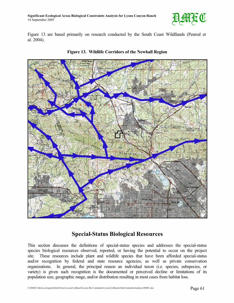
Significant Ecological Areas Biological Constraints Analysis for Lyons Canyon Ranch 14 September 2005
C:\DMEC\Jobs\LosAngeles\DalyOwens\LyonsCynRanch\Lyons Bio Constraints\LyonsCynRanch-BioConstraintsAnalysis-DMEC.doc Page 61
DMEC Figure 13 are based primarily on research conducted by the South Coast Wildllands (Penrod et al. 2004).
Figure 13. Wildlife Corridors of the Newhall Region
Special-Status Biological Resources
This section discusses the definitions of special-status species and addresses the special-status species biological resources observed, reported, or having the potential to occur on the project site. These resources include plant and wildlife species that have been afforded special-status and/or recognition by federal and state resource agencies, as well as private conservation organizations. In general, the principal reason an individual taxon (i.e. species, subspecies, or variety) is given such recognition is the documented or perceived decline or limitations of its population size, geographic range, and/or distribution resulting in most cases from habitat loss.

Significant Ecological Areas Biological Constraints Analysis for Lyons Canyon Ranch 14 September 2005
C:\DMEC\Jobs\LosAngeles\DalyOwens\LyonsCynRanch\Lyons Bio Constraints\LyonsCynRanch-BioConstraintsAnalysis-DMEC.doc Page 62
DMEC Definitions of Special-Status Biological Resources
Special-status Habitats are vegetation types, associations, or sub-associations that support concentrations of special-status plant or wildlife species, are of relatively limited distribution, or are of particular value to wildlife. Although special-status habitats are not afforded legal protection unless they support protected species, potential impacts on them may increase concerns and mitigation suggestions by resources agencies.
Special-status species are plants and animals that are at least one of the following: • Listed as endangered or threatened under Federal or California Endangered Species Acts, • Listed as rare under the California Native Plant Protection Act, or • Considered rare (but not formally listed) by resource agencies, professional
organizations (e.g. Audubon Society, CNPS, The Wildlife Society), and the scientific community.
For the purposes of this project, special-status species are defined in Table 4, Definitions of Special-Status Species.
Listed species are those taxa that are formally listed as endangered or threatened by the federal government (e.g. U.S. Fish and Wildlife Service), pursuant to the Federal Endangered Species Act or as endangered, threatened, or rare (for plants only) by the State of California (i.e. California Fish and Game Commission), pursuant to the California Endangered Species Act or the California Native Plant Protection Act.
The CNPS’ Inventory of Rare and Endangered Vascular Plants of California (CNPS 2001) categorizes rare California plants into one of five lists (1A, 1B, 2, 3, and 4) representing the five levels of species status, one of which is assigned to a sensitive species to indicate its status of rarity or endangerment and distribution. Table 5, California Native Plant Society List, provides a definition for each List code number. A CNPS List is a more general designation than the three separate sets of information provided in a CNPS R-E-D Code (defined in Table 6, California Native Plant Society R-E-D Code). However, the CNPS List is a significant designation in terms of a species’ overall status throughout all of California, and it works well in conjunction to the specifications of the R-E-D Code.

Significant Ecological Areas Biological Constraints Analysis for Lyons Canyon Ranch 14 September 2005
C:\DMEC\Jobs\LosAngeles\DalyOwens\LyonsCynRanch\Lyons Bio Constraints\LyonsCynRanch-BioConstraintsAnalysis-DMEC.doc Page 63
DMEC Table 4. Definitions of Special-Status Species
• Plants & animals legally protected under the California and Federal Endangered Species Acts or under other regulations.
• Plants and animals considered sufficiently rare by the scientific community to qualify for such listing; or
• Plants and animals considered to be sensitive because they are unique, declining regionally or locally, or are at the extent of their natural range.
Special-Status Plant Species Special-Status Animal Species
• Plants listed or proposed for listing as threatened or endangered under the Federal Endangered Species Act (50 CFR 17.12 for listed plants and various notices in Federal Register for proposed species).
• Plants that are Category 1 or 2 candidates for possible future listing as threatened or endangered under the Federal Endangered Species Act (55 CFR 6184, February 21, 1990).
• Plants that meet the definitions of rare or endangered species under the CEQA (State CEQA Guidelines, Section 15380).
• Plants considered by CNPS to be "rare, threatened, or endangered" in California (Lists 1B and 2 in CNPS 2001).
• Plants listed by CNPS as plants needing more information and plants of limited distribution (Lists 3 and 4 in CNPS 2001).
• Plants listed or proposed for listing by the State of California as threatened or endangered under the California Endangered Species Act (14 CCR 670.5).
• Plants listed under the California Native Plant Protection Act (California Fish and Game Code 1900 et seq.).
• Plants considered sensitive by other federal agencies (i.e. U.S. Forest Service, Bureau of Land Management) or state and local agencies or jurisdictions.
• Plants considered sensitive or unique by the scientific community; occurs at natural range limits (State CEQA Guidelines, Appendix G).
• Animals listed/proposed for listing as threatened/endangered under the Federal Endangered Species Act (50 CFR 17.11 for listed animals and various notices in Federal Register for proposed species).
• Animals that are Category 1 or 2 candidates for possible future listing as threatened or endangered under Federal Endangered Species Act (54 CFR 554).
• Animals that meet the definitions of rare or endangered species under the CEQA (State CEQA Guidelines, Section 15380).
• Animals listed or proposed for listing by the State of California as threatened and endangered under the California Endangered Species Act (14 CCR 670.5).
• Animal species of special concern to the CDFG (Remsen [1978] for birds; Williams [1986] for mammals).
• Animal species that are fully protected in California (California Fish & Game Code, Sections 3511 [birds], 4700 [mammals], 5050 [reptiles, amphibians]).

Significant Ecological Areas Biological Constraints Analysis for Lyons Canyon Ranch 14 September 2005
C:\DMEC\Jobs\LosAngeles\DalyOwens\LyonsCynRanch\Lyons Bio Constraints\LyonsCynRanch-BioConstraintsAnalysis-DMEC.doc Page 64
DMEC Table 5. California Native Plant Society List (CNPS List)
CNPS List Definition 1A Presumed Extinct in California 1B Rare or Endangered in California and elsewhere 2 Rare and Endangered in California, more common elsewhere 3 Need more information 4 Plants of Limited Distribution
The CNPS R-E-D Code is a three-numbered numeric ranking, which is assigned to a special-status species, consisting of one number (1, 2, or 3) for each of the three categories (Rarity-Endangerment-Distribution). Each number accurately describes the species’ population levels and distribution patterns within each category. The three number-codes are described for each category in Table 6, California Native Plant Society R-E-D Code, and is specific for each category.
Table 6. California Native Plant Society R-E-D Code
Rarity (R) 1 Rare, but found in sufficient numbers and distributed widely enough that the potential
for extinction is low at this time
2 Distributed in a limited number of occurrences, occasionally more if each occurrence is small
3 Distributed in one to several highly restricted occurrences, or present in such small numbers that it is seldom reported
Endangerment (E)
1 Not endangered
2 Endangered in a portion of its range
3 Endangered throughout its range
Distribution (D) 1 More or less widespread outside California
2 Rare outside California
3 Endemic to California
The CNDDB Element Ranking system provides a numeric global and state ranking system for all special-status species tracked by the CNDDB. The global rank (G-rank) is a reflection of the overall condition of an element (species or natural community) throughout its global range. The state rank (S-rank) is assigned much the same way as the global rank, except state ranks in California often also contain a threat designation attached to the S-rank. This Element Ranking system is defined below in Table 7, California Natural Diversity Database Element Ranking System.

Significant Ecological Areas Biological Constraints Analysis for Lyons Canyon Ranch 14 September 2005
C:\DMEC\Jobs\LosAngeles\DalyOwens\LyonsCynRanch\Lyons Bio Constraints\LyonsCynRanch-BioConstraintsAnalysis-DMEC.doc Page 65
DMEC Table 7. California Natural Diversity Database Element Ranking System
Global Ranking (G)
G1 Less than 6 viable elements occurrences (populations for species), OR less than 1,000 individuals, OR < 809.4 hectares (ha) (2,000 acres [ac]).
G2 6 to 20 element occurrences OR 809.4 to 4,047 ha (2,000 to 10,000 ac).
G3 21 to 100 element occurrences OR 3,000 to 10,000 individuals OR 4,047 to 20,235 ha (10,000 to 50,000 ac).
G4 Apparently secure; this rank is clearly lower than G3, but factors exist to cause some concern (i.e. there is some threat, or somewhat narrow habitat).
G5 Population, or stand, demonstrably secure to ineradicable due to being commonly found in the world.
GH All sites are historic; the element has not been seen for at least 20 years, but suitable habitat still exists.
GX All sites are extirpated; this element is extinct in the wild.
GXC Extinct in the wild; exists in cultivation.
G1Q The element is very rare, but there is a taxonomic question associated with it.
Subspecies Level: Subspecies receive a T-rank attached to the G-rank. With the subspecies, the G-rank reflects the condition of the entire species, whereas the T-rank reflects the global situation of just the subspecies or variety. * For example: Chorizanthe robusta var. hartwegii is ranked G2T1. The G-rank refers to the whole species range (Chorizanthe robusta), whereas the T -rank refers only to the global condition of the variety (var. hartwegii).
State Ranking (S)
S1 Less than 6 element occurrences OR less than 1,000 individuals OR less than 809.4 ha (2,000 ac).
S1.1 = very threatened S1.2 = threatened S1.3 = no current threats known
S2 6 to 20 element occurrences OR 3,000 individuals OR 809.4 to 4,047 ha (2,000 to 10,000 ac).
S2.1 = very threatened S2.2 = threatened S2.3 = no current threats known..
S3 21 to 100 element occurrences OR 3,000 to 10,000 individuals OR 4,047 to 20,235 ha (10,000 to 50,000 ac).
S3.1 = very threatened S3.2 = threatened S3.3 = no current threats known
S4 Apparently secure within California; this rank is clearly lower than S3 but factors exist to cause some concern (i.e., there is some threat, or somewhat narrow habitat). NO THREAT RANK.
S5 Demonstrably secure to ineradicable in California. NO THREAT RANK.
SH All California sites are historic; the element has not been seen for at least 20 years, but suitable habitat still exists.
SX All California sites are extirpated; this element is extinct in the wild.
Notes 1. Other considerations used when ranking a species or natural community include the pattern of distribution of the element on the landscape, fragmentation of the population/stands, and historical extent as compared to its modern range. It is important to take an aerial view when ranking sensitive elements rather than simply counting element occurrences.
2. Uncertainty about the rank of an element is expressed in two major ways: by expressing the rank as a range of values (e.g. S2S3 means the rank is somewhere between S2 and S3), and by adding a ? to the rank (e.g. S2?). This represents more certainty than S2S3, but less than S2.

Significant Ecological Areas Biological Constraints Analysis for Lyons Canyon Ranch 14 September 2005
C:\DMEC\Jobs\LosAngeles\DalyOwens\LyonsCynRanch\Lyons Bio Constraints\LyonsCynRanch-BioConstraintsAnalysis-DMEC.doc Page 66
DMEC Special-Status Biological Resources Survey Results
A search of the CNDDB RareFind3 (CDFG 2005) was conducted to report all tracked special-status species and habitats with potential to occur at the project site. Nine (9) California Quadrangles (USGS 7.5-minute Series Topographic Map) were queried for the CNDDB RareFind3 records search. Oat Mountain Quadrangle, in which the project site occurs, was searched, as well as all surrounding quadrangles, including Val Verde, Newhall, Mint Canyon, San Fernando, Van Nuys, Canoga Park, Calabasas, and Santa Susana. Figure 14, Special-Status Biological Resources Observed at Lyons Canyon Ranch, gives the locations of the special-status species and maps the sensitive habitats observed at the project site.
OBSERVED SPECIAL-STATUS PLANT SPECIES
Table 8, Special-Status Plant Species with Potential to Occur at Lyons Canyon Ranch, lists all special-status plant species with potential to occur onsite. Included in Table 8 is each species scientific name, common name, status, required habitat, and likelihood of occurrence. No federally or state listed plant species were observed at Lyons Canyon Ranch; however, five special-status plant species were observed onsite. In addition, seven (7) special-status plant species are considered likely to occur onsite, based on suitable required habitat present onsite A brief description of the special-status plant species observed during the focused survey are presented below (CNDDB 2005, BonTerra Consulting 2004). Voucher specimens were collected by BonTerra and/or Bowland & Associates for the Calystegia peirsonii, Calochortus plummerae, and Calochortus clavatus var. clavatus X Calochortus clavatus var. gracilis intermediate, and deposited in a herbarium at the Rancho Santa Ana Botanic Garden to ensure accuracy in identification. Calochortus clavatus var. gracilis (Slender Mariposa Lily) is a CNPS List 1B species. This perennial bulbiferous herb typically blooms between March and May. It is found in canyons below approximately 2,500 feet above msl in chaparral. All known occurrences are in Los Angeles County, with many locations in the Liebre Mountains. It is widespread, but only infrequently common locally in open scrub and especially on recent burns; it more or less freely grades into var. clavatus. Twenty-six (26) individuals of Calochortus clavatus var. gracilis were observed by Bowland & Associates in the middle portion of the project site on the southeast side of “Lyons Ranch Road” as well as in the southeastern corner of the project site just west of The Old Road (see Figure 14). Calochortus clavatus var. clavatus X Calochortus clavatus var. gracilis (Club-haired Mariposa Lily X Slender Mariposa Lily) is reported as observed onsite. Calochortus clavatus var. gracilis is described above. Calochortus clavatus var. clavatus is a CNPS List 4 species. This perennial bulbiferous herb typically blooms between May and June. It is found largely on soil of serpentine origin. This species prefers rocky slopes, chaparral, and open forest below approximately 4,300 feet above msl. It is widespread and locally common in open scrub and especially on recent burns. Approximately 600 individual intermediates (hybrids) observed by BonTerra Consulting in the northeastern portion of the project site south of Lyons Ranch Road (Figure 14). (Please note that individuals of Calochortus clavatus var. gracilis and C. clavatus var. clavatus X C. clavatus var. gracilis could very well be the same entity, since two different botanists reported these findings independently.)

Significant Ecological Areas Biological Constraints Analysis for Lyons Canyon Ranch 14 September 2005
C:\DMEC\Jobs\LosAngeles\DalyOwens\LyonsCynRanch\Lyons Bio Constraints\LyonsCynRanch-BioConstraintsAnalysis-DMEC.doc Page 67
DMEC Figure 14. Special-Status Biological Resources Observed at Lyons Canyon Ranch

Significant Ecological Areas Biological Constraints Analysis for Lyons Canyon Ranch 14 September 2005
C:\DMEC\Jobs\LosAngeles\DalyOwens\LyonsCynRanch\Lyons Bio Constraints\LyonsCynRanch-BioConstraintsAnalysis-DMEC.doc Page 68
DMEC Calochortus plummerae (Plummer’s Mariposa Lily) is a CNPS List 1B species. This perennial bulbiferous herb typically blooms between May and July. It is found in dry rocky places and in brush below approximately 5,000 feet above msl, in coastal sage scrub and yellow pine forest vegetation communities. It is locally scarce on rocky slopes and alluvial fans.
Twenty-six (26) individuals of Calochortus plummerae were observed by Bowland & Associates, and approximately 1,100 individuals were observed by BonTerra Consulting. These individuals were observed in the southeastern corner of the project site just west of The Old Road, in the mid-eastern portion of the project site, and in the northeastern portion near the intersection of The Old Road and Lyons Ranch Road (see Figure 14).
Calystegia peirsonii (Peirson’s Morning-glory) is a CNPS List 4 species. This perennial rhizomatous herb typically blooms between May and June. It is found on dry slopes from approximately 3,000 to 4,500 feet above msl, in creosote bush scrub and Joshua Tree Woodland vegetation communities. This species is a climbing vine also found in openings in Coastal Sage Scrub and chaparral, typically following a burn. Calystegia peirsonii occurs in the San Gabriel and Liebre Mountains and in the Antelope Valley. It was known only from a few collections prior to 1970 (Boyd 1999), but it is now believed to be more abundant in Coastal Sage Scrub throughout the Newhall-Mint Canyon region.
Occasional individuals were observed by BonTerra Consulting. No indication was made as to where this species was observed onsite (see Figure 14).
Juglans californica var. californica (Southern California Black Walnut) is a CNPS List 4 species. This perennial deciduous tree typically blooms between March and May. It is found on slopes, canyons and valleys from approximately 200 to 3,000 feet above msl. This species occurs in Orange County, and from western cismontane San Bernardino County to Ventura County.
Occasional individuals (a few small stands) were observed by BonTerra Consulting and DMEC in the southwestern corner of the project site (Figure 14).
Ambrosia confertiflora (Weakleaf Burweed) is a species of local concern. This small shrub usually blooms during the summer. It ranges spottily from San Francisco County south to San Diego County and inland to San Bernardino and Riverside Counties. The population onsite represent the northernmost known occurrence of Ambrosia confertiflora in Los Angeles County and one of only eight known populations (based on Jepson Herbarium database search) in the County. Only one likely extirpated population in Ventura County (Marr Ranch in Simi Valley – A.C. Sanders 22916 UCR).
Ericameria ericoides ssp. ericoides (Mock Heather) is a species of local concern. This small shrub typically blooms during the summer. It is found usually on stabilized sand dunes along the coast. This shrub ranges from Marin County south to Los Angeles County. Ericameria ericoides typically occurs along the coast and its presence this far inland represents a significant disjunction and extrallimital occurrence, and is therefore consider a locally rare species. It is possible that its presence along The Old Road represents a waif that was included in a hydroseed mulch applied for erosion control on the road cut immediately south of Lyon Canyon, along with the introduced Eriogonum fasciculatum var. fasciculatum at this site.
Navarretia hamata ssp. hamata (Skunk Navarretia) is a species of local concern. It is a small annual herb that blooms during the late spring and early summer. Navarretia hamata ssp. hamata ranges from Santa Cruz County south to San Diego County along the coast and inland

Significant Ecological Areas Biological Constraints Analysis for Lyons Canyon Ranch 14 September 2005
C:\DMEC\Jobs\LosAngeles\DalyOwens\LyonsCynRanch\Lyons Bio Constraints\LyonsCynRanch-BioConstraintsAnalysis-DMEC.doc Page 69
DMEC within Riverside and San Bernardino Counties below 500 meters. This taxon is treated as a locally rare species. It is considered a locally rare species in Ventura County (Magney 2005) and is not reported in the Liebre Mountains flora by Boyd (1999). No collections are reported this far north in Los Angeles County in the Jepson Herbarium online database for this variety.
SPECIAL-STATUS WILDLIFE SPECIES
Fifty (50) special status wildlife species have the potential to occur at the project site. Table 9, Special-Status Wildlife Species with Potential to Occur at Lyons Canyon Ranch, provides a summary of those 50 special-status wildlife species known to occur in the project region. Table 9 also provides information on the status, habitat requirements, and likelihood of occurrence.
No federal or state listed wildlife species were observed at Lyons Canyon Ranch; however, DMEC observed two special-status bird species, Cooper’s Hawk (Accipiter cooperi) and American Kestrel (Falco sparverius). Eleven (11) special-status wildlife species have a high likelihood of occurring onsite, based on suitable required habitat present onsite.
A brief description of the special-status wildlife species observed during the focused survey are presented below.
Cooper’s Hawk is a California Species of Concern. This raptor is an uncommon year-round resident in southern California. The Cooper’s Hawk prefers woodland habitats but can also be found in virtually any habitat during migration. Typical breeding habitat in southern California consists of riparian and oak woodlands, but it also nests in ornamental woodlands provided by parks and other urban habitats. This medium-sized hawk preys primarily on medium-sized birds and mammals. The project site provides suitable foraging, as well as nesting habitat for the Cooper’s Hawk. (BonTerra Consulting 2004.)
American Kestrel is a California Species of Concern. This raptor is one of the smallest falcons and is chestnut-colored except for its blue-gray wings and white face. It occurs in borders of woodlands, farmlands, open fields, pastures with scattered trees, marshes, suburban areas, grasslands, arid plains, deserts with giant cacti, wooded canyons, and forest openings to 4,400 meters in elevation. American Kestrel is often seen perched on wires along roads in rural areas. It hunts on the wing, often hovering, and often pumps its tail up and down upon landing. American Kestrel breeds in open or partly open habitats with scattered trees, also in cultivated and urban areas. It nests 12 to 80 feet high in trees or on cliff. The project site provides suitable hunting and nesting habitat for the American Kestrel. (http://www.birding.com/3553kes.asp.)
It should be noted also that a Barn Owl (Tyto alba) was observed flying from a nest in a Coast Live Oak tree onsite. The nest appeared to be occupied and active. Although Barn Owl has no protection as a species, all raptor nests are protected by the California Fish and Game Code Section 3503.5.
SENSITIVE HABITATS Table 10, Sensitive Habitats with Potential to Occur at Lyons Canyon Ranch, list the sensitive habitat types that are either unique, of relatively limited distribution in the region, or of particularly high wildlife value. These resources have been defined by Federal, State, and local government conservation programs. Table 10 lists 15 sensitive habitat types that are either unique, of relatively limited distribution in the region, or of particularly high wildlife value.

Significant Ecological Areas Biological Constraints Analysis for Lyons Canyon Ranch 14 September 2005
C:\DMEC\Jobs\LosAngeles\DalyOwens\LyonsCynRanch\Lyons Bio Constraints\LyonsCynRanch-BioConstraintsAnalysis-DMEC.doc Page 70
DMEC Table 8. Special-Status Plant Species with Potential to Occur at Lyons Canyon Ranch
Scientific Name27 Common Name Federal28 State G-Rank S-Rank CNPS List
CNPS R-E-D
Habitat Requirements29 Likelihood of Occurrence30
Ambrosia confertiflora Weakleaf Burweed - - G5 - - - Desert Scrub Known: Several individuals observed by Scott White.
Aster greatae Greata's Aster - - G2 S2.3 1B 2-1-3 Ch, OW Likely as suitable habitat is present and it occurs nearby.
Astragalus brauntonii Braunton’s Milkvetch E - G2 S2.1 1B 3-3-3 Cl-cCF, Ch, CSS, Gr Possible but not obaserved onsite.
Berberis nevinii Nevins’ Barberry E E G2 S2.2 1B 3-3-3 Ch, OW, CSS, RS
Unlikely as nearest occurrence consists of a naturalized population in San Francisquito Canyon planted by Theodore Payne in the 1930s (Boyd 1999).
Calochortus clavatus var. clavatus
Club-haired Mariposa Lily - - G4T3 S3.3 4 1-1-3 Ch, OW, Gr
Known: Approximately 600 individual intermediates (hybrids) of C. clavatus var. clavatus X C. clavatus var. gracilis reported as observed by BonTerra in the northeastern portion of the project site south of Lyons Ranch Road. However, individuals of C. clavatus var. clavatus X C. clavatus var. gracilis, C. clavatus var. clavatus, and/or C. clavatus var. gracilis
27 Bold = plant species known onsite. 28 Federal and State Listings: E = Endangered; T = Threatened; R = Rare; C = Candidate. For special-status species definitions see tables 4 through 7 above. 29 Habitat requirements definitions: AFSS = Alluvial Fan Sage Scrub; Cl-cCF = Closed-cone Coniferous Forest; Ch = Chaparral; ChenScrub = Chenopod Scrub; CSS =
Coastal Sage Scrub; Gr = Grassland; JTW = Joshua Tree Woodland; LMCF = Lower Montane Coniferous Forest; MDS = Mojavian Desert Scrub; OW = Oak (Cismontane) Woodland; PJW = Pinyon-Juniper Woodland; RS/W = Riparian Scrub/Woodland; so. Calif. = southern California.
30 Likelihood of occurrence based on species’ habitat requirements and the presence of required habitat in the project site. Known = the species has been reported as inhabiting or frequenting the project site; Likely = Required habitat exists at the project site and/or has been reported near by; Possible = Marginal required habitat exists onsite, and/or required habitat exists in surrounding areas; Unlikely = Required habitat does not exist at the project site nor does it exist nearby.

Significant Ecological Areas Biological Constraints Analysis for Lyons Canyon Ranch 14 September 2005
C:\DMEC\Jobs\LosAngeles\DalyOwens\LyonsCynRanch\Lyons Bio Constraints\LyonsCynRanch-BioConstraintsAnalysis-DMEC.doc Page 71
DMEC Scientific Name27 Common Name Federal28 State G-Rank S-Rank CNPS
List CNPS R-E-D
Habitat Requirements29 Likelihood of Occurrence30
could very well could be the same entity, since two different botanists reported these findings independently.
Calochortus clavatus var. gracilis Slender Mariposa Lily - - G4T1 S1.1? 1B 3-2-3 Ch, CSS
Known: 26 individuals of C. clavatus var. gracilis reported as observed by Bowland & Associates in the middle portion of the project site on the southeast side of Lyons Ranch Road as well as in the southeastern corner of the project site just west of The Old Road. Intermediates of C. clavatus var. clavatus X C. clavatus var. gracilis are reported as observed by BonTerra; however, individuals of C. clavatus var. clavatus X C. clavatus var. gracilis, C. clavatus var. clavatus, and/or C. clavatus var. gracilis could very well be the same entity, since two different botanists reported these findings independently.
Calochortus plummerae Plummer’s Mariposa Lily - - G3 S3.2 1B 2-2-3 CSS, Ch, Gr,
OW, LMCF
Known: 26 individuals observed by Bowland & Associates and approximately 1,100 individuals observed by BonTerra. These individuals were observed in the southeastern corner of the project site just west of The Old Road, in the mid-eastern portion of the project site, and in the northeastern portion near the intersection of The Old Road and Lyons Ranch Road.
Calystegia peirsonii Peirson’s Morning-glory - - G3 S3.2 4 1-2-3 Ch, CSS, ChenScrub, OW, LMCF
Known: Occasional individuals reported as observed by BonTerra Consulting. No indication was made as to where this species was observed onsite.
Chorizanthe parryi var. fernandina
San Fernando Valley Spineflower C E G2T1 S1.1 1B 3-3-3 CSS Possible but not observed during botanical
surveys.
Deinandra minthornii Santa Susana Tarplant - R G2 S2.2 1B 2-2-3 Ch, CSS Unlikely as preferred substrate not present onsite.
Dodecahema leptoceras Slender-horned Spineflower E E G1 S1.1 1B 3-3-3 Ch, CSS (AFSS) Possible
Dudleya blochmaniae ssp . blochmaniae Blochman's Dudleya - - G2T2 S2.1 1B 2-3-2 CSS, coastal bluff
scrub, Gr Unlikely as suitable habitat is not present onsite.

Significant Ecological Areas Biological Constraints Analysis for Lyons Canyon Ranch 14 September 2005
C:\DMEC\Jobs\LosAngeles\DalyOwens\LyonsCynRanch\Lyons Bio Constraints\LyonsCynRanch-BioConstraintsAnalysis-DMEC.doc Page 72
DMEC Scientific Name27 Common Name Federal28 State G-Rank S-Rank CNPS
List CNPS R-E-D
Habitat Requirements29 Likelihood of Occurrence30
Dudleya multicaulis Many-stemmed Dudleya - - G2 S2.1 1B 1-2-3 Ch, CSS, Gr Possible
Ericameria ericoides ssp. ericoides Mock Heather - - G3? S3.2? Locally
rare - Dune Scrub, CSS
Known: Rare along The Old Road south of mouth of Lyon Canyon. This population represents a disjunct, interior population not typical for this species.
Erodium macrophyllum Round-leaved Filaree - - G4 S2.1 2 2-3-1 Cismontane woodland, Gr Likely as suitable habitat is present onsite.
Harpagonella palmeri var. palmeri Palmer’s Grapplinghook - - G4 S3.2 4 1-2-1 Ch, CSS, Gr Possible
Helianthus nuttallii ssp . parishii Los Angeles Sunflower - - G5TH SH 1A -
Coastal salt and fresh-water marshes and swamps
Unlikely Presumed extinct. Historical from So. California.
Horkelia cuneata ssp . puberula Mesa Horkelia - - G4T2 S2.1 1B 2-3-3 Ch, OW, CSS Likely as suitable habitat is present onsite.
Juglans californica var. californica
Southern California Black Walnut - - G3 S3.2 4 1-2-3 Ch, CSS, OW
Known: Occasional individuals observed by BonTerra Consulting and DMEC in the southwestern corner of the project site.
Lepidium virginicum var. robinsonii Robinson’s Peppergrass - - G5T2? S2.2 1B 3-2-2 Ch, CSS Likely as suitable habitat is present onsite.
Malacothamnus davidsonii
Davidson’s Bush Mallow - - G1 S1.1 1B 2-2-3 CSS, RW, Ch Likely as suitable habitat is present onsite.
Navarretia fossalis Spreading Navarretia T - G2 S2.1 1B 2-3-2
Vernal pools, ChenScrub, marshes & swamps, playas
Unlikely as suitable habitat is not present onsite.
Navarretia hamata ssp. hamata Skunk Navarretia - - G4?T4? - - - CSS, Ch, OW Known: few plants found onsite within
Lyon Canyon.
Nolina cismontana Chaparral Nolina - - G1 S1.1 1B 3-2-3 Ch, CSS Likely as suitable habitat is present onsite.
Opuntia basilaris var. brachyclada Short-joint Beavertail - - G5T1 S1.2 1B 3-2-3 Ch, JTW, MDS,
PJW, RW Unlikely as suitable habitat is not present onsite.
Orcuttia californica California Orcutt Grass E E G2 S2.1 1B 3-3-2 Vernal pools Unlikely as suitable habitat is not present onsite.
Senecio aphanactis Rayless Ragwort - - G3? S1.2 2 3-2-1 OW, CSS Likely as suitable habitat is present onsite.

Significant Ecological Areas Biological Constraints Analysis for Lyons Canyon Ranch 14 September 2005
C:\DMEC\Jobs\LosAngeles\DalyOwens\LyonsCynRanch\Lyons Bio Constraints\LyonsCynRanch-BioConstraintsAnalysis-DMEC.doc Page 73
DMEC Table 9. Special-Status Wildlife Species with Potential to Occur at Lyons Canyon Ranch
Scientific Name Common Name31 Fed.32 State G-Rank
S-Rank CDFG Habitat Requirements33 Likelihood of
Occurrence34 FISH
Catostomus santaanae Santa Ana Sucker T - G1 S1 SC Endemic to Los Angeles basin south coastal streams. Unlikely
Gasterosteus aculeatus williamsoni
Unarmored Threespine Stickleback
E E G5T1 S1 - Weedy pools, backwaters, and among emergent vegetation at the stream edge in small so. Calif. streams. Unlikely
Gila orcutti Arroyo Chub - - G2 S2 SC Los Angeles basin south coastal streams. Unlikely AMPHIBIANS
Bufo californicus Arroyo Toad E - G2G3 S2S3 SC Semi-arid regions near washes or intermittent streams, including valley-foothill and desert riparian, desert wash, etc. Possible
Rana aurora draytonii California Red-legged Frog T - G4T2
T3 S2S3 SC Lowlands & foothills in or near permanent sources of deep water with dense, shrubby or emergent riparian vegetation. Unlikely
Rana muscosa Mountain Yellow-legged Frog E - G2 S2 SC
Federal listing refers to populations in the San Gabriel, San Jacinto & San Bernardino Mtns only. Unlikely
Spea (=Scaphiopus) hammondii Western Spadefoot - - G3 S3 SC
Occurs primarily in Gr habitats, but can be found in valley-foothill hardwood woodlands in the Central Valley and Coast Ranges from Point Conception, Santa Barbara County south to San Diego County. Rarely observed outside of the breeding season. They breed in vernal pools and other ponds. Has declined substantially throughout its range.
Possible
31 * = Nesting habitat protected. ** = Wintering site protected. 32 Federal and State Listings: E = Endangered; T = Threatened; R = Rare; C = Candidate. CDFG Listing: SC = California Species of Concern; FP = Fully Protected.
For special-status species definitions see tables 4 through 7 above. 33 Habitat requirements definitions: Ch = Chaparral; CSS = Coastal Sage Scrub; Gr = Grassland; JTW = Joshua Tree Woodland; PJW = Pinyon-Juniper Woodland;
RS/W = Riparian Scrub/Woodland; so. Calif. = southern California. 34 Likelihood of occurrence based on species’ habitat requirements and the presence of required habitat in the project site.
Known = the species has been reported as inhabiting or frequenting the project site; Likely = Required habitat exists at the project site and/or has been reported nearby; Possible = Marginal required habitat exists onsite, and/or required habitat exists in surrounding areas; Unlikely = Required habitat does not exist at the project site nor does it exist nearby.

Significant Ecological Areas Biological Constraints Analysis for Lyons Canyon Ranch 14 September 2005
C:\DMEC\Jobs\LosAngeles\DalyOwens\LyonsCynRanch\Lyons Bio Constraints\LyonsCynRanch-BioConstraintsAnalysis-DMEC.doc Page 74
DMEC Scientific Name Common Name31 Fed.32 State G-
Rank S-
Rank CDFG Habitat Requirements33 Likelihood of
Occurrence34 Taricha torosa torosa Coast Range Newt - - G5T4 S4 SC Coastal drainages from Mendocino County to San Diego County. Unlikely
REPTILES
Anniella pulchra pulchra
Silvery Legless Lizard - - G3G4T
3T4Q S3 SC
Sandy or loose loamy soils under sparse vegetation. Found beneath soil, under stones, logs, debris, or in leaf litter. Inhabits areas with moist soil including dry washes, woodlands, riparian, and scrub types at < 5,000 feet above msl within the Coast, Transverse, and Peninsular ranges and northwestern Baja Calif.
Likely
Aspidoscelis tigris stejnegeri
Coastal Western Whiptail - - G5T3
T4 S2S3 -
Found in deserts & semiarid areas w/sparse vegetation and open areas. Also found in woodland & riparian areas in sandy or gravelly substrate. Occurs in the coastal region of so. Calif. south to central Baja Calif., Mexico. Prey includes terrestrial insects. Has apparently declined due to loss of habitat.
Likely
Emys (=Clemmys) marmorata pallida
Southwestern Pond Turtle
- E G3G4T2T3Q S2 SC
Inhabits permanent or nearly permanent bodies of water in many habitat types; below 6,000 ft elev. Occurs in freshwater rivers, streams, lakes, ponds, vernal pools, and seasonal wetlands requiring water depths >6 feet and basking sites such as logs & banks. Occurs from Monterey Bay south through the Coast Ranges to northern Baja Calif. Current range is similar to the historic range, but populations fragmented by agriculture and urban development.
Unlikely
Phrynosoma coronatum (blainvillei)
San Diego Horned Lizard - - G4T3
T4 S2S3 SC
Inhabits open CSS and Ch in arid and semi-arid climate conditions. Prefers loose, friable soil for burrowing. Has declined due to loss of habitat, over-collecting, and introduction of exotic ants. Occurs in Transverse Ranges in Kern, Los Angeles, Santa Barbara, and Ventura counties southward into the Peninsular Ranges to Baja Calif.
Likely
Salvadora hexalepis virgultea
Coast Patch-nosed Snake
- - G5T3 S2S3 SC
Brushy or shrubby vegetation in coastal so. Calif. Its Calif. range is from SLO and Kern counties south to San Diego County. Inhabits open sandy areas with rocky outcrops within scrub, grassland, and woodland vegetation types. It occurs < 7,000 feet in elevation. Nearest known populations to project site are in the watershed of Santa Clara River.
Likely
Thamnophis hammondii
Two-striped Garter Snake - - G3 S2 SC
Coastal Calif. from vicinity of Salinas to northwest Baja Calif. From sea to about 7,000 ft elevation. Occurs from Monterey County south to northwest Baja Calif. This highly aquatic snake occurs in freshwater marsh and riparian habitats with perennial water. Prey consists of small fishes, frogs, and tadpoles. The nearest known populations to the project site are in the watershed of the Santa Clara River.
Possible

Significant Ecological Areas Biological Constraints Analysis for Lyons Canyon Ranch 14 September 2005
C:\DMEC\Jobs\LosAngeles\DalyOwens\LyonsCynRanch\Lyons Bio Constraints\LyonsCynRanch-BioConstraintsAnalysis-DMEC.doc Page 75
DMEC Scientific Name Common Name31 Fed.32 State G-
Rank S-
Rank CDFG Habitat Requirements33 Likelihood of
Occurrence34 BIRDS
Accipiter cooperii Cooper’s Hawk* - - G5 S3 SC
(Nesting) woodland, chiefly of open, interrupted or marginal. An uncommon year-round resident in so. Calif. Prefers woodland habitats but can also be found in virtually any habitat during migration. Typical breeding habitat in so. Calif. consists of riparian and oak woodlands, but also nests in ornamental woodlands provided by parks.
Known
Accipiter striatus Sharp-shinned Hawk* - - G5
(Nesting) Ponderosa Pine, Black Oak, RW, mixed conifer & Jeffrey Pine habitats. Prefers riparian areas. Fairly common winter resident in so. Calif. and a rare summer resident in the mountains.
Possible
Agelaius tricolor Tricolored Blackbird* - - G5 S3 SC
(Nesting colony) highly colonial species, most numerous in Central Valley & vicinity. Endemic to Calif. Unlikely
Aimophila ruficeps canescens
Southern California Rufous-crowned Sparrow
- - G5T2T4 S2 SC
Resident in so. Calif. CSS and sparse Mixed Ch. Prefer slopes with rock outcroppings. Present throughout the year in so. Calif. Likely
Amphispiza belli ssp . belli Bell’s Sage Sparrow* - - G5T2
T4 S2? SC
(Nesting) nests in Ch dominated by fairly dense stands of Chamise. Found in CSS, often with stands of cactus (Opuntia sp.), in south of range. An uncommon to fairly common local resident in the interior foothills of coastal so. Calif.
Likely
Aquila chrysaetos Golden Eagle*
Federal Bald Eagle Act .
- G5 S3 SC, FP (Nesting & wintering) rolling foothills mountains, sage-juniper flats, desert. Uncommon year-round resident in so. Calif. Typically nests on rocky cliff ledges or trees, but also rarely on the ground.
Possible
Asio flammeus Short-eared Owl - - G5 S3 SC (Nesting) found in swamplands, both fresh and salt; lowland meadows; irrigated alfalfa fields.
Unlikely
Asio otus Long-eared Owl* - - G5 S3 SC
(Nesting) riparian bottomlands grown to tall willows & cottonwoods; also, belts of oak paralleling stream courses. Uncommon resident in the deserts, and is quite rare coastally. Declined throughout Calif., but the most pronounced reductions have occurred in the southwestern part of the state with a minimum 55 percent decline.
Likely
Athene cunicularia Western Burrowing Owl - - G4 S2 SC
(Burrow sites) open, dry annual or per. Gr, deserts & scrublands characterized by low-growing vegetation. Possible
Buteo regalis Ferruginous Hawk** - - G4 S3S4 SC
(Wintering) open Gr, sagebrush flats, desert scrub, low foothills & fringes of PJW. Occurs as a winter resident in Calif. Occupies open, dry habitats such as grasslands, shrublands, rangelands, and, in winter, plowed agricultural fields.
Possible: unlikely to nest onsite, but may
occur as rare migrant

Significant Ecological Areas Biological Constraints Analysis for Lyons Canyon Ranch 14 September 2005
C:\DMEC\Jobs\LosAngeles\DalyOwens\LyonsCynRanch\Lyons Bio Constraints\LyonsCynRanch-BioConstraintsAnalysis-DMEC.doc Page 76
DMEC Scientific Name Common Name31 Fed.32 State G-
Rank S-
Rank CDFG Habitat Requirements33 Likelihood of
Occurrence34
Buteo swainsoni Swainson’s Hawk* - - G5 S2 - (Nesting) breeds in stands with few trees in juniper-sage flats, riparian areas and in oak savannah.
Possible
Campylorhynchus brunneicapillus sandiegensis
Coastal Cactus Wren - T G5T2T3Q S2S3 SC
So. Calif. CSS. Wrens require tall Opuntia cactus for nesting and roosting. Unlikely
Circus cyaneus Northern Harrier* - - G5 S3 SC
(Nesting) coastal salt & freshwater marsh. Nest & forage in Gr, from Saltgrass in desert sink to mountain cienagas. Fairly common winter resident in so. Calif., but a very scarce and local breeder. Nests on the ground in a variety of wetland and upland habitats.
Likely
Coccyzus americanus occidentalis
Western Yellow-billed Cuckoo* C - G5T2
Q S1 - (Nesting) riparian forest nester, along the broad, lower flood-bottoms of larger river systems. Unlikely
Dendroica petechia brewsteri
Western Yellow Warbler* - - G5T3? S2 SC
(Nesting) riparian plant associations. Prefers Salix, Populus, Platanus, & Alnus for nesting & foraging. Possible
Elanus leucurus White-tailed Kite* - - G5 S3 -
(Nesting) rolling foothills/valley margins w/scattered oaks & river bottomlands or marshes next to deciduous woodland. Uncommon locally, but fairly common year-round resident on the coast of so. Calif. Requires open habitats, such as grasslands, marshlands, and agricultural fields with nearby trees for perching and nesting.
Possible
Empidonax traillii extimus
Southwestern Willow Flycatcher* E - G5T1
T2 S1 -
(Nesting) RW in so. Calif. State listing includes all subspecies. Declined drastically due to a loss of breeding habitat and nest parasitism by Brown-headed Cowbirds. This species occurs in riparian habitats along rivers, streams, or other wetlands. On 12 October 2004, USFWS published a Final Rule designating critical habitat for this species. Approximately 99.8 river miles in Kern, Riverside, San Bernardino, and San Diego counties were designated for this species. The project site is not located within the designated critical habitat area for Southwestern Willow Flycatcher.
Unlikely Suitable riparian
habitat minimal for nesting
requirements.
Eremophila alpestris actia
California Horned Lark - - G5T3 S3 SC
Coastal regions, chiefly from Sonoma to San Diego Co. Also main part of San Joaquin Valley & east to foothills. In so. Calif., this subspecies is a fairly common breeding resident in grasslands and dry, open habitats.
Unlikely
Falco columbarius Merlin** - - G5 S3 SC
(Wintering) seacoast, tidal estuaries, open woodlands, savannahs, edges of Gr & deserts, farms & ranches. Uncommon fall migrant and rare winter resident in so. Calif. It prefers open to semi-open habitat for breeding and foraging.
Possible

Significant Ecological Areas Biological Constraints Analysis for Lyons Canyon Ranch 14 September 2005
C:\DMEC\Jobs\LosAngeles\DalyOwens\LyonsCynRanch\Lyons Bio Constraints\LyonsCynRanch-BioConstraintsAnalysis-DMEC.doc Page 77
DMEC Scientific Name Common Name31 Fed.32 State G-
Rank S-
Rank CDFG Habitat Requirements33 Likelihood of
Occurrence34
Falco mexicanus Prairie Falcon* - - G5 S3 SC
(Nesting) inhabits dry, open terrain, either level or hilly. Uncommon year-round resident in the interior of so. Calif. An increasingly scarce winter resident and very rare summer resident along the coast of so. Calif. Prefers dry open habitats such as grasslands and ag fields.
Possible
Falco sparverius American Kestrel* - - - - SC
Occurs in borders of woodlands, farmlands, open fields, pastures with scattered trees, marshes, suburban areas, grasslands, arid plains, deserts with giant cacti, wooded canyons, and forest openings to 4400 meters in elevation. Breeds in open habitats with scattered trees, also in cultivated and urban areas. Nests at 12 to 80 feet in trees or on cliff.
Known
Icteria virens Yellow-breasted Chat -- - G5 S3 SC (Nesting) summer resident; inhabits riparian thickets of willow & other brushy tangles near watercourses.
Unlikely
Lanius ludovicianus Loggerhead Shrike - - G4 S4 SC
(Nesting) broken woodlands, savannah, PJW, JTW, & RW, desert oases, scrub & washes. Widely distributed across North America but has declined throughout most of its range in recent decades. Has recently declined in its Calif. population. Found perched on fences and posts from which prey items can be seen hanging from a sharp object such as a barb-wired fence.
Likely
Polioptila californica californica
Coastal California Gnatcatcher T - G3 S2 SC
Obligate, permanent resident of several distinct alliances of CSS below 2500 ft in so. Calif. Brood parasitism by Brown-headed Cowbird and loss of habitat to urban development have caused population decline. On 24 October 2000, USFWS published a Final Rule to designate critical habitat for this species. On 24 April 2003, the USFWS published a Proposed Rule re-evaluating the boundaries; they proposed to designate 495,795 acres of land as critical habitat. The project site is not located within either the designated or proposed critical habitat areas for Coastal California Gnatcatcher.
Possible: Prior to Simi Fire,
project site provided suitable
CSS habitats. When suitable CSS recovers
onsite, focused surveys are
recommended.
Tyto alba Barn Owl - - - - Nest35 -
Known: Observed by
DMEC flying from active nest
35 One barn Owl was observed by DMEC flying from a nest in Coast Live Oak tree onsite. The nest appeared occupied and active. Although Barn Owl has no protection,
all raptor nests are protected by California Fish and Game Code Section 3503.5.

Significant Ecological Areas Biological Constraints Analysis for Lyons Canyon Ranch 14 September 2005
C:\DMEC\Jobs\LosAngeles\DalyOwens\LyonsCynRanch\Lyons Bio Constraints\LyonsCynRanch-BioConstraintsAnalysis-DMEC.doc Page 78
DMEC Scientific Name Common Name31 Fed.32 State G-
Rank S-
Rank CDFG Habitat Requirements33 Likelihood of
Occurrence34
Vireo bellii pusillus Least Bell’s Vireo* E E G5T2 S2 -
(Nesting) summer resident of so. Calif. in low riparian near water or dry river bottoms; < 2000 ft. Breeds primarily in riparian habitats dominated by willows (Salix spp.) with dense understory vegetation. A dense shrub layer two to ten feet above ground is the most important habitat characteristic for this species. On 2 February 1994, the USFWS published a final critical habitat for this species, designating approx. 37,560 acres of land in Santa Barbara, Ventura, Los Angeles, San Bernardino, Riverside, and San Diego counties, Calif. The project site is not located within the designated critical habitat area.
Unlikely: Simi Fire took
suitable habitat. When suitable
riparian habitat recovers onsite, focused surveys
for this species is recommended.
MAMMALS
Antrozous pallidus Pallid Bat - - G5 S3 SC
Deserts, Gr, shrublands, woodlands & forests. Most common in open, dry habitats with rocky areas for roosting. A locally common year-round resident at low elevations throughout most of Calif. Forages primarily on the ground for large insects. Roosting habitat consists of caves, crevices, mines, and occasionally hollow trees and buildings.
Possible
Corynorhinus townsendii pallescens
Pale Big-eared Bat - E G4T4 S2S3 SC
Lives in a wide variety of habitats but most common in mesic sites. One of two subspecies of Townsend’s Big-eared Bat that occurs throughout most of Calif. Pale Big-eared Bat occurs in the southern part of the state and occupies a variety of habitats including oak woodlands, arid deserts, grasslands, and high-elevation forests and meadows. Known roosting sites in Calif. include mine tunnels, limestone caves, lava tubes, and buildings. The roosts support larger breeding colonies and are especially susceptible to disturbance.
Possible
Euderma maculatum Spotted Bat - - G4 S2S3 SC Occupies a wide variety of habitats from arid deserts and Gr through mixed conifer forests. Feeds over water and along washes. Needs rock crevices in cliffs or caves for roosting.
Unlikely
Eumops perotis californicus Western Mastiff Bat - - G5T4 S3? SC
Many open, semi-arid to arid habitats, including conifer & deciduous woodlands, CSS, Gr, & Ch. An uncommon year-round resident at low elevations in California. The largest bat in North America, roosts in small colonies in crevices on cliff faces or very large boulders. This species forages over far distances from roost sites and can forage as high as 2,000 feet above ground.
Likely
Eumops perotis californicus Western Mastiff Bat - - G5T4 S3? SC
Many open, semi-arid to arid habitats, including conifer & deciduous woodlands, CSS, Gr., Ch. etc. Roosts in crevices in cliff faces, high buildings, trees, & tunnels.
Likely
Lepus californicus bennettii
San Diego Black-tailed Jackrabbit - - G5T3? S3? SC
Intermediate canopy stages of shrub habitats & open shrub / herbaceous & tree / herbaceous edges. Possible

Significant Ecological Areas Biological Constraints Analysis for Lyons Canyon Ranch 14 September 2005
C:\DMEC\Jobs\LosAngeles\DalyOwens\LyonsCynRanch\Lyons Bio Constraints\LyonsCynRanch-BioConstraintsAnalysis-DMEC.doc Page 79
DMEC Scientific Name Common Name31 Fed.32 State G-
Rank S-
Rank CDFG Habitat Requirements33 Likelihood of
Occurrence34
Macrotus californicus California Leaf-nosed Bat - - G4 S2S3 SC
Desert riparian, desert wash, desert scrub, desert succulent scrub, alkali scrub & palm oasis habitats. Known to occur from Riverside, Imperial, San Diego, and San Bernardino counties south to the Mexican border. Former populations have disappeared from coastal basins, in Los Angeles to San Diego counties. Prefers to roost in caves and mines, but may also roost in bridges or buildings.
Possible
Myotis yumanensis Yuma Myotis - - G5 S4? -
Optimal habitats are open forests & woodlands w/sources of water over which to feed. A common and widespread year-round resident in Calif. Found near ponds, stream, and lakes. Roosting habitat consists of buildings, mines, caves, crevices, and under bridges.
Possible
Neotoma lepida intermedia
San Diego Desert Woodrat - - G5T3? S3? SC
Coastal so. Calif. from San Diego to San Luis Obispo Counties. Occupies arid areas with sparse vegetation. This subspecies of desert woodrat is restricted to the Pacific slope in a range that stretches from SLO County to northwestern Baja Calif.
Likely
Onychomys torridus ramona
Southern Grasshopper Mouse - - G5T3? S3? SC
Desert areas, especially scrub habitats with friable soils for digging. Prefers low to moderate shrubs. Possible
INVERTEBRATES
Danaus plexippus Monarch Butterfly - - G5 S3 - Winter roost sites extend along the coast from northern Mendocino to Baja Calif., Mexico. Possible

Significant Ecological Areas Biological Constraints Analysis for Lyons Canyon Ranch 14 September 2005
C:\DMEC\Jobs\LosAngeles\DalyOwens\LyonsCynRanch\Lyons Bio Constraints\LyonsCynRanch-BioConstraintsAnalysis-DMEC.doc Page 80
DMEC Fourteen (14) of them are tracked by CNDDB (2005), while Coast Live Oak Woodland is protected by the Los Angeles County Oak Tree Ordinance. Eight (8) of those 15 sensitive habitat types were observed onsite by DMEC biologists.
Table 10 provides the Holland classification used by CNDDB as well as the Sawyer and Keeler-Wolf (1995) classification. Refer to the Habitat Description section (above) for complete descriptions of the sensitive habitat types that were identified within the project site, including:
• Cismontane Alkali Marsh (Distichlis spicata Alliance); • Southern Riparian Scrub (Baccharis salicifolia-Sambucus mexicana Alliance); • Southern Mixed Riparian Forest (Salix lasiolepis Alliance and Salix laevigata Alliance); • Valley Needlegrass Grassland (Nassella pulchra Alliance); • Coastal Sage Scrub (a general description of Coastal Sage Scrub is provided in the Habitat Description
section as well as the following inclusions - Sambucus mexicana-Salvia leucophylla Alliance, Salvia leucophylla Alliance, and Salvia apiana Alliance);
• Southern California Black Walnut Woodland (Juglans californica var. californica Alliance); • Coast Live Oak Woodland (Quercus agrifolia Alliance); and • Coast Live Oak Riparian Woodland (Quercus agrifolia Alliance).
Table 10. Sensitive Habitats with Potential to Occur at Lyons Canyon Ranch
Habitat Name (Holland 1986, CNDDB 2005)
Alliance Name Described Above in Habitat
Descriptions (Sawyer and Keeler-Wolf
(1995)
G-Rank36
S-Rank
Likelihood of Occurrence
Southern California Threespine Stickleback Stream
- G? S? Not observed, and highly unlikely to occur onsite.
Cismontane Alkali Marsh Distichlis spicata Alliance G2 S2.1
Observed onsite. Dense patches of Distichlis spicata Alliance were observed on the boundary of riparian communities; however, the characteristic associate species for Cismontane Alkali Marsh were not present.
Southern Riparian Scrub Baccharis salicifolia Alliance Sambucus mexicana Alliance
G3 S3.2 Observed onsite
Riversidian Alluvial Fan Sage Scrub
- G1 S1.1 Not observed, but could possibly occur onsite.
Southern Willow Scrub - G3 S2.1 Not observed, but could possibly occur onsite.
Southern Mixed Riparian Forest
Salix lasiolepis Alliance Salix laevigata Alliance
G2 S2.1 Observed onsite
Southern Cottonwood Willow Riparian Forest
- G3 S3.2 Not observed, and unlikely to occur onsite.
Southern Sycamore Alder Riparian Woodland
- G4 S4 Not observed, but could potentially occur onsite, especially after several years of wildfire succession.
Southern Coast Live Oak Riparian Forest
Quercus agrifolia Alliance G4 S4 Observed onsite.
36 For special-status definitions see tables 4 through 7above.

Significant Ecological Areas Biological Constraints Analysis for Lyons Canyon Ranch 14 September 2005
C:\DMEC\Jobs\LosAngeles\DalyOwens\LyonsCynRanch\Lyons Bio Constraints\LyonsCynRanch-BioConstraintsAnalysis-DMEC.doc Page 81
DMEC Habitat Name
(Holland 1986, CNDDB 2005)
Alliance Name Described Above in Habitat
Descriptions (Sawyer and Keeler-Wolf
(1995)
G-Rank36
S-Rank
Likelihood of Occurrence
Coast Live Oak Woodland Quercus agrifolia Alliance n/a n/a Observed onsite.
Valley Needlegrass Grassland
Nassella pulchra Alliance G1 S3.1 Observed onsite in patches bordering Coastal Sage Scrub and Annual Grassland communities.
Coastal Sage Scrub
Sambucus mexicana-Salvia leucophylla Alliance Salvia leucophylla Alliance Salvia apiana Alliance
n/a n/a Observed onsite.
California Walnut Woodland Juglans californica var. californica Alliance
G2 S2.1 Observed onsite.
Mainland Cherry Forest Prunus ilicifolia Alliance G1 S1.1 Not observed, and unlikely to occur onsite.
Valley Oak Woodland Quercus lobata Alliance G3 S2.1
Not observed, and unlikely to occur onsite; only scattered, emergent Valley Oak observed in Coast Live Oak Riparian Woodland

Significant Ecological Areas Biological Constraints Analysis for Lyons Canyon Ranch 14 September 2005
C:\DMEC\Jobs\LosAngeles\DalyOwens\LyonsCynRanch\Lyons Bio Constraints\LyonsCynRanch-BioConstraintsAnalysis-DMEC.doc Page 82
DMEC SECTION 3.
CHARACTERISTICS OF SURROUNDING AREA
EXISTING LAND USES
The general condition of the Lyons Canyon Ranch project site is influenced by several factors. Although the approximate 235-acre project site is predominantly open space and is undeveloped, with no active land uses currently, the project site has been influenced greatly by humans for many years. Historically, the property was used as an outdoor set for film-making, such as for the television series “Starsky and Hutch”. Although undeveloped, the site is transected by numerous dirt roads, which were created for various television and film productions. The project site is scattered with film props and portions of the property (lower elevations) have been graded for filming purposes as well. Additionally, the project site includes fencing and an abandoned water tank, water wells, and irrigation lines. Other utility structures, such as Southern California Edison electrical distribution lines, are adjacent to or traverse portions of the site.
Additional commercial uses in adjacent areas, such as restaurants, gas stations, grocery stores, and local shops, are located nearby approximately a half-mile north of the site near the Lyon Canyon Road/I-5 interchange. Six Flags Magic Mountain amusement park is located approximately five miles north west of I-5.
OPEN SPACE RESERVES Ed Davis Park in Towsley Canyon (otherwise known as Towsley Canyon Park) is a subset of the Santa Clarita Woodsland Park, and is an open space reserve located immediately to the south of Lyons Canyon Ranch. Other than Ed Davis Park, Lyon Canyon includes the majority of the remaining open space, including SEAs, as illustrated on Figure 15, Existing Land Uses, Including Open Space Reserves, in Areas Surrounding Lyons Canyon Ranch.
The County of Los Angeles defines two SEAs in the general area of the project: the Lyon Canyon SEA (SEA No. 63), and the Santa Susana Mountains SEA (SEA No. 20), portions of which are located within the project boundaries. As such, these portions of the project site are designated with an SEA Overlay designation in the County’s General Plan: the Lyon Canyon SEA Overlay and the Santa Susana Mountains SEA Overlay, respectively. These SEAs are areas that the County of Los Angeles has designated as ecologically fragile or important land, and water areas that are valuable as plant or animal communities.
The Lyon Canyon SEA is not precisely defined, but is described as covering approximately 61 acres in a relatively narrow canyon that contains both an oak woodland community and a substantial Chamise Chaparral community. The oak woodland, found in the southern portion of the Lyon Canyon SEA, contains both Quercus agrifolia and Quercus lobata (Valley Oak) trees. The northern portion of the SEA contains the Chamise Chaparral community consisting of Rhus ovata (Sugarbush), Ceanothus crassifolius (Snowball Ceanothus), Salvia mellifera, Baccharis salicifolia, and Adenostoma fasciculatum, which is the dominant shrub.

Significant Ecological Areas Biological Constraints Analysis for Lyons Canyon Ranch 14 September 2005
C:\DMEC\Jobs\LosAngeles\DalyOwens\LyonsCynRanch\Lyons Bio Constraints\LyonsCynRanch-BioConstraintsAnalysis-DMEC.doc Page 83
DMEC Figure 15. Existing Land Uses, Including Open Space Reserves
in Areas Surrounding Lyons Canyon Ranch

Significant Ecological Areas Biological Constraints Analysis for Lyons Canyon Ranch 14 September 2005
C:\DMEC\Jobs\LosAngeles\DalyOwens\LyonsCynRanch\Lyons Bio Constraints\LyonsCynRanch-BioConstraintsAnalysis-DMEC.doc Page 84
DMEC SURROUNDING BIOLOGICAL RESOURCES
This section discusses the surrounding biological resources in terms of the surrounding existing general vegetation types, how Lyons Canyon Ranch relates with the surrounding biotic mosaic, general species population sizes in the range, and the overall biological value of the area. Understanding the relationships between the project site and the surrounding environment are significant in understanding connectivity and fragementation of habitats and wildife resources, migration corridors, and gene pools.
Surrounding Vegetation The uses surrounding the project site are I-5 on the east, Ed Davis Park in Towsley Canyon to the south, vacant land to the west, residential uses on Sagecrest Circle and the Stevenson Ranch development, opposite of Sagecrest Circle, to the north. Due to the I-5 and the Stevenson Ranch development there is no vegetation bordering the project site to the east or to the north, respectively. South of the project site lies Ed Davis Park in Towsley Canyon, which contains habitat similar to that found onsite, including the following: Riparian Scrub/Woodland, California Annual Grassland, Coastal Sage Scrub, Chaparral, and Coast Live Oak Woodland. The undeveloped land to the west of the project site contains similar general vegetation types, with fewer oaks than encountered on the project site, and less riparian habitat, concentrated in narrow corridors. These general vegetation types are mapped below in Figure 16, Vegetation in Areas Surrounding Lyons Canyon Ranch. Figure 16 shows a 0.5-mile area of the vegetation surrounding the project site boundary, which equals approximately 1,418 acres of vegetation.
Project Site Relationship with Surrounding Biotic Mosaic
The project site provides habitat basically similar to that in the undeveloped land to the west and south (Ed Davis Park in Towsley Canyon), including Riparian Scrub/Woodland, California Annual Grassland, Coastal Sage Scrub, Chaparral, and Coast Live Oak Woodland. The steep slopes and ridges combined with the canyon lowlands provides a diversity of habitats locally.
The project site contains more oaks and more riparian habitat, than the area surrounding it.. However, the surrounding area has some communities with little to no representation in the project site, including Bigcone Spruce-Canyon Oak Forest, Coast Live Oak Riparian, California Juniper Woodland, Pinyon-Juniper Woodland, Southern Sycamore-Alder Woodland, Southern Willow Scrub, vernal pools, and Riversidian Alluvial Fan Sage Scrub, most of which are more than a half mile from the project site (see Figure 16). This increase in habitat diversity probably reflects an increase in community diversity of the surrounding area, versus the project area. The land to the north and east is developed and provides little to no habitat.
The surrounding area is larger than the project site, perhaps allowing more for species with large home ranges, such as Mountain Lion and Black Bear. There are more streams with less concrete in the surrounding area to the west and south, so the occurrence of special-status aquatic wildlife is more probable. California Red-legged Frog is known to occur in San Francisquito Creek, and the Unarmored Three-spine Stickleback is present in the Santa Clara River, neither of which has been observed at the project site. Southwestern Willow Flycatcher (Empidonax traillii extimus) and Least Bell’s Vireo (Vireo bellii pusillus) occupy habitat within the surrounding area. The

Significant Ecological Areas Biological Constraints Analysis for Lyons Canyon Ranch 14 September 2005
C:\DMEC\Jobs\LosAngeles\DalyOwens\LyonsCynRanch\Lyons Bio Constraints\LyonsCynRanch-BioConstraintsAnalysis-DMEC.doc Page 85
DMEC Southwestern Willow Flycatcher typically occupies the unincorporated county portion of the Planning Area near Castaic Creek just west of the Santa Clarita City boundary (a few miles north of the project site), while the Least Bell’s Vireo is found in local riparian habitats. (City of Santa Clarita and County of Los Angeles 2001.) Neither of these special status birds have been observed at the project site and suitable habitat is not present onsite.
Overall Species Population Sizes of Flora and Fauna in the Range
Wildlife within the Santa Clarita Valley-Santa Susana Mountains is extremely diverse with a special abundance in undeveloped high quality habitats. The river channels and open upland areas are ideal habitat for movement and foraging by wildlife species. The nearby Angeles National Forest also offers habitat and movement corridors for larger species. Native mammal diversity is extensive and abundant. Among others, species of bats, rodents, rabbits, weasels, American Badger, skunks, Raccoon, fox, Bobcat, Black Bear, and Coyote are known to primarily inhabit canyon areas scattered throughout the region.
Bird diversity within the region is related to habitat opportunities for resident, migrant, and seasonal species that occupy the area. Numerous species of raptors, sparrows, quail, hummingbirds, swallow, larks, and owls, along with federal and State special-status species such as Southwestern Willow Flycatcher (Empidonax traillii extimus), and Least Bell’s Vireo (Vireo bellii pusillus) occupy habitat within the region, primarily along the Santa Clara River. Amphibians and reptiles are abundant and relatively diverse within certain segments of the region. Snakes, toads, frogs, lizards, and salamanders, although habitat specific, are primarily found along the Santa Clara River as well as other creek areas. The Unarmored Threespine Stickleback (Gasterosteus aculeatus williamsoni) is a primary member of the aquatic community. The California Red-legged Frog (Rana aurora draytonii) has also been identified in San Francisquito Canyon. (City of Santa Clarita and County of Los Angeles 2001.)
Overall Biological Value of the Area
The Santa Clarita Valley area is 377,637 acres. Fifty percent of that is open space (191,823 acres). Approximately 36% is vacant land, which is not committed for permanent open space. Developed land comprises about 12% of the total acreage, and 58% of this is residential. (City of Santa Clarita and County of Los Angeles 2001.)
Although a substantial portion of the area along the Santa Clara River and I-5 has been developed, portions of the region are vacant or open space, and still support native plant and animal habitats and communities. These communities are adapted to the Mediterranean-type climate of the area, in that they thrive in the cool, wet winters, and dry hot summers typical of the area. Predominant vegetation types where these communities are found are coastal and desert scrub, and chaparral. Other vegetation types in the region include Bigcone Spruce-Canyon Live Oak Forest, Coast Live Oak Riparian Woodland, Juniper Woodland, Pinyon-Juniper Woodland, Southern Sycamore Alder Woodland, Southern Willow Scrub, freshwater marsh, vernal pools, Coastal Sage Scrub, Chaparral, Alluvial Fan Sage Scrub, and native and nonnative grassland.

Significant Ecological Areas Biological Constraints Analysis for Lyons Canyon Ranch 14 September 2005
C:\DMEC\Jobs\LosAngeles\DalyOwens\LyonsCynRanch\Lyons Bio Constraints\LyonsCynRanch-BioConstraintsAnalysis-DMEC.doc Page 86
DMEC Figure 16. Vegetation in Areas Surrounding Lyons Canyon Ranch

Significant Ecological Areas Biological Constraints Analysis for Lyons Canyon Ranch 14 September 2005
C:\DMEC\Jobs\LosAngeles\DalyOwens\LyonsCynRanch\Lyons Bio Constraints\LyonsCynRanch-BioConstraintsAnalysis-DMEC.doc Page 87
DMEC Sensitive terrestrial communities in the Valley include Southern Coast Live Oak Woodland; Valley Oak Woodland; Southern Mixed Riparian; Southern Riparian Scrub; Riversidean Sage Scrub; Mainland Cherry Desert; Walnut Woodland; Sycamore Alder Riparian Woodland; Southern Cottonwood-Willow Riparian Forests; And Southern Willow Scrub. Vernal pools have been identified on Cruzan Mesa, Plum Canyon, and Fair Oaks Ranch. These are significant sensitive resources within the Valley. (City of Santa Clarita and County of Los Angeles 2001.)
A number of sensitive bird species, including the federally endangered Least Bell’s Vireo and Southwestern Willow Flycatcher, depend on nesting and foraging habitat provided by vegetation communities found within the region. Other sensitive wildlife within the region potentially includes at least eighteen plants, two fish, an amphibian, seven reptiles, twenty-five birds, seven mammals,and an invertebrate species. CDFG identifies all listed sensitive species and their habitats on its website (www.dfg.ca.gov). Important habitats and biological resource areas within the region include the following:
• Land within the Angeles and Los Padres National Forests, including Elsmere Canyon and wildlife corridors between the Santa Susana Mountains and the San Gabriel Mountains;
• Canyon areas, including Whitney, Elsmere, Wiley, East, Towsley, Rice, San Francisquito, and all other canyons which provide important habitat (water, food, shelter, and movement corridors);
• Biological resources that add to the viewshed of the Santa Clarita Valley; • Land between SR-14 and Sand Canyon Road provides critical habitat for the Arroyo
Toad; • State-listed endangered and threatened plant and wildlife species associated with riparian
woodlands in the Santa Clara River; • Open water habitats provided by Castaic Lake, Castaic Lagoon, and isolated locations
along the Santa Clara River; • Habitat for State and federally endangered and threatened plant and wildlife species
found in chaparral and Coastal Sage Scrub habitat; • Habitat and associated biological resources in the SEAs designated by the County of Los
Angeles; • Habitat for federally listed endangered, threatened, or rare plant and animal species
associated with the riparian woodlands in the Santa Clara River; and • Oak, sycamore, cottonwood, and willow trees located within the City of Santa Clarita and
along the Santa Clara River. (City of Santa Clarita and County of Los Angeles 2001.)
Although the overall biological value of the area is high, a number of factors have contributed to the reduction in species diversity within the region. Those contributing factors include:
• The impact of nighttime lighting on wildlife may increase as development continues to encroach on habitat areas.
• Encroachment from development onto wildlife corridors and SEA areas has not been adequately addressed.
• Impacts on wildlife movement and reproductive capabilities have not been assessed.

Significant Ecological Areas Biological Constraints Analysis for Lyons Canyon Ranch 14 September 2005
C:\DMEC\Jobs\LosAngeles\DalyOwens\LyonsCynRanch\Lyons Bio Constraints\LyonsCynRanch-BioConstraintsAnalysis-DMEC.doc Page 88
DMEC • There are no current mitigation banks within the region; therefore, when habitat is lost
within the region due to development, it is being restored (i.e. mitigated for) outside the Planning Area. This leads to a net loss of habitat within the region.
• The lack of a local land swap program precludes the conservation of large areas of open space in return for tax credits.
• Single-family housing development is currently allowed in SEAs; SEATAC review board works with developers to modify plans to meet SEA requirements.
• Non-contiguous areas impact species diversity, corridors, and larger animal migration; mitigation should focus on contiguous areas (e.g. river corridor). (City of Santa Clarita and County of Los Angeles 2001.)
The Santa Clara River Enhancement and Management Plan Study (SCREMP) identified several key wildlife movement corridors within the Santa Clarita Valley as well. These corridors are generally located in undisturbed canyon and riverine stream habitat areas, such as shown on Figure 13. The preservation of these areas is essential for maintaining the wildlife diversity within the Planning Area. The Santa Monica Mountains Conservancy (SMMC) and the Mountain Recreation and Conservation Authority have also identified wildlife corridors in the region. These corridors include Elsmere Canyon, Towsley Canyon, Weldon/Bee Canyon and crossings along SR14 near Whitney Canyon and crossings between Canyon Country and Sulphur Springs. Elsmere Canyon is an integral part of the Rim of the Valley Trail Corridor and Wildlife Corridor, linking the Santa Clarita Woodlands, Whitney, and Placerita Canyons. The Rim of the Valley Trail Corridor traverses the Santa Monica, Santa Susana, and San Gabriel Mountains. As mitigation to a major transportation project, the San Gabriel/Santa Susana Wildlife Corridor and Open Space Acquisition Project identified key wildlife linkage corridors within the mountainous areas that lay along the high occupancy vehicle lanes proposed along SR14 between San Fernando Road and Sand Canyon Road. The corridors include the Whitney Canyon Movement Route and the highway underpass known as the Los Pinetos undercrossing. These corridors link significant Coastal Sage Scrub, oak woodland, and riparian woodland and scrub habitats. (City of Santa Clarita and County of Los Angeles 2001.)

Significant Ecological Areas Biological Constraints Analysis for Lyons Canyon Ranch 14 September 2005
C:\DMEC\Jobs\LosAngeles\DalyOwens\LyonsCynRanch\Lyons Bio Constraints\LyonsCynRanch-BioConstraintsAnalysis-DMEC.doc Page 89
DMEC SECTION 4. CONCLUSION
This section discusses the constraints to the Lyons Canyon Ranch development, and provides recommendations to avoid impacts to sensitive biological resources to the maximum extent possible during and resulting from the development.
In summary, no federally or state listed plant species were observed at Lyons Canyon Ranch; however, the surveys conducted by several biologists found other special-status biological resources onsite. Five special-status plant species were observed, including:
• Calochortus clavatus var. gracilis (Slender Mariposa Lily); • Calochortus clavatus var. clavatus X Calochortus clavatus var. gracilis (Club-haired
Mariposa Lily X Slender Mariposa Lily); • Calochortus plummerae (Plummer’s Mariposa Lily); • Calystegia peirsonii (Peirson’s Morning-glory); and • Juglans californica var. californica (Southern California Black Walnut).
(Seven other special-status plant species are also considered likely to occur onsite, based on suitable required habitat present onsite, as well as three locally rare species.)
Two special-status bird species were observed, including: • Cooper’s Hawk (Accipiter cooperi); and • American Kestrel (Falco sparverius).
An occupied Barn Owl nest was also observed onsite in a Coast Live Oak tree. (Eleven other special-status wildlife species have a high likelihood of occurring onsite, based on suitable required habitat present onsite.)
Eight special-status habitat types were observed, including: • Cismontane Alkali Marsh (Distichlis spicata Alliance); • Southern Riparian Scrub (Baccharis salicifolia-Sambucus mexicana Alliance);
• Southern Mixed Riparian Forest (Salix lasiolepis Alliance and Salix laevigata Alliance); • Valley Needlegrass Grassland (Nassella pulchra Alliance); • Coastal Sage Scrub (a general description of Coastal Sage Scrub is provided in the
Habitat Description section as well as the following inclusions - Sambucus mexicana-Salvia leucophylla Alliance, Salvia leucophylla Alliance, and Salvia apiana Alliance);
• Southern California Black Walnut Woodland (Juglans californica var. californica Alliance);
• Coast Live Oak Woodland (Quercus agrifolia Alliance); and • Coast Live Oak Riparian Woodland (Quercus agrifolia Alliance).
In addition to the special-status biological resources onsite, and the presence of portions of SEAs at Lyons Canyon Ranch are constraints to the development of the project site.

Significant Ecological Areas Biological Constraints Analysis for Lyons Canyon Ranch 14 September 2005
C:\DMEC\Jobs\LosAngeles\DalyOwens\LyonsCynRanch\Lyons Bio Constraints\LyonsCynRanch-BioConstraintsAnalysis-DMEC.doc Page 90
DMEC CONSTRAINTS TO DEVELOPMENT
The presence of two SEAs (20 and 63), wetlands, special-status species and habitats, and oak trees and oak woodland that exist onsite (Figure 17, Constraints to Development at the Lyons Canyon Ranch Project Site) represent biological resource constraints to developing the Lyons Canyon Ranch property. Impacts to each of these resources would likely represent significant impacts, some of which can be mitigated.
While the bounds and attributes of the two SEAs onsite are poorly defined, each contains important biological resources, in the form of wetland and upland plant communities and habitats, and a variety of rare plant and wildlife species.
Biological resources that represent constraints to development include the presence of wetlands, oak trees, rare species, wildlife movement corridors, rare habitats, and the relatively high biological diversity present onsite.
Wetlands are important habitats that require permits from at least three agencies before they can be modified, depending on the regulations of the regulatory agency, including the Corps, CDFG, and Los Angeles Regional Water Quality Control Board. Lyon Canyon Creek contains Palustrine wetland habitats onsite, which constrains development in the central portion of the project site.
Impacts to oak trees are regulated by the County of Los Angeles, which seeks to protect the habitat and aesthetic values of the native oak trees in the County. Over 2,000 oak trees occur scattered onsite, including 38 heritage-sized trees. These trees represent a constraint to development.
Federally, state, and locally rare species, both formally listed and not, are protected by laws, regulations, and policies enacted to prevent global and regional extinction of the covered species.
DMEC’s analysis of the wildlife corridors in the vicinity of the project site found that major wildlife movement corridors do not exist within the bounds of the development; therefore, the issue of wildlife corridors is not a constraint to development.
Although a portion of some of the habitats onsite, special-status and otherwise, would be lost as a result of the development, plant and wildlife species richness and diversity is not expected to be significantly reduced. The habitats (open areas) lost onsite would, however, contribute to the cumulative loss of general wildlife habitats, specific sensitive habitats, and collective open space.

Significant Ecological Areas Biological Constraints Analysis for Lyons Canyon Ranch 14 September 2005
C:\DMEC\Jobs\LosAngeles\DalyOwens\LyonsCynRanch\Lyons Bio Constraints\LyonsCynRanch-BioConstraintsAnalysis-DMEC.doc Page 91
DMEC Figure 17. Constraints to Development at the Lyons Canyon Ranch Project Site

Significant Ecological Areas Biological Constraints Analysis for Lyons Canyon Ranch 14 September 2005
C:\DMEC\Jobs\LosAngeles\DalyOwens\LyonsCynRanch\Lyons Bio Constraints\LyonsCynRanch-BioConstraintsAnalysis-DMEC.doc Page 92
DMEC RECOMMENDATIONS TO AVOID IMPACTS TO
SENSITIVE BIOLOGICAL RESOURCES
The proposed project has significantly reduced impacts to sensitive biological resources to a great extent, particularly regarding impacts to oak trees and wetlands. The original project designs avoided a majority of the oak trees onsite; however, the original road alignment along the existing ranch road along Lyon Canyon Creek would have filled a majority of the wetland acres onsite. SEA 63 would be impacted. SEA 20 is entirely avoided.
Realignment of the primary access road away from Lyon Canyon Creek significantly reduced impacts to existing wetland habitats, as well as avoiding impacts to additional oak trees. This alternative (the proposed project) significantly reduced the impacts to SEA 63; however, the primary access road and flood detention basins would bifurcate SEA 63, but avoiding most of the high value areas of this SEA.
Regardless, bifurcating the SEA significantly reduces some of the wildlife functions and integrity of the SEA. Options (alternatives) that may or may not be feasible economically that would minimize or avoid impacts to SEA 63 would include either restricting development entirely outside the SEA or further minimizing direct impacts to it such as minimizing the size of the detention basin or managing it such that habitats within it are minimally disturbed infrequently. The size of the detention basin is dictated by the Los Angeles County Department of Public Works based on basic watershed discharge calculations and projected sediment movement under worst-case scenarios. The worst-case scenario includes a significant flood event flowing a wildlfire removing the natural vegetation within the watershed. Such a scenario occurred during the winter of 2004-2005 when the project site received record rainfall within one year of having the entire watershed burned. However, there was no evidence of significant sediment or debris flows down Lyon Canyon Creek. In fact, the Lyon Canyon Creek under The Old Road did not fill with sediments and there was no evidence of significant sedimentation anywhere along Lyon Canyon Creek after the January 2005 storms.
The proposed project proposes to regrade portions of Lyon Canyon Creek and adjacent lowland habitats within the bounds of SEA 63 in the area to the east of the middle portion of the SEA; however, the creek habitat in this area is quite narrow with little structural diversity and low species richness. Adjacent lowland areas are dominated almost exclusively by invasive exotic plant species, primarily as a result of past land use practices (disturbance) for film making, such as for the TV series “Dukes of Hazzard”. While these habitats provide some habitat value and function, their relative value is much lower than surrounding habitats, including habitats proposed to be avoided and protected onsite. Regardless, proper management of this disturbed area could significantly increase habitat values and functions onsite.
Assuming development was permitted south and southwest of SEA 63, the integrity of the SEA could be maintained by providing a large enough wildlife undercrossing centered on Lyon Canyon Creek, and restoring currently degraded habitats adjacent to the creek by increasing habitat diversity, and planting the area with native plants. The flood control detention facility could be designed to require only minimal maintenance that would also provide habitat for wildlife.

Significant Ecological Areas Biological Constraints Analysis for Lyons Canyon Ranch 14 September 2005
C:\DMEC\Jobs\LosAngeles\DalyOwens\LyonsCynRanch\Lyons Bio Constraints\LyonsCynRanch-BioConstraintsAnalysis-DMEC.doc Page 93
DMEC CITATIONS
REFERENCES CITED
BonTerra Consulting. 2004. Lyons Canyon Ranch Biological Technical Report. 10 December 2004. Costa Mesa, California.
Boyd, S. 1999. Vascular Flora of the Liebre Mountains, Western Transverse Ranges, California . November. Rancho Santa Ana Botanic Garden, Claremont, California.
California Department of Fish and Game (CDFG). 1998. California Wildlife Habitat Relationships System. Wildlife and Habitat Data Analysis Branch. The Resource Agency, State of California, Sacramento, California. (http://www.dfg.ca.gov/whdab/html/wildlife_habitats.html.)
_______. 2003. List of California Terrestrial Natural Communities Recognized by the California Natural Diversity Database. May 2002. Wildlife and Habitat Data Analysis Branch. The Resource Agency, State of California, Sacramento, California.
_______. 2005. California Natural Diversity Database search of RareFind3. (Updated 29 April 2005) The Resource Agency, State of California, Sacramento, California.
California Native Plant Society. 2001. Inventory of Rare and Endangered Plants of California . Sixth edition. (Special Publication No. 1.) September 2001. Rare Plant Scientific Advisory Committee, David Tibor, Convening Editor, Sacramento, California.
City of Santa Clarita and County of Los Angeles. 2001. General Plan for the City of Santa Clarita. Published on the world wide web at http://www.santaclarita.com/vgp/tbr/files/3%20SCV% 20TBR%20Chapter%203.pdf.
Cowardin, L.M., V. Carter, F.C. Golet, and E.T. LaRoe. 1979. Classification of Wetlands and Deepwater Habitats of the United States. (FWS/OBS-79/31.) U.S. Fish and Wildlife Service. Washington, DC.
David Magney Environmental Consulting (DMEC). 2004a. Delineation of Jurisdictional Waters and Riparian Habitats for Lyons Canyon Ranch, Newhall, California. March (revised 24 June) 2004. (PN 03-0211). Ojai, California. Prepared for the U.S. Army Corps of Engineers, Regulatory Branch, Los Angeles, California, and the California Department of Fish and Game, San Diego, California, on behalf of Western Pacific Housing, Los Angeles, California.
______. 2004b. Oak Tree Assessment for Lyons Canyon Ranch, Newhall, California (Draft Report). 9 February 2004. (PN 03-0215). Ojai, California. Prepared for Western Pacific Housing, Los Angeles, California.
Davis, F.W., P.A. Stine, D.M. Stoms, M.I. Borchert, and A.D. Hollander. 1995. Gap Analysis of the Actual Vegetation of California: 1. The Southwestern Region. Madroño 42(1):40-78.
Edwards, R.D., D.F. Rabey, and R.W. Kover. 1970. Soil Survey of the Ventura Area, California. U.S. Department of Agriculture, Soil Conservation Service, Washington D.C., in cooperation with the University of California Agricultural Experiment Station, Davis, California.
Environmental Laboratory. 1987. Corps of Engineers Wetlands Delineation Manual. (Technical Report Y-87-1.) U.S. Army Engineer Waterways Experiment Station. Vicksburg, Mississippi.
Hickman, J. ed. 1993. The Jepson Manual: Higher Plants of California . University of California Press, Berkeley, California.

Significant Ecological Areas Biological Constraints Analysis for Lyons Canyon Ranch 14 September 2005
C:\DMEC\Jobs\LosAngeles\DalyOwens\LyonsCynRanch\Lyons Bio Constraints\LyonsCynRanch-BioConstraintsAnalysis-DMEC.doc Page 94
DMEC Holland, R.F. 1986. Preliminary Description of the Terrestrial Natural Communities of California.
California Department of Fish and Game, Sacramento, California.
Natural Resources Conservation Service. 1992. Field Office Official List of Hydric Soil Map Units for San Luis Obispo County, California, Coastal Region.
Penrod, K., C. Cabañero, P. Beier, C. Luke, W. Spencer, and E. Rubin. 2004. South Coast Missing Linkages Project: A Linkagle Design for the San Gabriel-Castaic Connection. March. South Coast Wildlands, Idyllwild, California. www.scwildlands.org.
RBF Consulting. 2005. Lyons Canyon Specific Plan Environmental Impact Report, Preliminary Draft (Master Case 02-277). 15 April 2005. Irvine, California. Prepared for the City of Santa Clarita, Santa Clarita, California.
Reed, P.B., Jr. 1988. National List of Plant Species That Occur in Wetlands: California (Region 0). (Biological Report 88[26.10].) U.S. Fish and Wildlife Service. Washington, DC.
San Bernardino County Museum. 2004. California High-speed Train Program Environmental Impact Report/Environmental Impact Statement - Bakersfield to Los Angeles Paleontologic Resources Technical Evaluation. January 2004. Prepared for California High-speed Rail Authority, U.S. Department of Transportation, Federal Railroad Administration.
Sawyer, J.O. and T. Keeler-Wolf. 1995. A Manual of California Vegetation. California Native Plant Society. Sacramento California.
Woodruff, G.A., W.J. McCoy, and W.B. Sheldon. 1970. Soil Survey Antelope Valley Area California . U.S. Department of Agriculture, Soil Conservation Service, Washington D.C., in cooperation with the University of California Agricultural Experiment Station, Davis, California.
www.lamountains.com. 2004. Butterflies of Towsley Canyon. Butterfly published on the world wide web at http://www.lamountains.com/pdf/Butterfly%20Brochure-screen.pdf.
www.wunderground.com. 2005. Data recorded at Granda Hills weather station, 10.6 mi S of Newhall center. Weather data published on the world wide web at http://www.wunderground.com/ weatherstation/WXDailyHistory.asp?ID=KCAGRANA1&month=6&day=14&year=2004.
Zedler, P., S. DeSimone, J. Giessow, D. Lawson, J. Else, and S. Bliss. February 1997. The Plant Communities of Camp Pendleton Marine Corps Base, California. San Diego State University, Department of Biology, Ecology Program. San Diego, California.
PERSONAL COMMUNICATIONS
Personal communication with Wendy Langhans, Mountains Recreation Trust ([email protected]. gov) regarding bird observations at Towsley Park, 21 July 2005.
Personal communication with Scott White, independent botanist, email correspondence of 26 August 2005 ([email protected]) regarding plant observations at Lyons Canyon Ranch, species list dated14 June 2004.

Significant Ecological Areas Biological Constraints Analysis for Lyons Canyon Ranch 14 September 2005
C:\DMEC\Jobs\LosAngeles\DalyOwens\LyonsCynRanch\Lyons Bio Constraints\LyonsCynRanch-BioConstraintsAnalysis-DMEC.doc Page 95
DMEC ACKNOWLEDGEMENTS
This report was written by Cher Batchelor and David Magney, with assistance from Wendy Cole. The GIS database and resulting graphics were created by Mr. Magney, Ken Niessen, Teri Reynolds, and William Abbott.
Weena Sangkatavat of BonTerra Consulting provided additional requested information regarding biological resources not included in BonTerra’s biological technical report. Scott White, botanist contracted to BonTerra also provided voucher specimen data and a plant checklist from the site.
Jasch Janowicz of Daly Owens Group reviewed a draft of this report and provided project information and valuable corrections and clarifications.

Significant Ecological Areas Biological Constraints Analysis for Lyons Canyon Ranch 14 September 2005
C:\DMEC\Jobs\LosAngeles\DalyOwens\LyonsCynRanch\Lyons Bio Constraints\LyonsCynRanch-BioConstraintsAnalysis-DMEC.doc Page 96
DMEC APPENDICES
APPENDIX A. BONTERRA CONSULTING -
LYONS CANYON RANCH BIOLOGICAL TECHNICAL REPORT
APPENDIX B. BOWLAND & ASSOCIATES -
RESULTS OF FOCUSED PLANT SURVEYS OF LYONS CANYON
APPENDIX C. LYONS CANYON RANCH PHOTOGRAPHS
Significant Ecological Areas Biological Constraints Analysis for Lyons Canyon Ranch 14 September 2005
C:\DMEC\Jobs\LosAngeles\DalyOwens\LyonsCynRanch\Lyons Bio Constraints\LyonsCynRanch-BioConstraintsAnalysis-DMEC.doc Page A-1
DMEC
APPENDIX A.
BONTERRA CONSULTING - LYONS CANYON RANCH BIOLOGICAL TECHNICAL REPORT

Significant Ecological Areas Biological Constraints Analysis for Lyons Canyon Ranch 14 September 2005
C:\DMEC\Jobs\LosAngeles\DalyOwens\LyonsCynRanch\Lyons Bio Constraints\LyonsCynRanch-BioConstraintsAnalysis-DMEC.doc Page B-1
DMEC
APPENDIX B.
BOWLAND & ASSOCIATES - RESULTS OF FOCUSED PLANT SURVEYS OF
LYONS CANYON

Significant Ecological Areas Biological Constraints Analysis for Lyons Canyon Ranch 14 September 2005
C:\DMEC\Jobs\LosAngeles\DalyOwens\LyonsCynRanch\Lyons Bio Constraints\LyonsCynRanch-BioConstraintsAnalysis-DMEC.doc Page C-1
DMEC
APPENDIX C.
LYONS CANYON RANCH PHOTOGRAPHS

Significant Ecological Areas Biological Constraints Analysis for Lyons Canyon Ranch 14 September 2005
C:\DMEC\Jobs\LosAngeles\DalyOwens\LyonsCynRanch\Lyons Bio Constraints\LyonsCynRanch-BioConstraintsAnalysis-DMEC.doc Page C-2
DMEC
Left: Steep canyon slope dominated by chaparral vegetation after fire. Right: Lyon Canyon Creek near east end of SEA 63 after fire.
Left: Steep canyon slope dominated by chaparral vegetation with Coast Live Oak Woodland in lowland areas of the site after fire; view NNW. Right: View NE from near SE corner of site after fire.
Left: Coast Live Oak Woodland vegetation after fire W of old house site; view W. Right: Small tributary canuon to Lyon Canyon after fire; view NNW.

Significant Ecological Areas Biological Constraints Analysis for Lyons Canyon Ranch 14 September 2005
C:\DMEC\Jobs\LosAngeles\DalyOwens\LyonsCynRanch\Lyons Bio Constraints\LyonsCynRanch-BioConstraintsAnalysis-DMEC.doc Page C-3
DMEC
Left: Steep canyon slope dominated by chaparral vegetation after fire W of project site; view W. Right: Lyon Canyon Creek near east end of SEA 63 after fire as seen from near top of ridge to the south; view NNW.
Left: Steep canyon dominated by chaparral vegetation after fire with Coast Live Oak Woodland in canyon bottom on adjacent Taylor-Prentice property; view SSE with I-5 in upper left of photo. Right: Same canyon as in right photo off project site.
Left: Unnamed main tributary creek to Lyon Canyon Creek after fire; view W. Right: Man-made ponds just NW of east end of SEA 63 in Lyon Canyon after fire, dominated by Mulefat; view NW.

Significant Ecological Areas Biological Constraints Analysis for Lyons Canyon Ranch 14 September 2005
C:\DMEC\Jobs\LosAngeles\DalyOwens\LyonsCynRanch\Lyons Bio Constraints\LyonsCynRanch-BioConstraintsAnalysis-DMEC.doc Page C-4
DMEC
Left: SW area of project site dominated by chaparral vegetation and scattered Coast Live Oak trees after fire; view W from ridge between Lyon Canyon and first major southern tributary canyon. Right: Lyon Canyon Creek and SEA 63 after fire at confluence of first major southern tributary canyon; view N towards Lyon Canyon Creek.
Left: Resprouting Chamise after fire in first southern main tributary canyon to Lyon Canyon. Right: Fossils exposed on primary ridge south of Lyon Canyon.
Left: Lyon Canyon Creek within the eastern end of SEA 63 after fire and winter 2004 rains; view upstream/SW. Right: Burned Chamise Chaparral on S-facing slope at SW corner of project site; view W.

Significant Ecological Areas Biological Constraints Analysis for Lyons Canyon Ranch 14 September 2005
C:\DMEC\Jobs\LosAngeles\DalyOwens\LyonsCynRanch\Lyons Bio Constraints\LyonsCynRanch-BioConstraintsAnalysis-DMEC.doc Page C-5
DMEC
Psuedo-panorama of first southern tributary canyon to Lyon Canyon; view eastward.
Left: Southwestern most onsite tributary canyon to Lyon Canyon Creek; view N. Right: Close-up of same view.
Left: Southern tributary canyon to Lyon Canyon Creek; view WSW. Right: View of Lyon Canyon from southern tributary canyon; view NNW.