Embed Size (px)
Citation preview
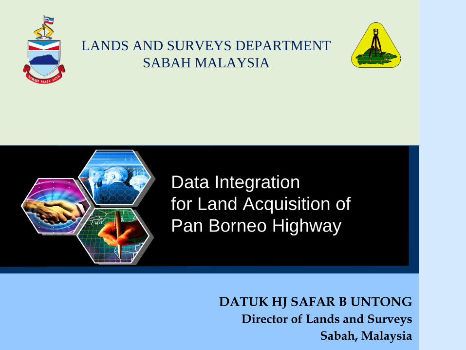
LANDS AND SURVEYS DEPARTMENT
SABAH MALAYSIA
DATUK HJ SAFAR B UNTONG
Director of Lands and Surveys
Sabah, Malaysia
Data Integration
for Land Acquisition of
Pan Borneo Highway
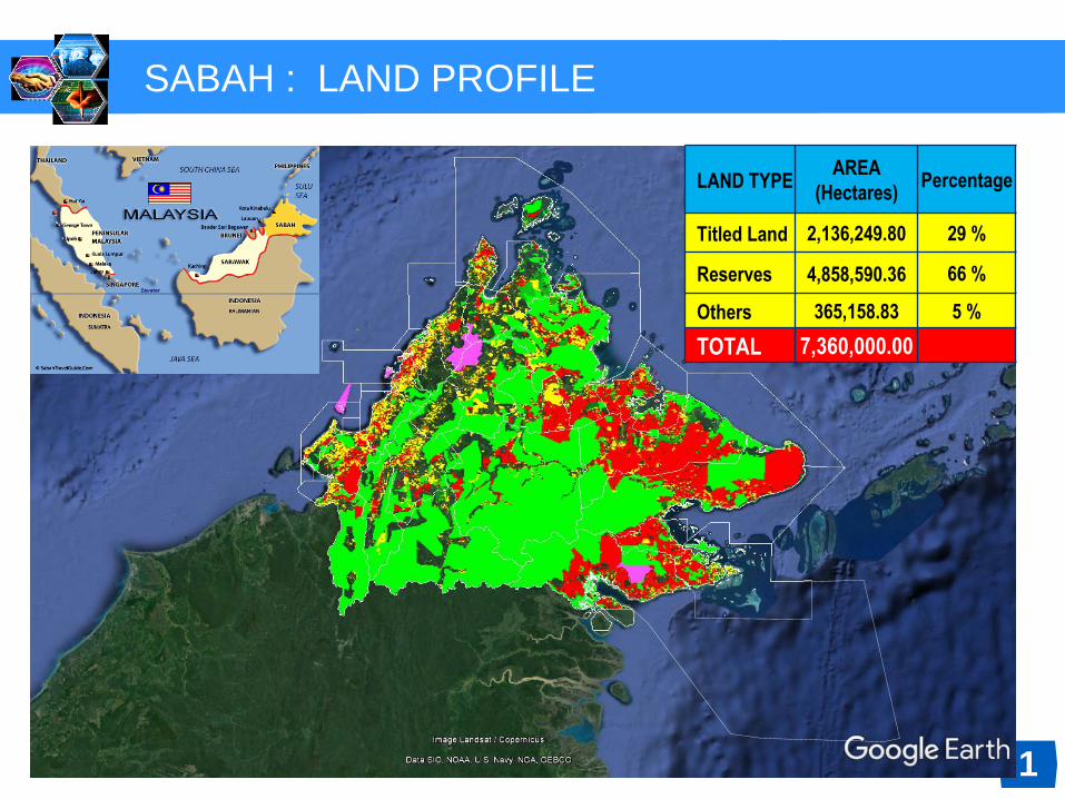
SABAH : LAND PROFILE
LAND TYPEAREA
(Hectares)Percentage
Titled Land 2,136,249.80 29 %
Reserves 4,858,590.36 66 %
Others 365,158.83 5 %
TOTAL 7,360,000.00
1
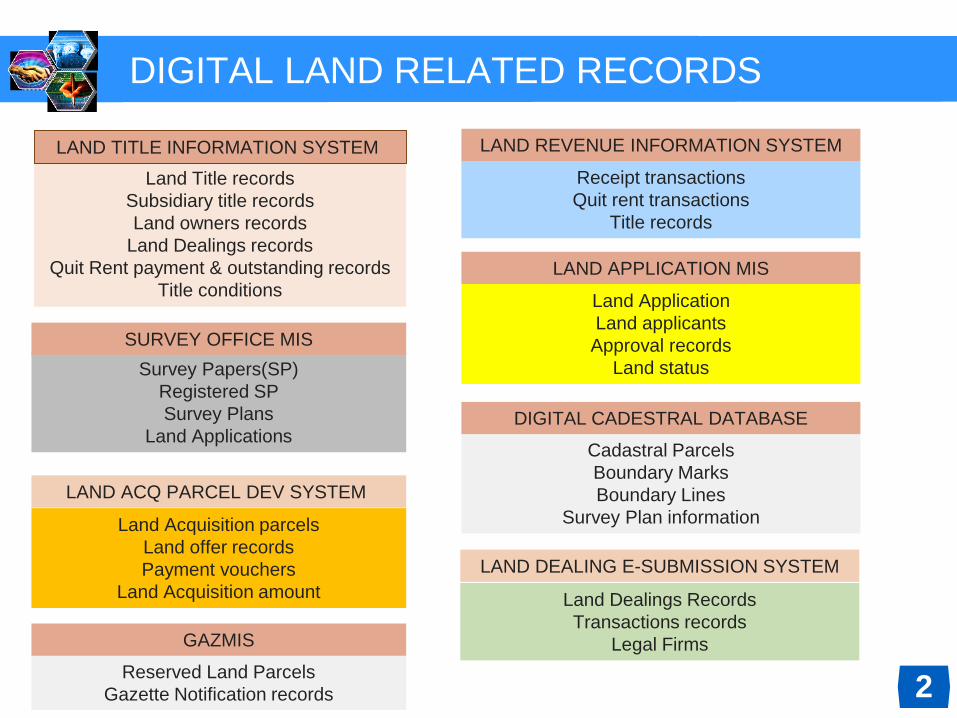
DIGITAL LAND RELATED RECORDS
Land Title records
Subsidiary title records
Land owners records
Land Dealings records
Quit Rent payment & outstanding records
Title conditions
LAND TITLE INFORMATION SYSTEM LAND REVENUE INFORMATION SYSTEM
Receipt transactions
Quit rent transactions
Title records
Reserved Land Parcels
Gazette Notification records
Survey Papers(SP)
Registered SP
Survey Plans
Land Applications
Land Dealings Records
Transactions records
Legal Firms
Land Acquisition parcels
Land offer records
Payment vouchers
Land Acquisition amount
SURVEY OFFICE MIS
GAZMIS
LAND DEALING E-SUBMISSION SYSTEM
LAND ACQ PARCEL DEV SYSTEM
2
LAND APPLICATION MIS
Land Application
Land applicants
Approval records
Land status
Cadastral Parcels
Boundary Marks
Boundary Lines
Survey Plan information
DIGITAL CADESTRAL DATABASE
Bongawan
Sindumin
Kg. Melalia
Beaufort
Donggongon
Inanam
Sepanggar
Bulatan Berunggis
Tuaran
Pituru
Rampayan Laut
Sarang
Temuno
Bingolon
Simpang Mengayau
2
3
4
6
7
9
10
11
12
13
Kg. Nabutan
Kg. Toupos
Kg. Lumou Baru
Telupid
Sg. Baoto
Sapi Nagoh
Moynod Kg. Lot
M
Sukau
Kg. Perpanduan Datuk Moh
Sg.
Takala
Kg. Sandau
SepagayaAgri Harvest
IGN Estate
Madai
Sg. Kalumpang
35
34
33
3231
30
2928
27
26
25
24
2321
22
2019
18
17
16
15
5
1
8
14
Tawau
Airport
WP
15 -
21
SOU
TH EA
ST
Sandakan M32
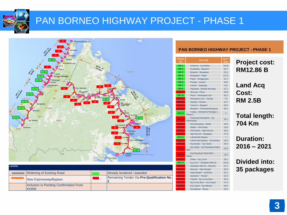
LEGEND :
Widening of Existing Road Already tendered / awarded
New Expressway/BypassRemaining Tender Via Pre-Qualification No.
2
Inclusion Is Pending Confirmation From
KKRM
PACKA
GESECTION
DIST.*
(KM)
WP 1 Sindumin - Kg Melalia 28.49
WP 2 Kg Melalia - Beaufort 34.7
WP 3 Beaufort - Bongawan 22.4
WP 4 Bongawan - Papar 22.72
WP 5 Papar - Donggongon 11.7
WP 6 Putatan - Inanam 19.6
WP 7 Inanam - Sepangar 9.9
WP 8 Sepangar - Bulatan Berungis 11.7
WP 9 Serusup - Pituru 20.8
WP 10 Pituru – Rampayan Laut 32.2
WP 11 Rampayan Laut – Sarang 7.3
WP 12 Sarang - Temuno 14.7
WP 13 Temuno – Bingolon 20.3
WP 14 Bingolon – Simpang Mengayau 28.1
WP 15Tawau – Semporna Package 1 –
Phase 25
WP 16Kampung Checkpoint – Sg
Kalumpang19.1
WP 17 Sg Kalumpang – Madai 19.0
WP 18 Madai – IGN Estate 13.8
WP 19 IGN Estate – Agri Harvest 18.5
WP 20 Agri Harvest - Sapagaya 17.9
WP 21 Lahad Datu Bypass 7
WP 22 Lahad Datu Bypass – Kg Sandau 23.8
WP 23 Kg Sandau – Sg Takala 25.0
WP 24Sg Takala – Kg Perpaduan Datuk
Moh15.9
WP 25Kg Perpaduan Datuk Moh –
Sukau15.0
WP 26 Sukau – Kg. Lot M 18.1
WP 27 Kg Lot M – Sandakan Mile 32 18.13
WP 28 Sandakan Mile 32 – Moynod 21.7
WP 29 Moynod – Sapi Nangoh 20.4
WP 30 Sapi Nangoh – Sg Baoto 22.1
WP 31 Sg Baoto – Telupid 14.3
WP 32 Telupid – Kg Lumou Baru 18.4
WP 33 Kg Lumou Baru – Kg Toupos 17.6
WP 34 Kg Toupos - Kg Nabutan 26.0
WP 35 Kg Nabutan - Ranau 31.0
PAN BORNEO HIGHWAY PROJECT - PHASE 1
Project cost:
RM12.86 B
Land Acq
Cost:
RM 2.5B
Total length:
704 Km
Duration:
2016 – 2021
Divided into:
35 packages
PAN BORNEO HIGHWAY PROJECT - PHASE 1
3

Area Acquired
5
Land Acq Parcel Database
4
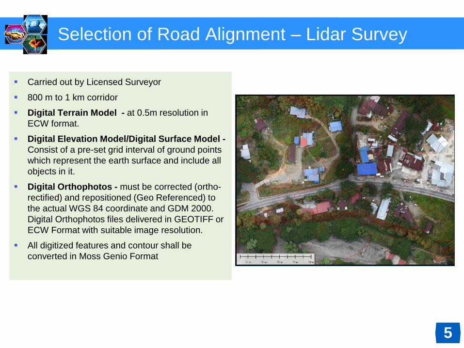
Selection of Road Alignment – Lidar Survey
Carried out by Licensed Surveyor
800 m to 1 km corridor
Digital Terrain Model - at 0.5m resolution in
ECW format.
Digital Elevation Model/Digital Surface Model -
Consist of a pre-set grid interval of ground points
which represent the earth surface and include all
objects in it.
Digital Orthophotos - must be corrected (ortho-
rectified) and repositioned (Geo Referenced) to
the actual WGS 84 coordinate and GDM 2000.
Digital Orthophotos files delivered in GEOTIFF or
ECW Format with suitable image resolution.
All digitized features and contour shall be
converted in Moss Genio Format
5

Detail Engineering Survey (long & cross section)
Divided into 35 packages
Surveyed by 20 registered
licensed surveyor
Detail Surveys information
given to PDP
Consulting Engineers
prepare alignment plan and
engineering design plan
6
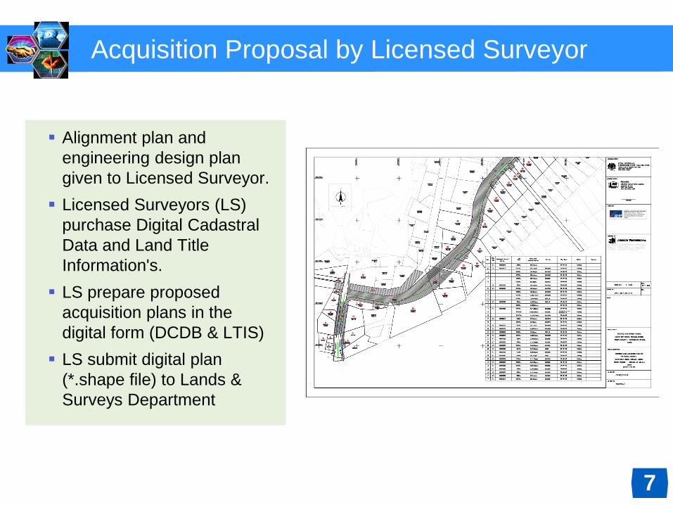
Acquisition Proposal by Licensed Surveyor
Alignment plan and
engineering design plan
given to Licensed Surveyor.
Licensed Surveyors (LS)
purchase Digital Cadastral
Data and Land Title
Information's.
LS prepare proposed
acquisition plans in the
digital form (DCDB & LTIS)
LS submit digital plan
(*.shape file) to Lands &
Surveys Department
7

Automated Plan Checking
Digital plan checking by LSD
Overlay with Cadastral Data
Base
If everything in order, LSD
advise LS to print proposed
plans to be sign by Director of
JKR as client department.
Proposed Acquisition Plans
submitted to LSD and to be
approved Director/Deputy
Director.
Approved Acquisition Plans dan
Draft Gazette Notification sent
to Chief Minister Office for
approval.
Gazette Notification publish at
government gazette.
Lands officially acquired
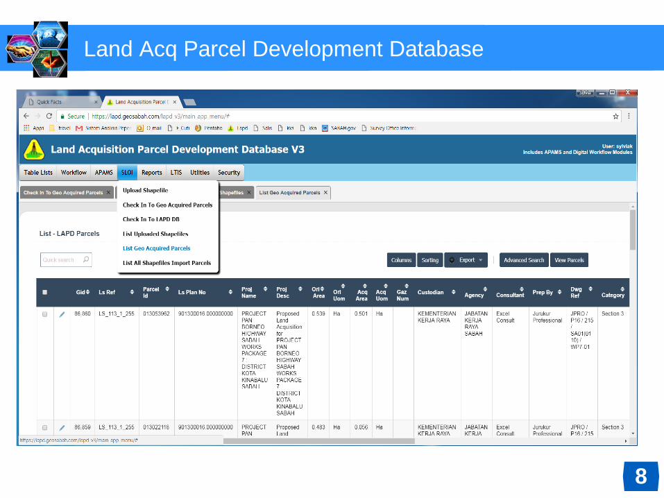
Land Acq Parcel Development Database
8

Land Acq Parcel Development Database
9
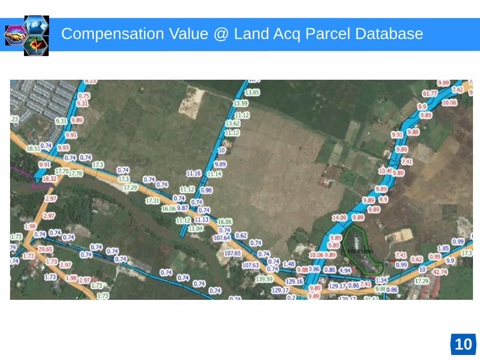
Compensation Value @ Land Acq Parcel Database
10
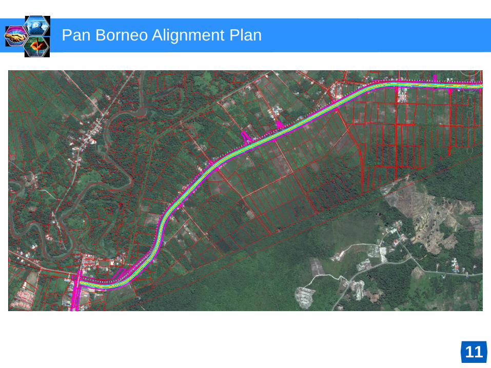
Pan Borneo Alignment Plan
11
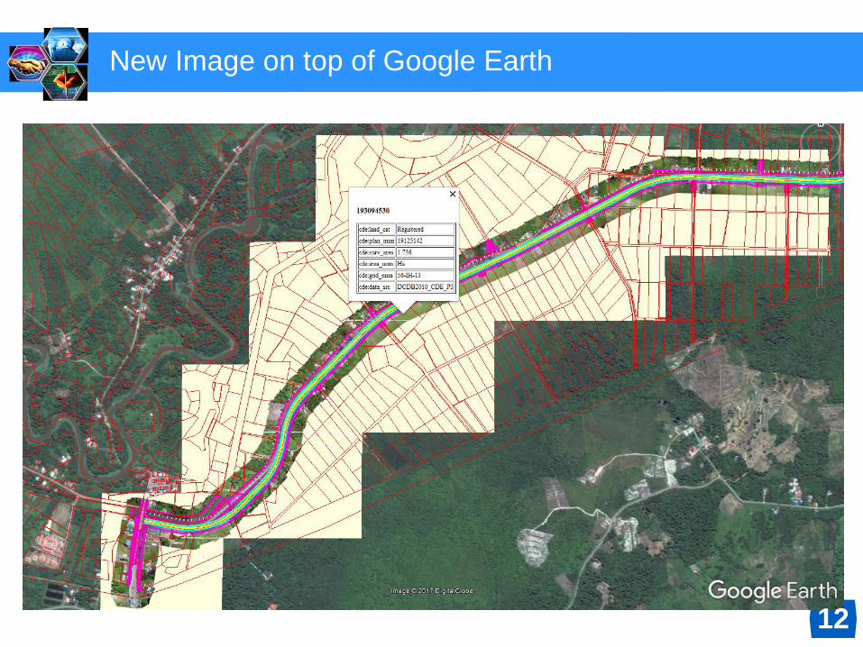
New Image on top of Google Earth
12

Land Acquisition Gazette Plan
13
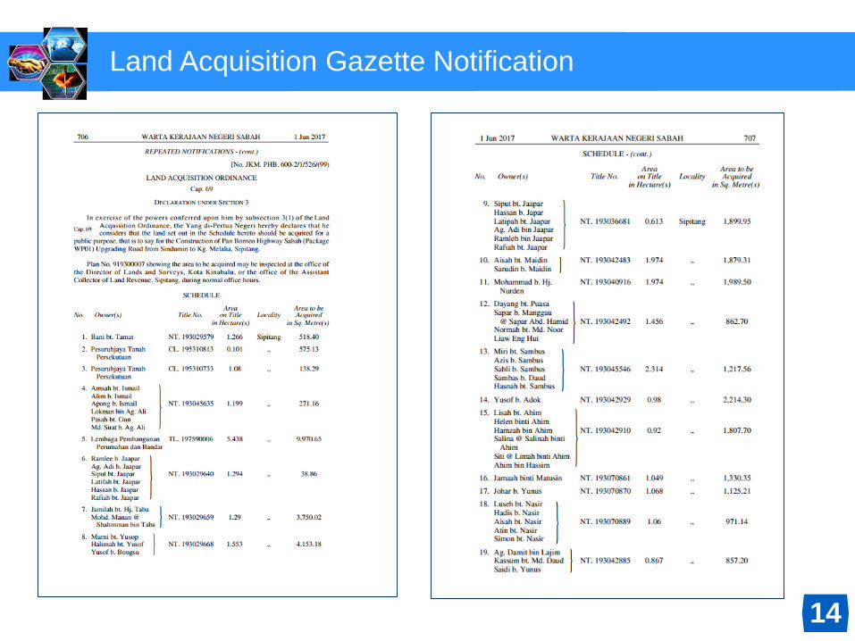
Land Acquisition Gazette Notification
14

Google Earth New Image on top of Google Earth
New Images – for ground inspection to determine Land and Building Compensations
15
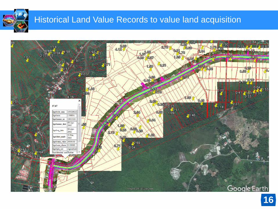
Historical Land Value Records to value land acquisition
16

Thank you
19