Embed Size (px)
Citation preview
Landmarks Preservation Commission December 20, 2011; Designation List 450 LP-2473
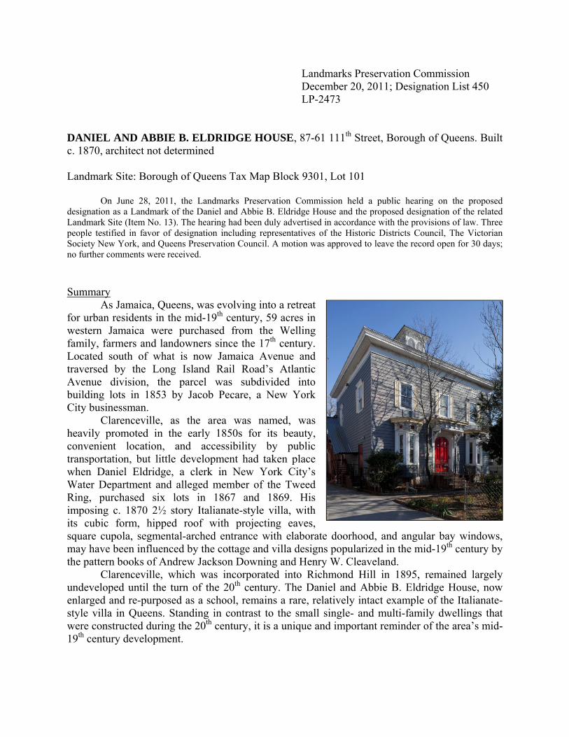
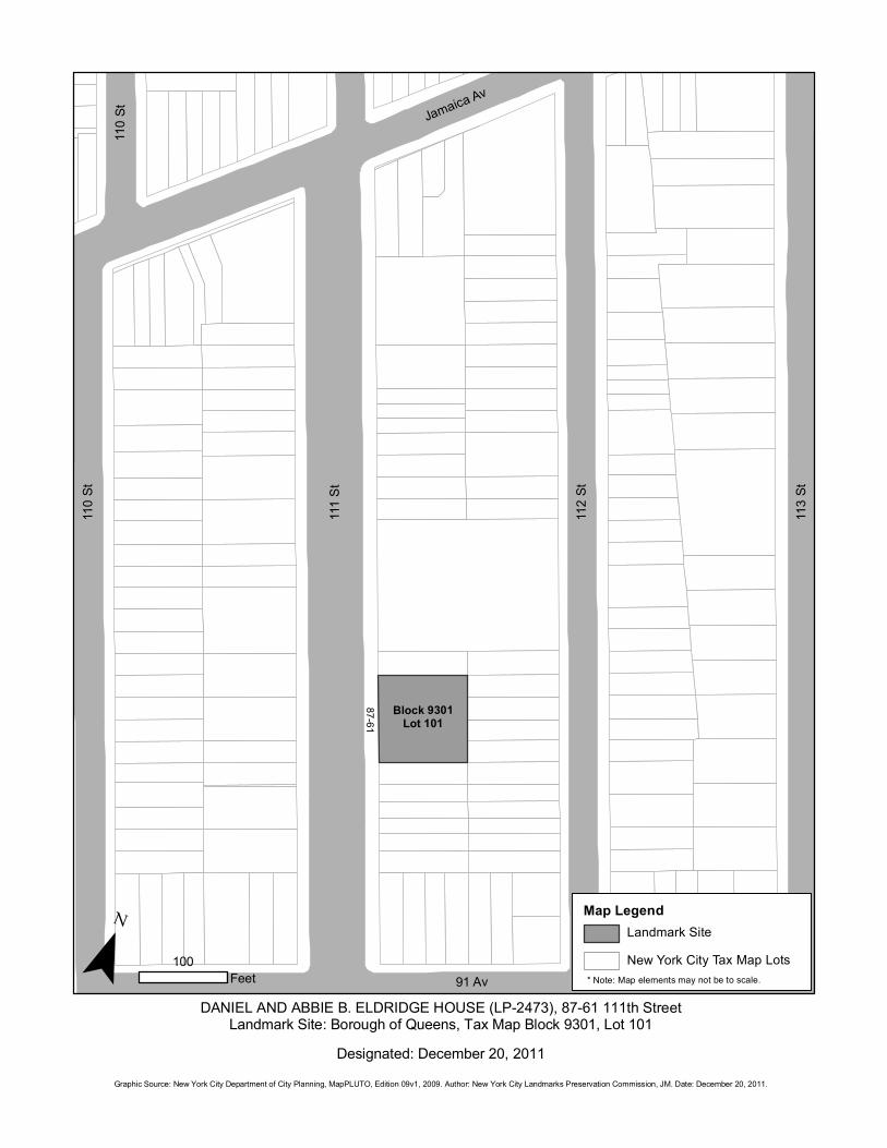
DANIEL AND ABBIE B. ELDRIDGE HOUSE, 87-61 111th Street, Borough of Queens. Built c. 1870, architect not determined Landmark Site: Borough of Queens Tax Map Block 9301, Lot 101
On June 28, 2011, the Landmarks Preservation Commission held a public hearing on the proposed designation as a Landmark of the Daniel and Abbie B. Eldridge House and the proposed designation of the related Landmark Site (Item No. 13). The hearing had been duly advertised in accordance with the provisions of law. Three people testified in favor of designation including representatives of the Historic Districts Council, The Victorian Society New York, and Queens Preservation Council. A motion was approved to leave the record open for 30 days; no further comments were received. Summary As Jamaica, Queens, was evolving into a retreat for urban residents in the mid-19th century, 59 acres in western Jamaica were purchased from the Welling family, farmers and landowners since the 17th century. Located south of what is now Jamaica Avenue and traversed by the Long Island Rail Road’s Atlantic Avenue division, the parcel was subdivided into building lots in 1853 by Jacob Pecare, a New York City businessman. Clarenceville, as the area was named, was heavily promoted in the early 1850s for its beauty, convenient location, and accessibility by public transportation, but little development had taken place when Daniel Eldridge, a clerk in New York City’s Water Department and alleged member of the Tweed Ring, purchased six lots in 1867 and 1869. His imposing c. 1870 2½ story Italianate-style villa, with its cubic form, hipped roof with projecting eaves, square cupola, segmental-arched entrance with elaborate doorhood, and angular bay windows, may have been influenced by the cottage and villa designs popularized in the mid-19th century by the pattern books of Andrew Jackson Downing and Henry W. Cleaveland. Clarenceville, which was incorporated into Richmond Hill in 1895, remained largely undeveloped until the turn of the 20th century. The Daniel and Abbie B. Eldridge House, now enlarged and re-purposed as a school, remains a rare, relatively intact example of the Italianate-style villa in Queens. Standing in contrast to the small single- and multi-family dwellings that were constructed during the 20th century, it is a unique and important reminder of the area’s mid-19th century development.

2
DESCRIPTION AND ANALYSIS
The Development of Clarenceville and Richmond Hill1 Before the arrival of the Europeans, Jamaica was inhabited by Native Americans belonging to the Jameco or Yamecah tribe. The settlers, English colonists from Massachusetts and Long Island, purchased the land in 1655, and successfully petitioned Peter Stuyvesant the following year to grant them a patent.2 The town called Rustdorp was renamed Jamaica when the English took over New Netherland from the Dutch in 1664 and was one of three towns, along with Flushing and Newtown, chartered in the western portion of Queens County in 1683.3 Through the next century, the community of Jamaica served as the county seat and became a trading post where farmers from the outlying areas brought their produce. Centrally located, Jamaica was well served by roads and in the 19th century by the railroad passing through Brooklyn and the western areas of Jamaica including what would become Clarenceville and Richmond Hill.
Jamaica Avenue, evolved from a Native American trail, has been called the oldest continuously used road on Long Island. In 1703 the colonial legislature established a highway, known as the “King’s Highway,” which extended from the East River (later Fulton) Ferry through Brooklyn and Queens (along portions of the current route of Fulton Street and Jamaica Avenue) to eastern Long Island. In the 19th century, the road was privatized and after 1850 it was sold to a group of Jamaica businessmen who incorporated as the Jamaica & Brooklyn Plank Road Company. The Brooklyn and Jamaica Railway Company established horsecar lines along the route in 1866 between East New York and Jamaica and in 1887 replaced them with the first electric trolley in Queens.4 The Brooklyn and Jamaica Railroad Company (not to be confused with the Brooklyn and Jamaica Railway), was chartered in 1832 to construct a railroad line from the East River to Jamaica roughly following the route of Atlantic Avenue. The Long Island Rail Road was founded two years later and leased the Brooklyn and Jamaica line, incorporating it into a planned connection to Boston through Long Island, and ran its first train to Jamaica in 1836.5
At the end of the 18th and beginning of the 19th century, Samuel and Thomas Welling owned farmland in the western outskirts of Jamaica that their ancestor, another Thomas, had purchased around 1660. Slavery was legal within New York until 1827, and both men are recorded in the United States census as employing free and enslaved African Americans.6 By the mid-19th century Jamaica was evolving into a retreat for urban residents, who patronized its numerous inns and saloons on weekend excursions and built large summer homes. Around 1852 the heirs of Samuel Welling sold two large parcels totaling 59 acres extending southward from the Brooklyn and Jamaica Turnpike (now Jamaica Avenue) and across Atlantic Avenue between roughly 110th and 112th Streets that became known as Clarenceville.7
Beginning in the fall of 1852 advertisements appeared in the New York Times and the Brooklyn Daily Eagle noting Clarenceville’s beauty, convenient location, and accessibility via stage or railroad. In 1853, Jacob Pecare, a New York businessman, purchased the property from the original developers, graded the streets and planted them with trees.8 Pecare then began an intense sales campaign offering lots at $94, payable in monthly or weekly installments, and, as an added incentive, offered all purchasers a chance of winning one of five houses built by the proprietors “at a cost of not less than $1,000” each on a two-lot parcel. By the following year, several houses were completed or under construction and five public pumps had been installed.9
In 1867 the Long Island Rail Road opened a depot on Atlantic Avenue and Greenwood Avenue (now 111th Street), probably replacing the depot referred to in Pecare’s sales campaign.

3
Within two years a new development, soon to be named Richmond Hill, was begun north of Jamaica Avenue by Albon Platt Man, a New York lawyer, and his business partner Edmund Richmond, a landscape designer, near the newly opened depot for the South Side Railroad. The new development encompassed the former farms of the Lefferts, Bergen, Welling, Roberts, and Hendrickson families. The Clarenceville Post Office was opened that same year in Jacob Van Wicklen’s store on the north side of Jamaica Avenue near Myrtle Avenue.10
The Eldridge House
Clarenceville was largely undeveloped in the 1860s, and remained so through the end of the century. In 1867 and 1869 Daniel Eldridge of Brooklyn purchased six lots from Charles and Libya Paulson that created an L-shaped parcel with 100-foot wide frontage on Greenwood Avenue (111th Street) the main throroughfare of the village.11 Although it cannot be determined when construction began or by whom the house was designed, the 40-foot-by-60-foot Italianate- style house was completed by 1870, making it a rare surviving mid-19th century residence in this area of Queens. Little is actually known about Daniel Eldridge beyond what is recorded in the 1870 census. He was employed as a clerk in the Water Department, at the time when such positions were among the plum patronage jobs controlled by the corrupt political boss William Marcy Tweed. Tweed and his Tammany Hall cronies ran city government from 1866 to 1870 offering many city jobs to immigrants and transplanted citizens from other parts of the country, such as the Maine-born Eldridge. It is unclear how long Eldridge and his wife Abbie enjoyed their home ― Eldridge, characterized as a member of the Tweed Ring, was arrested for embezzlement.12 Clarenceville had already begun to lose its identity in 1872 when the name of the post office was changed to Richmond Hill in honor of the more prominent development to its north. In 1873, the Eldridge house and property were sold at auction to George Fuller, a resident of the Morrisania section of Westchester (now the Bronx). Two years later it was purchased by Jane M. Fowler, the wife of Oliver B. Fowler, as an investment property. Oliver Fowler, a friend of Albon Man’s, was asked to assist with the laying out and management of Richmond Hill following the death of Edmund Richmond in 1870. The Fowlers, who lived in what was referred to as the “Farm Cottage” on Jamaica Avenue between Elm (114th) and Oak (115th) Streets, were very active in the development of Richmond Hill. Mrs. Fowler was instrumental in the establishment of the Church of the Resurrection where her husband served on the vestry. Mr. Fowler also served as the first president of the school board and worked for the establishment of a public school in Richmond Hill and for the construction of the Richmond Hill Clubhouse.13 From 1880 until the turn of the century, the house was the home of Mrs. Sarah Magee, a widow, and her children. In 1882, following the death of her husband, Mrs. Fowler sold the Eldridge property to Alexander Steel (or Steele) an Englishman, who purchased another seven lots adjoining the property between 1882 and 1884 creating one of the largest residential parcels in Clarenceville. Mrs. Magee married Steel sometime in the 1880s. Her son John Magee who became a lawyer and realtor in Richmond Hill lived there until 1895, the year Clarenceville was incorporated into the Village of Richmond Hill. Following Steel’s death, she and her daughter Sarah lived in the house until at least 1900.14
In 1917, the Eldridge house and three of the original lots (a fourth was added in 1919) were sold to the Karrmann family.15 The Karrmanns lived in the house until 1947 a period in which the population of Richmond Hill grew, residential development increased, and commercial activity flourished thanks to improved transportation such as the completion of the
4
Jamaica Avenue elevated, and elimination of grade crossings on both the Atlantic Avenue and Montauk lines of the Long Island Rail Road.16 In 1947, new owners purchased the Eldridge House and converted the ground floor into a nursery school. The current owners bought the house in 1986 and converted the entire building for use as a childcare facility and a school for the arts offering classes in dance, music, and acting for children.17 Design of the Daniel and Abbie B. Eldridge House18
By 1850, suburban villas like the Eldridge house had become a distinctive feature on the American landscape. Based on precedents that began to appear in England in the late 18th century and the residences that had long been constructed by wealthy Americans, American villas were often located on the outskirts of towns and cities.19 As Samuel Sloan wrote in The Model Architect (1852-53) when describing his own design for an Italianate-style villa: “It possesses very little of the rural character, and seems much more appropriate for the residence of one accustomed to city life, than one born and bred in the country. Its location, consequentially, should not be in the depths of the forest, but near some frequented highway within a few miles of a city.”20
Introduced to the United States around 1840, the Italianate style was first popularized by Andrew Jackson Downing as an alternative to the Gothic style. Italianate-style villas came in a variety of plans from the basic cubic form such as the Eldridge House to elaborate residences with complex plans such as the Benjamin T. Pike House in Astoria and Edwin Clarke and Grace Hill Litchfield House (aka Litchfield Villa) in Brooklyn’s Prospect Park (both designated New York City Landmarks). Characteristically, Italianate-style villas are two to three stories high, have a cubic form, sometimes extended into an L-shape, topped by hipped roofs with projecting eaves supported on decorative brackets, and often elaborated by a square cupola, gable, or tower; windows and doors are flat headed or arched, frequently with elaborate enframements.
In the mid-19th century, architectural pattern books, began to introduce new ideas about planning and design to the American public and were the most important sources for villa designs. Perhaps the most influential works were those of Andrew Jackson Downing, who transmitted English concepts of rural design and landscape architecture to a broad audience through books that included A Treatise on the Theory and Practice of Landscape Gardening (1841), Cottage Residences (1842), and The Architecture of Country Houses (1850). Downing, who featured the work of Alexander Jackson Davis, John Notman, Gervase Wheeler, Richard Upjohn, and Calvert Vaux, published numerous designs for farmhouses, villas, and cottages largely Gothic Revival, Italianate, and Swiss Cottage in style, which he deemed particularly suitable for country settings. Downing’s works continued to be reprinted after his death in 1852 and many architects, including Samuel Sloan, Henry W. Cleaveland, and Henry H. Holly published their own pattern books in the 1850s and 1860s. Although pattern-book designs were influential, they were rarely followed to the letter by the carpenters and builders who typically constructed country houses; as historian Daniel Reiff has observed, it was understood that they would adapt pattern-book designs and details “to meet local needs and financial constraints.”21 Indeed, precise copies were the exception rather than the rule, and many carpenters and builders combined architectural features from a variety of sources.
The Eldridge House does not appear to be an exact copy of any known pattern-book design, but it is possible that the anonymous architect or builder of the house was familiar with Downing’s work since it has an affinity to what Downing called his “Design VIII – A suburban cottage in the Italian style.”22 Although the Eldridge house differs from Downing’s design in
5
some respects – particularly its execution in wood rather than masonry, the elaborate decoration of the first story rather than a broad porch, and the glazed cupola – the two share a center-hall plan, three-bay-wide main facade, simple window enframements at the second story, hipped roof, and side bay window, which in the Eldridge House was angled, and doubled in number. Samuel Sloan in his The Modern Architect (1852-53) and Henry W. Cleaveland, William Backus, and Samuel D. Backus in their Village and Farm Cottages (1856) featured designs for similar, three-bay-wide homes with hipped roofs and porches. Cleaveland’s Design No. XVI for a two-bay-wide house with angular bay windows connected over the entrance by a bracketed doorhood23 may have been the inspiration for the design of the first story of the Eldridge House although here the windows and entrance with its doorhood are separate elements.
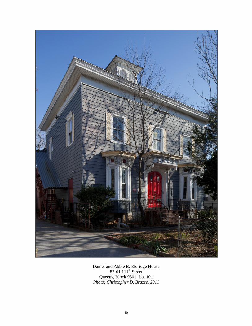
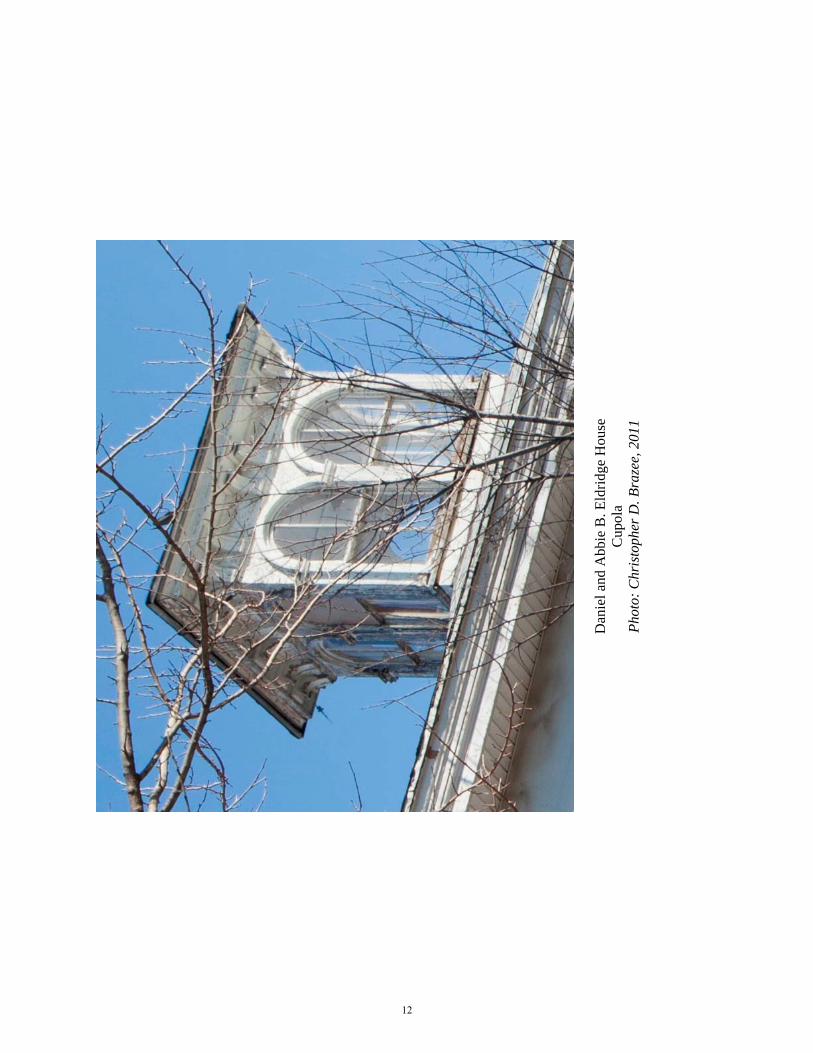
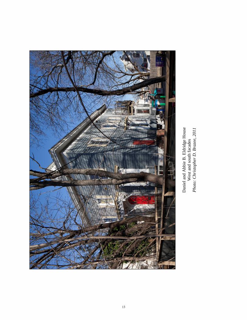
Although it has been altered by a modern addition on the rear (c. 2002), the c. 1870 Daniel and Abbie B. Eldridge House retains much of its original detailing including the hipped roof, square cupola with paired round-arched windows with two-over-two wood sash, segmental-arched entrance with heavy wood enframement and elaborate, bracketed doorhood, and four angular bay windows.
Description
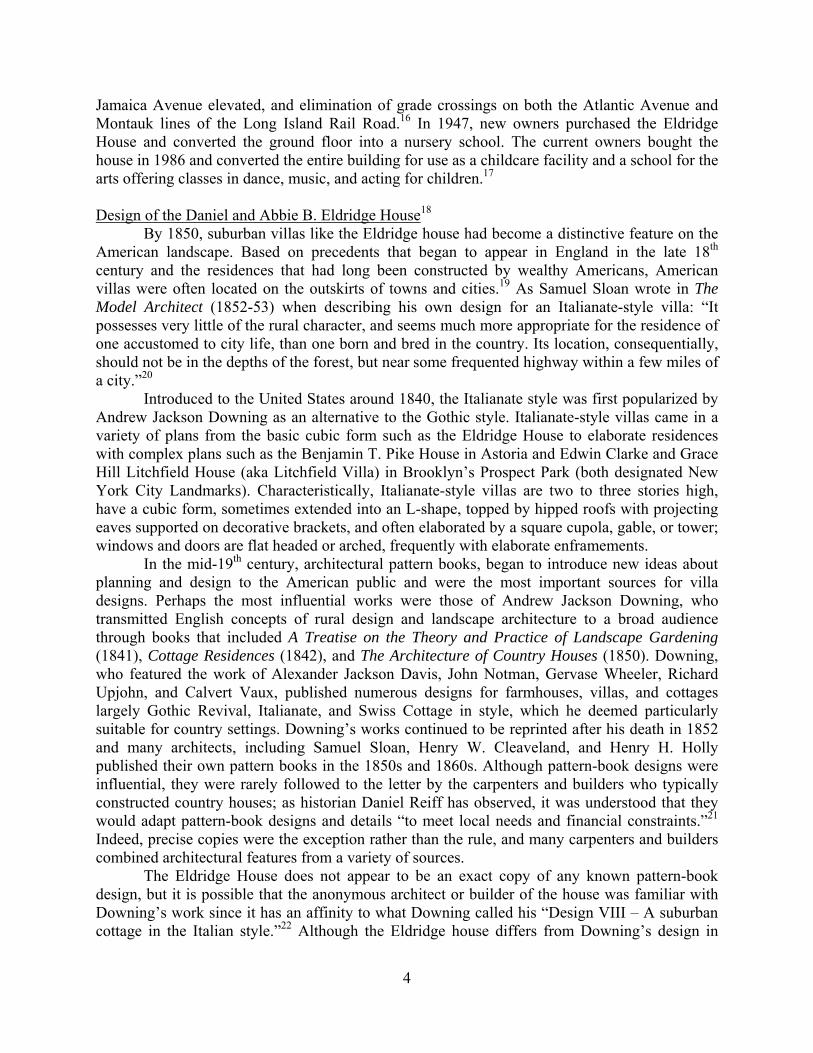
The Daniel and Abbie B. Eldridge House is a 2½-story, Italianate-style house, cubical in form with a small ell on the south.24 The hipped roof is surmounted by a glazed cupola whose paired, round-arched windows retain the historic wood sash.
Primary (west) facade: Central entrance with heavy, segmental-arched enframement and elaborate wood doorhood; angular bay windows each with a heavy cornice supported by scrolled brackets; two windows on the second story possibly historic two-over-two wood sash. Alterations: re-sided with vinyl or aluminum, stone basement painted; stoop and railings replaced; double-leaf door replaced with period door; sash replaced, except as noted; non-historic shutters; non-historic grilles at basement; roof replaced with asphalt shingles, brackets under eaves removed, soffit and frieze re-sided; facade cut at first and second stories for through-wall air conditioners; signage; alarms; leader; mailbox and intercom. North Facade: Similar to primary facade; one window at second story with possibly historic two-over-two wood sash. Alterations: large stuccoed addition at rear with three windows at the first story; missing panes in cupola replaced with wood panel; metal fire stair with corrugated roof; non-historic metal grille at first story on north; metal fire door with brick stoop and metal railing; lights. South Facade: Similar to primary facade; two angular bay windows, one same as primary facade, other larger with different brackets; possibly historic one-story addition at rear with shed roof; single frieze window. Alterations: metal fire door with brick stoop and metal railing; sash replaced; wood balcony with screened door over eastern bay window; concrete ramp with pipe railing; facade cut for through-wall air conditioner; leader; lights; conduits; electric meter. East Facade (partially visible): Upper facade similar to primary facade. Alterations: stucco extension with flat roof and pipe railing at parapet; missing panes in cupola replaced with wood panel; covered metal walkway at second story;

6
Site Features: Non-historic chain-link perimeter fence on north, west, and south with gates at driveway and walkway; stockade fence on east; front yard with three large free-standing signs, and planting beds; concrete driveway on north with double-leaf metal gate adjacent to building line; paved play area on south with furniture and play equipment; concrete walkway.
Report prepared by Marianne S. Percival Landmarks Preservationist
NOTES 1 Information in this section based on Landmarks Preservation Commission (LPC), Public School 66 (Formerly the Brooklyn Hills School, later the Oxford School, now the Jacqueline Kennedy Onassis School) Designation Report (LP-2317) (New York: City of New York, 2010), prepared by Jennifer L. Most, 2; LPC, (Former) Jamaica Savings Bank Designation Report (LP-2109) (New York: City of New York, 2008), prepared by Elisa Urbanelli, Marjorie Pearson, and Michael D. Caratzas, 2; Vincent Seyfried, “Clarenceville,” Vincent Seyfried and Jeffrey A. Kroessler, “Richmond Hill,” and Gerald R. Wolfe, “Jamaica,” Encyclopedia of New York City, 2nd ed. (New Haven, CT: Yale University Press, 2010), 265, 1103, 668. 2 The Native American “system of land tenure was that of occupancy for the needs of a group” and that those sales that the Europeans deemed outright transfers of property were to the Native American closer to lease or joint tenancy contracts where they still had rights to the property. Reginald Pelham Bolton, New York City in Indian Possession, 2nd ed. (New York: Museum of the American Indian, Heye Foundation, 1920; reprint 1975), 7, 14-15, 79. 3 There were five towns patented in Queens by the English in 1683, the other two were Hempstead and Oyster Bay in what is now Nassau County. Nassau became a separate county in 1898 with the creation of Greater New York City. 4 Jon A. Peterson, ed., A Research Guide to the History of the Borough of Queens and Its Neighborhoods: Bibliography, Chronology, and Other Aids (Flushing, NY: Queens College, Department of History, 1983), 14-15; Brian J. Cudahy, How We Got to Coney Island (New York: Fordham University Press, 2002), 32-33. 5 Peterson, 21; Cudahy, 43-44. 6 United States Census Records, 1790-1820. 7 There is some confusion as to the exact date at which the village of Clarenceville came into being. According to the Encyclopedia of New York City, 2nd ed., the property was purchased by W. T. B. Milliken, a lawyer and advocate of building associations, in 1853; however, Milliken’s name does not appear in the indexes for the conveyances for Queens County until the 1870s, and then only as a referee, and the earliest advertisements for lots in Clarenceville appeared in the fall of 1852. Encyclopedia of New York City, 265; “Building Associations,” New York Times (NYT), March, 30, 1852, 1; “Special Notices,” NYT, October 4, 1852, 1. 8 Pecare’s name is attached to a map of Clarenceville surveyed in January 1853, although he did not purchase the property until June of that year. Pecare had a varied career before 1852 when he served as the secretary of various Building Associations and entered the real estate business. By the 1860s he became a pawnbroker, and another Jacob Pecare, a lawyer and possibly his son, took over the real estate business. “Map of Clarenceville, Situated on the Brooklyn and Jamaica Plank Road and Rail Road, Town of Jamaica, County of Queens. The Property of Jacob

7
Pecare, Esq.,” surveyed and laid out by Martin G. Johnson, Jamaica, January 1853; New York City directories, 1848/49-1872/73; NYT, February 10, 1852, 1; Queens County, Office of the Registrar, Deeds and Conveyances, Liber 108, p. 21 (June 10, 1853). 9 Queens County, Office of the Registrar, Deeds and Conveyances, Liber 108, p. 21 (June 10, 1853); “Classified Advertisements,” NYT, September 22, 1852, 5, July 5, 1853, 5, June 23, 1854, 6. 10 LPC, Public School 66, 2; F. W. Beers, Atlas of Long Island, New York (New York: Beers, Comstock & Cline, 1873), pl. 95-96. 11 Queens County, Office of the Register, Deeds and Conveyances, Liber 292, p. 424 (October 21, 1867, recorded March 24, 1869) and p. 427 (March 15, 1869, recorded March 24, 1869). 12 Alexander B. Callow, Jr. The Tweed Ring (New York: Oxford University Press, 1969, reprinted 1970), 3, 65, 67, 115-7; United States Census Records, 1870; “The Steel House,” Historical Collections of the Borough of Queens, New York City, v. 11: Jamaica (Jamaica, NY: Long Island Collection, Queens Borough Public Library, 1938), 154-5 (typescript). 13 Queens County, Office of the Register, Deeds and Conveyances, Liber 427, p. 356 (December 26, 1873); Liber 469, p. 104 (July 23, 1875); Jeff Gottlieb, “History of Richmond Hill,” Leader-Observer, October 8-14, 1992, 2; “Chronological History of Richmond Hill,” typescript, 1994; William Krooss, A Peek at Richmond Hill Through the Keyhole of Time (Richmond Hill, NY: Richmond Hill Savings Bank, 1983) , 13-14, 52; Kate Matson Post, The Story of Richmond Hill (Richmond Hill, NY: Richmond Hill Record, 1905), 5, 10-12. 14 “The Steel House,” 154-5; United States Census Records, 1900; Queens County, Office of the Register, Deeds and Conveyances Liber 605, p. 195, 198, 199 (December 30, 1882, recorded January 17, 1883), Liber 640, p. 98, 100 (October 4, 1884). 15 Queens County, Office of the Register, Deeds and Conveyances, Liber 2147, p. 236 (October 23, 1917), Liber 2190, p. 63 (January 6, 1919). 16 Peterson 23; Queens County, Office of the Register, Deeds and Conveyances, Liber 5415, p. 526 (June 17, 1947); “Want Queens Grade Crossings Removed,” NYT, February 2, 1919, 23; “City to Get Plan for Atlantic Ave.,” NYT, November 18, 1937, 2; “Taxpayers Fight Crossing Project,” NYT, August 13, 1938, 15; George M. Mathieu, “Grades Out in Brooklyn,” NYT, August 13, 1939, XX6; “Atlantic Ave. Tube Open,” NYT, December 28, 1942, 21. The Montauk division was elevated in 1923. The stations between Hunters Point and Jamaica, including Richmond Hill, were abandoned in 1998 due to lack of ridership. Krooss, 44; Somini Sengupta, “End of the Line for L. I. R. R.’s 10 Loneliest Stops,” NYT¸ March 15, 1998, 35. 17 Queens County, Office of the Register, Deeds and Conveyances , Liber 5415, p. 526 (June 17, 1947), Liber 2144, p. 1987 (July 31, 1986); New York City, Department of Buildings, Queens County, Alt.1629-1986; Queens Address Directories, 1929-1986. 18 This section is based on LPC, James W. and Lucy S. Elwell House Designation Report (LP-2215) (New York: City of New York, 2006), prepared by Kathryn Horak, 5-6; LPC, George B. and Susan Elkins House Designation Report (LP-2207) (New York: City of New York, 2006), prepared by Michael D. Caratzas; LPC, Gustave A. Mayer House Designation Report (LP-1652) (New York: City of New York, 1988), prepared by David M. Breiner; LPC, 121 Heberton Avenue House Designation Report (LP-2120) (New York: City of New York, 2002), prepared by Gale Harris. Other sources are Virginia and Lee McAlester, A Field Guide to American Houses (New York: Alfred A. Knopf, 1997); Daniel D. Reiff, Houses from Books: Treatises, Pattern Books, and Catalogs in American Architecture, 1738-1950 (University Park, PA: Pennsylvania State University Press, 2001). 19 W. Barksdale Maynard, Architecture in the United States, 1800-1850 (New Haven, CT: Yale University Press, 2002), 119, 139. 20 Samuel Sloan, The Model Architect (Philadelphia: E. S. Jones & Co., 1852-53; reprinted as Sloan’s Victorian Buildings, New York: Dover Publications, 1980), 12. 21 Reiff, 62.

8
22 Andrew Jackson Downing, The Architecture of Country Houses (New York: D. Appleton & Co., 1850; reprinted, New York: Dover Publications, 1969) Fig. 33, opposite p. 109. 23 Henry W. Cleaveland, William Backus, and Samuel D. Backus, Village and Farm Cottages: The Requirements of American Village Homes (New York: D. Appleton & Co., 1856), plate opposite p. 102. (Google Books) 24 1891 is the earliest map showing development in Clarenceville and the Eldridge House (marked “A. Steel”) is drawn as L-shaped. The 1907 Hyde map marks the house as 2½ stories with an ell that is one to two stories. It is unclear if the ell was part of the house at the time of construction. Chester Wolverton, Atlas of Queens Co. Long Island New York (New York: Chester Wolverton, 1891), pl. 18; Hugo Ullitz, Atlas of the Borough of Queens, City of New York (New York: E. Belcher Hyde, 1907), v. 1, pl. 4.

9
FINDINGS AND DESIGNATION On the basis of a careful consideration of the history, the architecture, and other features of this building, the Landmarks Preservation Commission finds that the Daniel and Abbie B. Eldridge House has a special character, and a special historical and aesthetic interest and value as part of the development, heritage, and cultural characteristics of New York City.
The Commission further finds that, among its important qualities, the Daniel and Abbie B. Eldridge House was built c. 1870; that Daniel Eldridge was employed in the New York City Water Department and an alleged member of the Tweed Ring; that the house is a 2½ story Italianate-style villa; that its design may have been influenced by the cottage and villa designs included in mid-19th century pattern books by Andrew Jackson Downing and Henry W. Cleaveland; that it retains the cubic form, hipped roof with projecting eaves, cupola, elaborately decorated segmental-arched entrance and bay windows characteristic of the Italianate style; that it was built in the area known as Clarenceville which was subdivided for development in 1853, predating the development of Richmond Hill into which it was incorporated 1895; that Clarenceville remained largely undeveloped prior to the 20th century; that although enlarged and re-purposed as a school, the Daniel and Abbie B. Eldridge House is a relatively intact example of the Italianate-style villa and, in contrast to the small dwellings constructed during the 20th century, is a unique and important reminder of the area’s mid-19th century development. Accordingly, pursuant to the provision of Chapter 74, Section 3020 of the Charter of the City of New York and Chapter 3 of Title 25 of the Administrative Code of the City of New York, the Landmarks Preservation Commission designates as a Landmark the Daniel and Abbie B. Eldridge House, 87-61 111th Street, Borough of Queens, and designates Borough of Queens Tax Map Block 9301, Lot 101 as its Landmark Site. Robert B. Tierney, Chair Pablo E. Vengoechea, Vice-Chair Michael Devonshire, Joan Gerner, Christopher Moore, Margery Perlmutter, Elizabeth Ryan, Roberta Washington, Commissioners
Daniel and Abbie B. Eldridge House
87-61 111th Street Queens, Block 9301, Lot 101
Photo: Christopher D. Brazee, 2011
10

D
anie
l and
Abb
ie B
. Eld
ridge
Hou
se
Entra
nce
and
win
dow
det
ails
Ph
oto:
Chr
isto
pher
D. B
raze
e, 2
011
11
Dan
iel a
nd A
bbie
B. E
ldrid
ge H
ouse
C
upol
a Ph
oto:
Chr
isto
pher
D. B
raze
e, 2
011
12
Dan
iel a
nd A
bbie
B. E
ldrid
ge H
ouse
W
est a
nd so
uth
faca
des
Phot
o: C
hris
toph
er D
. Bra
zee,
201
1
13

Dan
iel a
nd A
bbie
B. E
ldrid
ge H
ouse
Ea
st fa
cade
Ph
oto:
Chr
isto
pher
D. B
raze
e, 2
011
14

Daniel and Abbie B. Eldridge House, c. 1940 Photo: New York City Dept. of Taxes (c. 1940), Municipal Archives
15
Block 9301Lot 101
87-61
111 S
t
112 S
t
113 S
t
91 Av
110 S
tJamaica Av
110 S
t
DANIEL AND ABBIE B. ELDRIDGE HOUSE (LP-2473), 87-61 111th StreetLandmark Site: Borough of Queens, Tax Map Block 9301, Lot 101
Landmark SiteMap Legend
New York City Tax Map Lots* Note: Map elements may not be to scale.
¯Graphic Source: New York City Department of City Planning, MapPLUTO, Edition 09v1, 2009. Author: New York City Landmarks Preservation Commission, JM. Date: December 20, 2011.
100Feet
Designated: December 20, 2011