Embed Size (px)
Citation preview

United States
Department of the Interior
Geological Survey
d. S, Geelogija,' Survey Geologic Branch Library
Water-supply inrestigation of Fort Defiance area,
ttavajo Indian Reservation, Apache County, Arizona
By
L. C. Halpenny and S. C. Brown
With a section on
Quality of water
By
J. D. Hem
fticson, Arizona
March

CONTENTS
PageAbstract ............................. 1Introduction t .......................... 2
Location .......................... 2Summary «f problem ..................... 2Pield work and acknowledgments ............... 3
Geology and ground-water resources ................ 3Geologic formations and their water-bearing properties ... 3
Pre-Cambrian rocks ................... 3Permian rocks ..................... 4Triassic rocks ..................... 5Jurassic and Cretaceous rocks ............. oTertiary (?) and Quaternary rocks ........... 6"
Structure ......................... 6Surface water .......................... 6Quality of water . ........................ 7Water supplies .......................... 7
Present Fort Defiance supply ................ 7Bonito Spring ........................ 8Supai Spring ........................ 9
Possibilities for obtaining additional water ........... 9Present Fort Defiance supply ................ 9Veil near school site .................... 9Bonito and Supai springs .................. 10
TABLES
Table 1. Analyses of water from Fort Defiance area, .Apache County,Arizona ........................ 11
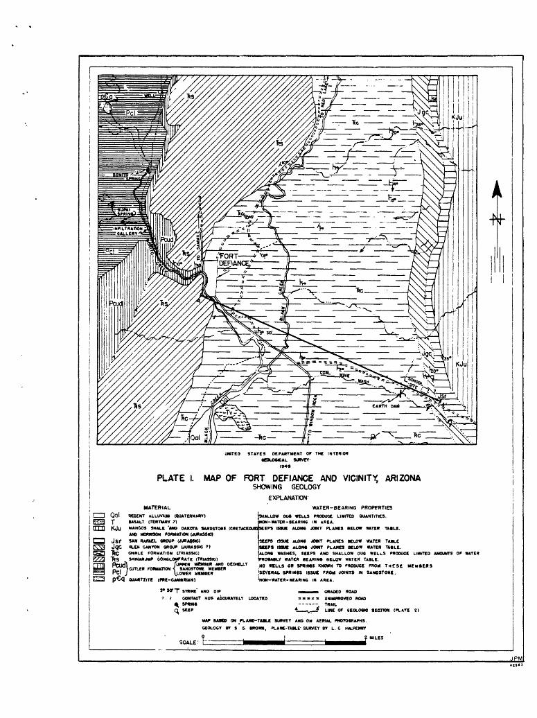
Plate 1. Map of Fort Defiance and vicinity, Arizona, showing geology. Plate 2. Geologic section across Fort Defiance area.

The ground-water resources of the Port Defiance area were investigated by the Geological Surrey in 19US. Fort Defiance is on the Navajo Indian Reservation, in the east-central part of Apache County, Arizona.
The geologic section exposed in the area ranges from pre-Cambrian quartzite upward througi Permian, Triassic, Jurassic, and Cretaceous sedimentary rocks. The beds dip to the east. The streams in the area are underlain "by Quaternary alluvium.
The existing supply of water for fort Defiance is obtained from an infiltration gallery in the alluvial fill of Bonito Creek. Scouring in the bed of the creek has lowered the level of the fill and decreased the productivity of the gallery. The possibility was considered of construct ing a low dam, which would be keyed into the rocks underlying the fill. This dam would impound the underflow in the fill and increase the yield of the gallery, T»t the cost probably would be excessive.
The investigation showed that it would not be advisable to obtain water for Port Defiance by drilling a well. The yield from a well probably would not exceed 25 gallons per minute, and the depth would have to be greater than 1,500 feet.
The most practicable method of procuring additional water would be to develop and utilize the flow from two artesian springs that issue from the lower member of the Cutler formation (Permian) in the area. The quality of the water from these springs is suitable for domestic use.
Bonito Spring, the larger of the two, occurs in the bed of Bonito Creek about a mile upstream from the infiltration gallery, in an area where the lower member of the Cutler foimation is overlain by 10 feet of alluvial fill. If a caisson were constructed in the fill at the spring, it is estimated that about 200 gallons per minute could be withdrawn by gravity flow. Calculations based on measurements of the spring discharge indicated that as much as 500 gallons per minute might be obtained if all the water from the spring could be collected into a caisson and pumped from an elevation 10 feet lower than the existing outlet of the spring,
Supai Spring^ the smaller of the two, produces about 75 gallons per minute from the lover member of the Cutler formation in a wash tributary to Bonito Creek. Water from the spring could be collected into a pipe line and would flow by gravity to £ort Defiance.
Poll use of the water from both springs would decrease the underflow of Bonito Creek and reduce the supply of ground water now available to the infiltration gallery. Development of the springs could be accomplished in three stages, depending on the amount of water needed by the community:
1. Construct a caisson at Bonito Spring and withdraw water by gravity flow. This would not seriously reduce the amount of water avail able at the infiltration gallery.
2. Withdraw water from Bonito Spring by pumping from the proposed caisson. This would reduce the amount of water available at the gallery.

3. Capture the entire flow of Supai Spring and pump from the proposed caisson at Bard to Spring. This would increase the total supply available, by reducing the amount of water now lost by evaporation from the stream bed* and by greatly reducing the underflow, part of which now passes the, infiltration gallery.
INTBQIXJCTI01T
late is January 19*& the Geological Surrey was requested to investi gate the possibilities of obtaining additional water supplies at several sites on the Navajo Indian Reservation. This request included an investi gation of the water supply at Fort Defiance.
Location
Fort Defiance is located at the mouth of Bonito Canyon, near the confluence of Bonito Creek and Black Creek, in the east-central part of .Apache County, Arizona. The town lies on the eastern flank of the Defiance uplift at an elevation of about 6,550 feet. The settlement was established shortly after 1550, and has been continuously occupied since that time. In 1$US, the population was estimated to be 1,200.
Summary of problem
The existing water supply consists of an infiltration gallery in the alluvial fill of Bonito Creek, about 1 mile upstream from Fort Defiance (see pi. 1). The gallery is reported to produce about 100 gallons per minute. The water flows by gravity to Fort Defiance, from where it is pumped to a 2?5»000-gallon storage tank on a hill northwest of the town.
Scouring in the bed of Bonito Creek during the past few years has caused a lowering of the water level in the infiltration gallery. The continued lowering of the water table has decreased the flow from the gallery so that the supply during the summer months is no longer adequate. The initial problem was to develop a supply of water which would be adequate to meet the needs of the community at all times, later, a second problem was presented: To increase the supply of water to accomodate a proposed total population of about 3,000. The additional 1,500 people would be located at a school to be built on the east side of Black Creek, about 5 miles east of Fort Defiance (see pi. l).
Assuming a daily rate of use of 150 gallons per person, a continuous supply of about 125 gallons per minute would be needed to support the present community of 1,200 people, and a continuous supply of about 315 gallons per minute would be needed for 3.000 people. If it is necessary to pump the needed water, and if it is desirable to confine the pumping to an 5-hour period each day, the rates of supply required would be 375 and 950 gallons per minute, respectively.
Three possible methods of obtaining additional water were suggested: (1) Place a low dam across Bonito Creek below the infiltration gallery, to raise the water table and increase the flow from the gallery; (2) drill a well in the valley of Black Creek; and (3) develop and utilize a spring in Bonito Creek about a mile upstream from the infiltration gallery.

Field work and acknowledgaents
The work was done under the general super-rial on of S. I*. Turner, District Engineer (Ground Water). Held work was done by S. C. Brown, geologist, and L, C. Halpenny, engineer, during parts of March, 4pril, July, and August, 19*18. The writers are indebted to C. B. Eead, of the Geologic Division; J. D, Hem, of the Qiality of Water Branch; and H, T. Petersda, of the Technical Coordination Branch, Water Resources Division, Mr, Head assisted in interpreting the stratigraphy of the region, and Mr. Hem made the quality-of-water interpretations. Mr. Peterson made a preliminary survey of the area.
GEOLOGY 4HD GBOtflflMftOTa B2SOTJRCES
Geologic formations and their water-bearing properties
The geologic section exposed in the Fort Defiance area is as follows:
Recent alluvium
(?) Basalt
CEBTACBOUS Undiff erentiated
JDBaSSIC : (Horrison formation(San Eafael group ( Entrada sandstone ( Carmel formation
JUBASSIQ (?) Glen Canyon group, undivided
THASSIC . (Chinle formation(Shinanunp conglomerate
PEEWIT Cutler formationUpper memberDeChelly sandstone member Lower member
PB&*CJMBRXJff
Plate 1 is a geologic map of the area and plate 2 is a geologic section showing the stratigraphic relations. The scale of the map is not sufficient to allow showing both the upper member and the DeChelly sandstone member of the Cutler formation as separate units along Bonito Creek, and therefore they are shown as a single unit.
P re-Cambrian rocks
Approximately 100 feet of quart zite, of pre-Cambrian age, is exposed about 2 miles northwest of Fort Defiance. The quart zite is fine- to medium-grained, dark gray, and weathers into angular fragments. It does not produce water in the area.
There is evidence that the Fort Defiance area may be underlain by granite, as several wells along the Defiance uplift have encountered granite below the lower member of the Cutler formation. .According to JDarton,!/ a test well 6% miles northwest of Fort Defiance encountered granite at 11^ feet* ± well drilled approximately 30 miles northwest of Fort Defiance, near Kaslini Trading Post, encountered what was reported to be granite below the member at a depth of about 800 feet. It is reported that water flowed from this well , and that stock which drank the water died. Ho water samples are known to have been collected before the well was plugged.
Permian rocks
The lower member of the Cutler formation, of Permian age, lies unconformably upon the pre-Cambrian quart zite. Between 300 and 350 feet of the member is exposed in the area. It is composed of alternating beds of fine-grained sandstone, shaly sandstone, and shale. The exposed part of the member is dark reddish brown in color and is heavily jointed.
the springs observed in the area issue from solution channels along Joints in the lower member of the Cutler formation. Two prominent sets of joints, dipping almost vertically and striking N. 20° V. and IT. 50° B. , were observed in the spring areas. Water from rain and melt- Ing snow enters the member in its outcrop area and issues from the solution channels. The lower member of the Cutler formation is the source of Bonito Spring (pi. l) , which issues in the bed of Bonito Creek. The member is overlain by 10 feet of alluvial fill at the spring, and water front the formation is under sufficient artesian pressure to move upward through the fill to the surface. Supai Spring (pi. 1} issues from the lower member of the Cutler formation in tha small wash that enters Bonito Creek from the west a few hundred feet north of the infiltration gallery. The member crops out in the bed of the v/ash at this locality, and the spring issues directly from solution channels along Joints* At least four other springs are known to issue from the lower member of the Cutler formation within a few miles north of the i'ort Defiance area. East of Bonito Creek the beds of the member dip underground , and at the school site they lid at too great a depth to be considered of value as an aquifer.
The DeChelly sandstone member of the Cutler formation is massive, hi^ly cross bedded* fine- to coarse-grained, and ligfrt to medium red in color. The sandstone ranges from 100 to 130 feet in thickness, and is exposed in the lower part of the east wall of Bonito Canyon.
In other parts of the region this sandstone is generally a good aquifer, although near Fort Defiance the small outcrop area limits recharge. The sandstone probably lies at least 1,900 feet below the land surface at the proposed school site 3 miles east of Fort Defiance. It is doubtful whether the needed supply of water could be obtained from the DeChelly sandstone member at the school site, as the recharge area is limited and the water-bearing properties are unknown. Therefore, the cost of drilling a test well to the depth at which the member lies pro bably would not be warranted.
S7Barton, N. H., A resume of Arizona geology: Univ. Arizona Bull. 119,p. s&, 1925.

The upper member of the Cutler formation lies with apparent conformity upon the DeChelly sandstone member. The exposure at Port Defiance is in the same stratigraphie position as the Hoskinnini tongue of the Cutler formation of Monument Valley, tJtah,^/ and the Moenkopi formation of the Black Mesa $asin of Arizona. In Bonito Canyon the upper member consists of 150 to 30Q feet of alternating beds of massive, sligitly cross bedded sand* stone with depositional breaks at intervals of approximately 25 feet. The sandstone is fine- to coarse-grained, and the color ranges from light gray and toff to light red brown on the weathered surface. This member is overlain unconformably by the Shlnarump conglomerate, of Trias sic age. C. B. Readnl/ of the Geologic Division, has indicated that the lower 30 to 100 feet of what is described here as the Tipper member of the Cutler forma tion may be the equivalent of the Glorieta sandstone member of the San Andres formation of New Mexico, and that for the Fort Defiance area this SO to 100 feet could be classified as the upper phase of the DeChelly sandstone member.
The water-bearing capacity of the upper member of the Cutler in the Fort Defiance area is not known* No wells in the area are known to produce water front the member. Furthermore, the exposures are higfr on the east wall of Bonito Canyon and present a small recharge area.
Triaasic rocks
The Shinarump conglomerate, of Triassic age, lies unconformably upon the upper member of the Cutler formation and is overlain unconformably by the Chinle formation, also of Triassic age. The Shinarump conglomerate consists of about 3° fee* of coarse-grained sandstone and cobble conglomer ate* The cobbles are well rounded and are predominantly of quartzite and petrified wood.
. The outcrop area of the Shinarump conglomerate occupies several square miles along the east flank of the Defiance uplift, thus presenting a good opportunity for recharge. In at least one place Black Creek flows over exposures of the formation, affording an opportunity for recharge during periods of stream flow. It is believed that this formation might be water bearing at the school site and that a well drilled into it might yield as much, as 10 to 25 gallons per minute. The well would have to be at least 1,500 feet deep to reach the Shinarump conglomerate. The water probably would be under artesian pressure, but it is doubtful that the well would flow.
The Chinle formation, of Triassic age, lies unconformably upon the Shinarump conglomerate and i« overlain with apparent conformity by the Glen Canyon group. The Chinle formation consists predominantly of variegated shales with occasional thin beds of sandstone and conglomerate. The conglomerate beds are composed of sandstone with quartz pebbles, some quart zite* and inclusions of red clay.
A limited supply of water might *be obtained from some of the sandstone and conglomerate members of the Chinle formation. & series of seeps total ing about 25 gallons per minute issue from the formation along the unnamed wash south of Coal Mine Wash.
Baker, Arthur A., Geology of the Monument Valley-Navajo Mountain region, San Juan County, Utah* IT. S. Geological Survey Bull. 865 pp. 3S-1*0, 1936,
Bead, C. B., Personal communication, Dec. 10,

Jurassic and Cretaceous rocks
the stratified rocks overlying the Chinle formation include the 01 en Canyon group of Jurassic (?) age, the San Hafael group» and Morrison forma tion of Jurassic age, and the Dakota sandstone and Mancos shale of Cretaceous age- 411 these rocks crop out on the high ridge east of the school site and dip toward the east.
The rocks of the Glen Canyon group probably are water tearing east of the area studied. Several seeps were noted at the base of the Ifevajo sandstone of the Glen Canyon group, and a small part of the flow of Coal Mine Wash may be derived from seepage out of the Navajo sandstone. Any water that might be found in these rocks would be costly to develop and utilize.
Tertiary (?) and Qiateraary rocks
Basalt of Tertiary (?) age is exposed near Black Creek in a hill known as Black Hock. The basalt does not yield water in this area.
About 50 feet of silt of Hecent (Quaternary) age lies along the course of Bonito Creek. The creek has cut a channel through the silt and has redeposited about 10 to 13 feet of sand and boulders. The infiltration gallery supplying Fort Defiance has been constructed in the sand and boulder fill at the edge of the Creek.
Hecent alluvium of unknown thickness* consisting of fine-grained sand and clay,, is exposed along the course of Black Creek. There are a few dog wells in this alluvium north of the Fort Defiance area, bat they are reported to produce water of very poor quality.
Structure
No faults were mapped in the Fort Defiance area, although definite evidence of a fault in the Chinle formation was observed about 3 miles northeast of the town. The fault could not be traced.
The 'beds in the Fort Defiance area, along the east flank of the uplift, dip 2° to 15* S. The strike of the beds ranges from H. 5° V. to H. 35° B.
SUEFACE WATER
Bonito Creek is the only perennial stream in the area. It derives its water from rainfall and melting snow and from springs which maintain the low flow during the summer months. The flow of the creek is used for irrigation during part of the year. The creek was estimated to be flowing from 2 to 5 second-feet at various times daring February and March 19US.
Black Creek, which has the largest drainage area of the streams in the region, derives its water from rainfall and melting snow on the Defiance uplift and in the Chuska Mountains. Hows of 5 to 50 second-feet were observed daring the spring of 19Ug. Except for flood flows, the creek is dry daring the summer months.

Intermittent flow was noted in Coal Mine Vash where the creek crossed successive hard-rock outcrops of the San Rafael group and the Glen Oanyon group* This water disappeared into the alluvial fill of the stream a few feet downstream from each outcrop.
A small flow was observed along the unnamed wash south of Coal Mine Wash. A ledge of sandstone of the Chinle formation crops out beneath the bridge on the Window Bock road, and at that point the flow was estimated to be 25 gallons per minute on 4pril 30. 19^>. A few feet downstream from the bridge the water disappeared into the alluvial fill.
qjJALITY 0? WATER
By J. D» Hem
Table 1 lists analyses of 13 samples of water collected in the Fort Defiance area. All the waters are moderately hard, but with one exception they contain only moderate amounts of dissolved matter. On the "basis of their dissolved solids all but one of the waters would be considered satis factory for domestic use. The water from the seep in the unnamed wash south of Coal Mine Wash contains excessive amounts of sodium and sulfate, probably derived from the Chinle formation.
The analyses of water samples from Bonito and Supai springs indicate the chemical character of water in the lower member of the Cutler formation in this area. The water from Supai Spring contains mostly calcium and bicarbonate. Water from Bonito Spring is considerably higher in dissolved solids concentration than water from Supai Spring. The difference is largely in sodium, sulfate, and chloride. The differences in concentration at the two spring locations may be the result of one of the waters passing througi a portion of the member that contains larger amounts of soluble matter.
Samples taken from the infiltration gallery that supplies Port Defiance show a considerably lower chloride concentration than the samples from Bonito Spring. .Although some change in the composition of the under flow of Bonito Creek probably occurs during the year, the analyses indicate that* at the time the samples were collected, a considerable part of the underflow at the infiltration gallery was derived from sources other than Bonito Creek.
WATER SUPPLIES
Present Fort Defiance supply
The infiltration gallery on Bonito Creek is parallel to the creek, at the base of a cliff of silty alluvial fill about 1*0 feet high and about 50 feet west of the stream channel. The gallery consists of three concrete caissons, each about 10 feet square and about 12 feet deep. The caissons are connected by a tunnel, from which the water flows by gravity throu^i a 5-inch line to Fort Defiance. About 19*4-7, in an effort to increase the diminishing discharge from the gallery, an S-inch diameter hole was drilled in the center of each caisson. These drill holes passed through 6 feet of fill in one of the caissons and througi ^ feet of fill in the other two caissons. All three holes were drilled U feet into the under lying lower member of the Cutler formation. After the holes were drilled,
g
the total depth of one caisson was 22 feet and the total depth of each of the other two was 20 feet. At the same tine, one of the shallower caissons was disconnected from the flow line, so that at the time this report was written only two of the caissons were supplying water for Fort Defiance.
It has been reported that the gallery was constructed many years ago in what was then a seepage area. However, no evidence of a seep or of a spring in the underlying lower member of the Cutler formation was found there during the investigation.
The source of the water obtained from the infiltration gallery is believed to be underflow of Bonito Creek* The underflow is produced by infiltration from surface flow originating in the drainage area upstream from the springs, and from the discharge of Bonito and Supai springs. During periods in which no runoff occurs, the underflow is derived from the discharge of the springs.
Bonito Spring
Bonito Spring issues from, the bed of Bonito Creek about a mile upstream from the infiltration gallery. The water issues under artesian pressure from solution, channels along joints in the lower member of the Cutler formation and flows upward through the overlying fine sand. The spring furnishes a perennial supply to the stream. Part of the flow of the stream is utilized for irrigation by diversion into a canal about three quarters of a mile upstream from Port Defiance.
There Is little or no underflow of the creek upstream from the spring, as the creek bed lies on the lower member of the Cutler formation. A small amount of water may move downstream past the spring through the fine silt on each side of the creek.
A detailed study of the spring was made during the investigation. Three sets of discharge measurements were made, and three sets of water samples were collected. Probes were made with an iron bar to determine the thickness of fill overlying the hard rocks of the lower member of the Cutler formation. The plane table survey was extended as far as the spring.
The discharge of the spring was 265 gallons per minute on March 27 19*&« Later, the stream cut deeper and lowered the outlet of the spring by 2 feet. This increased the discharge to 315 gallons per minute, measured on 4pril 22, 19^8. The discharge of the spring was remeasured in the summer in order to determine the minimum flow. The discharge was 250 gallona per minute on July 10, 19^. at which time the stream channel had refilled to the approximate level of March 2?.
The discharge measurements showed that the flow of the spring was increased by 50 gallons per minute when the outlet was lowered by 2 feet. Prom these data* the approximate specific capacity of the spring was estimated to be 25 gallons per minute per foot of drawdown. The probes showed that the lower member of the Cutler formation lies about 10 feet below the top of the sand. If all the overburden of sand were removed, and if water were withdrawn at the top of the lower member of the Cutler formation, the discharge of the spring might increase to as much as 500

gallons per minute. Most of the additional water thus obtained would otherwise hare moved downstream as underflow in the alluvial fill. The balance of the additional water would be obtained from the lower member of the Cutler formation, due to the increased drawdown at the spring open ing* The increase in yield from the formation would be sustained only if the increased drawdown eventually caused an increase in recharge to the formation or a decrease in discharge from other springs.
Supai Spring
The spring issues from solution channels along joints in the lower member of the Cutler formation in the bed of the wash that enters Bonito Creek a few hundred feet north of the infiltration gallery (pi. 1). The measured discharge was 75 gallons per minute on August 2*t, 19^8. Part of the flow of the spring seeps into the alluvium of the wash and is evapo rated, and part contributes to the flow of Bonito Creek.
POSSIBILITIES TOR OBTAINING ADDITIONAL VATEH
Present Fort Defiance supply
The only method of permanently Increasing the discharge of the infiltration gallery would be to place a low dam across Bonito Creek about 100 feet downstream from the gallery. The dam should be keyed into the lower member of the Cutler formation* and the crest should be about U feet above the present level of the stream. The dam would eventually increase the depth of fill at the gallery by about H- feet, and would make the dis charge of the gallery less susceptible to seasonal fluctuations.
If adequate means could be devised to tie the dam into the Uo-foot high silt walls of the stream channel, the dam would be relatively inexpen sive. If the dam had to be long enough to extend across the entire canyon, the cost might be great.
Veil near school site
The geologic field studies led to the following conclusions with respect to drilling a well near the school site in Black Creek Valley:
1. Of the underlying formations, the Shinarump conglomerate is most likely to be water bearing.
2. The depth at which the Shinarump conglomerate would be encountered would be greater than 1,500 feet.
3. It is unlikely that a yield of more than 25 gallons per minute could be obtained from the formation.
ty. Drilling a well at the school site for a public supply is not recommended.

10
Bonito and Sfopai springs
It is believed that the most practicable method of obtaining additional water in the Fort Defiance area would be to increase the dis charge of Bonito Spring. A method by which the spring could be partially developed would be to construct a caisson in the fill* sealing it to the lower member of the Cutler formation with concrete to keep sand from enter* ing at the bottom. She water level in the proposed caisson could be lowered about M- feet below the present level of the creek by constructing a pipe line through which water would flow by gravity to Fort Defiance. It is estimated that, if the water level were lowered ^ feet, about 200 gallons per minute could be obtained from the proposed caisson. The remainder of the water discharged from the lower member of the Cutler formation at the spring would enter the alluvial fill outside the caisson and would move down the creek as underflow. Withdrawal of 200 gallons per minute from the caisson probably would not reduce appreciably the amount recoverable at the infiltration gallery downstream, but would reduce the surface supply for irrigation.
It is not believed that one caisson would capture all the flow of Bonito Spring. However, if a caisson were constructed and if the water level in it were lowered almost to the bottom by pumping, a large part of the total flow of the spring could be captured. Under these conditions, the supply of water at the infiltration gallery would be reduced, because the underflow of the creek would be less.
The water from Supai Spring now seeps into the fill of the wash and contributes to the underflow of Bonito Creek. The flow of Supai Spring could be collected into a pipe line and would flow by gravity to Fort Defiance.
It is obvious that the supply of water at the infiltration gallery would be reduced considerably if the procedures outlined in both of the preceding paragraphs were followed. However, these two procedures would increase the total supply available by reducing that part of the under flow that now passes the infiltration gallery and the amount of water now lost by evaporation from the stream bed.
The two springs will produce sufficient water to supply the community of Fort Defiance and the proposed community of 1,600 at the school site, but it is doubtful if the springs could be developed sufficiently to supply both the domestic needs and the irrigation requirements. Supple mental water is available at Buell Park, which lies about 16 miles north of Fort Defiance. Water from this source would flow by gravity pipe line to the school site. Preliminary estimates indicate that about 250 gallons per minute of water of excellent quality is available at Buell Park. An investigation of that area is now in progress.

Table
1.
Analyees.of
wate
r fr
om For
t De
fian
ce a
rea, A
pache
County,
Ariz
ona
.JLnalyses b
y Geological S
urrey
^ar-million
exce
pt s
peci
fic
conductance)
Sam
ple
from
Bon
lto
. Sf
iJTi
ng?^
'....
...Jo..
........
.....
do.
do.
b/
do.
~c/
Bon
ito
Cre
ekfi
/do
. e/
infi
ltra
ti
on
gal
lery
do.
Seep
f/
,,.,,.,...
.».. .
« .
.. .d0
-^/
Sup
ai
Spri
ng/
_J?
si/_
Dat
e of
co
llec
tion,
19*«
$
Feb.
29
Mar
. 2?
Apr
. 22
do.
do.
Mar
. 2?
do.
Feb.
29
Mar
. 27
Apr
. 36
Aug
. 2k
do.
! do
.
Tem
p
erat
ure
(°
F)
51 **9
^ 1(8......... m
........
59
.-....
.»__
..*" . .......
...
.........i
3........
.....
^ecif
i«-c
ondu
ct
ance
(M
icro
- m
hos
at
25°C
.)
658
656
600
6tii
......... S
H- ..
.... ..1*
10 uyi
........M
I.........
...1.9
10 636
......
.3«t
..........
3^3
i
C«l
-£
iUB
(Ca) % 58 5U **1 U2 U6 56 - 130 b9 51 -
Mag
ne-
sium (Me) 25
"ST
"~23 -
.... .a .
.........17 22 23
........
^.. ....
.....
19
.........1
.7.......
........
..... ......
. .....
.Sodi
uman
d po
tass
ium
(H
a/K
)
. .5
6 . .
U6 U2 - U6 15.........
... i,i....
.....
18...~
.....
......
kl *-
3-
Bic
ar
bona
te
(HC0
3)
280
272
'"'ate
'
264
2U3
206
212
273 287
200
......
23P
....20
1
Su
l-
fate
(S
G^)
U6 ^
.....32.
......
52 23 28 23 785
170 16 -
"
Chl
o
ride
(C
l)
58 58 UU ^ U2 9.0
16 1U 13 25 5 6 5
Flu
o-
ride
(F
) 0,6 .1* - .k ~. .6 1.2 / .2 -
Hi-
tr
ate
(N03
)
2.8
.....2
,5...
2.0 -
.. .....:
6......
1.8 1.6
7.1 ~
... .....
.3......
1.0 1-5 -
Dis
so
lved
so
lids
382
........
.J&L..
. ........
331
.. m .. ...
........20
922
8
276
"*"'
"
l«39
0_!
W2_
_O
T 1
*»
1J
Tot
al
hard
ness
as
CaC
G}
2U2
.. ,,,..
552.
.. ......
229 - 266
175
J20g 23U
:::.5ff
i:::250 197 -
Midd
le p
art
of spring;
b/ Upstream
part o
f sp
ring
; j>
/ Downstream p
art
of sp
ring
; £/
Upstream
from s
pring;
_e/ Downstream f
rom
spring;
jf/ In
was
h south
of C
oal
Mine
Was
h (sample
taken
at road b
ridge); £/ in C
oal Mi
ne Was
h near
school si
te;
h/ A
t st
art
of flow; jj At
mouth o
f wash.
UNITED STATES DEPARTMENT OF THE INTERIORGEOLOGICAL SURVEY-
1949
PLATE MAP OF PORT DEFIANCE AND VICINITY, ARIZONASHOWING GEOLOGY
EXPLANATION
MATERIAL WATER-BEARING PROPERTIES
RECENT ALLUVIUM (QUATERNARY) BASALT (TERTIARY 7}
SAN RAFAEL GROUP (JURASSIC) OLEN CANTON GROUP (JURASSIC ?) CHINLE FORMATION ITRIASSIC) SHINARJMP CONGLOMERATE (TRlASSIC)
/UPPER MCMBER AND OECHEU.Y CUTLER FORMATION < SANDSTONE MEMBER
UDWER MEMBER QUARTIiTE (PRE-CAMGRIAN)
SHALLOW DIM WELLS PRODUCE LIMITED QUANTITIES.NON-WATER-BEARING IN AREA.
MANC03 SHALE 'KM DAKOTA SANDSTONE (CRETACEOUS) SEEPS ISBUE ALONG JOINT PLANES BELOW WATER TABLE. AND MORfOSON FORMATION (JURASSIC)
SEEPS ISSUE ALOW JOMT PLANES BELOW WATER TABLESUPS ISSUE ALONG JOMT PLANES BELOW WATER 1&BLE.ALONG WASHES, SEEPS AND SHALLOW DUG WELLS PRODUCE LIMITED AMOUNTS Of WATERPROBABLY WATCH BEARING 8tL«W WATER TABLE.NO WELLS OR SPRINGS KNOWN TO PRODUCE FROM THESE MEMBERS'SEVERAL SPRINGS issue FROM JOINTS IN SANDSTONE.^NON-WATER-BEARING IN AREA.
STRIKE' AND DIPCONTACT MOT ACCURATELY LOCATEDSPRING SEEP
GRADED ROAD
UNIMPROVED ROADTRAILLINE OF GEOLOGIC SECTION (PLATE
SCALE:
MAP BASED ON FLANC-TABLt SURVEY AND ON AERIAL PHOTOGRAPHS.
GEOLOGY BY S C. BROWN, PLANE-TABLE' SURVEY BY L. C HALPCNNY
9__________|___________!______________________? MILES
JPM

gm ro
osotom o
to to
s