Embed Size (px)
Citation preview
CZO Integrated Data Management
Web services, CZO data publication system prototype, demo
Ilya ZaslavskySDSC
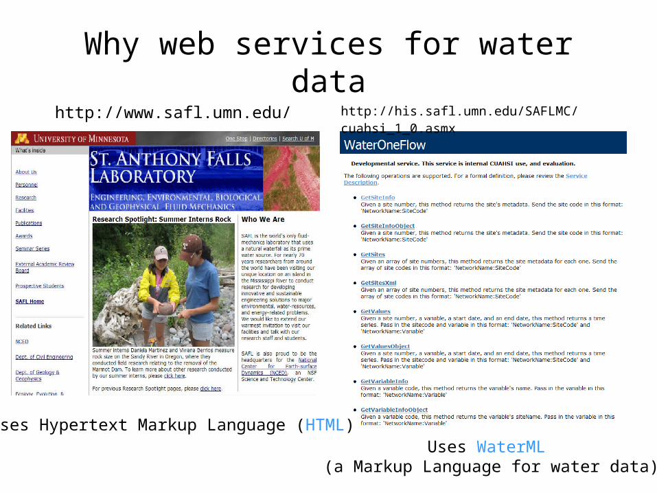
Why web services for water datahttp://www.safl.umn.edu/ http://his.safl.umn.edu/SAFLMC/cuahsi_1_0.asmx
Uses Hypertext Markup Language (HTML)Uses WaterML
(a Markup Language for water data)
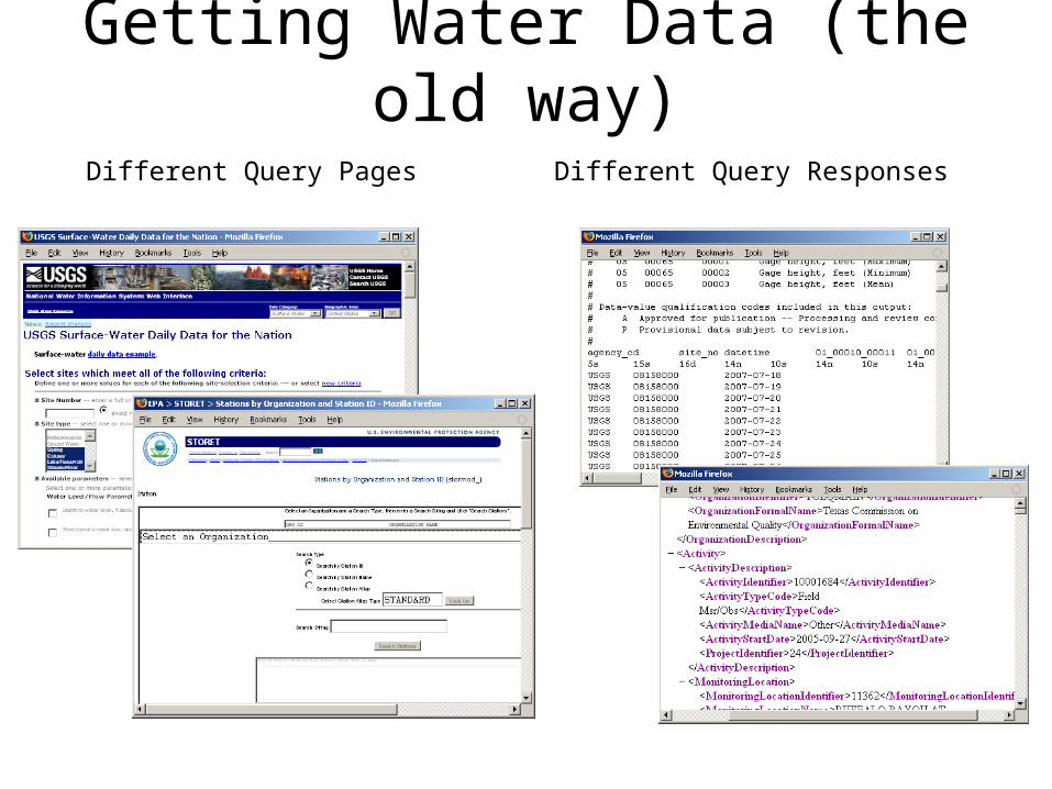
Getting Water Data (the old way)Different Query Pages Different Query Responses
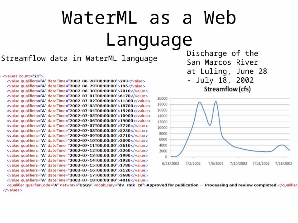
WaterML as a Web LanguageDischarge of the San Marcos River at Luling, June 28 - July 18, 2002
Streamflow data in WaterML language
Site Codes
Variable Codes
Date Ranges
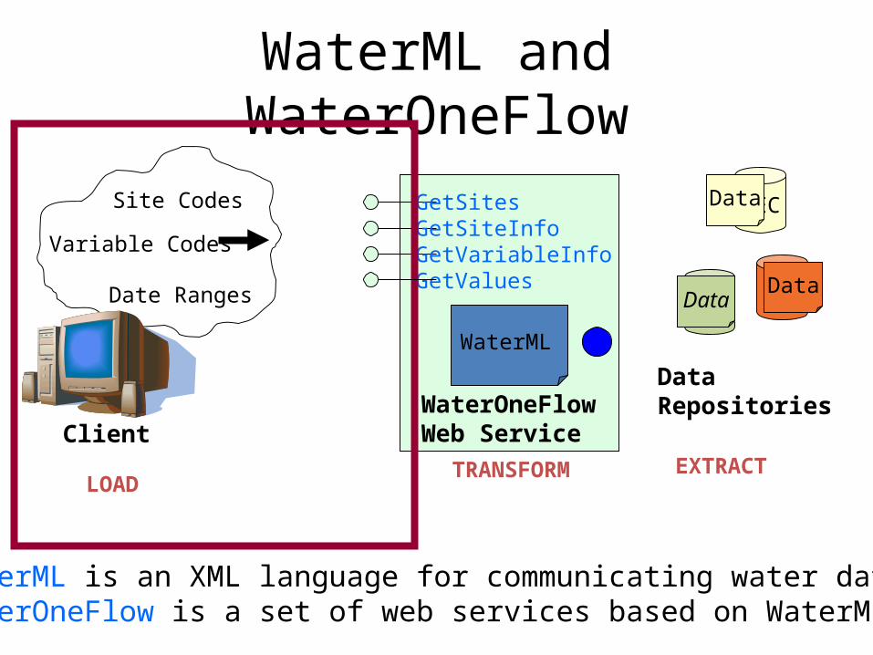
WaterML and WaterOneFlow
GetSitesGetSiteInfoGetVariableInfoGetValues
WaterOneFlowWeb ServiceClient
DEC
UVMUSGS
DataRepositories
Data
DataData
EXTRACTTRANSFORMLOAD
WaterML
WaterML is an XML language for communicating water dataWaterOneFlow is a set of web services based on WaterML
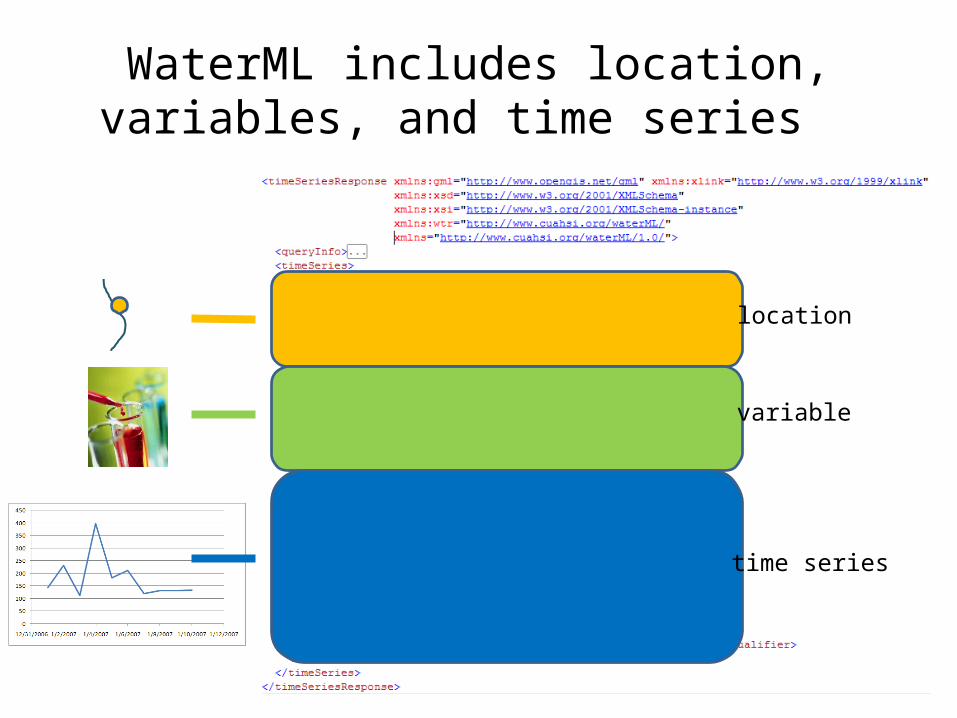
WaterML includes location, variables, and time series
location
variable
time series
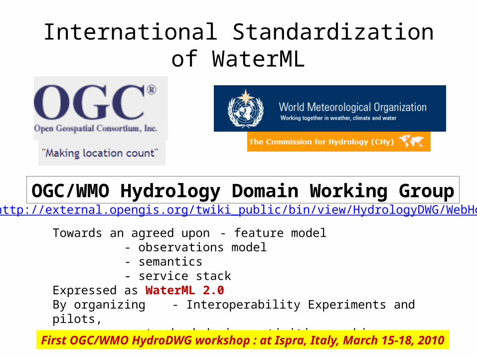
International Standardization of WaterML
7
OGC/WMO Hydrology Domain Working Grouphttp://external.opengis.org/twiki_public/bin/view/HydrologyDWG/WebHome
Towards an agreed upon - feature model- observations model- semantics- service stack
Expressed as WaterML 2.0By organizing - Interoperability Experiments and pilots,
standard design activities, webinars…
First OGC/WMO HydroDWG workshop : at Ispra, Italy, March 15-18, 2010

OGC/WMO Hydrology DWG• Interoperability Experiments:
– Groundwater (ongoing: USGS, CanadianGS, CUAHSI, CSIRO, several companies)– Surface Water (to start June’10: France, Germany, CSIRO, CUAHSI, several
companies)– Water Quality (USGS, EPA, others)– Forecasting (together with NWS, MetOcean DWG)– Water Use (USGS)
• WaterML 2.0 – to be submitted by June• Harmonization report – done• Coordination with WMO (MOU signed)• Next meeting: Silver Spring (at NOAA), June 15, 8am-12• Talks by USGS, NOAA, Unidata; also WaterML and IENext meeting: Silver Spring (at NOAA), June 15, 8am-12Talks by USGS, NOAA, Unidata; also WaterML and IE
9
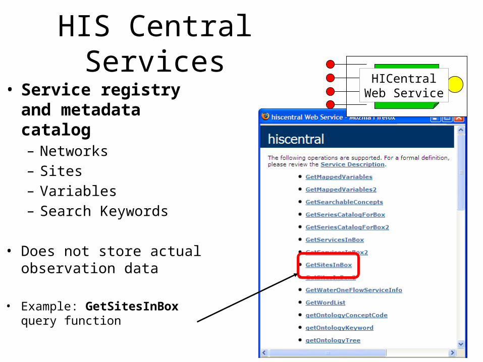
• Service registry and metadata catalog– Networks– Sites– Variables– Search Keywords
• Does not store actual observation data
• Example: GetSitesInBox query function
HIS Central ServicesHICentral
Web Service
CZO
Desktop
Matlab
R
Excel
ArcGIS
Modeling (OpenMI)
Local CZO DB
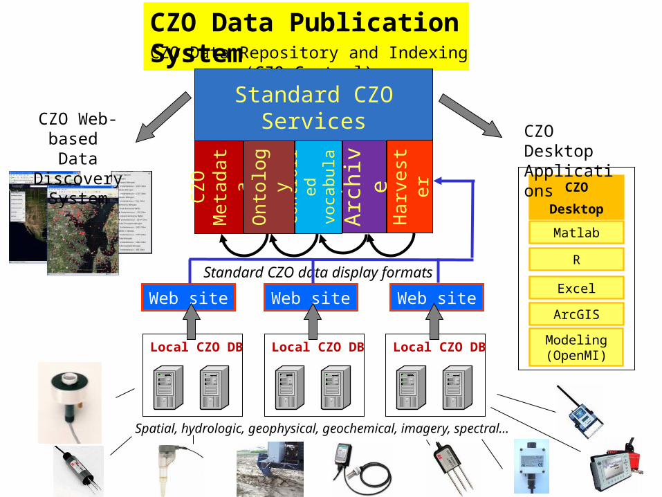
CZO Data Publication System
Spatial, hydrologic, geophysical, geochemical, imagery, spectral…
Local CZO DB Local CZO DB
Web site Web site Web site
CZO Data Repository and Indexing (CZO Central)
Standard CZO Services
Con
trol
led
voca
bula
ries
CZ
O
Met
adat
a
Ont
olog
y
Arc
hive
Har
vest
er
Standard CZO data display formats
CZO Web-based Data Discovery
System
CZO DesktopApplications

CZO Data Publication Model• Relies on individual CZO data management systems to generate display
files– Display file is modeled on LTER data file, and allows adding series-level and data value-
level attributes as defined in CUAHSI Observations Data Model
• When additional display files are generated and placed at CZO web sites, they are picked up and automatically ingested in a CZO repository at SDSC
• The time series in the files are then automatically exposed as water data services (WaterML-compliant web services used by CUAHSI HIS)
• These services are available for data discovery and analysis by a variety of applications: CZO Desktop (a version of HydroDesktop), Google Earth, etc.
• A non-intrusive system: no change in how one would normally publish data on CZO web sites; no additional software/hardware needed.
• Can be a good model for the community wishing to publish their data in an easy and inexpensive way – note the NSF requirement for data management plans with every proposal from October
2010

Comparison of publication models• CUAHSI HIS:
– Install a HydroServer, then:
This is done by local data managers
• CZO:– Manage your own
data system, and generate display filesTransform Raw Data
Load Data into Database
Wrap Database with Web Service
Register Web Service
Harvest catalog, tag variables
Attach Blank ODM Database
Download Data
Tag variables, in rare cases
Download Data
Done behind
the scenes
Comm
unity Water
Data Repository
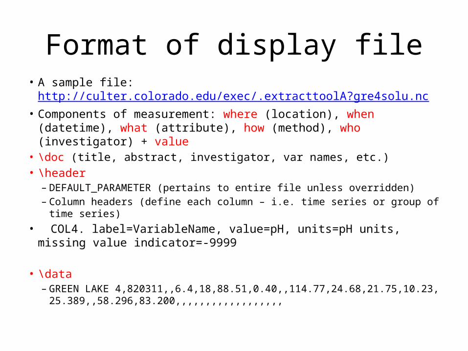
Format of display file• A sample file: http://culter.colorado.edu/exec/.extracttoolA?gre4solu.nc• Components of measurement: where (location), when (datetime), what
(attribute), how (method), who (investigator) + value• \doc (title, abstract, investigator, var names, etc.)• \header
– DEFAULT_PARAMETER (pertains to entire file unless overridden)– Column headers (define each column – i.e. time series or group of time series)
• COL4. label=VariableName, value=pH, units=pH units, missing value indicator=-9999
• \data– GREEN LAKE 4,820311,,6.4,18,88.51,0.40,,114.77,24.68,21.75,10.23,
25.389,,58.296,83.200,,,,,,,,,,,,,,,,,,
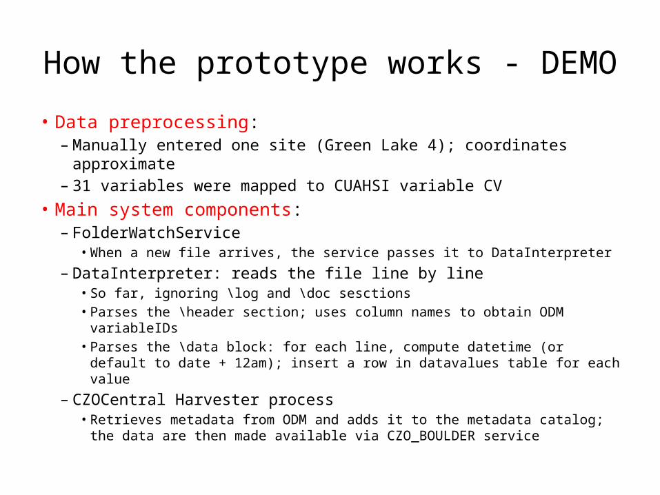
How the prototype works - DEMO• Data preprocessing:
– Manually entered one site (Green Lake 4); coordinates approximate– 31 variables were mapped to CUAHSI variable CV
• Main system components:– FolderWatchService
• When a new file arrives, the service passes it to DataInterpreter
– DataInterpreter: reads the file line by line• So far, ignoring \log and \doc sesctions• Parses the \header section; uses column names to obtain ODM variableIDs• Parses the \data block: for each line, compute datetime (or default to date
+ 12am); insert a row in datavalues table for each value
– CZOCentral Harvester process• Retrieves metadata from ODM and adds it to the metadata catalog; the
data are then made available via CZO_BOULDER service
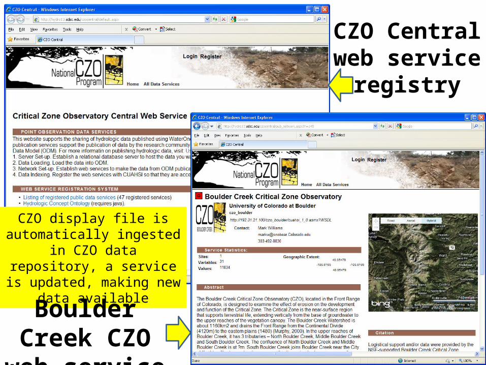
CZO Central web service
registry
CZO display file is automatically ingested in
CZO data repository, a service is updated, making
new data available
Boulder Creek CZO web service
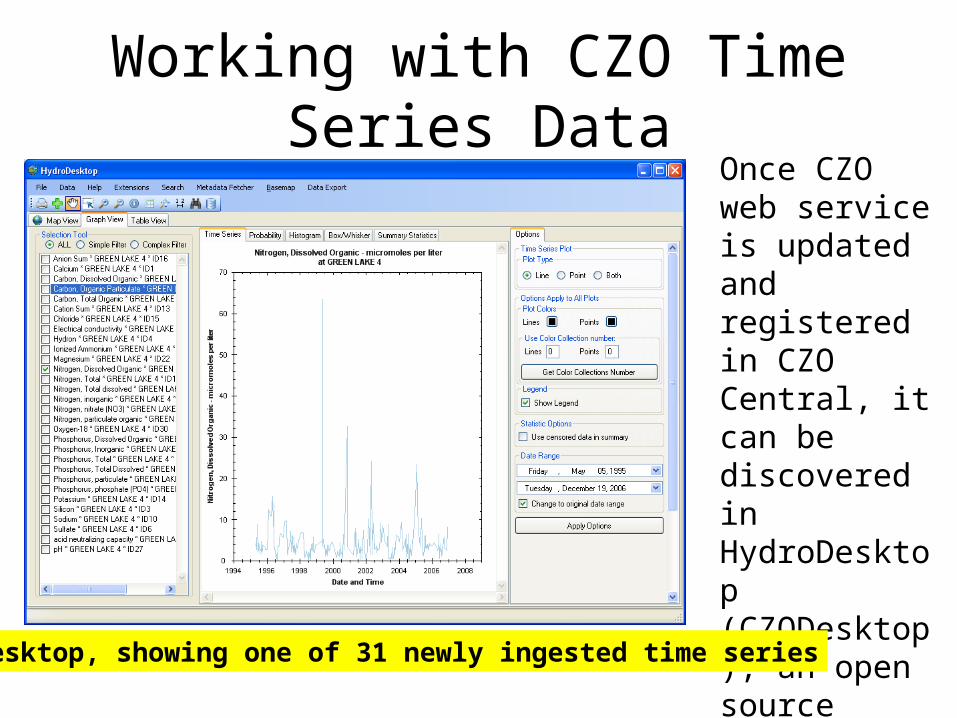
Working with CZO Time Series DataOnce CZO web service is updated and registered in CZO Central, it can be discovered in HydroDesktop (CZODesktop), an open source application with rich mapping and time series analysis capabilitiesHydroDesktop, showing one of 31 newly ingested time series
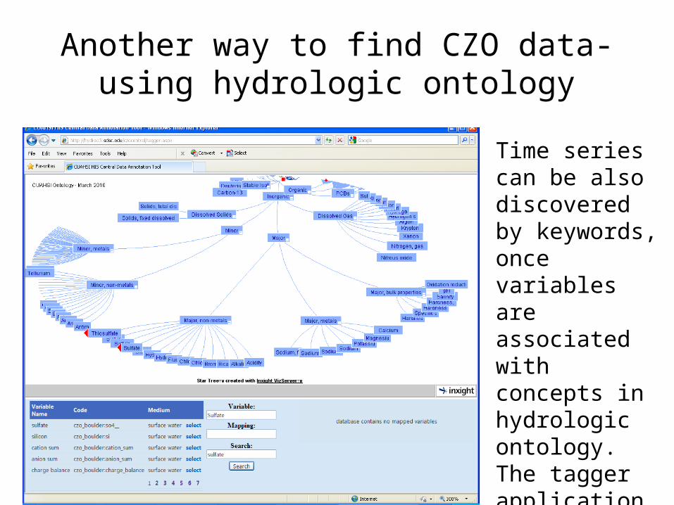
Another way to find CZO data-using hydrologic ontology
Time series can be also discovered by keywords, once variables are associated with concepts in hydrologic ontology. The tagger application is available as part of CZO Web Service Registry
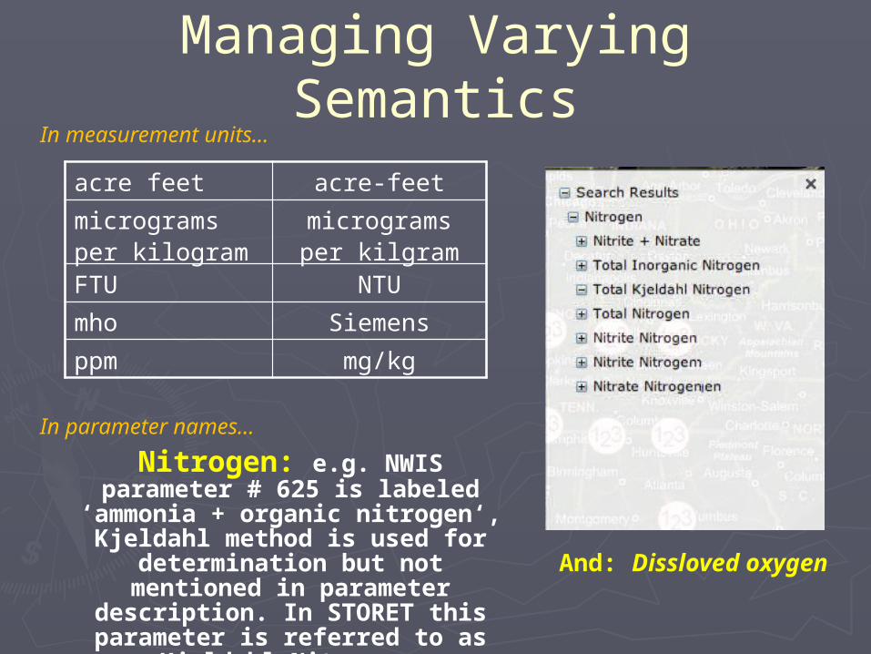
Managing Varying Semantics
Nitrogen: e.g. NWIS parameter # 625 is labeled ‘ammonia + organic
nitrogen‘, Kjeldahl method is used for determination but not mentioned in
parameter description. In STORET this parameter is referred to as Kjeldahl
Nitrogen.
And: Dissloved oxygen
acre feet acre-feet
micrograms per kilogram
micrograms per kilgram
FTU NTU
mho Siemens
ppm mg/kg
In measurement units…
In parameter names…
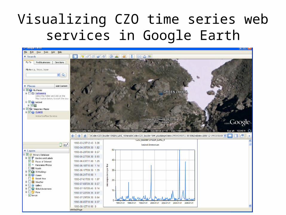
Visualizing CZO time series web services in Google Earth
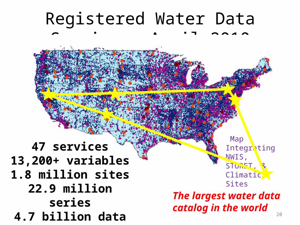
Registered Water Data Services, April 2010
20
Map Integrating NWIS, STORET, & Climatic Sites
47 services13,200+ variables1.8 million sites
22.9 million series4.7 billion data values
(96% of them searchable)
The largest water datacatalog in the world
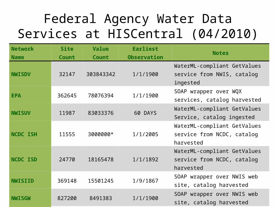
Federal Agency Water Data Services at HISCentral (04/2010)
Network Name Site Count Value Count Earliest Observation Notes
NWISDV 32147 303843342 1/1/1900 WaterML-compliant GetValues service from NWIS, catalog ingested
EPA 362645 78076394 1/1/1900 SOAP wrapper over WQX services, catalog harvested
NWISUV 11987 83033376 60 DAYS WaterML-compliant GetValues Service, catalog ingested
NCDC ISH 11555 3000000* 1/1/2005 WaterML-compliant GetValues service from NCDC, catalog harvested
NCDC ISD 24770 18165478 1/1/1892 WaterML-compliant GetValues service from NCDC, catalog harvested
NWISIID 369148 15501245 1/9/1867 SOAP wrapper over NWIS web site, catalog harvested
NWISGW 827200 8491383 1/1/1900 SOAP wrapper over NWIS web site, catalog harvested
RIVERGAGES 2206 263101295 1/1/2000 WaterML compliant REST services from Army Corps of Engineers
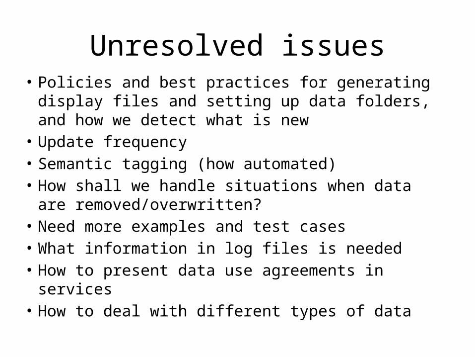
Unresolved issues• Policies and best practices for generating display files
and setting up data folders, and how we detect what is new
• Update frequency• Semantic tagging (how automated)• How shall we handle situations when data are
removed/overwritten?• Need more examples and test cases• What information in log files is needed• How to present data use agreements in services• How to deal with different types of data
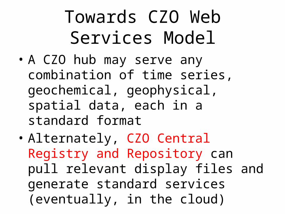
Towards CZO Web Services Model
• A CZO hub may serve any combination of time series, geochemical, geophysical, spatial data, each in a standard format
• Alternately, CZO Central Registry and Repository can pull relevant display files and generate standard services (eventually, in the cloud)
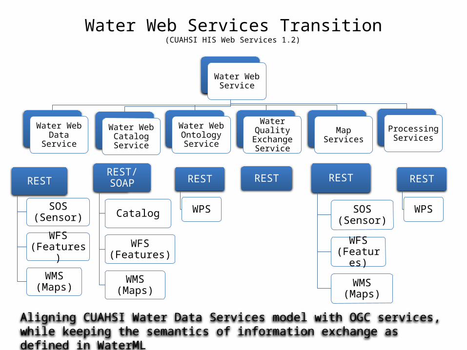
Water Web Services Transition (CUAHSI HIS Web Services 1.2)
Water Web Service
Water Web Data Service
Water Web Catalog Service
Water Web Ontology Service
Water Quality Exchange Service
Map ServicesProcessing
Services
REST
SOS (Sensor)
WFS (Features)
WMS (Maps)
REST
WPS
REST/SOAP
Catalog
WFS (Features)
WMS (Maps)
REST
SOS (Sensor)
WFS (Features)
WMS (Maps)
RESTREST
WPS
Aligning CUAHSI Water Data Services model with OGC services, while keeping the semantics of information exchange as defined in WaterML
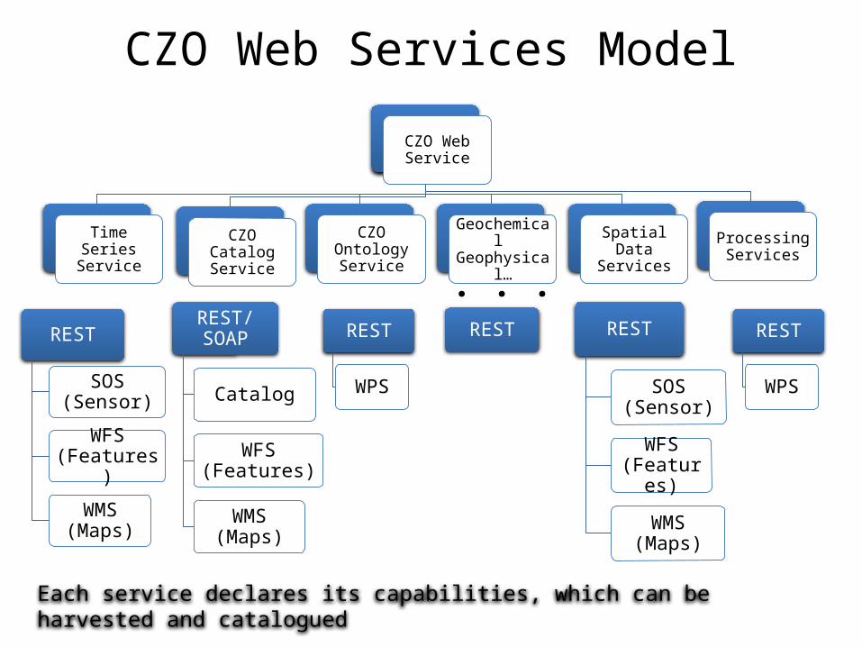
CZO Web Services Model
CZO Web Service
Time Series Service
CZO Catalog Service
CZO Ontology Service
Geochemical Geophysical…
Spatial Data Services
Processing Services
REST
SOS (Sensor)
WFS (Features)
WMS (Maps)
REST
WPS
REST/SOAP
Catalog
WFS (Features)
WMS (Maps)
REST
SOS (Sensor)
WFS (Features)
WMS (Maps)
RESTREST
WPS
Each service declares its capabilities, which can be harvested and catalogued
. . .