Embed Size (px)
Citation preview

Current Measurement ParadigmPathway to the Vision
Current Measurement ParadigmPathway to the Vision
Aqua
Aqua InstrumentsAIRS - Atmospheric Infrared SounderAMSU - Advanced Microwave Sounding UnitAMSR - Advanced Microwave Scanning RadiometerCERES - Clouds and the Earth's Radiant Energy SystemHSB - Humidity Sounder for BrazilMODIS - Moderate-Resolution Imaging SpectroradiometerAura InstrumentsHIRDLS — High Resolution Dynamics Limb SounderMLS — Microwave Limb SounderOMI — Ozone Monitoring InstrumentTES — Tropospheric Emission Spectrometer
The current paradigm for space-based remote sensing relies upon frequency-specific measurements in pre-defined orbits with fixed or narrowly variable detection ranges. The suites of Earth observing instruments currently deployed or planned for deployment within the next three years typify this approach.
Aura
TES - Makes ozone measurement in cloud free regions
MODIS -Determines the location of clouds
15 minutes

Sensor constellation with multiple vantage points provides:
– Continuous viewing– Ability to autonomously
detect an event– Ability to characterize
phenomena and inform appropriate organizations
Landsat heritage imageLandsat heritage imageLandsat heritage imageLandsat heritage image
Agile imaging platforms with full
spectrometers
Atmospheric constituents &
chemistry
Advanced Sensors and the SensorwebAdvanced Sensors and the Sensorweb
Energy balanceActive lidars with imagers
and spectrometers

MotivationProgrammatic Limiters to the VisionMotivationProgrammatic Limiters to the Vision
• Length of time to plan, development and deploy space-based instruments for periodic focused measurements
The result: A decade may pass between the theoretical identification of a phenomenon and the deployment of a space-based asset limits measurement continuity and applicability
• Limited budgets preclude continually launching unique instruments targeted toward specific measurement needs
The result: Instrument designs are targeted to specific measurements and consequently once deployed cannot accommodate new scientific findings

Future remote sensing instruments may need to employ large numbers of frequency-agile instruments capable of multi-scene observations. Real-time, autonomous adaptive sensing and taskability will be critical. Advanced capabilities will include:
– Miniaturized observatories
– Robust, compact instrument architectures
– Miniaturized/programmable components
– Aperture synthesis
– Deployable apertures
– Low cost production
Technology Enablers to the VisionKey Characteristics
Technology Enablers to the VisionKey Characteristics

Science Areas Addressed:– Long range weather prediction– Climate prediction– Biosphere & land process change– Global air & water quality– Natural hazards– Efficient management of natural
resources
Technology Investment Areas:
– Detectors
– Ultra-Large Antennas & Telescopes
– Lidars
– Microwave Sensing
Investment Areas and EnablersInvestment Areas and Enablers

Leverage OpportunitiesPartnershipsLeverage OpportunitiesPartnerships
Level of partnering from outside NASA
Detectors
– Uncooled and Passively Cooled Detectors High– Frequency Agile Detectors Low
Lidar Systems
– Doppler Winds (Coherent and Direct Detection)
Low
– Microlaser Altimetry Low– Atmospheric Chemistry, Clouds/Aerosols Medium
Microwave Sensing Medium-HighUltra-Large Antennas and Telescopes MediumData Processing and Storage HighTypical Partners:
Department of Defense Department of Energy
NOAA NASA’s Space Science Enterprise
Other U. S. Government Labs Academia & Industry

Passively Cooled Thermal IR DetectorsPassively Cooled Thermal IR Detectors
Now 2005 2010
Arr
ay S
ize
2020
256 x 256100K
1 K x 1 K120K
2 K x 2 K130K
16 K x 16 K150K
Key Technologies– Advances current HgCdTe arrays– Ultimately using GaAS QWIP out to
20-microns– Quantum efficiency greater than
20%
Payoff– Less dependence on cooling– Higher efficiency can mean
lower power requirements for active systems

Frequency Agile Detectors Using Non-Linear OpticsFrequency Agile Detectors Using Non-Linear Optics
Now 2010 2020
Sub-mm
Acc
ess
ible
Spect
ral R
egio
n
SWIR
ThermalInfrared
UV
Key Technologies– High-performance Si FPAs over
broad spectral range (UV-FIR)
Payoff– Eliminates cryogenic cooling– Enables programmable and
ultimately “universal” sensors

Now 2007 2015
Incr
easi
ng C
apabili
ty
1J @ 355nm3m telescope35% eff. det.holographic
scan
3J @ 355 nm10m telescope50% eff. det.
Doppler Winds (Direct Detection)
500mJ, 10Hz.5 m optics
NPOESS1J, 12.5
Hz0.75 - 1m
optics
Doppler Winds (Coherent Detection)
ICESAT100mJ, 40Hz0.8m optics
x2 lifetime>efficiency<mass, cost
Laser Altimetry
0.1 - 0.5 m
ht. res.
VCL<1m ht. res.
Atmospheric Chemistry,Clouds/Aerosols
PICASSO-CENAclouds & aerosolsH/V res.
250m/30m
UV DIAL O3 & trace
gases
CO2 Multi-kHz microlaser
altimeter~cm 3D res.
Scanning H2O DIAL
Lidar Systems RoadmapLidar Systems Roadmap
300mJ @ 355nm1m telescope25% eff. det.

Microwave SensingMicrowave Sensing
Now 2007 2015
Measu
rem
en
t C
ap
ab
ility
EOSMLS
GEOSAMSDemo P-Band
SAR
ArrayMLS
Geo SyntheticAperture Sounding
Compact SounderFor Constellations
CloudRadar
Hi-ResPrecip.Radar
Sea Surface WindRadiometer
ScanningCloud / Precip.
Radars
Multi-Frequency
SAR Interferomet
rySoil Moisture/Sea Surface
SalinityRadiometer
Key Technologies– MMIC low-noise submm amps– Low-noise mixers/arrays– THz mixers and LO’s– Compact, efficient transmitter
devices, P- to W- band– High throughput digital
processing
Payoff– New capabilities– Increased profiling sensitivity
with improved spatial sampling– Reduced mass and power– Reduced launch costs– Improved global coverage

Now
Arr
ay A
rea (
m2)
20202010
100000
10
ArealDensity(kg/m2)
1
100
Optical Telescope
s
RF Antennas
100
1000
10000
10
.1
.01
MultifunctioMultifunction n
Membrane Membrane StructuresStructures
Adaptive Adaptive MembranMembrane Opticse Optics
50m High 50m High Resolution Resolution
ImagerImager
GEO HighGEO HighResolution Resolution
Thermal Thermal ImagerImager
Deployable Deployable Segmented Segmented TelescopesTelescopes
LEO Synthetic LEO Synthetic ApertureAperture
Soil Moisture Soil Moisture and Sea Surface and Sea Surface
WindsWinds
LEO LEO Synthetic Synthetic ApertureAperture
Sea Surface Sea Surface SalinitySalinity
300m GEO 300m GEO Synthetic Synthetic Aperture Aperture
RadiometerRadiometerSoil Moisture and Soil Moisture and Sea Sea Surface Sea Sea Surface
WindsWinds
InflatableInflatableAntennasAntennas
Ultra-Large Antennas and TelescopesUltra-Large Antennas and TelescopesKey Technologies– Inflatable Structures– Deployable Structures– Multifunctional Structures– Adaptive Control Systems– Membrane Optics and Large
Deformable Mirrors
Payoff– Enables low cost, lightweight
sensor web nodes– Enables large diameter
instrument front ends– Enables high spatial resolution
science

2005 2010 2015 2020
2025
1 Pb
Storage Capacity
100 Tb
1 Tb
1T
10M
1M Num
ber
of
Gate
s
Reconfigurable computing
Pix
•Miniaturized, 3D packaging
•2 Gb stacks•Low power,
mass, volume•$1K/Gb •RAM-FPGA farm
•Basic onboard processing and data compression
•Pre-defined formats/protocols•COTS/DMBS•Direct delivery to user
• Improved manufacturing/ packaging process
•$5K/Tb
•RAM-FPGA farm•Advanced onboard
processing; algorithm uploads•User selectable formats•Direct delivery to user
•Holographic; photorefractive
•Distributed RAM-FPGA
• Interoperable processing among spacecraft and DBs
•Direct delivery to user
• Bio Computing
Data Processing & StorageData Processing & Storage

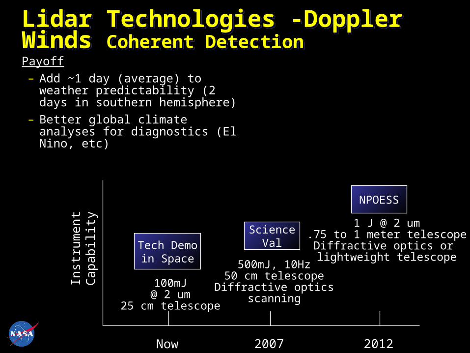
Lidar Technologies -Doppler Winds Coherent DetectionLidar Technologies -Doppler Winds Coherent Detection
Tech Demoin Space
Now 2007 2012
Inst
rum
ent
Capabili
ty ScienceVal
500mJ, 10Hz50 cm telescopeDiffractive optics
scanning
NPOESS
1 J @ 2 um.75 to 1 meter telescope
Diffractive optics or lightweight telescope
100mJ@ 2 um
25 cm telescope
Payoff– Add ~1 day (average) to weather
predictability (2 days in southern hemisphere)
– Better global climate analyses for diagnostics (El Nino, etc)

Now 2007 2015
Rela
tive C
apabili
ty
1000
30
1
300 mJ @ 3551 m ø telescope
25% eff det
1 J @ 3553 m ø telescope
35% eff detHolographic scanning
3 J @ 35510 m ø telescope
50% eff det
Lidar Technologies -Doppler Winds Direct DetectionLidar Technologies -Doppler Winds Direct Detection
Payoff– Improved weather forecast– Better understanding of long- and
short-term climate

Lidar Technologies -AltimetryLidar Technologies -Altimetry
Now 2005 2010
Inst
rum
ent
Capabili
ty
10 kHz SpaceborneFree Flyer (550 km)
4 kHz Shuttle Demo (300 km)
10 kHz Aircraft Demo (12 km)
Key Technologies– Multikilohertz laser
transmitter (4 mJ @ 10 kHz)
– Photon-counting imaging/ ranging microchannel plate photomultiplier
Payoff– Two orders of magnitude
better spatial resolution and coverage
– Less prone to optical damage and improved eye safety
Applications– Surface topography
(Land, Ice, Oceans)– Tree canopy heights
(Biomass)– Cloud heights
(Radiation Balance)– Sea level


![Collocating GRAS with AMSU onboard of Metop · Fig. 5: Differences of RO−AMSU for different channels 6a) 6b) 6c) Fig. 6: Differences of ECMWF−AMSU for different channels [AMSU]](https://img.dokumen.tips/doc/110x75/60479a47fe16580c6f3cf446/collocating-gras-with-amsu-onboard-of-metop-fig-5-diierences-of-roaamsu-for.jpg)


