Embed Size (px)
Citation preview

CS 128/ES 228 - Lecture 9a 1
Vector* Data Sources
* mostly

CS 128/ES 228 - Lecture 9a 2
[Georgian’s] First Law of GIS
Try to use somebody else’s data before you even think of
generating your own

CS 128/ES 228 - Lecture 9a 3
Geographic data portals
“Be aware” of their existence, but don’t memorize details!
Bear in mind while working on your course project

CS 128/ES 228 - Lecture 9a 4
Nat. Geospatial Data Clearinghouse Composed of
many federal agency reps.
Developing the National Spatial Data Infra-structure
Working with Office of Homeland Security

CS 128/ES 228 - Lecture 9a 5
USGS: National Mapping Info.
Primary responsibility for US mapping
Mapping standards and metadata
Topographic maps
GNIS

CS 128/ES 228 - Lecture 9a 6
US Bureau of the Census
Address and population data, tied to the census tract
TIGER maps

CS 128/ES 228 - Lecture 9a 7
NYS GIS Clearinghouse
Familiar site?
Statewide aerial photographs
DOT maps
Gateway to many USGS & NYS products

CS 128/ES 228 - Lecture 9a 8
Academic sites
Prominent GIS programs:
Cornell U.
U. Buffalo
U. Calif., SantaBarbara
U. Minnesota

CS 128/ES 228 - Lecture 9a 9
Commercial sites (i.e. $$)

CS 128/ES 228 - Lecture 9a 10
ESRI’s site
nice move, licensing GIS.com!)
The GIS portal!~ 100 GIS links
GIS World

CS 128/ES 228 - Lecture 9a 11
1. Digital Raster graphs (DRGs)
Scanned topographic maps at various scales
Resolution: 400 dpi typical
Projection and coordinate system: varies (read the metadata!)
Accuracy: roughly that of paper source maps
Layers: either 1 or 2. No full GIS capability

CS 128/ES 228 - Lecture 9a 12
Commercial sources of DRGsVarious companies(e.g., Delorme, Silva)
1:24,000 or 1:100,000
~ $100/state
various tools, but one layer

CS 128/ES 228 - Lecture 9a 13
3-D renderings

CS 128/ES 228 - Lecture 9a 14
USGS DRGs
1:24,000 or 1:100,000
two layers - features - topography
feature classes can’t be separated

CS 128/ES 228 - Lecture 9a 15
2. Digital line graphs (DLGs)
Scales 1:24,000 1:100,000 1:2 million
Full topological data structure (nodes, lines, areas + adjacency information)
Layers: 9 feature classes, street & address information, elevations
Projection: UTM (large & medium scale), Albers Conical Equal Area (small scale)
CS 128/ES 228 - Lecture 9a 16
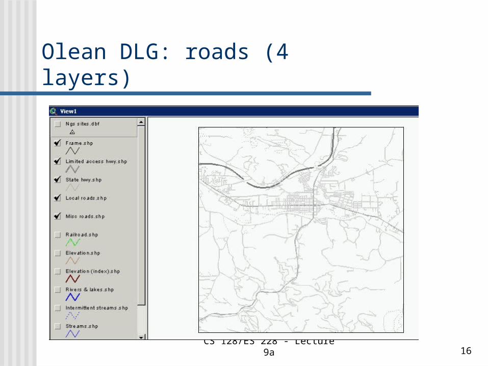
Olean DLG: roads (4 layers)

CS 128/ES 228 - Lecture 9a 17
Olean DLG: add water features

CS 128/ES 228 - Lecture 9a 18
Olean DLG: add contours

CS 128/ES 228 - Lecture 9a 19
Olean DLG: all layers

CS 128/ES 228 - Lecture 9a 20
How are geographical features represented?
Two Mile Creek near campus

CS 128/ES 228 - Lecture 9a 21
Larger rivers: both banks (lines)
Allegheny River near campus

CS 128/ES 228 - Lecture 9a 22
Major attribute codes

CS 128/ES 228 - Lecture 9a 23
Minor attribute codes

CS 128/ES 228 - Lecture 9a 24
3. TIGER maps
U. S. Census Bureau’s DLGformat
Include county,census tract, &census block
De facto standard/source for most commercial geocoding and trip planning software
Topologically Integrated Geographic Encoding & Referencing system

CS 128/ES 228 - Lecture 9a 25
The TIGER map browser

CS 128/ES 228 - Lecture 9a 26
Center on a familiar point…

CS 128/ES 228 - Lecture 9a 27
TIGER for Allegany NY

CS 128/ES 228 - Lecture 9a 28
Census Bureau databases
American Factfinder
Reports in table or map form
Joins or relates?

CS 128/ES 228 - Lecture 9a 29
Thematic maps

CS 128/ES 228 - Lecture 9a 30
Resolution to the census tract

CS 128/ES 228 - Lecture 9a 31
Local demographic stats

CS 128/ES 228 - Lecture 9a 32
Summary: digital data sources Digital
raster graphs(DRGs)
Digital line graphs(DLGs)
TIGER files