Embed Size (px)
Citation preview

TAJE_A_826735.3d (TAJE) 09-10-2013 19:18
Crustal architecture of the Capricorn Orogen, WesternAustralia and associated metallogeny
S. P. JOHNSON1*, A. M. THORNE1, I. M. TYLER1, R. J. KORSCH2, B. L. N. KENNETT3,
H. N. CUTTEN1, J. GOODWIN2, O. BLAY1, R. S. BLEWETT2, A. JOLY4, M. C. DENTITH4,
A. R. A. AITKEN4, J. HOLZSCHUH2, M. SALMON3, A. READING5, G. HEINSON6, G. BOREN6,
J. ROSS6, R. D. COSTELLOE2 AND T. FOMIN2
1Geological Survey of Western Australia, Department of Mines and Petroleum, Mineral House, 100 Plain Street,
East Perth, WA 6004, Australia2Minerals and Natural Hazards Division, Geoscience Australia, GPO Box 378, Canberra, ACT 2601, Australia3Research School of Earth Sciences, The Australian National University, Canberra ACT 0200, Australia4Centre for Exploration Targeting, School of Earth and Environment, The University of Western Australia, 35 Stirling
Highway, Crawley, WA 6009, Australia5School of Earth Sciences and CODES Centre of Excellence, University of Tasmania, Private Bag 79, Hobart, TAS
7001, Australia6Centre for Tectonics, Resources and Exploration, University of Adelaide, Adelaide, SA 5005, Australia
A 581 km vibroseis-source, deep seismic reflection survey was acquired through the Capricorn Orogenof Western Australia and, for the first time, provides an unprecedented view of the deep crustal archi-tecture of theWest Australian Craton. The survey has imaged three principal suture zones, as well as sev-eral other lithospheric-scale faults. The suture zones separate four seismically distinct tectonic blocks,which include the Pilbara Craton, the Bandee Seismic Province (a previously unrecognised tectonicblock), the Glenburgh Terrane of the Gascoyne Province and the Narryer Terrane of the Yilgarn Craton.In the upper crust, the survey imaged numerous Proterozoic granite batholiths as well as the architec-ture of the Mesoproterozoic Edmund and Collier basins. These features were formed during the punctu-ated reworking of the craton by the reactivation of the major crustal structures. The location andsetting of gold, base metal and rare earth element deposits across the orogen are closely linked to themajor lithospheric-scale structures, highlighting their importance to fluid flow within mineral systems bythe transport of fluid and energy direct from the mantle into the upper crust.
KEYWORDS: Ashburton Basin, Capricorn Orogen, Collier Basin, Edmund Basin, Fortescue Basin, Gas-coyne Province, Glenburgh Orogeny, Glenburgh Terrane, Hamersley Basin, intracontinental reworking,mineralisation, Narryer Terrane, Ophthalmian Orogeny, Pilbara Craton, seismic reflection study, suturezone, West Australian Craton, Yilgarn Craton.
INTRODUCTION
Like most continental regions on Earth, the Australiancontinent is particularly well endowed with severallarge, high-quality (or giant) orebodies including ironore in the Hamersley Ranges of the Pilbara, lead–zinc atBroken Hill, uranium–copper–gold at Olympic Dam andlead–zinc–copper–gold at Mount Isa, as well as numeroushigh-quality gold and nickel deposits. The large range ofcommodities and abundance of deposits has been themain driver for Australia’s recent economic success andstability; however, these resources are being depleted ata rate greater than they are being discovered. Thedecline in exploration success is due mostly to the
inaccessibility of the bedrock, up to 80% of which is cov-ered by a thick layer of regolith, or is locally deeplyweathered (Australian Academy of Science 2012). It alsosuffers from a lack of detailed geological knowledge insome underexplored (greenfields) parts of the continent.A variety of geological evidence has shown that the for-mation of giant orebodies or deposit clusters in theupper crust, are directly related to specific tectonic set-tings (e.g. Groves et al. 2005; Kerrich et al. 2005; Begget al. 2010; Hronsky et al. 2012), and that they commonlyoccur above deep crustal structures that mark the edgesof discrete continental blocks, such as fossil suturezones or the extended margins of rifted continents.
*Corresponding author: [email protected]� 2013 Crown Copyright
Australian Journal of Earth Sciences (2013)
60, 681–705, http://dx.doi.org/10.1080/08120099.2013.826735
Dow
nloa
ded
by [
Aus
tral
ian
Nat
iona
l Uni
vers
ity]
at 1
5:07
07
Nov
embe
r 20
13

TAJE_A_826735.3d (TAJE) 09-10-2013 19:18
Regional-scale geophysical surveys, including aeromag-netic, gravity and a range of passive and active seismictechniques, provide a relatively rapid method for greatlyincreasing our geological understanding of deeply bur-ied or weathered geological terranes, as well as provid-ing critical first-order constraints on crustalarchitecture (e.g. Golbey et al. 2006; Aitken & Betts 2009;Cayley et al. 2011). When these geophysical methods arecombined with some degree of geological knowledge,regions of preferential mineral endowment can be iden-tified, providing a locus for mineral exploration andtargeting.
The Capricorn Orogen of Western Australia is a�1000 km long, 500 km wide region of variably deformedrocks located between the Pilbara and Yilgarn Cratons(Figure 1) and records the Paleoproterozoic assembly ofthese cratons to form the West Australian Craton, aswell as over one billion years of subsequent intracra-tonic reworking (Cawood & Tyler 2004; Sheppard et al.2010a, b; Johnson et al. 2011a). Apart from the extensivehigh-grade iron-ore deposits along the southern Pilbaramargin, the region has few working mines and has hadlittle history of recent world-class orebody discovery.The western part of the orogen is particularly wellexposed, and as a result the surface geology, geologicalhistory and plate tectonic setting of the orogen is mostlywell understood (e.g. Sheppard et al. 2010b; Johnsonet al. 2011a). However, owing to extensive crustal rework-ing, the location of major crustal structures and broadarchitecture of the orogen are poorly constrained. Toimprove the exploration potential of the region, a betterunderstanding of the crustal architecture across the oro-gen is critical, especially identifying the location and
orientation of major crustal structures and craton edges,as well as any island arc, or exotic accreted crustalmaterial.
In April and May 2010, 581 km of vibroseis-source,deep seismic reflection data were acquired along threetraverses (10GA–CP1, 10GA–CP2, and 10GA–CP3)through the well-exposed western part of the orogen.These data were interpreted in conjunction with 400 m-line-spaced aeromagnetic and 2.5 km-spaced regionalgravity data, as well as detailed gravity and magnetotel-luric data that were collected along the length of the sur-vey. The traverses started in the southern part of thePilbara Craton, crossed the Gascoyne Province, andended in the Narryer Terrane of the Yilgarn Craton(Figures 2, 3). The project was a collaboration betweenthe Geological Survey of Western Australia (GSWA),AuScope (a component of NCRIS, the National Collabora-tive Research Infrastructure Strategy), and GeoscienceAustralia. The seismic data were processed by the Seis-mic Acquisition and Processing team of the OnshoreEnergy and Minerals Division at Geoscience Australiaand interpreted by the authors of this paper during sev-eral interpretation sessions. The seismic processingsteps, 2.5D geophysical forward modelling and geologicalinterpretation of the seismic data are outlined in detailin Johnson et al. (2011b) and in the SupplementaryPaper. This paper presents the results of that final inter-pretation in order to construct a rigid architectural andgeological framework for the orogen, and to betterunderstand the nature and geometry of events associ-ated with both the assembly and punctuated reactivationof the West Australian Craton. This improved and inte-grated geological dataset also provides critical
Figure 1 Elements of the Capricorn Orogen and surrounding cratons and basins, showing the location of the Capricorn Oro-gen seismic transect. Modified from Martin & Thorne (2004). The thick grey lines delimit the northern and southern bound-aries of the Capricorn Orogen. Inset shows location of the Capricorn Orogen and Paleoproterozoic crustal elements (KC,Kimberley Craton; NAC, North Australian Craton; SAC, South Australian Craton; WAC,West Australian Craton) and Archeancratons (YC, Yilgarn Craton; PC, Pilbara Craton; GC, Gawler Craton). Other abbreviations: MI, Marymia Inlier; YGC, Yarlar-weelor Gneiss Complex.
682 S. P. Johnson et al.
Dow
nloa
ded
by [
Aus
tral
ian
Nat
iona
l Uni
vers
ity]
at 1
5:07
07
Nov
embe
r 20
13

TAJE_A_826735.3d (TAJE) 09-10-2013 19:18
Figure 2 Geological map of the western Capricorn Orogen, showing the location of the Capricorn Orogen seismic lines 10GA–
CP1, 10GA–CP2, and 10GA–CP3.
Architecture of the Capricorn Orogen 683
Dow
nloa
ded
by [
Aus
tral
ian
Nat
iona
l Uni
vers
ity]
at 1
5:07
07
Nov
embe
r 20
13

TAJE_A_826735.3d (TAJE) 09-10-2013 19:18
geodynamic information that may be used to identifyregions of the upper crust that may contain a preferen-tial mineral endowment or be more prospective for par-ticular commodities.
GEOLOGICAL SETTING
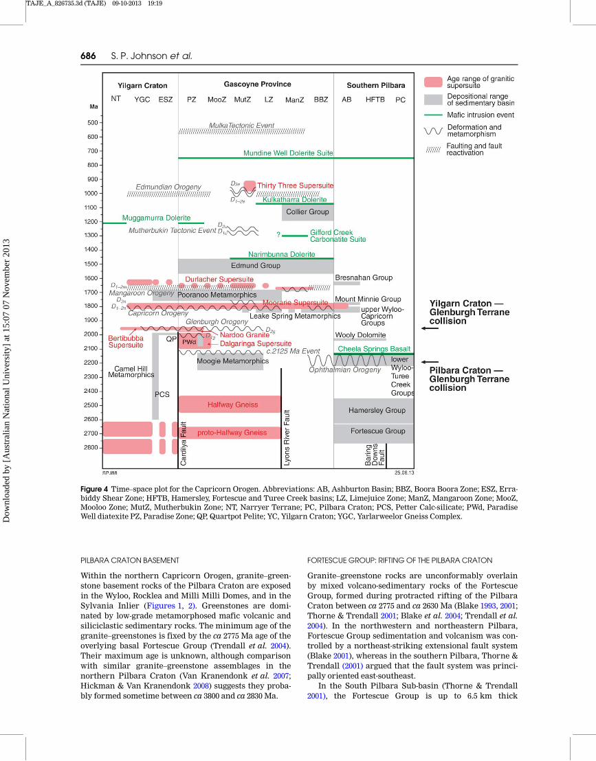
Early interpretations of the Capricorn Orogen (e.g.Horwitz & Smith 1978; Gee 1979) favoured an intracra-tonic setting. These were followed by plate tectonic mod-els in which the Proterozoic orogeny was driven bycollision between the hitherto unrelated Pilbara and Yil-garn Cratons (Muhling 1988; Tyler & Thorne 1990; Blake& Barley 1992; Powell & Horwitz 1994; Evans et al. 2003).More recent work, however, has highlighted the com-plexity of the Capricorn Orogen, which has now beenshown to record at least seven major orogenic events(Figure 4; e.g. Sheppard et al. 2010b), the oldest two ofwhich, the 2215–2145 Ma Ophthalmian Orogeny and the2005–1950 Ma Glenburgh Orogeny, relate to the punctu-ated assembly of the West Australian Craton (Blake &Barley 1992; Powell & Horwitz 1994; Occhipinti et al.2004; Sheppard et al. 2004; Rasmussen et al. 2005; John-son et al. 2011a), while the younger five, record over onebillion years of intracratonic reworking (Cawood &Tyler 2004; Sheppard et al. 2010b; Johnson et al. 2011a).
The orogen includes the deformed margins of the Pil-bara and Yilgarn Cratons and associated deformed conti-nental margin rocks of the Fortescue, Hamersley, TureeCreek and lower Wyloo Groups in the Ophthalmia FoldBelt; medium to high-grade meta-igneous and metasedi-mentary rocks of the Gascoyne Province that form the
core of the orogen; and numerous, variably deformedlow-grade metasedimentary rocks—including the upperWyloo, Bresnahan, Mount Minnie, Padbury, Bryah, Yer-rida, Earaheedy, Edmund and Collier Groups—that over-lie the West Australian Craton (Figures 1–4; Cawood &Tyler 2004; Sheppard et al. 2010b). The geological dataare summarised in a time–space plot in Figure 4, and adetailed geotectonic history of the orogen, in the vicinityof the seismic traverse, is provided below.
The Pilbara Craton and Archean to Proterozoicsedimentation in the northern Capricorn Orogen
During the late Archean and Paleoproterozoic, prior tothe collision of the Pilbara Craton with the GlenburghTerrane of the Gascoyne Province, the southern marginof the craton evolved from an intracontinental rift to apassive margin, before being converted to an active mar-gin, and subsequently into a series of foreland basins(Blake & Barley 1992; Krape�z 1999; Martin et al. 2000;Thorne & Trendall 2001; Trendall et al. 2004; Martin &Morris 2010). This history is marked by the deposition ofthe Fortescue, Hamersley, Turee Creek, and lower WylooGroups. Following the assembly of the West AustralianCraton, Paleoproterozoic intracontinental reactivationresulted in the deposition of the upper Wyloo and Capri-corn Groups (Figures 4, 5) in a possible foreland basinsetting. Based on the known stratigraphy, stacking of allthe Archean and Paleoproterozoic supracrustal unitspresent in the northern Capricorn Orogen gives a maxi-mum cumulative thickness of �26 km (Figure 5).
Figure 2 Continued.
684 S. P. Johnson et al.
Dow
nloa
ded
by [
Aus
tral
ian
Nat
iona
l Uni
vers
ity]
at 1
5:07
07
Nov
embe
r 20
13
TAJE_A_826735.3d (TAJE) 09-10-2013 19:18
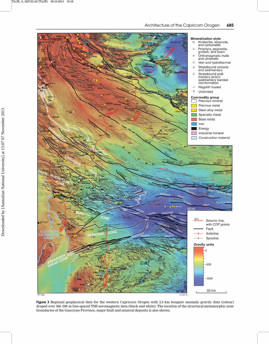
Figure 3 Regional geophysical data for the western Capricorn Orogen with 2.5 km bouguer anomaly gravity data (colour)draped over 300–500 m line-spaced TMI aeromagnetic data (black and white). The location of the structural-metamorphic zoneboundaries of the Gascoyne Province, major fault and mineral deposits is also shown.
Architecture of the Capricorn Orogen 685
Dow
nloa
ded
by [
Aus
tral
ian
Nat
iona
l Uni
vers
ity]
at 1
5:07
07
Nov
embe
r 20
13
TAJE_A_826735.3d (TAJE) 09-10-2013 19:19
PILBARA CRATON BASEMENT
Within the northern Capricorn Orogen, granite–green-stone basement rocks of the Pilbara Craton are exposedin the Wyloo, Rocklea and Milli Milli Domes, and in theSylvania Inlier (Figures 1, 2). Greenstones are domi-nated by low-grade metamorphosed mafic volcanic andsiliciclastic sedimentary rocks. The minimum age of thegranite–greenstones is fixed by the ca 2775 Ma age of theoverlying basal Fortescue Group (Trendall et al. 2004).Their maximum age is unknown, although comparisonwith similar granite–greenstone assemblages in thenorthern Pilbara Craton (Van Kranendonk et al. 2007;Hickman & Van Kranendonk 2008) suggests they proba-bly formed sometime between ca 3800 and ca 2830 Ma.
FORTESCUE GROUP: RIFTINGOF THE PILBARA CRATON
Granite–greenstone rocks are unconformably overlainby mixed volcano-sedimentary rocks of the FortescueGroup, formed during protracted rifting of the PilbaraCraton between ca 2775 and ca 2630 Ma (Blake 1993, 2001;Thorne & Trendall 2001; Blake et al. 2004; Trendall et al.2004). In the northwestern and northeastern Pilbara,Fortescue Group sedimentation and volcanism was con-trolled by a northeast-striking extensional fault system(Blake 2001), whereas in the southern Pilbara, Thorne &Trendall (2001) argued that the fault system was princi-pally oriented east-southeast.
In the South Pilbara Sub-basin (Thorne & Trendall2001), the Fortescue Group is up to 6.5 km thick
Figure 4 Time–space plot for the Capricorn Orogen. Abbreviations: AB, Ashburton Basin; BBZ, Boora Boora Zone; ESZ, Erra-biddy Shear Zone; HFTB, Hamersley, Fortescue and Turee Creek basins; LZ, Limejuice Zone; ManZ, Mangaroon Zone; MooZ,Mooloo Zone; MutZ, Mutherbukin Zone; NT, Narryer Terrane; PC, Pilbara Craton; PCS, Petter Calc-silicate; PWd, ParadiseWell diatexite PZ, Paradise Zone; QP, Quartpot Pelite; YC, Yilgarn Craton; YGC, Yarlarweelor Gneiss Complex.
686 S. P. Johnson et al.
Dow
nloa
ded
by [
Aus
tral
ian
Nat
iona
l Uni
vers
ity]
at 1
5:07
07
Nov
embe
r 20
13

TAJE_A_826735.3d (TAJE) 09-10-2013 19:19
(Figure 5), and is subdivided, into seven formations,which are grouped into four major tectono-stratigraphicunits. From the base upwards, Unit 1 consists of the Bel-lary Formation and Mount Roe Basalt; Unit 2 is theHardey Formation; Unit 3 consists of the Boongal, Pyra-die and Bunjinah formations; and Unit 4 is the JeerinahFormation. Thick mafic to ultramafic sills intrude muchof the succession above the Mount Roe Basalt. The originof the four major tectono-stratigraphic units of the For-tescue Group are interpreted to result from depositionin an extensional tectonic setting (Thorne & Trendall2001).
HAMERSLEY GROUP: PASSIVE- TO ACTIVE-MARGIN
SEDIMENTATION AND IGNEOUS ACTIVITY
The 2.5–3.0 km thick Hamersley Group conformablyoverlies the Fortescue Group (Figure 5), and was depos-ited between ca 2630 and ca 2450 Ma, when the southernPilbara evolved from a rift setting to a passive continen-tal margin and finally to an active margin (Morris &Horwitz 1983; Blake & Barley 1992; Krape�z 1999; Thorne& Trendall 2001; Trendall et al. 2004; Martin & Morris2010). Rocks of the Hamersley Group reflect this largelydeeper-marine distal setting, and are dominated bybanded iron-formation, shale, chert and fine-grainedcarbonate.
Seven major lithostratigraphic units are recognisedwithin the Hamersley Group. In ascending order, these
are the Marra Mamba Iron Formation, Wittenoom For-mation, Mount Sylvia Formation, Mount McRae Shale,Brockman Iron Formation, Weeli Wolli Formation, andBoolgeeda Iron Formation (Trendall & Blockley 1970;Simonson et al. 1993; Trendall et al. 2004).
TUREE CREEK GROUP AND LOWERWYLOOGROUP:
FORELAND BASIN SEDIMENTATION AND VOLCANISM DURING
THE OPHTHALMIAN OROGENY
Deposition of the Turee Creek and lower Wyloo Groups,took place during the early foreland-basin stage of the2215–2145 Ma Ophthalmian Orogeny, when the PilbaraCraton collided with the Glenburgh Terrane to the south(Blake & Barley 1992; Martin et al. 2000; Occhipinti et al.2004; Sheppard et al. 2004, 2010b; Rasmussen et al. 2005;Johnson et al. 2010, 2011a; Martin & Morris 2010). Analternative view by Krape�z &McNaughton (1999), consid-ered the post-Turee Creek Group history in terms of twomega-sequences that record the opening and closure ofan Atlantic-type ocean.
Along the southern Pilbara margin, the Turee Creekand lower Wyloo groups have maximum thicknesses ofabout 4 and 3 km, respectively, although the Turee CreekGroup was not crossed during the survey. The upperpart of the lower Wyloo Group is dominated by the� 2 km thick, ca 2210 Ma Cheela Springs Basalt, andboth the Turee Creek and lower Wyloo Groups areintruded by similar-aged dolerite sills and dykes (Martin
Figure 5 Generalised stratigraphy and deformation history of the northern Capricorn Orogen. The tectonic interpretation ismodified after Martin &Morris (2010).
Architecture of the Capricorn Orogen 687
Dow
nloa
ded
by [
Aus
tral
ian
Nat
iona
l Uni
vers
ity]
at 1
5:07
07
Nov
embe
r 20
13

TAJE_A_826735.3d (TAJE) 09-10-2013 19:19
et al. 1998; M€uller et al. 2005; Martin & Morris 2010). Thetwo groups are separated by a significant angular uncon-formity (Figure 5), and, together with another occurringwithin the upper Turee Creek Group, are interpreted toreflect the northward propagation of the Ophthalmiafold-and-thrust belt into the foreland basin (Martin &Morris 2010).
UPPER WYLOO ANDCAPRICORNGROUPS: FORELAND-BASIN
SEDIMENTATION AND VOLCANISM DURING THE CAPRICORN
OROGENY
The upper Wyloo Group (Figure 5) has an estimatedthickness of about 7.5 km, and, in ascending order, con-sists of the Mount McGrath Formation, Duck CreekDolomite, and Ashburton Formation (Thorne &Seymour 1991). A �120 m-thick, mixed mafic and felsicvolcanic unit, the June Hill Volcanics, overlies the DuckCreek Dolomite north of the Wyloo Dome, although thisunit was not crossed during the survey. The AshburtonFormation is unconformably overlain by siliciclastic,carbonate and felsic volcanic rocks of the CapricornGroup, deposited following the early deformation stageof the 1820–1770 Ma Capricorn Orogeny.
The age of the upper Wyloo Group is still poorly con-strained. Evans et al. (2003) obtained an age of ca1800 Ma for the June Hill Volcanics, whereas a tuffaceousunit in the overlying Ashburton Formation has beendated at ca 1829 Ma (Sircombe 2003). The apparent con-tradiction in these ages, coupled with the ca 1804 Ma ageof felsic volcanic rocks in the Capricorn Group (Hallet al. 2001), has led Evans et al. (2003) to suggest thatdeposition of the upper part of the upper Wyloo Groupand of the Capricorn Group were strongly diachronousowing to oblique basin closure during the CapricornOrogeny.
The tectonic setting of the upper Wyloo Group is con-sidered to be a retro-foreland basin associated with theonset of the 1820–1770 Ma Capricorn Orogeny (Tyler &Thorne 1990; Thorne & Seymour 1991; Evans et al. 2003),although Blake & Barley (1992) and Martin & Morris(2010) suggest that the setting may have been extensionalin its early stages.
The Narryer Terrane of the Yilgarn Craton
The Yilgarn Craton is an extensive region of Archeancontinental crust dominated by granite–greenstone ter-ranes. On the basis of recent geological mapping and are-evaluation of geological data at all scales (Cassidyet al. 2006), this craton has been divided into several dis-tinct tectonic entities—the Narryer, Youanmi and SouthWest Terranes, and the Eastern Goldfields Superterrane.The Narryer and South West Terranes are dominated bygranite and granitic gneiss with only minor supracrus-tal greenstone inliers, whereas the Youanmi Terraneand the Eastern Goldfields Superterrane contain sub-stantial greenstone belts separated by granite and gra-nitic gneiss. The Narryer Terrane contains the oldestrocks in Australia—the ca 3730 Ma Manfred Complex—as well as the oldest detrital zircons on Earth, at ca 4400Ma (Froude et al. 1983; Compston & Pidgeon 1986; Wildeet al. 2001). Part of the Narryer Terrane was subject to
extensive metamorphism and reworking during the1820–1770 Ma Capricorn Orogeny and these stronglydeformed parts have been termed the YarlarweelorGneiss Complex (Figures 1, 2; Sheppard et al. 2003). TheMurchison Domain consists of granite–greenstones andcontains rocks as old as ca 3000 Ma. All of the northernYilgarn Craton terranes were intruded by granitic rocksbetween ca 2800 and ca 2600 Ma. All of the northern Yil-garn Craton (super)terranes were intruded by high-CaTTG granitic rocks between ca 2690 and ca 2660 Ma, andlow-Ca granites between ca 2660 and ca 2620 Ma (Cassidyet al. 2006; Champion & Cassidy 2007).
The Glenburgh Terrane and assembly of theWest Australian Craton
The Glenburgh Terrane of the Gascoyne Province repre-sents a continental fragment, exotic to both the Pilbaraand Yilgarn Cratons. The oldest component of theGlenburgh Terrane, the 2555–2430 Ma Halfway Gneiss(Figures 2, 4), consists of heterogeneous graniticgneisses that contain abundant older inherited zircons,some of which are as old as ca 3447 Ma (Johnson et al.2011c). Although no older crust (>2555 Ma) is exposed,the Lu–Hf compositions and crustal model ages of bothmagmatic and inherited zircons indicate a long crustalhistory, ranging back to ca 3700 Ma. These isotopic dataalso demonstrate that large parts of the unexposed ter-rane formed via juvenile crustal growth processesbetween ca 2730 and ca 2600 Ma. Formation of the 2555–2430 Ma gneisses occurred mainly by the in situ rework-ing of these older crustal components (Johnson et al.2011c). A comparison of the U–Pb zircon ages and zircon-Hf isotopic compositions of the Halfway Gneiss withthose of the bounding Pilbara and Yilgarn cratons, indi-cates that the Halfway Gneiss (and thus the GlenburghTerrane) is exotic to, and evolved independently from,these cratons (Johnson et al. 2011c). The Glenburgh Ter-rane is interpreted to have collided with, and accretedto, the Pilbara Craton during the 2215–2145 Ma Ophthal-mian Orogeny (Blake & Barley 1992; Powell & Horwitz1994; Occhipinti et al. 2004; Johnson et al. 2010, 2011a, c).
The Moogie Metamorphics (Figures 2, 4) are domi-nated by psammitic schists, the protoliths to which weredeposited across the Glenburgh Terrane in a time framecoincident with the 2215–2145 Ma Ophthalmian Orogeny.These rocks contain detrital zircon sourced from thesouthern Pilbara region, and are interpreted to havebeen deposited in a foreland basin that formed inresponse to uplift of the southern margin of the PilbaraCraton during the collision of the Glenburgh Terranewith the Pilbara Craton (Occhipinti et al. 2004; Johnsonet al. 2010, 2011a; Martin & Morris 2010). Deposition ofthe Moogie Metamorphics occurred in a similar timeframe to the Beasley River Quartzite of the lower WylooGroup, which was also deposited in a foreland basin set-ting during the Ophthalmian Orogeny (Martin & Morris2010).
Sometime after the collision between the GlenburghTerrane and the Pilbara Craton, continental-margin arc-magmatic activity was initiated along the southern mar-gin of this newly amalgamated block (Sheppard et al.2004; Johnson et al. 2010, 2011a). The 2005–1975 Ma
688 S. P. Johnson et al.
Dow
nloa
ded
by [
Aus
tral
ian
Nat
iona
l Uni
vers
ity]
at 1
5:07
07
Nov
embe
r 20
13
TAJE_A_826735.3d (TAJE) 09-10-2013 19:19
Dalgaringa Supersuite is exposed in the southern part ofthe province (Figures 2, 4), and consists of graniticgneisses, which have major-, trace-, and rare earth ele-ment concentrations consistent with formation in asupra-subduction zone setting (Sheppard et al. 2004).Their whole-rock Sm–Nd, and magmatic zircon Lu–Hf,isotopic signatures indicate the incorporation of Neo-archean granitic gneisses with isotopic compositionssimilar to those of the Halfway Gneiss (Sheppard et al.2004; Johnson et al. 2011a), suggesting that magmatismoccurred in a continental-margin arc, the DalgaringaArc, which formed along the southern margin of theGlenburgh Terrane. This magmatic event records theprogressive closure and northward subduction of oce-anic crust under the combined Pilbara Craton–Glen-burgh Terrane.
Terminal ocean closure, the collision between theamalgamated Pilbara Craton–Glenburgh Terrane andthe Yilgarn Craton, and the formation of the WestAustralian Craton, all took place during the 1965–1950Ma collisional phase of the Glenburgh Orogeny (Occhi-pinti et al. 2004; Johnson et al. 2010, 2011a). The collisionresulted in the imbrication of the northern margin ofthe Yilgarn Craton with slices of the Glenburgh Terranealong the Errabiddy Shear Zone (Figure 2), and the high-grade tectonometamorphism of metasedimentary andmeta-igneous rocks along the southern margin of theGlenburgh Terrane. Substantial uplift and exhumationof the Narryer Terrane also occurred during this event(Muhling et al. 2008). The collisional event was accompa-nied by the intrusion of granitic stocks and dykes of the1965–1945 Ma Bertibubba Supersuite, which are the firstcommon magmatic element of the northern margin ofthe Yilgarn Craton, the Yarlarweelor Gneiss Complex,the Errabiddy Shear Zone, and the Paradise Zone of theGlenburgh Terrane (Figures 2, 4).
Intracratonic reworking, magmatism andsedimentation
Subsequent to the assembly of the West Australian Cra-ton during the Glenburgh Orogeny, the history of theCapricorn Orogen is dominated by more than one billionyears of episodic intracontinental reworking and reacti-vation, including sedimentation, magmatism, metamor-phism and deformation (Figure 4).
THE 1820–1770 MA CAPRICORN OROGENY
Although the Capricorn Orogeny had been widely inter-preted to be the result of oblique collision between theYilgarn and Pilbara Cratons (Myers 1990; Tyler &Thorne 1990; Krape�z 1999; Evans et al. 2003), most ofthose models were based largely on interpretations ofpoorly dated metasedimentary successions in the north-ern part of the orogen, or else did not take into accountthe ages, spatial distribution and composition of graniticmagmatism in the Gascoyne Province. The recognitionof pre-1950 Ma tectonometamorphic events associatedwith the assembly of the West Australian Craton alsonegates a Capricorn Orogeny-aged collision.
Structures and metamorphic mineral assemblagesrelated to the Capricorn Orogeny, and granites of the
accompanying 1820–1775 Ma Moorarie Supersuite, arerecognised across the province and in adjacent tectonicunits such as the Ashburton Basin to the north, the Yar-larweelor Gneiss Complex and Errabiddy Shear Zone tothe south, and the Padbury, Bryah and Yerrida basins tothe east (Thorne & Seymour 1991; Occhipinti et al. 1998;Krape�z & McNaughton 1999; Occhipinti & Myers 1999;Sheppard & Swager 1999; Pirajno et al. 2000; Sheppardet al. 2003, 2010b; Martin et al. 2005; Muhling et al. 2012).The orogeny is characterised by extensive compres-sional and possibly strike-slip deformation at low- tomedium-metamorphic grades, and was accompanied bythe intrusion of voluminous, felsic magmatic stocks andplutons of the Moorarie Supersuite, including the Min-nie Creek and Landor batholiths (Figures 2, 4). Intensestructural and magmatic reworking of the northern mar-gin of the Narryer Terrane formed the YarlarweelorGneiss Complex (Figures 1, 2; Sheppard et al. 2003). Sedi-mentation is recorded across the orogen with the deposi-tion of the upper Wyloo and Capricorn groups in theAshburton Basin, and the Leake Spring Metamorphicsin the Gascoyne Province (Figure 4).
THE 1680–1620 MAMANGAROONOROGENY
The Mangaroon Orogeny encompasses complex defor-mation, metamorphism, sedimentation and granite mag-matism. Extensional-related faults and fold structuresand metamorphic assemblages related to the orogenyappear to be restricted entirely to the Mangaroon Zone(Figures 2–4) in the northern part of the Gascoyne Prov-ince, although granite magmatism (the Durlacher Super-suite) and sedimentation (the Pooranoo Metamorphics)took place across the entire province (Figures 2, 4).
In the southern part of the Gascoyne Province, thePooranoo Metamorphics consist of a lower fluvial succes-sion of sandstones, which are overlain by shallow-marinesandstones. Farther north, in the Mangaroon Zone, deep-water turbiditic sandstones dominate the succession.Deformation and medium-grade metamorphism isrestricted to the Mangaroon Zone of the Gascoyne Prov-ince, which records high-temperature–low-pressure meta-morphism, presumably under extensional crustal regimes(Sheppard et al. 2005). Metamorphism was accompaniedby the intrusion of voluminous granitic stocks and plu-tons of the 1680–1620 Ma Durlacher Supersuite. Followingpeak metamorphism in the Mangaroon Zone, magmatismstepped across into the other parts of the Gascoyne Prov-ince, especially the Mutherbukin Zone (Figures 3, 4),where large volumes of megacrystic K-feldspar-phyricmonzogranite (the Davey Well batholith; Figures 2, 4)were emplaced between ca 1670 and ca 1650 Ma.
Although the driver of orogenesis is currentlyunknown, the high-temperature–low-pressure metamor-phic conditions, and short duration of metamorphism,magmatism and sedimentation imply extension-dominated orogeny (Sheppard et al. 2005).
MESOPROTEROZOIC SEDIMENTATION IN THE EDMUND
AND COLLIER BASINS
Following the Mangaroon Orogeny, mostly fine-grainedsiliciclastic and carbonate sediments were deposited in
Architecture of the Capricorn Orogen 689
Dow
nloa
ded
by [
Aus
tral
ian
Nat
iona
l Uni
vers
ity]
at 1
5:07
07
Nov
embe
r 20
13

TAJE_A_826735.3d (TAJE) 09-10-2013 19:19
the Edmund and Colliers basins (Figures 2, 4). TheEdmund and Collier groups consist of 4–10 km of silici-clastic and carbonate metasedimentary rocks that weredeposited under fluviatile to deep marine conditions.The groups have been divided into six depositional pack-ages, each being separated by an unconformity or basalmarine-flooding surface (Martin & Thorne 2004).
The Edmund Basin extends from the Pingandy Shelfin the north, and continues south across the Talga Faultas an extensional basin over 180 km in width (NE–SW)and 400 km in length (NE–SE) (Figures 1, 2). The sedi-mentary rocks unconformably overly granites of the1680–1620 Ma Durlacher Supersuite of the GascoyneProvince (Sheppard et al. 2010b), and in the uppermostpart of the basin, locally includes volcaniclastic rocksdated at 1463� 8 Ma (Figure 4; Wingate et al. 2010). Theseconstraints indicate deposition sometime between ca1620 and ca 1465 Ma. Deposition within the EdmundBasin was controlled mainly by extensional movementson the Talga Fault (Martin & Thorne 2004), with thebasin fill dramatically thickening to the southwest fromthe Pingandy Shelf. U–Pb SHRIMP dating of detrital zir-cons from the Edmund Group, and associated paleocur-rent directions indicate that detritus was sourcedpredominantly from the northern part of the orogen,including the Fortescue and Hamersley groups of thesouthern Pilbara region (Martin et al. 2008). Subsequentbasin inversion took place during the 1385–1200 MaMutherbukin Tectonic Event and the 1030–955 MaEdmundian Orogeny, with minor fault reactivation tak-ing place during the ca 570 Ma Mulka Tectonic Event.
Sedimentary rocks within the Collier Basin weredeposited across both basement of the Gascoyne Prov-ince and locally deformed sedimentary rocks of theEdmund Basin. In the western part of the CapricornOrogen, in the region of the seismic traverse, the basinis relatively restricted; although it widens significantlyto the east, to a maximum of �200 km (Figures 1, 2). Thedepositional age of the Collier Group is poorly con-strained. Faulting associated with the 1385–1200 MaMutherbukin Tectonic Event (Johnson et al. 2011d) doesnot appear to affect rocks of the Collier Group, thus pro-viding an upper age constraint for deposition. The lowerage constraint is provided by voluminous dolerite sills ofthe ca 1070 Ma Kulkatharra Dolerite (Figure 4)—whichform part of the Warakurna Large Igneous Province(Wingate et al. 2002)—and intrude rocks of both theEdmund and Collier basins, thus deposition took placesometime between ca 1200 and ca 1070 Ma. Depositionalso appears to have been less influenced by significantfault movements, which characterised the depositionwithin the Edmund Basin (Martin & Thorne 2004). U–PbSHRIMP dating of detrital zircons from the CollierGroup, and associated paleocurrent directions implythat detritus was sourced predominantly by the erosionof the underlying Edmund Basin (Martin et al. 2008).Subsequent basin inversion took place during the 1030–955 Ma Edmundian Orogeny.
THE 1385–1200 MAMUTHERBUKIN TECTONIC EVENT
The Mutherbukin Tectonic Event is a poorly defined tec-tonothermal event, known primarily from the
Mutherbukin Zone in the central part of the GascoyneProvince (Johnson et al. 2011d), although hydrothermalalteration and transpressional strike-slip faulting alsoaffected rocks of the Edmund Basin. This event does notappear to have been associated with any significant peri-ods of magmatism or sedimentation.
In the Gascoyne Province, the event is characterisedby amphibolite facies metamorphism and deformation,which is restricted to a narrow 50 km wide corridor,bounded by the Ti Tree and Chalba shear zones(Figures 2–4). Dating of metamorphic monazite, mainlyfrom garnet–staurolite schists, from widely spaced local-ities provides a range of ages between ca 1280 and ca 1200Ma, interpreted as the age of deformation and metamor-phism (Johnson et al. 2011d). In the overlying EdmundGroup, evidence for Mutherbukin-age deformation ismore cryptic, owing to its very low metamorphic gradeand restriction to narrow shear zones and faults, whichhave subsequently been reactivated. Nevertheless,Mutherbukin-aged hydrothermal monazite and xeno-time within these sedimentary rocks indicates that theywere subject to low-grade metamorphism and hydrother-mal alteration at this time (Rasmussen et al. 2010;Johnson et al. 2011d).
Although the driver of tectonism is not preciselyknown, it is noted that the timing and duration of defor-mation and hydrothermal fluid flow were synchronouswith Stages I (1345–1260 Ma) and II (1225–1140 Ma) of theAlbany-Fraser Orogeny (Spaggiari et al. 2011), as well asthe Mount West (1345–1293 Ma) and Musgrave Orogeny(1220–1150 Ma) in the west Musgrave Province (Howardet al. 2011). The synchronicity of tectonism across theWest Australian Craton, implies a period of continent-wide activity, possibly associated with a major period ofcontinent-scale plate reorganisation, i.e.during progres-sive break-up of the Nuna Supercontinent (e.g. Evans &Mitchell 2011; Johnson 2013).
THE 1030–955 MA EDMUNDIANOROGENY
The latest Mesoproterozoic to earliest NeoproterozoicEdmundian Orogeny is best known for widespread fold-ing and low-grade metamorphism in the Edmund andCollier basins (Martin & Thorne 2004), although theorogeny was also responsible for reworking a south-east-striking corridor between the Chalba and Ti Treeshear zones in the Gascoyne Province (Figures 2–4;Sheppard et al. 2007). Within this corridor, deformationand metamorphism were accompanied, and post-dated,by the intrusion of leucocratic granite stocks andsheets, and rare earth element-bearing pegmatites, ofthe 1030–925 Ma Thirty Three Supersuite.
In the Edmund and Collier basins, the EdmundianOrogeny was responsible for low- to very-low-grademetamorphism, thrust faulting and transpressional-related upright and open folding (Martin & Thorne 2004;Martin et al. 2005). The fold and fault structures strikewest–east to northwest–southeast, and are concordantwith both the general basin architecture and theregional-scale structures in the underlying GascoyneProvince basement (Figure 2).
The interval between ca 1050 and ca 1000 Ma is com-monly thought to mark the assembly of the Rodinia
690 S. P. Johnson et al.
Dow
nloa
ded
by [
Aus
tral
ian
Nat
iona
l Uni
vers
ity]
at 1
5:07
07
Nov
embe
r 20
13
TAJE_A_826735.3d (TAJE) 09-10-2013 19:19
supercontinent (e.g. Li et al. 2008 and referencestherein), of which the Australian continent may havebeen an integral part. Collision between the easternmargin of Australia and a partly assembled Rodinia isestimated at ca 1000 Ma (Li et al. 2008), the timing ofwhich coincides with the growth of peak metamorphicphases during the Edmundian Orogeny. In all recon-structions of Rodinia (e.g. Pisarevsky et al. 2003; Li et al.2008), however, the western margin of the West Austra-lian Craton is shown to face an open ocean. If so, thenthe deformation and metamorphism associated with theEdmundian Orogeny may have been a response to platereorganisation and collisions elsewhere in Rodinia,since no other impinging crustal block was inferred tobe present to the west.
THECA 570 MAMULKA TECTONIC EVENT
The Mulka Tectonic Event is responsible for a series ofanastomosing shear zones or faults that cut rocks of theGascoyne Province and Edmund and Collier groupsacross the southwestern part of the Capricorn Orogen(Figure 4). This tectonic event is characterised by faultreactivation, rather than reworking. Mulka-aged faultsare generally concentrated within discrete corridorssuch as the Chalba and Ti Tree shear zones (Figures 2–4)and show small dextral offsets in the order of 10–100 m,
although cumulative offsets across the Chalba ShearZone are up to 35 km (Sheppard et al. 2010b). The MulkaTectonic Event is coeval with the Petermann, Patersonand King Leopold Orogenies, and reflects an episode ofintracontinental reactivation during the assembly of theGondwana Supercontinent (Johnson 2013).
GEOLOGICAL INTERPRETATION OF THE SEISMICDATA
The seismic reflection profiling provided very clearimages, identifying many structures that extend rightthrough the crust (Figures 6–9). The depth to the base ofthe crust varies significantly, changing from a shallowbut variable Mohorovi�ci�c (‘Moho’) character visiblebeneath the Pilbara Craton (Figures 6, 9), to a deep,indistinct crust–mantle boundary beneath the southernpart of the Capricorn Orogen (Figures 7–9), and passinginto a shallower Moho once the northern edge of the Yil-garn Craton is reached at the southern end of line10GA–CP3 (Figures 8, 9). The upper crust can be subdi-vided into several provinces, basins and zones, basedprincipally on surface geological mapping and potential-field data (Johnson et al. 2011b). By comparison,the lower crust appears to consist of at least three dis-crete seismic provinces. Following Korsch et al. (2010),we use the term ‘seismic province’ to refer to a discrete
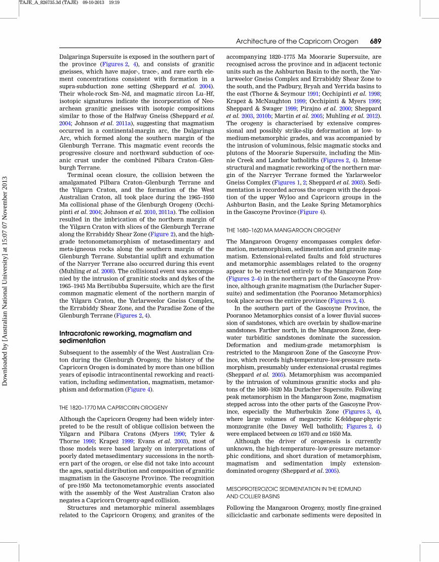
Figure 6 Migrated seismic section for line 10GA–CP1 across the northern Capricorn Orogen, showing both uninterpreted andinterpreted versions. Display shows vertical scale equal to the horizontal scale, assuming a crustal velocity of 6000 m/s. Com-mon Depth Point (CDP) locations are shown in Figures 2 and 3 (100 CDP ¼ 2 km).
Architecture of the Capricorn Orogen 691
Dow
nloa
ded
by [
Aus
tral
ian
Nat
iona
l Uni
vers
ity]
at 1
5:07
07
Nov
embe
r 20
13
TAJE_A_826735.3d (TAJE) 09-10-2013 19:19
volume of middle to lower crust, which cannot be tracedto the surface, and whose crustal reflectivity is differentto that of laterally or vertically adjoining provinces.
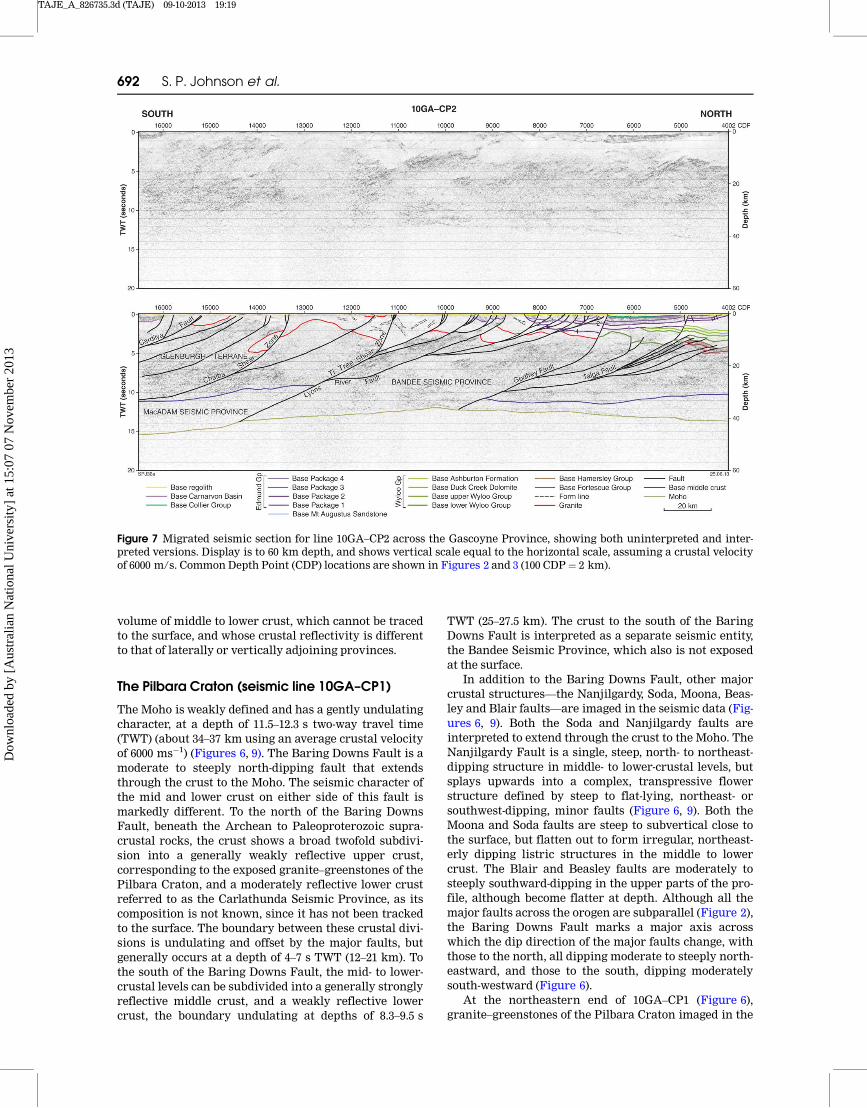
The Pilbara Craton (seismic line 10GA–CP1)
The Moho is weakly defined and has a gently undulatingcharacter, at a depth of 11.5–12.3 s two-way travel time(TWT) (about 34–37 km using an average crustal velocityof 6000 ms�1) (Figures 6, 9). The Baring Downs Fault is amoderate to steeply north-dipping fault that extendsthrough the crust to the Moho. The seismic character ofthe mid and lower crust on either side of this fault ismarkedly different. To the north of the Baring DownsFault, beneath the Archean to Paleoproterozoic supra-crustal rocks, the crust shows a broad twofold subdivi-sion into a generally weakly reflective upper crust,corresponding to the exposed granite–greenstones of thePilbara Craton, and a moderately reflective lower crustreferred to as the Carlathunda Seismic Province, as itscomposition is not known, since it has not been trackedto the surface. The boundary between these crustal divi-sions is undulating and offset by the major faults, butgenerally occurs at a depth of 4–7 s TWT (12–21 km). Tothe south of the Baring Downs Fault, the mid- to lower-crustal levels can be subdivided into a generally stronglyreflective middle crust, and a weakly reflective lowercrust, the boundary undulating at depths of 8.3–9.5 s
TWT (25–27.5 km). The crust to the south of the BaringDowns Fault is interpreted as a separate seismic entity,the Bandee Seismic Province, which also is not exposedat the surface.
In addition to the Baring Downs Fault, other majorcrustal structures—the Nanjilgardy, Soda, Moona, Beas-ley and Blair faults—are imaged in the seismic data (Fig-ures 6, 9). Both the Soda and Nanjilgardy faults areinterpreted to extend through the crust to the Moho. TheNanjilgardy Fault is a single, steep, north- to northeast-dipping structure in middle- to lower-crustal levels, butsplays upwards into a complex, transpressive flowerstructure defined by steep to flat-lying, northeast- orsouthwest-dipping, minor faults (Figure 6, 9). Both theMoona and Soda faults are steep to subvertical close tothe surface, but flatten out to form irregular, northeast-erly dipping listric structures in the middle to lowercrust. The Blair and Beasley faults are moderately tosteeply southward-dipping in the upper parts of the pro-file, although become flatter at depth. Although all themajor faults across the orogen are subparallel (Figure 2),the Baring Downs Fault marks a major axis acrosswhich the dip direction of the major faults change, withthose to the north, all dipping moderate to steeply north-eastward, and those to the south, dipping moderatelysouth-westward (Figure 6).
At the northeastern end of 10GA–CP1 (Figure 6),granite–greenstones of the Pilbara Craton imaged in the
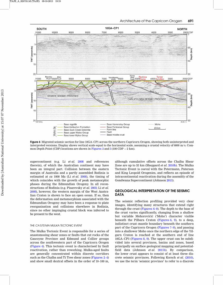
Figure 7 Migrated seismic section for line 10GA–CP2 across the Gascoyne Province, showing both uninterpreted and inter-preted versions. Display is to 60 km depth, and shows vertical scale equal to the horizontal scale, assuming a crustal velocityof 6000 m/s. Common Depth Point (CDP) locations are shown in Figures 2 and 3 (100 CDP ¼ 2 km).
692 S. P. Johnson et al.
Dow
nloa
ded
by [
Aus
tral
ian
Nat
iona
l Uni
vers
ity]
at 1
5:07
07
Nov
embe
r 20
13

TAJE_A_826735.3d (TAJE) 09-10-2013 19:19
Rocklea Dome are generally weakly reflective, althougha number of prominent southwest-dipping to flat-lyingreflections are recorded at depth. These reflections areinterpreted as discontinuous greenstone sheets withinthe granitic crust.
The Fortescue Group is most prominent in the north-eastern part of the section (Figures 6, 9) where it dipsgently to the southwest, and is imaged as a series ofweak to strong, layered reflections. Based on their seis-mic reflectivity, three units can be recognised within theFortescue Group: a lower layer of weak reflections 0.25 sTWT (�0.8 km) thick that possibly corresponds to sedi-mentary rocks of the Hardey Formation; a middle layerof strong reflections 0.7 s TWT (�2.2 km) thick that
equates to the mostly basaltic rocks of the Boongal, Pyra-die and lower Bunjinah formations; and an upper layerof weak reflections 0.5 s TWT (�1.4 km) thick, whichincludes the upper Bunjinah Formation and JeerinahFormation. Although the seismic reflections lose someof their definition beneath the Turner Syncline, theysuggest a southwesterly thickening of the FortescueGroup from about 1.5 s TWT (�4.5 km) to about 2 s TWT(�6 km) approaching the Moona Fault. The seismic dataalso suggest that a section of the Hamersley Group about1 s TWT (�3 km) thick is preserved in the TurnerSyncline.
A thick, almost complete, succession of the FortescueGroup crops out on the southwestern limb of the Rocklea
Figure 8 Migrated seismic section for line 10GA–CP3, showing both uninterpreted and interpreted versions. Display is to60 km depth, and shows vertical scale equal to the horizontal scale, assuming a crustal velocity of 6000 m/s. Common DepthPoint (CDP) locations are shown in Figures 2 and 3 (100 CDP ¼ 2 km).
Architecture of the Capricorn Orogen 693
Dow
nloa
ded
by [
Aus
tral
ian
Nat
iona
l Uni
vers
ity]
at 1
5:07
07
Nov
embe
r 20
13
TAJE_A_826735.3d (TAJE) 09-10-2013 19:20
Dome, and is cut by the Karra Well and Soda faults (Fig-ures 6, 9). Farther west, between the Soda and Nanjil-gardy faults, a succession of weakly to strongly reflectivelower and middle Fortescue Group rocks 1.7 s TWT(�5 km) thick is interpreted to overlie the weakly reflec-tive granite–greenstone rocks.
The stratigraphic succession between the Nanjil-gardy Fault and southwestern end of 10GA–CP1 (Fig-ures 6, 9) has been difficult to interpret from the seismicreflection data alone. The surface geology consists ofpolyphase-deformed fold- and fault-repeated succession
of rocks of the upper Wyloo Group, consisting of theMount McGrath Formation, Duck Creek Dolomite, andAshburton Formation, although this structural complex-ity is not imaged in the subsurface, probably because of alack of continuous reflective markers within the stratig-raphy. In the surface geology, the presence of both Fortes-cue and Hamersley group rocks to the south of theNanjilgardy Fault along strike of the seismic traverse,implies that both successions should be present beneaththe Ashburton Basin. The 2.5D forward modelling ofgravity and aeromagnetic data (Johnson et al. 2011b)
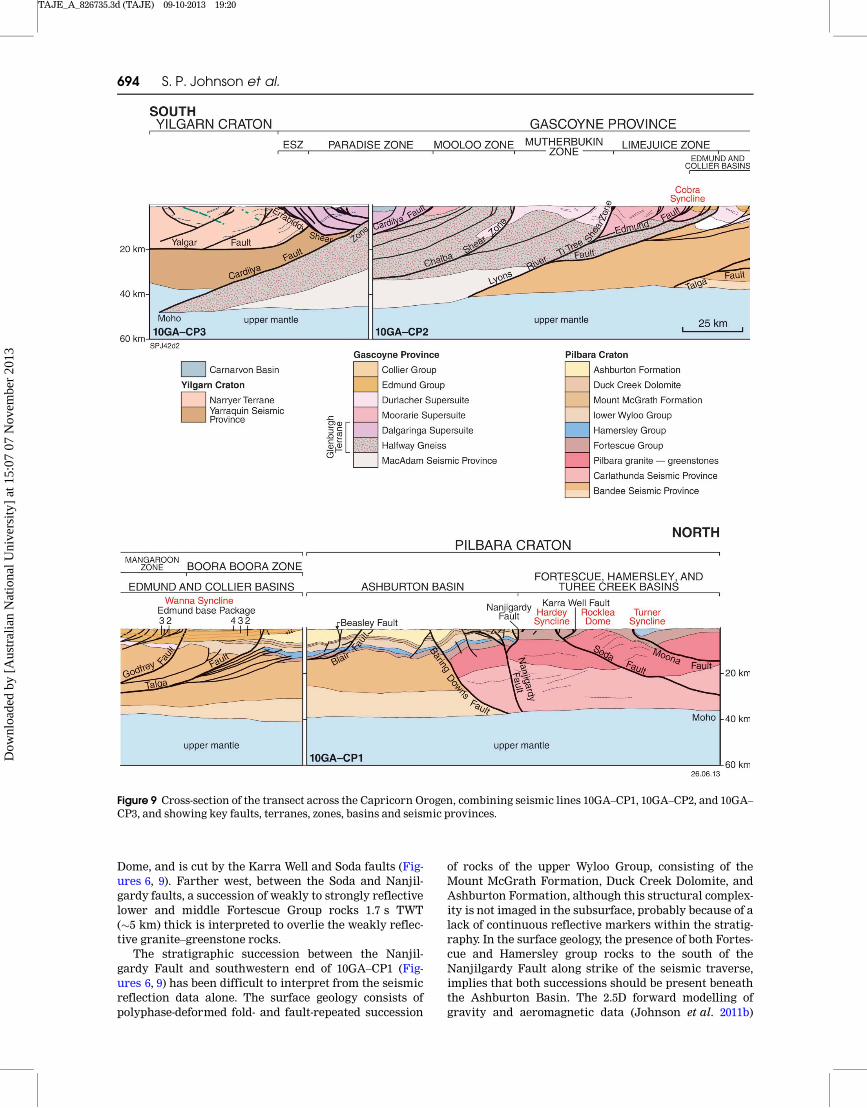
Figure 9 Cross-section of the transect across the Capricorn Orogen, combining seismic lines 10GA–CP1, 10GA–CP2, and 10GA–
CP3, and showing key faults, terranes, zones, basins and seismic provinces.
694 S. P. Johnson et al.
Dow
nloa
ded
by [
Aus
tral
ian
Nat
iona
l Uni
vers
ity]
at 1
5:07
07
Nov
embe
r 20
13

TAJE_A_826735.3d (TAJE) 09-10-2013 19:20
suggest that banded iron formation of the HamersleyGroup must be present to the south of the Baring DownsFault and so these units, although somewhat thinned,have been extend southward onto the northern part ofline 10GA–CP2 (Figures 7, 9). Although these layers donot have the same reflective signature as the exposedHamersley and Fortescue groups observed at the north-ern end of 10GA–CP1 (Figure 6), this may be due to anincreased structural complexity and, in particular, thepresence of numerous low-angle faults, beneath the Ash-burton Basin. On the northern part of 10GA–CP2 (Fig-ures 7, 9), these layers are dissected by a series of north-verging thrust faults which terminate within the lowerWyloo Group.
The Gascoyne Province and Yilgarn Craton(seismic lines 10GA–CP2 and 10GA–CP3)
The location and character of the Moho varies consider-ably across 10GA–CP2 and 10GA–CP3 (Figures 7–9).Under the Gascoyne Province, in 10GA–CP2 (Figure 7),the Moho is deep and undulating, varying between 12and 15.3 s TWT (36–46 km), and continues this trend intothe northern part of 10GA–CP3 (Figure 8), where theMoho is at 15 s TWT (�45 km) depth. In the central partof 10GA–CP3, the Moho is interpreted to be at about 16 sTWT (�48 km) depth, but at the southernmost end of theseismic line, the Moho is difficult to interpret. Line10GA–CP3 ties to another, more recently acquired, lineacross the southern Carnarvon Basin, 11GA–SC1(Korsch et al. 2013), and ends 40 km to the west of thestart of the Youanmi seismic line, 10GA–YU1 (Zibra et al.2013). Based on these three seismic lines, the Moho at thesouthern end of 10GA–CP3 is interpreted to have beenfaulted and duplicated by crustal-scale thrusting (Fig-ure 8) marking the subsurface boundary between the Yil-garn Craton and the Glenburgh Terrane. Therefore, theGlenburgh Terrane may be present below the Narryer
Terrane on seismic line 10GA–YU1 at around 15–16 sTWT (45–48 km).
CRUSTAL TERRANES, SEISMIC PROVINCES AND SUTURE ZONES
On the basis of seismic character and surface geology,two terranes—the Glenburgh and Narryer Terranes—and three seismic crustal provinces—the Yarraquin,MacAdam and Bandee Seismic Provinces—have beenidentified within lines 10GA–CP2 and 10GA–CP3 (Fig-ures 7–9). Most of these are separated by major crustalstructures, which coincide with mapped surface faultsor shear zones (Figures 2, 3).
Within line 10GA–CP2, the Glenburgh Terrane andMacAdam Seismic Province are separated from the Ban-dee Seismic Province by the moderately south-dippingLyons River Fault (Figures 7, 9), which in the middle andupper crust splays into the Ti Tree Shear Zone. Sincerocks of the Bandee Seismic Province are not exposed atthe surface, it is not possible to determine if this provinceis similar to the Glenburgh Terrane in terms of its age,lithological makeup and composition. However, the con-tact between the two, along the Lyons River Fault, ismarked by a zone of strong seismic reflections that paral-lel the fault (areas A and B in Figure 10); there is a signifi-cant step in the Moho where the Lyons River Faultintersects the upper mantle (area C in Figure 10); andalthough the seismic characters of the middle crust ofboth the Glenburgh Terrane and Bandee Seismic Prov-ince are relatively similar, the Glenburgh Terrane is char-acterised by a non-reflective lower crust—the MacAdamSeismic Province—that is not evident in the Bandee Seis-mic Province immediately north of the Lyons River Fault(Figures 7, 10). These observations suggest that the LyonsRiver Fault represents a major suture zone that separatestwo, distinct pieces of continental crust.
Based on the interpretation of deep seismic reflectiondata in 11GA–SC1 (Korsch et al. 2013), which crosses the
Figure 10 Interpreted migrated seismic section of part of line 10GA–CP2, showing the location of the suture zone between theGlenburgh Terrane and Bandee Seismic Province at the Lyons River Fault. Display shows vertical scale equal to the horizon-tal scale, assuming a crustal velocity of 6000 m/s.
Architecture of the Capricorn Orogen 695
Dow
nloa
ded
by [
Aus
tral
ian
Nat
iona
l Uni
vers
ity]
at 1
5:07
07
Nov
embe
r 20
13

TAJE_A_826735.3d (TAJE) 09-10-2013 19:20
southern part of 10GA–CP3, and 10GA–YU1 (Zibra et al.2013) to the east, the Yilgarn Craton at the southern endof 10GA–CP3 has been subdivided into the Narryer Ter-rane and the Yarraquin Seismic Province, the two sepa-rated by the Yalgar Fault. The Yarraquin SeismicProvince (Korsch et al. 2013) forms a highly reflectivelower crustal package that underlies the entire YouanmiTerrane (Zibra et al. 2013). The position of the YalgarFault in 10GA–CP3 has been tied from 11GA–SC1(Korsch et al. 2013) where the fault is imaged as an east-verging, west-dipping thrust. The flat geometry of theYalgar Fault in this section is due to the thrust faultbeing imaged normal to its movement direction, withthe Narryer Terrane moving out of the plane of section.Movement on this fault and the juxtaposition of theNarryer Terrane with the Yarraquin Seismic Provinceis interpreted to predate the final collision of the YilgarnCraton and the Glenburgh Terrane since the YalgarFault is cut by Glenburgh Orogeny-aged (ca 1950 Ma)structures (Korsch et al. 2013).
The Narryer Terrane and Yarraquin Seismic Prov-ince are separated from the Glenburgh Terrane by aseries of anastomosing, north-dipping faults known asthe Errabiddy Shear Zone, and a single, moderatelysouth-dipping fault named the Cardilya Fault, which isinterpreted to be the main suture (Figures 8, 9). Thesetwo fault systems also segment the Glenburgh Terraneinto two crustal elements:
The Dalgaringa Supersuite, including the Nardoo Gran-ite, which at the surface, represents the exhumed mid-crustal portions of a continental-margin arc known asthe Dalgaringa Arc (Sheppard et al. 2004; Johnson et al.2010, 2011a), and which occurs structurally above (thehangingwall) both the Errabiddy Shear Zone and the Car-dilya Fault.
The remainder of the Glenburgh Terrane, including thebasement gneisses into which the continental-margin arcmagmaswere intruded, occur in the footwall of the Cardi-lya Fault, lying structurally below the Narryer Terrane.
The Cardilya Fault, which separates the Yilgarn Cra-ton (the Narryer Terrane–Yarraquin Seismic Province)from the Glenburgh Terrane and MacAdam SeismicProvince, transects the entire crustal profile and can beimaged down to 15.5 s TWT (�46.5 km). It is interpretedto offset and duplicate the Moho, which under theNarryer Terrane, is much shallower at 12.5 s TWT(�37.5 km) depth (Figures 8, 9). These results are compa-rable to those obtained by passive-seismic methods(Reading et al. 2012) and gravity modelling (Hackney2004). At the northern end of line 10GA–CP3, the footwallof the Cardilya Fault is marked by a thick package, up to3 s TWT (�9 km) thick, of strong seismic reflections(area A in Figure 8) that are parallel to the fault. Similarpackages are also observed adjacent to the boundarywith the MacAdam Seismic Province (area B in Fig-ure 8), and these areas are interpreted to representstrongly deformed parts of the Glenburgh Terrane.Lithological variations within the Errabiddy ShearZone, such as imbricate slices of Narryer Terrane, orintrusions of the Bertibubba Supersuite, cannot be dif-ferentiated seismically.
THE TALGA ANDGODFREY FAULTS
Although the Talga and Godfrey faults do not appear toseparate crust of differing seismic character, they areimportant structures because they transect the entirecrustal profile, joining together before intersectingthe Moho (Figures 7, 9, 11). Both faults are listric in theupper 10 s TWT (� 30 km) of crust offsetting rocks asyoung as the 1620–1465 Ma Edmund Group, indicatingthey are Paleoproterozoic to Mesoproterozoic exten-sional structures which accommodated the deposition ofsediments into the Edmund Basin. However, from 3 to7 s TWT (9–21 km), the Talga Fault is parallel to animbricate set of faults (area A in Figure 11) that aredefined by series of parallel reflectors (area B in Fig-ure 11) indicating that it is a zone of intense deforma-tion. The faults offset units of both the Fortescue andHamersley groups (area C in Figure 11) and terminatewithin the lower Wyloo Group, suggesting the faultingmay be related to thrusting during the OphthalmianOrogeny. The northward-directed thrust sense of move-ment is parallel to the transport direction of exposednorthward-verging thrusts in the Ophthalmia Fold andThrust Belt (Tyler 1991). Therefore, the Talga Faultappears to be a major crustal shear zone that forms partof a north-verging fold and thrust system that was subse-quently reactivated as an extensional fault, accommodat-ing the deposition of the Edmund Group.
BATHOLITHS ANDGRANITE INTRUSIONS
Within the Glenburgh Terrane and upper part of theBandee Seismic Province, the upper 5 s TWT (�15 km)of the crust is defined by numerous, irregular and seis-mically non-reflective bodies (Figures 7, 9, 10), which areindicated by the mapped surface geology (Figure 2) to begranite plutons of the 1820–1775 Ma Moorarie Supersuiteand 1680–1620 Ma Durlacher Supersuite.
In the Mutherbukin Zone (Figures 2, 3, 9, 10), a single,large intrusion—the Davey Well batholith—belonging tothe 1680–1620 Ma Durlacher Supersuite is imagedbetween the Chalba and Ti Tree shear zones (CDPs11075–13325). The intrusion has a concave basal contactwith the underlying Glenburgh Terrane (Figure 10) andranges in thickness from 0.6 s TWT (�1.8 km) in the cen-tre of the Mutherbukin Zone, to 3.8 s TWT (�11.5 km) atits northerly contact where it is truncated by the Ti TreeShear Zone. The pluton thins rapidly to about 2 s TWT(�6 km) on the southern side of the Chalba Shear Zone,where it has been downthrown across this fault to thesouth. Weak seismic reflections within and beneath theintrusion are parallel to the concave basal contact, sug-gesting that the shape and orientation of the pluton isdue to folding during the Mutherbukin Tectonic Event.Prior to folding, the pluton would have been a flat-lyingor gently dipping, tabular body greater than, or equal to,11.5 km at its thickest.
In the Limejuice Zone, the Minnie Creek batholith(Figures 2, 3, 7, 9, 10) is imaged north of the Ti Tree ShearZone at CDP 11075, and is interpreted to continue north-ward, underlying rocks of the Edmund Basin in theCobra Syncline to CDP 8975 (Figure 10). North of theEdmund Fault at CDP 9450, the batholith is cut by
696 S. P. Johnson et al.
Dow
nloa
ded
by [
Aus
tral
ian
Nat
iona
l Uni
vers
ity]
at 1
5:07
07
Nov
embe
r 20
13

TAJE_A_826735.3d (TAJE) 09-10-2013 19:20
numerous listric normal faults, which have produced aseries of rotated (southwest-side down) half grabens. TheMinnie Creek batholith has not been imaged north ofthese half grabens (between CDP 8975 and the LyonsRiver Fault at CDP 8725), where the area is dominated byrocks of high seismic reflectivity (Figures 7, 10). Thebase of the Minnie Creek batholith is mostly interpretedas a fault contact, but between CDP 9900 and 10400, thebatholith has a relatively sharp, flat, possibly intrusivecontact with the underlying Glenburgh Terrane. In thissection, the batholith has a thickness of 2.25 s TWT(�6.75 km), but its maximum thickness, immediatelynorth of the Ti Tree Shear Zone, is 4.5 s TWT (�13.5 km);nevertheless, as the basal contact in this region is tec-tonic in origin, it is possible that the Minnie Creek bath-olith has been thickened during folding or faulting.
At several localities within the batholith (e.g. CDP10300, 10500, and 11000), regions of highly planar seismi-cally reflective material dip at moderate angle towardthe batholith centre (Figure 10). At the surface, thesebodies have been shown to be kilometre-scale rafts oflow-metamorphic grade pelitic and semipelitic schistbelonging to the 1840–1810 Ma Leake Spring Metamor-phics (Figure 2). These packages, some of which are upto 8 km in length, most likely represent vestiges of a for-merly coherent sedimentary succession, into which thegranites were intruded. The preservation of these tabu-lar metasedimentary packages suggest that the batholithmay have formed by a series of sheet-like plutons, aninterpretation supported in part by field evidence, whichindicates that many of the granites in the Moorarie
Supersuite, in the Limejuice Zone, have sheet-like geom-etries (Sheppard et al. 2010a, b).
Weakly reflective crust is imaged in the MangaroonZone (Figures 7, 11, 12), which is bounded by the LyonsRiver Fault in the south (CDP 8720), and the GodfreyFault to the north (CDP 6575). The area north of CDP8300 is covered by sedimentary rocks of the EdmundBasin, and there are no surface exposures of basementrocks in this region (Figure 2). The crust in the Manga-roon Zone is interpreted as mostly granitic rocks of the1680–1620 Ma Durlacher Supersuite, and metasedimen-tary rocks of the 1760–1680 Ma Pooranoo Metamorphics.In the centre of the zone (CDP 8300–8550), a package ofmoderately north-dipping, seismically reflective mate-rial (Figure 12) is interpreted to be a 6 km long raft ofmetasedimentary material of the Pooranoo Metamor-phics. The reflective package also parallels numerousother weak seismic reflections that occur throughoutthe zone, and which are interpreted to reflect relict sedi-mentary or lithological layering within the PooranooMetamorphics. The presence of parallel seismic reflec-tions down to �2.0 s TWT indicates that the Pooranoobasin was at least �6 km thick in the Mangaroon Zone.
Farther north, in the area underlying the EdmundBasin (south of the Godfrey Fault; Figure 11), it is diffi-cult to determine if the non-reflective packages are gran-ites of the Moorarie or Durlacher Supersuites, and forsimplicity they are tentatively shown as a continuationof the interlayered granitic and metasedimentary mate-rial of Durlacher Supersuite and PooranooMetamorphics.
Figure 11 Interpreted migrated seismic section of part of line 10GA–CP2, showing the attitude and orientation of the Talga andGodfrey faults. Display shows vertical scale equal to the horizontal scale, assuming a crustal velocity of 6000 m/s.
Architecture of the Capricorn Orogen 697
Dow
nloa
ded
by [
Aus
tral
ian
Nat
iona
l Uni
vers
ity]
at 1
5:07
07
Nov
embe
r 20
13

TAJE_A_826735.3d (TAJE) 09-10-2013 19:20
ARCHITECTURE OF THE EDMUND AND COLLIER BASINS
Although the Collier Basin succession in the Wanna Syn-cline is relatively thin, both Edmund and Collier basinsare well imaged in line GA10–CP2 (Figures 7, 11). Themaximum thickness of the Edmund Basin is 2.25 s TWT(�6.75 km) thick on the southern side of the GodfreyFault, and in the core of the Wanna Syncline, the CollierBasin is <0.25 s TWT (�750 m) thick. A relatively largepackage, up to 1 s TWT (�3 km) thick, of highly seismi-cally reflective material occurs between the base of Pack-age 2 and the top of Package 4 (Figure 11); thesereflections are interpreted to be abundant dolerite sillsof the ca 1465 Ma Narimbunna Dolerite and ca 1070 MaKulkatharra Dolerite, which intrude the upper parts ofthe Edmund Basin.
Three principal southwest-dipping structures, theTalga, Godfrey and Lyons River faults define three halfgrabens (Figures 7, 9, 11), into which sediments of theEdmund Basin were deposited (Martin & Thorne 2004),and across which significant variations in sedimentthickness are evident. On the Pingandy Shelf, to thenorth of the Talga Fault (Figure 11), the maximum thick-ness of Packages 1 and 2 are �0.5 s TWT (�1.5 km),whereas to the south they increase to �1.25 s TWT(�3.75 km). Across the Godfrey Fault, Packages 1 and 2increase from 2.0 s TWT (�6 km) to >2.75 s TWT(�8.25 km) thick. Packages 1 and 2 are consistentlythicker in the hangingwall of the basin-bounding exten-sional faults, suggesting that extensional downthrow onthese major faults was toward the southwest. Packages 1and 2 are not present south of CDP 8300, presumably hav-ing been incised and eroded away prior to the depositionof Packages 3 and 4 (Martin et al. 2008). In this region,Package 3 is at least 1 s TWT (�3 km) thick.
Between the Godfrey Fault (CDP 6575) and theEdmund Fault (CDP 9465), the Edmund Basin (Package3) is intensely folded, with numerous imbricate thrustfaults truncating the limbs of the tight, upright folds(Figure 11).
DISCUSSION
Crustal architecture, assembly and reactivationof the West Australian Craton
The new deep seismic reflection imaging, extendingfrom the southern Pilbara Craton to the northern Yil-garn Craton, provides, for the first time, a holistic viewof the crustal architecture of the Capricorn Orogen(Figure 9). These data are important because they notonly provide critical information on the timing, assem-bly and reworking history of the West Australian Craton,but also provide a rare insight into the anatomy of conti-nental collision zones in general.
THE PILBARA CRATON–BANDEE SEISMIC PROVINCE SUTURE
The Pilbara Craton granite–greenstones and underlyingCarlathunda Seismic Province are separated from theBandee Seismic Province by the steeply north-dippingBaring Downs Fault. The timing of amalgamation isuncertain, but must pre-date the deposition of the 2775–
2630 Ma Fortescue Group, since these rocks were depos-ited across the suture. The pre-ca 2775 Ma age for the col-lisional episode suggests that it may be contemporarywith other suturing events during the 3070–3060 Ma Prin-sep Orogeny, which amalgamated the East Pilbara Ter-rane and the numerous terranes of the West PilbaraSuperterrane (Van Kranendonk et al. 2007; Hickman &Van Kranendonk 2008; Hickman et al. 2010).
Deposition of over 20 km of sediments into the Fortes-cue, Hamersley, Turee Creek, and Ashburton basins hascovered the original suture, but the seismic reflectiondata indicate that reactivation of this structure hasextended the fault to the surface, where it is mapped asthe present-day Baring Downs Fault. The seismic dataalso show evidence of post-1800 Ma (the minimum age ofthe upper Wyloo Group within the Ashburton Basin)extensional displacements on this structure with signifi-cant downthrow on the northeastern side (Figures 6, 9).The exact age or setting for reactivation is not known,nor is it clear whether any fault reactivation accompa-nied deposition of the upper Wyloo Group in the Ashbur-ton Basin.
Although the Nanjilgardy Fault, which lies to thenorth of the Baring Downs Fault (Figures 6, 9), does notrepresent a suture zone, the fault transects the entirecrustal profile, rooting in the Moho. At the surface, thefault forms the major lithological boundary betweenthe 1840–1800 Ma upper Wyloo Group in the AshburtonBasin and older >ca 2200 Mametasedimentary and meta-volcanic rocks of the lower Wyloo, Turee Creek, Hamers-ley and Fortescue groups. The age of initiation, orsignificance of the Nanjilgardy Fault, is not known, butthe present-day architecture as a positive flower struc-ture must have been imparted during or after the 1820–1770 Ma Capricorn Orogeny as rocks of the upper WylooGroup have been displaced.
THE BANDEE SEISMIC PROVINCE–GLENBURGH TERRANE
SUTURE
The Glenburgh Terrane–MacAdam Seismic Provinceand Pilbara Craton–Bandee Seismic Province aresutured along the moderately south-dipping LyonsRiver Fault (Figures 2, 7, 9). From a variety of surfacegeological information, the collision is interpreted tohave occurred during the 2215–2145 Ma OphthalmianOrogeny (Occhipinti et al. 2004; Johnson et al. 2010,2011a, c; Martin & Morris 2010). However, intensecrustal reworking of the entire northern GascoyneProvince and the intrusion of voluminous plutonic gra-nitic rocks during episodic reworking (including the1820–1770 Ma Capricorn and 1680–1620 Ma Mangaroonorogenies) has obscured any evidence of this collision(Sheppard et al. 2005, 2010a, b). The suture zone is nowrepresented at the surface by faults that have propa-gated through the younger magmatic and metamorphicrocks. To the north of the Lyons River Fault, metasedi-mentary and metavolcanic rocks of the Fortescue andHamersley groups are interpreted to underlie much ofthe Ashburton Basin, occurring as far south as theTalga Fault in the Gascoyne Province (Figures 6, 7, 9).Both groups appear to be faulted and dissected by aseries of north-directed thrusts that terminate within,
698 S. P. Johnson et al.
Dow
nloa
ded
by [
Aus
tral
ian
Nat
iona
l Uni
vers
ity]
at 1
5:07
07
Nov
embe
r 20
13

TAJE_A_826735.3d (TAJE) 09-10-2013 19:20
and are progressively truncated by, the lower parts ofthe 2450–2210 Ma lower Wyloo Group, suggesting thatthrusting was related to collision during the Ophthal-mian Orogeny. Uplift and erosion of the Fortescue andHamersley groups along this axis during thrusting,may have provided much of the detritus for the fore-land basin deposits of the lower Wyloo Group (Martin& Morris 2010) and the Moogie Metamorphics in theGascoyne Province (Johnson et al. 2011a).
During intracontinental reactivation, the LyonsRiver and Geegin faults (Figure 12) were reactivatedas extensional structures allowing the deposition of upto 6 km of turbiditic sedimentary rocks (the 1740–1680Ma the Pooranoo Metamorphics) into the MangaroonZone, immediately prior to the 1680–1620 Ma Manga-roon Orogeny. Outside the Mangaroon Zone, the Poora-noo Metamorphics consist of less than 700 m ofmedium- to coarse-grained fluvial to shallow-marinesedimentary rocks.
Following the Mangaroon Orogeny, the Lyons River,Talga and Godfrey faults, appear to have controlledmuch of the depositional history of the 1620–1465 MaEdmund Basin (Johnson et al. 2011a). These three Oph-thalmian-aged structures were reactivated in an exten-sional setting to form a series of half grabens (Figures 7,9, 11) into which sediments of the Edmund Group weredeposited. Package thickness variations across themajor faults, especially from the Pingandy Shelf south-ward across the Talga Fault (Figure 11), imply intermit-tent and variable amounts of extensional movements onall three faults. The progressive truncation of older pack-ages by units higher in the succession indicates syn-depositional uplift and erosion during periods of short-
lived and punctuated reverse movements. Regional-scalepost-depositional basin inversion is evident as a series ofthrusts and hangingwall anticlines on fault splaysbetween the Lyons River and Godfrey faults (Figure 11).This corridor of intense deformation has been mappedin the surface geology (Figures 2, 3), and does not appearto have significantly affected rocks of the Collier Basin,suggesting either that the deformation is related to the1385–1200 Ma Mutherbukin Tectonic Event, or that theGodfrey Fault acted as a backstop to the northward-propagating thrust system during the 1030–955 MaEdmundian Orogeny.
THE GLENBURGH TERRANE–YILGARN CRATON SUTURE
The final assembly of the West Australian Cratonoccurred when the northern margin of the Yilgarn Cra-ton was sutured to the composite Pilbara–Bandee–Glen-burgh craton at about ca 1965 Ma, during the GlenburghOrogeny, along the Cardilya Fault. Owing to the intru-sion of voluminous post-collisional granitic rocks of the1820–1775 Ma Moorarie Supersuite across the CardilyaFault during the Capricorn Orogeny (Sheppard et al.2010a), the significance of this structure as the mainsuture zone was not recognised until the interpretationof the seismic data. Prior to the seismic investigation,the moderately well-exposed north-dipping ErrabiddyShear Zone, which contains an imbricate assemblage oflithologies from both the Glenburgh and Narryer Ter-ranes, was thought to be the main suture zone (e.g.Sheppard et al. 2010b).
Although there is little evidence of post-collisionalreactivation on the Cardilya Fault and Errabiddy Shear
Figure 12 Interpreted migrated seismic section of part of line 10GA–CP2, showing the architecture of the Mangaroon Zone,including the raft of metasedimentary material that is parallel to other weak seismic reflections (shown as dashed form lines)within the granitic body. Display shows vertical scale equal to the horizontal scale, assuming a crustal velocity of 6000 m/s.Abbreviations: D, Durlacher Supersuite; E, Edmund Group.
Architecture of the Capricorn Orogen 699
Dow
nloa
ded
by [
Aus
tral
ian
Nat
iona
l Uni
vers
ity]
at 1
5:07
07
Nov
embe
r 20
13

TAJE_A_826735.3d (TAJE) 09-10-2013 19:20
Zone in the seismic data, the Cardilya Fault truncatesand displaces plutonic magmatic rocks, specifically theLandor batholith, of the 1820–1775 Ma Moorarie Super-suite, indicating reactivation during, or after, the 1820–1770 Ma Capricorn Orogeny. Uplift and reworking acrossthe Errabiddy Shear Zone are also recorded by several40Ar/39Ar mica dates between ca 960 and ca 820 Ma(Occhipinti 2007), indicating a long-lived post-collisionalhistory for this fault system.
IMPLICATIONS FOR CONTINENTAL COLLISION AND
SUBSEQUENT CRUSTAL REWORKING
The West Australian Craton was built progressivelyover one billion years from the punctuated collision ofcontinental blocks (the Bandee Seismic Province, theGlenburgh Terrane and the Yilgarn Craton) to thesouthern Pilbara Craton margin. Owing to significantpost-collisional tectonomagmatic reworking and verti-cal extension of the major fault structures into youn-ger rock packages, the principal crustal sutures onlyhave a weak expression at the surface, and ophiolites,high-pressure rocks or melanges, which are usuallyconsidered key components of continental suturezones, are either not preserved or not exposed.However, the suture zones, as well as other majorcrustal-scale structures related to the assembly of theWest Australian Craton, are well preserved andimaged to great depth in the seismic reflection data(Figures 6–9). The preservation of ancient reworkedsutures and crustal-scale structures within the mid- tolower-crust appears to be a common feature of manycontinental suture zones, where examples have beendocumented in seismic reflection data from the Trans-Hudson Orogen (e.g. White et al. 2005), Slave Province(e.g. Clowes et al. 2005; Cook & Erdmer 2005) andnumerous Australian orogenic belts (e.g. Korsch et al.2010, 2012; Cayley et al. 2011; Wyche et al. 2013).
The preservation of ancient suture zones in the deepcrust is therefore critical for understanding the crustalarchitecture and evolution of the collision zone, but doesit reliably preserve pre-collisional geometric relation-ships such as the subduction polarity? Furthermore, incomplex collision zones, what stage during the colli-sional/orogenic cycle does the present-day architecturereflect? In the Capricorn survey, both the 2215–2145 MaOphthalmian and 2005–1950 Ma Glenburgh Orogenysuture zones (the Lyons River and Cardilya faults,respectively) dip moderately southward (Figure 9). Thesimplest interpretation implies south-directed subduc-tion of oceanic crust during both events. However, thewealth of whole-rock geochemical, isotopic and in situzircon Lu–Hf isotopic data (Sheppard et al. 2004; Johnsonet al. 2011a) demonstrates that during the 2005–1950 MaGlenburgh Orogeny, the subduction of oceanic crust wasnorth-directed with the formation of the Dalgaringa Arcwithin the southern margin of the Glenburgh Terrane,opposite to the present-day dip of the suture zone. Thecurrent crustal architecture implies significant syn- topost-collisional modification of the crustal profile eitherby a style of ‘crocodile tectonics’ (e.g. Meissner 1989;Sadowial et al. 1991; Xu et al. 2002) or by the interplay ofcomplex syn- to post-collisional events such as crustal
obduction, backthrusting and crustal delamination.This implies that the crustal architecture was preservedrelatively late in the orogenic cycle and that pre-collisional features may not be inherently preserved inthe orogenic architecture. Additional information, suchas whole-rock geochemical and isotopic data (e.g.Sheppard et al. 2004), or where the subduction-relatedmagmatic rocks are not accessible, in situ Lu–Hf isotopiccomposition of appropriately aged inherited zircongrains, are thus required to constrain pre-collisionalrelationships. However, such information is not avail-able to constrain the subduction polarity leading up tothe pre-ca 2775 Ma collision between the Pilbara Cratonand Bandee Seismic Province or the 2215–2145 Ma Oph-thalmian-aged collision between the Bandee SeismicProvince and the Glenburgh Terrane.
Following the final assembly of the West AustralianCraton, the orogen was subject to over one billion yearsof punctuated intracontinental reactivation and rework-ing (e.g. Sheppard et al. 2010b), including present-dayseismic movements (Revets et al. 2009; Keep et al. 2012).The three principal sutures associated with the assem-bly of the West Australian Craton, as well as most of theother crustal structures, show evidence for multiplereactivation (Figure 9), in extensional, compressionaland oblique-slip settings. Reactivation of these majorcrustal structures has led to their vertical extension intoyounger sedimentary or plutonic rocks (a process com-mon to ancient collision zones; e.g. O’Driscoll 1986;Hronsky et al. 2012), and so the suture zones, and otherassociated crustal-scale faults, are commonly onlyweakly expressed at the surface by much younger faultsor fault systems (Figures 2, 3, 9). The accommodation ofregional-scale strain (extensional, compressional andoblique-slip) during the numerous reworking eventsappears to have been accommodated mostly by the reac-tivation of the pre-existing faults and shear zones, ratherthan by the generation of new crustal-scale structures.Furthermore, in the Gascoyne Province, the orientationof most tectonometamorphic fabrics and syn-tectonicmagmatic intrusions such as the Minnie Creek, Landorand Davey Well batholiths (Figure 2) are also coaxial tothe main crustal-scale structures. The depositionalarchitecture of the 1620–1465 Ma Edmund and 1200–1070Ma Collier basins, and subsequent style of basin inver-sion were controlled by extensional and transpressionalmovements on these structures and, more importantly,their orientation (Johnson et al. 2011a). Therefore, thecrustal architecture, imparted during the assembly ofthe West Australian Craton ca 2200 to ca 1950 millionyears ago, has strongly influenced the partitioning ofdeformation, metamorphism and magmatism duringthe numerous intracratonic reworking events.
Mineral prospectivity
The Capricorn seismic survey has identified a series ofmajor crustal structures, many of which cut through thecrust to the mantle and show evidence for multiple reac-tivation (Figure 9). Numerous mineral deposit typeshave been recognised throughout the orogen (Figure 3)and include the world-class hematite iron-ore deposits ofthe Hamersley Basin; volcanic-hosted massive sulfide
700 S. P. Johnson et al.
Dow
nloa
ded
by [
Aus
tral
ian
Nat
iona
l Uni
vers
ity]
at 1
5:07
07
Nov
embe
r 20
13

TAJE_A_826735.3d (TAJE) 09-10-2013 19:20
(VHMS) copper–gold deposits in the Bryah Basin on theYilgarn Craton margin; orogenic lode-gold mineralisa-tion, such as that at Peak Hill in the southern CapricornOrogen margin, Glenburgh and the Star of Mangaroonin the Gascoyne Province, and Paulsens and MountOlympus along the northern Capricorn Orogen margin;various intrusion- and shear zone-related base metal,tungsten, rare earth element, uranium and rare-metaldeposits in the Gascoyne Province; and lead–copper–zinc sediment-hosted mineralisation at Abra within theEdmund Basin (Figure 3). However, the tectonic settingof these deposits or their relation to the crustal architec-ture has yet to be adequately assessed.
Central to the orogen’s prospectivity is the growingunderstanding that the formation of ore deposits is anexpression of much larger earth-system processes,which operate on a variety of scales to focus mass andenergy flux. Many factors including the geodynamic set-ting, architecture, metal source, fluid-flow drivers andpathways, and depositional mechanisms (Wyborn et al.1994; Knox-Robinson & Wyborn 1997), influence the type,style and location of mineralisation. One of the aims ofthe seismic survey was to identify large-scale crustalstructures, including those that cut through the crust tothe mantle, which may form pathways for fluid flow tomineral systems. A recent mineral prospectivity studyof the Gascoyne Province, using the mineral systemsapproach, has also highlighted the significance of thesemajor crustal structures to sites of potential mineralisa-tion (Aitken et al. 2013). Although factors such as rocktype, rock composition and metal source are importantfor mineralisation, the faults and, in particular, theirconstant reactivation during subsequent and punctuatedorogenesis are key to focussing the fluids and energyflux of the mineral system. Especially important are thestructures that transect the entire crustal profile (theNanjilgardy, Baring Downs, Talga, Lyons River, and Car-dilya faults; Figures 2, 3, 9, 13), as they provide a litho-spheric-scale deep plumbing system to allow thetransport of fluid and energy direct from the mantle intothe upper crust.
In most cases, known sites of mineralisation lie along,close to or within fault splays related to the major crustalstructures (Figures 3, 13). The Soda and Karra faults inthe northern Capricorn Orogen are associated with thepremium martite–microplaty hematite ores. The
Nanjilgardy Fault hosts significant gold deposits in boththe Fortescue Group of the Wyloo Dome at Paulsens andProterozoic rocks of the Ashburton Basin such as atMount Olympus. The Baring Downs Fault hosts severalgold and base metal deposits in the Ashburton Basinsuch as Star of the West, Glen Florrie and SoldiersSecret. In the Gascoyne Province, the composite LyonsRiver–Minnie Creek–Minga Bar Fault system hosts rareearth elements at Gifford Creek, and gold at the Star ofMangaroon. An along-strike extension of the LyonsRiver Fault, the Quartzite Well Fault, hosts the polyme-tallic Abra base metal deposit. The Ti Tree and Chalbashear zones host numerous tungsten, molybdenum andcopper–gold base metal deposits, and the Cardilya–Dead-man Fault hosts gold at Glenburgh. Apart from the MtOlympus gold deposit, which has been dated at ca1740 Ma (Sener et al. 2005), the age of the various mineraldeposits across the orogen are not precisely known, andso it is difficult to determine whether they represent pri-mary deposits related directly to tectonic setting (i.e.cra-ton edge or island arc), or whether they are younger,secondary hydrothermal deposits related to fluid flowduring intracontinental reactivation.
In the case of the Mt Olympus deposit, which liesalong the Nanjilgardy Fault, the gold is interpreted to beof hydrothermal origin (Sener, et al. 2005). The seismicdata show the Nanjilgardy Fault to have been (re)acti-vated during the 1820–1770 Ma Capricorn Orogeny con-sistent with the age dating and demonstrate thathydrothermal fluid flow within this major-crustal struc-ture is an important mechanism for gold mineralisation.
The polymetallic Pb–Cu–Zn deposit at Abra in thelower part of the Edmund Group (which lies on an exten-sion of the Lyons River Fault) shows a complex historyof monazite and xenotime growth between ca 1385 and ca1235 Ma (Rasmussen et al. 2010). The deposit has beeninterpreted to be SEDEX in origin (Vogt & Stumpf 1987;Collins & McDonald 1994), but the polyphase growth ofphosphate minerals implies significant secondaryupgrading associated with hydrothermal fluid flow(Pirajno et al. 2009; Rasmussen et al. 2010) during faultreactivation.
The Lyons River Fault also hosts significant rareearth elements within the Gifford Creek CarbonatiteSuite (formerly the Gifford Creek Complex; Pearson1996; Pearson & Taylor 1996; Pearson et al. 1996)
Figure 13 Summary cross-section through the Capricorn Orogen, showing the spatial relationship between known mineraldeposits and the location of suture zones and other major lithospheric-scale faults.
Architecture of the Capricorn Orogen 701
Dow
nloa
ded
by [
Aus
tral
ian
Nat
iona
l Uni
vers
ity]
at 1
5:07
07
Nov
embe
r 20
13

TAJE_A_826735.3d (TAJE) 09-10-2013 19:20
(Figures 3, 13). The suite consists of a series of ferroancarbonatite sills that are distributed within a 30 km longnorthwest-trending belt that parallels the Lyons RiverFault (Pearson 1996; Pearson & Taylor 1996; Pearsonet al. 1996). The sills were emplaced into metasedimen-tary and granitic rocks of the Pooranoo Metamorphicsand Durlacher Supersuite, respectively and so are youn-ger than ca 1620 Ma. During subsequent tectonometa-morphism, hydrothermal alteration of the carbonatitesled to extensive upgrading of rare earth elements into aseries of mineralised ironstone veins and dykes.Although the ages of the carbonatite sills and subse-quent rare earth element-rich ironstones are not pre-cisely known (<ca 1620 Ma), the emplacement of thealkalic rocks implies the interaction of mantle-derivedmelts with thinned, metasomatised, subcontinental lith-ospheric mantle (Foley 2008). Emplacement of the sills inthe upper crust was controlled by ?extensional move-ments on the Lyons River Fault, and subsequent rareearth element-upgrading took place during hydrother-mal activity.
These three examples highlight the importance andinterplay between hydrothermal activity, the reactiva-tion of lithospheric-scale faults, and gold, base metal andrare earth element mineralisation. Although the ages orstructural settings of other deposits in the orogen arenot precisely known, it is noted that the main litho-spheric-scale structures (at the surface) host most of theknown deposits. This association highlights the impor-tance of major crustal-scale structures as conduits offluid flow to mineral systems by the transport of fluidand energy direct from the mantle into the upper crust.However, these structures also coincide with former cra-ton edges and possible island arcs (areas of preferen-tially endowed crust) and so, with regard to the source ofmetals, there may be a deeper, underlying ‘tectonic’ con-trol (e.g. Groves et al. 2005; Kerrich et al. 2005; Begg et al.2010; Hronsky et al. 2012) on the location of particularcommodities within the orogen. The clustering of goldand base metal deposits around the three main suturezones (Figure 13) may reflect this underlying tectoniccontrol, but some deposits, such as the rare earth ele-ment deposits at Gifford Creek, show a direct mantle-derived component for the metal source (the carbonatitesills). In reality, mineralisation is likely to reflect bothend-member components and various combinations ofthe two. However, since most of the former island arcsand craton edges are now deeply buried or reworked, themost important factor for mineral prospectivity is thepresence and location of repeatedly reactivated litho-spheric-scale faults (Figure 13).
CONCLUSIONS
The Capricorn Orogen deep seismic reflection surveyhas imaged the crust and upper mantle structure, pro-viding, for the first time, a holistic view of the crustalarchitecture of the Western Australian Craton. The sur-vey demonstrates that the craton was built from fourmain crustal components: the Pilbara and Yilgarn Cra-tons, the Glenburgh Terrane and the Bandee SeismicProvince, by the progressive and punctuated collision of
continental blocks to the southern Pilbara Craton mar-gin. This collisional architecture has fundamentally con-trolled the style and orientation of over one billion yearsof intracontinental reactivation, including deformation,metamorphism, magmatism and sedimentation.
The three main crustal suture zones, as well as othermajor crustal structures, are well preserved in the midand lower crust, but are only weakly expressed at thesurface by vertical extensions of these structuresthrough younger (meta)sedimentary and (meta)igneousrock packages during intracontinental reactivation. Thepresent-day architecture is the culmination of numerouscollision-related processes that may have been preservedrelatively late in the orogenic cycle. Therefore, theimaged architecture may not be used to reconstruct thepre-collisional tectonic settings such as the subductionpolarity.
The majority of known mineral deposits in the Capri-corn Orogen are spatially associated with the surfaceexpression of the major crustal suture zones and otherlithospheric-scale faults. These faults show evidence ofhaving been multiply reactivated in an intracontinentalsetting, and highlight the importance of major crustal-scale structures and fluid flow to mineral systems by thetransport of fluid and energy direct from the mantle intothe upper crust.
ACKNOWLEDGEMENTS
This work forms part of a collaborative project betweenGSWA, AuScope and Geoscience Australia. GSWA fund-ing was sourced from the Exploration Incentive Scheme(EIS) under the Royalty for Regions program. Manythanks go to the two reviewers, Dr Peter Betts andDr David Martin, for greatly improving the manuscript.Thanks also go to Michael Prause for drafting of figures.
REFERENCES
AITKEN A. R. A. & BETTS P. G. 2009. Constraints on the Proterozoicsupercontinent cycle from the structural evolution of the south-central Musgrave Province, central Australia. PrecambrianResearch 168, 284–300.
AITKEN A. R. A., JOLY A., DENTITH M., JOHNSON S. P., THORNE A. M. &TYLER I. M. 2013. 3D architecture, structural evolution and mineralprospectivity of the Gascoyne Province. Geological Survey of West-ern Australia, Report 123.
AUSTRALIAN ACADEMY OF SCIENCE 2012. Searching the deep earth: a visionfor exploration geoscience in Australia. pp. 42. Australian Acad-emy of Science, Canberra.
BEGG G. C., HRONSKY J. A. M., ARNDT N. T., GRIFFIN W. L., O’REILLY S. Y. &HAYWARD N. 2010. Lithospheric, cratonic, and geodynamic settingof Ni–Cu–PGE sulfide deposits. Economic Geology 105, 1057–1070.
BLAKE T. S. 1993. Late Archaean crustal extension, sedimentary basinformation, flood basalt volcanism, and continental rifting. TheNullagine and Mount Jope Supersequences, Western Australia.Precambrian Research 60, 185–241.
BLAKE T. S. 2001. Cyclic continental mafic tuff and flood basalt volca-nism in the Late Archaean Nullagine and Mount Jope Superse-quences in the eastern Pilbara, Western Australia. PrecambrianResearch 107, 139–177.
BLAKE T. S. & BARLEY M. E. 1992. Tectonic evolution of the LateArchaean to Early Proterozoic Mount Bruce megasequence set,Western Australia. Tectonics 11, 1415–1425.
BLAKE T. S., BUICK R., BROWN S. J. A. & BARLEY M. E. 2004. Geochronol-ogy of a Late Archaean flood basalt province in the Pilbara
702 S. P. Johnson et al.
Dow
nloa
ded
by [
Aus
tral
ian
Nat
iona
l Uni
vers
ity]
at 1
5:07
07
Nov
embe
r 20
13

TAJE_A_826735.3d (TAJE) 09-10-2013 19:20
Craton, Australia: constraints on basin evolution, volcanic andsedimentary accumulation, and continental drift rates.Precambrian Research 133, 143–173.
CASSIDY K. F., CHAMPION D. C., KRAPE�Z B., BARLEY M. E., BROWN S. J. A.,BLEWETT R. S., GROENEWALD P. B. & TYLER I. M. 2006. A revised geo-logical framework for the Yilgarn Craton, Western Australia. Geo-logical Survey of Western Australia, Record 2006/8, pp. 8
CAWOOD P. A. & TYLER I. M. 2004. Assembling and reactivating the Pro-terozoic Capricorn Orogen: lithotectonic elements, orogenies,and significance. Precambrian Research 128, 201–218.
CAYLEY R. A., KORSCH R. J., MOORE D. H., COSTELLO R. D., NAKAMURA A.,WILLMAN C. E., RAWLING T. J., MORANDV. J., SKLADZIEN P. B. & O’SHEA
P. J. 2011. Crustal architecture of central Victoria: results fromthe 2006 deep crustal reflection seismic survey. Australian Jour-nal of Earth Sciences 58, 113–156.
CHAMPION D. C. & CASSIDY K. F. 2007. An overview of the Yilgarn and itscrustal evolution. In: Bierlein F. P. & Knox-Robinson C. M. eds.Proceedings, Geoscience Australia, Geoconferences (WA) Inc. Kal-goorlie ‘07, Kalgoorlie, Western Australia, 25 September 2007;Record 2007/14 pp. 8–13.
CLOWES R. M., HAMMER P. T., FERNANDEZ-VIEJO G. & WELFORD J. K. 2005.Lithospheric structure in northwestern Canada from Lithoprobeseismic refraction and related studies: a synthesis. CanadianJournal of Earth Sciences 42, 1277–1293.
COLLINS P. L. F. & MCDONALD I. R. 1994. A Proterozoic sediment-hostedpolymetallic epithermal deposit at Abra in the Jillawara sub-basinof the central Bangemall Basin, Western Australia. GeologicalSociety of Australia; 12TH AUSTRALIAN GEOLOGICAL CONVENTION,PERTH, WESTERN AUSTRALIA, 1994, Proceedings Abstract series 37,68–69.
COMPSTON W. & PIDGEON R. T. 1986. Jack Hills, evidence of morevery old detrital zircons in Western Australia. Nature 321,766–769.
COOK F. A. & ERDMER P. 2005. An 1800 km cross section of the litho-sphere through the northwestern North American plate: lessonsfrom 4.0 billion years of Earth’s history. Canadian Journal ofEarth Sciences 42, 1295–1311.
EVANS D. A. D. & MITCHELL R. N. 2011. Assembly and breakup of thecore of Paleoproterozoic–Mesoproterozoic supercontinent Nuna.Geology 39, 443–446.
EVANS D. A. D., SIRCOMBE K. N., WINGATE M. T. D., DOYLE M., MCCARTHY
M., PIDGEON R. T. & VAN NIEKERK H. S. 2003. Revised geochronologyof magmatism in the western Capricorn Orogen at 1805–1785 Ma:Diachroneity of the Pilbara–Yilgarn collision. Australian Journalof Earth Sciences 50, 853–864.
FOLEY S. F. 2008. Rejuvination and erosion of the cratonic lithosphere.Nature Geoscience 1, 503–510.
FROUDE D. O., IRELAND T. R., KINNY P. D., WILLIAMS I. S., COMPSTON W.,WILLIAMS I. R. & MYERS J. S. 1983. Ion microprobe identification of4100–4200 Myr-old terrestrial zircons.Nature, 304, 616–618.
GEE R. D. 1979. Structure and tectonic style of the Western AustralianShield. Tectonophysics 58, 327–369.
GOLBEY B. R., BLEWETT R. S., FOMIN T., FISHWICK S., READING A. M.,HENSON P. A., KENNETT B. L. N., CHAMPION D. C., JONES L., DRUMMOND
B. J. & NICOLL M. 2006. An integrated multi-scale 3D seismic modelof the Archaean Yilgarn Craton, Australia. Tectonophysics 420,75–90.
GROVES D. I., CONDIE K. C., GOLDFARB R. J., HRONSKY J. M. A. & VIEL-
REICHER R. M. 2005. Secular changes in global tectonic processesand their influence on the temporal distribution of gold-bearingmineral deposits. Economic Geology 100, 202–223.
HACKNEY R. 2004. Gravity anomalies, crustal structure and isostasyassociated with the Proterozoic Capricorn Orogen, Western Aus-tralia. Precambrian Research 128, 219–236.
HALL C. E., POWELL C. M. & BRYANT J. 2001. Basin setting and age of theLate Palaeoproterozoic Capricorn Formation, Western Australia.Australian Journal of Earth Sciences 48, 731–744.
HICKMAN A. H. & VAN KRANENDONK M. J. 2008. Archean crustal evolutionand mineralization of the northern Pilbara Craton — a field guide.Geological Survey of Western Australia, Record 2008/13, pp. 79.
HICKMAN A. H., SMITHIES R. H. & TYLER I. M. 2010. Evolution of activeplate margins: West Pilbara Superterrane, De Grey Superbasin,and the Fortescue and Hamersley Basins — a field guide. Geologi-cal Survey of Western Australia, Record 2010/3, pp. 74.
HORWITZ R. C. & SMITH R. E. 1978. Bridging the Yilgarn and PilbaraBlocks. Precambrian Research 6, 293–322.
HOWARD H. M., WERNER M., SMITHIES R. H., KIRKLAND C. L., KELSEY D. E.,HAND M., COLLINS A., PIRAJNO F., WINGATE M. T. D., MAIER W .D. &RAIMONDO T. 2011. The geology of the west Musgrave Province andthe Bentley Supergroup— a field guide. Geological Survey of West-ern Australia, Record 2011/4, pp. 116.
HRONSKY J. M. A., GROVES D. I., LOUCKS R. R. & BEGG G. C. 2012. Aunifiedmodel for gold mineralisation in accretionary orogens and impli-cations for regional-scale exploration targeting methods. Minera-lium Deposita 47, 339–358.
JOHNSON S. P. 2013. The birth of supercontinents and the Proterozoicassembly of Western Australia, pp. 78 Geological Survey of West-ern Australia, Perth, Western Australia.
JOHNSON S. P., SHEPPARD S., RASMUSSEN B., WINGATE M. T. D., KIRKLAND
C. L., MUHLING J. R., FLETCHER I. R. & BELOUSOVA E. 2010. The Glen-burgh Orogeny as a record of Paleoproterozoic continent–continentcollision. Geological Survey of Western Australia, Record 2010/5,pp. 54.
JOHNSON S. P., SHEPPARD S., RASMUSSEN B., WINGATE M. T. D., KIRKLAND C.L., MUHLING J. R., FLETCHER I. R. & BELOUSOVA E. A. 2011a. Two colli-sions, two sutures: punctuated pre-1950 Ma assembly of the WestAustralian Craton during the Ophthalmian and Glenburgh Orog-enies. Precambrian Research 189, 239–262.
JOHNSON S. P., SHEPPARD S., THORNE A. M., RASMUSSEN B., FLETCHER I. R.,WINGATE M. T. D. & CUTTEN H. N. 2011d. The role of the 1280–1250Ma Mutherbukin Tectonic Event in shaping the crustal architec-ture and mineralization history of the Capricorn Orogen. inGSWA 2011 extended abstracts: promoting the prospectivity of West-ern Australia. Geological Survey of Western Australia, Record2011/2, pp. 1–3.
JOHNSON S. P., SHEPPARD S., WINGATE M. T. D., KIRKLAND C. L. & BELOUSOVA
E. A. 2011c. Temporal and hafnium isotopic evolution of the Glen-burgh Terrane basement: an exotic crustal fragment in the Capri-corn Orogen. Geological Survey of Western Australia, Report 110,pp. 27.
Johnson S. P., Thorne A. M. & Tyler I. M. eds. 2011b. Capricorn Oro-gen seismic and magnetotelluric (MT) workshop 2011: extendedabstracts. Geological Survey of Western Australia, Record 2011/25, pp. 120.
KEEP M., HENGESH J. & WHITNEY B. 2012. Natural seismicity and tec-tonic geomorphology reveal regional transpressive strain innorthwestern Australia. Australian Journal of Earth Sciences 59,341–354.
KERRICH R., GOLDFARB R. J. & RICHARDS J. 2005. Metallogenic provincesin an evolving geodynamic framework. 100th Anniversary Vol-ume of Economic Geology 100th Anniversary volume, 1097–1136.
KNOX-ROBINSON C. M. & WYBORN L. A. I. 1997. Towards a holistic explo-ration strategy: using Geographic Information Systems as a toolto enhance exploration. Australian Journal of Earth Sciences 44,453–463.
KORSCH R. J., DOUBLIER M. P., ROMANO S. S., JOHNSON S. P., MORY A. J.,CARR L. K., COSTELLO R. D. & BLEWETT R. S. 2013. Geological Inter-pretation of deep seismic reflection line 11GA–SC1: Narryer Ter-rane, Yilgarn Craton and Southern Carnarvon Basin. In: WycheS., Korsch R. J. & Ivanic T. eds. Yilgarn Craton seismic and magne-totelluric (MT) workshop 2013: extended abstracts. Geological Sur-vey of Western Australia, Perth.
KORSCH R. J., HUSTON D. L., HENDERSON R. A., BLEWETT R. S., WITHNALL
I. W., FERGUSSON C. L., COLLINS W. J., SAYGIN E., KOSITCIN N., MEIXNER
A. J., CHOPPING R., HENSON P. A., CHAMPION D. C., HUTTON L. J., WOR-
MALD R., HOLZSCHUH J. & COSTELLOE R. D. 2012. Crustal architectureand geodynamics of North Queensland, Australia: Insightsfrom deep seismic reflection profiling. Tectonophysics 572–573,76–99.
KORSCH R. J., PREISS W. V., BLEWETT R. S., COWLEY R. S., NEUMANN N. L.,FABRIS A. J., FRASER G. L., DUTCH R., FOMIN T., HOLZSCHUH J., FRICKE
C. E., REID A. J., CARR L. K. & BENDALL B. R. 2010. Deep seismicreflection transect from the western Eyre Peninsula in SouthAustralia to the Darling Basin in New South Wales: geodynamicimplications. In: Korsch R. J. & Kositcin N. eds. South AustralianSeismic and MT Workshop 2010: extended abstracts, GeoscienceAustralia, Record 2010/10. pp. 105–116.
KRAPE�Z B. 1999. Stratigraphic record of an Atlantic-type global tec-tonic cycle in the Palaeoproterozoic Ashburton Province of West-ern Australia. Australian Journal of Earth Sciences 46, 71–87.
KRAPE�Z B. & MCNAUGHTON N. J. 1999. SHRIMP zircon U–Pb age andtectonic significance of the Palaeoproterozoic Boolaloo
Architecture of the Capricorn Orogen 703
Dow
nloa
ded
by [
Aus
tral
ian
Nat
iona
l Uni
vers
ity]
at 1
5:07
07
Nov
embe
r 20
13

TAJE_A_826735.3d (TAJE) 09-10-2013 19:20
Granodiorite in the Ashburton Province, Western Australia. Aus-tralian Journal of Earth Sciences 46, 283–287.
LI Z. X., BOGDANOVA S. V., COLLINS A. S., DAVIDSON A., DE WAELE B., ERNST
R. E., FITZSIMONS I. C. W., FUCK R. A., GLADKOCHUB D. P., JACOBS J.,KARLSTROM K. E., LU S., NATAPOV L. M., PEASE V., PISAREVSKY S. A.,THRANE K. & VERNIKOVSKY V. 2008. Assembly, configuration, andbreak-up history of Rodinia: a synthesis. Precambrian Research160, 179–210.
MARTIN D. M. & MORRIS P. A. 2010. Tectonic setting and regional impli-cations of ca 2.2 Ga mafic magmatism in the southern HamersleyProvince, Western Australia. Australian Journal of Earth Scien-ces 57, 911–931.
MARTIN D. M. & THORNE A. M. 2004. Tectonic setting and basin evolu-tion of the Bangemall Supergroup in the northwestern CapricornOrogen. Precambrian Research 128, 385–409.
MARTIN D. M., LI Z. X., NEMCHIN A. A. & POWELL C. M. 1998. A pre-2.2 Gaage for giant hematite ores of the Hamersley Province, Australia.Economic Geology 93, 1084–1090.
MARTIN D. M., POWELL C. M. & GEORGE A. D. 2000. Stratigraphic archi-tecture and evolution of the early Paleoproterozoic McGrathTrough, Western Australia. Precambrian Research 99, 33–64.
MARTIN D. M., SHEPPARD S. & THORNE A. M. 2005. Geology of the Maroo-nah, Ullawarra, Capricorn, Mangaroon, Edmund, and ElliottCreek 1:100 000 sheets. Geological Survey of Western Australia,1:100 000 Geological Series Explanatory Notes, pp. 65.
MARTIN D. M., SIRCOMBE K. N., THORNE A. M., CAWOOD P. A. & NEMCHIN A.A. 2008. Provenance history of the Bangemall Supergroup andimplications for the Mesoproterozoic paleogeography of the WestAustralian Craton. Precambrian Research 166, 93–110.
MEISSNER R. 1989. Rupture, creep, lamellae and crocodiles: happeningsin the continental crust. Terra Nova 1, 17–28.
MORRIS R. C. & HORWITZ R. C. 1983. The origin of the iron formation-rich Hamersley Group of Western Australia — deposition on aplatform. Precambrian Research 21, 273–297.
MUHLING J. R. 1988. The nature of Proterozoic reworking of earlyArchaean gneisses, Mukalo Creek area, southern Gascoyne Prov-ince, Western Australia. Precambrian Research 40–41, 341–362.
MUHLING J. R., FLETCHER I. R. & RASMUSSEN B. 2008. Dating high-grademetamorphic events in the Narryer Terrane by U–Pb SHRIMPanalysis of monazite and zircon. Geological Society of Australia;Australian Earth Sciences Convention (AESC) 2008: New Genera-tion Advances in Geoscience, Perth, 20 July 2008; Abstracts v. 89,pp. 180.
MUHLING J. R., FLETCHER I. R. & RASMUSSEN B. 2012. Dating fluid flowand Mississippi Valley type base-metal mineralization in thePaleoproterozoic Earaheedy Basin, Western Australia. Precam-brian Research 212–213, 75–90.
M€ULLER S. G., KRAPE�Z B., BARLEY M. E. & FLETCHER I. R. 2005. Giantiron-ore deposits of the Hamersley province related to thebreakup of Paleoproterozoic Australia: New insights from insitu SHRIMP dating of baddeleyite from mafic intrusions. Geol-ogy 33, 577–580.
MYERS J. S. 1990. Precambrian tectonic evolution of part of Gond-wana, southwestern Australia. Geology 18, 537–540.
O’DRISCOLL E. S. T. 1986. Observations of the lineament–ore relation.Philosophical Transactions of the Royal Society of London A317,195–218.
OCCHIPINTI S. A. 2007. Neoproterozoic reworking in the PaleoproterozoicCapricorn Orogen: evidence from 40Ar/39Ar ages. Geological Sur-vey of Western Australia Record 2007/10, pp. 41.
OCCHIPINTI S. A. & MYERS J. S. 1999. Geology of the Moorarie 1:100 000sheet. Geological Survey of Western Australia, 1:100 000 Geologi-cal Series Explanatory Notes, pp. 20
OCCHIPINTI S. A., MYERS J. S. & SWAGER C. P. 1998.Geology of the Padbury1:100 000 sheet. Geological Survey of Western Australia, 1:100 000Geological Series Explanatory Notes, pp. 29.
OCCHIPINTI S. A., SHEPPARD S., PASSCHIER C., TYLER I. M. & NELSON D. R.2004. Palaeoproterozoic crustal accretion and collision in thesouthern Capricorn Orogen: the Glenburgh Orogeny. Precam-brian Research 128, 237–255.
PEARSON J. M. 1996. Alkaline rocks of the Gifford Creek Complex, Gas-coyne Complex, Western Australia — their petrogenetic and tectonicsignificance. University of Western Australia, Perth, PhD thesis(unpublished).
PEARSON J. M. & TAYLOR W. R. 1996. Mineraology and geochemistry offenitized alkaline ultrabasic sills of the Giffor Creek Complex,
Gascoyne Complex, Western Australia. The Canadian Mineralo-gist 34, 201–219.
PEARSON J. M., TAYLOR W. R. & BARLEY M. E. 1996. Geology of the alka-line Gifford Creek Complex, Gascoyne Complex, Western Aus-tralia. Australian Journal of Earth Sciences 43, 299–309.
PIRAJNO F., OCCHIPINTI S. A. & SWAGER C. P. 2000. Geology and minerali-zation of the Palaeoproterozoic Bryah and Padbury Basins, West-ern Australia. Geological Survey of Western Australia, Report 59,pp. 52.
PIRAJNO F. M., HELL A., THORNE A. M. & CUTTEN H. N. 2009. The Abradeposit: a breccia pipe polymetallic system in the Edmund Basin,Capricorn Orogen: implications for mineral exploration. Geologi-cal Survey of Western Australia, Record 2009/2, pp. 31–33.
PISAREVSKY S. A., WINGATE M. T. D., POWELL C. M., JOHNSON S. P. & EVANS
D. A. D. 2003. Models of Rodinia assembly and fragmentation.Geo-logical Society, London, Special Publications 206, 35–55.
POWELL C. M. & HORWITZ R. C. 1994. Late Archaean and Early Protero-zoic tectonics and basin formation in the Hamersley Ranges. In:12th Australian Geological Convention. Geological Society of Aus-tralia (WA Division), excursion guidebook 4, pp. 53.
RASMUSSEN B., FLETCHER I. R., MUHLING J. R., THORNE A. M., CUTTEN H. N.,PIRAJNO F. & HELL A. 2010. In situ U–Pb monazite and xenotime geo-chronology of the Abra polymetallic deposit and associated sedi-mentary and volcanic rocks, Bangemall Supergroup, WesternAustralia. Geological Survey of Western Australia, Record 2010/12, pp. 31.
RASMUSSEN B., FLETCHER I. R. & SHEPPARD S. 2005. Isotopic dating of themigration of a low-grade metamorphic front during orogenesis.Geology 33, 773–776.
READING A. M., TKALCIC H., KENNETT B. L. N., JOHNSON S. P. & SHEPPARD S.2012. Seismic structure of the crust and uppermost mantle of theCapricorn and Paterson Orogens and adjacent cratons, WesternAustralia, from passive seismic transects. Precambrian Research196–197, 295–308.
REVETS S. A., KEEP M. & KENNETT B. L. N. 2009. NW Australian intra-plate seismicity and stress regime. Journal of GeophysicalResearch 114, B10305.
SADOWIAK P., WEVER T. & MEISSNER R. 1991. Deep seismic reflectivitypatterns in specific tectonic units of Western and Central Europe.Geophysical Journal International 105, 45–54.
SENER K. M., YOUNG C., GROVES D. I., KRAPE�Z B. & FLETCHER I. R. 2005.Major orogenic gold episode associated with Cordilleran-styletectonics related to the assembly of Paleoproterozoic Australia?Geology 33, 225–228.
SHEPPARD S. & SWAGER C. P. 1999. Geology of the Marquis 1:100 000 sheet.Geological Survey of Western Australia, 1:100 000 GeologicalSeries Explanatory Notes, pp. 21.
SHEPPARD S., BODORKOS S., JOHNSON S. P., WINGATE M. T. D. & KIRKLAND
C. L. 2010a. The Paleoproterozoic Capricorn Orogeny: intraconti-nental reworking not continent–continent collision. Geological Sur-vey of Western Australia, Report 108, pp. 33.
SHEPPARD S., JOHNSON S. P., WINGATE M. T. D., KIRKLAND C. L. & PIRAJNO F.2010b. Explanatory Notes for the Gascoyne Province, GeologicalSurvey of Western Australia, Perth, Western Australia, pp. 336.
SHEPPARD S., OCCHIPINTI S. A. & TYLER I. M. 2003. The relationshipbetween tectonism and composition of granitoid magmas, Yarlar-weelor Gneiss Complex, Western Australia. Lithos 66, 133–154.
SHEPPARD S., OCCHIPINTI S. A. & TYLER I. M. 2004. A 2005–1970 MaAndean-type batholith in the southern Gascoyne Complex, West-ern Australia. Precambrian Research 128, 257–277.
SHEPPARD S., OCCHIPINTI S. A. & NELSON D. R. 2005. Intracontinentalreworking in the Capricorn Orogen, Western Australia: the 1680–1620 Ma Mangaroon Orogeny. Australian Journal of Earth Scien-ces 52, 443–460.
SHEPPARD S., RASMUSSEN B., MUHLING J. R., FARRELL T. R. & FLETCHER I. R.2007. Grenvillian-aged orogenesis in the Palaeoproterozoic Gas-coyne Complex, Western Australia: 1030–950 Ma reworking of theProterozoic Capricorn Orogen. Journal of Metamorphic Geology25, 477–494.
SIMONSON B. M., HASSLER S. W. & SCHUBEL A. 1993. Lithology and pro-posed revisions in stratigraphic nomenclature of the WittenoomFormation (Dolomite) and overlying formations, HamersleyGroup, Western Australia. In: Professional papers. GeologicalSurvey of Western Australia, Report 34, pp. 65–80.
SIRCOMBE K. N. 2003. Age of the Mt Boggola volcanic succession andfurther geochronological constraint on the Ashburton Basin,
704 S. P. Johnson et al.
Dow
nloa
ded
by [
Aus
tral
ian
Nat
iona
l Uni
vers
ity]
at 1
5:07
07
Nov
embe
r 20
13

TAJE_A_826735.3d (TAJE) 09-10-2013 19:20
Western Australia. Australian Journal of Earth Sciences 50, 967–974.
SPAGGIARI C. V., KIRKLAND C. L., PAWLEY M. J., SMITHIES R. H., WINGATE
M. T. D., DOYLE M. G., BLENKINSOP T. G., CLARK C., OORSCHOT C. W.,FOX L. J. & SAVAGE J. 2011. The geology of the east Albany–FraserOrogen — a field guide. Geological Survey of Western Australia,Record 2011/23, pp. 97.
THORNE A. M. & SEYMOUR D. B. 1991. Geology of the Ashburton Basin,Western Australia. Geological Survey of Western Australia, Bulle-tin 139, pp. 141.
THORNE A. M. & TRENDALL A. F. 2001. Geology of the Fortescue Group,Pilbara Craton, Western Australia. Geological Survey of WesternAustralia, Bulletin 144, pp. 249.
TRENDALL A. F. & BLOCKLEY J. G. 1970. The iron formations of the Pre-cambrian Hamersley Group, Western Australia, with special refer-ence to the associated crocidolite. Geological Survey of WesternAustralia, Bulletin 119, pp. 366.
TRENDALL A. F., COMPSTON W., NELSON D. R., DE LAETER J. R. & BENNETT
V. C. 2004. SHRIMP zircon ages constraining the depositionalchronology of the Hamersley Group, Western Australia. Austra-lian Journal of Earth Sciences 51, 621–644.
TYLER I. M. 1991. The geology of the Sylvania Inlier and the southeastHamersley Basin. Geological Survey of Western Australia, Bulle-tin 138, pp. 108.
TYLER I. M. & THORNE A. M. 1990. The northern margin of theCapricorn Orogen, Western Australia — an example of an earlyProterozoic collision zone. Journal of Structural Geology 12,685–701.
VAN KRANENDONK M. J., SMITHIES R. H., HICKMAN A. H. & CHAMPION D. C.2007. Review: secular tectonic evolution of Archean continentalcrust: interplay between horizontal and vertical processes in theformation of the Pilbara Craton, Australia. Terra Nova 19, 1–38.
VOGT J. H. & STUMPFL E. F. 1987. Abra: a stratabound Pb–Cu–Ba miner-alisation in the Bangemall Basin, Western Australia. EconomicGeology 82, 805–825.
WHITE D. J., THOMAS M. D., JONES A. G., HOPE J., NEMETH B. & HAJNAL Z.2005. Geophysical transect across a Paleoproterozoic continent–continent collision zone: The Trans-Hudson Orogen. CanadianJournal of Earth Sciences 42, 385–402.
WILDE S. A., VALLEY J. W., PECK W. H. & GRAHAM C. M. 2001. Evidencefrom detrital zircons for the existence of continental crust andoceans on the Earth 4.4 Gyr ago.Nature 409, 175–178.
WINGATE M. T. D., KIRKLAND C. L. & THORNE A. M. 2010. 149019: felsic vol-caniclastic rock, Tangadee Road. Geochronology Record 875. Geo-logical Survey of Western Australia, pp. 4.
WINGATE M. T. D., PISAREVSKY S. A. & EVANS D. A. D. 2002. Rodinia con-nections between Australia and Laurentia: no SWEAT, no AUS-WUS? Terra Nova 14, 121–128.
WYBORN L. A. I., HEINRICH C. A. & JAQUES A. L. 1994. Australian Protero-zoic mineral systems: essential ingredients and mappable crite-ria. In: Hallenstein P. C. ed. Australian mining looks north — thechallenges and choices.. Australian Institute of Mining and Metal-lurgy; 1994 AUSIMM ANNUAL CONFERENCE, DARWIN, NORTHERN TERRI-
TORY, 5 AUGUST 1994. pp. 109–115.Wyche S., Ivanic T. J. & Zibra I. eds. 2013. Younanmi and Southern
Carnarvon seismic and magnetotelluric (MT) workshop. Geologi-cal Survey of Western Australia, Record 2013/6, pp. 171.
XU P., FUTIAN L., KAI Y., QINGCHEN W., BOLIN C. & HUI C. 2002. Flake tec-tonics in the Sulu orogen in eastern China as revealed by seismictomography. Geophysical Research Letters 29, 23–1–23-4.
ZIBRA I., WYCHE S., ROMANO S. S., KORSCH R. J., IVANIC T., KENNETT B. L. N.,COSTELLOE R. D. & BLEWETT R. S. 2013. Geological interpretation ofdeep seismic reflection line 10GA-YU1. In: Wyche S., Korsch R. J.& Ivanic T. eds. Yilgarn Craton seismic and magnetotelluric (MT)workshop 2013. Extended abstracts preliminary edition Geologi-cal Survey of Western Australia, Record 2013/6, pp. 171.
Received 18 December 2012; accepted 16 July 2013
SUPPLEMENTARY PAPER
Seismic Reflection Data Processing
Architecture of the Capricorn Orogen 705
Dow
nloa
ded
by [
Aus
tral
ian
Nat
iona
l Uni
vers
ity]
at 1
5:07
07
Nov
embe
r 20
13


![Episodic crustal anatexis and the formation of Paiku ... · melting reactions of middle-lower crustal materials in re-sponse to the tectonic evolution of the Himalayan orogen [1,4,8,13,14,16,26–29]](https://img.dokumen.tips/doc/110x75/5f1fc11c049def1507645460/episodic-crustal-anatexis-and-the-formation-of-paiku-melting-reactions-of-middle-lower.jpg)