Embed Size (px)
Citation preview
Cretaceous volcanogenic and Miocene calcareous strata dredged from the deepwater Gippsland Basin on R/V Franklin Research Cruise FR 11/98N.F. Exon, P.J. Hill, A. Partridge, G.C. Chaproniere and J.B. Keene
S P A T I A L I N F O R M A T I O N F O R T H E N A T I O N
A U S T R A L I AGEOSCIENCE
Record 2002/07
Geoscience Australia
Petroleum and Marine Division
Record 2002/07
Cretaceous volcanogenic and Miocene calcareousstrata dredged from the deepwater Gippsland Basin
on R/V Franklin Research Cruise FR 11/98
N.F. Exon¹, P.J. Hill¹, A. Partridge², G.C. Chaproniere3 and J.B. Keene4
Canberra 2002
¹ Geoscience Australia, GPO Box 378, Canberra, ACT 2601² Biostrata Pty Ltd, 302 Waiora Road, Macleod, Victoria 30853 Geology Department, Australian National University, Canberra 26014 School of Geosciences, The University of Sydney, Sydney, NSW 2006

Department of Industry, Tourism & Resources
Minister for Industry, Tourism & Resources: The Hon Ian Macfarlane MPParliamentary Secretary: The Hon. Warren Entsch, MPSecretary: Mark Patterson
Geoscience Australia
Chief Executive Officer: Neil Williams
Commonwealth of Australia 2002
This work is copyright. Apart from any fair dealings for the purposes of study, research,criticism or review, as permitted under the Copyright Act, no part may be reproduced by anyprocess without written permission. Inquiries should be directed to the Communications Unit,Geoscience Australia, GPO Box 378, Canberra City, ACT, 2601.
ISSN: 1039-0073ISBN: 0 642 46736 6
Bibliographic reference: Exon, N.F., Hill, P.J., Partridge, A., Chaproniere, G.C. and Keene,J.B., 2002. Cretaceous volcanogenic and Miocene calcareous strata dredged from thedeepwater Gippsland Basin on R/V Franklin Research Cruise FR 11/98. GeoscienceAustralia Record 2002/07
Geoscience Australia has tried to make the information in this product as accurate as possible.However, it does not guarantee that the information is totally accurate or complete.THEREFORE, YOU SHOULD NOT RELY SOLELY ON THIS INFORMATION WHENMAKING A COMMERCIAL DECISION

CONTENTS
Page
1. Abstract …………………………………………………….………………………. 52. Introduction ………………………………………………………………………… 6
2.1 General cruise objectives ………………………………………………………. 62.2 General activities ………………………………………………………………. 6
3. Dredged rocks ……………………………………………………………….…….. 93.1. Dredging activities ………………………………………………………....… 93.2. Seaspray Group …………………………………………………………….… 193.3. Emperor and Golden Beach Subgroups ……………………………………… 193.4. Outer margin rift volcanics …………………………………………………… 20
4. Reconnaissance palynological analysis of FR11/98 dredge samples ……………… 214.1. Introduction ………………………………………………………………….… 214.2. Results from samples ………………………………………………………….. 214.3. Conclusions ……………………………………………………………….…… 344.4. Recommendations …………………………………………………………….. 35
5. Foraminiferal studies of FR11/98 dredge samples ………………………………… 356. Relationship to seismic profiles ……………….…………………………………… 407. Conclusions ………………………………………………………………………… 478. Acknowledgements ………………………………………………………………… 489. References ………………………………………………………………………….. 49
Figures1. Regional setting2. Bathymetric map showing sampling stations and figured seismic profiles. Swath
bathymetry after Hill et al. (1998, 2000).3. Stratigraphic nomenclature of the Latrobe Group after Bernecker & Partridge (2001)4. Seismic profile A showing dredge locations5. Seismic profile B showing dredge locations6. Seismic profile C showing dredge locations7. Seismic profile D showing dredge locations8. Seismic profile E showing dredge locations9. Seismic profile F showing dredge locations
Tables1. Successful dredges2. Thin-section rock descriptions3. Palynological summary4. Distribution of Neogene Foraminifera
Appendices1. Cruise FR11/98 personnel2. All FR11/98 station data3. FR11/98 sparker seismic data4. Chemical analyses of ferromanganese material5. Preliminary results for Neogene sediments

5
1. ABSTRACT
In 1998, Franklin Cruise FR11/98 recovered 18 dredge hauls in deep water in the GippslandBasin. The dredge hauls were sited on the basis of seismic reflection profiles andmorphological features. The study provided information on the lithologies, ages and paleo-environments of the little-known deepwater Gippsland Basin. The rocks and sediments fallbroadly into four categories: volcanics of probable Late Cretaceous age, volcaniclastics andlabile sediments of Late Cretaceous age, Neogene marly calcareous sediments, and calcareousoozes of Quaternary to Holocene age. Minor ferromanganese nodules and crusts from severaldeepwater stations are of no economic potential, being high in SiO2 and remarkably low incopper and cobalt.
Volcanics were confined to the three easternmost dredges (present water depths 3300-3800m) from a rifted block elongated west-northwest and just inboard of the continent-oceanboundary. They consist of basalt, hyaloclastite, breccia, scoria and volcaniclastic sandstone.Because, these volcanic rocks occur on an isolated ridge they cannot have derived pebblesand clasts from younger sequences. The rocks are not dated but may have been laid downduring the Tasman Sea rifting phase in the Turonian to Coniacian. We hypothesise that lavaflows and domes formed on a coastal plain and in shallow water. Normal vesicular flowsformed on dry land, including scorias. In water they broke up to form volcaniclastic massflow deposits such as hyaloclastites. Some of the volcaniclastics apparently becameintermingled with soft clays and lime muds, because the interstices are now filled withzeolites, clay minerals and calcite.
No Early Cretaceous rocks (Strzelecki Group) age were recovered, suggesting that they mightnot have been deposited east of the Gippsland Rise (~149°30’E). Immature labile rocks of theLate Cretaceous (Emperor and Golden Beach Subgroups of the Latrobe Group) wererecovered in eleven dredges on the outer continental margin (present water depths 800-2040m). Palynological ages are Turonian to Campanian (~90 Ma to ~74 Ma). Thin tomedium bedded labile sandstone, siltstone and mudstone (and their weathered variants) arecarbonaceous in part. Some beds are burrowed and mottled or contain cross-lamination,ferruginous nodules, trace fossils, load casts, ripple marks and plants. Marine macrofossilsare generally absent. These rocks were apparently deposited rapidly in coastal and marineenvironments, in the rift involving eastern Australia, Lord Howe Rise, and the GippslandBasin. Palynology documents the onset on marine conditions, and rapid subsidence between~90 Ma and ~86 Ma, as the Tasman Sea entered. Silts and clays were deposited in a deepfreshwater lake in the Early to mid Turonian, deep marine carbonates in the Santonian, anddeep marine muds in the Campanian.
Marine calcareous rocks of the post-Eocene Seaspray Group were recovered in eight dredges(present water depths 680-2800 m): medium to very fine grained calcarenites, calcisiltites andcalcareous mudstones, composed largely of molluscan debris, foraminifers and clay. They areoften poorly bedded, with some thin to medium bedding. Quartz, feldspar, clay clasts andmuscovite are common. Mottling shows that bioturbation was widespread, and organic debrisincludes wood and leaves, sponge spicules and echinoderm spines. Foraminifera date theolder rocks as early to middle Miocene. Microplankton indicate deep-water deposition.
Key Words: Gippsland Basin, Late Cretaceous, Miocene, deep water, seabed samples,volcanics, volcaniclastic sediments, limestone

6
2. INTRODUCTION
This Record covers in detail the results of dredging of older strata on Franklin CruiseFR11/98 in the Gippsland Basin (Figures 1 & 2). Within Geoscience Australia, the cruise isknown as AGSO Survey 211. Keene (1998) first reported on Franklin Cruise FR11/98 in theGippsland Basin. As part of the expedition, 25 dredge stations were occupied in deeper waterover a period of 5 days. The locations were determined on the basis of detailed seabed mapsobtained during an earlier swath-mapping cruise of R.V. Melville (Hill et al., 1998; Exon etal., 1999), and of interpreted Geoscience Australia seismic reflection profiles.
Only here and in Appendix 5 are the other activities on the cruise outlined briefly and theirresults summarised (after Keene, 1998). Keene led the cruise, and Exon and Hill wereresponsible for the deepwater dredging. Exon dealt with the dredge sedimentology, petrologyand ferromanganese, Partridge with the palynology, Chaproniere with the palynology, andHill with the geophysics.
2.1. General cruise objectives
The general objectives of Franklin Cruise FR11/98 were:• To obtain sediment and sparker seismic transects across the shelf to enable the
development of a sedimentological and environmental framework.• To obtain sediment, bottom photographs and sparker seismic data from three canyon
heads on the outer shelf and upper slope.• To obtain sediment, bottom photographs and sparker seismic data from the slope and
proximal basin floor to enable the correlation of this analogous modern sedimentaryregime with that of the Tertiary Seaspray Group in order to develop a rigorousenvironmental framework for the shelf and slope.
• To obtain rock samples from the strata outcropping on the sides of canyons to assess therate of propagation, erosion and origin of submarine canyon/channel development inslope sediments and to extend the boundaries of offshore Gippsland Basin sedimentaryfacies. These rock samples would also confirm the age of seismic reflectors obtained fromprevious surveys and constrain the tectonic evolution of the basin.
2.2. General activities
Overall Franklin Cruise FR 11/03 was successful in meeting all scientific objectives. Thevessel sailed from Hobart at 1000 on Friday 18 September 1998, and arrived in Sydney at0900 on Monday 5 October 1998. A total of 101 stations were occupied on the cruise ofwhich 86 were successful or useful. We were particularly fortunate with the weather in thisoften stormy region, as only 31 hours were lost to bad weather. The cruise personnel arelisted in Appendix 1. The study area is shown in Figure 1 and an enlargement showingstation locations is shown in Figure 2. Station numbers are compared to dredge, grab, orpiston core numbers in Appendix 2.
Samples were sorted, briefly described and labelled on board. Un-edited merged one minutenavigation and bathymetric data were provided on Exabyte tape. Geoscience Australia alsoreceived 5 second data on tape. Edited 5 minute navigation and PDR data were supplied byCSIRO post-cruise. All rock samples were shipped to Geoscience Australia for curation.

Figure 1. Regional setting.

148 30 E 149 E 149 30 E 150 E
39 S
38 30 S
39 20 S
38 21 S148 10 E 150 05 E
-4000
0004-
00 0 3 -
000
3-
000
3-
000 2-
000
2
-
- 2000
0001-
0 00
1-
-10 00
MG01
MG04
MG20MG21
MG22
MG23MG24
MG25B
MG26
MG27
MG43
MG44
MG45
MG47
MG48
MG49 MG50B
MG51
MG52
MG53
MG54
MG55
MG56MG57MG58
MG59
MG60
MG61
MG62
MG63
MG64
MG65MG66
MG67MG68
MG69
MG70
MG71
MG72
MG73
PC01PC03
PC08
PC14
PC15
PC16
PC17
PC18
PC19
PC20
PC21
PC22PC23PC24PC25
PC26
PC27
PC28
PC29
PC30
PC31
PC36
BMR68-GC4siltstone, carb.BMR68-DR1
calc. siltstone; lithic sst
C83-3DBmudstoneSantonian
C84-3DBmudstoneSantonian
C84-4DBmudstoneSantonian
C84-5DBmudstoneSantonian
DR04sst, labile
DR05calcarenite, carb.; fg sstMio-L. Pliocene
DR06limestone, marly
DR08calcisiltite/calcareniteE-M. Miocene
DR09clay
DR10vfg sst/siltstone
DR11mudstone, siltyE-L. Miocene
DR12siltstone, dolom.;calcisiltite
DR13qtz sst
DR14siltstone, carb.
DR15mudstone, carb.; sst, labileL. Campanian
DR17volcs, ?conglom.
DR18sst, arkosicE-M. Turonian
DR19siltstone, labile sstE-M. Turonian
DR20ooze, few pebbles
DR21mudstone, labile sstE. Campanian
DR22vfg sst, labile
DR23calcisiltiteSantonian
DR24volcanic breccia
DR25basalt, hyaloclastite
25 km
148 30 E 149 E 149 30 E 150 E
39 S
38 30 S
39 20 S
38 21 S148 10 E 150 05 E
Isobaths at 100 m interval
AB
CD
E
F
Bass
Strait
Tasman
Abyssal
Plain
Gippsland
oil & gas
fields
Everard
Canyon
Figure 2. Detailed map showing sampling stationsand figured seismic profiles (A-F, see Figures 4-9).
FR11/98 dredge
FR11/98 core
FR11/98 grab
BMR68 station
Cook C84 dredge
Exploration well
BMR/Shell MCS line
Bass Canyon
9
High-resolution sparker seismic profiles were shot on the continental shelf (Appendix 3)using a 0.5 second sweep (firing rate) and are curated at the University of Melbourne.Navigation data were recorded using Sydney University’s GPS and a PC laptop computer.Copies of one minute fixes, course and speed are curated at Sydney University andMelbourne University. The single channel seismic data were recorded solely in analogueform until the start of Line 14, from whence they were also recorded digitally to the end ofLine 24. Six Exabyte tapes in SEG-Y format were recorded and are curated at the Universityof Melbourne, with copies at the University of Sydney and Geoscience Australia.
When possible, and during weather delays, bathymetric surveys were carried out betweenstations. This was important on the upper slope where there was a data gap between theNational Mapping 0-300 m data and the swath mapping below 2,000 m collected by RVMelville in 1997.
Some of the dredge results have been incorporated into a series of papers and reportsrepresenting broader, largely geophysical studies of the Gippsland Basin, including thedeepwater Gippsland Basin, under VIMP, the Victorian Initiative for Minerals and Petroleum(Bernecker et al., 2001; Moore and Wong, 2001; Moore et al., 2001; Smith et al., 2000).
3. DREDGED ROCKS
3.1. Dredging activities
Sampling of the older, deeper-water rocks was targeted by using the maps produced by the1997 swath-mapping cruise of R.V. Melville (Hill et al., 1998; Exon et al., 1999). A laterswath-mapping cruise covered more of the northern slope of the Bass Canyon (Hill et al.,2000). The dredging had mixed success, partly due to the slope being sediment covered,partly due to the limitations of the ship in holding position and dredging in specificdirections, partly due to lack of experience in dredging from Franklin in deep water, andpartly due to failure of chain bag dredges. The lightness of the dredge wire (4 tonne safeworking load) meant that a very weak link was inserted in deep water, and sheared withrelatively light pulls.
Altogether, twenty-five dredge hauls were attempted (Figure 2) and they are described andrelated to seismic profiles in Table 1. Eighteen dredges were successful in obtaining someolder rocks, although only eleven were large hauls. Most are related to seismic profiles inFigures 4-9. The hand-specimen descriptions, made aboard ship, were somewhat modifiedafter 45 thin sections were examined (Table 1). The thin sections are described in Table 2.We use the stratigraphic nomenclature of Bernecker and Partridge (2001) as illustrated inFigure 3.
The dredge stations and the transits between them took about five days of ship time.Dredging was done from the main winch with a chain bag box dredge, a smaller solid boxdredge and a pipe dredge. For the early stations we used conventional chain bag dredges, butexperience showed that the dominantly soft sediments on the margin were being chewed upin the chain bag, giving very poor recovery. The bridles of the two new chain bag dredgesproved to be poorly made, so that they both broke leading to zero or little recovery at twostations. Fortunately, the safety strap worked in each case, the dredge coming back on deck
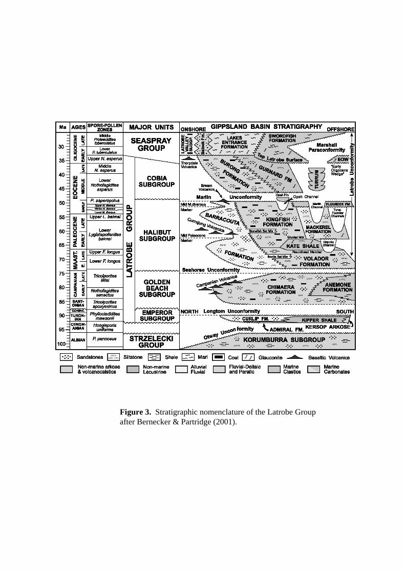
Figure 3. Stratigraphic nomenclature of the Latrobe Groupafter Bernecker & Partridge (2001).

11
tail first or sideways. The ship’s engineering group re-welded the bridles successfully. Theweak link broke at one station where the bridle also gave way (DR 14).
For later dredges (DR18 onwards) a simple box dredge was generally used, with betterresults. In all, we regard 15 dredge hauls as successful in that they recovered reasonablequantities of older rocks, three as moderately successful with some older rocks, and seven asunsuccessful with no recovery or only younger oozes.
The rocks and sediments that were recovered in deep water fall broadly into four categories:volcanics of uncertain but possibly early Late Cretaceous age, volcaniclastics and other labilesediments of Late Cretaceous age, marly Neogene calcareous sediments, and Quaternary toHolocene calcareous oozes. Nearly all dredges contained oozes, which will not be discussedfurther here. Most rocks are bored and manganese veneers are common. These rocks arediscussed in more detail below, and a report on the chemistry of the ferromanganese materialis given in Appendix 4.

12
Table 1: Successful Dredges
SampleNumberDepth(metres)
Latitude (S)Longitude (E)
Comment* Hand specimen description
DR043500-3100
39 17.63149 24.02
Half dredgeGolden BeachassemblageFigure 9
A: Abundant light olive grey (5Y6/1) ooze.B: Abundant white (N9) possibly calcareous clay.C: Yellowish grey (5Y8/1) possibly calcareousclaystone.D: Olive grey, medium-coarse labile sandstone,abundant clay pellets and carbonaceous grains.Variably sized sorted, thin to medium bedded, boredand lightly manganese encrusted
DR051750-1520
39 11.15148 55.33
Full dredge SeasprayassemblageA1: Late Plioceneforams B2: LatePliocene-MiocenepalynologyC2: Late PleistocenepalynologyFigure 9
A: Rare light olive grey (5Y6/1) lithified mediumquartz sandstone with carbonaceous flecks and leafimpressions. Some calcareous organisms.B: Rare light olive grey (5Y6/1) weakly lithifiedsiltstone to fine sandstone with carbonaceous flecks.Some calcareous organismsC: Common soft light olive grey (5Y6/1) silty to finesandy calcarenite. Abundant black ?carbonaceousgrains, rare white clay clasts, 1 scaphopodD: Common soft yellowish grey (5Y7/2) silty clay.
DR06737-632
38 30.9738 31.05148 34.48148 34.36
10 kg material indredge. Bridle brokenSeaspray assemblage
A: Cobbles of light brown marly limestone with shellyfossils.Coarse sand in pipe dredge, with quartz, lithics andshells
DR07284-277
38 17.3838 17.37148 36.53148 36.13
pipe dredge Very coarse coarse quartz and shelly debris with wholeshells including live squids, prawn like crustaceans,small turritellids, large gastropods, bivalves, worms.Quartz content ca. 40%, well rounded polished &coarse grained, with some brown stained lithics.
DR082800-2600
38 47.4149 01.0
5 kg + pipe dredgeSeasprayAssemblageA1: ?Early MioceneforamsB1& B3: late EarlyMiocene foramsB2: Early to MiddleMiocene palynology
A: Minor cemented clayey medium grained calcarenitewith lithic grains. Light olive grey (5Y 6/1)B: Abundant moderately lithified clayey, thin beddedcalcisiltite to very fine calcarenite with carbonaceousflecks. Light olive grey (5Y 6/1).C: Soft light olive grey (5Y 6/1) silty clay
DR093030-2700
38 50.338 50.4149 07.5149 07.0
pipe dredgeFigure 7
Soft silty and sandy clay. Light olive grey (5Y 6/1)
DR103100-2700
38 40.0438 39.71149 19 .08149 17.88
1/3 dredge + pipedredge SeasprayassemblageA1-3: Early Mioceneand Late PlioceneforamsFigure 4
A: Yellowish grey (5Y 7/2) heavily weathered quartzrich to clayey v.f. sandstone to siltstone. Thin tomedium bedded with some cross-lamination; beddingpicked out by changes in lithology content andcementation. Some calcareous organisms. Mottled inpart. Probably lake, swamp and estuarine deposits
DR112700-2550
38 37.95149 19.50
full dredge + pipedredge SeasprayassemblageA1-3: late earlyMiocene, MiddleMiocene, Pleistocene
A: Early and Middle Miocene greenish grey (5G 6/1)silty mudstone with a few thin carbonaceous layers.Some calcareous organismsB: Early to Middle Miocene light olive grey (5Y 6/1)mod. lithified mudstone with ferruginous veneer.Poorly med. bedded with some woody material. Some
13
foramsB1: late Early MioceneforamsB2: Early to MiddleMiocene palynologyD1: Middle MioceneforamsE1: Late MiocenepalynologyFigure 4
calcareous organisms. Marine characteristics includespreite and mottling.C: Dominant yellowish grey (5Y 7/2) mottled siltymudstone. Weakly lithified; weathered version oflithofacies B.D: Common Middle Miocene yellowish grey (5Y 7/2),lithified muddy siltstone to v.f. sandstone. Somecalcareous organisms. Thin bedded, ferruginised, withsome spreite.E: Common Late Miocene light olive grey (5Y 6/1)mod. lithified mudstone. Marine characteristics includespreite and mottling.
DR121725-1600
38 47.0148 34.03
1/4 dredge SeasprayassemblageB1: Quaternary foramsB2: Pleistocenepalynology
A: Common interbedded and lithified very light grey(N8) dolomitic siltstone and light olive grey (5Y 6/1)dolomitic m. calcarenite. Sand grains dominantlycalcareous bioclasts and quartz with some dark lithics.Laminated to thinly bedded.B: Abundant greenish grey (5GY 6/1) soft siltycalcisiltite and calcarenite with some weak colourbanding. Very homogeneous & massive with bivalves.Abundant large living deepsea barnacle clumps with 4main scutes and 2 subsidiary
DR133770-3450
39 13.0939 14.14149 30.01149 27.37
1/4 dredge full GoldenBeach assemblageFigure 9
A: Minor yellow brown, soft clayey m. quartzsandstone with muscovite and carbonaceous flecks.Mn veneer, bored.B: Common grey brown, moderately lithified f.-c.quartz sandstone, with feldspar, muscovite, lithic andcarbonaceous grains. Medium bedded, Mn crust to 3mm thick, bored. Circular burrows 3 mm across withorganic-rich walls.Pipe dredge contains grey brown muddy ooze, withpatches of ferruginous m. muddy quartz sand.
DR143400-2800
39 05.40149 28.30
Minor rocks &plus sand and ooze inpipe dredge. Bridle andweak link brokeGolden BeachassemblageFigure 8
A: Light olive grey (5Y 6/1) to brownish fissilesiltstone to sandy siltsone with carbonaceous partingsand a Mn veneer. Grains of quartz, feldspar andmuscovite.Pipe dredge contains light olive grey ooze and sandweathered from lithotype A. It also contains severallight brown clasts up to 2 cm across of brown coal.
DR153700-3400
38 59.1738 58.63149 42.09149 41.87
Minor rocks & ooze inpipe dredgeGolden BeachassemblageC1: Late CampanianpalynologyFigure 7
A: Minor greenish grey (5GY 6/1) moderatelylithified, thin labile sandstone. Well size sorted, withquartz, shaly clasts, feldspar, muscovite andcarbonaceous flecks. Bored surface with Mn crust 2mm thick.B: Trace greenish olive (10Y 4/2) mud to softmudstone.C: well lithified greenish olive (10Y 4/2) carbonaceousmudstone.Light browny grey ooze, slightly silty
DR173800-3700
38 57.05149 52.6
Dredge brokeVolcanic assemblageFigure 8
A: Minor Mn crusts 2-4 mm thick, plus one irregularnodule 3 cm thickB: Minor dark grey to dark brown subrounded tosubangular pebbles, possibly from a Cretaceousconglomerate. Most are volcanics, aphitic, somevesicular. Probably acid to intermediate. Also someflattish fine grained metasediments.
DR183820-3300
38 51.8149 35.8
1/4 dredgeGolden BeachassemblageB2: Early to mid
A: Common dark yellowish brown (10 YR 4/2) c-v.c.arkosic sandstone with feldspar, quartz, lithics. Thin tomedium bedded, Mn veneer.B: Rare dark yellowish brown (10 YR 4/2) thin bedded
14
Turonian palynologyC2: Probably TuronianpalynologyD1: Early to midTuronian palynologyFigure 5
flaggy siltstone with obvious plant remainsC: Abundant dark yellowish (10YR 4/2) sandysiltstone. Fissile to flaggy with load casts. Borings, MnveneerD: Common dark yellowish brown (10YR 4/2) poorlyconsolidated silty mud or clay, with Mn veneer.E: Pale yellowish brown (10YR 6/2) sticky silty clay.F: Mn crusts to 4 mm thick.All these lithotypes are from the one interbeddedsequence.Pale yellowish brown (10YR 6/2) clay from pipedredge
DR193375-2900
38 52.0038 52.00149 34.96149 34.63
Full dredgeGolden BeachassemblageA1: Early to midTuronian palynologyFigure 5
A: Abundant blue grey (5B 5/1) laminated lithifiedsandy siltstone with thin Mn crustB: Dominant orange (5YR 5/6) clayey f-c. labilesandstone to sandy mudstone (greywacke). Thinbedded to massive, ripple marked in part. Thin Mncrust (2 mm).C: Abundant grey m-c. labile sandstone. Mn crust to 2cm thick. Buff grey calcareous ooze in pipe dredge
DR203150-2610
38 45.238 43.7149 36.8149 36.2
Pipe dredge Pale olive (10Y 6/2) ooze with some forams and a fewsmall pebbles
DR213200-2800
38 45.438 45.0149 36.8149 36.4
Pipe dredge GoldenBeach assemblageB1 & B2: EarlyCampanian palynologyFigure 5
A: Minor pebbles of m-c. labile sandstone. Grey toorange or black when altered. Well size sorted,subangular grains.B: Common large pebbles of olive grey (5Y 4/1)lithified mudstone. Laminated to thin bedded, lowdensity. Some mottling, boring, Mn veneer.C: Minor small pebbles of yellowish grey (5Y 7/2)foram-rich calcareous mudstone. Variably lithifiedSeaspray Group.Sticky pale to medium grey calcareous clay fromdredge teeth.Yellowish grey (5Y 7/2) calcareous ooze in pipedredge
DR223500-3160
38 45.938 45.1149 32.3149 33.1
Pipe dredgeGolden BeachassemblageFigure 5
A: Few small pebbles of pale yellowish brown (10YR6/2) to moderate brown (5Y 5/2) laminated to thinbedded v.f. labile sandstone to silty sandstone withminor muscovite. Bored with Mn veneer.Minor dark yellowish brown (10YR 4/2) sticky siltyclay in box dredge.Light olive grey (5Y 5/2) calcareous ooze with someforams in pipe dredge.
DR233600-3100
38 47.4038 46.50149 37.50149 38.30
1/2 dredge, pipedredge.Golden BeachassemblageB1: Miocene oryounger foramsC1: SantonianpalynologyFigure 5
A: light grey yellow (5Y7/2) muddy calcarenite andcalcisiltite. Only partly consolidated but fizzes in acid,foraminifera visible.B: light bluey grey (5B 7/1) partly consolidated,calcisiltite.C: dark grey lignitic (5Y 3/2) sticky clay - slightlycalcareous and probably carbonaceousOoze from pipe dredge, pale yellow brown (10YR6/2).
DR243600-3300
38 53.238 53.9149 45.15149 45.3
1/4 dredge A: Cobbles of yellowy green olive (10Y 6/2)hyaloclastite, breccia or tuff, with vesicles and veins.May be chloritic. Thin Mn cust, bored.B: Slabs of brownish grey green (10YR 5/4) grittyvolcanic breccia, with clasts up to 1 cm.C: Cobbles of red brown orange (10 YR 6/6) fine

15
grained rock, possibly volcanic scoria.Light brown ooze in pipe dredge, with starfish, seaspider and sponges
DR253600-3300
38 57.338 58.3149 53.7149 52.4
2 kgFigure 8
A: Cobbles and pebbles of rounded black fine grainedbasalt and hyaloclastite, massive to highly vesicular.B: Light brown (5Y 6/4) f-c. volcaniclastic rocks,highly vesicular basalt clasts in part.Ooze in pipe dredge
*On the basis of the hand specimen descriptions, the thin-section descriptions below, and thepalynological results, the rocks dredged were separated into three groups:• Seaspray assemblage (Miocene-Pleistocene ages)• Emperor and Golden Beach assemblage (Turonian to Campanian ages)• Outer margin rift volcanics (assumed early Late Cretaceous age)

16
Table 2: Thin-section rock descriptions
Sample Description and ageDR05-12 Miocene-Pleistocene Seaspray Group ( dredged from 630-2800 m water
depth)DR05 A1: Sandy mudstone, with angular fine quartz and feldspar, clay clasts,
muscovite, forams and other calcareous fragments, rare siliceous spongespicules. Late Pliocene forams.B1: Silty calcareous mudstone, with very minor angular quartz and feldsparclasts, woody material, forams and other calcareous fragments. ?MiddleMiocene forams.C1: Fine calcarenite, with abundant pyrite-filled forams, other calcareous clastsand sponge spicules. Some subangular quartz, feldspar and clay clasts, claymatrix. Late Pliocene forams.[B2: Late Pliocene-Miocene palynology]
DR08 A1: Medium calcarenite, with abundant forams and other calcareous clasts.Some subangular quartz, feldspar, lithic and clay clasts, abundant clay matrix.?Early Miocene foramsB1: Calcisiltite with some forams and minor carbonaceous wisps. Rare v.f.quartz clasts. Late Early Miocene forams.B3: Calcisiltite with common pyrite-filled forams and minor carbonaceouswisps. Rare v.f. quartz clasts, sponge spicules. More clayey than B1. Late EarlyMiocene forams.[B2: Early to Middle Miocene palynology]
DR10 A1: Carbonaceous mudstone with some forams and minor other calcareousclasts. Rare v.f. quartz clasts. Late Pliocene or younger forams.A2: Carbonaceous mudstone with rare forams and sponge spicules. Early toMiddle Miocene forams.A3: Medium grained clayey sandstone, with abundant angular quartz and lesserfeldspar, muscovite, chloritised lithic grains, carbonaceous grains and opaques.Intraclast of carbonaceous mudstone with some pyrite-filled forams. LatePliocene or younger forams.
DR11 A1: Carbonaceous mudstone with rare quartz sand grains. Intraclasts of foram-bearing mudstone. Late Early Miocene forams.A2: Foram-rich calcisiltite with other calcareous clasts, and rare quartz,glauconite and carbonaceous wisps. Pleistocene forams.A3: Carbonaceous mudstone with common foraminifera, some sponge spicules,and rare quartz grains. Middle Miocene or younger forams.B1: Mottled carbonaceous calcareous mudstone with minor forams, spongespicules and quartz. Late Early Miocene forams.C1: Mottled mudstone, with some carbonaceous and quartz clasts, rare foramsand sponge spicules.D1: Ferruginous mudstone with common foraminifera and other calcareousfragments, and some quartz grains. Middle Miocene forams.[B2: Early to Middle Miocene palynology][E1: Late Miocene palynology]
DR12 A1: Fine grained calcarenite consisting largely of molluscan debris, with rarequartz, muscovite and feldspar.B1: Mottled medium grained calcarenite with abundant molluscan clasts andsome forams. Contains common subrounded quartz, feldspar and altered lithic
17
grains, and minor muscovite, in a clayey groundmass. Some carbonaceousclasts. Quaternary forams.
DR04 &13-23
Late Cretaceous Emperor and Golden Beach Subgroups (dredged from2040-3800 m water depth)
DR04 D1: Medium to coarse grained labile sandstone, with angular quartz andchloritised lithic grains, and lesser feldspar, muscovite, biotite, carbonaceousgrains and opaques. Some clayey groundmass.D2: Medium to coarse grained clayey sandstone, with angular quartz andchloritised lithic grains, and lesser feldspar, muscovite, and opaques.
DR13 A1: Fine grained clayey quartz sandstone with large clayey faecal pellets.Detrital clasts are subangular, with dominant quartz, with common muscoviteand altered clay clasts, and minor biotite and feldspar.B1: Medium grained clayey quartz sandstone with large clayey burrows.Detrital clasts are subangular, with dominant quartz and chloritised clay clasts(some probably altered glauconite), with common feldspar, minor muscoviteand biotite, and rare opaques and carbonaceous straps. Mn crust.B2: Bioturbated medium grained clayey quartz sandstone with large clayeyburrows. Detrital clasts are subangular, with dominant quartz and chloritised orsericitised clay clasts (some probably altered glauconite), with minor feldsparand muscovite, and rare opaques.B3: Medium grained clayey quartz sandstone with subangular quartz andchloritised clay clasts (some probably altered glauconite), with minor feldspar,muscovite and biotite, and rare opaques and carbonaceous straps.
DR14 A1: Fissile mudstone with carbonaceous partings. Fine sandy layers containquartz, feldspar, muscovite, and carbonaceous grains.
DR15 A1: Burrowed medium grained labile sandstone, with abundant subangularquartz, chloritised and sericitised shaly clasts, and feldspar, and commonmuscovite, biotite and opaques.[C1: Late Campanian palynology]
DR18 A1: Very coarse arkosic sandstone with abundant angular quartz and feldspar,and minor opaques, in a clayey groundmass.C1: Iron-stained sandy siltstone with abundant angular quartz grains andsericitised fine lithic clasts, and common feldspar and carbonaceous grains, setin a muddy matrix.[B2: Early to mid Turonian palynology][C2: Probably Turonian palynology][D1: Early to mid Turonian palynology]
DR19 A2: Mottled sandy siltstone with abundant angular quartz grains and sericitisedfine lithic clasts, and common carbonaceous fragments and minor feldspar, setin a muddy matrix. Thin interbeds of fine sandstone with quartz dominant overlithic clasts.A3: Bimodal sandy siltstone with 20% coarse sand grains. Sand grains arelargely angular or embayed quartz and presumed v.f. grained acid volcanics,plus some sericitised lithic clasts and carbonaceous grains, and minormuscovite. Siltstone matrix is finer grained equivalent. Mud flow?B1: Well-bedded v.f. to coarse labile sandstone with abundant subangular clastsof two feldspars, quartz, varied v.f. grained acid lithics, and carbonaceousgrains, with minor muscovite. Extensive alteration to brownish yellow claymineral.B2: Coarse iron-stained labile sandstone with abundant subangular feldspar,quartz, varied v.f. grained acid lithics, and carbonaceous grains, with minor
18
muscovite. Extensive iron alteration.B3: Coarse labile sandstone with abundant angular feldspars, quartz, varied v.f.grained acid lithics, and carbonaceous grains, with minor muscovite. Somealteration to brownish yellow clay mineral.C1: Coarse labile sandstone with abundant angular quartz, feldspars, varied v.f.grained acid lithics, and carbonaceous straps, with some muscovite. Somealteration to brownish yellow clay mineral.C2: Coarse to very coarse labile sandstone with abundant angular quartz,feldspars, varied v.f. grained acid lithics, with some muscovite. Some stratawith v.c. clasts of brown v.f. ?claystone. A few carbonaceous straps.C3: Coarse labile sandstone with abundant angular quartz, feldspars, varied v.f.grained acid lithics, and carbonaceous straps, with some muscovite. Extensiveiron alteration.[A1: Early to mid Turonian palynology]
DR21 A1: Coarse labile sandstone with abundant angular quartz, feldspars, varied v.f.grained acid lithics, and carbonaceous straps. Extensive iron alteration.[B1 & B2: Early Campanian palynology]
DR22 A1: Fine iron-stained silty labile sandstone with carbonaceous partings andgrains. Clasts dominantly v.f. grained acid lithics and quartz, with somefeldspar and muscovite.
DR23 B1: Calcarenite, v.f. grained consisting largely of molluscan clasts, withabundant forams, and some echinoid spines, sponge spicules, quartz and lithicgrains, carbonaceous grains and clay matrix. Miocene or younger forams.[C1: Santonian palynology]
DR24-25 Outer margin rift volcanics (presumed early Late Cretaceous) dredgedfrom 3300-3600 m water depth
DR24 A1: Light and dark volcanics welded together, with light material filling poresin dark. Light material is a hyaloclastite, dominantly of angular glassyvesicular clasts (1-4 mm), with some darker vesicular clasts, and some largecalcite bodies between clasts. It may have been a flow in which other materialwas caught up, before quenching and breakup. Calcite has filled the interstices,and entered pores later still. Dark material is vesicular basalt, with feldsparneedles and brown altered olivine crystals in aphanitic groundmass. Vesicleslargely 1mm across are filled with clay minerals and/or calcite.A2: Vesicular basalt, with feldspar needles and brown altered olivine crystalsin aphanitic groundmass. Vesicles largely 1mm across, but some reach 4 mm,and are partly filled with clay minerals or calcite. Darker and lighter layers inthe rock. The darker layers show slightly more advanced crystallisation,probably being further from the cooling front.B1: Hyaloclastite, dominantly of light coloured, angular glassy vesicular clasts(3-10 mm), probably pumice, with some darker similar clasts. Interstices notvery abundant and filled with fine grained clay/zeolite with some calcite.
DR25 A1: Brown hyaloclastite, consisting of angular clasts (1-10 mm) of vesicularaltered glassy material containing some altered olivine microphenocrysts andfresh titanian clinopyroxene (“titanaugite”) (60%), floating in a matrix of radialzeolites and lesser clay minerals (40%), probably originally mud.B1: Brown vesicular basaltic glass (palagonite), containing feldspar [? check!]and altered olivine phenocrysts to 2 mm and euhedral titanian clinopyroxenecystals to 0.2 mm. The olivine is replaced by clays and red layered silicates(“iddingsite’). Vesicles are elongate (1-4 mm) and partially filled with zeolites.

19
3.2. Seaspray Group
Dredges 5-12 recovered marine calcareous rocks believed to be part of the post-EoceneSeaspray Group, in present-day water depths varying from 680 m to 2800 m. Palynology(Section 4) shows that DR8 and DR11 are Miocene in age, and DR5 and DR12 include Plio-Pleistocene strata (Section 5). Microplankton show that water depths were deep duringdeposition. Foraminifera (Section 5) show that the older rocks dredged in DR5, DR8, DR10and DR11 are Early to Middle Miocene in age, and that the Quaternary DR12 consists ofshallow-water material that was displaced downslope.
The rocks recovered include medium to very fine grained calcarenites, calcisiltites andcalcareous mudstones, composed largely of molluscan debris, foraminifera (often filled withpyrite) and clay. Other organic debris includes wood and leaves, sponge spicules andechinoderm spines. Detrital clasts are largely quartz, feldspar, clay clasts and muscovite. Thestrata are often poorly bedded, with thin to medium bedding apparent in some cases. Mottlingshows that bioturbation was widespread.
3.3. Emperor and Golden Beach Subgroups
Eleven dredges (DR4, DR13-16, DR18-23) recovered immature labile rocks believed to bepart of the Late Cretaceous Emperor and Golden Beach Subgroups. Ages obtained thus farvary from Turonian to Campanian (Section 4). The dredges were taken on the outercontinental margin in water depths ranging from 2040m to 3800 m (Figure 2). No rocks ofEarly Cretaceous (Strzelecki Group) age were recovered, perhaps supporting the view ofMegallaa (1993) that they were not deposited on or east of the Gippsland Rise (a NNE-trending feature at ~149°30’E).
Common lithologies are labile sandstone, siltstone and mudstone (and the weathered variants,silt and clay). The sediments are carbonaceous in part and plant remains are apparent in somebeds. They are often thin to medium bedded, and burrowed and mottled in part. Occasionalbeds contain other environmental indicators such as cross-lamination, ferruginous nodules andtrace fossils. Load casts are present in DR18, and ripple marks in DR19. These rocks weredeposited in the rift involving eastern Australia, Lord Howe Rise, and the Gippsland Basin,and are lithologically similar to those of the Strzelecki Group and the Emperor and GoldenBeach Subgroups.
The rocks form a siliciclastic assemblage of lithologically immature, but well size-sorted,sandstones and mudstones, laid down rapidly in coastal plains, swamps and shallow-marineenvironments. Clasts are angular to subangular. Much of the debris consists of volcanicquartz, feldspar (dominantly plagioclase), and clasts of fine grained lithic rocks including acidvolcanics. Carbonaceous straps and grains are very common. Minor but widespreadcomponents are muscovite, biotite and opaque minerals. Glauconite occurs in a few samples.The groundmass is clayey, and both it and some of the clasts are commonly chloritised andsericitised. Marine macrofossils are generally absent, despite the common presence of marineindicators such as burrows and mottling.
Santonian carbonaceous mudstone had earlier been dredged from the flanks of Bass Canyonby HMAS Cook (Marshall, 1988) in dredge hauls C84-3DB, C84-4DB and C84-5DB(Figures 2 & 4-6). Another earlier dredge haul, BMR 68-DR1 (Figures 2 & 7), consists of

20
undated calcareous mudstone and lithic sandstone (Colwell, Coffin et al., 1987). This comesfrom the eastern continental slope, very close to our DR15 consisting of Late Campaniansiliciclastic sediments.
The palynological results document the onset on marine conditions along the newly formingouter continental margin in the Late Cretaceous, as the developing Tasman Sea entered fromthe east. Algal cysts in Early to Middle Turonian sediments (DR18 & 19: ~90 Ma) show thatsilts and clays were deposited in a deep freshwater lake near the outer continental margin.Coniacian sediments were not recovered, but in the Santonian (DR23: ~86 Ma )microplankton indicate that considerable post–breakup subsidence of the outer continentalmargin had occurred, and that carbonates were being deposited in deep marine conditions. Inthe Early and Late Campanian (DR21 & DR15: ~82 Ma & ~75 Ma), deep marine mudscontinued to be deposited on the outer margin. Thus the results show that subsidence belowsea level occurred between 90 Ma and 86 Ma.
3.4. Outer margin rift volcanics
The easternmost dredges were taken in water depths of 3300-3800 m (Figure 2) from a riftedblock elongated west-northwest and just inboard of the continent-ocean boundary (DR17,DR24 & DR25). They contain basalt, hyaloclastite, breccia and volcaniclastic sandstone, noneof which have been dated. The largest and most diverse dredge haul, DR24, contains cobblesof yellowy green olive hyaloclastite with highly vesicular clasts 1-4 mm in size, andcontaining dark vesicular basalt pebbles. The interstices, veins and vesicles are filled withcalcite. It also contains slabs of brownish grey-green gritty hyaloclastite, with clasts up to 1cm across. Interstices are filled with clay minerals and calcite. The third rock type occurs ascobbles of red brown orange fine grained vesicular volcanic scoria.
The small haul of DR25 is dominated by cobbles and pebbles of rounded, black, fine grainedbasalt and hyaloclastite, massive to highly vesicular. The interstices of the hyaloclastite arefilled with zeolites and lesser clay minerals. Another common assemblage consists of lightbrown fine to coarse volcaniclastic rocks, containing highly vesicular basalt clasts. The verysmall haul of DR17 consists of dark grey to dark brown subrounded to subangular pebbles.Most are aphanitic volcanics, probably of acid to intermediate composition, some of whichare vesicular. There are also some flattish pebbles of fine grained metasediments.
This assemblage of volcanic rocks occurs on an isolated ridge at the continent-oceanboundary and cannot have derived its pebbles and clasts from younger sequences. Theassemblage is presumed to have been laid down sometime during the Tasman Sea riftingphase, in the Turonian to Coniacian. If this is correct, the labile non-marine sediments of theEmperor Subgroup (described in Section 3.3) were deposited synchronously further west.Bernecker and Partridge (2001) mention that basaltic volcanics of Campanian age occur insome wells near the Rosedale and Darriman fault systems, which bound the central deep ofthe Gippsland Basin, but they are probably unrelated.
We hypothesise that lava flows and domes formed on a coastal plain and in shallow water. Inwater, they were quenched and broken up to form volcaniclastic mass flow deposits such ashyaloclastites. Where the volcaniclastics formed by the combination of volcanic rock andmuds, the interstices are now filled with zeolites and clay minerals, and any lime mud wasreplaced by diagenetic calcite. In the cases where the domes and flows formed on dry land,normal vesicular flows resulted, weathering to scorias in some cases.

21
4. RECONNAISSANCE PALYNOLOGICAL ANALYSIS OFFR11/98 DREDGE SAMPLES
Alan D. Partridge, Biostrata Pty Ltd.
4.1. Introduction
Fourteen seafloor samples dredged from the sides of the Bass Canyon system in theGippsland Basin in southeastern Australia were given a reconnaissance palynological analysisto determine age and possible stratigraphic assignment. The six shallower samples recoveredfrom water depths between 1500 and 2800 metres gave Neogene ages (Early Miocene toRecent), while the eight deepest samples in water depths between 2800 and 3800 metres allgave Late Cretaceous ages (Turonian to Campanian). The results for each sample arediscussed below with other information on the samples given in Table 3.
The material analysed consisted of an unfiltered kerogen slide and usually two unoxidisedpalynological slides sieved or filtered at 10µm and 20µm from each sample. The unfilteredkerogen slides generally displayed a very dense “felt” or suspension of very finely shredded,structured terrestrial, sapropelic, and opaque kerogen types and tiny pyrite crystal, in whichfloated very rare larger kerogen pieces and palynomorphs. The extreme density of thesuspension on the unfiltered kerogen slides, combined with an average kerogen particle sizeof <5µm made these slides unusable for biostratigraphic purposes. The other two filtered butunoxidised slides were noticeably skewed, as the assemblages recorded from the different sizefractions contained markedly different abundances of palynomorphs. It was therefore foundnecessary to examine both slides to achieve representative assemblages for the samples, buteven when this was completed many of the assemblages recorded were considered to beskewed relative to assemblages previously recorded by the author in equivalent age samplesfrom elsewhere in the basin. It is uncertain whether these problems are a consequence of thenature of the rocks or a result of the laboratory preparation methods.
4.2. Results from samples
SAMPLE: DR05-B2 (MFP12528)Age: Late Pliocene to Pleistocene.Zone: Tubulifloridites pleistocenicus Zone.Stratigraphic unit: Seaspray Group.Comments: The occurrence in the sample of abundant Cyathidites paleospora with commonTubulifloridites pleistocenicus and Tubulifloridites simplis is considered diagnostic of thelargely Pleistocene Tubulifloridites pleistocenicus spore-pollen Zone. The Spiniferitesramosus dominated microplankton assemblage is probably no younger than theAchomosphaera ramulifera Zone of McMinn (1992), and the environment of deposition isopen-marine consistent with the modern depositional setting of the dredge site.

22
SPECIES LIST:Spore-pollenAraucariacites australisBanksieaeidites elongatusChenopodipollis chenopodiaceoidesCyathidites paleosporaForaminisporis bifurcatusGleicheniidites circiniditesHaloragacidites haloragoidesHaloragacidites harrisiiLaevigatosporites majorLaevigatosporites ovatusLygistepollenites floriniiMatonisporites ornamentalisMilfordia incertaOphioglossisporites lacunosusPodocarpidites spp.Podocarpidites antarcticusPolypodiaceoisporites ornatusPseudowinterapollis couperiRicciaesporites boxatus n.sp.Tricolporites spp.Tricolporopollenites pelargonioidesTubulifloridites pleistocenicusTubulifloridites simplisMicroplankton & AlgaeAchomosphaera alcicornuAchomosphaera ramuliferaBotryococcus brauniiImpagidinium spp.Lingulodinium machaerophorumSpiniferites ramosusTasmanites punctatusTuberculodinium vancampoae
SAMPLE: DR05-C2 (MFP12529)Age: Late Pleistocene to Recent.Zone: Tubulifloridites pleistocenicus Zone.Stratigraphic unit: Seaspray Group.Comments: Low yielding sample with a low concentration of palynomorphs on the slides.The microplankton Protoperidinium spp., Impagidinium spp. and the microforaminiferalliners appear to be most abundant forms, with Tubulifloridites spp. the commonest pollen.Abundance of other species is difficult to evaluate. Although recorded assemblage is oflimited diversity the microplankton assemblage compares best with either the Achomosphaeraramulifera or Protoperidinium leonis Zones of McMinn (1992). Environment of deposition isopen-marine consistent with the modern depositional setting of the dredge site.

23
SPECIES LIST:Spore-pollenAcaciapollenites myriosporitesChenopodipollis chenopodiaceoidesCyathidites paleosporaDiporites n.sp. aff. G. nebulosusHaloragacidites haloragoidesHaloragacidites harrisiiLaevigatosporites ovatusMatonisporites ornamentalisMilfordia incertaMonotocidites galeatusMyrtaceidites parvusPseudowinterapollis couperiTricolporites spp.Tubulifloridites pleistocenicusTubulifloridites simplisMicroplanktonAchomosphaera sp.Impagidinium spp.Lingulodinium machaerophorumProtoperidinium conicumProtoperidinium oblongumSpiniferites membranaceusSpiniferites ramosusOther palynomorphsMicroforaminiferal linersScolecodonts
SAMPLE: DR08-B2 (MFP12530)Age: Early to Middle MioceneZone: Middle P. tuberculatus to T. bellus Zone.Stratigraphic unit: Seaspray Group.Comments: This low yielding sample gave a microplankton assemblage dominated by thedinoflagellate Impagidinium spp. and numerous undescribed dinoflagellate species that arecan be assigned to the broad Operculodinium Superzone, which dominates the thick Mioceneportion of the Seaspray Group. In the associated spore-pollen assemblage Ophioglossisporiteslacunosus indicates an age no older than Late Oligocene, while Cyatheacidites annulatusindicates an age no younger than Pliocene. It is notable that Nothofagidites pollen, abundantin the more inshore Seaspray Group and equivalent aged coal measures in the Latrobe Valley,are extremely rare in the sample. It is suspected that their scarcity is more a consequence ofsample preparation than removal by depositional processes. An open-marine, deep-waterenvironment of deposition is most likely.
SPECIES LIST:Spore-pollenAraucariacites australisCyatheacidites annulatus

24
Cyathidites paleosporaDilwynites granulatusFoveotriletes balteusGleicheniidites circiniditesHaloragacidites harrisiiIschyosporites gremiusKuylisporites waterbolkiiLaevigatosporites majorLaevigatosporites ovatusLygistepollenites floriniiNothofagidites emarcidus/heterusOphioglossisporites lacunosusPodocarpidites spp.Retitriletes sp.Rugulatisporites mallatusStereisporites antiquisporitesMicroplanktonCymatisphaera spp.Impagidinium spp.Protoellipsodinium spp.Pyxidinopsis sp.Spiniferites ramosusTectatodinium sp.Tectatodinium sp. cf. T. pellitum
SAMPLE: DR11-B2 (MFP12531)Age: Early to Middle MioceneZone: Middle P. tuberculatus to T. bellus Zone.Stratigraphic unit: Seaspray Group.Comments: A low yielding sample dominated by undescribed dinoflagellate speciesprovisionally assigned to Protoellipsodinium. Although most or the assemblage isundescribed it has been widely recorded from the Early and Middle Miocene part of theSeaspray Group, and is part of the Operculodinium Superzone. The low diversity spore-pollenassemblage recorded is consistent with this age. An open-marine deep-water environment ofdeposition is most likely.
SPECIES LIST:Spore-pollenAraucariacites australisCyatheacidites annulatusCyathidites paleosporaLaevigatosporites majorLaevigatosporites ovatusLatrobosporites sp.Lygistepollenites floriniiPodocarpidites spp.Retitriletes sp.MicroplanktonImpagidinium spp.

25
?Invertocysta sp.Lingulodinium solarumOperculodinium tabulatum n.sp.Protoellipsodinium simplex n.sp.Protoellipsodinium spp.Pyxidinopsis sp.Spiniferites ramosusTuberculodinium vancampoae
SAMPLE: DR11-E1 (MFP12532)Age: Late Miocene.Zone: Foraminisporis bifurcatus Zone.Stratigraphic unit: Seaspray Group.Comments: Although also low yielding like the other sample from this locality, theassemblage recorded suggests a younger age based on the presence of the sporeForaminisporis bifurcatus n.comb., which is not known to range below the Late Miocene.The microplankton assemblage is also conspicuously different in lacking theProtoellipsodinium species and containing the distinctive dinoflagellate cystMelitasphaeridium choanophorum. This latter species is recorded as ranging from LateOligocene to Pliocene by Williams & Bujak (1985; fig.19), but has a later first appearance inthe Gippsland Basin somewhere in the Miocene, and a older last occurrence in the earlyPliocene (McMinn, 1992). Once the total range of this species is better established it mayprovide a more precise age for this sample. Environment of deposition is interpreted as deep-water open-marine.
SPECIES LIST:Spore-pollenAraucariacites australisCyatheacidites annulatusCyathidites paleosporaDacrycarpites australiensisForaminisporis bifurcatusHaloragacidites harrisiiIschyosporites irregularis n.sp.Lygistepollenites floriniiMatonisporites ornamentalisPodocarpidites spp.Polypodiaceoisporites ornatusPolypodiidites perverrucatusPseudowinterapollis couperiRetitriletes sp.Microplankton & AlgaeAchomosphaera alcicornuAchomosphaera ramuliferaCyclopsiella vietaImpagidinium spp.Lingulodinium machaerophorumMelitasphaeridium choanophorumNematosphaeropsis rhizoma n.sp.

26
Operculodinium centrocarpum Spiniferites ramosusTasmanites punctatus
SAMPLE: DR12-B2 (MFP12533)Age: Pleistocene.Zone: Tubulifloridites pleistocenicus Zone.Stratigraphic unit: Seaspray Group.Comments: The sample is dominated by abundant large pieces of structure terrestrial kerogenassociated with common Cyathidites paleospora, Matonisporites ornamentalis andTubulifloridites spp., and in contrast to these terrestrial palynomorphs there are relatively fewmicroplankton. Overall the assemblage has a nearshore character, but considering the youngage and collection depth of >1600 metres it is concluded that the bulk of the organic materialin the sample has been derived from the shelf and was probably delivered to the present site asturbidites.
SPECIES LIST:Spore-pollenChenopodipollis chenopodiaceoidesCyathidites paleosporaForaminisporis bifurcatusHaloragacidites harrisiiHaloragacidites trioratusMatonisporites ornamentalisMilfordia incertaMonoporites mediaMyrtaceidites eucalyptoides orthusMyrtaceidites parvusMyrtaceidites xanthomyrtoidesPseudowinterapollis couperiTubulifloridites pleistocenicusTubulifloridites simplisMicroplankton & AlgaeAchomosphaera sp.Brigantedinium sp.Operculodinium sp.Tasmanites punctatusOther palynomorphsMicroforaminiferal liners
SAMPLE: DR15-C1 (MFP12534)Age: Late Campanian.Zone: Isabelidinium korojonense ZoneStratigraphic unit: Anemone Formation of Golden Beach Subgroup.Comments: The sample contains an abundant and diverse microplankton assemblagedominated by Isabelidinium greenense, which can be confidently assigned to the I.korojonense Zone on the presence of the eponymous species. Spore-pollen are rare in the
27
assemblage but can be considered consistent with a T. lilliei Zone assignment. Environment ofdeposition is distal marine and probably deep water.
SPECIES LIST:Spore-pollenCoronatispora perforataCyathidites minorDilwynites granulatusGambierina croccodilus n.sp.Gambierina rudataGleicheniidites circiniditesHerkosporites proxistriatusLaevigatosporites ovatusLygistepollenites floriniiMicrocachryidites antarcticusNothofagidites senectusOrnamentifera strumosus n.sp.Phyllocladidites mawsoniiPodocarpidites spp.Proteacidites spp.Retitriletes sp.Trichotomosulcites subgranulatusMicroplanktonCribroperidinium sp., Marshall 1990Exochosphaeridinium sp.Isabelidinium cretaceumIsabelidinium greenenseIsabelidinium korojonenseIsabelidinium variabileIsabelidinium spp.Microdinium cassiculumOdontochitina sp. cf O. echinatus n.sp.Odontochitina harrisii n.sp.Odontochitina prolata n.sp.Odontochitina spinosaSamlandia mayiSenoniasphaera edenensisSpiniferites ramosusTrithyrodinium vermiculataTrithyrodinium sp. A, Marshall 1990
SAMPLE: DR18-B2 (MFP12535)Age: Early to mid Turonian.Zone: Rimosicysta Superzone.Stratigraphic unit: Kipper Shale of Emperor Subgroup.Comments: The sample is poorly preserved and notwithstanding an abundance ofpalynomorphs on the slides there is only a limited diversity. This is entirely consistent withthe character of assemblages recovered from the Kipper Shale. The dominance of Dilwynitespollen is characteristic of a Neves effect found in the distal and interpreted deepwater parts of
28
the Kipper Shale (e.g. Partridge, 1990). The endemic suite of algal cysts, originally describedby Marshall (1989) and here considered to represent the Rimosicysta Superzone, are alsocharacteristic of the formation, and are interpreted to indicate deposition in a fresh-waterlacustrine environment.
SPECIES LIST:Spore-pollenAraucariacites australisBaculatisporites spp.Corollina torosaCyathidites minorDilwynites granulatusDilwynites pusillus n.sp.Falcisporites grandisMicrocachryidites antarcticusPerotrilites jubatusPodocarpidites spp.
Microplankton & AlgaeRimosicysta asperatusRimosicysta eversaRimosicysta spp.?Tetrachacysta keeneiWuroia corrugataWuroia tubiformis
SAMPLE: DR18–C2 (MFP12536)Age: Probably Turonian.Zone: Indeterminate.Stratigraphic unit: Probably Kipper Shale.Comments: The palynology residue is dominated by opaque and semi-opaque kerogen inwhich palynomorphs are rare. Although this low diversity assemblage is not age diagnostic itsoverall character and preservation is consistent with the assemblages from the three otherdredge samples assigned to the Kipper Shale, and therefore a similar Turonian age issuggested.
SPECIES LIST:Spore-pollenAraucariacites australisCeratosporites equalisCorollina torosaCyathidites minorDilwynites granulatusMicrocachryidites antarcticusPodocarpidites spp.Trichotomosulcites subgranulatus

29
SAMPLE: DR18-D1 (MFP12537)Age: Early to mid Turonian.Zone: Rimosicysta Superzone.Stratigraphic unit: Kipper Shale of Emperor Subgroup.Comments: Assigned to the Kipper Shale based on the characteristic suite of algal cystsdiagnostic of the Rimosicysta Superzone. The sample differs from DR18–B2 by containingcommon specimens of the colonial algae Amosopollis cruciformis. The spore-pollen arerepresentative of the P. mawsonii Zone assemblages recorded from the formation in that thereis a lack of most key species, but presence of a weak Neves effect. The sample is interpretedto have been deposited in a deep-water lacustrine environment.
SPECIES LIST:Spore-pollenAraucariacites australisBaculatisporites spp.Ceratosporites equalisCupressacites sp.Cyathidites australisCyathidites minorDilwynites granulatusDilwynites pusillus n.sp.Gleicheniidites circiniditesInterulobites intraverrucatusLaevigatosporites ovatusMicrocachryidites antarcticusPerotrilites jubatusPodocarpidites spp.Reticulosporis sp. cf. R. albertonensisRugulatisporites mesomallatus n.sp.Trichotomosulcites subgranulatusMicroplankton & AlgaeAmosopollis cruciformisLuxadinium sp.Rimosicysta cucullataRimosicysta eversaRimosicysta spp.Wuroia sp. cf. W. tubiformis
SAMPLE: DR19–A1 (MFP12538)Age: Early to mid Turonian.Zone: Rimosicysta Superzone.Stratigraphic unit: Kipper Shale of Emperor Subgroup.Comments: The low diversity microplankton are again diagnostic of the RimosicystaSuperzone, while the spore-pollen are considered to relate to the equivalent P. mawsoniiZone. The concentration of spore-pollen is too low to confidently demonstrate any Neveseffect. Like the samples from locality 18, a distal and deep-water lacustrine environment ofdeposition is suggested.

30
SPECIES LIST:Spore-pollenCyathidites minorDilwynites granulatusLaevigatosporites ovatusMicrocachryidites antarcticusPerotrilites jubatusPodocarpidites spp.Rugulatisporites mesomallatus n.sp.Trichotomosulcites subgranulatusMicroplankton & AlgaeBotryococcus brauniiPediastrum sp.Rimosicysta eversaRimosicysta kipperiiRimosicysta spp.
SAMPLE: DR21-B1 (MFP12539)Age: Early Campanian.Zone: Nothofagidites senectus Zone.Stratigraphic unit: Anemone Formation of Golden Beach Subgroup.Comments: The sample contains a high concentration of palynomorphs representingmoderately diverse assemblages of both spore-pollen and microplankton. Although theeponymous species was not recorded the spore-pollen are confidently assigned to theN. senectus Zone based on the common occurrence of Forcipites sabulosus. Themicroplankton assemblage is dominated by Isabelidinium variabile and although the overallassemblage is consistent with the age assignment suggested by the spore-pollen it is difficultto confidently place this assemblage in relation to those described by Marshall (1988, 1990).The problem is that the sample lacks Nelsoniella aceras and N. semireticulata that areassociated with the eponymous species of the Satyrodinium haumuriense Zone, but containsAlterbidinium acutulum which previously has not been recorded before the youngerI. korojonense Zone (Marshall, 1990; fig.4), yet at the same time the presence of Chatangiellaarvensis and spinose species of Odontochitina suggest affinities with the older Santonianassemblages described by Marshall (1988). Until the sequence of these assemblages is moreadequately documented a microplankton zone assignment for this sample will remainuncertain. Environment of deposition is distal marine and probably deep water.
SPECIES LIST:Spore-pollenAustralopollis obscurusClavifera triplexDensoisporites velatusDictyophyllidites sp.Dilwynites granulatusDilwynites pusillus n.sp.Forcipites sabulosusGleicheniidites circiniditesHerkosporites proxistriatusLygistepollenites florinii
31
Microcachryidites antarcticusPeninsulapollis gilliiPhyllocladidites mawsoniiPodocarpidites spp.Proteacidites spp.Retitriletes nodosusRetitriletes spp.Trichotomosulcites subgranulatusVitreisporites signatus
Microplankton & AlgaeAlterbidinium acutulumAmosopollis cruciformisChatangiella arvensisChatangiella victoriensisIsabelidinium variabileIsabelidinium spp.Odontochitina costataOdontochitina harrisii n.sp.Odontochitina spinosaPalambages sp.Samlandia mayiSpiniferites ramosusTrithyrodinium vermiculata
SAMPLE: DR21–B2 (MFP12540)Age: Early Campanian.Zone: Nothofagidites senectus Zone.Stratigraphic unit: Anemone Formation of Golden Beach Subgroup.Comments: The sample contains a nearly identical assemblage to that recorded from DR21–C1 and has same zone assignment problems for the microplankton. However, numerousspecimens of Nothofagidites senectus were recorded from the slide filtered at 10µm, therebyconfirming assignment to the N. senectus Zone. An equivalent deep-water marineenvironment of deposition is inferred.
SPECIES LIST:Spore-pollenAraucariacites australisCyathidites minorDilwynites granulatusDilwynites pusillus n.sp.Forcipites sabulosusGleicheniidites circiniditesLygistepollenites floriniiMicrocachryidites antarcticusNothofagidites senectusPeninsulapollis gilliiPerotrilites n.sp. (reticulate)Podocarpidites spp.

32
Proteacidites spp.Tricolpites confessusTrichotomosulcites subgranulatusVitreisporites signatusMicroplankton & AlgaeAlterbidinium acutulumAmosopollis cruciformisChatangiella victoriensisExochosphaeridinium sp.Isabelidinium sp. cf. I. ponticumIsabelidinium variabileIsabelidinium spp.Microdinium cassiculumOdontochitina harrisii n.sp.Odontochitina spinosaPalambages sp.Spiniferites ramosusVeryhachium sp. cf. V. collectumVeryhachium sp.Xiphophoridium alatum
SAMPLE: DR23-C1 (MFP12541)Age: SantonianZone: Equivalent to Isabelidinium cretaceum Zone.Stratigraphic unit: Anemone Formation of Golden Beach Subgroup.Comments: The sample contains moderately diverse assemblages of both spore-pollen andmicroplankton. The latter are very similar to the Santonian assemblages documented byMarshall (1988) and broadly conform to the interval of the O. porifera to I. cretaceum Zonesalthough neither of the eponymous species were recorded. Assignment to the youngerI. cretaceum Zones is preferred based on the occurrence of Odontochitina indigena which hasnot been recorded by the author from below the younger zone in the Otway Basin. The spore-pollen assemblage also lacks key index species, but is consistent with assignment to theTricolporites apoxyexinus Zone. Once again an open-marine deep-water environment ofdeposition is suggested.
SPECIES LIST:Spore-pollenAraucariacites australisAustralopollis obscurusBaculatisporites spp.Cicatricosisporites sp.Cyathidites australisCyathidites minorDensoisporites velatusDictyophyllidites sp.Dilwynites echinatus n.sp.Dilwynites granulatusDilwynites tuberculatusGleicheniidites circinidites

33
Microcachryidites antarcticusPerotrilites n.sp. (reticulate)Phyllocladidites eunuchus msPhyllocladidites mawsoniiPodocarpidites spp.Proteacidites spp.Retitriletes spp.Rugulatisporites mallatusTrichotomosulcites subgranulatusMicroplanktonAmosopollis cruciformisChatangiella tripartitaCyclonephelium compactumExochosphaeridium sp.Isabelidinium variableOdontochitina costataOdontochitina indigenaOligosphaeridium complexPalambages spp.Rimosicysta spp. (reworked?)Spiniferites ramosusTrithyrodinium sp.Veryhachium sp.

34
Table 3: Palynological Summary
Sample Latitude SLongitudeE
WaterDepth(metres)
Description
DR05 39 11.15148 55.33
1750-1520
B2: Late Pliocene-Miocene grey weakly lithified siltstone to finesandstone. Open marine microplankton.C2: Late Pleistocene to Recent soft grey silt to fine sand. Open marinemicroplankton.
DR08 38 47.4149 01.0
2800-2600
B2: Early to Middle Miocene grey moderately lithified clayey, thinbedded very fine quartz sandstone with carbonaceous flecks. Openmarine microplankton.
DR11 38 37.95149 19.50
2700-2550
B2: Early to Middle Miocene greenish grey silty mudstone with a fewthin carbonaceous layers. Open marine microplanktonE1: Late Miocene grey mudstone, with some woody material. Marinecharacteristics include spreite and mottling. Open marinemicroplankton.
DR12 38 47.0148 34.03
1725-1600
B2: Pleistocene grey soft silty mudstone. Very homogeneous &massive with rare bivalves. Nearshore palynomorphs believed re-deposited.
DR15 38 59.17149 09.00 to38 58.63149 41.87
3700-3400
C1: Late Campanian greenish olive carbonaceous mudstone. Openmarine microplankton, probably deep water.
DR18 38 51.8149 35.8
3820-3300
B2: Early to mid Turonian yellowish brown thin bedded flaggysiltstone with obvious plant remains. Algal cysts indicate fresh-waterlake.C2: Probably Turonian dark yellowish sandy siltstone. Fissile to flaggywith load casts. Environment non-marine.D1: Early to mid Turonian yellowish brown poorly consolidated siltymud or clay. Algal cysts indicate deep fresh-water lake.
DR19 38 52.00149 34.96 to38 52.00149 34.63
3375-2900
A1: Early to mid Turonian blue grey laminated lithified claystone.Deep fresh-water lake suggested.
DR21 38 45.4149 36.8 to38 45.0149 36.4
3200-2800
B1: Olive grey lithified mudstone. Laminated to thin bedded, lowdensity. Some mottling, boring. B1 soft, B2 hard: both EarlyCampanian. Microplankton indicate deep marine for both.
DR23 38 47.40149 37.50 to38 46.50149 38.30
3600-3100
C1: Santonian grey lignitic sticky clay - slightly calcareous andprobably carbonaceous. Microplankton indicate deep marine.
Samples identified in the form “FR11/98/DR05/B2”
4.3. Conclusions
The reconnaissance palynological analysis show that the seafloor dredge samples fall into thefollowing three groups, (1) lacustrine sediments of Turonian age, (2) distal marine andprobably deep-water sediments of Santonian to Late Campanian in age, and (3) deep-watermarine sediments of Neogene age.
Not seen, and not even evidenced by reworked palynomorphs, are Early Cretaceous sedimentsof the Strzelecki Group and the Maastrichtian to Oligocene age sediments that account for theupper part of the Latrobe Group and basal part of the Seaspray Group. The Strzelecki Groupis interpreted to have either not been deposited over the East Gippsland Rise east of longitude

35
149° (see Megallaa, 1993; p.47), or to have been removed by erosion during the CenomanianOtway Unconformity. The upper Latrobe and basal Seaspray Groups are interpreted to bemissing at an extended version of the “Latrobe Unconformity”. Most of the missing time canbe accounted by either non-deposition or extremely starved and condensed deposition. A thirdunconformity is also interpreted to be present located between the Turonian lacustrinesediments of the Kipper Shale and the Santonian marine sediments of the AnemoneFormation. This last unconformity is correlated to the commencement of seafloor spreading inthe Tasman Sea.
4.4. Recommendations
Additional palynological studies are only recommended at this time on the samples recoveredfrom the Late Cretaceous Anemone Formation and Kipper Shale. Distribution of sedimentsbelonging to two these formations is still poorly known in the Gippsland Basin andconsequently any further study of the marine microplankton from these older samples mayhelp future petroleum exploration. If this work is to be undertaken further palynological slideswill need to be prepared for both abundance counts and more thorough documentation of theassemblages.
In contrast, no additional palynological study of the Neogene age samples can be justified atthis time because of the lack of a suitable reference standard against which the recordedassemblages can be calibrated. A better approach would be to have the samples analysed forcalcareous microfossils to test the ages proposed by the palynology. If the results offoraminiferal and nannofossil analyses are inconclusive, or provide encouragement for furtherpalynological studies the latter should be conducted in conjunction with the investigation of awell dated long stratigraphic section through the Seaspray Group to establish the Neogeneranges of microplankton in the Gippsland Basin.
5. FORAMINIFERAL STUDIES OF FR11/98 DREDGE SAMPLES
George Chaproniere, Geology Department, Australian National University
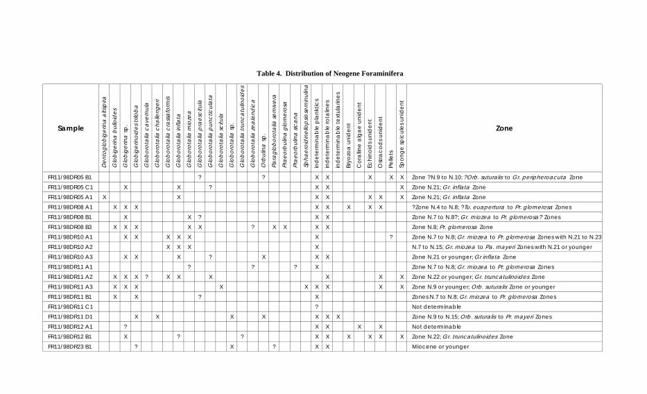
A brief scan of the foraminiferal assemblages from Cainozoic calcareous samples, carried outto provide evidence of age and palaeo-water depth, is summarised below. Table 4 is a specieslist for the samples, including foraminifers and other fossil groups. Planktonic forams greatlypredominate over benthic forams, indicating that all sediments were deposited in depths ofover 200 m. Echinoids, ostracodes, sponge spicules and bryozoans are present in some dredgehauls (Table 4).
The oldest samples in DR05-11 are all Early to Middle Miocene (14-16 Ma) in age and weredeposited in upper bathyal depths (estimated at somewhere in the range 200-2000 m). Theyare now in somewhat deeper water (1600-2900 m), which suggests there has been somesubsidence related to compaction and probably some tectonic subsidence of the margin.
Samples from DR12 contain Quaternary forams (and Quaternary palynomorphs) and shallowmarine assemblages laid down in an outer shelf to upper slope regime (50-500 m). As thesamples are now in water ~1650 m deep, they must have been carried there by downslopemass transport.
36
The forams from DR23 are of Miocene and younger age and were laid down in upper slopewater depths (200-500 m). As the present water depth is ~3300 m these forams must havebeen transported down slope. It should be noted that the palynomorphs from this dredge haulare Santonian in age (~86 Ma).
FR11/98DR05 B1Biostratigraphy: Zone ?N.9 to N.10; ?O. suturalis to Gr. peripheroacuta Zone; ?MiddleMiocene.Palaeodepth: Lower bathyal (500-2000 metres).Lithology: Bioclastic mudstone.
FR11/98DR05 C1Biostratigraphy: Zone N.21; Gr. inflata Zone; Late Pliocene.Palaeodepth: 5.0 - Lower bathyal (500-2000 metres)Lithology: Fine grained calcarenite
FR11/98DR05 A1Biostratigraphy: Zone N.21; Gr. inflata Zone; Late Pliocene.Palaeodepth: 5.0 - Lower bathyal (500-2000 metres)Lithology: Sandy mudstone
FR11/98DR08 A1Biostratigraphy:?Zone N.4 to N.8; ?Tu. euapertura to Pr. glomerosa Zones; Early Miocene?Palaeodepth: 5.0 - Lower bathyal (500-2000 metres)Lithology: Medium grained calcarenite
FR11/98DR08 B1Biostratigraphy: Zone N.7 to N.8?; Gr. miozea to Pr. glomerosa? Zones; late Early Miocene.Palaeodepth: 5.0 - Lower bathyal (500-2000 metres)Lithology: Calcisiltite
FR11/98DR08 B3Biostratigraphy: Zone N.8; Pr. glomerosa Zone; late Early Miocene.Palaeodepth: 5.0 - Lower bathyal (500-2000 metres)Lithology: Calcisiltite
FR11/98DR10 A1Biostratigraphy: Zone N.7 to N.8; Gr. miozea to Pr. glomerosa Zones; Early Miocene withN.21 to N.23; Late Pliocene of younger.Palaeodepth: 5.0 - Lower bathyal (500-2000 metres)Lithology: Calcareous mudstone
FR11/98DR10 A2Biostratigraphy: N.7 to N.15; Gr. miozea to Pa. mayeri Zones; Early to Middle Miocene;with N.21 or younger in burrows.Palaeodepth: 5.0 - Lower bathyal (500-2000 metres)Lithology: Carbonaceous mudstone
37
FR11/98DR10 A3Biostratigraphy: Zone N.21 or younger; Gr inflata Zone; Late Pliocene or younger.Palaeodepth: 5.0 - Lower bathyal (500-2000 metres)Lithology: Medium grained clayey sandstone
FR11/98DR11 A1Zones N.7 to N.8; Gr. miozea to Pr. glomerosa Zones; late Early Miocene.Palaeodepth: 5.0 - Lower bathyal (500-2000 metres)Lithology: Carbonaceous mudstone
FR11/98DR11 A2Biostratigraphy: Zone N.22 or younger; Gr. truncatulinoides Zone; Pleistocene.Palaeodepth: 4.5 - Upper bathyal (200-500 metres)Lithology: Foram-rich calcisiltite
FR11/98DR11 A3Biostratigraphy: Zone N.9 or younger; Orb. suturalis Zone or younger; Middle Miocene oryounger.Palaeodepth: 5.0 - Lower bathyal (500-2000 metres)Lithology: Carbonaceous mudstone
FR11/98DR11 B1Biostratigraphy: Zones N.7 to N.8; Gr. miozea to Pr. glomerosa Zones; late Early Miocene.Palaeodepth: 5.0 - Lower bathyal (500-2000 metres)Lithology: Carbonaceous calcareous mudstone
FR11/98DR11 C1Biostratigraphy: Not determinablePalaeodepth: 5.0 - Lower bathyal (500-2000 metres)Lithology: Mudstone
FR11/98DR11 D1Biostratigraphy: Zone N.9 to N.15; Orb. suturalis to Pr. mayeri Zones; Middle MiocenePalaeodepth: 5.0 - Lower bathyal (500-2000 metres)Lithology: Ferruginous mudstone
FR11/98DR12 A1Biostratigraphy: Not determinablePalaeodepth: 3.5 - Deep middle neritic (50-100 metres)Lithology: Fine grained calcarenite
FR11/98DR12 B1Biostratigraphy: Zone N.22; Gr. truncatulinoides Zone; QuaternaryPalaeodepth: 4.5 - Upper bathyal (200-500 metres)Lithology: Medium grained calcarenite
FR11/98DR23 B1Biostratigraphy: Miocene or youngerPalaeodepth: 4.5 - Upper bathyal (200-500 metres)Lithology: Very fine grained calcarenite
Sample
De
nto
glo
big
erin
a a
ltisp
ira
Glo
big
erin
a b
ullo
ide
s
Glo
big
erin
a s
p.
Glo
big
erin
oid
es
trilo
ba
Glo
bo
rota
lia c
ave
rnul
a
Glo
bo
rota
lia c
halle
nge
ri
Glo
bo
rota
lia c
rass
afo
rmis
Glo
bo
rota
lia in
flata
Glo
bo
rota
lia m
ioze
a
Glo
bo
rota
lia p
rae
scitu
la
Glo
bo
rota
lia p
unc
ticul
ata
Glo
bo
rota
lia s
citu
la
Glo
bo
rota
lia s
p.
Glo
bo
rota
lia tr
unc
atu
lino
ide
s
Glo
bo
rota
lia z
ea
land
ica
Orb
ulin
a s
p.
Pa
rag
lob
oro
talia
se
miv
era
Pra
eo
rbul
ina
glo
me
rosa
Pra
eo
rbul
ina
sic
ana
Sp
hae
roid
ine
llop
sis s
em
inul
ina
in
de
term
ina
ble
pla
nkt
ics
in
de
term
ina
ble
rota
line
s
in
de
term
ina
ble
te
xtu
larin
es
Bry
ozo
a u
nid
en
t
Co
rallin
e a
lga
e u
nid
en
t
Ec
hin
oid
s u
nid
en
t
Ost
rac
od
s u
nid
en
t
Pe
llets
Sp
on
ge
sp
icu
les
un
ide
nt
Zone
FR11/98DR05 B1 ? ? X X X X X Zone ?N.9 to N.10; ?Orb. suturalis to Gr. peripheroacuta Zone
FR11/98DR05 C1 X X ? X X X Zone N.21; Gr. inflata Zone
FR11/98DR05 A1 X X X X X X X Zone N.21; Gr. inflata Zone
FR11/98DR08 A1 X X X X X X X X ?Zone N.4 to N.8; ?Tu. euapertura to Pr. glomerosa Zones
FR11/98DR08 B1 X X ? X X Zone N.7 to N.8?; Gr. miozea to Pr. glomerosa? Zones
FR11/98DR08 B3 X X X X X ? X X X X Zone N.8; Pr. glomerosa Zone
FR11/98DR10 A1 X X X X X X ? Zone N.7 to N.8; Gr. miozea to Pr. glomerosa Zones with N.21 to N.23
FR11/98DR10 A2 X X X X N.7 to N.15; Gr. miozea to Pa. mayeri Zones with N.21 or younger
FR11/98DR10 A3 X X X ? X X X Zone N.21 or younger; Gr inflata Zone
FR11/98DR11 A1 ? ? ? X Zone N.7 to N.8; Gr. miozea to Pr. glomerosa Zones
FR11/98DR11 A2 X X X ? X X X X X X Zone N.22 or younger; Gr. truncatulinoides Zone
FR11/98DR11 A3 X X X X X X X X X Zone N.9 or younger; Orb. suturalis Zone or younger
FR11/98DR11 B1 X X ? X Zones N.7 to N.8; Gr. miozea to Pr. glomerosa Zones
FR11/98DR11 C1 ? Not determinable
FR11/98DR11 D1 X X X X X X X Zone N.9 to N.15; Orb. suturalis to Pr. mayeri Zones
FR11/98DR12 A1 ? X X X X Not determinable
FR11/98DR12 B1 X ? ? X X X X X X Zone N.22; Gr. truncatulinoides Zone
FR11/98DR23 B1 ? X ? X X Miocene or younger
36
Table 4. Distribution of Neogene Foraminifera

39
6. RELATIONSHIP TO SEISMIC PROFILES
The map of the Bass Canyon complex (Figure 2) shows sample station information and thelocations of six key seismic profiles that portray the structural and stratigraphic environmentsof the dredge sites. These profiles, A-F, are presented in Figures 4-9. The detailed bathymetryin Figure 2 was derived from recent AGSO swath (multibeam sonar) surveys (Exon et al.1999; Hill et al. 2000).
As indicated in Figure 2, exploration wells in the Gippsland Basin are located mainly on theshelf and those off the shelf are in water depths of less than 800 m. The absence of wellcontrol over most of the deepwater Gippland Basin, including the Bass Canyon complex,indicates the importance of the new geological sampling data in making stratigraphicinterpretations.
The multichannel seismic profiles (Figures 4-9) were shot during the 1972-73 Shell (Petrel)deep-water scientific survey and during BMR’s Survey 68 in 1987 (Colwell, Coffin et al.1987). They show as much as 2.5 s twt of sedimentary section of Gippsland Basin section onthe margin, and 2 s twt of well-stratified post-breakup (Campanian and younger) TasmanBasin section beneath the adjacent rise and abyssal plain. The syn-rift section, comprising theEmperor (Turonian) and Golden Beach (Santonian-Campanian) Subgroups and possiblyStrzelecki Group (Early Cretaceous), is faulted and folded and up to 2 s twt thick (as seen inthe profiles). The overlying post-rift Latrobe siliciclastics (Halibut Subgroup, Maastrictian-Eocene) are gently folded and do not appear to be more than ~0.5 s twt thick. The postEocene upper megasequence, the Seaspray Group, comprises mainly marine carbonates thatare thick (~1 s twt) and strongly prograding on the upper continental slope but that rapidlywedge out downslope.
Fine-grained labile sandstones, siltstones and mudstones of the Golden Beach Subgroup areexposed in the steep middle and lower walls of Bass Canyon (Figures 4-6). In the deepestpart of the canyon, on the lower southern wall, are outcropping siltstones and arkosicsandstones of the older (Turonian) Emperor Subgroup (Figure 5). The upper slopes of BassCanyon are underlain by calcareous mudstones and other fine-grained sediments of theSeaspray Group (Figure 4). These deposits may partially mantle sediments of the Latrobesiliciclastics on the canyon walls. Dredging indicates that the 15-20 km long ridge at themouth of Bass Canyon (Figure 8) is of volcanic origin. Its location at the continent-oceanboundary (COB) and the fact that it appears to be onlapped by the entire Tasman Basinsuccession, here ~1.5 s twt thick (Figures 6 & 9), suggests that it was emplaced close tobreakup time (Campanian).
Several dredge sites were located on the steep and canyoned continental slope, southeast ofthe Bass Canyon complex (Figures 7-9). The seismic profiles at these sites show ruggedbasement relief and less than ~1 s twt of sedimentary section. Samples recovered comprised avariety of sedimentary lithologies, including labile sandstones. Though most could not bedated, they all appear to be of Golden Beach assemblage. Given the relatively thinsedimentary section on the margin in the vicinity of the sites, it is likely that any StrzeleckiGroup section in this area is very thin or absent.
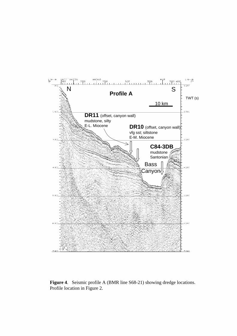
TWT (s)Profile A
Figure 4. Seismic profile A (BMR line S68-21) showing dredge locations.Profile location in Figure 2.
N S
BassCanyon
DR11 (offset, canyon wall)mudstone, siltyE-L. Miocene DR10 (offset, canyon wall)
vfg sst; siltstoneE-M. Miocene
C84-3DBmudstoneSantonian
10 km

TWT (s)Profile B
Figure 5. Seismic profile B (BMR line S68-23) showing dredge locations.Profile location in Figure 2.
N S
BassCanyon
DR21 (offset, canyon wall)mudstone; sst, labileE. Campanian
DR22 (offset)vfg sst, labile
DR23 (offset)calcisiltiteSantonian
DR18sst, arkosicE-M. Turonian
DR19 (offset)siltstone;sst, labileE-M. Turonian
10 km

TWT (s)Profile C
Figure 6. Seismic profile C (Shell Petrel line N434) showing dredge locations. Profile location in Figure 2.The C84 dredge samples were recovered by The University of Sydney and are described by Marshall (1988).
W E
TasmanBasin
Floor of Bass Canyon
C84-mudstoneSantonian3DB
5DB4DB 10 km

TWT (s)
Profile D
Figure 7. Seismic profile D (BMR line S68-16) showing dredge locations. Profile location in Figure 2.
W E
DR09 (offset)clay
TasmanBasin
BMR68-DR1calc. siltstone; lithic sst
DR15mudstone, carbonaceous; sst, labileL. Campanian
10 km

TWT (s)Profile E
Figure 8. Seismic profile E (Shell Petrel line N433) showing dredge locations. Profile location in Figure 2.
WSW ENE
DR14siltstone, carbonaceous
DR25basalt; hyaloclastite
DR17(offset)volcanics;conglomerate
Volcanic ridge
10 km

TWT (s)Profile F
Figure 9. Seismic profile F (BMR line S68-17) showing dredge locations. Profile location in Figure 2.
W E
TasmanAbyssal Plain
DR05 (offset, canyon wall)calcarenite, carbonaceous; fg sstMiocene-L. Pliocene
DR04 (offset)sst, labile
DR13qtz sst
10 km

46
7. CONCLUSIONS
As part of Franklin Cruise FR11/98 in the Gippsland Basin (Keene, 1998), 25 dredge stationswere occupied in deeper water. The locations were determined on the basis of detailed seabedmaps obtained during an earlier swath-mapping cruise of R.V. Melville (Hill et al., 1998;Exon et al., 1999), and of interpreted Geoscience Australia (BMR) seismic reflection profiles.The study was designed to provide information on the lithology, age and paleo-environmentof the little-known deepwater Gippsland Basin. Fifteen dredge hauls were successful inrecovering reasonable quantities of older rocks, three were moderately successful inrecovering some older rocks, and seven were unsuccessful with no recovery of anything otherthan recent oozes. They are related to nearby seismic reflection profiles in Figures 4-9. Ourresults have been incorporated into recent reviews of the deepwater Gippsland Basin(Bernecker et al., 2001; Moore and Wong, 2001; Moore, Wong and Bernecker, 2001; Smith etal., 2000).
The rocks and sediments that were recovered in deep water fall broadly into four categories:volcanics of possible Turonian-Coniacian (Late Cretaceous) age, volcaniclastics and labilesediments of definite Turonian-Campanian age, Neogene marly calcareous sediments, andcalcareous oozes of the Quaternary to Holocene. No rocks of Early Cretaceous (StrzeleckiGroup) age were recovered, supporting the view of Megallaa (1993) that they were notdeposited on or east of the Gippsland Rise (a NNE-trending feature at ~149°30’E). Minorferromanganese nodules and crusts from deepwater stations DR17 and DR18 (Appendix 4)are of no economic potential. They are high in SiO2 and remarkably low in copper and cobalt.
Volcanics were confined to the three easternmost dredges, taken in water depths of 3300-3800 m from a rifted block elongated west-northwest and just inboard of the continent-oceanboundary (DR17, DR24 & DR25). The larger hauls, DR 24 & DR25, consist of basalt,hyaloclastite, breccia, scoria and volcaniclastic sandstone. Dredge DR17 consists of a fewpebbles of aphanitic volcanics, probably of acid to intermediate composition, and fine grainedmetasediments.
These basaltic volcanic rocks occur on an isolated ridge (Figures 2 & 8) and cannot havederived pebbles and clasts from younger sequences. The rocks are not fresh enough forradioactive dating, but are presumed to have been laid down during or immediately after theTasman Sea rifting phase in Turonian to Coniacian times. We hypothesise that lava flows anddomes formed on a coastal plain and in shallow water. Where the domes and flows formed ondry land, normal vesicular flows resulted, and these weathered to scorias in some cases. Inwater they were quenched and broke up to form volcaniclastic mass flow deposits such ashyaloclastites. Some of the volcaniclastics apparently became intermingled with soft claysand lime muds, because the interstices are now filled with zeolites, clay minerals and calcite.
Immature labile rocks of the Late Cretaceous Emperor and Golden Beach Subgroupswere recovered in eleven dredges (DR4, DR13-16, DR18-23) on the outer continental marginin water depths of 2040m to 3800 m (Figure 2). Palynological ages obtained thus far areTuronian to Campanian (~90 Ma to ~74 Ma). Common lithologies are labile sandstone,siltstone and mudstone (and the weathered variants: silt and clay). The sediments arecarbonaceous in part and plant remains are apparent in some beds. They are often thin tomedium bedded, and burrowed and mottled in part. Occasional beds contain cross-lamination,

47
ferruginous nodules, trace fossils, load casts and ripple marks. These rocks were deposited inthe rift involving eastern Australia, Lord Howe Rise, and the Gippsland Basin, and arelithologically similar to those of the Strzelecki Group and Golden Beach Subgroup elsewherein the Gippsland Basin.
The rocks are lithologically immature, but well size-sorted, sandstones and mudstones.Angular to subangular debris consists of volcanic quartz, feldspar (dominantly plagioclase),and clasts of fine grained lithic rocks including acid volcanics. The groundmass is clayey, andboth it and labile clasts are commonly chloritised and sericitised. Carbonaceous straps andgrains are very common. Minor but widespread components are muscovite, biotite andopaque minerals, and there is glauconite in a few samples. Marine macrofossils are generallyabsent, despite the common presence of marine indicators such as burrows and mottling.These sediments appear to have been rapidly deposited in coastal and marine environments.
The palynological results document the onset of marine conditions as the developing TasmanSea entered from the east. Algal cysts in Early to mid Turonian silts and clays (DR18 & 19:~90 Ma) indicate deposition in a deep freshwater lake near the outer continental margin.Microplankton in deep marine carbonates in the Santonian (DR23: ~86 Ma ) indicate thatconsiderable post–breakup subsidence of the outer continental margin had occurred by then.Thus there rapid subsidence between ~90 Ma and ~86 Ma. Microplankton in deep marinemuds in the Campanian (DR21 & DR15: ~82 Ma & ~75 Ma) indicate continued deposition onthe outer margin.
Marine calcareous rocks of the Neogene Seaspray Group were recovered in Dredges 5-12,in present-day water depths of 680 m to 2800 m. These rocks are medium to very fine grainedcalcarenites, calcisiltites and calcareous mudstones, composed largely of molluscan debris,foraminifers and clay. Common detrital clasts are quartz, feldspar, clay clasts and muscovite.They are often poorly bedded, with some thin to medium bedding. Organic debris includeswood and leaves, sponge spicules and echinoderm spines. Mottling shows that bioturbationwas widespread.
Foraminifera date the older rocks dredged in DR5, DR8, DR10 and DR11 as early to middleMiocene, and show that the Quaternary dredge DR12 consists of shallow-water materialdisplaced down slope. Palynology dates DR8 and DR11 as Miocene, and shows that DR5 andDR12 include Plio-Pleistocene strata (Section 5). Microplankton show that the water wasdeep during deposition.
8. ACKNOWLEDGEMENTS
This report covers a subset of the results of Franklin Cruise FR11/98, and as such involvedthe cooperation of all the scientific party (Appendix 1), whose excellent support we gratefullyacknowledge. In particular, we would like to thank Guy Holdgate and Stephen Gallagher fortheir hand specimen descriptions of the dredge hauls, and David Mitchell for his help andadvice with the dredging. We would also like to gratefully acknowledge the help given by theMaster Dick Dougal, and the Mates, Arthur Staron and John Lynch, the ship’s crew and theCSIRO support staff (all listed in Appendix 1), which enabled the cruise to be both enjoyableand a success. First Engineer Greg Pearce helped greatly by repairing the faulty AGSO (nowGeoscience Australia) dredges.

48
Jon Stratton of the operations group of AGSO ensured that we had the necessary equipmentaboard. Igneous petrologists Elizabeth Jagodzinski and Morrie Duggan of AGSO helped withthe descriptions of the volcanic rocks. Jim Colwell and Phil O’Brien of Geoscience Australiakindly reviewed the text.
9. REFERENCES
Bernecker, T. and Partridge, A.D., 2001. Emperor and Golden Beach Subgroups: the onset ofLate Cretaceous sedimentation in the Gippsland Basin, SE Australia. In Hill, K.C. &Bernecker T. (Eds.) Eastern Australasian Basins Symposium, a Refocused EnergyPerspective for the Future, Petroleum Exploration Society of Australia, SpecialPublication, 391-402.
Bernecker, T., Woollands, M.A., Wong, D., Moore, D.H. and Smith, M.A. 2001.Hydrocarbon Prospectivity of the Deepwater Gippsland Basin, Victoria, Australia. APPEAJournal, 41 (1), 79-101.
Colwell, J.B., Coffin, M. et al., 1987. Rig Seismic research cruise 13: northeast GippslandBasin and southern New South Wales margin – initial report. Bureau of MineralResources, Australia, Report 283.
Exon, N.F., Hill, P.J., Keene, J.B. and Smith, S.M., 1999. AGSO Cruise Report: Cruise 210 –The “Sojourn 7” swath-mapping cruise of R.V. Melville off eastern Tasmania and in theGippsland Basin. Australian Geological Survey Organisation Record 1999/7, 50p.
Gallagher, G.J., Smith, A.J., Jonasson, K., Wallace, M.W., Holdgate, G.R., Daniels, J., andTaylor, D., 2001. The Miocene palaeonvironmental and palaeoceanographic evolution ofthe Gippsland Basin, Southeast Australia: a record of Southern Ocean change.Palaeogeogeography, Palaeoclimology, Palaeoecology 172, 53-80.
Hill, P.J., Exon, N.F., Keene, J.B. and Smith, S.M., 1998. The continental margin off eastTasmania and Gippsland: structure and development using new multibeam sonar data.Exploration Geophysics (Bulletin Australian Society Exploration Geophysicists) 29, 410-419.
Hill, P.J., Rollet, N., Rowland, D., Calver, C.R. and Bathgate, J., 2000. Seafloor mapping ofthe south-east region and adjacent waters - AUSTREA-1 cruise report: Lord Howe Island,south-east Australian margin and central Great Australian Bight. Australian GeologicalSurvey Organisation Record 2000/6, 138p.
Keene, J.B., 1998. Anatomy and growth history of non-tropical carbonate shelves and slopesin south-eastern Australia. Cruise Summary, R/V Franklin, FR 11/98.
Marshall, N.G., 1988. A Santonian dinoflagellate assemblage from the Gippsland Basin,Southeastern Australia. Association of Australasian Palaeontologists Memoir 5, p.195-215.
Marshall, N.G., 1989. An unusual assemblage of algal cysts from the late Cretaceous,Gippsland Basin, Southeastern Australia. Palynology 13, p.21–56.
Marshall, N.G., 1990. Campanian dinoflagellates from southeastern Australia. Alcheringa 14,p.1-38.
McMinn, A. 1992. Pliocene through Holocene dinoflagellate cyst biostratigraphy of theGippsland Basin, Australia. In: Neogene and Quaternary Dinoflagellate Cysts andAcritarchs, M.J. Head and J.H. Wrenn, editors, American Association of StratigraphicPalynologists Foundation: Dallas, p.147-161.
Megallaa, M., 1993. Tectonic evolution of the Gippsland Basin and hydrocarbon potential ofits lower continental shelf. The APEA Journal, 23(1), p.45-61.
Moore, D.H. and Wong, D., 2001. Eastern and Central Gippsland Basin, SoutheasternAustralia; Basement Interpretation and Basin Links. Victorian Initiative for Minerals andPetroleum Report 69. Department of Natural Resources and Environment.

49
Moore, D.H., Wong, D. and Bernecker, T., 2001. Enhancing prospectivity in the GippslandBasin by utilising new potential field data. APPEA Journal, 41 (1), poster abstract, inpress.
Partridge, A.D., 1990. Palynological analysis of Admiral–1, Gippsland Basin. Esso AustraliaLtd. Palaeontological Report 1990/14, p.1–31.
Smith, M.A., Bernecker, T., Liberman, N., Moore, D. H. and Wong, D., 2000. Petroleumprospectivity of the deep-water Gazettal Areas V00-3 and V00-4, southeastern GippslandBasin, Victoria, Australia. Victorian Initiative for Minerals and Petroleum Report 65.Department of Natural Resources and Environment.
Williams, G.L. and Bujak, J.P., 1985. Mesozoic and Cenozoic dinoflagellates. In: PlanktonStratigraphy, H.M. Bolli, J. B. Saunders and K. Perch-Nielsen, editors, CambridgeUniversity Press, Cambridge, 847-964.

50
APPENDIX 1. CRUISE FR 11/98 PERSONNEL
Scientific PartyAssociate Professor Jock Keene, Dr Michael Hughes, Mr David Mitchell, Ms Karen Rae,School of Geosciences, The University of SydneyDr Stephen Gallagher, Dr Guy Holdgate, Mr Jim Daniels, Mr Andrew Smith, School of EarthScience, University of MelbourneDr Neville Exon, and Mr Peter Hill, AGSO, Canberra
ORV SupportBob Beattie, CSIRO Marine Research, Cruise Manager and ComputingAlan Poole, CSIRO Marine Research, Electronics
Ship’s CrewMaster: Dick Dougal1st Mate: Arthur Staron2nd Mate: John LynchChief Engineer: John Morton1st Engineer: Greg PearceElectrical Engineer: Andrew McLaganGreaser: Wayne BrowningBosun: Jannick HansenAB: Peter GengeAB: Jerry O’HalloranAB: Bill HughesChief Cook: Gary Hall2nd Cook: Tom CondonChief Steward: Ron Culliney

51
APPENDIX 2: ALL FR11/98 STATION DATA
StationNumber
SampleNumber
Latitude S Longitude E WaterDepth(s)(metres)
Results
1 DR01 39 37.10 149 23.30 3900-3550 no recovery
2 DR02 39 27.02 149 25.82 3400-3200 no recovery
3 DR03 39 27.42 149 24.86 3400-3200 no recovery
3 DR04 39 17.63 149 24.02 3500-3100 successful, rocks
4 DR05 39 11.15 148 55.33 1750-1520 successful, rocks
5 MG01 39 20.00 148 30.28 46.5 shell hash, medium sand
5 PC01 39 19.97 148 30.20 47.5 sand, 0.8m
6 MG02 39 21.25 148 36.25 112 muddy, coarse shelly sand
7 MG03 39 21.70 148 38.43 308.5 coarse sand
7 PC02 39 21.83 148 38.16 224 limestone rock
8 MG04 39 19.15 148 38.85 324 sandy mud
8 PC03 39 19.11 148 38.59 240 sandy mud, 2.4m
9 MG05 39 12.79 148 50.16 1440 unsuccessful
10 MG06 38 17.19 147 21.11 19.5 medium bioclastic quartz sand
11 MG07 38 20.62 147 21.86 25 medium bioclastic quartz sand
12 MG08 38 23.65 147 22.47 34 medium bioclastic quartz sand
12 PC04 38 23.78 147 22.40 34.5 muddy sand-shell hash 1.63m
13 MG09 38 24.26 147 25.59 39 medium bioclastic sand
14 MG10 38 24.59 147 29.52 42.5 coarse bioclastic sand
15 MG11 38 24.83 147 30.93 44 coarse shelly quartz sand
15 PC05 38 24.88 147 30.97 44 muddy sand 2.7m
16 MG12 38 25.56 147 35.46 48.5 coarse shelly sand
17 MG13 38 25.92 147 40.15 51.5 muddy coarse sand
18 MG14 38 28.37 147 43.36 55 bioclastic sand
18 PC06 38 28.43 147 43.40 55 2.9m
19 MG15 38 31.41 147 47.35 62 muddy bioclastic sand
20 MG16 38 33.18 147 52.24 66 muddy coarse sand
21 MG17 38 33.11 147 59.28 70 medium shelly sand
21 PC07 38 33.11 147 59.28 70 coarse sand-rock 1.1m
22 MG18 38 33.98 148 04.02 76 med coarse bioclastic sand
23 MG19 38 34.81 148 08.70 78 med coarse bioclastic sand
24 MG20 38 35.63 148 13.94 79 med coarse bioclastic sand
25 MG21 38 36.18 148 17.39 84 med coarse bioclastic sand
25 PC08 38 36.68 148 17.08 86 shelly sand 1.25m
26 MG22 38 24.09 148 21.66 88 muddy coarse sand
27 MG23 38 26.84 148 25.11 134 coarse bioclastic quartz sand
28 MG24 38 26.97 148 25.25 145 coarse bioclastic sand
29 MG25 38 28.87 148 27.20 232 not successful
29 MG25B 38 28.63 148 27.31 242 med bioclastic sand
30 DR06 38 30.97 148 34.48 632-737 successful, rocks
31 MG26 38 31.81 148 31.43 471 sandy marl
32 MG27 38 29.80 148 28.96 210 calcareous mud
33 MG28 37 59.68 147 45.69 24.5 coarse shelly sand
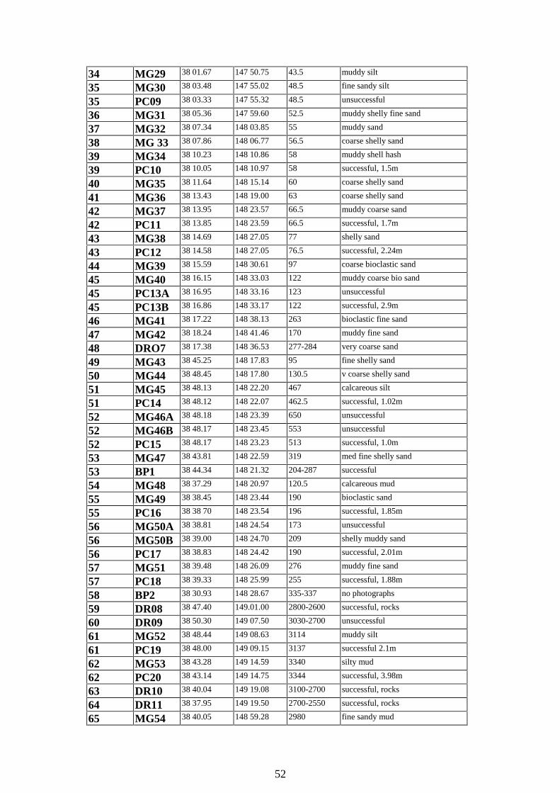
52
34 MG29 38 01.67 147 50.75 43.5 muddy silt
35 MG30 38 03.48 147 55.02 48.5 fine sandy silt
35 PC09 38 03.33 147 55.32 48.5 unsuccessful
36 MG31 38 05.36 147 59.60 52.5 muddy shelly fine sand
37 MG32 38 07.34 148 03.85 55 muddy sand
38 MG 33 38 07.86 148 06.77 56.5 coarse shelly sand
39 MG34 38 10.23 148 10.86 58 muddy shell hash
39 PC10 38 10.05 148 10.97 58 successful, 1.5m
40 MG35 38 11.64 148 15.14 60 coarse shelly sand
41 MG36 38 13.43 148 19.00 63 coarse shelly sand
42 MG37 38 13.95 148 23.57 66.5 muddy coarse sand
42 PC11 38 13.85 148 23.59 66.5 successful, 1.7m
43 MG38 38 14.69 148 27.05 77 shelly sand
43 PC12 38 14.58 148 27.05 76.5 successful, 2.24m
44 MG39 38 15.59 148 30.61 97 coarse bioclastic sand
45 MG40 38 16.15 148 33.03 122 muddy coarse bio sand
45 PC13A 38 16.95 148 33.16 123 unsuccessful
45 PC13B 38 16.86 148 33.17 122 successful, 2.9m
46 MG41 38 17.22 148 38.13 263 bioclastic fine sand
47 MG42 38 18.24 148 41.46 170 muddy fine sand
48 DRO7 38 17.38 148 36.53 277-284 very coarse sand
49 MG43 38 45.25 148 17.83 95 fine shelly sand
50 MG44 38 48.45 148 17.80 130.5 v coarse shelly sand
51 MG45 38 48.13 148 22.20 467 calcareous silt
51 PC14 38 48.12 148 22.07 462.5 successful, 1.02m
52 MG46A 38 48.18 148 23.39 650 unsuccessful
52 MG46B 38 48.17 148 23.45 553 unsuccessful
52 PC15 38 48.17 148 23.23 513 successful, 1.0m
53 MG47 38 43.81 148 22.59 319 med fine shelly sand
53 BP1 38 44.34 148 21.32 204-287 successful
54 MG48 38 37.29 148 20.97 120.5 calcareous mud
55 MG49 38 38.45 148 23.44 190 bioclastic sand
55 PC16 38 38 70 148 23.54 196 successful, 1.85m
56 MG50A 38 38.81 148 24.54 173 unsuccessful
56 MG50B 38 39.00 148 24.70 209 shelly muddy sand
56 PC17 38 38.83 148 24.42 190 successful, 2.01m
57 MG51 38 39.48 148 26.09 276 muddy fine sand
57 PC18 38 39.33 148 25.99 255 successful, 1.88m
58 BP2 38 30.93 148 28.67 335-337 no photographs
59 DR08 38 47.40 149.01.00 2800-2600 successful, rocks
60 DR09 38 50.30 149 07.50 3030-2700 unsuccessful
61 MG52 38 48.44 149 08.63 3114 muddy silt
61 PC19 38 48.00 149 09.15 3137 successful 2.1m
62 MG53 38 43.28 149 14.59 3340 silty mud
62 PC20 38 43.14 149 14.75 3344 successful, 3.98m
63 DR10 38 40.04 149 19.08 3100-2700 successful, rocks
64 DR11 38 37.95 149 19.50 2700-2550 successful, rocks
65 MG54 38 40.05 148 59.28 2980 fine sandy mud
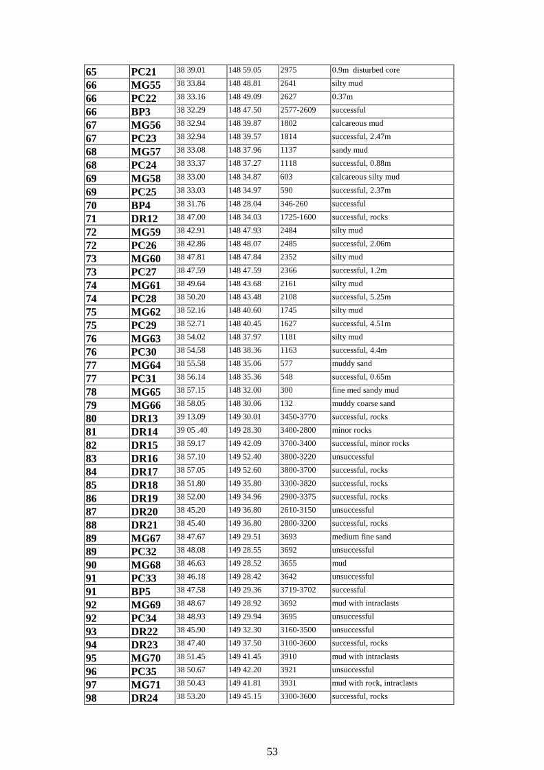
53
65 PC21 38 39.01 148 59.05 2975 0.9m disturbed core
66 MG55 38 33.84 148 48.81 2641 silty mud
66 PC22 38 33.16 148 49.09 2627 0.37m
66 BP3 38 32.29 148 47.50 2577-2609 successful
67 MG56 38 32.94 148 39.87 1802 calcareous mud
67 PC23 38 32.94 148 39.57 1814 successful, 2.47m
68 MG57 38 33.08 148 37.96 1137 sandy mud
68 PC24 38 33.37 148 37.27 1118 successful, 0.88m
69 MG58 38 33.00 148 34.87 603 calcareous silty mud
69 PC25 38 33.03 148 34.97 590 successful, 2.37m
70 BP4 38 31.76 148 28.04 346-260 successful
71 DR12 38 47.00 148 34.03 1725-1600 successful, rocks
72 MG59 38 42.91 148 47.93 2484 silty mud
72 PC26 38 42.86 148 48.07 2485 successful, 2.06m
73 MG60 38 47.81 148 47.84 2352 silty mud
73 PC27 38 47.59 148 47.59 2366 successful, 1.2m
74 MG61 38 49.64 148 43.68 2161 silty mud
74 PC28 38 50.20 148 43.48 2108 successful, 5.25m
75 MG62 38 52.16 148 40.60 1745 silty mud
75 PC29 38 52.71 148 40.45 1627 successful, 4.51m
76 MG63 38 54.02 148 37.97 1181 silty mud
76 PC30 38 54.58 148 38.36 1163 successful, 4.4m
77 MG64 38 55.58 148 35.06 577 muddy sand
77 PC31 38 56.14 148 35.36 548 successful, 0.65m
78 MG65 38 57.15 148 32.00 300 fine med sandy mud
79 MG66 38 58.05 148 30.06 132 muddy coarse sand
80 DR13 39 13.09 149 30.01 3450-3770 successful, rocks
81 DR14 39 05 .40 149 28.30 3400-2800 minor rocks
82 DR15 38 59.17 149 42.09 3700-3400 successful, minor rocks
83 DR16 38 57.10 149 52.40 3800-3220 unsuccessful
84 DR17 38 57.05 149 52.60 3800-3700 successful, rocks
85 DR18 38 51.80 149 35.80 3300-3820 successful, rocks
86 DR19 38 52.00 149 34.96 2900-3375 successful, rocks
87 DR20 38 45.20 149 36.80 2610-3150 unsuccessful
88 DR21 38 45.40 149 36.80 2800-3200 successful, rocks
89 MG67 38 47.67 149 29.51 3693 medium fine sand
89 PC32 38 48.08 149 28.55 3692 unsuccessful
90 MG68 38 46.63 149 28.52 3655 mud
91 PC33 38 46.18 149 28.42 3642 unsuccessful
91 BP5 38 47.58 149 29.36 3719-3702 successful
92 MG69 38 48.67 149 28.92 3692 mud with intraclasts
92 PC34 38 48.93 149 29.94 3695 unsuccessful
93 DR22 38 45.90 149 32.30 3160-3500 unsuccessful
94 DR23 38 47.40 149 37.50 3100-3600 successful, rocks
95 MG70 38 51.45 149 41.45 3910 mud with intraclasts
96 PC35 38 50.67 149 42.20 3921 unsuccessful
97 MG71 38 50.43 149 41.81 3931 mud with rock, intraclasts
98 DR24 38 53.20 149 45.15 3300-3600 successful, rocks

54
99 DR25 38 57.30 149 53.70 3300-3600 successful, rocks
100 MG72 38 37.09 149 33.01 1996 shelly mud
101 MG73 38 28.06 149 34.65 1469 muddy shelly sand
101 PC36 38 27.68 149 35.70 1446 successful, 1.5m
DR = dredge, PC = piston core, MG = Smith-McIntyre grab, BP = bottom photography
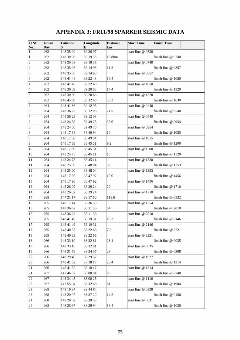
55
APPENDIX 3: FR11/98 SPARKER SEISMIC DATA
LINENo.
JulianDay
LatitudeS
LongitudeE
Distancekm
Start Time Finish Time
1 262 148 35 09 39 30 97 start line @ 0530
1 262 148 30 08 39 19 35 19.8km finish line @ 0740
2 262 148 30 08 39 19 35 start line @ 0740
2 262 148 35 08 39 14 98 11.2 finish line @ 0857
3 262 148 35 08 39 14 98 start line @ 0857
3 262 148 41 48 39 22 43 16.4 finish line @ 1050
4 262 148 41 48 39 22 43 start line @ 1050
4 262 148 30 39 39 20 63 17.4 finish line @ 1320
5 262 148 30 39 39 20 63 start line @ 1320
5 262 148 45 99 39 32 45 33.2 finish line @ 1630
6 264 148 41 86 39 12 95 start line @ 0440
6 264 148 36 23 39 12 03 21.5 finish line @ 0540
7 264 148 36 23 39 12 03 start line @ 0540
7 264 148 24 88 39 49 78 55.6 finish line @ 0954
8 264 148 24 88 39 49 78 start line @ 0954
8 264 148 17 88 38 49 94 10 finish line @ 1055
9 264 148 17 88 38 49 94 start line @ 1055
9 264 148 17 89 38 45 31 9.2 finish line @ 1200
10 264 148 17 89 38 45 31 start line @ 1200
10 264 148 24 73 38 45 11 10 finish line @ 1320
11 264 148 24 73 38 45 11 start line @ 1320
11 264 148 25 00 38 48 04 5.6 finish line @ 1353
12 264 148 25 00 38 48 04 start line @ 1353
12 264 148 17 90 38 47 92 10.6 finish line @ 1456
13 264 148 17 90 38 47 92 start line @ 1456
13 264 148 26 02 38 39 24 20 finish line @ 1710
14 264 148 26 02 38 39 24 start line @ 1710
14 265 147 21 17 38 17 50 118.6 finish line @ 0332
15 265 148 17 14 38 36 50 start line @ 1354
15 265 148 36 62 38 11 56 54 finish line @ 2010
16 265 148 36 62 38 11 56 start line @ 2010
16 265 148 41 49 38 19 31 18.2 finish line @ 2146
17 265 148 41 49 38 19 31 start line @ 2146
17 265 148 40 33 38 22 66 7.5 finish line @ 2221
18 265 148 40 33 38 22 66 start line @ 2221
18 266 148 33 10 38 32 81 28.4 finish line @ 0035
19 266 148 33 10 38 32 81 start line @ 0035
19 266 148 21 79 38 24 07 23 finish line @ 0308
20 266 148 29 40 38 29 57 start line @ 1027
20 266 148 41 52 38 18 17 26.4 finish line @ 1314
21 266 148 41 52 38 18 17 start line @ 1314
21 267 147 46 37 38 00 04 90 finish line @ 2240
22 267 148 34 45 38 00 25 start line @ 1110
22 267 147 55 94 38 32 68 81 finish line @ 1904
23 268 148 19 37 38 44 64 start line @ 0320
23 268 148 20 97 38 37 29 14.2 finish line @ 0450
24 268 148 26 02 38 39 33 start line @ 0831
24 268 148 28 97 38 29 94 18.4 finish line @ 1020

56
APPENDIX 4: CHEMICAL ANALYSES OF FERROMANGANESEMATERIAL
Minor ferromanganese nodules and crusts were found at several stations on Franklin CruiseFR11/98. Three bulk samples were analysed by Analabs in Adelaide. They came fromdeepwater dredge hauls DR17 and DR18, whose locations are shown in Figure 2 and Table 1in the general text.
Two samples were analysed from DR17, taken in a water depth of 3800-3700 m. The onlymaterials recovered from this dredge were minor ferromanganese crusts 2-4 mm thick, plusone irregular nodule 3 cm thick, and minor subrounded to subangular pebbles, possibly from aCretaceous conglomerate. DR17/1 is a black microbotryoidal subspherical polygenetic noduleabout 5 x 4 cm in size with a small core of ferromanganese crust and clay clasts. Most of it isa mottled mixture of ferromanganese and clay, and there is an outer dense layer of laminatedferromanganese 5 mm thick. DR17/2 is a smooth black crust, 2 x 1.5 cm in size, consisting ofmixed clayey and ferromanganese material, overlain by dense ferromanganese up to 5 mmthick. The outermost dark layer is about 1 mm thick.
One sample was analysed from DR18, also taken in a water depth of 3800-3700 m. Thedredge haul consisted of Turonian arkosic sandstone, flaggy siltstone with obvious plantremains, flaggy sandy siltstone with load casts, silty clay, and ferromanganese crusts up to 4mm thick. The sample analysed, DR18/F1, was a black crust measuring 1 x 3.5 cm, and torndirectly off the substrate.
Table. Chemical analyses in weight percent
Sample Type Fe % Mn % Co % Cu % Ni % SiO2% LOI%DR17 A1 Nodule 12.95 10.79 0.0051 0.1110 0.369 31.71 15.80DR17 A2 Crust 17.29 6.66 0.0029 0.0895 0.240 40.94 12.41DR18 F1 Crust 5.38 0.39 0.0032 0.0072 0.017 62.00 6.09
The samples are all very high in SiO2 (clay content) and water (LOI = loss on ignition) andremarkably low in cobalt and copper. DR17A1 is more typical of nodules from the Australianregion than the others, in that it has considerable manganese and iron and an Fe:Mn ratioaround one. DR17A2 has a high Fe:Mn ratio. DR18F1 is so high in SiO2 that all the othervalues are perforce very low.
57
APPENDIX 5: PRELIMINARY RESULTS FOR NEOGENE SEDIMENTS
Many of the shipboard party had a primary interest in Neogene sediments. The team withparticular interest in the Neogene carbonates came from the School of Earth Science,University of Melbourne: Stephen Gallagher, Guy Holdgate, Jim Daniels and Andrew Smith.The team with particular interest in turbidite sedimentation in the canyons came from theSchool of Geosciences, The University of Sydney: Jock Keene, Michael Hughes, DavidMitchell and Karen Rae. Their final results will be published elsewhere (e.g., Gallagher et al.,2001) but this Appendix is drawn from their initial shipboard summary, drawn from Keene etal. (1998). Virtually all their sampling was by Smith-McIntye grab or piston core. Stationnumbers and locations are shown in Appendix 2, and the station numbers are different fromthe sample numbers which we use in the body of the report for the dredge stations.
A large wedge of sediments, which has accumulated in the last 30 million years in theGippsland Basin, epitomises a large part of the geological history of Australia’s southernmargins. The sediment wedge contains an assemblage of sedimentary rocks including browncoals, coastal barrier sands, marine non-tropical limestones and deeper water calcareousmudstones and older rocks cut by submarine canyons. Together these sediments and rocktypes make up a unusual shelf and slope type by global standards. The aim of the Neogenesedimentation studies was to learn how this type of shelf and slope is formed.
The modern siliciclastic sediments of the Gippsland shelf are not analogous with thecarbonate sediments in the underlying Seaspray Group. The abrupt change in depositionalenvironments from the carbonates of the Seaspray Group to the more quartz-rich sedimentsof the present day is possibly associated with Pleistocene to Recent uplift of the AustralianHighlands. However, this is only a tentative hypothesis based on preliminary results.
The Seaspray Group is composed of cool-water grainstones, packstones and wackestoneswith very little quartz sand present (<5%). These sediments appear to represent deep-water(outer shelf and slope) environments with little terrigenous input. Those Seaspray Groupsediments that were dredged from the slopes of submarine canyons are dominated bycarbonate-rich, bioclast-bearing wackestones and packstones, sometimes with intraclasts, andoften in association with spiculites and dolomites.
In contrast, the modern submarine canyons in the Gippsland Basin are dominated by fine tomedium terrigenous quartz sand with mud and fine bioclasts, like that on the shelf. Slope andcanyon sampling transects show a diversity of environments including debris flow in thefloor of Bass Canyon with angular dolomite and intraclasts along with clean channel floorsands. The canyon heads and deep canyon floor are dominated by siliciclastic sediment.
Samples recovered from seven stations in the upper continental slope, in upper bathyal tomid-bathyal environments (200-1000 m water depth) range from greenish grey to grey finesilty muds to fine sands (31, 32, 56, 57, 69, 77, 78 - Appendix 2). However, sediments fromthree stations associated with canyons range from yellow-brown bioclastic sands to greybioclastic silt (46, 51, 53). Epifaunal organisms associated with the upper continental slopeinclude abundant sponges, Crustacea, Bryozoa, Bivalvia, Gastropoda, barnacles, and wormtubes.
Sediments recovered from 18 stations on the lower continental slope and toe of slope, inlower bathyal to abyssal environments (1000-4000 m in water depth) were dominated by

58
brown to green-grey foraminifera-bearing silty clays and muds with occasional sand andvarying amounts of fine bioclasts (61, 62, 65-68, 72-76, 89, 90, 92, 95, 97, 100, 101).However, one locality, on the floor of a channel at 3,693 m in Bass Canyon, contained cleanwell-sorted medium to fine sand (89). Occasional intraclasts, probably associated with debrisflows, were seen in two samples (95, 97). Bioturbation was common in many samples withabundant feeding traces (?Thalissinoides) and nearly complete homogenisation of surfacesediments. Epifaunal organisms present in samples from the lower continental slope includesponges, worms, irregular echinoids, and brachiopods. Deposition in the lower continentalslope and toe of slope represents largely hemipelagic deposition with turbidity currentinfluence.
The sparker seismic records from the upper slope and canyon heads (Appendix 3) providedinformation as to how the modern and buried canyons erode and fill. Reflectors showunconformities, downlap and onlap of strata. These stratigraphic relationships for the near-surface layers (0.5 s two-way time: twt) should be further enhanced with shore-basedprocessing of the digital data. Grab sampling in these canyons was relatively successful inwater less than 500 m, but deeper than 500 m the canyons become very narrow (less than200m wide) and difficult targets for sampling. Three runs were made by the SydneyUniversity group with a deepsea camera, and bottom photographs should further characterisethe sedimentary environments.