Embed Size (px)
Citation preview

CREDITVIEW HEIGHTS GLEN WILLIAMS, ONTARIO
ENVIRONMENTAL IMPLEMENTATION REPORT
prepared for
EDEN OAK HOMES 1443 HURONTARIO STREET
MISSISSAUGA, ONTARIO L5G 3H5
by
updated JUNE 2016
LGL PROJECT TA4783

CREDITVIEW HEIGHTS GLEN WILLIAMS, ONTARIO
ENVIRONMENTAL IMPLEMENTATION REPORT
prepared by:
Nancy Falkenberg
ECOLOGIST/BOTANIST
LGL Limited environmental research associates
22 Fisher Street, PO Box 280 King City, Ontario L7B 1A6
Tel: 905-833-1244 Fax: 905-833-1255 Email: [email protected]
URL: www.lgl.com
updated JUNE 2016 LGL PROJECT TA4783

Creditview Heights, Glen Williams, Ontario updated June 2016 Environmental Implementation Report
LGL Limited environmental research associates Page i
TABLE OF CONTENTS 1.0 INTRODUCTION................................................................................................................................... 1
1.1 STUDY SITE LOCATION ......................................................................................................................................... 1
1.2 PURPOSE .......................................................................................................................................................... 1
2.0 APPROACH AND METHODS ................................................................................................................. 3 2.1 AGENCY CONSULTATION ...................................................................................................................................... 3
2.2 FIELD STUDIES.................................................................................................................................................... 4
2.3 EVALUATION AND IMPACT ANALYSIS ...................................................................................................................... 4
3.0 EXISTING CONDITIONS ........................................................................................................................ 4 3.1 LANDFORM ....................................................................................................................................................... 4
3.2 REGIONAL CONTEXT ............................................................................................................................................ 5
3.3 EXISTING LAND USE ............................................................................................................................................ 5
3.4 SOILS ............................................................................................................................................................... 5
3.5 GROUNDWATER ................................................................................................................................................. 7
3.6 SURFACE WATER ................................................................................................................................................ 8
3.7 VEGETATION ...................................................................................................................................................... 8
3.8 FLORISTICS ...................................................................................................................................................... 12
3.8.1 Species at Risk and Locally Rare Species ................................................................................................ 13
3.9 TREE SURVEY ................................................................................................................................................... 14
3.10 FAUNA ........................................................................................................................................................... 14
3.10.1 Fisheries ............................................................................................................................................. 14
3.10.2 Amphibians and Reptiles ................................................................................................................... 15
3.10.3 Birds ................................................................................................................................................... 15
3.10.4 Mammals ........................................................................................................................................... 15
3.10.5 Species at Risk ................................................................................................................................... 16
4.0 EXISTING REGULATORY POLICIES ........................................................................................................ 16 4.1 PROVINCIAL POLICY .......................................................................................................................................... 16
4.2 GREENBELT PLAN ............................................................................................................................................. 16
4.3 REGIONAL MUNICIPALITY OF HALTON................................................................................................................... 16
4.4 THE TOWN OF HALTON HILLS OFFICIAL PLAN ‐ THE HAMLET OF GLEN WILLIAMS SECONDARY PLAN (GWSP) ................... 17
4.5 CREDIT VALLEY CONSERVATION AUTHORITY .......................................................................................................... 18
5.0 DESCRIPTION OF PROPOSED DEVELOPMENT ...................................................................................... 20 5.1 DESCRIPTION OF SUBDIVISION ............................................................................................................................. 20
5.2 LOCATION OF DEVELOPMENT LIMITS .................................................................................................................... 20
5.3 FUNCTIONAL SERVICING CONCEPT ....................................................................................................................... 20
6.0 ANALYSIS OF NATURAL FEATURES, POTENTIAL IMPACTS FROM DEVELOPMENT AND PROPOSED MITIGATION ...................................................................................................................................... 23
6.1 GROUNDWATER ............................................................................................................................................... 23
6.1.1 Impacts and Mitigation.......................................................................................................................... 23
6.1.2 Impacts of Trenches on the Groundwater Regime and Mitigation ........................................................ 24
6.2 FISH HABITAT .................................................................................................................................................. 24
6.2.1 Impacts and Mitigation.......................................................................................................................... 24

Creditview Heights, Glen Williams, Ontario updated June 2016 Environmental Implementation Report
LGL Limited environmental research associates Page ii
6.3 CVC BIRDS OF CONCERN ................................................................................................................................... 25
6.3.1 Impacts and Mitigation.......................................................................................................................... 26
6.4 LOSS OF TREES ................................................................................................................................................. 28
6.4.1 Impacts and Mitigation.......................................................................................................................... 28
6.5 VEGETATION COMMUNITIES (TREED AND WETLAND COMMUNITIES).......................................................................... 30
6.5.1 Impacts .................................................................................................................................................. 30
6.5.2 Mitigation .............................................................................................................................................. 31
6.6 COMPENSATION PLANTING AND LANDSCAPE PLANTING ........................................................................................... 34
6.7 LOCALLY RARE PLANT SPECIES ............................................................................................................................. 37
6.7.1 Impacts and Mitigation.......................................................................................................................... 37
6.8 STEEP SLOPES, LONG‐TERM STABLE TOP OF SLOPE AND SUPPORTIVE GREENLANDS ...................................................... 37
6.8.1 Impacts and Mitigation.......................................................................................................................... 39
6.9 RECHARGE ...................................................................................................................................................... 41
6.10 GRADING ....................................................................................................................................................... 41
6.11 POTENTIAL SHORT‐TERM CONSTRUCTION‐RELATED IMPACTS .................................................................................... 41
6.11.1 General Disturbance of Vegetation Communities from Construction ............................................... 42
6.11.2 Erosion and Siltation .......................................................................................................................... 42
6.11.3 Soil and Water Contamination .......................................................................................................... 43
6.12 POTENTIAL LONG‐TERM IMPACTS ....................................................................................................................... 43
6.12.1 Damage to Natural Areas due to Unregulated Human Use .............................................................. 43
6.12.2 Invasive Non‐native Plants and Animals ........................................................................................... 43
6.13.3 Impacts on Water Quality ................................................................................................................. 44
7.0 LINKAGES ........................................................................................................................................... 44 7.1 TRAILS AND ON‐ROAD LINKAGES ......................................................................................................................... 44
8.0 MONITORING .................................................................................................................................... 44 8.1 SHORT‐TERM (CONSTRUCTION) MONITORING ....................................................................................................... 44
8.2 LONG‐TERM MONITORING ................................................................................................................................. 45
9.0 CONCLUSION AND RECOMMENDATIONS ........................................................................................... 46 10.0 REFERENCES ....................................................................................................................................... 49
LIST OF FIGURES
Figure 1. Key Plan ......................................................................................................................................... 2 Figure 2. Development Limit ........................................................................................................................ 6 Figure 3. Natural Heritage Features ............................................................................................................ 9 Figure 4. Glen Williams Secondary Plan Schedule A (GWSP 2005) .......................................................... 18 Figure 5. Glen Williams Secondary Plan Schedule B (GWSP 2005) ........................................................... 19 Figure 6. Proposed Development and Constraints ................................................................................... 21 Figure 7. Retained Vegetation and Proposed Planting Areas ................................................................. 27

Creditview Heights, Glen Williams, Ontario updated June 2016 Environmental Implementation Report
LGL Limited environmental research associates Page iii
LIST OF TABLES
Table 1. Monitored Groundwater Levels ............................................................................................. 7 Table 2. Summary of Ecological Land Classification Vegetation Communities .................................... 10 Table 3. Floristic Quality Assessment of Plant Communities at the Creditview Heights Site ............... 13 Table 4. Significant Plant Species Recorded within Creditview Heights Study Site ............................. 13 Table 5. Significant Bird Species Recorded within Creditview Heights Study Site ............................... 15 Table 6. Quality Control Analysis (Condeland Engineering updated June 2016) ................................. 22 Table 7. Tree Removal ...................................................................................................................... 28 Table 8. Summary of Impacts to Vegetation Communities ................................................................ 33 Table 9. Recommended Plant Species for SWM Pond ....................................................................... 35 Table 10. Recommended Plant Species for Supportive Greenlands and Sloped Areas ......................... 36
LIST OF APPENDICES APPENDIX A: Correspondence from the Town of Halton Hills and from the Credit Valley Conservation Authority APPENDIX B: CVC Letter APPENDIX C: Vascular Plant List APPENDIX D: Acronyms and Definitions used in Species Lists APPENDIX E: Tree Inventory and Preservation Plan, Kuntz Forestry Consulting Inc., updated 2016 APPENDIX F: List of Wildlife APPENDIX G: Correspondence from the Region of Halton

Creditview Heights, Glen Williams, Ontario updated June 2016 Environmental Implementation Report
LGL Limited environmental research associates Page 1
1.0 INTRODUCTION
1.1 STUDY SITE LOCATION The Hamlet of Glen Williams is situated along the banks of the Credit River, in the Town of Halton Hills, within the Region of Halton. The Eden Oak property, Creditview Heights (formerly known as Glen Chase), is approximately 0.5 km north of the Credit River. Within Glen Williams, the subject property or study site is located south of Credit and Park Streets. The lands to the northwest and to the east consist of rural/agricultural properties and a golf course, lands to the south and to the southeast consist of the urban fabric of Georgetown. The property is bound by low density development to the north, west and east, and by an old railway line to the south. The subject property is approximately 8.25 ha in size. Figure 1 is a key plan to illustrate the location of the study site in a regional context.
1.2 PURPOSE LGL Limited has undertaken an investigation and review of environmental constraints for the draft plan approval of the Creditview Heights subdivision development; a residential development in the Hamlet of Glen Williams. The study site, Part Lot 20, Concession 9 is owned by Eden Oak Homes. The Town of Halton Hills Official Plan (HHOP) designates the community of Glen Williams as a “Hamlet Area” and has prepared Official Plan Amendment No. 113 “The Hamlet of Glen Williams Secondary Plan” (GWSP 2005). Within this framework, Glen Williams is designated as a “Hamlet” within the Rural System of the Region of Halton and the GWSP provides criteria that guides for “growth that maintains the hamlet character of the community.”
The GWSP (2005) identifies the following environmental features on the study site:
1. the north eastern perimeter of the site is identified as “Supportive Greenlands”;
2. the study site is identified as an “Area of Potentially Higher Recharge”.
Land Use Policies (Section 5.3c of the GWSP) further specifies that prior to draft plan approval, plans of subdivision within the Hamlet Residential designation must be supported by an Environmental Implementation Report (EIR) that implements the Glen Williams Integrated Planning Project Scoped Subwatershed Plan (Dillon 2003) at the tributary level for the subject property, and must also include a Stormwater Management Plan. The GWSP also states: The Scoped Subwatershed Plan should be used as a reference when interpreting Plan policies particularly as they apply to lands designated as Greenlands (Page 1, GWSP 2005).
A summary of issues related to hydrogeology, geology, functional servicing and storm water management are provided in this report. For a more complete discussion of these topics the reader is referred to the following reports:
Condeland Engineering Ltd. Updated June 2016. Functional Servicing Report for Proposed Low Density Residential Development by Eden Oak (Creditview Heights) Inc. located at Glen Williams Area Credit Street South-Ann Street North Town of Halton Hills (Georgetown);
V.A. Wood Associates Limited. Updated June 2016. Hydrogeological Investigation Proposed Subdivision Part of Lot 20, Concession 9, Town of Halton Hills, Ontario. Consultant report prepared for Eden Oak Homes; and
V.A. Wood Associates Limited. Revised June 2016. Geotechnical Investigation and Slope Stability Assessment Proposed Subdivision Part of Lot 20, Concession 9, Town of Halton Hills, Ontario.

Creditview Heights, Glen Williams, Ontario updated June 2016 Environmental Implementation Report
LGL Limited environmental research associates Page 2
Figure 1. Key Plan

Creditview Heights, Glen Williams, Ontario updated June 2016 Environmental Implementation Report
LGL Limited environmental research associates Page 3
2.0 APPROACH AND METHODS As provided by the GWSP, the required EIR for the Hamlet of Glen Williams has been undertaken by LGL Limited with a detailed review of environmental constraints for Creditview Heights. The EIR has been triggered by the submission of a proposed Draft Plan of Subdivision, and is intended to provide guidance that will minimize environmental impacts on the site. This EIR has been updated to address comments provided by staff at the Town of Halton Hills (correspondence dated January 19, 2016 presented in Appendix A), and comments provided by Credit Valley Conservation Authority (correspondence dated April 22, 2016 presented in Appendix A).
As a part of the EIR, the following tasks have been undertaken:
an evaluation of the Supportive Greenlands (GWSP 2005) as well as Category 1 and Category 2 designations (Dillon 2003) in relation to the natural features present on the subject property;
determine the impact of development on Supportive Greenlands;
determine what the impacts are to the Areas of Potentially Higher Recharge (study undertaken by V.A. Wood Associates Ltd.); and
determine if any significant species or significant species habitat are present on site.
2.1 AGENCY CONSULTATION Preliminary investigations and a review of pertinent background information were completed. This review within the Hamlet included information from the Credit Valley Conservation Authority (CVC), Town of Halton Hills (ToHH), Regional Municipality of Halton (RMoH), and the Ministry of Natural Resources (MNR) in order to gain a clear understanding of the natural features on site. A field review of regulatory constraints including the development limit was carried out on August 24th, 2005 with Dave Matthews of Matthews Planning & Management Limited, representatives from Credit Valley Conservation including Andrew Marshall, and Steve Burke, Senior Planner – Policy, Planning, Development and Sustainability for the Town of Halton Hills. Subsequent discussions with CVC staff were carried out on January 29, 2016 to discuss several issues including a compensation analysis due to impacts to treed communities and wetlands, Eastern Wood-pewee (Contopus virens), and locally rare plant species. Credit Valley Conservation staff included Colleen Bonner, Planner. Also in attendance was Dave Matthews, Matthews Planning, Nancy Falkenberg and Lisa Catcher both with LGL Limited. The following is a list of environmental features which required review, the sub-consultants who carried out the work and the reports prepared for the Creditview Heights subdivision.
Geotechnical Investigation and Slope Stability Assessment Proposed Subdivision Part of Lot 20, Concession 9 Town of Halton Hills, Ontario of Slope Stability, Revised June 2016. V.A. Wood Associates Limited Consulting Geotechnical Engineers.
V.A. Wood Associates Limited. Updated June 2016. Hydrogeological Investigation Proposed Subdivision Part of Lot 20, Concession 9, Town of Halton Hills, Ontario. Consultant report prepared for Eden Oak Homes
Functional Servicing Report for Proposed Low Density Residential Development by Eden Oak Inc. located at Glen Williams Area, Credit Street South-Ann Street North, Town of Halton Hills (Georgetown). Updated June 2016. Condeland Engineering Ltd.

Creditview Heights, Glen Williams, Ontario updated June 2016 Environmental Implementation Report
LGL Limited environmental research associates Page 4
Tree Inventory and Preservation Plan Figure and results for EIR inclusion, Eden Oak, Glen Williams, Town of Halton Hill, 2016. Kuntz Forestry Consulting Inc.
The ToHH provided digital lines for the Core and Supportive Greenlands, Hamlet Buffer and the Area for Potentially Higher Recharge.
Letter from CVC dated March 14, 2007 regarding its position on the development limits for the study site (Appendix B).
The Glen Williams Integrated Planning Project Scoped Subwatershed Plan (SSP) by Dillon (2003) and the GWSP (2005) were also reviewed to ensure that the Draft Plan of Subdivision conforms to the concerns and constraints outlined within those reports.
2.2 FIELD STUDIES A preliminary field investigation was undertaken by North-South Environmental Inc. (NSE) in April 2008. Additional field investigations carried out in 2008 and in 2016, are outlined below:
April 9th, 2008 amphibian survey; May 27th , 2008 bird survey, spring and early summer flora, and mammal surveys (NSE); October 20th, 2008 fall flora survey, verified ecological classification of vegetation communities
(NSE); May 15th and June 24th and 25th, 2008 tree survey (Kuntz Forestry Consulting 2008); and June 7, 2016.
These field surveys provided plant and animal species lists for the site, particularly the presence of significant species. The vegetation communities were classified according to the Ecological Land Classification for Southern Ontario: First Approximation and Its Application (Lee et al. 1998). A plant list and a description of the general structure of vegetation were obtained during the field survey on the subject property. Vascular plant nomenclature follows Newmaster et al. (1998), with a few exceptions.
2.3 EVALUATION AND IMPACT ANALYSIS Potential impacts to the natural features on the study site and their functions are documented in Section 6.0 based on the proposed development concept, including a consideration of the impact from servicing and stormwater management. A review of the overall impacts include both short and projected long-term impacts from construction and the ultimate changes that will occur in the post development state as a result of the change in land use altering the site. These impacts were reviewed in association with the present use and condition of the site. Field visits included observations for the confirmation and refinement of the designated natural features on site.
3.0 EXISTING CONDITIONS
3.1 LANDFORM The Niagara Escarpment cuts diagonally across Halton Region from the southwest corner in the City of Burlington to the northeast corner at the Hamlet of Glen Williams. The escarpment presents an abrupt and major change in landscape. Below the escarpment and toward Lake Ontario, the topography is dominated by a broad till plain which has been dissected by numerous streams producing a strongly rolling landscape (Chapman and Putnam 1984). Above the escarpment, the topography is strongly bedrock controlled with numerous exposures of the Amabel/Lockport dolostone.

Creditview Heights, Glen Williams, Ontario updated June 2016 Environmental Implementation Report
LGL Limited environmental research associates Page 5
The study site is within the Credit River watershed which drains into Lake Ontario east of the Halton Region. The Credit River has a drainage area of 850 square km and a total length of 93 km from northeast of Orangeville to Port Credit, travelling through hilly areas which include moraines and gravel terraces (Chapman and Putman 1984). The study site is located approximately 0.5 km west of the Credit River, and is outside of the Limit of the Regulatory Flood Area (GWSP 2005). The main valley of the Credit River and some of its major tributaries north of Georgetown contain glacial outwash sand and gravels underlying the Halton Till. Modern alluvium including silt, muck, sands and gravels also occur within the floodplain and terraces of the Credit River in the Glen Williams area. The subject property has a complex micro-topography with a variety of slope conditions ranging from steep to gently rolling, ultimately the slopes fall towards the Credit River to the north. Within the central portion of the site is a small valley with a total length of 180 m and an average slope of 12.0% (Condeland Engineering updated June 2016).
3.2 REGIONAL CONTEXT The Hamlet of Glen Williams is located in the Middle Watershed Unit of the Credit River Basin, which extends from the community of Norval to the south, to Inglewood to the north. Within this unit, the Hamlet boundaries lie entirely within Subwatershed 12 as noted in the SSP (Dillon Consulting 2003). This subwatershed encompasses land within the Town of Halton Hills, the Town of Caledon and the Town of Erin. Subwatershed 12 contains several natural features including the Niagara Escarpment, the Credit River Valley, a number of wetlands, Environmentally Sensitive Areas (ESAs), and Areas of Natural or Scientific Interest (ANSIs) (Dillon Consulting 2003). The subject property neither contains nor is in close proximity to Provincially Significant Wetlands, designated ANSIs or ESAs. The Credit River is located approximately 0.5 km to the northeast of the subject property. The lands surrounding this property range in use from rural/agricultural to residential.
3.3 EXISTING LAND USE Along the south side of the subject property is a Rail Trail, previously a line for the Canadian National Railway. There are a number of ad hoc paths that cross the property, and the property appears to be used as a connection between the residential neighbourhoods. Currently, the subject property contains several natural features that are in early stages of natural regeneration. At the top of the eastern portion of the site, the vegetation is more heavily trampled, because in addition to its use as a pathway, the area is also being used by Bicycle Motocross (BMX) or All-Terrain Vehicles (ATV); tracks can be seen along the eastern half of the subject property on the airphoto (Figure 2) along with the study limits.
3.4 SOILS Available Quaternary and bedrock geological maps from the Ontario Department Mines indicate that the area of Glen Williams and Wildwood Hamlets in Georgetown are underlain by glacial drift deposits overlying shale of the Queenston Formation (V.A. Wood revised June 2016). V.A. Wood Associates completed field work to identify the subsurface conditions and to determine the soil properties on the subject property. As part of the hydrogeological assessment, seven boreholes were established across the study site and soil samples were obtained from Standard Penetration tests and were subsequently classified under laboratory conditions.
Full details of the soils encountered in each borehole are provided in the Hydrogeological Investigation provided under separate cover (V.A. Wood updated June 2016). In summary, the soil profile consists generally of a 3 to 8 m thick sequence of sandy silt to clayey silt till with layers of clayey silt, gravelly sand and sandy clay which is underlain by a deposit of sand and silty sand.

WILDWOOD ROAD
PARK STREET EAST
GAMBLE STREET
CRED
IT STR
EET ERIN STREET
ALEXANDER ST
REET
ANN STREET
JASON CRESCENT
CHELTON STREET
BEACON GATE
PARK STREET WEST
MEAD
OWGL
ENBO
ULEVA
RD
CREDITVIEW HEIGHTSDEVELOPMENT LIMIT
40 0 4020 Metres
Figure:Prepared By:Checked By:
TA4783June, 20161 : 2000
2MWFNMF
C:\_TA\TA4783 - Glen Chase EIR\Maps\Figure2-DevelopmentLimit.mxd
L E G E N D
Project:Date:Scale:
Development Limit
´

Creditview Heights, Glen Williams, Ontario updated June 2016 Environmental Implementation Report
LGL Limited environmental research associates Page 7
Soil analyses of the sand/silty sand deposit indicate that this sand/silty sand deposit is comprised generally of fine sand (V.A. Wood updated June 2016).
3.5 GROUNDWATER The following summary is based on a review of the hydrogeological and geotechnical investigations carried out by V.A. Wood (Hydrogeological Investigation updated June 2016; Geotechnical Investigation and Slope Stability Assessment revised June 2016) to assess the hydrogeological conditions on the study site. The summary includes excerpts from those reports and the complete reports with full details are available under separate cover. As part of the assessment seven boreholes with groundwater monitoring wells were established; however, one of these was damaged (MW103). Noted in the report, groundwater levels at the remaining six wells were monitored over a full seasonal cycle from May 2009 to April 2010. With the exception of one borehole close to the western boundary of the study site (MW107), the difference in the water levels over the 11 month monitoring period was less than 0.5 m at the other five wells which indicates that those water levels are representative of the groundwater condition of the site (see Table 1 below from the Hydrogeological Investigation (V.A. Wood updated June 2016).
Table 1. Monitored Groundwater Levels
BH No. Ground
Elevation
After Drilling
(May 27-June 4, 2009)
June 12, 2009
June 29, 2009
July 28, 2009
February 2, 2010
April 15, 2010
MW101 264.5 m 255.7 m 255.7 m 255.69 m 255.68 m 255.2 m 255.35 m MW102 243.0 m 236.3 m 236.3 m 235.98 m 235.8 m 235.75 m 236.1 m
MW103 261.5 m below
252.0 m damaged -- -- -- --
MW104 262.5 m 257.2 m 257.2 m 256.92 m 257.16 m 257.1 m 257.1 m MW105 250.0 m 249.5 m 249.53 m 249.32 m 249.32 m 249.15 m 249.53 m
MW106 263.2 m 253.9 m 253.9 m below
253.9 m below
253.9 m below
253.9 m below
253.9 m
MW107 266.5 m 260.0 m 260.0 m 259.79 m 258.7 m 259.6 m below
258.7 m Historical water level data was obtained from measurements taken in 1996 and these are presented in the Hydrogeological Investigation (V.A. Wood updated 2010). These measurements indicate that the ground water table generally follows the ground surface, and within most of the site it is generally within 5 m to 8 m from the ground surface (between Elevation 261 m and Elevation 250 m) except at the extreme east side of the study site where the groundwater table dips eastward following the 20 m high slope (V.A. Wood updated June 2016). In general, the direction of groundwater flow is towards the Credit River to the east, and locally to the north following the slope. A seepage area is located along a swale, close to the southern end of a Forb Mineral Meadow Marsh (MAM2-10). Based on the water table contours provided in the Hydrogeological Investigation (V.A. Wood updated June 2016), the water table at the seepage area is about 2 m below the ground surface (Elevation 256 m to Elevation 257 m). The seepage is caused by water that is likely perched on a clayey silt till or silt deposit as was encountered in borehole MW104 located just south of the seepage area and forb meadow marsh. The hydrogeological investigation notes that the seasonal variation in the water table is generally within 0.5 m, thus, the seasonal high water table is not expected to significantly increase the seepage flow. A second wet area was observed closer to the north end of the forb meadow marsh (southwest of borehole
Creditview Heights, Glen Williams, Ontario updated June 2016 Environmental Implementation Report
LGL Limited environmental research associates Page 8
MW105). In this area, the hydrogeological investigation shows that the groundwater table intersects the ground surface near borehole MW105 which suggests that the area to the west is a natural spring. Further north the water table dips below the ground surface indicating that the wet area is likely due to perched water probably on top of the surficial silty clay which was encountered in borehole MW105 (V.A. Wood updated June 2016).
3.6 SURFACE WATER No standing water was evident on the subject property during the field investigations. However, at a low elevation, within the north central portion of the property adjacent to Credit Street, the ground was soft and groundwater seepage was noted during field surveys within the forb meadow marsh (see Section 3.5). There was also evidence of a few eroded channels along the adjacent valley walls and evidence of water being conveyed along these channels to this low point (wetland).
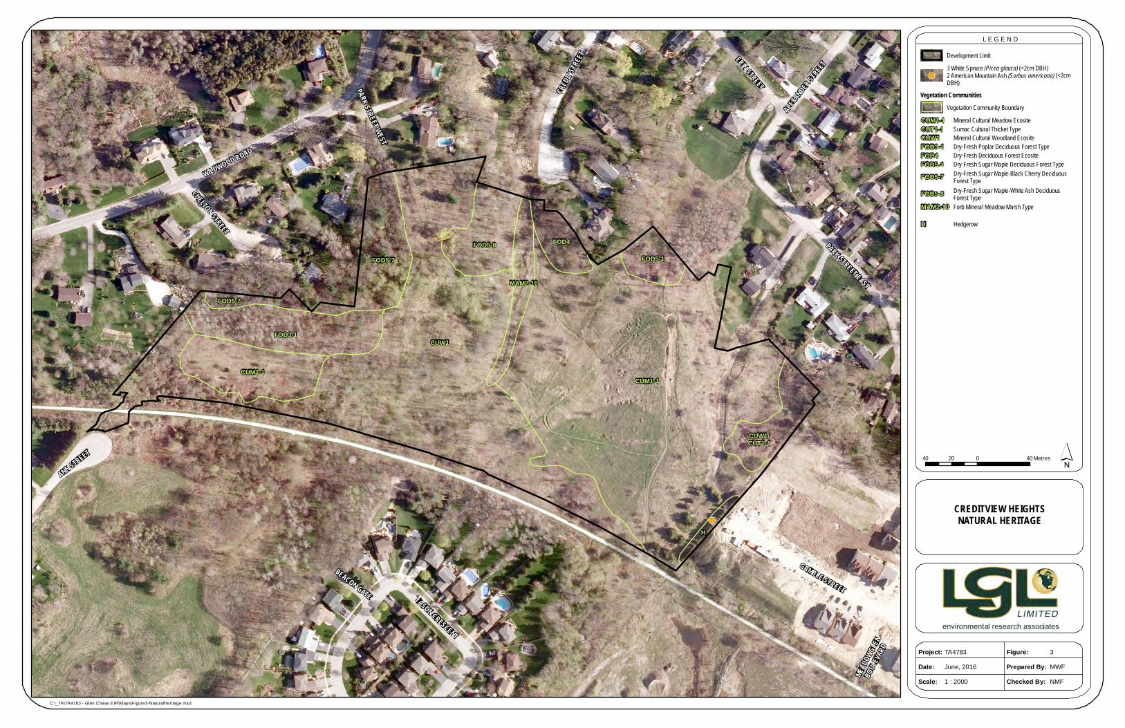
3.7 VEGETATION The spatial extent, composition, structure and function of the vegetation communities were identified through air photo interpretation and a field investigation. Air photos were interpreted to determine the limits and characteristics of the vegetation communities identified. A field investigation of the vegetation communities was conducted within the study area on May 27th and October 20th, 2008 to ground truth the boundaries of the vegetation communities and to conduct botanical surveys which was conducted by NSE. As previously noted, an additional field survey was conducted on June 7, 2016 to locate any significant plant species previously identified on the subject property. Prior to conducting field work, plant communities were delineated and given a preliminary classification based on aerial photograph interpretation. Each community identified was then visited in the field to confirm the boundaries and complete the classification of vegetation type following the Ecological Land Classification for Southern Ontario (Lee et al. 1998). The main focus of the vegetation survey was to refine plant community boundaries and classifications, and to provide an inventory of plant species within each classified community type. Nine different vegetation communities were mapped on the study site (Figure 3 and Table 2). A list of plants identified in each community is provided in Appendix C. Plant species were also entered into an Access database to facilitate a Floristic Quality Assessment (FQA) to assess vegetation quality following the methods of Oldham et al. (1995) for each community type within the study site. Within large portions of the subject property identified as cultural meadow (CUM1-1), cultural thicket (CUT1-1) and cultural woodland (CUW1) there is evidence indicative of human disturbances including ad hoc paths, trails used for biking and/or motorized vehicles, and dumped garbage (see Section 3.3). There is also an area that is likely seasonally flooded which is identified as a Forb Mineral Meadow Marsh. There is also a small hedgerow that is located at the southeast corner of the subject property (Figure 3). Tree species within the hedgerow include white pine (Pinus strobus) and white spruce (Picea glauca). A more detailed description of each community type and a list of some of the species that are in each vegetation community are provided in Table 2. A complete list of plants identified on the subject property is presented in Appendix C.
!(
CUM1-1CUM1-1
FOD3-1
FOD5-7
FOD5-7
CUW1
FOD5-8 FOD4
FOD5-1
MAM2-10
CUW1/CUT1-1
H
WILDWOOD ROAD
PARK STREET EAST
GAMBLE STREET
CRED
IT STR
EET ERIN STREET
ALEXANDER ST
REET
ANN STREET
JASON CRESCENT
CHELTON STREET
BEACON GATE
PARK STREET WEST
MEAD
OWGL
ENBO
ULEVA
RD
CREDITVIEW HEIGHTSNATURAL HERITAGE
40 0 4020 Metres
Figure:Prepared By:Checked By:
TA4783June, 20161 : 2000
3MWFNMF
C:\_TA\TA4783 - Glen Chase EIR\Maps\Figure3-NaturalHeritage.mxd
L E G E N D
Project:Date:Scale:
Development Limit
´
Vegetation CommunitiesVegetation Community Boundary
CUM1-1 Mineral Cultural Meadow EcositeCUT1-1 Sumac Cultural Thicket TypeCUW1 Mineral Cultural Woodland EcositeFOD3-1 Dry-Fresh Poplar Deciduous Forest TypeFOD4 Dry-Fresh Deciduous Forest EcositeFOD5-1 Dry-Fresh Sugar Maple Deciduous Forest TypeFOD5-7 Dry-Fresh Sugar Maple-Black Cherry Deciduous
Forest TypeFOD5-8 Dry-Fresh Sugar Maple-White Ash Deciduous
Forest TypeMAM2-10 Forb Mineral Meadow Marsh Type
H Hedgerow
!(3 White Spruce (Picea glauca)2 American Mountain Ash (Sorbus americana)
(<2cm DBH) (<2cm
DBH)

Creditview Heights, Glen Williams, Ontario updated June 2016 Environmental Implementation Report
LGL Limited environmental research associates Page 10
Table 2. Summary of Ecological Land Classification Vegetation Communities
ELC Code Vegetation Type
Species Association Comments
Terrestrial-Cultural CUM CULTURAL MEADOW CUM1-1 Dry – Moist
Old Field Meadow Type
Canopy or emergent: includes green ash (Fraxinus americana), scotch pine (Picea abies) and staghorn sumac (Rhus hirta). Understorey: includes red raspberry (Rubus idaeus), wild carrot (Daucus carota) and staghorn sumac. Ground Cover: includes Kentucky bluegrass (Poa pratensis), smooth brome (Bromus inermis), flat-top fragrant goldenrod (Euthamia graminifolia), Canada goldenrod (Solidago canadensis) and sulphur cinquefoil (Potentilla recta).
Cultural communities (CU). Tree cover and shrub cover <25 % (M). This community can occur on a wide range of soil moisture regimes (Dry-Moist) (-1). Pioneer community resulting from, or maintained by, anthropogenic-based influences.
CUW/CUT CULTURAL WOODLAND/THICKET CUW1/CUT1-1 Cultural
Woodland/ Sumac Cultural Thicket
Canopy: includes black walnut (Juglans nigra) and Manitoba maple (Acer negundo). Understorey: includes staghorn sumac, green ash and common buckthorn (Rhamnus cathartica). Ground Cover: dominant old field species includes red raspberry, garlic mustard (Alliaria petiolata) and smooth brome.
Cultural communities (CU). Tree cover and shrub cover <25 % (M). This community can occur on a wide range of soil moisture regimes (Dry-Moist) (-1). Pioneer community resulting from, or maintained by, anthropogenic-based influences.
CUW CULTURAL WOODLAND CUW1 Mineral
Cultural Woodland
Canopy: includes green ash, trembling aspen (Populus tremuloides), black walnut, and Manitoba maple. Understorey: includes green ash, hawthorn (Crataegus sp.), common crabapple (Malus pumila), grey dogwood (Cornus foemina ssp. racemosa), northern red currant (Ribes rubrum), and Tartarian honeysuckle (Lonicera tartarica). Ground Cover: dominant old field species includes Kentucky bluegrass, yellow trout lily (Erythronium americanum), garlic mustard, orchard grass (Dactylis glomerata) and enchanter’s nightshade (Circcaea lutetiana ssp. canadensis).
Cultural communities (CU). Tree cover and shrub cover <25 % (M). This community can occur on a wide range of soil moisture regimes (Dry-Moist) (-1). Pioneer community resulting from, or maintained by, anthropogenic-based influences.

Creditview Heights, Glen Williams, Ontario updated June 2016 Environmental Implementation Report
LGL Limited environmental research associates Page 11
ELC Code Vegetation Type
Species Association Comments
Terrestrial-Natural/Semi-natural/Cultural FOD DECIDUOUS FOREST FOD3-1 Dry-Fresh
Poplar Deciduous Forest
Canopy: includes trembling aspen and green ash. Understorey: includes trembling aspen, green ash and common buckthorn. Ground Cover: includes Canada goldenrod, panicled aster (Sympyotrichum lanceolatum), common St. John's-wort (Hypericum perforatum) and crown vetch (Vicia cracca).
Tree cover >60% (FO). Deciduous trees >75% of canopy cover (D). Deciduous forest (3). Dry-Fresh (-1).
FOD4 Dry-Fresh Deciduous Forest
Canopy: includes American beech (Fagus grandifolia), red oak (Quercus rubra) and green ash. Understorey: includes choke cherry (Prunus virginiana) and green ash. Ground Cover: includes garlic mustard, common buckthorn and yellow avens (Geum aleppicum).
Tree cover >60% (FO). Deciduous trees >75% of canopy cover (D). Deciduous forest (4). Dry sands and loams.
FOD5-1 Dry-Fresh Sugar Maple Deciduous Forest
Canopy: includes Sugar maple (Acer saccharum ssp. saccharum) and green ash. Understorey: includes choke cherry, and common buckthorn. Ground Cover: includes Canada goldenrod, common buckthorn, and choke cherry.
Tree cover >60% (FO). Deciduous trees >75% of canopy cover (D). Deciduous forest (5). Shallow soils over bedrock, rock, sands and loams that are dry to fresh (-1).
FOD5-7 Dry-Fresh Sugar Maple – Black Cherry Deciduous Forest
Canopy: includes sugar maple, black cherry (Prunus serotina), white pine (Pinus strobus) and basswood (Tilia americana). Understorey: includes sugar maple and black cherry. Ground Cover: includes broad-leaved goldenrod (Solidago flexicaulis), Virginia waterleaf (Hydrophyllum virginianum), upright yellow wood-sorrel (Oxalis stricta) and ostrich fern (Matteuccia struthiopteris var. pensyvanica).
Tree cover >60% (FO). Deciduous trees > 75% of canopy cover (D). Deciduous forest (5). Coarse and fine loams with a silt and clay content that are typically on tablelands with suitable drainage (-7).
FOD5-8 Dry-Fresh Sugar Maple – White Ash Deciduous Forest
Canopy: includes green ash, black walnut and sugar maple. Understorey: includes green ash, riverbank grape (Vitis riparia), sugar maple and common crabapple. Ground Cover: includes garlic mustard, large-leaved avens (Geum macrophyllum), Canada goldenrod, and orchard grass.
Tree cover >60% (FO). Deciduous trees >75% of canopy cover (D). Deciduous forest (5). Coarse and fine loams with a silt and clay content that are typically on tablelands with suitable drainage (-8).
Wetland-Semi-natural/Cultural MAM MEADOW MARSH MAM2-10 Forb Mineral
Meadow Marsh
Understorey: includes red-osier dogwood (Cornus sericea). Ground Cover: includes spreading bentgrass (Agrostis stolonifera), elecampane (Inula helenium), spotted jewel-weed (Capensis impatiens), purple-stemmed aster (Symphyotrichum puniceum), narrow-leafed cattail (Typha angustifolia), and field mint (Mentha arvensis).
Tree and shrub cover <25 % and water table seasonally drops below the substrate surface (MAM). Mineral soil (2).

Creditview Heights, Glen Williams, Ontario updated June 2016 Environmental Implementation Report
LGL Limited environmental research associates Page 12
3.8 FLORISTICS The floristic analysis was conducted on broad categories of plant communities based on their Ecosite classification (Lee et al. 1998). A total of 153 plant species were recorded on the lands proposed for the Creditview Heights subdivision, however, four of these plants could only be identified to genus. Of the 149 plants identified to species, 90 are native (60%) and 59 are non-native (40%). The overall percentage of native species in the study area is low when compared with the percentage of native plant species in the flora of Ontario (77%: Kaiser 1983). This is likely a reflection of the amount of disturbance the site experiences, as well as land use in the surrounding area which includes residential/agricultural land uses. Agriculture and development are related to an increased diversity of non-native species and these types of land use can promote the dispersal of these plants. The percentage of non-native plants can be an indicator of disturbance in a community, since non-native plants tend to invade disturbed soils. None of the nine vegetation communities have a proportion of native plant species over 77% (Kaiser 1983). In general, the plant species found at the Creditview Heights site are typical of cultural meadows, cultural woodlands, cultural thickets and small marsh patches in south-central Ontario. In order to provide a quantitative evaluation of the plant communities within the study site, a Floristic Quality Assessment (FQA) was generated. The Floristic Quality Index (FQI) and Native Mean Coefficient of Conservatism (Native Mean C) provide a comparison of vegetation quality of natural areas (Oldham et al. 1995). The FQI is derived, in part, from the assignment of a number between 0 and 10 for each native plant according to its habitat requirements (the Coefficient of Conservatism). Individual plants found in a diversity of habitats have low scores (0), and those plants found in only a few habitats or highly specific habitats have high scores (10). The scores for all plants within a community are summed and averaged to obtain the Native Mean C and divided by the square root of the number of species to obtain the FQI. Therefore, very high quality habitats with a high diversity of plant species have higher FQIs and mean Coefficients of Conservatism (Mean C) which is an indication of sensitive habitat. Table 3 shows the results of the FQI for the various plant communities found within the Creditview Heights site. All plant communities have sufficient diversity (greater than 30 native plant species) to allow for an FQA. Vegetation communities with a FQI greater than 30.0 or a Mean C higher than 3.3, are considered to be communities with moderate plant diversity and/or plant sensitivity. None of the vegetation communities on the subject property have an FQI greater than 30.0, however, five communities have Mean C’s greater than 3.3, and these values are bolded. The cultural woodland (CUW1) stands out more than the other four vegetation communities because it has a greater diversity of plants (91). The Dry-Fresh Sugar Maple – Black Cherry Deciduous Forest (FOD5-7) has a Mean C value greater than 4.0, and this is considered to be a high value. The cultural meadow and cultural woodland (CUM and CUW) plant communities which cover a large part of the site, contain a number of species which take advantage of highly disturbed conditions. These conditions include low levels of moisture, increased exposure to light (higher temperatures), and increased exposure to wind. Many of the species currently present in the CUM and CUW, will likely continue to persist while habitat conditions remain fairly open with little presence of an upper canopy. These species are also resilient to ongoing impacts like trampling.

Creditview Heights, Glen Williams, Ontario updated June 2016 Environmental Implementation Report
LGL Limited environmental research associates Page 13
Table 3. Floristic Quality Assessment of Plant Communities at the Creditview Heights Site
Ecosite Plants Native
FQI Native
Mean C % Native
Native Exotic Unknown Total
CUM1-1 29 37 1 67 15.60 2.9 44.0
CUW1/CUT1-1 10 17 0 27 8.85 2.80 37.0
CUW1 54 33 4 91 25.86 3.52 62.0
FOD3-1 17 7 0 24 16.01 3.88 71.0
FOD4 14 4 0 18 12.29 3.29 78.0
FOD5-1 12 6 0 18 12.70 3.67 67.0
FOD5-7 17 6 0 23 16.98 4.12 74.0
FOD5-8 12 8 0 20 12.70 3.67 60.0
MAM2-10 17 7 0 24 13.40 3.25 71.0
3.8.1 Species at Risk and Locally Rare Species
No plant species that are regulated under the Ontario Endangered Species Act or the Canada Species at Risk Act were encountered during the botanical investigations. Five locally rare plant species were documented at the Creditview Heights site following the locally significant plant list for Halton Region (Varga et al. 2000) and seven species are documented as CVC species of concern. As previously noted, an additional survey was undertaken on June 7, 2016 to locate locally rare plant species and to determine the potential for transplanting these individuals. During this subsequent field visit the following plant species could not be found including water dock (Rumex orbiculatus), American hareball (Campanula rotundifolia), arrow-leaved aster (Symphyotrichum urophyllum), herbaceous greenbriar (Smilax lasionueura), pointed broom sedge (Carex scoparia), and inflated sedge (Carex vesicaria). However, it is possible that arrow-leaved-aster was mis-identified. During the June 2016 field survey heart-leaved aster (Symphyotrichum cordifolium) was identified in the CUW1/CUT1-1, this species could have been mistaken for the locally rare species. Water dock was also not found, but it is possible that the more common curly dock (Rumex crispis) was mistakenly identified as well, though this species was not identified on-site during the subsequent field investigation. Both white spruce and American mountain-ash (Sorbus americana) were identified within the hedgerow identified at the eastern end of the site (see Figure 3). Table 4 lists the locally rare plant species along with the habitat in which they were found. Table 4. Significant Plant Species Recorded within Creditview Heights Study Site
Plant Community Scientific Name Common Name Rarity Status*
S Rank Halton CVC
CUM1-1 and CUW1
Picea glauca (Moench) Voss White Spruce S5 No Yes
MAM2-10 Rumex orbiculatus A. Gray** Water Dock S4S5 Yes Yes
FOD5-1 and CUW1
Sorbus americana Marshall American Mountain-ash S5 No Yes
CUM1-1 Campanula rotundifolia L. American Hareball S5 Yes Yes

Creditview Heights, Glen Williams, Ontario updated June 2016 Environmental Implementation Report
LGL Limited environmental research associates Page 14
Plant Community Scientific Name Common Name Rarity Status*
S Rank Halton CVC
CUW1/CUT1-1 Symphyotrichum urophyllum (Lindl. in DC.) Nesom**
Arrow-leaved Aster S4 Yes Yes
FOD3-1 Smilax lasionueura Hook. Herbaceous Greenbriar S4 Yes No
CUW1 Carex scoparia Schkuhr ex Willd. Pointed Broom Sedge S5 Yes Yes
CUW1 Carex vesicaria L. Inflated Sedge S5 No Yes
*see Appendix D for rarity status information / **Species may have been mis-identified during original survey.
3.9 TREE SURVEY A tree inventory was carried out on the subject property by Kuntz Forestry Consulting Inc. (August 2008). The work was carried out on May 15th and June 24th and 25th, 2008. This included a determination of species composition, tree diameter and health. Forest communities identified on the subject property are composed of young to mid-age stands of native deciduous trees. It was noted that the forest communities are highly fragmented in relation to the high degree of recreational use incurred on-site. Thirty-six trees were identified and tagged on the property. The tree species identified include:
American ash (Fraxinus americana); Manitoba maple (Acer negundo); black walnut (Juglans nigra); trembling aspen (Populus tremuloides); white pine; black cherry (Prunus serotina); sugar maple (Acer saccharum ssp. saccharum); and hawthorn (Crataegus sp.).
Two hawthorn trees were only identified to genus; therefore, their status cannot be determined. All trees identified ranged in condition from fair to good. A total of 1415 trees measuring 10 cm DBH or greater were surveyed within approximately 15 vegetation units identified by Kuntz Forestry Consulting Inc. staff; this included specimen trees which are presented on the Tree Inventory and Preservation Plan (see Appendix E. Trees were typically observed to be in fair to good condition with a few exceptions.
3.10 FAUNA Twenty-five wildlife species, all of which were birds, were observed on the site during the course of surveys in 2008.
3.10.1 Fisheries
No fish inventories were carried out because there is no fish habitat on the study site. However, the proposed development could indirectly impact fish habitat within the Credit River through issues related to recharge and discharge. An enhanced level of stormwater control, Level 1 or Enhanced Protection, will be implemented in the Stormwater Management Facility (SWM) to mitigate water quality control of water stored, and subsequently discharged from the stormwater pond (see Section 5.3). This level of protection is in accordance with Table 3.2 of the Storm Water Planning and Design Manual, March 2003 (Condeland Engineering updated June 2016).

Creditview Heights, Glen Williams, Ontario updated June 2016 Environmental Implementation Report
LGL Limited environmental research associates Page 15
3.10.2 Amphibians and Reptiles
A frog survey was conducted between 9:30 p.m. and 10:00 p.m. on April 9th, 2008 by NSE. On the same night a test pond, several kilometres to the south was used, and several Spring Peepers (Pseudacris crucifer) were heard calling in the test pond at approximately 9:00 p.m. However, at the Forb Mineral Meadow Marsh vegetation community on the subject property, no frogs were heard calling. During other field reconnaissance visits, no incidental observations of amphibians or reptiles were made. The Forb Mineral Meadow Marsh is situated on a slope; no ponded water was observed within any portion of this vegetation community.
3.10.3 Birds
Bird surveys were conducted between 05:00 and 10:00 a.m. in late May 2008. Twenty-five bird species were observed on the subject property. Five birds are considered species of conservation priority in the Credit River watershed by CVC (see Table 5 and Appendix F). Three species of conservation priority including Yellow-billed Cuckoo (Coccyzus americanus), Eastern Kingbird (Tyrannus tyrannus) and Gray Catbird (Dumetella carolinensis) nest in thickets and hedgerows. Eastern Kingbird, Gray Catbird and to a lesser extent Yellow-billed Cuckoo are relatively adaptable and can continue to nest within urban environments that maintain small natural areas with hedgerows. The Eastern Wood-pewee and Mourning Warbler (Oporornis philadelphia) generally inhabit forests or forest edges. The Mourning Warbler has been found to live in/adjacent to urban areas. In contrast, the Eastern Wood-pewee generally avoids heavily urbanized areas. Observations in the deciduous forested areas along the western perimeter of the site revealed the lowest number of bird species (see Appendix F). The smaller size of these latter habitats may explain the lower number of bird observations.
Table 5. Significant Bird Species Recorded within Creditview Heights Study Site
Preferred Plant Community
Scientific Name
Common Name Area
Sensitive
Rarity Status*
G Rank S Rank COSEWIC CVC
open/forest Coccyzus americanus
Yellow-billed Cuckoo
G5 S4B NAR yes
deciduous/mixed forest
Contopus virens Eastern Wood-pewee G5 S5B NAR yes
thicket/hedgerow Tyrannus tyrannus
Eastern Kingbird G5 S5B NAR yes
thicket/hedgerow Dumetella carolinensis
Gray Catbird G5 S5B NAR yes
coniferous/mixed forest
Oporornis philadelphia
Mourning Warbler G5 S4S5B NAR yes
3.10.4 Mammals
Mammal surveys were conducted opportunistically during the field surveys conducted in May and October 2008. There were no observations or evidence of any mammal species on the site. It is expected that mammals that are typical of urban habitat like raccoons, squirrels, rabbits and mice are using the site.

Creditview Heights, Glen Williams, Ontario updated June 2016 Environmental Implementation Report
LGL Limited environmental research associates Page 16
3.10.5 Species at Risk
No wildlife species that were regulated under the Ontario Endangered Species Act (ESA 2007) or the Canada Species at Risk Act were encountered during the field investigation. Eastern Wood-pewee was identified on the subject property during the field survey in 2008, and at the time their populations were identified as common, widespread, and abundant in Ontario (S5). However, Eastern Wood-pewee is now listed as Special Concern (ESA 2007). Species listed as Special Concern are not regulated under the ESA 2007.
4.0 EXISTING REGULATORY POLICIES
4.1 PROVINCIAL POLICY The Provincial Policy Statement (PPS 2005) provides guidance to assist planners in matters of provincial interest in municipal land use planning under the Planning Act. The Planning Act requires that planning authorities “shall have regard to” the PPS in matters that affect planning so that natural features will be protected from incompatible development. There are two categories of natural heritage areas specified in the PPS for protection. Areas where no development or site alternation is permitted, including: Provincially Significant Wetlands; and significant habitats of endangered and threatened species. The second category of natural heritage areas specified in the PPS are areas where development and site alteration may be permitted if it can be demonstrated that no negative impacts will occur on the natural features or their ecological functions. These areas include: fish habitat; significant valley lands; significant wildlife habitat; Provincially Significant Areas of Natural and Scientific Interest (ANSI’s); and Significant Woodlands.
At the Creditview Heights study site there are no Provincially Significant Wetlands within or within 120 m of the study area, nor are there any significant portions of the habitat that provide refuge for endangered or threatened species. Five bird species of local conservation concern and one species that is now listed as Special Concern under the ESA 2007 are described in Sections 3.10.3 and 3.10.5 above, and are discussed in Section 6.2 below.
4.2 GREENBELT PLAN The Halton Hills Official Plan policies are intended to implement the Greenbelt Plan which came into effect on February 28, 2005. Within the Town of Halton Hills (ToHH), areas that overlap with the Greenbelt Plan are designated “Protected Countryside” (see Schedule A1, HHOP 2006), and within the Protected Countryside there are areas the Greenbelt Plan defines as Natural Heritage System (NHS). The NHS includes areas with the highest concentration of the most sensitive and/or significant natural features and functions and these areas are to be managed as a connected and integrated NHS. The subject property does not lie within the Greenbelt Plan. Greenbelt “Protected Countryside” is located to the south and east of the subject property.
4.3 REGIONAL MUNICIPALITY OF HALTON The Regional Municipality of Halton (RMOH) specifies that local official plans for each Municipality are extensions of The Regional Official Plan (ROP 2006). These local official plans are intended to direct development to meet local needs and issues. The Plan also requires that “Secondary Plans be prepared by Local Municipalities for new communities, Nodes, Corridors and Hamlets in accordance with the ROP” (RMOH 2006). Secondary Plans shall conform to Regional and Local Official Plans and be incorporated as amendments to the Local Official Plan (Section 49, ROP 2006). The Glen Williams Secondary Plan

Creditview Heights, Glen Williams, Ontario updated June 2016 Environmental Implementation Report
LGL Limited environmental research associates Page 17
(2005) conforms to the ROP and provides a guide to development within the Hamlet of Glen Williams and was used as the primary official planning document to guide this report. A letter from the Region of Halton to the Town of Halton Hills dated December 2, 2015 (see Appendix G) confirms that the subject property does not fall within the Region of Halton Greenlands System, as identified in the 2006 Regional Official Plan and as such, the Region was satisfied to have the review of the impacts to the natural environment undertaken by Credit Valley Conservation Authority staff.
4.4 THE TOWN OF HALTON HILLS OFFICIAL PLAN - THE HAMLET OF GLEN
WILLIAMS SECONDARY PLAN (GWSP) As previously noted, the HHOP designates the community of Glen Williams as a “Hamlet Area” and has prepared Official Plan Amendment No. 113 “The Hamlet of Glen Williams Secondary Plan” (GWSP 2005). The Hamlet of Glen Williams Secondary Plan OPA 113 (GWSP 2005) is the guiding document for planning within the study area. Schedule A of the GWSP (Figure 4) has designated the majority of the Creditview Heights site as “Hamlet Residential” with one small area along the northeast boundary of the site designated as “Greenlands Categories”. Schedule A also shows a “Hamlet Buffer” which is located immediately adjacent and south of the former Canadian National Railway; however, this buffer does not appear to be within the development limits of the subject property. Schedule A also identifies an existing trail and an area of “Potential Trails and On-Road Linkages” on the subject property. The GWSP (2005) identifies Core Greenlands and Supportive Greenlands as areas designated as having environmental importance. The GWSP designates two categories of Greenlands as follows:
Core Greenlands which are areas that have the natural heritage components that include regulatory floodplains; fish habitat; woodlands within or adjacent to the main valley system of the Credit River; riparian corridors linked to watercourses with fish habitat; and provincially significant wetlands; and
Supportive Greenlands which are areas that have natural heritage features that may not have specific provincial policy to regulate development. Such areas include woodlots; unevaluated wetlands, steep slopes and minor tributaries of the Credit River.
The Greenland’s Categories, shown on Schedule B (Figure 5), illustrates that on the Creditview Heights site there is only a very small portion of “Supportive Greenlands” at the eastern end of the site. Schedule B also shows an environmental area designated “Areas of Potentially Higher Recharge” that covers the entire subject site.

Creditview Heights, Glen Williams, Ontario updated June 2016 Environmental Implementation Report
LGL Limited environmental research associates Page 18
Figure 4. Glen Williams Secondary Plan Schedule A (GWSP 2005)
Section 9.3.2 of the GWSP (2005) states “development may be permitted in Supportive Greenlands areas where an Environmental Implementation Report is completed that illustrates how the environmental function of this area can be protected and improved through actions such as stream rehabilitation efforts, reforestation and vegetative planting programs.” The Supportive Greenlands, Area of Potentially Higher Recharge, and Trails and On-Road Linkages have been taken into consideration in the discussion provided in Section 6.0 below.
4.5 CREDIT VALLEY CONSERVATION AUTHORITY The Crediview Heights site falls within CVC’s area of jurisdiction. The CVC implements policies to ensure the protection of people and property from environmental hazards such as flooding and steep slopes and the agency also protects the environmental integrity of the Credit River watershed. Credit Valley Conservation policies identify standards that can be used to determine the location and setbacks from features such as watercourses, valleys and ravines, wetlands, woodlands, fish habitat and other significant environmental features.
Approximate location of proposed
Creditview Heights Subdivision

Creditview Heights, Glen Williams, Ontario updated June 2016 Environmental Implementation Report
LGL Limited environmental research associates Page 19
Figure 5. Glen Williams Secondary Plan Schedule B (GWSP 2005)
Approximate location of proposed
Creditview Heights Subdivision

Creditview Heights, Glen Williams, Ontario updated June 2016 Environmental Implementation Report
LGL Limited environmental research associates Page 20
5.0 DESCRIPTION OF PROPOSED DEVELOPMENT
5.1 DESCRIPTION OF SUBDIVISION The Creditview Heights development consists of 31 single detached residential units (see Figure 6) over an area of approximately 5.4 ha. The proposed lot sizes range between approximately 0.1 ha to 0.5 ha. The proposed Creditview Heights subdivision is for residential use; no commercial development creating extensive hard surfaces for customer parking are planned. Access to the proposed Creditview Heights subdivision will be along Gamble Street with emergency access only through Ann Street. The proposed roads make up 1.23 ha of the development. The proposed development includes a Stormwater Management Facility (Block 32) that is approximately 1.1 ha, two walkways (Blocks 35 and 36) that are approximately 0.033 ha, and open space blocks (Blocks 33 and 34) that is approximately 0.696 ha. The proposed Subdivision covers a total area of approximately 8.073 ha. For detailed information regarding sanitary sewage conveyance and treatment, the proposed road alignment and lot grading, stormwater management quantity and quality control, proposed erosion control measures and water supply and distribution for the proposed development, see the Functional Servicing Report (Condeland Engineering updated June 2016) available under separate cover.
5.2 LOCATION OF DEVELOPMENT LIMITS The limit of development on the subject property was previously confirmed and staked with the CVC while the property was owned by Desol Developments (D12). The current owner, Eden Oak, has received confirmation that CVC will support the development limit agreed to with the previous owner (correspondence dated February 20th, and March 14, 2007 presented in Appendix B). The development limit for additional lands, as part of the current study area shown on Figure 2, was staked with Colleen Ditner, Planner with the CVC, Mark Kluge, Senior Planner with the Town of Halton Hills and Dave Matthews, Matthews Planning & Management Limited on February 24, 2010.
5.3 FUNCTIONAL SERVICING CONCEPT The Stormwater Management design for the proposed Creditview Heights subdivision will follow the criteria established in the Functional Servicing Report prepared by Condeland Engineering (updated June 2016). The Functional Servicing Report outlines the current drainage conditions which flow off of the property in seven directions (outlets).
1. 1000 mm diameter culvert (southwest tributary to the Credit River).
2. 1000 mm diameter culvert (southwest tributary to the Credit River).
3. 750 mm diameter culvert (southwest tributary to the Credit River).
4. Road side ditches along Credit Street (discharge via road side ditches directly to the main branch of the Credit River).
5. Road side ditches along Chelten Street (discharge via road side ditches directly to the main branch of the Credit River).
6. Road side ditches along Park Street (discharge via road side ditches directly to the main branch of the Credit River).
7. Road side ditches along Gamble Road (discharge via road side ditches directly to the main branch of the Credit River).

1 2 3 4 56 7
8
9
10
1112
13
1415
16
17
Block 34Open Space
1819
2021
2223
2425
2627
2829
3031
Block 32Stormwater
Management
Street A
Stree
t B
Walkw
ay
Block 33
Walkway
WILDWOOD ROAD
PARK STREET EAST
GAMBLE STREET
CRED
IT STR
EET ERIN STREET
ALEXANDER ST
REET
ANN STREET
JASON CRESCENT
CHELTON STREET
BEACON GATE
PARK STREET WEST
MEAD
OWGL
ENBO
ULEVA
RD
CREDITVIEW HEIGHTSPROPOSED DEVELOPMENT
AND CONSTRAINTS
40 0 4020 Metres
Figure:Prepared By:Checked By:
TA4783June, 20161 : 2000
6MWFNMF
C:\_TA\TA4783 - Glen Chase EIR\Maps\Figure6-ProposedDevelopmentAndConstraints.mxd
L E G E N D
Project:Date:Scale:
Development Limit
´
Area of Potentially Higher Recharge
Proposed DevelopmentCore GreenlandsSupportive Greenlands
Long Term Stable Top of Slope
Long Term Stable Top of Slope SetbackTree Protection Zone

Creditview Heights, Glen Williams, Ontario updated June 2016 Environmental Implementation Report
LGL Limited environmental research associates Page 22
Condeland Engineering proposes to approximately maintain flows as these currently exist through the existing three culverts Post-Development. The FSR (Condeland Engineering updated June 2016) indicates that if the municipality prefers the removal of the extraneous flows, rear lot catch basins could be introduced and the drainage would be diverted to the proposed SWM pond. Outlet 4 represents the main tributary area that will drain to the proposed SWM pond, draining an area approximately 5.78 ha in size. This area includes the new roadway and the front area of lots including the house area, driveway and front yards. Outlets 5 and 6 collect drainage predominantly from the rear of lot areas and will be treated under natural conditions maintaining pre-development flows. Drainage from outlet 7 will be captured into outlet 4 which, in turn, will drain to the proposed SWM pond (Pre-development Storm Drainage [Figure 4] and Post-development Storm Drainage Area [Figure 5] are available under separate cover in the Functional Servicing Report or FSR [Condeland Engineering updated June 2016]). Analysis by Condeland Engineering indicates that overall, post-development flows will be equal to or less than the pre-development flows, with the exception of Outlet 4. As indicated in the FSR, all post-development flows for Outlet 4 will be directed to the proposed stormwater pond facility where flows will be attenuated to the allowable discharge rate for the downstream system using a control structure. Quality control within the Stormwater Management pond will be based on Level 1 or Enhanced Protection in accordance with Table 3.2 of the Storm Water Planning and Design Manual (March 2003). Table 6 presents the results of the quality control analysis undertaken by Condeland Engineering as presented in the FSR (updated June 2016).
Table 6. Quality Control Analysis (Condeland Engineering updated June 2016)
Watershed Area
(Hectares)
Area Weighted Imperviousness
(%)
Enhanced Protection
Volume (cum) (110cum/Ha)
Extended Detention
Volume (cum) (40cum/Ha)
Permanent Pool Storage required
Volume (cum) (70cum/Ha)
5.78 60.0 636 231 405 Based on the preliminary pond design, at elevation of 252.50, the Permanent Storage provided is 845.7 cum. The FSR states that to ensure 48 hour drawn down time, an orifice / Inlet Control Device (ICD) can be installed within the proposed control structure. The FSR provides detailed information on the following:
sanitary sewage conveyance and treatment; road alignment and lot grading; stormwater management quantity and quality control; erosion control measures; and water supply and distribution.
Full details of the functional servicing concept are presented in the Functional Servicing Report (Condeland Engineering updated June 2016), available under separate cover.

Creditview Heights, Glen Williams, Ontario updated June 2016 Environmental Implementation Report
LGL Limited environmental research associates Page 23
6.0 ANALYSIS OF NATURAL FEATURES, POTENTIAL IMPACTS FROM DEVELOPMENT AND PROPOSED MITIGATION
An investigation of the natural features within the study property found that the following environmental features will be impacted:
potential indirect impacts to fish habitat within the Credit River;
five bird species of CVC conservation priority and one bird species which is now listed as Special Concern under the ESA 2007;
the loss of forest habitat from the subject property;
impacts to a small portion of the Supportive Greenlands;
the loss of a small Forb Mineral Meadow Marsh in the central portion of the site;
an area of steep slopes along the north and northeast perimeters of the site; and
an area of potentially higher recharge. Below is a discussion of the natural features within the study area identifying appropriate protection measures based on the PPS (2005), the GWSP (2005) and the scoped sub-watershed study completed by Dillon (2003), where appropriate. Some of the information provided in this section, and sections above, is a summary of or excerpts from detailed studies completed. Where there are any discrepancies, refer to the respective reports available under separate cover. Potential impacts that are addressed in this section include impacts to natural features associated with development, short-term impacts associated with construction, and long-term direct and indirect impacts associated with the change in land use from the proposed Creditview Heights subdivision.
6.1 GROUNDWATER As noted in the Hydrogeological Investigation (V.A. Wood updated 2016) and in Section 3.5, the geological profile at the study site and the area immediately adjacent to the site is comprised of a 3 m to 8 m thick sequence of sandy silt to clayey silt till with layers of clayey silt, gravelly sand and sandy clay, followed by a thick deposit of sand and silty sand which is comprised mainly of sand. Within the site the groundwater table is generally within 5 m to 8 m from the ground surface and the direction of groundwater flow is generally towards the Credit River and locally to the north following the slope.
6.1.1 Impacts and Mitigation
The proposed SWM pond is located on the north central portion of the study site (Block 32). The placement of the SWM pond in this location will result in the removal of the Forb Mineral Meadow Marsh. The SWM pond should be created using an embankment dam which will create a barrier against water. To avoid interference with the groundwater flow and quality, the dam and pond should be relatively impervious to prevent infiltration into the sandy sub-soils. To obtain this stability the pond should include a compacted clay bed and the dam should be developed with an impervious clay core to mitigate surface or seepage erosion (V.A. Wood updated June 2016). The seepage that was identified within the forb meadow marsh will be maintained. On-site grading will not be deep enough to impact the clay layer within which the perched water is likely contained. A French drain will be installed to intercept and convey the perched water in the direction of the slope which will be

Creditview Heights, Glen Williams, Ontario updated June 2016 Environmental Implementation Report
LGL Limited environmental research associates Page 24
released at the base of the stormwater pond. The total seepage volume from the perched water, located at the north end of Block 32, is generally small and is expected to have a minimal impact on the storage capacity of the SWM pond. The pond design has two storage components, active and permanent storage; the active storage will not be impacted as the seepage will be directed to the permanent storage pond. This seepage will serve to provide continual long-term support for wetland plantings. In addition, directing the perched water in this way will mitigation slope instability by directing flow away from the toe of slope (details provided by Condeland Engineering 2016).
6.1.2 Impacts of Trenches on the Groundwater Regime and Mitigation
As noted in the Hydrogeological Investigation and the Geotechnical Investigation (V.A. Wood updated June 2016; V.A. Wood revised June 2016), the groundwater level is generally within 5 m to 8 m from the ground surface, but varies up to more than 15 m in some areas, below the existing grade. Based on the proposed grading plan some re-grading will be required on the east side of the property with up to 3+ m of cut and fill. It is anticipated that the service trenches will not exceed 3 m in depth and, as such, the excavation would be above the ground water table and dewatering would not be required during the excavation. Where water wells are located below the plateau, these are unlikely to be affected by the trench excavations at the site (V.A. Wood updated June 2016). The subsoil below the water table is comprised mainly of fine sand and is highly permeable. Due to the high permeability of the subsoil, the cone of depression from dewatering will likely be shallow and the zone of influence of the cone will likely be very wide. Consequently, deep excavations that are substantially below the water table will likely require significant dewatering works. The methodology for dewatering should be reviewed by the geotechnical engineer to ensure excavation stability. For infrastructure (i.e., sewer pipes) that is installed below the water table, trench collars should be employed to ensure that groundwater flow is not impacted (V.A. Wood updated June 2016).
6.2 FISH HABITAT No fish habitat is located on the study site; however, the proposed development could indirectly impact fish habitat within the Credit River through issues related to recharge and discharge. The proposed development will increase the impervious areas within the subject lands including paved municipal roads, driveways and residences, etc., and this will result in an increase in runoff volume and a corresponding decrease in infiltration and evapotranspiration under post-development compared to pre-development conditions (Condeland Engineering updated June 2016). The potential impacts and mitigation measures to groundwater (recharge and discharge) and to water quality (stormwater management) are discussed below.
6.2.1 Impacts and Mitigation
Infiltration (Groundwater) While at a site level the local recharge function may seem insignificant, the cumulative effect of the loss of such recharge throughout the watershed could have an impact on baseflow rates and surface flow volumes in the receiving watercourses, as well as to the recharge of deeper aquifers. It is therefore important to maintain the quantity and quality of recharge over the subject site, to the extent possible. The subject lands have been identified as an Area of Potentially Higher Recharge (Figure 6). As such, mitigation for the increase in impervious areas proposed should include measures to encourage infiltration (e.g., rear yard swales, soak-away pits, 'French drains', large pervious areas, etc.). The increase in impervious surface area from the proposed development will likely result in an increase in runoff (to the SWM facilities) and an associated decrease in infiltration, as generally occurs with development. This could negatively impact the local aquifer and groundwater discharge to the receiving watercourse, the Credit River. The Credit River is managed as a mixed cool/coldwater fish community which is dependent on groundwater discharge and

Creditview Heights, Glen Williams, Ontario updated June 2016 Environmental Implementation Report
LGL Limited environmental research associates Page 25
requires a high level of protection. Therefore, all on-site measures should maintain or enhance the local infiltration function. Stormwater Management (Water Quality and Quantity) As part of the FSR, Condeland Engineering (updated June 2016) has outlined stormwater management quantity and quality control measures for the proposed development. The treatment of stormwater produced by the proposed development should be provided at an enhanced level of stormwater control, Level 1 or Enhanced Protection to mitigate water quality control of water stored, and subsequently discharged from the stormwater pond. This level of protection is in accordance with Table 3.2 of the Storm Water Planning and Design Manual, March 2003. This measure will serve to protect the receiving watercourse (Credit River) from impacts related to water quantity and quality. Overall, drainage from the study area is expected to be conveyed through optimally located culverts and roadside ditches either directly to the Credit River or to the Credit River via the SWM facility. It is proposed that through these drainage features pre-development flows will be maintained under post-development conditions (Condeland Engineering updated June 2016). Discharge that is directed to the stormwater facility will be initially conveyed into a forebay. The length of the forebay will be sufficient to allow for discharge to reach the appropriate settling velocity to mitigate the discharge of sediment into the permanent pool. It is expected that the capacity of the SWM facility will be greater than is required for the subject site. Consequently, it is expected that stormwater at all events would be released at a rate that would not negatively impact the Credit River. Collectively, this design would address erosion thresholds and fluvial geomorphological considerations related to any discharge to the Credit River. Although the volume of stormwater produced from the subject site is expected to be low and impacts to the Credit River will likely be small, cumulatively, stormwater inputs from multiple sources can negatively affect the receiving watercourse. There is a high level of protection placed on the Credit River due to the sensitive nature of the fish community. Overall, measures to mitigate water quality and quantity include Level 1 or Enhanced Protection stormwater management with extended volume storage and extended drawdown. In addition, means to reduce runoff and encourage infiltration should be implemented to mitigate some of the recharge decreases associated with development such as natural surface landscaped areas, soak away pits, surface/subsurface infiltration trenching, etc., to collect drainage from roof-top surfaces and rear yards. (Condeland Engineering updated June 2016). Full details related to stormwater management including mitigating decreases in infiltration on the subject property are presented in the FSR prepared by Condeland Engineering (updated June 2016) available under separate cover.
6.3 CVC BIRDS OF CONCERN Five bird species of conservation priority were observed on the site primarily within the cultural communities. These bird species include: Yellow-billed Cuckoo, Eastern Wood-pewee, Eastern Kingbird, Gray Catbird, and Mourning Warbler. Other bird species found on the property are regulated under the Migratory Birds Convention Act. Numerous bird species located within the project limits are listed under the Migratory Birds Convention Act (MBCA). The MBCA prohibits the killing, capturing, injuring, taking or disturbing of migratory birds (including eggs) or damaging, destroying, removing or disturbing of nests. Migratory insectivorous and non-game birds are protected year-round and migratory game birds are protected from March 10 to September 1. No permits are issued for the destruction of migratory birds or their nests incidental to some other undertaking, or activity and project works or activities not specifically prohibited under the Act. Eastern Wood Pewee As previously noted, wildlife surveys were conducted on the subject property in 2008 when Eastern Wood-pewee was identified. At that time, Eastern Wood-pewee populations were identified as common,

Creditview Heights, Glen Williams, Ontario updated June 2016 Environmental Implementation Report
LGL Limited environmental research associates Page 26
widespread, and abundant in Ontario (S5). Consequently, the location of the singing male that was heard calling was not noted during the field investigations and it cannot be confirmed the bird was present on the subject property. Given the type of habitat present on the subject property, it is reasonable to assume that Eastern Wood-pewee would use the subject property for breeding/nesting purposes and as such, Candidate Significant Wildlife Habitat would be present on the subject property (see correspondence from CVC dated April 22, 2016: comment #4 presented in Appendix A).
6.3.1 Impacts and Mitigation
With the proposed development, most of the vegetation communities including bird habitat, will be removed from the subject property. To meet the requirements of the MBCA, no vegetation removals should occur during the nesting season. This includes the period from April 1 to July 31. If vegetation clearing is required during this period, a bird nest survey should be carried out by a qualified avian biologist prior to construction. If active nests are found, a site-specific mitigation plan should be prepared in consultation with the Canadian Wildlife Service. Though much of the natural features within the study area will be removed due to grading and the proposed development, approximately 1.36 ha of deciduous forest and cultural woodland/cultural thicket will be retained for use by wildlife along the rear of lots 1 to 9, along the northern limit of Block 32 and within the Open Space Block 34. In addition, it is proposed that approximately 0.63 ha of land within and around the stormwater pond (Block 32), within the rear of lots 14 and 15, and along the sloped areas along the rear of lots 20 to 24, lots 30 and 31 be planted with trees and in some areas shrubs and adjacent to the emergency exit. The retained vegetation and planted areas are expected to provide habitat for various wildlife as perches, nesting habitat and stop-over habitat during migration or when moving between habitat. The current grading and proposed development impacts have been overlain on an airphoto to show areas that will not be disturbed where vegetation can be retained, and areas identified where additional planting is proposed, and these are presented on Figure 7 (see correspondence from ToHH dated January 19, 2016: comments 1.6 and 2.2 presented in Appendix A). Mitigation for the removal of the Eastern Wood-pewee habitat will be provided on both a short-term and long-term basis. In the short-term construction activities such as clearing and grubbing will be restricted to outside of the breeding bird season (May 25-July 10). If works are proposed during this period, a nest survey should be conducted prior to the commencement of tree removal to ensure no established nests will be disturbed. In addition, areas identified where existing treed habitat can be retained, along with the recommended tree/shrub planting areas noted above, may also continue to provide stop-over habitat for the birds during migration, when foraging, potential for nesting or when moving between habitat. There are several existing treed natural areas within 250 m to 1 km around the study area that also provide suitable foraging and nesting habitat for Eastern Wood-pewee.

1 2 3 4 56 7
8
9
10
1112
13
1415
16
17
Block 34Open Space
1819
2021
2223
2425
2627
2829
3031
Block 32Stormwater
Management
Street A
Stree
t B
Walkw
ay
Block 33
Walkway
WILDWOOD ROAD
PARK STREET EAST
GAMBLE STREET
CRED
IT STR
EET ERIN STREET
ALEXANDER ST
REET
ANN STREET
JASON CRESCENT
CHELTON STREET
BEACON GATE
PARK STREET WEST
MEAD
OWGL
ENBO
ULEVA
RD
CREDITVIEW HEIGHTSRETAINED VEGETATION AND
PROPOSED PLANTING AREAS
40 0 4020 Metres
Figure:Prepared By:Checked By:
TA4783June, 20161 : 2000
7MWFNMF
C:\_TA\TA4783 - Glen Chase EIR\Maps\Figure7-RetainedVegetationAndProposedPlantingAreas.mxd
L E G E N D
Project:Date:Scale:
Development Limit
´
Proposed DevelopmentCore GreenlandsSupportive GreenlandsRetained Vegetation (Undisturbed Areas)
Proposed Planting Area

Creditview Heights, Glen Williams, Ontario updated June 2016 Environmental Implementation Report
LGL Limited environmental research associates Page 28
6.4 LOSS OF TREES Several treed communities were identified on the subject property, including cultural vegetation communities such as woodland. Several tree species were identified within these communities including the following:
American ash; white pine; Manitoba maple; black cherry; black walnut; sugar maple; and trembling aspen; hawthorn.
As part of the tree inventory undertaken by Kuntz Forestry Consulting Inc. (KFCI), an assessment of tree removal was undertaken and the results are presented in Table 7. Removals in this table includes specimen trees. The table lists the KFCI unit in which trees were identified, and these are illustrated on the Tree Inventory and Preservation Plan (Figure 1) presented in Appendix E (Kuntz Forestry Consulting Inc., updated June 2016). The Tree Inventory and Preservation Plan was updated to reflect current proposed development impacts (see correspondence from ToHH dated January 19, 2016: comments 1.6 and 2.1 presented in Appendix A)
Table 7. Tree Removal*
KFCI Vegetation Unit % of Unit to be
Removed # of Trees to be
Removed** FC-B 100% -
FC-C_west 100% 19 FC-A 35% 2
FC-D_west 100% 523 FC-E 100% 225 FC-I 100% - FC-J 100% 34 FC-N 100% -
FC-D_east 100% 32 -- 100% 57
FC-F 18% 20 FC-G 70% 95 FC-K 100% 74
FC-C_east 81% 52 FC-H 100% 77
Total 1210 *Data provided by Kuntz Forestry Consulting Inc. / ** Greater than 10cm DBH
6.4.1 Impacts and Mitigation
The following tree survey information was derived from works undertaken as part of the Tree Inventory and Preservation Plan (Kuntz Forestry Consulting Inc., revised June 2016), which has been updated to reflect the current proposed development plan and agency comments (see correspondence from the ToHH comments 1.6 and 2.1 presented in Appendix A). Areas have been identified where tree retention on-site can occur, and these areas are presented on Figure 7. Development Impacts The proposed development will have an impact on most trees and vegetation communities identified on the subject property, with the exception of select perimeter trees and communities primarily located within the proposed Open Space Block 34 which partly lies within the Supportive Greenlands. However, many of the

Creditview Heights, Glen Williams, Ontario updated June 2016 Environmental Implementation Report
LGL Limited environmental research associates Page 29
trees identified within this vegetation community, especially along the edge, consist of generalist shrub and tree species including eastern white cedar (Thuja occidentalis), and Manitoba maple. Site planning, earth works and servicing requirements for the proposed development preclude the retention of a large number of trees currently on the subject property (see Appendix E: Figure 1). Grading, with cut or fill of 0.5 m or more would result in the removal and exposure of roots, and thus, increase the likelihood of tree mortality. Tree Removals Specimen Trees 113-120, 122-124, 133-142 and 145-149 and the vegetation communities in which these trees are located would be removed as a result of the proposed development including earthworks and servicing requirements. Affected forest communities identified represent a low constraint to development due to composition, structure (ecological integrity) and low basal area measurements. Refer to Appendix E, Figure 1 (revised June 2016), for the locations of trees identified for removal. Tree Preservation Preservation of Specimen Trees 125-132 and trees identified along the western side of the property, the southwest corner, and within the northeast corner of the property, may be possible as proposed grading does not affect these tree resources. Per Appendix E, these vegetation units include the FC-L, FC-M, and portions of the FC-C east, FC-G, FC-F, and FC-A (identified as CUW1/CUT1-1 and portions of the CUM1-1, CUW1, and FOD5-7 units as presented on Figure 3). Where tree retention is possible, installation of appropriate tree protection will be required. Grading throughout the subject property has been minimized to protect as many perimeter trees as possible. Tree protection measures will have to be implemented prior to the construction phase to ensure the noted tree resources are not impacted by the development. Tree protection zones should respect existing grades for trees identified for preservation as indicated on the preservation plan. The preservation of trees is important, but where trees cannot be retained, the planting of trees to provide compensation is recommended. Halton Region has deferred the review of the impacts to the natural environment to Credit Valley Conservation staff (letter dated December 2, 2015) (see Appendix G). The agreed to compensation is outlined below in Section 6.5. Tree Retention Trees are identified for retention should be protected from construction. Protection recommendations include:
Tree protection fencing should be installed using paige wire fencing with siltation control fabric placed on metal T-bars at 3 m centres. Refer to Appendix E: Figure 1, for further preservation details and the location of the Tree Protection Zone. Also, see the location of the Tree Protection Zone presented on Figure 6 (see correspondence from ToHH dated January 19, 2016: comments 1.6 and 2.1 presented in Appendix A);
Tree protection fencing should be installed 1 m outside of the dripline (i.e., canopy edge) (tree protection zone);
Tree protection fencing should be installed prior to the commencement of any construction activities;
Construction materials, equipment, soil, construction waste or debris are not to be stored within 1 m of the dripline for trees identified for protection;
Any tree pruning or root cutting required is to be conducted by a Certified Arborist or City Forester;
Disposal of any liquids shall not occur within the tree protection zone; and
Should any incidental or accidental tree injuries occur during construction, a qualified Arborist or City Forester should be consulted to determine whether additional mitigation measures are required.

Creditview Heights, Glen Williams, Ontario updated June 2016 Environmental Implementation Report
LGL Limited environmental research associates Page 30
These efforts will help to ensure that impacts to retained trees are minimal so that the condition and character of these trees will not change, either in the short-term or long-term period.
6.5 VEGETATION COMMUNITIES (TREED AND WETLAND COMMUNITIES) Due to the significant grading for the construction of roads and general infrastructure, the construction of 31 residential units with front and rear lots, driveways, and the construction of a Stormwater Management Facility, much of the vegetation communities that exist within the study area will be removed. Vegetation communities identified were observed to have various levels of disturbance including extensive ad hoc trails and dumped garbage.
6.5.1 Impacts
Treed Communities Impacts to treed communities include both direct and indirect impacts. Direct impacts includes the partial removal of five, small deciduous forest communities, and cultural woodland (see Figures 3 and 6). The cultural woodland covers an area of approximately 2.61 ha which is the largest treed community on the subject property. There are five deciduous forests which range in size from 0.14 ha to 0.45 ha and these are present along the edges of the subject property where these back onto adjacent residential development (see Figure 3). As a result of the proposed development a total of 3.45 ha of treed communities will be removed from the subject property. Indirect impacts to treed communities are related to edge effects where treed communities have newly exposed edges where portions of these communities are retained. The exposure of new edges can result in the spread of non-native and/or invasive plant species, and result with increased light and wind infiltrating into forest communities. Similar impacts to the remaining cultural woodlands are not anticipated. The nature of these communities is that these are culturally influenced and exist in areas that have been previously cleared, usually for the purposes of agricultural or development. As a result, these cultural communities typically contain a higher proportion of non-native and invasive plant species, and also experience higher light and wind levels with associated impacts to soil moisture, as these are more open communities with less than 60% canopy cover. Wetland The area in which the wetland occurs on the subject property is part of Block 32 which is the location of the proposed SWM facility. As part of the FSR, Condeland Engineering (updated June 2016) has outlined stormwater management quantity and quality control measures for the proposed development. Due to both grading and the placement of the SWM pond, the forb meadow marsh which covers an area of 0.17 ha, will be removed. This marsh is not identified as locally, regionally or provincially significant. No standing water was evident on the subject property during the botanical field investigations, however, groundwater seepage was reported within this marsh (see Sections 3.5 and 3.6). There was no visible surface water connection between the marsh and any other on-site surface feature. No amphibian or reptiles species were observed using the marsh (see Section 3.10.2). The marsh acts as both a seasonal discharge zone and likely has some recharge capability, though the wetland is on a slope and there is no pooling of water within the study area. The Hydrological Investigation (V.A. Wood updated June 2016) determined that a seepage area is located along a swale close to the southern end of the marsh. This seepage is caused by water that is likely perched on a clayey silt till or silt deposit as was encountered in a borehole located just south of the seepage area and forb meadow marsh. A second wet area was observed closer to the north end of the marsh. In this area, the hydrogeological investigation shows that the groundwater table intersects the ground surface near the one borehole, but further north the water table dips below the ground surface indicating that the wet area is likely due to perched water probably on top of the surficial silty clay which was encountered in the relevant borehole.

Creditview Heights, Glen Williams, Ontario updated June 2016 Environmental Implementation Report
LGL Limited environmental research associates Page 31
6.5.2 Mitigation
Treed Communities Portions of several treed communities will be retained. The location of these communities are typically associated with sloped areas along the boundaries of the subject property. Portions of vegetation communities to be retained include Dry-Fresh Sugar Maple-Black Cherry Deciduous Forest (FOD5-7), Dry-Fresh Sugar Maple-White Ash Deciduous Forest (FOD5-8), a small portion of cultural woodland (CUW1) and cultural meadow (CUM1-1), and the cultural woodland/cultural thicket (CUW1/CUT1-1) which is located within the Supportive Greenlands. Consequently, within the subject property it is expected that approximately 1.36 ha of deciduous forest and cultural woodland/cultural thicket will be retained along the rear of lots 1 to 9, along the northern limit of Block 32, a portion of Block 33, and within the Open Space Block 34. Current proposed development plans including impacts associated with grading have been summarized and overlain on an airphoto base. Areas where vegetation can be retained are presented on Figure 7 (see letter from ToHH dated January 19, 2016: comment 1.6 presented in Appendix A). As noted in Section 6.4.1, tree protection should be installed using paige wire fencing with siltation control fabric placed on metal T-bars at 3 m centres, and this fencing should be installed 1 m outside of the dripline (i.e., canopy edge). As well, tree protection fencing should be installed prior to the commencement of any construction activities. This fencing will help to clearly demarcate to construction crews where plant removal and grading is prohibited. As part of mitigation for the removal of treed communities, it is proposed that planting be undertaken to the extent possible within the subject property towards the end or post-construction. The areas identified for planting include approximately 0.63 ha of land, as follows:
within and around the stormwater pond (Block 32); along the sloped area at the rear of lots 14 and 15; along the sloped areas along the rear of lots 20 to 24, lots 30 and 31 (backing onto the existing
pedestrian trail); and Block 33 and any disturbed areas adjacent to the emergency exit.
Areas identified where planting is proposed are also presented on Figure 7 (see letter from ToHH dated January 19, 2016: comments 1.6 and 2.2 presented in Appendix A). There is also a strip of cultural woodland (CUW1) that is expected to persist outside of the subject property along the north side of the former Canadian National Railway (CNR) which is now a pedestrian pathway. Planting at the rear of lots 20 to 24, 30 and 31 will also serve to improve screening along the pathway. It is recommended that trees be planted within any gaps that exist along this screened area north of the pathway. With the retained vegetation and the proposed planting areas identified above, a total of 2.0 ha of treed communities are expected to exist within the subject property post-construction. In additional, boulevard trees are also recommended to be planted as part of general landscaping across the site. As noted in Section 6.3.1, the retained vegetation and planted areas are expected to provide habitat for various wildlife as perches, nesting habitat and stop-over habitat during migration or when moving between habitat, and will also serve to promote a development that is set within a more naturalized landscape. Wetland Condeland Engineering has outlined a stormwater management concept which takes into account some of the function of the forb meadow marsh. Consequently, the existing seepage within the meadow marsh will be maintained. It is expected that on-site grading will not be deep enough to impact the clay layer within which the water becomes perched (V.A. Wood updated June 2016; V.A. Wood revised June 2016). It is proposed that a French drain be installed to intercept and convey the perched water into the base of the permanent pond. Even during dry periods, flows from the perched water will continue to outlet into the

Creditview Heights, Glen Williams, Ontario updated June 2016 Environmental Implementation Report
LGL Limited environmental research associates Page 32
pond which will serve to maintain mesic to wet conditions for wetland plantings within the permanent pond during dry periods, as it currently does within the forb meadow marsh. This water would only be discharged when the level of water reaches the top elevation of the permanent pool (details provided by Condeland Engineering 2016). Though the stormwater pond does not serve as a direct replacement for the loss of the forb meadow marsh, the proposed permanent stormwater pool is large, and the construction of a dispersion peninsula is recommended. A dispersion peninsula can help to slow water and further mitigate the removal of fine particulates, and thus the removal of soluble contaminants such as nutrients. The permanent pool should be constructed with an irregular shape to enhance its natural appearance; these additional recommendations for the design of the permanent pool should be reviewed and implemented at the detail design phase, to the extent possible. It is recommended that the dispersion peninsula and the lower half of the berm that will surround the forebay and pond, be planted with suitable trees and shrubs, to the extent possible. The inundation zone along the margins of ponded water should be planted with suitable emergent macrophytes. Within portions of the permanent pool, submerged and floating-leaved macrophytes could be incorporated to the extent these don’t negatively impact the function of the stormwater pond. Such wetland plantings can further enhance contaminant removal by promoting the settling of particulates out of the water column, filtering solids through root mats and soils, increasing adsorption to soil particles, and enhancing chemical transformations and uptake or conversion to less harmful forms by plants and bacteria. Though the creation of a wetland within a stormwater facility will not truly replace the form and function of a naturally occurring wetland, calculated planning can produce a feature that will provide habitat for both terrestrial and wetland wildlife and will enhance water quality, a benefit to the receiving watercourse, the Credit River. As discussed with Condeland Engineering staff, water from the stormwater pond was originally proposed to be discharged from the outfall in the same location as water currently discharges from the forb meadow marsh; along the wetland swale located adjacent and west of Credit Street, immediately north of the study area. Subsequently, a request was made to pipe up to 0.13 cms to the Credit River storm sewer. This scenario would have stopped the continuous flow of water within the wetland swale except in the event of a 50-year storm. However, due to issues with access, this pipe scenario may not be feasible. Currently, it is proposed that all flows be directed to the existing channel as originally proposed. This would continue to sustain wetland plants within the wetland swale. Currently, water is conveyed through this swale and continues further to the northwest, west of Wildwood Road, where the vegetation appears to transition to deciduous swamp and a meadow or shallow marsh which are located well over 150 m away from the study area. It is recommended that native emergent, submergent and floating-leaved wetland plant species be used around the forebay and permanent pond, including the recommended dispersion peninsula. Native wetland shrub species should be planted around the outlet swale, to the extent possible, to cool water exiting the pond. Tree and shrub species should be native and non-invasive and able to tolerate mesic to wet conditions should be used. It is also recommended that the upland or terrestrial portion of the stormwater facility be planted in such a way to provide some woodland function. All plant species used as part of planting should be native and non-invasive. Section 6.6 below outlines general considerations that are recommended as part of planting within the subject property and as part of compensation planting outlined in the following below. Compensation Analysis In addition to mitigation measures outlined above for the removal of early successional treed and forest communities and the meadow marsh, further compensation was discussed with CVC. As agreed upon between Peter Kuntz, Kuntz Forestry and Warren Harris, Town of Halton Hills and subsequently the CVC,

Creditview Heights, Glen Williams, Ontario updated June 2016 Environmental Implementation Report
LGL Limited environmental research associates Page 33
compensation for the loss of treed communities will be provided at a rate of 1:1 for early successional habitat and 2:1 for native woodlands.1 It was agreed upon that compensation for the removal of the meadow marsh community could be provided through additional plantings at a rate of 2:1 (see letter from CVC dated April 22, 2016: comment #3 and letter from the ToHH dated January 19, 2016: comment 1.6 presented in Appendix A). Consequently, an impact analysis was undertaken to determine the amount of treed and meadow marsh communities that will be removed as a result of the proposed development, and a memo prepared and submitted to CVC. The contents of the memo have been incorporated into this section of the EIR and the response from CVC (letter dated April 22, 2016) is presented in Appendix A. It is important to note that since that assessment was undertaken for CVC, vegetation has been identified that will be retained within undisturbed zones and these are presented on Figure 7. Consequently, the area (ha) calculations for treed communities presented in the memo to CVC are reduced. The area calculations provided in Table 8 reflect the reduction of those portions of retained vegetation within the subject property. There is also a small addition of impacts to woodland at the southwest corner of the subject property where emergency access to Ann Street will be constructed. The areas (ha) presented in Table 8 include this additional impact. The following is an outline of the agreed to compensation. A total of 3.62 ha will be removed as a result of the proposed development, consisting of early successional, forest and meadow marsh communities (see Table 8). Of the 3.62 ha, 2.50 ha of early successional cultural woodland will be removed to be compensated at a ratio of 1:1. Meadow marsh will also be impacted by the proposed development resulting in the removal of 0.17 ha which will compensated for at the required 2:1 ratio. Five native forest community types will be impacted as result of the proposed development, resulting in the removal of 0.95 ha. In accordance with the agreed upon compensation requirement of 2:1 for the loss of native forests and wetland, a total of 2.24 ha of planting of forested lands would be required.
Table 8. Summary of Impacts to Vegetation Communities
ELC Community Removal Per ELC
Community Type (ha)* Compensation (ha)
1:1 Compensation for Early Successional Habitat CUW1 2.50 2.50
2:1 Compensation of Native Woodlands and Wetland FOD5-7 0.05 0.10 FOD5-1 0.14 0.28 FOD3-1 0.39 0.78 FOD4 0.12 0.24 FOD5-8 0.25 0.50 MAM2-10 0.17 0.34
Total 3.62 ha 4.74 ha Based on the summary of impacts to treed communities and wetland presented in Table 8, and the agreed upon compensation as noted above, a total of 4.74 ha would be required to compensate for the loss of treed and the marsh communities. This is a reduction of 1.11 ha from 5.85 ha previously calculated in the memo to CVC (February 23, 2016, revised April 28, 2016). As discussed with CVC, planting within the proposed development site would not be considered as an acceptable planting area for the compensation of 4.74 ha. However, it was discussed that planting within Open Space Block 34 is acceptable; approximately half of this block is identified as Support Greenlands (see Figure 6) with impacts to only 0.02 ha (lot 19), the remaining 0.22 ha should not be impacted. Infill planting has been identified as part of compensation/enhancement within Block 34 (approximately 0.02
1 Harris, Warren. "Eden Oak (Glen Chase) Subdivision." Message to Peter Kuntz. 11 Oct. 2012. E-mail.

Creditview Heights, Glen Williams, Ontario updated June 2016 Environmental Implementation Report
LGL Limited environmental research associates Page 34
ha), as well as planting an area of 0.25 ha within the Supportive Greenlands adjacent and east of the subject property in an area that appears to have been previously disturbed (see Figure 7). The total area of compensation planting within the Supportive Greenland would be 0.27 ha, and this includes 0.25 ha of additional planting that would increase vegetation cover within the Supportive Greenlands. Consequently, the total area of compensation planting identified in Table 8 would be reduced to 4.47 ha. As outlined in CVC’s letter (April 22, 2016), they recognize the limited area for compensation planting on-site, and as such recommend the following:
large blocks of area be targeted for restoration/enhancement plantings; a landscape enhancement plan be prepared to illustrate the location and extent (ha) of on-site
compensation planting; planting should include a diversity of native and non-invasive tree species to provide a range of
suitable habitat; and compensation planting areas should be in public ownership and/or designated in an appropriate
zoning category for management and long-term protection. It is expected that a detailed enhancement plan for Block 34 will identify the location of the site, but not individual plantings as planting is expected to be undertaken as infill within open meadow areas, along the existing path, and within canopy gaps. However, details will include the identification trees and shrubs proposed for installation, stock size, spacing requirements, etc. Similar landscape plans for any compensation planting planned off of the subject property. Discussions with CVC and the ToHH staff is recommended to identify suitable habitat on public lands where planting as part of compensation can be undertaken. Where such lands cannot be identified, payment in lieu of planting should be discussed. Where planting is undertaken as part of the required compensation, a planting plan(s) as described above, should be prepared by a qualified landscape architect or qualified restoration expert, and plans should be in accordance with the Conservation Halton Landscaping and Tree Preservation Guidelines (2010) (see correspondence from ToHH dated January 19, 2016: comment 1.6 presented in Appendix A). Where there are deviations from this guideline, reasons for such deviations should be outlined.
6.6 COMPENSATION PLANTING AND LANDSCAPE PLANTING Proposed plantings within the subject property associated with the stormwater facility, along sloped areas at the rear of lots, as part of edge management, planting as part of compensation, and landscape planting should be comprised of tree and shrub species that are native and non-invasive in nature. As noted above, a planting plan(s) should be prepared by a qualified landscape architect or qualified restoration expert, and plans should be in accordance with the Conservation Halton Landscaping and Tree Preservation Guidelines (2010) (see correspondence from ToHH dated January 19, 2016: comment 1.6 presented in Appendix A). Where there are deviations from this guideline, reasons for such deviations should be outlined. Plans should be prepared during the detail design phase.
Appendix B of the Landscape Design Guide for Low Impact Development (CVC 2010) should be reviewed and taken into consideration as part of the vegetation works within the stormwater facility, as part of the preparation of planting plans at the detail design phase. The following are some general recommendations for planting:
As previously noted, plants should include only native and/or non-invasive species, and should include native and/or non-invasive species that were identified on the site or are identified within the surrounding landscape where planting is undertaken off of the subject property;

Creditview Heights, Glen Williams, Ontario updated June 2016 Environmental Implementation Report
LGL Limited environmental research associates Page 35
A list of recommended plant species for the stormwater pond is provided in Table 9 (also see Vascular Plant List in Appendix C). This list has been refined from the previous version;
Landscape components including additional planting on sloped areas, edge management, etc., within the Creditview Heights development should be included in a landscape plan during the detail design phase;
As part of edge management along newly exposed forest edges where vegetation has been identified for retention, dense infill plantings of native and non-invasive shrubs in areas immediately adjacent or within gaps identified along newly exposed edges, is recommended;
Native and/or non-invasive plant materials should be listed on planting plans and include species, quantity, stock form (i.e., potted, live stakes, burlapped, whips, etc.), and note any seed mix proposed and quantity per ha;
Stock received should be of good quality acceptable for installation; Planting techniques utilized should be specified (i.e., manual planting, machine planting, etc.); Where existing aggressive vegetation persists when tree/shrub planting is to be undertaken, herbicide
applications by a qualified, licensed applicator may be necessary. Herbicide use will be species-specific. Herbicide application will be focused using spot sprayers or wicking devices to the extent possible to mitigate inadvertent impacts to existing desirable vegetation. Aggressive species which could negatively impact preferred planted stock includes dog-strangling vine, smooth brome, Canada goldenrod, thistles, vines, etc. (Cynanchum rossicum, Bromus inermis, Solidago canadensis, Cirsium sp., Vitis riparia, etc.);
In planting areas that are denuded of vegetation due to grading where planting is proposed, a suitable nurse crop, that contains species that are native and/or non-invasive should be incorporated to stabilize soils and to provide some protection to establishing preferred planted stock;
Landscape plan(s) should be prepared by a qualified professional; and Installation of plantings should be carried out by a qualified professional.
Table 9. Recommended Plant Species for SWM Pond
Scientific Name Common Name SRank GRank
SUBMERGED AND FLOATING-LEAVED MACROPHYTES Nymphaea odorata white water lily S5 G5 Polygonum amphibium water smartweed S5 G5
TREES AND SHRUBS FOR SWM POND BERM AND OUTLET SWALE Salix nigra black willow S5 G5 Thuja occidentalis eastern white cedar S5 G5 Pinus strobus white pine S5 G5 Picea glauca white spruce S5 G5 Acer saccharum sugar maple S5 G5 Populus balsamifera spp. balsamifera balsam poplar S5 G5 Populus tremuloides trembling aspen S5 G5 Populus grandidentata large-tooth aspen S5 G5 Sambucus canadensis common elderberry S5 G5 Physocarpus opulifolius ninebark S5 -- Cornus sericea ssp. sericea red-osier dogwood S5 G5
SHRUBS FOR INUNDATION ZONE, LOWER EDGE OF BERM, AND OUTFALL SWALE Cornus sericea ssp. sericea red-osier dogwood S5 G5 Salix petiolaris slender willow S5 G4 Salix eriocephala Missouri willow S5 G5 Salix bebbiana long-beaked willow S5 G5 Spiraea alba narrow-leaved meadow-sweet S5 G5

Creditview Heights, Glen Williams, Ontario updated June 2016 Environmental Implementation Report
LGL Limited environmental research associates Page 36
As previously noted, a list of recommended plant species for additional planting areas within the subject property including sloped areas, compensation planting within Block 34 and the adjacent Supportive Greenlands, and edge management is presented in Table 10. It is recommended that a mix of both coniferous and deciduous trees be planted to optimize success. Ground flora should also be seeded to provide slope stability and protection for newly planted seedlings. A seed mix that is predominantly native and/or non-invasive is recommended. A few such species that could be incorporated into the seed mix are also presented in Table 10. The species presented in the following table have been refined. Herbaceous species that were previously included in the list would not likely survive in the high light conditions during the early stages of planting. It is expected that herbaceous species that exist in adjacent, retained forest communities will establish in newly planted areas over time.
Table 10. Recommended Plant Species for Supportive Greenlands and Sloped Areas
Scientific Name Common Name SRank GRank
TREE AND SHRUB SPECIES Picea glauca white spruce S5 G5 Thuja occidentalis eastern white cedar S5 G5 Pinus strobus white pine S5 G5 Populus tremuloides trembling aspen S5 G5 Populus grandidentata large-tooth aspen S5 G5 Populus balsamifera ssp. balsamifera Balsam poplar S5 G5 Tilia americana basswood S5 G5 Acer saccharinum sugar maple S5 G5 Quercus rubra red oak S5 G5 Fagus grandifolia American beech S5 G5 Amelanchier arborea downy serviceberry S5 G5 Prunus virginiana choke cherry S5 G5 Aronia melancarpa black chokecherry S5 G5 Sambucus canadensis common elderberry S5 G5 GROUND FLORA Elymus canadensis Canada wild-rye S5 G5 Oenothera biennis common evening-primrose S5 G5 Rudbeckia hirta brown-eyed Susan S5 G5 Symphyotrichum ericoides white heath aster S5 G5 Symphyotrichum novae-angliae New England aster S5 G5 Symphyotrichum laevis smooth aster S5 G5 Symphyotrichum cordifolium heart-leaved aster S5 G5 Carex pensylvanica Pennsylvania sedge S5 G5? Panicum virgatum Switch grass S4 G5 Sorghastrum nutans Indian grass S4 G5 Solidago nemoralis ssp. nemoralis gray goldenrod S5 G5T?
Plantings should be placed in an irregular pattern to provide a more naturalized appearance, to the extent possible. Overall, plantings will provide soil and slope stability, promote infiltration, mitigate temperature through shading, contaminant removal, provide visual screening/buffering, provide habitat for wildlife, and continue to provide the natural setting to which local residents have become accustomed (CVC 2010). Site preparation, planting and maintenance for one to three years is important. Preliminary conditions at restoration sites may not be immediately conducive or support optimal plant establishment and growth. Poor quality plant stock and competition with non-native and aggressive plant species could negatively impact restoration efforts as part of establishing woodland/forest habitat that should be dominated by native

Creditview Heights, Glen Williams, Ontario updated June 2016 Environmental Implementation Report
LGL Limited environmental research associates Page 37
species. The following section outlines some recommendations to mitigate the extensive establishment of aggressive plant species. Aggressive Plant Species Competition by aggressive plant species should be monitored during the first one to three years of planting as these plant species can lead to reduced growth or mortality of seedlings as a result of shading, moisture stress, and chemical inhibition (i.e., allelopathic interactions). Competition can come from both perennial and annual plants including grasses, herbs, vines, shrubs and trees. The control of aggressive plants such as European buckthorn, swallow-wort (Cynanchum rossicum), and garlic mustard (Alliaria petiolata) will be critical for optimum growth and success of those plantings targeted for restoration around the stormwater facility. To create a strong linkage or connection between and within the existing Greenlands System within the Hamlet of Glen Williams, is to produce self-sustaining, functioning vegetation communities that provide real value for wildlife and the local residents.
6.7 LOCALLY RARE PLANT SPECIES Five locally rare plant species were documented on the subject property (Varga et al. 2000) and seven species are documented as CVC species of concern (see Section 3.8.1). An additional field survey was undertaken on June 7, 2016 to locate locally rare plant species and determine the potential for transplanting those individuals found. During this subsequent field visit two of the plant species originally identified were located, including white spruce and American mountain-ash. Several of the locally rare plant species previously identified were not located during the June 2016 field visit, and as noted in Section 3.8.1, two of these species may have been mis-identified during the preliminary investigation in 2008.
6.7.1 Impacts and Mitigation
Most of the subject property will be cleared due to the proposed development and that includes the removal of many of the locally rare species identified on the site. The two locally rare plant species located during the 2016 field visit includes white spruce and American mountain-ash. Several of the white spruce trees that were identified were greater than 5 cm DBH (diameter at breast height). However, three white spruce seedlings and one American mountain-ash were identified within the hedgerow at the eastern end of the site (see Figure 3), and these five seedlings are suitable for transplanting measuring approximately 1 to 2 cm DBH. It is recommended that these five seedlings be removed from their location prior to construction and be transplanted into Block 34 where impacts associated with construction are not expected, or within the adjacent portion of land identified outside and east of the subject property, where additional planting as part of compensation has been identified (see correspondence from CVC dated April 22, 2016: comment #5 presented in Appendix A).
6.8 STEEP SLOPES, LONG-TERM STABLE TOP OF SLOPE AND SUPPORTIVE
GREENLANDS There is an area of moderately steep, approximately 20+ m high, slopes that exist along the north and northeast boundaries of the study area. Portions of the sloped lands along these boundaries are covered with herbaceous species, trees and shrubs, and open bare ground which consists of a thin layer of topsoil (V.A. Wood revised June 2016). The sloped area at the northeast boundary of the property is characterized as cultural woodland/cultural thicket (CUW1/CUT1-1), and is identified as Supportive Greenlands (Figure 6). This cultural woodland/cultural thicket contains abundant black walnut and Manitoba maple trees in the canopy, staghorn sumac (Rhus hirta) and green ash (Fraxinus pennsylvanica) were identified in the sub-canopy with European buckthorn (Rhamnus cathartica) the dominant species in this layer.

Creditview Heights, Glen Williams, Ontario updated June 2016 Environmental Implementation Report
LGL Limited environmental research associates Page 38
Steep Slopes and Long Term Stable Top of Slope The development proposed for the Creditview Heights subdivision includes several lots to be created with the crest of slope and a portion of the slope itself, inside of the lot. A slope stability analysis was required to determine the subsurface conditions of the slope walls. The following information was taken from the Geotechnical Investigation (V.A. Wood revised June 2016) which is provided under separate cover. The Geotechnical Investigation and Slop Stability Assessment carried out by V.A. Wood (revised June 2016), was based on the requirements defined in the Ontario Ministry of Natural Resources (MNR), Natural Hazards Training Manual (Policy 3.1). Of the 31 lots proposed in the Creditview Heights subdivision, Lots 1 to 19 include or back onto a slope. No laboratory soil strength tests were carried out; the soil parameters used were based on previous experience with similar materials. Conservative parameters were used in the analysis where necessary. The analysis was carried out using the commercial slope program G-Slope. This is a limit equilibrium slope stability analysis program which calculates the Factor of Safety (FOS) against circular failure of different slope configurations using the assessed soil and water parameters. The outcome of the slope stability analysis indicates that the slopes analysed have a minimum Factor of Safety of at least 1.5 or better against circular failure for lots 1 to 10; this is considered to be stable. The outcome of the slope stability analysis for lots 11 to 21 indicates that this slope has a minimum Factor of Safety of at least 1.5 or better against circular failure; this is considered to be stable (V.A. Wood revised June 2016). The CVC policy guidelines stipulate a 1.5 minimum Factor of Safety for land development and planning. These guidelines also stipulate that slopes be provided with stability and toe erosion setbacks determined on the basis of various parameters which include height of slope, proximity of the slope toe to a watercourse, type of soils comprising a slope, condition of vegetation, etc. The CVC policy guidelines provide a generalized stability setback criteria based on the slope height and type of soil(s) comprising a slope. In addition, it also stipulates a provision of a detailed investigation consisting of site specific boreholes and a slope stability analysis to refine/determine the safe stability setback distance. Consequently, the minimum Factor of Safety of 1.5, noted above, are considered adequate for long-term stability, and since there is no waterway within 15 m of the toe of the slopes, no setback is required (V.A. Wood revised June 2016). It was concluded that for all of the affected lots, erosion access allowance is not an issue as long as the existing slope vegetation is maintained (V.A. Wood revised June 2016). However, due to the significant grading required on the subject property, a setback of 6 m, especially for lots 1 to 9, is recommended. As indicated by Condeland Engineering (June 2016) and in accordance with CVC policy, the construction of structures is not permitted within 10 m of the top of stable slope. The Conservation Authority has permitted a 4 m encroachment into this setback only where it is associated with grading. Beyond the Long-Term Stable Top of Slope setback, along lots 1 to 9, vegetation has been identified for retention. The Long-Term Stable Top of Slope Setback is presented on Figure 6 (see correspondence from ToHH dated January 19, 2016: comment 2.2 presented in Appendix A). However, due to the significant on-site grading expected a general construction setback of 6 m is recommended for all lots adjacent to slopes. A more detailed review of the geotechnical findings is provided in the Geotechnical Investigation and Slope Stability Assessment (V.A. Wood revised June 2016), available under separate cover. The Long-Term Stable Top of Slope is presented on Figure 6 (see correspondence from ToHH dated January 19, 2016: comment 2.2 presented in Appendix A). It is understood that an application under Ontario Regulation 160/06 is required because the subject property is regulated due to the presence of valley slopes associated with the Credit River. Such an application is not part of the scope of this EIR, however, it is expected that an application will be submitted by the study team’s Planner or Engineer, at a later date.

Creditview Heights, Glen Williams, Ontario updated June 2016 Environmental Implementation Report
LGL Limited environmental research associates Page 39
Supportive Greenlands An area of approximately 0.27 ha of Supportive Greenlands is located at the northeast edge of the study area (see Figure 6). The Supportive Greenlands identified on-site are located on a north to northeast facing slope. This sloped area is dominated by non-native plant species including common crabapple (Malus pumila), wild carrot (Daucus carota), smooth brome (Bromus inermis), meadow Timothy (Phleum pratense) and Manitoba maple. Other plants include early successional species like trembling aspen. There is a dirt driveway at the base of the slope, ad hoc paths through the area, and it is generally in a very disturbed state. These Supportive Greenlands are part of a deciduous forest community that continues to the northeast, almost to Mountainview Road North. In Section 9.3 of The Hamlet of Glen Williams Secondary Plan (Consolidated, Town of Halton Hills 2005), Supportive Greenlands are defined as follows:
“The Supportive Greenlands designation contains functions and linkages that support the ecological function of the features in the Core Greenlands designation. These areas would benefit from rehabilitation or restoration efforts to enhance their ecological value. Any proposal for development within the Supportive Greenlands designation must be accompanied by an Environmental Implementation Report that can demonstrate the ecological function of the area can be maintained, and environmental impacts can be appropriately mitigated.”
6.8.1 Impacts and Mitigation
Steep Slopes and Long-Term Stable Top of Slope Setback Re-grading on the subject property will be necessary to support the development of residential units, roads, sewers and stormwater facilities. Overall, re-grading will provide better stability and visual appeal for the proposed Creditview Heights subdivision, while still maintaining topographic variability. The area within the lower and central portion of the subject site is the location for the SWM facilities (Block 32). The adjacent slopes within this area will be re-graded with a 3:1 slope ratio or less to accommodate basement walkouts for residential units on adjacent lots (Condeland Engineering updated June 2016). In addition, the lowest point within Block 32 will be elevated to better conform to adjacent sloped areas, to meet requirements for the safe construction of the SWM facility, to allow for suitable basement walk- outs for the adjacent lots, and to provide for a more aesthetically pleasing look for the subdivision as part of the Hamlet of Glen Williams. All of the sloped areas should be stabilized with vegetation as soon as possible, post grading. As part of slope rehabilitation/restoration, the following recommendations should be taken into consideration:
• the micro-climatic conditions shall be considered when selecting native plant species for planting along slopes including slope aspect, angle and exposure;
• rehabilitation/restoration of the slopes at the north and northeast edges of the study area should include quick growing, non-invasive grasses / nursery crops - these may be initially required for slope stability, but the projected vegetation community within these areas in the long-term is good quality woodland/forest, consequently, grass species must be carefully chosen so that these do not impede shrub and tree establishment and growth;
• native and non-invasive plantings along the sloped areas at the rear of lots 14 and 15 should be planted to return as much lands as possible to woodland/forest habitat;
• only native and non-invasive plants should be incorporated along the sloped areas within the study area; and
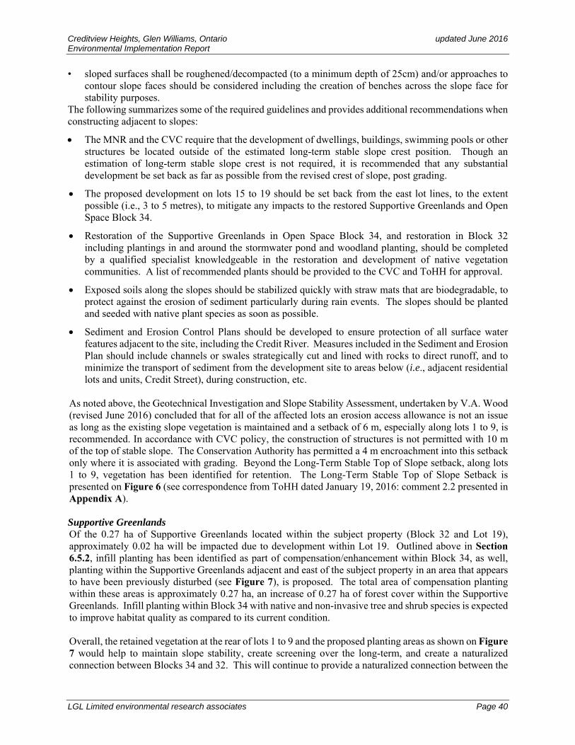
Creditview Heights, Glen Williams, Ontario updated June 2016 Environmental Implementation Report
LGL Limited environmental research associates Page 40
• sloped surfaces shall be roughened/decompacted (to a minimum depth of 25cm) and/or approaches to contour slope faces should be considered including the creation of benches across the slope face for stability purposes.
The following summarizes some of the required guidelines and provides additional recommendations when constructing adjacent to slopes:
The MNR and the CVC require that the development of dwellings, buildings, swimming pools or other structures be located outside of the estimated long-term stable slope crest position. Though an estimation of long-term stable slope crest is not required, it is recommended that any substantial development be set back as far as possible from the revised crest of slope, post grading.
The proposed development on lots 15 to 19 should be set back from the east lot lines, to the extent possible (i.e., 3 to 5 metres), to mitigate any impacts to the restored Supportive Greenlands and Open Space Block 34.
Restoration of the Supportive Greenlands in Open Space Block 34, and restoration in Block 32 including plantings in and around the stormwater pond and woodland planting, should be completed by a qualified specialist knowledgeable in the restoration and development of native vegetation communities. A list of recommended plants should be provided to the CVC and ToHH for approval.
Exposed soils along the slopes should be stabilized quickly with straw mats that are biodegradable, to protect against the erosion of sediment particularly during rain events. The slopes should be planted and seeded with native plant species as soon as possible.
Sediment and Erosion Control Plans should be developed to ensure protection of all surface water features adjacent to the site, including the Credit River. Measures included in the Sediment and Erosion Plan should include channels or swales strategically cut and lined with rocks to direct runoff, and to minimize the transport of sediment from the development site to areas below (i.e., adjacent residential lots and units, Credit Street), during construction, etc.
As noted above, the Geotechnical Investigation and Slope Stability Assessment, undertaken by V.A. Wood (revised June 2016) concluded that for all of the affected lots an erosion access allowance is not an issue as long as the existing slope vegetation is maintained and a setback of 6 m, especially along lots 1 to 9, is recommended. In accordance with CVC policy, the construction of structures is not permitted with 10 m of the top of stable slope. The Conservation Authority has permitted a 4 m encroachment into this setback only where it is associated with grading. Beyond the Long-Term Stable Top of Slope setback, along lots 1 to 9, vegetation has been identified for retention. The Long-Term Stable Top of Slope Setback is presented on Figure 6 (see correspondence from ToHH dated January 19, 2016: comment 2.2 presented in Appendix A). Supportive Greenlands Of the 0.27 ha of Supportive Greenlands located within the subject property (Block 32 and Lot 19), approximately 0.02 ha will be impacted due to development within Lot 19. Outlined above in Section 6.5.2, infill planting has been identified as part of compensation/enhancement within Block 34, as well, planting within the Supportive Greenlands adjacent and east of the subject property in an area that appears to have been previously disturbed (see Figure 7), is proposed. The total area of compensation planting within these areas is approximately 0.27 ha, an increase of 0.27 ha of forest cover within the Supportive Greenlands. Infill planting within Block 34 with native and non-invasive tree and shrub species is expected to improve habitat quality as compared to its current condition. Overall, the retained vegetation at the rear of lots 1 to 9 and the proposed planting areas as shown on Figure 7 would help to maintain slope stability, create screening over the long-term, and create a naturalized connection between Blocks 34 and 32. This will continue to provide a naturalized connection between the

Creditview Heights, Glen Williams, Ontario updated June 2016 Environmental Implementation Report
LGL Limited environmental research associates Page 41
Supportive Greenlands east of the study area to the Supportive and Core Greenlands identified north and outside of the subject property, west of Wildwood Road. The goal for the restoration of lands within the Supportive Greenlands and the proposed addition to Supportive Greenlands is to create good quality woodland/forest habitat. All plant species used will be native and non-invasive and plantings should be undertaken with live plantings of trees, shrubs, as well as seeding. Table 10 provides a list of plant species that should be considered for planting as part of the restoration of Supportive Greenlands. Plantings should be placed in an irregular pattern to provide a more naturalized appearance. Overall, plantings will provide soil and slope stability, promote infiltration, mitigate temperature through shading, provide visual screening/buffering, provide habitat for wildlife, and continue to provide the natural setting to which local residents have become accustomed. Site preparation, planting and maintenance for one to three years is important in the restoration process. Preliminary conditions at restoration sites may not be immediately conducive or support optimal plant establishment and growth. Poor quality plant stock and competition with non-native and aggressive plant species would negatively impact the successful restoration of the projected woodland/forest habitat that should be dominated by native, non-invasive species. Recommendations for planting plans, species, installation, dealing with aggressive and invasive plant species, etc., are outlined in Section 6.6 above.
6.9 RECHARGE An Area of Potentially Higher Recharge has been identified as one of the environmental features present within the study area (Figure 6). The GWSP (2005) acknowledges development may have an impact on recharge and to this end requires that a hydrogeological study be conducted to ensure groundwater resources will not be negatively impacted in terms of water quantity or quality. It is a priority that such a study be completed to understand and resolve any issues related to the quantity and quality of infiltration pre- and post-development as these issues relate both to potential impacts to the receiving body of water (Credit River) (see Section 6.1) and to the Draft Plan of Subdivision for the Creditview Heights site. The Hydrogeological Investigation carried out by V.A. Wood (updated June 2016) which reviewed groundwater features and functions and potential protection measures is available under separate cover.
6.10 GRADING Due to the topographic complexity of the subject property and the grading that will be required to accommodate the proposed plan of subdivision, a large proportion of the existing vegetation communities within the subject property will be removed. However, portions of forest and woodland communities along the west, northwest boundary of the property have been identified for retention. Similarly, vegetation within the Open Space Block 34, including most of the Support Greenlands are expected to remain intact. Tree protection fencing should be installed to protect existing vegetation during construction (see Figure 7, and the Tree Inventory and Preservation Plan updated June 2016, presented in Appendix E. Additional plantings have been proposed at the rear of lots 14 and 15 which will serve to provide stability over time. Planting of native and non-invasive tree, shrub and ground flora species should be undertaken immediately upon the completion of grading and construction for the purposes of slope stability, natural screening and wildlife habitat. Recommendations for planting plans, species, installation, dealing with aggressive and invasive plant species, etc., are outlined in Section 6.6 above.
6.11 POTENTIAL SHORT-TERM CONSTRUCTION-RELATED IMPACTS The main impacts to be addressed in this section include:
disturbances from construction traffic and activity (access roads, and stockpiling of materials);

Creditview Heights, Glen Williams, Ontario updated June 2016 Environmental Implementation Report
LGL Limited environmental research associates Page 42
impacts associated with the potential removal of additional vegetation and increased disturbance to vegetation; and
slope erosion.
6.11.1 General Disturbance of Vegetation Communities from Construction
Short-term impacts from construction may be associated with equipment operations.
Mitigation Natural features on adjacent property that require protection should be clearly identified (including
individual trees where applicable) and fenced (1 m outside of the drip line of trees) to ensure no construction traffic, or equipment or materials storage intrude on these areas;
stockpiling of soil should be done away from protected natural areas and silt fencing used to prevent sediment transport;
where possible fill removed in the process of grading on the subject property (i.e., cutting) should be used again on the property as fill where appropriate;
for those areas designated for development, soil disturbance and disturbance of the existing vegetation on site should be limited to those areas requiring grading or excavation;
development limits should be fenced with page wire fencing to delineate areas for protection and non-disturbance. Filter cloth should also be placed on the development side of the fencing, toe-in with earth; and
disturbed soils should be stabilized to prevent water and wind erosion.
6.11.2 Erosion and Siltation
Siltation of nearby watercourses and natural vegetation arising from soil erosion of exposed soils can occur if appropriate sediment control is not undertaken. An approved sediment control plan should be in place prior to the start of construction. The proposed erosion control measures should be implemented prior to the commencement of construction activities, they should be inspected regularly (more frequently prior to periods of rainfall), and they should be repaired or replaced where damaged by construction activities or where they have become ineffective due to silt build-up.
Mitigation Development should follow an approved erosion and sediment plan;
prior to commencement of any construction activities (area grading, road construction, vegetation removal, etc.), appropriate temporary, followed by permanent stormwater management facilities should be installed to mitigate sedimentation from surface water runoff;
perimeter silt fencing of a size and type capable of containing runoff should be installed down slope of all construction areas to retard and filter surface water runoff;
silt fences should be installed in locations where steep slopes occur to ensure that sediment does not enter adjacent habitat;
the timing of construction should avoid periods of high rainfall in the spring and fall;
exposed soils should be re-vegetated as soon as possible and re-vegetation should be completed prior to the onset of winter;
site drainage should be designed to prevent direct concentrated or channelized surface runoff from flowing directly over slopes;
the slopes should not be steepened;
fill materials that could potentially need to be stored for any length of time should not be placed on the slope or within 5 m of the slope crest.

Creditview Heights, Glen Williams, Ontario updated June 2016 Environmental Implementation Report
LGL Limited environmental research associates Page 43
6.11.3 Soil and Water Contamination
Soil and water contamination can arise from fuel storage or re-fuelling of vehicles on site.
Mitigation Fuel storage on site should only use approved (preferably double-wall containment) fuel storage tanks;
vehicle re-fuelling should be carried out using appropriate precautions to prevent spillage and in designated refuelling zones; and,
Spill kits should be on-site and located at the refuelling zones.
6.12 POTENTIAL LONG-TERM IMPACTS
6.12.1 Damage to Natural Areas due to Unregulated Human Use
With more people living in close proximity to natural areas like the Supportive Greenlands, there is the potential for additional impacts associated with unregulated use. This can result from such activities as informal trails, the construction of forts or other structures for play, encroachment of lawns, sheds, gardens from neighbouring lots, dumping of unwanted grass clippings, leaves, soil, etc. by local residents, and removal of plants from natural areas (e.g., Supportive Greenlands).
Local residents will ultimately become the stewards for the natural areas within the Creditview Heights subdivision. In order for them to act responsibly there is a need to inform them about the kinds of natural areas present and their sensitivities. A “Welcoming Letter” or pamphlet could be provided to new residents with information about the natural areas present and the role local residents can play in protecting these areas. Mitigation Where possible, living fences consisting of planted native trees and/or shrubs should be installed along
the edges of lots adjacent to the Supportive Greenlands and Open Space Block 34 to demark the boundary between the private lots and the restored natural habitat, as well as to deter dumping and the expansion of rear lots in this area; and
the public should be educated about the natural areas present and their sensitivities (i.e., valley slopes and the possibility of erosion or plant loss due to trampling, etc.).
6.12.2 Invasive Non-native Plants and Animals
Non-native invasive plants and animals can establish in natural areas displacing native species. Efforts to control non-native species that have become established, as well as prevent the establishment of new non-native plants and animals are important to maintain the health and diversity of natural ecological systems.
Mitigation Restore disturbed areas to native vegetation communities, such as marsh, thicket and woodland using
appropriate native species of local stock;
do not use invasive, non-native ornamentals plants for landscaping (e.g. Scots Pine, Norway maple, purple loosestrife, Japanese knotweed, Japanese honeysuckle, etc.);
do not allow cats and dogs to roam freely within natural areas; and
signage or pamphlets regarding stewardship programs could be provided to inform local residents about non-native invasive species and to promote stewardship programs to control/remove invasive, non-native species within natural areas.
Creditview Heights, Glen Williams, Ontario updated June 2016 Environmental Implementation Report
LGL Limited environmental research associates Page 44
6.13.3 Impacts on Water Quality
The proposed Creditview Heights development has the potential for local impacts on the Credit River due to reduced infiltration of water in to the ground and changes in the amount, quality and timing of sub-surface water flows to the Credit River (Dillon 2003). Mitigation measures outlined in the Hydrogeological Investigation (V.A. Wood updated 2010) should be carried
out to the full extent;
best management practices be utilized to ensure the maintenance of both water quality and quantity as a part of the stormwater management facilities proposed;
residents should avoid using chemicals (e.g. pesticides, herbicides, cleaning products, etc.) that may contaminate surface water and no deleterious substances (e.g. paint, oil, soapy water, etc.) should be dumped into storm sewers.
7.0 LINKAGES An important character to the Hamlet of Glen Williams is the existence of linkages that connect natural areas and residents throughout the Hamlet. The intent is to provide residents with access to areas by foot or by bicycle, as well as provide residents with a link to the natural environment.
7.1 TRAILS AND ON-ROAD LINKAGES The Hamlet of Glen Williams has begun to develop a public trail system throughout the area. The purpose is to provide linkages that can be accessed throughout the Hamlet. This is an important element of the Hamlet character and promotes the creation of an extensive network of public pathways intended to link new and existing residential areas with the community core, and provides a complement to the Halton Hills Trails and Cycling Master Plan (GWSP 2005). Conceptual alignments for potential new trails are shown on Schedule A (Figure 4). To the south of the subject property is the former Canadian National Railway line that now serves as a trail linking communities to the west and east. As a part of the proposed development two walkways are proposed, one that links the proposed development to the Rail Trail (between lots 27 and 28), and a second walkway adjacent to lot 19 that will link the proposed development to communities to the north, through the Open Space Block and along the walkway to the proposed Gamble Street extension (Figure 6). Where the trail is exposed, native and non-invasive plantings are recommended for screening to buffer views to residences that back onto the trail.
8.0 MONITORING
8.1 SHORT-TERM (CONSTRUCTION) MONITORING Regular inspection and monitoring of environmental protection measures identified in this report are recommended. Construction activities should be monitored to ensure that there are no impacts to environmental features adjacent to the study site, and special attention should be paid when there are periods of unusually high rainfall or rapid snowmelt. When serious environmental impacts are discovered there should be immediate notification to the following persons to remedy the problem: the contractor responsible for activities on the site, the developer for the site, and the appropriate contacts at the ToHH and the CVC. The recommended monitoring tasks may include:
1. In consultation with contractors identify in the field the location of areas for protection and ensure the installation of appropriate fencing for the protection of these areas.

Creditview Heights, Glen Williams, Ontario updated June 2016 Environmental Implementation Report
LGL Limited environmental research associates Page 45
2. Verify the placement and construction of sediment and erosion control measures as identified in sediment and erosion control plans.
3. Site inspections should consider the need to vegetate areas of exposed soil that may be prone to wind and/or water erosion.
4. Undertake regular site inspections to monitor the efficacy of all erosion and sediment control measures.
5. Monitoring to ensure the appropriate de-watering and erosion control measures are taken to avoid impacts to water quality within the Credit River. Additional erosion control mats may be needed to mitigate impacts associated with unforeseen circumstances that may arise when soils are exposed and rainfall events occur.
6. Site inspections should be conducted to monitor for any toxic spills. Particular attention should be given to the maintenance practices for construction equipment, diesel and gasoline filling tanks/pumps (if present on site) and any other toxic materials that may be brought on site as a part of site development.
7. Verify that all construction activities, including the movement of heavy equipment, parking of vehicles and placement of construction materials takes place outside of designated protection zones.
8. Large garbage containers used on site should have covers to minimize the amount of garbage blown around both on and off the site, during the construction of homes. Verify that garbage is disposed of responsibly on site, and garbage carried off by the wind should be collected and disposed of properly. This is an ongoing issue at many construction sites, and should be carefully monitored.
9. Verify the completion of planting plans for the SWM facility.
10. Verify the completion of planting plans within the Supportive Greenlands.
8.2 LONG-TERM MONITORING The environment is dynamic and changes will occur over time. Due to the change in surrounding land use some changes in the environment may be considered negative and appropriate steps may be taken to prevent further impact and/or reverse the existing change. Some of the long-term monitoring required to ensure the health of protected open space include the following:
inspection of SWM facilities to determine their continued functioning as intended, to look for erosion at outlets and to determine the need to remove accumulated silt;
summer field survey of valley slopes for excessive erosion that may be prevented through remedial actions such as additional planting to stabilize soils;
field surveys may look for invasive species requiring removal;
restoration areas may be examined to determine if follow up stewardship measures are required; and
the boundary of natural areas may be surveyed to look for encroachment or illegal dumping.
The CVC has a long-term environmental monitoring program that examines ecological integrity at landscape, community and species scales. CVC should be contacted to determine what appropriate long-term monitoring protocols would complement existing monitoring in the Credit River watershed that could be implemented within the Creditview Heights community.

Creditview Heights, Glen Williams, Ontario updated June 2016 Environmental Implementation Report
LGL Limited environmental research associates Page 46
9.0 CONCLUSION AND RECOMMENDATIONS Development within Credit River Subwatershed requires careful planning to minimize the overall impact to the immediate and surrounding natural areas. The retention of existing vegetation, the protection and restoration of Supportive Greenlands, plantings along sloped areas, and the additional compensation plantings identified in this report, are based on objectives to maintain and improve the essential natural features and their ecological functions that currently exist on the subject property. These include:
forest targets of 30% within the Glen Williams Planning Area;
protecting and re-vegetating headwater areas with limited development;
rehabilitation and stabilization of sloped areas;
planting and maintenance for one to three years of functioning, self-sustaining wetland/woodland planting areas associated with the Stormwater Management Facility (Block 32); and
the creation and maintenance for one to three years of woodland/forest within Supportive Greenlands that increases the extent of Supportive Greenlands within the subject lands, and continues the connection of Greenlands within the Hamlet of Glen Williams.
The proposed Subdivision plan for Creditview Heights addresses these protection issues while also accommodating an area of development. This study has identified the following environmental features and recommended protection measures as follows: 1. To meet the requirements of the MBCA, no vegetation removals should occur during the nesting season
which includes the period from April 1 to July 31. If vegetation clearing is required during this period, a bird nest survey should be carried out by a qualified avian biologist prior to construction. If active nests are found, a site-specific mitigation plan should be prepared in consultation with the Canadian Wildlife Service.
2. There is no fish habitat on the study site. Issues related to the potential changes to recharge and discharge as a result of the proposed development are expected to influence fish habitat within the Credit River. However, an enhanced level of stormwater control, Level 1 or Enhanced Protection, will be implemented in the Stormwater Management facility to mitigate water quality control of water stored, and subsequently discharged from the stormwater pond. This level of protection is in accordance with Table 3.2 of the Storm Water Planning and Design Manual, March 2003 (Condeland Engineering updated June 2016).
3. The treatment of stormwater produced by the proposed development should be provided at an enhanced level to protect the receiving watercourse (Credit River) from impacts related to water quantity and quality, and where possible on-site infiltration should be encouraged.
4. Several treed communities and a small wetland will be impacted as a result of the proposed development. Grading throughout the subject property has been minimized to protect portions of forest and woodland habitat along the western boundary of the site, and includes approximately 1.36 ha of forest and woodland. The Tree Inventory and Preservation Plan identifies a Tree Protection Zone (see Figure 6 and Appendix E: Figure 1) that will be installed in the field to protect retained vegetation on-site during construction. The removal of treed and wetland communities includes the removal 3.62 ha. As part of mitigation for the removal of these communities, it is proposed that planting be undertaken to the extent possible within the subject property. The areas identified for planting on the subject property include approximately 0.63 ha of land, as follows:

Creditview Heights, Glen Williams, Ontario updated June 2016 Environmental Implementation Report
LGL Limited environmental research associates Page 47
within and around the stormwater pond (Block 32); along the sloped area at the rear of lots 14 and 15; along the sloped areas along the rear of lots 20 to 24, lots 30 and 31 (backing onto the existing
pedestrian trail); and Block 33 and any disturbed areas adjacent to the emergency exit.
A compensation assessment was also carried out based on compensating at 1:1 for early successional habitat and 2:1 for native woodlands and wetlands. As a result, an additional 4.74 ha of planting would be required to compensate for the loss of treed and marsh communities. A total of 0.27 ha this compensation planting will be carried out within the Open Space Block 34 which includes a portion of Supportive Greenlands, as well as an area adjacent and east of this block. Discussions with CVC and the ToHH staff is recommended to identify suitable habitat on public lands where planting of the remaining 4.47 ha can be carried out. Where such lands cannot be identified, payment in lieu of planting should be discussed.
5. The small (0.17 ha) Forb Mineral Meadow Marsh (MAM2-10) will be removed as a result of the
proposed development. No standing water was evident on the subject property, however, groundwater seepage within this marsh was evident, and thus, the marsh acts as both a seasonal discharge and recharge zone. The area in which the wetland occurs on the subject property is within Block 32 which is the designated location for the proposed SWM facility. Detailed stormwater management quantity and quality control features are presented in the Functional Servicing Report available under separate cover (Condeland Engineering updated June 2016). It is expected that the seepage will be maintained and the seepage will be conveyed to the permanent stormwater pool. Wetland plantings, including emergent macrophytes, and possibly submerged and floating-leaved macrophytes will be incorporated within the SWM facility. Plantings along the berm or sloped area around the pond are also proposed.
6. The proposed Creditview Heights development includes several lots to be created adjacent to the crest of slopes along the north and northeast or eastern boundaries of the subject property. Slope analyses were undertaken resulting with a Factor of Safety of 1.5, which is considered adequate for long-term stability (V.A. Wood revised June 2016). All of the lots adjacent to slopes (1 to 19) do not require an erosion access as long as the existing slope vegetation is maintained. For several lots adjacent to slopes, the Long-Term-Stable Top-of-Slope (LTSTOS) is located slightly inside the lot lines. Where this occurs, a construction setback of 6 m from the LTSTOS is generally satisfactory (V.A. Wood revised June 2016). Due to the significant on-site re-grading necessary throughout the subject property, vegetated slopes will be affected to some extent. A construction setback of 6 m is likely required for all lots adjacent to sloped areas; and where vegetation from sloped areas is impacted, re-vegetation should be carried out as soon as possible post grading. The Long Term Stable Top of Slope and its Setback (10 m) are presented on Figure 6, and beyond or west of the Setback, existing vegetation will be retained (see Figure 7).
7. Two locally rare plant species have been located on-site including 3 white spruce seedlings and 2 American mountain-ash that can be transplanted (1 to 2 cm DBH). These seedlings should be removed prior to construction and be used as part of planting within the Supportive Greenlands associated with the subject property.
8. In 2008, wildlife surveys identified Eastern Wood-pewee. At that time, Eastern Wood-pewee populations were identified as common, widespread, and abundant in Ontario (S5). This species is now listed as Special Concern under the ESA 2007, but is not regulated. Given the type of habitat present on the subject property, it is reasonable to assume that Eastern Wood-pewee would use the subject property for breeding/nesting purposes and as such, Candidate Significant Wildlife Habitat would be present on the subject property. Mitigation for the removal of the Eastern Wood-pewee habitat will be provided on both a short-term and long-term basis. In the short-term, construction activities such as clearing and grubbing will be restricted to outside of the breeding bird season (May 25-July 10). If

Creditview Heights, Glen Williams, Ontario updated June 2016 Environmental Implementation Report
LGL Limited environmental research associates Page 48
works are proposed during this period, a nest survey should be conducted prior to the commencement of tree removal to ensure no established nests will be disturbed. In addition, areas identified where existing treed habitat can be retained, along with the recommended tree/shrub planting areas on the subject property, will likely continue to provide stop-over habitat for the birds during migration, when foraging, potential for nesting or when moving between habitat. There are several existing treed natural areas within 250 m to 1 km around the study area that also provide suitable foraging and nesting habitat for Eastern Wood-pewee.
9. Of the 0.25 ha of Supportive Greenlands located within the subject property, approximately 0.02 ha will be impacted due to development within Lot 19. Infill planting has been identified as part of compensation/enhancement within Block 34 (~0.02 ha), as well, planting within the Supportive Greenlands adjacent and east of the subject property in an area that appears to have been previously disturbed (see Figure 7), is proposed. This additional planting area would increase forest cover within the Supportive Greenlands by approximately 0.25 ha. Infill planting within Block 34 including within the Supportive Greenlands portion, with native and non-invasive tree and shrub species is expected to improve habitat quality as compared to its current condition.
Overall, the retained vegetation at the rear of lots 1 to 9, along the northern limit of Block 32 and within the Open Space Block 34, as well as the proposed planting areas as shown on Figure 7, would improve slope stability, create screening over the long-term, and create a naturalized connection between Blocks 34 and 32. This will continue to provide a naturalized connection between the Supportive Greenlands east of the study area to the Supportive and Core Greenlands identified north and west of Wildwood Road. This will help to create a continuum of natural habitat that will provide real value for wildlife and the local residents. Collectively, the proposed restoration of natural habitat within the Creditview Heights development is expected to provide an overall net-benefit to the existing Supportive Greenlands system within the Hamlet of Glen Williams, and within the ToHH.
10. An important characteristic of the Hamlet of Glen Williams is the development of an extensive trail system throughout the Hamlet. This system will provide linkages that can be accessed by foot or bicycle, and links new and existing residential areas with the community core. Two walkways within the proposed development will help to link the site to the existing trail to the south, as well as to communities to the north.

Creditview Heights, Glen Williams, Ontario updated June 2016 Environmental Implementation Report
LGL Limited environmental research associates Page 49
10.0 REFERENCES Chapman, L.J. and D.F. Putnam. 1984. The Physiography of Southern Ontario; Ontario Geological Survey,
Special Volume 2, 270 p. Accompanied by Map P.2715 (coloured), scale 1:600 000.
Condeland Engineering Ltd. Updated June 2016. Functional Servicing Report for Proposed Low Density Residential Development by Eden Oak located at Glen Williams Area, Credit Street South, Ann Street North, Town of Halton Hills (Georgetown).
Credit Valley Conservation Authority. 2010. Appendix B: Landscape Design Guide for Low Impact Development.
Credit Valley Conservation Authority. 1996. Watercourse & Valleyland Protection Policies.
Dillon Consulting. 2003. Glen Williams Integrated Planning Project Scoped Subwatershed Plan for the Town of Halton Hills.
Karrow, P.F. 1987. Quaternary Geology of the Brampton Area, Western Half, Southern Ontario. Ontario Geological Survey, Map P. 3072, Geological Series (1:50,000).
Kuntz Forestry Consulting Inc. 2008. Tree Inventory and Preservation Plan, Eden Oak, Glen Williams, Town of Halton Hills.
Ministry of Municipal Affairs and Housing. 2005. Greenbelt Plan.
Ministry of Municipal Affairs and Housing. 2005. Provincial Policy Statement.
Ontario Ministry of Natural Resources. 2000. OMNR Wildlife Technical Guide
Regional Municipality of Halton, The. 2006. The Regional Plan: Official Plan for the Halton Planning Area.
Stoneman, C. and M. L. Jones. 1996. A simple method to classify stream thermal status with single observations of daily maximum water and air temperature. North American Journal of Fisheries Management: 16:728- 737.
Town of Halton Hills. 2008. The Town of Halton Hills Official Plan.
Town of Halton Hills, 2006. The Hamlet of Glen Williams Secondary Plan. Official Plan Amendment No. 113.
V.A. Wood Associates Limited. Updated June 2016. Hydrogeological Investigation Proposed Subdivision Part of Lot 20, Concession 9, Town of Halton Hills, Ontario.
V.A. Wood. Revised June 2016. Geotechnical Investigation and Slope Stability Assessment Proposed Subdivision Part of Lot 20, Concession 9, Town of Halton Hills, Ontario.
Varga, S., D. Leadbeater, J. Webber, J. Kaiser, B. Crins, J. Kamstra, D. Banville, E. Ashley, G. Miller, C. Kingsley, C. Jacobsen, D. Mewa, L. Tebby, E. Mosley, E. Zajc. 2000. Distribution and Status of the Vascular Plants of the Greater Toronto Area.

LGL Limited environmental research associates
APPENDIX A: CORRESPONDENCE FROM THE TOWN OF HALTON HILLS AND
FROM THE CREDIT VALLEY CONSERVATION AUTHORITY


LGL Limited environmental research associates
APPENDIX B: CVC LETTER


LGL Limited environmental research associates
APPENDIX C: VASCULAR PLANT LIST

LGL Limited environmental research associates
Appendix C. Vascular Plant List
Scientific Name Common Name
S R
ank
Hal
ton
CV
C
MA
M2-
10
FO
D3-
1
FO
D4
FO
D5-
1
FO
D5-
7
FO
D5-
8
CU
M1-
1
CU
W1/
C
UT
1-1
CU
W1
Aulacomniaceae Moss
Aulacomnium acuminatum (Lindb. & Arnell) Kindb.
(none) No No x
Equisetaceae Horsetail
Equisetum arvense L. Field Horsetail S5 No No x x x
Equisetum hyemale L. ssp. affine (Engelm.) Calder & Roy
Scouring-rush S5 No No x
Dryopteridaceae Wood Fern
Dryopteris carthusiana (Vill.) H.P. Fuchs
Spinulose Wood Fern S5 No No x
Matteuccia struthiopteris (L.) Tod. var. pensylvanica (Willd.) C.V. Morton
Ostrich Fern S5 No No x
Onoclea sensibilis L. Sensitive Fern S5 No No x x
Pinaceae Pine
* Picea abies (L.) Karsten Norway Spruce SE3 No No x
Picea glauca (Moench) Voss White Spruce S5 No Yes x x
Pinus strobus L. White Pine S5 No No x x x x x
* Pinus sylvestris L. Scotch Pine SE5 No No x x
Tsuga canadensis (L.) Carrière Eastern Hemlock S5 No No x
Cupressaceae Cedar
Juniperus communis L. Ground Juniper S5 No No x
Thuja occidentalis L. Eastern White Cedar S5 No No x x x
Aristolochiaceae Duchman's-pipe
Asarum canadense L. Wild Ginger S5 No No x x
Ranunculaceae Crowfoot or Buttercup
Actaea rubra (Aiton) Willd. Red Baneberry S5 No No x
Anemone virginiana L. Virginia Anemone S5 No No x x x

LGL Limited environmental research associates
Scientific Name Common Name
S R
ank
Hal
ton
CV
C
MA
M2-
10
FO
D3-
1
FO
D4
FO
D5-
1
FO
D5-
7
FO
D5-
8
CU
M1-
1
CU
W1/
C
UT
1-1
CU
W1
* Ranunculus acris L. Tall Butter-cup SE5 No No x x x
Berberidaceae Barberry
Podophyllum peltatum L. May Apple S5 No No x
Papaveraceae Poppy
* Chelidonium majus L. Celandine SE5 No No x
Sanguinaria canadensis L. Bloodroot S5 No No x x
Juglandaceae Walnut
Juglans nigra L. Black Walnut S4 No No x x x x x x
Fagaceae Beech
Fagus grandifolia Ehrh. American Beech S5 No No x
Quercus rubra L. Red Oak S5 No No x x x
Caryophyllaceae Pink
* Dianthus armeria L. Deptford-pink SE5 No No x
Polygonaceae Smartweed or Buckwheat
Rumex orbiculatus A. Gray Water Dock S4S5 Yes Yes x
Guttiferae St. John's-wort
* Hypericum perforatum L. Common St. John's-wort SE5 No No x x x x
Tiliaceae Linden
Tilia americana L. American Basswood S5 No No x
Cucurbitaceae Gourd
Echinocystis lobata (Michx.) Torr. & A. Gray
Wild Cucumber S5 No No x x x
Salicaceae Willow
Populus balsamifera L. ssp. balsamifera Balsam Poplar S5 No No x
Populus tremuloides Michx. Trembling Aspen S5 No No x x x x x
* Salix alba L. White Willow SE4 No No x
Brassicaceae Mustard
* Alliaria petiolata (M. Bieb.) Cavara & Grande
Garlic Mustard SE5 No No x x x x x x x

LGL Limited environmental research associates
Scientific Name Common Name
S R
ank
Hal
ton
CV
C
MA
M2-
10
FO
D3-
1
FO
D4
FO
D5-
1
FO
D5-
7
FO
D5-
8
CU
M1-
1
CU
W1/
C
UT
1-1
CU
W1
* Barbarea vulgaris R. Br. Yellow Rocket SE5 No No x
* Hesperis matronalis L. Dame's Rocket SE5 No No x x
Grossulariaceae Gooseberry or Currant
Ribes americanum Miller Wild Black Currant S5 No No x x
* Ribes rubrum L. Northern Red Currant SE5 No No x
Rosaceae Rose
Agrimonia gryposepala Wallr. Tall Hairy Groovebur S5 No No x
Amelanchier sp. Serviceberry S? ? ? x
Crataegus sp. Hawthorn S? ? ? x x
Fragaria virginiana Miller ssp. glauca (S. Watson) Staudt
Strawberry S5 No No x x x x
Geum aleppicum Jacq. Yellow Avens S5 No No x x x x x
Geum macrophyllum Willd. Large-leaved Avens S5 No No x x x x
* Malus pumila Miller Common Crabapple SE5 No No x x x x x x x
* Potentilla recta L. Sulphur Cinquefoil SE5 No No x x x
Prunus serotina Ehrh. Black Cherry S5 No No x x x x
Prunus virginiana L. Choke Cherry S5 No No x x x
Rosa blanda Aiton Smooth Rose S5 No No x
* Rosa multiflora Thunb. ex Murray Multiflora Rose SE4 No No x x
Rubus allegheniensis Porter Allegheny Blackberry S5 No No x
* Rubus idaeus L. ssp. idaeus Red Raspberry SE1 No No x x x x x x
Rubus idaeus L. ssp. melanolasius (Dieck) Focke
Red Raspberry S5 No No x
Rubus occidentalis L. Black Raspberry S5 No No x x
Sorbus americana Marshall American Mountain-ash S5 No Yes x x
Fabaceae Pea or Pulse
* Coronilla varia L. Crown-vetch SE5 No No x x
* Medicago lupulina L. Black Medic SE5 No No x
* Melilotus alba Medik. White Sweet Clover SE5 No No x x

LGL Limited environmental research associates
Scientific Name Common Name
S R
ank
Hal
ton
CV
C
MA
M2-
10
FO
D3-
1
FO
D4
FO
D5-
1
FO
D5-
7
FO
D5-
8
CU
M1-
1
CU
W1/
C
UT
1-1
CU
W1
* Trifolium pratense L. Red Clover SE5 No No x x x
* Trifolium repens L. White Clover SE5 No No x
* Vicia cracca L. Tufted Vetch SE5 No No x x
Elaeagnaceae Oleaster
* Elaeagnus angustifolia L. Russian Olive SE3 No No x
Onagraceae Evening-primrose
Circaea lutetiana L. ssp. canadensis (L.) Aschers. & Magnusson
Enchanter's Nightshade S5 No No x
* Epilobium hirsutum L. Great-hairy Willow-herb SE5 No No x
Cornaceae Dogwood
Cornus alternifolia L. f. Alternate-leaf Dogwood S5 No No x x x x
Cornus foemina Miller ssp. racemosa (Lam.) J.S. Wilson
Grey Dogwood S5 No No x
Cornus sericea L.. Red-osier Dogwood S5 No No x x x x x
Rhamnaceae Buckthorn
* Rhamnus cathartica L. European Buckthorn SE5 No No x x x x x x x x
Vitaceae Grape or Vine
Parthenocissus vitacea Thicket creeper S5 No No x
Vitis riparia Michx. Riverbank Grape S5 No No x x x x x x
Aceraceae Maple
Acer negundo L. Manitoba Maple S5 No No x x x x x
* Acer platanoides L. Norway Maple SE5 No No x x
Acer saccharum Marshall ssp. saccharum
Sugar Maple S5 No No x x x x x x
Anacardiaceae Sumac or Cashew
Rhus hirta (L.) Sudw. Staghorn Sumac S5 No No x x x x x
Oxalidaceae Wood Sorrel
Oxalis stricta L. Upright Yellow Wood-sorrel S5 No No x
Geraniaceae Geranium

LGL Limited environmental research associates
Scientific Name Common Name
S R
ank
Hal
ton
CV
C
MA
M2-
10
FO
D3-
1
FO
D4
FO
D5-
1
FO
D5-
7
FO
D5-
8
CU
M1-
1
CU
W1/
C
UT
1-1
CU
W1
Geranium maculatum L. Wild Crane's-bill S5 No No x x
Balsaminaceae Touch-me-not or Jewel-weed
Impatiens capensis Meerb. Spotted Jewel-weed S5 No No x x
Apiaceae Carrot or Parsley
* Daucus carota L. Wild Carrot SE5 No No x x x x
Apocynaceae Dogbane
Apocynum androsaemifolium L. Spreading Dogbane S5 No No x
* Vinca minor L. Periwinkle SE5 No No x x
Asclepiadaceae Milkweed
Asclepias syriaca L. Common Milkweed S5 No No x
Solanaceae Potato or Nightshade
* Solanum dulcamara L. Climbing Nightshade SE5 No No x x
Hydrophyllaceae Water-leaf
Hydrophyllum virginianum L. Virginia Waterleaf S5 No No x x x x
Boraginaceae Borage
* Echium vulgare L. Common Viper's-bugloss SE5 No No x
* Myosotis scorpioides L. True Forget-me-not SE5 No No x
Verbenaceae Vervain
Verbena hastata L. Blue Vervain S5 No No x
Lamiaceae Mint
* Ajuga reptans L. Carpet-bugel SE2 No No x
Mentha arvensis L. Field Mint S5 No No x
Prunella vulgaris L. ssp. lanceolata (W.C. Barton) Hultén
Heal-all S5 No No x
* Satureja hortensis L. Summer Savory SE2 No No x
Plantaginaceae Plantain
* Plantago lanceolata L. English Plantain SE5 No No x
* Plantago major L. Nipple-seed Plantain SE5 No No x x
Plantago rugelii Decne. Black-seed Plantain S5 No No x

LGL Limited environmental research associates
Scientific Name Common Name
S R
ank
Hal
ton
CV
C
MA
M2-
10
FO
D3-
1
FO
D4
FO
D5-
1
FO
D5-
7
FO
D5-
8
CU
M1-
1
CU
W1/
C
UT
1-1
CU
W1
Oleaceae Olive
Fraxinus americana L. White Ash S5 No No x
Fraxinus pennsylvanica Marshall Green Ash S5 No No x x x x x x
* Syringa vulgaris L. Lilac SE5 No No x
Scrophulariaceae Figwort
* Linaria vulgaris Miller Butter-and-eggs SE5 No No x x x
* Verbascum thapsus L. Great Mullein SE5 No No x x
Campanulaceae Bluebell or Bellflower
Campanula rotundifolia L. American Harebell S5 Yes Yes x
Caprifoliaceae Honeysuckle
* Lonicera tatarica L. Tartarian Honeysuckle SE5 No No x x x x
Viburnum acerifolium L. Maple-leaved Viburnum S5 No No x
* Viburnum lantana L. Wayfaring Tree SE2 No No x
Viburnum trilobum Marshall Highbush Cranberry S5 No No x x x x
Asteraceae Composite or Aster
* Achillea millefolium L. Common Yarrow SE No No x
Antennaria neglecta Greene Field Pussy-toes S5 No No x
* Arctium minus (Hill) Bernh. Common Burdock SE5 No No x x
* Bidens aristosa (Michx.) Britton Tickseed Beggar-ticks SE1 No No x
* Carduus nutans L. ssp. leiophyllus (Petrovic) Stoy. & Stef.
Nodding Thistle SE5 No No x
* Chrysanthemum leucanthemum L. Oxeye Daisy SE5 No No x
* Cichorium intybus L. Chicory SE5 No No x
* Cirsium arvense (L.) Scop. Canada Thistle SE5 No No x x x
Cirsium sp. Thistle S? ? ? x
Erigeron annuus (L.) Pers. White-top Fleabane S5 No No x x
Eupatorium maculatum L. ssp. maculatum
Spotted Joe-pye-weed S5 No No x x
Euthamia graminifolia (L.) Nutt. Flat-top Fragrant-golden-rod S5 No No x x

LGL Limited environmental research associates
Scientific Name Common Name
S R
ank
Hal
ton
CV
C
MA
M2-
10
FO
D3-
1
FO
D4
FO
D5-
1
FO
D5-
7
FO
D5-
8
CU
M1-
1
CU
W1/
C
UT
1-1
CU
W1
* Hieracium caespitosum Dumort. ssp. caespitosum
Yellow Hawkweed SE5 No No x
Hieracium sp. Hawkweed S? ? ? x
* Inula helenium L. Elecampane SE5 No No x x x
Rudbeckia hirta L. Black-eyed Susan S5 No No x
Solidago altissima L. var. altissima Tall Goldenrod S5 No No x x
Solidago canadensis Canada Goldenrod S5 x x x x x x x x
Solidago flexicaulis L. Broad-leaved Goldenrod S5 No No x x
Solidago rugosa Aiton Rough Goldenrod S5 No No x
Symphyotrichum cordifolium (L.) Nesom
Heart-leaved Aster S5 No No x x x
Symphyotrichum lanceolatum Panicled Aster S5 x x x x
Symphyotrichum lateriflorum Starved Aster S5 x x
Symphyotrichum novae-angliae (L.) Nesom
New England Aster S5 No No x x x x x
Symphyotrichum puniceum (L.) Love & Love
Purple-stemmed Aster S5 No No x
Symphyotrichum urophyllum (Lindl. in DC.) Nesom
Arrow-leaved Aster S4 Yes Yes x
* Taraxacum officinale G. Weber Common Dandelion SE5 No No x
* Tragopogon pratensis L. ssp. pratensis Meadow Goat's-beard SE5 No No x
Juncaceae Rush
Juncus effusus L. ssp. solutus (Fern. & Wiegand) Hämet-Ahti
Soft Rush S5? No No x
Cyperaceae Sedge
Carex bebbii (L.H. Bailey) Olney ex Fern.
Bebb's Sedge S5 No No x
Carex pensylvanica Lam. Pennsylvania Sedge S5 No No x
Carex scoparia Schkuhr ex Willd. Pointed Broom Sedge S5 Yes Yes x
Carex stipata Muhlenb. ex Willd. Stalk-grain Sedge S5 No No x
Carex vesicaria L. Inflated Sedge S5 Yes Yes x

LGL Limited environmental research associates
Scientific Name Common Name
S R
ank
Hal
ton
CV
C
MA
M2-
10
FO
D3-
1
FO
D4
FO
D5-
1
FO
D5-
7
FO
D5-
8
CU
M1-
1
CU
W1/
C
UT
1-1
CU
W1
Carex vulpinoidea Michx. Fox Sedge S5 No No x
Eleocharis erythropoda Steud. Red-stemmed Spike-rush S5 No No x
Poaceae Grass
Agrostis stolonifera L. Spreading Bentgrass S5 No No x
* Bromus inermis Leyss. ssp. inermis Smooth Brome SE5 No No x x x x
* Bromus tectorum L. Cheat Grass SE5 No No x
* Dactylis glomerata L. Orchard Grass SE5 No No x x x x x
* Elymus repens (L.) Gould Quack Grass SE5 No No x x
Glyceria grandis S. Watson American Manna-grass S4S5 No No x
Phalaris arundinacea L. Reed Canary Grass S5 No No x
* Phleum pratense L. Meadow Timothy SE5 No No x x
Poa pratensis L. ssp. pratensis Kentucky Bluegrass S5 No No x x
Typhaceae Cat-tail
* Typha angustifolia L. Narrow-leaved Cattail SE5 No No x
Typha latifolia L. Broad-leaf Cattail S5 No No x
Liliaceae Lily
* Asparagus officinalis L. Asparagus SE5 No No x
Erythronium americanum Ker Gawl. Yellow Trout Lily S5 No No x x
* Hemerocallis lilioasphodelus L. Yellow Daylily SE4 No No x
* Tulipa sylvestris L. ssp. sylvestris Wild Tulip SE1 No No x
Smilacaceae Catbrier or Smilax
Smilax lasioneura Hook. Herbaceous Greenbrier S4 Yes No x
* Denotes non-native plant species / x = plant presence

LGL Limited environmental research associates
APPENDIX D: ACRONYMS AND DEFINITIONS USED IN SPECIES LISTS

LGL Limited environmental research associates
APPENDIX D. ACRONYMS AND DEFINITIONS USED IN SPECIES LISTS
The following rarity ranks were obtained from the Natural Heritage Information Centre (NHIC 2006) and CVC Natural Heritage information.
Legend * Introduced Species x Present FQI Floristic Quality Index FQI CC Coefficient of conservatism (Mean Coefficient of Conservatism). Floristic Quality Assessment
System for Southern Ontario. 1995. Oldham et al.
Species Rank
SRANK Provincial Rank
Provincial (or Sub-national) ranks are used by the Ontario Ministry of Natural Resources Natural Heritage Information Centre (NHIC) to set protection priorities for rare species and natural communities. These ranks are not legal designations. Provincial ranks are assigned in a manner similar to that described for global ranks, but consider only those factors within the political boundaries of Ontario. By comparing the global and provincial ranks, the status, rarity, and the urgency of conservation needs can be ascertained. The NHIC evaluates provincial ranks on a continual basis and produces updated lists at least annually.
S1 Critically Imperiled in Ontario because of extreme rarity (often 5 or fewer occurrences) or because of some factor(s) such as very steep declines making it especially vulnerable to extirpation.
S2 Imperiled in Ontario because of rarity due to very restricted range, very few populations (often 20 or fewer occurrences) steep declines or other factors making it very vulnerable to extirpation.
S3 Vulnerable in Ontario due to a restricted range, relatively few populations (often 80 or fewer), recent and widespread declines, or other factors making it vulnerable to extirpation.
S4 Apparently Secure—Uncommon but not rare; some cause for long-term concern due to declines or other factors.
S5 Secure—Common, widespread, and abundant in Ontario.
SX Presumed Extirpated – Species or community is believed to be extirpated from Ontario.
SH Possibly Extirpated – Species or community occurred historically in Ontario and there is some possibility that it may be rediscovered.
SNR Unranked—Conservation status in Ontario not yet assessed
SU Unrankable—Currently unrankable due to lack of information or due to substantially conflicting information about status or trends.
SNA Not Applicable —A conservation status rank is not applicable because the species is not a suitable target for conservation activities.
S#S# Range Rank —A numeric range rank (e.g., S2S3) is used to indicate any range of uncertainty about the status of the species or community. Ranges cannot skip more than one rank (e.g., SU is used rather than S1S4).
Credit Watershed Status A species that occurs at fewer than 11 locations in the watershed or fewer than 6 locations in the Region of Halton. Yes or no is given for species native or non-native to the Credit River watershed. Credit Valley Conservation Authority Yes or no is given for species found or not found within the Credit River watershed boundary (i.e. CVC jurisdiction).

LGL Limited environmental research associates
APPENDIX E: TREE INVENTORY AND PRESERVATION PLAN,
KUNTZ FORESTRY CONSULTING INC. UPDATED 2016


LGL Limited environmental research associates
APPENDIX F: LIST OF WILDLIFE

LGL Limited environmental research associates
Appendix F. List of Wildlife
Scientific Name Common Name S Rank COSEWIC MNR CVC Area Sensitive MAM2-10 CUM1-1 CUW1 Zenaida macroura Mourning Dove S5B,SZN x Coccyzus americanus Yellow-billed Cuckoo S4B,SZN Yes x Picoides pubescens Downy Woodpecker S5 x Contopus virens Eastern Wood-pewee S5B,SZN Yes x Tyrannus Eastern Kingbird S5B,SZN Yes x x Vireo gilvus Warbling Vireo S5B,SZN x Vireo olivaceus Red-eyed Vireo S5B,SZN x Cyanocitta cristata Blue Jay S5 x Corvus brachyrhynchos American Crow S5B,SZN x Tachycineta bicolor Tree Swallow S5B,SZN x x Poecile atricapillus Black-capped Chickadee S5 x x Troglodytes aedon House Wren S5B,SZN x Turdus migratorius American Robin S5B,SZN x Dumetella carolinensis Gray Catbird S5B,SZN Yes x Bombycilla cedrorum Cedar Waxwing S5B,SZN x Oporornis philadelphia Mourning Warbler S5B,SZN Yes x Spizella pusilla Field Sparrow S5B,SZN x Melospiza melodia Song Sparrow S5B,SZN x Cardinalis Northern Cardinal S5 x Pheucticus ludovicianus Rose-breasted Grosbeak S5B,SZN x Passerina cyanea Indigo Bunting S5B,SZN x Agelaius phoeniceus Red-winged Blackbird S5B,SZN x x Molothrus ater Brown-headed Cowbird S5B,SZN x Icterus galbula Baltimore Oriole S5B,SZN x
Carduelis tristis American Goldfinch S5B,SZN x

LGL Limited environmental research associates
APPENDIX G: CORRESPONDENCE FROM THE REGION OF HALTON