Embed Size (px)
Citation preview

Creating a GIS from Creating a GIS from NOAA Electronic NOAA Electronic
Navigational ChartsNavigational Charts
James Hawks and Matthew AustinJames Hawks and Matthew Austin
NOS Office of Coast Survey Coast Survey NOS Office of Coast Survey Coast Survey Development LabDevelopment Lab

IntroductionIntroduction
Background-- Nautical Charts, Background-- Nautical Charts, ENCs, S-57ENCs, S-57
ENC Direct to GIS WebsiteENC Direct to GIS Website UsersUsers BenefitsBenefits Web ServicesWeb Services Future DirectionFuture Direction ConclusionConclusion

What is a Nautical Chart?What is a Nautical Chart?
A graphic depiction of the marine A graphic depiction of the marine environmentenvironment

Nautical Charts Show:Nautical Charts Show:
Nature and form of the coast Nature and form of the coast General configuration of the sea bottom General configuration of the sea bottom Water depths Water depths Aids to navigationAids to navigation Topographic aids to support navigationTopographic aids to support navigation Used primarily as tool for safe Used primarily as tool for safe
navigationnavigation
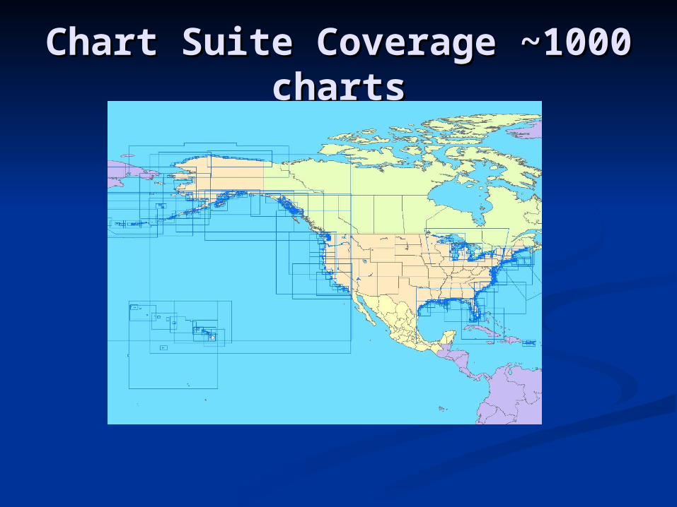
Chart Suite Coverage Chart Suite Coverage ~1000 charts~1000 charts
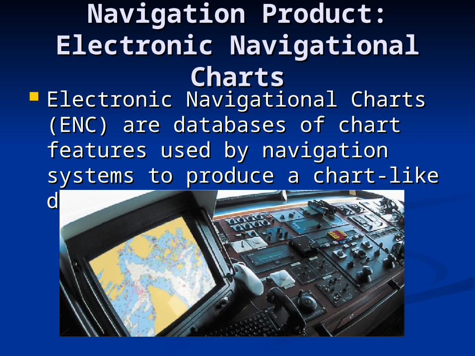
Navigation Product:Navigation Product:Electronic Navigational Electronic Navigational
ChartsCharts Electronic Navigational Charts Electronic Navigational Charts
(ENC) are databases of chart (ENC) are databases of chart features used by navigation systems features used by navigation systems to produce a chart-like display.to produce a chart-like display.

What is S-57?What is S-57?
International Hydrographic International Hydrographic Organization (IHO) for Transfer Organization (IHO) for Transfer Standard for Digital Hydrographic DataStandard for Digital Hydrographic Data
Uses International Standard Uses International Standard Organization (ISO) 8211 file formatOrganization (ISO) 8211 file format Platform independent structurePlatform independent structure
Provides a standard catalog for chart Provides a standard catalog for chart featuresfeatures
ENC is a product specification for S-57ENC is a product specification for S-57
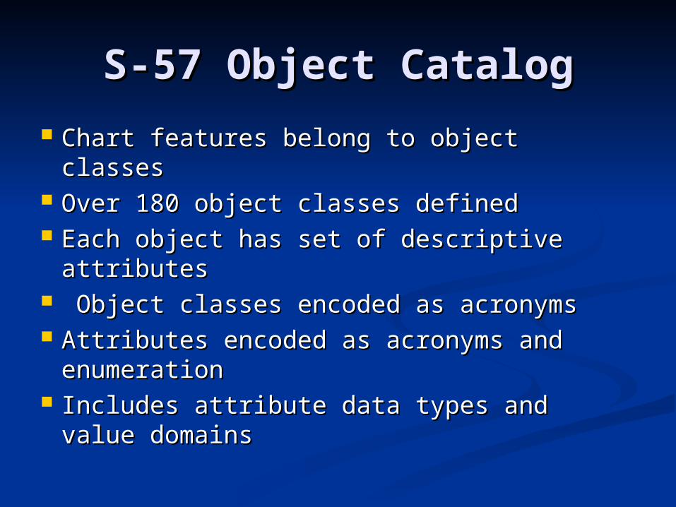
S-57 Object CatalogS-57 Object Catalog
Chart features belong to object classesChart features belong to object classes Over 180 object classes definedOver 180 object classes defined Each object has set of descriptive Each object has set of descriptive
attributesattributes Object classes encoded as acronymsObject classes encoded as acronyms Attributes encoded as acronyms and Attributes encoded as acronyms and
enumerationenumeration Includes attribute data types and value Includes attribute data types and value
domainsdomains

Using ENCs in GISUsing ENCs in GIS
Rich structure of the object catalog Rich structure of the object catalog requires the use of data decoders to requires the use of data decoders to make sense of information contained make sense of information contained in S-57in S-57
Off the shelf GIS software packages Off the shelf GIS software packages do not support ENC in native S-57 do not support ENC in native S-57 formatformat
S-57 standard is complex and hard S-57 standard is complex and hard to fully integrate in GISto fully integrate in GIS

ENC Direct: The GIS ENC Direct: The GIS SolutionSolution
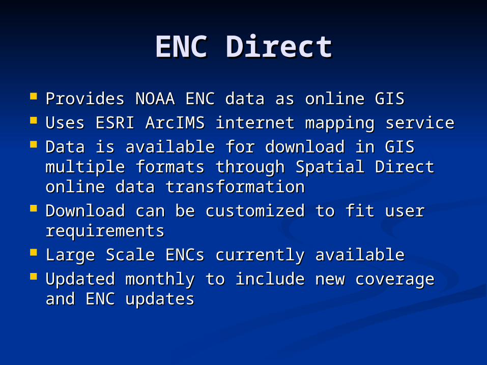
ENC DirectENC Direct
Provides NOAA ENC data as online GISProvides NOAA ENC data as online GIS Uses ESRI ArcIMS internet mapping serviceUses ESRI ArcIMS internet mapping service Data is available for download in GIS Data is available for download in GIS
multiple formats through Spatial Direct multiple formats through Spatial Direct online data transformationonline data transformation
Download can be customized to fit user Download can be customized to fit user requirementsrequirements
Large Scale ENCs currently availableLarge Scale ENCs currently available Updated monthly to include new coverage Updated monthly to include new coverage
and ENC updatesand ENC updates

NOAA ENC data NOAA ENC data conversionconversion
Safe Software’s Feature Manipulation Safe Software’s Feature Manipulation Engine (FME) used for data conversionEngine (FME) used for data conversion
Custom translation developed in houseCustom translation developed in house Converts S-57 to shapefile and ArcSDEConverts S-57 to shapefile and ArcSDE Chart features are merged together to Chart features are merged together to
create seamless GIS layers from NOAA create seamless GIS layers from NOAA ENCsENCs

GIS layers of aggregated GIS layers of aggregated nautical features covering nautical features covering
US watersUS waters
Contiguous information about Contiguous information about Nautical Chart features available in Nautical Chart features available in GIS layersGIS layers
Example: ENC Direct coastline layer Example: ENC Direct coastline layer contains information from 400 ENCs contains information from 400 ENCs of the same scale that have been of the same scale that have been glued togetherglued together
Over 200 GIS layers availableOver 200 GIS layers available

ENC Direct to GISENC Direct to GIS
Layers have been symbolized to give Layers have been symbolized to give a chart like displaya chart like display
S-57 object classes have been S-57 object classes have been organized into meaningful groups organized into meaningful groups based on ESRI’s S-57 data modelbased on ESRI’s S-57 data model
Layers have scale dependency to Layers have scale dependency to improve performance. Layers are improve performance. Layers are only visible at a particular scaleonly visible at a particular scale
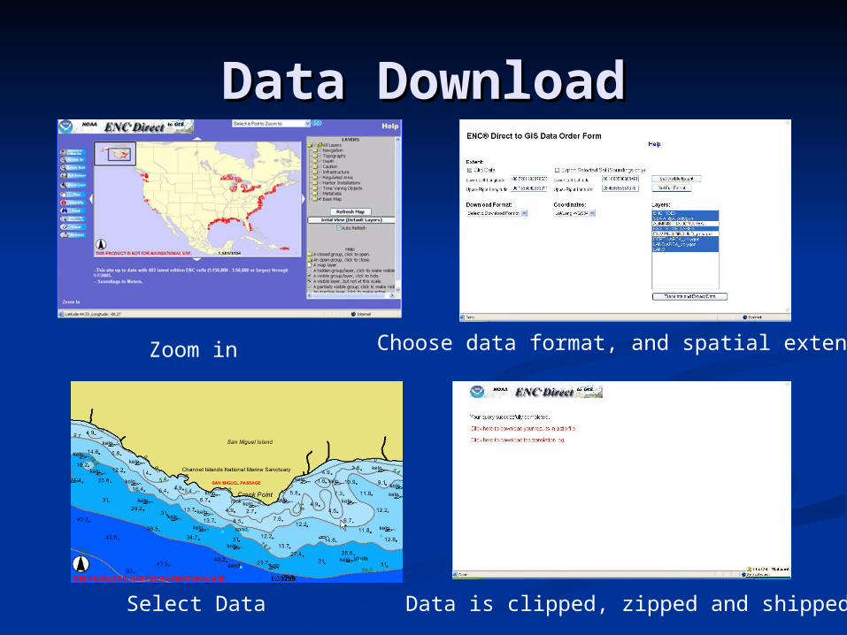
Data DownloadData Download
Zoom in
Select Data Data is clipped, zipped and shipped
Choose data format, and spatial extent
BenefitsBenefits
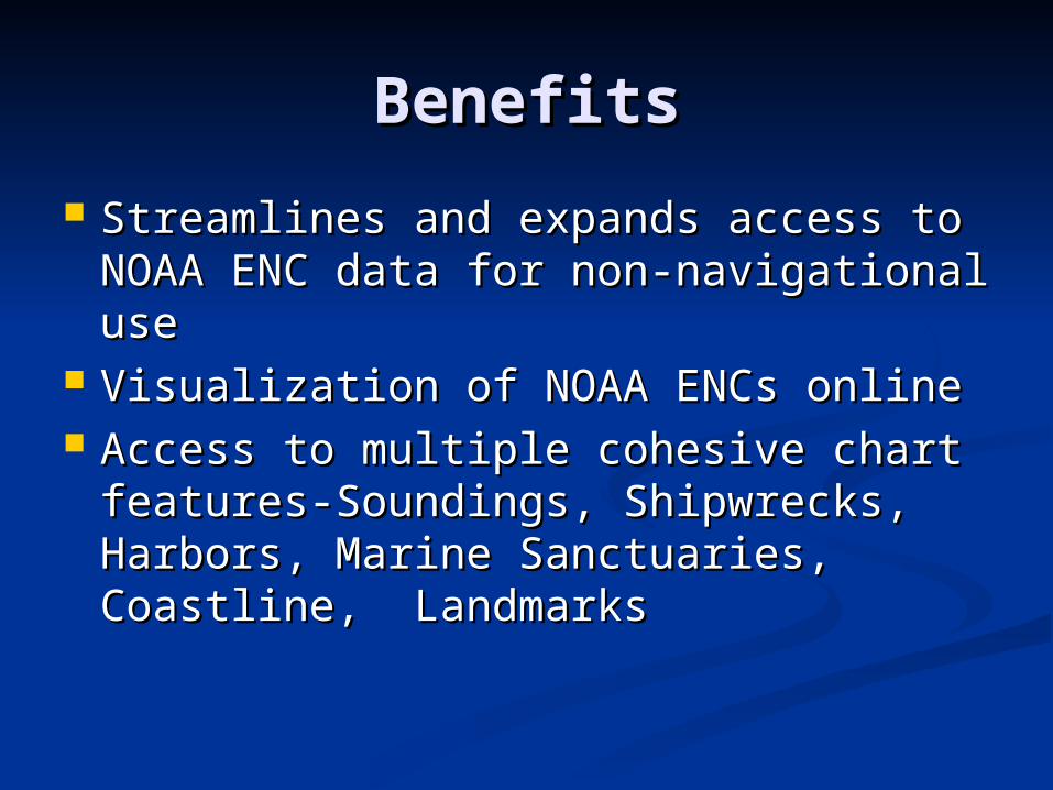
Streamlines and expands access to Streamlines and expands access to NOAA ENC data for non-NOAA ENC data for non-navigational usenavigational use
Visualization of NOAA ENCs onlineVisualization of NOAA ENCs online Access to multiple cohesive chart Access to multiple cohesive chart
features-Soundings, Shipwrecks, features-Soundings, Shipwrecks, Harbors, Marine Sanctuaries, Harbors, Marine Sanctuaries, Coastline, LandmarksCoastline, Landmarks

Web ServicesWeb Services
Web Map Services and Web Feature Web Map Services and Web Feature ServicesServices
Eliminate need for data downloadEliminate need for data download Data can be view directly through Data can be view directly through
desktop GIS clients (ESRI clients desktop GIS clients (ESRI clients only at the moment) and stacked only at the moment) and stacked with other web serviceswith other web services

ENC Direct Web Service ENC Direct Web Service viewed in ArcMapviewed in ArcMap
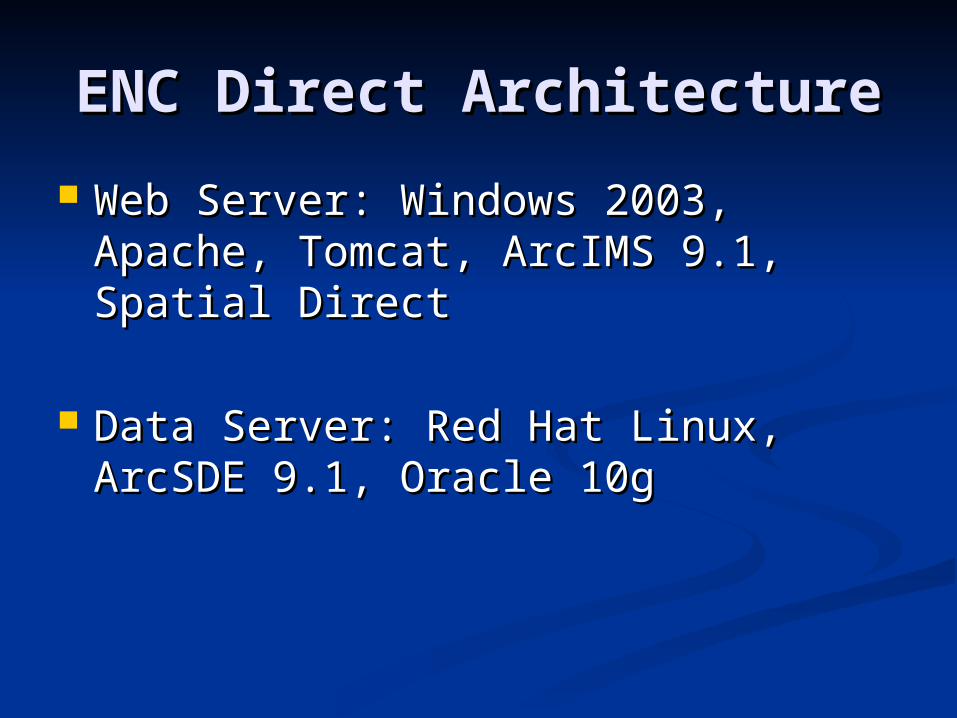
ENC Direct ArchitectureENC Direct Architecture
Web Server: Windows 2003, Apache, Web Server: Windows 2003, Apache, Tomcat, ArcIMS 9.1, Spatial Direct Tomcat, ArcIMS 9.1, Spatial Direct
Data Server: Red Hat Linux, ArcSDE Data Server: Red Hat Linux, ArcSDE 9.1, Oracle 10g9.1, Oracle 10g

UsersUsers
USGS National MapUSGS National Map US Coast Guard Homeland SecurityUS Coast Guard Homeland Security Coastal ManagersCoastal Managers Coastal EngineersCoastal Engineers Marine ModelersMarine Modelers State and Local GovernmentState and Local Government Private SectorPrivate Sector

ConclusionConclusion
ENC Direct to GIS expands access ENC Direct to GIS expands access and usage of NOAA ENCsand usage of NOAA ENCs
For further information, contact: For further information, contact: [email protected]@noaa.gov
http://nauticalcharts.noaa.gov/csdl/ctp/encdirect_new.hthttp://nauticalcharts.noaa.gov/csdl/ctp/encdirect_new.htmm