Embed Size (px)
Citation preview

1
Cover Letter to the Planning Inspectorate
PINS Document Reference: 1.1
APFP Regulation 5(2)(q)
January 2015

Hornsea Offshore Wind Farm
Project Two – Application for Development Consent
Cover Letter to the Planning Inspectorate
SMart Wind Limited
11th Floor
140 London Wall
London
EC2Y 5DN
Tel 02077765500
Email [email protected]
Copyright © 2015
All pre-existing rights reserved.
Liability
This document has been prepared by Shepherd and Wedderburn LLP, with reasonable skill and care, within the terms of their contracts with SMart Wind Limited or by a sub-contractor of Shepherd and Wedderburn LLP instructed in accordance with Shepherd and Wedderburn LLP’s contracts with SMart Wind Limited, as the case may be.
Document release and authorisation record
Report number UK06-060700-LET-0001
Date January 2015
Company name SMart Wind Limited

National Infrastructure Directorate The Planning Inspectorate Temple Quay House Temple Quay Bristol BS1 6PN
30 January 2015
Dear Sirs
Planning Act 2008 - Application for Development Consent SMart Wind Limited as agent on behalf of Optimus Wind Limited and Breesea Limited The proposed Hornsea Two Offshore Wind Farm Order (“the Order”) Application ref: EN010053
We enclose an application for an order granting development consent (“the Application”) pursuant to section 37 of the Planning Act 2008 (“the 2008 Act”) on behalf of Optimus Wind Limited and Breesea Limited who are the joint applicants (together “the Applicant”) for the development consent order (“DCO”) for the proposed Hornsea Two Offshore Wind Farm (referred to as “Project Two”).
1. Subject of the Application
1.1 The Application is for development consent to construct, operate and maintain Project Two. Project Two is the second development proposed within the Hornsea Zone and it comprises up to two offshore wind farms, consisting of up to 360 wind turbine generators, together with associated infrastructure and all associated development, with an installed capacity of up to 1,800 MW. The area within the Hornsea Zone in which turbines and inter-array cabling, as well as associated infrastructure for Project Two will be placed, has been labelled ‘Subzone 2’. Subzone 2 is located in the centre of the Hornsea Zone, 89 km from the coast of the East Riding of Yorkshire and 50 km from the median line between United Kingdom (UK) and Dutch Waters. Subzone 2 has an area of approximately 462 km² and lies within the UK Renewable Energy Zone.
1.2 Development consent is required to the extent that development is or forms part of a Nationally Significant Infrastructure Project (NSIP) pursuant to section 14(1)(a) and 15(3) of the 2008 Act. As Project Two is expected to have a capacity of more than 100 MW it is an NSIP for the purposes of the 2008 Act. It is for this reason that the Project falls within the remit of the Secretary of State.
2. Documentation enclosed and application fee
2.1 We enclose three hard copies of:
2.1.1 The completed and signed application form;
2.1.2 The Environmental Statement (ES); and
2.1.3 Each of the other documents listed in the enclosed Schedule.
2.2 We also enclose 10 USB Memory Sticks containing the documentation at 2.1.1 - 2.1.3 above. In addition we enclose 1 USB Memory Stick containing the documentation at 2.1.1 – 2.1.3 above with any necessary redactions and minus any confidential documents, to assist with document upload to the Planning Inspectorate webpage.

2.3 A fee in the sum of £4,500 has been submitted by BACS transfer to the account of the Planning Inspectorate (PINS).
3. Application formalities
3.1 The Application is made in the form required by section 37(3)(b) of the 2008 Act. The Application documentation complies with the overall requirements of section 37 and the requirements set out in:
3.1.1 The Infrastructure Planning (Applications: Prescribed Forms and Procedure) Regulations 2009 (the APFP Regulations);
3.1.2 The Infrastructure Planning (Environmental Impact Assessment) Regulations 2009;
3.1.3 The published Department of Communities and Local Government (DCLG) Guidance and PINS' Advice Note 6 on the preparation and submission of application documentation.
4. Description of the Project
4.1 The Application seeks consent for the development outlined above and described in full in Schedule A to the Order (Document Reference 3.1) and in the ES (Document Reference 7). The proposed DCO will, among other things, licence and authorise:
4.1.1 the construction and operation of up to 360 offshore wind turbines, depending on the individual capacity of each turbine, with a tip height up to 276 metres above lowest astronomical tide, and their foundations;
4.1.2 the construction of up to six offshore HVAC collector substations, up to two offshore HVDC converter stations, up to two offshore accommodation platforms and up to two offshore HVAC reactive compensation substations and their foundations;
4.1.3 the construction of a network of subsea electrical circuits connecting the wind turbines, offshore HVAC collector substations, offshore HVDC converter stations and offshore accommodation platforms;
4.1.4 the construction of a marine connection to the shore, the mode of transmission of which may be HVAC or HVDC, running in a south-westerly direction from the southern boundary of Subzone 2 to the proposed landfall at Horseshoe Point in Lincolnshire, including cable and pipeline crossing works, consisting of up to eight subsea electrical circuits which may connect with the offshore HVAC reactive compensation substation(s);
4.1.5 the construction of a foreshore connection consisting of an extension of the electrical circuits comprising the marine connection to the shore, crossing under the existing sea wall and terminating at the electrical circuit transition joint bays;
4.1.6 the construction of up to eight underground electrical circuit transition joint bays in the vicinity of Horseshoe Point in the parish of North Coates in the county of Lincolnshire, housing the connections between the offshore and the onshore electrical circuits;
4.1.7 the construction of up to eight underground transmission electrical circuits, running in a north-westerly direction for approximately 40 km, connecting the underground electrical circuit transition joint bays in the vicinity of Horseshoe Point to the onshore substation.
4.1.8 the construction of an onshore substation which could comprise up to two electrical transmission stations including up to two main buildings and associated facilities in the vicinity of North Killingholme;

4.1.9 the construction of a connection consisting of up to two underground electrical circuits between the onshore substation and the North Killingholme National Grid substation, including a connection within the National Grid substation;
4.1.10 improvements to the verge, highway and private access road running from Chase Hill Road between the junction with Haven Road in the east and Eastfield Road in the west;
4.1.11 scour protection around the foundations of the offshore structures;
4.1.12 cable protection measures such as rock placement and the placement of concrete mattresses and frond mattresses;
4.1.13 the disposal of seabed sediment dredged during the installation of the foundations of the offshore structures;
4.1.14 works to alter the position of apparatus, including mains, sewers, drains and cables;
4.1.15 works to alter the course of, or otherwise interfere with, non-navigable rivers, streams or watercourses;
4.1.16 landscaping and other works to mitigate any adverse effects of the construction, maintenance or operation of the authorised project;
4.1.17 works for the benefit or protection of land affected by the authorised project;
4.1.18 working sites in connection with the construction of the authorised project;
4.1.19 compensation compounds;
4.1.20 works to secure means of access;
4.1.21 works to construct surface water drainage systems;
4.1.22 the construction of jointing pits (including link and/or earthing boxes) in the immediate vicinity of the underground electrical circuit transition joint bays;
4.1.23 in relation to the electrical transmission stations, the construction of private roads and hardstanding for parking;
4.1.24 the construction of a temporary haul road and temporary access track, both alongside and used for the purpose of constructing the underground transmission electrical circuits connecting the underground electrical circuit transition pits to the electrical transmission stations;
4.1.25 works to enable utility services to be run from Chase Hill Road to the electrical transmission stations;
4.1.26 such other works and apparatus, plant and machinery of whatever nature as may be necessary or expedient for the purposes of or in connection with the construction of the authorised project;
4.1.27 the temporary stopping up, alteration or diversion of any street;
4.1.28 the compulsory acquisition of land and the compulsory acquisition of rights on a permanent and/or temporary basis for Project Two;
4.1.29 the disapplication of legislation relevant to Project Two including inter alia provisions of the Water Resources Act 1991 and the Land Drainage Act 1991; and
4.1.30 the application of legislation relevant to Project Two including inter alia legislation relating to compulsory purchase.

5. Consent Flexibility - Rochdale Envelope
5.1 The Order provides for flexibility in relation to the generating station and its associated development. The Applicant has given careful consideration to the guidance in the National Policy Statements and PINS' Advice Note 9 “Rochdale Envelope”, together with the pre-application discussions with PINS. In the Applicant’s view, the flexibility provided for in the Order is necessary so as to ensure that the Applicant can take advantage of new developments and emerging products in the market for offshore wind turbine generators and other equipment. The potential ability to exploit these prospective factors (and take advantage of any cost benefits) makes it easier to attract equity investment and access debt funding in a competitive international market.
5.2 The environmental impact assessment (EIA) which has been carried out in support of the Application has been careful to take account of the flexibility which is sought in the Order. This matter is addressed in the ES and in all cases the parameters referred to in the Order have been adopted in the ES.
5.3 Further explanation on the Applicant’s approach to the Rochdale Envelope is contained within the Explanatory Memorandum (Document Reference 3.2).
6. Deemed Marine Licences
6.1 Included within the Order at Schedules H, I, J and K are deemed marine licences as provided for in section 149A of the 2008 Act. The Order, and the deemed marine licences, have been the subject of consultation with, and comment by PINS, the Marine Management Organisation (MMO), English Heritage, the Maritime and Coastguard Agency, Trinity House, Cefas and Natural England. Where possible or appropriate the Applicant has sought to take comments into account in the documents submitted, but it should not be assumed that any of these organisations have approved the detailed form of the Order and deemed marine licences. The Applicant may have further discussions to refine some aspects of the detail of the Order and deemed licences after acceptance, as has taken place with other accepted NSIP applications.
7. Habitats Regulations
7.1 The Application documents include a Habitats Regulations Assessment (Document Reference 12.6), as required by Regulation 5(2)(g) of the APFP Regulations. This identifies all relevant European sites and provides sufficient information for the competent authority to determine whether the Project is likely to have an adverse effect on the integrity of any European site. It concludes that where it is considered necessary for the Competent Authority to undertake an Appropriate Assessment the Project is not expected, either alone or in combination with other offshore wind farms or other developments, to have an adverse effect on the integrity of any of those sites. In preparing the report, SMart Wind and the Applicant have been mindful throughout of PINS' Advice Note 10 "Habitats Regulations Assessment".
8. Compulsory acquisition
8.1 The Applicant is seeking authority within the Order to acquire compulsorily land and interests and other related powers to support the delivery of the Project, details of which can be found in the Book of Reference (Document Reference 6.3) and Statement of Reasons (Document Reference 6.1). Funding for compensation is dealt with in the Funding Statement (Document Reference 6.2).
8.2 Optimus Wind Limited and Breesea Limited have both been granted a Generation Licence under the provisions of the Electricity Act 1989 by OFGEM

and are therefore statutory undertakers for the purposes of compulsory acquisition.
8.3 Some land over which rights are sought is held by statutory undertakers for the purposes of their undertaking. It is the Applicant’s belief that the rights it seeks can be taken without serious detriment being caused to the statutory undertakers’ interests. Whilst it has not been possible to reach agreement with all statutory undertakers prior to the making of this Application, SMart Wind on behalf of the Applicant will continue to progress commercial negotiations with those outstanding statutory undertakers in tandem with the compulsory acquisition process, with a view to concluding an agreement as soon as possible. It is necessary to include the statutory undertakers’ land in the Order to ensure that all the land required to deliver the Project can be assembled within an appropriate timeframe. Furthermore, it remains the Applicant’s preference and intention to acquire the required rights in statutory undertakers’ land by agreement. In consequence of the inclusion of provision in the DCO (Document Reference 3.1) for the acquisition of rights in the land and to ensure the necessary powers and rights can be secured in a reasonable timescale, in the event that a representation is made by a statutory undertaker, it will be necessary for the Secretary of State to be satisfied of the matters set out in section 127(6) of the 2008 Act so as to authorise the acquisition of rights within the land.
9. Other consents
9.1 Details of other consents and licences not forming part of the Order, which the Applicant or others may be seeking in relation to the construction and operation of the proposed generating station and associated development, are set out in the Consents Management Plan (Document Reference 12.10) which has been progressed with the Consents Service Unit within the Planning Inspectorate.
10. Pre-application consultation
10.1 The Applicant has had careful regard to the pre-application consultation requirements of the 2008 Act, the guidance on pre-application consultation issued by DCLG and PINS, and its pre-application discussions held with PINS, as required by sections 50 and 55(4) of the 2008 Act.
10.2 As required by section 37(3)(c), the Application is accompanied by a Consultation Report (Document Reference 2.1), which provides details of the Applicant’s compliance with sections 42, 47, 48 and 49 of the 2008 Act. The responses of statutory and non-statutory consultees are listed and summarised in the Consultation Report and these have informed the evolution of the Application and the Project overall.
11. Other matters
11.1 Under Regulation 6(b)(i) of the APFP Regulations, an applicant is required to provide details of the proposed route and method of installation for any cable. This information can be found in the Cable Statement (Document Reference 11.2) which accompanies the Application. These details have also been provided within the ES in the Project Description (Document Reference 7.1.3) and in the Works Plans (Document References 5.1, 5.2 and 5.3). Details of the design process of, and access provisions to, the onshore electrical transmission works are also within the ES, notably in the Project Description (Document Reference 7.1.3), Site Selection and Consideration of Alternatives (Document Reference 7.1.4).

11.2 Under Regulation 6(b)(ii) of the APFP Regulations, an applicant is required to provide a statement in respect of safety zones. The Applicant’s Safety Zone Statement accompanies this Application (Document Reference 11.1).
11.3 Under Regulation 5(2)(l) of the APFP Regulations, an applicant is required to provide a plan of certain nature conservation sites and features and an assessment of any effects on those sites and features likely to be caused by the proposed development. There is an equivalent requirement under Regulation 5(2)(m) in relation to certain historic sites and features. The plans are attached as separate documents (Document References 12.7 and 12.8) but the assessments are provided in the ES (Document References 7.2.9, 7.3.3, 7.3.5 and 12.6) and not as stand-alone documents.
11.4 Under Regulation 5(3) and 5(4A) of the APFP Regulations, any plans, drawings or sections shall be no larger than A0 size, shall be drawn to an identified scale (no smaller than 1:2500) and, in the case of plans, show the direction of North. This is subject to Regulation 5(4B) which provides that the scaling requirement does not apply to plans which show matters entirely within the marine area. The offshore plans submitted with the Application do not comply with the scale of 1:2500 because the development covers a very large area of sea. The plans do however still show with sufficient accuracy the limits within which the proposed development may be carried out. Several onshore plans are appropriately scaled for the content for example the Onshore Statutory and Non-Statutory Conservation and Historic or Scheduled Monuments Sites Plan, scaled at 1:50,000 at A1 size. (Document Reference 12.7).
We look forward to hearing from you in relation to the formal acceptance of the Application. If we can be of any assistance in that regard, please do not hesitate to contact us.
Yours faithfully,
Chris Jenner
Development and Consents Manager - Hornsea Project Two

Schedule of Application Documents in Numerical Order
Doc Ref Document
1 Application form
1.1 Cover Letter to the Planning Inspectorate
1.2 Application Form for Hornsea Project Two
1.3 Copies of Newspaper Notices
1.4 Index to the Environmental Statement
2 Consultation Report
2.1 Consultation Report
2.2 Consultation Report Annexes 1 to 4
2.2 Consultation Report Annexes 5 to 6
2.2 Consultation Report Annexes 7 to 9
2.2 Consultation Report Annexes 10 to 16
3 Development Consent Order
3.1 Draft Development Consent Order
3.2 Draft DCO Explanatory Memorandum
4 Land Plans
4.1 Land Plans
5 Works Plans
5.1 Works Plans (Offshore)
5.2 Works Plans (Onshore)
5.3 Work Plans (Intertidal)
6 Compulsory Purchase Information
6.1 Statement of Reasons
6.2 Funding Statement
6.3 Book of Reference Part 1 of 5 (1 of 2)
6.3 Book of Reference Part 1 of 5 (2 of 2)
6.3 Book of Reference Part 2 of 5
6.3 Book of Reference Part 3 of 5
6.3 Book of Reference Parts 4 to 5 and Schedule
7 Environmental Statement
7.1 Introduction
7.1.a Non-technical Summary
7.1.b Glossary
7.1.1 Introduction
7.1.2 Policy and Legislative Context
7.1.3 Project Description
Doc Ref Document
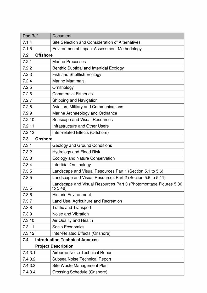
7.1.4 Site Selection and Consideration of Alternatives
7.1.5 Environmental Impact Assessment Methodology
7.2 Offshore
7.2.1 Marine Processes
7.2.2 Benthic Subtidal and Intertidal Ecology
7.2.3 Fish and Shellfish Ecology
7.2.4 Marine Mammals
7.2.5 Ornithology
7.2.6 Commercial Fisheries
7.2.7 Shipping and Navigation
7.2.8 Aviation, Military and Communications
7.2.9 Marine Archaeology and Ordnance
7.2.10 Seascape and Visual Resources
7.2.11 Infrastructure and Other Users
7.2.12 Inter-related Effects (Offshore)
7.3 Onshore
7.3.1 Geology and Ground Conditions
7.3.2 Hydrology and Flood Risk
7.3.3 Ecology and Nature Conservation
7.3.4 Intertidal Ornithology
7.3.5 Landscape and Visual Resources Part 1 (Section 5.1 to 5.6)
7.3.5 Landscape and Visual Resources Part 2 (Section 5.6 to 5.11)
7.3.5 Landscape and Visual Resources Part 3 (Photomontage Figures 5.36 to 5.48)
7.3.6 Historic Environment
7.3.7 Land Use, Agriculture and Recreation
7.3.8 Traffic and Transport
7.3.9 Noise and Vibration
7.3.10 Air Quality and Health
7.3.11 Socio Economics
7.3.12 Inter-Related Effects (Onshore)
7.4 Introduction Technical Annexes
Project Description
7.4.3.1 Airborne Noise Technical Report
7.4.3.2 Subsea Noise Technical Report
7.4.3.3 Site Waste Management Plan
7.4.3.4 Crossing Schedule (Onshore)

Doc Ref Document
7.4.3.5 Not Used
7.4.3.6 Crossing Schedule (Offshore)
7.4.3.7 Illustrative Layouts and Drawings
7.4.3.8 Dredging and Disposal Site Characterisation
Site Selection and Consideration of Alternatives
7.4.4.1 Offshore Export Cable Route Selection
7.4.4.2 Landfall, Onshore Cable Route and Converter/Substation Location Selection
EIA Process and Methodology
7.4.5.1 Cumulative Effects Screening Matrix
7.4.5.2 Transboundary Impacts Screening Note
7.4.5.3 Location of Offshore Cumulative Schemes
7.4.5.4 Project One / Project Two Interface
7.4.5.5 Enhancement, Mitigation and Monitoring Commitments
7.4.5.6 Compensation Compounds Plan
7.5 Offshore Technical Annexes
Marine Processes
7.5.1.1 Tidal Modelling Calibration and Validation Report
7.5.1.2 Wave Modelling
7.5.1.3 Metocean Data Review
7.5.1.4 Plume Dispersion Modelling
7.5.1.5 Bedform Analysis of Cable Route Corridor
7.5.1.6 Cable Burial Plume Assessment
7.5.1.7 Landfall Assessment
7.5.1.8 Foundation Scour Assessment
Benthic Subtidal and Intertidal Ecology
7.5.2.1 Benthic Ecology Technical Report
7.5.2.2 Water Framework Directive Assessment
Fish and Shellfish Ecology
7.5.3.1 Fish and Shellfish Technical Report
Marine Mammals
7.5.4.1 Marine Mammal Technical Report
Ornithology
7.5.5.1 Ornithology Technical Report
Commercial Fisheries
7.5.6.1 Commercial Fisheries Technical Report
Shipping and Navigation

Doc Ref Document
7.5.7.1 Subzone 2 and Offshore Cable Route NRA
7.5.7.2 Offshore HVAC Reactive Compensation Substation NRA
Aviation, Military and Communications
7.5.8.1 Aviation, Military and Communication Technical Report
Marine Archaeology and Ordnance
7.5.9.1 Marine Archaeology Technical Report
7.5.9.2 Draft Written Scheme of Investigation
Seascape and Visual Resources
7.5.10.1 Seascape and Visual Technical Report
7.5.10.2 Wirelines from Sample Viewpoints
7.5.10.3 Cumulative Effects Wirelines from Sample Views
7.5.11.1 Radar Early Warning Systems Technical Annex
7.6 Onshore Technical Annexes
Geology and Ground Conditions
7.6.1.1 Baseline Data from the Environment Agency and Local Authorities
7.6.1.2 Fugro Landfall Site Investigation
7.6.1.3 Groundsure EnviroInsight and GeoInsight Reports
7.6.1.4 Landmark Envirocheck Report Converter Substation Site
7.6.1.5 Borehole Logs
Hydrology and Flood Risk
7.6.2.1 Environmental Information Part 1 of 4
7.6.2.1 Environmental Information Part 2 of 4
7.6.2.1 Environmental Information Part 3 of 4
7.6.2.1 Environmental Information Part 4 of 4
7.6.2.2 Legislation Summary
7.6.2.3 HVDC Converter/HVAC Substation Flood Risk Assessment
7.6.2.4 Tetney to Saltfleet Flood Risk Assessment
7.6.2.5 Classification of Surface Water Bodies
Ecology and Nature Conservation
7.6.3.1 Terrestrial Ecology Survey Figures and Associated Tables
7.6.3.2 Phase 1 Intertidal, Sand Dune and Salt Marsh Habitat Survey
7.6.3.3 Hedgerow Survey
7.6.3.4 Great Crested Newt Survey
7.6.3.5 Reptile Survey
7.6.3.6 Otter and Water Vole Survey
7.6.3.7 Bat Survey
7.6.3.8 Onshore Bird Survey

Doc Ref Document
7.6.3.9 Confidential Otter Survey Findings
7.6.3.10 Confidential Badger Survey and Impact Assessment
Intertidal
7.6.4.1 Intertidal Bird Survey
Landscape and Visual Resources
7.6.5.1 Landscape and Visual Impact Assessment (LVIA) Methodology
7.6.5.2 Nationally Designated Landscapes and Landscape Character Areas
7.6.5.3 Locally Designated Landscapes and Regional and Local Landscape Character Areas
7.6.5.4 Historic Landscapes and Landscape Character Areas
7.6.5.5 Seascape Character Areas
7.6.5.6 Planning Policy
7.6.5.7 Representative Visual Receptors for Landfall and Cable Route
7.6.5.8 Representative Visual Receptors for Onshore HVDC Converter/HVAC Substation
7.6.5.9 Effects on Landscape Resources During the Construction Phase
7.6.5.10 Effects on Visual Receptors During the Construction Phase
7.6.5.11 Effects on Landscape Resources During the Operational Phase
7.6.5.12 Effects on Visual Receptors During the Operational Phase
7.6.5.13 Effects on Landscape Resources During the Decommissioning Phase
7.6.5.14 Effects on Visual Receptors During the Decommissioning Phase
7.6.5.15 Meteorological Data
Historic Environment
7.6.6.1 Desk Based Assessment
7.6.6.2 Aerial Photographic Survey Report
7.6.6.3 Geophysical Survey Report
7.6.6.4 Field Walking Report
7.6.6.5 Trial Trenching Report
7.6.6.6 Intertidal Walkover Survey Report
7.6.6.7 Site Gazeteer
7.6.6.8 Designated Assets Baseline
7.6.6.9 Screening Assessment HVDC Converter/HVAC Substation
Land Use, Agriculture and Recreation
7.6.7.1 Soil Types and Descriptions
7.6.7.2 Hornsea P2 Wind Farm Safety Assessment: North Coates Airfield
Traffic and Transport
7.6.8.1 Transport Assessment
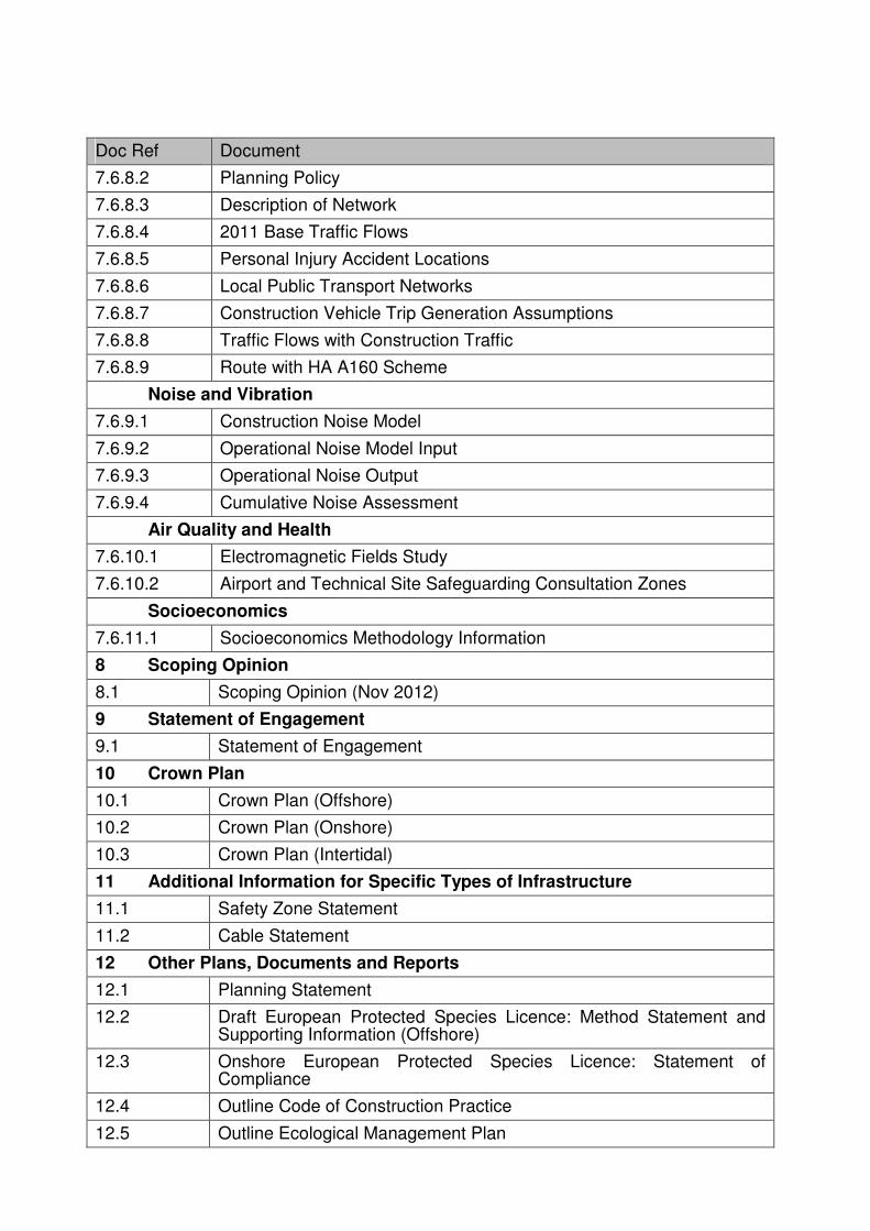
Doc Ref Document
7.6.8.2 Planning Policy
7.6.8.3 Description of Network
7.6.8.4 2011 Base Traffic Flows
7.6.8.5 Personal Injury Accident Locations
7.6.8.6 Local Public Transport Networks
7.6.8.7 Construction Vehicle Trip Generation Assumptions
7.6.8.8 Traffic Flows with Construction Traffic
7.6.8.9 Route with HA A160 Scheme
Noise and Vibration
7.6.9.1 Construction Noise Model
7.6.9.2 Operational Noise Model Input
7.6.9.3 Operational Noise Output
7.6.9.4 Cumulative Noise Assessment
Air Quality and Health
7.6.10.1 Electromagnetic Fields Study
7.6.10.2 Airport and Technical Site Safeguarding Consultation Zones
Socioeconomics
7.6.11.1 Socioeconomics Methodology Information
8 Scoping Opinion
8.1 Scoping Opinion (Nov 2012)
9 Statement of Engagement
9.1 Statement of Engagement
10 Crown Plan
10.1 Crown Plan (Offshore)
10.2 Crown Plan (Onshore)
10.3 Crown Plan (Intertidal)
11 Additional Information for Specific Types of Infrastructure
11.1 Safety Zone Statement
11.2 Cable Statement
12 Other Plans, Documents and Reports
12.1 Planning Statement
12.2 Draft European Protected Species Licence: Method Statement and Supporting Information (Offshore)
12.3 Onshore European Protected Species Licence: Statement of Compliance
12.4 Outline Code of Construction Practice
12.5 Outline Ecological Management Plan

Doc Ref Document
12.5 Confidential Outline Ecological Management Plan
12.6 Habitats Regulation Assessment Part 1 of 2
12.6 Habitats Regulation Assessment Part 2 of 2
12.6.1 Habitats Regulation Assessment Evidence Plan
12.6.2 Habitats Regulation Assessment Screening Report
12.6.3 Habitats Regulation Assessment Screening and Integrity Matrices
12.7 Statutory and non-statutory conservation and historic or scheduled monument sites plan (Onshore)
12.8 Statutory and non-statutory conservation and historic or scheduled monument sites plan (Offshore)
12.9 Outline Landscape Scheme and Management Plan
12.10 Consents Management Plan
12.11 DCO/DML Coordinates Plan