Embed Size (px)
Citation preview

1
Course Review Form Reviewer Recommendation U.S. Citizenship/Diversity/Community Accept Revisions Needed Course: GEO 320 Using the course syllabus as a reference, identify when and how the following learning outcomes are addressed in the course. Since learning outcomes will likely be addressed multiple ways within the same syllabus, please identify a representative example (or examples) for each outcome.
Evidence that demonstrates student understanding of historical, societal, and cultural differences, such as those arising from race, ethnicity, gender, sexuality, language, nationality, religion, political and ethical perspectives, and socioeconomic class. Date/location on syllabus of such evidence: Brief description or example:
Materials and processes that foster student understanding of how these differences influence issues of social justice and/or civic responsibility. Date/location on syllabus of such evidence: Brief description or example:
Readings, lectures, or presentations that encourage student s to demonstrate an understanding of historical, societal, and cultural contexts relevant to the subject matter of the course. Date/location on syllabus of such evidence: Brief description or example:
Processes and assignments that engage students in understanding at least two of the following, as they pertain to the subject matter of the course:
a. Societal, cultural, and institutional change over time b. Civic engagement c. Regional, national, or cross-national comparisons d. Power and resistance
Date/location on syllabus of such evidence: Brief description or example:

2
At least two assessable individual or group projects that focus on personal and/or collective decision-making. The projects should require students to identify and evaluate conflicts, compromises, and/or ethical dilemmas. These projects shall demonstrate a basic understanding of effective and responsible participation in a diverse society. Date/location on syllabus of such evidence: Brief description or example:
Evidence that students make effective use of library and other information sources, when applicable, in order to demonstrate information literacy in the exploration of the course’s major thematic foci. Date/location on syllabus of such an assignment: Brief description or example: Reviewer Comments: The committee as a whole found this course proposal satisfactory along many dimensions. It demonstrates explicitly how issues of diviersity and community are illuminated through maps and geographic data. It is well structured and nicely thought out. It will clearly serve both needs of the new general education curriculum and the departmental curriculum. The committee was provided with additional evidence of how active learning is to be engaged in the course and how the research essay assignment will be tied to library literacy. A detailed statement on the research essay assignment was provided and postively reviewed.


1
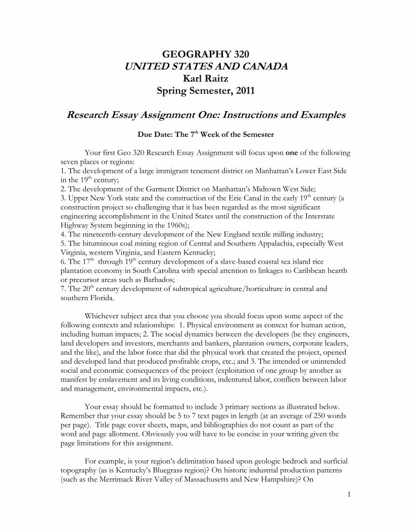
GEOGRAPHY 320 UNITED STATES AND CANADA
Karl Raitz Spring Semester, 2011
Research Essay Assignment One: Instructions and Examples
Due Date: The 7th Week of the Semester
Your first Geo 320 Research Essay Assignment will focus upon one of the following seven places or regions: 1. The development of a large immigrant tenement district on Manhattan‟s Lower East Side in the 19th century; 2. The development of the Garment District on Manhattan‟s Midtown West Side; 3. Upper New York state and the construction of the Erie Canal in the early 19th century (a construction project so challenging that it has been regarded as the most significant engineering accomplishment in the United States until the construction of the Interstate Highway System beginning in the 1960s); 4. The nineteenth-century development of the New England textile milling industry; 5. The bituminous coal mining region of Central and Southern Appalachia, especially West Virginia, western Virginia, and Eastern Kentucky; 6. The 17th through 19th century development of a slave-based coastal sea island rice plantation economy in South Carolina with special attention to linkages to Caribbean hearth or precursor areas such as Barbados; 7. The 20th century development of subtropical agriculture/horticulture in central and southern Florida. Whichever subject area that you choose you should focus upon some aspect of the following contexts and relationships: 1. Physical environment as context for human action, including human impacts; 2. The social dynamics between the developers (be they engineers, land developers and investors, merchants and bankers, plantation owners, corporate leaders, and the like), and the labor force that did the physical work that created the project, opened and developed land that produced profitable crops, etc.; and 3. The intended or unintended social and economic consequences of the project (exploitation of one group by another as manifest by enslavement and its living conditions, indentured labor, conflicts between labor and management, environmental impacts, etc.). Your essay should be formatted to include 3 primary sections as illustrated below. Remember that your essay should be 5 to 7 text pages in length (at an average of 250 words per page). Title page cover sheets, maps, and bibliographies do not count as part of the word and page allotment. Obviously you will have to be concise in your writing given the page limitations for this assignment.
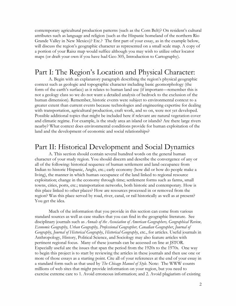
For example, is your region‟s delimitation based upon geologic bedrock and surficial topography (as is Kentucky‟s Bluegrass region)? On historic industrial production patterns (such as the Merrimack River Valley of Massachusetts and New Hampshire)? On
2
contemporary agricultural production patterns (such as the Corn Belt)? On resident‟s cultural attributes such as language and religion (such as the Hispanic homeland of the northern Rio Grande Valley in New Mexico)? Etc.? The first part of your essay, as in the example below, will discuss the region‟s geographic character as represented on a small scale map. A copy of a portion of your Raisz map would suffice although you may wish to utilize other locator maps (or draft your own if you have had Geo 305, Introduction to Cartography).
Part I: The Region‟s Location and Physical Character:
A. Begin with an explanatory paragraph describing the region‟s physical geographic context such as geologic and topographic character including basic geomorphology (the form of the earth‟s surface) as it relates to human land use (if important—remember this is not a geology class so we do not want a detailed analysis of bedrock to the exclusion of the human dimension). Remember, historic events were subject to environmental context to a greater extent than current events because technologies and engineering expertise for dealing with transportation, agricultural production, craft work, and so on, were not yet developed. Possible additional topics that might be included here if relevant are natural vegetation cover and climatic regime. For example, is the study area an island or islands? Are there large rivers nearby? What context does environmental conditions provide for human exploitation of the land and the development of economic and social relationships?
Part II: Historical Development and Social Dynamics
A. This section should contain several hundred words on the general human character of your study region. You should discern and describe the convergence of any or all of the following: historical sequence of human settlement and land occupance from Indian to historic Hispanic, Anglo, etc.; early economy (how did or how do people make a living), the manner in which human occupance of the land linked to regional resource exploitation; change in the economy through time; settlement forms such as farms, small towns, cities, ports, etc.; transportation networks, both historic and contemporary. How is this place linked to other places? How are resources processed in or removed from the region? Was this place served by road, river, canal, or rail historically as well as at present? You get the idea. Much of the information that you provide in this section can come from various standard sources as well as case studies that you can find in the geographic literature. See disciplinary journals such as Annals of the Association of American Geographers, Geographical Review, Economic Geography, Urban Geography, Professional Geographer, Canadian Geographer, Journal of Geography, Journal of Historical Geography, Historical Geography, etc., for articles. Useful journals in Anthropology, History, Political Science, and Sociology may also feature articles with pertinent regional focus. Many of these journals can be accessed on line at JSTOR. Especially useful are the issues that span the period from the 1920s to the 1970s. One way to begin this project is to start by reviewing the articles in these journals and then use one or more of those essays as a starting point. Cite all of your references at the end of your essay in a standard form such as that used by The Chicago Manuel of Style. Note: The WWW counts millions of web sites that might provide information on your region, but you need to exercise extreme care to 1. Avoid erroneous information; and 2. Avoid plagiarism of existing
3
information without proper citation credit. You may use any WWW materials you can find to support your essay, BUT, you MUST also find, use, and cite a minimum of five (5) traditional scholarly print sources; ie., scholarly journals, books, technical reports, etc. General WWW sites such as Wikipedia might be useful as a starting point, but a better strategy would be to utilize the bibliography in your text and use those sources to build a “bibliographic tree” of scholarly writings as a basis for your research. Part III: Intended or Unintended Social and Economic Consequences A. This section should discuss and critically evaluate the social and economic consequences of your project including the possible exploitation of one group by another as manifest by enslavement, indentured labor, conflicts between labor and management, treatment of renters by landlords, issues of personal and public health and safety. Each of the topical choices listed above include examples of social exploitation that ultimately resulted in political action at the local, state, or national level. For example, who were the laborers who dug the Erie Canal, and how were they paid, housed, and fed? What role did Tammany Hall politicians in New York City play in recruiting laborers from Ireland who were subsequently indentured to construction contractors? What were the hazards associated with construction, and how were these hazards dealt with by the contractors and engineers who planned and oversaw construction? Who were the primary benefactors of canal construction and how did they relate to those who provided the manual labor of construction? Or, how and why did the nation‟s largest garment manufacturing district develop in the heart of Manhattan Island? Who comprised the labor force? What were working conditions like? How did the Triangle Shirtwaste Fire of 1911 relate to garment manufacturing and what was the political upshot of that event? Or, who were the original land owners in the Central Appalachian coal fields and how did certain local individuals (John C. C. Mayo in Eastern Kentucky, for example), and outside corporations such as U.S. Steel and International Harvester come to disenfranchise local landowners and control a very large proportion of the region‟s mineral rights? Who were the people who were hired to mine coal? How were they paid, and what were their “benefit packages”? How safe was or is underground coal mining? (Note that during the first third of the 20th century an average of 1,000 coal miners died in mining accidents in America each year. In 1907, 3,242 coal miners died, 358 in one mine explosion in Monongah, West Virginia. Put another way, three coal miners on average died each day so that coal could be extracted for shipment north to iron and steel production plants at places such as Pittsburgh, Johnstown, Bethlehem, Sparrows Point, Cleveland, and East Chicago.). How did conflicts between miners and mine operators manifest in strikes, the formation of the United Mine Workers, and the demise of the coal company store and town? Or, how and why did central and southern Florida become the primary production area for citrus fruits and cane sugar (and numerous other horticultural products such as strawberries, sweet corn, melons, etc). What are the physical conditions that invite planting citrus and sugar cane in Florida (note that these crops are not grown in the same place)? What might Marjory Stoneman Douglas‟ book The Everglades: River of Grass tell us about this area? Who were the land “developers”? Who are or were the laborers who tended and
4
harvested these crops. Where did they live, under what kind of conditions? How did the development of subtropical agriculture in Florida relate to immigration from Latin America and the Caribbean and to what consequence? B. End Notes and Bibliography. Use any standard method of entering end notes and bibliographic entries for the sources you have used as reference or are citing in your tables or text. The Chicago Manual of Style is a basic resource for essay construction and you would profit by owning your own copy. Of course there are also standard formats for citing Internet sources. Reference Bibliography Listed here is a brief bibliography with references that relate to each of the seven regional topics listed above that you might pursue as a starting point for your research. Your course text also includes a bibliography at the end of each chapter. 1. Tenement district on Manhattan‟s Lower East Side. Arbinder, Tyler, 2002. “From Famine to Five Points: Lord Lansdowne‟s Irish Tenants Encounter America‟s most Notorious Slum,” American Historical Review, 107, 2: 351-387. Berrol, Selma. 1994. East Side/East End: Eastern European Jews in London and New York, 1870-1920 Westport, CT: Praeger. Bial, Raymond. 2002. Tenement: Immigrant Life on the Lower East Side New York: Houghton Mifflin. Blackmar, Elizabeth. 1989. Manhattan for Rent, 1785-1850 Ithaca, NY: Cornell University Press. Elsing, W. T. 1895. “Life in New York Tenement Houses,” in Robert A. Woods, ed. The Poor in Great Cities New York: Scribner‟s, 42-85. Ernst, R. 1949. Immigrant Life in New York City New York: Friedman and King‟s Crown Press. Hardy, Charles. III. 1997. “Lower East Side Tenement Museum,” Journal of American History, 84, 3: 1009-1013. Hopkinson, Deborah. 2003. Shutting out the Sky: Life in the Tenements of New York, 1880-1924 New York: Orchard Books. 2. Manhattan‟s Midtown Garment District Hall, Max, ed. 1959. Made in New York Cambridge: Harvard University Press.
5
Kolen, Amy. 2001. “Fire,” The Massachusetts Review 42, 1: 13-36. McEvoy, Arthur F. 1995. “The Triangle Shirtwaist Factory Fire of 1911: Social Change, Industrial Accidents, and the Evolution of Commonsense Causality,” Law & Social Inquiry 20, 2: 621-651. Stein, Leon. 1962. The Triangle Fire New York: J. B. Lippincott. Waldinger, Roger. 1984. “Immigrant Enterprise in the New York Garment Industry,” Social Problems 32, 1: 60-71. 3. Upper New York State and the Erie Canal Bernstein, Peter. 2005. Wedding the Waters: The Erie Canal and the Making of a Great Nation New York: W. W. Norton. Carp, Roger E. 1990. “The Limits of Reform: Labor and Discipline on the Erie Canal,” Journal of the Early Republic, 10, 2: 191-219. Chalmers, Harvey, II. 1964. How the Irish Built the Erie New York: Bookman Associates. Ignatiev, Noel. 1995. How the Irish Became White New York: Routledge. McGreevy, Patrick. 2009. Stairway to Empire: Lockport, The Erie Canal, and the Shaping of America Albany, NY: State University of New York Press. McKelvey, Blake. 1951. “The Erie Canal: Mother of Cities,” New York Historical Society Quarterly 35: 55-80. Shaw, Ronald. 1966. Erie Water West: A History of the Erie Canal Lexington, KY: University of Kentucky Press. Watson, Elkanah. 1820. History of the Rise, Progress, and Existing Conditions of the Western Canals in the State of New York New York: D. Steele. Way, Peter. 1993. Common Labour: Workers and the Digging of North American Canals, 1780-1860 Baltimore: John Hopkins Press. Way, Peter. 1993. “Evil Humors and Ardent Spirits: The Rough Culture of Canal Construction Laborers,” Journal of American History 79, 4: 1397-1428. Whitford, Nobel. 1906. History of the Canal System of the State of New York Albany, NY: State of New York. 4. The New England textile milling industry
6
Brown, Richard D. 1988. “The Agricultural-Industrial Transition in New England,” New England Quarterly 61: 260-268. Cameron, Ardis. 1993. Radicals of the Worst Sort: Laboring Women in Lawrence, Massachusetts, 1860-1912 Urbana, IL: University of Illinois Press. Cole, D. B. 1963. Immigrant City: Lawrence, Massachusetts, 1845-1921 Chapel Hill: NC: University of North Carolina Press. Cope, Meghan. 1996. “Weaving the Everyday: Identity, Space, and Power in Lawrence, Massachusetts, 1920-1939,” Urban Geography 17, (2): 179-204. Cope, Meghan. 1998. “Home-Work Links, Labor Markets, and the Construction of Place in Lawrence, Massachusetts, 1920-1939,” Professional Geographer 50, (1): 126-139. Estall, R. C. 1961. “Changing Industrial Patterns of New England,” Geography 46: 120-138. Goldberg, Daniel. 1989. A Tale of Three Cities: Labor Organization and Protest in Patterson, Passaic, and Lawrence, 1916-1921 New Brunswick: Rutgers University Press. Goldthwait, James W. 1927. “A Town That Has Gone Downhill,” Geographical Review 17: 527-552. Hay, Duncan E. 1986. “Building „The New City on the Merrimack‟: The Essex Company and Its Role in the Creation of Lawrence, Massachusetts” (Unpublished Ph.D. Dissertation, University of Delaware). LeBlanc, Robert. 1969. Location of Manufacturing in New England in the Nineteenth Century Dartmouth Publications in Geography No. 7. Hanover, NH: Dartmouth College. Meyer, David R. 1998. “Formation of Advanced Technology Districts: New England Textile Machinery and Firearms, 1790-1820,” Economic Geography, Extra Issue of the 1998 Annual AAG Meeting, Boston, MA: 31-45. Wallace, William H. 1961. “Merrimack Valley Manufacturing: Past and Present,” Economic Geography 37: 284-308. 5. The coal mining region of Central and Southern Appalachia Appalachian Land Ownership Taskforce, 1983. Who Owns Appalachia? Land Ownership and its Impact Lexington, KY: University Press of Kentucky. Bethell, Thomas, and McAteer, J. Davitt. 1972. “The Pittston Mentality: Manslaughter on Buffalo Creek,” Washington Monthly May: 19-28.

7
Bowman, Mary Jean, and Haynes, W. Warren. 1963. Resources and People in East Kentucky: Problems and Potentials of a Lagging Economy Baltimore: Johns Hopkins University Press. Brosky, Alphonse F. 1923. “Building a Town for a Mountain Community: A Glimpse of Jenkins and Nearby Villages,” Coal Age 23:554-563. Caudill, Harry M. 1963. Night Comes to the Cumberlands Boston: Little Brown. Caudill, Harry M. 1971. My Land is Dying New York: Dutton. Dunaway, Wilma A. 1996. The First American Frontier: Transition to Capitalism in Southern Appalachia, 1700-1860 Chapel Hill, NC: University of North Carolina Press. Eller, Ronald D. 1977. “The Coal Barons of the Appalachian South, 1880-1920,” Appalachian Journal 4 (Spring-Summer): 195-207. Eller, Ronald D. 2008. Uneven Ground: Appalachia Since 1945 Lexington, KY: University Press of Kentucky. Gaventa, John. 1980. Power and Powerlessness: Quiescence and Rebellion in an Appalachian Valley Urbana, IL: University of Illinois Press. Raitz, Karl B. 1984. “Topographic Maps and Coal Mining,” 83 Journal of Geography (May-June): 116-125. Raitz, Karl B. and Ulack Richard. 1984. Appalachia, A Regional Geography: Land, People, and Development Boulder, CO: Westview Press. 6. The slave-based coastal sea island rice plantation economy in South Carolina Carney, Judith A. 2001. Black Rice: The African Origins of Rice Cultivation in the Americas Cambridge: Harvard University Press. Clowse, C. D. 1971. Economic Beginnings in Colonial South Carolina, 1670-1730 Columbia: University of South Carolina Press. Coclanis, P. A. 1991. The Shadow of a Dream: Economic Life and Death in the South Carolina Low Country, 1670-1920 New York: Oxford University Press. Donnan, E. 1928. “The Slave Trade into South Carolina Before the Revolution American Historical Review 33: 804-828. Hilliard, Sam B. 1978. “Antebellum Tidewater Rice Culture in South Carolina and Georgia,” in J. R. Gibson, ed. European Settlement and Development in North America: Essays on Geographical Change in Honour and Memory of Andrew Hill Clark Toronto: Dawson. 91-115.
8
Kovacik, Charles F. and Lawrence S. Rowland. 1973. “Images of Colonial Port Royal, South Carolina,” Annals of the Association of American Geographers 63: 331-340. Kovacik Charles F. and John J. Winberry. 1987. South Carolina: The Making of a Landscape Columbia: University of South Carolina Press. Morgan, P. 1982. “Work and Culture: The Task System and the World of Low Country Blacks, 1700-1880,” William & Mary Quarterly 3rd Series 39: 563-599. Robertson, David. 2000. Denmark Vesey: The Buried Story of America’s Largest Slave Rebellion and the Man Who Led It New York: Vintage Books Edition. Rogers, George C. Jr. 1980. Charleston in the Age of the Pinckneys Columbia: University of South Carolina Press. Wax, Donald. 1982. “ ‟The Great Risque we Run‟: The Aftermath of Slave Rebellion at Stono, South Carolina, 1739-1745,” Journal of Negro History 67, 2: 136-147. Wood, Peter. 1974. Black Majoritiy: Negroes in Colonial South Carolina from 1670 through the Stono Rebellion New York: Norton. Zeigler, John M. 1959. “Origin of the Sea Islands of the Southeastern United States,” Geographical Review 49: 222-237. 7. Subtropical agriculture/horticulture in central and southern Florida. Carson, Robe B. 1951. “The Florida Tropics,” Economic Geography 27, 4:321-339. Crist, Raymond E. 1955. “The Citrus Industry in Florida,” American Journal of Economics and Sociology 15, 1: 1-12. Dicken, S. N. 1935. “Central Florida Farm Landscape,” Economic Geography 11: 173-182. Douglas, Marjory Stoneman. 1997 [1947]. The Everglades: River of Grass Sarasota, FL: Pineapple Press, 50th Commemorative Edition. Grubbs, Donald H. 1961. “The Story of Florida‟s Migrant Farm Workers,” Florida Historical Quarterly 40, 2: 103-122. Hamilton, Shane. 2003. “Cold Capitalism: The Political Ecology of Frozen Concentrated Orange Juice,” Agricultural History 77, 4: 557-581. Heitmann, John A. 1998. “The Beginnings of Big Sugar in Florida, 1920-1945,” Florida Historical Quarterly 77, 1: 39-61.
9
Patterson, Gordon. 1997. “Raising Cane and Refining Sugar: Florida Crystals and the Fame of Fellsmere,” Florida Historical Quarterly 75, 4: 408-428. McPhee, John. 1966. Oranges New York: Farrar, Straus and Giroux. Shafner, Jerrell H. 1993. “Communists, Klansmen, and the CIO in the Florida Citrus Industry,” Florida Historical Quarterly 71, 3: 300-309. Sowder, Wilson T. and Joseph Lawrence. 1969. “A Migrant Labor Crisis in Immokalee [Florida],” Public Health Reports 74, 1: 77-80. Wilkinson, Alec. 1989. Big Sugar: Seasons in the Cane Fields of Florida New York: Alfred A. Knopf. Wood, Charles H., and Terry L. McCoy. 1985. “Migration, Remittances and Development: A Study of Caribbean Cane Cutters in Florida,” International Migration Review 19, 2: 251-277.
GEOGRAPHY 320
UNITED STATES AND CANADA
Research Essay Assignment Two: Instructions and Examples
Due Date: The 14th Week of the Semester. Your second Geo 320 Research Essay Assignment is a direct parallel with the first essay. Note that as the class and text materials progress from the east to the west, so will your essay topic choices shift westward. Your second essay will focus upon one of the following seven places or regions: 1. The construction and operation of the Chicago Union Stock Yards and related slaughterhouse industry in the 19th and 20th centuries and the concomitant development of the Chicago Sanitary Canal (nee Chicago River). Of special interest here are the European immigrants who were employed by the Stock Yards (primarily Polish), and the immigrants who dug the Sanitary Canal (primarily Irish). 2. Homesteading the prairie lands of the Middle West. This is a general heading that embraces dozens of potential topics. Much of the Middle West (Ohio west to Nebraska, Missouri north to Minnesota and Michigan) was settled under the Federal Homestead Act that President Lincoln signed into law in 1862. Thousands of European immigrants took up land under the Act and created ethnic enclaves, many of which still thrive (New Prague, MN, New Ulm, MN, Beatrice, NB, New Glarus, WI, Westby, WI, and hundreds of other examples).
10
3. The tar sands of Alberta. Although the tar sands constitute one of the world‟s largest deposits of hydrocarbons (which can be refined into petroleum), the environmental conditions for extraction are very difficult and very expensive with substantial environmental impact. 4. Large scale mineral mining in the Rocky Mountain states. Gold, silver, copper, and other minerals have been mined commercially in the west since the early 19th century. The Federal General Mining Act of 1872 allowed individuals or corporations to claim mineral deposits on Federal Land for very low cost (a policy that is still in effect). Miners located major deposits of silver (Tombstone, AZ, Virginia City, UT), gold (Lead, SD), and copper (Butte, MT, Santa Rita, NM, Bingham Canyon, UT). Most large-scale mining operations were undertaken by large corporations. Mining conditions were often unsafe and dangerous. When the minerals were exhausted, the company often abandoned the mine and moved elsewhere. The result has often been massive contamination of the surrounding environment such as at Durango, Colorado, and uranium mining sites in western New Mexico. 5. Settlement of the semi-arid central and southern Great Plains (Nebraska, Kansas, Oklahoma, Texas) the Dust Bowl of the 1930s, and contemporary exploitation of the Ogallala Aquifer. Settlers from the humid east struggled to adapt to environmental conditions in the semiarid southern plains as became evident during the prolonged drought of the 1930s. Many farmers lost everything and migrated to California‟s Central Valley were they sought work as farm laborers. Since the 1950s, farmers have used technological advances in deep drilling and pumping to tap water in the Ogallala Aquifer which allows them to grow crops such as corn that are usually grown in the humid east (Corn Belt). Now draw down of the aquifer is causing significant water shortages in some areas and economic stress for many farmers. 6. The Rio Arriba country of Northern New Mexico (Albuquerque north to the Colorado border) where ancient Indian, Hispanic, and Anglo cultures meet. This unique area in the United States is home to some of the nation‟s most culturally dynamic Indian tribes as well as Hispanics whose ancestors arrived via the El Camino Real in the late 1500s. The Spanish capital here was established north of present day Espanola in 1598, nine years before English settlers founded Jamestown, Virginia. Frontier folk such as Kentucky‟s Kit Carson began to settle amongst the Indians and Spanish with the opening of the Santa Fe Trail from Missouri in 1821. How do traditional Indian groups adapt to a strongly Anglo-influenced economy and society and yet maintain their identity? Historically there were conflicts between Indian groups (Navajo and Pueblo peoples, for example), between Indian and Spanish, and between Indians, Spanish, and Anglos. Do ethnic tensions still exist in the region? You may extend this topic to include related Indian groups in Arizona such as the Hopi if you wish. 7. Water conflicts in the Colorado River drainage basin and surrounding territory. Much of the American west has a desert or semiarid climate and is chronically water short. Agriculture and urban development is contingent upon the availability of large quantities of water. The Colorado River, the river that carved the Grand Canyon, is so intensively used, that it no longer reaches the sea. Select one water management project from the following list and trace its development and impacts: The Central Arizona Project; Hoover Dam; Glen Canyon Dam; Hetch Hetchy Dam; O‟Shaughnessy Dam; Owens Valley-Los Angeles
11
Aqueduct Project; Feather River Project; the Imperial Valley and the All American Canal, Coolidge Dam-Gila River. As with the first essay, whichever subject area that you choose you should focus upon contexts and relationships: 1. Physical environment as context for human action; 2. The social dynamics between the developers (be they engineers, land developers and investors, merchants and bankers, plantation owners, corporate leaders, and the like), and the labor force that did physical work that created the project, opened and developed land that produced profitable crops, etc.); and 3. The intended or unintended social and economic consequences of the project (exploitation of one group by another as manifest by enslavement and its conditions, indentured labor, conflicts between labor and management, conflicts between urban developers and rural farmers, etc). Be especially alert for situations that led to legislation at state or federal levels and to legal engagements between groups. Reference Bibliography Listed here is a brief bibliography with references that relate to each of the seven regional topics listed above that you might pursue as a starting point for your research. Your course text also includes a bibliography at the end of each chapter. 1. Chicago‟s Union Stock Yards and Sanitary Canal. Barrett, James R. 2002. Work and Community in the Jungle: Chicago’s Packinghouse Workers, 1894-1922 Urbana, IL: University of Illinois Press. Conzen, Michael P. and Brian M. Wulfestieg. 2001. “Metropolitan Chicago‟s Regional Cultural Park: Assessing the Development of the Illinois & Michigan Canal National Heritage Corridor,” Journal of Geography 100: 110-116. Conzen, Michael P. and Carr, Kay J. 1988. The Illinois and Michigan Canal National Heritage Corridor DeKalb, IL: Northern Illinois University Press. Cronon, William. 1991. Nature’s Metropolis: Chicago and the Great West New York: W. W. Norton. Cutler, Irving. 1980. Chicago: Metropolis of the Mid-Continent Dubuque, IA: Kendall Hunt. Danckers, Ulrich and Jane Meredith. 2000. Early Chicago River Forest, IL: Early Chicago Inc. Federal Writers‟ Project. 1937 [Reprinted 1990]. Illinois: Chicago and Its Environs American Guide Series. Evanston, IL: Chicago Historical Bookworks. Frynell, F. M. 1924. The Physiography of the Region of Chicago Chicago, IL: University of Chicago Press. Greenberg, Joel. 2000. A Natural History of the Chicago Region Baltimore, MD: Johns Hopkins University Press.
12
Hansen, Harry. 1942. The Chicago Rivers of America Series, New York: Farrar & Rinehart. Hill, Libby, 2000. The Chicago River: A Natural and Unnatural History Chicago, IL: Lake Claremont Press. Hudson, John C. 2001. “Chicago: Patterns of the Metropolis,” Journal of Geography 100: 95-103 Mayer, Harold M., and Wade, Richard C. 1969. Chicago: Growth of a Metropolis Chicago, IL: University of Chicago Press. Miller, Donald L. 1997. City of the Century New York: Simon and Schuster. Reinemann, Martin W. 1960. “The Pattern and Distribution of Manufacturing in the Chicago Area,” Economic Geography 36: 139-144. Sinclair, Upton. 1906. The Jungle New York: Doubleday (And many paperback editions.) Solzman, David M. 2001. “Re-Imagining the Chicago River,” Journal of Geography 100: 117-122. Solzman, David M. 1998. The Chicago River: An Illustrated History and Guide to the River and its Waterways Chicago, IL: Loyola Press. Wade, Louise Carol. 1987. Chicago’s Pride: The Stockyards, Packingtown, and Environs in the Nineteenth Century Urbana, IL: University of Illinois Press. Willman, H. B. 1971. Summary of the Geology of the Chicago Area Circular 460. Urbana, IL: Illinois State Geological Survey. 2. Homesteading the Middle West Bogue, Allan G. 1963. From Prairie to Corn Belt: Farming on the Illinois and Iowa Prairies in the Nineteenth Century Chicago, IL: University of Chicago Press. Bogue, Margaret B. 1959. Patterns from the Sod Springfield, IL: Illinois State Historical Library Society. Hart, John Fraser. 1986. “Change in the Corn Belt,” Geographical Review 76: 51-72. Hudson, John C. 1988. “North American Origins of Middle-western Frontier Populations,” Annals of the Association of American Geographers 78: 395-413. Hudson, John. C. 1994. Making the Corn Belt Bloomington, IN: Indiana University Press. Prince, Hugh. 1997. Wetlands of the American Midwest: A Historical Geography of Changing Attitudes Chicago, IL: University of Chicago Press.
13
Rolvaag, O. E. 1927. Giants in the Earth New York: Harper & Row. [with numerous subsequent editions] 3. Alberta‟s Athabascan Tar Sands Brandie, G. W. et al., 1982. “The Economic Enigma of the Tar Sands,” Canadian Public Policy 8, 2: 156-164. Krimm, Arthur. 2003. “Fort McMurray: Future City of the Far North,” Geographical Review 93, 2: 258-266. Lock, G. S. H. 1974. “Tar Sand Technology,” Science, New Series, 183, 4124: 459. Maugh, Thomas II. 1978. “Tar Sands: A New Fuels Industry Takes Shape,” Science New Series, 199, 4330: 756-760. Mossop, Grant D. 1980. “Geology of the Athabasca Oil Sands,” Science New Series, 207, 4427: 145-152. Tenenbaum, David J. 2009. “Oil Sands Development: A Health Risk Work Taking?” Environmental Health Perspectives 117, 4: A150-A156. 4. Mining in the Rocky Mountain West Cash, J. H. 1973. Working the Homestake Ames, IA: Iowa State University Press. Brum, D., and M. L. Knox. 1992. “We Want People who have a Problem with Mine Wastes to Think of Butte,” Smithsonian 23, 8: 46-57. Francaviglia, Richard V. 1991. Hard Places: Reading the Landscape of American Historic Mining Districts Iowa City, IA: University of Iowa Press. Gini, A. R. 1986. “A „Butte‟ of a Hole in Montana,” Journal of Business Ethics 5, 1: 79-83. Gutfeld, Arnon. 1969. “The Speculator Disaster in 1917: Labor Resurgence at Butte, Montana,” Arizona and the West 11, 7: 27-38. Kersten, Earl W. Jr. 1964. “The Early Settlement of Aurora, Nevada, and Nearby Mining Camps,” Annals of the Association of American Geographers, 54, 4: 490-507. Raymer, Robert G. 1935. “Early Copper Mining in Arizona,” Pacific Historical Review 4, 2; 123-130. Ringholz, Raye C. 1989. Uranium Frenzy: Boom and Bust on the Colorado Plateau Albuquerque, NM: University of New Mexico Press.
14
Shovers, Brian. 1987. “The Perils of Working in the Butte Underground: Industrial Fatalities in the Copper Mines, 1880-1920,” Montana: The Magazine of Western History 37, 2: 26-39. Smith, D. A. 1983. “My Profit, Your Land: Colorado Mining and the Environment, 1858-1900,” in D. S. Smith, ed., A Taste of the West Boulder, CO: Pruett Publishing, 87-108. Wenders, Win. 2006. “About Butte,” Montana: The Magazine of Western History 56, 4: 61-63. Wyckoff, William. 1995. “Postindustrial Butte,” Geographical Review, 85, 4: 478-496. Young, James A. and Jerry D. Budy. 1979. “Historical Use of Nevada‟s Pinyon-Juniper Woodlands,” Journal of Forest History 23, 3: 112-117, 119, 121. 5. The Central and Southern Great Plains Booth, Alfred W. 1942. “The Portales Region: A Pump Irrigation District in the Llano Estacado,” Economic Geography 18: 97-105. Bowden, Martyn J. 1971. “The Great American Desert and the American Frontier, 1800-1822: Popular Images of the Plains,” in Tamara Hareven, ed. Anonymous Americans: Explorations in Nineteenth Century Social History Englewood Cliffs, NJ: Prentice-Hall. Doughty, Robin. 1986. “Settlement and Environmental Change in Texas, 1820-1900,” Southwestern Historical Quarterly 89: 423-442. Cummins, W. F. 1892. “Report on the Geography, Topography, and Geology of the Llano Estacado or Staked Plains,” Third Annual Report of the Geological Survey of Texas 1891 Austin, TX: State Printing Office. Gibson, J. Sullivan. 1932. “Agriculture of the Southern High Plains,” Economic Geography 8: 245-261. Gould, Charles N. 1906. The Geology and Water Resources of the Western Portion of the Panhandle of Texas Water-Supply and Irrigation Paper No. 191. Washington, DC: Government Printing Office. Green, Donald E. 1973. Land of the Underground Rain: Irrigation on the Texas High Plains, 1910-1970 Austin, TX: University of Texas Press. Haley, J. Evetts. 1953. The XIT Ranch of Texas, and the Early Days of the Llano Estacado Norman, OK: University of Oklahoma Press. Hart, John Fraser. 1959. “Cotton Goes West in the American South,” Geography 44: 43-45. Hewes, Leslie. 1973. The Suitcase Farming Frontier: A Study in the Historical Geography of the Central Great Plains Lincoln, NB: University of Nebraska Press.

15
Luebke, Frederick C. ed. 1980. Ethnicity on the Great Plains Lincoln: University of Nebraska Press. McIntosh, C. Barron. 1974. “Forest Lien Selections in the Sand Hills of Nebraska,” Annals of the Association of American Geographers 64, 1: 87-99. ----------- 1975. “Use and Abuse of the Timber Culture Act,” Annals of the Association of American Geographers 65: 347-362. ----------- 1976. “Patterns From Land Alienation Maps,” Annals of the Association of American Geographers 66, 4: 570-582. ----------- 1981. “One Man‟s Sequential Land Alienation on the Great Plains,” Geographical Review 7, 4: 427-445. ----------- 1996. The Nebraska Sand Hills: The Human Landscape Lincoln, NB: University of Nebraska Press. McQuillan, D. Aidan. 1990. Prevailing Over Time: Ethnic Adjustment on the Kansas Prairies, 1875-1925 Lincoln, NB: University of Nebraska Press. Malin, James C. 1967. The Grassland of North America: Prolegomena to its History with Addenda and Postscript Gloucester, MA: Peter Smith. Morris, John Miller. 1997. El Llano Estacado: Exploration and Imagination on the High Plains of Texas and New Mexico, 1536-1860 Austin, TX: Texas State Historical Association. Sears, Paul. Deserts on the March Norman, OK: University of Oklahoma Press. Shortridge, James R. 1995. Peopling the Plains Lawrence, KS: University Press of Kansas. Steinbeck, John. 1939. The Grapes of Wrath New York: Viking Press [and numerous subsequent editions] Stevens, Richard E. 1965. “Patterns and Problems of Irrigation on the Llano Estacado of Texas-New Mexico,” Annals of the Association of American Geographers 55: 650. Worster, Donald. 1979. Dust Bowl New York: Oxford University Press. 6. Indians, Spanish, and Anglos in the Rio Arriba Bailey, Garrick and Robert Bailey. 1986. A History of the Navajos: The Reservation Years Santa Fe, NM: School of American Research Press. Bryan, Kirk. 1929. “Flood-Water Farming,” Geographical Review 19:444-456.

16
Bryan, Kirk. 1941. “Pre-Columbian Agriculture in the Southwest, as Conditioned by Periods of Alluviation,” Annals of the Association of American Geographers 31: 219-242. Carlson, Alvar W. 1975. “Long-Lots in the Rio Arriba,” Annals of the Association of American Geographers 65: 48-57. Carlson, Alvar W. 1990. The Spanish-American Homeland: Four Centuries in New Mexico’s Rio Arriba Baltimore, MD: Johns Hopkins University Press. Fliedner, Detrich 1975. “Pre-Spanish Pueblos in New Mexico,” Annals of the Association of American Geographers 65: 363-377. Goodman, James M. and Thompson, Gary L. 1975. “The Hopi-Navajo Land Dispute,” American Indian Law Review 3: 397-417. Hoover, J. W. 1930. “Tusayan: The Hopi Indian Country of Arizona,” Geographical Review 20: 425-444. Hoover, J. W. 1937. “Navajo Land Problems,” Economic Geography 13: 281-300. Huckleberry, Gary A. and Brian R. Billman, “Floodwater Farming, Discontinuous Ephemeral Streams, and Puebloan Abandonment in Southwestern Colorado,” American Antiquity 63: 595-616. Hutchins, Wells A. 1928. “The Community Acequia: Its Origins and Development,” Southwestern Historical Quarterly 31: 261-284. Jett, Stephen C. 1978. “The Origins of Navajo Settlement Patterns,” Annals of the Association of American Geographers 68: 351-362. Kelley, Wilfred D. 1955. “Settlement of the Middle Rio Grande Valley,” Journal of Geography 54: 387-399. McIntire, Elliott G. 1971. “Changing Patterns of Hopi Indian Settlement,” Annals of the Association of American Geographers 61: 510-521. Meinig, D. W. 1971. Three Peoples in Geographical Change, 1600-1970 New York: Oxford University Press. 95-103. Moke, Irene A. 1946. “Role of Pueblo Indian Economy in Santa Fe,” Economic Geography 22: 148-152. . Nostrand, Richard L. 1970. “The Hispanic-American Borderland—Delimitation of an American Culture Region,” Annals of the Association of American Geographers 60: 638-661. Nostrand, Richard L. 1992. The Hispano Homeland Norman, OK: University of Oklahoma Press.
17
Selcraig, Bruce. 2002. “Digging Ditches,” Smithsonian 132 (Feb), No. 11. pp. 55-62. Simmons, Marc. 1969. “Settlement Patterns and Village Plans in Colonial New Mexico,” Journal of the West 8: 7-21. Simmons, Marc. 1972. “Spanish Irrigation Practices in New Mexico,” New Mexico Historical Review 47: 135-150. Stanislawski, Dan. 1947. “Early Spanish Town Planning in the New World,” Geographical Review 37: 94-105. Whitely, Peter M. 1988. Deliberate Acts: Changing Hopi Culture through the Oraibi Split Tucson: University of Arizona Press. 7. Western Water Conflicts Boyle, Robert, et al., eds. 1971. The Water Hustlers San Francisco, CA: Sierra Club. Garber, Paul. 1981. A River No More: The Colorado River and the West New York: Alfred A. Knopf. Gottlieb, Robert, and Peter Wiley. 1982. Empires in the Sun New York: Putnam. Gregor, Howard F. 1959. “An Evaluation of Oasis Agriculture,” Yearbook of the Association of Pacific Coast Geographers 21: 39-50. Hollon, W. Eugene. 1966. The Great American Desert, Then and Now New York: Oxford University Press. Ingram, Helen M. 1969. Patterns of Politics in Water Resource Development Tucson, AZ: University of Arizona Press. Kahrl, William. 1982. Water and Power Berkeley, CA: University of California Press. Lilley, William, and Lewis L. Gould. 1966. “The Western Irrigation Movement 1878-1902: A Reappraisal,” in Gene M. Gressley, ed., The American West: A Reorientation Laramie: University of Wyoming Publications. McPhee, John. 1970. Encounters with the Archdruid New York: Farrar, Straus and Giroux. McWilliams, Carey. 1976. California: The Great Exception Santa Barbara, CA: Peregrine Smith. Powell, John Wesley. ed. by Wallace Stegner. 1957. The Exploration of the Colorado River Chicago: University of Chicago Press. Raup, H. F. 1959. “Transformation of Southern California to a Cultivated Land,” Annals of the Association of American Geographers 49: 58-77.

18
Reisner, Marc. 1986. Cadillac Desert: The American West and its Disappearing Water New York: Penguin Books. Righter, Robert W. 2005. The Battle over Hetch Hetchy New York: Oxford University Press. Welsh, Frank. 1985. How to Create a Water Crisis Boulder, CO: Johnson Press.