Embed Size (px)
Citation preview
COUNTY PLAN ON NATURAL DISASTER PREVENTION 1
COUNTY PLAN ON NATURAL DISASTER PREVENTION
(landslides, earthquakes, floods, forest fires) - Harghita County -

COUNTY PLAN ON NATURAL DISASTER PREVENTION 2
1. INTRODUCTION
Given the importance and complexity of contemporary risks and their economic
stake, it is essential to have a holistic view of risks and the methods/means of prevention and intervention in the district of the Inspectorate for Emergency Situations "Olt" County Harghita.
This plan we developed for identification and evaluation of four types of risk that are specific to the district of the Inspectorate for Emergency Situations "Olt" Harghita County, establishing prevention and intervention measures.
Description of the area
Administrative matters The administrative organization of the county is the following: 5 towns (Balan,
Vlahita, Cristuru Secuiesc, Borsec, Baile Tusnad), and 4 municipia (Miercurea Ciuc – the capital of the county), 58 communes and 236 villages. The administrative organization of some communes includes 1 or 2 villages in opposite to other communes where it includes 9 – 14 villages. Most of the settlements lie along the main rivers and their tributaries (Mures, Olt, Tarnava Mare, Trotus, Bistricioarea), along the main roads and railway routes. Few of the villages lie in the mountainous area of the county, these being isolated from the main communication ways. There are no community services in these villages.
The density of population is higher in cities, towns, and in the villages which are the capital of communes, and it is lower in the rest of the villages.
According to statistical data from 1st July 2009 Harghita County’s population is 324,222.
Harghita County is in the central part of the Eastern Carpathians where the Calimani, Gurghiu and Harghita volcanic chains are separated by great depressions, by the Mures River and the Olt River, by the forested peaks of Giurgeu, Hasmas and Ciuc mountains.
Harghita County is situated in the eastern part of the Transylvanian Plateau. Situated in the central part of Romania, Harghita County is bordered to the north by Suceava County, to the east by Bacau and Neamt counties, to the south by Covasna and Brasov counties, and to the vest by Mures County.

COUNTY PLAN ON NATURAL DISASTER PREVENTION 3
The geographic coordinates of Harghita County are between parallels of 46.13 and 47.11 North latitude and between 24, 52 and 26, 15 East longitude.
Geographical location and relief Harghita County has a total area of 6,639 km² and represents 2.8% of the country's
area. It is mainly covered by forests that create an ecological balance and invaluable tourism resources.
The main characteristic of the relief is the dominance of the mountainous areas, which represents over 60% of the county’s territory. There are mountains with heights up to 2000 m, hills up to 800 meters, and depressions between 400 and 800 meters in Harghita County.
The mountainous area is grouped in two parallel chains to north-west and south-east. In this zone are two depressions, namely the depressions of Ciuc and Giurgeu which intercalate. In the eastern part of the county are the Giurgeu Mountains – the highest peak is the Prisaca (1545 meters), the Hasmas Mountains – the highest peak is the Hasmasul Mare (1793 meters), the Ciuc Mountains – the highest peak is the Nascalat (1550 meters) and the Ciomat Mountains – the highest peak is the Ciomatu (1558 meters). There are volcanic chains such as the Gurghiu Mountains – the highest peak is the Seaca (1777 meters), the Central Harghita Mountains – the highest peak is the Harghita Madaras (1801 meters) and the South Harghita Mountains – the highest peak is the Cucu (1558 meters).
COUNTY PLAN ON NATURAL DISASTER PREVENTION 4
In the southwestern of the Harghita massif, the relief goes downhill through the volcanic tablelands to the hilly area of the two Tarnava Rivers, namely the Tarnava –Mica River and the Tarnava-Mare River.
Closely related to the existing landforms, there is a variety of soils specific to mountains, hills and depressions in Harghita County. In the mountainous area we can find brown, acid brown soils, as well as podzolic soils (Giurgeu, Ciuc, Călimani and Harghita Mountains). The brown argillaceous-alluvial and podzolic soils are common in the area of the hills and of the intra-mountainous depressions. We can find alluvial, rendzina and hidromorf soils in the upper basin of the Tarnava River, at the intra-mountainous depressions of Giurgeu and Ciuc and on the riverside of the Mures and the Olt.
There are karst regions in the county that include lot of well-known caves, among them worth mentioning are: the cave from Meresti, on the Virghis creek, the Sugau Cave that lies between Voslobeni and Valea Stramba, at the bottom of the Sipos hill, 13 km from Gheorgheni , and the Licas pothole which is the one of the few vertical caves and we can find it in the northern side of the Hasmasul Mare massif, about 200 meters north to the peak with the same name at an altitude of 1650 meters. It is important to mention that there are more than 2000 mineral water springs in the county.
The subsoil of the county is rich in: volcanic tuff deposits in the depressions of Bilbor, Borsec and Ciuc, lignite at Borsec, copper pyrites at Balan and Jolotca, salt at Praid, kaolin at Harghita Bai, clay at Corund, Suseni, Odorheiu Secuiesc, basalt at Toplita, Galautas, solid limestone at Lazarea, Izvorul Mures, andesite at Chileni, Voslobeni, Vlahita, Praid and travertine at Borsec.
Agricultural land covers 409,950 ha of the county’s area, 92,766 ha of this is plough land. There are more than 311.313 ha of pasture and this offers a favorable condition for raising animals providing the main income in the sector of agriculture.
In terms of crop structure, there is a difference between geographical areas in the county. In the area of Odorheiu Secuiesc and Cristuru Secuiesc where the climate is milder, grain straw and corn occupies most of the agricultural area. Small areas are planted with vegetables, sugar beets, and potatoes in the bundle.
In the area of Ciuc, Gheorgheni and Toplita grain (barley, barley, rye) and potatoes fill the bill, followed by culture for linseed flax and sugar beet.
Consumption and seed potatoes, the superior biological categories, are grown on large areas in Tuşnad, Sanmartin, Sânsimion and Ciuc. Annual production of potatoes in Harghita County may reach 200,000 tons/year.
The forest lies on 229,000 ha and represents 34% from the total area of the county. The forests are the main natural wealth of the county and an important resource of economic development.
COUNTY PLAN ON NATURAL DISASTER PREVENTION 5
Climate The climate of the county is characteristic to the mountainous zones and intra-
mountainous depressions, frosty, long winters and chilly summers. Miercurea Ciuc, Toplita and Joseni are known as “the North Pole of Romania” as there are in average 166 days of chilling temperature in a year and in the county it is common the autumn (beginning from September) and spring (sometimes still in June and July) frost as well.
The highest temperature was registered (36,6 C0) in Odorheiu Secuiesc in 1952, and the lowest one (39,5 C0) in Joseni in 1962.
The average annual temperature is 1 – 4 C0 on the volcanic plateaus, 4 – 6 C0 in the intra-mountainous depressions and 6 – 8 C0 in the area of hills.
The average rainfall in a year varies between 550 – 1000 l/m2 . Generally, it snows a lot in winter but as the area is not characterized by heavy
winds, cars circulate without any problem if these are equipped properly. In 1978, 1994, 1995 and 1998, there were some extreme phenomena such as heavy storms and some of the forests in Miercurea Ciuc, Gheorgheni, Toplita, Sarmas and Subcetate were broken down.
In the period of 14-23 august 2005, it rained a lot, more than 100 l/m2, and this affected the following towns: Odorheiu Secuiesc, Lupeni, Mugeni, Feliceni, Simonesti, Martinis, Dealu and Corund. As a result of the heavy rainfall, there were heavy water flows in these towns, and victims as well as damages were registered. 36 persons were evacuated and 16 persons died.
Hydroghraphic network
The hydrographic network of the county is composed of 3 main hollows: - To the west is the Mures River (its tributaries: Tarnava Mare and Tarnava Mica) - To the south is the Olt River (its tributaries: Homorod Mare and Homorod Mic) - To the east are the Bistricioara River and the Trotus River
These rivers originate in the county. In the center of the county the rivers have a smooth flow while at the county’s boundaries these become torrents as their runways are getting narrower.
The main features of the watershed
OLT River (VIII. 1) - Location: springs from Hăşmaşul Mare Mountains, crosses Depression Ciucului, is bordered on the left by Bodoc and Ciucului Mountains and on the right side by Harghita Mountains; - length: 86 km in the teritory of the county; - Basin area: 1355 km2; - Flow measured at: Sândominic 5% - 50 MC3 / s; 1% - 80 MC3 / s; Mădăraşul Mare 5% - 80 MC3 / s;

COUNTY PLAN ON NATURAL DISASTER PREVENTION 6
1% - 120 MC3 / s; Sâncrăieni 5% - 105 MC3 / s; 1% - 180 MC3 / s; - tributaries : Lunca Mare
- Length – 16 km; - Basin area – 54 km2. Mădăraşul Mare - Length – 17 km; - Basin area – 62 km2. Racu - Length – 17 km; - Basin area – 126 km2; - Flow - 5% - 40 m3
- 1 % - 70 mc3 /s; Frumoasa - Length – 20 km; - Basin area – 52 km2. Pustnic - Length – 15 km; - Basin area – 46 km2. Fişag - Length – 25 km; - Basin area – 182 km2; - Flow - 5% - 40 m3
- 1 % - 70 mc3 /s; Tuşnad - Length – 13 km; - Basin area – 37 km2; Caşin - Length – 26 km; - Basin area – 217 km2; Homordul Mare - Length – 36 km; - Basin area – 184 km2; Homordul Mic - Length – 33 km; - Basin area – 105 km2; Vârghiş - Length – 31 km; - Basin area – 170 km2;
COUNTY PLAN ON NATURAL DISASTER PREVENTION 7
River Mureș (IV. 1) - Location: springs in the mountains of Hasmașul Mare crosses the of Depression Giurgeu, is bordered by mountains of Gurghiu on the left and on the right by Giurgeu Mountains;
- length: 84 km in the teritory of the county; - Basin area: 1320 km2; - Flow measured at: Topliţa 5% - 460 MC3 / s; 1% - 720 MC3 / s;
- tributaries : Şumuleu Mare - Length – 15 km; - Basin area – 54 km2; Belcina - Length – 33 km; - Basin area – 109 km2; Borzont - Length – 15 km; - Basin area – 46 km2; Lăzarea - Length – 16 km; - Basin area – 31 km2; Ghiduţ - Length – 15 km; - Basin area – 32 km2; Eseniu - Length – 17 km; - Basin area – 28 km2; Ditrău - Length – 16 km; - Basin area – 34 km2; Jolotca - Length – 15 km; - Basin area – 54 km2;
Topliţa - Length – 29 km; - Basin area – 215 km2. - Flow - 5% - 170 m3
- 1 % - 275 mc3 /s; Călimănel - Length – 17 km; - Basin area – 61 km2;

COUNTY PLAN ON NATURAL DISASTER PREVENTION 8
River TÂRNAVA MARE (IV. 1. 96 ) - Location: springs from Gurghiului Mountains, crosses hills of Odorhei and the of plateau Târnavelor; - length: 96 km in the teritory of the county; - Basin area: 1583 km2; - Flow measured: Odorheiu Secuiesc 5% - 290 MC3 / s; 1% - 440 MC3 / s;
- tributaries: Şicasău - length – 20 km; - basin area – 155 km2.
Băutor - length – 17 km; - basin area – 71 km2.
Brădeşti - length – 18 km; - basin area –80 km2.
Hodoş - length – 15 km; - basin area – 48 km2.
Feher Nico - length – 33 km; - basin area – 195 km2.
Goagiu - length – 23 km; - basin area – 92 km2.
River TÂRNAVA Mică ( IV. 1. 96. 52 )
- Location: springs in the mountains of Gurghiu and crosses Şiclod hills; - length: 96 km in the teritory of the county; - Basin area: 251 km2; - Flow measured: mine 5% - 225 MC3 / s; 1% - 340 MC3 / s; - tributaries: Creanga Mică
- length – 15 km; - basin area – 41 km2.
Corund - length – 23 km; - basin area – 136 km2.
Iuhod - length – 17 km; - basin area – 75 km2.
COUNTY PLAN ON NATURAL DISASTER PREVENTION 9
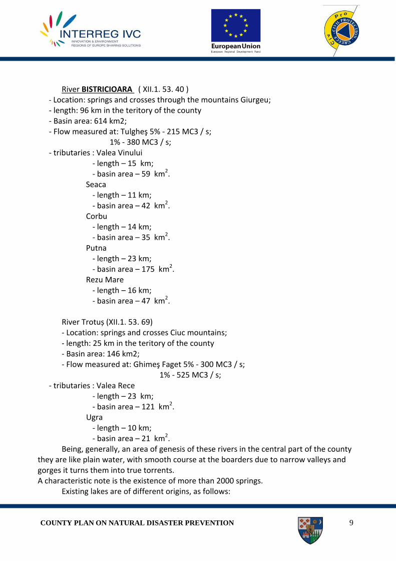
River BISTRICIOARA ( XII.1. 53. 40 ) - Location: springs and crosses through the mountains Giurgeu; - length: 96 km in the teritory of the county - Basin area: 614 km2; - Flow measured at: Tulgheş 5% - 215 MC3 / s; 1% - 380 MC3 / s; - tributaries : Valea Vinului
- length – 15 km; - basin area – 59 km2.
Seaca - length – 11 km; - basin area – 42 km2.
Corbu - length – 14 km; - basin area – 35 km2.
Putna - length – 23 km; - basin area – 175 km2.
Rezu Mare - length – 16 km; - basin area – 47 km2.
River Trotuș (XII.1. 53. 69) - Location: springs and crosses Ciuc mountains; - length: 25 km in the teritory of the county - Basin area: 146 km2; - Flow measured at: Ghimeş Faget 5% - 300 MC3 / s; 1% - 525 MC3 / s;
- tributaries : Valea Rece - length – 23 km; - basin area – 121 km2.
Ugra - length – 10 km; - basin area – 21 km2.
Being, generally, an area of genesis of these rivers in the central part of the county they are like plain water, with smooth course at the boarders due to narrow valleys and gorges it turns them into true torrents. A characteristic note is the existence of more than 2000 springs.
Existing lakes are of different origins, as follows:
COUNTY PLAN ON NATURAL DISASTER PREVENTION 10
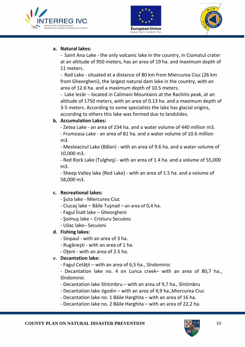
a. Natural lakes:
- Saint Ana Lake - the only volcanic lake in the country, in Ciomatul crater at an altitude of 950 meters, has an area of 19 ha. and maximum depth of 11 meters. - Red Lake - situated at a distance of 80 km from Miercurea Ciuc (26 km from Gheorgheni), the largest natural dam lake in the country, with an area of 12.6 ha. and a maximum depth of 10.5 meters. - Lake Iezăr – located in Calimani Mountains at the Rachitis peak, at an altitude of 1750 meters, with an area of 0.13 ha. and a maximum depth of 3-5 meters. According to some specialists the lake has glacial origins, according to others this lake was formed due to landslides.
b. Accumulation Lakes: - Zetea Lake - an area of 234 ha. and a water volume of 440 million m3. - Frumoasa Lake - an area of 81 ha. and a water volume of 10.6 million m3. - Mesteacnul Lake (Bălan) - with an area of 9.6 ha. and a water volume of 10,000 m3. - Red Rock Lake (Tulgheş) - with an area of 1.4 ha. and a volume of 55,000 m3. - Sheep Valley lake (Red Lake) - with an area of 1.5 ha. and a volume of 58,000 m3.
c. Recreational lakes:
- Şuta lake - Miercurea Ciuc - Ciucaş lake – Băile Tuşnad – an area of 0,4 ha. - Fagul Înalt lake – Gheorgheni - Şoimuş lake – Cristuru Secuiesc - Uilac lake– Secuieni
d. Fishing lakes: - Sinpaul - with an area of 3 ha. - Rugăneşti - with an area of 1 ha. - Oţeni - with an area of 2.5 ha.
e. Decantation lake: - Fagul Cetăţii – with an area of 6,5 ha., Sîndominic - Decantation lake no. 4 on Lunca creek– with an area of 80,7 ha., Sîndominic - Decantation lake Sîntimbru – with an area of 9,7 ha., Sîntimbru - Decantation lake Jigodin – with an area of 4,9 ha.,Miercurea Ciuc - Decantation lake no. 1 Băile Harghita – with an area of 16 ha. - Decantation lake no. 2 Băile Harghita – with an area of 22,2 ha.

COUNTY PLAN ON NATURAL DISASTER PREVENTION 11
- Decantation lake of vaste Băile Harghita – with an area of 0,9 ha.
Population After the most recent data, Harghita County had 326,558 inhabitants, of which
35.01% lives in the four municipalities, namely Miercurea Ciuc, Székelyudvarhely, Gheorgheni and Toplita and 9.22% in the 5 towns respectively Cristuru Secuiesc, Bălan, Vlăhiţa, Borsec şi Băile Tuşnad and a number of 182,135 in rural areas (55.77%) in the 58 communes with 236 villages.
Transport routes The network of the routes of communication is determined by the county’s relief:
the depressions of Ciuc and Giurgeu are linked by railway in the valley of Mures and Olt rivers, namely by line 400, built in XIX century, which runs between 333 and 454 km crossing the county from north to south, and it links the county to the capital. Railway bifurcates at Siculeni. Line 501, from 0 km to 32 km, ensures traffic between Moldova and Harghita through the Ghimes – Palanca Pass. Line 308, from 0 km to 33 km, ensures the traffic between Odorheiu Secuiesc and Sighisoara through the Transylvanian Plateau. The railway network in the zone of Odorhei and Cristur is not well developed; there are only two lines, namely line 308 between Sighisoara and Odorheiu Secuiesc, and line 307 between Praid and Tg. Mures.
As Harghita County is divided by the mountain chains, there is no railway between Miercurea Ciuc and Odorheiu Secuiesc municipia. The whole length of the railway line is 213 km and 165 km of this is electrified.
The network of roads is also determined by the mountainous relief of the county. The network of national and local roads is better distributed than the network of railway. Generally, the national roads run along the railway lines.
Economic development
The county’s economic profile presents elements of strong dependence on forestry and wood manufacture, agriculture and food industry, light industry, industries which need intensive physical labor.
Trade and services, albeit with smaller share in Harghita County’s economy are dynamic branches, most commercial and service activities achieved by private units.
Average industrial areas are located in cities and towns of the county, predominantly wood manufacturing industry (in all municipalities and cities), light industry - clothing (Miercurea Ciuc, Odorheiu Secuiesc, Gheorgheni şi Topliţa), provision of various services.
According to Statistical Yearbook of Romania in Harghita county (an area of 663,890 ha) 406,443 ha is agricultural land, 231,494 ha forest area and 25,953 ha other surfaces.
A large proportion of the population’s activity is in the the livestock area of competence, with 100 ha: 22.9 cattle, pigs 112.2, 112.7 61 sheep and goats and birds.
COUNTY PLAN ON NATURAL DISASTER PREVENTION 12
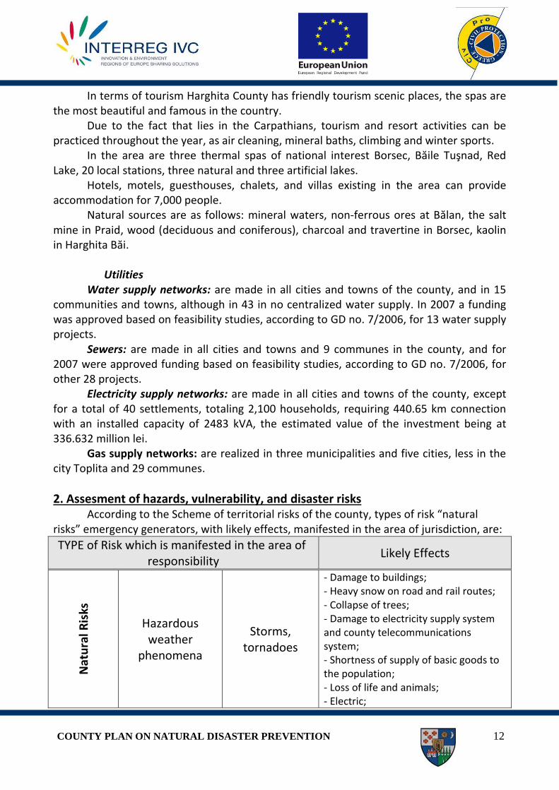
In terms of tourism Harghita County has friendly tourism scenic places, the spas are the most beautiful and famous in the country.
Due to the fact that lies in the Carpathians, tourism and resort activities can be practiced throughout the year, as air cleaning, mineral baths, climbing and winter sports.
In the area are three thermal spas of national interest Borsec, Băile Tuşnad, Red Lake, 20 local stations, three natural and three artificial lakes.
Hotels, motels, guesthouses, chalets, and villas existing in the area can provide accommodation for 7,000 people.
Natural sources are as follows: mineral waters, non-ferrous ores at Bălan, the salt mine in Praid, wood (deciduous and coniferous), charcoal and travertine in Borsec, kaolin in Harghita Băi.
Utilities
Water supply networks: are made in all cities and towns of the county, and in 15 communities and towns, although in 43 in no centralized water supply. In 2007 a funding was approved based on feasibility studies, according to GD no. 7/2006, for 13 water supply projects.
Sewers: are made in all cities and towns and 9 communes in the county, and for 2007 were approved funding based on feasibility studies, according to GD no. 7/2006, for other 28 projects.
Electricity supply networks: are made in all cities and towns of the county, except for a total of 40 settlements, totaling 2,100 households, requiring 440.65 km connection with an installed capacity of 2483 kVA, the estimated value of the investment being at 336.632 million lei.
Gas supply networks: are realized in three municipalities and five cities, less in the city Toplita and 29 communes.
2. Assesment of hazards, vulnerability, and disaster risks According to the Scheme of territorial risks of the county, types of risk “natural
risks” emergency generators, with likely effects, manifested in the area of jurisdiction, are:
TYPE of Risk which is manifested in the area of responsibility
Likely Effects
Nat
ura
l Ris
ks
Hazardous weather
phenomena
Storms, tornadoes
- Damage to buildings; - Heavy snow on road and rail routes; - Collapse of trees; - Damage to electricity supply system and county telecommunications system; - Shortness of supply of basic goods to the population; - Loss of life and animals; - Electric;

COUNTY PLAN ON NATURAL DISASTER PREVENTION 13
- Decline of construction or falling objects.
Floods
- Water overflow and flooding of farms and crops; - Loss of life and animals; - Damage.
Drought
-impaired population, crops, livestock and forestry; - Encouraging the production of large fires
Frost
- Bridges and dams of ice; - Heavy snow falls, blizzards, ice deposits on conductors; - Shortness of conducting socio-economic activities
Forest fires - Partial or total damage of forests and villages in the area; - Environmental damage.
Avalanche
- Capturing people in the area, human victims; - Blocking communication paths, damage to buildings, damage to property.
Destructive geological phenomena
Landslides - Damage to communities and population
Earthquakes - Collapse of buildings; - Capturing people under the rubble.
Classification in terms of civil protection, depending on the types of risk, “Natural
risks” of administrative-territorial units, is as follows:
No. Community/Town
/City E S/CF F D AV FF
1 Miercurea Ciuc
2 Odorheiu Sec.
3 Gheorgheni
4 Topliţa NO
5 Băile Tuşnad
6 Bălan
7 Borsec
8 Cristuru Sec.
9 Vlăhiţa
10 Atid
11 Avrămeşti
12 Bilbor
13 Brădeşti
14 Căpâlniţa
COUNTY PLAN ON NATURAL DISASTER PREVENTION 14
15 Cărţa
16 Ciceu
17 Ciucsângeorgiu
18 Ciumani
19 Corbu
20 Corund
21 Cozmeni
22 Dăneşti
23 Dârjiu
24 Dealu
25 Ditrău
26 Feliceni
27 Frumoasa
28 Gălăuţaş
29 Joseni
30 Lăzarea
31 Leliceni
32 Lueta
33 Lunca de jos
34 Lunca de Sus
35 Lupeni
36 Mădăraş
37 Mărtiniş
38 Mereşti
39 Mihăileni
40 Mugeni
41 Ocland
42 Păuleni Ciuc
43 Plăieşii de Jos
44 Porumbeni
45 Praid
46 Racu
47 Remetea
48 Satu Mare
49 Săcel
50 Sărmaş
51 Secuieni
52 Siculeni
53 Sâncrăieni
54 Sândominic
55 Sânmartin
56 Sânsimion
57 Sântimbru
58 Subcetate
59 Suseni
60 Şimoneşti
61 Tomeşti
62 Tulgheş
63 Tuşnad Sat
64 Ulieş
65 Vărşag
66 Voşlobeni
COUNTY PLAN ON NATURAL DISASTER PREVENTION 15
67 Zetea
E-Earthquake; FF- Forest Fire; S/CF- Slide / collapse of field; D – Drought F- Floods; AV – Avalanches;
Natural Hazards - LANDSLIDES Unlike other natural hazards, landslides are difficult to locate both planimetric and
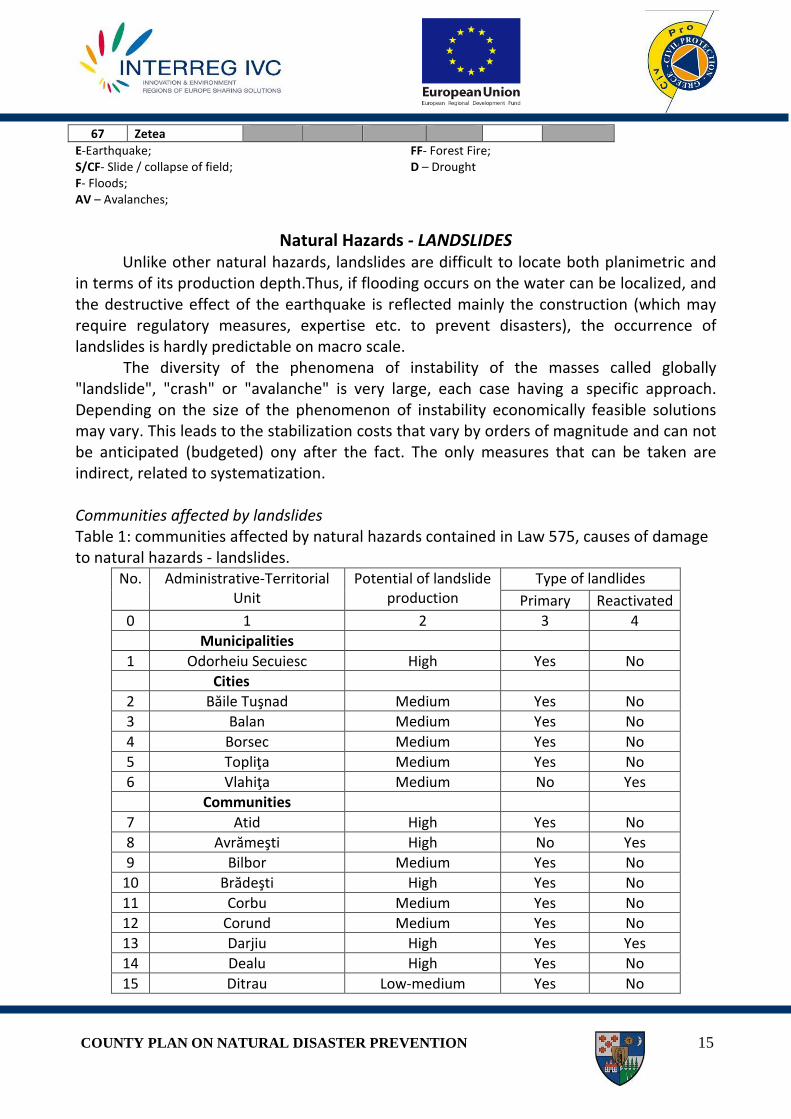
in terms of its production depth.Thus, if flooding occurs on the water can be localized, and the destructive effect of the earthquake is reflected mainly the construction (which may require regulatory measures, expertise etc. to prevent disasters), the occurrence of landslides is hardly predictable on macro scale. The diversity of the phenomena of instability of the masses called globally "landslide", "crash" or "avalanche" is very large, each case having a specific approach. Depending on the size of the phenomenon of instability economically feasible solutions may vary. This leads to the stabilization costs that vary by orders of magnitude and can not be anticipated (budgeted) ony after the fact. The only measures that can be taken are indirect, related to systematization. Communities affected by landslides Table 1: communities affected by natural hazards contained in Law 575, causes of damage to natural hazards - landslides.
No. Administrative-Territorial Unit
Potential of landslide production
Type of landlides
Primary Reactivated
0 1 2 3 4
Municipalities
1 Odorheiu Secuiesc High Yes No
Cities
2 Băile Tuşnad Medium Yes No
3 Balan Medium Yes No
4 Borsec Medium Yes No
5 Topliţa Medium Yes No
6 Vlahiţa Medium No Yes
Communities
7 Atid High Yes No
8 Avrămeşti High No Yes
9 Bilbor Medium Yes No
10 Brădeşti High Yes No
11 Corbu Medium Yes No
12 Corund Medium Yes No
13 Darjiu High Yes Yes
14 Dealu High Yes No
15 Ditrau Low-medium Yes No
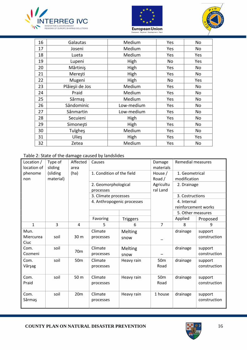
COUNTY PLAN ON NATURAL DISASTER PREVENTION 16
16 Galautas Medium Yes No
17 Joseni Medium Yes No
18 Lueta Medium Yes Yes
19 Lupeni High No Yes
20 Mărtiniş High Yes No
21 Mereşti High Yes No
22 Mugeni High No Yes
23 Plăieşii de Jos Medium Yes No
24 Praid Medium Yes No
25 Sărmaş Medium Yes No
26 Sândominic Low-medium Yes No
27 Sânmartin Low-medium Yes No
28 Secuieni High Yes No
29 Simoneşti High Yes No
30 Tulgheş Medium Yes No
31 Ulieş High Yes Yes
32 Zetea Medium Yes No
Table 2: State of the damage caused by landslides Location / location of phenomenon
Type of sliding (sliding material)
Affected area (ha)
Causes Damage materials
Remedial measures
1. Condition of the field House / Road / Agricultural Land
1. Geometrical modification
2. Geomorphological processes
2. Drainage
3. Climate processes 3. Costructions 4. Anthropogenic processes 4. Internal
reinforcement works 5. Other measures Favoring Triggers Applied Proposed
1 3 4 5 6 7 8 9
Mun. Miercurea Ciuc
soil 30 m Climate processes
Melting snow
–
drainage support construction
Com. Cozmeni
soil 70m
Climate processes
Melting snow
–
drainage support construction
Com. Vârşag
soil 50m Climate processes
Heavy rain 50m Road
drainage support construction
Com. Praid
soil 50 m Climate processes
Heavy rain 50m Road
drainage support construction
Com. Sărmaş
soil 20m Climate processes
Heavy rain 1 house
drainage support construction

COUNTY PLAN ON NATURAL DISASTER PREVENTION 17
1. Field Conditions Factor Control methods
soft soils - Chalk columns - Structural measures
glomerular clays - Protection of surface water entering
altered rocks - Protection of the rock surface - Installation works of defense
cracked rocks - Clogging cracks - Installation of nets or panels anchored - Installation works of defense
rock layer in unfavorable orientation (slope of bedrock, schistosity, cleavage, etc.).
there are no specific measures
discontinuities of material in an disavantegous way (faults, lenses, etc.).
there are no specific measures
alternation of layers in terms of permeability and / or stiffness
- drainage - structural measures
2. Geomorphological processes
Factor Control methods
earthquake - Seismic design of support structures
ice distention there are no specific measures
fluvial erosion of the slope toe - Installation of defense works
coastal erosion - Installation of defense works
glacial erosion - Installation of defense works
underground erosion there are no specific measures
overload of hill ridges - earthworks
vegetation removal (from erosion, forest fires, droughts)
- reforestation
3. Physical processes
Factor Control methods
short and intense rainy periods - Installation of surface water drainage sistems long rainy periods
rapid melting of snow freeze-thaw cycles Sudden decrease of water levels in lakes after floods or natural dam break
- Installation of regularization sistems
4. Anthropogenic processes
Factor Control methods
- Excavation slopes and foot slopes - Legislative measures and their

COUNTY PLAN ON NATURAL DISASTER PREVENTION 18
- Charging embankments or ridge areas - Emptying of accumulation lakes - Irrigation in areas of slope - Poor maintenance of water networks and sewage - Installation of water mains without sewerage network - Deforestation - Surface and deep mining - Creating deposits of loose granular materials - Artificially induced vibration (traffic, striking pile, heavy machinery, etc.).
implementation
NATURAL HAZARDS - EARTHQUAKE geological-geotechnical and seismic studies
Harghita Miercurea Ciuc Odorheiu Secuiesc Baile
Tusnad Balan Cristuru Secuiesc Gheorgheni Toplita Vlahita
Communities
Geotechnical drilling and dynamic penetration tests
- 1 location/1km2
- 1 location/10km2 -
drilling with a minimumdepth of 50m
- 1 location/1km2
- 1 location/10km2 -
drilling with a minimumdepth of 50m
- 1 location/1km2
- 1 location/10km2 - drilling
with a minimumdepth of 50m
1 location
Dynamic laboratory tests (cyclic triaxial / column
resonance)
3 tests for each layer/ location
3 tests for each layer/ location
3 tests for each layer/ location
Optional
Seismic measurements (Downhole)
1 location/10km2
1 location
1 location Optional
Micro-vibration measurements
in 24 locations in the city
in 12 locations in the city
in 6 locations in the city Optional
NATURAL HAZARDS - FLOOD Flood protection measures taken locally for various phases of defense come into
force by hydrological forecast and warnings reported by basin information systems and based on recorded data at hydrometric stations and hydrotechnic constructions (dams, dikes, etc) during high waters period.

COUNTY PLAN ON NATURAL DISASTER PREVENTION 19
I. Measures for warning and alarm the population at the moment when hydrological or meteorological warnings were received
Warning - transmission of warnings received from MMDD/ANM/INHGA/AN Romanian Waters by ISUJ (and through it to al of CLSU from the County), by Operational Centers for Emergencies of the County’s SGA, and by mass-media (through press releases to local radio - TV and newspapers). In turn, presidents of CLSU have the obligation to announce the population about the warnings they received. II. Measures to achieve a.1. Attention level - entering into the defense device of the Operational Centres for Emergency Situations and CLSU - increasing the frequency of observations and measurements that are made to track weather phenomena and to forcast its evolution - checking the hydrotechnic constructions with defense role against flood and monitoring the drainage conditions of large waters on watercourses - removing the materials from the sections of bridges and cluverts - transmission of daily operational reports (whenever necessary) to institutions with higher level a.2. Flood level - Operational Centers for Emergencies and CLSU are maintained - continous monitoring of work with role of defense against inundation - directing forces and means of intervention - raising and strengthening of dams and coasts according to the maximum predicted rates - to take measures to warn the population informing them of the possibility of evacuation in case of danger - to take measures to warn and alarm socio-economic objectives located downstream to hidrotechnic constructions, in case of danger - providing the function of the information flow – operative and decisional, increasing the frequency of information transmission - transmission of daily operational reports (whenever necessary) to institutions with higher technical level, and to county level institutions to create human and material resources to limit damage production
a.3. Danger level - providing development for limitation and removal actions to save people, animals, goods, accomodations for victims, food and water supply, medical assistance
COUNTY PLAN ON NATURAL DISASTER PREVENTION 20
- increasing the frequency of observations, measurements which are made for monitoring the phenomena and to forcast its evolution, and its transmission of information in every hour - directing forces and means of intervention - raising and strengthening dams - to take measures to warn and alarm socio-economic objectives located downstream to hidrotechnic constructions, in case of imminent danger to them - transmission of daily operational reports (whenever necessary) to institutions with higher technical level, and to county level institutions
b.1. Phase I Dam defence - supervisioning the dams and taking measures to combat phenomena which appear even if they are mild - providing matirials, transport and intervention - avoiding the erosion of the dam body due to the action of waves by preparing and protecting the slope of the dam with ledges or wattle fences, placement of floating elements parallel with the dig - at the appearance of infiltration upstream dam sealing is involved with plastic wrap if leakage occurs only through the dam body, or by making a bulkhead of sheet piling, if infiltration occurs at the foundation of the dam - increasing the frequency of observations and measurements
b.2. Phase II Dam defence - supervisioning the dams and taking measures to combat phenomena which appear - directing forces and means of intervention - the appearance of curve of infiltration accompanied by softening of the downstream slope and / or the foundation, in order to protect it is used a drainage prism on the principle of inverse filters; - the appearance of isolated infiltrations near the dam drainage will result the usage of drainage prism (inverse filter rule); - the infiltrations located in a larger distance from the dam, can be annihilated by increasing the level of the water with an inner dam - increasing the frequency of observations and measurements
b.3. Phase III Dam defense - To ensure to proceed the action on limitation and removal of flood effects to save people, animals, goods, materials, accommodation victims, water and food, medical assistance; - Elevation of dams conidering the danger of exceeding and potential damage. In case if the chamber has no high degree of equipment, may be sacrificed to save from flooding an area which has higher damage potential;
COUNTY PLAN ON NATURAL DISASTER PREVENTION 21
c.1. Phase I Defense against ice - Increasing the frequency of observations and measurements are made to track weather phenomenon and its evolution; - Check the hydrotechnic construction of flood defense and track the condition of drainage of large rivers - Removal of materials from bridges in the right places;
c.2. Phase II Defense against ice - Increasing the frequency of observations and measurements are made to track weather phenomenon and its evolution; - Check the hydrotechnic construction of flood defense and track the condition of drainage of large rivers - The steps in case of ice torrent formation, are taken: a) dislocation of the ice with icebreakers (ships) b) the explosion of the ice with dynamite to ensure the flow of floes;
c.3. phase III defense of ice - Increasing the frequency of observations and measurements are made to track weather phenomenon and its evolution; - Check the hydrotechnic construction of flood defense and track the condition of drainage of large rivers - Acting with special intervention forces and equipment to destroy floes;
d. specific warning thresholds of precipitation - are transmited warnings received from the NMA ISUJ (and through all of CLSU – County level), to Operational Centers for Emergencies of SGA, of operators and other institutions directly involved
COUNTY PLAN ON NATURAL DISASTER PREVENTION 22
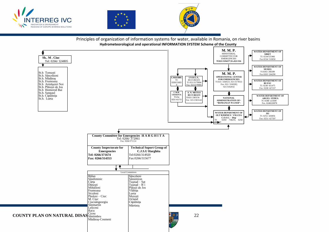
Principles of organization of information systems for water, available in Romania, on river basins Hydrometeorological and operational INFORMATION SYSTEM Scheme of the County
I.N.H.G.A..
BUCUREŞTI Tf./021/3179994
Fax. 0213179995
C.M.R.SIBU
Tf: 0269/21683
9
0269/235148
C.M.R.
CRAIOVA
Tf.-Fax
0251/ 411711
Sh.. M . Ciuc
Tel: 0266/ 324805
County Committee for Emergencies H A R G H I T A Tel: 0266/ 372061
Fax: 0266/371114
County Inspectorate for
Emergencies
Tel: 0266/371674
Fax: 0266/314353
Technical Suport Group of
C.J.S.U Harghita Tel:0266/314920 Fax:0266/315677
Local Committees
Bălan Sândiminic Cârţa Dăneşti Mihăileni Frumoasa Siculeni Păuleni – Ciuc M. Ciuc Ciucsângeorgiu Sânmartin Leliceni Racu Ciceu Sântimbru Mădăraş-Cosmeni
Sâncrăeni Sânsimion Tuşnad – Sat Tuşnad – B`i Plăeşii de Jos Vlăhiţa Lueta Mereşti Ocland Căpâlniţa Mărtiniş
St.h Tomeşti St.h. Sâncrăieni St.h. Mădăraş St.h. Frumoasa St.h Armăşenii Noi St.h. Plăieşii de Jos St.h Homorod Bai St.h. Sanpaul St.h. Câpâlniţa St.h. Lueta
A. N. METEO
BUCUREŞTI
Tf.021/ 2303116
Fax 021/2303143 NATIONAL
ADMINISTRATION OF~
“ROMANIAN WATER”-
C.O.S.U.
Fax.021 3103526 / 021 3123738
Tf. 021//3110396 WATER DEPARTMENT OF
OLT RÂMNICU VÂLCEA
C.O.S.U. - Disp Tf: 0250/ 738255, 0250/ 739840
Fax: 0250/ 738255
M. M. P. MINISTERIAL
COMMITTEE FOR EMERGENCIES
Tf.021/3194377;Fx.021/316
2032
M. M. P. OPERATIONAL CENTER
FOR EMERGENCIES
Tf.021/ 3160521; 021/3170551
Fax: 021/ 3160282;
021/3162032
WATER DEPARTMENT OF
SIRET
Tf. 0234/515466
Fax.0234/ 510050
WATER DEPARTMENT OF
MUREŞ
Tf.0265/ 260289
Fax.0265/ 264290
WATER DEPARTMENT OF
BUZĂU Tf. 0238/ 431475
Fax. 0238/ 427237
WATER DEPARTMENT OF
ARGEŞ -VEDEA
Tf. 0248/ 223449 Fax. 0248220878
WATER DEPARTMENT OF
JIU Tf. 0251/ 426856
Fax. 0251/ 427597

COUNTY PLAN ON NATURAL DISASTER PREVENTION 23
NATURAL HAZARDS- FOREST FIRE
Forest fires are part of natural hazards with high frequency in Harghita County (forestry
fund, this represent 34% of the county’s surface). Although in most cases these phenomena are due to human negligence, in some case these are caused by atmospheric electric discharges (lightning).
Forest fires have special problems due to the danger of spreading fire on large wooded areas and reduced opportunities to intervene effectively to limit and to extinguish the outbreaks.
Locating the danger zones Forest fires can appear on the entire area, especially during spring and autamn when the
vegetation is dry or summer when it is drougth. The most vulnerable areas are:
Western sector: - Călimani Mountains: located in northern part in the defile of Mureş, with high altitudes,
some over 2.000 m (Pietrosu Peak 2.102 m) - Gurghiu Mountains - Harghita Mountains form a 70 km long chain and it is 25 km wide, with the next peaks:
Harghita Race – 1757 m, Harghita Ciceu – 1759 m and Harghita Mădăraş – 1800 m. They are delimited by the Sicaş Pass and the spring of Târnava Mare in north, by the line of Feliceni, Văleni, Mereşti şi Mărtiniş localities in south, and by the Baraolt Depresion and Mountains on the line of Herculian and Filia localities.
Eastern sector: - Budac Mountains - Giurgeu Mountains takes the form of an extended ridge between the Călimani
Mountains in nord, Borsec and Bilbor Depression in east and in north-east, Hăşmaş Mountains in south and Hăşmaş Depression in vest.
- Hăşmaş Mountains - Ciuc Mountains located at the eastern limit of the Ciuc Depression between the Olt
Spring, Trotuş Spring and Uz Spring - Perşan Mountains penetrate in Harghita County by the northern peaks located on the
Vargyas Creek Valley.
Serious consequences of forest fires Forest fires can affect some localities such as: Red Lake, Borsec, Bilbor, Secu, Vîrşag, Băile
Tuşnad, Plăieşii de Jos. These localities may be affected partially or completely, forcing the special evacuation.
COUNTY PLAN ON NATURAL DISASTER PREVENTION 24
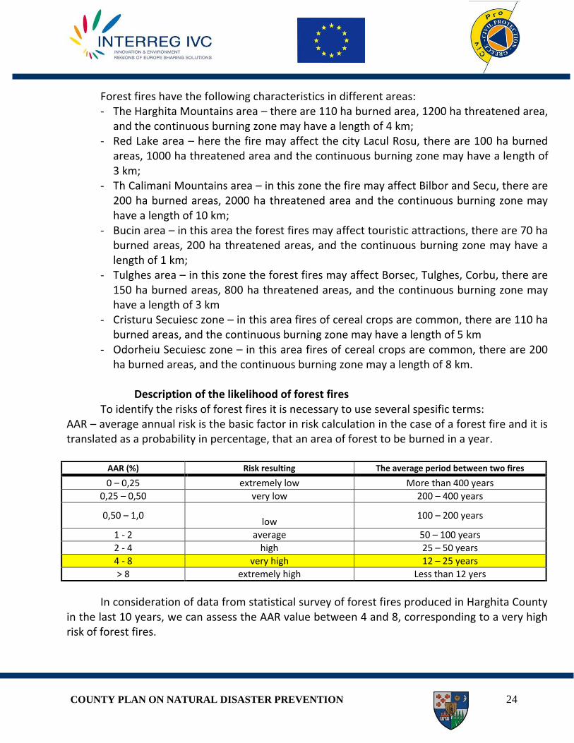
Forest fires have the following characteristics in different areas: - The Harghita Mountains area – there are 110 ha burned area, 1200 ha threatened area,
and the continuous burning zone may have a length of 4 km; - Red Lake area – here the fire may affect the city Lacul Rosu, there are 100 ha burned
areas, 1000 ha threatened area and the continuous burning zone may have a length of 3 km;
- Th Calimani Mountains area – in this zone the fire may affect Bilbor and Secu, there are 200 ha burned areas, 2000 ha threatened area and the continuous burning zone may have a length of 10 km;
- Bucin area – in this area the forest fires may affect touristic attractions, there are 70 ha burned areas, 200 ha threatened areas, and the continuous burning zone may have a length of 1 km;
- Tulghes area – in this zone the forest fires may affect Borsec, Tulghes, Corbu, there are 150 ha burned areas, 800 ha threatened areas, and the continuous burning zone may have a length of 3 km
- Cristuru Secuiesc zone – in this area fires of cereal crops are common, there are 110 ha burned areas, and the continuous burning zone may have a length of 5 km
- Odorheiu Secuiesc zone – in this area fires of cereal crops are common, there are 200 ha burned areas, and the continuous burning zone may a length of 8 km.
Description of the likelihood of forest fires
To identify the risks of forest fires it is necessary to use several spesific terms: AAR – average annual risk is the basic factor in risk calculation in the case of a forest fire and it is translated as a probability in percentage, that an area of forest to be burned in a year.
AAR (%) Risk resulting The average period between two fires
0 – 0,25 extremely low More than 400 years
0,25 – 0,50 very low 200 – 400 years
0,50 – 1,0
low 100 – 200 years
1 - 2 average 50 – 100 years
2 - 4 high 25 – 50 years
4 - 8 very high 12 – 25 years
> 8 extremely high Less than 12 yers
In consideration of data from statistical survey of forest fires produced in Harghita County in the last 10 years, we can assess the AAR value between 4 and 8, corresponding to a very high risk of forest fires.
COUNTY PLAN ON NATURAL DISASTER PREVENTION 25
For the purpose of risk assessment, parameters close to reality, as a priority of our institution is the realization of a statistic on the large forest fires, per years, per climate seasons, on administrative areas and forest structure over a period of 20 - 40 years.
To reduce fire risks should be taken into account: - systematic and qualified examination of factors determined by riscs - establishing and developing analitic plans and covering the risk by all
administrative units - establishing persons with tasks on implementation of measures for emergency
management
COUNTY PLAN ON NATURAL DISASTER PREVENTION 26
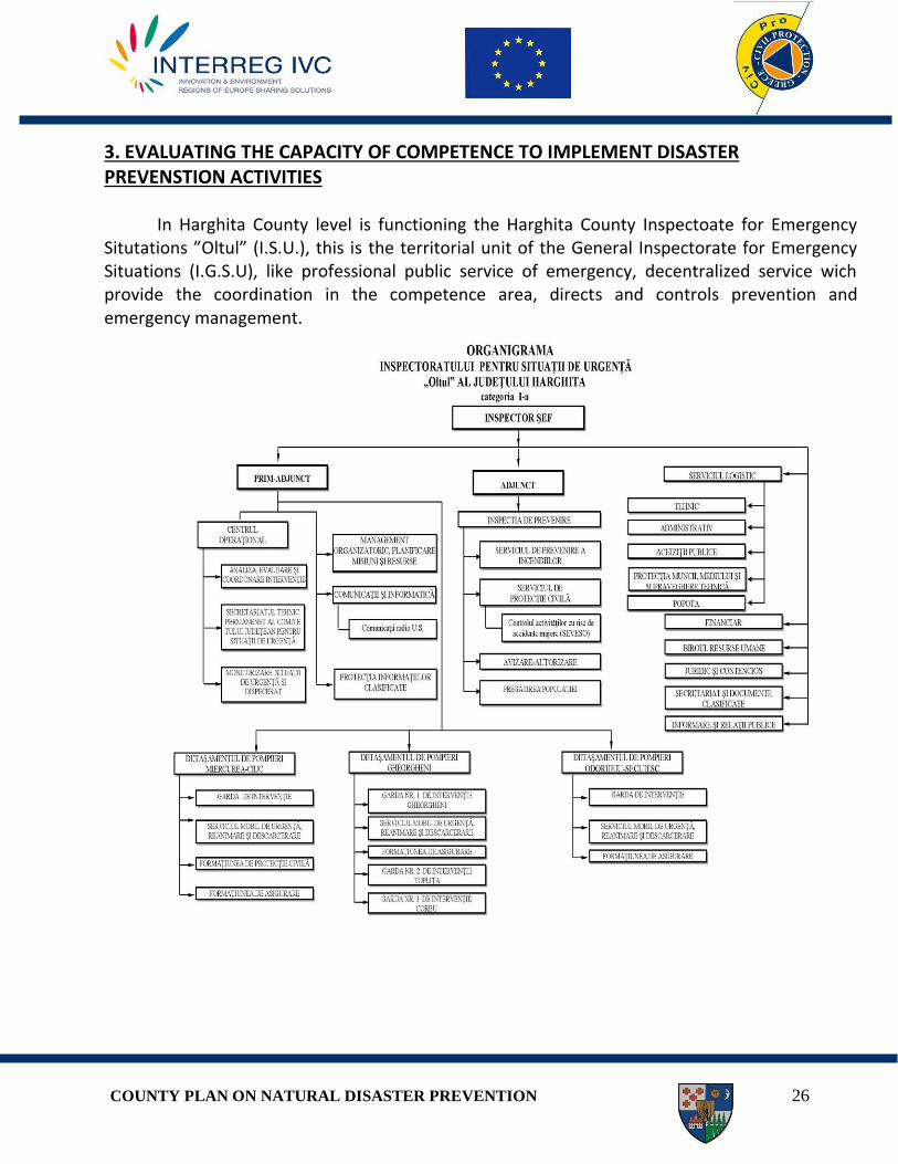
3. EVALUATING THE CAPACITY OF COMPETENCE TO IMPLEMENT DISASTER PREVENSTION ACTIVITIES
In Harghita County level is functioning the Harghita County Inspectoate for Emergency
Situtations ”Oltul” (I.S.U.), this is the territorial unit of the General Inspectorate for Emergency Situations (I.G.S.U), like professional public service of emergency, decentralized service wich provide the coordination in the competence area, directs and controls prevention and emergency management.

COUNTY PLAN ON NATURAL DISASTER PREVENTION 27
Whitin the inspectorate works the County Operational Center (C.O.J) – wich meets permanent monitoring functions, evaluation, notification, warning, alerting and operational technical coordination of emergency situations at county level.
Whitin the County Operational Center (C.O.J) works the permanent technical secretariat of the County Commitee for Emergency Situations (S.TH.P. al C.J.S.U.)
The County Commitee for Emergency Situations is under the lead of the prefect. The Commitee members are: president of the county council, heads of decentralized services and head of city management and other managers of institutions and companies, wich fulfill the function of emergency management support, as well as economic agency’s managers, who through their specific activities are generatosr of potentioal risk factors for emergency situations.
The County Commitee for Emergency Situations (C.J.S.U) functions by the order of the prefect.
In the municipalities, towns and villages are formed, under the mayor’s editorship, local emergency committees (C.L.S.U) wich includes a deputy mayor, a seretary and representatives of public services and major institutions and economic agents from the administrative-teritorial unit, and managers and leaders of economic agency’s, subsidiaries, branches and local work points that, through their specific activities are generators of potential risk factors for emergency situtaions.
The General Inspectorate of Emergency Situations, as a specialized body subordinated to the Ministry of Administration and Interior, provides consistent and continuos coordination of prevention and management of national emergency situations.
National Committee for Emergency Situations functions under the direct leadership of the Ministry of Administration and Interior and under the leadership of the Prime Minister.
The National Committee for Emergency Situations is an interministerial body, comprising persons with decisional power, experts and specialists appointed by the ministries with responsabilities in managing complex emergencies. The National Committe for Ermergency Situations provide the completion of the specific tasks of the achievement of the objectives of international strategy for disaster reduction.
The General Inspectorate of Emergency Situations by the National Operational Center (C.O.N.) provide the permanent technical secretariat of the National Committe for Ermergency Situations (C.N.S.U.)
The General Inspectorate of Emergency Situations provide the cooperation and representation on national level of the areas as follows : civil protection, defense against fires and emergency management.
In ministries and other public central institutions with responsabilities in emergency management is functioning the Ministerial Committe for Emergency Situations (C.M.S.U).
COUNTY PLAN ON NATURAL DISASTER PREVENTION 28
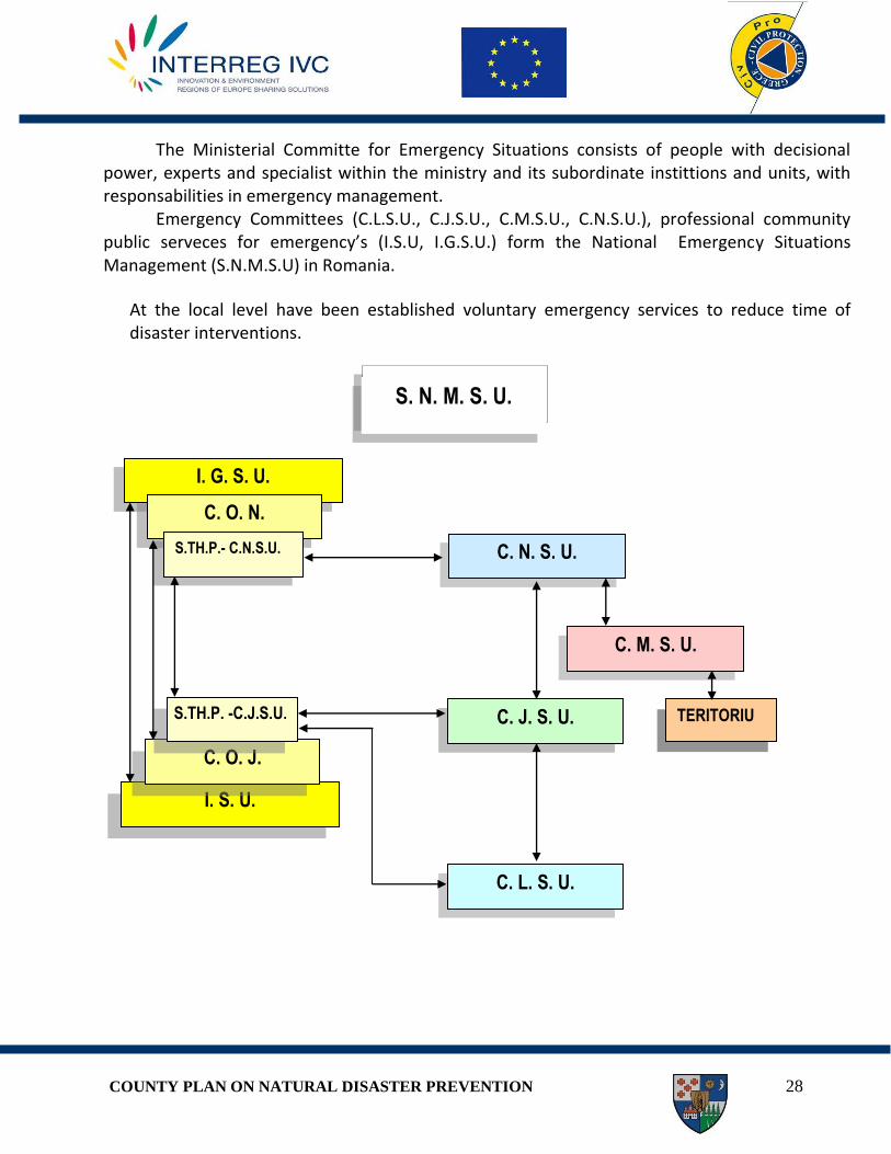
The Ministerial Committe for Emergency Situations consists of people with decisional power, experts and specialist within the ministry and its subordinate instittions and units, with responsabilities in emergency management.
Emergency Committees (C.L.S.U., C.J.S.U., C.M.S.U., C.N.S.U.), professional community public serveces for emergency’s (I.S.U, I.G.S.U.) form the National Emergency Situations Management (S.N.M.S.U) in Romania.
At the local level have been established voluntary emergency services to reduce time of disaster interventions.
C. J. S. U.
I. G. S. U.
C. O. N.
S.TH.P.- C.N.S.U. C. N. S. U.
C. M. S. U.
C. L. S. U.
I. S. U.
C. O. J.
S.TH.P. -C.J.S.U.
TERITORIU
S. N. M. S. U.

COUNTY PLAN ON NATURAL DISASTER PREVENTION 29
VVOOLLUUNNTTAARRYY SSEERRVVIICCEESS FFOORR EEMMEERRGGEENNCCYY SSIITTUUAATTIIOONNSS-- IINN TTHHEE CCOOMMPPEETTEENNCCEE AARREEAA OOFF II..SS..UU ““OOLLTTUULL””
HHAARRGGHHIITTAA CCOOUUNNTTYY
No. S.V.S.U.
Community S.V.S.U.
Category
Equipment
Fire trucks Other types of trucks
( Extrication ) Tota
l
M.P
Type/Brand Pc. Type/Brand Pc. St. Ev.
1. CRISTURU-SECUIESC IV APCA - RABA
ATI - SR 114 2 Extrication CSEPEL 1 3 5 1
2. CORUND IV APC - MAGIRUS
APC - MERCEDES 2 - - 2 2 2
3. DEALU IV APC - STEYER
APC - F.MERCUR 2 - - 2 4 -
4. DITRĂU IV APC - IFA
APC - MERCEDES 2 - - 2 1 1
5. MĂRTINIŞ IV APC - IFA
APC - GAZ 2 - - 2 6 6
6. TOMEŞTI IV APC - STEYER
APC - OPEL 2 - - 2 1 -
7. ATID IV
APCT - R
APC - MAGIRUS 2 - - 1 3 3
8. PRAID IV APCA - RABA
APCA - IVECO 2
Extrication MERCEDES
1 3 4 1
9. BĂILE-TUŞNAD III API - FORD 1 - - 1 1 -
10. BORSEC III API - MAGIRUS 1 - - 1 2 -
11. CÂRŢA III APCA - RABA 1 - - 1 3 1
12. CICEU III APC - IFA 1 - - 1 1 -
13. CIUMANI III APC - STEYER 1 - - 1 2 -
14. DĂNEŞTI III APC - CSEPEL 1 - - 1 1 -
15. JOSENI III APCT - R 1 - - 1 5 -
16. LUPENI III APC - CSEPEL 1 - - 1 5 -
17. LUNCA DE JOS III APC - ZIL 1 - - 1 1/0
2
18. MĂDĂRAŞ III APC - CSEPEL 1 - - 1 - -
19. REMETEA III APC - IFA 1 - - 1 2 2
20. SÂNCRĂIENI III APC - STEYER 1 - - 1 - 1
21. SÂNDOMINIC III APC - MERCEDES 1 - - 1 2 2
22. SÂNMARTIN III APC - MERCEDES 1 - - 1 1 -
23. SÂNSIMION III APC - MERCEDES 1 - - 1 2 -
24. SÂNTIMBRU III APCA - RABA 1 - - 1 1 1
25. TULGHEŞ III API - TV 1 - - 1 1 -
26. VLĂHIŢA III APCT - R 1 Extrication
WOLSVAGEN 1 2 2 2
27. ZETEA III APC - MERCEDES 1 - - 1 1 1
28. AVRĂMEŞTI I - - - - - 2 -
29. BĂLAN I - - - - - - -
30. BILBOR I - - - - - 4/2
-
31. BRĂDEŞTI I - - - - - 2 -
32. CĂPÂLNIŢA I - - - - - 1 1
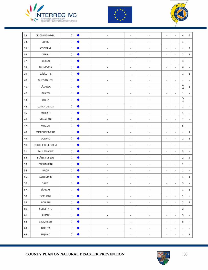
COUNTY PLAN ON NATURAL DISASTER PREVENTION 30
33. CIUCSÂNGIORGIU I - - - - - 4 4
34. CORBU I - - - - - 1 -
35. COZMENI I - - - - - - 2
36. DÂRJIU I - - - - - 2 2
37. FELICENI I - - - - - 4 -
38. FRUMOASA I - - - - - 6 -
39. GĂLĂUŢAŞ I - - - - - 1 1
40. GHEORGHENI I - - - - - - -
41. LĂZAREA I - - - - - 2/0
1
42. LELICENI I - - - - - 1 -
43. LUETA I - - - - - 5/4
-
44. LUNCA DE SUS I - - - - - 1 -
45. MEREŞTI I - - - - - 1 -
46. MIHĂILENI I - - - - - 1 -
47. MUGENI I - - - - - 5 -
48. MIERCUREA-CIUC I - - - - - - 1
49. OCLAND I - - - - - 2 1
50. ODORHEIU-SECUIESC I - - - - - - -
51. PĂULENI-CIUC I - - - - - 3 -
52. PLĂIEŞII DE JOS I - - - - - 2 2
53. PORUMBENI I - - - - - 1 -
54. RACU I - - - - - 1 -
55. SATU MARE I - - - - - 1 1
56. SĂCEL I - - - - - 3 -
57. SĂRMAŞ I - - - - - 1 1
58. SECUIENI I - - - - - 1 -
59. SICULENI I - - - - - 2 2
60. SUBCETATE I - - - - - 2 -
61. SUSENI I - - - - - 3 -
62. ŞIMONEŞTI I - - - - - 8 -
63. TOPLIŢA I - - - - - - -
64. TUŞNAD I - - - - - - 1

COUNTY PLAN ON NATURAL DISASTER PREVENTION 31
4. DEFENSE STRATEGIES
LANDSLIDES During the International Mitigation Decade of Natural Disasters has developed a scheme
wich includes the main types of works to prevent and stabilize landslides. Recovery measures for landslides:
o Changing the geometry of the slope o removing material from the area of the initiation of sliding (with possible
substitutes by filling light) o a deposit of material in the maintenance area (counterweight berms, filling) o a general reduction the slope angle
o Drainage o Surface drainage to collect water from the slip surface (ditches and pipes) o Outward or deep trenches, filled with easily draind material (granular or
geosynthetic material) o Buttresiss of granular material (hidrogeological effect) o Small diameter vertical drilling, with free pomping or draining o Large diameter vertical wells, with gravity drains o Subhorizontal drilling o Tunnels, access gallery with role of drainage o Depletion by vacuuming o Drainage by siphoning o Electroosmotic depletion o Vegetation planting (hydrological effect)
o Resistance strutures o Weight retaining walls o Block walls o Gabion walls o Passive pile, columns and caissons
65. ULIEŞ I - - - - - 4 4
66. VÂRŞAG I - - - - - 2 1
67. VOŞLOBENI I - - - - - 1 2
TOTAL
CATEGORIA IV -
8 CATEGORIA III -
19 CATEGORIA I -
40
35/33 - F 3/3 - F 38
135 /
129 -
F
53 / 5
3 - F
COUNTY PLAN ON NATURAL DISASTER PREVENTION 32
o Walls of concrete pillars o Resistante soil structures metal bars or polymer insertions o Buttresses of granular material (mechanical effect) o System for retaining of surface rock on slopes o Systems that attenuate or stop a collapse of rock (trench stops, benches, walls) o Rocks or concrete-blocks protecting against erosion
o Internal reinforcement of slopes o Short Anchors (beaten) o Micropiles o Anchors (prestressed and passive) o Injection o Column of stone and chalk o Thermic treatment o Freezing o Electroosmotice anchor o Planting of vegetation (resistance of roots has mechanical effect)
The role of prevention or mitigation/stopping the landslides by action of disturbing factors is essential.
Measures, varied and spesified for each case in part, function of the scale of the phenomenon, can be grouped as follows:
-change the original geometry; -reducing pore water pressure; -physical, chemical, biological measures; -mechanical measures.
It is intended to increase safety of slopes by: - ensuring a state of tension in the field, comparable to its resistance to shear; - preserving in time the shear resistance of the land, by preventing their reduction; -balancing the state of tension by realizing a support work of a sliding mass
In order to reduce potential effects to produce landslides troughout the Harghita County are required the following measures: - Prohibiting any kind of construction on polygonal surfaces with elevated values of average
hazard factors (KM= 0,51 – 9,80) – high potential production of landslides; - Acceptance/approval of construction projects (of any type) in areas with average – high
values of hazard factors (Km= 0,31 – 0,50), with average probability of landslides, due to development of projects on achieving controlled drainage, the road layout, location of utility networks, taking into account the hazard map of Harghita County landslides;
- acceptance / approval of any construction project to comply with law, for sectors with low values of environmental hazard factor (Km <0.30), according to a low potential of landslides.

COUNTY PLAN ON NATURAL DISASTER PREVENTION 33
EARTHQUAKES Seismic risk can be reduced only if the vulnerability of buildings can be reduced, the
seismic hazard and the exposure of dwelling cannot be modified by people. In this condtitiion, measures designed to reduce significantly the seismic risk have crucial importance, the current situation being able to generate, in the near future, social and economic aspects of a dramatic scale. Immediate action to reduce seismic risk - Making buildings safe (in the next years) wich present a high risk of collapse and wich shelter
a significant number of people - Creating buffer spaces to shelter the population, in case they have to leave their houses
temporary, during the execution of intervention works in case of an earthquake - Continuing the inventory and expertise actions of the constructions from the seismic areas - Creating technical and organizational conditions necessary for collecting, prosessing and
storageing information relating to the constructions with seismic risk - Competing the organizational framework for taking post-seism emergency measures
(especially those with technical character, related to a quick post-seism assessment and to a safe provisional release)
- Measures to improve the public information and the decisional factors at different levels (central, local), about the main aspects of sesimic risk and about the measures to reduce it.
Information and education strategy The antiseismic education of the population program should be an action with national character, to focus on education refering to practial conditions of hazard, vulnerability and risk, taking into account the following main areas: - general education of the population (urban and rural communities) - specific education programs of socio-professional categories including professionals and
peoples with management powers in public institutions responsible for defense against disasters and for civil society components. As an embodiment of the aboce programs can be proposed:
- posters, leaflets, brochures with basic rules of individual and collective protection - debate and popularization through the mass-media - manuals/ practical guides including general and specific socio professional knowlege - documentaries - training/periodically organized exercises
COUNTY PLAN ON NATURAL DISASTER PREVENTION 34
FLOOD Using the managment strategie of hazards in case of flood on average term requires
investments in flood protection infrastructure for: - arranging the interior rivers - arranging small watersheds, which are sources of risk to population, environent and
infrastruture - maintenance and operation in safe conditions of flood defense infrastructure
Arranging the interior rivers: flood defense works – promovation of new flood defense works and completion of ongoing works
Regularization of rivers Embankment constructions Consolidation of banks Bridges/culverts
Creating an additional volume of retention for high waters period: - Completion of the ongoing permanent accumulation works - Making non-permanent accumulation - Creation of wetlands near the watercourses
- maintenance and operation in safe conditions of flood defense infrastructure - making maintenance works and developments of dams on interior rivers - increase the safety level, safe maintenance and operation of permanent and non-permanent accumulation - constructions to secure the accumulation of categories C and D (mining ponds, reservoirs and recreational fishing)
A. Investment works accomplished in critial points B. Planning for flood control in Olt river basin and the Black River basin, Harghita County. C. Regularization of Mitac creek in Tuşnad Nou, Harghita County, GD 986/2006. D. Regularization of Frumoasa creek, Frumoasa dam, Harghita County. E. Regularization of Trotus rimver and tributaries, Harghita County (PHARE 2005-17). F. Regularization Toplita creek in order to prevent flood affecting the town of Toplita, Harghita county. G. River regulation of Feernic in Lupeni - Rufanesti, Harghita County, GD 373/2006. H. Regularization of river Mures in the area of communes Ciumani, Suseni, Remetea; threshold restoration and protection of river bank on Tarnava River at Odorheiul Secuiesc, Harghita County. I. Regularization of Tarnava Mare River at Albesti-Odorheiul Secuiesc, Harghita County. J. Regularization and defense of the Casin Creek bank in Pelestii de Jos, Harghita County. K. Recalibration of Mitac Creek in Tuşnad Nou, Harghita County.

COUNTY PLAN ON NATURAL DISASTER PREVENTION 35
FOREST FIRES In accordance with provisions of the regulation on emergency cases during forest fires,
approved by Order no. 551/1475 of 8 August 2006, in Romania the emergency management of forest fires is a national interest, taking into account the frequency and the dimension of the effects of these hazards.
Directly or indirectly are exposed to this risc factor: a. Population and its mobile or immobile goods b. Social objectives c. Productive capacity (comertial places, electric power plants, agrozootechnical
farms, fisheries and others) d. Routes and railways, electricity grids, natural gas pipes, sources of water supply,
sewer systems, waste water treatment plants, telecommunication grids and others e. Natural environment (forests, agricultural areas, built settlements and others)
According to the owner of the forest in which the fire was triggered, the emergency management of the forest fire will be carried out by the territorial inspectorate of forestry and hunting (for the forests in private property) and by the Direction of National Forests – Romsilva (for the state owned forests).
In Romania, the elaboration of strategy and concept of defence against forest fires is the duty of the committee of emergency cases in the frame of the Ministry of Agriculture and Rural Development which is subordinating the National Commitee of Emergency Cases. Monitoring of emergency cases, evaluation of the informations, notification, warning, prealarming, at national level, such as coordination of prevention and management measures of the emergency situations is provided by the operative centre for emergency situations, a technical body with permanent activity, founded in the frame of Ministry of Agriculture and Riral Development.
Applying the strategy and the technical coordination at national level of the actions to prevent and stop the forest fires are provided by the Direction of National Forests – Romsilva in the case of state owned forests and by territorial inspectorates for forests in private property.
Taking into account the features of the emergency case management generated by the forest fires, development of actions to be taken and organization of leadership, coordination and cooperation is provided by:
- Operative centers for emergency situations with permanent activities, founded at the level of Direction of National Forests – Romsilva and at territorial inpectorates of forestry and hunting, under the direct command of the general director, respectively the chief inspectors.
- Groups of technical support for emergency situation management of forest fires at state forests, which are founded in the frame of county committees, from professionals coopted with responsabilities in this domain, being conducted by the representats of territorial inspectorates of forestry and hunting.
COUNTY PLAN ON NATURAL DISASTER PREVENTION 36
Attributions for monitoring forest fires: For monitoring the forest fires and its negative effects, chief inspectors of territorial
inspectorates of forestry and hunting and directors of directions of forests in the frame of Direction of National Forests – Romsilva have the following main obligation in the prevention and forest fires stopping activities and echipements:
a. To establish by written provisions the responsabilites and the way of organization on protection against forest fires, in the jurisdiction of the inspectorate, respectively of the direction of forests of which they lead, to update them each time in the case of modifications and to notify the employees, the users and every interested persons
b. To asure the identification and the evaluation of riscs of forests fires in the jurisdiction of the inspectorate, respectively of the direction of forests of which they lead, and to justify in front of the responsible authorities that the forest fire protection measures are in correlation with the nature and the level of risks.
c. To obtain the necessary permits and authorizations for protection and stopping of forest fires, prescribed by the law
d. To fill tand uptade the permanent list with hazardous materials, classified according to law, used in their activity under each form, with mentioning the following: physico-chemical properties, identification codes, risk posed to environment and health, recommended protection measures, first aid methods, substances for fire fighting, neutralization and decontamination
e. To elaborate forest fire protection instructions and to establish the duties of employees, fot each job positions
f. To chech the employees, even the external persons, who are conducting activities in the activity area of the inspectorate, respectively of the direction of forests of which they lead, to have, to know and to follow the necessary instructions about forest fire protection measures
g. To establish a number of persons with applying, control and supervision attributions of the forest fire protection measures
h. To provide proper technical equipment and the necessary intervention personal in the case of forest fires, respectively the training conditions of them, in correlation with the nature of the forest fire, with the activity profile and the size of the inspectorate and the direction of forests
i. To asure the preparation of intervention planes and the condisions to make this plan operational in every moment
j. to asure contracts, agreements, commitments, conventions and plans necessary to corelate in the case of forest fires, of sources and own equipments with the ones in the property of the inspectorate for the emergency situations and with the ones in the property of volunteer public services for emergeny situations which can be called to help; to permit access to these in the area of activity of the inspectorate, respectively of the direction of forests of which they

COUNTY PLAN ON NATURAL DISASTER PREVENTION 37
lead, with the aim of recognition, instruction and training and to participaty in exercises and in organized tactical intervention actions.
k. To asure and to provide free technical equipments, personal protection equipments, and chemical substances for fire fighting, respectively medication and antidotes needed for first aid, for the called helping forces, which are in the disposal and in the usage of the inspectorate, respectively of the direction of forests of which they lead.
l. To foresee and provide the necessary fonds to implement forest fire protection measures, on demand payment of costs of other fizical or legal persons who helped at fire fighting in the activity area of the inspectorate, respectively of the direction of forests of which they lead.
m. To establish and send to economical operators in the activity area of the inspectorate, respectively of the direction of forests of which they lead, respectively to interested third parties, the specified rules and forest fire protection measures of these in correlation with the predictable risks at the usage, manipulation, transport, deposit and conservatoin of respective products.
5. LEGISLATION IN THE FIELD Landslides - O.M.T.C.T. / O.M.A.I. no. 1995/1160 of November 18, 2005/30 January 2006 approving the Regulation on protection and management of specific risks in the case of earthquakes and / or landslides. - Law no. 575 of 22 October 2001 concerning the approval of national planning - Section V - Natural risk areas. - Order MLPAT no. 18/N/1997 approving the Guidelines on the identification and monitoring of landslides and setting intervention solutions - GT006-97, approved by and published in the Bulletin of building nr.10/1998; - Order MLPAT no. 80/N/1998 approving the Guidelines for creating slope landslide risk maps for building stability - GT019-98, approved by and published in the Bulletin of building no. 6/2000;
EARTHQUAKES - Government Ordinance no. 20/1994 on reduction of seismic risk of existing construction, completed and republished - O.M.T.C.T. / O.M.A.I. no. 1995/1160 of November 18, 2005/30 January 2006 approving the Regulation on emergency prevention and management of risk specific in the case of earthquakes and / or landslides. - Law no. 575 of 22 October 2001 concerning the approval of national planning - Section V - Natural risk areas.

COUNTY PLAN ON NATURAL DISASTER PREVENTION 38
- Order no. 708/923 of 20 June 2005 on the main communication features in the case of earthquakes in Romania and convened as appropriate risk management structures to earthquakes - Order no. 171 of 8 March 2007 on measures to warn the population in areas of risk from earthquakes FLOOD - Directive 2007/60/EC on the assessment and management of flood risks - GEO. 21/2004 regarding the National Emergency Situation Management, approved with amendments by Law no. 15/2005; - Law no. 107/1996 – Law of waters, with amendments and modifications; - Law no. 481/2004 on civil protection; - Government Decision no. 2288/2004 for approving the allocation of key support functions For the ministries, other central agencies and organizations, NGOs on prevention and emergency management; - Government Decision no. 1489/2004 on organization and functioning of National Emergency Situations Committee; - Government Decision no. 1490/2004 on approval of the organization and functioning of the General Inspectorate for Emergency Situations, with amendments and modifications; - Government Decision no. 1491/2004 for approval of the framework for organizational structure, functions, operation and endowment committees and emergency operational centers; - Government Decision no. 1176/2005 on approval of the statute of organization and operation of National Administration "Romanian Waters" - Order no. 638/420/2005 of Ministry of Administration and Interior and Ministry of Environment and Water for approval of the management of emergencies caused by floods, weather, dangerous accidents and accidental hydraulic structures. - Manual of the prefect for emergency management in case of floods, 2005 ", Ministry of Environment and Sustainable Development - Government Decision no. 1854/2005 decision approving the National Strategy for Management of flood risk - Manual of the mayor for emergency management in case of floods, 2005 ", Ministry of Environment and Sustainable Development Forest fires -Law no. 307/2006 on protection against forest fire; -Order no. 551/1475 of 8 August 2006 on approval of the emergency management as a result of forest fires;
COUNTY PLAN ON NATURAL DISASTER PREVENTION 39
-O.M.A.I. no. 163/2007 on approving the general standarts of forest fire protection; -H.G.R. no. 762 of 16 July 2008 approving the National Strategy for preventing emergencies; -O.M.I.R.A. no. 210 of May 21, 2007 on approving the methodology for the identification, evaluation and control of fire hazards amended and supplemented by O.M.I.T.A. no. 663 of 27 November 2008.
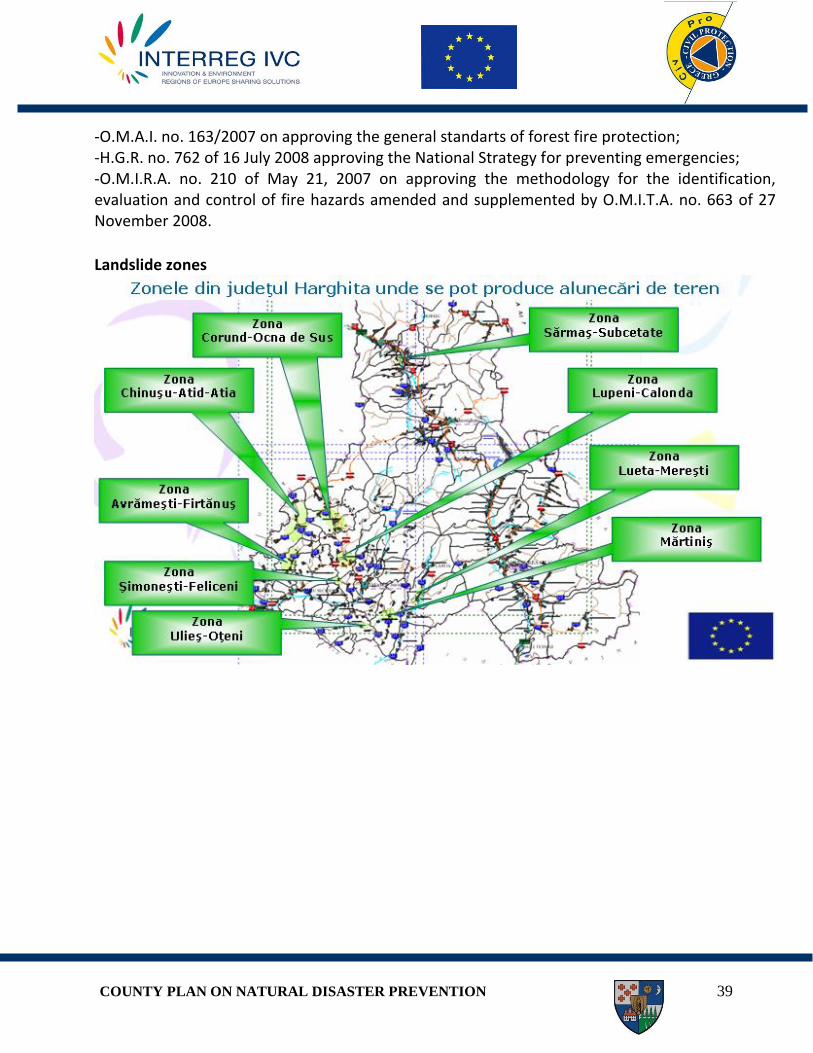
Landslide zones

COUNTY PLAN ON NATURAL DISASTER PREVENTION 40
Areas of seismic coefficient

COUNTY PLAN ON NATURAL DISASTER PREVENTION 41
Areas with high flood risk
COUNTY PLAN ON NATURAL DISASTER PREVENTION 42
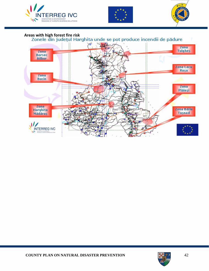
Areas with high forest fire risk


![[Challenge:Future] Disaster Prevention](https://img.dokumen.tips/doc/110x75/553a72504a7959d9368b4576/challengefuture-disaster-prevention.jpg)