Embed Size (px)
Citation preview

WV Local Technical Assistance Program&Country Roads
City Streets&Country RoadsCity Streets&Country RoadsCity Streets
In ThIs Issue
Spring 2017 Benjamin M. Statler College of Engineering & Mineral Resources Vol. 32 No. 1Work!®®
Pages 1-2 Comparison Sign Panel Kits Available
Pages 2-3 Check Out the WV LTAP’s Equipment Loan Program
Pages 4-7 Developing the Allegheny Highlands Rails-With-Trails
Page 7 West Virginia Showcase
Page 8 2017 Build a Better Mousetrap Competition
ComparIson sIgn panel KITs avaIlable Signs are a critical part of our roadways. They assign right-of-way at intersections, give rules such as speed limits, and warn of hazards; in short, signs help drivers safely navigate our roads and streets. However, signs must be seen in order to accomplish their designated functions.
The 2009 edition of the Manual on Uniform Traffic Control Devices (MUTCD), defines the standards for installing and maintaining traffic control devices on roadways open to public travel. Retroreflectivity (the sign’s ability to return a portion of the light from the headlamp back to the driver) is one of
several factors associated with maintaining nighttime sign visibility. Regulatory warning and guide signs are required to be retroreflective to show the same shape and color both day and night. The MUTCD requires that each public agency use an assessment or management method designed to maintain sign retroreflectivity at or above minimum values.
There are several maintenance options available, including using sign life, using a trained older inspector in a vehicle, measuring every sign with a retroreflectometer (a device that measures retroreflectivity), or conducting nighttime inspection using comparison panels.
Comparison panels are components of sign sheeting that are at or near the MUTCD minimum required retroreflectivity levels. To use this process, an inspector drives your roads at night.
Visit the WV LTAP’s website for a list of upcoming classes! wvltap.wvu.edu
Kits include fluorescent yellow-green, yellow, orange, green, red, and white.
Brown is available on request.
Country Roads & City Streets, Vol. 32, No. 1, Spring 2017 1

radar reCorders
The WV LTAP’s radar recorders can be used to collect data on the number of vehicles being driven on your two-lane roads, along with their size and speed. Unlike traditional traffic counters, these devices are attached to utility poles or trees and use radar, so there is no need to put sensors or long tubes in the road. The placement of these counters also helps to collect more accurate information, as drivers are usually unaware that they are present. The WV LTAP has two of these devices available.
Country Roads & City Streets is published three to four times per year. The purpose of th is newsletter i s to provide information that is beneficial to decision makers, elected officials, and roadway construction, maintenance, and management personnel.
The material and opinions included in this newsletter are those of the West Virginia LTAP and do not necessarily reflect the views of the Federal Highway Administration or the West Virginia Department of Transportation. Every effort has been made to ensure the integrity and accuracy of both original and borrowed m ate r i a l ; h o weve r, t h e West Virginia LTAP does not assume responsibility for any information that is found to be incorrect.
The West Virginia LTAP is part of the National Local Technical Assistance Program, which is funded by the Federal Highway Administration. West Virginia LTAP also receives funding f r o m t h e We s t V i r g i n i a Department of Transportation.
Mission:The mission of the WV LTAP is to foster a safe, efficient, and environmentally sound surface transportation system b y i m p ro v i n g s k i l l s a n d increasing knowledge of the transportation workforce and decision makers.
To help achieve this mission, training , demonstrat ions, technical ass istance, and resource materials are provided.
For several years, the WV LTAP has maintained an equipment loan program that includes a variety of devices and tools to help local agencies in West Virginia collect valuable data. Equipment can be borrowed for a period of two-weeks at no cost. However, the agency that is borrowing the equipment is responsible for paying for repairs or replacement in the event that the equipment gets damaged.
To request more information, or to borrow equipment, contact Kim at 304-293-9924 or [email protected]. You can also find more information and complete an online request to borrow the equipment under the Services tab on our website, wvltap.wvu.edu.
CheCK ouT The Wv lTap’s equIpmenT loan program
When a marginal sign is identified, the driver stops the vehicle on the side of the road to classify the sign’s retroreflectivity as good, marginal, or questionable. The inspector then attaches the comparison panel to the sign. The inspector walks back from the sign 15 to 25 feet and shines a flashlight on the sign to determine if the sign is brighter or less bright than the panel. If the sign is less bright, it is scheduled for replacement.
To help local agencies jump start their sign retroreflectivity program, the WV LTAP has developed comparison sign panel kits that are available free of charge to municipal agencies (one per municipality). These kits include green, white, yellow, red, orange, and fluorescent yellow-green sign sheeting in 3x6 inch panels. The panels were produced based on the processes outlined by the Cornell Local Roads Program.
To find out more about these panels, including instructions for proper use, visit the WV LTAP website, wvltap.wvu.edu. To obtain a set of these panels for your local agency, contact Kim Carr at 304-293-9924 or email [email protected].
Radar Speed Sign
The WV LTAP’s radar speed sign mounts directly and securely to an existing u-channel sign post and operates on a battery for up to two weeks. It meets the requirements of the Manual on Uniform Traffic Control Devices for roads with speed limits up to 35 mph.
Like the larger trailer-mounted variety, this sign displays the speed that a vehicle is moving as it approaches the sign. If a driver is speeding, the sign can be set so that the registered number blinks; thus, alerting the driver to the fact that they
are exceeding the posted speed limit. In addition to collecting speed data, the radar speed sign also records the number of vehicles that pass by the sign. The WV LTAP has one of these devices available.
2 Country Roads & City Streets, Vol. 32 No. 1, Spring 2017

Infrared TraIl CounTers
The infrared trail counters can be used to collect information on pedestrian and bicycle traffic on trails, paths, and sidewalks. These counters use an infrared beam that is able to detect warm, moving objects. Through this technology, the infrared counter is able to detect and count the number of pedestrians and cyclists that pass a specific location. The WV LTAP has three trail counters available.
dIgITal levels
It is important to make sure that our sidewalks can accommodate everyone who wants to use them. The Americans with Disabilities Act provides requirements for walkways regarding grade and cross slope to accommodate users with mobility impairments. It is vital that the grades and cross slopes of walkways are not too steep.
A digital level can be a useful tool i n e v a l u a t i n g pedestrian access routes. Unlike a traditional level,
a digital level has a digital display that provides the percent slope of the surface on which it is resting. The WV LTAP has two of these devices available.
measurIng Wheel
A measuring wheel (sometimes referred to as a surveyor’s wheel) is a convenient and low-cost tool when you are in need of collecting accurate distances quickly. As opposed to a tape measure, a measuring wheel can be used easily by a single person, making the process quicker and more efficient. WV LTAP’s wheel measures to the nearest inch and collects lengths of up to 10,000 feet. If you need to determine how much sidewalk you have, how many parking spaces you can accommodate on a block, or the width of your roads, a measuring wheel can be a great tool. The WV LTAP has one of these devices available for loan.
TurnIng movemenT CounTers
Turning movement counters are manual devices that require someone to operate the device during the entire count period. These counters are good when you have a problematic intersection, and you want to better understand how vehicles and pedestrians travel through the intersection. You can use the counters to determine how many vehicles turn at an intersection, or how long vehicles wait, on average, at a stop sign. The WV LTAP has two of these devices available.
reTrorefleCTomeTer
The retroreflectometer can be used to measure sign retroreflectivity in the field. It comes with an extension pole that enables sign measurements to be taken without using a bucket truck or ladder. The WV LTAP has one retroreflectometer available.
Country Roads & City Streets, Vol. 32, No. 1, Spring 2017 3

Rail trails and rails-with-trails are popular in many communities, and can be enjoyed by everyone. However, they don’t just magically appear overnight; the planning, design, and construction may take several years, from the initial thought to completion. The Allegheny Highlands Trail, in our neighboring state of Maryland, is a perfect example.
The article below details developing the Allegheny Highlands Trail and provides insight into the challenges and considerations that were necessary in order to make this trail a reality.
overvIeW
The Allegheny Highlands Trail (Trail) in western Maryland is a 20.48-mile multi-use recreational trail in Allegany County. The eastern end of the Trail connects with the C&O Canal Towpath. The western end of the Trail is at the Mason-Dixon Line, where it connects to the Allegheny Highlands Trail in Somerset County, PA. Cumberland is the center point of an interstate trail that connects the towpath in Georgetown, Washington, D.C., to the Golden Triangle area of Pittsburgh, PA.
The initial 14.1 miles of the Trail coexists with the Western Maryland Scenic Railroad (WMSRR) on a dual track right-of-way from Baltimore Street, Cumberland, MD to “Switch 9” south of Frostburg, Md. On this portion, the Trail ranges in width from 8.5 to 10 feet and the surface is either paved or has a No. 10 aggregate.
At Switch 9, the WMSRR moves onto the former Cumberland and Pennsylvania (C&P) alignment to The Old Depot train station in
developIng The alleghenY hIghlands raIls-WITh-TraIlsadvIsorY board
FHWA-WV Division
Chandra Inglis-Smith Charleston, WV
Shaneka Owens Charleston, WV US Forest Service
Jacob D’Angelo Elkins, WV
WVDOT
Steve Cole Lewisburg, WV
Marvin Murphy Buckhannon, WV
Donald Williams Morgantown, WV
Austin Macri West Virginia Governor’s Highway Safety Program Charleston, WV
Municipal
Damien Davis City Engineer Morgantown, WV
Chris Knox City Engineer Charleston, WV
Bill Lanham Town Superintendent Fayetteville, WV
Chris Starkey Department Coordinator Philippi, WV
Private
Robert Amtower Rummel, Klepper & Kahl Burlington, WV
Dale Hill Builders Supply Assoc. of WV Charleston, WV
Pat Parsons Asphalt Pavement Assoc. of WV Charleston, WV
Senior Advisors
Michael DeMary Retired Stormwater Program Manager, Fairmont, WV
Terry Hough Retired City Engineer and Public Works Director, Morgantown, WV
Ronald Tenney Retired WVDOH Highway Administrator, Weston, WV
Authored by Kevin T. Beachy, P.E., KTB Professional Engineering, LLC Edited by Kim Carr, WV LTAP
Figure No. 1 Project Map
What is the difference between a rail trail and a rails-with-trails? A rail trail is when a railway that is no longer used is converted into a multi-use path, typically for walking and cycling.
Rails-with-trails are trails that exist alongside of a working railway.
What is a towpath? A towpath is a path beside a river or canal, originally used as a pathway for horses towing barges.
4 Country Roads & City Streets, Vol. 32 No. 1, Spring 2017

through rock cuts and on top of elevated embankments, in addition to three bridge crossings and the previously mentioned Brush Tunnel.
The trail design used the following guidelines:
• In order to comply with the Code of Maryland Regulations (COMAR) for minimum clearance areas to protect railroad employees, the setback from railroad centerline to the closest Trail element had to be at least 8 1/2 feet in all cases. Under this criteria, three areas required special evaluation, i.e., the Brush Tunnel, the Woodcock Hollow Road landslide area, and another location northwest of Woodcock Hollow Road.
• Measures were taken to begin trail elements at a 10-foot setback or greater to provide additional security and enhance safety (achieved in 94.8 percent of the designed alignment).
• In instances where the Trail was located 10-feet or closer to the tracks, a post and cable fence (like that shown below in Figure No. 2) was installed. The fence was installed in 200-foot sections to make it easier for maintenance workers to
Frostburg. The Trail, at a width of 10-feet covered with No. 10 aggregate, follows the original Western Maryland Railway double-track alignment west up Savage Mountain to the Mason-Dixon Line.
plannIng and desIgn ConsIderaTIons relaTed To The WesTern marYland sCenIC raIlroad
The Western Maryland Scenic Railroad (WMSRR) provides tourist excursions four to five days a week, one round trip per day from April through December.
The WMSRR posed several critical items that needed considered during the trail’s planning and designing. Some of the specific items taken into account were:
• The train, when powered by the steam locomotive, created unique issues when operating in close proximity to the proposed Trail.
» These issues were especially acute when the separation between the edge of Trail and the active track centerline was less than ten feet. (Brush Tunnel is an example of this issue.)
» The Trail, when completed, would cross the active railroad alignment at six proposed locations.
• The Brush Tunnel (913-feet in length) required special safety considerations when the train was present and for a short period prior to and after the train passed, due to steam and condensation releases, brown ashes, soot, gases, and noise.
alTernaTIves
For the trail, various construction alternatives were investigated and analyzed to avoid or mitigate Trail user interaction with the WMSRR in the Brush Tunnel. Neglecting right-of-way costs, these options ranged from $0.1M to $19.1M.
The two options were:
Option 1Shared alignment with additional signage, separation barrier, warning signals at portals, and public education
Option 2Total avoidance through separate alignments
» Separate alignment east and west of existing tunnel
» Separate paral lel tunnel for bicyclists and pedestrians
seleCTed opTIon
Option 1 was selected with the additional warning signage at each portal, textured hot-mix asphalt approaches, and a two-strand removable cable barrier inside the tunnel parallel the full-length asphalt trail surface; yellow centerline and white edge markings were also installed on the asphalt.
TraIl desIgn
This 14.1-mile alignment traverses two significant Appalachian ridgelines (Haystack/Wills Mountain, and Piney Mountain) and ascends approximately 1,100 feet in elevation. This involves almost continuous alignment changes
Figure No. 2 South Entrance to Brush Tunnel (Looking North)
Country Roads & City Streets, Vol. 32, No. 1, Spring 2017 5
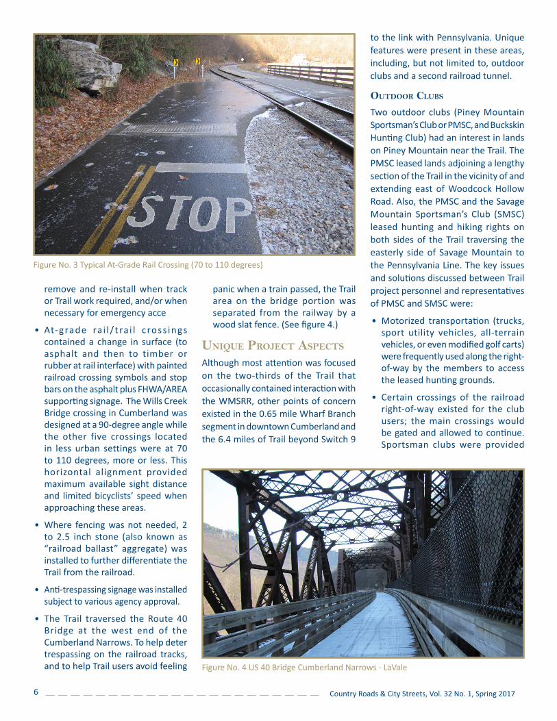
panic when a train passed, the Trail area on the bridge portion was separated from the railway by a wood slat fence. (See figure 4.)
unIque projeCT aspeCTs
Although most attention was focused on the two-thirds of the Trail that occasionally contained interaction with the WMSRR, other points of concern existed in the 0.65 mile Wharf Branch segment in downtown Cumberland and the 6.4 miles of Trail beyond Switch 9
remove and re-install when track or Trail work required, and/or when necessary for emergency access.
• At-grade ra i l / t ra i l c ross ings contained a change in surface (to asphalt and then to timber or rubber at rail interface) with painted railroad crossing symbols and stop bars on the asphalt plus FHWA/AREA supporting signage. The Wills Creek Bridge crossing in Cumberland was designed at a 90-degree angle while the other five crossings located in less urban settings were at 70 to 110 degrees, more or less. This horizontal alignment provided maximum available sight distance and limited bicyclists’ speed when approaching these areas.
• Where fencing was not needed, 2 to 2.5 inch stone (also known as “railroad ballast” aggregate) was installed to further differentiate the Trail from the railroad.
• Anti-trespassing signage was installed subject to various agency approval.
• The Trail traversed the Route 40 Bridge at the west end of the Cumberland Narrows. To help deter trespassing on the railroad tracks, and to help Trail users avoid feeling
to the link with Pennsylvania. Unique features were present in these areas, including, but not limited to, outdoor clubs and a second railroad tunnel.
ouTdoor Clubs
Two outdoor clubs (Piney Mountain Sportsman’s Club or PMSC, and Buckskin Hunting Club) had an interest in lands on Piney Mountain near the Trail. The PMSC leased lands adjoining a lengthy section of the Trail in the vicinity of and extending east of Woodcock Hollow Road. Also, the PMSC and the Savage Mountain Sportsman’s Club (SMSC) leased hunting and hiking rights on both sides of the Trail traversing the easterly side of Savage Mountain to the Pennsylvania Line. The key issues and solutions discussed between Trail project personnel and representatives of PMSC and SMSC were:
• Motorized transportation (trucks, sport utility vehicles, all-terrain vehicles, or even modified golf carts) were frequently used along the right-of-way by the members to access the leased hunting grounds.
• Certain crossings of the railroad right-of-way existed for the club users; the main crossings would be gated and allowed to continue. Sportsman clubs were provided
Figure No. 3 Typical At-Grade Rail Crossing (70 to 110 degrees)
Figure No. 4 US 40 Bridge Cumberland Narrows - LaVale
6 Country Roads & City Streets, Vol. 32 No. 1, Spring 2017

CenTer sTaff & ConTaCT InformaTIon
WV LTAP West Virginia University PO Box 6103 Engineering Sciences Building Room 651A Morgantown, WV 26506 Phone: (304) 293-9924 Fax: (304) 293-7109 E-mail: [email protected] Website: wvltap.wvu.edu
Staff
Dr. John Zaniewski, P.E. Director (304) 293-9955 [email protected]
Kim Carr Program Coordinator (304) 293-9924 [email protected]
Dr. Ron Eck, P.E. Senior Advisor (304) 293-9931 [email protected]
Andrew Morgan, P.E. Program Coordinator (304) 293-9939 [email protected]
Ashley Peterson PR and Administrative Assistant (304) 293-9930 [email protected]
Alex Gennuso Student Employee
County-issued keys to the gate locks.
• Unauthorized use by dirt bikers and all-terrain vehicle riders was a major issue for the clubs, landowners and the County. The clubs proposed and enacted a joint policing effort. Upon completion of the Trail, club members would apply for a use sticker for any motorized vehicle. In return for this privilege, the vehicle user was asked to provide direct and indirect policing and safety support within the Trail alignment, supporting Trail security and emergency response efforts.
raIlroad Tunnel loCaTed on pIneY mounTaIn
On Piney Mountain, a second railroad tunnel burrows through a side ridge for a length of 953 feet. This tunnel is positioned geometrically in a straight line, and visibility throughout was present. However, in the center of the tunnel, a biker was not able to visually “read” the surface for potholes, rocks, or temporary unanticipated obstructions, or have a clear view of other Trail users, especially when riding downhill at a relatively high rate of speed. In order to avoid possible accidents, downhill riders are required to slow their speed and move to the
right. The alignment was hard surfaced and constructed as wide as possible. Future improvements could potentially include solar-powered or battery-operated lights, a formal separation of the uphill and downhill lanes within this tunnel, and/or positioning a rest stop or a flared bicycle path at this location.
oTher Challenges
A variety of other challenges occurred in the planning, design and construction of this trail, including, but not limited to: public input and project acceptance, right-of-way acquisition, permitting, historic sites, endangered species, wetlands, environment assessment and abatement, public and private use of pre-existing facilities abutting the Trail, phased and sequenced construction, materials testing and approval, portions of the project built within the jurisdiction of two municipalities, temporary access and site logistics for equipment and materials delivery and stockpiling, and repairs from hurricane force wind and rain. However, even with all of these challenges, with a considerable amount of attention to detail, teamwork, and available funding, this $9.2M Rail-to-Trail project was completed.
The WV LTAP staff would love to showcase transportation projects and programs that are happening in our great state in future editions of this newsletter or our electronic newsletter (Road & Street Speak).
For instance, have you implemented a new paving program or are you trying a new material? Are you in the midst of a streetscape or lighting project? Are you
working on a sidewalk enhancement project? Have you developed a rail trail or is one in the works? Do you have a successful employee leadership/development program? Whatever it is, if you have a program or project you are excited about, we want to hear about it! Please contact Kim or Ashley.
WesT vIrgInIa shoWCase
Country Roads & City Streets, Vol. 32, No. 1, Spring 2017 7

The WV LTAP staff is pleased to announce our 2017 Build a Better Mousetrap Competition! The purpose of this competition is to collect and disseminate real world examples of best practices and/or tips from the field.
We’d love to know if you, one of your coworkers, or one of your employees recently built an innovative gadget or developed an improved way/process to accomplish an everyday task. If either of these apply, you’ve built a better mousetrap and now is the time to show off your project.
Entries will be judged using the criteria of cost savings, benefits to the community and/or agency, ingenuity, transferability to others, and
effectiveness. Winners will be recognized in this newsletter and receive a prize. The winning entry will also be submitted into the Regional and National LTAP Build a Better Mousetrap Competitions, held later this summer.
WV LTAP staff members are also available to help with your write-up or to take photos. We know that you and your crews are doing phenomenal things, on limited budgets, but with unlimited imagination and foresight. Help us share your challenges and solutions with other agencies!
For more information on this competition, or to enter, visit wvltap.wvu.edu. If you have questions or would like an entry form emailed or mailed to you, please email Kim Carr at [email protected] or call (304) 293-9924. The deadline for submissions is May 25.
West Virginia Local Technical Assistance ProgramWest Virginia UniversityBenjamin M. Statler College of Engineering and Mineral Resources Department of Civil and Environmental EngineeringPO Box 6103Morgantown, WV 26506-6103
Change Service Requested
Non-Profit OrganizationU.S. Postage PaidMorgantown, WV
Permit No. 34
Country Roads and City StreetsA Newsletter of the WV Local Technical Assistance Program
The WV LTAP encourages you to share this newsletter with others or direct them to the electronic version on our website wvltap.wvu.edu.
• Road Supervisors• Elected Officials• Public Works Department• Road Crew• Managers• City Engineers• Others
2017 buIld a beTTer mouseTrap CompeTITIon
Work!®®
8 Country Roads & City Streets, Vol. 32 No. 1, Spring 2017