Embed Size (px)
Citation preview

COUNCIL ASSESSMENT PANEL MEETING
9 December 2020
AGENDA – 9.2
Applicant: Access SDM Pty Ltd
Landowner: D G Koerner & M M Lehmann
Agent: Greg Burgess Originating Officer: Doug Samardzija
Development Application:
20/1091/473
(20/D049/473)
Application Description: Land division - boundary realignment (3 into 3)
Subject Land:
Lot:13 Sec: P5151 DP:94407 CT:6146/168
Lot:11 Sec: P5151 DP:94407 CT:6146/166
Lot:12 Sec: P5151 DP:94407 CT:6146/167
General Location: 758 Swamp Road, Lot 11
Swamp Road, and Lot 12 Swamp Road, Lenswood
SA 5240
Attachment – Locality Plan
Development Plan Consolidated : 08 August
2019
Map AdHi/ 1, 3 & 53
Zone/Policy Area: Watershed (Primary
Production) Zone - Lenswood Policy Area
Form of Development:
Merit
Site Area: 6.008 Hectares (total combined size of 3
allotments)
Public Notice Category: Category 1 Merit - Representations Received: N/A
Representations to be Heard: N/A
1. EXECUTIVE SUMMARY
The purpose of this application is to realign the boundaries of three allotments.
The subject land is located within the Watershed (Primary Production) Zone - Lenswood Policy
Area.
The proposal is a merit, Category 1 form of development.
As per the CAP delegations, the CAP is the relevant authority because the allotments are in the
Watershed (Primary Production) Zone, and the realignment involves three allotments with one
of the proposed allotments to have an area less than 2 hectares, and the other two remaining
allotments to have respective areas of 2.643 hectares and 2.86 hectares in area.
The purpose of the proposal is to realign the allotment boundaries to consolidate the existing
winery and the vineyards on the adjoining allotment into one allotment and also to expand the
size of this allotment to allow for future expansion of the vineyard. The realignment will also result
in the consolidation of the rural living land into a 5,050m² allotment separate from the other non-
residential land uses.
The main issues relating to the proposal are impacts on the primary production land, creation of a
rural living allotment and impacts on native vegetation.
In consideration of all the information presented, and following an assessment against the
relevant zone and Council Wide provisions within the Development Plan, staff are recommending
that the proposal be GRANTED Development Plan Consent, subject to conditions:

Council Assessment Panel Meeting - 9 December 2020
Access SDM Pty Ltd
20/1091/473 2
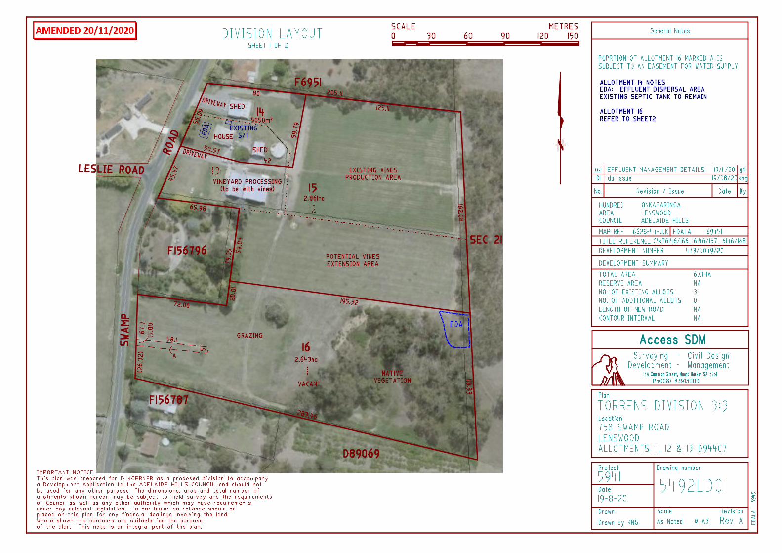
2. DESCRIPTION OF THE PROPOSAL
The proposal is for boundary realignment involving three allotments.
Existing Allotments
Allotment Area (ha) Currently containing
13 6,161m² Single storey dwelling, 500 tonne winery,
associated shed and water storage tank
12 1.634ha Shed and a vineyard
11 3.76ha Vacant allotment with approximately a third of the
allotment covered with dense native vegetation
Proposed Allotments
Allotment Area (ha) Containing
14 5,050m² Single storey dwelling, associated domestic
outbuildings and water storage tank
15 2.86ha 500 tonne winery and associated vineyard
16 2.643ha Vacant allotment with just under half of the
allotment covered with dense native vegetation
The plan of division includes:
The outline of existing structures on the subject properties as well as other site features
such as a vineyard and native vegetation. The location of the easement marked A on
proposed allotment 16 has also been shown and this easement is for the purposes of
water supply.
The proposed plans are included as Attachment – Proposal Plans with other information included
as Attachment – Application Information

Council Assessment Panel Meeting - 9 December 2020
Access SDM Pty Ltd
20/1091/473 3
3. BACKGROUND AND HISTORY
APPROVAL DATE APPLICATION NUMBER DESCRIPTION OF PROPOSAL
26 October 2020 20/747/473 Variation to Development
Authorisation 16/769/473 to
delete addition with
associated change to building
layout, alter loading area
configuration & wastewater
disposal system location and
include additional access over
Lot 12 with 2x new 22,500L
water storage tanks
06 June 2019 19/271/473 Change of use to include
horticulture- viticulture (1.1
ha)
06 July 2020 19/249/473 Dwelling alterations &
additions, retaining wall
(maximum height 500mm) &
associated earthworks
26 October 2018 18/846/473 Water tank (44,000L) &
associated earthworks
26 October 2018 16/769/473 Alterations & additions to
outbuilding including change
of use to a winery
(maximum 500 tonne crush
per annum) and associated
earthworks and storage
tanks
24 November 2010 10/D045/473 Land division – Boundary
realignment (4 into 4) - SCAP
relevant authority. Part of
this boundary realignment
application include the
creation of the current
allotment 13 which the
current boundary
realignment application now
proposes to revert back to
similar layout prior to the
2010 division.

Council Assessment Panel Meeting - 9 December 2020
Access SDM Pty Ltd
20/1091/473 4
4. REFERRAL RESPONSES
SA WATER
SA Water did not have any comments to provide. There is no mains water or sewer
infrastructure.
SCAP
Standard response was provided by SCAP requiring a final survey plan (refer SCAP
condition 1).
RATES
The proposed allotment 15 will retain 758 Swamp Road and proposed allotment 14
(house & Sheds) will use the primary address allocated by DPTI of 762 Swamp Road.
Proposed allotment 16 - vacant with the number to be allocated upon request
EHU
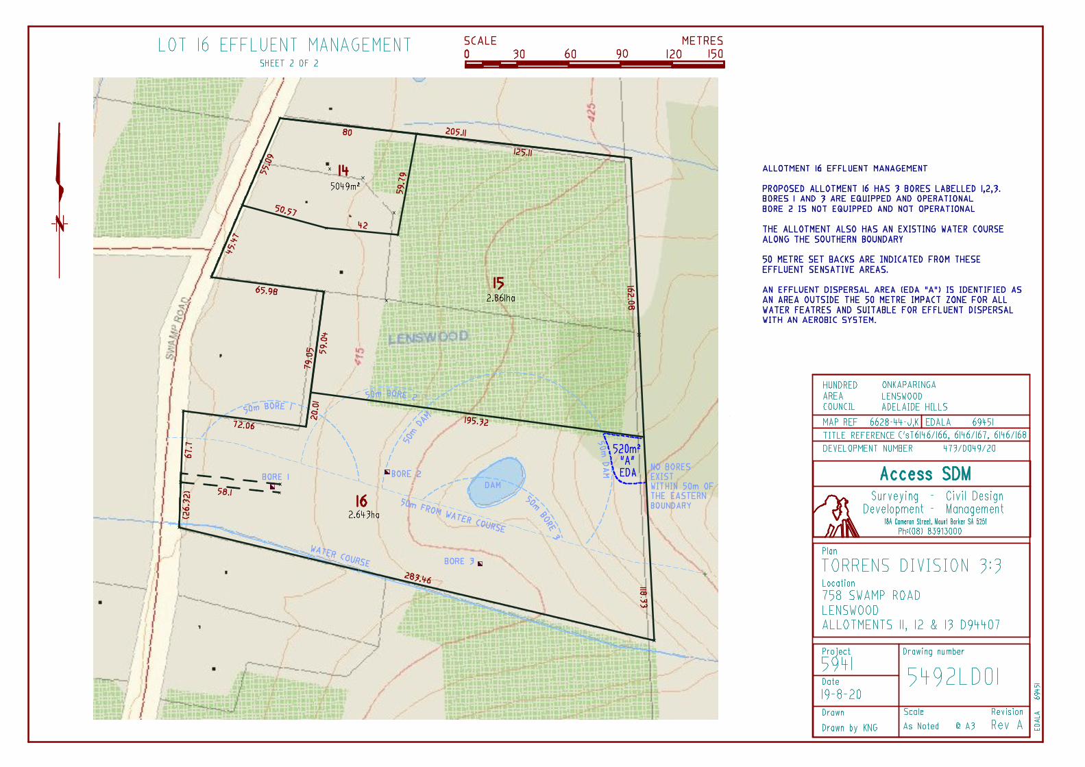
Council’s Health Department advised that the nominated EDA area for proposed
allotment does not have any native vegetation and the area looks to be around 300m²
which is sufficient. In addition the Health Department responded to the surveyors
comments relating to the connection of the dwelling to the EDA as discussed under the
Natural Resource section of the report below. The following response was provided:
“The surveyor advised that the waste system would be an aerobic, however as the
surveyor is unlikely be involved when the site is develop, this may not be what the
developer opts for. So he is only providing a response for one system type. The type of
waste system is usually determined by the preference of the owner and then engineer will
design the system to accommodate this if possible. The majority today are aerobics but
not all. If it is an aerobic then the pipe from the tank to the EDA can be 25mm-40mm, so
the pipe to suggest is ok. The requirement is for the pipe to be 150mm below surface
level at the point is dispersal (EDA), the pipe to the EDA can be at surface level but is not
advised as it can easily be damaged. The pipe can be run along the boundary, however
generally it will be installed using the least amount of pipe as possible (shortest distance
between 2 lines is a straight) to ensure the pump will be able to cope. The longer the pipe
length or any change in direction of the pipe will require a larger pump and most people
want the cheapest possible systems. So in short what the surveyor said is true in theory if
they put in aerobic, but they do not have too”.
The above responses are included as Attachment – Referral Responses.
5. CONSULTATION
The application was categorised as a Category 1 form of development not requiring formal
public notification.
The applicant(s) or their representative – may be in attendance.

Council Assessment Panel Meeting - 9 December 2020
Access SDM Pty Ltd
20/1091/473 5
6. PLANNING & TECHNICAL CONSIDERATIONS
This application has been evaluated in accordance with the following matters:
i. Environmental Food Production Area
The subject land is located within the Environmental Food Production Area (EFPA) as
defined by General Registry Office Map G17/2015. The boundary realignment is not
proposing any additional allotments to be used for residential purposes but
maintaining the status quo of the existing allotments which might include future
residential use.
ii. The Site’s Physical Characteristics
The subject land is comprised of three allotments with a combined area of 6.008
hectares. Existing allotment 11 is an irregular shaped allotment of approximately 3.76
hectares with a direct frontage of 68m to Swamp Road. The allotment is vacant with
majority of the land currently utilised for grazing whilst the remainder of the
allotment is covered in dense native vegetation.
Existing allotment 12 has a similar configuration to a hammer head type allotment
with a narrower 27m frontage to Swamp Road which then expands into a large
allotment of 1.6 hectares. Current site improvements include a shed along the front
of the property and a 1.1 hectare vineyard at the rear of the property.
Existing allotment 13 is the smallest of the three allotments with 6161m² in size
fronting directly to Swamp Road. Current site improvements include a single storey
dwelling, shed at the rear of the dwelling and a 500 tonne crush winery along the
southern side of the property. All of the allotments are connected to SA Water mains
water supply and as such there would be no risk from land use conflict relating from
vineyard spraying and water tank adjacent the vineyard.
iii. The Surrounding Area
The locality is characterised by a mixture of allotment sizes and uses ranging from
large primary production allotments in excess of 28 hectares immediately to the
north of the subject land to small rural living allotments of 954m². Predominantly land
uses in the locality are in the form of primary production generally involving
horticulture. Apart from residential and primary production uses, other uses in the
locality include tourist accommodation with the property immediately opposite of the
subject land recently developed with two freestanding tourist accommodation units.
iv. Development Plan Policy considerations
a) Policy Area/Zone Provisions
The subject land lies within the Watershed (Primary Production) Zone - Lenswood
Policy Area and these provisions seek:
Policy Area
- The retention of orchards and bushland as predominant uses
- Retention of the present village character and size of Lenswood and Forrest Range
- No further provision of small rural living allotments.

Council Assessment Panel Meeting - 9 December 2020
Access SDM Pty Ltd
20/1091/473 6
The following are considered to be the relevant Policy Area provisions:
Objectives: 1, 2 and 3
Objective 1 seeks that orchards and bushland are retained as prominent use. Whilst
Objective 1 specifically refers to retention of orchards it is still none the less a
relevant objective in this instance considering viticulture is a form of horticulture use
and similar to an orchard. The proposed realignment of the boundary will result in a
creation of a larger primary production allotment which would allow for further
expansion of the existing vineyard and better management of land whilst still
maintaining and preserving existing native vegetation. As such the proposal is
considered to be consistent with the intent of Objective 1.
Objective 2 seeks the retention of the village character of Lenswood whilst Objective
3 seeks that no further rural living allotments are created. The proposal will not result
in a creation of a new rural living allotment as it is simply swapping the boundaries
around the existing rural living allotment to separate and consolidate the residential
use within a single allotment and the winery and associated vineyard into another
allotment. The outcome of the realignment is a rural living allotment of 5,050m²
which is a reduction of 1,111m² in land size from the current living allotment. The
realignment of the boundaries would also result in the rural living allotment returning
to a similar layout that existed prior to the 2010 land division as indicated in the
image below where the rural living allotment at the time was approximately 3,563m²
in area. The proposal is therefore considered to be consistent with Objective 3.
Considering the above it can therefore also be argued that the realignment of the
boundaries as proposed is going to retain the village character of Lenswood and is
therefore consistent with Objective 2.

Council Assessment Panel Meeting - 9 December 2020
Access SDM Pty Ltd
20/1091/473 7
Watershed (Primary Production) Zone
- The enhancement of the Mount Lofty Ranges Watershed as a source of high
quality waters
- The long-term sustainability of rural production in the south Mount Lofty Ranges
- The preservation and restoration of remnant native vegetation in the south Mount
Lofty Ranges
The following are considered to be the relevant Zone provisions:
Objectives: 2, 3 & 4
PDCs: 16, 17, 18, 19, 20, 21, 22, 31, 33, 34, 42, 44 & 70
Form of Development
PDCs 16 and 17 as well as Objective 3 seek to ensure that primary production is not
prejudiced, and that land that is particularly suitable for primary production remains
available for this purpose. It is considered that the proposed realignment of the
boundaries is not going to have any impacts on the use of available primary
production land for such purposes and is in fact improving on the existing
arrangement by expanding the existing allotment 12 to allow for future expansion of
a vineyard use and by incorporating the winery and the vineyard into a single
allotment for better management of these uses. As such it is considered that the
proposal is consistent with the PDCs 16 and 17 as well as Objective 3.
Land Division
PDC 70 is procedural relating to the non-complying development triggers in the zone.
Land division in Watershed (Primary Production) Zone is considered to be non-
complying application unless it is able to meet the following exemptions:
Land Division where no additional allotments are created, either partly or wholly,
within the Watershed (Primary Production) Zone, and where the development of
the proposed allotments does not result in a greater risk of pollution of surface or
underground waters than would the development of the existing allotments, and
provided a suitable site for a detached dwelling is available such that the site and
the dwelling would comply with the criteria in Table AdHi/5.
The proposed boundary realignment is considered to be a merit form of development
because it does not result in the creation of an additional allotment. In addition the
proposed realignment of boundaries will not result in a greater risk of pollution of
surface or underground water. It is also considered that proposed lot 16, the only
vacant allotment, is a suitable size which would be able to meet Table AdHi/5
requirements for any future dwelling. The second exemption relating to land division
in Watershed (Primary Production) Zone is not relevant in this instance as it does not
relate to Caravan and Tourist Park Policy Area.
Upon establishing the procedural matters of the application, PDCs 18, 19, 20, 21 & 22
relate directly to the circumstances under which land divisions in the zone would be
considered.

Council Assessment Panel Meeting - 9 December 2020
Access SDM Pty Ltd
20/1091/473 8
PDC 18 provides that land division should only occur where a site for a detached
dwelling which complies with the criteria detailed in Table AdHi/5 is available. Failure
to meet the criteria of Table AdHi/5 is a non-complying development trigger in the
Zone. The aim of PDC 18 is therefore to ensure that resulting allotments are able to
be developed with detached dwellings that are not non-complying in nature. At the
same time PDCs 19 and 21 are similar in that they both seek that land division
proposals do not result in an increased pollution risk to water resources or cause the
loss of productive primary production land.
The Table AdHi/5 criteria sets out that detached dwellings must be:
Sited at least 25m away from watercourses; and
Connected to an approved wastewater system that is at least 50m from the
watercourse, on the slope gradient of no more than 1 in 5 and no less than 1.2m
depth to bedrock
Currently only the proposed allotment 14 will contain a residential dwelling with the
dwelling connected to the existing on site waste system and all elements will be
contained within the proposed allotment 14. The proposed allotment 16 is the only
vacant allotment and whilst there was no request for the applicant to demonstrate
compliance with the above Table AdHi/5, applicant has provided an amended aerial
plan of division showing the potential location of the effluent disposal area for
allotment 16 which would comply with the requirements stipulated in Table AdHi/5.
The proposed allotment 15 will contain the existing winery and vineyard. Whilst it
currently does not contain a dwelling, and no dwelling is proposed, it is of a sufficient
size to allow for both expansion of the vineyard and a dwelling and an onsite waste
system. The existing allotment could also facilitate a dwelling on each allotment, so
the proposed boundary realignment is not creating further development potential.
The proposal is therefore considered to be consistent with PDCs 18, 19 and 21.
PDC 20 provides guidance as to the circumstances where land division proposals are
appropriate in the zone. This PDC states that land division may be undertaken
provided no additional allotments are created and the purpose of the plan of division
is to provide a re-adjustment of boundaries to correct anomalies in the placement of
those boundaries with respect to location of existing buildings. Alternatively the
minor readjustment could be undertaken if it is facilitating improved management of
the land for primary production purposes and/or conservation of natural features.
The proposal is not considered to be a minor re-adjustment of allotment boundaries
nor is its purpose to correct any anomalies in the form of boundary encroachments.
The proposal is therefore not considered to be consistent with PDC 20 (a).
Realignment of the boundary between existing allotments 11 and 12 retains the
native vegetation within the confines of a single allotment boundary whilst at the
same time still allowing for the resultant allotment 16 to be developed in the future
without any further impact on this vegetation. The realignment will also allow for the
section of land currently used for grazing purposes to be incorporated within a larger
rural allotment which is already being used for viticulture purposes and allows for
further expansion and continuation of this use. Therefore it can be argued that the
realignment is consistent with the intent of PDC 20 (b). The retention of native

Council Assessment Panel Meeting - 9 December 2020
Access SDM Pty Ltd
20/1091/473 9
vegetation into one single proposed allotment 16 is also consistent with Objective 4
of the zone which seeks preservation and restoration of remnant native vegetation.
PDC 22 states that re-arrangement of allotment boundaries should produce
allotments of a size consistent with that of the locality. As mentioned earlier in the
report, allotments in the locality range from as large as 28 hectares to allotments as
small as 954m². The proposal will still retain one rural living allotment which is going
to be marginally smaller than the existing rural living allotment, however the overall
proposal is in fact an improvement on the current situation considering that it will
result in two allotments of over 2 hectares in size where currently this is only the case
with one of the allotments. The proposal is therefore considered to be consistent with
PDC 22.
Conservation
PDC 31 seeks that land use does not change in or near native vegetation, whilst PDC
33 seeks that realignment of boundaries does not result in an increased number of
allotments adjoining an allotment with native vegetation. At the same time PDC 34
seeks that boundary realignment does not occur where it will increase the number of
allotments over areas covered by native vegetation. The proposed boundary
realignment will result in additional area which would be suitable for future
expansion of existing vineyard as indicated in the documents submitted with this
application. Any future expansions of the vineyard would be subject to a separate
development application during which any potential impacts on adjoining native
vegetation would be considered and assessed. Whilst it is anticipated that there
would be a change of use to a portion of land in the future and as such it is
considered that the proposed realignment is not consistent with PDC 31, any impacts
associated with this use can be managed in a way to prevent any impacts on native
vegetation in a future development application. The realignment will not result in
more allotments adjoining native vegetation nor will it increase the number of
allotments with native vegetation and as such it is consistent with PDCs 33 and 34.
Rural Development
PDC 42 states that rural areas should be retained for primary production purposes
and other uses compatible with maintaining rural productivity. PDC 44 states that
development which would remove productive land from primary production or
diminish its overall productivity for primary production should not be undertaken
unless the land is required for essential public purposes. The proposed realignment of
boundaries is considered to maintain primary production and is not considered to
diminish the overall productivity of the land for primary production. The realignment
and consolidation of the winery and viticulture use within a single allotment will also
improve the overall management of primary production land. The proposal is
therefore considered to be consistent with PDCs 42 and 44.
b) Council Wide provisions
The Council Wide provisions of relevance to this proposal seek (in summary):
- The retention of rural land in primary production especially land suitable for high
rates or fruit and vegetable production

Council Assessment Panel Meeting - 9 December 2020
Access SDM Pty Ltd
20/1091/473 10
- Development located to minimise the treat and impact of bushfires on life and
property while protecting natural and rural character
- Land division restricted in rural areas to ensure that efficient use of rural land for
primary production
- Retention, protection and restoration of the natural resources and environment
- Orderly and economic development that creates a safe, convenient and pleasant
environment in which to live in
The following are considered to be the relevant Council Wide provisions:
Animal Keeping & Rural Development
Objectives: 1 & 2
PDCs: 1
Objectives 1 and 2 as well as PDC 1 seek that rural land should be retained for either
primary production and/or native vegetation conservation and retention purposes.
The proposed realignment is considered to achieve both of these requirements.
Proposed allotment 16 whilst being reduced in size is not considered to be prejudicing
primary production land, nor is it contributing to the loss of native vegetation. The
realignment of this boundary will increase proposed allotment 15 which would
consolidate a section of land currently only used for grazing within the vineyard
allotment which would allow for future expansion of the vineyard and maintain
primary production use. Native vegetation will not be impacted and is still going to be
retained within a single proposed allotment which will also have potential to further
be developed with a dwelling without any impacts on the section of land covered in
native vegetation. Standard Native Vegetation Council requirements are that any
new boundary fence (where there is no fence existing) should be placed at least 5m
from remnant vegetation to protect that vegetation from clearance for a new fence
line (refer to Council Land Division Statement of Requirements condition 1).
Hazards
Objectives: 5
PDCs: 1, 6, 7 & 13
Objective 5 seeks that development be located to minimise the threat and impact of
bushfire on life and property and this is reinforced by PDC 1. PDCs 6, 7 and 13 on the
other hand refer specifically to the Ministers Code: Undertaking Development in
Bushfire Protection Areas and seek that the measure in the Code can be met to
ensure any future habitable building is adequately protected in the event of the
bushfire. Whilst the proposed development does not include construction of
habitable buildings, the Development Plan still seeks that proposed division is able to
satisfy the necessary bushfire requirements for any potential future developments.
Whilst there has been no assessment of the proposed boundary realignment by the
CFS, it is considered that the proposed allotment 16 is still of sufficient size which
would allow for appropriate access by CFS vehicles as well as any potential turning
area dependent on where any future dwelling is positioned. As such it is considered
that the proposed development is consistent with Objective 5 and PDCs 1, 6, 7 and
13.
Land Division

Council Assessment Panel Meeting - 9 December 2020
Access SDM Pty Ltd
20/1091/473 11
Objectives: 2 & 5
PDCs: 1, 2, 5, 6, 7, 11, 21 & 22
The proposed division does not restrict existing rural living properties from continued
use as such, nor does it prevent the allotment from being redeveloped for such
purposes in the future. Each of the allotments has a direct access to a public road;
existing dwelling is connected to an existing on site waste system whilst proposed
allotments 15 and 16 have ample space to accommodate a future waste system
should the future land use be for purposes other than primary production. As such it
is considered the proposal adequately satisfies Objective 2 and PDCs 1, 2 and 6(c), 7.
PDCs 5 and 11 seek that land division be designed and configured so that it does not
impact on native vegetation. As mentioned earlier in the report the proposed
realignment will not impact on any native vegetation. As such proposal is considered
consistent with PDCs 5 and 11.
Objective 5 seeks retention of efficient use of rural land for primary production
purposes and this is further enforced by PDCs 21 and 22 which seek that allotments
be retained for primary production purposes and that the natural resources are
protected. The proposed realignment of boundaries is not considered to impact on
the primary production use of the land. The proposal is simply moving one of the
boundaries so that one section of primary production land currently utilised for
grazing is incorporated within the allotment currently being used for viticulture
purposes which along with the realignment of the section of land incorporating a
winery would ensure a more efficient use of land. The realignment will not result in
the loss of this primary production of land and will still ensure that the area covered
by dense native vegetation is contained in a single allotment and separate to the
allotment which is used for primary production purposes. As such it is considered to
satisfy the intent of Objective 5 and PDCs 21 and 22.
Natural Resources
Objectives: 1
PDCs: 1, 37, 38 & 39
Objective 1 and PDC 1 seek retention, protection and restoration of natural resources
and environment including water quality, land, soil and biodiversity. The proposed
realignment of boundaries achieves the requirements set out in Objective 1 and PDC
1. It will not result in an increase in development potential given that existing
allotment 11 is vacant with the option of future use other than primary production
which might require an on-site waste system and this will not change as a result of
proposed allotments 15 and 16. The proposed realignment of the boundaries does
not alter this aspect.
Similar to some of other PDCs discussed earlier in the report, PDCs 37, 38 and 39 put
an emphasis on protecting native vegetation and locally indigenous plant species. An
additional plan has been provided showing the location of the potential future
effluent disposal area for proposed allotment 16. The plans indicated that the
soakage area would need to be located at the rear of existing native vegetation in
order to achieve the minimum 50 metre separation to any water course, bore or a
dam. This section of the land is not covered by native vegetation and whilst some

Council Assessment Panel Meeting - 9 December 2020
Access SDM Pty Ltd
20/1091/473 12
works might be required through the native vegetation area in order to connect the
house to the soakage area. Applicant has advised that “The hose connecting the
filtration tank to the EDA is a 30mm PVC line or a 32mm blue line pipe. This pipe can
be laid on the surface, but would be subject to damage. Preferably it would be buried,
the depth of the pipe need not be more than 100 or 150mm. Given the EDA is in the
corner of the land, the pipe would run along the boundary (fence line), typically 1
metre off the fence. This area would also likely be kept free of trees for site fence
maintenance and general site access. Should the pipe be placed through a treed area
it could also be placed in such a way to weave around trees and if required, buried 100
– 150mm deep. The pipe is only buried to protect it from damage, not for any other
need”. Considering the above the proposed realignment is unlikely to impact upon or
result in the loss of native vegetation and is therefore considered to meet the
requirements set out in PDCs 37, 38 and 39.
Orderly and Sustainable Development
Objectives: 1, 4, 8, 9 & 10
PDCs: 1 & 2
Objective 1 seeks orderly and economic development whilst Objective 4 seeks
development which does not prejudice the achievements of the provision of the
Development Plan. The proposed development is seeking to realign the boundaries of
three existing contiguous allotments and will not result in the creation of a new
allotment in the Watershed (Primary production) Zone and is considered to be
sufficiently consistent with the provisions set out in the Development Plan.
Objectives 8, 9 and 10 as well as PDCs 1 and 2 seek the protection of rural areas,
surrounding watersheds and prevention of urban development from further
encroachment into rural areas. There will be no land use conflicts from the proposed
vineyard allotment 15 and residential allotment 14 and as such would not require an
additional vegetated buffer. The properties are all connected to mains water and as
such do not rely on the onsite water storage for water supply. In addition there
approximately 11 meter separation between the vineyards and the boundary with the
proposed allotment 14 which also includes an internal access track which would act
as a separation buffer between the viticulture use and residential use. As mentioned
earlier in the report, the proposed realignment of boundaries does not prejudice
primary production land and is not resulting in creation of a new allotment within the
watershed zone, nor is it increasing development potential within the zone. The
proposal is therefore considered to be consistent with Objectives 8, 9 and 10 as well
as PDCs 1 and 2.
7. SUMMARY & CONCLUSION
The proposal seeks consent to realign the boundaries of three allotments in the Watershed
(Primary Production) Zone and Lenswood Policy Area.
The purpose of the proposal is to realign the allotment boundaries to incorporate a section of
arable primary production land and section of land currently containing a winery into a single
parcel (allotment 15) in conjunction with existing vineyards and which would also allow for future
expansion of this vineyard. The realignment will also place the existing residential use into a single
allotment (allotment 14). Native vegetation will still be retained on a single allotment (allotment
16) and whilst this allotment is not of sufficient size to be used for any productive primary

Council Assessment Panel Meeting - 9 December 2020
Access SDM Pty Ltd
20/1091/473 13
production purposes without removing the existing vegetation, it will still have potential to be
used for residential purposes whilst not impacting on native vegetation.
It is considered that the proposed realignment is not going to prejudice any primary production
land with proposed allotment 15 creating potential for expansion of the primary production use.
Furthermore the proposal improves the management of the land for primary production by
combining an arable section of existing allotment 11 and also the winery into a single allotment.
The development of the proposed allotments does not result in a greater risk to water quality in
the watershed area than the existing allotments. The existing dwelling will be retained on a single
allotment with an existing approved waste system whilst the status quo for the other two
allotments will remain the same.
The proposal is sufficiently consistent with the relevant provisions of the Development Plan, and it
is considered the proposal is not seriously at variance with the Development Plan. In the view of
staff, the proposal has sufficient merit to warrant consent. Staff therefore recommend that
Development Plan Consent be GRANTED, subject to conditions.
8. RECOMMENDATION
That the Council Assessment Panel considers that the proposal is not seriously at variance
with the relevant provisions of the Adelaide Hills Council Development Plan, and GRANTS
Development Plan Consent and Land Division Consent to Development Application
20/1091/473 (20/D049/473) by Access SDM Pty Ltd for Land division - boundary realignment
(3 into 3) at 758 Swamp Road, Lenswood, Lot 11 Swamp Road, Lenswood and Lot 12 Swamp
Road, Lenswood subject to the following conditions:
(1) Development In Accordance With The Plans
The development herein approved shall be undertaken in accordance with the
following plans, details and written submission accompanying the application, unless
varied by a separate condition:
Plan of division prepared by Access SDM, drawing number 5492LD01, revision A
dated 19/08/20
Amended aerial plan of division prepared by Access SDM, drawing number
5492LD01, revision A dated 19/08/2020
REASON: To ensure the proposed development is undertaken in accordance with the
approved plans.

Council Assessment Panel Meeting - 9 December 2020
Access SDM Pty Ltd
20/1091/473 14
Notes
(1) Development Plan Consent
This Development Plan Consent (DPC) is valid for a period of twelve (12) months
commencing from the date of the decision (or if an appeal has been commenced the
date on which it is determined, whichever is later). Building Rules Consent must be
applied for prior to the expiry of the DPC, or a fresh development application will be
required. The twelve (12) month time period may be further extended by Council
agreement following written request and payment of the relevant fee.
(2) Department of Environment and Water (DEW) - Native Vegetation Council
The applicant is advised that any proposal to clear, remove limbs or trim native
vegetation on the land, unless the proposed clearance is subject to an exemption
under the Regulations of the Native Vegetation Act 1991, requires the approval of the
Native Vegetation Council. For further information visit:
www.environment.sa.gov.au/Conservation/Native_Vegetation/Managing_native_veg
etation
Any queries regarding the clearance of native vegetation should be directed to the
Native Vegetation Council Secretariat on 8303 9777. This must be sought prior to Full
Development Approval being granted by Council.
(3) Property Identifiers
The property identifiers for these properties are now:
Allotment 14 (house & sheds): 761 Swamp Road, Lenswood
Allotment 15: 758 Swamp Road, Lenswood
Alottment 16: vacant with the number to be allocated upon request
Council Land Division Statement of Requirements
(1) Prior To Section 51 Clearance- Survey Plan Showing Boundary Location
Prior to Section 51 clearance a final survey plan shall be provided to Council to
demonstrate that new boundaries are placed at least 5m from remnant vegetation.
REASON: Protect native vegetation from clearance for a new fence line.
SCAP Land Division Statement of Requirements
(1) Requirement For Certified Survey Plan
A final plan complying with the requirements for plans as set out in the Manual of
Survey Practice Volume 1 (Plan Presentation and Guidelines) issued by the Registrar
General to be lodged with the State Commission Assessment Panel for Land Division
Certificate purposes.
REASON: Statutory requirement in accordance with Section 51 of the Development Act
1993.

Council Assessment Panel Meeting - 9 December 2020
Access SDM Pty Ltd
20/1091/473 15
9. ATTACHMENTS
Locality Plan
Proposal Plans
Application Information
Referral Responses
Respectfully submitted Concurrence
___________________________ _______________________________
Doug Samardzija Deryn Atkinson
Statutory Planner Assessment Manager


ACCESS SDM PTY LTD 18A Cameron Road
ABN 72 111 199 734 Mount Barker SA 5251
PO Box 1700
Mount Barker SA 5251
Surveyors & Development Managers Mobile 0407 391 691 --/-- [email protected] --/-- P 8391 3000 / F 8391 2330
Planning Summary Boundary Adjustment 3 allotments into 3 allotments
Subject lands
The application is proposed boundary adjustment between 3 contiguous allotments:
• 11 D94407 CT 6146/166. - 3.76 ha
• 12 D94407 CT 6146/167 - 1.634ha
• 13 D94407 CT 6146/168 - 6161sqm
The lands are at 758 Swamp Road Lenswood within the Adelaide Hills Council, Hundred of Onkaparinga.
Current Land Use
Allotment 11 has approximately 1.25ha of existing native vegetation and balance open grazing land
Allotment 12 is planted with vines and has an unproductive area of a shed, driveway and unplanted area at the north west corner
Allotment 13 is a rural living allotment and contains the existing shed and infrastructure associated with the vine plantings on allotment 12.
Application proposal
The division proposes adjusting the boundary relocating the existing vineyard shedding with the same allotment as the existing vineyard (currently located on the same land as the rural living allotment 13.)
This maintains the rural living allotment and reverses the layout maintaining the house on a 5050smm allotment with an existing driveway.
The resultant allotment 15 includes the existing vineyard shed, vineyard driveway and all existing vines. The resultant allotment 15 is enlarged for additional vine planting with amalgamation of a portion of allotment 11. The balance lands of allotment 11 maintains an open grazing portion and maintains the existing native vegetation stand wholly within the resultant allotment.

Development Plan Zoning
The lands are contained within the Watershed (Primary Production) Zone AdHi 3 and further included within Policy Area Lenswood Policy Area AdHi 53. The Objectives of the Primary Production Zone identify the following Objectives relevant to the lands and division proposal:
Objective 1: Maintain and enhance natural resources of the Mount Lofty Ranges
Objective 2: Enhancement of the Mount Lofty Ranges as a source of high quality water
Objective 3: long term sustainability of rural production in the south Mount Lofty Ranges
Objective 4: Preservation of remnant Native Vegetation south Mount Lofty Ranges
Objective 5: Enhance the amenity and landscape of the south Mount Lofty Ranges
The relevant Principals of Development Control of the Primary Production Zone identify the following PDC:
Form of Development
PDC 9 driveways and access tracks to follow contours of the land
PDC 14 Development should not detract from the natural and rural landscape
PDC 16 Development should ensure that primary production activity is not prejudiced.
PDC 17 Land which is particularly suitable for primary production should be used and remain available such purposes
Land Division
PDC 19 Land division should not occur in rural areas where the proposed use is liable to (b0 cause a loss of productive primary production land
PDC 20 Land division must not create an additional allotment and (b) provide for a minor readjustment of boundaries to improve the management of land for the purpose of primary production and / or the conservation of its natural featres.
PDC 21 Land division may occur provided the development does not result in a loss of primary production
PDC 22 land division creates allotments of a size consistent with the locality.
Conservation
PDC 31 No change of use should occur in or near areas of native vegetation which are adverse to the vegetation
PDC 33 Division shall not increase the number of allotments adjoining allotments on which there is native vegetation.
PDC 34 Division shall not increase the number of allotments
Over view comparison with the Development Plan
The Development does not increase the number of allotments or increase the risk of pollution and is not a non complying form of application.
The proposal maintains the existing rural living allotment 13 at 5050sqm (currently 6161sqm). The additional land is amalgamated with proposed allotment 15 (currently planted with vines) and adjusts the boundary to place the existing Vineyard shed and infrastructure to the same allotment as the vines.

Existing allotment 11 at 3.76 ha is reduced in size to 2.643ha with the additional lands being amalgamated with existing allotment 12 (currently planted with vines).
The outcome of the boundary adjustment;-
➢ increases the area of suitable land available for primary production and related functions from1.634ha to 2.86ha
➢ reduces the rural living allotment from 6161sqm to 5050sqm
➢ reduces the native vegetation allotment from 3.76ha to 2.64ha. The reduction in land has not impact upon the native vegetation stand.
➢ Does not alter the number of allotments adjoining allotment 16 which contains Native vegetation
➢ Results in an over all increase in available and active primary production lands
➢ Has no impact upon pollution potential of the lands
➢ Protects and preserves the existing native vegetation
➢ Increases the sustainability of the primary production capacity of the lands by increasing the viability from additional plantings
➢ Does not alter the appearance or function of the natural resource or appearance of the Ranges in the locality
Summary
The proposal seeks to adjust current boundaries, increasing the area available for vine planting by a contiguous expansion of the current vine area and amalgamate the existing infrastructure and shed associated with the vines to the same allotment as the vines.
The increased area for primary production maintains the existing native vegetated area without negative impact upon the vegetation.
The existing rural living allotment is maintained at a slightly smaller area and without increasing the potential for vine planting closer to the existing residence.
The natural resources of the Ranges are not impacted by the proposal.
Yours sincerely
Access SDM Pty Ltd
Greg Burgess

Contact Planning Services Telephone 7109 7016 Email [email protected]
19 October 2020 Chief Executive Officer Adelaide Hills Council PO Box 44 WOODSIDE SA 5244 Dear Sir/Madam Re: Proposed Development Application No. 473/D049/20 (ID 69451)
for Land Division by Access SDM Pty Ltd
Further to my letter dated 18 September 2020 and to assist the Council in reaching a decision on this application, copies of consultation agency reports received by the State Commission Assessment Panel (SCAP) are available for your consideration. IT IS REQUESTED PURSUANT TO SECTION 33 (1) (c) OF THE DEVELOPMENT ACT 1993 THAT THE COUNCIL INCLUDE IN ITS DEVELOPMENT APPROVAL THE FOLLOWING REQUIREMENTS OF THE SCAP.
1. A final plan complying with the requirements for plans as set out in the Manual of Survey Practice Volume 1 (Plan Presentation and Guidelines) issued by the Registrar General to be lodged with the State Commission Assessment Panel for Land Division Certificate purposes.
SA Water Corporation has no requirements pursuant to the Development Act. Please upload the Decision Notification Form (via EDALA) following Council’s Decision. Yours faithfully,
Biljana Prokic LAND DIVISION COORDINATOR – PLANNING SERVICES as delegate of the STATE COMMISSION ASSESSMENT PANEL

14 October 2020
SA Water Level 6, 250 Victoria Square ADELAIDE SA 5000 Ph (08) 7424 1119
Our Ref: H0104299 Inquiries SARAH JOHNSON Telephone 7424 1388
The Chairman State Commission Assessment Panel 50 Flinders St ADELAIDE SA 5000
Dear Sir/Madam
PROPOSED LAND DIVISION APPLICATION NO: 473/D049/20 AT LENSWOOD
In response to the abovementioned proposal, I advise that this Corporation has no requirements pursuant to Section 33 of the Development Act.
Yours faithfully
SARAH JOHNSON for MANAGER LAND DEVELOPMENT & CONNECTIONS