Embed Size (px)
Citation preview

COPPER DEPOSITS NEAR KEATING, OREG.
By JAMES GIKLUL.Y
ABSTRACT
The copper deposits near Keating, Oreg., in the southwestern foothills of the Wallowa Mountains, form part of a series distributed along a belt over 75 miles long. The belt containing copper deposits extends from a point west of North Powder to and beyond the Snake River at Homestead.
The area is underlain by three groups of rocks a greenstone series consisting of albitic volcanic rocks, both massive and pyroclastic, together with dioritic and granitic intrusive bodies and a few limestone lenses; an intermediate series of lavas and lacustrine deposits; and a younger series of superficial terrace gravel, talus, and slide rock. The older series is of Permian age except the intrusive rocks, which are probably Mesozoic; the intermediate series is of Miocene age; the younger series is Pleistocene and Recent.
The Permian rocks are steeply, possibly isoclinally folded; the Tertiary rocks are gently warped and faulted, though the faults are generally of slight magnitude; the Quaternary deposits are undeformed.
The copper deposits, which are thought to be genetically related to the Mesozoic intrusive rocks, occur in irregular bodies impregnating and replacing the greenstones along shear zones, faults, and fractures. Most of the fractures are short and irregular, but several of the shear planes are of considerable extent and have controlled the deposition of the larger deposits.
The gangue minerals connected with the copper deposits include quartz, sericite, chlorite, nontronite, barite, ankerite, and calcite. The sulphides pres ent are pyrite and chalcopyrite. Oxidation products are calcite, limonite, malachite, azurite, native copper, cuprite, tenorite, chrysocolla, and jarosite. A small amount of supergene enrichment has occurred, with the production of a little bornite and chalcocite.
INTRODUCTION
Copper minerals, associated with gold, are exceedingly widespread in eastern Oregon in a belt over 75 miles long, extending from a point west of North Powder, near the south edge of Union County, in a roughly east direction to and beyond the Snake Kiver, into the Seven Devils Mountains of Idaho. Although the copper deposits of this region have .been known for over 50 years, practically all the production from them thus far has come from the Iron Dike and adjacent mines at Homestead. The Homestead properties have pro-

2 CONTRIBUTION'S TO ECONOMIC GEOLOGY, 1931-32, PART I
duced over 11,500,000 pounds of copper, valued at over $2,400,000. They were operated vigorously for six or seven years but have been shut down since 1922. The salient features of the mineral deposits of this extensive area were pointed out by Lindgren1 in 1901 and reviewed by Swartley 2 in 1914, but the geology has never been stud ied in detail. Accordingly, when, in 1929, funds became available for a cooperative survey of the mineral resources of Oregon by the State Mining Board and the United States Geological Survey, it was deemed desirable to undertake a study of this area in the hope
FIGURE 1. Index map of northeastern Oregon, showing location of the Heating1 copperdistrict
that it might throw light on the occurrence of the copper. The pres ent report embodies the results of the survey of that small portion of this wide area which lies near Keating, where the most active prospecting was under way in 1929. The area discussed in this re port is shown in Figure 1.
The field work was done between June 15 and August 10, 1929. The area was mapped by plane table and alidade on a scale of
1 Lindgren, Waldemar, The gold belt of the Blue Mountains of Oregon : U. S. 'Geol. Sur vey Twenty-second Ann. Kept., pt. 2, pp. 629-634, 729-733, 1901.
2 Swartley, A. M., Ore deposits of northeastern Oregon : Mineral Resources of Oregon, vol. 1, No. 8, pp. 119-124, 1914.
COPPER DEPOSITS NEAR KEATING, OREG. 3
1:24,000. The drainage and culture shown on the map have only sketch value except close to the geologic contacts.
The writer was capably assisted by Ralph B. Stewart for the en tire season in mapping both the area here discussed and the area along the greenstone belt farther west, where work was carried on until late September, 1929. Robert Heitkemper acted as instrument man- for a few days in July. The writer wishes to acknowledge his gratitude to the several men in charge of operations in the area, all of whom cooperated cordially in the work of the survey, especially Messrs. John Arthur, P. W. Racey, and J. L. Pearson, of the Oregon Copper Co.
GEOGRAPHY
The Keating district lies in the extreme southwestern part of the fo'othill belt of the Wallowa Mountains. The area mapped in detail on Plate 1 lies' 3 miles northeast of the new post office of Keating (Erwin on the United States Geological Survey map of the Baker City quadrangle). It embraces about 45 square miles and includes the prospects along Balm Creek, Goose Creek, and Clover Creek. The district is reached from Baker, the principal supply center, over a well-graded and surfaced highway through Virtue Flat to the mouth of Ruckles Creek Canyon, thence by a graded but unsurf aced road through Keating. At Keating the road forks, one branch run ning northeast to Clover Creek, passing near the prospects along this stream, the other east-to Clover Creek and then northeast to Balm Creek, which is followed to the active prospects at Slide Creek. These prospects are about 28 miles from Baker. The prospects along Goose Creek are reached by a route that leaves the main Lower Pow der Highway east of Middle Bridge. The distance from Baker to the copper prospects on Goose Creek west of Sparta is nearly 40 miles.
The relief of the area is moderate, altitudes ranging from about 3,000 to about 4,500 feet. The- higher ground, along the north edge of the area, is a south westward-sloping bench land; the more central areas are rolling hills. Toward the southwest these merge into smooth gravel terraces, only slightly dissected by the streams. This topography reflects the geology of the terrane; for the high bench land is due to the gently southward-dipping Columbia River lava, the rolling hills hava resulted from the removal of these once con tinuous flows from the undulating pre-lava surface, which has been somewhat modified in the present cycle of erosion, and the smooth surface of the gravel terraces in the southwest corner of the map area reflect the ready erosion and planation of the soft lacustrine sediments that underlie this part of the district.

4 CONTRIBUTIONS TO ECONOMIC GEOLOGY, 1931-32, PART I
The drainage is effected by three perennial southward-flowing tributaries of the Powder River Goose Creek, Balm Creek, and Clover Creek. Their present courses are believed to be somewhat modified from those of streams that were consequent upon warping of a late Tertiary erosion surface.
The climate is rather dry. The average precipitation for 40 years has been about 13 inches at Baker and presumably about the same at Keating, though doubtless somewhat greater in the foothills of the Wallowa Mountains; to the northeast. The temperature ranges from well below zero in winter to over 100° F. at times in the summer. The vegetation is confined to sparse shrubs and grass in the low lands, but pine forests flourish in the higher lands in the northern part of this area.
GENERAL GEOLOGY
SUMMARY
The area is underlain at different places by three groups of rocks an older greenstone series, consisting of altered volcanic rocks, both massive and pyroclastic, together with dioritic and granitic intrusive rocks and a few lenses of limestone; an intermediate series of lavas and lacustrine deposits; and a younger series of superficial terrace gravel, talus, and slide rock.
The older series probably underlies the entire area. The dominant rock, greenstone, is the product of shearing and thermal metamor- phism of spilitic lavas, breccias, and tuffs. The rocks are for the most part highly albitic and can be best classed as spilites, kerato- phyres, and quartz keratophyres. The age of the greenstone series is Permian, as shown by fossils collected from some of the small marine limestone lenses in it. These marine limestones seem also to indicate that large portions of the associated volcanic rocks com posing the greenstone series are the product of submarine eruptions. The lavas of this series have been intensely folded and minutely sheared by mountain-building forces.
Intrusive into the greenstone series are bodies of altered diabase and several large masses of quartz diorite and albite granite. Pre sumably the mineralization of the greenstone is to be attributed to solutions emanating from or at least motivated by these intrusions. No definite age can be assigned to these intrusions on the basis of evi dence from this local area, beyond the statement that they are younger than Permian and older than the Tertiary lava flows. On the basis of regional reconnaissance, however, Lindgren 3 has tenta tively classed them as post-Jurassic, pre-Chico Cretaceous. In view of the considerably more intense deformation and metamorphism of the Permian greenstones compared to the Triassic limestones, as
8 Lindgren, Waldemar, op. cit., p. 596.

COPPER DEPOSITS NEAR SEATING, OREG. 5
well as the evidence of angular unconformity between them to the east of this area, however, the intrusions may be of pre-Triassic age, as suggested by Lindgren 3 for the gabbros and diorites of the Virtue district and southern Elkhorn Range.
The greenstone series and the rocks intrusive into it were exposed to erosion for a long period, and a rolling topography was carved upon them before the eruption of the Columbia Eiver lava. These lavas consist of basalt and andesite and form a part of the widespread lavas of the Columbia Plateau. Naturally, in their extrusion and flooding of the region, they disrupted the earlier drainage pattern, with the result that numerous lakes, large and small, were formed. During the long period required for the extrusion of the Columbia River lava there was time for the deposition of considerable bodies of sediments in these lakes. The tuffs that are interbedded with the lava flows in subordinate yet not inconsiderable amount supplied con siderable soluble silica to the lakes, furnishing very favorable con ditions for the growth of diatoms. The result was that these minute plants flourished in great numbers, and their siliceous shells ac cumulated to form thick beds. Silt, sand, and even conglomerate, probably in part of fluviatile origin, are interbedded in these lacus trine sediments, also, yet nearly or quite half of the lake beds in the Keating area appear to be composed of practically pure diatomite. Elsewhere these lake beds are overlain as well as underlain by lavas. Overlying flows may have been present in the Keating area alsoi, but if so they have been removed by erosion.
After Tertiary volcanism ceased, or perhaps in part while it was going on, there was considerable deformation both by warping and by faulting. The rocks in the Keating area were tilted toward the southwest, forming the northeast flank of an elongated synclinal fold whose axis is roughly followed by the Lower Powder Valley. Erosion followed, perhaps interrupted by earth movements, so that several cycles were partly completed. After exposure of the soft lacustrine sediments they were readily planed off by the streams, with the production of wide gravel terraces along the Powder River. Some of the gravel of the terraces is residual from the gravel inter bedded in the lake sediments, but most of it was probably brought down from the hills by the streams. Such terraces may have been formed and destroyed several times; those now being dissected are so slightly above the level of the Powder River that they are prob ably to be considered of Pleistocene age.
As erosion in the higher plateau country cut below the Columbia River lava it exposed the pre-basalt surface where weathering prior to the volcanic period had produced a clayey soil. This soil offers a difficultly permeable zone beneath the highly permeable lavas, whose
8 Lindgren^ Waldemar, op. cit., p. 596.

6 CONTRIBUTIONS TO ECONOMIO GEOLOGY, 19 3 1-3 2, PART I
joints permit easy penetration of rain water, and the unconformity at the base of the lavas is therefore the site of many springs and seeps. The concentration of water at this horizon has led to further decomposition of the rock, with the result that a good many land slides occur. Some of these slides along the north wall of its valley have given the name to Slide Creek. These slides and large areas where soil creep has occurred and masked the bedrocks have been mapped as colluvium.
BOCK FORMATIONS
PERMIAN GREENSTONE SERIES
VOLCANIC ROCKS
The dominant rocks of the greenstone series are altered lavas. All are strongly sheared and characteristically break along chlorite seams, which divide the rocks into rhombic and lozenge-shaped forms. The result of this minute shearing is the production of a rock of only moderate strength and, considered in the mass, one es sentially uniform in its resistance to erosion. Accordingly the sur face forms developed on this formation are but slightly governed by its strike and are smoothly rounded.
Here as in many other localities where submarine lavas occur, the rocks are highly albitized and constitute a spilitic association as defined by Dewey and Flett.4 Pillow structure, a common but not invariable feature of spilitic lavas, was not recognized, although its absence may be due to later shearing.
The common varieties of lava identified, named in the order of abundance, are quartzose keratophyre, keratophyre,5 spilite, albite diabase, meta-andesite, and metabasalt.
The quartz keratophyres, which make up large portions of the greenstone series, are dense greenish rocks, weathering dark gray. They contain variable amounts of dark quartz and feldspar occur ring as phenocrysts, the largest nearly 1 centimeter in diameter. Commonly the phenocrysts are rounded by resorption. The ground- mass is dense and chloritic. Thin sections show quartz, albite, in both phenocrysts and groundmass, chlorite, epidote, clinozoisite, and the common accessories, apatite, magnetite, and zircon. The texture
* Dewey, H., and Flett, J. S., British pillow lavas and the rocka associated with them: Geol. Mag., dec. 5, vol. 8, pp. 202-209, 241-248, 1911.
5 The term "keratophyre" has been used in two senses in petrography (1) as a name for a lava bearing primary (magmatic) albite; (2) as a name for lava whose origi nal more calcic feldspars have been later albitized. Published descriptions of most spilitic associations suggest the second mode of origin. It may be that rocks of both va rieties are included under the name in this report, although it is believed that most of their contained albite is of postmagmatic origin. The name does not necessarily imply such an origin, however, and as here used connotes merely an effusive rock with highly albitic feldspars.

COPPER DEPOSITS KEAft HEATING, OREG. 7
is felsitic to trachytic. The original dark minerals have in most specimens been altered to chlorite and epidote; a few show horn blende. The phenocrysts are commonly broken by flow movements in the lava, although considerable shearing is of later date also. In some specimens the albite appears quite clear and fresh, with good crystal forms; in others it is very cloudy with zoisite and epidote and appears to be a product of the metamorphism of a more calcic feldspar.
Nonquartzose keratophyres are common in the greenstone series. They are dense to finely porphyritic dark-green rocks with locally recognizable flow structure. In thin section albite crystals, com monly representative of two generations, epidote, clinozoisite, and chlorite are seen to form the bulk of the rock. . Magnetite and apatite are accessories. A few specimens show unaltered augite, but in some specimens this is replaced by uralitic amphiboles, with green and brown pleochroism, and in others chlorite pseudomorphic after augite is present. The total amount of ferromagnesian minerals in these rocks is not large; they owe their green color to finely divided dark minerals rather than to large quantities of them. The common texture is trachytic, but some specimens are andesitic. As in the quartzose keratophyres the feldspars of some of the rocks are clear and ap parently unaltered, but other specimens show albite feldspars defi nitely derived by metamorphism of more calcic feldspars.
Spilites carrying more hornblende and augite than the kera tophyres are common. The dark minerals are chloritized; the feld spar is albite, much of it water clear but some carrying epidote prob ably derived through the albitization of a more calcic feldspar. It is difficult to draw a sharp line between these rocks and meta-andesites and metabasalts, whose spilitic affinities are marked only by very slight albitization.
Normal meta-andesites, with andesine or oligoclase-andesine feld spars, are common members of the greenstone series. They show characteristically more augite and hornblende and less epidote and chlorite than the keratophyres, but even the freshest of them show some alteration. Some contain a little secondary quartz, which fills fractures or replaces the groundmass. Calcite is a common alteration product. Some specimens show their feldspars partly albitized with or without accompanying epidote and sericite, being thus transitional to the spilites. Their texture is ordinarily felted and shows slight suggestions of the flow lines characteristic of andesite. Shearing has been intense, as elsewhere in the greenstones, and is represented by chlorite seams, which cut the rock in all directions.
The albite diabases differ from the meta-andesites only in their somewhat coarser grain and in their local preservation of their origi-

8 CONTRIBUTIONS TO ECONOMIC GEOLOGY, 1931-32, PART 1
nal diabasic textures. The original augite is altered to uralitic amphibole. No specimens were seen with other than albite feld spars undoubtedly the result of postmagmatic alteration.
Metabasalts are not common. They are highly chloritized rocks, with little of their augite remaining and with their original calcic feldspars partly altered to albite.
A small body of saussuritized diorite occurs at the junction of Slide Creek and Balm Creek. It appears to be a sill, about 400 feet thick, standing nearly vertical and extending west-northwestward, conforming with the general attitude of the greenstone series. The westward extension of the body is hidden by the cap rock of Colum bia River lava. The rock is sheared somewhat and is traversed by chlorite seams. Fresh -hand specimens of the rock are medium gray and equigranular, with recognizable plagioclase crystals interspersed with an unrecognizable dark mineral. A hand lens reveals a small amount of pyrite. The average grain size is 1 to 2 millimeters. The rock weathers to a dark brown. In thin section the rock shows hypidiomorphic granular texture, with augite and plagioclase as the dominant primary minerals. The plagioclase appears cloudy with low magnifications but with high power is identified as albite, about Ab95An5 , crowded with minute grains of epidote (?). The type of feldspar alteration represented by this rock is called saussuritization. The augite is altered to chlorite, which seems also to have replaced plagioclase, though in less amount. Apatite, ilmenite, titanite (leucoxene), and pyrite are accessories. There is little suggestion of brecciation of the rock in any of the sections studied, and some of the pyroxene is only a little altered; yet the saussuritized feldspar indicates that the rock has undergone metamorphism comparable to that of the intruded greenstones. The difference in degree of brec ciation is doubtless due to the more massive character of the diorite compared to the surficial volcanic rocks making up most of the greenstone series.
The prevalence of clearly secondary albite in the greenstone series suggests that all the albite in them is of postmagmatic, metamorphic origin. Some is clearly due to saussuritization of more calcic plagio clase, but some appears probably due to metasomatic replacement of the original plagioclase by albite from an external source. This probability, suggested by the texture and composition of the green stone members, is strengthened by the recognition of postmagmatic albitization of some of the later intrusive rocks to produce an albi- tized granite, as described on page 17.
According to this interpretation, then, many if not all of the rocks here described as keratophyres and quartz keratophyres were of more calcic composition when they were extruded. They were possibly albitized at the same time as the later intrusives.

COPPER DEPOSITS NEAR KEATING, OREG. 9
SEDIMENTARY ROCKS
Intercalated with the altered lavas of the greenstone series are sedi mentary beds, among which volcanic breccia and tuff, conglomerate, limestone, and argillite have been recognized. The most prominent are lenticular limestones, though they are quantitatively greatly sub ordinate to the pyroclastic beds. A few conglomerate and argillite beds also occur.
LIMESTONES
The lenticular limestones intercalated with the lavas are dark gray or blue-gray, weathering light gray. Commonly they are rather impure, with hackly weathered surfaces. Some of them are fossiliferous; brachiopods and crinoid stems are sparsely present in many localities. They range from 10 feet in length and 1 or 2 feet in thickness to about 1,800 feet in length and 200 feet in thickness. The largest lens seen is west of Table Mountain, outside the Keating area. The lenses are sparsely distributed and constitute only a very small fraction of 1 per, cent of the total bulk of the formation. In only a few of them, as in the exposure east of Big Creek, in sec. 2, T. 7 S., R. 41 E., northwest of the Keating district, can the bedding be readily made out. The lenticular character of the limestones appears to be mostly if not wholly due to shearing and even to flowage during the deformation of the rocks. This origin is strongly suggested in the area just east of the road in sec. 34, T. 7 S., R. 42 E., where there is a complex group of limestone lenses that strike in different directions. The steplike relations of the three largest lenses are similar to those characteristic of limestone lenses in schists, which are generally recognized as due to intense deformation and disruption of a single bed and not to original deposition of sepa rate lenses. The relations of the smaller lenses to the larger lenses of the group may be similar, though they are more obscure. The fact that many of the lenses carry marine invertebrate fossils seems also to support the hypothesis that their present lenticular forms are due to disruption and flowage, because marine limestones are characteristically persistent, and though doubtless lenticular in a broad sense, their variations are assuredly less abrupt, as a rule, than those shown by the limestones of this formation. Nevertheless the limestones are not commonly very coarsely crystalline, as is usual where intense flowage has taken place. Their gross forms and some deformation of their contained fossils as well as the evidences of stretching of contained fragments of volcanic rock (as seen in thin section) are conclusive in demonstrating that some flowage has occurred.

10 CONTRIBUTIONS TO ECONOMIC GEOLOGY, 1931-32, PAET I
BRECCIAS AND TUFFS
A large part of the greenstone series is composed of pyroclastic sediments breccias and tuffs. Excellent exposures of altered tuffs are to be seen along Clover Creek in sec. 35, T. 7 S., K. 42 E., and west of the Keating district in the area between Big Creek and the Medical Springs road in sees. 15 and 22, T. 7 S., R. 41 E., and in sees. 18 and 19, T. 7 S., K. 42 E. In the canyon of Powder River, about a mile above the mouth of Big Creek and near the cop per prospects at Burkemont, coarse volcanic breccias occur in the greenstones. The above-named localities by no means exhaust the list of places at which pyroclastic sediments occur. Such sediments are found in smaller amount or less well exposed very widely in the greenstone series. Although they are not prominent in the part of the greenstone series exposed along the Eagle River, east of this area, it seems'likely that they constitute at least a fourth and per haps nearly half of the entire formation in the Keating region.
The coarser breccia members are composed of angular and sub- rounded fragments of volcanic rock a foot or even more in maximum length, set in a fine-grained chloritic groundmass. In many locali ties it is difficult to decide whether the somewhat sheared f ragmental- appearing blocks composing a given member of the greenstone series are volcanic bombs and boulders or originally blocky lava (aa), or whether they are portions of an originally massive flow which have been sheared, rounded in part, and separated by chloritic zones formed during the later deformation of the series. Obviously, if several rock types are represented in such fragmented beds, the breccia origin is established. The commonest varieties so recognized are keratophyres, chiefly nonquartzose, although quartz keratophyre, normal andesite, albite diabase, and locally a few limestone frag ments are also represented.
Finer-grained tuffaceous sediments are rather common. Charac teristically they are faintly banded rocks whose laminations are em phasized on weathered surfaces. They range in color from gray through buff, light green, dark green, and blue-green to nearly black. Some are dense rocks without recognizable granular structure or rec ognizable minerals; others are clearly clastic rocks and contain recognizable feldspar, quartz, and chlorite, or small pellets of vol canic rocks. Many are highly silicified and break with a conchoidal fracture.
In thin section representative specimens of these rocks are seen to be composed chiefly of small angular fragments of rock with separate slivers of individual crystals. Most of the fragments are albitic vol canic rocks, either nonquartzose, with trachytoid or diabasic texture, or quartzose, with rhyolitic texture. Practically all the pyrogenic dark

COPPER DEPOSITS NEAR SEATING, OREG. 11
minerals have been altered to epidote-chlorite aggregates, with a little hornblende, although a few crystals of augite remain but slightly altered. Some of the albite is clear and glassy, but much of it con tains considerable clinozoisite and epidote and is thus probably an alteration product of an originally more calcic feldspar. This origin is supported by the fact that a few fragments of andesitic rock re tain their original andesine. The quartzose keratophyres exhibit marked magmatic corrosion of both quartz and plagioclase pheno- crysts.
The crystal slivers common in these rocks plainly can not have been transported any considerable distances. Locally the rocks are cemented with calcite and even contain calcite nodules as apparently clastic constituents; elsewhere they are silicified.
In addition to the fragmental texture visible both in hand speci mens and in thin sections, these rocks have almost all undergone considerable shearing and brecciation at a much later date, so that they contain chlorite seams and are well impregnated with sericite and epi*dote.
Some of these crystal tuffs are so fine grained that they resemble argillites very closely.
Whether or not the original feldspars of these rocks were albite, as seems probable in certain specimens, or some more calcic feldspar, as is elsewhere evident, the great bulk are now highly albitic. The rocks are sheared keratophyre tuffs (schalsteins).
CONGLOMERATES
Conglomerates are not common in the greenstone series, but a few were seen, consisting of rather poorly sorted pebbles of volcanic and argillitic rocks. Quartz diorite pebbles are reported from such beds in the Wallowa Mountains.6 Presumably they are not so directly associated with volcanic activity as the breccias but represent some what reworked volcanic debris.
ABGTTiLITEB
Besides the definitely pyroclastic rocks just described, a number of argillite beds occur iii the greenstone series. They are dense, mas sive rocks, either structureless or with such poor stratification that only a faint banding is visible even on weathered surfaces. These rocks are commonly very dark gray or brown, with conchoidal frac ture. None of their minerals are megascopically determinable.
In thin section the rocks exhibit only the faintest sort of banding and poor sorting. A very little muscovite is the only micaceous or
6 Ross, C. P., oral communication.

12 CONTRIBUTIONS TO ECONOMIC GEOLOGY, 1931-32, PAET I
clay material present in these rocks, which are composed dominantly of very fine angular fragments of quartz. Some contain minute frag ments of albite (?), others andesine, and others saussuritized feld spar. Chlorite and clinozoisite were seen in some specimens.
ORIGIN OF THE GREENSTONE SERIES
The interbedded flows, tuffs, breccias, argillites, and limestones that make up the greenstone series seem to indicate submarine con ditions during at least a part of the period of deposition. Pillow structure, such as is common in many submarine flows, has not been recognized in any of the lavas, but the shearing to which they have later been subjected, together with the poor exposures usual in this series, may suffice to explain its absence. Of course the lava flows may be in part of subaerial origin, although the evidence of the marine fossils in the interbedded limestones is conclusive as to the marine origin of these parts of the series. It may be noted that albitization, which is widespread in these rocks, is common in many lavas of submarine origin.7 Some of the albitization, however, seems more reasonably referred to a later period when albitic solu tions were active in the rocks intrusive into the greenstones.
STRUCTURE AND THICKNESS
The structure of the greenstone series is obscure, owing to the original massive character of many of its members, to its subsequent shearing and metamorphism, and to the rather poor exposures; the interbedded sedimentary members, however, offer some clues to the attitude of the series. Wherever observed, the sedimentary members strike east or within a few degrees of east, except near the road in sec. 34, T. 7 S., R. 42 E., where very complicated structure must exist, to judge by the different strikes of the numerous limestone lenses there found. Dips in the greenstone series are steep for the most part. The folds may even be isoclinal or nearly so, for the width of the greenstone outcrop transverse to its strike would otherwise require an almost unbelievably great thickness of the series. Even under the assumption of close folding of the series, its thickness must reach several thousand feet. This is in agreement with Ross's esti mates 8 of 3,000 or 4,000 feet for the thickness along Eagle River, east of this district. The writer, from work in the Baker City quadrangle as a whole, is inclined to consider these estimates as a minimum.
7 Dewey, H., and Flett, J. S., op. cit. B Ross, C. P., unpublished manscript.
COPPEB DEPOSITS NEAR KEATING, OKEG. 13AGE
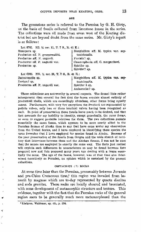
The greenstone series is referred to the Permian by G. H. Girty, on the basis of fossils collected from limestone lenses in the series. The collections were all made from areas west of the Keating dis trict but are beyond doubt from the same series. Mr. Girty's report is as follows:
Lot 6761. SE. % sec. 11, T. 7 S., R. 41 E.:Stenopora sp.Productus aff. P. gruenewaldti. Productus aff. P. aagardi. Productus aff. P. aagardi var. Productus sp.
Lot 6763. NE.Batostomella sp.Derbya? sp.
Marginifera aff. M. typica var. sep-tentrionalis.
Pustula? sp.Camarophoria aff. C. margaritovi. Spirifer sp. Spirifer? sp.
sec. 21, T. 7 S., R. 41 E.:Marginifera aff. M. typica var. sep-
tentrionalis.Productus aff. P. aagardi var. Spirifer 3 sp.
Ambocoelia? sp.
These collections are noteworthy in several respects. The faunal lists rather misrepresent than conceal the fact that the fauna consists almost entirely of productoid shells, which are exceedingly abundant, other forms being equally scarce. Furthermore, with very few exceptions the Producti are represented by pedicle valves, only two or three brachial valves having been recognized as such. In point of preservation these fossils leave much to be desired, and that fact accounts for my inability to identify, except generically, the rarer forms, or even to suggest probable relations for them. The two collections contain essentially the same fauna, which appears to be more nearly allied to the Permian faunas of Alaska than to any that have come under my observation from the United States, and I have employed in identifying these species the same formulae that I have employed for species found in Alaska. Because of the poor preservation of the fossils from Oregon and the wide stretch of terri tory that intervenes between them and the Alaskan faunas, I can not be sure that the names are employed in exactly the same way. The facts just recited will explain such differences in nomenclature as may be found between lists prepared now and lists prepared many years ago dealing with a fauna essen tially the same. The age of the fauna, however, was at that time also deter mined tentatively as Permian, an opinion which is sustained by the present collections.
CRETACEOUS ( ?) ROCKS
At some time later than the Permian, presumably between Jurassic and pre-Chico Cretaceous time,,9 this region was invaded from be neath by magmas which are to-day represented by quartz diorites and soda granites. These rocks are locally sheared and brecciated, with some development of metamorphic structure and texture. This evidence, together with the fact that the Permian rocks of the general region seem to be generally much more metamorphosed than the
B Llndgren, Waldemar, op. cit., p. 596.
14 CONTRIBUTIONS TO ECONOMIC GEOLOGY, 1931-32, PART I
Triassic, renders it possible that these intrusive rocks are older than the Triassic, perhaps belonging to the post-Permian period of intru sion to which Lindgren 9 referred the gabbros and diorites near Vir tue and Elkhorn Kidge. However, this is not established, and as Ross 10 found in the Wallowa Mountains rocks which he regards as comagmatic with the albite granite intrusive into Triassic rocks, it seems best to retain the provisional assignment of these intrusive masses to the post-Jurassic.
QUARTZ DIORITE
Quartz diorite forms several stocks along Goose Creek and between Goose Creek and Balm Creek. Poor exposures and the cover of Tertiary formations prevent the precise outlining of these stocks. The western part of the large intrusive mass in sees. 7, 8, and 9, T. 8 S., R. 43 E., is about a mile wide and is composed of quartz diorite. Toward the east this mass appears to grade into a soda granite, which, however, may be a separate intrusion, though this is not probable. Smaller masses of quartz diorite occur to the north along Goose Creek at and near the mouth of Sheep Creek.
The contact relations of these quartz diorite bodies are obscure, but as these bodies as well as the irregular masses of greenstone in cluded in them show a decided tendency to be elongated in an east- west direction, which corresponds with the general strike of the pre-Tertiary formations in the area, the structure of the greenstones evidently had some control on the emplacement of the quartz diorite.
The relations of the quartz diorite to the albite granite are uncer tain. Exposures are not sufficient to permit a positive statement that they grade into each other, but no intrusive contact was found. Both in hand specimens and in thin sections there appear to be all gradations from an undoubted quartz diorite to an undoubted albite granite, so that the hypothesis is here suggested that they are facies of the same mass. Their present contrasted character is not, however, supposed to be due to magmatic differentiation in place, but to post- magmatic changes in connection with dynamic metamorphism. This is discussed on page 17.
No prominent structural features in the quartz diorite were dis covered in the field, and thin sections reveal only a few microscopic faults filled with epidote.
The rock is medium gray and equigranular, with an average grain size of about 2 to 4 millimeters. Plagioclase and hornblende are prominent, with subordinate quartz. In thin section the rock shows a granitic texture. Hornblende and andesine (zoned normally from AbgoAnso to Ab60An40 ) are the dominant minerals and present
10 Ross, C. P., unpublished manuscript.

U. 8. GEOLOGICAL SURVEY BULLETIN 830 PLATE 1
/ /' x/ x ' '//< x/< /'
Columbia River lava (Andesito and basalt flows')
Quartz Albite granite diorite' facies
Greenstone with' some limestone lenfiea.cls
Fault(Dashed where inferred;
D shows dowrihrown side)
Approximate dip of beds; strike undetermined
Culture and drainag'e have only sketch value except near ^eolo^ic contacts; land lines are approximate
5,ooo'-\
A.
3fiOO-
^^^^^^^^\\\\VviK\v \\ V> ^ V >L ^ r A * IA A V > i /IMf lh 7\\\ WS'\l^\VJi^^Vt-v r̂ >>A^^^ tVAVA\I
Section alor»^ line A~Ar
Scale 31^680 o
1931
AREAL GEOLOGIC MAP OF THE KEATING COPPER DISTRICT, OREGON

COPPER DEPOSITS NEAR SEATING, ORE6. 15
euhedral to subhedral forms, the interstices being .filled with quartz. A few grains of augite, largely altered to hornblende, occur. Apatite and ilmenite are minor accessories, particularly associated with the hornblende. Small amounts of chlorite and epidote have been de veloped after hornblende. A little sericite impregnates the andesine but is not sufficient to make it cloudy. Very little epidote is found in the feldspar, but a few narrow veinlets cut the rock. Nothing was seen in the thin sections which implied other than a normal origin for this rock.
ALBITE GRANITE
Albite granite, part of a mass described by Lindgren,11 crops out over a considerable area on the east side of Goose Creek, below the mouth of Sheep Creek. A smaller body is exposed east of Clover Creek in an area embraced between " prongs " of the Tertiary basalt rim rock. Much larger bodies occur to the east, near Sparta, where Lindgren estimates that the granite occupies about 30 square miles (misprinted 300). The albite granite masses are irregularly shaped, although they appear to be roughly parallel to the strike of the greenstones.
Over considerable areas the albite granite is sheared and granu lated. The more intensely sheared parts are reduced to streaked rocks in which epidote and quartz veinlets penetrate a chalky-appear ing but firm groundmass in which feldspar but no dark minerals can be seen. In other places the rock shows less evidence of shearing, although it seems everywhere to be somewhat more brecciated than the adjoining quartz diorite.
The less crushed albite granite is a medium-gray, almost equi- granular rock in which plagioclase, hornblende, and bluish quartz grains averaging about 2 to 4 millimeters in size are recognizable in hand specimens- In passing to the more sheared portions of the mass the dark minerals become less and less plentiful and the quartz increasingly prominent. Some of the rocks show a pseudoporphyritic texture, with large irregular areas of bluish quartz as much as 2 centimeters in diameter in a groundmass of greenish plagioclase and subordinate epidote. In some specimens there are small veinlike masses of bluish quartz 3 or 4 centimeters long and 2 to 5 millimeters wide. The more sheared the rock the less recognizable hornblende it retains and the more greenish are the feldspars from included epidote.
In thin section the albite granite is extremely variable. Some slides superficially resemble the quartz diorite in a striking manner. The feldspar grains are of about the same size, from 2 to 4 milli-
n Lindgren, Waldemar, op. cit., p. 734. 71910° 33 2
16 CONTBIBTJTTONS TO ECONOMIC GEOLOGY, 1931-32, PAUT I
meters in diameter, and the hornblendes do not noticeably differ. However, there is considerably more quartz in the albite granite, and its habit is notably different, in that it occupies not merely wedge-shaped interstices between the grains of the other minerals but is found in irregular and worm-shaped masses, partly embedded in the albite. The albite grains have glassy and clear border zones about one-fifth of the thickness of the grains. Their inner parts are all obscured by masses of highly refracting fibers of uncertain com position, probably epidote and clinozoisite, which so thoroughly mask the feldspar base that its composition is not evident, although it seems to be albite of the same index of refraction as that in the clear zone about it. The same accessory minerals, apatite and mag netite, are present in this rock as in the quartz diorite.
All gradations are found from the rock just described to rocks which are composed almost wholly of the elaborate albite-quartz reg ular intergrowths known as myrmekite, in rosettes over 1 millimeter in diameter. Minute crystals of epidote, hornblende, biotite, sericite, and magnetite are embedded in the albite of the myrmekite, but not in such numbers as to prevent its optical determination.
Other specimens carry large crystals of quartz, most of which exhibit serrate edges toward the feldspar, which has a " resorbed " appearance. In some specimens both fine myrmekite and coarse wormlike masses of quartz occur in only slightly cloudy albite.
Many of these more siliceous rocks exhibit breccia structure in fact, the more brecciated rocks are notably much more siliceous than the less brecciated. A few myrmekite rocks show little breccia struc ture, however. A few specimens of the albite granite have typical granoblastic texture in which the various mineral grains occupy embayments in one another, without any evidence of a sequence of crystallization.
The optical constants of the albite indicate a composition at least as sodic as Ab92An8 and probably as sodic as Ab95Ang, y being in most specimens less than 1.54.
Amphibole is present merely in shreds and with the biotite and epidote does not make up more than a small fraction of the amount of dark minerals present in the less siliceous rocks. The hornblende is apparently of the common variety, identical with that of the quartz diorite in several specimens, with extinction angle yA<? of 21°, opti cally negative, 2V moderate, Z blue-green, Y brown-green, and X yellow-green; Z> Y>X. These properties do not indicate any nota ble content of alkalies. However, in some specimens the common green hornblende is blotched with greenish-blue patches, and in sev eral specimens its place is taken by a green-blue amphibole whose

COPPER DEPOSITS NEAR KEATING, OREG. 17
properties correspond with those of the more sodic variety, hastings^ ite (extinction angles yA<? 28°, birefringence surely less than 0.015,, the strong colors rendering its measurement difficult, optically nega tive, optic angle very small, Z=Y, a deep greenish blue, >X, light yellow-brown). This amphibole is accompanied by common horn blende in most of its occurrences. Nearly all specimens show late veinlets of epidote through the rock.
The field relations of the albite granite and quartz diorite together with their microscopic features just summarized have led to the fol lowing tentative hypothesis of origin. The entire mass of quartz dioxite and albite granite was emplaced as a single intrusive mass and solidified into a homogeneous quartz diorite. Shortly after ward, or perhaps even before the final consolidation of the mass, mountain-building forces became active, and their localization by factors not now discernible produced profound shearing and breccia- tion in some portions and little effect in others. Orogenic pressure is known to favor saussuritization, and alteration of this type, going forward in the presence of circulating solutions, may well have set free sodic solutions to replace the feldspars of adjacent parts of the mass. On the other hand, this albitization may be at least in part attributed to sodic and siliceous solutions rising from deeper magmas which thoroughly permeated the sheared and brecciated portions. The effects of these solutions were to albitize the feldspars, a process doubtless facilitated by continued erogenic pressure, and to replace the feldspars by quartz, both in coarse wormlike and in myrmekitic forms, a process which is also advanced by pressure.12 Albitization and myrmekitization are often recognizably parts of one process, which is typically illustrated in the rocks under consideration. Ad ditional effects of the circulating sodic and siliceous solutions were to produce some biotite as a reaction product between hornblende and feldspar, to remove large parts of the femic constituents from the rock, and to add soda to some of the amphibole, with the production of hastihgsite.
Analyses of representative specimens of the quartz diorite and albite granite, together with two intermediate rocks, seem to support the above hypothesis, by showing that there is rather definitely a complete gradation between the two end types.
V* Sederholm, J. J., On synantetic minerals and related phenomena: Comm. ge"ol. Fin- lande Bnli., vol. 9, No. 48, 1916.

18 CONTRIBUTION'S TO ECONOMIC GEOLOGY, 1931-32, PART I
Analyses of quartz di&rite, alMte granite, and. transitional phases
[J. O. Fairchild, analyst]
A1 203 .Fe20 3 -- ..FeO. ..........MgO - -.. -...CaO..--...-......NasO.. K20.. ....... _H20-. ...........
188
54.6715.952.087.484.097.972.71
.00
205
67.8114.131.504 fl41.563.763.361.62.06
209
73.8112.36
.942 97.78
1.623.891.47
fU
15
77 fU11.881.051.32.04
1.284.451 64.00
H.O+ ...Ti02 -C02. -P205.. .. ... .MnO._ ........BaO...._ SrO. .............
188
1.261.161.24.11.17.00nn
100. 05
205
1.24.79.45.06.13.00.00
100. 51
209
.90
.70
.31
.04
.10
.00
.00
99.93
15
.54
.37
.14
.04
.00
.00
.00
99.79
188. Quartz diorite, sec. 9, T. 8 S., R 43 E. 205. Partly albitized quartz diorite, same locality as 188. 209. Pseudoporphyritic albite granite, sec. 8, T. 8 S., E. 43 E. 15. Pseudoporphyritic albite granite, sec. 13, T. 8 S., E. 43 E.
The principal weakness of this hypothesis is the obscurity of field evidence, due to the inadequacy of exposures. The proof of an intrusive contact between rocks of the two kinds would overthrow the hypothesis, at least in the form stated above, but apparent grada- tional relations in the field and the petrographic and chemical evi dence all seem to testify strongly to the postmagmatic introduction of soda and silica into the rock.
TERTIARY ROCKS (MIOCENE?)
COLUMBIA RIVER LAVA
The most widespread geologic formation in eastern Oregon is, the Columbia Kiver lava. In the Keating district it forms the bedrock over large areas. In the high, ground to the north, it forms a gently southward-sloping table-land, and thin remnants descend along the intermediate ridges to altitudes of 3,000 feet, or even to 2,600 feet at the Powder River, southeast of the mapped area.
The lavas rest unconformably upon the Permian greenstones and Cretaceous (?) intrusive rocks, and locally, as southwest of Crane's Mill, they lie conformably upon thin beds of tuff closely related to themselves. The relief of the pre-lava surface was considerable, as is clear along upper Goose Creek and upper Balm Creek within this area and even more strikingly along Big Creek and the Powder River Canyon, to the northwest. This explains the marked local variations in the altitude of the exposed basal contact of the lavas. For example, on the high hills in sees. 9 arid 10, T. 8 S., R. 43 E., south of the east-west part of the course of Goose Creek, the contact is as much as 400 feet higher than it is in sees. 4 and 5 of the same township, along the north side of the Goose Creek Canyon. Sim ilarly, the small basalt cap on the hill just northeast of the mouth of Slide Creek is conspicuously lower than the contact on the hill next to the northeast. Yet neither of these discrepancies is greater

COPPER DEPOSITS NEAR SEATING, OREG. 19
than can elsewhere be shown to be due solely to relief in the pre-lava topography, and neither is believed to demand faulting as an ex planation. It is impossible to deny that part of these differences may be ascribed to faulting, but if so, the faults have very slight persistence in strike.
In the Keatirig district, as elsewhere, the Columbia River lava consists of many flows, ranging from about 20 to 80 feet in thickness and averaging about 40 feet. Many of the flows are separated at the top and bottom by scoriaceous zones, which are commonly but by no means invariably red.
The maximum thickness of the Columbia River lava in this district is probably only 400 or 500 feet, as it has suffered considerable ero sion. Ten miles to the northwest, in the Powder River Canyon, at least 800 feet is exposed, and much greater thicknesses fully 4,000 feet are to be seen in the Snake River Canyon, to the east.
Three principal varieties of lava are apparent in the Columbia River flows on cursory inspection, and the microscope confirms the conclusion drawn from hand specimens. These are olivine basalt, hypersthene-augite andesite, and hypersthene andesite. Perhaps half of the flows are composed of typical olivine basalt, a dense dark- gray rock carrying olivine crystals as much as 1 millimeter in diameter in an aphanitic, finely vesicular groundmass. The microscope reveals an ophitic to divergent granular texture. Tabular crystals of labra- dorite-bytownite, about Ab30AnTO, constitute 40 to 45 per cent of the rock; olivine, chiefly in microphenocrysts, 8 to 10 per cent; pyrox enes, which range from normal augite to a variety of pigeonite, 30 per cent; and magnetite, apatite, and glass the remainder.
The hypersthene-augite andesite forms nearly as many flows as the olivine basalt. It is a dense light to medium gray rock with platy structure. The platy structure is commonly subparallel to the base of the flow, but locally it may stand at any angle and may even be normal to the base. Wavy streaks of very fine vesicles bring out the flow structure. In thin section the rock shows a felted texture with local tendencies to fluidal arrangement of crystals in a glassy grOund- mass. Feldspar of composition close to Ab55An4 5 occurs in minute laths not more than 0.1 millimeter long and makes up about 50 to 60 per cent of the rock. Augite occurs in granules averaging about 0.03 millimeter in length and constituting about 25 per cent. Hyper sthene in microphenocrysts as much as 0.2 millimeter long constitutes about 5 per cent. Small quantities of magnetite and apatite are present, and the rest is glass.
The hypersthene andesite, though not as abundant as the two lavas just described, is widespread and prominent. It is a very dark gray, almost black rock, extremely dense and glassy and break ing with a glistening conchoidal fracture. None of its minerals are

20 CONTRIBUTIONS TO ECONOMIC GEOLOGY, 1931-32, PART I
megascopically identifiable. The microscope reveals a felted texture with some signs of flow structure in a glassy groundmass. About 45 per cent of the rock is composed of very minute feldspar laths, only rarely exceeding 0.1 millimeter in length, whose composition is about Ab5oAn5o. About 3 per cent of the rock is made up of columnar crystals of hypersthene as microphenocrysts 0.5 millimeter in maxi mum length. A little magnetite is the only other mineral present, and glass makes up about half of the rock. In some specimens a little augite is present in addition to the hypersthene.
LAKE BEDS
Lake beds and associated fluviatile deposits are closely associated with the Columbia River lava in many places in Oregon, Washing ton, and Idaho. In the southwestern part of the Keating district they crop out over several square miles. The exposures are relatively poor, owing to the unconsolidated character of the material, but where observations could be made the beds dip southward at low angles. They rest unconformably upon the pre-Tertiary basement rocks where exposed in this district, but the same lake beds and asso ciated fluviatile deposits rest conformably upon Columbia River lava at the mouth of the Powder River Canyon, about 7 miles to the west. Lavas of the same series overlie the lake beds along the lower course of Goose Creek, south of the mapped area. Accordingly the lake beds are considered to be equivalent in age to part of the Columbia River lava, although the exposed contacts with the lava in the Keat ing district are fault contacts.
The lake beds are all soft and have been truncated by erosion and covered with terrace gravel. However, dissection of those terraces is proceeding in the present cycle, so that within the Keating dis trict relatively small areas of terrace remain intact, though gravel let down from them is widespread. Only the undissected terraces are mapped as such on the accompanying map.
Exposures of the lake beds reveal very light gray to cream-colored or even white, soft, well-bedded sediments. Considerable volumes are composed of exceedingly fine particles, impalpable between the fingers and very soft in the mass. The microscope reveals the fact that this material is composed of practically nothing but diatoms. Other parts of the sediments, probably of fluviatile origin, are con glomeratic, containing pebbles of greenstone, diorite, argillite, ba salt, and andesite. Some fine grit beds and some shaly layers also occur. Locally, on Balm Creek, a very scoriaceous basalt is inter- bedded in the sediments. Casts of leaves are very numerous along many bedding surfaces in the formation. They were collected in some quantity, but those examined were too poorly preserved for determination of age.

COPPER DEPOSITS NEAR KEATING, OREG. 21
The thickness of the lake beds exposed in this district is unknown but probably only about 300 feet.
AGE
The age of these sedimentary beds and lavas is undetermined. They are undoubtedly Tertiary and from analogy with similar sedi ments in near-by parts of Oregon and Idaho are probably Miocene, but this can not be definitely affirmed. Lava flows, such as are pres ent in this district, have been poured out in this general area at differ ent times from Eocene to Pliocene. It seems that the bulk of them in northeastern Oregon are of Miocene age, but the writer believes that the elucidation of the Tertiary history of this region will be further advanced by emphasizing the uncertainty of correlation of the different lava flows than by the facile assumption of correlations which, however probable, are not established by tracing or by. paleon- tologic evidence.
QUATERNARY DEPOSITS
TERRACE GRAVEL
The small remnants of terrace gravel, doubtless once continuous over the area underlain by lake sediments in the southwestern part of the Keating district, are thin veneers only a few feet thick. They are made up of very slightly consolidated gravel derived from all the older rocks in the drainage areas of the region. Eecent dissec tion has led to the scattering of the gravel over the valley slopes throughout most of the lake-bed area, but only the uneroded rem nants are shown on the accompanying map. There is no direct evi dence for dating these deposits of terrace gravel, but their relations to the present streams, incised but a few score feet below them, strongly suggest a Pleistocene age.
COLLTTVIUM
The term colluvium designates all the loose debris accumulated in rock flows, soil flows, and similar movements of surficial matter. Only those areas where this material is so thick as to conceal the bed rock completely are shown on the accompanying map. The deposits are transitory and are referable entirely to the present cycle of erosion.
GEOLOGIC HISTORY
There is no record, within the Keating district, of the pre-Permian history. During Permian time the area was the site of volcanic activity, and great thicknesses of lava flows with accompanying frag- mental material were deposited. Much of this material was sub marine, as evidenced by interbedded marine limestones, but some of it may have been subaerial.
22 CONTRIBUTIONS TO ECONOMIC GEOLOGY, 1931-32, PAET I
At a later period, possibly pre-Triassic, possibly not until post- Jurassic, these rocks were intensely folded and sheared, intruded by quartz dioritic magmas, and later in large part albitized, together with some of the quartz diorite. Some or perhaps most of the green stone albitization may have been earlier, but some was almost surely associated with the intrusion of these rocks. Continued mineraliza tion, characterized by the deposition of quartz, sericite, pyrite, and chalcopyrite, took place along shear and fracture zones in the green stone and replaced the rock on a large scale at many localities.
A long period of erosion followed, and a surface of considerable relief was developed. Then, in Tertiary time, the country was flooded by great outpourings of lava. The drainage was disrupted, and lakes were formed and partly filled with sediments, which were in turn covered by the later lava flows. Warping and minor fault ing of the flows and lake beds then took place, and erosion followed, cutting through the lava cover and into the pre-Tertiary rocks be neath. This superposition of the streams upon the pre-lava surface resulted in drainage modifications due to the control exerted by irreg ularities in this surface upon the distribution of the ground water. The two sharp angles in the course of Goose Creek form a striking example. The westward-flowing part in sees. 3 and 4, T. 8 S., R. 43 E., between the two sharp bends, was originally a branch of Sheep Creek, while Goose Creek continued its upper course in an essentially straight line to the south. However, as the basalt de scended to a lower altitude along the course of Sheep Creek than along that of Goose Creek, when the tributary of Sheep Creek dis covered the pre-Columbia River lava valley joining the two creeks it was able to extend headward, divert the ground-water flow from Goose Creek, and finally capture that stream and establish its present course.
Downcutting may not have been continuous: there may have been several partly completed cycles. One such pause is reflected in the Pleistocene gravel. The latest stage in the history has been one of renewed dissection of the gravel into terraces and the development of some landslides.
MINERAL DEPOSITS
GENERAL FEATURES
Copper prospects are widespread in a belt extending from a point west of North Powder in a general easterly direction to and beyond the Snake River into Idaho, a distance of over 75 miles. At the time of this survey the most active prospecting was going forward in the area between Clover and Goose Creeks, in Tps. 7 and 8 S., Rs. £2 and 43 E.

COPPER DEPOSITS NEAB SEATING, OKEG. 23
Throughout this belt the deposits, in so far as they have been out lined by workings, are all impregnation or replacement bodies along shear zones, faults, and fractures, which form a maze of intersecting openings in the greenstones. Most of the fractures are short and irregular, but several of the shear planes are of considerable extent and have controlled the deposition, of the larger deposits.
The forms of the mineralized bodies are very irregular, and natu rally they are difficult to outline, the more so as the impregnation by pyrite is considerably more widespread than that by chalcopyrite. The largest body so far outlined is that in the Balm Creek mine of the Oregon Copper Co., which is about 150 by 100 feet in its greatest dimensions. These dimensions merely outline the limits within which mineralization has been intense, as considerable chalcopyrite occurs for as much as 200 feet beyond them. From this size the replacement bodies range down to dimensions of a few feet.
The irregular forms and erratic distribution of the mineralized bodies are probably due to two factors the broken structure of the greenstones and the time required for the mineralization. The mineralization seems to have taken place in stages. The earliest and most widespread alteration of the rocks, albitization, probably had only remote connection, if any, with the later sulphide mineraliza tion, for it apparently affected very wide areas, far from any present signs of sulphide minerals.
Probably earth movements were occurring throughout the period of mineralization, so that the mineralizing solutions were from time to time diverted from one channel to another, as new openings were formed and old ones closed or partly closed. The blocky character of the rock restricted the continuity of the openings, so that all the alterations later than the albitization were irregularly distributed. Thus the silicification and sericitization which affected considerable bodies of rock in the neighborhood of the ore bodies was not coin cident with either the earlier albitization or the slightly later sul- phidization, although it was much more closely associated with the sulphide mineralization than with the widespread albitization.
Following somewhat different channels than the silicifying and sericitizing solutions, the sulphides, pyrite and chalcopyrite, were introduced. Gold was also introduced at this time, probably in the pyrite, as, assays fail to show any close relation between gold and copper content of the rocks. Gangue minerals accompanying the sulphides include quartz, sericite, chlorite, nontronite, barite, an- kerite, and calcite. Lindgren 13 also reports natrolite, but none was seen during this survey.
18 Lindgren, Waldemar,. op. clt,, p. 731.

24 CONTRIBUTIONS TO ECONOMIC GEOLOGY, 1931-32, PART I
These .factors irregular and discontinuous openings in the coun try rock and shifting passages ,of solutions during the mineraliza tion have produced mineralized bodies of so great irregularity that they are among the most difficult kinds in which to estimate reserves. The presence or absence of a body of ore on one level is no justifi cation for the belief that ,on the next level below ore will be either present or absent, for the bodies are likely to pinch out abruptly or come in abruptly in any direction.
Weathering has led to the production of siliceous cappings, with some calcite and limonite. The sulphides have been altered by oxidation to malachite, azurite, native copper, cuprite, tenorite, chrysocolla, jarosite, and " limonite." Supergene enrichment has produced small amounts of bornite and chalcocite.
PROSPECTS
OREGON COPPER CO.
The most active prospecting in the area during the summer of 1929 was going forward at the Oregon Copper Co.'s property, on Balm and Slide Creeks, in sec. 32, T. 7 S., R. 43 E. The company holds a very large block of claims at this locality, extending eastward to Goose Creek. Prospecting for copper has been carried on inter mittently at the site for over 30 years, but the first development on a large scale was begun about 1924. The property has been known at various time as the Gilkeson, the Poorman, and the Mother Lode but has been in the hands of the Oregon Copper Co. since 1926. A few small shipments were made to the Sumpter Valley smelter in 1923 as test lots, but no commercial production has been reported.
The property is readily accessible from Baker, distant 28 miles by good road. The hills near the workings are bare, but abundant tim ber suitable for mining purposes is found only 2 or 3 miles to the north. Water in sufficient quantity for use in mining is readily avail able from Balm Creek. Electric power lines of the Eastern Oregon Power & Light Co. extend to the property.
The property is developed by two shafts and three tunnels, with numerous subsidiary levels, raises, and crosscuts. The workings accessible in 1929 (pis. 2 and 3) aggregated more than 13,000 feet. Those on Slide Creek, called the Poorman workings (pi. 3), included a tunnel about 1,400 feet long, with several crosscuts and raises, and a shaft 420 feet deep, from which two levels were turned, one at 138 and the other at 289 feet below the collar. The upper of these levels, known as the Poorman No. 2, consists of about 2,300 feet of drifts and crosscuts; the lower, or Poorman No. 3, about 650 feet. Only a moderate amount of water was being pumped from this shaft, and sinking was going forward at the time of the survey.

COPPER DEPOSITS NEAR KEATING, OREG. 25
The Balm Creek workings (pi. 2) include two tunnels, the upper connecting by a short raise to the Gilkeson tunnel, which enters the hill from the Slide Creek side, and a shaft, which was 700 feet deep at the time of this survey. The levels turned included Nos. 3 to 6, at 150, 244, 434, and 578 feet below the shaft collar. The No. 5 inter mediate level, 84 feet above the No. 5, and the No. 6 intermediate, 72 feet above the No. 6, had riot been cut through to the shaft. The No. 1 or upper tunnel is 43 feet higher than, the shaft collar, and the No. 2 tunnel is 12 feet below it.
The No. 1 tunnel and the connecting Gilkeson tunnel had about 2,200 feet of accessible workings, the No. 2 tunnel about 1,200 feet, the No. 3 level about 1,200 feet, the No. 5 intermediate about 550 feet, and the No. 5 about 2,400 feet. No. 5 level was being vigorously advanced eastward to cut beneath the Poorman workings and con nect with the Poorman shaft. This connection has been completed since the survey. A southern crosscut was also being driven. The lower levels of the shaft were inaccessible because of the strong flow of water, which was barely controlled by the pumps available at that time. Additional pumps were being installed, and sinking was to be resumed.
The workings of the Oregon Copper Co. are all in the Permian greenstone series. In the neighborhood of the property the Permian greenstones beneath the basalt rim rock are poorly exposed because of the creep of the soil and of talus from outcrops higher on the hills. Accordingly it is difficult to work out the structure in detail. Only two localities were found near the workings where the attitude of the rocks could be convincingly determined. These were both in road cuts near the confluence of Slide and Balm Creeks, where sili ceous tuff members were found to strike slightly north of west and to dip 50°-70° N.
The great bulk of the greenstone series as exposed in and near the workings is composed of keratophyre, spilite, and quartz kerato- phyre, which, though much metamorphosed and silicified, have pre served their original texture in many places. From this original texture it may be determined that some of these rocks were originally diabasic, but most of them have the texture of rhyolites or andesites. Some volcanic breccia members were also seen.
In addition to these highly sheared and incipiently schistose rocks there are somewhat less broken members, which also, however, are greatly chloritized and contain albitic feldspars. Some of these are perhaps dikes in the old lava and pyroclastic deposits. A few rather fresh basaltic dikes occur, possibly referable to the Columbia Eiver lava.
Intensive study was given to the local stratigraphy of the green stone series, in the hope that characteristic members could be
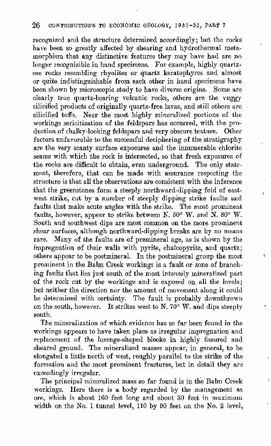
26 CONTRIBUTIONS TO ECONOMIC GEOLOGY, 1931-32, PART I
recognized and the structure determined accordingly; but the rocks have been so greatly affected by shearing and hydrothermal meta- morphism that any distinctive features they may have had are no longer recognizible in hand specimens. For example, highly quartz- ose rocks resembling rhyolites or quartz keratophyres and almost or quite indistinguishable from each other in hand specimens have been shown by microscopic study to have diverse origins. Some are clearly true quartz-bearing volcanic rocks, others are the vuggy silicified products of originally quartz-free lavas, and still others are silicified tuffs. Near the most highly mineralized portions of the workings sericitization of the feldspars has occurred, with the pro duction of chalky-looking feldspars and very obscure texture. Other factors unfavorable to the successful deciphering of the stratigraphy are the very scanty surface exposures and the innumerable chlorite seams with which the rock is intersected, so that fresh exposures of the rocks are difficult to obtain, even underground. The only state ment, therefore, that can be made with assurance respecting the structure is that all the observations are consistent with the inference that the greenstones form a steeply northward-dipping fold of east- west strike, cut by a number of steeply dipping strike faults and faults that make acute angles with the strike. The most prominent faults, however, appear to strike between N. 50° W. and N. 80° W. South and southwest dips are most common on the more prominent shear surfaces, although northward-dipping breaks are by no means rare. Many of the faults are of premineral age, as is shown by the impregnation of their walls with pyrite, chalcopyrite, and quartz; others appear to be postmineral. In the postmineral group the most prominent in the Balm Creek workings is a fault or zone of branch ing faults that lies just south of the most intensely mineralized part of the rock cut by the workings and is exposed on all the levels; but neither the direction nor the amount of movement along it could be determined with certainty. The fault is probably downthrown on the south, however. It strikes west to N. 70° W. and dips steeply south.
The mineralization of which evidence has so far been found in the workings appears to have taken place as irregular impregnation and replacement of the lozenge-shaped blocks in highly fissured and sheared ground. The mineralized masses appear, in general, to be elongated a little north of west, roughly parallel to the strike of the formation and the most prominent fractures, but in detail they are exceedingly irregular.
The principal mineralized mass so far found is in the Balm Creek workings. Here there is a body regarded by the management as ore, which is about 160 feet long and about 30 feet in maximum width on the No. 1 tunnel level, 110 by 90 feet on the No. 2 level,

27
170 by 60 feet on the No. 3 level, and 150 by 80 feet on the No. 5 intermediate level. It was not found on the No. 5 level, although it is probably represented there by horses in the large fault above described. This body is represented by a very wide baritic gossan zone on the surface but is much narrower in depth. It pitches rather gently to the east between the No. 1 and No. 2 tunnel levels, but from the No. 2 level down it has a southwestward pitch. This pitch is somewhat less steep than that of the prominent fault zone mentioned above, so that the ore body appears to terminate against the fault or be cut off by it between the No. 5 and No. 5 intermediate levels. A little mineralized rock has been found on the No. 5 level at the foot of the raise to the No. 5 intermediate. This is probably a dragged block in the fault.
Within this mineralized body the 'distribution of the metals is very irregular. Little copper is present on the upper levels, what was formerly there having been leached out. However, oxidation has not seriously affected the minerals at lower levels, and here too the distribution of gold and copper is erratic. Most of the material is highly silicified and carries sporadically distributed specks and vein- lets of chalcopyrite and pyrite. The gold and chalcopyrite do not appear to be closely associated, as grab samples show wide variations in gold content although running about the same in copper.
The best mineralization appears to have occurred in the ground cut by the No. 5 intermediate level. Here veinlets of chalcopyrite and pyrite as much as 2 feet long and an inch or two wide are rather common, and the disseminated sulphides are also unusually plentiful. A grab sample of some of the best-appearing material yielded over 11 per cent of copper and $6.80 in gold to the ton. The sporadic dis tribution of the metals here is well illustrated by a comparison of samples taken by four different men over essentially the same width on this level. The assays of these samples, according to Mr. John Arthur, ranged between $10.14 and $54.46 a ton, computed on a basis of $20 an ounce for gold and 14 cents a pound for copper. It seems probable that the lower figure would be much closer to the value of the minable material than the higher.
Many other mineralized bodies occur in the workings, but none of them approach this in size. Similarly, in the Poorman workings (pi. 3) there are several areas where considerable mineralization has occurred, notably along two west-northwestward-trending fissures on both the No. 1 and No. 2 levels. They do not approach in size the Balm Creek bodies, being only about 30 feet in maximum width and probably less than 10 feet in average width.
The mineralogy of the deposits is simple. Pyrite and chalcopyrite are essentially the only primary metallic minerals. The gangue is dominantly quartz, with some sericite, ankerite, calcite, chalcedony,

28 CONTRIBUTIONS TO ECONOMIC GEOLOGY, 1931-32, PAET I
and barite. It is possible that some of the plentiful epidote and chlorite was deposited at the same time as the ore minerals, but for the most part they were formed earlier. Weathering on the upper two/ levels of the Balm Creek mine and in the shallower parts of the Poorman No. 1 level has resulted in the leaching out of some of the sulphides and the production of a superficial zone of siliceous ma terial containing a little gold, as well as jarosite, "limonite," mala chite, chrysocolla, and a little azurite. Barite persists in the gossan zone. A little chalcocite occurs below the leached capping, but no marked zone of chalcocite enrichment was exposed in any of the workings. No signs of oxidation were seen below the No. 3 level in the Balm Creek workings, and only slight oxidation is seen on the No. 2 Poorman level. None has occurred on lower levels at either place.
CLOVER CREEK COPPER CO.
The property of the Clover Creek Copper Co. is on Clover Creek in sec. 35, T. 7 S., R. 42 E., and comprises a large block of claims. The temporary buildings of the camp are also on Clover Creek.
The property is easily reached from Baker, about. 25 miles distant, by a good road. There is an electric power line to the property. A moderate amount of water but enough for prospecting is available .from Clover Creek. Abundant timber for use in mining is to be found within 3 or 4 miles to the north.
Prospecting for copper has been carried on for a number of years in the valley o,f Clover Creek in the west-central part of sec. 35. For some years the claims were held, together with those of the present Oregon Copper Co., by the Mother Lode Copper Co. In 1928 they were taken over by the Clover Creek Copper Co.
The developments in the west-central part of sec. 35 at the time of this survey included a considerable number of shallow trenches and a caved tunnel reported to be 400 feet long. A headframe had been erected, and preparations were being made for a shaft on the west side of Clover Creek near this old prospect tunnel. Another tunnel half a mile to the south, near the south line of the section, was being driven northeastward and was about 1,300 feet long in August, 1929. (See fig. 2.)
All the claims of the Clover Creek Copper Co. are in the Permian greenstone series, which consists, here as elsewhere, of interbedded quartzose and nonquartzose keratophyre and spilite flows and pyro- clastic rocks, with a very few small lenses of limestone. The attitude of the rocks is uncertain at the south end of the property, but just north of the old caved tunnel on Clover Creek tuffaceous members strike eastward and dip steeply to each side of the vertical. The rocks appear to form an isoclinally folded series.

TT. S. GEOLOGICAL SURVEY BULLETIN 830 PLATE 4R.9W. EXPLANATION
SEDIMENTARY ROCKS
Dothan formation (Chiefly hand sa,nctstane;ctZsp
argittite, chert,and. fvne-grcdn- e& conglomerate)
Quartz diorite and relatedrocks ; includes some smallareas of undifferentiatedmetagabbro
Serpentine and serpentinizedperidotite; some talc schist
Chiefly metagabbro but ineludes some small areas ofserpentine and quartz
Fine-grained, greenstones:chiefly metabasalt "but include some talc andchlorite
Aerial tramway
Contour interval 200 feet Elevations from aneroid barometers
MAP SHOWING GEOLOGY IN THE VICINITY OF THE ROBERTSON MINE, JOSEPHINE COUNTY, OREG.
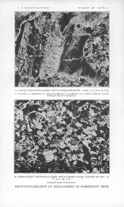
U. S. GEOLOGICAL SURVEY BULLETIN1 830 PLATE 5
A. PARTLY HECRYSTALLIZED METAGABBRO FROM SW. Vi SEC. 1, T. 35 S., K. 9 W.
a, Aciinolitc; p, plagioclase; h, dusty hornblende; f, completely reorystalli/.ed feldspar cryslal. Enlarged,about, 67 diameters.
B. COMPLETELY HECRYSTALLIZED METAGABBRO NEAR CENTER OF SEC. 13,T. 35 S., R. 9 W.
Enlarged about 36 diameters.
RECRYSTALLIZATION IN METAGABBRO OF ROBERTSON MINE

U. S. GEOLOGICAL SURVEY BULLETIN 830 PLATE 6
NO. I
SO"
91 L.
SECTION OF NO. f THROUGH WINZE
9O° Seams white quartz and some sulphides
\
MC CAUL£Y \ \ RAISE
PLAN
2O Oi i ' i I
20
7O
6060
IOOI
EXPLANATION
Quartz (Figures show thickness)
Gou^eor slickensided surface
Strike and dip
HI Shaft
Winze
aRaise
Blocky weathered greenstone
SO"
ZOO FEET
18
2"3" width of quartz veins in inches
SECTION
20 Oi i i i i
20 60i
IOO FEET
PLAN AND SECTION SHOWING THE PRINCIPAL WORKINGS OF THE ROBERTSON MINE, GALICE DISTRICT, OREGONFrom Brunton compass survey by P. .1. Shenon

COPPER DEPOSITS NEAR KEATING, OREG. 29
The rock is cut by innumerable fractures and shear surfaces, char acteristically coated by chlorite. In the new tunnel the most promi nent shear planes strike generally within 30° of north, chiefly N. 10°-30° W. Most of them (see fig. 2) dip west at rather steep angles, but many have easterly dips. Some very prominent shear zones trend about east. This seems to be the dominant trend at the north ern prospects. In addition to these somewhat clear-cut fractures, the greenstones are divided by undulating shear surfaces into rhombic
Basalt dike
Quartz kerajophyrt
Mineralized area
Fissure (Showing dip)
FIGURE 2. Map of the Clover Creek Copper Co.'s prospect tunnel
and small lozenge-shaped blocks. It is difficult to obtain a hand specimen not bounded on all sides by chlorite, so that the identity of the rock is megascopically almost indeterminate.
The new prospect tunnel was being driven to cut beneath oxidized bodies of gossan which contain barite, malachite, jarosite. " limon- ite," and casts of sulphides. At the time of this survey a few narrow stringers of quartz and manganiferous ankerite, with associated

30 CONTRIBUTIONS TO ECONOMIC GEOLOGY, 19 3 1-3 2, PART I
pyrite and small amounts of chalcopyrite, Had been intersected, but the tunnel had not reached a point below the most prominent gossans.
Near the old caved tunnel there are considerable evidences of min eralization. A 4-foot vein of barite crops out just east of Clover Creek opposite the new headframe, and much barite is disseminated through the gossan outcrops on both sides of the creek. Assays of barite from this locality are reported to have shown over 18 ounces of silver and $1.24 in gold to the ton. A grab sample collected by the writer showed a trace of copper and 80 cents in gold to the ton. The gossans extend in two subparallel zones about 200 feet apart in a general easterly direction. They range from a few feet to about 20 feet in width.
Little can be determined from the surface exposures as to the shapes of the mineralized bodies of which these are outcrops, but from analogy with the Balm Creek bodies they are probably also replacement bodies of irregular but roughly tabular form.
The presence of considerable pyrite and a little chalcopyrite in fragments of fresh rock on the dump of the caved tunnel implies that the oxidized zone is shallow. A grab sample of highly pyritic rock from this dump, collected by the writer, showed 0.40 per cent of copper and 40 cent& in gold to the ton.
COPPER QUEEN MINE
The old Copper Queen mine, sometimes called the Copper Butte, is just southwest of Crane's Mill, near the Avest edge of sec. 24, T. 7 S., K. 42 E. It is on a good road about 8 miles from Keating post office and 28 miles from Baker.
The copper deposits at this place have been known for nearly 60 years, for Raymond's report for 1873 14 states that " W. B. Crane & Co. sold their copper mine [at Copper Butte] to Messrs. Carson, Wil liams & Co., of Detroit, Mich." A furnace was erected, and 41/£> tons of copper was smelted. For a long time after this the workings were idle. Up to 1900 about 100 tons of 12 per cent copper ore was reported to have been shipped. No report of further activity was received until 1923, when, according to Hill,15 the property was re opened " with a view to supplying the Sumpter Valley smelter with fluxing ore." Since that time no activity has been reported at the property. The early production and the test lots for the Sumpter smelter from this property and the Poorman group (now owned by the Oregon Copper Co.) constitute the only reported copper produc tion from the Keating district. The mine was dismantled at the time of this survey in 1929.
14 Quoted by Lindgren, Waldemar, op. cit., p. 731.15 Hill, J. M., Gold, silver, copper, and lead in Oregon: U. S. Geol. Survey Mineral Re
sources, 1923, pt. 1, p. 370, 1925.

COPPER DEPOSITS NEAR KEATTKTG, OREG. 31
The workings consist almost wholly of shallow surface cuts, but there are also a few short tunnels and shafts. None of them were accessible in 1929.
The country rocks include amygdaloidal and tuffaceous members of the Permian greenstone series. Their structure is obscure, but they are cut by many fractures, the most prominent of which strike north west and have steep dips. Along these fractures the rock is coated with oxidation minerals malachite, azurite, chrysocolla, and cuprite, which also permeate the greenstone along the joints. A very little bornite was seen in one or two of the joints. A specimen of cupritic material from this locality assayed 20 per cent of copper and 40 cents in gold to the ton. The ore body is probably due to the oxidation of chalcopyrite originally disseminated through the greenstone along the fractures and replacing the body of the rock, as in the other occurrences. Mining below the shallow oxidized zone was evidently not profitable.
OTHER PROSPECTS
Copper oxidation minerals are widespread in this area, and a great many shallow pits and short tunnels have been excavated on them. A 40-foot shaft has been sunk in the NW. % sec. 25, T. 7 S., R. 42 E., in greenstone whose joints are impregnated with malachite, azurite, and chrysocolla. A shallower shaft has been sunk in the southwest quarter of the same section and another, now caved, in the SE. 14 sec. 34, T. 7 S., R. 42 E. Several other prospects have been driven on gossan zones in Sawmill Gulch in sec. 2, T. 8 S., R. 43 E. None of these appear to have developed any very encouraging showings.
CONCLUSIONS AND ECONOMIC CONSIDERATIONS
The existence of widespread but low-grade deposits of copper in the Keating district is well established. These deposits contain small amounts of gold and silver in addition to the copper. Small streaks of relatively high-grade chalcopyrite have been found, but the only hope of establishing a paying mine in this district lies in the block ing out of large ore bodies that can be mined at low cost. The atti tude and character of the mineralized bodies are not, so far as known, favorable to open-cut mining such as is carried on in many of the disseminated or " porphyry " copper deposits, enabling costs to be reduced so low that material carrying less than 1 per cent of copper is ore. Underground mining, with its increased charges for timbering, pumping, and hoisting, would require, to repay the cost of working, either larger or richer bodies than were known at the time of this study. Thus, although in the prospects examined there
71910° 33 3
32 CONTBIBUTIONS TO ECONOMIC GEOLOGY, 1931-32, PABT I
is undoubtedly considerable mineralized ground which carries more gold and perhaps more copper than the average of the " porphyry " bodies, the tonnage of mineralized ground so far blocked out in the district is very small in comparison with that of one of the larger " porphyry " camps.
However, despite these handicaps and the additional one of the- considerable distance to a railroad, it is distinctly possible that pay ing mines may be developed here. Where evidences of mineralization are as widespread as they are in this district, a certain amount of optimism may be felt as to the probability of the existence some where in the district of a sufficient concentration of metals to make mining profitable.