Embed Size (px)
Citation preview
SCHOOL OF GLOBAL STUDIES
Coping with climate variability in West Pokot, Kenya.
The influences of land use on responses to climate variability, by
pastoralist and agro-pastoralist communities in arid and semi-arid areas
of West Pokot, Kenya.
Master thesis in Global Studies 30 hp
Autumn Semester 2014
Author: Lotje Geutjes
Supervisor: Per Knutsson

1
Abstract
Many pastoralist and agro-pastoralist communities in semi-arid and arid areas in East
Africa, face the challenge of climate change, while the pressure on land is increasing and
at the same time land use changes are ongoing. This study focuses on the influences of
land use change on the responses to climate variability, by applying the contextual
vulnerability framework on the case study of West Pokot in Kenya for the comparison of
pastoralist (mainly communal ownership of land) and agro-pastoralist (mainly privatised
land) communities. The contextual conditions in which the land use change takes place
and by which land use is influenced are analysed and divided into political and
institutional structures, climatic variability and economic and social structures and their
changes.
Although there is a mutual influence of these changes and structures on the one hand
and land use on the other hand, the findings of the analysis show that improvements
initiated by these changes and structures favour the transition towards private ownership
and lead to more economic opportunities that improve the possibilities to cope with
climatic variability. This makes agro-pastoralist communities less vulnerable for climate
changes. However, it complicates comparison of those communities and their responses
as agro-pastoralist communities are ahead with regard to economic and living conditions.
Nevertheless, all the strategies in both communities are focused on coping with general
circumstances and climatic conditions that matter today and not on adaptation to climate
change.

2
Acknowledgements
This thesis could not have been made possible without the help of several people:
Thanks to the Triple L research initiative for the financial support of this research.
Thanks to all respondents for their time and input.
Thank you Clotilda Kamama Shangale, Johnson Asimwai, Benjamin Lokorwa and Manuel
for your help in the collection and translation of data.
Thank you Fathers of the Catholic Mission of Kacheliba for providing a safe place to stay
during the research.
Thank you Damiano Morulem, William Makokha Libusi and Lonah Mukoya for your efforts
and connections that made it possible to realize this research.
Thank you Sophie E. Kibuywa for your knowledge and friendship. Thank you for your
hospitality and having me stay in your home.
Thank you Arnold Geutjes, for your infinite support and constructive feedbacks.
Thank you Per Knutsson for your supervision.

3
For any questions regarding this thesis, the author can be contacted:

4
Table of contents 1. Introduction ............................................................................................................................ 7
1.1 General introduction ............................................................................................................ 7
1.2 Research aim and questions ............................................................................................. 7
1.2.1 Research aim .................................................................................................................. 7
1.2.2 Research questions ...................................................................................................... 7
1.3 The case study site: West Pokot ..................................................................................... 8
1.3.1 Kenya ................................................................................................................................. 8
1.3.2 West Pokot ...................................................................................................................... 8
1.4 Thesis outline ......................................................................................................................... 9
2. Background ........................................................................................................................... 10
2.1 Factors that influence land use change ...................................................................... 10
2.2 Land use change: policies and property right regimes ........................................ 11
2.2.1 Ideas behind policies ................................................................................................. 11
2.2.2 Property right regimes in East Africa .................................................................. 11
2.3 Climate change and land use change in semi-arid and arid areas in Kenya13
3. Theory ..................................................................................................................................... 14
3.1 Theory on vulnerability ..................................................................................................... 14
3.1.1 Definition ........................................................................................................................ 14
3.1.2 Different approaches of vulnerability .................................................................. 14
3.2 Contextual vulnerability framework ............................................................................ 17
3.2.1 Explanation of the framework ................................................................................ 17
3.2.2 Local land use............................................................................................................... 18
3.2.3 Adaptation and coping strategies ......................................................................... 19
4. Methodology ......................................................................................................................... 21
4.1 Comparative Case Study ................................................................................................. 21
4.2 Epistemology and ontology ............................................................................................. 22
4.3 Data collection ..................................................................................................................... 22
4.3.1 Literature review ......................................................................................................... 22
4.3.2 Semi-structured interviews ..................................................................................... 22
4.3.3 Observations ................................................................................................................. 23
4.3.4 Group talks .................................................................................................................... 23
4.4 Limitations ............................................................................................................................. 23

5
5. Results and analysis .......................................................................................................... 24
5.1 Structures and changes ................................................................................................... 24
5.1.1 Political and institutional structures and changes .......................................... 24
5.1.2 Climate variability and change .............................................................................. 25
5.1.3 Economic and social structures and changes .................................................. 25
5.2 Contextual conditions ........................................................................................................ 26
5.2.1 Institutional conditions ............................................................................................. 26
5.2.2 Biophysical conditions ............................................................................................... 27
5.2.3 Socio-economic conditions ...................................................................................... 28
5.2.4 Technological conditions .......................................................................................... 29
5.3 Responses .............................................................................................................................. 29
5.3.1 Coping strategies ........................................................................................................ 29
5.3.2 Adaptation ..................................................................................................................... 30
6. Discussion and conclusion ............................................................................................... 31
References ......................................................................................................................................... 33
Appendix ............................................................................................................................................ 36
Appendix 1: Map of Kenya with counties .......................................................................... 36
Appendix 2: Interview guides Chepareria ......................................................................... 37
Appendix 3: Interview guides Kacheliba ........................................................................... 40

6
List of abbreviations
INGO International Non Governmental Organisation
IPCC Intergovernmental Panel on Climate Change
IUCN International Union for Conservation of Nature NGO Non Governmental Organisation
7
1. Introduction
1.1 General introduction There is increasing evidence that land use is subject to change in pastoralist and agro-
pastoralist areas across East Africa (Woodhouse, 2003, Boye and Kaarhus, 2011,
Fekadu, 2009, Grimm and Lesorogol, 2012). The pressure on land in the semi-arid and
arid areas of East Africa is increasing due to several reasons. For example population
growth and the loss of grazing land to conservation areas and wildlife reserves (Butt,
2011). In Kenya there is 3% population growth per year (Worldbank, 2014). Currently
many of the present climate models predict rising temperatures and decreasing rainfall in
arid and semi-arid areas in Africa (Hesse in Huho et al. (2009)). Future climatic changes
will most likely increase the difficulties pastoralist communities are dealing with.
Understanding the factors that influence the responses of agro-pastoralist and pastoralist
communities to climate variability is likely to increase our capacity to identify relevant
adaptation strategies in relation to future climate change impacts.
The aim of this research is to analyze if and how land use influences the responses of
pastoralists and agro-pastoralist communities to climate variability and change. While
there has been much research done on the relation between climate change and
vulnerability in semi-arid and arid areas in East Africa, (for example Dong et al. (2011),
Kelly and Adger (2000), Mertz et al. (2009) and Mwang`ombe et al. (2011)) and on
changing land uses in arid and semi-arid areas in Africa (Boone, 2007), (Behnke, 2008),
(Flintan, 2011) and (Turner, 2011), very little research has been done on the relationship
between change of land use and the responses to climate variability.
The aim of this research will be realized by a case study in West Pokot, Kenya, through
an analysis of the vulnerability of the communities in relation to the local land use.
The outcomes of this study contribute to an understanding of possible adaptation and
coping strategies to climate change, and of the factors influencing these strategies. More
knowledge about adaptation strategies is relevant because of the increase of issues
related to changing habitats that are caused by climate change. (Snarr and Snarr, 2008).
1.2 Research aim and questions
1.2.1 Research aim
This study is based on a case study in West Pokot county, Kenya, with the aim to see if
and how changing land use practices, influence pastoralist and agro-pastoralist
communities in their responses to climate variability.
1.2.2 Research questions
How does ongoing land use change influence the way agro-pastoralist and pastoralist
communities respond to climate change1 in West Pokot, Kenya?
To answer this main question the following sub questions will be addressed.
1. What different land uses exist in West Pokot, how have they developed over time?
2. How and to which extent is land use change influenced by external and local
processes respectively?
3. How do people in West Pokot respond to climate variability?
4. What influences these responses to climate variability?
1 To make ‘climatic changes’ more tangible I used ‘climate variability’ in the sub questions, which
implies the fluctuation in climate experienced today.

8
5. How and to which extent does land use influence the way people respond to
climate change?
By asking all these sub-questions all the steps to find out how land use influences
responses to climate variability are covered, namely the influences on land use change,
the different types of land use and the different responses in relation to the land use
change.
1.3 The case study site: West Pokot
1.3.1 Kenya
The Republic of Kenya covers 580 728 km². 85% Of this land is semi-arid and arid the so
called ASAL areas. These areas account for 70% of the livestock production and 30% of
the national population (Government of Kenya, 2013). The case study site is also an
ASAL area.
According to data from the World Bank Kenya’s economy is growing. The GNI per capita
(PPP) increased from $1,490.0 in 2003 to $2,180.0 in 2012. Also the annual growth of
GDP increased from 2.9 in 2003 to 4.6 in 2012.(Worldbank, 2012)
1.3.2 West Pokot
Kenya consists of 47 counties, see appendix 1. West Pokot is one of these counties,
located in the North West of Kenya, bordering Uganda. The area is partly arid and partly
semi-arid, the amount of rainfall differs between 700mm and 1600mm a year, depending
on the altitude. The highlands have a sub-humid climate while the lowlands have an arid
climate (Huho, 2012).
The land in West Pokot is historically divided according to its use that is based on the soil
composition. The high mountain tops, that receive the most rain are most fertile and
most productive. The steep mountain slopes, where the soil is loose, are traditionally
used for cultivation of finger millet. The flat valley land is especially good for cultivation
near the rivers. And the ‘parched dry lands’ are used by pastoralists for grazing their
animals (Nangulu, 2001).
Since history the area of West Pokot has suffered from droughts, erosion and land
degradation. Previous research done on the region has shown that this resulted in less
food production and a lack of food security. Although the state and NGOs have been
helping out by giving famine relief, the structural problems remained (Nangulu, 2001).
Since 1880 many interethnic conflicts took place in the area of Pokot, many of these
conflicts arose in the border areas with neighbouring tribes. A strategy to avoid conflicts
is to avoid using the border areas for grazing (Bollig, 2006). However during droughts
the grazing areas that are normally used, are not sufficient to feed the animals. There is
a need to migrate with the animals to places where pasture is available. In the border
area will be some pasture, because it is normally not used for grazing. However all tribes
in the area suffer from the drought and are looking for pasture to feed their animals.
Conflicts arise when several tribes claim the border area.
During colonial times, from 1902 until 1960s, many parts of West Pokot were not well
integrated in the colonial economy, although tax was collected and headsmen and chiefs
were appointed (Bollig, 2006). One of the ways the Pokot tribe suffered from land
alienation by the colonial power was when the colonial powers took the fertile high lands
of Trans Nzoia, around Kitale. These highlands used to be grazing land for the animals of
the Pokot people. The Pokot were dislodged and forced to graze in the lower West Pokot,
where the land is less fertile and more dry (Nangulu, 2001). Nowadays the land around
Kitale is still used for agricultural purposes, often by large state owned farms, and the
dryer lowlands are nowadays increasingly used for cultivation.

9
West Pokot nowadays consists of divisions (see figure 1) and each division exists of
several sub-divisions. This research focuses specifically on two divisions: Chepareria and
Kacheliba. Both divisions belong to the lowlands of West Pokot. The livelihood zones of
the two divisions are however different. Chepareria consists of mainly agro-pastoral and
a small part mixed farming, while the whole of Kacheliba is dominated by pastoral
livelihood.
The altitude of both divisions differs, which influences the temperature and amount of
rainfall and thus the fertility of the land. In Chepareria division the altitude varies from
1200 till 2150 meter while in Kacheliba division the altitude varies from 900 till 1850
meters (Hendrix et al., 1985). Also the population density is different between both
divisions. In Chepareria 78 people live per km² while in Kacheliba this number is 39
people per km² (Commission on Revenue Allocation, 2011).
Figure 1: Map of West Pokot
Source: Drought Early Warning Bulletin – West Pokot County
1.4 Thesis outline Chapter 2, the background chapter, deals with the known factors that influence land use
change. It focuses especially on policies that influence land use change. Also climate
change in relation to land use change in the semi arid and arid areas of Kenya is
mentioned briefly in chapter 2. Chapter 3 covers the theory used in this study. The
concept of vulnerability is discussed in this chapter and the selection of the contextual
vulnerability framework is explained. Also a discussion of the concepts of adaptation and
coping strategies is provided. In chapter 4 an explanation of the selection of the applied
methods is given as well as their contents and their limitations. Chapter 5 contains the
results and analysis. Here the contextual vulnerability framework is applied to analyse
the contextual conditions that influence the local land use, and the influence of local land
use on responses to climate variability. Finally chapter 6 covers the discussion and
conclusion of the thesis.
10
2. Background This chapter covers the background of land use change in East Africa. It focuses on the
circumstances in which land use is taking place such as climate change in East Africa and
Kenya, and the policies on land use change in semi-arid and arid areas. However the
chapter starts with some known factors that cause land use change.
2.1 Factors that influence land use change It is important to know the factors already known, that influence land use, when
investigating the influence of land use change in West Pokot. Also what is known about
land use changes in semi-arid rangelands, under similar circumstances as in West Pokot,
can help in the analysis of whether land use changes influence responses to climate
variability.
Since land use change is the reflection of ‘human activities and environmental processes
over time and over space’ (Olson, 2004,1), there are several processes that can lead to
land use change, on a house hold level, according to Olson, namely:
- Globalization
- National policies
- Civil strife and insecurity
- Income diversification and urbanization
- Gender roles and labour allocation
- Differential poverty and wealth
The way some of these forces can influence land use change is formulated clearly by
Lambin et al. (2001,261,262): ’peoples’ responses to economic opportunities, as
mediated by institutional factors, drive land-cover changes. Opportunities and constraints
for new land uses are created by local as well as national markets and policies. Global
forces become the main determinants of land-use changes, as they amplify or attenuate
local factors’.
From these definitions we can conclude that there are different factors and forces that
influence land use change. Many of these forces and factors are mediated by policies
(Behnke, 2008, Kamara, 2005, Gebre, 2009), therefore policies is the focus of this
chapter.
Lambin et al. (2001) argue that the political policies are causing land use change in semi-
arid rangeland areas because of the misunderstanding of the characteristics of the
rangelands. These misunderstandings lead to policies that force a change of land use.
Rangelands are often wrongly understood as being natural entities, while in fact they are
maintained by the interaction of human and biophysical drivers. It used to be believed,
and still many theories are based on these ideas, that there is a natural carrying capacity
of the rangeland: a maximum amount of animals that can graze and more animals would
mean that the rangeland is overstocked. However due to the readily reversible
fluctuations of the rangeland, the carrying capacity of semi-arid rangelands is not
constant. They are considered non-equilibrium ecosystems of which the biological
productivity is determined by rainfall and weather events (Lambin et al., 2001). However
due to the belief in overstocking and carrying capacity of the rangeland, policies are often
implemented to control, reduce and even destroy the traditional patterns of pastoralism,
for example the introduction of individual land ownership will harm traditional
pastoralism. Further in this chapter, these policies will be elaborated.
11
2.2 Land use change: policies and property right regimes
2.2.1 Ideas behind policies
In Kenya, land fragmentation started during colonial times, with the main aim to control
the pastoral movements that were considered a threat for the imperial control (Behnke,
2008). However nowadays the motivation for policies that encourage fragmentation often
stems from the idea that pastoralist overstock the communal grazing lands which leads
to degradation (Lambin et al., 2001). Especially in Kenya, many traditional herders
suffered from these ideas (Monbiot, 1994). This idea of overstocking of grazing lands
comes from a rather old theory, known as the ‘tragedy of the commons’ (Hardin, 1968).
Hardins’ theory says that there are no regulations and no owners of the land therefore it
is overgrazed and overstocked. Hardins’ solution for overgrazing was nationalisation or
privatisation, which is still a basis for many policies today. However the theory is not
correct because the land is not open for everyone as Hardin believed, it is regulated by
the people that live there (Monbiot, 1994). Supported by Hardins’ ideas attempts to
privatisation and the change from pastoralists existence to farming in combination with
drought led to famine in Kenya (Monbiot, 1994). This fosters the idea that keeping
animals and overgrazing could be the only way for inhabitants of semi-arid and arid
areas to survive. The pastoralists’ strategy is to keep a large number of animals as
possible so that during a drought at least some animals will survive. Some animals can
be sold for food and later on the herd can be rebuild from the animals that are left. By
singularly dependence on cultivation, a drought can spoil the complete harvest and then
there will be no food at all. The mobility, necessary because of big herds, can be
understood as a means to deal with the circumstances of the dry lands, this is the so
called ‘New pastoral development paradigm’ (Turner, 2011).
In the development plan from 2012 from the Government of the Republic of Kenya called
‘Vision 2030, Development Strategy for Northern Kenya and other Arid Lands’, it is stated
that these ideas about mobility are changing in the theories. However in practise these
ideas and attitudes take more time to change and to be implemented (Government of
Kenya, 2012). For example, the World Bank is still in favour of privatisation of land
because the private ownership of land, includes a title deed2 or other proof of ownership.
With this proof of ownership there can be trade in and mortgages over the land. This
means there will be more (short term) economic possibilities (Boone, 2007). This (short
term) economic development is often preferred over the long term survival of the
pastoralists.
2.2.2 Property right regimes in East Africa
Land use changes are directly linked to changing property rights. Land use changes can
be considered a driver of property right regimes changes as well as a consequence of
property right regime changes. Property rights regimes are changing in Kenya and all
over Africa often due to changing policies. The often noticed change in property rights is
from communal ownership of land towards individual ownership of land (Boone, 2007,
Flintan, 2011, Gebre, 2009, Boone, 2012).
Land use change can be considered a driver when pastoralists that used to migrate with
their cattle, settle and change their way of existence towards agro-pastoralism. Their
activities change towards agriculture and settled pastoralist existence. With an increasing
importance of agriculture, the importance of having ownership of cultivatable land also
increases. For example, a change of crops can increase the outcome of land, and instead
of producing for household, one can produce for the market which makes agriculture a
source of income (Behnke, 2008). The land becomes more important and claims on, what
used to be communal land, are made and the land will be privatised quickly.
2 Document that proves official ownership of land
12
Land use change can also be a consequence of property rights regime change. When the
property rights changes, pastoralists are forced to change their way of living. When land
is claimed for private use, the size of land used for communal grazing reduces or
disappears which can force pastoralists to change their livelihoods. For example by in-
migration of agriculturalists, the land used for grazing reduces which leads to carving up
the rangelands into individual landholdings (Flintan, 2011).
The most frequently used terms regarding changing property right regimes I found in my
literature review are fragmentation, privatisation and individualisation. These terms are
often used interchangeably however they have different meanings as explained below.
2.2.2.1 Fragmentation of land in East Africa
The term fragmentation is used with different meanings, for example in relation to sub-
division of a group ranch in the Kajiado district in Kenya. Land that used to belong to the
group, is further divided into individual plots (Kimani and Pickard, 1998). Or the term is
used in relation to the more general change in spatial pattern of the landscape (Thornton
et al., 2007). The most suitable definition that is also used for this research, is:
fragmentation of land is a change in spatial pattern (Reid et al., 2004).
In East-Africa there are two main causes considered for fragmentation namely; ‘1)
increased cultivation and 2) to promote the shift from subsistence/nomadic to
commercial/settled livestock production’ (Behnke, 2008, 308).
Fragmentation of land can be found in Chepareria as well as the causes of land
fragmentation. Developments towards cultivation increased and on top of that the shift
from nomadic to commercial livestock production is encouraged by the local ministry by
organising educational field days (Wernersson, 2013).
2.2.2.2 Privatisation and individualisation of land in East Africa
Privatisation is the process towards private ownership of land (Gebre, 2009). It can be
the change towards individual or/and corporate property rights (Woodhouse, 2003). In
this thesis the focus is on individual ownership and individual property rights, after all the
research questions cover responses of people and not of corporations. The term
individualisation is often used in line with the term privatisation. Individualisation is used
for the governments‘ system of policies that encourage individual land use rights for
cultivated land (Kamara, 2005), and it also implies the process of households that stayed
together and shared the communally owned land, that get their own individual parcel
(Rutten, 1992). When pastoralists gain private rights and get their individual parcel, they
often build fences around it (Reid et al., 2004). This leads to habitat loss for other
pastoralists that don’t have private rights and are depending on communal land.
The process of privatisation can be intentionally or unintentionally initiated by the state.
For example by introducing National Parks and commercial agriculture in Ethiopia, the
pressure on land increases and what used to be communal grazing land is enclosed and
no longer available for communal grazing (Gebre, 2009). More often however, the state
intentionally initiates the change from a communal ownership system towards private
ownership system by fencing common rangelands.
These efforts towards controlling the pastoral migration come from the belief that private
ownership is more sustainable than communal ownership. The mainstream economic
theories say that communal ownership prevents productivity while private ownership
‘provides greater incentives for individuals to invest in their land, ultimately transforming
into improvements in household welfare’ (Demsetz (1967), Barzel (1989), Cheung
(1970), and Libecap (1989) in Lesorogol (2005, 1959). However these ideas that private
ownership always improves welfare can be incorrect because, due to the dry
circumstances in semi-arid and arid areas, pastoralist existence accompanied by
communal ownership of land, might be the best way to survive.

13
In East Africa and in North Kenya the change towards private land ownership is visible
(Lesorogol, 2008). More specifically in the area of Chepareria in West Pokot privatisation
has taken place: the more land was demarcated, the more people felt that there was a
need to privatise all land into individual plots (Wernersson, 2013).
In Chepareria all land is privatised. However during dry season in certain areas
neighbours open up their private land to ‘use it as communal land for grazing their
animals’ (Saxer, 2014)3. The land is privatised but there is still temporary communal use.
2.3 Climate change and land use change in semi-arid and arid
areas in Kenya Climate creates (partly) the circumstances where communities are living in and they
have to deal with. Especially in semi-arid and arid areas such as West Pokot where
cultivation and pastoralism are dependent on rainfall, the climate and change of climate
have a big impact on the communities. Therefore this section looks at future scenarios
for Africa, East Africa, Kenya and West Pokot as well as what consequences climate
change has for Kenya.
Different research has been done on climate change, however the predictions are always
carefully presented and with caution is spoken about indications. Looking (with due
caution) at the future scenarios from the Fifth Assessment Report of the IPCC Working
Group (Chapter 22), these show that the mean annual temperature will exceed at least
2°C by the end of the 21st century but could also exceed 3°C till 6°C. Especially the arid
areas in Africa are expected to have a faster rise in temperature than average. Beside a
rise in temperature also water supply and its availability will become a problem because
the water resources will decrease in the semi-arid areas (IUCN and WISP, 2010, IPCC,
2014). In areas with a dependency on rainfall for agriculture this is problematic.
There are projections of climate change, that also should be taken into account with
caution, that predict a wetter climate for whole of East Africa in general (Hulme et al.,
2001, Faramarzi et al., 2013). But due to regional differences the prediction for West
Pokot is still a temperature rise of 3°C. Also the predictions of precipitation in the same
region show a negative picture namely, 10-24% reduction in rainfall (Faramarzi et al.,
2013).
Another conclusion from the Fifth IPCC Report is that climate change will interact with
non-climate drivers and stressors. Especially in semi-arid areas, where the land is used
for agricultural purposes the vulnerability will increase. (UNEP, 2009, IPCC, 2014). This is
already experienced in Kenya namely in the sense that the agricultural sector in high
farming potential areas and in arid and semi-arid lowlands, is adversely affected by the
increased frequency of extreme weather events, such as floods, landslides, droughts and
forest fires (UNEP, 2009). Extreme weather events have led to problems such as
displacement of communities and conflicts over natural resources, due to the in and out
migration of pastoralists on national levels (Government of Kenya, 2013). Another
problem found in pastoralist areas, relates to the migration of men to urban centres, due
to the disappearance of nomadic livestock keeping as source of income, the burden for
women and children increases which results in child labour, absence from school and
even more conflicts over resources (Government of Kenya, 2013).
Climate change has another effect on land use change when for example urbanisation of
rural communities from dry areas takes place, which contributes to overpopulated slums.
Then slum dwellers migrate to the semi-arid areas and execute cultivation of crops in
areas not suitable for agriculture (Government of Kenya, 2013).
3 Important to know is that the findings used in this thesis from Saxer(2014) were collected at the same time as the data collection for this research. Therefore Saxers’ results were unknown at the time of research design and execution.

14
3. Theory Knowing about the general causes of land use change, this chapter is focused on
providing a framework to analyse the specific causes of land use change in the case
study area. Knowing the climatic circumstances and predictions for semi-arid and arid
areas in East Africa, and knowing the policies and property right regimes and their
relation to land use, this chapter will start with focusing on a theory to analyse the
situation in West Pokot. This theory is based on the previous mentioned elements that
are also important for the analysis.
To find out how changing land use practices influence pastoralist and agro-pastoralist
communities in their responses to climate variability it is necessary to find out the
vulnerability status of these communities. This is done by analysing the vulnerability of
the communities. Not only because the vulnerability influences the status quo but also
because vulnerability influences the responses to climate variability. The vulnerability of
the communities will therefore be analyzed in relation to the local land use.
I choose to use an integrated approach in this study by focussing on vulnerability with
the contextual vulnerability framework of O'Brien et al. (2007). This framework is used
because it pictures the vulnerability factors that influence the situation the communities
of West Pokot are in. Adaptation and coping strategies are compared and discussed as
responses to climate variability.
3.1 Theory on vulnerability
3.1.1 Definition
To be able to picture the current situation according to the vulnerability of the
community, first the term vulnerability needs to have a context and be discussed. A
strong definition of vulnerability comes from Smit and Wandel (2006, 286):
‘Vulnerability of any system (at any scale) is reflective of (a function of) the exposure
and sensitivity of that system to hazardous conditions and the ability or capacity or
resilience of the system to cope, adapt or recover from the effects of those conditions’.
The interesting part of this definition of vulnerability is that it includes the terms
resilience, coping and adaptation, that are important terms for recovery in general, and
important for the use of vulnerability in this research.
3.1.2 Different approaches of vulnerability
Social ecological change is a complicated global problem that lays at the basis of this
research. An integrated approach between social and natural sciences is necessary to
solve this problem (Miller et al., 2010, Gallopín, 2006). It is important to realize that the
term vulnerability is mainly used in social sciences and is often contrasted with the term
resilience that is used in the natural sciences (Miller et al., 2010). The term vulnerability
has a social-political focus on analysing social-ecological change, while the term
resilience has an ecological-biophysical focus. To give a notion of all the different
approaches of vulnerability that exist, the conceptual framework, suggested by Füssel
(2007) is introduced. This conceptual framework gives a context to the definition of
vulnerability applied in this study. Füssel categorizes vulnerability factors according to
the dimensions scale/sphere versus domain, see table 1. In case the domain is
considered socio economic and the sphere is internal, the vulnerability factors can be
household income, social networks and access to information. In case the domain is socio
economic and the sphere is external one can think of vulnerability factors as national
policies, international aid and economic globalization. So socio economic external
influences affect the situation of a community. When there is a biophysical domain and
the sphere is internal one can think of vulnerability factors such as topography,

15
environmental conditions and land cover. For example the land cover of the location
where a community lives, trees or no trees can influence the risk of landslides. When the
domain is biophysical but the sphere is external examples of vulnerability factors can be
severe storms, earthquakes and sea-level change, say factors that are out of control of
the community. Table 1: Examples for each of the four categories of vulnerability factors classified according to the dimensions sphere and knowledge domain
Source: Füssel (2007)
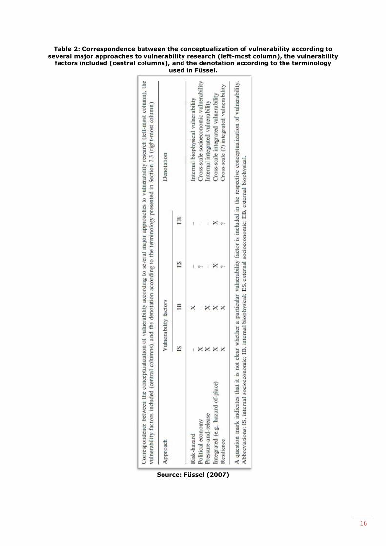
After categorising the vulnerability factors, Füssel uses these factors to classify different
concepts of vulnerability according to the different vulnerability factors. He focused on
the main concepts of vulnerability used in vulnerability research, see table 2.
The concepts of vulnerability in the approaches are categorised according to the category
or combination of categories of vulnerability factors they include. For example in the
political economic approach the internal socio economic vulnerability factors are the main
factors that this approach focuses on. The risk-hazard approach focuses mainly on the
external biophysical vulnerability factors. The pressure-and-release approach focuses on
both internal socio economic and internal biophysical vulnerability factors as does the
resilience approach. The integrated approach focuses on all the vulnerability factors.
Because for this study all aspects of vulnerability factors will be considered, the
integrated approach will be applied.
Fussels’ framework (table 1) is one general applicable framework for all different
approaches to vulnerability. It represents the diversity of all the vulnerability concepts
and gives clarity on the concept of vulnerability. It will ‘bridge the various approaches to
researching vulnerability to climate change’ (Füssel, 2007, 155).
In my study an integrated approach will be applied, according to Füssels’ classification.
This will be done by analysing the contextual vulnerability. The framework of contextual
vulnerability comes from O'Brien et al. (2007) who claims that there are in fact two
approaches and frameworks to climate change vulnerability, namely, outcome
vulnerability and contextual vulnerability, both rooted in different discourses and
impossible to merge into one framework. The first coming from scientific framing and the
second from human security framing of the term vulnerability.
I choose the contextual vulnerability framework of O’brien to analyse the situation of the
communities of West Pokot, because it gives a comprehensive interpretation of the term
vulnerability, which lacks in many other definitions of vulnerability. It focuses on the
many factors that according to me are important influences of responses to climate
variability. In contrast to the outcome vulnerability framework in which vulnerability is
pictured as a linear process. So although this framework comes from the idea that one
general applicable framework is not possible, I found it useful because it focuses on all
the vulnerability factors as mentioned by the integrated approach, see table 2.
16
Table 2: Correspondence between the conceptualization of vulnerability according to
several major approaches to vulnerability research (left-most column), the vulnerability
factors included (central columns), and the denotation according to the terminology used in Füssel.
Source: Füssel (2007)

17
3.2 Contextual vulnerability framework
3.2.1 Explanation of the framework
O’Briens’ framework, see figure 2, departs from the idea that climate change and climate
variability occur in a changing context. In general all the structures and changes
influence the contextual conditions. The contextual vulnerability of, in this case local land
use, is determined by the contextual conditions that exist of institutional, biophysical,
socio-economic and technological conditions.
Figure 2: Contextual vulnerability framework
Source: O'Brien et al. (2007)
The three boxes at the top of the figure represent the current situation. In the analysis
the political and institutional situation, mentioned structures and changes, the climatic
situation and the economic and social situation, will be described here. In short the
external contemporary situation will be described according to this structure.
The arrows between the box ‘contextual conditions’ and the three boxes on top,
represent the interaction between the external factors that create the contemporary
situation, and the contextual conditions. The political and institutional structures and
changes influence the contextual conditions, and vice versa: the contextual conditions
influence the political and institutional structures and changes as well. The same applies
for climate variability and change and for the economic and social structures and
changes, they influence the contextual conditions and vice versa.
The arrows between the box ‘contextual conditions’ and the box below with the
‘responses’ represent the interaction between responses and contextual conditions. The
responses are influenced by the contextual conditions and contextual vulnerability, also
the responses influence the contextual vulnerability and conditions.

18
The contextual conditions are influencing the contextual vulnerability directly, as can be
seen by the circle ‘contextual vulnerability’ that is in the centre of the ‘contextual
conditions’ box.
I made the choice to use this framework because it gives a complete picture of the
vulnerability of the communities of West Pokot by focusing on many factors that
according to previous research are important in shaping the responses to climate
variability. However there is also a risk in using this framework. Because the framework
is very broad, the risk is that the analysis becomes too general. However by focusing on
local land use, the framework will provide a focused, complete and coherent picture of
the current situation. The aim of the research is to find out how land use change
influences pastoralist and agro-pastoralist communities’ responses to climate variability,
the local land use conditions will therefore be analyzed in the contextual vulnerability
framework.
3.2.2 Local land use
Looking at figure 2, the box in the middle will be the contextual conditions of local land
use. This section tries to find out the institutional, biophysical, socio-economic and
technological conditions of land use by focusing on the interaction of land use change
with ‘political and institutional structures and changes’, the ’climate variability and
change’ and the ’economic and social structures and changes’. Land use change leads to
different types of land use. Looking at the structures and changes as mentioned in the
framework is done to find out if and what kind of influence land use has on responses to
climate change. The lowest box with responses in the figure, will be responses to climate
variability.
3.2.2.1 Political and institutional structures and changes and the interactions with local
land use
As mentioned in the background chapter, policies and property right regimes can have a
big influence on land use. Fragmentation, privatization and individualization can be a
consequence of changing policies.
The interaction, visualized with the arrows, between the contextual conditions of local
land use conditions and political and institutional structures and changes can be
understood as: land use change that can be influenced by policy/property right regime
change and land use change can also drive a change in property right regime/policies.
Local situation:
Kenya has a relatively new constitution, from 2010, that should guarantee a more equal
land ownership, land access and registered land rights. Both sons and daughters are
entitled to inherit land. However the local situation is different, ‘many title deeds still only
have the name of a man on them’. Logically people give land to their sons as their
daughters are expected to leave home when they marry and have access to the land of
their husband (Wernersson, 2013, 43).
There are some areas, close to Ywalateke, Chepareria Town and sub-locations of
Senetwo that have individual title deeds since the mid 90s (Wernersson, 2013, Saxer,
2014). Other areas have demarcated the land, but use informal land agreements as
claims of ownership (Saxer, 2014).
3.2.2.2 Climate variability and change and the interactions with land use
Climate variability influences land use because it creates the circumstances communities
have to deal with. Agro-pastoral and pastoral communities depend on rainfall to cultivate
which makes climate variability an enormous influence. Also for livestock keeping climate
variability is important, for fodder production and also for nomadic pastoralists because
their migration with animals is depending on precipitation. Climate change has an

19
influence on land use, as mentioned in the background chapter, a change of climate can
make an area unsuited for the land use that has been practiced for years.
The interaction can be understood as climate change and climate variability influencing
land use, and also land use influences climate change. For example deforestation, when
happened in large amounts, has an impact on climate change. One goal of Kenya’s Vision
2030 is ‘to provide its citizens with a clean, secure and sustainable environment by the
year 2030’ (UNEP, 2009).
Because the research focuses on a local level, namely the community level in West
Pokot, the influence of land use on climate change is omitted. The analysis focuses on
how climate variability influences land use.
Local situation
The general influence of climate variability has been handled in the background chapter,
so what is already known about Chepareria is that it knows environmental stress,
especially droughts (Wernersson, 2013).
3.2.2.3 Economic and social structures and changes, and the interactions with land use
Economic improvement has an influence on land use, namely because there will be more
investments in the land if there is more money available. For example technological
improvements can be made when there are more economic resources.
The interaction means that the economic situation influences the way land is used and
land use influences the economic situation. Namely, the way land is used can improve or
worsen the economic situation, for example growing a variety of crops can mean a
spreading of financial risk, while cultivating a single crop can be very risky. Also the
choice to cultivate cash crops can have positive and negative influence on the economic
situation.
The social structures influence land use, for example cultivation can be considered as not
significant because the main source of income is animals. This influences the way the
land is cultivated, because it is not considered as important as when cultivation was a
source of income. The outcome will not be maximized.
The interaction arrows mean that the social structures influence land use, but also land
use influences social structures. For example when the change of pastoralist to agro-
pastoralist existence happens, men who were traditionally migrating with their animals
are staying around the home stead, this can influence the social situation at home.
Local situation:
In Chepareria we find a loss of certain traditions that are related to migrational
pastoralist existence. For example young men used to migrate with the cattle during dry
season, they would learn to herd cattle including to protect it and to rustle (Wernersson,
2013). With the disappearing of this form of keeping cattle, also the knowledge of
herding disappears.
A local example of how social structures influence land use is that ‘men and women have
different preferences on how to use land: - women prioritize long term food security for
the family and the men prioritize large short-term projects that produce money.’
(Wernersson, 2013).
3.2.3 Adaptation and coping strategies
Looking at the contextual vulnerability framework there is also a box that shows
‘responses’. In the research the goal is to discover the responses to climate change of
communities of West Pokot. Besides discovering responses, this research is also trying to
find out how land use practices influence the responses to climate variability. These

20
responses can be understood as adaptation to, or coping with climate change. To be able
to distinguish the responses between adaptation and coping strategies it is important to
discuss the meanings of both terms and their differences here.
3.2.3.1 Adaptation
For a solid understanding of adaptation a combination of three definitions of the term
adaptation is used. To start, adaptation can be seen as a way to reduce vulnerability. It
can be ‘considered responses to risks associated with the interaction of environmental
hazards and human vulnerability or adaptive capacity’ (Smit and Wandel, 2006, 282).
Adaptation refers also to the ‘adjustment in ecological, social, or economic systems in
response to actual or expected climatic stimuli and their effects or impacts’ (Smit and
Pilifosova in O'Brien et al. (2007, 84)).
Lastly, according to the IPCC report (IPCC et al., 2007) adaptation includes reducing
harm and exploiting beneficial opportunities. This definition is important because it
includes actions that reduce harm and actions that make use of climate change in a
positive way. For example new possibilities that arise with a changing climate.
In this research the way people respond to the risks and consequences of extreme
droughts and extreme rainfall are the responses meant in figure 2. These changes, or
responses, are influenced by the land use practices and can also influence the land use
practices. In this research this will be the response, on a house hold level, of the
communities in West Pokot to climatic changes and also the impacts of climatic changes.
For example how do they respond to an increase of droughts and a decrease of rainfall?
And how do they respond to a failed harvest due to these droughts?
3.2.3.2 Levels
Decisions on adaptation can be made at different governance levels; from individual
household level to community level to national and even on international level (IPCC et
al., 2007). For example on international level the United Nations Framework Convention
on Climate Change (UNFCCC) makes National Adaptation Programmes for Action
(NAPAs), that focus on adaption to climate change. On a national level for example the
government invests in adaptation measures. On a community level, initiatives arise
locally and decisions are taken to adapt. On an individual household level also decisions
are taken to adapt to climate change, for example to move to an area with more rainfall.
In this research the focus is on responses from individuals related to their land use
practices. The approach on adaptation is therefore from the individual household level,
on what individuals and families decide, in relation to adaptation to climate change.
3.2.3.3 Coping strategies
The terms coping, coping strategies and coping mechanisms are often used in addition to
the term adaptation, however these terms are not the same. Coping capacity is the
‘sense of responses that people employ in order to maintain well-being in the face of
environmental stress’ (Eriksen et al., 2005, 288). The most important difference when
compared with adaptation is the time scale; ‘coping capability’ is used to indicate the
ability to short term survival while the term ‘adaptive capacity’ is used for more
sustainable and long term adjustments (Smit and Wandel, 2006). As Adger (1996 in
Eriksen et al. (2005, 288)) states ‘coping refers to the actions and activities that take
place within existing structures, such as production systems, whereas adaptation
frequently involves changing the framework within which coping takes place’.
For the research, this means that decisions made and actions done on a short term to
deal with climate variability, will be considered coping strategies while the long term
plans and adjustments anticipating predicted climate changes, are considered adaptation.
Examples of these, short term focused, coping strategies that are studied: reduction of
the number of mouths to feed by reallocating family members, selling of livestock, focus
on other ways of income (Roncoli et al., 2001), rainwater harvesting techniques,

21
destocking, vaccination of animals and purchase of pastures, migration to urban areas,
wage employment, changing of the composition of the herd and the diversification of
farming (Mwang`ombe et al., 2011). Local knowledge often plays an important role in
making coping strategies for example the knowledge of arable locations, crop types and
rain forecasts (Liwenga, 2008).
Examples of adaptation strategies, focused on long term adaptation, are: water
conservation, construction of water dams, changing crop types, changing the location of
farming and structural improvements in housing (O'Brien et al., 2007, Smit and Wandel,
2006).
4. Methodology In this research the situation in the area created the research questions. The research
was executed in context of a broader research project called Triple L in which among
others, Gothenburg University and Vi Agroforestry4 are involved. A scholarship was given
by the Triple L project to perform this research.
To investigate whether changing land use influences the responses to climate variability
it is important to find out how the people involved act and react to climate variability.
Ways of acting and their justifications are best to discover through a case study, that will
give a deeper understanding of how communities in semi-arid and arid, agro-pastoralist
and pastoralist areas live and how they respond to climate variability. By studying
Chepareria and Kacheliba the evolution of the factor, changing land use and its influence
on responses to climate change can be discovered.
4.1 Comparative Case Study Chepareria and Kacheliba are a good representation of the entire West Pokot county.
Both areas have different climatic circumstances namely semi-arid and arid and they
have different types of livelihood, namely agro-pastoral and pastoral. Although in
Chepareria a very small part of the division belongs to the livelihood type of mixed
farming (figure 1), the research is focused on the agro-pastoral and pastoral areas.
In the beginning the research focused singularly on Chepareria but after detecting that
there is no longer communal land ownership in Chepareria, I decided to expand the
research area and include Kacheliba where still is communal ownership. In this way I
could investigate how the different property right regimes influence the response to
climate variability. I was able to interview people living in all the different areas with
different property right regimes.
The case study is a comparative study, however this was not anticipated when defining
the study. After executing the research, it was found that the contextual conditions of
both Chepareria and Kacheliba are different but that the ongoing changes are similar.
The study could be seen as two different case studies but in this research it is considered
as one ongoing development in two areas which makes it possible to compare both
situations. The ongoing development, namely the privatisation of land in the higher and
fertile areas of Chepareria is ahead of the process in Kacheliba.
4 ViAgroforestry is a, from origin Swedish, NGO that started in the 1980s with the introduction of enclosures to
recover eroded land in Chepareria.
22
4.2 Epistemology and ontology To find out how different land uses influence the way agro-pastoralist and pastoralist
communities respond to climate change it is necessary to:
1. Find out what different land uses exist in West Pokot and how they have
changed over time.
2. Find out how people respond to climate variability.
The answer of the first question can be partly found by using information from previous
studies, to create a general picture. However to find out how the local current situation
is, interviewing local people is necessary. To answer the second question also
interviewing will be the right method, because the way they are acting and its
justification are of importance. The reason to do so is, that in this way responses to
climate variability of people from different locations and different divisions, facing
different circumstances, easily can be compared. This is how the influence of land use
change can be discovered.
The sub-questions are formulated to find the different land uses and their relation with
external processes. Also the way people respond to climate variability is covered. The
findings in the areas of communal ownership will be compared with the findings in areas
where the communal ownership has diminished, to find out how and to which extend
land use influences the way people respond to climate variability.
Because there might be different ways of responding it is important to discover by what
these responses are influenced according to respondents. The epistemological
consideration is interpretivism, because the questions are about the respondents’
experiences in their situation. Their knowledge is dependent on the context. I will find
out how they feel about the consequences of developments in general and their own
responses specifically. I will try to ‘grasp the subjective meaning of social action’
(Bryman, 2012). The ontological consideration is constructivism because social actors will
tell their reality, the knowledge that they have constructed, when being asked about
their situation and their responses to climate variability.
4.3 Data collection
4.3.1 Literature review
The literature review was used to cover the existing knowledge in the field of this
research (Bryman, 2012). Literature research has been done as well to find a suitable
theory to analyze the findings and give these findings the right context. The results of
the literature review are found in the first three chapters.
4.3.2 Semi-structured interviews
A combination of several methods was used to perform the research. However the main
method for this qualitative research was semi-structured interviews (Bryman, 2012). I
chose to do semi-structured interviews in West Pokot because it has a conversational
side while it is also controlled and structured (Mikkelsen, 2005). I wanted to give space
for new issues to come up and for the opinions of the respondents, at the same time I
wanted to be sure certain themes and issues would be mentioned. In total 92 people of
West Pokot were interviewed. 45 Respondents from Chepareria, 31 male and 14 female.
47 Respondents from Kacheliba, 29 male and 18 female. The age of the respondents
varied from 18 till over 100 years old. The interviews were conducted by using an
interview guide, that was adjusted after doing the first interviews. The interview guide
from Chepareria differs from the interview guide used in Kacheliba because the situation
regarding type of land ownership is different in both areas. The interview guides can be
found in the appendix.

23
The reason for interviewing less women than men is that women have a bigger workload
and are therefore more busy and less available. Also the people that take decisions
related to land are mostly men. When issues arise, the elderly men, also called village
elders, decide. Men and women have different tasks in Pokot society and they might
perceive changes differently, therefore I put a lot of effort to also include women in the
research.
I decided to focus on older respondents, most of them over 45 years old, because they
have lots of experience, they are often the ones that decide and they experience changes
over time. I interviewed a few younger respondents, under 45 years, to know their ideas
and perspectives on changes and to find out their future perspectives.
In Chepareria the selection of the respondents happened by my translator who is a
former employee of ViAgroforestry, because ViAgroforestry worked in the area for many
years it has a well established network in the area that made it easy to move around. I
made sure to interview a good variety of people. In the beginning we identified the area
into locations and sub-locations. To get a representative picture of the whole of
Chepareria division we made sure to have respondents from all the different locations.
In Kacheliba there was no network of ViAgroforestry to rely on, because they didn’t work
in this area. I got in touch with the daughter of one of the chiefs, who translated for me
together with her husband. In a group talk the locations and sub-locations of Kacheliba
were identified. We visited each area and found people at their home stead to interview.
Beside inhabitants of Chepareria and Kacheliba, I also interviewed chiefs, assistant
chiefs, people from a local agricultural NGO, a representative from the local ministry and
a representative from the National Drought Management Authority in Kapenguria. I
consider them all well informed people whose information helped to make the overall
picture clearer.
4.3.3 Observations
During the days of interviewing I spend the nights locally. In Chepareria I stayed at a
small guesthouse in Chepareria town and in Kacheliba at the Catholic Mission in
Kacheliba town. The interviews are most of the time performed at the respondents’ home
stead, with some exceptions when I met people in town, at the market or accidentally on
the road. This gave me a chance to observe several things. I traveled by motorbike
together with my translator and the piki-piki(motorbike)driver, so I was able to see a lot
of the area as well. This helped me in adjusting the interview questions and
understanding the answers of the respondents. I could also see with own eyes the
differences between several areas, which revealed differences between Chepareria and
Kacheliba.
4.3.4 Group talks
Informal group talks, with key informants were used to identify sub-locations and
locations of Kacheliba division and of Chepareria division. Also to double check
information gathered from the interviews.
4.4 Limitations The interviews are performed in the local language, Pokot, this meant that the help of a
translator who spoke English was necessary. There is a risk in losing information in the
translation from English into Pokot, when asking the questions, and from Pokot into
English when the respondent replied. Also the Kenyan English is slightly different from
my Dutch English, but with additional explanations it turned out alright. The presence of
the translator, who was always a local person being part of the community, might have
influenced the respondents in their answers, also the gender of the translator might have
influenced the respondents.
24
There are a lot of cultural differences that I came across. One limitation, on the one
hand, was that as the researcher, I am an outsider who is a young, white girl from
Western Europe, this might also influence the respondents in their answers. On the other
hand, it can also be seen as an advantage because respondents might be more willing to
share and explain their experiences.
One of the initial ideas was to compare official rainfall data with answers from
respondents, but the search for official rainfall data turned out to be long and unfruitful,
also respondents didn’t remember years very precise. Also efforts to get an updated map
of the region were without success, due to new borders and a redistribution of locations
and sub-locations.
The findings of the research from Saxer (2014) were not available at the time of research
design of this thesis, because the data collection happened simultaneously with the data
collection of this research. If the findings of Saxers’ research would have been available
before hand this research, it would have been designed and executed differently.
5. Results and analysis The results from the research are presented here and structured according to the
selected theoretical framework of contextual vulnerability. Although the study is
comparative, the results are analysed and compared in one framework.
5.1 Structures and changes The subjects mentioned by respondents in the interviews are classified according to the
theme that they belong to in the contextual vulnerability framework.
5.1.1 Political and institutional structures and changes
5.1.1.1Type of ownership
From talking to respondents and key informants, I have come to know that Chepareria
and Kacheliba consist of the following areas, called locations. Each location also exists of
sub-locations. The type of ownership is listed here as well.
Chepareria consists of the locations:
- Ywalateke and Kipkomo are locations where people have individual title deeds.
- In Senetwo two sub-locations have individual title deeds. The other areas are
subject to the group ranch5.
- Psirum and Chepkopegh are locations that belong to group ranches.
- Shalpogh is the location that is officially registered as trust land6.
In Chepareria all land is demarcated, regardless the official indications of group ranch
and trust land, in almost all places fences have been put up. In some areas the
ownership can be proven with an official title deed. In case of the group ranch areas and
trust land, an informal agreement letter functions as proof of ownership to be able to sell
and inherit land. Also in the group ranches and trust land the land is demarcated
nowadays and people expect to get official papers in the (near) future.
5 Group ranch is a large piece of land that is registered and owned privately by a certain group of people
(Lengoiboni in Saxer (2014). In Chepareria this means ‘in the pastoral context people employ communal land use and livestock movement within the boundaries of their group ranch.’(Saxer, 2014). 6 Trust land is land managed according to traditional communal practices, there is no official individual or group
ownership(Lengoiboni and Veit, in Saxer(2014)).

25
Kacheliba consists of the following locations:
- Kopulio
- Suam
- Lokichar
- Kodich
- Cherangang
All of Kacheliba is trust land and almost all of it is managed as communal land. Kopulio
location encloses amongst others the sub-location of Kopulio and Kanyerus. In Kopulio
sub-location people demarcated the land. In Kanyerus the land will be demarcated after
the harvest (in 2014). In a few other sub-locations respondents mention that there are
plans to demarcate but it is unsure when or what exactly is decided on this issue. A
reason to demarcate is when people heard about the demarcation of other areas and
they want to prevent outsiders from coming in. It also seems that the areas that are
valuable are demarcated. For example the area beside the main road and the land
besides the river.
In general the bulk of the areas is still owned communally and has not been demarcated.
5.1.1.2 Governmental investments
In Chepareria there is an agricultural development centre, that started as INGO but
nowadays belongs to the government. This centre stimulates people in Chepararia to
improve their animals and cultivation. Respondents in Chepareria mention also projects
of the Ministry of Agriculture to improve the outcome of their land and investments of the
government in the region through financing a livestock market and introducing a milk
cooler.
Respondents mention the improved availability of water, not only done by the
government but also by Non Governmental Organisations, by construction of water tanks
and a water pipe in some areas that brings the water into the home stead.
In Kacheliba none of the respondents mention projects of any ministry or the
government. On the contrary, few respondent mention that in general the government
has forgotten them. The shortage of water is an often mentioned problem by
respondents. Also by my own observation it is clearly visible that there is a lack of water
points. Also the infrastructure in Kacheliba is of less quality than in Chepareria, there is
no tarmac road and the state of the dirt road is a reason for concern.
5.1.2 Climate variability and change
Respondents of both areas mention that there are more droughts nowadays than in
history and few mention that the rain has become ‘less reliable’. But when asking about
specific years of droughts and of extreme rainfall there are no coherent answers.
Respondents of both areas mention that with too much rainfall, landslides occur, the river
sweeps away cultivated land, animals and sometimes even humans. However there is a
difference in how too much rainfall is experienced, in Kacheliba and the dry areas of
Chepareria too much rain is considered a blessing. These years are remembered by no
migration of animals, availability of grass and milk all year around.
Future climate change is mentioned as a challenge by one respondent. None of the other
respondents seems to worry about this issue.
5.1.3 Economic and social structures and changes
Changes mentioned by respondents that belong to the economic and social structures,
are analysed here.
26
5.1.3.1 Education
Both respondents in Chepareria and Kacheliba mentioned that the introductions of
schools has been very important for a change of society. However in Chepareria the
number of schools is much higher and there are many secondary schools, of which are
very few in Kacheliba, where the number of primary schools is also much lower than in
Chepareria. Schooling has an influence on the disappearing of traditions and changing
structures, according to respondents. All traditions have disappeared in Chepareria. In
Kacheliba respondents say some, but not all traditions are still practiced, this differs
locally. The reason for disappearance of traditions is that the children that used to
participate are in school nowadays. Education is considered important. Payment of the
high school fees is a reason to sell land, animals or take a loan.
In Chepareria it used to be the case, while in Kacheliba it still happens at times, that the
small children take care of the goats and small animals. The young boys, from age 12/14
start to take care of the livestock and migrate with it. When children and youth are in
school others have to take care of the animals.
5.1.3.2 Living conditions
Respondents of both divisions mention improved living standards and conditions.
Clothing has improved and respondents from Chepareria mention to have more meals a
day, compared to Kacheliba where a respondent mentions that they drink tea, nowadays.
The quality of the houses seems at first sight, more improved in Chepareria than in
Kacheliba.
5.1.3.3 Monetary economy
Respondents in both areas mention that money became more important. The economy
used to be based on animals, and still ones’ wealth is visible by the number of cattle one
owns. However money is needed to buy things, nowadays. Working on someone’s farm is
done for payment and no longer for a meal. Some respondents grumble that life has
become more materialistic, but in general the improvement of standard of life is
experienced as positive by the respondents.
5.2 Contextual conditions In this analysis the contextual conditions that are consequences of the structures and
changes mentioned in 5.1 are specified here as well as the influences of the
consequences on land use.
5.2.1 Institutional conditions
5.2.1.1 Consequences of the type of ownership
One of the most important consequences of having an official individual title deed is the
access to bank loans. The informal agreement letter that is used in many places as
replacement of the official title deed, doesn’t entitle the owner of the land to a bank loan
since it is not a government approved document.
Having individual land, by official ownership papers or by informal agreement letter,
leads to the possibility to sell the land and pay for example for school fees, for hospital
bills or for investments. In Kacheliba were the land is communally owned there is no
possibility to sell land, this leads to fewer economic opportunities.
In Chepareria all of the land is privatised, although not always with an official title deed,
all the land has been demarcated and fenced. This means that each family has their own
piece of land and can decide what to do with it. In Kacheliba, with a few places as
exception, the land is owned communally, which means that the elders decide which
areas are used for grazing and which for cultivation. Also when newcomers come in, the
elders will appoint them a place to live.

27
Influence on land use
The type of ownership of land has an influence on the decision making unit. Both types
have an influence on the way land is used. There are several advantages and
disadvantages mentioned of individual or communal ownership of land, by respondents
from both areas. One of the advantaged of having ones’ own land is that one can decide
what to do with the land. One can decide to let his animals graze, grow pasture for
preservation, or cultivate crops. In case one wants to plant trees, these will not be cut
down by other people. An often mentioned disadvantage of having individual ownership
is that one is not able to keep as many animals as one would like.
A mentioned disadvantage of cultivation in the communally managed area, is the
dependence on other community members to put the fences up together, around the
cultivated areas. If not all fences are up or maintained well, the animals will come in and
eat the crops. It is therefore very difficult for an individual to start cultivating a crop that
needs early planting. The crops will be eaten by the animals that are walking around
freely. When it is jointly decided that the time is right for cultivation, the fences are put
up together and a joint effort is made to prevent animals from eating the crops.
An often mentioned positive side of communally managed land is that one can keep as
many animals as one can afford and that the animals walk around freely. This is
considered more natural than keeping animals within fences. In communally owned land
it is not necessary to plan for pasture, when the area becomes dry it is time to migrate.
Migration takes place jointly by a few neighbours or relatives.
In Chepareria we see fewer animals and they are kept within fences, but the animals are
of an improved breed that gives more milk as opposed to the original indigenous breed
that is kept in Kacheliba. Respondents in Chepareria mention that they plan for the
pasture to feed their animals, either by preserving areas, by storing hay or by making
deals with people in the highlands that have a surplus of grass.
5.2.1.2 Consequences of the governmental investments
A consequence of the investments of the government and projects of the Ministry of
Agriculture in Chepareria, is that people keep the improved breed of animals and that
they changed their crops. By financing the livestock market the possibilities to trade, and
to make money, have increased. Also the introduction of a milk cooler has led to more
economic activity, respondents say that they sell their surpluses at the cooler.
A consequence of the lack of investment by the government can mean that there are
fewer economic opportunities for the people of Kacheliba. People grow the same crops
they have grown for years and they have not improved their animals. The infrastructure
is bad and the lack of water points aggravates the dry circumstances of the area and the
hardship that people have to deal with. A good infrastructure leads to better connections
between areas and makes trade easier. It is for example easier to sell animals and buy
food.
Influence on land use
The influence of these consequences on land use is that in Chepareria more diversity of
crops is cultivated than in Kacheliba. A better water supply in Chepareria leads to more
possibilities of what to do with the land, and more importantly it leads to a higher
outcome. A better infrastructure can result in production for the market, because there is
better access to markets.
5.2.2 Biophysical conditions
The dry circumstances create the biophysical conditions. The rainfall pattern influences
the conditions to cultivate and to which crop is most suitable to grow, especially in
Kacheliba where there is less availability of water.
28
Influence on land use
In general we can say that climate creates conditions that influence land use. For
example, respondents mention to cultivate near the river. Due to dry circumstances of
the area this is the only place to grow crops that need water. However when there is
heavy rainfall, these areas are swept away and cultivation, land and income are lost.
Perhaps not singularly stimulated by the climate but also by the ownership of land,
respondents in Chepareria mention that due to their individual land ownership trees are
conserved and vegetation has improved. They also mention that there is less soil erosion
and rivers that used to be dry are flowing again. This is thanks to a better balanced
water system. Because of the increase of the amount of trees in the area, the soil holds
more water and the water drainage happens more evenly, the river is therefore ‘flowing
again’.
5.2.3 Socio-economic conditions
5.2.3.1 Consequences of increased school attendance
A consequence of children being in school and no longer taking care of the animals,
means there is less work force available and someone else has to take over that work.
In general all respondents are convinced that schooling is important and will improve
their own and their childrens’ lives. Education will lead to employment elsewhere and an
increased income. The respondents are convinced that their children will take care of
them and return with lots of money. This will improve their economic situation and
housing condition.
Influence on land use
Few respondents mention that there is a reduction in the cultivation of sorghum due to
the lack of children that used to chase away the birds. These children are also in school.
The production of sorghum fails due to a lack of ‘bird chasers’ and is therefore less
cultivated.
5.2.3.2 Consequences of changing living conditions
The improvement of living conditions is more a consequence of improved land use than
an influence on land use. However when the general wealth (and living conditions)
improves, investments can be made. One respondent mentioned being originally a
farmer, he made enough money to invest in a store in Chepareria Town.
Influence on land use
When investment in land is made it can have an influence on the way land is used. One
can for example hire labour forces or invest in a tractor to cultivate the land. Not only
crops to feed the family are grown, also crops suitable for the market can be cultivated.
5.2.3.3 Consequences of a monetary economy
The development towards a monetary economy has as a consequence that every service
and product is converted into money. Even work that used to be considered a favour,
done in return for food, is nowadays done in exchange of money, in short the ownership
of money has become important, for example to pay school fees and medical fees.
Influence on land use
A change towards a monetary economy can mean that the land will be used to cultivate
cash crops and make money instead of cultivation of crops meant for feeding the family.

29
5.2.4 Technological conditions
Respondents from both areas mention that there have been several technological
improvement in the area. One is the grinding of maize that no longer happens by hand
but by machines. Also cultivation is made easier by an increased use of machines
however still manual labour is common.
5.3 Responses
The way of acting during extreme weather events is analysed here. Because heavy
rainfall appears sudden and is very rare, the focus of the adaptation and coping
strategies is on droughts.
5.3.1 Coping strategies
Respondents explained their ways of acting during severe droughts. A division is made
between the answers of respondents of Chepareria and Kacheliba.
5.3.1.1 Human beings
In case of a drought in Chepareria, respondents mention to sell goats or livestock or
when the drought gets more severe even land, to be able to buy maize. In case one has
no land or animals to sell, they will work on someone’s farm for money or for food. Some
respondents mention that during a severe drought, they will cook and eat wild fruits and
leaves of the Balanite tree and sometimes they will even eat the roots of the Akan trees,
to survive. Sometimes the government provides relief food, which is necessary according
to the respondents.
In Kacheliba when a drought occurs, people sell their animals to buy food. It is
mentioned as a common practice, that happens yearly, to sell animals to be able to buy
food. After selling all their animals people mention to ask the government for help in the
form of relief food. Some respondents say just to wait for death.
Also in Kacheliba the cooking and eating of wild fruits and leaves and roots is a common
practice during droughts. Several respondents mention to depend on charcoal production
to be able to buy food. One respondent mentions working in the mine in Uganda as an
alternative strategy to survive a severe drought.
5.3.1.2 Animals
The respondents in Chepareria say to plan for their animals to get through the dry
season. They have to preserve grass by rotational grazing, to store grass or to look for
pasture elsewhere. This can be nearby, ones’ neighbour or relative but it can also be
elsewhere in the highlands. During a severe drought it is depending on the herd size
what one will decide to do. In case there are only a few animals, they can survive by
eating the branches of trees that grow on ones’ land. In case someone owns many
animals he has to migrate. Respondents mention to migrate to: the border with Uganda,
into Uganda, the highlands of Trans Nzoia, or Kapenguria. Respondents mention that in
Trans Nzoia one has to pay for pasture and maize stems, while in Uganda the land is still
‘open’ and no payment has to be fulfilled. A few respondents mention that they prefer to
migrate to Trans Nzoia because in Uganda it is unsafe.
In Kacheliba most of the respondents indicate that they migrate their animals yearly to
Uganda in search for pasture. Some respondents mention going every second year,
depending on the availability of pasture. There is an exception in the area of Kanyerus
sub-location, where animals can graze at other side of the hill from where people live.
(This is the area which will be demarcated after the harvest, this area is elevated higher
compared to the rest of Kacheliba).
Young boys and men, from the age 10 to 20 years old, take care of the animals. However
most of them are over 15 years. The older men go from time to time to Uganda to check
up on their animals, or they herd together with the young men. The migration to Uganda
happens jointly with 3 to 5 families together, for safety reasons. Migration to Uganda has

30
its disadvantages, for example the lack of milk and meat for the small children at home,
and there is all kind of danger. Frequently mentioned risks are: diseases that lead to the
death of animals, human diseases because there are no nearby hospitals, cattle rustling
by neighbouring tribes in which sometimes people get hurt or killed and there is a risk of
wild animals attacking the herd. Few of these risks were mentioned by respondents in
Chepareria, mostly when referring to migration in history. In Kacheliba these risks are
contemporary concerns, one respondents’ cattle was taken this year, and a few
respondents lost their animals to cattle rustling last year. One more development that
leads to conflicts in Uganda, is that demarcation has started there as well, the communal
land that can be used for grazing is therefore decreasing.
5.3.1.3 Changes over time
In Chepareria respondents mention that in history they had to travel far to get maize.
Nowadays it is much easier to get maize because the infrastructure has improved and
there are markets close by. In Kacheliba there doesn’t seem to be a difference in acting
during droughts in history and droughts nowadays.
Severe droughts in history are remembered, in both divisions, by migration of animals
and sometimes of people as well, into Uganda. There are also extremely dry years that
are remembered because of the relief food that was given. One year respondents
mention to have survived thanks to the yellow maize provided by the government.
Another year, around 1965, conserved relief food was given by the USA to survive.
5.3.2 Adaptation
As mentioned in the theory chapter, adaptation is considered to include plans and
adjustments anticipating influences of climate change on the long run. Looking at the
household level, it is difficult to mention specific acts that can be considered adaptation
to climate change. Looking at changes over time, mentioned by respondents, none
seems directly related to the adaptation to climate change. However the spreading of
income generating activities, that we can find in Chepareria, from a focus on singularly
keeping of animals and cultivation for feeding the family, to cultivation for the market,
growing and selling of fruits, selling of milk and even investments in shops, can be
considered adaptation to climate change. Although not intentionally focussed on
adaptation to climate change, less dependence on rainfed agriculture will make the
community less vulnerable to climate change. Also thanks to the increase of income
generating activities and economic opportunities a drought leads less often to famine.
With a better economic situation and better contextual conditions, more possibilities to
respond to drought arise. This is obvious when looking at the coping strategies of both
Chepareria and Kacheliba. In Chepareria it is not as common to sell animals for food, as
it is in Kacheliba where it is a standard practice.
Another action that can be considered adaptation to climate change, is the permanent
migration to another area. Although very few times mentioned, it is possible to buy a
piece of land in the areas of higher elevation and live there. Because the highlands have
wetter circumstances, cultivation is easier and there is more green pasture available. In
this way the people are less influenced by droughts and better able to survive.

31
6. Discussion and conclusion The research aim was to discover how ongoing land use change influences the way agro-
pastoralist and pastoralist communities respond to climate change. This was done by
investigating the case study site of West Pokot in Kenya because in that area different
ways of land use exist so it was possible to investigate how those land uses influence
responses to climate variability.
In West Pokot, different forms of ownership of land were found as well as a difference in
land use possibilities related to the type of ownership. By focusing on the two divisions
Chepareria and Kacheliba all possible land uses and ownership types of West Pokot were
represented. The livelihood zones of both areas are different, Chepareria consists of
mainly agro-pastoral and a small part mixed farming, while the whole of Kacheliba is
dominated by pastoral livelihood.
In Chepareria there are areas where inhabitants own individual title deeds. There are
also areas that officially belong to a group ranch or to trust land but that are demarcated
and where (almost everywhere) fences have been build to show the private ownership.
In the latter areas an informal agreement letter functions as proof of land ownership and
official papers are expected. The area of Chepareria is considered agro-pastoral
livelihood. In Kacheliba all land is officially trust land and owned in a communal way.
However there are a few exceptions of small areas that have been demarcated recently.
The land in Kacheliba, that is owned communally, is considered pastoral livelihood.
The local land use situation in both Chepareria and Kacheliba is analysed through the
contextual vulnerability framework. The contextual conditions in which land use takes
place and by which land use is being influenced are analysed and divided into political
and institutional structures, climatic variability and economic and social structures and
their changes. The influences that create the contextual conditions of land use in the case
of West Pokot are: type of ownership, governmental investments, climate variability, the
development of a monetary economy, schooling and technological improvements. All
these structures and changes influence the conditions for land use and have therefore
also an indirect influence on responses to climate variability.
In this research it was discovered that when the land is owned privately (agro-pastoralist
area) the animals are kept within fences and because one is the owner of the land, one
can decide what to cultivate and which trees to grow. Migration with the animals is less
common, only when one owns a big herd and there is a severe drought, migration is
necessary. Normally people plan for the pasture to feed their animals. The cultivation is
more intensive and surpluses and fruits are sold. During a persistent drought also
animals are sold, starting with goats and then cows. If necessary even the land can be
sold to buy food.
When the land is owned communally (pastoralist area), animals walk around freely
everywhere and there are small areas selected for the use of cultivation. Migration with
the animals for green pasture during the dry season, occurs frequently, with related
risks. The crops grown are mainly to feed the family. During a persistent drought animals
will be sold to be able to buy food. Selling the animals is the only option and is done even
when the drought is not persistent.
The contextual conditions are different in both areas and influence the behaviour of the
inhabitants of the areas. In Chepareria the land is privately owned which gives more
opportunities. In this area there is also a better infrastructure, more and better access to
water, the biophysical circumstances are better and there is more and a higher level of
schooling, than in Kacheliba. All these developments cause that Chepareria is ahead of
Kacheliba in terms of general development.
32
The contextual conditions in Chepareria, create a situation in which it is less often
necessary to sell animals during droughts, than it is in Kacheliba. A drought, in the
privately owned area leads less often to famine because of the broader range of income
generating activities and better circumstances that lead to the ability to plan for the dry
season.
Looking at the responses to climate change, the most important differences between
adaptation and coping strategies is the time scale. Adaptation is used for sustainable and
long term adjustments while coping strategy is used to indicate the ability to short term
survival. In both Chepareria and Kacheliba inhabitants mention changing climatic
conditions when they compare droughts and rain patterns from nowadays with those in
the past. However none (except one respondent) mention to worry about future climate
change. All the strategies applied by inhabitants of Chepareria and Kacheliba are focused
on coping with general circumstances and climatic conditions that matter today and not
on adaptation to climate change on the long term.
Because there are more economic opportunities in Chepareria than in Kacheliba, the
people living in Chepareria have more possibilities to respond to climatic changes. The
people living in Kacheliba will continue to struggle in their survival because of their
dependence on rainfall. The inhabitants of Chepareria are becoming less dependent on
rainfall. Thanks to the increased economic opportunities and better contextual conditions,
the people unwittingly adapt to climate change. However this is not done with the
intension to adapt to climate change for the long term.
A disadvantage on this research is that the comparison in this research between both
areas is hampered as the area of Chepareria is ahead of Kacheliba in terms of general
development. This is due to governmental investments, nongovernmental support and
better biophysical circumstances that make the change to agro-pastoralist existence
easier. These circumstances accelerated the transition towards private ownership and
make it easier to survive.
To be able to describe differences in responses to climate variability, to only land use,
further research might be necessary. It would be useful to compare two areas where the
contextual conditions are the same and the only difference is the land use. This could be
possible in the areas in Kacheliba where in some parts of that area changing the
ownership type to private ownership is anticipated for the near future. The land use will
change then as well. However, given the results of current research, the outcome might
be that there is no difference with respect to coping and adapting responses, so the
follow-up research should focus on the consequences of changing land use for the
general livelihood conditions.
Another interesting question for follow-up research could be the question whether or not
it is possible but also wise to transfer the livelihood in (all of) Kacheliba from pastoralist
to agro-pastoralist. This issue arises from the discussion mentioned in chapter 2 where
the idea that private ownership always improves welfare is questioned. The non-
equilibrium character of the rangeland ecosystem in the area should not be ignored.
Indeed pastoralist existence accompanied by communal ownership of land might be the
best way to survive during a severe drought, especially in areas where contextual
conditions are not highly developed.

33
References BEHNKE, R. H. J. 2008. The Drivers of Fragmentation in Arid and Semi-Arid Landscapes. In: GALVIN, K.,
REID, R., JR, R. B. & HOBBS, N. T. (eds.) Fragmentation in Semi-Arid and Arid Landscapes. Springer Netherlands.
BOLLIG, M. 2006. Risk management in a hazardous environment: a comparative study of two pastoral societies / [Elektronisk resurs], New York, Springer.
BOONE, C. 2007. Property and Constitutional Order: Land Tenure Reform and the Future of the African State. African Affairs, 106, 557-586.
BOONE, C. 2012. Land Conflict and Distributive Politics in Kenya. African Studies Review, 55, 75-103. BOYE, S. R. & KAARHUS, R. 2011. Competing Claims and Contested Boundaries: Legitimating Land
Rights in Isiolo District, Northern Kenya. Africa Spectrum, 46, 99-124. BRYMAN, A. 2012. Social research methods, Oxford, Oxford University Press. BUTT, B. 2011. Coping with Uncertainty and Variability: The Influence of Protected Areas on Pastoral
Herding Strategies in East Africa. Human Ecology, 39, 289-307. COMMISSION ON REVENUE ALLOCATION 2011. Kenya County Fact Sheets. DONG, S., WEN, L., LIU, S., ZHANG, X., LASSOIE, J. P., YI, S., LI, X., LI, J. & LI, Y. 2011. Vulnerability of
Worldwide Pastoralism to Global Changes and Interdisciplinary Strategies for Sustainable Pastoralism. Ecology and Society, 16, 10-10.
ERIKSEN, S. H., BROWN, K. & KELLY, P. M. 2005. The Dynamics of Vulnerability: Locating Coping Strategies in Kenya and Tanzania. The Geographical Journal, 171, 287-305.
FARAMARZI, M., ABBASPOUR, K. C., ASHRAF VAGHEFI, S., FARZANEH, M. R., ZEHNDER, A. J. B., SRINIVASAN, R. & YANG, H. 2013. Modeling impacts of climate change on freshwater availability in Africa. Journal of Hydrology, 480, 85-101.
FEKADU, B. 2009. Exploring incentives for rangeland enclosures among pastoral and agropastoral households in eastern Ethiopia. Global Environmental Change, 19, 494-502.
FLINTAN, F. 2011. “Broken lands: Broken lives?” Causes, processes and impacts of land fragmentation in the rangelands of Ethiopia, Kenya and Uganda.
FÜSSEL, H.-M. 2007. Vulnerability: A generally applicable conceptual framework for climate change research. Global Environmental Change, 17, 155-167.
GALLOPÍN, G. C. 2006. Linkages between vulnerability, resilience, and adaptive capacity. Global Environmental Change, 16, 293-303.
GEBRE, A. 2009. When Pastoral Commons are Privatised: Resource Deprivation and Changes in Land Tenure Systems among the Karrayu in the Upper Awash Valley Region of Ethiopia, Trondheim.
GOVERNMENT OF KENYA 2013. Kenya's National Climate Change Action Plan. GOVERNMENT OF KENYA, O. T. R. 2012. Vision 2030, Development Strategy for Northern Kenya and
other Arid Lands. In: LANDS, M. O. S. F. D. O. N. K. A. O. A. (ed.). GRIMM, E. M. & LESOROGOL, C. K. 2012. The Impact of Land Privatization on Cooperation in Farm
Labor in Kenya. Human Ecology, 40, 69-79. HARDIN, G. 1968. The Tragedy of the Commons. Science, 162, 1243-1248. HENDRIX, H., MWANGI, M. S., VOS, N. D. & MINISTRY OF, P. A. N. D. 1985. District atlas West Pokot,
Kapenguria; Kapenguria, Arid and Semi Arid Lands Development Programme ; Ministry of Planning and National Development.
HUHO, J. M. 2012. CONFLICT RESOLUTION AMONG PASTORAL COMMUNITIES IN WEST POKOT COUNTY, KENYA: A MISSING LINK. Academic Research International, 3, 458-468.
HUHO, J. M., NGAIRA, J. K. W. & OGINDO, H. O. 2009. Climate Change and Pastoral Economy in
Kenya: A Blinking Future. 地质学报:英文版, 83, 1017-1023.
HULME, M., DOHERTY, R., NGARA, T., NEW, M. & LISTER, D. 2001. African climate change: 1900-2100. Climate research, 17, 145-168.
IPCC, I. P. O. C. C. 2014. WGII AR5 Chapter 22.
34
IPCC, I. P. O. C. C., KLEIN, R. J. T., HUQ, S., DENTON, F., DOWNING, T. E., RICHELS, R. G., ROBINSON, J. B. & TOTH, F. L. 2007. Inter-relationships between adaptation and mitigation. Climate Change 2007: Impacts, Adaptation and Vulnerability. Contribution of Working Group II to the Fourth Assessment Report of the Intergovernmental Panel on Climate Change.
IUCN, T. I. U. F. C. O. N., EASTERN AND SOUTHERN AFRICA REGIONAL OFFICE, NAIROBI & WISP, W. I. F. S. P. A. P. O. I. 2010. Building climate change resilience for African livestock in sub-Saharan Africa.
KAMARA, A. B. 2005. The Dynamics of Land Use and Property Rights in Semi-Arid East Africa: Ethiopia Case Study. Collective Action and Property Rights for Sustainable Rangeland Management.
KELLY, P. M. & ADGER, W. N. 2000. Theory and practice in assessing vulnerability to climate change and facilitating adaptation. Climatic Change, 47, 325.
KIMANI, K. & PICKARD, J. 1998. Recent Trends and Implications of Group Ranch Sub-Division and Fragmentation in Kajiado District, Kenya. The Geographical Journal, 164, 202-213.
LAMBIN, E. F., GEIST, H. J., AGBOLA, S. B., BRUCE, J. W., HOMEWOOD, K., FOLKE, C., XIUBIN, L., COOMES, O. T., LEEMANS, R., TURNER, B. L., RICHARDS, J. F., SKANES, H., MORAN, E. F., DIRZO, R., FISCHER, G., IMBERNON, J., STONE, G. D., GEORGE, P. S., SVEDIN, U., VOGEL, C., RAMAKRISHNAN, P. S., STEFFEN, W., MORTIMORE, M., ANGELSEN, A. & JIANCHU, X. 2001. The causes of land-use and land-cover change : moving beyond the myths. Global Environmental Change, 11, 261-269.
LESOROGOL, C. K. 2005. Privatizing Pastoral Lands: Economic and Normative Outcomes in Kenya. World Development [H.W. Wilson - SSA], 33, 1959.
LESOROGOL, C. K. 2008. Land Privatization and Pastoralist Well‐being in Kenya. Development and Change, 39, 309-331.
LIWENGA, E. T. 2008. Adaptive livelihood strategies for coping with water scarcity in the drylands of central Tanzania. Physics and Chemistry of the Earth, 33, 775-779.
MERTZ, O., MBOW, C., REENBERG, A. & DIOUF, A. 2009. Farmers' perceptions of climate change and agricultural adaptation strategies in rural Sahel. Environmental management, 43, 804-816.
MIKKELSEN, B. 2005. Methods for development work and research: a new guide for practitioners / [Elektronisk resurs], New Delhi, SAGE.
MILLER, F., OSBAHR, H., BOYD, E., THOMALLA, F., BHARWANI, S., ZIERVOGEL, G., WALKER, B., BIRKMANN, J., VAN DER LEEUW, S., ROCKSTRÖM, J., HINKEL, J., DOWNING, T., FOLKE, C. & NELSON, D. 2010. Resilience and Vulnerability: Complementary or Conflicting Concepts? Ecology and Society, 15.
MONBIOT, G. 1994. The Tragedy of The Enclosure. The Social Contract. MWANG`OMBE, A. W., EKAYA, W. N., MUIRU, W. M., WASONGA, V. O., MNENE, W. M., MONGARE,
P. N. & CHEGE, S. W. 2011. Livelihoods under Climate Variability and Change: An Analysis of the Adaptive Capacity of Rural Poor to Water Scarcity in Kenya’s Drylands. Journal of Environmental Science and Technology, 4, 403-410.
NANGULU, A. K. 2001. Food security and coping mechanisms in Kenya's marginal areas: The case of West Pokot. Dissertation/Thesis, ProQuest, UMI Dissertations Publishing.
O'BRIEN, K., ERIKSEN, S., NYGAARD, L. P. & SCHJOLDEN, A. 2007. Why different interpretations of vulnerability matter in climate change discourses. Climate Policy, 7, 73-88.
OLSON, J. M. 2004. A research framework to identify the root causes of land use change leading to land degradation and changing biodiversity, LUCID Project, International Livestock Research Institute.
REID, R. S., THORNTON, P. K. & KRUSKA, R. L. 2004. Loss and fragmentation of habitat for pastoral people and wildlife in east Africa: concepts and issues. African Journal of Range & Forage Science, 21, 171-181.
RONCOLI, C., INGRAM, K. & KIRSHEN, P. 2001. The costs and risks of coping with drought: livelihood impacts and farmers' responses in Burkina Faso. Climate Research, 19, 119-132.

35
RUTTEN, M. M. E. M. 1992. SELLING WEALTH TO BUY POVERTY. THE PROCESS OF THE INDIVIDUALIZATION OF LANDOWNERSHIP AMONG THE MAASAI PASTORALISTS OF KAJIADO DISTRICT, KENYA, 1890-1990. PhD.
SAXER, L. 2014. From Communal to Private: Dynamics of a Changing Land Tenure System in Chepareria, West Pokot County, Kenya.
SMIT, B. & WANDEL, J. 2006. Adaptation, adaptive capacity and vulnerability. Global Environmental Change, 16, 282-292.
SNARR, M. T. & SNARR, N. 2008. Introducing global issues, Boulder, Colo, Lynne Rienner Publishers. THORNTON, P. K., BOONE, R. B., GALVIN, K. A., BURNSILVER, S. B., WAITHAKA, M. M., KUYIAH, J.,
KARANJA, S., GONZÁLEZ-ESTRADA, E. & HERRERO, M. 2007. Coping Strategies in Livestock-dependent Households in East and Southern Africa: A Synthesis of Four Case Studies. Human Ecology, 35, 461-476.
TURNER, M., D. 2011. The New Pastoral Development Paradigm: Engaging the Realities of Property Institutions and Livestock Mobility in Dryland Africa. Society & Natural Resources, 24, 469-484.
UNEP, U. N. E. P. 2009. Kenya: Atlas of Our Changing Environment. WERNERSSON, J. E. V. 2013. Towards a Critical Social Theory of Landscape. Perceptions and
Experiences of Land-use Change in Chepareria, Kenya. Masters, University of Gothenburg. WOODHOUSE, P. 2003. African Enclosures: A Default Mode of Development. World Development, 31,
1705-1720. WORLDBANK. 2012. World Databank [Online]. [Accessed 4 November 2014 2014]. WORLDBANK. 2014. World Databank [Online]. [Accessed 4 November 2014 2014].

36
Appendix
Appendix 1: Map of Kenya with counties
Source: GOVERNMENT OF KENYA, O. T. R. 2012. Vision 2030, Development Strategy for Northern Kenya and other Arid Lands. In: LANDS, M. O. S. F. D. O. N. K. A. O. A. (ed.).

37
Appendix 2: Interview guides Chepareria
Interview guide Chepareria version 1
Explain that we are students interested in land-use, especially in land tenure and strategies of
drought management. Explain that what is said is confidential and will stay anonymous, we need
their name only for ourselves.
Personal information Age:………………………… Gender:………………….. Name:…………………….. Place (village, sub-location, location):………………………. General info Would it be possible to show the land you own? Title deeds What are the requirements to get a title deed? From what age men can get a title deed? Once having the title deed, who is deciding what to grow on the land? Who is working on the land? Private land use When did you start to cultivate private land? (or having own land)(year) What changed after that? Please name a positive and negative thing. Droughts nowadays When is the rain? (In which months?) And how much rain do you get? Did this change over the last 60 years? Has there ever been a year in which you got too much rain? How did you act? How do you act during droughts nowadays? (What do you do?) Who decides what to do and how to act? Are there any activities before or after you do to prepare? When was the last drought? How did you act at that time? Did everyone act in the same way or were there people who did something different? What did they do? And why did they act in a different way?

38
Droughts in the time before having private land In the time, before owning your private land, what were you cultivating? (Is this different from what you are cultivating now?) Where there any droughts back then? (In which year?) How frequent were the droughts? What did you do, back then, to get through the dry season? What did you do during droughts? Who decides what to do and how to act? Did everyone act the same, or were there people doing something different? What did they do? Why did they act in a different way? General What in general did you see changing over time? (Due to the change of land use.) How do you see your future? And how do you see the future for your children/grand children? What are your challenges?

39
Interview guide Chepareria version 2
Explain that we are students interested in land-use, especially in land tenure and strategies of drought management. Explain that what is said is confidential and will stay anonymous, we need their name only for ourselves. Personal information Age:………………………… Gender:………………….. Name:…………………….. Place (village, sub-location, location):……………………….
1. When does the rain comes? (In which months?)
2. Is this always the same or does it differ per year?
3. Do you remember how the rainfall was 40 or more years ago? What was different if you compare it with the rainfall now?
4. When was the last/most recent drought? How did you act? How did other people act? Why?
5. Do you remember a drought long time ago, 40 years or more? How did people react to it?
6. From when you cultivated land, have you always been cultivating the same crop or did it
change over time? (Which crops did you cultivate long time ago, 40 and more years ago, and now?)
7. When was the last time you experienced too much rain? How did you act?
8. Do you remember a year with too much rain, long time ago, 40 years or more? How did
people react to it?
9. Do you experience any changes in culture, traditions and society due to the change from pastoral land to private title deeds? (Positive and negative) What are costs and what are benefits?
10. What changes in society do you expect in the future?

40
Appendix 3: Interview guides Kacheliba
Interview guide Kacheliba version 1
Ownership of land (title deed) 1. Who owns the land? 2. Do you have individual title deeds or a document saying how the land is shared?
In case of individual ownership
3. Since when do you have an individual title deed? 4. How is the process of getting an individual title deed? 5. When started people cultivating individually? (private land use) 6. When did they demarcated the land? 7. Why started people demarcating? 8. Is there any open land, that can be used by anyone, left in Kacheliba? 9. Where is it? 10. How is it used? 11. Are there still people who migrate with their animals?
In case of communal ownership
12. How is the land used? (Are there any parts used for cultivation? How is this arranged?) 13. Who decides what to do with the land?
Rainfall
14. When do you expect rainfall in a normal year? 15. Is this always the same?
Drought in history
16. Do you remember a drought long time ago? What happened? What did you do? (Where did the animals migrate to?)
Drought nowadays
17. When was the most recent drought? What did you do? 18. Or If there would be a drought this year, what would you do? 19. Who decides what to do during drought (or how to handle)? (When to migrate the cattle?)
Rainfall
20. Did you ever experience a year with too much rain? What happened? What did you do? Cultivation
21. What are you cultivation now on your land? 22. Has this always been the same or did it change? 23. Why did you change?
Positive/Negative consequences (private land use)
24. What changes do you see for pastoralism, with the change to individual ownership? 25. Do you see any positive and negative changes in culture related to individual ownership? 26. What is an advantage of shared management of the land over individual management? 27. What changes in society and culture did you experience in the last 40 years? (Or as long as
you can remember?) Future (General)

41
28. What challenges and positive things do you expect for the future?

42
Interview guide Kacheliba version 2
Land use 1. How is the land used? (Are there any parts used for cultivation and for grazing?) 2. How big is the piece of land that you cultivate? Where is it located? 3. Are there ever any conflicts with goats/cows destroying cultivation? 4. Do you have individual title deeds or a Land agreement Letter for the land that you
cultivate? 5. Who decides what to do with the land? Which areas are for cultivating and which are for
grazing or building home states? 6. Is the land demarcated in this area? 7. Are there plans to demarcate the land? 8. Why did people start demarcating? 9. Have people already fenced their lands? 10. Is it possible to sell or buy land?
Rainfall
11. When do you expect rainfall in a normal year? 12. Is this always the same?
Drought in history
13. Do you remember a drought long time ago? What happened? What did you do? (Where did the animals migrate to?)
Drought nowadays
14. When was the most recent drought? What did you do? 15. Or If there would be a drought this year, what would you do? 16. Who decides what to do during drought (or how to handle)? (When to migrate the
cattle?) 17. How often do the animals migrate? Where do they migrate to? 18. Are there any challenges with migrating the cattle?
Rainfall
19. Did you ever experience a year with too much rain? What happened? What did you do? (Was there any destruction?)
Cultivation
20. What are you cultivation on your land? 21. Has this always been the same or did it change? 22. What and why did you change? 23. After the harvest, can the animals come in and graze the maize stems?
Individual versus community ownership
24. Can you name some positive things about communal ownership of land? 25. Are there also challenges or negative things? 26. In other areas people have individual title deeds, can you think of a positive side of that?
Or negative? 27. Why do you think, are people in your area not (yet) having individual title deeds or
demarcated the land? 28. Do you think demarcation will happen in the future?

43
General 29. What changes in general in society and culture did you experience since you were small
child? 30. What challenges and positive things do you expect for the future?