Embed Size (px)
Citation preview
April 2014 EPC DRAFT
DRAFT
DRAFT
oors orridorC PC lan
85
1.0 Introduction
1.1 The purpose of the Design Overlay Zone (DOZ) is to ensure that development and redevelopment of properties within the Coors Corridor DOZ boundary help realize the Plan’s goals and policies for the area. The DOZ applies to all land use types unless specified otherwise. Most of the properties within the DOZ sub-area are zoned for commercial or multi-family residential uses. In addition to General Development Regulations that apply throughout the DOZ area, the DOZ includes View Preservation (VP) Regulations that only apply to the VP sub-area located east of Coors Blvd.
1.2 The VP regulations prevail over any conflicting regulations in the DOZ.
1.3 Where a provision of the DOZ conflicts with applicable regulations of an overlapping sector development plan or the Zoning Code, the provision of the DOZ prevails, unless the other regulation is specific to a particular land use. In that case, the most restrictive regulation prevails.
1.4 Where the DOZ is silent, other applicable regulations govern. These include but are not limited to general regulations of the Zon-ing Code for off-street parking, shopping center sites, signs, land-scaping, building and site design, and walls and fences.
1.5 Terms used in these regulations are as defined in the Zoning Code, unless they are italicized indicating that they appear under Defini-tions (see Section 3.1), or are otherwise qualified within this Plan.
2.0 UrbanDesignandEnvironmentalProtectionPolicies
The following policies articulate the Plan’s goals (see Chapter A Section 6.0) in more detail as they relate to development and redevelopment along the Corridor. They help express the intent of the DOZ regulations. They may also be relevant to a zone change application for a property within the DOZ area, where the proposed change in land uses, density or intensity of development may impact the transportation function of Coors Blvd. or the area adjacent to the property.
2.1 Open Space Policies:
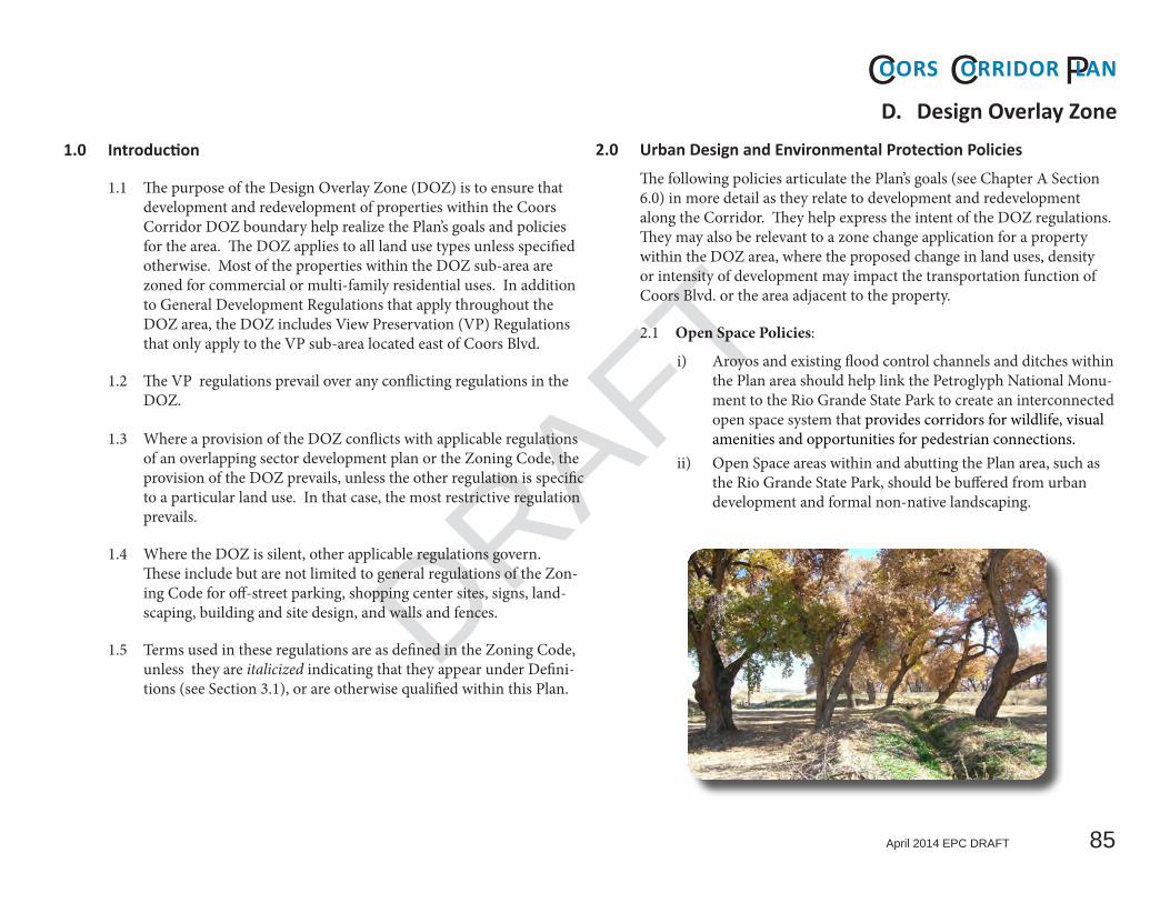
i) Aroyos and existing flood control channels and ditches within the Plan area should help link the Petroglyph National Monu-ment to the Rio Grande State Park to create an interconnected open space system that provides corridors for wildlife, visual amenities and opportunities for pedestrian connections.
ii) Open Space areas within and abutting the Plan area, such as the Rio Grande State Park, should be buffered from urban development and formal non-native landscaping.
D. DesignOverlayZone

April 2014 EPC DRAFT
DRAFT
oors orridorC PC lan
86
D. Design Overlay Zone2.2 View Preservation Policies:
i) Views of the bosque and Sandias Mountains should be main-tained through buffers for waterways and public open spaces and the design of streets, trails, and built forms.
ii) Public viewsites should be provided at appropriate locations along Coors Blvd. and within the View Preservation sub-area to enhance the public’s enjoyment of the Corridor’s scenic as-sets.
iii) Natural features on-site, such as existing vegetation, slopes and outward views, should be considered in site design. Design should also relate to the surrounding natural landscape of existing and planned Open Spaces.
iv) Buildings should be sited to minimize the alteration of exist-ing topography.
v) Common open space areas in Activity Centers and on shop-ping center sites should create a sense of place and community identity, and take advantage of views to the bosque and Sandia Mountains where possible.
vi) As property develops and re-develops in the VP area, care should be taken to preserve existing views of the bosque and Sandia Mountains from Coors Blvd.
2.3 Urban Design and Development Policies:
i) Moderate to high-density employment and mixed-use devel-opment are encouraged in designated Activity Centers and near major transit stops, in order to serve adjacent neighbor-hoods, increase housing choice and strengthen the viability of non-motorized modes of transportation.
ii) Development should maintain connectivity for all modes of transportation and improve it where possible, to ensure access and traffic flows in and through the Plan area.
2.4 Grading and Drainage Policies:
i) Changes to natural topography and building on steep slopes should be kept to a minimum in order to avoid major erosion problems.
ii) If grading is necessary, contour grading is preferred in order to preserve natural features including vegetation.

April 2014 EPC DRAFT
DRAFT
DRAFT
oors orridorC PC lan
87
D. Design Overlay Zoneiii) A portion of stormwater run-off from development should
be held and utilized on-site to reduce the potential for down-stream pollution, to supplement irrigation for landscaping and encourage infiltration.
iv) Swales and ponding areas should be designed to provide landscape and/or passive recreational amenities in addition to controlling stormwater.
ii) Commercial, apartment and mixed-use developments should be designed to allow safe pedestrian circulation throughout the development sites. In addition to required pedestrian connections to sidewalks, they should provide convenient connections to any adjacent multi-use trails, transit stops and residential neighborhoods.
iii) Edges of arroyos, flood control channels and ditches should be considered as potential alignments for new off-street paths linking urban and Open Space areas, in order to improve non-motorized public access to Open Space areas and complement the City’s designated multi-use trail network.
2.6 Utility Policies:
i) The City should work with the utility companies to encour-age and support moving existing power distribution lines and communication lines underground as they need to be replaced. New lines shall be installed underground in accor-dance with existing regulations.
2.5 Pedestrian and Bicycle Facilities Policies
i) As development and re-development occur, pedestrian and bicycle facilities along Coors Blvd. and other streets should be constructed to ensure continuous non-motorized routes between destinations such as Activity Centers and residential neighborhoods that are located within and adjacent to the DOZ sub-area. The facilities will be sidewalks and bike lanes within the public ROW, and may include off-street paved multi-use trails depending on the location and context of a particular development site.

April 2014 EPC DRAFT
DRAFT
oors orridorC PC lan
88
D. Design Overlay Zone3.0 GeneralDevelopmentRegulations
3.1 Definitions
Gated community. A residential area where accessibility is controlled by means of a gate, guard or barrier which restricts access to nor-mally public spaces such as streets and pedestrian/bike paths. A residential development with controlled access that functions as a nursing home or that offers multiple levels of care (e.g.“assisted liv-ing”) or a community residential program is not considered a gated community.
Monument sign. A free-standing sign mounted on a visible solid base with no clear space in-between, where the base is connected to the ground and equal to at least 75% of the width of the sign face.
Multi-Use Trail. A path physically separated from motorized ve-hicle traffic by an open space or barrier, and constructed within the street right-of-way or within an independent right-of-way, includ-ing shared-use rights-of-way or utility or drainage easements, that permits more than one type of non-motorized use. Multi-use trails are typically paved.
Pedestrian-oriented areas. Areas that are intended primarily to provide access, amenities or space for services that benefit people on foot. They include but are not limited to sidewalks, walkways, multi-use trails, transit stops, spaces for outdoor seating or vending, plazas, parks, and public facilities associated with City Open Space.
Portable sign. A sign fixed on a movable, self-supporting stand or frame that is not: firmly embedded in the ground; supported by an animal, person or other object; mounted on wheels, a movable vehicle; or made easily movable in any other manner.
3.2 Site Design
The following regulations calls for site design that takes into consid-eration any natural assets of the site, how the development relates to its surroundings and to Coors Blvd., and that maintains or enhances connectivity in the Corridor.
i) Natural features on the site, including topographical features and trees, and views from the site to adjacent features such as the bosque or watercourses shall be considered in the site design. They shall be retained or incorporated where feasible. Applicants shall demonstrate how any on-site or adjacent natural features influence the site design.
ii) Buildings shall generally be oriented to the street by provid-ing a main entrance that faces the street and has convenient pedestrian access to the sidewalk. However, on sites adjoining Coors Blvd., buildings may have their primary entrances on internal or secondary streets rather than Coors Blvd. in the following situations:a. On shopping center sites or in mixed-use developments
on premises of 5 or more acres located in designated Activity Centers, where the site design would help create a discrete destination and sense of place.
b. Where the grade differential between the developable area of the site and the nearest driving lanes of Coors Blvd. is such that the entrance to a building facing Coors Blvd would not be visible from the roadway, or that ADA-com-pliant access to the entrance is not viable.
iii) Applications for development shall include a multi-modal circulation plan that includes access points for cars, service vehicles, pedestrians and bicycles to adjacent public streets and areas with compatible uses, and to the multi-use trail

April 2014 EPC DRAFT
DRAFT
DRAFT
oors orridorC PC lan
89
D. Design Overlay Zonenetwork as appropriate. Site plans and site development plans for building permit shall also detail internal circulation for all modes of transportation.
iv) The number and location of access points shall meet appli-cable requirements for access to Coors Blvd./Bypass in Chap-ter C Section 8.0. Note that an application may result in a requirement from the NMDOT and/or the City Engineer for the development to share access with an adjacent property-owner. Depending on the location and traffic impact of the development and conditions in the area such as traffic conges-tion levels and road safety issues, the City may also pursue a feasibility study for a connector street per Chapter C Section 8.3 in coordination with NMDOT and other agencies,
3.3 Landscape Setback/Buffer
A landscaped strip is required along Coors Blvd., watercourses and Open Space areas that functions as both a setback and buffer. Along Coors Blvd. it enhances the Corridor, maintaining a degree of open-ness, and protects customers, employees or residents of the development from the noise and visual impact of traffic. In the other locations, the landscaped strips provide a transition zone and protection for the ecosystems and/or recreational uses associated with waterways and Open Spaces.
i) Coors Blvd.a. South of Western Trail or Namaste Rd.: 15 ft. minimum
width from the right-of-way (ROW) for Coors Blvd. recommended in Chapter C (see Table C-1 through Table C-4).
b. North of Western Trail or Namaste Rd.: 35 ft. minimum width from the ROW at the time of the Plan’s adop-tion. Minimum width may be reduced to accommodate a turn lane to access development or if additional ROW
is required to comply with recommendations in Chapter C (see Table C-4 through Table C-9), but shall be no less than 15 ft.
ii) Detention Dams, Arroyos, Canals, Ditches & Drains a. Corrales Riverside Drain: 100 ft. minimum width from
the drain ROW or the Rio Grande State Park/Open Space boundary, whichever is closer.
b. San Antonio and Calabacillas Arroyos: 20 ft. minimum width from the property or easement line of the facility.
c. Other MRGCD and AMAFCA surface facilities: 5 ft. minimum width from the property or easement line.
See Chapter F Map F-17 through Map F-21 for location of facilities.
iii) Petroglyph National Monument or Open Space west of the Corrales Riverside Drain: 25 ft. minimum width in addition to any street located between the public land and the site.
iv) Design.a. The setback/buffer shall be landscaped using low to
medium water use vegetation, including plants native to the West Mesa, to achieve 50% minimum live vegetative coverage at maturity.
b. The setback/buffer may contain a pre-existing access ease-ment or a multi-use trail, benches, educational signage or shade structures for pedestrians, but no other structures except retaining walls or screens for parking areas, drives and drive-through lanes.
c. Witin setbacks/buffers ii) and iii), existing vegetation shall be left in place, unless it poses a fire hazard as determined by the Fire Marshall or it includes species prohibited by City Ordinance. Additional perennial native plants shall be added where necessary to achieve 50% minimum live

April 2014 EPC DRAFT
DRAFT
oors orridorC PC lan
90
D. Design Overlay Zonevegetative cover at maturity. (See plant list in Chapter F Section 4.1 for appropriate species.)
3.4 Setbacks for Structures (other than walls and fences)
Setbacks are per the underlying zone, with the following exceptions:
i) Adjoining a landscape setback/buffer, the minimum setback is 0 ft., unless the setback/buffer is on a separate parcel, where the minimum setback is 5 ft.
ii) The minimum setback is 5 ft. from the ROW of a street other than Coors Blvd., another limited access roadway or principal arterial, unless the setback must accommodate a Public Utility Easement or a public Right-of-Way for a public utility or drain-age.
iii) The setback is 11 ft. minimum from the junction of a driveway and an existing or proposed public sidewalk.
iv) Clear sight triangles shall be maintained.
3.5 Walls and Fences
i) Solid fences and walls along Coors Blvd., other than retaining walls and screen walls for vehicles, are not allowed within the landscape setback/buffer.a. Retaining walls within the setback/buffer shall be located
at least 10 ft. back from the ROW of Coors Blvd. and shall not exceed 3 ft. in height.
b. Screen walls within the setback/buffer shall be located no more than 5 ft. back from the edge of parking areas, drives and drive-through lanes.
ii) Screen walls for parking, drives and drive-through lanes shall be 3 1/2 ft. in height, i.e. sufficiently high to screen headlights of Sports Utility Vehicles and light trucks as well as sedans.
iii) Vinyl plastic fencing, chain link with viny slats, barbed tape,
razor or barbed wire or similar materials are not allowed along Coors Blvd.. or other public street. or adjacent to a visi-tor facility or designated path in Open Space. Public utility structures and Albuquerque Police Department and Transit Department facilities are exempt from this regulation.
3.6 Pedestrian Circulation
i) Continuous sidewalks shall be provided along public streets as follows:a. On Coors Blvd. and Coors Bypass per Chapter C Section
5.1 and Figure C-3 through Figure C-6.b. Adjacent to Major Activity Centers and Community
Activity Centers as designated in the Albuquerque/Ber-nalillo County Comprehensive Plan or lower-ranked City plan, whichever is the more current designation: 10 ft. minimum on arterial streets; 8 ft. minimum on collector streets.
c. The width at other locations shall be per City standard.d. Sidewalks on adjoining sites shall align to the extent pos-
sible.ii) The pedestrian walkways between street sidewalks and the
principal entrance(s) of the nearest building(s) on a site shall be located to provide convenient access for transit stops, in-cluding BRT stops proposed in this Plan (see Chapter C Figure C-13 through Figure C-20), by making the connections as direct as possible.
iii) Pedestrian connections shall be provided to adjoining Open Space:a. where visitor facilities, including trailheads, exist or are
designated in plans such as the Bosque Action Plan; and
b. these facilities are located within 300 ft of the development site.
April 2014 EPC DRAFT
DRAFT
DRAFT
oors orridorC PC lan
91
D. Design Overlay Zone3.7 Multi-Use Trail Network
i) Trail segments that meet the following criteria shall be provided as part of development in order to provide conve-nient access for pedestrians and cyclists and to fill gaps in the network:a. Segments that are designated in the Long Range Bikeway
System map of the Metropolitan Transportation Plan or in an adopted City plan, such as the Trails and Bikeways Facility Plan or the Facility Plan for Arroyos. (See Chap-ter F Map F-23 through Map F-27 for facilities current at Plan adoption.)
andb. Segments that are located within or adjoining the prop-
erty line of the development site.ii) Connections for pedestrians and cyclists from a site to a
designated trail on adjacent property shall be provided where feasible and at a minimum interval of 300 ft.
iii) The design, construction and maintenance of multi-use trails and connections shall meet City standards. Public multi-use trails shall be paved; connections to trails shall be paved or may be constructed of another surface acceptable to the City.
3.8 Off-Street Parking
i) The minimum number of required car parking spaces per land use plus 10% is the maximum number of car parking spaces allowed.
ii) On shopping center sites or other sites containing 5 or more acres governed by a site development plan, cross-access and cross-parking shall be provided internally between any smaller lots that form the site. Parking spaces dedicated to residents and employees, but not to visitors and customers, are exempt from this requirement.
Note: Cross access may be required between adjoining sites to comply with access management policies in Chapter C Sec-tion 8.0.
iii) No parking area shall intrude upon required landscape set-backs/buffers.
3.9 Landscaping
i) The total landscaped area required for each development shall equal not less than 20% of the net lot area as defined in §14-16-3-10(E)(1) of the Zoning Code. Landscape setbacks/buffers on the same property as the development count toward the total landscaped area.
ii) The required percentage of vegetative cover at maturity is 75% except within landscape setback/buffers (see Section 3.3.iv)a.)
iii) Existing mature deciduous trees shall be incorporated into landscape design, unless they are of a species prohibited by the Albuquerque Pollen Control Ordinance.
iv) Terraced landscaping is encouraged on steeper slopes. v) Artificial turf is not permitted. Where a lawn is desired, native
grass species are encouraged.vi) The use of coarse gravel (e.g. river rock) is discouraged east of
Coors Blvd. except in drainage swales or on slopes vulnerable to erosion.
vii) Landscaping along public, paved multi-use trails shall be drought tolerant native plant, tree or grass species and shall be planted at least 3 ft. from either side of the trails so they do not encroach on this 3 foot “clear zone” for maintenance purposes.
3.10 Grading and Drainage
i) Contour grading and terracing are encouraged. ii) In order to minimize opportunities for fugitive dust during

April 2014 EPC DRAFT
DRAFT
oors orridorC PC lan
92
D. Design Overlay Zonesite development and construction, development shall comply with the following standards:a. All development over ¾ acres must comply with the joint
Albuquerque and Bernalillo CountyFugitive Dust Or-dinance found in the New Mexico Administrative Code 20.11.20.
b. All development must comply with the City Drainage Control Ordinance and the Flood Hazard Control Ordi-nance, including a requirement for an approved Erosion and Settlement Control Plan prior to being issued a grad-ing permit.
c. For all non-residential and mixed-use developments, grading permits shall only be issued concurrently with building permits. For developments over ¾ of an acre, applicants shall provide proof of a 20.11.20 NMAC Fugi-tive Dust Control Permit from the Environmental Health Department prior to being issued a building permit.
d. For exclusively residential developments, a grading permit shall only be issued after a preliminary plat and an Ero-sion and Sediment Control Plan have been approved.
e. In situations that require grading without a building permit or a preliminary plat, or in advance of a building permit or a preliminary plat, the City Engineer may grant a grading permit if an applicant makes a special request, provided that the requirements in items (a) through (c) above are met, as well as other requirements from both the City Engineer and the City Environmental Health Department.
f. Grading within public rights-of-way or public easements is exempt.
iii) Stormwater runoff shall be detained or retained on-site as re-quired by the City Hydrologist, and be integrated with the site
and landscape plan by means of the following measures:a. Mandatory
• Minimize cross-sections and corner radii on streets that are not typically used by service vehicles;
• Slope sidewalks to drain to any flanking landscape areas;
• Notch curbs along streets and in parking areas to al-low stormwater run-off into swales, landscape areas or tree wells.
b. Where feasible• Use permeable material for parking spaces other than
disabled spaces;• Surface parking areas with gravel (see parking lot reg-
ulations in §14-16-2-15 (12)(a) of the Zoning Code);• Direct roof run-off to swales and ponding areas that
are also designed to provide landscaping and/or pas-sive recreational amenities.
3.11 Utilities
i) Electricala. All screening and vegetation surrounding ground-
mounted transformers and utility pads must allow 10 ft. of clearance in front of the equipment door and 5 to 6 ft. of clearance on the remaining three sides for access and to ensure the safety of the work crews and public dur-ing maintenance and repair. Ground-level clearance may include parking area.
b. Consult the Facility Plan Electric System, Transmission and Generation 2010-2020 (2012) and the PNM Electric Service Guide for further details.
Note that standards for other utilities, such as easements for water and sewer lines, may also apply. Consult the City Planning Depart-ment or the utility company for further information.

April 2014 EPC DRAFT
DRAFT
DRAFT
oors orridorC PC lan
93
D. Design Overlay Zone3.12 Structure Height
i) Height of structures is determined from the finished grade of the site.
ii) Maximum height shall be per the underlying zone with the following exceptions:a. Structures in the View Preservation sub-area are subject to
its height and mass regulations (see Section 4.3).b. In zones where structure height is limited by an angle
plane, structures on properties that adjoin the Coors Blvd. ROW, or adjoin the landscape setback/buffer at the Coors Blvd. ROW, and are located outside designated Commu-nity or Major Activity Centers: the 450 or 600 angle plane on Coors Blvd. shall be drawn from the property line (using the full ROW width recommended in this Plan, see Figure D-1) rather than the centerline of Coors Blvd.
Coors Blvd. ROW
15� setback
35� setback
45 60
45 60
(Note: Not to scale. For illustrative purposes only.)
N
E
Property LineIf adjoining a property
Center LineIf on ROW other than Coors Blvd.
Property Line
4560 45
NE, W & SStructure
26ft
(Note: Not to scale. For illustrative purposes only.)
setback
FigureD-1:Structure Height controlled by Angle Planes on Coors Blvd.
FigureD-2:Structure Height controlled by Angle Planes on frontages other than Coors Blvd.

April 2014 EPC DRAFT
DRAFT
oors orridorC PC lan
94
D. Design Overlay Zone3.13 Solar Access
Non-Residential as well as residential buildings shall meet the stan-dards to preserve solar access of any adjoining property to the north per §14-16-3-3 (A)(7) of the Zoning Code.
3.14 Architecture
The following regulations and guidelines aim to foster design of buildings and other architectural features that enhance the urban environment of the Coors Corridor and complement its natural setting. They are not intended to discourage innovative forms and materials, nor establish a uniform style throughout the Corridor.
i) Multiple buildings on one premises shall be designed to create a visually cohesive development.
ii) National “trademark” architecture is discouraged, unless it fully complies with the rest of the regulations in the DOZ.
iii) Predominant exterior building materials shall be durable and of high quality including: tinted and textured concrete mason-ry units, brick, stone, wood, architectural metal panels and/or stucco. Other materials will be considered on a case-by-case basis and approved by the EPC or the Planning Director (or his/her designee), as appropriate.
iv) Predominant façade finishes and colors shall have lower light reflective values (20 to 50%).
v) Trim may contrast with the remainder of the façades, but shall avoid the use of high intensity, metallic or fluorescent materi-als and colors.
vi) Glazing shall have low reflective value and no reflective coat-ings.
vii) Elevations and architectural details of a building and any ac-
cessory structures shall be coordinated with regard to form, color, and type and number of materials, in order to achieve harmony and continuity of design. Architectural details include such features as roof lines, parapets, window openings, canopies, entrances and portals. Accessory structures in this Plan include but are not limited to monument signs, refuse enclosures, walls and fences.
viii) Solar panels shall be designed as visually integral parts of their supporting structures, e.g. of building or carport roofs, or screened per the general zoning regulations that apply to mechanical and electrical equipment.
ix) The material and color of permanent site furnishings, in-cluding but not limited to lightpoles, seating, bicycle racks, bollards and trash receptacles, shall be coordinated with the architecture and landscape design of the development.
3.15 Lighting
The following shall apply to non-residential and mixed-use devel-opments, in order to mitigate night-time light pollution without compromising security:
i) All outdoor light fixtures used for security purposes or to il-luminate walkways, driveways, equipment yards and parking lots shall be designed and operated as cutoff or semi-cutoff fixtures and shall be equipped with light and motion sensors and/or automatic timing devices.
ii) All outdoor lighting fixtures on buildings shall be mounted no higher than 16 ft. above finished grade, except as required by Federal or State regulations.
iii) All outdoor light fixtures on properties abutting residential zones shall remain off between 11:00 PM and sunrise except for specified security purposes or because the establishments operate during those hours.

April 2014 EPC DRAFT
DRAFT
DRAFT
oors orridorC PC lan
95
D. Design Overlay Zone3.16 Signage
The sign regulations of underlying zones and relevant general regu-lations of the Zoning Code, including shopping centers (§14-16-3-2) and signs (§14-16-3-5), shall apply with the following exceptions:
i) Type and Location a. Free-standing signs.
• One free-standing sign shall be allowed for each street frontage of each premises, or joint sign premises, provided the street frontage is at least 100 ft.
• Premises or an area governed by a site development plan that is 5 acres or larger shall be allowed a second free-standing sign on each street frontage longer than 600 ft.
• All free-standing signs shall be monument signs. b. Building-mounted signs for a single business are limited
to three façades of a building. c. Building-mounted signs, as defined in §14-16-1-5 of the
Zoning Code, shall not extend above the predominant roof line of the building, except: • An on-premise religious sign consisting only of a
religious symbol may extend 6 ft. above the roof line of a building used as a place of worship.
• A request for one sign adjacent to a new elevated segment of Coors Blvd. on a development site outside the View Preservation sub-area may be submitted for review and approval by the EPC or Planning Director (or his/her designee), as appropriate. The factors that the approving body uses in coming to a decision may include, but are not limited to: - the length of the site frontage along the elevated segment
- the sign’s proximity to the elevated segment- the sign’s orientation to the direction of traffic flow on the elevated segment, e.g. within a 45° angle- the sign’s height above the grade of the elevated segment.The sign area will be included in calculations for the total sign area of building-mounted signs.
ii) Sizea. The area for each sign face of a freestanding or project-
ing sign shall be limited to 75 sq. ft. except multi-tenant and joint-premise signs on shopping center sites may be increased by 15 sq. ft. per tenant or additional premise, up to a maximum of 105 sq. ft.
b. Total sign area of building-mounted signs other than pro-jecting signs is limited to 6% of each façade area.
c. Individual letters are limited to a maximum height of 3 ft.d. Logos are limited to a maximum height and width of 3 ft.
iii) Height and Widtha. Free-standing signs for a multi-family residential devel-
opment are limited to a maximum height and width of 9 ft.
b. Free-standing signs for other uses are limited to a maxi-mum height and width of 12 ft.
iv) Prohibited Signsa. Electronic display/board panel, as defined in the Zoning
Code §14-16-1-5.Note: All electronic signs, including message reader boards, are prohibited in parts of the Corridor by Gen-eral Sign Regulations in §14-16-3-5 (C)(2): in residential zones; within 660 ft of the Coors Blvd. ROW south of Central Ave.; within 660 ft of Coors Blvd. between St

April 2014 EPC DRAFT
DRAFT
oors orridorC PC lan
96
D. Design Overlay Zoneii) Where a queuing lane, order-board or service window faces
these areas, it shall be screened at minimum by a 3 1/2 foot high solid wall and a 4 foot wide landscaped strip that is located on the residential, pedestrian or street side and is planted with evergreen shrubs. The 3 1/2 foot wall is optional next to a residential zone where a special landscape buffer that includes a 6 foot high solid wall is already required per §14-16-3-10(E)(4) of the Zoning Code.
3.18 Regulations for Residential Development
i) Gated communities and Walled Subdivisions. Larger gated communities and walled subdivisions would restrict their residents’ access to local destinations and minimize connec-tivity in the Corridor, which generally does not have a grid pattern of roadways. These types of development would likely aggravate an existing congestion problem along the Corridor by funneling vehicular traffic onto a small number of pub-lic streets. Gated communities and walled subdivisions are therefore limited to sites of no more than 5 acres, unless they comply with the following requirements:a. The development is split into smaller gated communities
or walled subdivisions of no more than 5 acres separated by a publicly accessible street, or flanked by such a street on at least one side, that connects to the public roadway network. The access arrangements shall be consistent with Chapter C Section 8.0 (policies for access to Coors Blvd./Bypass) and Section 8.3 (recommendations for connector streets).
b. An opening and connecting path are provided every 600 ft minimum to the sidewalk on the adjacent street and to any adjacent multi-use trail. The connecting path shall be at least 10 ft wide, flanked by landscaped strips at least 5 ft wide, and shall conform to requirements of the Americans with Disabilities Act (ADA).
Joseph’s Drive and the Calabacillas Arroyo/Coors Bypass; and within 1320 ft. of Major Public Open Space and the Petroglyph National Monument.
b. A sign consisting of banners, pennants, ribbons, stream-ers, strings of light bulbs and spinners, unless it is dis-played during a holiday season or a special event for a maximum period of 21 days and is approved by the Plan-ning Director or his/her designee.
c. A sign that is in any way animated (including twinkling or wind-activated movable parts); emits smoke, visible vapors, particles, or odor; rotates or moves in any manner.
d. A portable sign as defined in this DOZ, unless it is a small A-frame sign that meets the definition and regulations for portable signs in §14-16-1-5 and 14-16-3-5(K) of the Zoning Code respectively.
e. A sign that is painted on or affixed to a water tower, stor-age tank, utility pole or other similar structure.
f. A sign that is painted on or affixed to trees, rocks or other natural features.
g. A sign that covers or intrudes upon any architectural fea-ture of a building, including a major ornamental feature.
3.17 Drive-up service windows
Developments with drive-up service window uses shall be designed to mitigate the impacts of traffic, noise, odors and lights on adjacent public and residential areas. In addition to zone-based and general regulations in the Zoning Code, the following apply:
i) Drive-up queuing lanes, order-boards and service windows shall not face residential zones, pedestrian-oriented areas and/or streets to the extent possible. (The areas to protect are listed here in priority order.)

April 2014 EPC DRAFT
DRAFT
DRAFT
oors orridorC PC lan
97
D. Design Overlay Zoneii) Multi-family Residential Development
The intent of the following regulations is to break up the mass and vary the façades of apartment buildings, including at-tached townhouses, a. The maximum length of a building shall be 400 ft.b. The minimum distance between buildings shall be 20 ft.
Building façades shall be articulated at least every 60 ft with: • a wall plane projection or recess of at least 3 ft. that
extends the width of one residential unit at minimum and
• one or more of the following: a change in color or material; a change in visible roof plane or parapet height; patios; balconies; or other treatment approved by the EPC or Planning Director (or his/her desig-nee).
c. Residential buildings shall orient their primary entrances to the nearest street or internal path.
d. Surface parking, driveways, carports and garages shall not dominate primary building frontages:• Individual parking spaces, carports and garages for
units with ground floor entrances should be located at the side or rear of buildings. Where located at the front, they shall be limited to 50% of the unit’s front façade. Every two adjoining units with direct vehicle access from a local or internal street shalle share a driveway with a maximum curb cut of 16 ft.
• Aggregate parking, carports and garages for residents shall be located to the side or rear of buildings. They shall be divided into groups of 40 spaces maximum with no more than 10 spaces side-by-side, separated by buildings or by landscaping at least 20 ft. wide that includes paths where appropriate.
• Visitor parking may be located at the front of build-ings.
e. Usable open space shall be provided per the underlying zoning and meet the following requirements:• Between 25% and 50% of the required usable open
space shall be in the form of aggregate common space available to the development’s residents, such as courtyards, roof terraces, playgrounds, passive or active recreational areas.
• Each aggregate common space shall be 400 sq. ft. minimum and contain seating and shade covering a minimum of 25% of the area.
• In developments abutting arroyos, including but not limited to AMAFCA and MRGCD facilities, aggre-gate common open space shall be adjacent to the ar-royo to provide an amenity for the development and a landscape buffer for the arroyo.
iii) Single-family residential developmenta. Where allowed, Private Commons Developments are
encouraged to maintain visual and functional open space and views of adjacent natural features such as the bosque. (See Private Commons Development regulations in §14-16-3-16 of the Zoning Code).
3.19 Regulations for Phased development
The intent is to prevent unsightly vacant areas, to protect public health and the environment, and for each phase of development to attain a visual and functional completeness:
i) No grading or scraping of the site for future phases or interim ponding shall occur without timely and adequate stabilization of bare ground to prevent erosion (see also Section 3.10.ii)).
ii) The first phase of development shall at minimum include im-provements to existing public right(s)-of-way on the perim-

April 2014 EPC DRAFT
DRAFT
oors orridorC PC lan
98
D. Design Overlay Zoneeter of the entire site, including sidewalks and any multi-use trails, and the planting of associated street trees.
iii) Open space, including aggregate common space where fea-sible, shall be implemented with each phase.
iv) Temporary barriers or walls around lots that will be developed in future phases shall be painted and trimmed to complement the permanent construction.

April 2014 EPC DRAFT
DRAFT
DRAFT
oors orridorC PC lan
99
D. Design Overlay Zone4.0 ViewPreservationRegulations
The regulations in this section apply to development on sites in the city in the View Preservation sub-area.
Located north of Namaste Rd. and east of Coors Blvd., this sub-area of the Plan has a very scenic natural setting to the northeast, with the bosque forming the middle ground and the Sandia Mountains visible in the distance. Higher ranked City plans recognize visual quality, in particu-lar views of the Bosque and Sandia Mountains, as a valuable community asset that adds to the City’s livability and attractiveness. The intent of the View Preservation regulations is to keep a critical portion of this setting visible over the long-term, for the benefit of the many people who travel in the Coors Corridor including residents, commuters and visitors. This section also includes additional regulations to protect the Night Sky.
The protected views are based on the perspective of motorists (passen-gers in particular) heading northbound on Coors Blvd., for substantive and practical reasons: the views to the northeast are the most special; the number of people in cars is expected to continue forming the largest proportion of the travelling public; and if the views are maintained for people sitting in cars, they will also be maintained for truck passengers, cyclists, pedestrians, and transit riders in the Corridor all of whose sight lines begin at an equivalent or higher elevation above the pavement.
The regulations were informed by a comprehensive view analysis of the Corridor completed in 2008, with input from the Coors Corridor Plan advisory group that met through 2009 and from residential and commer-cial stakeholders in late 2013 and early 2014 (see Chapter F Sections 1.3 and 1.5). Changes in conditions and City policies and regulations since 2008 have also informed the regulations. The aim of the Plan is to srike an appropriate balance between protecting individual owners’ rights to develop their property and protecting a public good that is highly valued by the West Side community and the community-at-large as reflected in adopted City policy. For example, a distinction between land north and south of Paseo del Norte is reflected in some of the regulations. North of
Paseo del Norte, properties adjacent to Coors are at a similar grade to the pavement, tend to be smaller, and most are one lot deep, at the edge of a slope that drop significantly to the Corrales Riverside drain and the valley floor. The lowlands are mostly zoned for single family homes and are already developed.

April 2014 EPC DRAFT
DRAFT
oors orridorC PC lan
100
D. Design Overlay Zone4.1 Definitions
These definitions explain the measures for demonstrating compli-ance with the structure height and mass regulations that follow. They enable a comprehensive analysis of a development proposal’s impact on views to the Sandias, in plan, section and elevation view.
View Area. Consists of two or more view frames for each site, depending on the size of the site. The bottom of the view area is formed by the elevation of Coors Blvd. The left and right edges of the view area are created by vertical extensions from the north and south boundaries of the site. The highest point of the ridgeline of the Sandia Mountains visible between the left and right edges of the view area forms the top of the view area.
View Frame. A vertical rectangle established at the east edge of the Coors Blvd. ROW, looking toward the Sandia Mountains. The sight line) begin at the edge of the Coors Blvd. ROW as follows:
• Sites of less than 5 acres * - the point at the south corner of the site; and at the mid-point of the property line along Coors Blvd.or at a distance of 660 ft. from the south corner, whichever distance is less.
• Sites of 5 acres or greater * - the point at the south corner of the site; and points at 660 ft intervals along the property line, up to the north corner of the site.
• Sight lines shall be added as necessary to incorporate all pro-posed structures on the site or to show the area between set-backs if the location of structures has not been determined e.g. in a site development plan for subdivision.
The direction of the sight lines follows a horizontal 45° angle from the alignment of Coors Blvd., i.e. in approximately a northeasterly direction.

April 2014 EPC DRAFT
DRAFT
DRAFT
oors orridorC PC lan
101
D. Design Overlay Zone
Building
Building
Building
North Coors Blvd. ROW
North Property Line South Property Line
45 45
View Frames
Mid-Point
Sight lines
660 �. max.
(Note: Not to scale. For illustrative purposes only.)
View Area( = A + B + C )
A
B
C
Rear Property Line
Existing building
Edge of View Area
Edge of View AreaWall
Adjoining Property
Top of View Area
Grade of Coors Blvd. Bottom of View Area
Min. SetbackMin. SetbackNorth Property Line South Property Line
Ridge Line Sandia Mountains
FigureD-3:View Frames and View Area with Structures – Plan View
FigureD-4:View Area with Structures – Elevation View

April 2014 EPC DRAFT
DRAFT
oors orridorC PC lan
102
D. Design Overlay Zone
North Coors Blvd. ROW
North Property Line South Property Line
45 45
View Frames
Mid-Point
Sight lines
660 �. max.
(Note: Not to scale. For illustrative purposes only.)
View Area( = A + B + C )
A
B
C Rear Property Line
Buildable Area ( at minimum setbacks)
Edge of View Area
Edge of View Area
Adjoining Property
View Area
View Frame A View Frame C View Frame B Top of View Area
Grade of Coors Blvd. Bottom of View Area
Sight lines Min. SetbackMin. Setback Sight linesNorth Property Line South Property Line
Sandia Mountains Ridge Line
View Area
View Frame A View Frame C View Frame B Top of View Area
Grade of Coors Blvd. Bottom of View Area
Sight lines Min. SetbackMin. Setback Sight linesNorth Property Line South Property Line
Sandia Mountains Ridge Line
FigureD-5:View Frames and View Area for Buildable Area – Plan View
FigureD-6:View Area for Buildable Area - Two Concepts with Structures – Elevation View

April 2014 EPC DRAFT
DRAFT
DRAFT
oors orridorC PC lan
103
D. Design Overlay Zone* Note: For sites that are separated from the Coors Blvd. ROW by a platted strip of land forming the landscape setback or that are lo-cated further east, the sight lines of the view frames begin at points on Coors Blvd. that correspond to the south corner, mid-point etc. as drawn at a 90° angle from the nearest property line of the site to the Coors Blvd. ROW.
North Coors Blvd. Mid-Point 660 �. max.
(Note: Not to scale. For illustrative purposes only.)
45 45
90 90
View Frames
Mid-Point
Sight lines
660 �. max.
View Area( = A + B + C )
A
C
North Property Line South Property Line
Rear Property Line
Adjoining Property
B
(Note: Not to scale. For illustrative purposes only.)
Coors Blvd.
Property Line
4ft
35� setback 50% of building height
FigureD-7:View Frames and View Area for a Site off Coors Blvd. – Plan View
FigureD-8:Horizontal View Plane
Horizontal View Plane. A horizontal plane established at 4 ft. above the east edge of the pavement of Coors Blvd. that begins at the edge of the Coors ROW and extends across the site to its eastern boundary. The grade of the pave-ment reflects the existing condition at the time of application.

April 2014 EPC DRAFT
DRAFT
oors orridorC PC lan
104
D. Design Overlay Zone
Mid-Point 660 �. max.
Edge of View Area
Adjoining Property
Building Existing
4545Edge of View Area
70
Sight lines
View Area
North Property Line South Property Line
View Window
Building
Building Building
North Coors Blvd. ROW
(Note: Not to scale. For illustrative purposes only.)
View Window
View Area
FigureD-9:View Windows - Two Concepts
North Coors Blvd. ROW
(Note: Not to scale. For illustrative purposes only.)
View Window
View Window
Stre
et o
r Driv
e
Building
Building
View Area
Edge of View Area
Adjoining Property
Edge of View Area
Building Existing
4545
45
Sight lines
Mid-Point 660 �. max.
View Area
View Window. Consists of a vertical portion of a view area that pro-vides an unobstructed view of the Sandia Mountains, and provides a view of the bosque to the extent possible. The direction of a view window may be at an angle between 450 and 900 from the alignment of Coors Blvd.

April 2014 EPC DRAFT
DRAFT
DRAFT
oors orridorC PC lan
105
D. Design Overlay Zone4.2 Building and Site Design Guidelines
i) Developments with several buildings should provide a variety of building size and massing. A transition from lower build-ing elevations on the Coors Blvd. frontage or adjoining Major Public Open Space to taller structures and larger buildings at the interior of the site is encouraged.
ii) In designing the site layout, the following should be consid-ered to maintain visual open-ness where it helps preserve the public’s view of the bosque and Sandia mountains from Coors Blvd., including:a. Cluster buildings or, alternatively, maintain an adequate
distance between buildings to provide a view window;b. Where it is allowed by the underlying zone, design a resi-
dential development as a Private Commons Development with a private commons area;
c. Through the alignment of public rights-of-way and drives, e.g. in a northeasterly direction.
d. Through the placement and shape of off-street parking, aggregate open space (e.g. plazas and playgrounds), and landscape and ponding area(s).
4.3 Structure Height and Mass
i) Exceptions to height standards shall not apply to spires, or-namental towers, flag poles, etc. listed in the supplementary height regulations in §14-16-3-3(A)(1) of the Zoning Code
ii) On sites south of Paseo del Norte:a. Height
1. 50% of the total height of a structure may penetrate above the horizontal view plane provided the struc-ture’s height complies with the underlying zone and its mass complies with Section 4.3.ii)b.
2. No portion of a structure, including but not limited to parapet, building-mounted sign and rooftop equip-ment, may extend above the top of the view area.
b. Mass: 1. No more than 30% of an individual structure’s width
shall penetrate above the horizontal view plane as seen in the view area.
2. All the structures on the development site shall ob-scure no more than 50% of the view area.
Horizontal View Plane
Top of View Area
Grade of Coors Blvd. Bottom of View Area
30% of building width
(Note: Not to scale. For illustrative purposes only.)
Sandia Mountains Ridge Line
FigureD-10:Structure Mass in VP sub-area
Horizontal View Plane
Top of View Area
Grade of Coors Blvd. Bottom of View Area
30% of building width
(Note: Not to scale. For illustrative purposes only.)
Sandia Mountains Ridge Line

April 2014 EPC DRAFT
DRAFT
oors orridorC PC lan
106
D. Design Overlay Zoneiii) On sites north of Paseo del Norte:
a. The height and mass of structures shall comply with Sec-tion 4.3.i) and ii)
orb. Structures shall be placed on the site to provide a view
window or windows of a minimum width according to the site area, as follows:
<3 acres 40 ft or 40% of the length of the lot facing Coors Blvd. whichever is larger
3 to <5 acres 80 ft. 5 to <8 acres 100 ft. 8 to <10 acres 125 ft. 10 to <12 acres 150 ft. ≥12 acres 175 ft.
c. On sites where more than one view window is provided, the minimum width of a view window shall be 40 ft.
d. To guarantee that the view window(s) will remain unob-structed, the view window(s) shall be defined and per-manently established through the use of rights-of-way, easements, or other legal instrument acceptable to the City Attorney, but the land is not required to be owned by the City of Albuquerque.
e. Outside the view windows, no portion of a structure may extend above the top of the view area and structures shall be designed to minimize penetration of the horizontal view plane.
f. Maximum structure height shall be established on the site development plan and/or other official document as part of the City approval.
4.4 Landscaping
i) Only deciduous species are allowed as street trees and as shade trees in parking areas. Evergreen trees may be used to screen outdoor storage, service and loading areas.
ii) Tree species shall be selected and placed so that, at maturity, they do not block protected views of the bosque and Sandia Mountains.
iii) Trees may be planted singly or in groups to achieve these ends.
4.5 Lighting
Maximum height of lightpoles shall be 20 ft.
4.6 Signage
i) Illuminated signs shall not be mounted on the 30% portion of a building that may extend above the horizontal view plane as seen in the view area (see Figure D-10).
ii) A religious sign that extends above the roof line of the build-ing to which it is mounted shall not be illuminated.
4.7 Application Requirements
i) All applications for development in the View Preservation sub-area shall provide a view analysis that contains sufficient data and graphic information to demonstrate compliance at the time of application for a site development plan for subdi-vision or building permit, or a site plan for building permit. Applications for development that do not show building footprints, i.e. for development that is phased and/or includes pad sites, shall demonstrate that the lot configuration will al-low future structures to be sited to comply with the height and mass regulations.

April 2014 EPC DRAFT
DRAFT
DRAFT
oors orridorC PC lan
107
D. Design Overlay Zone
OORS ORRIDORC PC LAn
ii) The view analysis documentation shall indicate the existing condition and proposed development of the site in plan, sec-tion and elevation formats, based at minimum on the follow-ing data and graphic elements: a. The existing location of the pavement edge of Coors Blvd.,
and its proposed location if the public ROW will be wid-ened to meet the corridor segment recommendations in the Plan (see Chapter C Section 13.0).
b. Existing spot elevations of Coors Blvd. along the site frontage beginning at the south corner of the site.
c. Proposed spot elevations at locations of structures (e.g. buildings, walls and fences, signs), including at the base of their highest elements, and of trees.
d. Finished floor grades of buildings.e. Minimum setbacks for structures, and location of struc-
tures.f. Photographs of the view area in its current condition, one
of which will be used as a backdrop for the renderings and elevations of the proposed development.

April 2014 EPC DRAFT108
oors orridorC PC lan
This Page Left Intentionally Blank