Embed Size (px)
Citation preview

Convenience Store Development
Lot 11 (11) Yanchep Beach Road,
Yanchep
Transport Impact Statement
Client // Whirlwind Nominees
Office // WA
Reference // W153420
Date // 26/07/18

© GTA Consultants (GTA Consultants (WA) Pty Ltd) 2018
The information contained in this document is confidential and
intended solely for the use of the client for the purpose for which it has
been prepared and no representation is made or is to be implied as
being made to any third party. Use or copying of this document in
whole or in part without the written permission of GTA Consultants
constitutes an infringement of copyright. The intellectual property
contained in this document remains the property of GTA Consultants. TIA
/RSA
MA
- V
IC (
180116 v
9.0
)
Melbourne | Sydney | Brisbane
Canberra | Adelaide | Perth
Convenience Store Development
Lot 11 (11) Yanchep Beach Road, Yanchep
Transport Impact Statement
Issue: A 26/07/18
Client: Whirlwind Nominees
Reference: W153420
GTA Consultants Office: WA
Quality Record
Issue Date Description Prepared By Checked By Approved By Signed
A-Dr 16/07/18 Draft Rodney Ding A Zhang T Moran
A 26/07/18 Final Rodney Ding T Moran

W153420 // 26/07/18
Transport Impact Statement // Issue: A
Convenience Store Development, Lot 11 (11) Yanchep Beach Road, Yanchep
Table of Contents
1. Introduction 1
1.1 Background & Proposal 1
1.2 Context 1
1.3 Purpose of this Report 1
1.4 Reference Material 2
2. Development Proposal 3
2.1 Indicative Site Layout & Land Uses 3
2.2 Site Location 3
2.3 Car Parking 4
2.4 Vehicle Access 5
2.5 Pedestrian Access & Facilities 5
2.6 Bicycle Access & Facilities 5
2.7 Loading Areas 6
3. Accessibility Review 7
3.1 Introduction 7
3.2 Access by Road 7
3.3 Public Transport 8
3.4 Walking and Cycling 8
3.5 Crash Statistics 8
4. Trip Generation and Traffic Impact 10
4.1 Current Traffic Flows 10
4.2 Expected Traffic Flows 10
4.3 Vehicle Types 10
4.4 Traffic Generation and Traffic Impact 10
4.5 Internal Vehicle Queues 12
4.6 Level of Service Concepts 13
4.7 Traffic Impact of Development on Local Area 14
5. Findings, Summary & Conclusions 15
Appendices
A: Development Plans
B: Large Vehicle Swept Paths
W153420 // 26/07/18
Transport Impact Statement // Issue: A
Convenience Store Development, Lot 11 (11) Yanchep Beach Road, Yanchep
Figures
Figure 2.1: Site Location Plan 4
Tables
Table 2.1: Development Schedule 3
Table 2.2: Parking Required 4
Table 3.1: Crash Record for Roads and Intersections/Road Sections in the vicinity of the
Subject Site 9
Table 4.1: Estimated Traffic Generation 11
Table 4.2: Estimated Traffic Generation - Total 11
Table 4.3: Austroads Guidelines 11
Table 4.4: Comparison to Austroads Guidelines 11
Table 4.5: Yanchep Beach Rd/Newman Rd Intersection – Long Term Intersection
Operation in PM Peak 12
Table 4.6: Yanchep Beach Rd Crossover – Long Term Operation in PM Peak 12
Table 4.7: Queues at Refuelling Positions 12
Table 4.8: DOS & LOS Summary 14
W153420 // 26/07/18
Transport Impact Statement // Issue: A
Convenience Store Development, Lot 11 (11) Yanchep Beach Road, Yanchep 1
1. Introduction
1.1 Background & Proposal
GTA Consultants (GTA) has been engaged by Whirlwind Nominees to prepare a Transport Impact
Statement (TIS) for the development of the site at Lot 11 (11) Yanchep Beach Road in Yanchep.
This report follows the guided methodology of a TIS, prepared in line with the Western Australian
Planning Commission publication ‘Transport Assessment Guidelines for Development, August
2016’ (WAPC Guidelines). It also considers the City of Wanneroo’s (CoW) planning policies and
the key elements of the site’s integration with the existing transport networks and the potential
traffic impact of the proposed redevelopment.
1.2 Context
The redevelopment site is in the northern extremity of the City of Wanneroo at the southern end
of Yanchep, situated approximately 57km north of the Perth CBD by road (approximately 50km in
a direct line). The proposed redevelopment is within the established and now expanding suburb
of Yanchep and so benefits from already being well connected to nearby vehicular, walking,
cycling and public transport networks.
WAPC Guidelines provide direction on the level of assessment which is necessary to be carried
out with respect to the likely traffic impact of a development proposal. Typically, any
development which is expected to have a ‘moderate’ traffic impact, that is, generating less than
100 trips in the peak hour is satisfied by a TIS. Any development which is expected to generate in
excess of 100 trips in the peak hour requires a Transport Impact Assessment (TIA) to be
undertaken. Both types of assessment consider the operation and layout of the site, but they
differ in their assessment of external traffic impact.
In the context of this redevelopment and its land use proposal, it is expected that there will be
less than 100 trips generated in a given peak hour if applying ‘typical’ traffic generation rates
(which represent locations outside of non-major activity corridors). In this case a TIS is
appropriate.
1.3 Purpose of this Report
This TIS briefly outlines the transport aspects surrounding the proposed redevelopment. The intent
of a TIS, as per the WAPC Guidelines, is to provide the approving authority with sufficient transport
information to confirm that the Applicant has adequately considered the transport aspects of the
development and that it would not have an adverse transport impact on the surrounding area.
Of particular relevance is the accessibility of the development by non-car modes, in accordance
with Government's sustainable development objectives, and its integration with the surrounding
area.
In accordance with the WAPC Guidelines, this TIS outlines:
redevelopment proposals
current vehicle access arrangements and existing traffic conditions proximate to
the site
the traffic generating characteristics of the proposed redevelopment and to any
low volume residential roads
1
W153420 // 26/07/18
Transport Impact Statement // Issue: A
Convenience Store Development, Lot 11 (11) Yanchep Beach Road, Yanchep 2
particular intersections or sections of road that may be adversely affected
the potential for rat-running, especially through existing residential areas
developments operating outside normal business hours in/near residential areas
information on the pedestrian, bicycle and public transport access arrangements
to the site
suitability of the proposed parking provision within the site
any issues associated with the heavy vehicles generated by the development
the anticipated impact of the proposed redevelopment on the surrounding road
network.
1.4 Reference Material
In preparing this report, reference has been made to the following:
Plans prepared by Vespoli Constructions showing the proposed development
Liveable Neighbourhoods Guidelines
WAPC Transport Assessment Guidelines for Development
Traffic surveys undertaken by GTA Consultants as referenced in the context of this
report
Other documents as nominated.
W153420 // 26/07/18
Transport Impact Statement // Issue: A
Convenience Store Development, Lot 11 (11) Yanchep Beach Road, Yanchep 3
2. Development Proposal
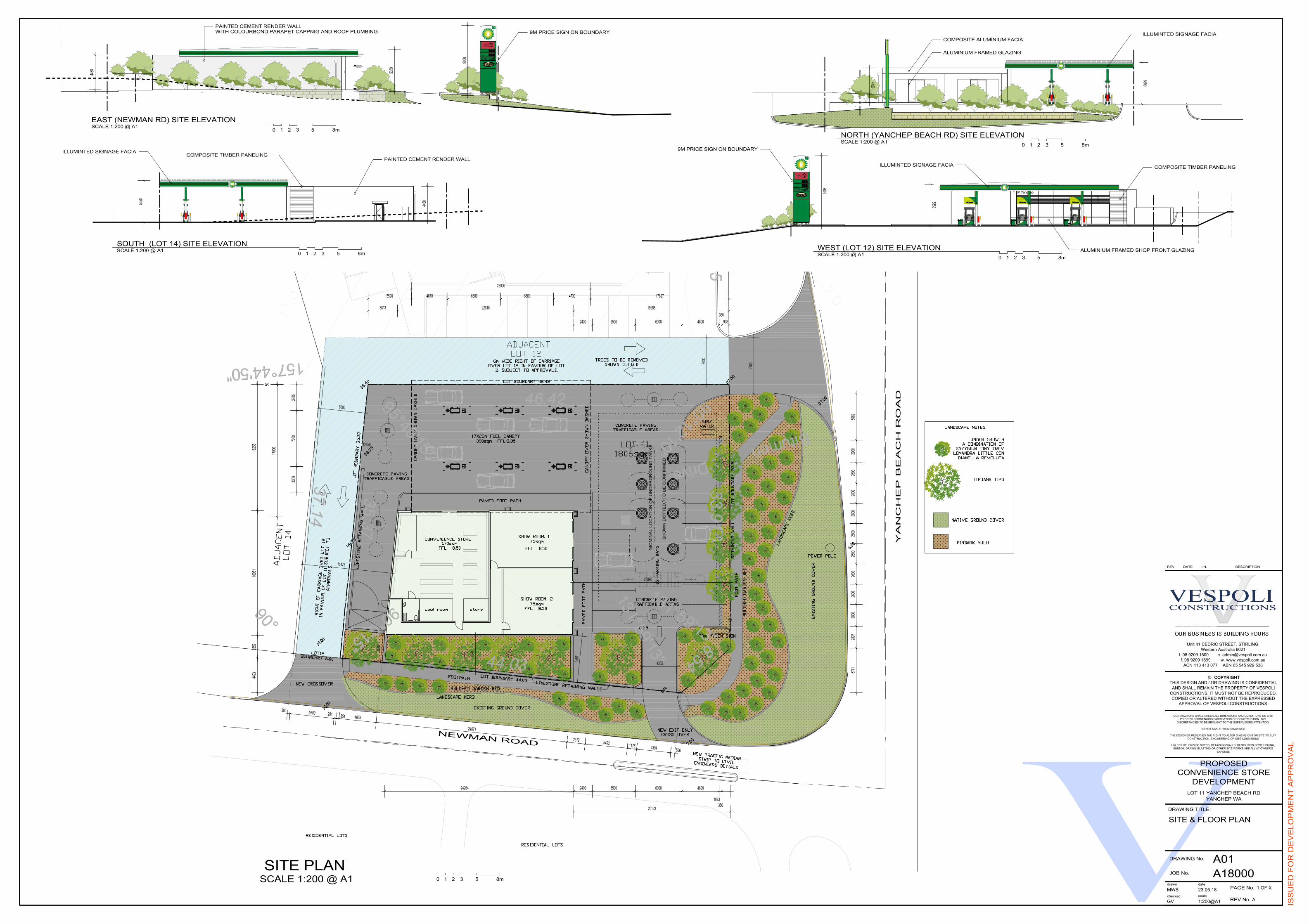
2.1 Indicative Site Layout & Land Uses
A copy of the proposed development plans is provided at Appendix A as prepared by the
project construction contractor, Vespoli Constructions. The proposed site access and car parking
layouts are discussed in the following sections.
The proposal includes the construction of a 170m2 “Convenience Store”, 12 refuelling positions,
and two units of 75m2 each as showrooms. In addition to the 12 refuelling positions, there is
proposed to be 15 on-site parking bays including one bay for Persons with a Disability (PWD) and
shared area as part of the development.
There is proposed to be a 6m wide right of carriageway over the adjacent site, Lot 12 (3)
Newman Road, in the favour of this site, Lot 11. This right of carriageway will connect the
proposed crossover on Yanchep Beach Road to a proposed crossover on Newman Road on the
southern side of the proposed development site (refer Development Plans at Attachment A).
The 1,806m2 development site is currently vacant and is zoned as “Business” under the CoW
District Planning Scheme No. 2 (DPS 2).
Table 2.1: Development Schedule
Use Size
Convenience Store 170m2
Showrooms (ea, 2 of) 75m2 (150m2 total)
Refuelling Positions 12
Parking Bays 15 on-site including 1 PWD/shared area
2.2 Site Location
The subject site is located at Lot 11 (11) Newman Road in the suburb of Yanchep in CoW. It is
located on the south-west corner of the Yanchep Beach Road/Newman Road T-junction. The
site has two street frontages, Newman Road to the east and Yanchep Beach Road to the north.
The land uses around the site are predominantly residential with the zoning as “Residential” under
the CoW DPS 2 with a “Commercial” zoning for the immediate adjacent site of Lot 12 (3)
Newman Road and a “Private Clubs and Recreation” zoning for two larger lots further to the
south along Newman Road. The site is also approximately 150m east of the intersection of
Yanchep Beach Road and Two Rocks Road and 650m west of the intersection of Marmion
Avenue and Yanchep Beach Road.
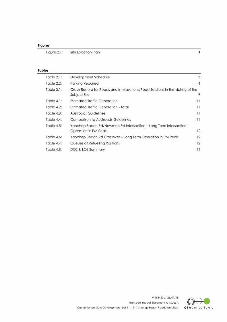
The subject site and its environs are shown in Figure 2.1.
2
W153420 // 26/07/18
Transport Impact Statement // Issue: A
Convenience Store Development, Lot 11 (11) Yanchep Beach Road, Yanchep 4
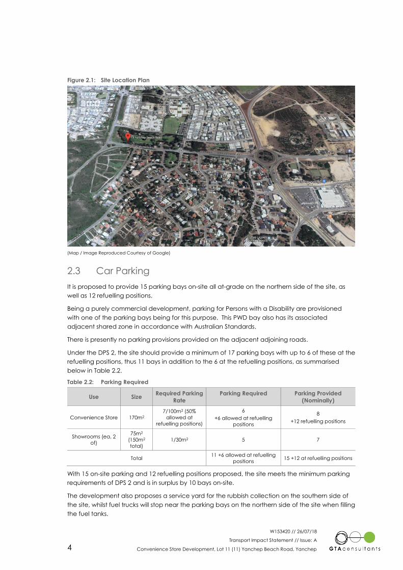
Figure 2.1: Site Location Plan
(Map / Image Reproduced Courtesy of Google)
2.3 Car Parking
It is proposed to provide 15 parking bays on-site all at-grade on the northern side of the site, as
well as 12 refuelling positions.
Being a purely commercial development, parking for Persons with a Disability are provisioned
with one of the parking bays being for this purpose. This PWD bay also has its associated
adjacent shared zone in accordance with Australian Standards.
There is presently no parking provisions provided on the adjacent adjoining roads.
Under the DPS 2, the site should provide a minimum of 17 parking bays with up to 6 of these at the
refuelling positions, thus 11 bays in addition to the 6 at the refuelling positions, as summarised
below in Table 2.2.
Table 2.2: Parking Required
Use Size Required Parking
Rate
Parking Required Parking Provided
(Nominally)
Convenience Store 170m2
7/100m2 (50%
allowed at
refuelling positions)
6
+6 allowed at refuelling
positions
8
+12 refuelling positions
Showrooms (ea, 2
of)
75m2
(150m2
total)
1/30m2 5 7
Total 11 +6 allowed at refuelling
positions 15 +12 at refuelling positions
With 15 on-site parking and 12 refuelling positions proposed, the site meets the minimum parking
requirements of DPS 2 and is in surplus by 10 bays on-site.
The development also proposes a service yard for the rubbish collection on the southern side of
the site, whilst fuel trucks will stop near the parking bays on the northern side of the site when filling
the fuel tanks.
W153420 // 26/07/18
Transport Impact Statement // Issue: A
Convenience Store Development, Lot 11 (11) Yanchep Beach Road, Yanchep 5
2.4 Vehicle Access
The proposed development includes:
a 7.2m wide crossover to the on-site car parking, approximately 150m from the
intersection of Yanchep Beach Road and Two Rocks Road;
a 6m wide crossover on Newman Road, approximately 75m south of Yanchep
Beach Road (this connecting to the right of carriageway); and
an exit crossover from the site onto Newman Road located approximately 25m
south of the intersection at Yanchep Beach Road.
Access to and from the site via the street network is expected to be predominantly via Yanchep
Beach Road via the 7.2m wide crossover in the short to medium term. In the longer term, as
traffic volumes increase on Yanchep Beach Road and this road is duplicated into a four-lane
dual carriageway, the 7.2m wide crossover is expected to become a left-in/left-out crossover.
The intersection of Yanchep Beach Road and Newman Road will then be expected to cater for
the right turn movements from the site that would have occurred at the 7.2m wide crossover in
the short to medium term.
Newman Road is an Access Road under the functional road hierarchy, whilst Yanchep Beach
Road is a Distributor-B road under the functional road hierarchy.
Sight distance for the proposed crossovers meet the requirements of AS/NZS 2890.1:2004 Parking
facilities Part 1: Off-street car parking. For a development of this nature, a sight distance of 97m in
a 60km/h zone (with an assumed 70km/h 85th percentile speed) for a desirable 5 second gap
can be achieved with a sight distance of approximately 150m to the west towards the
intersection at Two Rocks Road and 250m to the east to the roundabout intersection at Wilkie
Avenue. Given the proximity of the crossover to both Two Rocks Road and the Wilkie Avenue
roundabout and the speeds of vehicles exiting these intersections, this sight distance is
considered appropriate.
Service vehicles will be able to enter the site via the Yanchep Beach Road crossover and then
exit via the right of carriageway onto Newman Road as shown at Appendix B.
Fuel delivery trucks will be able to enter the site via the same crossover, but the exit onto
Newman Road will require an apron to allow for the trailer sweep. This is also shown at Appendix
B.
2.5 Pedestrian Access & Facilities
There is currently no access to the site for pedestrians. There are no footpaths on any roads in the
vicinity of the site. Pedestrian access is proposed to be upgraded on the immediate site frontage
with a footpath connecting the crossover on Newman Road to the crossover on Yanchep Beach
Road. There will be direct access to the site from the footpath on the Newman Road frontage.
2.6 Bicycle Access & Facilities
No specific provision is to be made for cycling for the development.
W153420 // 26/07/18
Transport Impact Statement // Issue: A
Convenience Store Development, Lot 11 (11) Yanchep Beach Road, Yanchep 6
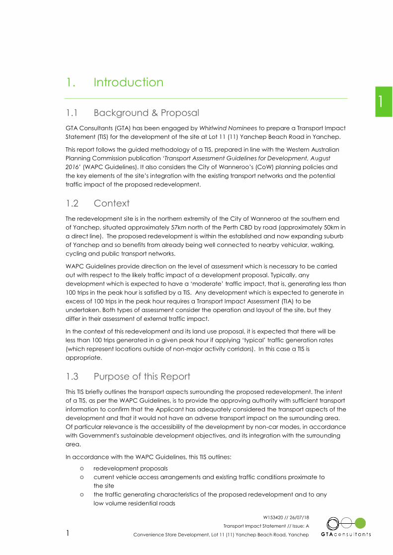
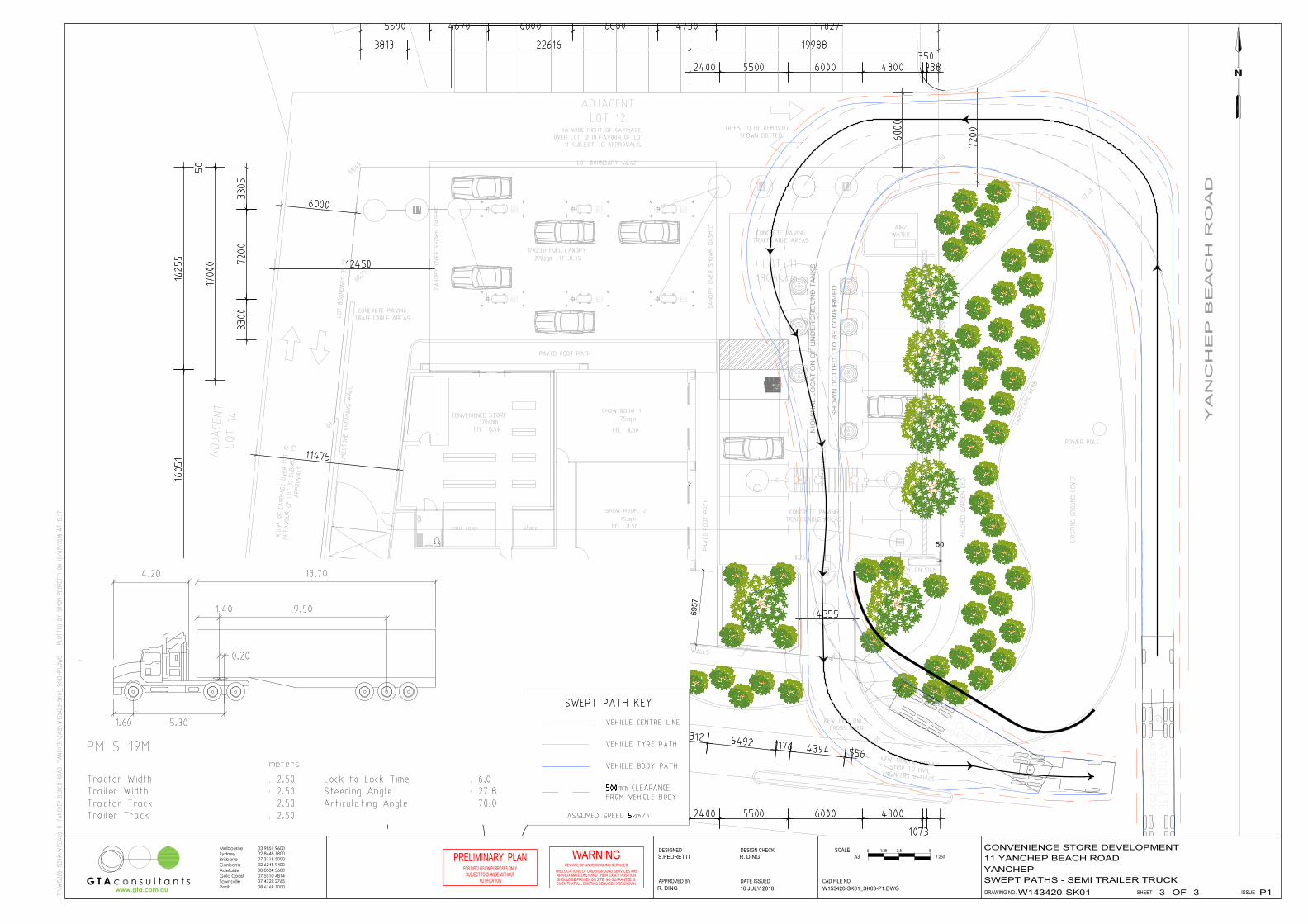
2.7 Loading Areas
Loading for the proposed development is proposed to occur to and from the proposed loading
bay located on the southern side of the building, north of the right of carriageway. A 10.5m long
rubbish collection truck can drive into a service bay on the southern side of the site, north of the
right of carriageway and then reverse out and exit onto Newman Road via the right of
carriageway. Semi-trailer sized fuel delivery trucks can enter via the Yanchep Beach Road
crossover and then exit onto Newman Road via an exit only crossover. This will require
modification of the crossover to allow an apron area to cater for the swept path of the trailer as it
exits the site. Swept path assessments are shown at Attachment B.

W153420 // 26/07/18
Transport Impact Statement // Issue: A
Convenience Store Development, Lot 11 (11) Yanchep Beach Road, Yanchep 7
3. Accessibility Review
3.1 Introduction
This chapter outlines the outcome of a baseline accessibility assessment that was undertaken to
establish the transport provision serving the site and its surrounds. It also recognises that walking
and cycling are encouraged modes of transport and are also secondary modes of travel for
public transport users.
3.2 Access by Road
The development site abuts one Access Road, as classified in the Main Roads WA (MRWA)
Functional Road Hierarchy and one Distributor-B road. Due to the site’s good connections to the
external road network, rat-running the right of carriageway is highly unlikely.
3.2.1 Local Roads
Newman Road is an Access Road bordering the development site to the east and is of a single
carriageway standard, providing one lane for travel in each direction. This road provides direct
driveway access to residential properties with a general urban speed limit of 50km/h and a
capacity of up to 3,000 vehicles a day (indicative). Newman Road is approximately 7.2m wide
between kerbs.
Traffic volumes on Newman Road was estimated based on the number of properties fronting the
road and is estimated at approximately 200 vehicles per day (vpd).
3.2.2 Arterial Roads
Yanchep Beach Road
Yanchep Beach Road runs in an east-west direction with a posted speed limit of 60km/hr. It is
classified as a Distributor-B road according to the MRWA Functional Road Hierarchy, and it is
presently configured as a single carriageway two-lane road with a traffic volume of
approximately 6,950 vpd (from 2016 CoW traffic counts), but the 40m road reserve width suggests
that it will be ultimately configured as a four-lane dual-carriageway carrying around 21,000 vpd
in 2031. This suggests an annual traffic growth of approximately 7.6%. Yanchep Beach Road is
approximately 8.4m wide between kerbs, thus providing a 4.2m wide lane in each direction of
travel. The current two-lane format should be able to cater for up to approximately 15,000 vpd.
Vehicles traveling to/from the site will likely use predominantly the Yanchep Beach Road
crossover in the short to medium term until such time as Yanchep Beach Road is duplicated, at
which time the crossover is expected to become left-in/left-out with the right turn movements
shifted to the intersection of Yanchep Beach Rd/Newman Rd.
3.2.3 Key Intersections
There are two nearby intersections which may be affected by the proposed development. These
are discussed below.
3

W153420 // 26/07/18
Transport Impact Statement // Issue: A
Convenience Store Development, Lot 11 (11) Yanchep Beach Road, Yanchep 8
Yanchep Beach Rd/Newman Rd
These two roads intersect as a three-way T-junction with Yanchep Beach Road the priority road
and Newman Road the terminating road. The sight distances on all approaches were
considered appropriate during the site visit and acceptable for the road environment and
abutting land-uses/property boundaries. There is no sign control, hazard board or holding line on
the Newman Road approach to the intersection.
Newman Rd/Yanchep Beach Rd Service Rd
These two roads intersect as a three-way T-junction with Newman Road the priority road and the
Yanchep Beach Road service road the terminating road. The sight distances on all approaches
were considered appropriate during the site visit and acceptable for the road environment and
abutting land-uses/property boundaries. There is no sign control, hazard board or holding line on
the Yanchep Beach Road service road approach to the intersection.
3.3 Public Transport
It is considered that access to the site via public transport is applicable to all users including
residents and visitors. The nearest bus stops are located within a short walking distance for both
directions of travel to and from Perth. As such the site is conducive to public transport usage.
The site is located approximately 150m (approximately a 1 to 2-minute walk) from bus stops
located on Yanchep Beach Road, east of the site.
These stops service Route 490 running between Two Rocks and Butler Train Station. These services
run approximately every 20 minutes in peak periods in the peak direction.
3.4 Walking and Cycling
The site is located in an area where the walking and cycling infrastructure is either not provided
or very limited. No footpaths have been provided on the local road network and thus access to
and from the site and to between it and nearby bus stops may be problematic for pedestrians.
This is a local area issue for CoW to consider irrespective of the development.
On-site bicycle parking will not be explicitly provided for.
Notwithstanding the above, any Development Application will review and revise the design to
ensure it complies with the provision of the necessary pedestrian network upgrade and bicycle
parking.
3.5 Crash Statistics
MRWA Crash Analysis Reporting System (CARS) provides detailed crash data and covers all
intersections and midblock sections which have had one or more reported road crashes over a
5-year period from 2013 to 2017. It provides detailed crash data for Newman Road, Yanchep
Beach Road and nearby intersections over that period.
Crash data has been reviewed and only one crash was recorded along the mid-block sections,
this being on Yanchep Beach Road. The crash detail is reviewed in more detail below in Table
3.1.

W153420 // 26/07/18
Transport Impact Statement // Issue: A
Convenience Store Development, Lot 11 (11) Yanchep Beach Road, Yanchep 9
Table 3.1: Crash Record for Roads and Intersections/Road Sections in the vicinity of the Subject Site
Location State Ranking Crash Severity Total
Crashes Cost Frequency PDO Medical Hospital Fatal
Yanchep Beach
Rd/Newman Rd N/A [1] 0 0 0 0 0
Newman
Rd/Yanchep
Beach Rd Service
Rd
N/A [1] 0 0 0 0 0
Yanchep Beach
Rd/Newman Rd
to Two Rocks Rd
N/A [2] 1 0 0 0 1
PDO – property damage only, Medical – roadside medical assistance, Hospital – hospitalisation required
[1] State ranking not considered appropriate for a local access road due to no recorded crashes.
[2] State ranking not considered appropriate for a local access road due to being a road section.
The above summary crashes are discussed below in more detail.
Yanchep Beach Road - the single recorded crash involved an animal at night.
This crash rate recorded on Yanchep Beach Road is the equivalent to approximately 0.70 crashes
per million vehicle kilometre (MVkm). This is less than the network average for roads of similar
nature and there does not appear to be an underlying road safety issue which would be
exacerbated by this proposal.
The traffic volumes generated by the development during peak hours and over the course of a
day are considered to be low at approximately 25 vehicles in any one hour in the short term
increasing to approximately 85 in the long term. This traffic is split between in/out vehicle
movements and is further is dispersed over a number of turning movements at the site access
points.
A development of this type, in this location could not be expected to materially alter the existing
frequency and severity of road crashes in the area. Further, the low increase in traffic volumes
could not be expected to adversely affect pedestrians crossing roads, or any cyclists that travel
on-road.
Accordingly, the road safety characteristics of the proposed development are considered
acceptable.
W153420 // 26/07/18
Transport Impact Statement // Issue: A
Convenience Store Development, Lot 11 (11) Yanchep Beach Road, Yanchep 10
4. Trip Generation and Traffic Impact
4.1 Current Traffic Flows
Traffic volumes on the adjacent road network of Yanchep Beach Road and Newman Road were
assessed based on the current traffic counts sourced from CoW and from manual spot counts by
GTA.
Yanchep Beach Road: 6,950 vpd (from a CoW 2016 count) with 8% heavy vehicles
PM Peak: ~8% of the daily volume 185 eastbound, 370 westbound
Newman Road: estimated at 200 vpd
PM Peak: 7 northbound, 13 southbound
Based on the calculated 7.6% per annum growth in traffic from Section 3.2.2, traffic flows by 2019
the estimated time of the opening of the development, should be approximately 8,650 vpd.
4.2 Expected Traffic Flows
With the surrounding residential development having reached maturity (this being Newman
Road), the current traffic volumes are expected to remain relatively unchanged into the near
future on the local street network. Traffic volumes on Yanchep Beach Road have been based on
traffic numbers sourced from an SKM report for the St Andrews development. This study
estimated approximately 21,000vpd on Yanchep Beach Road near the development site in 2031.
With the forecast increase in traffic volumes, it is expected that Yanchep Beach Road will
become a dual carriageway and the proposed crossover onto Yanchep Beach Road will
become left-in/left-out. At that time right traffic that would use the crossover in the short term will
utilise the intersection of Yanchep Beach Rd/Newman Rd. At this time the peak hour flows
expected on Yanchep Beach Road would be in the order of 1,700 vehicles per hour (based on
the current 8% of the expected daily traffic flows).
4.3 Vehicle Types
The types of vehicles accessing the site will be mostly private motor vehicles with the exception
being the semi-trailer fuel delivery truck and rubbish collection truck. Apart from the above, no
traffic to and from the site is expected to be truck type traffic, except for vehicles similar in size to
furniture delivery vans.
4.4 Traffic Generation and Traffic Impact
In order to estimate the trip generation associated with the proposed development, reference
has been made to trip rates within the WAPC Guidelines (which often refer to the RTA Guidelines,
NSW) and the Trip Generation 9th edition, 2012 - Institute of Transportation Engineers (ITE),
Washington, USA. These trip rates are considered to accommodate the general vehicle activity
at the site incorporating:
Convenience Store
Petrol Pumps
Show Rooms.
4

W153420 // 26/07/18
Transport Impact Statement // Issue: A
Convenience Store Development, Lot 11 (11) Yanchep Beach Road, Yanchep 11
Table 4.1: Estimated Traffic Generation
Land Use Peak Hour Rates
(vph two-way)
Short Term Peak Hour Trip
Generation Estimates (vph)
(using PM peak for worst
case)
Long Term Peak Hour Trip
Generation Estimates (vph)
(using PM peak for worst
case)
Convenience Store with
Petrol Pumps 0.04 / passing traffic 35 84
Table 4.2: Estimated Traffic Generation - Total
Trip type Trips IN Trips OUT
PM Vehicle (short term) 18 18
PM Vehicle (long term) 42 42
Assumed in/out split is 50%/50% in the in the PM peak as per WAPC Guidelines.
Based on the above, the total traffic generation of the development site is expected to be in the
order of 350 vehicular trips in a day in the short-term (at opening in say 2019) with 35 vehicle
movements in a typical evening peak hour. As traffic flows increase in the longer term the traffic
generated is expected to increase to approximately 840 trips per day with 84 in the peak hour.
With regards to the intersections, Table 2.4 from the Austroads publication, Guide to Traffic
Management Part 6 – Intersections, Interchanges and Crossings provides advice as to
intersection and crossover performance in peak flow conditions about possible further analysis.
This is summarised in Table 4.3. If the calculated expected traffic flows for this development
exceed those shown in Table 4.3 further assessment is typically required.
Table 4.3: Austroads Guidelines
Major Road Type Major Road Flow (two-way,
vph)
Minor Road Flow (two-way,
vph)
Two-lane 400 250
500 200
650 100
Four-lane 1,000 100
1,500 50
2,000 25
Examining the expected traffic flows at the crossover and nearby affected intersections for the
proposed development, Table 4.4 is derived.
Table 4.4: Comparison to Austroads Guidelines
Intersection Major Road Flow (two-way,
vph)
Minor Road Flow (two-way,
vph)
Crossover (short term) 555 35
Yanchep Beach Rd/Newman Rd
(short term) 555 20
Crossover (long term) 1,700 50
Yanchep Beach Rd/Newman Rd
(long term) 1,700 55
From the above it can be seen that in the short-term the Yanchep Beach Rd/Newman Rd
intersection and crossover are expected to have traffic volumes significantly less than shown in
green in Table 4.3. Thus, there is no need for these to be examined in further detail using analysis
W153420 // 26/07/18
Transport Impact Statement // Issue: A
Convenience Store Development, Lot 11 (11) Yanchep Beach Road, Yanchep 12
software such as SIDRA Intersection. Under these flow conditions, the level of service is expected
to be at A or similar with minimal delays and queues. However, in the long term the intersection
and crossover are expected to have traffic flows exceeding these levels as shown in red in Table
4.3. These were therefore assessed utilising SIDRA Intersection with the results shown below for the
critical movements for each.
Yanchep Beach Road/Newman Road
The existing performance of this intersection is shown in Table 4.5.
Table 4.5: Yanchep Beach Rd/Newman Rd Intersection – Long Term Intersection Operation in PM
Peak
Critical Turning Movements
Approach Mvt. Short Lane Length DOS LOS Average
Delay (sec)
95th
Percentile
Queue (m)
South RT NA 0.11 C 22s 2m (0-1 cars)
West RT 75m 0.06 C 15s 2m (0-1 cars)
DOS – Degree of Saturation, # - Intersection DOS, LOS – Level of Service
Even with the expected traffic volumes on Yanchep Beach Road there is expected to be minimal
delays and queues for the critical turns and thus be acceptable.
Yanchep Beach Road Crossover
The existing performance of this crossover is shown in Table 4.5Table 4.6.
Table 4.6: Yanchep Beach Rd Crossover – Long Term Operation in PM Peak
Critical Turning Movements
Approach Mvt. Short Lane Length DOS LOS Average
Delay (sec)
95th
Percentile
Queue (m)
South LT NA 0.04 A 3s 1m (0-1 cars)
Overall the crossover is expected to operate satisfactorily in the PM peak with minimal delays
and queues.
4.5 Internal Vehicle Queues
The internal vehicle queueing at the fuel pumps were checked using an M/M/c queuing model
for the 12 fuel pumps and assuming a 10-minute service time at each pump. This was assessed
for the rate of the expected short-term arrivals (approximately 18 per hour) and then the rate of
the expected long-term arrivals (approximately 42 per hour).
Table 4.7: Queues at Refuelling Positions
Approach Average Queue (veh) 95th %ile Queue (veh) 99th %ile Queue (veh)
Short Term 3 6 8
Long Term 7 12 15
From the above, with the maximum expected arrival rate of 42 vehicles in an hour in the long-
term, all the vehicles will be able to be contained on-site, either stopped at the fuel pumps or
queued on-site waiting for a free fuel pump. With 12 refuelling positions all vehicles can be
catered for most expected arrival patterns, this being the 95th percentile, typically the threshold
and which queuing areas are designed to. Even with the highest expected queuing (allowing for
99% of queues in the long-term which is considered higher than designs should reasonably cater
W153420 // 26/07/18
Transport Impact Statement // Issue: A
Convenience Store Development, Lot 11 (11) Yanchep Beach Road, Yanchep 13
for) there is expected to be approximately 3 cars queued (15 less 12 refuelling) waiting for a free
fuel pump and these could fit within the site.
4.6 Level of Service Concepts
The level of service concept describes the quality of traffic service in terms of six levels,
designated A to F, with level of service A (LOS A) representing the best operating condition (i.e.
at or close to free flow), and level of service F (LOS F) the worst (i.e. forced flow). More
specifically:
LOS A: Primarily free flow operations at average travel speeds, usually about 90%
of the FFS (free flow speed) for the given street class. Vehicles are completely
unimpeded in their ability to manoeuvre within the traffic stream. Control delay at
signalised intersections is less than 10 seconds. At non-signalised movements at
intersections the average control delay is less than 10 seconds;
LOS B: Reasonably unimpeded operations at average travel speeds, usually about
70% of the FFS for the street class. The ability to manoeuvre within the traffic stream
is only slightly restricted, and control delays at signalised intersections are between
10 and 20 seconds. At non-signalised movements at intersections the average
control delay is between 10 and 15 seconds;
LOS C: Stable operations; however, ability to manoeuvre and change lanes in mid-
block locations may be more restricted than at LOS B, and longer queues, adverse
signal coordination, or both may contribute to lower average travel speeds of
about 50% of the FFS for the street class. Signalised intersection delays are
between 20 and 35 seconds. At non-signalised movements at intersections the
average control delay is between 15 and 25 seconds;
LOS D: A range in which small increases in flow may cause substantial increases in
delay and decreases in travel speed. LOS D may be due to adverse signal
progression, inappropriate signal timing, high volumes, or a combination of these
factors. Average travel speeds are about 40% of FFS. Signalised intersection
delays are between 35 and 55 seconds. At non-signalised movements at
intersections the average control delay is between 25 and 35 seconds;
LOS E: Characterised by significant delays and average travel speeds of 33% of
the FFS or less. Such operations are caused by a combination of adverse
progression, high signal density, high volumes, extensive delays at critical
intersections (between 55 and 80 seconds), and inappropriate signal timing. At
non-signalised movements at intersections the average control delay is between
35 and 50 seconds; and,
LOS F: Characterised by urban street flow at extremely low speeds, typically 25% to
33% of the FFS. Intersection congestion is likely at critical signalised locations, with
high delays (in excess of 80 seconds), high volumes, and extensive queuing. At
non-signalised movements at intersections the average control delay is greater
than 50 seconds.
In addition to the above:
Average Delay: is the average of all travel time delays for vehicles through the
intersection
Queue: is the queue length below which 95% of all observed queue
lengths fall.
W153420 // 26/07/18
Transport Impact Statement // Issue: A
Convenience Store Development, Lot 11 (11) Yanchep Beach Road, Yanchep 14
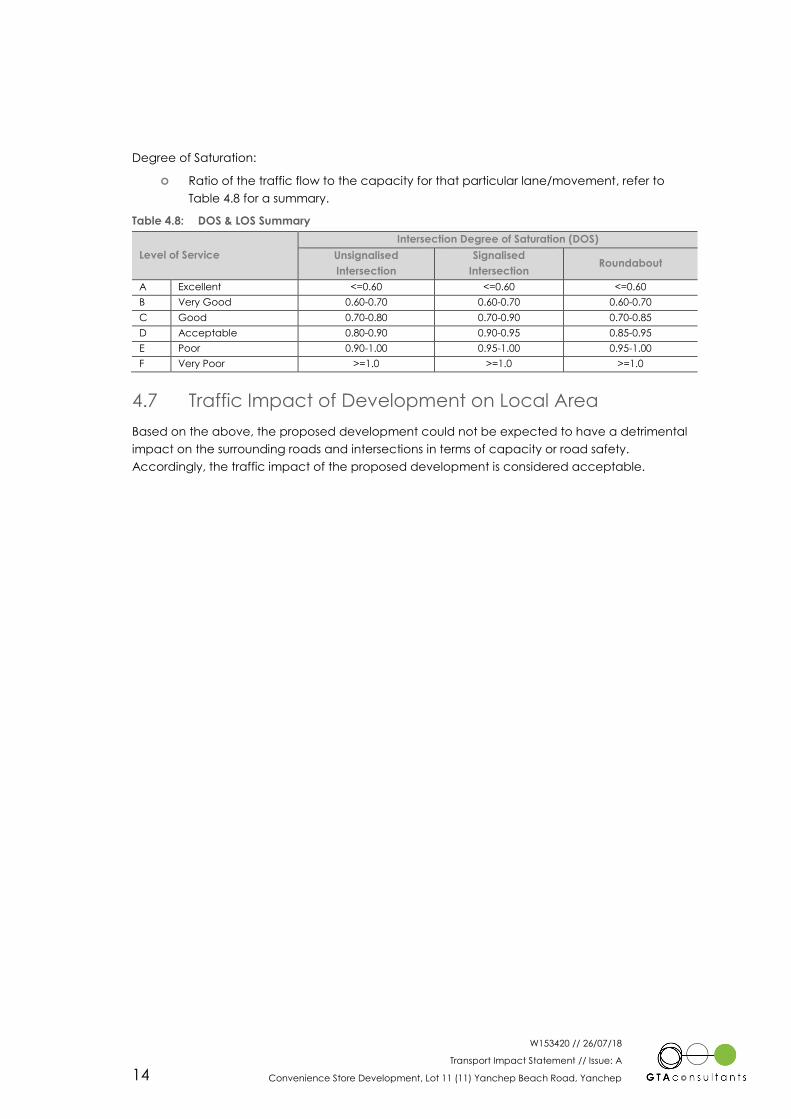
Degree of Saturation:
Ratio of the traffic flow to the capacity for that particular lane/movement, refer to
Table 4.8 for a summary.
Table 4.8: DOS & LOS Summary
Level of Service
Intersection Degree of Saturation (DOS)
Unsignalised
Intersection
Signalised
Intersection Roundabout
A Excellent <=0.60 <=0.60 <=0.60
B Very Good 0.60-0.70 0.60-0.70 0.60-0.70
C Good 0.70-0.80 0.70-0.90 0.70-0.85
D Acceptable 0.80-0.90 0.90-0.95 0.85-0.95
E Poor 0.90-1.00 0.95-1.00 0.95-1.00
F Very Poor >=1.0 >=1.0 >=1.0
4.7 Traffic Impact of Development on Local Area
Based on the above, the proposed development could not be expected to have a detrimental
impact on the surrounding roads and intersections in terms of capacity or road safety.
Accordingly, the traffic impact of the proposed development is considered acceptable.
W153420 // 26/07/18
Transport Impact Statement // Issue: A
Convenience Store Development, Lot 11 (11) Yanchep Beach Road, Yanchep 15
5. Findings, Summary & Conclusions
As a result of the traffic analysis undertaken for the proposed development at Lot 11 (11)
Yanchep Beach Road in Yanchep:
i The impacts of the traffic volumes associated with the development on the road
network are considered acceptable now and in the future;
ii The development should initially generate in the order of 350 vehicular trips per day
with 35 of these in the PM peak;
iii In the longer term the development should generate in the order of 840 vehicular trips
per day with 84 of these in the PM peak;
iv The parking area layout is suitable with an appropriate number of parking bays
provided for the demographic use of the development;
v Fuel trucks and rubbish trucks will be able to enter and exit the site;
vi The adjacent footpath network is non-existent and is proposed to be upgraded on the
immediate site frontage of the proposed development;
vii There is no requirement for any of the road network to be modified for vehicular
movement purposes as a result of this development.
5
W153420 // 26/07/18
Transport Impact Statement // Issue: A
Convenience Store Development, Lot 11 (11) Yanchep Beach Road, Yanchep
Development Plans
Ap
pe
nd
ix A
GROUND0 mm
CEILING LINE3000 mm
FRONT PARAPET4450 mm
0 mm
© COPYRIGHT
THIS DESIGN AND / OR DRAWING IS CONFIDENTIAL
AND SHALL REMAIN THE PROPERTY OF VESPOLI
CONSTRUCTIONS. IT MUST NOT BE REPRODUCED,
COPIED OR ALTERED WITHOUT THE EXPRESSED
APPROVAL OF VESPOLI CONSTRUCTIONS.
CONTRACTORS SHALL CHECK ALL DIMENSIONS AND CONDITIONS ON SITE
PRIOR TO COMMENCING FABRICATION OR CONSTRUCTION. ANY
DISCREPANCIES TO BE BROUGHT TO THE SUPERVISORS ATTENTION.
DO NOT SCALE FROM DRAWINGS.
THE DESIGNER RESERVES THE RIGHT TO ALTER DIMENSIONS ON SITE TO SUIT
CONSTRUCTION, ENGINEERING OR SITE CONDITIONS
UNLESS OTHERWISE NOTED, RETAINING WALLS, DEMOLITION,SEWER PILING,
SUBSOIL DRAINS, BLASTING OR OTHER SITE WORKS ARE ALL AT OWNER'S
EXPENSE
Unit 41 CEDRIC STREET, STIRLING
Western Australia 6021
t. 08 9209 1800 e. [email protected]
f. 08 9209 1899 w. www.vespoli.com.au
ACN 113 413 077 ABN 65 545 929 538
23.05.18
1:200@A1
MWS
GV
1 OF X
A

W153420 // 26/07/18
Transport Impact Statement // Issue: A
Convenience Store Development, Lot 11 (11) Yanchep Beach Road, Yanchep
Appendix B
Large Vehicle Swept Paths
Ap
pe
nd
ix B

YA
NC
HE
P B
EA
CH
R
OA
D
NEWMAN ROAD
NIO
MIN
AL
LO
CA
TIO
N O
F U
ND
ER
GR
OU
ND
TA
NK
S
SH
OW
N D
OT
TE
D.
TO
BE
CO
NF
IRM
ED
50
5957
3430
4644
0 1.25 2.5 5
1:250A3SCALEDESIGNED
APPROVED BY DATE ISSUED
DESIGN CHECK
DRAWING NO. SHEET ISSUE
CAD FILE NO.
WARNINGTHE LOCATIONS OF UNDERGROUND SERVICES ARE
APPROXIMATE ONLY AND THEIR EXACT POSITIONSHOULD BE PROVEN ON SITE. NO GUARANTEE IS
GIVEN THAT ALL EXISTING SERVICES ARE SHOWN.
BEWARE OF UNDERGROUND SERVICES
c o n s u l t a n t sG T A
MelbourneSydneyBrisbaneCanberraAdelaideGold CoastTownsvillePerth
03 9851 960002 8448 180007 3113 500002 6243 940008 8334 360007 5510 481407 4722 276508 6169 1000www.gta.com.au
PRELIMINARY PLANFOR DISCUSSION PURPOSES ONLY
SUBJECT TO CHANGE WITHOUTNOTIFICATION
OFW153420-SK01_SK03-P1.DWG
S.PEDRETTI
R. DING
R. DING
16 JULY 2018
CONVENIENCE STORE DEVELOPMENT11 YANCHEP BEACH ROADYANCHEPSWEPT PATHS - GARBAGE TRUCK ENTERING
W143420-SK01 1 3 P1

YA
NC
HE
P B
EA
CH
R
OA
D
NEWMAN ROAD
NIO
MIN
AL
LO
CA
TIO
N O
F U
ND
ER
GR
OU
ND
TA
NK
S
SH
OW
N D
OT
TE
D.
TO
BE
CO
NF
IRM
ED
50
5957
3430
4644
0 1.25 2.5 5
1:250A3SCALEDESIGNED
APPROVED BY DATE ISSUED
DESIGN CHECK
DRAWING NO. SHEET ISSUE
CAD FILE NO.
WARNINGTHE LOCATIONS OF UNDERGROUND SERVICES ARE
APPROXIMATE ONLY AND THEIR EXACT POSITIONSHOULD BE PROVEN ON SITE. NO GUARANTEE IS
GIVEN THAT ALL EXISTING SERVICES ARE SHOWN.
BEWARE OF UNDERGROUND SERVICES
c o n s u l t a n t sG T A
MelbourneSydneyBrisbaneCanberraAdelaideGold CoastTownsvillePerth
03 9851 960002 8448 180007 3113 500002 6243 940008 8334 360007 5510 481407 4722 276508 6169 1000www.gta.com.au
PRELIMINARY PLANFOR DISCUSSION PURPOSES ONLY
SUBJECT TO CHANGE WITHOUTNOTIFICATION
OFW153420-SK01_SK03-P1.DWG
S.PEDRETTI
R. DING
R. DING
16 JULY 2018
CONVENIENCE STORE DEVELOPMENT11 YANCHEP BEACH ROADYANCHEPSWEPT PATHS - GARBAGE TRUCK EXITING
W143420-SK01 2 3 P1
YA
NC
HE
P B
EA
CH
R
OA
D
NEWMAN ROAD
NIO
MIN
AL
LO
CA
TIO
N O
F U
ND
ER
GR
OU
ND
TA
NK
S
SH
OW
N D
OT
TE
D.
TO
BE
CO
NF
IRM
ED
50
59573
430
4644
0 1.25 2.5 5
1:250A3SCALEDESIGNED
APPROVED BY DATE ISSUED
DESIGN CHECK
DRAWING NO. SHEET ISSUE
CAD FILE NO.
WARNINGTHE LOCATIONS OF UNDERGROUND SERVICES ARE
APPROXIMATE ONLY AND THEIR EXACT POSITIONSHOULD BE PROVEN ON SITE. NO GUARANTEE IS
GIVEN THAT ALL EXISTING SERVICES ARE SHOWN.
BEWARE OF UNDERGROUND SERVICES
c o n s u l t a n t sG T A
MelbourneSydneyBrisbaneCanberraAdelaideGold CoastTownsvillePerth
03 9851 960002 8448 180007 3113 500002 6243 940008 8334 360007 5510 481407 4722 276508 6169 1000www.gta.com.au
PRELIMINARY PLANFOR DISCUSSION PURPOSES ONLY
SUBJECT TO CHANGE WITHOUTNOTIFICATION
OFW153420-SK01_SK03-P1.DWG
S.PEDRETTI
R. DING
R. DING
16 JULY 2018
CONVENIENCE STORE DEVELOPMENT11 YANCHEP BEACH ROADYANCHEPSWEPT PATHS - SEMI TRAILER TRUCK
W143420-SK01 3 3 P1

Melbourne
A Level 25, 55 Collins Street
PO Box 24055
MELBOURNE VIC 3000
P +613 9851 9600
Brisbane
A Level 4, 283 Elizabeth Street
BRISBANE QLD 4000
GPO Box 115
BRISBANE QLD 4001
P +617 3113 5000
Adelaide
A Suite 4, Level 1, 136 The Parade
PO Box 3421
NORWOOD SA 5067
P +618 8334 3600
Townsville
A Level 1, 25 Sturt Street
PO Box 1064
TOWNSVILLE QLD 4810
P +617 4722 2765
Sydney
A Level 6, 15 Help Street
CHATSWOOD NSW 2067
PO Box 5254
WEST CHATSWOOD NSW 1515
P +612 8448 1800
Canberra
A Tower A, Level 5,
7 London Circuit
Canberra ACT 2600
P +612 6243 4826
Gold Coast
A Level 9, Corporate Centre 2
Box 37, 1 Corporate Court
BUNDALL QLD 4217
P +617 5510 4800
F +617 5510 4814
Perth
A Level 27, 44 St Georges Terrace
PERTH WA 6000
P +618 6361 4634
www.gta.com.au www.gta.com.au