Embed Size (px)
Citation preview
Geological Society of AmericaSpecial Paper 365
2002
49
Controls on orogenesis along an ocean-continent margin transitionin the Jura-Cretaceous Peninsular Ranges batholith
K.L. Schmidt*Natural Sciences, Lewis-Clark State College, Lewiston, Idaho 83501, USA
P.H. WetmoreDepartment of Earth Sciences, University of Southern California, Los Angeles, California 90089-0740, USA
S.E. JohnsonDepartment of Geological Sciences, University of Maine at Orono, Orono, Maine 04469-5790, USA
S.R. PatersonDepartment of Earth Sciences, University of Southern California, Los Angeles, California 90089-0740, USA
ABSTRACT
The Jura-Cretaceous Peninsular Ranges batholith (PRb) of southern and BajaCalifornia is a remarkable example of a zoned batholith containing distinct oceanic(western) and continental (eastern) basements. The transition between these base-ments is marked by a crustal-scale boundary along which distinct volcano-sedimentary, structural, and metamorphic histories evolved during Mesozoic orogen-esis. Our work across this boundary in the Sierra San Pedro Martir of Baja California,Mexico indicates that it controlled a number of processes in the PRb including mag-matism, the location of forearc or intraarc basins, and the locus and extent of con-tractional deformation and denudation. However, our work farther north indicatesthat notable differences occur along strike in the character of the western arc andtransition zone, and these differences are most pronounced across the modern AguaBlanca fault. This fault was also active in the Mesozoic, at which time it separatedthe western zone into northern and southern arc segments.
In the northern half of the batholith, the western arc (Santiago Peak Volcanics)lie in depositional contact with Triassic(?)-Jurassic sediments that mostly receiveddetritus of North American origin and show a long history of contractional defor-mation and late extensional overprint. We concur that this part of the batholithevolved in Jura-Cretaceous time across an inherited ocean-continent crustal join. Incontrast, south of the AGUA BLANCA FAULT, the boundary between the westernarc (Alisitos) and transitional zones is marked by reverse mylonite shear zones thattypically correspond with inverted metamorphic gradients and sharp steps in maxi-mum pressures and cooling histories. Here the transition zone contains basins thatcollected mostly volcanogenic detritus during the Late Jurassic-Early Cretaceous andpreserve a history of long-lived contractional deformation including shear zone de-velopment during collision. Thus, although both northern and southern segments ofthe transition zone share similarities in their plutonic, structural, metamorphic, and
Schmidt, K.L., Wetmore, P.H., Johnson, S.E., and Paterson, S.R., 2002, Controls on orogenesis along an ocean-continent margin transition in the Jura-CretaceousPeninsular Ranges batholith, in Barth, A., ed., Contributions to Crustal Evolution of the Southwestern United States: Boulder, Colorado, Geological Society ofAmerica Special Paper 365, p. 49–71.
*E-mail: [email protected]
K.L. Schmidt et al.50
denudational histories only the southern segment experienced collision. These obser-vations indicate that the crustal-scale boundary strongly controlled subsequent evo-lution but that collision was not the major driving process for orogenesis.
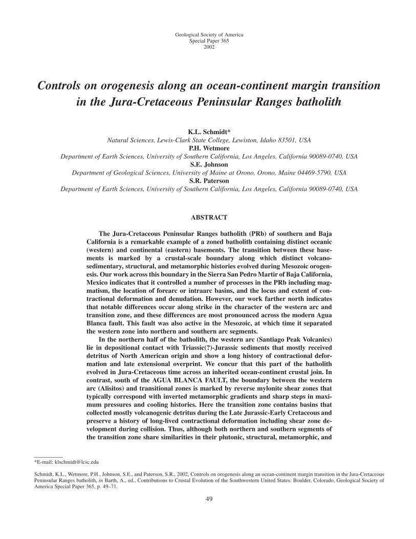
Figure 1. Map of western North Amer-ica showing major Mesozoic Cordille-ran batholiths and selected Paleozoic-Mesozoic tectonic features of thesouthwest North American margin dis-cussed in text. Possible continuation ofOuachita-Marathon suture across Mex-ico from Stewart (1988).
IDAHO
PENINSULARRANGES
SIERRANEVADA
COASTRANGE
ALASKA-ALEUTIAN RANGE
500 km
Mexico
USA
Canada
Alaska
Gulf ofMexico?
?
?
?
J Mojave-Sonoramegasearor olderstructure
P-T Ouachita-Marathonsuture
R
P-T Golcondathrust
R Pz miogeocline-craton hingeline
INTRODUCTION
Mesozoic batholiths emplaced along much of the Cordil-lera show an increasing continental basement signature fromtheir oceanic to landward positions. In many cases it can bedemonstrated that the more outboard assemblages in these bath-oliths evolved on oceanic to transitional crust. A classic ex-ample of one of these oceanic to continental basement transi-tions occurs in the Jura-Cretaceous Peninsular Ranges batholith(PRb) of the southern Cordillera, which extends �800 km fromRiverside California to the 28th parallel in Baja California (Fig.1). The transition in this batholith between a western zone withstrong oceanic basement affinity and an eastern zone of strongcontinental affinity is narrow and sharply defined by across-strike changes in the petrology and geochemistry of plutons(e.g., Silver et al., 1979; DePaolo, 1981; Gastil et al., 1990;Walawender et al., 1991, Tate and Johnson, 2000). This zone
is particularly striking because a number of other geologicalfeatures also define it including a belt of distinctive clastic tovolcaniclastic metasediments (e.g., Gastil et al., 1975; Gastiland Miller, 1984; Gastil, 1993), a discrete belt of contractionalstructures (e.g., Gastil et al., 1975; Todd et al., 1988; Thomsonand Girty, 1994; Johnson et al., 1999a; Schmidt, 2000), and asharp contrast between western shallow and eastern deepercrustal levels (e.g., Todd et al., 1988; Grove, 1994). Theseacross-strike transitions are a hallmark of the PRb, perhaps bet-ter developed here than in any other batholith in the world.
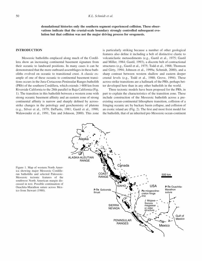
Three tectonic models have been proposed for the PRb, inpart to explain the characteristics of the transition zone. Theseinclude construction of the Mesozoic batholith across a pre-existing ocean-continental lithosphere transition, collision of afringing oceanic arc by backarc basin collapse, and collision ofan exotic island arc (Fig. 2). The first and most fixist model forthe batholith, that of an inherited pre-Mesozoic ocean-continent
Controls on orogenesis along an ocean-continent margin transition 51
Early Cretaceous
mid- Late Cretaceous
C) Collision of exoticwestern island arc
Extinct/ active magmatism
Western batholith crust
Transitional batholith crust
Eastern batholith crust
Oceanic crust
late Early Cretaceous flysch basin
mid - Late Cretaceous
Late Jurassic -Early Cretaceous
B) Backarc extension,development of western fringing arc,followed by collapse of marginalbasin
Triassic - Late Cretaceous
A) Arc built acrosspre-Mesozoic crustal join
W E
remnantmagmatism
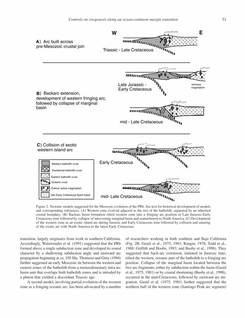
Figure 2. Tectonic models suggested for the Mesozoic evolution of the PRb. See text for historical development of modelsand corresponding references. (A) Western zone evolved adjacent to the rest of the batholith, separated by an inheritedcrustal boundary. (B) Backarc basin formation rifted western zone into a fringing arc position in Late Jurassic-EarlyCretaceous time followed by collapse of intervening marginal basin and reattachment to North America. (C) Developmentof the western zone as an exotic island arc during Jurassic and Early Cretaceous time followed by collision and suturingof the exotic arc with North America in the latest Early Cretaceous.
transition, largely originates from work in southern California.Accordingly, Walawender et al. (1991) suggested that the PRbformed above a single subduction zone and developed its zonedcharacter by a shallowing subduction angle and eastward arcpropagation beginning at ca. 105 Ma. Thomson and Girty (1994)further suggested an early Mesozoic tie between the western andeastern zones of the batholith from a metasedimentary intra arcbasin unit that overlaps both batholith zones and is intruded bya pluton that yielded a discordant Triassic age.
A second model, involving partial evolution of the westernzone as a fringing oceanic arc, has been advocated by a number
of researchers working in both southern and Baja California(Fig. 2B; Gastil et al., 1975, 1981; Rangin, 1978; Todd et al.,1988; Griffith and Hoobs, 1993; and Busby et al., 1998). Theysuggested that back-arc extension, initiated in Jurassic time,rifted the western, oceanic part of the batholith to a fringing arcposition. Collapse of the marginal basin located between thetwo arc fragments, either by subduction within the basin (Gastilet al., 1975, 1981) or by crustal shortening (Busby et al., 1998),occurred in the mid-Cretaceous, followed by eastward arc mi-gration. Gastil et al. (1975, 1981) further suggested that thenorthern half of the western zone (Santiago Peak arc segment)
K.L. Schmidt et al.52
was sutured to the margin in Early Cretaceous time, whereasthe southern half (Alisitos arc segment) collided in mid- to LateCretaceous time. They proposed that the two segments wereseparated by an ancestral transform fault that has been reacti-vated to form the presently active Agua Blanca fault.
A third model, built on the ideas of others such as Gastilet al. (1975, 1978; 1981), Todd et al. (1988), and Griffith andHoobs (1993), is that the western zone is an exotic island arccomplex, which was sutured to the North American margin inthe Early Cretaceous (Fig. 2C; Sedlock et al., 1993; Johnson etal., 1999a; Dickinson and Lawton, 2001). Intrinsic to this modelis evidence that western zone rocks show little influence ofcontinental crustal material including lack of zircon inheritancein both plutonic and volcanic rocks, paucity of quartz and K-feldspar components in volcanogenic sediments, and plutonswith strong island arc geochemical and isotopic affinities (Sil-ver and Chappell, 1988; Johnson et al., 1999a). The above au-thors differ on details of facing of subduction zone(s) thatclosed the intervening ocean basin and only one possible sce-nario is shown in Figure 2C.
The range of possible tectonic scenarios discussed abovearises partly from researchers working in different areas sepa-rated by extensive regions that are poorly known. Most of thisprevious work has occurred in the northern half of the batholith.Our work has focused on the less studied section in the SierraSan Pedro Martir region of Baja California, Mexico, where re-lationships in the transition zone of the batholith are particularlywell exposed. We have found several significant differencesbetween relationships in this region and those described fromfarther north, suggesting that the northern and southern parts ofthe PRb do not share an identical evolution. Moreover, pub-lished data as well as our own reconnaissance work suggest thatthese relationships change across the presently active AguaBlanca fault, and thus, we concur with Gastil et al. (1975, 1981)that the Agua Blanca fault has a Mesozoic history and servedas an important tectonic break during PRb evolution.
Below we examine the transition zone in the PRb and itsrelationship to the western and eastern zones. We further ex-plore the implications of these relationships for tectonic modelsof the PRb acknowledging that other significant problems be-yond the scope of this paper remain with regards to the rela-tionship of the PRb to North America (e.g., paleomagnetic evi-dence that the batholith evolved in a more southerly location,Hagstrum et al., 1985 and suggestions for a W-northwest-striking Jurassic strike slip fault, the Mojave Sonora Megashearof Silver and Anderson, 1974, or older transform fault, Dick-inson, 2000). We argue that the transition zone is a distinctentity in the PRb and has been closely tied to the eastern zoneof the batholith throughout the Mesozoic. General aspects ofthe transition zone appear to remain consistent along-strike be-tween northern and southern parts of the batholith includingcomparable degrees of Mesozoic basin formation, contractionaldeformation, and metamorphic and denudation histories. How-ever, specific aspects appear to change across the Agua Blanca
fault, including the age of basins and the type of detritus theycollected as well as the location and timing of deformation inmylonite shear zones. These differences occur in concert withdistinct variation between northern and southern parts of thewestern oceanic arcs, supporting our contention that the south-ern, Alisitos arc segment collided with the margin in Early Cre-taceous time, whereas the northern, Santiago Peak arc segmentevolved as an inherited oceanic terrane, across which the bath-olith was constructed during Jura-Cretaceous time (Wetmoreand Paterson, 2000). Our studies suggest that collision of theAlisitos island arc was only one episode in a long history oforogenesis in the PRb. Other processes must have driven oro-genesis along a much larger portion of the PRb during Jura-Cretaceous time masking the effects of local collision.
PREVIOUS WORK ESTABLISHING THE ZONEDNATURE OF THE PENINSULAR RANGESBATHOLITH
The Peninsular Ranges batholith traditionally has been di-vided into distinct western and eastern zones with the boundarydefined by a number of different criteria that include: prebath-olithic assemblages; pluton lithologies; metamorphic histories;major, trace, and isotopic geochemistry of plutons; geophysi-cally defined crustal structure; and magmatic and cooling his-tories. Typically, this boundary between western and easternzones is designated by a single line based on one or more ofthe above criteria. This practice is problematic because the lo-cation of this boundary changes depending on which criteriaare chosen to differentiate the two zones (compare for examplethe location of the d18O and magnetite/ilmenite lines on Figure3). Moreover, some criteria such as the d18O step in plutonsvary sharply across a distance �5 km, while others, such asinitial Sr isotopic values vary across distances �40 km. Thus,in contrast to previous convention, it may be more accurate todefine a transitional zone in the batholith, which occurs betweenwestern and eastern zones and that encompasses the transitionsin criteria listed above. Below we argue that this transitionalzone is geologically distinct from the crustal zones to eitherside, and variation in geochemical, geophysical, and geologicalparameters by which it is defined along strike are critical tounderstanding the tectonic evolution of the PRb.
The Peninsular Ranges batholith intrudes a series of north-west-trending, prebatholithic, lithostratigraphic assemblages(Fig. 4) that include from west to east (Gastil, 1993): (1) aTriassic-Cretaceous continental borderland assemblage (notshown in Figure 4); (2) a Jura-Cretaceous volcanic arc and fore-arc assemblage; (3) a Triassic(?)-mid Cretaceous clastic andvolcaniclastic flysch assemblage of uncertain tectonic origin;(4) an Ordovician-Permian slope-basin clastic assemblage; and(5) an upper Proterozoic-Permian miogeoclinal carbonate-siliciclastic assemblage. These have been assigned to distinctbelts that include a western zone consisting of the borderlandand volcanic arc assemblages and an eastern zone composed of

Controls on orogenesis along an ocean-continent margin transition 53
116
30
114 112
32
USAMex
Ensenada
Guaymas
La Paz
SanFelipe
PacificOcean
115 110
30
25
Mexico
Gulf of California
USA 100 km
San Diego
Ensenada
SanFelipe
PuertecitosSanQuintin
ElRosario
Bahia de LA
gabbro/tonalite line
0.706
0.704
0.706
87Sr/86Sr isopleth
Magnetite/Ilmenite line
8.5 δ18O isopleth
REE zones
USAMex
SSPM
Agua Blancafault
Stratigraphicallydefined boundaries
Figure 3. Map of the Peninsular Rangesbatholith showing the magnetite-ilmen-ite line, Rare Earth Element belts, se-lected isopleths for initial 87Sr/86Sr andd18OSMOW, and the gabbro/tonaliteline. From Gastil et al. (1990), Grometand Silver (1987), Taylor and Silver(1978), Silver et al. (1979), and Silverand Chappell (1988). Also shown arecontacts between flysch strata of thetransition zone and strata in the westernand eastern zones to either side.
both Paleozoic clastic and carbonate-siliciclastic assemblages.In this paper we argue that the intervening Mesozoic flyschassemblage represents the transitional zone because its extentencompasses the transitions in the known geochemical and iso-topic parameters in the batholith (Fig. 3).
Plutons intruding the above units vary from tonalite, gab-bro, quartz gabbro, and diorite in the west to mostly tonaliteand granodiorite with some granite and rare gabbro in the east.Gastil (1983) delineated “gabbro” and “tonalite” belts on west-ern and eastern sides of the peninsula respectively, and “gran-odiorite-granite” and “alkaline” belts further east in mainlandMexico (Fig. 4). Metamorphic grade changes from lowergreenschist grade in the westernmost part of the western zone,
to andalusite-sillimanite-bearing lower amphibolite grade in thetransition zone, to sillimanite-bearing upper amphibolite gradein the eastern zone (Todd et al., 1988). Reconnaissance Al-in-hornblende studies on plutons in southern California by Agueand Brimhall (1988), Butler et al. (1991), and Ague and Bran-don (1992) indicated pressures up to 6 kbar in the eastern zoneand �2 kbar in the western zone.
Most geochemical and isotopic work in the PRb has beenfocused on the younger undeformed plutons in southern Cali-fornia, with little attention given to plutons farther south, aswell as older, gneissic plutons that outcrop extensively in thePRb. Across-strike variation in pluton chemistry, including ma-jor element (Baird et al., 1974; Baird and Miesch, 1984), and
K.L. Schmidt et al.54
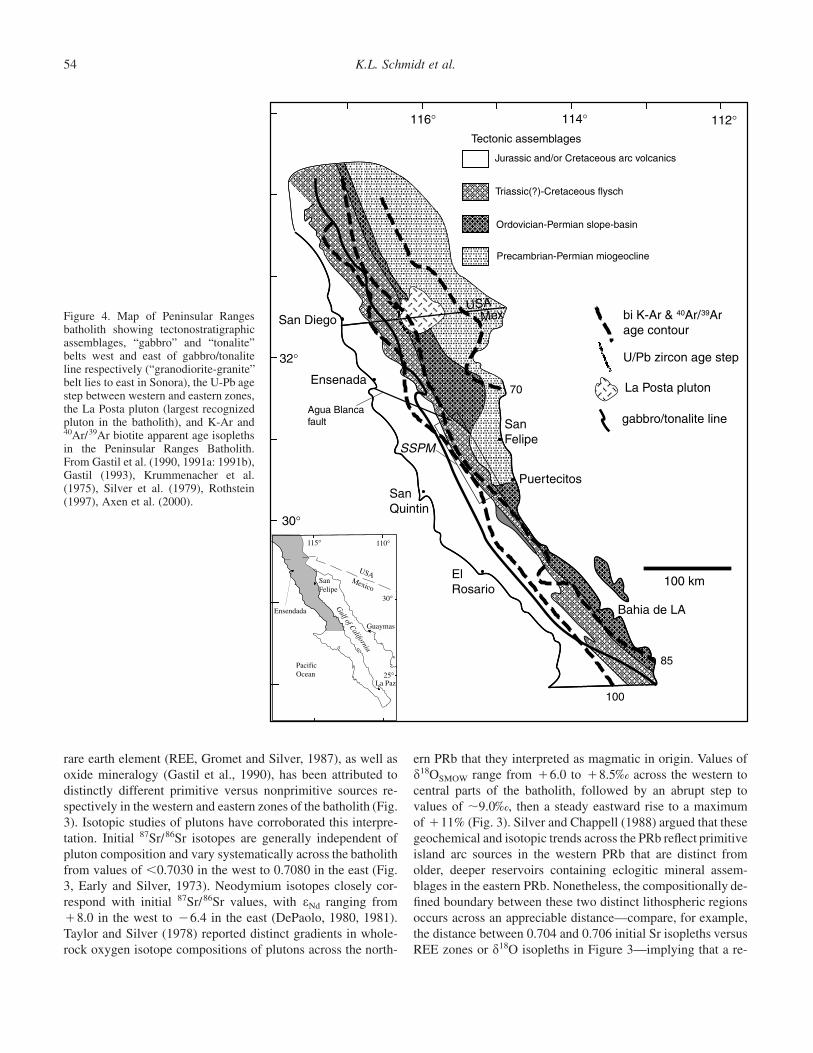
Figure 4. Map of Peninsular Rangesbatholith showing tectonostratigraphicassemblages, “gabbro” and “tonalite”belts west and east of gabbro/tonaliteline respectively (“granodiorite-granite”belt lies to east in Sonora), the U-Pb agestep between western and eastern zones,the La Posta pluton (largest recognizedpluton in the batholith), and K-Ar and40Ar/39Ar biotite apparent age isoplethsin the Peninsular Ranges Batholith.From Gastil et al. (1990, 1991a: 1991b),Gastil (1993), Krummenacher et al.(1975), Silver et al. (1979), Rothstein(1997), Axen et al. (2000).
116° 114° 112°
32°
30°
100
85
100 km
115° 110°
30°
25°
Ensendada
SanFelipe
USAMexico
Gulf of California
La Paz
PacificOcean
Guaymas
ElRosario
SanQuintin
Bahia de LA
Puertecitos
SanFelipe
gabbro/tonalite line
SSPM
La Posta pluton
U/Pb zircon age step
bi K-Ar & 40Ar/39Arage contour
MexUSA
70Ensenada
Agua Blancafault
San Diego
Precambrian-Permian miogeocline
Ordovician-Permian slope-basin
Triassic(?)-Cretaceous flysch
Jurassic and/or Cretaceous arc volcanics
Tectonic assemblages
rare earth element (REE, Gromet and Silver, 1987), as well asoxide mineralogy (Gastil et al., 1990), has been attributed todistinctly different primitive versus nonprimitive sources re-spectively in the western and eastern zones of the batholith (Fig.3). Isotopic studies of plutons have corroborated this interpre-tation. Initial 87Sr/86Sr isotopes are generally independent ofpluton composition and vary systematically across the batholithfrom values of �0.7030 in the west to 0.7080 in the east (Fig.3, Early and Silver, 1973). Neodymium isotopes closely cor-respond with initial 87Sr/86Sr values, with eNd ranging from�8.0 in the west to �6.4 in the east (DePaolo, 1980, 1981).Taylor and Silver (1978) reported distinct gradients in whole-rock oxygen isotope compositions of plutons across the north-
ern PRb that they interpreted as magmatic in origin. Values ofd18OSMOW range from �6.0 to �8.5‰ across the western tocentral parts of the batholith, followed by an abrupt step tovalues of �9.0‰, then a steady eastward rise to a maximumof �11% (Fig. 3). Silver and Chappell (1988) argued that thesegeochemical and isotopic trends across the PRb reflect primitiveisland arc sources in the western PRb that are distinct fromolder, deeper reservoirs containing eclogitic mineral assem-blages in the eastern PRb. Nonetheless, the compositionally de-fined boundary between these two distinct lithospheric regionsoccurs across an appreciable distance—compare, for example,the distance between 0.704 and 0.706 initial Sr isopleths versusREE zones or d18O isopleths in Figure 3—implying that a re-
Controls on orogenesis along an ocean-continent margin transition 55
gion of transition exists that has been influenced by magmaticprocesses in both oceanic as well as continental lithosphere.
Distinct basement to the western and eastern zones hasbeen corroborated by limited geophysical studies in the north-ern PRb. These studies include both Bouguer gravity data (Ol-iver, 1980; Fuis et al., 1982; Weslow, 1985; Jachens, 1986) andthree-dimensional imaging of P wave velocities from earth-quakes (Magistrale and Sanders, 1995), and indicate a largedensity contrast (�0.035 g cm�1) between western and easternzones of the batholith to a depth of at least 22 km, and probablythrough the entire crust. Other studies have also noted consid-erable contrast in Moho depths across the compositional bound-ary using teleseismic receiver function techniques (Ichinose etal., 1996; Lewis et al., 2000; Richards-Dinger and Shearer,1997) and reflection seismic studies (Zhu and Kanamori, 2000).Ichinose et al. (1996) and Lewis et al. (2000) determined arelatively deep and flat Moho (37–41 km depth) beneath thewestern PRb that changed across the transition zone to aneastward-shallowing Moho that decreases to �25 km depth be-neath the eastern PRb. They attributed this shallowing Mohoto crustal thinning resulting from Neogene extension in the Sal-ton Trough–Gulf of California extensional province. Their pre-liminary work in the Sierra San Pedro Martir indicates thatsimilar Moho depths continue into the southern half of the bath-olith (Lewis et al., 2000, personal commun.).
Some of the earliest evidence for distinct western and east-ern belts in the PRb comes from U-Pb zircon geochronologystudies along the international border (Silver et al., 1979; Silverand Chappell, 1988). These authors defined an older, “static,”western plutonic belt that ranges in age from ca. 140–105 Maand a younger, eastward migrating, eastern belt in which largelyundeformed plutons range in age from ca. 105–90 Ma, andsuggested that an age boundary between the two belts corre-sponds with the compositional boundary in the batholith. (Fig.4). Silver and Chappell (1988) reported U-Pb zircon ages of80–57 Ma for the batholith farther east in Sonora, mainlandMexico. Nevertheless, the evidence for a pluton age boundaryin the batholith is problematic, as apparent from subsequentgeochronology studies in southern California that have yieldedJurassic, and possibly Triassic ages from orthogneiss units inboth the western and eastern zones as they were originally de-fined in southern California (Todd et al., 1991; Walawender etal., 1991; Thomson and Girty, 1994). Furthermore, Walawenderet al. (1990), in the same region, determined that magmatismin the eastern belt was not eastward migrating based on addi-tional dates and the reinterpretation of a single pluton in thetransect as a “western” rather than an “eastern” zone pluton.Additionally, a more recent geochronologic transect across thenorthernmost PRb (Premo et al., 1998) found an apparentlysmooth progression of pluton ages across the transition zonefrom ca. 125 Ma in the west to ca. 83 Ma in the east. We suspectthat early interpretations of geochronology work in the PRbwere problematic because they focused largely on undeformedplutons and were undertaken in a transect that included the
largest pluton recognized in the PRb, the La Posta pluton, whichhas a diameter that is nearly the width of their transect (Fig. 4).This underscores the problem of representing the crustal scaleboundary in the batholith as a single line. Not only do geo-chemical and isotopic parameters change across a perceptibledistance on maps of the batholith, but individual plutons withinthe transition zone reach sizes of �1500 km2 and, thus, maystrongly influence geochemical, isotopic, as well as geochro-nologic gradients in the batholith.
In contrast to the U-Pb geochronology, the K-Ar geochro-nology system has consistently shown distinct differences be-tween western and eastern zones of the PRb, in agreement withdifferences in crustal exposure levels between the two zones(Evernden and Kistler, 1970; Armstrong and Suppe, 1973; Sil-ver et al., 1979). Krummenacher et al. (1975) reported K-Arhornblende and biotite ages from plutons across an extensiveregion of the PRb and found that both hornblende and biotiteages systematically become younger from west to east acrossthe batholith; hornblende ages vary from �120 to ca. 75 Maand biotite ages vary from ca. 115 Ma to ca. 65 Ma (Fig. 4).Differences among hornblende-biotite K-Ar cooling age pairsalso vary across the batholith, a feature that they attributed tointerplay among parameters such as pluton emplacement depthsand timing and rates of denudation that vary between westernand eastern zones. K-Ar ages are concordant with U-Pb zirconages from plutons in the western zone, but become increasinglydiscordant, by as much as 25 m.y., in the eastern zone of thebatholith (Silver et al., 1979).
In summary, discrete western and eastern zones can be de-fined in the PRb that contain distinct sedimentary assemblages,chemical and isotopic pluton compositions, geophysical param-eters, and thermal and metamorphic histories. The western zoneformed above dense, largely oceanic crust that presently has athickness of �40 km, and shows variable Mesozoic coolinghistories within a supracrustal volcanic sequence, consistentwith the exposure of shallow levels of the Peninsular Rangesarc. In contrast, the eastern zone evolved above less dense,largely continental crust with Paleozoic North American sedi-mentary assemblages that thins eastward (37–25 km thick) asa result of Neogene tectonism, and displays systematic east-ward-younging cooling trends that generally correspond withdeeper denudation to midcrustal levels. The transition zone be-tween these western and eastern zones occurs across an appre-ciable distance and is defined by a distinct stratigraphic assem-blage (flysch) and strong gradients in pluton chemistries andisotopes, metamorphism, and thermal evolution of rocks withinthe batholith. The origin of this transitional zone is critical tounderstanding the tectonic evolution of the PRb.
COMPARISON OF ZONES IN THE PRB NORTH ANDSOUTH OF THE AGUA BLANCA FAULT
The three zones in the batholith in many ways are moredistinct to the south, a fact that underscores important differ-
K.L. Schmidt et al.56
ences in the tectonic development of the PRb north and southof the Agua Blanca fault. The modern Agua Blanca fault is aNeogene-Recent, west-northwest-striking, dextral strike slipfault that forms a part of the San Andreas transform system(Fig. 3, Allen et al., 1960; Suarez-Vidal et al., 1991). However,this modern fault is located on an important Mesozoic bound-ary that is oriented obliquely across the western and transi-tion zones of the batholith, dividing it into northern andsouthern parts (Gastil et al., 1975, 1981; Wetmore and Pat-erson, 2000).
In contrast to the western and transitional zones of the bath-olith, the Mesozoic geology in the eastern zone appears to becontinuous across the eastward extension of the modern AguaBlanca fault. The eastern zone was clearly tied to North Amer-ica during the Mesozoic as evidenced by North American Pre-cambrian-Paleozoic sedimentary assemblages that underlie it aswell as prevalent Pb inheritance in zircon within plutons (Gastil,1993). These inherited components are typically ca. 1100–1300Ma, similar to basement ages in northern mainland Mexico. Theeastern zone preserves a long history of arc magmatism thatstretches back much further than was originally apparent frominitial studies in the northern PRb. Our recent work has yieldeda 206Pb/238U zircon SHRIMP age of 164.3 � 2.3 Ma (MSWD2.5, minor older component yielded ages of ca. 900–1000 Ma)for orthogneiss that appears to underlie a substantial portion ofthe eastern zone near latitude 31 �N (Schmidt, 2000), suggestingthat the Jurassic arc extended from present-day southern Cali-fornia well into Peninsular California. The ca. 99–92 Ma LaPosta suite also features prominently in this zone (Kimbroughet al., 2001) and is discussed in more detail below. Nevertheless,an important along strike break is evident in the eastern zoneat �30.5�N latitude. This break occurs �100 km farther southof the Agua Blanca fault, and in contrast to the ancestral AguaBlanca fault, it appears to be an inherited, pre-Mesozoic featurein the batholith that corresponds to the transition from shelf toslope deposits in the Precambrian-Paleozoic miogeocline (Gas-til et al., 1991a). This inherited boundary appears to have con-trolled a number of Mesozoic features in the eastern zone ofthe batholith including structural style and denudation history.North of this boundary, crust underlain by miogeoclinal rocksappears to have operated as a backstop to shortening in the restof the arc to the west (Schmidt, 2000) and was deeply denudedduring Cretaceous time. In contrast, south of this boundary, theeastern zone was significantly shortened and less denudation isapparent (Rothstein, 1997).
Below we examine assemblages west of the eastern zoneof the PRb in more detail focusing discussion on the transitionzone and its eastern and western boundaries, and compare ourwork in the Sierra San Pedro Martir of the southern half of thebatholith (Johnson et al. 1999a, 1999b; Schmidt, 2000), withpublished work and our own reconnaissance work (Wetmore etal., 2002) north of the Agua Blanca fault.
Transition Zone and its boundaries with the easternand western zones
The transition zone forms a distinct belt within the batho-lith that contains its own distinct stratigraphy, magmatism, andstructures, and is the location of major breaks in metamorphicand rock cooling histories across the strike of the batholith.Changes in the way in which the eastern and western geologicalboundaries to this zone are expressed across the Agua Blancafault is one of the critical distinctions between northern andsouthern parts of the batholith.
Stratigraphy
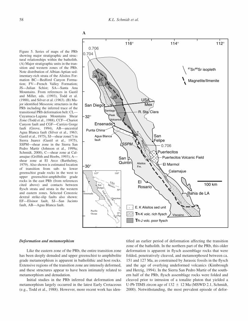
In the northern PRb, metamorphosed rocks of the flyschassemblage (Bedford Canyon Formation, French Valley For-mation, and Julian Schist) and their apparent correlatives innorthern Baja California (Rancho Vallecitos Formation andstrata near Rancho Santa Clara, east of Ensenada) consist ofpelitic and psammitic schist and gneiss with minor calc-silicaterocks interpreted as continentally derived turbidite to deltaicdeposits (Fig. 5A; Germinario, 1993; Lothringer, 1993; Reed,1993). Few volcanic protoliths have been described in thesenorthern assemblages, with the notable exception of a poorlyknown and undated amphibolite-grade metavolcanic unit in SanDiego County (Todd et al., 1988).
Age control for the northern flysch units is mainly fromJurassic (Bajocian–Callovian, ca. 177–159 Ma) fossils in theBedford Canyon Formation. Fossils are either absent or provideonly tentative age control for the other metasedimentary units.Thomson and Girty (1994) interpreted 234 � 39 Ma (U-PbTIMS zircon technique) Harper Creek orthogneiss as intrusiveinto Julian Schist, thus providing a pre-Triassic-earliest Jurassicage constraint on the Julian Schist. The flysch assemblage unitsin southern California contain zircon populations derived fromLate Proterozoic, and Paleozoic-early Mesozoic sources that areconsistent with ages of abundant igneous rocks in Arizona andnorthern Sonora (Gastil and Girty, 1993). Hence, these sedi-mentary basins appear to be tied to North America during theirformation.
In the Sierra San Pedro Martir of the southern part of thebatholith (Fig. 5A), the flysch assemblage includes a substantialvolcanic component. Rock types include schistose and gneissicbasalts, silicic lithic crystal tuffs, tuff breccias, and tuffaceoussandstones, as well as uncommon, relatively pure marble andquartzite layers. Age constraints are poor here. Johnson et al.(1999a) obtained a 206Pb/238U zircon SHRIMP age of 127.9 �1.2 Ma (MSWD 1.0) from a gneissic igneous layer in flyschstrata on the western side of the transition zone, but are uncer-tain as to whether or not the layer dated is a volcanic flow inthe sequence or later sill. This assemblage is faulted againstAlisitos Formation strata of western zone provenance as de-scribed below. Measures (1996) obtained discordant zircon
Controls on orogenesis along an ocean-continent margin transition 57
U-Pb TIMS ages from a metavolcanic unit in the eastern sideof the transition zone that he interpreted as ca. 123 Ma. Thispackage lies in fault contact with shelf facies rocks of the east-ern zone of the batholith.
In the transition zone farther south, flysch assemblagerocks occur in fault slivers that are juxtaposed with both Paleo-zoic assemblages and apparent Alisitos equivalents. At somelocations, depositional contacts between flysch strata and bothof these units have been reported. At El Marmol (Fig. 5A), aLower Permian to Lower Triassic argillite sequence (Zamora,El Volcan, and De Indio Formations) conformably overliesLower Permian chert and argillite strata and was interpretedby Buch and Delattre (1993) as the southern extension of aPermian-Triassic miogeocline belt that occurs in southern Ne-vada and east-central California. These units are overlain by anapparent Alisitos Formation equivalent unit (Olvidada Forma-tion) that contains Aptian-Albian (ca. 121–99 Ma) fossils andincludes turbiditic chert, sandstone, and shale interlayered withvolcanic tuffs and breccias (Phillips, 1993). In the Calamajueregion (Fig. 5A), Griffith and Hoobs (1993) mapped a meta-volcanic sequence (Canon de las Palmas unit), containing in-termediate composition flow rocks and volcaniclastics with mi-nor basalt and limestone, from which a U-Pb TIMS zircon ageof ca. 156 Ma was obtained. This unit is juxtaposed with Mis-sissippian carbonate strata (Canon Calamajue unit) and an ap-parent Alisitos Formation equivalent sequence that includes in-termediate volcanic flow rocks, tuffs, and breccias that yieldeda U-Pb TIMS zircon age of 103 � 4 Ma.
Magmatism
The character of plutonism in the transition zone is stronglyheterogeneous and distinct in several aspects from that in theeastern and western zones. In the transition zone, pluton shapesand geometries vary from blob-like and relatively homoge-neous to vertically oriented, centimeter- to meter-wide, intri-cately interlayered sheets. Igneous rock types range from horn-blende gabbro to muscovite biotite granite, and, in many places,spectacular zones of magma mingling occur between differentcompositions. Textures in plutonic rocks vary from magmaticand barely discernable to strongly mylonitic and gneissic. Inmany cases, strong contrasts in rock rheology during defor-mation are apparent between adjacent rocks of different com-position. For example, blob-shaped gabbro plutons in the SierraSan Pedro Martir commonly show poorly developed magmaticfabrics and locally developed spaced, high-temperature cleav-age parallel to the regional structural grain, whereas adjacenttonalite and metavolcanic wall rocks typically form myloniteand ultramylonite that strongly wraps around the ends of thegabbro plutons. Extensive exposures of migmatite occur inflysch and orthogneiss wall rocks, and in some places more thanone generation of migmatite are apparent.
Magmatism in the transition zone occurred during a sig-nificant portion of Mesozoic time. In the northern part of thebatholith, a few important studies have identified plutonic suitesthat are considerably older than the ca. 120–95 Ma plutons firstdescribed by Silver et al. (1979). These assemblages includetwo separate units of the largely granodioritic Harper Creekorthogneiss, which yielded 234 � 39 and 156 � 12 Ma ages,and the Cuyamaca Creek gneiss, another arc plutonic suite,which yielded ages of 161 � 12 and 149 � 21 Ma (usingU-Pb TIMS zircon technique, �7 fractions, reported in Thom-son, 1994). All data plot along cords with inherited componentsof ca. 1763–1437 Ma.
In the Sierra San Pedro Martir of the southern part of thetransition zone new U-Pb SHRIMP zircon geochronology hasidentified a number of important relationships. An areally ex-tensive orthogneiss unit that is lithologically similar to the Cuy-amaca Creek gneiss yielded an age of 164.4 � 1.2 Ma (MSWD0.41) and includes a minor older component that yielded agesof ca. 1100–1000 Ma (Schmidt, 2000). A long history of sub-sequent arc magmatism is apparent in this region. Tonalite andgranite plutons have given U-Pb zircon TIMS and SHRIMPages ranging from ca. 134–100 Ma (Johnson et al., 1999a;Schmidt, 2000). A distinctive suite of 108–102 Ma hornblendetonalite plutons occurs across the western side of the transitionzone, which Johnson et al. (1999a) argued stitches the transitionand western zones of the batholith following collision of thewestern zone. Geochemical studies show permissible evidencefor mixed continental/island arc lower crustal sources for theseplutons whereas previously intruded plutons in the adjacentwestern zone do not (Gromet and Silver, 1987; Silver and Chap-pell, 1988; Tate and Johnson, 2000). A major pulse of mag-matism subsequently occurred in this region between 99 and92 Ma as part of the La Posta plutonic event.
The 99–92 Ma La Posta plutonic suite occurs along thelength of both the transition and eastern zones of the PRb (e.g.,Gastil et al., 1991b; Kimbrough et al., 2001). La Posta-typeplutons reach diameters of 40 km and are typically concentri-cally zoned from hornblende tonalite margins to muscovite-bearing monzogranite cores. Geochemical and isotopic dataalso show zoning in these plutonic complexes, ranging fromvalues that are considered “western PRb” in their margins to“eastern PRb” in their cores, including increasing zircon Pbinheritance in pluton centers. These plutons are consideredtype-examples of eastern zone plutons (Walawender et al.,1990; Gastil et al., 1991b). However, a substantial region of thetransitional and eastern zones of the batholith is underlain byvariably deformed and metamorphosed granitoid plutons ofMiddle Jurassic through Early Cretaceous age. Thus, althoughthe La Posta suite is clearly a volumetrically important igneousunit in the batholith, it is only a part of a long history of arcmagmatism that is apparent in the transitional and eastern zonesof the PRb.
K.L. Schmidt et al.58
Deformation and metamorphism
Like the eastern zone of the PRb, the entire transition zonehas been deeply denuded and upper greenschist to amphibolitegrade metamorphism is apparent in batholithic and host rocks.Extensive regions of the transition zone are intensely deformed,and these structures appear to have been intimately related tometamorphism and denudation.
Initial studies in the PRb inferred that deformation andmetamorphism largely occurred in the latest Early Cretaceous(e.g., Todd et al., 1988). However, more recent work has iden-
tified an earlier period of deformation affecting the transitionzone of the batholith. In the northern part of the PRb, this olderdeformation is apparent in flysch assemblage rocks that werefolded, penetratively cleaved, and metamorphosed between ca.151 and 127 Ma, as constrained by Jurassic fossils in the flyschand the age of overlying undeformed volcanics (Kimbroughand Herzig, 1994). In the Sierra San Pedro Martir of the south-ern half of the PRb, flysch assemblage rocks were folded andcleaved prior to intrusion of a tonalite pluton that yielded aU-Pb TIMS zircon age of 132 � 12 Ma (MSWD 2.1, Schmidt,2000). Notwithstanding, the most prevalent episode of defor-
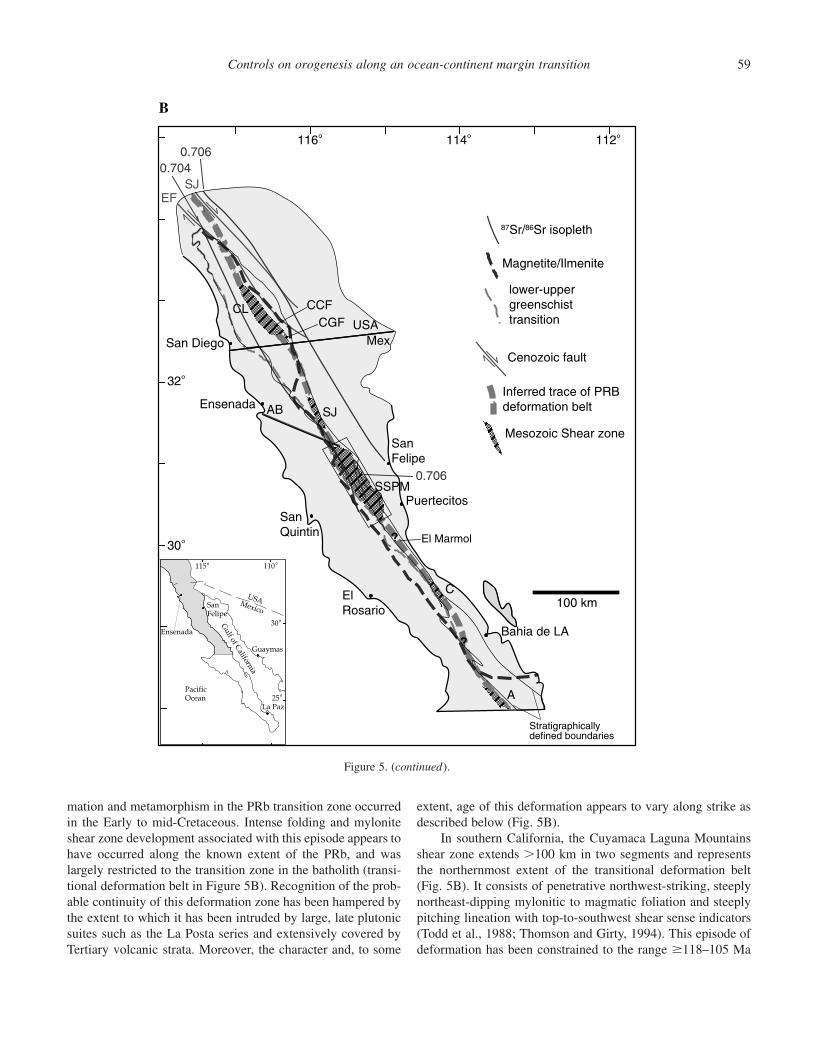
Figure 5. Series of maps of the PRbshowing major stratigraphic and struc-tural relationships within the batholith.(A) Major stratigraphic units in the tran-sition and western zones of the PRb.Note distribution of Albian-Aptian sed-imentary-rich strata of the Alisitos For-mation BC—Bedford Canyon Forma-tion; FV—French Valley Formation;JS—Julian Schist; SA—Santa AnaMountains. From references in Gastiland Miller, eds. (1993), Todd et al.(1988), and Silver et al. (1963). (B) Ma-jor identified Mesozoic structures in thePRb including the inferred trace of thetransitional PRb deformation belt: CL—Cuyamaca-Laguna Mountains ShearZone (Todd et al., 1988), CCF—ChariotCanyon fault and CGF—Carrizo Gorgefault (Grove, 1994), AB—ancestralAgua Blanca fault (Silver et al., 1963;Gastil et al., 1975), SJ—shear zone(?) inSierra Juarez (Gastil et al., 1975),SSPM—shear zone in the Sierra SanPedro Martir (Johnson et al., 1999a;Schmidt, 2000), C—shear zone at Cal-amajue (Griffith and Hoobs, 1993); A—shear zone at El Arco (Barthelmy,1979). Also shown is estimated locationof transition from sub- to lowergreenschist grade rocks in the west toupper greenschist-amphibolite graderocks in the east PRb (from referencescited above) and contacts betweenflysch strata and strata in the westernand eastern zones. Selected Cenozoicdextral strike-slip faults also shown:EF—Elsinor fault, SJ—San Jacintofault, AB—Agua Blanca fault.
?
116°
30°
114° 112°
32°
Ensenada
La Paz
SanFelipe
PacificOcean
115° 110°
25°
Mexico
Gulf of C
alifornia
USA 100 km
San Diego
0.7060.704
0.706
USAMex
Ensenada
SanFelipe
Puertecitos
SanQuintin
ElRosario
Bahia de LA
El Marmol
Guaymas
30°
SAB C
FV
JS
?
SSPM
Santiago
Peak
Volcanics
Punta China
Agua Blancafault
AlisitosFm.
E. K Alisitos sed unit
TR-K volc. rich flysch
TR-J volc. poor flysch
Viscaino
Calamajue
Puertecitos Volcanic Field
R. Sta. Clara
Magnetite/Ilmenite
87Sr/86Sr isopleth
A
Controls on orogenesis along an ocean-continent margin transition 59
116
30
114 112
32
Ensenada
Guaymas
La Paz
SanFelipe
PacificOcean
115 110
30
25
Mexico
Gulf of California
USA 100 km
San Diego
?
A
C
SSPM
SJ
CL
AB
SJEF
?
Inferred trace of PRBdeformation belt
Mesozoic Shear zone
Cenozoic fault
lower-uppergreenschisttransition
0.7060.704
0.706
87Sr/86Sr isopleth
Magnetite/Ilmenite
USAMex
Ensenada
SanFelipe
PuertecitosSanQuintin
ElRosario
Bahia de LA
CCFCGF
B
El Marmol
Stratigraphicallydefined boundaries
Figure 5. (continued).
mation and metamorphism in the PRb transition zone occurredin the Early to mid-Cretaceous. Intense folding and myloniteshear zone development associated with this episode appears tohave occurred along the known extent of the PRb, and waslargely restricted to the transition zone in the batholith (transi-tional deformation belt in Figure 5B). Recognition of the prob-able continuity of this deformation zone has been hampered bythe extent to which it has been intruded by large, late plutonicsuites such as the La Posta series and extensively covered byTertiary volcanic strata. Moreover, the character and, to some
extent, age of this deformation appears to vary along strike asdescribed below (Fig. 5B).
In southern California, the Cuyamaca Laguna Mountainsshear zone extends �100 km in two segments and representsthe northernmost extent of the transitional deformation belt(Fig. 5B). It consists of penetrative northwest-striking, steeplynortheast-dipping mylonitic to magmatic foliation and steeplypitching lineation with top-to-southwest shear sense indicators(Todd et al., 1988; Thomson and Girty, 1994). This episode ofdeformation has been constrained to the range �118–105 Ma
K.L. Schmidt et al.60
and occurred under amphibolite grade metamorphic conditions.An overprinting deformation event that produced northeast-sidedown shear sense on nearly vertical northwest-striking mylon-itic foliation and steeply pitching lineation in a �12-km-longsection of the main shear zone has been bracketed between ca.105 and ca. 94 Ma (Thomson and Girty, 1994). Cooling below400 �C in this portion of the batholith occurred from ca. 88–85Ma (Grove, 1994).
In the more poorly known Sierra Juarez to the south, in-tensely developed, steeply-dipping, northwest-striking cleavageoccurs across a broad region of the transition zone (Gastil etal., 1975). Wall rocks have been metamorphosed to amphibolitegrade and extensively intruded by blob-like and sheeted plu-tons. Rothstein (1997) inferred rapid cooling below 400 �C inthis region from ca. 85–72 Ma.
In the southern part of the batholith, south of the AguaBlanca fault, the transitional deformation belt is spectacularlyexposed across the Sierra San Pedro Martir. In this region a�20-km-wide, doubly vergent fan structure occurs, consistingof moderately inward-dipping mylonite belts on either side thatsteepen toward the center where both mylonitic and magmaticfabrics occur in a region syn-tectonically intruded by verticallysheeted plutons (Fig. 6, Schmidt, 2000). In this region complexdeformation occurred largely at amphibolite metamorphic con-ditions over a protracted period of time, with much of the de-formation apparent between intrusion of 118.2 � 2.6 Ma gran-ite (U-Pb zircon TIMS age) and ca. 85 Ma when thermalgradients determined by apatite fission track methods had equil-ibrated across the structure. Structural development of the fanincludes extensive mylonitic shear zones, minor brittle over-printing, and multiple episodes of folding with contrastingstyles and orientations. All identifiable deformation is contrac-tional, potentially including a small amount of sinistral trans-pression during a restricted period of time around syn-tectonicintrusion of tonalite sheets in the center that yielded a 206Pb/238U zircon SHRIMP age of 100.1 � 0.5 Ma. Rapid bedrockcooling below 400 �C in this region is inferred for the periodca. 91–85 Ma (40Ar/39Ar and fission track methods, Ortega-Rivera et al., 1997; Rothstein, 1997; Schmidt, 2000).
In the transitional deformation belt farther south, at El Mar-mol (Fig. 5A and 5B), upper greenschist to lower amphibolitemetamorphic grade rocks in the transition zone have beenstrongly cleaved and multiply folded, with a change fromproduction of north-northeast-plunging to west-northwest-plunging fold sets apparent during Albian-Aptian time (Buchand Delattre, 1993; Phillips, 1993). In the Calamajue region, amajor northwest-striking shear zone occurs in upper greenschistto amphibolite grade rocks in the transition zone, which formsa series of southwest-vergent thrust slices consisting of 103 �4 Ma (U-Pb zircon TIMS methods) apparent Alisitos Formationand Jurassic flysch assemblage rocks sandwiched between Pa-leozoic passive margin assemblages (Fig. 5B, Griffith andHoobs, 1993). Steeply northeast-dipping mylonitic foliationand steeply pitching lineation are well developed in the shear
zone. Foliation is axial planar to steeply-plunging isoclinalfolds that have progressively rotated during deformation. Flat-tening strains and �60%–70% shortening have been ascer-tained in parts of the shear zone, and deformation has beenconstrained to ca. 103–100 Ma as determined from deformedapparent Alisitos equivalent strata and a crosscutting unde-formed granite that yielded a single fraction U-Pb zircon TIMSage of �100 Ma. In the southernmost reported exposure of thePRb transition zone, at El Arco, strongly folded and cleavedamphibolite grade flysch assemblage rocks occur in discon-nected wall rock screens in a region that has been extensivelyintruded (Barthelmy, 1979).
Boundary with the eastern zone
The Mesozoic boundary between eastern and transitionalzones in the batholith is defined by a changes in prebatholithicstratigraphy from flysch to miogeoclinal sequences, Mesozoiccontractional shear zones, and sharp gradients in regional cool-ing histories. A spectacular escarpment with �1000 m of reliefcommonly coincides with this Mesozoic boundary (e.g., Grove,1994; Rothstein et al., 1995). This feature formed in Neogenetime by normal faulting associated with extension in the Gulfof California that appears to have reactivated parts of the olderboundary.
In the northern batholith, the eastern side of the CuyamacaLaguna Mountains shear zone in the Chariot Canyon and Car-rizo Gorge areas corresponds with the boundary between thetransition and eastern zones of the PRb and a distinct step inmetamorphism and rock cooling histories (Fig. 5B, Grove,1989, 1994). Upper amphibolite grade rocks that equilibratedat 4.5 � 1.5 kbar and 650 � 50 �C have been thrust westwardbetween 76 and 72 Ma (and possibly earlier) over phyllite ofthe Julian Schist that attained only 2.5 � 1.2 kbar and 550 �35 �C. Footwall rocks to this structure underwent rapid cooling(below 400 �C) from ca. 88–85 Ma, whereas rapid cooling isapparent in hanging wall rocks from ca. 76–72 Ma (Grove,1994).
In the southern batholith, on the eastern side of the fanstructure in the Sierra San Pedro Martir, migmatitic flysch as-semblage rocks in the transition zone have been thrust eastwardover miogeoclinal rocks in the eastern zone. The age of thrust-ing is poorly constrained to the time between ca. 164 Mastrongly deformed orthogneiss and crosscutting ca. 99–92 MaLa Posta-type plutons (Schmidt, 2000). Thrust vergence here isthe opposite of that in other regions along strike in the batholith,such as in the Chariot Canyon area of southern California (Fig.5B). Biotite 40Ar/39Ar apparent ages are similar across theboundary between transition and eastern zones in the fan struc-ture, but a 14 m.y. gradient is apparent in apatite fission trackages, with younger cooling histories apparent in the footwall.Farther south in the batholith, the eastern boundary of the tran-sition zone has not been defined.
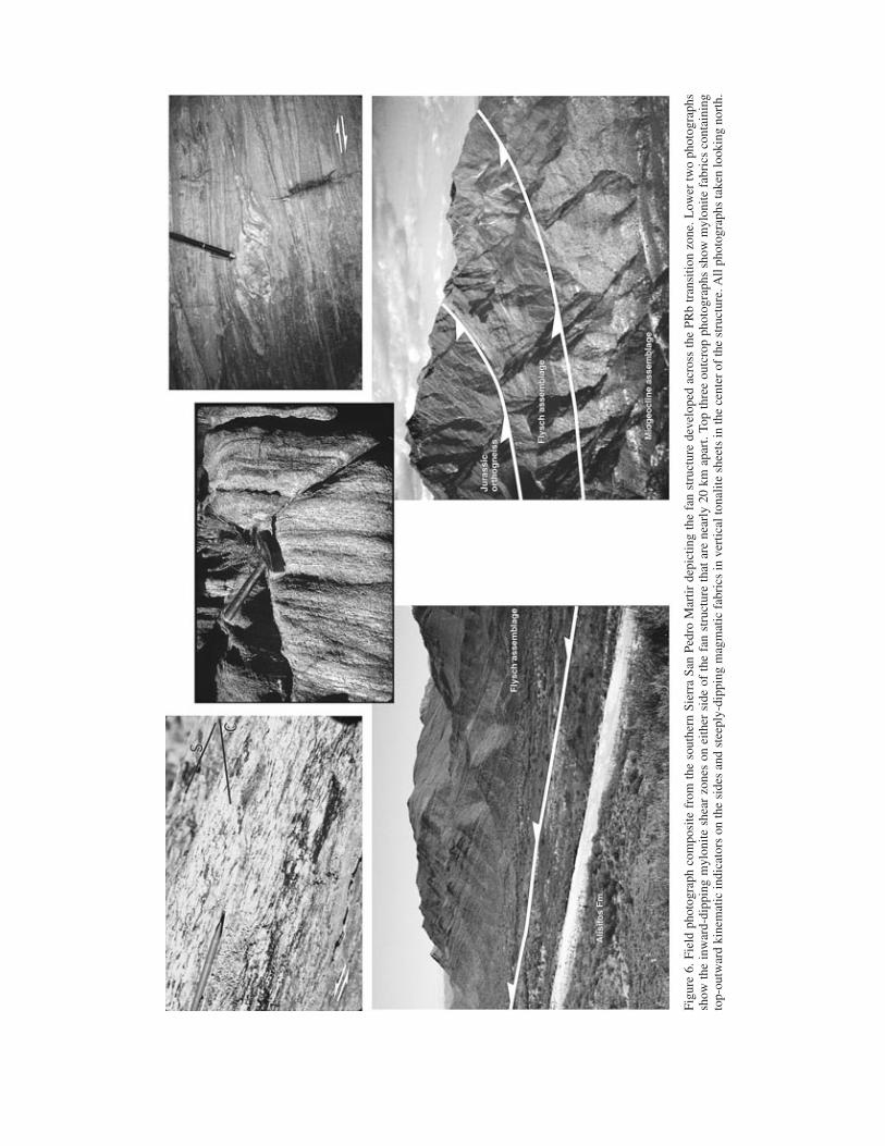
Figu
re6.
Fiel
dph
otog
raph
com
posi
tefr
omth
eso
uthe
rnSi
erra
San
Pedr
oM
artir
depi
ctin
gth
efa
nst
ruct
ure
deve
lope
dac
ross
the
PRb
tran
sitio
nzo
ne.L
ower
two
phot
ogra
phs
show
the
inw
ard-
dipp
ing
myl
onite
shea
rzo
nes
onei
ther
side
ofth
efa
nst
ruct
ure
that
are
near
ly20
kmap
art.
Top
thre
eou
tcro
pph
otog
raph
ssh
owm
ylon
itefa
bric
sco
ntai
ning
top-
outw
ard
kine
mat
icin
dica
tors
onth
esi
des
and
stee
ply-
dipp
ing
mag
mat
icfa
bric
sin
vert
ical
tona
lite
shee
tsin
the
cent
erof
the
stru
ctur
e.A
llph
otog
raph
sta
ken
look
ing
nort
h.
K.L. Schmidt et al.62
Boundary with the western zone
In contrast to the eastern boundary of the transition zone,the western boundary is in places impressively exposed anddefined. This boundary shows dramatic contrasts in its characteracross the Agua Blanca fault. North of the fault, depositionalcontacts between flysch assemblage and Santiago Peak Vol-canic rocks occur in several places. These exposures lie well tothe west of major shear zones in the transition zone deformationbelt and sharp gradients in metamorphism and rock coolinghistories. In the Santa Ana Mountains, deformed and meta-morphosed rocks of the late Middle Jurassic Bedford CanyonFormation depositionally underlie nearly horizontal strata of theSantiago Peak Volcanics that yielded a 127 � 2 Ma zirconU-Pb TIMS age (Herzig and Kimbrough, 1998). A similar re-lationship occurs near San Diego, where Santiago Peak Vol-canic strata lies depositionally on the undated folded andcleaved amphibolite grade metavolcanic rocks described byTodd et al. (1988).
In the Sierra Juarez, the contact between Santiago PeakVolcanics and flysch assemblage rocks appears to remain westof the main belt of deformation in the transition zone (Fig. 5B).The contact here is gradational across a broad region displayingcomplex folding and strong cleavage development, and we sug-gest that it is a sheared unconformity.
The boundary between the transition zone and westernzones of the batholith is strikingly defined in the Sierra SanPedro Martir south of the Agua Blanca fault. On the westernside of the fan structure flysch assemblage rocks in the transi-tion zone have been thrust southwestward over the Alisitos For-mation in the western zone (Fig. 6, Johnson et al., 1999a).Nearly 15 km of structural throw is apparent across this shearzone as ascertained from a dramatic metamorphic pressure gra-dient ranging from �2–5 kbar that corresponds with a �10 m.y.gradient in 40Ar/39Ar biotite and K-feldspar and apatite fissiontrack cooling ages (Kopf et al., 2000; Schmidt, 2000). Wallrocks in the center of the fan structure preserve a metamorphicprogression from early gedrite-sillimanite followed by over-growth of staurolite, then late garnet-cordierite. This progres-sion indicates decompression from peak pressures of �5 kbarto �3 kbar that occurred between ca. 100 and 85 Ma and isconfirmed by Al-in-hornblende results of 5–6 kbar from ca. 100Ma plutons. In contrast, volcanic rocks in the footwall of theshear zone along the western side of the fan structure preservegreenschist grade pumpellyite-muscovite-chlorite assemblagesand Al-in-hornblende barometry in plutons of the western zonehere indicate pressures �2 kbar.
Farther south in the batholith, the western boundary of thetransition zone has not been defined, and appears to be largelyobscured. However, at El Arco, Barthelmy (1979) describedlimited exposures of a shear zone that is analogous to the onealong the western side of the fan structure. Alisitos Formationrocks in the western zone are progressively more deformed andmetamorphosed from chlorite to amphibolite grade toward the
northeast across a �5-km-wide belt that is adjacent to expo-sures of strongly deformed flysch assemblage rocks. Unfortu-nately, the actual contact appears to be completely intruded outand/or covered.
Summary of the transition zone
In summary, the transition zone is a distinctive entity in thePRb that evolved since early Mesozoic time. Many similaritiesin the evolution of this zone are apparent between northern andsouthern parts of the batholith. Along its length, this belt pre-serves a long history of Mesozoic basin formation and strongties between these basins and North America. Both northernand southern parts of the transition zone share a similar historyof long-lived arc magmatism extending from Late Jurassic toLate Cretaceous time, and major plutonic suites such as the LaPosta suite are continuous across the Agua Blanca fault. Theentire transition zone shows more intensively developed Jura-Cretaceous deformation than the western and eastern zones toeither side, and mylonite shear zones with east-side-up dis-placement are common. Similar metamorphic grades and peakP-T conditions are also apparent along this belt, and sharp,eastward-increasing metamorphic gradients commonly occuracross the east-side-up shear zones. Sharp steps in rock coolinghistories also typically correspond with the shear zones, indi-cating that denudation in the batholith was accommodated bythese structures (Grove, 1994).
However, some important differences in the evolution ofthe northern and southern parts of the transition zone are ap-parent across the Agua Blanca fault. The northern part appearsto preserve older basins (Triassic(?)-Late Jurassic) that col-lected mostly sedimentary detritus, largely derived from NorthAmerican sources. In contrast, basins in the southern half ofthe batholith appear to be younger (Late Jurassic-Early Creta-ceous) and contain a large proportion of locally derived vol-canic detritus in addition to North American derived sediment.Moreover, from known regions to the south of the Agua Blancafault, mylonite shear zones, and their associated metamorphicgradients and steps in cooling ages, consistently define theboundary with the western zone, while those in the north donot (Fig. 5B). Despite these changes in the locus of denudationin the batholith, it appears that both northern and southernhalves of the transition zone were denuded at about the sametime and to similar degrees with some local variation. Forearcbasin detrital thermal studies in the northern part of the batholithindicate rapid denudation in Cenomanian–Turonian time (ca.99–89 Ma, Lovera et al., 1999), while bedrock thermal historystudies in the southern part of the batholith show rapid coolingthat has been attributed to rapid denudation within the periodca. 100–85 Ma (Rothstein, 1997; Ortega-Rivera et al., 1997;Schmidt, 2000).
The boundary between the transitional and eastern zoneslargely corresponds with structural and lithological changesacross the trend of the batholith that coincide with some vari-
Controls on orogenesis along an ocean-continent margin transition 63
ation in west-to-east cooling age gradients and minor changesin crustal exposure levels. North-south variation along theboundary appears to be minimal, and includes local changes inthrust vergence and minor variation in the relative degree ofdenudation and cooling histories of rocks to either side. Thetransitional and eastern zones of the batholith have been joinedacross this apparently inherited crustal boundary since pre-Mesozoic time.
In contrast, the boundary between the transitional andwestern zones is strikingly defined by stratigraphic, structural,and metamorphic relationships that change along-strike in thebatholith. The most dramatic change occurs across the AguaBlanca fault. In general, unconformities, both depositional andsheared, define the boundary north of the Agua Blanca fault,and major gradients in metamorphic grade and bedrock coolinghistories occur farther east within the transition zone. In con-trast, the boundary to the south is largely defined by faultcontacts between pre-Albian-Aptian assemblages, and sharplydefined inverted metamorphic gradients and major eastward-younging steps in bedrock thermal histories coincide with thesefaults.
Western zone. The western zone of the PRb shows a num-ber of changes in stratigraphy, pluton source characteristics, andstructures across the Agua Blanca fault that are even more com-pelling than changes across this structure in the transition zone.Pre- to syn-batholithic stratigraphy of the western zone is sub-divided into the Santiago Peak Volcanics (Larson, 1948) northof the Agua Blanca fault and the Alisitos Formation (Allison,1955, 1974) to the south (Fig. 5A). The Santiago Peak Volcan-ics consist predominantly of andesite and quartz latite flow andvolcaniclastic rocks (Larson, 1948; Schroeder, 1967; Adams,1979). A largely subaerial depositional environment has beeninterpreted for this volcanic sequence. Age constraints for theSantiago Peak Volcanics include latest Jurassic fossils (Fife etal., 1967), and U-Pb TIMS zircon ages that range from 138 to118 Ma for the volcanics and 120–105 Ma for plutons thatintrude them (Silver and Chappell, 1988; Walawender et al.,1991; Carrasco et al., 1995). In contrast, the Alisitos Formationconsists of volcanic breccia, tuff, and flows of largely andesiteand dacite composition, and tuffaceous mudstone and wackewith sparse biostromal limestone. Its depositional environmentappears to have been largely submarine (Santillan and Barrera,1930; Silver et al., 1963; Allison, 1955, 1974). Near the AguaBlanca fault, in the type-section of the Alisitos Formation, thesequence is particularly rich in sedimentary strata that appearsto be exclusively of volcanic and organic origin and is at least6500 m thick, with no top or bottom exposed (Fig. 5A). Vol-canic complexes identified in the Alisitos segment include largestratovolcanos and associated caldera complexes near El Ro-sario that fed debris into marine basins on their flanks, whichare inferred to be fault-bounded (Busby et al., 1998; Fackler-Adams and Busby, 1998). The deeper roots (5–9 km deep) tosimilar systems appear to be preserved as ring complexes in thewestern zone of the Sierra San Pedro Martir (Johnson et al.,
1999b). Age constraints for the Alisitos Formation includeAlbian-Aptian fossils (121–99 Ma; Silver et al., 1963; Allison,1974), U-Pb zircon ages of 116 � 2 Ma and 115.7 � 1.1 Mafrom volcanics by, respectively, TIMS (Carrasco et al., 1995)and SHRIMP (Johnson, written commun.) methods, and 206Pb/238U zircon SHRIMP ages ranging from ca. 117–113 Ma fromplutons that intrude the volcanics (Tate et al., 1999; Johnson etal., 1999a).
Basement to western zone volcanic sequences is not seenexcept in the north where eastern exposures of the SantiagoPeak Volcanics lie unconformably on flysch assemblage rocks.Volcanic rocks yield zircons with some inheritance from theSantiago Peak segment (e.g., Meeth, 1993), but volcanics andplutons in the Alisitos segment have not, as yet, been shown tocontain zircons with inherited Pb (e.g., Johnson et al., 1999a).Thus, at least the Alisitos segment of the western zone may notcontain continental crustal basement and could have evolved inan environment that was isolated from continental influenceuntil inferred collision at ca. 115–108 Ma (Johnson et al.,1999a). Moreover, if additional data from the Alisitos segmentcontinue to indicate a lack of inheritance, then it is unlikely thatthe flysch sequences containing conspicuous inherited zirconcomponents in the transition zone are present in the basementof the Alisitos segment of the western zone, unless magma thatintruded this crust somehow avoided chemical and mechanicalexchange with a portion of its host rock.
Rocks of the western zone are for the most part onlyweakly deformed, but along-strike and across-strike structuralvariation is apparent within this belt. In southern Californiamuch of the Santiago Peak Volcanics are nearly horizontal. Far-ther south in Baja California, near the boundary with the tran-sition zone strata are tightly folded and contain steeply-dippingcleavage (our unpublished mapping). South of the Agua Blancafault, in the Alisitos Fm., a deformation gradient is apparentacross a west-to-east transect west of the Sierra San Pedro Mar-tir. Alisitos strata are horizontal to gently folded near the PacificCoast and become more folded eastward into open folds withnearly horizontal, northwest-southeast trending axes. Within afew km of the boundary between western and transition zones,Alisitos strata are tightly to isoclinally folded with moderately-to steeply-plunging axes and well-developed axial planar cleav-age that are parallel (� 20�) to the strike of reverse faults alongthe boundary. Deformation along this transect is loosely con-strained to pre- to syn-emplacement of 117–113 Ma plutons(Johnson et al., 1999a; 1999b). Farther south, inferred basin-bounding normal faults associated with the caldera complexesnear El Rosario are ca. 130–120 Ma (C. Busby, 1999, personalcommun.).
The contact between the Santiago Peak Volcanics and Al-isitos Formation across the Agua Blanca fault appears to be animportant tectonic boundary in the western zone of the batholith(Fig. 5B, Gastil et al., 1975, 1981; Wetmore and Paterson,2000). A pre-Tertiary sinistral history has been inferred for thispresently active fault based on discordances in stratigraphic and
K.L. Schmidt et al.64
structural trends in both the Santiago Peak Volcanics and Al-isitos strata (Gastil et al., 1975; Armijo and Suarez-Vidal, 1981;Wetmore and Paterson, 2000). A marked change in lithologyoccurs across the fault, from a sequence dominated by volcanicflows and tuffs to the north to a mixed volcanic/epiclastic andcarbonate sequence to the south that continues southward alongthe boundary between western and transition zones of the bath-olith (Fig. 5A). Furthermore, the structural trend of the largelymargin-parallel Santiago Peak Volcanics is highly discordant tothe trend of the Agua Blanca fault, whereas Alisitos strata southof the fault bend from a margin-parallel (and highly fault-oblique) orientation at distances farther away from the fault tofault-parallel near to it. Ductilely deformed Alisitos rocks in thesedimentary-rich package near the Agua Blanca fault are in-truded by undeformed western zone plutons, indicating a Me-sozoic age of deformation (Wetmore and Paterson, 2000). Thewestward bending of stratigraphic and structural trends in theAlisitos segment near the Agua Blanca fault suggests drag-folding of the Alisitos block in a sinistral sense.
DISCUSSION
The transition zone is a long-lived entity in the PRb, ex-tending as far back as early Mesozoic time when flysch sedi-ments were deposited within basins located along it. Over thecourse of �60 m.y. during Jurassic-Cretaceous time, thisboundary divided distinct lithosphere to the west and east withvery different source and host rock characteristics for arc mag-mas that formed the batholith. Contractional deformation wasfocused along the transition zone during �40 m.y. as the arcdeveloped, producing a belt of reverse shear zones, folds, andintense cleavage that was once continuous along the length ofthe PRb. As the batholith was exhumed in its culminating stagesof formation, the transition zone served as a important boundarydividing relatively stable crust to the west that preserves highcrustal levels from deeply denuded crust to the east. At least inplaces, east-side-up shear zones formed along this boundarythat accommodated differential exhumation of the batholith.Thus, the transition zone is an inherited feature in the PRb,across which the batholith was constructed. It formed a belt ofactive crustal heterogeneity within the batholith that appears tohave been a weak crustal zone along which orogenesis wasfocused.
Stratigraphic, magmatic, and structural relationships out-lined above indicate that the eastern and transitional zones ofthe batholith evolved together during the Mesozoic. These in-clude: (1) Triassic(?)-Early Cretaceous flysch strata in the tran-sition zone that contain detritus of North American origin (Gas-til, 1993); (2) plutons of similar lithology and identical MiddleJurassic age (164.4 � 1.2 and 164.3 � 2.3 Ma) intrude boththe transition and eastern zones of the batholith (Schmidt,2000); and (3) plutons in the transition zone show inherited Pbages of ca. 1100–1300 Ma, a common basement age to the eastin Sonora (Gastil and Girty, 1993; Gastil, 1993). The main ques-
tion in PRb tectonics therefore concerns whether the westernand transition zones evolved together during the Mesozoic, andif not then when, and by what process, were they juxtaposed?One issue that bears prominently on this problem is that theSantiago Peak and Alisitos segments of the western zone appearto have been juxtaposed during Cretaceous time by sinistraldisplacement on the Agua Blanca fault (Gastil et al., 1975,1978, 1981; Wetmore and Paterson, 2000).
Implications for tectonic models of the PeninsularRanges batholith
In the northern part of the PRb, western zone strata weredeposited on flysch basement, strongly suggesting that a single,broad arc formed across an inherited continental-oceanic litho-spheric boundary. This interpretation is corroborated by Pb in-heritance in zircons from volcanics and plutons in the SantiagoPeak segment, reflecting the presence of continentally-derivedsources in its basement (possibly flysch strata). Thus, model Ain Figure 7 seems to appropriately describe the Jura-Cretaceousevolution of the northern PRb.
In contrast, the Alisitos segment of the western zone doesnot show stratigraphic ties with the batholith transition zoneuntil at least Albian-Aptian time (ca. 121–99 Ma), when Alis-itos strata of this age were deposited and subsequently cut byreverse faults that bound the two zones. Moreover, petrologicalstudies suggest a primitive island arc setting for plutons in theAlisitos segment, and both plutons and volcanics appear to lackinherited continental components. Finally, a major Cretaceousstrike slip or transpressive shear zone is apparent along the traceof the presently active Agua Blanca fault. Thus, the Alisitossegment appears to have evolved as an island arc in isolationfrom continental influences, which subsequently collided withthe North American margin in the period ca. 115–108 Ma(model C in Figure 7). This model is built on the ideas of manyresearchers for the origin of the western zone of the batholithincluding Gastil et al. (1981), Todd et al. (1988), Sedlock et al.(1993), and Johnson et al. (1999a), but here is restricted to thesouthern half of the PRb. Prior to collision of the Alisitos arc,it is likely that oceanic basement of the Santiago Peak segmentcontinued to the south along the length of the PRb.
The tectonic setting(s) for basins that collected the diverseflysch assemblage remains open to debate. A commonly citedtectonic model for the flysch assemblage is deposition in anintraarc or backarc setting (Fig. 7b, e.g., Rangin, 1978; Gastil,1993). Gastil et al. (1981) recognized that the flysch assemblagechanges along strike; strata north of the Agua Blanca fault ap-pear to be older than those to the south. Thus, they proposedthat the marginal basin in the north collapsed prior to the oneto the south and the Agua Blanca fault served as an accom-modation zone between these two segments in the batholith.
However, this model has several problems. First, there islittle evidence in the transitional and eastern zones of the PRbfor backarc extension of the arc in latest Jurassic-Cretaceous
Controls on orogenesis along an ocean-continent margin transition 65
A) Arc built acrosspre-Mesozoic crustal join
B) Backarc extension,development of western fringing arc,followed by collapse of marginalbasin
C) Collision of exoticwestern island arc
Alisitos segmentin southern PRB?
Early Cretaceous
mid- Late Cretaceous
extension? contraction
extension? contraction
Doesn’t fit LateJurassic throughEarly Cretaceoushistory in transitionalzone
Late Jurassic -Early Cretaceous
Triassic - Late Cretaceous
robust arcmagmatism
130-120 Ma >132-85 Ma
?
?
Figure 7. Tectonic models suggested for the PRb with constraints determined in this synthesis. Explanation is the sameas for Figure 2.
time. Furthermore, the transitional zone of the batholith expe-rienced voluminous arc magmatism during this time, from ca.164 Ma to �92 Ma. This is an issue that is difficult to explainby subduction of oceanic crust produced in a backarc settingbecause it would require a basin large enough to sustain �50m.y. of subduction and associated arc magmatism in the tran-sition and eastern zones of the batholith before final suturing
of the Alisitos arc segment. Thus, Early Cretaceous extensioninferred in the Alisitos arc segment (Busby et al., 1998; Fackler-Adams and Busby, 1998) may be more readily reconciled withan extensional Alisitos island arc system that later collided withNorth America rather than backarc basin formation within thecontiguous PRb (Fig. 7b).
Several observations indicate an alternative tectonic setting

K.L. Schmidt et al.66
for the flysch assemblage that is more consistent with collisionof the Alisitos island arc. First, not only are flysch strata northof the Agua Blanca fault older than their counterparts to thesouth, but they appear to show few recognizable volcanic com-ponents. A likely origin for these early Mesozoic basins is in aforearc setting where they received either little, or only fine-grained, volcanic detritus from a distant arc that was locatedwell inboard of the continental margin in present-day Arizonaand northern Sonora. In contrast, strata to the south appear tobe Mid-Jurassic or younger in age and invariably contain coarsevolcanic detritus, presumably from proximal sources. Thus, theflysch assemblage appears to be a strongly composite tectono-stratigraphic unit that may consist entirely of forearc strati-graphic sequences of various Mesozoic ages that are preservedin different parts of the PRb transition zone.
A difficulty with the Alisitos arc collision model in thesouthern PRb is the fate of the forearc element that must haveexisted prior to collision. Some of this assemblage may be pre-served in the flysch assemblage of the southern part of the bath-olith. However, the proposed suture in this area occurs withinthe Early Cretaceous arc, implying that part of the older forearcis missing. On Figure 7c we speculate that the western part ofthe old forearc was thrust beneath the transition zone of thebatholith. At present there is no evidence for this event. How-ever, this region is very poorly known and, thus, is a criticalpart of the PRb in which to test collisional and backarc modelsfor the Alisitos segment.
Collision of the Alisitos arc segment in the period ca. 115–108 Ma has important implications for orogenesis in the bath-olith to the east. During the period ca. 100–90 Ma a majororogenic pulse is apparent along the length of the PRb. Thetransitional and eastern zones of the batholith adjacent to boththe Santiago Peak and Alisitos segments experienced similarhistories of heightened deformation, exhumation, and extensiveLa Posta magmatism during this time. Thus, the effects of Al-isitos arc collision on the North American margin appear tohave been masked by other more widespread orogenic pro-cesses, possibly including increased subduction zone couplingthat affected an extensive part of the southern North AmericanCordillera (e.g., Tobisch et al., 1995; Miller et al., 1993).
Tectonic overview—a hypothesis for evolution of thePeninsular Ranges batholith
The eastern zone of the PRb was constructed on the rem-nant Precambrian-Paleozoic passive margin of southwesternNorth America (Fig. 8a). By Jurassic (and possibly Triassic)time, forearc basins in the presently exposed transition zone inthe northern part of the batholith received detritus from NorthAmerican sources, with little, or only fine grained, materialfrom a volcanic arc(s) that was likely located well to the east(Fig. 8a). We infer the depositional substrate for the flysch tobe, at least in part, oceanic crust, which subsequently served asthe basement to the Santiago Peak segment. Limited arc mag-
matism initiated within the transitional zone in southern Cali-fornia in Triassic to earliest Jurassic time as indicated by the234 � 39 Ma Harper Creek orthogneiss (Thomson and Girty,1994).
Sedimentation continued within the PRb transition zonethrough the Early Cretaceous, at least in the southern part ofthe batholith, and detritus was derived from both cratonal NorthAmerica as well as proximal volcanic arc(s) (Fig. 8B). Middleto earliest Late Jurassic arc magmatism occurred in a belt withinthe transitional and eastern zones stretching from southern Cali-fornia through the southern Sierra San Pedro Martir, and prob-ably farther south (Fig. 8B). We suggest that this was the south-ern extension of the Jurassic arc in Arizona and northern Sonoraafter restoring Tertiary northeast-southwest extension across theGulf of California and western Sonora as well as �300 km ofright lateral offset across the Gulf. However, we recognize thatother scenarios are possible. The earliest discernable episode ofcontractional deformation occurred within the period 151–127Ma in the transition zone, and apparently affected both thenorthern and southern parts of the batholith. We infer an Alis-itos island arc evolving well offshore during this time in Figure8B and the presence of a transform fault that will extend intothe margin to form the Agua Blanca fault in the next time step(Fig. 8c).
We infer collision of the Alisitos island arc with the marginof the Peninsular Ranges within the interval ca. 115–108 Ma(Fig. 8c, Johnson et al. 1999a). Part of the original forearc wasremoved, presumably by underthrusting, and the trench for thePRb arc transferred to the western side of the docked Alisitosarc. Relationships along the Agua Blanca fault suggest its roleas a Cretaceous transform fault that juxtaposed Alisitos andSantiago Peak segments (Gastil et al., 1975, 1981; Wetmoreand Paterson, 2000). Magmatism was widespread and robustthroughout the PRb during the time leading up to collision. Inthe present western zone of the batholith, the Santiago PeakVolcanics erupted from 138 Ma to at least ca. 118 Ma in thenorth, and volcanism the Alisitos segment in the south beganbefore ca. 116 Ma. In the transition zone, Cretaceous plutonismin the northern part of the batholith was apparently restrictedto ca. 120–100 Ma, however, in the Sierra San Pedro Martir ofthe southern batholith, plutonism is known to have occurredwithin the periods ca. 135–128, and ca. 118 Ma. Contractionaldeformation is evident from both the northern and southernparts of the transition zone during this interval before collision.
In the time interval during and following collision (ca.115–100 Ma), magmatism continued across all zones of thePRb and includes intrusion of abundant plutons in the westernand transition zones as well as eruption of an extensive pile ofvolcanic strata across the eastern zone (Herzig and Kimbrough,1998). Contractional deformation also continued to be focusedwithin the transitional deformation belt along the length of thebatholith (Fig. 8c). Much of the deformation in this belt in thesouthern part of the batholith occurred during inferred collisionof the Alisitos arc segment, but significant deformation oc-
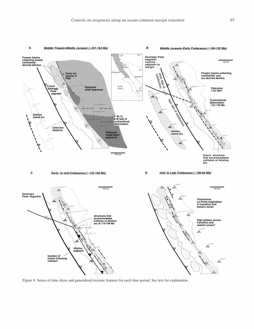
Controls on orogenesis along an ocean-continent margin transition 67
100 km
?
?
?
Forearc basinscollecting mostlycontinental-derived detritus
Unknowndistance
Alisitosisland arc
Middle Triassic-Middle Jurassic (~241-164 Ma)
Future Santiago Peak segment
Some arcactivity inPRB
A
Ensenada
Guaymas
La Paz
SanFelipe
PacificOcean
115 110
30
25
Mexico
aUSA
??
?
?
Paleozoicshelf sequence
Paleozoicslope-basinsequence
100 km
Middle Jurassic-Early Cretaceous (~164-132 Ma)
Forearc basins collectingcontinental- andarc-derived detritus
?
?
Extension>151 Ma?
Contractionaldeformation~151-132 Ma
Santiago Peaksegmentevolvesadjacent tomargin
B
Alisitosisland arc
future structurethat accommodatescollision of Alisitosarc
slow rate of
subduction
fast rate of subduction
100 km
?
?
?
?
Early- to mid-Cretaceous (~132-100 Ma)C
location oftrench followingcollision
structures thataccommodatedcollision of Alisitosarc at 115-108 Ma
SantiagoPeak segment
Alisitossegment
100 km
VoluminousLa Posta magmatismin transition andeastern zones
mid- to Late Cretaceous (~100-65 Ma)
?
?High plateau acrosstransition andeastern zones?
D
P- R (?)E-W belt ofcontractionaldeformation
T
?
?
Figure 8. Series of time slices and generalized tectonic features for each time period. See text for explanation.
K.L. Schmidt et al.68
curred prior to and following collision adjacent to both the Al-isitos and Santiago Peak segments. In comparison, little defor-mation is apparent in the western zone during this time, withthe exception of rocks near the Agua Blanca fault. And in theeastern zone, miogeoclinal rocks north of 30.5�N were appar-ently only locally deformed, while significant deformation isapparent in this belt farther south.
An episode of voluminous La Posta plutonism occurred inthe transitional and eastern zones along the length of the bath-olith from ca. 99–92 Ma (Kimbrough et al., 2001). This wasfollowed by an apparent eastward migration of magmatism thatreached present-day Sonora by latest Cretaceous-earliest Ter-tiary time (Fig. 8D). Dramatic exhumation of the transitionaland eastern zones of the PRb occurred syn- to post La Postatime. For example, plutons in the transitional zone of the south-ern Sierra San Pedro Martir that were emplaced ca. 100 Ma at�15 km depth had reached near-surface conditions (�5 km)by ca. 85 Ma during uplift accommodated on reverse shearzones (Schmidt, 2000). Thick sequences of coarse detritus ac-cumulated in forearc settings along the present western coastof Peninsular California beginning at ca. 99 Ma (Fig. 8D, e.g.,Bottjer and Link, 1984; Busby et al., 1998; Kimbrough et al.,2001). Detrital 40Ar/39Ar K-feldspar studies of these sedimentscorroborate rapid denudation of the transition and eastern zonesof the batholith (Lovera et al., 1999). This denudation continueduntil ca. 70 Ma in the transition zone of the batholith and intothe Paleogene in the eastern zone, where distinct variation isapparent in the amount of denudation across the crustal bound-ary along �30.5�N latitude (Rothstein, 1997).
CONCLUSIONS
Our present understanding of geologic relationships in thePRb indicate that the eastern, transitional, and western zones ofthe batholith are distinct basement belts across which the bath-olith was constructed in Jura-Cretaceous time. The eastern zoneof the PRb appears to be underlain by North American base-ment that was variably deformed during Mesozoic orogenesisand deeply denuded in the Late Cretaceous. It contains an in-herited, pre-Mesozoic boundary that crosses it at �30.5�N lat-itude, which separates shelf from slope facies Paleozoic mio-geoclinal rocks and appears to have influenced the Mesozoicdeformation and exhumation history of the eastern zone. In con-trast, the western zone was constructed on basement of oceaniccharacter, experienced primitive arc magmatism, is generallylittle deformed, and preserves upper crustal levels of the Pen-insular Ranges arc.
The transition zone, which evolved across the interface be-tween western and eastern zone crust, is a long-lived featurethat is tied by sedimentological and petrological criteria to theeastern zone throughout the Mesozoic. It played an importantrole in the evolution of the batholith in the following ways:
1. It separated distinct lithospheric belts within the batho-
lith that generated very different magma compositions during�60 m.y. of Mesozoic arc magmatism.
2. It controlled the distribution of long-lived forearc or in-traarc basins within the batholith.
3. It focused contractional deformation along a narrow beltof reverse shear zones, folds, and intense cleavage along thelength of the batholith for �40 m.y.
4. It determined how exhumation progressed as the easternbelt was deeply denuded during the later stages of the batho-lith’s history.
A significant Mesozoic across-strike boundary in the PRboccurs across the western and transition zones along the modernAgua Blanca fault. In the western zone of the batholith, theAgua Blanca fault appears to separate two distinct Mesozoicarc segments. The Santiago Peak segment is clearly tied bydepositional contacts to the transition zone since ca. 127 Ma,and Pb zircon inheritance in igneous rocks within the terrane isconsistent with its evolution adjacent to the transition zone. Theless well understood Alisitos arc segment to the south, on theother hand, shows no ties to the transition zone until ca. 115–108 Ma. Moreover, igneous rocks from this segment, as of yet,have yielded no inherited Pb in zircons that would be consistentwith the terrane’s origin adjacent to North America, and pet-rological studies strongly suggest an island arc environment.Finally, the geometry of stratigraphy and structures in the Al-isitos arc segment adjacent to the Agua Blanca fault suggestssinistral drag folding, consistent with docking of the Alisitosarc terrane south of the Santiago Peak segment.
Features that define the transition zone are continuousalong-strike across the Agua Blanca fault. However, some dis-tinct changes are also apparent including mostly clastic sedi-ment in the flysch assemblage to the north versus volcaniclasticto the south, and the location of shear zones and gradients inmetamorphic and thermal histories of rocks appears to shiftfrom the eastern side of the transition zone in the northern bath-olith to its western side in the southern batholith. Consequently,an interesting problem is apparent in the PRb transition zoneadjacent to the Santiago Peak and Alisitos segments. The tran-sition zone shows some variation in evolution along-strike be-tween regions that are adjacent to these respective noncolli-sional and collisional terranes. For example, the boundarybetween the Alisitos arc segment and the transition zone is de-fined by impressively developed mylonite shear zones, whereasthe boundary to the north is not as well defined. However, thetransition zone in both the northern and southern parts of thebatholith experienced a similar degree of metamorphism, de-nudation, and focused deformation compared to eastern andwestern zones to either side. Thus, it appears that the effects ofcollision of the Alisitos arc segment with North America at ca.115–108 Ma have been masked by orogenesis driven by pro-cesses such as heightened subduction zone coupling that mayhave affected a large part of the southern Cordilleran margin.Collision was, accordingly, not a major mechanism that drove
Controls on orogenesis along an ocean-continent margin transition 69
orogeny in the PRb, and the pulse of deformation and exhu-mation after ca. 100 Ma resulted from other orogenic processes.
ACKNOWLEDGMENTS
We thank a number of individuals for valuable discussions onthe Mesozoic tectonics of the Peninsular Ranges batholith overthe past few years including Gordon Gastil, Gary Girty, CelesteThomson-Yoshinobu, Richard Sedlock, Marty Grove, and JohnFletcher. Thoughtful reviews by Greg Davis, Gary Girty, andPaul Umhoefer helped us to clarify many of our ideas and sig-nificantly improved the manuscript.
REFERENCES CITED
Adams, M.A., 1979, Stratigraphy and petrography of the Santiago Peak Vol-canics east of Rancho Santa Fe, California [M.S. thesis]: San Diego, Cali-fornia, San Diego State University, 123 p.
Ague, J.J., and Brandon, M.T., 1992, Tilt and northward offset of Cordilleranbatholiths resolved using igneous barometry: Nature, v. 360, p. 146–149.
Ague, J.J., and Brimhall, G.H., 1988, Magmatic arc asymmetry and distributionof anomalous plutonic belts in the batholiths of California: Effects ofassimilation, crustal thickness, and depth of crystallization: GeologicalSociety of America Bulletin, v. 100, p. 912–927.
Allen, C.R., Silver, L.T., and Stehli, F.G., 1960, Agua Blanca fault: A majortransverse structure of Baja California, Mexico: Geological Society ofAmerica Bulletin, v. 71, p. 457–482.
Allison, E.C., 1955, middle Cretaceous Gastropoda from Punta China, BajaCalifornia, Mexico: Journal of Paleontology, v. 29, p. 400–432.
Allison, E.C., 1974, The type Alisitos Formation (Cretaceous, Aptian-Albian)of Baja California and its bivalve fauna, in Gastil, G., and Lillegraven,J., eds., Geology of peninsular California: American Association of Pe-troleum Geologists, Pacific Section, Guidebook Annual Meeting, 49th,p. 20–59.
Armijo, R., and Suarez-Vidal, F., 1981, Neotectonics of northern Baja Califor-nia: Geological Society of America Abstracts with Programs, v. 13, no. 2,p. 42.
Armstrong, R.L., and Suppe, J., 1973, Potassium-argon geochronometry ofMesozoic igneous rocks in Nevada, Utah, and southern California: Geo-logical Society of America Bulletin, v. 84, p. 1375–1392.
Axen, G.J., Grove, M., Stockli, D., Lovera, O.M., Rothstein, D.A., Fletcher,J.M., Farley, K., and Abbott, P.L., 2000, Thermal evolution of MonteBlanco dome: Low-angle normal faulting during Gulf of California riftingand late Eocene denudation of the eastern Peninsular Ranges: Tectonics,v. 19, p. 197–212.
Baird, A.K., and Miesch, A.T., 1984, Batholithic rocks of southern California-a model for the petrochemical nature of their source materials: U.S. Geo-logical Survey Professional Paper 1284.
Baird, A.K., Baird, K.W., and Welday, E.E., 1974, Chemical trends acrossCretaceous batholithic rocks of southern California: Geology, v. 2, p. 493–495.
Barthelmy, D.A., 1979 Regional geology of the El Arco porphyry copper de-posit, Baja California, in Abbott, P.L., and Gastil, R.G., eds., Baja Cali-fornia Geology: Field Guides and Papers: Geological Society of America,p. 127–138.
Bottjer, D.J., and Link, M.H., 1984, A synthesis of Late Cretaceous southernCalifornia and northern Baja California paleogeography, in Crouch, J.K.,and Bachman, S.B., eds., Tectonics and Sedimentation Along the Cali-fornia Margin: Pacific Section Society of Economic Paleontologists andMineralogists 38, p. 171–188.
Buch, I.P., and DeLattre, M.P., 1993, Permian and Lower Triassic stratigraphy
along the 30th parallel, eastern Baja California Norte, Mexico, in Gastil,R.G., and Miller, R.H., eds., The prebatholithic stratigraphy of peninsularCalifornia: Boulder, Colorado, Geological Society of America SpecialPaper 279, p. 77–90.
Busby C., Smith, D., Morris, W., and Fackler-Adams, B., 1998, Evolutionarymodel for convergent margins facing large ocean basins: Mesozoic BajaCalifornia Mexico: Geology, v. 26, p. 227–230.
Butler, R.F., Dickinson, W.R., and Gehrels, G.E., 1991, Paleomagnetism ofcoastal California and Baja California: Alternatives to large-scale north-ward transport: Tectonics, v. 10, p. 561–576.
Carrasco, A.P., Kimbrough, D.L., and Herzig, C.T., 1995, Cretaceous arc-volcanic strata of the western Peninsular Ranges: Comparison of the San-tiago Peak Volcanics and Alisitos Group: Abstracts of Peninsular Geo-logical Society International Meeting on Geology of the Baja CaliforniaPeninsula III, April 17–21, 1995, La Paz, Mexico, p. 19.
DePaolo, D.J., 1980, Sources of continental crust: Neodymium isotope evi-dence from the Sierra Nevada and Peninsular Ranges: Science, v. 209,p. 684–687.
DePaolo, D.J., 1981, A neodymium and strontium isotopic study of the Me-sozoic calc-alkaline granitic batholiths of the Sierra Nevada and Penin-sular Ranges, California: Journal of Geophysical Research, v. 86, p.10470–10 488.
Dickinson, W.R., 2000, Geodynamic interpretation of Paleozoic tectonic trendsoriented oblique to the Mesozoic Klaath-Sierran continental margin inCalifornia, in Soreghan, M.J., and Gehrels, G.E., eds., Paleozoic and Tri-assic paleogeography and tectonics of western Nevada and northern Cali-fornia: Boulder, Colorado, Geological Society of America Special Paper347, p. 209–245.
Dickinson, W.R., and Lawton, T.F., 2001, Carboniferous to Cretaceous assem-bly and fragmentation of Mexico, Geological Society of America Bul-letin, v. 113, no. 9, p. 1142–1160.
Early, T.O., and Silver, L.T., 1973, Rb-Sr isotopic systematics in the PeninsularRanges batholith of southern and Baja California: Eos (Transactions,American Geophysical Union), v. 54, p. 494.
Evernden, J.F., and Kistler, R.W., 1970, Chronology of emplacement of Me-sozoic batholithic complexes in California and western Nevada: U.S.Geological Survey Professional Paper 623, 42 p.
Fackler-Adams, B.N., and Busby, C.J., 1998, Structural and stratigraphic evo-lution of extensional oceanic arcs: Geology, v. 26, p. 735–738.
Fife, D.L., Minch, J.A., and Crampton, P.J., 1967, Late Jurassic age of theSantiago Peak Volcanics, California: Geological Society of America Bul-letin, v. 78, p. 229–304.
Fuis, G.S., Mooney, W.D., Healey, J.H., McMechan, G.A., and Lutter, W.J.,1982, Crustal structure of the Imperial Valley region, in The ImperialValley, California, Earthquake of October 15, 1979, U.S. Geological Sur-vey Professional Paper 1254, p. 25–50.
Gastil, R.G., 1983, Mesozoic and Cenozoic granitic rocks of southern Califor-nia and western Mexico, in Roddick, J.A., ed., Mesozoic and Cenozoicgranitic rocks of southern California and western Mexico: Boulder, Col-orado, Geological Society of America Memoir 159, p. 265–275.
Gastil, R.G., 1993, Prebatholithic history of peninsular California, in Gastil,R.G., and Miller, R.H., eds., The prebatholithic stratigraphy of peninsularCalifornia: Boulder, Colorado, Geological Society of America SpecialPaper 279, p. 145–156.
Gastil, R.G., and Girty, M.S., 1993, A reconnaissance U-Pb study of detritalzircon in sandstones of Peninsular California and adjacent areas, in Gastil,R.G., and Miller, R.H., eds., The prebatholithic stratigraphy of peninsularCalifornia: Boulder, Colorado, Geological Society of America SpecialPaper 279, p. 135–144.
Gastil, R.G., and Miller, R.H., 1984, Prebatholithic paleogeography of penin-sular California and adjacent Mexico, in Grizzel, V.A., ed., Geology ofthe Baja California peninsula: Society of Economic Paleontologists andMineralogists, Pacific Section, p. 9–16.
Gastil, R.G., and Miller, R.H., editors, 1993, The prebatholithic stratigraphy of
K.L. Schmidt et al.70
peninsular California: Boulder, Colorado, Geological Society of AmericaSpecial Paper 279, 163 p.
Gastil, R.G., Phillips, R.P., and Allison, E.C., 1975, Reconnaissance geologyof the State of Baja California: Boulder, Colorado, Geological Society ofAmerica Memoir 140, 170 p.
Gastil, R.G., Morgan, G.J., Krummenacher, D., 1978, Mesozoic history of Pen-insular California and related areas east of the Gulf of California, in How-ell, D.G., and McDougall, K.A., eds., Mesozoic paleogeography of thewestern United States: Pacific Section, Society of Economic Paleontol-ogists and Mineralogists, Pacific Coast Paleogeography Symposium 2,p. 107–116.
Gastil, R.G., Morgan, G.J., and Krummenacher, D., 1981, The tectonic historyof Peninsular California and adjacent Mexico, in Ernst, W.G., ed., Thegeotectonic development of California (Rubey Volume I): EnglewoodCliffs, New Jersey, Prentice Hall, p. 284–306.
Gastil, R.G., Diamond, C.K., Walawender, M.J., Marshal, M., Boyles, C., andChadwick, B., 1990, The problem of the magnetite/ilmenite boundary insouthern and Baja California, in Anderson, J.L., ed., The Nature andOrigin of Cordilleran Magmatism: Boulder, Colorado, Geological Societyof America Memoir 174, p. 19–32.
Gastil, R.G., Miller, R., Anderson, P., Crocker, J., Campbell, M., Buch, P.,Lothringer, C., Leier-Engelhardt, P., DeLattre, M., Hoobs, J., and Roldan-Quintana, J., 1991a, The relation between the Paleozoic strata on oppositesides of the Gulf of California, in Perez-Segura, E., and Jacques-Ayala,C., eds., Studies of Sonoran geology: Boulder, Colorado, Geological So-ciety of America Special Paper 254, p. 7–17.
Gastil, R.G., Kimbrough, J., Tainosho, Y., Shimizu, M., and Gunn, S., 1991b,Plutons of the eastern Peninsular Ranges, southern California, U.S.A.,and Baja California, Mexico, in Walawender, M.J., and Hanan, B.B., eds.,Geological Excursions in Southern California and Mexico: San Diego,California, Geological Society of America Annual Meeting Guidebook,p. 319–331.
Germinario, M., 1993, The early Mesozoic Julian Schist, Julian, California, inGastil, R.G., and Miller, R.H., eds., The prebatholithic stratigraphy ofpeninsular California: Boulder, Colorado, Geological Society of AmericaSpecial Paper 279, p. 107–118.
Griffith, R., and Hoobs, J., 1993, Geology of the southern Sierra Calamajue,Baja California Norte, Mexico, in Gastil, R.G., and Miller, R.H., eds.,The prebatholithic stratigraphy of peninsular California: Boulder, Colo-rado, Geological Society of America Special Paper 279, p. 43–60.
Gromet, L.P., and Silver, L.T., 1987, REE variations across the PeninsularRanges batholith: Implications for batholithic petrogenesis and crustalgrowth in magmatic arcs: Journal of Petrology, v. 28, no. 1, p. 75–125.
Grove, M., 1989, Nature of the metamorphic discontinuity across the ChariotCanyon fault, east-central Peninsular Ranges batholith, California: Geo-logical Society of America Abstracts with Program, v. 21, no. 5, p. 87.
Grove, M., 1994, Contrasting denudation histories within the east-central Pen-insular Ranges batholith (33�N), in McGill, S.F., and Ross, T.M., eds.,Geological investigations of an active margin: San Bernardino, Califor-nia, Geological Society of America Cordilleran Section Guidebook, p.235–240.
Hagstrum, J.T., McWilliams, M., Howell, D.G., and Gromme, C.S., 1985, Me-sozoic paleomagnetism and northward translation of the Baja Californiapeninsula: Geological Society of America Bulletin, v. 96, p. 1077–1090.
Herzig, C.T., and Kimbrough, D.L., 1998, Provenance of silicic volcanic clastsin Upper Cretaceous strata, northern Santa Ana Mountains, California, inBehl, R.J., ed., Late Cretaceous denudation history of the PeninsularRanges as recorded in Upper Cretaceous–Paleocene sedimentary rocks,northern Santa Ana Mountains: Longbeach, California, Geological So-ciety of America field trip guide, trip #13, p. 23–29.
Ichinose, G., Day, S.M., Magistrale, H., Prush, T., Vernon, F.L., and Edelman,A., 1996, Crustal thickness variations beneath the Peninsular Ranges,southern California: Geophysical Research Letters, v. 23, p. 3095–3098.
Jachens, R.C., Simpson, R.W., Griscom, A., and Marano, J., 1986, Plutonic
belts in southern California defined by gravity and magnetic anomalies:Geological Society of America Abstracts with Programs, v. 18, no. 2,p. 120.
Johnson, S.E., Tate, M.C., and Fanning, C.M., 1999a, New geologic mappingand SHRIMP U-Pb zircon data in the Peninsular Ranges batholith, BajaCalifornia, Mexico: Evidence for a suture?: Geology, v. 27, p. 743–746.
Johnson, S.E., Paterson, S.R., and Tate, M.C., 1999b, Structure and emplace-ment history of a multiple-center, cone-sheet-bearing ring complex: BajaCalifornia, Mexico, The Zarza Intrusive Complex: Geological Society ofAmerica Bulletin, v. 4, p. 607–619.
Kimbrough, D.L., and Herzig, C.T., 1994, Late Jurassic–Early Cretaceous de-formation in the prebatholithic basement of the Cretaceous PeninsularRanges batholith magmatic arc—an expression of the J-2 cusp?: Geolog-ical Society of America Abstracts with Programs, v. 26, no. 2, p. 63.
Kimbrough, D.L., Smith, D.P., Mahoney, J.B., Moore, T.E., Grove, M., Gastil,R.G., and Ortega-Rivera, A., 2001, Forearc-basin sedimentary responseto rapid Late Cretaceous batholith emplacement in the Peninsular Rangesof southern and Baja California: Geology, v. 29, p. 491–494.
Kopf, C.F., Whitney, D.L., and Schmidt, K.L., 2000, Distinct P-T domainsacross the Peninsular Ranges batholith in northern Baja California, Mex-ico: Evidence for a long-lived interarc convergent zone: Geological So-ciety of America Abstracts with Program, v. 32 no. 7, p. 296.
Krummenacher, D., Gastil, R.G., Bushee, J., and Doupont, J., 1975, K-Ar ap-parent ages, Peninsular Ranges batholith, southern California and BajaCalifornia: Geological Society of America Bulletin, v. 86, p. 760–768.
Larson, E.S., Jr., 1948, Batholith and associated rocks of Corona, Elsinore, andSan Luis Rey quadrangles, southern California: Boulder, Colorado, Geo-logical Society of America Memoir 29, 182 p.
Lewis, J.L., Day, S.M., Magistrale, H., Eakins, J., and Vernon, F., 2000, Re-gional crustal thickness variations of the Peninsular Ranges, southernCalifornia: Geology, v. 28, p. 303–306.
Lothringer, C.J., 1993, Allochthonous Ordovician strata of Rancho San Marcos,Baja California Norte, Mexico, in Gastil, R.G., and Miller, R.H., eds.,The prebatholithic stratigraphy of peninsular California: Boulder, Colo-rado, Geological Society of America Special Paper 279, p. 11–22.
Lovera, O.M., Grove, M., Kimbrough, D.L., and Abbott, P.L., 1999, A methodfor evaluating basement exhumation histories from closure age distribu-tions of detrital minerals: Journal of Geophysical Research, v. 104, p.29419–29 438.
Magistrale, H., and Sanders, C., 1995, P wave image of the Peninsular Rangesbatholith, southern California: Geophysical Research Letters, v. 22, p.2549–2552.
Measures, M.A., 1996, Geology of the Agua Caliente region, southeast SierraSan Pedro Martir, Baja California Mexico [M.S. thesis]: San Diego StateUniversity, 105 p.
Meeth, G., 1993, Stratigraphy and petrology of the Santiago Peak Volcanicseast of La Mission, Baja California, [B.S. thesis]: San Diego, California,San Diego State University, 16 p.
Miller, R.B., Brown, E.H., McShane, D.P., and Whitney, D.L., 1993, Majorintraarc crustal loading and its tectonic implications, North Cascades crys-talline core, Washington and British Columbia: Geology, v. 21, 255–288.
Oliver, H.W., 1980, Peninsular Ranges, in Oliver, H.W., ed., Interpretation ofthe Gravity Map of California and its Continental Margin, CaliforniaDivision of Mines and Geology Bulletin 205, p. 17–19.
Ortega-Rivera, A., Farrar, E., Hanes, J.A., Archibald, D.A., Gastil, R.G., Kim-brough, D.L., Zentilli, M., Lopez-Martınez, M., Feraud, G., and Ruffet,G., 1997, Chronological constraints on the thermal and tilting history ofthe Sierra San Pedro Martir pluton, Baja California, Mexico, from U-Pb,40Ar/39Ar and fission-track geochronology: Geological Society of Amer-ica Bulletin, v. 109, p. 728–745.
Phillips, J.R., 1993, Stratigraphy and structural setting of the mid-CretaceousOlvidada Formation, Baja California Norte, Mexico, in Gastil, R.G., andMiller, R.H., eds., The prebatholithic stratigraphy of peninsular Califor-
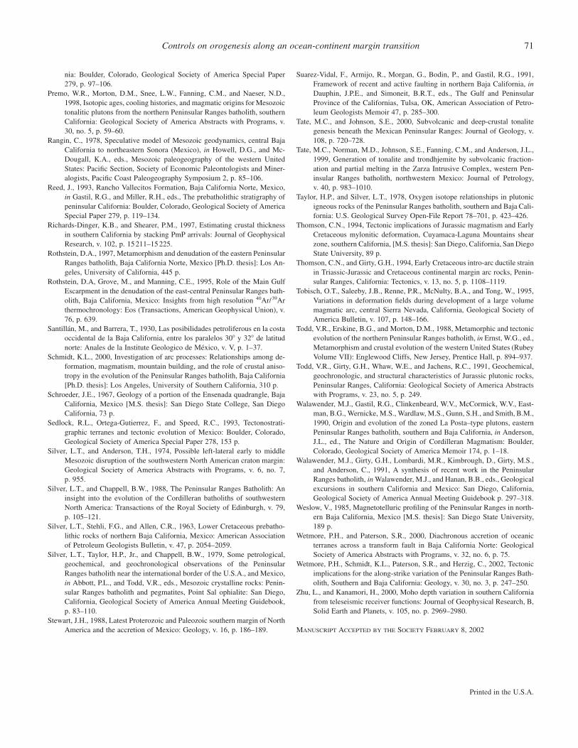
Controls on orogenesis along an ocean-continent margin transition 71
Printed in the U.S.A.
nia: Boulder, Colorado, Geological Society of America Special Paper279, p. 97–106.
Premo, W.R., Morton, D.M., Snee, L.W., Fanning, C.M., and Naeser, N.D.,1998, Isotopic ages, cooling histories, and magmatic origins for Mesozoictonalitic plutons from the northern Peninsular Ranges batholith, southernCalifornia: Geological Society of America Abstracts with Programs, v.30, no. 5, p. 59–60.
Rangin, C., 1978, Speculative model of Mesozoic geodynamics, central BajaCalifornia to northeastern Sonora (Mexico), in Howell, D.G., and Mc-Dougall, K.A., eds., Mesozoic paleogeography of the western UnitedStates: Pacific Section, Society of Economic Paleontologists and Miner-alogists, Pacific Coast Paleogeography Symposium 2, p. 85–106.
Reed, J., 1993, Rancho Vallecitos Formation, Baja California Norte, Mexico,in Gastil, R.G., and Miller, R.H., eds., The prebatholithic stratigraphy ofpeninsular California: Boulder, Colorado, Geological Society of AmericaSpecial Paper 279, p. 119–134.
Richards-Dinger, K.B., and Shearer, P.M., 1997, Estimating crustal thicknessin southern California by stacking PmP arrivals: Journal of GeophysicalResearch, v. 102, p. 15211–15 225.
Rothstein, D.A., 1997, Metamorphism and denudation of the eastern PeninsularRanges batholith, Baja California Norte, Mexico [Ph.D. thesis]: Los An-geles, University of California, 445 p.
Rothstein, D.A, Grove, M., and Manning, C.E., 1995, Role of the Main GulfEscarpment in the denudation of the east-central Peninsular Ranges bath-olith, Baja California, Mexico: Insights from high resolution 40Ar/39Arthermochronology: Eos (Transactions, American Geophysical Union), v.76, p. 639.
Santillan, M., and Barrera, T., 1930, Las posibilidades petroliferous en la costaoccidental de la Baja California, entre los paralelos 30� y 32� de latitudnorte: Anales de la Institute Geologico de Mexico, v. V, p. 1–37.
Schmidt, K.L., 2000, Investigation of arc processes: Relationships among de-formation, magmatism, mountain building, and the role of crustal aniso-tropy in the evolution of the Peninsular Ranges batholith, Baja California[Ph.D. thesis]: Los Angeles, University of Southern California, 310 p.
Schroeder, J.E., 1967, Geology of a portion of the Ensenada quadrangle, BajaCalifornia, Mexico [M.S. thesis]: San Diego State College, San DiegoCalifornia, 73 p.
Sedlock, R.L., Ortega-Gutierrez, F., and Speed, R.C., 1993, Tectonostrati-graphic terranes and tectonic evolution of Mexico: Boulder, Colorado,Geological Society of America Special Paper 278, 153 p.
Silver, L.T., and Anderson, T.H., 1974, Possible left-lateral early to middleMesozoic disruption of the southwestern North American craton margin:Geological Society of America Abstracts with Programs, v. 6, no. 7,p. 955.
Silver, L.T., and Chappell, B.W., 1988, The Peninsular Ranges Batholith: Aninsight into the evolution of the Cordilleran batholiths of southwesternNorth America: Transactions of the Royal Society of Edinburgh, v. 79,p. 105–121.
Silver, L.T., Stehli, F.G., and Allen, C.R., 1963, Lower Cretaceous prebatho-lithic rocks of northern Baja California, Mexico: American Associationof Petroleum Geologists Bulletin, v. 47, p. 2054–2059.
Silver, L.T., Taylor, H.P., Jr., and Chappell, B.W., 1979, Some petrological,geochemical, and geochronological observations of the PeninsularRanges batholith near the international border of the U.S.A., and Mexico,in Abbott, P.L., and Todd, V.R., eds., Mesozoic crystalline rocks: Penin-sular Ranges batholith and pegmatites, Point Sal ophialite: San Diego,California, Geological Society of America Annual Meeting Guidebook,p. 83–110.
Stewart, J.H., 1988, Latest Proterozoic and Paleozoic southern margin of NorthAmerica and the accretion of Mexico: Geology, v. 16, p. 186–189.
Suarez-Vidal, F., Armijo, R., Morgan, G., Bodin, P., and Gastil, R.G., 1991,Framework of recent and active faulting in northern Baja California, inDauphin, J.P.E., and Simoneit, B.R.T., eds., The Gulf and PeninsularProvince of the Californias, Tulsa, OK, American Association of Petro-leum Geologists Memoir 47, p. 285–300.
Tate, M.C., and Johnson, S.E., 2000, Subvolcanic and deep-crustal tonalitegenesis beneath the Mexican Peninsular Ranges: Journal of Geology, v.108, p. 720–728.
Tate, M.C., Norman, M.D., Johnson, S.E., Fanning, C.M., and Anderson, J.L.,1999, Generation of tonalite and trondhjemite by subvolcanic fraction-ation and partial melting in the Zarza Intrusive Complex, western Pen-insular Ranges batholith, northwestern Mexico: Journal of Petrology,v. 40, p. 983–1010.
Taylor, H.P., and Silver, L.T., 1978, Oxygen isotope relationships in plutonicigneous rocks of the Peninsular Ranges batholith, southern and Baja Cali-fornia: U.S. Geological Survey Open-File Report 78–701, p. 423–426.
Thomson, C.N., 1994, Tectonic implications of Jurassic magmatism and EarlyCretaceous mylonitic deformation, Cuyamaca-Laguna Mountains shearzone, southern California, [M.S. thesis]: San Diego, California, San DiegoState University, 89 p.
Thomson, C.N., and Girty, G.H., 1994, Early Cretaceous intro-arc ductile strainin Triassic-Jurassic and Cretaceous continental margin arc rocks, Penin-sular Ranges, California: Tectonics, v. 13, no. 5, p. 1108–1119.
Tobisch, O.T., Saleeby, J.B., Renne, P.R., McNulty, B.A., and Tong, W., 1995,Variations in deformation fields during development of a large volumemagmatic arc, central Sierra Nevada, California, Geological Society ofAmerica Bulletin, v. 107, p. 148–166.
Todd, V.R., Erskine, B.G., and Morton, D.M., 1988, Metamorphic and tectonicevolution of the northern Peninsular Ranges batholith, in Ernst, W.G., ed.,Metamorphism and crustal evolution of the western United States (RubeyVolume VII): Englewood Cliffs, New Jersey, Prentice Hall, p. 894–937.
Todd, V.R., Girty, G.H., Whaw, W.E., and Jachens, R.C., 1991, Geochemical,geochronologic, and structural characteristics of Jurassic plutonic rocks,Peninsular Ranges, California: Geological Society of America Abstractswith Programs, v. 23, no. 5, p. 249.
Walawender, M.J., Gastil, R.G., Clinkenbeard, W.V., McCormick, W.V., East-man, B.G., Wernicke, M.S., Wardlaw, M.S., Gunn, S.H., and Smith, B.M.,1990, Origin and evolution of the zoned La Posta–type plutons, easternPeninsular Ranges batholith, southern and Baja California, in Anderson,J.L., ed., The Nature and Origin of Cordilleran Magmatism: Boulder,Colorado, Geological Society of America Memoir 174, p. 1–18.
Walawender, M.J., Girty, G.H., Lombardi, M.R., Kimbrough, D., Girty, M.S.,and Anderson, C., 1991, A synthesis of recent work in the PeninsularRanges batholith, in Walawender, M.J., and Hanan, B.B., eds., Geologicalexcursions in southern California and Mexico: San Diego, California,Geological Society of America Annual Meeting Guidebook p. 297–318.
Weslow, V., 1985, Magnetotelluric profiling of the Peninsular Ranges in north-ern Baja California, Mexico [M.S. thesis]: San Diego State University,189 p.
Wetmore, P.H., and Paterson, S.R., 2000, Diachronous accretion of oceanicterranes across a transform fault in Baja California Norte: GeologicalSociety of America Abstracts with Programs, v. 32, no. 6, p. 75.
Wetmore, P.H., Schmidt, K.L., Paterson, S.R., and Herzig, C., 2002, Tectonicimplications for the along-strike variation of the Peninsular Ranges Bath-olith, Southern and Baja California: Geology, v. 30, no. 3, p. 247–250.
Zhu, L., and Kanamori, H., 2000, Moho depth variation in southern Californiafrom teleseismic receiver functions: Journal of Geophysical Research, B,Solid Earth and Planets, v. 105, no. p. 2969–2980.
MANUSCRIPT ACCEPTED BY THE SOCIETY FEBRUARY 8, 2002