Embed Size (px)
Citation preview

Himalaya, the Journal of theAssociation for Nepal and
Himalayan Studies
Volume 33 | Number 1 Article 8
March 2014
Contemporary Human Impacts on Subalpine andAlpine Ecosystems of the Hinku Valley, Makalu-Barun National Park and Buffer Zone, NepalAlton ByersThe Mountain Institute, [email protected]
Follow this and additional works at: http://digitalcommons.macalester.edu/himalaya
This Research Article is brought to you for free and open access by theDigitalCommons@Macalester College at DigitalCommons@MacalesterCollege. It has been accepted for inclusion in Himalaya, the Journal of theAssociation for Nepal and Himalayan Studies by an authorizedadministrator of DigitalCommons@Macalester College. For moreinformation, please contact [email protected].
Recommended CitationByers, Alton (2014) "Contemporary Human Impacts on Subalpine and Alpine Ecosystems of the Hinku Valley, Makalu-BarunNational Park and Buffer Zone, Nepal," Himalaya, the Journal of the Association for Nepal and Himalayan Studies: Vol. 33: No. 1, Article8.Available at: http://digitalcommons.macalester.edu/himalaya/vol33/iss1/8
Contemporary Human Impacts on Subalpine and Alpine Ecosystems ofthe Hinku Valley, Makalu-Barun National Park and Buffer Zone, Nepal
AcknowledgementsThe author would like to thank the National Geographic Society, American Alpine Club, and The MountainInstitute for their support of this and other projects designed to promote community-based alpineconservation throughout the high mountain world.
This research article is available in Himalaya, the Journal of the Association for Nepal and Himalayan Studies:http://digitalcommons.macalester.edu/himalaya/vol33/iss1/8

HIMALAYA Volume 33, Numbers 1 & 2 | 25
Contemporary Human Impacts on Subalpine and Alpine Ecosystems of the Hinku Valley, Makalu-Barun National Park and Buffer Zone, Nepal
Alton C. Byers
A reconnaissance of the upper Hinku valley, Makalu-Barun National Park and Buffer Zone, Nepal was undertaken in May, 2007 to determine the impacts of contemporary adventure tourism upon its subalpine and alpine ecosystems. Results showed that visitor numbers, lodges, and other tourist-related infrastructure grew from one structure in 1995 to 129 in 2007. This growth was accompanied by a corresponding and accelerated harvesting of subalpine timber for lodge construction, and of shrub juniper and dwarf rhododendron for use as fuel in alpine tourist lodges. These practices were largely discontinued with the formation of the Mera Alpine Conservation Group (MACG) in 2008, which placed greater restrictions on timber harvesting, mandated
the use of kerosene as a fuel substitute for alpine shrubs, and attempted to limit the number of new lodges that could be built in the valley. Repeat sampling of alpine hillslopes suggest that these actions have had significant conservation benefits. However, it is clear that the challenges of promoting high altitude conservation, and of finding renewable, sustainable energy sources alternative to alpine shrubs and kerosene, will remain for the foreseeable future. Strategies that could facilitate beneficial change in current alpine usage practices are discussed in the paper.
Keywords: Himalaya, Nepal, adventure tourism, alpine, subalpine.

26 | HIMALAYA Fall 2013
Introduction
Alpine ecosystems cover three percent of the earth’s land surface and contain over 10,000 species of plants. Among the most biodiverse ecosystems per unit area in the world (Körner 1999), they are of critical importance as sources of freshwater (Bandyopadhay et. al 1997), medicinal and aromatic plants (Olsen and Larsen 2003; Buntane et al. 2006; Cox 2008), and as integral parts of high mountain livelihoods that are increasingly becoming dependent on the adventure tourism trade (Godde et al. 2000; Nepal 2000; Nepal et al. 2002).
Alpine ecosystems throughout the mountain world have been heavily altered by human activities, especially during the past 20 to 30 years with the substantial growth of mountaineering, trekking, and adventure tourism to remote mountain regions (Nagy and Grabherr 2009: 299-302; Byers 2005). The most common impacts include the removal of slow growing alpine shrubs and cushion plants by lodge owners, porters, and climbing/trekking parties for use as fuel (Stevens 2003; Byers 2001, 2005). The recent growth in the uncontrolled harvesting of the medicinal plant yarsagumba (Cordyceps sinensis) has placed additional stresses on alpine ecosystems in Nepal and elsewhere (Cox 2008). Associated accelerations in soil loss and decreased slope stability often result from the indiscriminate removal of these soil-binding shrubs (Byers 1987b, 1997, 2005; Körner 1999). Other forms of disturbance include turf cutting (Byers 1987b, 2005; Olsen and Larsen 2003); increased numbers of pack animals (yak and dzopio in the Himalayas, burros and cattle in the Andes) to accommodate growing numbers of tourists (Byers 2005, 2011; Pérez 1998); accelerated water borne health hazards as a result of improper human waste disposal (MacLellan et al. 2000; Manfredi et al. 2010; McDowell et al. 2012); accumulations of solid waste at camping sites, basecamps, and highcamp regions (Lachapelle 1998; Associated Press 2008; Byers et al. 2011; Byers 2013a); and the growing presence of landfills and human waste disposal pits in the vicinity of villages along the main trekking routes (Rogers and Aitchison 1998; Byers et al. 2011; Goldenberg 2011).
My own alpine-specific field research began in the Sagarmatha (Mt. Everest) National Park (SNP) region in the mid-1980s (see: 1987a, 1987b, 19897c), followed by more detailed work from 1995 to the present (see: Byers 2001, 2005: 127-131; this paper). Collectively, the results of my field investigations revealed that a heavy loss of shrub juniper (Juniperus indica) and other alpine plants had occurred along the traditional Everest basecamp route since the opening of the region to adventure travel in the early 1950s (Schneider 1963; Hillary 1999). This disturbance
was found to be linked to the unsustainable harvesting of alpine shrubs by lodges, climbing teams, trekking parties, and porters to satisfy their fuelwood (for cooking and heating) and puja (ceremonial) requirements, which in turn was responsible for the loss of an estimated 70,000 kilograms of shrub juniper per year from the hillslopes surrounding the Pheriche, Dingboche, and Chukung settlements (Byers 2001, 2005). The accelerated harvesting of alpine cushion plants for fuel (especially Arenaria spp.) and dwarf rhododendron spp. (e.g., Rhododendron anthropogon, R. setosum), was also documented. This was of particular concern because all of these plants have extremely slow growth rates, for example, a 5 cm-diameter shrub juniper cross section collected near Chukung and analyzed by the Columbia University Tree Ring Laboratory showed an age of 157 years (Krusic pers. comm. 2007). Collectively, these disturbances appeared to be creating high altitude wastelands throughout much of the upper Imja khola (river) watershed (see Byers 2005: 127-136), including accelerated soil loss processes that were estimated to exceed 40 metric tons/ha/yr (Byers 1987b: 169). National park enforcement of existing conservation regulations was largely absent at the time for reasons that are not entirely understood. I have observed similar processes occurring around many of the world’s iconic mountain landscapes that have experienced significant growth in tourist traffic over the past several decades, including Everest (China and Nepal sides), Makalu, Kanchendzunga, Kilimanjaro, Mt. Kenya, Huascarán, the Russian and Mongolian Altai, and others.
In 2004, The Mountain Institute (TMI) and American Alpine Club (AAC) established the Alpine Conservation Partnership (ACP). The ACP is dedicated to the conservation and restoration of tourist-impacted alpine ecosystems throughout the high mountain world using science driven, community based models. A typical project first identifies the problem and root causes through the use of a range of field methods that can include repeat photography (aerial and oblique), groundcover disturbance analyses, fuelwood usage practices, and interviews with local people and other stakeholders. Community consultations are then held to discuss the findings, and to gauge local interest in forming an alpine conservation council or committee that works in partnership with national park authorities to develop a series of conservation and alternative energy interventions. Seed funding is provided in support of activities approved by the alpine conservation committees for the first year or two, with the understanding that the committees agree to be financially independent by year three. In 2004, the Khumbu Alpine Conservation
HIMALAYA Volume 33, Numbers 1 & 2 | 27
Committee (KACC) was established using this model in the Sagarmatha (Everest) National Park, Nepal. Activities of the KACC since then have included the substitution of kerosene for shrub juniper as fuel; establishment of local kerosene depots; construction of porter shelters; establishment of alpine nurseries; and the cessation of ceremonial shrub juniper burning in the Everest basecamp (see: Byers 2005, 2007, 2012). Similar methods have been used with success in the Huascarán National Park of Peru (Byers 2009, 2011).
In the interests of expanding this work to other high altitude regions of the Himalaya, a survey of the Hinku valley, Makalu-Barun National Park and Buffer Zone, Nepal was undertaken during 12-27 May, 2007. Subsequent visits to the valley were made in 2008, 2009, 2010, and 2012.
The Study Region
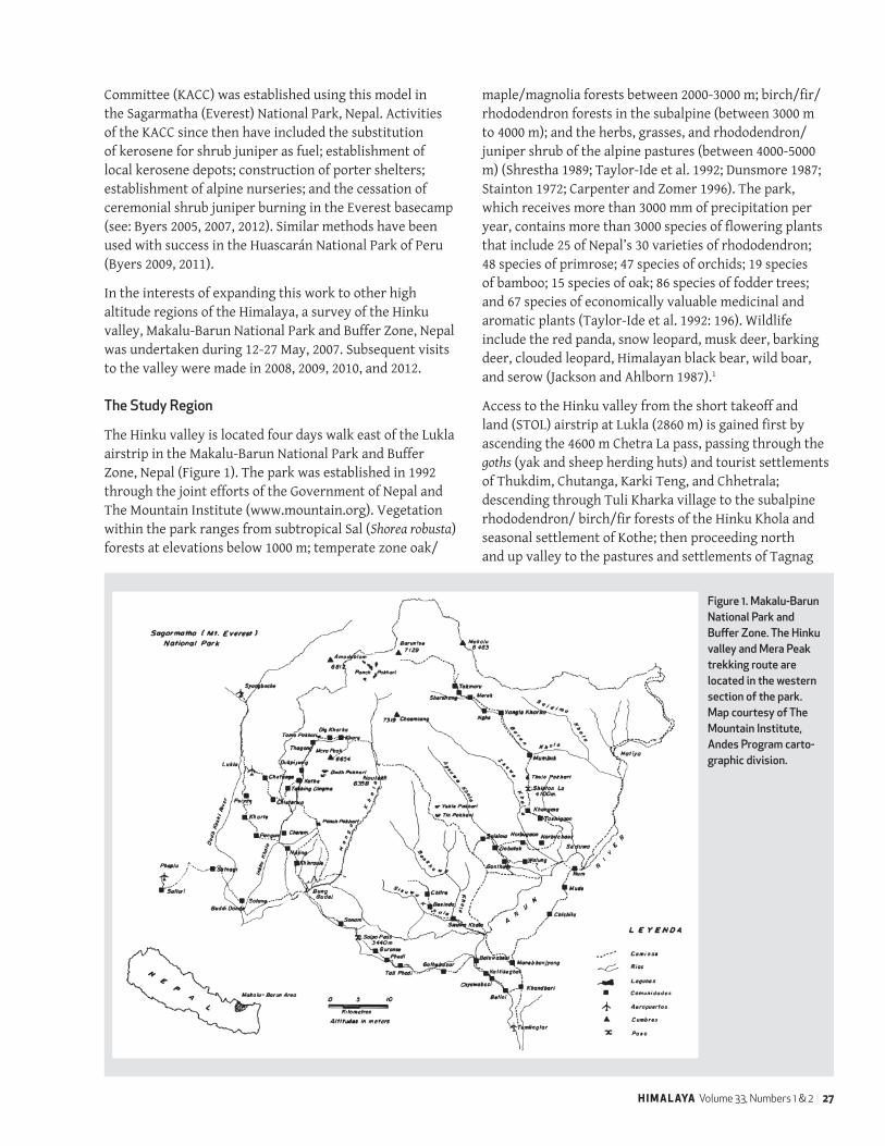
The Hinku valley is located four days walk east of the Lukla airstrip in the Makalu-Barun National Park and Buffer Zone, Nepal (Figure 1). The park was established in 1992 through the joint efforts of the Government of Nepal and The Mountain Institute (www.mountain.org). Vegetation within the park ranges from subtropical Sal (Shorea robusta) forests at elevations below 1000 m; temperate zone oak/
maple/magnolia forests between 2000-3000 m; birch/fir/rhododendron forests in the subalpine (between 3000 m to 4000 m); and the herbs, grasses, and rhododendron/ juniper shrub of the alpine pastures (between 4000-5000 m) (Shrestha 1989; Taylor-Ide et al. 1992; Dunsmore 1987; Stainton 1972; Carpenter and Zomer 1996). The park, which receives more than 3000 mm of precipitation per year, contains more than 3000 species of flowering plants that include 25 of Nepal’s 30 varieties of rhododendron; 48 species of primrose; 47 species of orchids; 19 species of bamboo; 15 species of oak; 86 species of fodder trees; and 67 species of economically valuable medicinal and aromatic plants (Taylor-Ide et al. 1992: 196). Wildlife include the red panda, snow leopard, musk deer, barking deer, clouded leopard, Himalayan black bear, wild boar, and serow (Jackson and Ahlborn 1987).1
Access to the Hinku valley from the short takeoff and land (STOL) airstrip at Lukla (2860 m) is gained first by ascending the 4600 m Chetra La pass, passing through the goths (yak and sheep herding huts) and tourist settlements of Thukdim, Chutanga, Karki Teng, and Chhetrala; descending through Tuli Kharka village to the subalpine rhododendron/ birch/fir forests of the Hinku Khola and seasonal settlement of Kothe; then proceeding north and up valley to the pastures and settlements of Tagnag
Figure 1. Makalu-Barun National Park and Buffer Zone. The Hinku valley and Mera Peak trekking route are located in the western section of the park. Map courtesy of The Mountain Institute, Andes Program carto-graphic division.

28 | HIMALAYA Fall 2013
and Khare within the alpine zone (>4,000 m, or above the continuous treeline). The upper alpine has provided a traditional summer grazing resource for the Sherpas from Solu Khumbu; and Rais, Chhetris, and Gurungs from the Bung and Cheskam to the south, evidenced by the numerous and apparently ancient religious monuments (e.g., mani walls, chortens) and seasonal stone shelters encountered.
Bernbaum (1980: 58) writes that the upper Hinku valley is of considerable cultural importance to neighboring Buddhist communities. In 1976, while undertaking a search for the hidden valley of Khembalung, he writes of meeting “...an old woman who told us about a shrine under an overhang ahead [who said], ‘If you stand there and look across the valley, you’ll see a snake high on the mountain - that’s the direction to Khembalung.’” Bernbaum writes that when “…we reached the shrine... I looked where she had told us to look and saw, thousands of feet up a wall of granite dripping with glaciers, a band of metamorphic rock twisted into the shape of a cobra with its head drawn back ready to strike. I took a compass bearing and lined it up on our map: The arrow pointed right toward the valley we had identified as [Khembalung].”
The Duk Pho Gompa (“dragon living place”) has since been built under the overhang2. It appears to be regularly utilized and well maintained, although I have never encountered the resident lama in the course of multiple visits since 2007. The dragon or snake-like feature on the opposite, west facing rock wall mentioned by Bernbaum remains a distinctive geologic and culturally important feature of the landscape.
Between 2001 and 2006, the upper Hinku valley, i.e., from the village of Khote north, became a base of operations for Maoist insurgents who removed all presence of the national park and its regulatory functions during that period3. The region has since become increasingly popular among foreign visitors as an alternative to the overcrowded Everest basecamp trek, and also because of its access to Mera Peak, the highest “trekking peak” in Nepal at 6476 m. The valley is also the route to the remote and uninhabited Hongu valley to the east (Sawagaki et al. 2010; Byers et al. 2012) and Amphu Laptsa pass (5780 m) into the Sagarmatha (Mt. Everest) National Park to the north. This is a challenging semi-technical route that is gaining in popularity among groups attempting both Mera Peak (6400 m) in Makalu-Barun, and Island Peak (6100 m) in Sagarmatha, during a 21 day trekking/climbing circuit within both parks.
Cox (1999) reports that as early as 1996 the region’s subalpine forests were severely impacted as a result of growing tourism. He noted that “the dwarf juniper [in the alpine zone was being] devastated by trekking groups and local lodges,” stating further that at “each lodge huge piles of firewood are burned in the stove, [and] porters can be seen out daily chopping away at the juniper.” These observations were supported by other field reports from that time that included those of Capron et al. (1997), Sherpa (1998), Eastman (pers. comm. 1999), and Carpenter et al. (2001). However, the extent and severity of these practices since the late 1990s remained essentially unknown before our 12-22 May, 2007 survey. The objectives of our study included enhanced understandings of:
(1) the environmental and social impacts of adventure tourism within the Mera Peak region since 1995 (the date of the first known impact assessment by Cox),
(2) how to better manage environmental harm caused by tourism, and
(3) how to more directly involve local people and adventure tourists in the conservation of high altitude ecosystems.
Field methods included literature reviews, systematic belted transects to determine groundcover characteristics (Mueller-Dombois et al. 1974; Krebs 1989; Hill et al. 2005), semi-structured participant interviews (Schensul et al. 1999; Dunn 2000), and direct measurement of fuelwood stockpiles, juniper shrub harvesting areas, and numbers of cut stems to determine volumes used by tourist lodges. Formal and informal follow up visits to the study sites occurred annually between 2008 and 2012.
Infrastructure Change since 1995
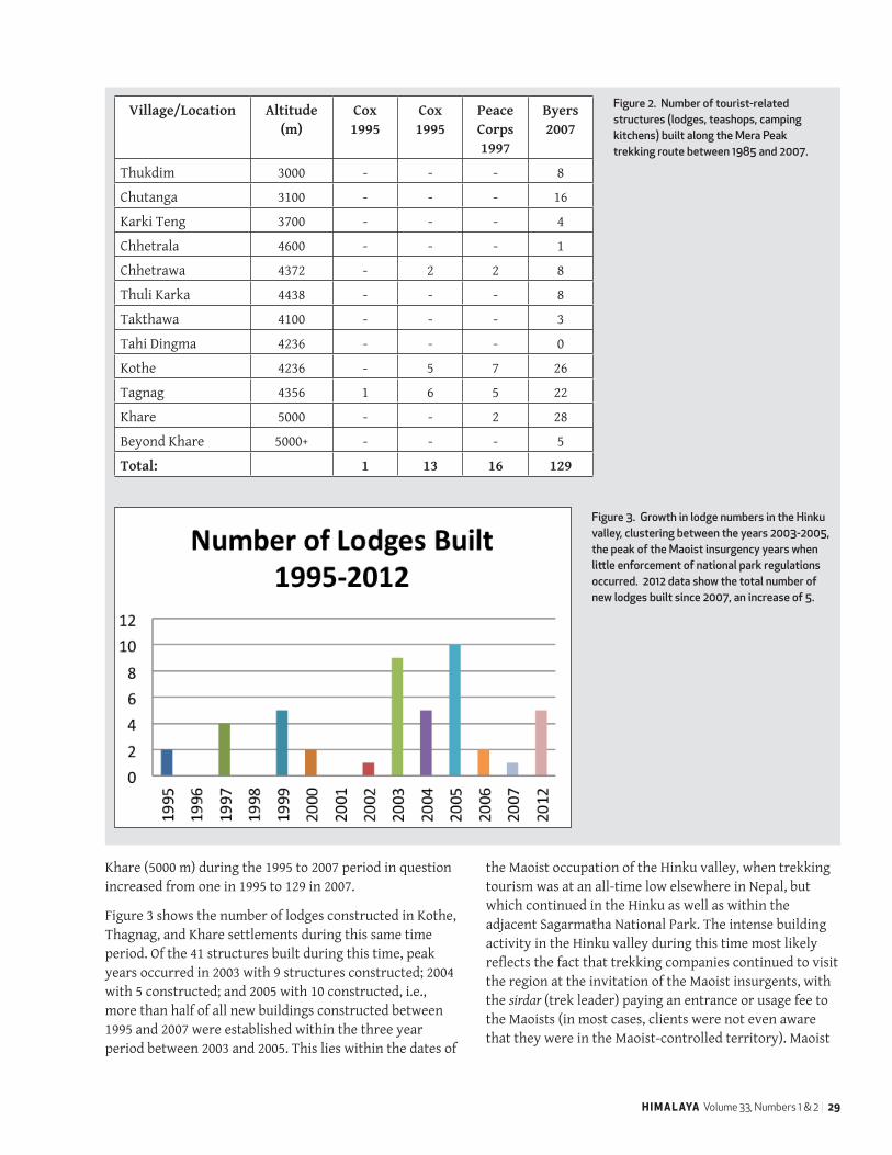
Figure 2 presents a comparative analysis of the number of structures observed and recorded by several visitors to the region between 1995 and 2007 that include Cox in 1995 and 1996; Capron et al. in 1997, and Byers in 2007. “Structures” as defined here include porter shelters, lodges, outside kitchens, and teashops - i.e., any permanent structure that did not exist prior to 1995 and which was clearly linked to tourism in one way or the other. Goths, or seasonal rock shelters utilized by yak and sheep herders that are characterized by replaceable bamboo matt roofs, were not included since they represent historic cultural landscape features that predate the post-1995 period of concern4. As can be seen in Figure 2, the number of tourist-related structures constructed between Thukdim (3000 m) and
HIMALAYA Volume 33, Numbers 1 & 2 | 29
Khare (5000 m) during the 1995 to 2007 period in question increased from one in 1995 to 129 in 2007.
Figure 3 shows the number of lodges constructed in Kothe, Thagnag, and Khare settlements during this same time period. Of the 41 structures built during this time, peak years occurred in 2003 with 9 structures constructed; 2004 with 5 constructed; and 2005 with 10 constructed, i.e., more than half of all new buildings constructed between 1995 and 2007 were established within the three year period between 2003 and 2005. This lies within the dates of
the Maoist occupation of the Hinku valley, when trekking tourism was at an all-time low elsewhere in Nepal, but which continued in the Hinku as well as within the adjacent Sagarmatha National Park. The intense building activity in the Hinku valley during this time most likely reflects the fact that trekking companies continued to visit the region at the invitation of the Maoist insurgents, with the sirdar (trek leader) paying an entrance or usage fee to the Maoists (in most cases, clients were not even aware that they were in the Maoist-controlled territory). Maoist
Village/Location Altitude (m)
Cox 1995
Cox 1995
Peace Corps 1997
Byers 2007
Thukdim 3000 - - - 8
Chutanga 3100 - - - 16
Karki Teng 3700 - - - 4
Chhetrala 4600 - - - 1
Chhetrawa 4372 - 2 2 8
Thuli Karka 4438 - - - 8
Takthawa 4100 - - - 3
Tahi Dingma 4236 - - - 0
Kothe 4236 - 5 7 26
Tagnag 4356 1 6 5 22
Khare 5000 - - 2 28
Beyond Khare 5000+ - - - 5
Total: 1 13 16 129
Figure 2. Number of tourist-related structures (lodges, teashops, camping kitchens) built along the Mera Peak trekking route between 1985 and 2007.
Figure 3. Growth in lodge numbers in the Hinku valley, clustering between the years 2003-2005, the peak of the Maoist insurgency years when little enforcement of national park regulations occurred. 2012 data show the total number of new lodges built since 2007, an increase of 5.

30 | HIMALAYA Fall 2013
leaders appear to have encouraged such activities, selling building rights to lodge owners as a means of generating income to finance the revolution, in addition to most likely promoting an active timber, medicinal plant, fuelwood, and bushmeat trade (Peniston pers. comm. 2007). Since the Hinku Khola region was a center of Maoist activity between 2001 and 2006, these actions also served as a symbolic disregard of the region’s national park status, since the park had previously enforced prohibitions on building, resource extraction, hunting, and medicinal plant extraction, all of which were demonstrably disregarded by Maoists and local communities alike during the insurgency.
As early as 1996, impacts on the landscape such as excessive garbage accumulations, improper human waste disposal, and fuelwood/structural timber harvesting had already been observed. In 1995, Kothe is described as “a small, uninhabited Kharka (pasture) without structures, and scant human population” (Cox 1999: 7). A year later, Cox reports the presence of “five bamboo and wood huts constructed at the beginning of the trekking season to cater to the increasing Mera Peak traffic,” in addition to heavy felling of timber north and south of the settlement in response to the demand for timber by entrepreneurs in Tagnag. In 1997, Capron et al. (1997) report finding trash piles, degraded garbage pits, and a major human waste problem in the region. Tagnag had one small tea shop in 1995; by 1996, three new store-cum-inns were present, and “mats of black juniper in the flats …[were being] extensively thinned by the [firewood] demand” (Cox 1999: 11). In 1997, he reports that five lodges, overflowing
garbage pits, many camping areas, and a human waste problem were present. Carpenter et al. (2001: 22-24) report that 17 structures existed in 2001, and include photographs that document the small number of buildings at the time as well as the extensive use of shrub juniper as fuel. In 2007, Tagnag contained 22 tourist structures, and the cutting of shrub juniper was continuing in full force based on the presence of large stockpiles of fuelwood outside of every lodge (Figure 10).
Interviews with climbing guides and lodge owners in 2007 suggested that approximately 800 to 1000 trekkers and climbers were visiting the region per year (official park records of tourist numbers were not available at the time). When support staff are included (e.g., porters, cooks, kitchen staff), the total number of non-local persons rises to a more realistic 2500 visitors per year (Regmi pers. comm. 2011). Seasonal lodge owners and their staff are estimated to total an additional 245 persons, based on the presence of 49 tourist service structures (lodges, teashops, and stores)5 between Kothe and Kare in 2012, multiplied by an estimated 5 persons inhabiting each structure.
A new national park Sector Office was built in Khote in 2010 that is expected to improve visitor data collection and conservation awareness within the near future. Visitor numbers will most likely grow in the coming years because of the (a) cessation of hostilities and rapid return of trekking tourism to Nepal, (b) desire of many tourists to see a region more remote and wild than Sagarmatha National Park, (c) growing popularity of both Mera Peak and the Hinku-Hongu-Amphu Laptsa pass circuit, and (d) continued growth of the adventure tourism trade,
Figure 4 . Kothe village (4236 m) in 2007. Every structure is either a lodge or other tourist-related feature that did not exist when visited by Cox in 1995.
(photo by A. Byers)

HIMALAYA Volume 33, Numbers 1 & 2 | 31
especially in mountaineering. In fact, 891 tourists were recorded for the fall, 2012 season alone (A.R. Sherpa pers. comm. 2012), which extrapolates to nearly twice the number estimated for 2007 once a similar number of spring visitors is added. While present tourist populations are by no means large by Sagarmatha National Park standards (i.e., more than 36,000 visitors were recorded by park’s entrance station for 2012), the narrowness and fragility of the Hinku valley suggests that even the presence of approximately 2000 foreign visitors per year, and their support staff, could have major impacts on the region, unless properly managed.
Sanitation and Garbage
Cox (1999) describes in detail the growing occurrence of garbage, especially of beer bottles outside the lodges in Tagnag, and of growing “free range defecation” along the trek between 1995 and 1996. Capron et al. (1997) placed a particular emphasis on the abundance of garbage and human waste problems throughout the trek just one year after Cox’s visit.
Charpis (outhouse toilets), mostly of poor and unsanitary design, have been constructed at nearly all the lodges and settlements encountered in the Hinku since the Cox and Capron et al. excursions. Solid waste (steel cans, plastic bottles, glass and beer bottles), whose growing accumulations are in direct response to tourist demands for a varied diet, was found to be deposited in landfill pits in the outskirts of all settlements, burned and covered with soil when full. Lachapelle (1998), Manfredi et al. (2010), and McDowell et al. (2012) cite this combination of open defecation, unsanitary outhouses, porous lodge septic tanks, and growing number of landfills in the Sagarmatha (Everest) National Park (SNP) as directly contributing to the region’s growing water contamination problems, particularly since the outhouses and landfills are frequently located in seasonal water courses. The similarities between the Hinku and SNP suggest that increased visitation to the Hinku valley could create similar conditions there as well.
Large amounts of garbage were also found in the Mera Peak high basecamp (5400 m) in 2010, left behind by climbing parties usually outfitted by Kathmandu-based trekking agencies6. No efforts to enforce any system of human waste management in the basecamp were apparent at the time, and sanitary conditions were extremely poor. Litter on the trails, however, was found to be a relatively minor problem in 2007.
Fuelwood and Timber Harvesting
In 2007, corridors of recently harvested timber were found on either side of the trail from Lukla to the Khote tourist hub. Most conspicuous in terms of timber removal were the largely deforested hillslopes from Lukla to Chutanga, first reported by Cox during his 1996 trip and a striking, large-scale feature of the landscape during our May, 2007 and subsequent investigations. This transformation of the previously old growth fir/ rhododendron (Abies spectabilis/Rhododendron spp.) forest has occurred in response to the structural timber and fuelwood demands of Lukla during the past 10 to 20 years, and porters can be seen daily with headloads of fuelwood returning there from the Chutanga region (this was also true when we last visited the valley in May of 2012). Fir also appeared to have been selectively cut within the region, leaving a woodland of individual tree Rhododendron in its place in a landscape now increasingly used for grazing.
Corridors of increased tree and shrub rhododendron sp. harvesting were also noted from Chutanga to Karki Teng; in the vicinity of Chhetrawa; and from Chhetrawa to Takthawa down to the Hinku Khola (Figure 1). Starting about 2 km downstream from Kothe, and continuing well beyond the settlement upstream, extensive evidence of logging and lumber production in makeshift pit sawmills was observed in 2007 in response to the continued demand for structural lumber. Dozens of standing trees along the trail, apparently destined for harvesting during the June-July, 2007 cutting season, were marked with a slash.
In the thick rhododendron/fir/birch subalpine forests from below Chhetrawa to Kothe, deadwood that can be used for fuel is relatively abundant compared to the treeless alpine regions further upriver. Based on interviews with six lodge owners, estimates of fuelwood use by the subalpine settlements of Chhetrawa, Takthawa, and Kothe, are 14,175 kg, 28,350 kg, and 179,550 kg per tourist season respectively. It must be stressed that these figures are only estimates, based on the reported number of loads consumed per day times a standard fuelwood load weight (approximately 35 kg) times the approximate number of days in the tourist season (Figure 5). However, they are most likely reasonable approximations of annual fuelwood demands and usage because of the vast experience base, and entrepreneurial nature, of the lodge owners interviewed. For the entire upper Hinku alpine valley, they are also most likely underestimates, given the difficulty in calculating the annual fuelwood needs of transient yak and sheep herders who graze the alpine pastures each monsoon.

32 | HIMALAYA Fall 2013
I was aware that Cox (1999) had reported that significant impacts upon shrub juniper were taking place as early as 1996. In fact, during our 2007 investigation, stockpiles of shrub juniper (J. indica) were seen outside of every lodge in Tagnag (Figure 10) and Khare, and numerous rock storage sheds were filled with drying dwarf rhododendron in Khare. Nine of the juniper stockpiles were measured outside of seven lodges in Tagnag (Figure 3) that convert to a total of approximately 47 m3 (approximately 5000 kg, estimated on the basis of the approximately 3 loads of fuelwood contained in each cubic meter times an average weight of 35 kg/load) of slow growing shrub trunks and branches. This figure is not static, as the stockpiles were being constantly replenished by daily excursions to the nearby hillslopes. The average branch or stem length within a stockpile was 84 cm, and the average diameter was 4.9 cm, based on a sample of 21 stems. In terms of yearly shrub juniper use in the alpine, lodges in Tagnag and Khare were reported to be burning and estimated 106,000 kg and 78,000 kg respectively. Informants stated that an additional 67,200 kg/year was consumed by yak
herders, and an unknown quantity burned by the Rai sheep herders each year, such that the totals presented here are most likely underestimates.
Based on a sample of 10 uncut juniper shrubs measured (length x width) in the Tagnag area, the typical prostrate juniper provides 5.5 m2 of groundcover that is of vital importance as wildlife and plant habitat, erosion control, and slope stability (Körner 1999). Four bare and recently disturbed areas averaging 3.6 m2 in size contained an average of 50 cut branches and stumps (Figure 6). In the comparatively undisturbed Duk Pho Gompa region some 30 minutes south and downriver of Tagnag, the average surface area of the individual juniper shrub measured was 17.8 m2, based on a random sample of four shrubs. The greater average size and cover of the Duk Pho Gompa shrubs may be related to differences in micro-climate, aspect, and altitude. Juniper was also observed to be used as fencing material at the Gompa’s potato fields. With the depletion of fuelwood supplies in Tagnag, accelerated harvesting of the juniper in the Duk Pho Gompa region appeared to be occurring in 2007 (Figure 8).
Village # months/
year
# days loads/day
dormsteahouses
loads/season
# kgs # lbs
Tagnag 4.5 135 1.5 15 3037.5 106313 233888
Khare 4.5 135 1.5 11 2227.5 77963 171518
Chhetrawa 4.5 135 1.5 2 405 14175 31185
Takthawa 4.5 135 2 3 810 28350 62370
Kothe 4.5 135 2 19 5130 179550 395010
Figure 5. Estimated fuelwood use per tourist season for alpine (Thagnag and Khare) and subalpine (Chhetrawa, Takthawa, and Kothe) villages in 2007.
Lodges in Tagnag in 2007 Volume of shrub juniper stockpiles (m3)
Mera Guest House-1 5.5
Mera Guest House-2 .70
Mera Guest House-2 9.5
N.S. Sherpa 4.2
N.S. Sherpa 4.6
J. Rai 2.1
P. Sherpa 6.3
T.S. Rai 9
R. Rai 5.2
Total: 47 m3
Figure 6. Volume of harvested shrub juniper found at Tagnag lodges in 2007.

HIMALAYA Volume 33, Numbers 1 & 2 | 33
Five cross sectional samples from the Tagnag shrub juniper stockpiles were aged by the Columbia University Tree Ring Laboratory (Columbia University Tree Ring Laboratory 2007). The average sample diameter, ranging between 3 cm and 12.1 cm, was 7 cm and showed an average age of 90 years, indicative of the shrub’s extremely slow growth rates.
Collectively, and if left unchecked, these disturbances can lead to the loss of groundcover and hillslope integrity
that in turn results in heavy regional soil erosion (Körner 1999: 291), in spite of lower annual precipitation amounts and intensities. This correlation has been demonstrated in the Dingboche region of Sagarmatha (Everest) National Park, Nepal (Byers 2005). Additionally, once the alpine turf protecting the young (inceptisol), high altitude soils is destroyed, vegetation re-establishment can take decades, if not centuries, to occur.
Area (m2) # of branches cut
2.4 39
6.2 85
4.3 47
1.6 30
Average 3.6 50.3
Figure 7. Ground area covered and number of cut branches of a sample of prostrate shrub juniper shrubs near the Duk Pho Gompa.
Figure 8. Active shrub juniper harvesting near the Duk Pho Gompa, south of Tagnag.
(photo by A. Byers)

34 | HIMALAYA Fall 2013
Discussion
In 2007, forest destruction in the subalpine regions near Kothe, and the destruction of the alpine ecosystems between Duk Pho Gompa, Tagnag, and Khare was found to be occurring at a rate comparable to that reported by Cox and others in previous decades. Unregulated lodge building and fuelwood harvesting during and after the 1990s appears to be responsible for these phenomena, largely because the Maoist insurgency during this time prohibited the presence of park personnel or enforcement of the previously gazetted conservation regulations.
A number of interlinked conflict, political, social, and economic factors appear to have led to the impacts observed and measured in the upper Hinku valley in 2007. For example, during the Maoist occupation, foreign visitors were viewed as potential sources of funding for the insurgency that in turn may have encouraged the unprecedented growth of infrastructure between 2001 and 2006. National park prohibitions regarding the cutting of structural timber, harvesting of trees and alpine shrubs for fuel, gathering of medicinal plants, and hunting of wildlife were purposely ignored by the Maoists. The opportunity to make significant amounts of money from the tourist trade in the short term appears to have overshadowed any consideration of what the long-term environmental impacts might be. The impacts of the Maoists upon the forests, wildlife, medicinal/aromatic plants, and alpine ecosystems during this period, although unknown, must have been considerable.
In 2007, lodge owners were well aware of the technical illegality of their lodges, and that the national park
would be justified in having them all removed. On 17 May 2007, at their request, TMI and the Chief Warden of Makalu-Barun National Park organized a meeting with 15 lodgeowners from Kothe, Tagnag, and Khare to discuss and build consensus on the issues of illegal lodge building, forest destruction, shrub juniper and dwarf rhododendron harvesting, and the need for better land stewardship. A second meeting was then held in Lukla in late September, 2007 where the Mera Alpine Conservation Group (MACG) was officially formed and registered at the District Administration Office, Salleri, as a local non-government organization (NGO). The MACG then prepared a two year implementation plan for alpine conservation activities that has since resulted in the nearly complete replacement of shrub juniper with kerosene for fuel7. Beer bottles were also banned, and a small nursery was established in Kothe. Garbage and sanitation facilities at lodges and campgrounds were improved, and interpretational sign boards were installed along the trekking route to Hinku valley. Additionally, fifty headloads of garbage were removed from the Mera Peak basecamp low and high camps (approximately 1750 kg) during the same year (A.R. Sherpa pers. comm. 2008).
Subsequent visits to the Hinku valley in 2009 (Byers 2009), 2010 (Byers et al. 2010), and 2012 (Byers et al. 2013) suggested that most of the above measures had remained more or less in effect. A new Makalu-Barun National Park Sector Office was constructed in 2009 in Kothe, and in 2010 the Park’s presence appeared to once again be visible and strong. The building of new lodges and tourist structures in the park has been somewhat curtailed but not eliminated, in spite of the MACG’s efforts since 2004
# Variable (average all plots) 2007 2012
1 % Juniper 19 38
2 % Other shrubs 12 10
3 % Herbaceous 33 13
4 % Bare 18 6
5 % Rock 10 4
6 % Detritus 8 29
7 # Juniper stumps 19 0
8 # Cut dwarf rhododendron 195 0
9 # Cut branches 249 0
10 Rank terracettes 1 1
11 Rank cattle impacts 1 1
12 Rank mass wasting 1 1
13 Rank human impacts 2 0
Figure 9. Groundcover changes near Tagnag village between 2007 and 2012.

HIMALAYA Volume 33, Numbers 1 & 2 | 35
to prevent any new construction. The presence of the national park, especially since the construction of the new sector office, is expected to reduce such activity in the future.
Figure 9 shows the comparative results of systematic belted transects established near Tagnag in 2007 and re-sampled in 2012 using a modified Braun-Blanquet cover abundance scale (Mueller-Dombois and Ellenberg 1974; see Byers 2005: 128). In 2007, three, 5x5 m quadrats, spaced at 20m intervals, were established along the contour at the hillslope base, midsection, and ridgeline. Percent bare ground, rock, juniper shrub, and other groundcover variables were then estimated visually. An ordinal ranking (1 = low, 3 = high) system was included to record other forms of disturbance observed, such as presence of cattle terracettes, mass wasting processes, and human disturbance in general (e.g., cut juniper and dwarf rhododendron). Collectively, a total of 9 sampling plots were established on the hillslope and 117 data points collected, which were replicated in approximately the same locations in May of 2012.
It should be noted that the sample size for both 2007 and 2012 is small; that groundcover percentages were visually estimated; and that plot locations were not replicated precisely, suggesting that the values shown in Figure 9 should be considered to more accurately reflect trends rather than quantitatively precise values8. For example, 2007 data are clearly reflective of the high level of disturbance found within the typical plot as shown by the relative large numbers of freshly cut juniper shrub, dwarf rhododendron, and branches, as well as a high overall average of observed human impacts. These impacts were largely absent in the 2012 plots sampled, which is most likely related to the replacement of shrub juniper with kerosene by the MACG as the primary fuel source (the daily burning of small amounts of juniper for puja (worship) purposes, however, continues). This correlation is further strengthened by the absence of shrub juniper stockpiles at alpine lodges within one year after the formation of the MACG (Figures 10 and 11). Ranked terracettes and cattle impacts remained the same, perhaps indicative of the fact that although alpine shrub harvesting practices had changed, traditional grazing practices had not. In summary, the data suggest that significant improvements in alpine vegetation cover and groundcover in general had occurred in the interim period between 2007 and 2012, largely attributed to the changes in land stewardship and fuelwood use introduced and enforced by the MACG.
Challenges
Satisfying as this progress has been, a number of chronic challenges remain that threaten the sustainable future of the Mera Peak and other alpine ecosystems in the mountain world. The substitution of kerosene for shrub juniper as cooking fuel has proven, in the case of the Khumbu and Mera Peak regions, to be an excellent short-term solution—the stockpiles of shrub juniper once common outside of Tagnag and Khare lodges are now largely absent (see Figures 10 and 11). However, kerosene is neither a renewable nor a sustainable energy source, and like petrol in Kathmandu is subject to frequent shortages as a result of political embargos imposed by India. There is a clear need to develop alternative sources of renewable energy within these frequently visited alpine ecosystems that may include solar, wind, and mini-hydro technologies (Culhane 2011; Byers et al. 2012).
The proper disposal of human waste remains a chronic and as yet unresolved problem that grows in magnitude with each passing year (Lachappelle 1998; Manfredi 2010). In the Mera Peak high camp (6100 m), the situation was reaching unacceptable levels when visited in 2009, and many charpis (toilets) along the main Hinku trail are situated over the river bed, or within seasonal watercourses, with little thought given to possible freshwater or downstream contamination. Although the impacts of contemporary climate change have yet to be documented for the Hinku valley, recent studies in the neighboring Khumbu valley have identified water contamination as an additional stressor to reduced freshwater supplies brought about by changing precipitation regimes (McDowell et al. 2012)
Solid waste disposal is a third problem that grows in sequence with the popularity of the trekking or approach route (Sherpa 2003; Spoon 2013). As mentioned, tin cans, aluminum beer cans, glass bottles, plastic bottles, and other plastic goods are now burned and deposited in landfills located outside of villages. Local lodge owners refer to these accumulations by the misnomer “burnable garbage,” which is indeed “burned” periodically with little effect prior to being covered with soil. Pits full of aluminum beer cans, glass bottles, and plastic water bottles can be seen within a few minutes’ walk of most villages and lodges. In the Hinku valley and most other trekking destinations in Nepal, lodge owners are not held accountable for these practices, nor are they encouraged to employ alternative solid waste management practices such as recycling, or collection and deportation to Kathmandu or sites outside of the park. Both could conceivably be accomplished if additional fees or deposits were attached to the use of canned and bottled goods,

36 | HIMALAYA Fall 2013
fees that most visitors would assuredly be happy to pay in the interests of sustaining the region’s natural beauty, while promoting a cleaner and healthier environment. At present, the tons of containers and packaging that become the solid waste are brought in by porter at lodge owner expense, but remain within the parks, ultimately creating some of the world’s highest landfills (Byers et al. 2011). Programs that build awareness, provide training, and test incentives for lodge owners to recycle and/or remove solid
waste from the high altitude environment (e.g., deposits on containers) are urgently needed.
Notable progress has been made by certain trekking and climbing agencies, some of which have used percentages of their profits to fund libraries, bridges, or other projects in remote villages. However, these well-intentioned gestures are irregular, geographically dispersed, usually target the sirdar’s (trek supervisor) village, and do little for actual alpine conservation. Likewise, international attention
Figure 10. Stockpiles of shrub juniper outside of a lodge in Tagnag in 2007.
(photo by A. Byers)
Figure 11. Following the formation of the Mera Alpine Conservation Group in 2007, the burning of shrub juniper and dwarf rhododendron species was almost totally eliminated, as can be seen in the 2009 photograph above.
(photo by A. Byers)

HIMALAYA Volume 33, Numbers 1 & 2 | 37
continues to focus on basecamp cleanup expeditions as the ultimate solution to high mountain conservation, when in fact the cleanup results are largely cosmetic, and do little to counter the real problems of ecosystem destruction, groundwater contamination, and environmental pollution (Byers 2005; Associated Press 2008; Byers 2013a, 2013b).
Conclusion
In 1995, the Hinku valley in Makalu-Barun National Park and Buffer Zone was rarely visited by adventure tourists and contained almost no tourist-related infrastructure. By 2007, 129 structures (lodges, porter shelters, camp kitchens, teashops), 28 of which were lodges, were present along the trail from Thukdim (3000 m) to Khare (5000 m). The majority of building activity was concentrated in the years between 2003 and 2005, or peak of the Maoist insurgency, when the Hinku valley was a Maoist base of operations and local people were encouraged to develop the valley’s adventure tourist potential. The economic benefits of accelerated tourism came at the cost of significant forest and alpine ecosystem disturbance in the form of harvested timber for lodge construction, and destruction of shrub juniper and dwarf rhododendron thickets in the alpine zone for use as fuel for lodges and trekking/climbing expeditions. In 2007, the Mera Alpine Conservation Group, a local NGO established with the assistance of the newly formed Alpine Conservation Partnership, was created which, in partnership with national park authorities, enforced restrictions on the harvesting of timber and building of new lodges; replaced shrub juniper and dwarf rhododendron with kerosene as fuel; and improved garbage and sanitation conditions at lodges and climbing basecamps. Significant improvements in the condition of alpine vegetation were observed in subsequent years by research team members visiting the region.
Since its establishment in 2004, the Alpine Conservation Partnership has positioned itself as a unique project that has made innovative and pioneering contributions to the protection and restoration of the alpine ecosystems in three popular climbing and trekking destinations in the Himalaya and Andes. On a pilot scale, the project is refining a model of community-based conservation that may be applicable to other high mountain regions of the world, helping the people who live in these fragile regions protect the ecosystems from which they derive a substantial proportion of their incomes, while strengthening and diversifying their income generating opportunities. Ironically, it is the direct and indirect impacts of those people professing the greatest love for
these high altitude ecosystems—primarily trekkers and mountaineers—who are driving the processes that cause the bulk of the damage, such as the increased use of pack animals, overgrazing, the cutting of tons of slow-growing shrubs for fuelwood by trekking lodges and porters, or turf “mining” for building purposes. The resultant damage is becoming characteristic to most of the world’s spectacular and treasured mountains. Although the bulk of this damage is apparently unintentional, and often unrecognized by the trekker and climber clients, the situation does argue for a greater building of awareness within the tourism community for the range of their direct and indirect impacts on fragile, high mountain ecosystems. Likewise, the outdoor gear manufacturing industry, adventure tourism industry, trekking/climbing agencies, and international mountaineering clubs need to become more meaningfully involved in the protection, conservation, and restoration of the regions from which they ultimately derive their incomes and/or recreational experiences. When accompanied by realistic incentives for lodge owners to play a more active role in the recycling and/or removal of solid waste, as well as protecting the quality of their freshwater sources, these interventions could play a major role in the conservation of fragile alpine ecosystems in perpetuity.

38 | HIMALAYA Fall 2013
Endnotes
1. Like much of the Himalayan region, the geologic environ-ment of the Hinku valley is dynamic and prone to earth-quakes, avalanches, landslides, and glacial lake outburst floods. At 5:00 a.m. on 3 September, 1998, for example, the Tama Pokhari glacial lake at the head of the valley burst when an ice avalanche fell into the lake, creating a surge wave that overtopped and breached the terminal moraine. The resultant glacial lake outburst flood (GLOF) lasted for 20 hours, destroyed seven houses in Tagnag, killed two people downstream in Waku and Pawai villages, damaged four suspension bridges and two wooden bridges, buried farmland, and partially blocked the Dudh Kosi River for two years (McKinney 2012; Mool et al., 2001; Osti and Egashira 2009; Osti et al. 2010). Significant damage to the traditional trekking trails also occurred, some of which had to be re-routed to higher ground. In May of 2012, villagers reported that a series of smaller surges had occurred since 1998, indicative of the continued ice avalanches cascading into the lake. Glacial lakes within the entire Dudh Kosi wa-tershed, of which the Hinku khola is a tributary, have been increasing in size and number, particularly over the past 30 years (Bajracharya et al. 2007; Sawagaki et al.2012; Byers et al. 2013a).
2. Most likely after 2001, as Cox et al. (2001: 19) describe the “Saure Gompa” that existed then, doubling as a lodge and tea shop, as “1 stone building, bamboo roof covered by tarp (blue plastic).”
3. Most of the national park’s sector offices were destroyed during this time.
4. Such traditional structures appear to have been sited more intelligently with respect to the landscape than the newer and/or expanded settlements, which tend to place
tourism structures in places that may be colder or damper, less sunny, but more in the direct path of incoming visitors (Carpenter pers. comm. 2013).
5. Determining an exact number of “lodges” for the Hinku valley is not possible, since it was discovered in 2012 that the different recorders during the 2007 and 2012 expedi-tions used slightly different criteria to define a “lodge” vs. a teahouse, or other similar structure.
6. Clients usually leave the basecamp before staff, who are engaged in taking down tents and packing for the days’ trek, and are unaware of the garbage usually left behind.
7. Imported kerosene stoves from India, and some pro-pane, is used for most cooking purposes in lodges since the ban on using shrub juniper for fuel was enforced in 2004. Most lodges have metal wood stoves in their dining areas that are lit in the evenings, usually burning dried cattle dung. Some fuelwood, collected from the subalpine fir/birch/rhododendron forests south of Tagnag, is burned in the kitchens as well, resulting in the smoky conditions rem-iniscent of pre-electric Namche Bazaar and other Khumbu villages. Very few alternative energy trials have been tested with the exception of a few solar water heaters and battery chargers, and the survey conducted by Byers et al. 2012.
8. In particular, the dramatic increase in shrub juniper cover between 2007 and 2012 appears to be an overes-timate, primarily because of the shrub’s extremely slow growth rates as discussed earlier in the paper. For example, comparisons between juniper cover data collected in 2004 and 2011, both within a 50 m2 cattle exclosure above the village of Dingboche in Sagarmatha (Everest) National Park, showed an increase in juniper cover of only three percent (Byers et al. 2011: 38-39). On the other hand, the hillslopes above Dingboche are in a much more disturbed and eroded condition than those above Tagnag (see: Byers 2005), and the wetter climate of the Hinku valley could conceivably play a role in the faster restoration or rengeneration capaci-ties of the species.
References
Associated Press. 2008. China Plans Mount Everest Cleanup in 2009. Associated Press. http://www.usatoday.com/news/world/environment/2008-06-23-everest_N.htm.
Bajracharya, Samjwal Ratna, Pradeep Kumar Mool, and Basanta Raj Shrestha. 2007. Impact of Climate Change on Himalayan Glaciers and Glacial Lakes: Case Studies on GLOF and Associated Hazards in Nepal and Bhutan. Kathmandu: International Centre for Integrated Mountain Development (ICIMOD).
Alton C. Byers, Ph.D. is a mountain geographer specializing in applied research, high altitude ecosystems, climate change, and integrated conservation and development programs. He joined The Mountain Institute (TMI) in 1990 as Environmental Advisor, and has since worked as Co-Manager of the Makalu-Barun National Park (Nepal Programs), founder and Director of Andean Programs, Director of Appalachian Programs, and since 2001 as Director of Science and Exploration. Since 2012 he has co-managed the USAID-funded High Mountains Adaptation Partnership project (HiMAP) that is implementing climate change adaptation projects in the Mt. Everest region of Nepal and Cordillera Blanca region of Peru.
The author would like to thank the National Geographic Society, American Alpine Club, and The Mountain Institute for their support of this and other projects designed to promote community-based alpine conservation throughout the high mountain world.

HIMALAYA Volume 33, Numbers 1 & 2 | 39
Bandyopadhay, Jayendra, John Rodda., Rick Kattelmann, Zbigniew Kundzewicz, and Dieter Kraemer.1997. Highland waters: A Resource of Global Significance. In Mountains of the World: A Global Priority. Messerli, Brunoo and Jack.D. Ives, eds., 131-156. New York: Parthenon Publishing Group.
Bernbaum, Edwin. 1980. The Way to Shambala: A Search for the Mythical Kingdom Beyond the Himalayas. New York: Anchor Books.
Buntaine, Mark, Renee Mullen, and James Lassoie. 2006. Human Use and Conservation Planning in Alpine Areas of Northwestern Yunnan, China. Springer: Environment, Development and Sustainability.
Byers, Alton. 2013a. The Nature of Everest. In The Call of Everest. Anker, Conrad. Washington, D.C.: National Geographic Society.
. 2013b. Three Sides of Everest: There’s More to a Moun-tain than Its Summit. Natural History Magazine.
. 2011. Recuperacion de Pastos Alpinos en el Valle de Ishinca, Parque Nacional de Huascaran, Peru: Implicaciones para la Conservacion, las Communicades y el Cambio Climatico. Documento de Trabajo No. 1. Huaraz: Instituto de Montana.
. 2009. A Comparative Study of Tourism Impacts on Alpine Ecosystems in the Sagarmatha (Mt. Everest) National Park, Nepal and the Huascarán National Park, Peru. In Ecotourism and Environmental Sustainability, edited by Hill, J. and Gale, T. London: Ashgate.
. 2008. The Alpine Conservation Partnership: Saving Mountain Ecosystems, Building Resilience to Climate Change. Alpine Journal. Fall 2008. London: Alpine Journal.
. 2007. The Alpine Conservation Partnership: A Global Initiative to Protect and Restore Alpine Ecosystems. Amer-ican Alpine Journal. Winter 2007. Golden: American Alpine Club.
. 2005. Contemporary Human Impacts on Alpine Landscapes in the Sagarmatha (Mt. Everest) National Park, Khumbu, Nepal. Annals of the Association of American Geographers Vol. 95 (1): 112-140.
. 2001. An Assessment of Contemporary Impacts on Alpine Ecosystems in the Sagarmatha (Mt. Everest) National Park, Nepal. Final Report to the National Geographic Society, Committee for Research and Exploration. Report. Washington, D.C.: The Mountain Institute.
. 1997. Landscape Change Sagarmatha (Mt. Everest) National Park, Nepal. Himalayan Research Bulletin XVII (2). Special issue: SoluKhumbu and the Sherpa.
. 1987a. An Assessment of Landscape Change in the Khumbu Region of Nepal Using Repeat Photography. Moun-tain Research and Development 7 (1): 77-81.
. 1987b. A Geoecological Study of Landscape Change and Man-accelerated Soil Loss: The Case of the Sagarmatha (Mt. Everest) National Park, Khumbu, Nepal. Ph.D. thesis, Department of Geography, University of Colorado, Boulder, Colorado. 354.
. 1987c. Landscape Change and Man-Accelerated Soil Loss: The Case of the Sagarmatha (Mt. Everest) National Park, Khumbu, Nepal. Mountain Research and Development 7(3): 209-216.
Byers, Alton, Daene McKinney, Marcelo Somos-Valenzuela, and Teiji Watanabe. 2013. Glacial lakes of the Hongu Valley, Makalu-Barun National Park and Buffer Zone, Nepal. Natural Hazards, April, 2013. DOI: 10.1007/s11069-013-0689-8.
Byers, Alton, Thomas Culhane, and Chris Rainier. 2012. Protecting and Restoring the World’s Alpine Ecosystems through NGS Explorer Collaboration and Exchange: The Role of Awareness Building, Improved Conservation Practices, and High Altitude Alternative Energy Development. Report to the National Geographic Society-Blackstone Challenge Grant Program. Final Report: Hinku Valley, Makalu-Barun National Park and Buffer Zone, Nepal. Washington, D.C.: The Mountain Institute.
Byers, Alton, Thomas Culhane, Debbie Marcinkowski, Shankar Lal Vaidya, and Caroline Howe. 2011. Protecting and Restoring the World’s Alpine Ecosystems through NGS Explorer Collaboration and Exchange: The Role of Awareness Building, Improved Conservation Practices, and High Altitude Alternative Energy Development. Report to the National Geographic So-ciety-Blackstone Challenge Grant Program. Interim Report: Upper Imja Valley, Sagarmatha (Everest) National Park, Nepal. Washington, D.C.: The Mountain Institute.
Byers, Alton, Teiji Watanabe, Takanobu Sawakaki, and Damodar Lamsal, D. 2010. The Threat from Above: A Survey of New and Potentially Dangerous Glacial Lakes in the Hongu and Imja Valleys, Eastern Nepal. Report to the National Geographic Society-Waitt Grant Program. Washington, D.C.: The Mountain Institute.
Caprone, S., Laflamme, D., and Behenfeld, S. 1997. The Inkhu Valley-Mera Peak Ecotourism Project: Report of Activities, May 5 – May 23, 1997. Report. Kathmandu: The Mountain Institute.
Carpenter, Chris. 2013. Wildlands Studies, California State University. Personal communication, May 2013, regarding the comparative siting of historic and new structures in the Hinku valley and Kembachen, Kangchenjunga region.

40 | HIMALAYA Fall 2013
Carpenter, Chris and Zomer, Robert. 1996. Forest Ecology of the Makalu-Barun National Park and Conservation Area, Nepal. Mountain Research and Development 16 (2): 135–148.
Carpenter, Chris, Duin, K., and Laxmi Dewan. 2001. An Assessment of Tourism Impact in the Bung Sector, Makalu-Barun National Park and Buffer Zone, Nepal. Report. Kathmandu: The Mountain Institute.
Cox, J.H. 2008. Uncontrolled Exploitation of Yarsagumba Cordyceps Sinensis in Rukum and Dolpa Districts, Nepal: Observations in May-June 2007 and a Suggested Course of Action. Report. Kathmandu: The Mountain Institute and Department of National Parks and Wildlife Conservation.
. 1999. An Assessment of Habitats and Human Interaction in the Hinkhu, Hongu, Kasuwa and Barun Kholas of Makalu-Barun National Park and Conservation Area. Kathmandu: Makalu Barun Conservation Project.
Culhane, Thomas. 2011. Alternative Energy Development in Alpine Ecosystems of the Sagarmatha (Mt. Everest) National Park, Nepal. In Protecting and Restoring the World’s Alpine Ecosystems through NGS Explorer Collaboration and Exchange: The Role of Awareness Building. Byers, A.C., Culhane, T., Marcinkowski, D., Vaidya, S., and Howe, C. Improved Conservation Practices, and High Altitude Alternative Energy Development. Interim Report to the National Geographic Society-Blackstone Challenge Grant Program. Report. Washington, D.C.: The Mountain Institute, 5-13.
Dunn, Kevin. 2000. Interviewing. In Qualitative Methods in Human Geography, edited by Hay, I., 50-82. South Melbourne, Australia: Oxford University Press.
Dunsmore, John. 1988. Mountain Environmental Management in the Arun River Basin of Nepal. Occasional Paper No. 9. Kathmandu: International Centre for Integrated Mountain Development.
Eastman, Thomas. 1999. Trustee, The Mountain Institute. Personal communication regarding his observations and photographs of shrub juniper fuelwood usage in the Hinku valley, Makalu-Barun National Park and Buffer Zone, in May, 1999.
Godde, Pamela, Martin Price, and Fredrich Zimmermann. 2000. Tourism and Development in Mountain Regions. Oxon: CABI Publishing.
Goldenberg, Suzanne. 2011. Himalayas in Danger of Becoming a Giant Rubbish Dump. U.K. Guardian, 12 September 2011.
Hillary, Edmund. 1999. View from the Summit. London: Transworld Publishers.
Hill, David, Matham Fasham, Graham Tucker, Michael Shewry, and Philip Shaw. 2005. Handbook of Biodiversity Methods: Survey, Evaluation and Monitoring. Cambridge, UK: Cambridge University Press.
Jackson, Rodney, and Gary Ahlborn. 1987. A High Altitude Survey of the Hongu Valley with Special Emphasis on Snow Leopard. Consultant Report. Woodlands Mountain Institute and HMG Department of National Parks and Wildlife Conservation. Kathmandu.
Körner, Christian. 1999. Alpine Plant Life. Heidelberg: Springer-Verlag.
Krebs, Charles J. 1989. Ecological Methodology. New York: HarperCollins.
Krusic, Paul. 2007. Columbia University Tree Ring Laboratory, Palisades, New York. Personal communication, December 2007.
Lachapelle, Paul. 1998. Managing Sanitation in Protected Areas: Problems and Challenges in Sagarmatha (Mt. Everest) National Park, Nepal. Himalayan Research Bulletin XVIII (1): 53-57.
MacLellan, L.Rory, Peter U.C. Dieke, and Bhim Kumari Thapa. 2000. Mountain Tourism and Public Policy in Nepal. In Tourism and Development in Mountain Regions, Godde, P., Price, M., and Zimmermann, F., 173-198. New York: CABI Publishing.
Manfredi, C., B. Flury, G. Vivlano, S. Thakuir, S. Khanal, R. Jha, R. Maskey, R. Kayastha, K. Kafle, S. Bhochhlbhoya, N. Ghimire, B. Shrestha, G. Chaudhary, F. Giannino, F. Carteni, S. Mazzoleni, and F. Salerno. 2010. Solid Waste and Water Quality Management Models for Sagarmatha National Park and Buffer Zone. Mountain Research and Development 30 (2): 127-142.
McDowell, G., Ford, J, Lehner, B., Berrang-Ford, L., and Sherpa, A. 2012. Climate-Related Hydrological Change and Human Vulnerability in Remote Mountain Regions: A Case Study from Khumbu, Nepal. Springer-Verlag: Reg Environ Change.
McKinney, Daene. 2012. Hinku Valley Trip Report, May 2012. Report. High Mountain Glacial Watershed Program. The Mountain Institute and University of Texas at Austin.
Mool, Pradeep, Samjwal Bajracharya, and Sharad Joshi. 2001. Inventory of Glaciers, Glacial Lakes, and Glacial Lake Outburst Floods: Monitoring and Early Warning Systems in the Hindu Kush-Himalayan Regions - Nepal. International Centre for Integrated Mountain Development (ICIMOD), Kathmandu, Nepal (ICIMOD, 2001).

HIMALAYA Volume 33, Numbers 1 & 2 | 41
Nagy, Laszlo and Georg Grabherr. 2009. The Biology of Alpine Habitats. New York: Oxford University Press, Inc.
Mueller-Dombois, Dieter. and Heinz Ellenberg. 1974. Aims & Methods of Vegetation Ecology. John Wiley & Sons. New York.
Nepal, Sanjay K. 2000. Tourism in Protected Areas: The Nepalese Himalaya. Annals of Tourism Research 27 (3): 661-81.
. 2001. Examining Tourism Impacts from an Interdisci-plinary Perspective: The Himalayan Case Study. Asiatische Studien Etudes Asiatiques LV-3-2001: 777-804.
Nepal, Sanjay K., Thomas Kohler, and Bernhard Banzhaf. 2002. Great Himalaya: Tourism and the Dynamics of Change in Nepal. Berne: Swiss Foundation for Alpine Research.
Olsen, Carsten S. and Helle O. Larsen. 2003. Alpine Medicinal Plant Trade and Himalayan Mountain Livelihood Strategies. The Geographical Journal 169 (3): 243–254.
Osti, Rabindra, and Shinki Egashira. 2009. Hydrodynamic Characteristics of the Tama Pokhari Glacial Lake Outburst Flood in the Mt. Everest Region, Nepal, Nepal Hydrol. Process 23: 2943–2955.
Osti, Rabindra, Shinji Egashira, Katsuhito Miyake, and Tara Nidhi Bhattarai. 2010. Field Assessment of Tama Pokhari Glacial Lake Outburst Flood in Khumbu Region, Nepal. Journal of Disaster Research 5 (3): 264–273.
Peniston, Brian. 2007. Director, Nepal Programs, The Mountain Institute, Kathmandu, Nepal. Personal communication, October 2007, Kathmandu, Nepal.
Pérez, Francisco L. 1998. Human Impact on the High Páramo Landscape of the Venezuelan Andes. In Nature’s Ge-ography: New Lessons for Conservation in Developing Countries Zimmerer, Karl S. and Kenneth R. Young. Madison: The University of Wisconsin Press.
Regmi, Dhananjay. 2011. Director, Himalayan Research Ex-peditions Pvt. Ltd. Personal communication, Kathmandu, Nepal, September 2011.
Rogers, Paul and John Aitchison. 1998. Towards Sustainable Tourism in the Everest Region of Nepal. IUCN: Kathmandu, Nepal.
Sawagaki, Takanobu, Damodar Lamsal, Alton C. Byers, and Teiji Watanabe. 2012. Changes in Surface Morphology and Glacial Lake Development of Chamlang South Glacier, Eastern Nepal Himalaya, since 1964. Global Environmental Research 16: 83-94.
Schensul, Stephen, Jean Schensul, and Margaret LeCompte.1999. Essential Ethnographic Methods: Observations, Interviews, and Questionnaires. Walnut Creek, CA: Altamira Press.
Schneider, Erwin. 1963. Foreword to the Map of the Mount Everest region. In Mount Everest: Formation, Population and Exploration of the Everest Region, Hagen, Toni, Gunther-Oskar Dyhrenfurth, Christoph von Furer-Haimendorf, and Erwin Schneider, 182-195. London: Oxford University Press.
Sherpa, Ang Rita. 2012. Personal communication, De-cember, 2012 regarding the recorded number of foreign visitors recorded at the Khote Sector Office, Makalu-Barun National Park and Buffer Zone, Nepal.
. 2008. Personal communication, October 2008 regarding various Mera Peak basecamp and cleanup activities of the Mera Alpine Conservation Council.
. 2003. Triumph on Everest: A Tribute from the Sherpas of Nepal. Mandala Book Point: Kathmadu, Nepal.
. 1998. Recommended Program for the Mera Peak Ecotourism Management Plan in the Fall of 1998. Report. Kathmandu: The Mountain Institute.
Shrestha, Tirtha B.S. 1989. Development Ecology of the Arun River Basin. Kathmandu: International Centre for Integrated Mountain Development.
Spoon, Jeremy. 2013. From Yaks to Tourists: Sherpa Livelihood Adaptations in Sagarmatha (Mount Everest) National Park and Buffer Zone, Nepal. In Continuity and Change in Cultural Adaptation in Mountain Environments, Studies in Human Ecology and Adaptation 7, edited by Lonzy, L.R. New York: Springer Science-Business Media.
Stainton, J.D.A. 1972. Forests of Nepal. New York: Hafner Publishing Co.
Stevens, Stanley F. 1993. Claiming the High Ground: Sherpas, Subsistence, and Environmental Change in the Highest Himalaya. Berkeley: University of California Press.
Taylor-Ide, Daniel, Alton C. Byers, and Gabriel J. Campbell. 1992. Mountains, Nations, Parks, and Conservation: A Case Study of the Mt. Everest Region. GeoJournal 27 (1): 105-112.


![Sediment Source Assessment: Squaw Creek Watershed, Placer ... · Squaw Creek is a small (approximately 8.2 square mile [21.1 km2]), subalpine and alpine watershed located about six](https://img.dokumen.tips/doc/110x75/5f0422057e708231d40c79e5/sediment-source-assessment-squaw-creek-watershed-placer-squaw-creek-is-a-small.jpg)