Embed Size (px)
Citation preview

Consumer and Commercial Drones How a technological revolution is impacting Irish society
No. 1 of 2021
Dr. Boris Galkin, Trinity College Dublin, SFI Researcher-in-
Residence
10 February 2021
Abstract
This Spotlight examines the emerging technology of drones and
their rapid proliferation into the consumer and commercial
sectors. At the time of writing, drones are being adopted by a
variety of organisations and industries worldwide, with wide-
ranging consequences. This paper provides an overview of
drone technology, including its future trends. It also explores
examples of the real-world impact of drone use and the
evolving legislation governing drones in Ireland.

Library & Research Service | Consumer and Commercial Drones
1
Contents
Glossary ......................................................................................................................................... 3
Executive Summary ........................................................................................................................ 5
Introduction ..................................................................................................................................... 7
1. Principles of Drone Operation ................................................................................................. 8
1.1 Drone Types ......................................................................................................................... 8
1.2 Drone-Pilot Communication Link ........................................................................................... 9
1.3 Drone Artificial Intelligence .................................................................................................. 11
1.4 Drone Cameras ................................................................................................................... 15
1.5 Anti-Drone Measures .......................................................................................................... 16
2. Technological Developments ................................................................................................ 22
2.1 Communication Link Improvements .................................................................................... 22
2.2 Flight Time Improvements .................................................................................................. 25
2.3 Drone Artificial Intelligence Improvements ........................................................................... 26
3. Real Life Applications of Drone Technology .......................................................................... 29
3.1 Photography and Filmmaking .............................................................................................. 29
3.2 Emergency Services and Law Enforcement ........................................................................ 30
3.3 Infrastructure Inspection and Surveying .............................................................................. 31
3.4 Smart Agriculture and Environmental Monitoring ................................................................. 33
3.5 Delivery and Transportation ................................................................................................ 35
3.6 Telecommunications ........................................................................................................... 38
3.7 Recreational Use ................................................................................................................. 39
3.8 Illegal Uses ......................................................................................................................... 40
4. Regulations on Drone Use .................................................................................................... 42
4.1 Controlled and Uncontrolled Airspace ................................................................................. 42
4.2 Prior Regulations on Drone Use .......................................................................................... 43
4.3 Current EU Regulations on Drone Use ................................................................................ 46
4.4 U-Space and Drone Air Traffic Management ....................................................................... 51
4.5 GDPR and Drone Camera Recordings ................................................................................ 53
4.6 Drone Use in Sensitive Areas .............................................................................................. 56
4.7 Role of An Garda Síochána and the Irish Air Navigation Service ........................................ 57
Conclusion .................................................................................................................................... 58
Library & Research Service | L&RS Spotlight 2
This L&RS Spotlight may be cited as:
Oireachtas Library & Research Service 2021, L&RS Spotlight: Consumer and Commercial Drones - How a
technological revolution is impacting Irish society
Legal Disclaimer
No liability is accepted to any person arising out of any reliance on the contents of this paper. Nothing herein constitutes
professional advice of any kind. This document contains a general summary of developments and is not complete or
definitive. It has been prepared for distribution to Members to aid them in their parliamentary duties. Some papers, such
as Bill Digests are prepared at very short notice. They are produced in the time available between the publication of a Bill
and its scheduling for second stage debate. Authors are available to discuss the contents of these papers with Members
and their staff but not with members of the general public.
A number of companies/organisations/entities are referenced in this document by the author. These references are
provided for illustrative purposes; are not exhaustive; and do not constitute an endorsement of these
companies/organisations/entities or their products.
This document was prepared using unclassified material available to the general public and does not provide insight on
issues of Irish State security. The author is not affiliated with any law enforcement organisation, state military or military
research body.
© Houses of the Oireachtas 2021
Acknowledgements
The author would like to thank Dr. Etaoine Howlett, Ms. Maria Fitzsimons and Mr. Ivan Farmer of
the Oireachtas Library & Research Service for their work as internal QAs on this paper. The author
would also like to thank Ms. Julie Garland of Avtrain, Mr. Dennis McNulty and Dr. Tom O’Dea of
CONNECT, as well as Capt. Lou Fine of the Irish Aviation Authority for their assistance as external
QAs. Finally, the author would like to thank Mr. Darren Lawlor of the Oireachtas Library &
Research Service for assistance with the graphical content of this paper and Dr. Anna Jackman of
the University of London for her guidance with regards to the preparation of this document.
This publication has emanated from research supported in part by a research grant from Science
Foundation Ireland (SFI) under Grant Number 19/PSF/7615.
The author, Dr. Boris Galkin, produced this publication whilst Researcher-in-Residence at the
Oireachtas Library & Research Service and is available to discuss his work on drone technology
with interested parties. Dr. Galkin may be contacted at the CONNECT Centre, Trinity College
Dublin at [email protected]. CONNECT is the world leading SFI Research Centre for Future Networks
and Communications. It is co-funded under the European Regional Development Fund.

Library & Research Service | Consumer and Commercial Drones
3
Glossary
This section sets out a number of definitions for the purpose of this L&RS Spotlight.
5G: is a family of mobile phone network technologies and standards which are currently being
adopted by network operators worldwide.
ATC (Air Traffic Control): is the authority that monitors aircraft while in flight and ensures their
safety by providing flight guidance and instructions.
AI (Artificial Intelligence): is the software on a drone that allows it to operate automatically or
autonomously.
Automatic flight: is a type of drone flight where the AI is piloting the drone, with the pilot
supervising and taking manual control if necessary.
Autonomous flight: is a type of drone flight where the AI is piloting the drone, and the pilot is not
able to intervene and take manual control.
Beyond Visual Line-of-Sight (BVLOS): refers to drone flight where the device flies beyond the
point where the drone pilot can see it with the naked eye.
Controlled airspace: refers to airspace that can only be accessed by aircraft with prior approval
from ATC.
Drone: refers to a flying machine that does not have a pilot on-board.
Drone operator: refers to the legal owner of a drone.
Drone pilot: refers to the person responsible for the safe and successful flight of a drone. The pilot
sends flight instructions to a drone during its operation and receives flight information back from
the drone.
EASA (European Union Aviation Safety Agency): is the European Union (EU) agency
responsible for civilian aviation safety.
Fixed-wing drone: refers to a type of drone that resembles an aeroplane (i.e. with two wings).
Geofencing: refers to a safety function that prevents a drone from entering a certain area, based
on Global Positioning System (GPS) coordinates.
GDPR (General Data Protection Regulation): is a set of EU regulations on the gathering,
processing, and use of personal data.
GPS (Global Positioning System): is a technology that allows a device to identify its exact
location using signals sent from satellites.
IAA (Irish Aviation Authority): is the state-owned company responsible for regulating the use of
Irish airspace, and the lawful operation of drones in the country.
IMU (Inertial Measurement Unit): are a group of sensors that measure how a drone is moving
and how it is positioned while in flight.
Interference: refers to a loss of radio signal quality which arises when multiple devices are
transmitting on the same frequency band, causing a “collision” of signals.
Library & Research Service | L&RS Spotlight 4
LOS (Line-of-Sight): is when a radio signal transmitter and receiver can “see” one another,
because there are no obstacles directly between them.
Manned aviation: refers to flights carried out by aircraft which have human pilots (and possibly
human passengers) on-board, such as commercial jet airliners.
Meteorology: refers to the study of the atmosphere, including weather forecasting. In the context
of aviation, it refers specifically to the topic of how weather affects flight performance.
Model aircraft: refers to a type of remote-controlled toy aircraft that is modelled after real-world
vehicles. These are typically flown by hobbyists in dedicated model aircraft clubs.
Multi-rotor drone: refers to a type of drone that has several rotors (propellers) that push air
downwards and allow the drone to fly. These types of drones usually have four rotors, in which
case they are also called “quadcopters”.
No-fly zone: refers to a protected area such as an airport or prison where a drone is not allowed to
fly.
NLOS (Non-Line-of-Sight): is when an obstacle is between a radio signal transmitter and
receiver, which prevents the two devices from “seeing” each other.
Off-the-shelf drone: refers to a drone which is fully assembled by the manufacturer and sold with
all of the required components. This drone can be flown by the pilot out of the box, with no
additional assembly or other DIY work required.
Radar: refers to a system that uses radio waves to track the location of aircraft.
Remote-controller: refers to a (typically handheld) device with buttons, switches, and joysticks
that a pilot uses to wirelessly send flight commands to a drone.
Rotor: is a broader term for a propeller, which rapidly spins and pushes air in a certain direction
and allows the drone to fly.
RPAS (Remotely Piloted Aircraft System): is another name for a drone.
RTH (Return-to-Home): is a drone failsafe where the AI will autonomously fly the drone back to
where it originally started its flight should it lose the wireless connection with its pilot.
Shadowing: refers to a loss in signal quality where there is an obstacle between a transmitter and
a receiver that blocks LOS, similar to how an obstacle in front of a light source blocks the light and
creates a shadow.
Telemetry: refers to important information about the flight status of a drone, such as its height
above ground, its speed, its GPS coordinates, and its battery power levels.
UAV (Unmanned Aerial Vehicle): is another name for a drone.
Uncontrolled airspace: refers to airspace that can be used by aircraft without prior approval from
ATC.
VTOL (Vertical Take-Off and Landing): is the ability of an aircraft to move directly up or down
when it is taking off or landing. An aeroplane cannot VTOL and so requires a runway, whereas a
helicopter can VTOL and can land in a confined space.

Library & Research Service | Consumer and Commercial Drones
5
Executive Summary
Drones are an emerging technology in the consumer and commercial sectors of the economy. This
paper describes how they work, how the technology will develop, how it is currently used, and how
it is regulated.
What are drones? In the broadest definition of the term, a drone is any flying machine that does
not carry a pilot on-board. Due to their wide range of applications, drones come in a variety of
shapes and sizes. Today, civilian drones can be as small as a smartphone or as large as a
conventional manned aircraft. Certain drone models resemble miniature aeroplanes, with wings
and rotors. Others resemble helicopters (with multiple spinning rotors pushing air downwards) or
balloons. Each type of design has its own strengths and weaknesses, which correspond to the task
that the drone is meant to fulfil.
As drones do not have a pilot on-board to fly them, they rely on a pilot on the ground to send them
flight instructions remotely. Drones today resemble remote-controlled toys in that a typical drone is
controlled via remote-controller. This control is achieved using wireless radio signals, similar to the
type of radio signals used by WiFi or the mobile phone network. These radio signals are affected
by the distance they have to travel between the remote-controller and the drone, by obstacles in
the environment (such as trees or buildings) which can block the signal, and by other devices
nearby which can cause radio interference. These issues limit the effective range at which a pilot
can send commands to the drone, and so limit the distance that the drone can fly away from a
pilot.
Drones are increasingly using Artificial Intelligence (AI) to help the pilot with their flying. This AI
uses sensors on-board the drone to ensure safe and reliable flight. Some types of drones even
include the option of letting the AI fly the drone by itself, with the human pilot supervising.
Most consumer drones on the market today include cameras which send a live video feed back to
the pilot. This helps the pilot safely fly the drone and allows the pilot to take photos and videos
from the drone’s aerial point of view.
How do the law enforcement agencies stop illegally used drones? The rise in drones has
been accompanied by a rise in anti-drone technology. Drones are difficult to identify, track, and
stop using conventional systems such as aircraft radar. Dedicated anti-drone measures are being
developed which can allow authorities to protect sensitive areas from trespassing drones. This
includes sensors to track drones based on their unique features (such as the sounds created by
their rotors), as well as tools to stop or destroy these drones.
How is the technology developing? Drone technology is rapidly developing, with drones
becoming increasingly more efficient and powerful. The remote-control link between the pilot and
the drone will soon be extended by allowing both the pilot and the drone to connect into the 5G
mobile phone network. This will allow drones to communicate with their pilots wherever there is
phone service. The batteries used by drones are being improved to allow them to fly for longer
periods of time and recharge more efficiently. The AI used by drones is becoming more advanced,
allowing drones to be more independent of their pilot and to fly in a way that a human pilot would
not be capable of.
Library & Research Service | L&RS Spotlight 6
How are drones being used? At the time of writing, drones are being used for a variety of tasks
by hobbyists and professionals. Photographers and filmmakers have widely embraced drones for
their ability to easily, safely, and affordably capture aerial photographs and videos. Thanks to
drones, it is now easier than ever to create cinematic footage. Emergency services such as the
Dublin Fire Brigade (DFB), Civil Defence, and the Irish Coast Guard now use drones in emergency
scenarios, such as search and rescue work. Organisations such as ESB Networks use drones to
inspect wind-turbines, as this allows pilots to perform infrastructure inspections without putting their
safety at risk. Drones have established themselves as valuable tools in agriculture and
environmental monitoring. Their ability to rapidly move and have a ‘bird’s eye view’ of the
environment allows pilots to use them for monitoring plant health, precision-spraying crops, and
herding livestock. As drones can lift packages, they are used in parts of the world to carry out rapid
deliveries. In parts of Africa, drones are currently used for delivering vital medical supplies. In
China, drones are starting to be used in cities for package deliveries. As of 2020, commercial
drone deliveries have been on trial in parts of Ireland. Drones are also capable of lifting radio
communication equipment, which has allowed them to be used to provide mobile phone service.
High-altitude balloon drones were used in Puerto Rico in 2017 to provide emergency phone
service after Hurricane Maria. Currently, they are being used to deliver phone service in parts of
Africa. Outside of the professional applications, drones are being increasingly used by hobbyists
for racing.
The spread of drones has also resulted in an increase in crimes being committed by drone pilots.
Over the past decade, drones have been involved in numerous air traffic incidents, including near
collisions with commercial aircraft and airport shutdowns. Criminals have begun to use drones as
spy tools to stalk and harass targets, as well as for scoping out isolated properties to identify
valuables. In addition to this, drones have been used for smuggling contraband across national
borders and into prisons, with numerous incidents occurring in Irish prisons. Drones have also
been weaponised by criminals: organisations such as the Islamic State of Iraq and Syria (ISIS)
have used modified drones in their conflict.
What are the regulations? Since the year 2000, drone use in Ireland has been regulated by the
Irish Aviation Authority (IAA). The regulations have been updated on several occasions to keep up
with the rapidly developing technology. On 31 December 2020, new EU-wide regulations
governing drone use came into effect. These regulations impose requirements for drone pilot
training and drone operator registration, as well as strict limits on how drones may be used,
depending on their size and weight. In the coming years, the EU will adopt an air traffic
management system for drones, to allow them to be safely used over densely populated areas and
alongside manned aircraft. This air traffic management system is expected to be rolled out in
phases up to the mid-2030s. As drones carry cameras, they are also subject to GDPR regulations,
which may create legal challenges for drone operators intending to fly drones near or above
private properties.
Conclusion. Drone technology is increasingly playing a bigger part in civil society. Drones can
offer many valuable services to the public. However, to do so, they must be regulated in a way that
accounts for both public welfare and the interests of drone operators. The growth of this
technology in Ireland will rely on the policies adopted by Members of the Oireachtas with regards
to its use.
Library & Research Service | Consumer and Commercial Drones
7
Introduction
This L&RS Spotlight provides an overview of the emerging technology of drones, and the
associated economic, social and ethical implications for Irish society. The term “drone” (often used
interchangeably with the term Unmanned Aerial Vehicle (UAV) or Remotely Piloted Aircraft System
(RPAS))1 refers to an aircraft that does not have a pilot on-board and is instead controlled remotely
from a distance. While drones have been in use by some military organisations for decades, recent
developments in battery technology, portable electronics, and cheap electric motors have allowed
drone technology to enter the civilian domain. Over the past decade, worldwide drone use in
consumer and commercial markets has grown exponentially from year to year. In 2016, the global
‘addressable market value’2 for drones was estimated to be over US$127 billion.3 Future forecasts
for the United Kingdom suggest that drone technology may add £42 billion to its national GDP by
2030.4 As of 2020, there are approximately 22,000 registered drones in Ireland, with even more
drones that are unregistered.5 The European Union Aviation Safety Agency (EASA) forecasts that
by the mid-2030s, the typical European city may see in the region of 30,000 drone flights per hour.6
This rapid development may present a challenge for legislators and policymakers worldwide to
regulate this technology in a manner that balances public welfare with innovative use by business
and civil sectors. To be effective and enforceable, drone regulations must be written with an
understanding of the technology and its limits. Given that the technology is developing at such a
rapid pace, policymakers may need to look beyond what drones are capable of today, to ensure
that drone regulations account for the trends and developments that are on the horizon.
This document is structured as follows. The first chapter introduces and discusses the main technical
principles behind today’s commercially available drones. The second chapter provides an overview
of the main technological developments in the drone domain. The third chapter gives examples of
how drones are currently being used in Ireland, as well as other parts of the world. The fourth chapter
considers the legislation surrounding drone use in Ireland.
1 In this paper, for the sake of clarity the term “drone” will be used.
2 “Addressable market value” refers to the current value of labour and businesses that could be replaced by drone-based solutions.
3 PwC, Clarity from above: PwC global report on the commercial applications of drone technology, May 2016 (Last accessed 6 January 2021).
4 PwC, The impact of drones on the UK economy, 2018 (Last accessed 6 January 2021).
5 Anton McNulty, ‘No privacy legislation on drones flying over homes’, Mayo News, 3 March 2020 (Last accessed 6 January 2021).
6 EASA, Opinion No. 01/2020, 13 March 2020, p. 28 (Last accessed 6 January 2021).

Library & Research Service | L&RS Spotlight 8
1. Principles of Drone Operation
The following chapter provides an overview of the various aspects of drone operation. This will
help the reader appreciate the strengths and weaknesses of existing drone technology.
1.1 Drone Types
Drones on the consumer and commercial markets come in a variety of designs, each with their
own technical strengths and weaknesses (see Table 1 below). As most drones are electric
vehicles, they rely on a limited battery supply to power their electronics and motors, which means
that the design of the drone will directly affect the length of time a drone can fly. This also impacts
on the types of jobs for which drones can be used.
Table 1: Drone Types
Drone Type Description Advantages Disadvantages
Multi-rotor
Drones that fly using several rotors (propellers) which push air downwards and lift the drone up.
Most manoeuvrable drone type as capable of Vertical Take-Off and Landing (VTOL),7 can hover in place, and can operate in narrow areas.
Consume a lot of battery power compared to other drone types, and so cannot stay in the air for very long.
Fixed-wing Drones that resemble aeroplanes, with two wings.
Require less battery power to fly compared to multi-rotor drones and can fly for longer periods.
Cannot VTOL or hover, require a lot of open space to fly.
Balloon
Drones that resemble large balloons or blimps. May either have rotors or rely on wind to move around.
Most energy-efficient drone type. May be able to operate for days or even weeks in the sky.
Worst manoeuvrability of the three types. Vulnerable to wind when in the air.
Hybrid drone designs are also possible. For example, a fixed-wing drone can have multiple rotors
that push air downward and enable VTOL functionality, exactly like a multi-rotor drone. These
rotors would only be used during take-off and landing. When the drone is in the air, it would fly like
a fixed-wing drone to benefit from reduced battery power use.
7 VTOL is when a drone can move directly up or down during take-off and landing. The drone therefore does
not require an open area for take-off. An analogy can be drawn to aeroplanes and helicopters. Aeroplanes require very large runways for take-off and landing, whereas helicopters can take-off and land in relatively small areas.
Drones can resemble small helicopters with multiple rotors, miniature aeroplanes, or
balloons. Drones today can be as small as smartphones or as big as manned aircraft. Most
drones are electric vehicles that are powered by on-board batteries.

Library & Research Service | Consumer and Commercial Drones
9
Consumer and commercial drones also come in an extensive range of sizes and weights. For
instance, certain consumer drones designed for portability may be the size of a smartphone,8
whereas commercial drones designed for heavy-duty operation can have sizes comparable to
manned aircraft. Facebook’s cancelled internet delivery drone, for example, had the wingspan of a
commercial jet.9
While their shapes and sizes may significantly differ, all drones have the same key technologies in
common. These are discussed in the following sections.
1.2 Drone-Pilot Communication Link
To safely operate, a drone and its pilot need to maintain a reliable channel of communication. This
section describes how this communication is achieved, and what its limitations are.
As an unmanned vehicle, the drone does not carry its pilot on-board. Instead, the pilot remains on
the ground and sends flight commands to the drone using a remote-controller. These flight
commands typically take the form of instructions to change the drone speed, travel direction or
height above ground. The drone, in turn, sends telemetry information10 about its flight back to the
pilot. For most types of drones, it is not feasible to use a cable to connect the drone back to its
pilot.11 Instead, the drone and the pilot’s remote controller communicate wirelessly, using radio
communication technology similar to WiFi.12 The radio signal for communication means that the
connection link can degrade in quality and even fail. The three factors that cause signal
degradation are discussed below.
8 For example, the Mavic Mini drone from manufacturer DJI which weighs only 249 grams (Last accessed 6
January 2021).
9 Adam Satariano, ’Facebook Halts Aquila, Its Internet Drone Project’, New York Times, 27 June 2018 (Last accessed 6 January 2021).
10 Telemetry information refers to important information about the flight status of a drone, such as its height above ground, its speed, its GPS coordinates, and its battery power levels.
11 For an example of a drone that uses a wired cable refer to the AT&T COW drone (last accessed 6 January 2021).
12 Cheaper drone models tend to use WiFi for the connection; whereas more expensive models adopt proprietary radio technology.
Pilots control drones using remote-controllers. These remote-controllers communicate with
drones using radio signals similar to WiFi. The radio signals are affected by the distance
between the controller and the drone, obstacles between the two, and other nearby
devices which can cause interference. As a result, there is a limit to how far away the pilot
can safely fly the drone.
Library & Research Service | L&RS Spotlight 10
1.2.A Signal Degradation over Distance
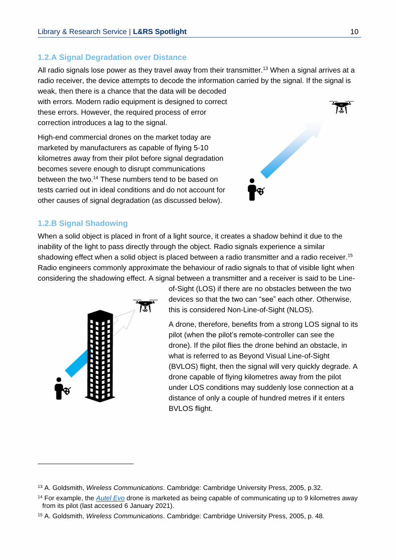
All radio signals lose power as they travel away from their transmitter.13 When a signal arrives at a
radio receiver, the device attempts to decode the information carried by the signal. If the signal is
weak, then there is a chance that the data will be decoded
with errors. Modern radio equipment is designed to correct
these errors. However, the required process of error
correction introduces a lag to the signal.
High-end commercial drones on the market today are
marketed by manufacturers as capable of flying 5-10
kilometres away from their pilot before signal degradation
becomes severe enough to disrupt communications
between the two.14 These numbers tend to be based on
tests carried out in ideal conditions and do not account for
other causes of signal degradation (as discussed below).
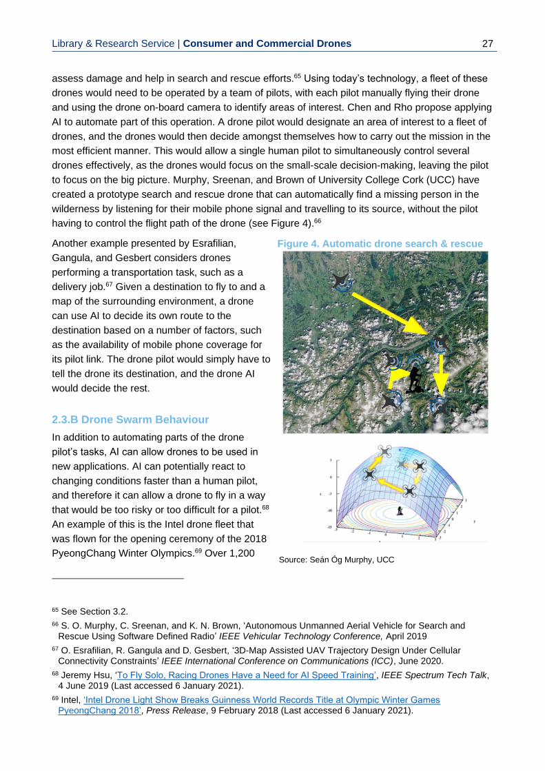
1.2.B Signal Shadowing
When a solid object is placed in front of a light source, it creates a shadow behind it due to the
inability of the light to pass directly through the object. Radio signals experience a similar
shadowing effect when a solid object is placed between a radio transmitter and a radio receiver.15
Radio engineers commonly approximate the behaviour of radio signals to that of visible light when
considering the shadowing effect. A signal between a transmitter and a receiver is said to be Line-
of-Sight (LOS) if there are no obstacles between the two
devices so that the two can “see” each other. Otherwise,
this is considered Non-Line-of-Sight (NLOS).
A drone, therefore, benefits from a strong LOS signal to its
pilot (when the pilot’s remote-controller can see the
drone). If the pilot flies the drone behind an obstacle, in
what is referred to as Beyond Visual Line-of-Sight
(BVLOS) flight, then the signal will very quickly degrade. A
drone capable of flying kilometres away from the pilot
under LOS conditions may suddenly lose connection at a
distance of only a couple of hundred metres if it enters
BVLOS flight.
13 A. Goldsmith, Wireless Communications. Cambridge: Cambridge University Press, 2005, p.32.
14 For example, the Autel Evo drone is marketed as being capable of communicating up to 9 kilometres away from its pilot (last accessed 6 January 2021).
15 A. Goldsmith, Wireless Communications. Cambridge: Cambridge University Press, 2005, p. 48.

Library & Research Service | Consumer and Commercial Drones
11
1.2.C Signal Interference
Every radio signal is transmitted on a specific radio
frequency. The spectrum of available radio frequencies is
limited. For this reason, in each country, the spectrum is
regulated by a communications regulator.16 The
communications regulator issues exclusive licences to
stakeholders such as mobile phone operators to use
specific spectrum bands. Certain spectrum bands, such as
the Industrial, Scientific and Medical (ISM) bands, are
intentionally kept licence-free to allow for free use by the
public. This lack of a licence requirement is why the ISM
bands are currently used by devices such as microwave
ovens, WiFi routers, and the current generation of
consumer drones.
When several devices transmit a signal on the same frequency, all the signals may be received
simultaneously by a radio receiver. This causes the signals to interfere with one another and make
it difficult for a receiver to decode the desired signal.17 What this means is that a drone which is
using the ISM bands for communicating with a pilot is vulnerable to any other nearby
communications occurring on the same frequencies (e.g. from devices such as WiFi routers).
Newer drone models are designed to account for this and can automatically choose specific ISM
frequencies which do not appear to be in use. However, this helps only when there are unused
ISM frequencies still available. For this reason, a drone which is capable of flying kilometres away
from its pilot in an unpopulated rural environment may simply not be capable of maintaining a radio
connection over the same distance when in a populated urban area.
1.3 Drone Artificial Intelligence
Drones are capable of a degree of independent navigation and flying. Using a variety of on-board
sensors, drones can make decisions independently of their pilot input. This section provides an
overview of how drones use AI to make decisions.
16 In Ireland, the communications regulator is the Commission for Communication Regulation (ComReg)
(Last accessed 6 January 2021).
17 A. Goldsmith, Wireless Communications. Cambridge: Cambridge University Press, 2005, p. 507.
Drones have on-board sensors for tracking the surrounding environment. Drone Artificial
Intelligence (AI) uses these sensors to assist the pilot with safely flying the drone. This
assistance includes obstacle avoidance and safety features which are triggered in the
event that the radio signal with the pilot is lost. Some drone models can fly entirely by
themselves using just their AI, with no pilot control.

Library & Research Service | L&RS Spotlight 12
The modern generation of commercially available drones come equipped with a variety of sensors
which allow them to be aware of their surrounding environment during flight, and relay that
information to the pilot (see Table 2 below).
Table 2: Drone Sensor Types
Sensors Measurement Purpose Description
Global Positioning System (GPS) receivers
Drone location in three-dimensional space
GPS receivers pick up signals from dedicated GPS satellites, which are used to determine the exact coordinates of a drone.
Infrared and optical proximity sensors
Distance to nearby obstacles
Cameras which are positioned around the drone that can detect nearby objects and calculate how far away they are from a drone, similar to the parking sensors in certain models of cars.
Inertial Measurement Unit (IMU)
Drone tilt, rotation and acceleration
Sensors that tell the drone if it is tilted, rotating, or moving in a certain direction, similar to an electronic spirit level.
Compass Drone orientation relative to magnetic north
Sensors that detect the earth's magnetic field.
Barometer Drone height changes Sensors that measure air pressure, which changes as a drone moves up or down.
Thermometer Temperature of drone components
Sensors that monitor the temperature of drone components such as the electronics, motors, and batteries, to warn the pilot if overheating occurs.
The exact combinations and configurations of sensors vary among drone models. Cheaper drones
which are designed as toys for children may not have any sensors, whereas industrial drones
intended for high-precision work may have all of the sensors listed, including backup sensors to
minimise the chance of errors. A drone that uses multiple down-facing proximity sensors to detect
the ground is shown in Figure 1 overleaf.
1.3.A Pilot Assistance
The drone AI uses the information from its sensors to keep the pilot informed about the state of the
flight, as well as performing certain flight operations independently of pilot input. For example, if a
drone detects an obstacle directly in its path, it will warn the pilot and may also choose to stop or
fly around the obstacle, even if the pilot does not issue a ‘stop command’. Newer drone models
can override a pilot’s flight instructions if the sensors suggest that the instruction is unsafe. Another
important example of this capability is the use of geofencing. Geofencing refers to areas which a
drone is not permitted to enter by its AI. Typically, these areas would be built into the drone by its
manufacturer and would be based on the locations of no-fly zones (as determined by aviation

Library & Research Service | Consumer and Commercial Drones
13
organisations such as national aviation authorities).18 If the AI detects from its GPS information that
it is inside a no-fly zone, it will issue a warning to the pilot and either stop or attempt to land.
The AI on certain drone models also assists the pilot with flight. For example, a drone can
automatically compensate for wind gusts, so that the drone is not blown off-course or flipped-over.
The AI detects these wind gusts via its sensors, compensates against the wind to keep the drone
steady and level, and warns the pilot about the presence of wind. This allows the pilot to focus on
other aspects of the flight, instead of compensating for the wind. This acts as both a safety feature
which protects the drone, as well as a navigational aid for the pilot.
1.3.B Automatic & Autonomous Flight
In addition to offering pilot assistance during flight, certain models of drones can fly by themselves
using AI. This is referred to as automatic flight, whereby the human pilot oversees the flight and
can assume manual control at any moment. Autonomous flight is also possible; this is when a
drone is being piloted by AI with no direct communication to the pilot, such that the pilot is not able
to take manual control of the drone.
18 DJI, ‘DJI Improves Geofencing To Enhance Protection of European Airports and Facilities’, Press Release,
12 February 2019 (Last Accessed 6 January 2021).
Figure 1. Ground proximity sensors on the underside of a drone

Library & Research Service | L&RS Spotlight 14
The main types of AI-driven drone flights are given in Table 3 below.
Table 3: Types of AI-driven Drone Flights
Type Description
Return-to-Home (RTH) flight
An important safety feature that has become widespread among newer drone models. If a drone loses the radio connection to its pilot (due to factors such as signal shadowing) it will attempt to autonomously return back to where it began its flight (based on GPS information), while searching for the pilot’s radio signal and attempting to reconnect. This failsafe ensures that a loss of radio signal while a drone is mid-air will not result in a crash.
Following a designated flight path
Using the drone software, the pilot draws a flight path that the drone should fly along, specifying its speed, height, and other flight behaviours. The drone then follows this flight path automatically, reacting to any obstacles but otherwise keeping to the instructions specified by the pilot.
Flying over a designated area
The pilot can choose to designate a certain area that they wish the drone to fly in, and the drone AI will automatically calculate its own flight path within the bounds of this area. This type of automatic flight is typically used for surveying or photography work where a drone needs to fly over every part of a certain area to take recordings or measurements.
Object tracking
Certain drone models have AI which is capable of image recognition. Using this, a drone can be instructed to identify a moving object which it locates/identifies with its camera (i.e. ‘sees’). The drone then follows the object, keeping it in-frame. This type of flight is popular for video-recording, as it allows the pilot to easily record a moving object using the drone.
In the flight examples in Table 3, the drone communicates with the pilot whenever the radio
connection is available. The pilot can choose to override or cancel the AI at any time. As the AI is
flying the drone by itself, the pilot can also choose to allow the drone to disconnect from the pilot’s
remote-controller without triggering the RTH functionality, and thus fly autonomously. This allows
the drone to fly a large distance away from the pilot in BVLOS flight. However, the clear challenge
with this is that the pilot may not receive information from the drone about the flight, and therefore
cannot intervene if there is an emergency. At the time of writing, autonomous flight is illegal in
Ireland due to the safety concerns of allowing drones to fly with no pilot oversight.19
19 The current regulations governing drone use in Ireland are the Commission Implementing Regulation (EU)
2019/947 (Last accessed 6 January 2021), see Section 4.3.

Library & Research Service | Consumer and Commercial Drones
15
1.4 Drone Cameras
In addition to the optical sensors described in the previous section, most drone models are
equipped with a camera, which enables many of the current drone applications.20 The potential for
drones to be used to spy on people and violate their privacy is one of the bigger concerns with the
spread of drone technology; this concern has been raised in Dáil Éireann on several occasions.21
This section considers the camera capabilities of the typical consumer drone model.
Typical commercial drone cameras attempt to strike a balance between being pilot-friendly and
offering good surveillance opportunities. While the drone camera may also be used by the drone AI
for flight purposes, the main function of the camera is to provide the pilot with a live view from the
drone.
20 See Chapter 3.
21 Minister for Transport, Tourism and Sport, Shane Ross T.D., Response to Parliamentary Question No. 557 (Aviation Industry Regulations), Dáil Éireann Debate, 16 May 2017 (Last accessed 6 January 2021); Minister for Justice and Equality, Charles Flanagan T.D., Response to Parliamentary Question No. 355 (Legislative Measures), Dáil Éireann Debate, 5 November 2019 (Last accessed 6 January 2021).
Most drone models have on-board cameras which send a live video feed back to the pilot.
This camera feed helps the pilot fly the drone and allows the pilot to take photos and
videos from the sky.
Figure 2. Drone remote-controller displaying drone camera view and flight information

Library & Research Service | L&RS Spotlight 16
This has two important functions:
• The drone camera assists the pilot with flying the drone, by letting the pilot see nearby obstacles and other important landmarks.
• The drone camera gives the pilot an aerial view of the surroundings, letting them take photos and videos from the sky and engage in aerial surveillance.
These two functions impose very different requirements on the design of the drone camera: the
former requires the camera to be able to see obstacles around it, while the latter requires a camera
which can see things clearly from a distance. To give the pilot a clear picture of the drone
surroundings for flight, the camera needs to have good peripheral vision (which is referred to as a
“wide field-of-view”). Such a camera would allow the pilot to see everything in front of the drone in
a wide area. The fundamental trade-off with a wide field-of-view camera is that it sacrifices a
detailed view of distant objects to achieve this peripheral vision. This means that such a camera
does not provide the pilot with good surveillance images.
When a pilot takes a photo or records a video, a copy of the material is stored on the pilot’s mobile
device (such as a smartphone).22 Certain models of drones can also store the material via internal
memory, allowing them to record photos and videos, even when a connection to the pilot is
unavailable (such as during autonomous flight).
1.5 Anti-Drone Measures
Drones flying into sensitive areas without permission are becoming a growing problem. In
response, a variety of technological solutions have been created to give authorities (such as law
enforcement authorities) the ability to track, deter, capture, or destroy trespassing drones, while
also tracking down their pilots.23
Anti-drone measures can be grouped under three categories:
• detecting drones,
• disrupting drone communications, and
• physically disabling the drone in flight.
22 By connecting drones to smartphones members of the public can quickly and easily share their drone
footage over the internet.
23 J. Wang, Y. Liu, and H. Song, ‘Counter-Unmanned Aircraft System(s) (C-UAS): State of the Art, Challenges and Future Trends’ Arxiv e-prints, August 2020.
Authorities have access to a variety of tools and technologies to stop trespassing drones.
These include special sensors which detect and track drones, devices which can hack a
drone and force it to land, as well as devices which can knock a drone out of the sky or
otherwise destroy it.

Library & Research Service | Consumer and Commercial Drones
17
1.5.A Detecting Drones
The first steps to stopping a drone involve detecting its presence and determining its location.
Drones can vary in size and their rotors can be quite loud (particularly for multi-rotor drones that
have several rotors). Therefore, detecting a drone can be as straightforward as simply seeing it
and hearing it. While straightforward, this type of visual detection can be susceptible to errors. In
December 2018, Gatwick airport had to shut down its flights for almost two days due to sightings of
trespassing drones on airport grounds. Numerous drone sightings were reported by members of
the public. However, in the aftermath of the intrusion, the accuracy of these reports was
questioned.24
More accurate drone detection can be achieved using the following technical means:
Radar. Manned aircraft such as aeroplanes and helicopters are tracked by authorities using radar
waves, which are a type of radio signal. A transmitter sends out radio signals into the sky and
these signals are reflected off the aircraft back down to earth. A radar dish picks up these signals
and determines the location of the aircraft in the sky based on how the signal was reflected. Radar
detection can accurately detect aircraft across extremely large distances in this manner. However,
radar designed to detect manned aircraft has difficulty detecting drones (due to their size).25 For
this reason, new types of radar designed to detect small drones are required. These anti-drone
radar systems are designed to detect and identify the unique features of drones, such as their
spinning rotors. The disadvantage of these systems, though, is that they work over much shorter
distances than radar for manned aircraft.
Detecting the drone-pilot wireless link. As discussed in Section 1.2, drones use radio signals to
wirelessly communicate with their pilot. This radio communication can be detected by anti-drone
equipment and used to locate and track the drone.26 The effectiveness of this method depends on
two factors. First, if the drone is flying autonomously, it may not be communicating with a pilot at
all. Therefore, there may not be any radio signal to detect. Second, if the drone radio signal is
using the WiFi frequency band, then it may be difficult for the anti-drone equipment to distinguish
the drone signal from other types of WiFi signals. As a result, the anti-drone equipment may not
identify the drone, or it may detect another WiFi signal and mistake it for a drone.
Drone visual detection. Drones can have very distinct colours and shapes compared to other
flying objects such as birds. For this reason, they can be detected using cameras that have image-
recognition AI.27 These types of cameras may not be suitable during night or in other low-light
conditions. However, thermal cameras can be used instead as drones generate heat from their
24 ‘Some Gatwick drone sightings 'may have been police devices'’, RTÉ News, 29 December 2018 (Last
accessed 6 January 2021); Samira Shackle, ‘The mystery of the Gatwick drone’, The Guardian, 1 December 2020 (Last accessed 6 January 2021).
25 I. Guvenc, F. Koohifar, S. Singh, M. L. Sichitiu, and D. Matolak, ‘Detection, Tracking, and Interdiction for Amateur Drones’ IEEE Communications Magazine, vol. 56(4), April 2018, pp. 75-81.
26 Ibid.
27 C. Briese, A. Seel, and F. Andert, ‘Vision-based detection of non-cooperative UAVs using frame differencing and temporal filter’ International Conference on Unmanned Aircraft Systems (ICUAS), June 2018, pp. 606-613.

Library & Research Service | L&RS Spotlight 18
batteries, electrical circuits, and motors during operation. This makes them visible to thermal
cameras irrespective of the time of day.
Drone sound detection. As drone rotors create noise, they
can be detected using microphones specially designed for
the purpose. Researchers have designed microphones that
have AI which allows them to identify the specific sound of
drone rotors.28 By placing several microphones in a location
and connecting those microphones together, a microphone
system can not only detect a drone but
also determine its location, by
comparing the sound levels at the
different microphones.29 The
disadvantage of this detection approach
is that it works over a relatively short
distance and is vulnerable to ambient noise from the environment.
Each of the detection methods described above has its own strengths and weaknesses. A reliable
drone detection system would therefore need to combine several detection methods to ensure its
accuracy.
1.5.B Disrupting Drone Communications
Once a trespassing drone is identified and located, lawful
authorities can use a variety of methods to stop the
drone.30 One approach is to disrupt the drone’s
communication systems, which can involve the following:
Signal jamming. The drone-pilot radio link is vulnerable to
other radio transmissions on the same frequency. By
intentionally transmitting a high-power radio signal on the
frequency that the drone is using it is possible to stop
communication with the pilot. If a drone is not flying
autonomously, then jamming the communication signal will
result in a number of potential outcomes. Depending on the
drone model, these include either the drone triggering its
RTH failsafe and flying back to the pilot, the drone stopping
28 S. Jeon, J. Shin, Y. Lee, W. Kim, Y. Kwon, and H. Yang, ‘Empirical study of drone sound detection in real-
life environment with deep neural networks’ 25th European Signal Processing Conference (EUSIPCO), September 2017, pp. 1858-1862.
29 X. Chang, C. Yang, J. Wu, X. Shi, and Z. Shi, ‘A Surveillance System for Drone Localization and Tracking Using Acoustic Arrays’ IEEE 10th Sensor Array and Multichannel Signal Processing Workshop (SAM), July 2018, pp. 573-577.
30 Note that in Ireland drones are legally treated as aircraft, and therefore it is unlawful for members of the public to interfere with their flight or attempt to destroy them.

Library & Research Service | Consumer and Commercial Drones
19
in mid-air, or falling out of the sky. As many drone models rely on GPS transmissions from
satellites for their navigation, these signals can also be jammed. Note that losing the GPS signal
by itself may not be sufficient to stop a drone flight, particularly if it is being flown manually by a
pilot. While effective, the disadvantage of signal-jamming is that it can negatively impact
bystanders. Transmitting jamming signals on WiFi frequencies will disrupt WiFi communication for
all nearby devices, not just the drone. Similarly, a GPS jammer can disable GPS for everyone in its
vicinity, which can be dangerous if used in an airport environment with aircraft in the air.
Signal spoofing. Signal spoofing refers to the practice of sending false signals to a receiving
device, to fool it into doing something the authorities want. For example, the authorities may
transmit false GPS signals which are designed to fool the drone into leaving the area or landing.31
If the authorities know what kind of radio signal the pilot uses to talk to the drone, then they can
spoof the pilot’s signal. This will fool the drone into treating the authorities as its pilot, and so it will
obey their flight commands. While successfully spoofing a signal and fooling the drone is more
technically complicated than simply jamming those signals, signal spoofing is far less likely to do
harm to others in the area.
1.5.C Physically Disabling the Drone
When disrupting the drone’s communications systems is ineffective or unsuitable, a variety of
solutions exist to stop the drone more directly. These involve the following:
Shooting the drone down. The most straightforward way to permanently disable a drone is to
shoot it down. During the Gatwick airport incident of December 2018, British Armed Forces snipers
were deployed around the airport area with the intention of firing on the drone.32 However, a
moving drone may pose a very challenging target, even for a trained sharpshooter. Military-grade
anti-missile systems such as the American Close-in Weapon System (CIWS)33 can offer far more
reliable protection. The obvious drawback of this approach is that gunfire may simply be too
dangerous due to the risk of stray bullets. Depending on the location and the risk posed by the
drone, the option of shooting the drone down may create a bigger problem than it will solve.
31 A.J. Kerns, D.P. Shepard, J.A. Bhatti, and T.E. Humphreys, ‘Unmanned Aircraft Capture and Control Via
GPS Spoofing’ Journal of Field Robotics, vol. 31(4), June 2014, pp. 617-636.
32 ‘Gatwick chaos: Police ‘could shoot down drone’’, BBC News, 21 December 2018 (Last accessed 6 January 2021).
33 John Keller, ‘Raytheon to upgrade and overhaul computer-controlled radar-guided shipboard weapons in $109.6 million order’, Military & Aerospace Electronics, 12 March 2020 (Last accessed 6 January 2021).

Library & Research Service | L&RS Spotlight 20
Directed-energy weapons. This category of weapon involves using focused energy in the form of
lasers34 or microwaves35 to damage the drone. A drone is vulnerable to laser beams due to its
reliance on its camera and other optical sensors; a laser beam can temporarily or permanently
blind these sensors. A sufficiently powerful laser beam can also cause the drone to heat up to the
point where its electronics and battery break, causing the drone to crash. A directed microwave
beam, meanwhile, can disable a drone’s electronics, thereby causing it to malfunction and likely
crash. The advantage of these directed-energy weapons is that they are less dangerous to
bystanders than the gunfire-based alternatives. These weapons still pose a risk of
causing unintended damage to nearby equipment, however. Laser beams can
cause damage over large distances; firing a laser into the sky can accidentally
strike distant aeroplanes or satellites in orbit.
Nets. As a drone requires rapidly spinning rotors to move, catching it in a net and
trapping the rotors is a reliable way to stop it. The difficulty of achieving this lies in
bringing the net to the drone’s location in the air. One solution is to fire the net at
the drone from a portable cannon using compressed air.36 In Japan, authorities
are using their own drones to carry these nets and “sweep up” the intruding
drones.37 While the difficulty of trapping the drone in a net is a disadvantage, the
big benefit of this anti-drone solution is that it is much safer for bystanders and
nearby equipment (as compared to the options discussed above).
Trained attack birds. A novel solution that has been explored38 (and subsequently abandoned39)
by Dutch authorities is the use of trained birds to attack and bring down drones. Certain birds of
prey such as falcons have a long history of being trained for hunting. This type of animal
husbandry can be adapted for dealing with drones. The effectiveness of this approach relies
entirely on how well the animal is trained, as it may have problems responding to commands from
its handlers or identifying the correct drone to attack, especially if there are other drones operating
lawfully in the area. Another drawback of this approach is the relative cost. Trained birds can be
prohibitively expensive; the Dutch authorities abandoned their anti-drone attack bird program due
to its lack of cost-effectiveness.40
34 Ben Wolfgang, ‘Air Force tests new anti-drone laser weapon’, Washington Times, 15 September 2020
(Last accessed 6 January 2021).
35 Evan Ackerman, ‘Raytheon Sets Phasers to Drone Destruction with Directed Energy Weapon Test’, IEEE Spectrum Tech Talk, 28 November 2016 (Last accessed 6 January 2021).
36 Matt Reynolds, ‘Anti-drone net launcher can down quadcopters from 100 metres’, Wired Magazine UK, 4 March 2016 (Last accessed 6 January 2021).
37 Keith Wagstaff, ‘Tokyo Police to Deploy Net-Carrying Drone to Catch Rogue Drones’, NBC News, 11 December 2015 (Last accessed 6 January 2021).
38 ‘Dutch police fight drones with eagles’, BBC News, 12 September 2016 (Last accessed 6 January 2021).
39 ‘Dutch police drops drone-hunting eagles project’, NL Times, 7 December 2017 (Last accessed 6 January 2021).
40 Ibid.

Library & Research Service | Consumer and Commercial Drones
21
1.5.D Assistance from Drone Manufacturers
Drone manufacturers can play a big part in preventing drone misuse. As previously mentioned in
Section 1.3, certain drone manufacturers include geofencing restrictions into a drone to prevent it
from flying into restricted areas. Drone manufacturers can provide authorities with tools to easily
detect and track their specific drones.41 With the cooperation of drone manufacturers, authorities
can respond to drone threats more quickly and with less risks to members of the public.
41 An example of this is the DJI Aeroscope, (Last accessed 6 January 2021).

Library & Research Service | L&RS Spotlight 22
2. Technological Developments
The usefulness and safety of drones is determined by a number of underlying technologies, which
continue to develop at a rapid pace. This is such that every year drones are used in new
applications that were not possible before. In this chapter several major technological trends,
which will impact how drones will be able to perform in the near future, are discussed. This will give
the reader a better understanding of how drone technology will evolve in the years ahead and how
this will impact on its applications.
2.1 Communication Link Improvements
The drone flight range is limited by its ability to maintain a wireless connection to its pilot. Allowing
drones to fly further, while still communicating with the pilot, is one of the biggest hurdles to cross
for drone technology to thrive. The drone communication range has improved in recent years, as
manufacturers have designed better communication systems used by their drones and remote-
controllers. There is, however, a practical limit to how far the drone-pilot link can extend when the
two are directly connected.
To truly solve the communication challenge, the drone and pilot would need to talk “indirectly”
through a communication network. The most well-known example of such a communication
network is the mobile phone network, which allows customers to talk to one another using their
phones across large distances. The phones themselves are not directly talking to one another via
wireless link; each phone is wirelessly connected to a nearby mobile phone tower, which sends the
phone data through the network to its destination (in this example, the other person’s phone).
Enabling the drone and pilot to communicate in this manner would allow them to be a large
distance apart and thereby solve the range issue.
2.1.A Using the Mobile Phone Network
While creating a new communication network for drones may be necessary in some specific
cases, for most drone users the mobile phone network is the most suitable solution. The big
benefit of the mobile phone network is that it already exists. Consequently, there is no need to
invest in new infrastructure such as new radio towers for drones. The telecommunications industry
has recognised the importance of the phone network for providing this type of wireless
The effective range of the radio link between the pilot and the drone restricts how far
drones can fly. By connecting the pilot and drone through a communications network
(instead of having them talk directly via a radio link) this range limitation can be removed.
The mobile phone network is the best candidate to use, although other network types such
as dedicated satellite networks may be used for some drone applications.

Library & Research Service | Consumer and Commercial Drones
23
connectivity, and is designing the next generation of phone networks with this in mind.42 While 4G
(and the mobile network generations before it) were designed to serve mobile phones, the new
family of communications technologies and standards (referred to as 5G)43 is designed to also
provide connectivity to new types of devices. These include Internet of Things (IoT) gadgets,44
connected and autonomous vehicles, as well as drones (as depicted in Figure 3 below).45
42 A. Ghosh, A. Maeder, M. Baker, and D. Chandramouli, ‘5G Evolution: A View on 5G Cellular Technology
Beyond 3GPP Release 15’ IEEE Access, vol. 7, September 2019, pp. 127639-127651.
43 ComReg, About 5G (Last accessed 6 January 2021).
44 Internet of Things refers to the principle of attaching computers and sensors to everyday objects and connecting them together through the internet, to allow them to perform useful functions. As an example, consider an internet-enabled smartwatch which keeps track of your physical exercise using various sensors.
45 H. Ullah, N. Gopalakrishnan Nair, A. Moore, C. Nugent, P. Muschamp, and M. Cuevas, ‘5G Communication: An Overview of Vehicle-to-Everything, Drones, and Healthcare Use-Cases’ IEEE Access, vol. 7, March 2019, pp. 37251-37268.
Figure 3. Drones connected to the mobile phone network, where Base Station (BS) refers
to the phone towers
Source: H. Ullah, N. Gopalakrishnan Nair, A. Moore, C. Nugent, P. Muschamp, and M. Cuevas, ‘5G Communication: An
Overview of Vehicle-to-Everything, Drones, and Healthcare Use-Cases’ IEEE Access, vol. 7, March 2019, pp. 37251-
37268.

Library & Research Service | L&RS Spotlight 24
Research is still underway into providing this drone connectivity, as drones create several unique
problems for the mobile phone network.46 As they have to meet a certain standard of safety, the
communications link provided by the phone network needs to meet a high quality standard.47 For
example, to allow a pilot to effectively control a drone, the video signal from a drone’s camera has
to be able to reach the pilot’s remote controller within a very short length of time.48 Furthermore, as
drones are airborne they experience very different radio conditions to what people on the ground
experience.49 Designing the phone network to allow a drone to always have a high-quality wireless
connection to its pilot wherever it may fly is a complicated task.50 A number of academic and
commercial research groups around the world are working on this problem.51
2.1.B Using Other Networks
In addition to using the phone network, other options are possible for the drone-pilot link. Long
range military drones, such as those used by the US Air Force, rely on satellite links, where
satellites in orbit relay the data between the drone and the pilot.52 This solution has also been
proposed for civilian drones in applications where the drones may have to fly in regions with no
mobile phone coverage.53 Another option that is possible for drones is what is known as an “ad-
hoc network”.54 If a fleet of drones are flying in a certain area, then the drones can set up a
temporary network amongst each other. A pilot communicating with a distant drone would send
data to a nearby drone instead, and that data would be relayed through the ad-hoc network to its
destination drone. The advantage of this ad-hoc network is that it does not rely on any additional
infrastructure, as the drones themselves perform all the network routing operations.
46 Y. Zeng, Q. Wu, and R. Zhang, ‘Accessing From the Sky: A Tutorial on UAV Communications for 5G and
Beyond’ Proceedings of the IEEE, vol. 107(12), December 2019, pp. 2327-2375.
47 Ibid.
48 The technical term for this is “low latency”.
49 For example, typical phone towers have antennas which are pointed down towards the ground to send radio signals to people using their phones at ground-level; as a result, the drones which are high above ground receive a weak signal from those antennas.
50 Y. Zeng, J. Lyu, and R. Zhang, ‘Cellular-Connected UAV: Potential, Challenges, and Promising Technologies’ IEEE Wireless Communications, vol. 26(1), February 2019, pp. 120-127.
51 In Ireland, this research is carried out by groups such as the Science Foundation Ireland research centre CONNECT and the Hamilton Institute in NUI Maynooth. (Last accessed 6 January 2021).
52 Alberto Cuadra and Craig Whitlock, ‘How drones are controlled’, Washington Post, 20 June 2014 (Last accessed 6 January 2021).
53 M. Vondra, M. Ozger, D. Schupke, and C. Cavdar, ‘Integration of Satellite and Aerial Communications for Heterogeneous Flying Vehicles’ IEEE Network, vol. 32(5), September 2018, pp. 62-69.
54 W. Zafar and B. Muhammad Khan, ‘Flying Ad-Hoc Networks: Technological and Social Implications’ IEEE Technology and Society Magazine, vol. 35(2), June 2016, pp. 67-74.

Library & Research Service | Consumer and Commercial Drones
25
2.2 Flight Time Improvements
Most consumer drones on the market are battery powered. They have a rechargeable battery on-
board which provides power to the drone components, including the electric motors which spin the
rotors. As an electric battery can store a limited amount of energy, a battery-powered drone has a
limited amount of time it can fly in the air. This also means that there is a limited distance it can fly
from its starting point. As electric batteries are the key to enabling the electric car market, there is a
significant amount of commercial and academic interest in developing new types of batteries.55
These new batteries will be more cost-effective to manufacture, easier to recharge, and they will
be able to store more energy, leading to longer device usage on a single battery charge.56
Naturally, other consumer devices will also benefit from these developments. At the time of writing,
a typical commercial multi-rotor drone may have a flight time of between 30-60 minutes on a full
battery charge; this flight time may increase four-fold by 2030 due to new battery types which can
store more energy.57
In addition to the improvements to battery energy storage, there is ongoing research into improving
how drone batteries recharge. Currently, drone batteries are recharged in the same manner as
other consumer electronics. The drone pilot removes the battery from the drone and connects it to
a power supply such as an electrical outlet. This means that if a drone is running out of battery
power, it must return to its pilot and land to have its battery replaced and the old battery recharged.
This battery recharging and replacement takes up valuable time and forces the drone to always
remain close to its pilot. An alternative has been proposed by researchers who have developed a
robotic battery-switching station.58 In this scenario, the drone lands at the station, and a robotic
arm replaces its battery with a new one. The entire process is automated so that the human pilot
does not need to take part, and therefore the pilot does not need to be close to the docking station.
Another option is to recharge the drone wirelessly.59 In this case, the drone lands (or hovers
55 E. Chemali, M. Preindl, P. Malysz, and A. Emadi, ‘Electrochemical and Electrostatic Energy Storage and
Management Systems for Electric Drive Vehicles: State-of-the-Art Review and Future Trends’ IEEE Journal of Emerging and Selected Topics in Power Electronics, vol. 4(3), September 2016, pp. 1117-1134.
56 Ibid.
57 B. Galkin, J. Kibilda, and L. A. DaSilva, ‘UAVs as Mobile Infrastructure: Addressing Battery Lifetime’ IEEE Communications Magazine, vol. 57(6), June 2019, pp. 132-137.
58 D. Lee, J. Zhou, and W. T. Lin, ‘Autonomous battery swapping system for quadcopter’ International Conference on Unmanned Aircraft Systems (ICUAS), June 2015, pp. 118-124.
59 M. Lu, M. Bagheri, A. P. James, and T. Phung, ‘Wireless Charging Techniques for UAVs: A Review, Reconceptualization, and Extension’ IEEE Access, vol. 6, May 2018, pp. 29865-29884.
The length of time a drone can stay in the air depends on its battery power. New battery
technologies are emerging which will extend this time. New battery recharging
mechanisms are being developed which will allow drones to recharge their batteries
automatically without human involvement. Solar power and laser power are also being
developed for drones, to allow them to recharge by landing in sunlight or even in mid-air.

Library & Research Service | L&RS Spotlight 26
overhead) next to a wireless power supply which recharges its battery, again without the need for
the human pilot.
Solar power is viewed as a promising technology for drones.60 When equipped with solar panels, a
multi-rotor drone would have the ability to land anywhere in direct sunlight to recharge, instead of
being limited to dedicated recharging stations.61 Such a drone could be released “into the wild” to
carry out its mission, land somewhere to recharge its batteries, and then continue. Combined with
the communication link improvements described in Section 2.1, this could also allow the drone to
travel great distances away from the pilot.
For situations where a drone must stay in the air for a very long time, laser power is an option. One
company have demonstrated a laser-powered prototype drone which uses a modified solar panel
that is hit by a laser on the ground.62 The laser energy is harvested by the solar panel and used to
power the drone. The energy delivered by the laser is enough to keep the drone in the air, which
means it can keep flying for as long as the laser is powering it. The drawback of this power
technique is that a laser powerful enough to keep the drone in the air is powerful enough to cause
damage if it hits something other than the drone.
2.3 Drone Artificial Intelligence Improvements
With the help of an array of on-board sensors, drones can make low-level decisions about their
flight (using AI). As previously noted in Section 1.3, these decisions currently involve reacting to
obstacles to avoid collisions or following flight instructions previously issued by the pilot. Drone AI
is a significant research topic among the academic and commercial sectors.63 The purpose of this
research is to develop more advanced types of AI which would allow drones to perform more
functions independently of the pilot.
2.3.A Drones Choosing Their Own Flight Paths
Chen and Rho consider a disaster response example for their drone AI application.64 In the case of
an emergency (such as an earthquake), drones would be used by first responders to quickly
60 Ibid.
61 N. Kingry et al., ‘Design, Modeling and Control of a Solar-Powered Quadcopter’ IEEE International Conference on Robotics and Automation (ICRA), May 2018, pp. 1251-1258.
62 Bill Read, ‘Fly By Light’, Royal Aeronautical Society, 14 February 2017 (Last accessed 6 January 2021).
63 Y. Zhou, B. Rao, and W. Wang, ‘UAV Swarm Intelligence: Recent Advances and Future Trends’ IEEE Access, vol. 8, October 2020, pp. 183856-183878.
64 B. Chen and S. Rho, ‘Autonomous Tactical Deployment of the UAV Array Using Self-Organizing Swarm Intelligence’ IEEE Consumer Electronics Magazine, vol. 9(2), March 2020, pp. 52-56.
Drone Artificial Intelligence (AI) is being developed to allow drones to make more
complicated decisions independently of pilot commands, such as choosing their own flight
paths to safely and efficiently perform their tasks. AI is also being improved to allow drones
to closely cooperate with other drones and fly as coordinated “swarms”.
Library & Research Service | Consumer and Commercial Drones
27
assess damage and help in search and rescue efforts.65 Using today’s technology, a fleet of these
drones would need to be operated by a team of pilots, with each pilot manually flying their drone
and using the drone on-board camera to identify areas of interest. Chen and Rho propose applying
AI to automate part of this operation. A drone pilot would designate an area of interest to a fleet of
drones, and the drones would then decide amongst themselves how to carry out the mission in the
most efficient manner. This would allow a single human pilot to simultaneously control several
drones effectively, as the drones would focus on the small-scale decision-making, leaving the pilot
to focus on the big picture. Murphy, Sreenan, and Brown of University College Cork (UCC) have
created a prototype search and rescue drone that can automatically find a missing person in the
wilderness by listening for their mobile phone signal and travelling to its source, without the pilot
having to control the flight path of the drone (see Figure 4).66
Another example presented by Esrafilian,
Gangula, and Gesbert considers drones
performing a transportation task, such as a
delivery job.67 Given a destination to fly to and a
map of the surrounding environment, a drone
can use AI to decide its own route to the
destination based on a number of factors, such
as the availability of mobile phone coverage for
its pilot link. The drone pilot would simply have to
tell the drone its destination, and the drone AI
would decide the rest.
2.3.B Drone Swarm Behaviour
In addition to automating parts of the drone
pilot’s tasks, AI can allow drones to be used in
new applications. AI can potentially react to
changing conditions faster than a human pilot,
and therefore it can allow a drone to fly in a way
that would be too risky or too difficult for a pilot.68
An example of this is the Intel drone fleet that
was flown for the opening ceremony of the 2018
PyeongChang Winter Olympics.69 Over 1,200
65 See Section 3.2.
66 S. O. Murphy, C. Sreenan, and K. N. Brown, ‘Autonomous Unmanned Aerial Vehicle for Search and Rescue Using Software Defined Radio’ IEEE Vehicular Technology Conference, April 2019
67 O. Esrafilian, R. Gangula and D. Gesbert, ‘3D-Map Assisted UAV Trajectory Design Under Cellular Connectivity Constraints’ IEEE International Conference on Communications (ICC), June 2020.
68 Jeremy Hsu, ‘To Fly Solo, Racing Drones Have a Need for AI Speed Training’, IEEE Spectrum Tech Talk, 4 June 2019 (Last accessed 6 January 2021).
69 Intel, ‘Intel Drone Light Show Breaks Guinness World Records Title at Olympic Winter Games PyeongChang 2018’, Press Release, 9 February 2018 (Last accessed 6 January 2021).
Figure 4. Automatic drone search & rescue
Source: Seán Óg Murphy, UCC

Library & Research Service | L&RS Spotlight 28
drones carrying colourful lights moved in perfect synchronicity to create three-dimensional shapes
and figures. This was achieved using AI which allowed the drones to work together and fly in
unison. Given the large number of drones, their intricate movement, and the close distances
between them, such a performance would be impossible to achieve using human pilots. This type
of “swarm” behaviour can be used outside of entertainment purposes to allow drones to perform
new types of operations in areas such as search and rescue.70
2.3.C Machine Learning
The field of AI is currently experiencing a revolution due to the development of Machine Learning
(ML).71 Prior types of AI rely on a human to design its behaviour. By contrast in ML, the AI teaches
itself how to act, based on trial-and-error experimentation. This can allow AI to be used to solve
problems that were previously unsolvable by AI. This revolution has impacted a variety of technical
fields, and drones are no exception.72 While ML will not only make drone AI more capable than
before, it will also affect how the AI is trained. For example, if ML is used to teach a drone AI how
to fly in a certain environment, the AI would need to practice flying through the environment, trying
different paths and different strategies. After some experimentation, the AI would determine how it
should fly and would remember this behaviour for future flights. This new type of AI would
therefore impact how drone pilots would use their drones and create new regulatory challenges.
70 X. Zhu, C. Bian, Y. Chen and S. Chen, ‘A Low Latency Clustering Method for Large-Scale Drone Swarms’
IEEE Access, vol. 7, December 2019, pp. 186260-186267.
71 A. Ghafourifar and M. Evans, ‘The Machine Learning Revolution: How Artificial Intelligence Could Transform Your Business’, Forbes Magazine, 20 October 2018 (Last accessed 6 January 2021).
72 Z. Ullah, F. Al-Turjman and L. Mostarda, ‘Cognition in UAV-Aided 5G and Beyond Communications: A Survey’ IEEE Transactions on Cognitive Communications and Networking, vol. 6(3), September 2020, pp. 872-891.
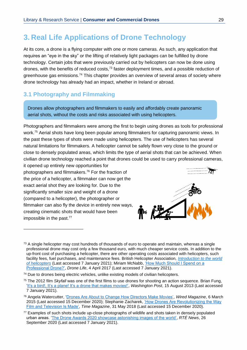
Library & Research Service | Consumer and Commercial Drones
29
3. Real Life Applications of Drone Technology
At its core, a drone is a flying computer with one or more cameras. As such, any application that
requires an “eye in the sky” or the lifting of relatively light packages can be fulfilled by drone
technology. Certain jobs that were previously carried out by helicopters can now be done using
drones, with the benefits of reduced costs,73 faster deployment times, and a possible reduction of
greenhouse gas emissions.74 This chapter provides an overview of several areas of society where
drone technology has already had an impact, whether in Ireland or abroad.
3.1 Photography and Filmmaking
Photographers and filmmakers were among the first to begin using drones as tools for professional
work.75 Aerial shots have long been popular among filmmakers for capturing panoramic views. In
the past these types of shots were made using helicopters. The use of helicopters has several
natural limitations for filmmakers. A helicopter cannot be safely flown very close to the ground or
close to densely populated areas, which limits the type of aerial shots that can be achieved. When
civilian drone technology reached a point that drones could be used to carry professional cameras,
it opened up entirely new opportunities for
photographers and filmmakers.76 For the fraction of
the price of a helicopter, a filmmaker can now get the
exact aerial shot they are looking for. Due to the
significantly smaller size and weight of a drone
(compared to a helicopter), the photographer or
filmmaker can also fly the device in entirely new ways,
creating cinematic shots that would have been
impossible in the past.77
73 A single helicopter may cost hundreds of thousands of euro to operate and maintain, whereas a single
professional drone may cost only a few thousand euro, with much cheaper service costs. In addition to the up-front cost of purchasing a helicopter, there are other operating costs associated with helicopters, such facility fees, fuel purchases, and maintenance fees. British Helicopter Association, Introduction to the world of helicopters (Last accessed 7 January 2021); Miriam McNabb, ‘How Much Should I Spend on a Professional Drone?’, Drone Life, 4 April 2017 (Last accessed 7 January 2021).
74 Due to drones being electric vehicles, unlike existing models of civilian helicopters.
75 The 2012 film Skyfall was one of the first films to use drones for shooting an action sequence. Brian Fung, ‘It’s a bird!, It’s a plane! It’s a drone that makes movies!’, Washington Post, 15 August 2013 (Last accessed 7 January 2021).
76 Angela Watercutter, ‘Drones Are About to Change How Directors Make Movies’, Wired Magazine, 6 March 2015 (Last accessed 15 December 2020); Stephanie Zacharek, ‘How Drones Are Revolutionizing the Way Film and Television Is Made’, Time Magazine, 31 May 2018 (Last accessed 15 December 2020).
77 Examples of such shots include up-close photographs of wildlife and shots taken in densely populated urban areas. ‘The Drone Awards 2020 showcase astonishing images of the world’, RTÉ News, 26 September 2020 (Last accessed 7 January 2021).
Drones allow photographers and filmmakers to easily and affordably create panoramic
aerial shots, without the costs and risks associated with using helicopters.

Library & Research Service | L&RS Spotlight 30
3.2 Emergency Services and Law Enforcement
As cheap, easy-to-use flying cameras, drones are a natural fit for emergency services. The DFB
has been using drones as part of their emergency response since 2016.78 In an emergency, such
as a fire, a DFB pilot travels to the site of the incident (while keeping a safe distance away),
launches the drone, and flies it over the site while using the live feed from the drone camera to
coordinate the emergency response. This is a function that previously would have been performed
by service helicopters, as in the filmmaking sector. The key innovation introduced by drone
technology is its deployment speed. A drone can be carried by the operator in a backpack to the
incident site and launched within minutes, whereas a manned helicopter would need to be
launched from a dedicated heliport and travel to the incident site, resulting in a potentially slower
response.
The advantages that drones offer over manned helicopters have prompted the Civil Defence to
invest in their own drone fleet, to be used for search and rescue operations alongside An Garda
Síochána and the Irish Coast Guard.79 Drones allow a pilot to very quickly inspect a large area for
signs of life. In an emergency scenario, where time is limited, this rapid response can have life-
saving results. As drones fly in the air, they are not affected by difficult or inaccessible ground,
which means that search and rescue teams are able to check areas for signs of life that would
otherwise be very difficult or unsafe to reach,
such as steep mountains or shorelines. The
drones used by Civil Defence also carry thermal
cameras, which further simplify the process of
locating people in wide open areas.80 As of
2020, the Irish Coast Guard have their own
search and rescue drone teams operating on the
west coast of the country.81
An Garda Síochána is currently exploring the
possibility of using drones as part of their law
78 Mark Hilliard, ‘Dublin Fire Brigade likely to begin using drones before end of year’, Irish Times, 9
November 2015 (Last accessed 7 January 2021).
79 Claire Murphy, ‘Civil Defence drone pilots to help in cases of missing persons’, Irish Independent, 26 November 2018 (Last accessed 7 January 2021).
80 Civil Defence, Search & Rescue, (Last accessed 7 January 2021).
81 Pat Flynn, ‘Doolin Coast Guard unit drone team goes live’, Clare Herald, 20 December 2019 (Last accessed 7 January 2021).
Emergency services use drones as an “eye in the sky” to coordinate emergency crews and
look for survivors. Presently, the Dublin Fire Brigade (DFB), Civil Defence and the Irish
Coast Guard are using drones in their emergency work, with An Garda Síochána
considering adopting the technology.

Library & Research Service | Consumer and Commercial Drones
31
enforcement operations.82 the Gardaí are considering using drones for operations such as road
traffic surveillance, mapping out crime scenes, and ensuring public order at crowded events.83 Due
to the COVID-19 crisis, law enforcement agencies abroad have begun using drones to enforce
public compliance such as social distancing.84 Concerns have been raised about the civil rights
issues that may arise from the Gardaí using drones, with the Irish Council of Civil Liberties issuing
a statement that the use of drones in this manner may negatively impact on the privacy and
freedom of assembly rights of Irish citizens.85 The police in the UK have faced similar criticism from
privacy campaigners for their use of drones in policing COVID-19 restrictions.86 Wexford County
Council have used drones to monitor COVID-19 compliance in public areas such as caravan
parks, which was found by the Data Protection Commission (DPC) to have been a potential breach
of data protection regulations. The DPC also highlighted that no data protection impact
assessment (DPIA) was carried out, although Wexford County Council had included a requirement
for a DPIA in its drone policy by the time of the DPC decision.87
3.3 Infrastructure Inspection and Surveying
Drones are very well-suited for industrial sectors that require overseeing large projects spanning
large territories or working in unsafe environments.88 Drones are commonly used today for
performing inspections of critical infrastructure such as wind turbines. Given their size and moving
parts, wind turbines pose a challenge for workers investigating damage or signs of disrepair. With
a drone, a worker can safely remain on the ground while getting an up-close view of the wind
turbine from an angle that cannot be seen from the ground.89 Additional sensors (e.g. thermal
cameras or Light Detection and Ranging (LiDAR)90 sensors) can be carried by the drone to detect
82 Aiden Corkery, ‘Gardaí to look into using drones for first time’, Business Post, 17 May 2020 (Last
accessed 7 January 2021).
83 Ibid.
84 Courtney Linder, ‘Police Are Using Drones to Yell at People for Being Outside’, Popular Mechanics, 17 March 2020 (Last accessed 7 January 2021).
85 ‘Irish Council of Civil Liberties raises privacy concerns about potential drone use by Gardaí’, Irish Examiner, 18 May 2020 (Last Accessed 7 January 2021).
86 ‘Coronavirus: Peak District drone police criticised for 'lockdown shaming'’, BBC News, 27 March 2020 (Last accessed 7 January 2021).
87 Cianan Brennan, ‘Covid-19: Council broke the law by using drones to monitor public movement’, Irish Examiner, 4 October 2020 (Last accessed 7 January 2021).
88 Accenture Consulting, A business approach for the use of drones in the Engineering & Construction industries, 2016, p. 5 (Last accessed 7 January 2021).
89 Jennifer Runyon, ‘How Drones Will Transform Wind Turbine Inspections’, Renewable Energy World, vol. 20(6), 2017 (Last accessed 7 January 2021).
90 LiDAR is a system that uses laser pulses to create 3D scans of an object.
Drones can be used to safely carry out up-close inspections of infrastructure such as wind
turbines and power lines. ESB Networks has begun using drones for this purpose. Drones
can also be used by civil engineers to make 3D scans of an area, for analysis purposes.

Library & Research Service | L&RS Spotlight 32
issues not visible to the naked eye.91 With
the inclusion of AI, the inspection process
can also be largely automated by the drone,
reducing the time and effort involved in the
inspection. All of this results in a
corresponding reduction of costs, with
current estimates suggesting that drones
can reduce wind turbine survey expenses
by up to 80%.92 Drones are used in a similar
manner to inspect other types of
infrastructure such as railway lines, power
lines, and gas pipelines.93 At the time of
writing, ESB Networks has completed a
pilot project to apply drone inspections to their power lines,94 and has begun the use of automatic
drones for wind turbine inspections.95
In addition to allowing workers to safely and efficiently inspect infrastructure, drones can provide
for a deeper level of analysis when surveying an area. Drones can be used to “scan” an area and
create a 3D model, using a technique known as “photogrammetry”.96 Users can then extract
important information from this 3D model that would otherwise be difficult to obtain. For example,
drones have been used by researchers to generate a 3D topology map of a quarry, from which
they were then able to accurately calculate the remaining volume of deposits left in the quarry.97
This type of 3D surveying can be applied to a wide range of applications and scenarios. Possibly,
the most well-known example of photogrammetry is Google Earth, which offers users high
resolution 3D scans of major world cities. Due to the technical and regulatory restrictions on drone
use, these scans are currently made using low-flying manned aeroplanes with cameras.98
91 M. Car, L. Markovic, A. Ivanovic, M. Orsag and S. Bogdan, ‘Autonomous Wind-Turbine Blade Inspection
Using LiDAR-Equipped Unmanned Aerial Vehicle’ IEEE Access, vol. 8, July 2020, pp. 131380-131387.
92 Charles Choi, ‘The Future of Drones and Wind Power’, Inside Unmanned Systems, 28 October 2020 (Last accessed 7 January 2021).
93 Peter Gutierrez, ‘Infrastructure Inspection – UAS Are All Over It’, Inside Unmanned Systems, 1 May 2019 (Last accessed 7 January 2021).
94 ESB Networks, Innovation for the Network of the Future, 2020, p. 40 (Last accessed 7 January 2021).
95 ESB Networks, ‘Sterblue helps deliver ESB’s ambition for a cleaner future’, Press Release, 4 May 2020 (Last accessed 7 January 2021).
96 In photogrammetry, a large number of photographs of an area are taken from different angles. These photographs are then entered into an AI algorithm along with the exact GPS coordinates where they were taken. The AI algorithm recreates the 3D shape of the area using these photographs and GPS coordinates.
97 Á. Török, G. Bögöly, Á Somogyi, T Lovas, ‘Application of UAV in Topographic Modelling and Structural Geological Mapping of Quarries and Their Surroundings-Delineation of Fault-Bordered Raw Material Reserves’ Sensors (Basel), vol. 20(2), January 2020 (Last accessed 7 January 2021).
98 Natalie Dennis, Google, ‘Google Earth’s incredible 3D imagery, explained’, Press Release, 18 April 2017 (Last accessed 7 January 2021).
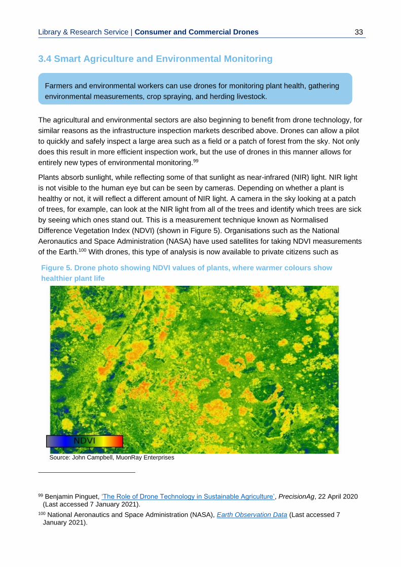
Library & Research Service | Consumer and Commercial Drones
33
3.4 Smart Agriculture and Environmental Monitoring
The agricultural and environmental sectors are also beginning to benefit from drone technology, for
similar reasons as the infrastructure inspection markets described above. Drones can allow a pilot
to quickly and safely inspect a large area such as a field or a patch of forest from the sky. Not only
does this result in more efficient inspection work, but the use of drones in this manner allows for
entirely new types of environmental monitoring.99
Plants absorb sunlight, while reflecting some of that sunlight as near-infrared (NIR) light. NIR light
is not visible to the human eye but can be seen by cameras. Depending on whether a plant is
healthy or not, it will reflect a different amount of NIR light. A camera in the sky looking at a patch
of trees, for example, can look at the NIR light from all of the trees and identify which trees are sick
by seeing which ones stand out. This is a measurement technique known as Normalised
Difference Vegetation Index (NDVI) (shown in Figure 5). Organisations such as the National
Aeronautics and Space Administration (NASA) have used satellites for taking NDVI measurements
of the Earth.100 With drones, this type of analysis is now available to private citizens such as
99 Benjamin Pinguet, ‘The Role of Drone Technology in Sustainable Agriculture’, PrecisionAg, 22 April 2020
(Last accessed 7 January 2021).
100 National Aeronautics and Space Administration (NASA), Earth Observation Data (Last accessed 7 January 2021).
Farmers and environmental workers can use drones for monitoring plant health, gathering
environmental measurements, crop spraying, and herding livestock.
Figure 5. Drone photo showing NDVI values of plants, where warmer colours show
healthier plant life
,
Source: John Campbell, MuonRay Enterprises

Library & Research Service | L&RS Spotlight 34
independent farmers. Using a drone, a typical farmer can take NDVI measurements of a crop,
identify the exact areas where there are crop health issues, and react accordingly.101
Drones can also be used to physically take measurements from the environment. An example of
this is an Environmental Protection Agency (EPA) trial which investigated whether drones could be
used to collect water samples from lakes.102 The EPA is responsible for monitoring the quality of
water in Ireland’s lakes, which normally involves travelling by boat to various parts of a lake and
collecting water samples by hand. The speed and mobility of a drone can allow a pilot to gather
water samples from certain points on a lake’s surface more quickly than if the pilot has to travel
there by boat. The report suggested that the use of a drone for sample gathering could make the
process more than three times faster, with the additional benefits of allowing the pilot to gather
samples in areas inaccessible by boat, while also being less invasive to wildlife. The report
highlighted the disadvantages of using a drone, which included the up-front costs of the hardware
compared to the cost of using a boat, the restriction on the sample weight that the drone can carry,
as well as the legal permissions that are required for operating the drone.103
Another emerging application for drones in agriculture is crop spraying. As drones can carry a
certain amount of weight, it is possible to fly them close to crops and spray them with liquids such
as pesticides. By precisely controlling the height and speed of a drone, the pilot can ensure a
precise amount of fluid is delivered to a crop, which can offer more efficient crop-spraying than
conventional ground-based methods.104
In smart agriculture, sensors are becoming more commonplace. For example, health sensors
similar to smartwatches are available to enable farmers to monitor the health of their livestock in
real-time.105 These sensors wirelessly transmit information to the farmer; however, the effective
distance across which these sensors can transmit data is not very long.106 This is an issue for large
farms, as it means the sensors may be spread out in such a way that they cannot directly
communicate with the farmer unless the farmer travels to them. Drones offer a possible solution to
this, as they can quickly travel around a farm, flying close to relevant sensors of interest, gathering
the data from them and then passing it on to the pilot.
101 Kevin O'Sullivan, ‘Drones set to help Irish farmers practise ‘precision agriculture’’, Irish Times, 21 October
2019 (Last accessed 7 January 2021).
102 EPA Research, Assessing the Potential of Drones to Take Water Samples and Physico-chemical Data from Open Lakes, prepared by H. Lally, I. O’Connor, L. Broderick, M. Broderick, O. Jensen, and C. Graham, Galway-Mayo Institute of Technology, 2020 (Last accessed 7 January 2021).
103 Ibid, pp 18-19.
104 Stephen Cadogan, ‘First large drone adapted for agricultural use’, Irish Examiner, 2 December 2019 (Last accessed 7 January 2021).
105 Enterprise Ireland, Fitbits for cows: how wearables are driving the ‘Internet of Animals’ in agriculture, prepared by Alan Horan (Last accessed 7 January 2021).
106 The wireless communication of these sensors is affected by the same issues that affect the drone-pilot communication link, discussed in Section 1.2.

Library & Research Service | Consumer and Commercial Drones
35
One of the challenges posed by drones on
farms is that the noise from their rotors may
disturb animals. This, however, also creates
an interesting opportunity for using drones to
herd livestock. Farmers in parts of the world
such as New Zealand have begun using
drones for precision herding, where the drone
is flown in such a way as to direct the herd and
control stragglers.107 The Irish Natura And Hill
Farmers Association (INHFA) has called for
government grants to support the purchase of
drones to enable
this type of
herding.108
The agricultural drone market continues to develop worldwide, with
some forecasts suggesting that it may become a billion US dollar market
by 2024.109
3.5 Delivery and Transportation
While drones cannot carry heavy weights (as compared to ground vehicles), their ability to quickly
fly through the sky has made them an attractive option for delivery scenarios where quick delivery
times are critical, such as with medical deliveries. In 2016, one company began using drones for
delivering blood packs to hospitals in Rwanda.110 As it is a developing country, the quality of
Rwandan road infrastructure creates difficulties for emergency response, including blood delivery
107 Peter Holley, ‘New Zealand farmers have a new tool for herding sheep: drones that bark like dogs’,
Washington Post, 7 March 2019 (Last accessed 7 January 2021).
108 Declan O'Brien, ‘Calls for government funding of drones to herd hill sheep’, Irish Independent, 22 September 2020 (Last accessed 7 January 2021).
109 Andrew Meola, ‘Exploring agricultural drones: The future of farming is precision agriculture, mapping, and spraying’, Business Insider, 8 January 2020 (Last accessed 7 January 2021).
110 Martin Giles, ’Zipline launches the world’s fastest commercial delivery drone’, MIT Technology Review, 3 April 2018 (Last accessed 7 January 2021).
Drones have been used to make emergency medical deliveries in situations where
deliveries by road are not feasible. In parts of the world, drones are beginning to be used
to deliver packages and other products (e.g. food). Drone medical and shopping delivery
trials were carried out in Ireland in 2020. There is a growing interest in using bigger drones
as flying taxis in the future.
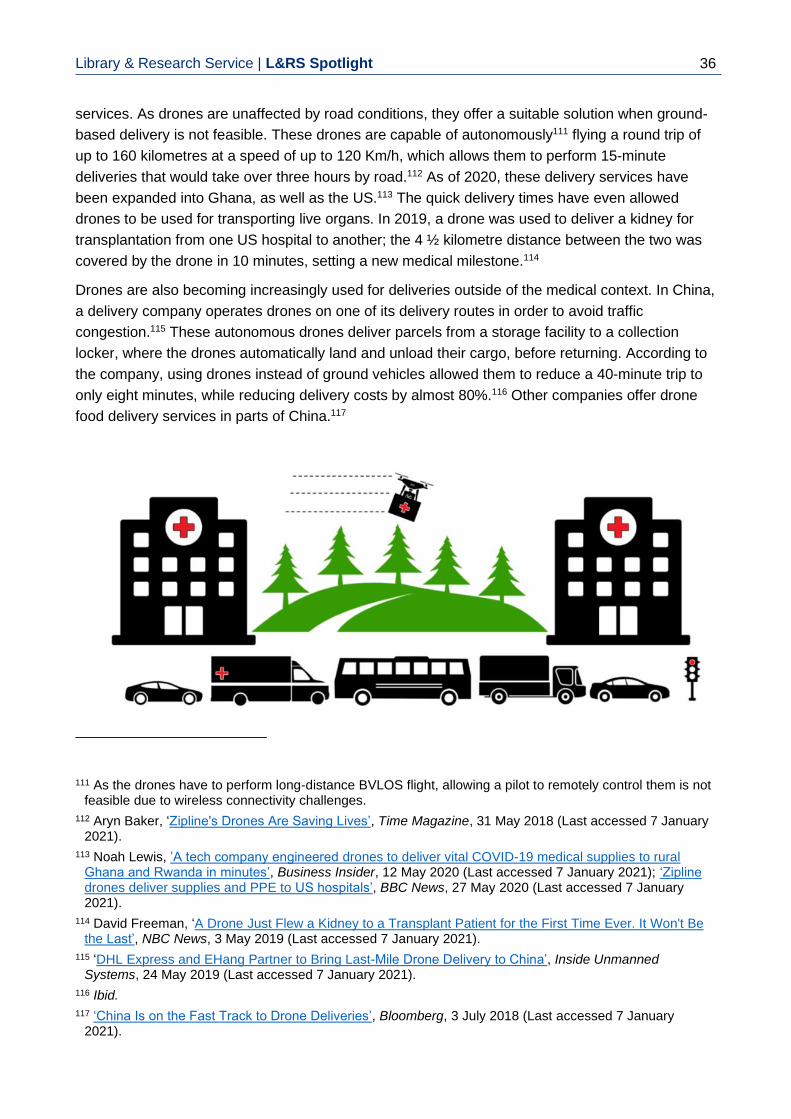
Library & Research Service | L&RS Spotlight 36
services. As drones are unaffected by road conditions, they offer a suitable solution when ground-
based delivery is not feasible. These drones are capable of autonomously111 flying a round trip of
up to 160 kilometres at a speed of up to 120 Km/h, which allows them to perform 15-minute
deliveries that would take over three hours by road.112 As of 2020, these delivery services have
been expanded into Ghana, as well as the US.113 The quick delivery times have even allowed
drones to be used for transporting live organs. In 2019, a drone was used to deliver a kidney for
transplantation from one US hospital to another; the 4 ½ kilometre distance between the two was
covered by the drone in 10 minutes, setting a new medical milestone.114
Drones are also becoming increasingly used for deliveries outside of the medical context. In China,
a delivery company operates drones on one of its delivery routes in order to avoid traffic
congestion.115 These autonomous drones deliver parcels from a storage facility to a collection
locker, where the drones automatically land and unload their cargo, before returning. According to
the company, using drones instead of ground vehicles allowed them to reduce a 40-minute trip to
only eight minutes, while reducing delivery costs by almost 80%.116 Other companies offer drone
food delivery services in parts of China.117
111 As the drones have to perform long-distance BVLOS flight, allowing a pilot to remotely control them is not
feasible due to wireless connectivity challenges.
112 Aryn Baker, ‘Zipline's Drones Are Saving Lives’, Time Magazine, 31 May 2018 (Last accessed 7 January 2021).
113 Noah Lewis, ’A tech company engineered drones to deliver vital COVID-19 medical supplies to rural Ghana and Rwanda in minutes’, Business Insider, 12 May 2020 (Last accessed 7 January 2021); ‘Zipline drones deliver supplies and PPE to US hospitals’, BBC News, 27 May 2020 (Last accessed 7 January 2021).
114 David Freeman, ‘A Drone Just Flew a Kidney to a Transplant Patient for the First Time Ever. It Won't Be the Last’, NBC News, 3 May 2019 (Last accessed 7 January 2021).
115 ‘DHL Express and EHang Partner to Bring Last-Mile Drone Delivery to China’, Inside Unmanned Systems, 24 May 2019 (Last accessed 7 January 2021).
116 Ibid.
117 ‘China Is on the Fast Track to Drone Deliveries’, Bloomberg, 3 July 2018 (Last accessed 7 January 2021).

Library & Research Service | Consumer and Commercial Drones
37
In 2020, a drone delivery company began delivery trials in Moneygall, Co. Offaly and Oranmore,
Co. Galway.118 In Moneygall, they worked with local pharmacies to deliver prescription medication
to residents self-isolating due to COVID-19. In Oranmore, they partnered with several takeaways
and shops, including Tesco, to deliver online purchases to nearby customers. To comply with
regulations, these automatic drone deliveries were carried out across short two-kilometre distances
and were monitored at all times by human operators who were ready to take manual control of the
drones in case of any issues.119
As delivery drone technology continues to mature, there is a growing interest in using bigger, more
powerful drones as flying taxis to carry human passengers. Unlike conventional passenger
helicopters, these drones would not have pilots on-board and would instead rely on a degree of
automatic flight. This would potentially reduce the operating expenses and the costs for the
passengers while still offering the benefits of air travel such as the avoidance of road congestion.
At present, there are dozens of companies developing taxi drone technology.120 The technology is
currently in the prototype stages, with the rate of commercialisation slowed by safety and
legislative concerns. As taxi drones carry human passengers, the safety standards that must be
met are more stringent than with smaller and lighter package delivery drones. While drone taxi
services are still years away, forecasts for the worldwide drone transportation market suggest that
it may be worth US$1.5 trillion by 2040.121
The adoption of drone technology for delivery and transportation services is part of a larger
technological trend of automating the transport and logistics sectors. There are significant
concerns about the impact of automation on job security in the sector.122 A report from PwC
estimates that as much as 50% of jobs in the transport sector are at risk of being automated by the
mid-2030s,123 resulting in large labour migrations as workers switch to new jobs. While automation
will also create new jobs in new markets,124 it is not clear if the amount of new employment
opportunities will be enough to cover the jobs that have been replaced, and if those replaced by
transport automation, will have access to the new job markets.
118 ‘From takeaways to medication, Irish drone company changes course over coronavirus pandemic’, RTÉ
News, 18 May 2020 (Last accessed 7 January 2021); Ciara O'Brien, ‘Tesco and Manna to offer drone deliveries in Galway’, Irish Times, 9 September 2020 (Last accessed 7 January 2021).
119 Manna Aero, Manna Aero FAQ, (Last accessed 7 January 2021).
120 Adrienne Bernhard, ‘The flying car is here – and it could change the world’, BBC Future, 12 November 2020 (Last accessed 7 January 2021); Bernard Marr, ‘6 Amazing Passenger Drone Projects Everyone Should Know About’, Forbes, 26 March 2018 (Last accessed 7 January 2021).
121 Morgan Stanley Research, Are flying cars preparing for takeoff?, 23 January 2019 (Last accessed 7 January 2021).
122 Eva Short, ‘How worried are you about job automation?’, Silicon Republic, 17 September 2018 (Last accessed 7 January 2021).
123 PwC, Will robots really steal our jobs? An international analysis of the potential long term impact of automation, February 2018 (Last accessed 7 January 2021).
124 The McKinsey Global Institute suggests that 8 to 9% of labour demand in 2030 may be for new types of jobs that currently do not exist. McKinsey Global Institute, Jobs lost, jobs gained: What the future of work will mean for jobs, skills, and wages, 28 November 2017 (Last accessed 7 January 2021).

Library & Research Service | L&RS Spotlight 38
3.6 Telecommunications
One of the big issues faced by mobile network operators is dealing with service demand
fluctuations. A mobile phone network is typically built in a certain area based on predictions of local
average service demand; if the area experiences an increase in users who are trying to use the
mobile phone network, the network may become overwhelmed and the users will experience a
drop in service quality. If these “service demand hotspots” are predictable in advance, the network
operators can plan ahead and put up additional infrastructure to deal with the demand spikes.125
Otherwise, if the service demand hotspots occur with little warning,126 the network in the area can
become overwhelmed. Issues may also occur if a piece of infrastructure breaks or otherwise stops
functioning properly. For example, if a mobile phone tower above a busy street breaks, then this
will result in a loss of phone service for everyone there.
Drones can carry phone communications equipment and, as such, they have attracted the
attention of the telecommunications sector as tools for dealing with these network issues.127 If a
service demand hotspot appears in an area that cannot be accommodated by the existing mobile
phone infrastructure, then a fleet of drones can be deployed to fly over the area. This fleet provides
temporary phone service to people on the ground, either until the demand hotspot disappears, or
until the network operators can apply a more permanent
solution. This type of drone use is still in the early stages of
adoption. However, the concept has been successfully
proven in real-world conditions as part of disaster relief
efforts.128
In 2017, Puerto Rico was devastated by Hurricane Maria.129
For weeks, most of the region was left without electricity,
which also resulted in the loss of mobile phone service.
Google’s parent company, Alphabet, responded with
Project Loon. This involved launching 30 solar-powered
balloon drones carrying phone communications equipment
125 For example, network operators are aware than sports stadiums will become service demand hotspots
whenever a sport event occurs, and so plan their network to have extra capacity for these events.
126 For example, a public gathering in an area that does not normally see large crowds.
127 M. Mozaffari, W. Saad, M. Bennis, Y. Nam, and M. Debbah, ‘A Tutorial on UAVs for Wireless Networks: Applications, Challenges, and Open Problems’ IEEE Communications Surveys & Tutorials, vol. 21(3), March 2019, pp. 2334-2360.
128 Mary-Ann Russon, ‘Drones to the rescue!’, BBC News, 30 April 2018 (Last accessed 7 January 2021).
129 ‘Puerto Rico’s death toll rises to 34 following Hurricane Maria’, Irish Times, 4 October 2017 (Last accessed 7 January 2021).
Drones are being used as flying mobile phone networks to provide people on the ground
with phone connectivity in areas with limited phone service.

Library & Research Service | Consumer and Commercial Drones
39
over Puerto Rico.130 These drones hovered 20 kilometres above ground,131 travelling on air
currents while providing basic phone service to those affected by the hurricane. It is estimated that
approximately 100,000 people were provided phone service using these drones until the phone
network was brought back online.132 In 2020 these drones provided mobile phone service to parts
of Mozambique and Kenya.133 In January 2021, Alphabet announced the cancellation of Project
Loon due to financial difficulties.134
3.7 Recreational Use
Remote-controlled model aircraft have a long history among hobbyists, spanning most of the 20th
century.135 Today, the drone technological revolution has made recreational flight more accessible
to the public than ever before. Safety features such as GPS, AI assistance, and on-board cameras
have made it easier to safely and enjoyably fly a remote-controlled aircraft.
In addition to the consumer off-the-shelf drone market, this technological trend has also created a
new market for DIY racing drones. Members of the public can buy individual drone components
such as motors, cameras, and drone electronics and assemble them at home. These types of
drones are often designed for speed or acrobatic
performance, with certain high-performance
models capable of reaching speeds of up to 260
Km/h.136 To allow for precise control of the drone,
the drone pilots wear virtual reality (VR) headsets
which receive the video feed from the drone
camera.
130 Ryan Nakashima, ‘Google's parent company has made internet balloons available in Puerto Rico, the first
time it's offered Project Loon in the US’, Business Insider, 21 October 2017 (Last accessed 7 January 2021).
131 At this height, the drones were safely above the controlled airspace used by manned aircraft, see Section 4.1.
132 Jessica Guynn, ‘Google parent's Project Loon delivers Internet to 100,000 in Puerto Rico’, USA Today, 9 November 2017 (Last accessed 7 January 2021).
133 Tom Bowker, ‘High-flying balloons to boost northern Mozambique’s internet’, Associated Press, 13 May 2020 (Last accessed 7 January 2021); Duncan Miriri, ‘Alphabet's Loon launches balloon internet service in Kenya’, Reuters, 8 July 2020 (Last accessed 7 January 2021).
134 Jennifer Elias, ‘Alphabet cancels Loon, project to beam internet to earth from balloons’, CNBC, 21 January 2021 (Last accessed 9 February 2021).
135 British Model Flying Association, History of Model Flying (Last accessed 7 January 2021).
136 ‘DRL Racer sets new world speed record!’, Rotor Drone Pro Magazine, 11 April 2019 (Last accessed 7 January 2021).
Drone racing is an international sport that has brought in millions of television and online
viewers from across the world in 2020. There are drone racing clubs in Ireland which
organise their own events.

Library & Research Service | L&RS Spotlight 40
Professional global sports organisations such as the Drone Racing League (DRL) have emerged
to organise international drone racing competitions. In 2020, drone races organised by the DRL
were broadcast on TV channels and online platforms where they received millions of viewers.137
Ireland has drone racing clubs which organise their own competitions.138
3.8 Illegal Uses
The spread of drone technology among members of the public has unfortunately resulted in drones
being used in illegal activities. As drones have such a wide range of uses, these illegal activities
also vary significantly in scope and severity.
As consumer drones can be purchased by members of the public, without proof of training or
certification,139 this has allowed individuals to fly drones without knowledge of the legal restrictions
or the safety risks involved. This unregulated use of drones has resulted in drones being flown in
an illegal manner, for example, by flying near airports and creating hazards for manned aircraft.
EASA reports that there were 12 collisions or near-collisions in the EU which involved drones and
manned aircraft in 2018.140 Due to the danger that drones pose for aircraft, if a drone is detected
inside airport airspace, the typical procedure is to halt flights until the risk has passed. This can
result in significant delays and flight cancellations, with the corresponding economic impact.141
Other examples of illegal, high-risk flights include drones being flown over stadiums during sporting
events142 and over gorse fires, with the latter disrupting the fire-fighting efforts of emergency
services.143
As drones allow a pilot to oversee an area from the sky, they have become popular spy tools for
criminals. In the UK, drones have been used by criminals for stalking, voyeurism and
137 Alan Baldwin, ‘Drone racing-League viewing figures flying high amid virus shutdown’, Reuters, 24 March
2020 (Last accessed 7 January 2021).
138 ‘Enthusiasts seek safe place for 160km/h drone races’, RTÉ News, 10 March 2017 (Last accessed 7 January 2021).
139 For more information on the current pilot training and certification requirements, see Section 4.3.
140 EASA, Annual Safety Review 2020, 30 July 2020, p. 145 (Last accessed 7 January 2021).
141 The incident in Gatwick airport in 2018 caused more than 1,000 flight cancellations. Samira Shackle, ‘The mystery of the Gatwick drone’, The Guardian, 1 December 2020 (Last accessed 6 January 2021).
142 ‘Man fined for illegally flying drones over football stadiums’, BBC News, 15 September 2015 (Last accessed 7 January 2021).
143 Alan O'Keeffe and Philip Ryan, ‘Flying drones near gorse fires 'putting lives at risk'’, Sunday Independent, 15 July 2018 (Last accessed 7 January 2021).
Drones are being used by criminals worldwide for smuggling contraband and spying on
citizens. Modified civilian drones have also been used as weapons, both in assassination
attempts and on battlefields.
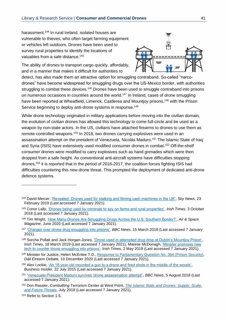
Library & Research Service | Consumer and Commercial Drones
41
harassment.144 In rural Ireland, isolated houses are
vulnerable to thieves, who often target farming equipment
or vehicles left outdoors. Drones have been used to
survey rural properties to identify the locations of
valuables from a safe distance.145
The ability of drones to transport cargo quickly, affordably,
and in a manner that makes it difficult for authorities to
detect, has also made them an attractive option for smuggling contraband. So-called “narco-
drones” have become widespread for smuggling drugs over the US-Mexico border, with authorities
struggling to combat these devices.146 Drones have been used to smuggle contraband into prisons
on numerous occasions in countries around the world.147 In Ireland, cases of drone smuggling
have been reported at Wheatfield, Limerick, Castlerea and Mountjoy prisons,148 with the Prison
Service beginning to deploy anti-drone systems in response.149
While drone technology originated in military applications before moving into the civilian domain,
the evolution of civilian drones has allowed this technology to come full-circle and be used as a
weapon by non-state actors. In the US, civilians have attached firearms to drones to use them as
remote-controlled weapons.150 In 2018, two drones carrying explosives were used in an
assassination attempt on the president of Venezuela, Nicolás Maduro.151 The Islamic State of Iraq
and Syria (ISIS) have extensively used modified consumer drones in combat.152 Off-the-shelf
consumer drones were modified to carry explosives such as hand grenades which were then
dropped from a safe height. As conventional anti-aircraft systems have difficulties stopping
drones,153 it is reported that in the period of 2016-2017, the coalition forces fighting ISIS had
difficulties countering this new drone threat. This prompted the deployment of dedicated anti-drone
defence systems.
144 David Mercer, ‘Revealed: Drones used for stalking and filming cash machines in the UK’, Sky News, 23
February 2019 (Last accessed 7 January 2021).
145 Conor Lally, ‘Drones being used by criminals to spy on farms and rural properties’, Irish Times, 3 October 2018 (Last accessed 7 January 2021).
146 Tim Wright, ‘How Many Drones Are Smuggling Drugs Across the U.S. Southern Border?’, Air & Space Magazine, June 2020 (Last accessed 7 January 2021).
147 ‘Charges over drone drug smuggling into prisons’, BBC News, 15 March 2018 (Last accessed 7 January 2021).
148 Sorcha Pollak and Jack Horgan-Jones, ‘Drone used in attempted drug drop at Dublin’s Mountjoy Prison’, Irish Times, 18 March 2019 (Last accessed 7 January 2021); Marese McDonagh, ‘Minister promises new tech to counter drone smuggling into prisons’, Irish Times, 2 May 2019 (Last accessed 7 January 2021).
149 Minister for Justice, Helen McEntee T.D., Response to Parliamentary Question No. 364 (Prison Security), Dáil Éireann Debate, 10 December 2020 (Last accessed 7 January 2021).
150 Alex Lockie, ‘An 18-year-old mounted a gun to a drone and fired shots in the middle of the woods’, Business Insider, 22 July 2015 (Last accessed 7 January 2021).
151 ‘Venezuela President Maduro survives 'drone assassination attempt'’, BBC News, 5 August 2018 (Last accessed 7 January 2021).
152 Don Rassler, Combatting Terrorism Center at West Point, The Islamic State and Drones: Supply, Scale, and Future Threats, July 2018 (Last accessed 7 January 2021).
153 Refer to Section 1.5.

Library & Research Service | L&RS Spotlight 42
4. Regulations on Drone Use
To ensure the safe operation of drones in Ireland, the technology is regulated at national level by
the IAA,154 and at EU level by EASA.155 At the time of writing, the existing Irish Aviation Authority
(Small Unmanned Aircraft (Drones) and Rockets) Order 2015 (‘The 2015 Order’),156 governing
drone use is being substituted by Commission Implementing Regulation (EU) 2019/947 (‘The
Regulation’). This Regulation came into effect on 31 December 2020. The purpose of this section
is to provide an overview of this transition, along with an overview of other legislation that is
relevant to drone operations. It is the responsibility of anyone who intends to fly a drone in Ireland
to be familiar with this legislation, and to follow the restrictions that are put in place by the relevant
authorities.
4.1 Controlled and Uncontrolled Airspace
Airspace is separated into different categories. The two main categories of airspace are controlled
and uncontrolled.
• Controlled airspace is actively monitored by ATC, which uses radio communication and
radar technology to track and manage aircraft. In Ireland, the IAA further divides this
controlled airspace into Class A and Class C,157 depending on the type of monitoring the
ATC provides. For an aircraft to lawfully enter controlled airspace, the pilot needs to provide
a flight plan to the ATC in advance of the flight and must receive clearance to enter.
• Uncontrolled airspace (referred to as Class G by the IAA) is any airspace where aircraft
can enter and operate without prior authorisation from the ATC (such as filing a flight plan).
154 Irish Aviation Authority (Last accessed 7 January 2021).
155 European Union Aviation Safety Agency (Last accessed 7 January 2021).
156 S.I. No. 563 of 2015.
157 IAA, Guide to IAA Air Traffic Management Operations, at p. 8 (Last accessed 7 January 2021).
The skies above Ireland are monitored by Air Traffic Control (ATC) and are regulated by
the IAA. Parts of the sky can only be accessed by aircraft if the flights have been approved
in advance by ATC.
This Chapter provides an overview of the regulatory landscape surrounding the use of
drones in Ireland. For specific questions on the laws for drone use by members of the
public, the reader is encouraged to refer to the IAA webpage on drones, as well as EASA’s
Frequently Asked Questions page.

Library & Research Service | Consumer and Commercial Drones
43
In addition to the above categories, the IAA designates certain airspaces as being restricted, due
to additional safety or security concerns. For example, the airspace around Casement Aerodrome
is restricted, and any aircraft flying in the area must follow additional guidelines from ATC.158
4.2 Prior Regulations on Drone Use
This section provides a brief overview of the history of drone regulation in Ireland, before the
adoption of the current regulations. The first set of regulations that governed drone use in Ireland
were brought into effect in 2000, with the Irish Aviation Authority (Rockets and Small Aircraft)
Order 2000 (‘the 2000 Order’).159 The 2000 Order laid out the main flight restrictions for unmanned
aircraft having a weight below 20 kilograms.160 These restrictions included:
• A ban on flying within 5 kilometres of an airport without prior permission from airport operators;
• A ban on flying higher than 120 metres above ground;161 and
• A ban on flying inside controlled airspace.
158 Ibid.
159 S.I. No. 25 of 2000.
160 S.I. No. 25 of 2000, section 1(1) and section 5.
161 Manned aircraft are prohibited from flying below 150 metres outside of take-off and landing. IAA, Guide to IAA Air Traffic Management Operations, p. 7 (Last accessed 7 January 2021).
Since 2000, Ireland has seen several regulations governing drone use. These regulations
have introduced restrictions on drone flights around airports and urban areas, restrictions
on the permitted weights of drones, as well as requirements for drone registration and pilot
training.
Figure 6. IAA Airspace Classes
Source: IAA, Guide to IAA Air Traffic Management Operations, at p. 9

Library & Research Service | L&RS Spotlight 44
It is important to note that when the order came into effect in 2000, civilian drones in their current
form did not exist. Unmanned aircraft available to civilians at the time were either remote-controlled
toys or model aircraft used by hobbyists. These devices did not have technology such as GPS or
collision-avoidance sensors. Perhaps more importantly, these devices also did not have on-board
cameras that could allow a pilot to perform remote surveillance. The 2000 Order therefore imposed
unmanned aircraft restrictions purely from the perspective of avoiding issues for manned aircraft,
with no regard for issues of privacy. Another important factor regarding the 2000 Order concerned
the imposed weight categories of unmanned aircraft. According to the 2000 Order, unmanned
aircraft weighing below seven kilograms were only required to adhere to the minimum airport
distance requirement, with the remaining restrictions being imposed on heavier aircraft.162 This was
in line with the technological capabilities of unmanned aircraft at the time; an aircraft weighing less
than seven kilograms would be unlikely to fly far enough to pose a serious threat to aircraft in
controlled airspace, and so was of little regulatory concern to the IAA.
The release of the first camera-equipped, off-the-shelf consumer drone (the Parrot AR drone) in
2010 created new issues for the regulatory framework. This new class of drone was easier to fly
than previous unmanned aircraft, significantly lighter163 and included an on-board camera. Due to
their weight, these new drones were exempt from the 2000 Order. In response, the IAA published
the Operations Advisory Memorandum 02/12 (‘the Memorandum’)164 and IAA Aeronautical Notice
O.63.165 In addition to removing the drone weight exemption, these new regulations brought in new
restrictions on drone use to ensure safety for pedestrians. Under the new regulations, drone pilots
were forbidden to:
• Fly the drone more than 500 metres away from their location or fly the drone in BVLOS
mode;
• Fly within 150 metres of a person, vehicle, or building that is not under the control of the
pilot;
• Fly in a congested area without prior IAA approval;
• Fly within 150 metres of a crowd of people without prior IAA approval; and
• Fly without valid liability insurance.
In addition to the previous restrictions, it should be noted that the IAA recognised the issue of
drone radio connectivity for long-distance or BVLOS flight, and so specifically prohibited it with the
Memorandum. The Memorandum also introduced a distinction between commercial and hobbyist
flight. Following this distinction, any drone flight performed for commercial purposes would need to
be approved by the IAA in advance.
162 S.I. No. 25 of 2000, section 5(3).
163 The Parrot AR drone weighed less than a kilogram.
164 An Advisory Memorandum is an explanatory document of law that is in effect, whereas an Aeronautical Notice is a legal extension of a Statutory Instrument or Regulation.
165 IAA, ‘Remote Piloted Aircraft Systems Use Grows in Ireland’, Press Release, 20 November 2014 (Last accessed 7 January 2021); K. O’Sullivan, ‘Low-flying Drones and Ownership of Airspace in Ireland’ Conveyancing and Property Law Journal, vol. 21(1), 2016, pp. 7-11.

Library & Research Service | Consumer and Commercial Drones
45
The 2015 Order introduced two important requirements for drone use: drone registration and drone
competency training. It also removed the differentiation between hobby and commercial pilots.
Under the 2015 Order, drones were separated into several weight classes, as set out below.
• All drones weighing more than one kilogram (or intended to be flown higher than 15 metres
above ground) were required to be registered online with the IAA, with a unique registration
number displayed on the drone exterior.166
• All drones weighing more than four kilograms required the pilot to take a course of drone
safety training from an IAA-approved authority.167
• All drones weighing more than 25 kilograms were not permitted to fly without prior
permission from the IAA.168
The introduction of a drone registration database and pilot competency training allowed the IAA to
introduce additional safety mechanisms to drone flight, while at the same time streamlining the
regulatory process for using drones commercially. Under the 2015 Order, pilots intending to use a
drone for commercial purposes were no longer required to seek IAA approval before each
individual flight, assuming the flight met the standard regulations.169 The requirement for
mandatory liability insurance was also removed, with liability insurance only recommended to pilots
seeking IAA permission to fly drones beyond the standard limits. While previously introduced
restrictions on drone use were kept, some specific safety thresholds were adjusted in line with the
evolving drone technology.170
With the 2015 Order, the IAA set the foundation for drone pilot schools and their IAA-approved
training programmes. A typical course for a drone pilot would consist of two full days of classes
followed by a day of practical flight training. Courses typically covered:
• Existing legislation on drone use;
• The principles of drone operation;
• Meteorology and working with weather forecasts; and
• Dealing with emergencies
In addition to allowing the drone pilot to fly drones above four kilograms, the pilot certificate of
competence (PCC) allowed the drone pilot to apply for Specific Operating Permission (SOP) from
the IAA. The SOP was a mechanism by which the IAA could issue specific exemptions to drone
pilots, to allow them to fly beyond the normal operational limits. As part of the application, the pilot
would present a flight plan giving information about the flight, including potential safety risks and
how they were to be mitigated by the pilot. The IAA would then, subject to any IAA instructions or
restrictions, issue written permission to proceed with the flight. To fly in controlled airspace, an
166 S.I. No. 563 of 2015, section 7(1).
167 S.I. No. 563 of 2015, section 7(7).
168 S.I. No. 563 of 2015, section 7(8).
169 Unlike the 2000 Order, the 2015 Order did not distinguish between hobbyist and commercial flight, which removed the additional requirements for commercial pilots.
170 For example, section 7(5) of the 2015 Order reduced the minimum permitted flying distance to pedestrians from 150 metres to 30 metres.

Library & Research Service | L&RS Spotlight 46
additional application was required by the IAA, outside of the SOP. This required the drone pilot to
detail the exact time, duration, location of the flight, details of the pilot and the drone, as well as
mobile phone numbers to allow ATC to contact the pilot during flight.
4.3 Current EU Regulations on Drone Use
As of 31 December 2020, civilian drone use in Ireland is subject to the newly adopted Commission
Implementing Regulation (EU) 2019/947 (‘The Regulation’), which has replaced the 2015 Order.171
The Regulation has introduced a number of notable changes to how drones are to be operated in
Ireland. In summary, these changes include:
• Drone categories: The Regulation defines three categories for civilian drones, based on risk profile. In increasing order of risk, these are the ‘Open’, ‘Specific’ and ‘Certified’ categories.
• Mandated safety features: The Regulation mandates that consumer drones sold in the EU market must conform to one of several defined operating classes, with safety features such as geofencing and remote operator identification to be included by the manufacturers.
• Risk-based approach to regulation: The Regulation imposes restrictions on drone use based on the level of risk associated with the flight, with no regard given to the purpose of the flight (whether hobbyist, commercial, or government service).172
• Mandatory drone operator registration: Drone operators are required to register with their national aviation authority, regardless of their drone category.
• Mandatory pilot competency training. All pilots are to receive a basic level of drone pilot training from their national aviation authority or an approved training organisation.
• Cross-border sharing of registration data: The operator registration data is to be shared between the national aviation authorities of all the EU Member States, to allow all drone operators the ability to operate in any Member State once registered with their own authority.173
• Automatic flight permissions: The Regulation recognises the ability of some drone models to fly using on-board Artificial Intelligence (AI), without direct pilot control. Allowances are made for certain types of automatic flight under specific conditions.
171 ‘Know the drone safety rules before you fly – IAA’, RTÉ News, 17 December 2020 (Last accessed 7
January 2021). Note that certain IAA Aeronautical Notices such as U.04 (which governs maximum drone heights near airports) will remain in effect and be updated to work with the new Regulation.
172 Under Article 3 of the Chicago Convention on International Civil Aviation (of which Ireland is a signatory), state-operated aircraft are not subject to civil aviation regulations. As such, it is currently unclear to what extent organisations such as the Dublin Fire Brigade (DFB) must adhere to the Regulation when operating its drones in an emergency. (Last accessed 7 January 2021).
173 Note that the UK is implementing this EU regulation at national level (Last accessed 7 January 2021) but, due to Brexit, UK regulations may diverge in the future. At the time of writing, registration data sharing is not due to be implemented between Ireland and the UK.
At the time of publication, drone use in Ireland is subject to EU regulations. These
regulations introduce new drone categories that civilian drones must operate under. The
regulations also introduce additional training and registration requirements for drone pilots
and operators.

Library & Research Service | Consumer and Commercial Drones
47
• Privacy risk mitigation: The Regulation recognises the potential for drones to violate the privacy of individuals. As such, all drones that are equipped with a camera require operator registration, irrespective of drone weight or other factors.
• Noise pollution mitigation: The Regulation recognises the issue of noise pollution created by drones during flight. As such, drones operating in the open category must meet set noise requirements, while pilots looking to fly drones in the specific category must account for noise in their flight plans.
• Standard scenarios: The process of applying for flight permission from national aviation authorities has been streamlined with the introduction of “standard scenarios”, which serve as templates for pilots to refer to in their applications.
These points are discussed in more detail in the following subsections.
4.3.A Open, Specific, and Certified Categories
To address the diversity of drone shapes, sizes, and designs on the civilian and commercial
markets, the Regulation introduces three main categories for drones, based on the anticipated
risks involved with their flight.
The Open category includes drones that pose the least risk to public safety or privacy, such as
small drones used by hobbyists.174 A pilot intending to fly an Open category drone does not require
prior permission from their national aviation authority. The Open category includes drones with a
weight of up to 25 kilograms, and is further subdivided into three subcategories A1, A2, and A3, as
outlined in Table 4.
Table 4: Open Category Subcategories
Subcategory Flying in urban areas Flights over pedestrians Flights over crowds
A1 Permitted Permitted, but should be avoided
Prohibited
A2 Permitted
Prohibited, must keep 30 metres away from pedestrians (or 5 metres if operating in low-speed setting)
Prohibited
A3 Prohibited, must keep 150 metres away from urban areas
Prohibited Prohibited
Drones in all three subcategories must fly below 120 metres above ground, and BVLOS flight is
prohibited. The limit on the maximum distance a drone can fly from the pilot is removed, provided
the pilot can see the drone without the use of binoculars or other equipment. The subcategories
also permit some types of automatic flight; provided a drone stays within 50 metres of a pilot and
the latter can take control of the drone in an emergency the drone is allowed to fly by itself.
174 Commission Implementing Regulation (EU) 2019/947, Article 4.

Library & Research Service | L&RS Spotlight 48
A key element of the Regulation is that any drone sold for use in the EU must adhere to a set of
product standards, which are similar to the CE marking scheme. New drones sold in the EU for
use in the Open category are required to conform to one of five specified classes based on their
weight, maximum speed, maximum noise output, and included safety features, in accordance with
the Commission Delegated Regulation (EU) 2019/945 (‘the Delegated Regulation’). These classes
are denoted as C0, C1, C2, C3, and C4, as outlined in Table 5.
Table 5: Open Category Drone Classes
Class Weight Permitted subcategories Notes
C0 <250 grams A1, A2, A3 -19 m/s max speed -120 metre max distance to pilot
C1 <900 grams A1, A2, A3 -19 m/s max speed
C2 <4 kilograms A2, A3 -must have 3 m/s low-speed setting
C3 <25 kilograms A3 -includes AI flight modes
C4 <25 kilograms A3 -does not include AI flight modes
All new drones sold in the EU market must be visibly labelled and marketed as belonging to one of
these five classes by the manufacturers. A transition period until June 2022 is in place, during
which, existing drones that are not labelled may operate under the three categories and depending
on their weight class. Post-June 2022, any drones below 250 grams can operate under the A1
category, otherwise they are restricted to A3.
The Specific category refers to drones below 25 kilograms that are flown in a way that is not
covered by the Open category.175 For example, flying a one-kilogram drone above a crowd of
people would be covered by the Specific category. For this type of flight, the drone pilot is required
to receive permission from the national aviation authority prior to take-off. The drone pilot presents
a flight plan to the IAA with an assessment of potential risks, and the steps taken to mitigate them.
The Regulation streamlines the application process by introducing what are called “standard
scenarios”. These are example scenarios that describe a drone flight, define the risks involved,
and indicate what steps are to be taken to ensure safety. Under previous regulations, the pilot
needed to carry out this risk assessment by themselves for each individual application. Now, the
pilot can simply indicate which standard scenario their intended flight aligns with and follow the
relevant safety requirements. The standard scenarios for the Specific category will be published by
EASA in 2021. Under the Regulation, certain organisations that operate drones may also apply for
a Light UAS Operator Certificate (LUC) from their national aviation authority, which gives them
additional privileges.176 These privileges include the possibility of authorising their own flights under
the Specific category, by carrying out their own risk assessments. This LUC mechanism can
streamline drone operations for organisations such as the DFB.
175 Commission Implementing Regulation (EU) 2019/947, Article 5.
176 The full requirements for a LUC, and the responsibilities and privileges of a LUC holder are included in Part C of the Annex to Commission Implementing Regulation (EU) 2019/947.

Library & Research Service | Consumer and Commercial Drones
49
The Certified category refers to drone operations with the highest risk.177 This includes large
drones flying in congested areas, drones carrying human passengers, and drones carrying
dangerous goods. Given the high-risk nature of these drone flights, they will be subject to similar (if
not the same) regulations as manned aircraft. This means that the drones will need to be
registered with the national aviation authority. They will need to meet strict airworthiness
requirements and their ground maintenance will also be regulated.178 At the time of writing, the
exact regulations to be imposed on the Certified category of drones have not been published by
the IAA or EASA.
4.3.B Drone Operator Registration and Pilot Training
The Regulation introduces a distinction between “drone operators” and “drone pilots”. The “drone
operator” is the owner of a drone (whether an individual or a company), whereas a “drone pilot” is
the person responsible for flying the drone safely. A hobbyist flying their own drone is therefore
both an operator and a pilot. The Regulation mandates that all drone operators that own a drone,
which either weighs more than 250 grams or has a camera, and does not meet the definition of a
“toy” according to Directive 2009/48/EC of the European Parliament and of the Council on the
safety of toys,179 must register with their national aviation authority.
The Regulation also mandates that any pilot who intends to fly such a drone must receive a basic
level of competency training from their national aviation authority.180 The Regulation defines this as
an online multiple-choice test issued by the national aviation authority comprising of 40 questions
on the following topics:
• Air safety;
• Airspace restrictions;
• Aviation regulation;
• Human performance limitations;
• Operational procedures;
• Drone general knowledge;
• Privacy and data protection;
• Insurance; and
• Security
This level of training is considered sufficient to allow a pilot to fly in subcategories A1 and A3 of the
Open category.
177 Commission Implementing Regulation (EU) 2019/947, Article 6.
178 For example, the maintenance will only be performed by authorised and trained maintenance crews, who will need to keep detailed and accurate records of a drone’s maintenance history.
179 To qualify as a toy under this Directive, the drone must be manufactured in a way that takes child safety into account and must be intended to be used by persons under 14.
180 The full competency training requirements for all three subcategories in the Open category are included in Part A of the Annex to Commission Implementing Regulation (EU) 2019/947.
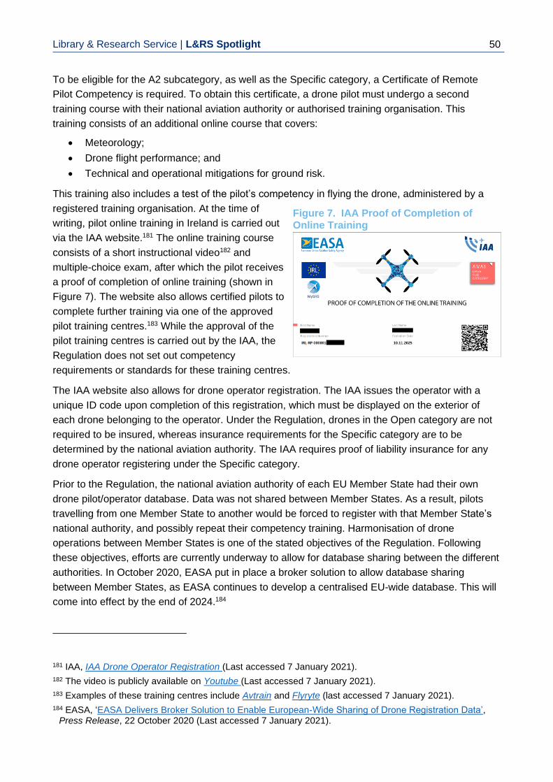
Library & Research Service | L&RS Spotlight 50
To be eligible for the A2 subcategory, as well as the Specific category, a Certificate of Remote
Pilot Competency is required. To obtain this certificate, a drone pilot must undergo a second
training course with their national aviation authority or authorised training organisation. This
training consists of an additional online course that covers:
• Meteorology;
• Drone flight performance; and
• Technical and operational mitigations for ground risk.
This training also includes a test of the pilot’s competency in flying the drone, administered by a
registered training organisation. At the time of
writing, pilot online training in Ireland is carried out
via the IAA website.181 The online training course
consists of a short instructional video182 and
multiple-choice exam, after which the pilot receives
a proof of completion of online training (shown in
Figure 7). The website also allows certified pilots to
complete further training via one of the approved
pilot training centres.183 While the approval of the
pilot training centres is carried out by the IAA, the
Regulation does not set out competency
requirements or standards for these training centres.
The IAA website also allows for drone operator registration. The IAA issues the operator with a
unique ID code upon completion of this registration, which must be displayed on the exterior of
each drone belonging to the operator. Under the Regulation, drones in the Open category are not
required to be insured, whereas insurance requirements for the Specific category are to be
determined by the national aviation authority. The IAA requires proof of liability insurance for any
drone operator registering under the Specific category.
Prior to the Regulation, the national aviation authority of each EU Member State had their own
drone pilot/operator database. Data was not shared between Member States. As a result, pilots
travelling from one Member State to another would be forced to register with that Member State’s
national authority, and possibly repeat their competency training. Harmonisation of drone
operations between Member States is one of the stated objectives of the Regulation. Following
these objectives, efforts are currently underway to allow for database sharing between the different
authorities. In October 2020, EASA put in place a broker solution to allow database sharing
between Member States, as EASA continues to develop a centralised EU-wide database. This will
come into effect by the end of 2024.184
181 IAA, IAA Drone Operator Registration (Last accessed 7 January 2021).
182 The video is publicly available on Youtube (Last accessed 7 January 2021).
183 Examples of these training centres include Avtrain and Flyryte (last accessed 7 January 2021).
184 EASA, ‘EASA Delivers Broker Solution to Enable European-Wide Sharing of Drone Registration Data’, Press Release, 22 October 2020 (Last accessed 7 January 2021).
Figure 7. IAA Proof of Completion of Online Training

Library & Research Service | Consumer and Commercial Drones
51
4.3.C Mandatory Safety Features
The Delegated Regulation requires that all new drones sold on the EU market (except for the C0
class) be fitted with several safety mechanisms by the drone manufacturers.185 This includes a
remote operator identification system, the use of which allows a drone to transmit identification
radio signals during its flight. These signals contain the operator’s ID, the drone’s serial number,
and telemetry information about the drone flight. Pedestrians on the ground (both law enforcement
personnel and members of the public) will be able to receive these signals on their mobile devices.
This will give them information about the drone and its operator and allow them to respond to any
issues arising from the drone.186
Other safety mechanisms mandated by the Regulation include location geofencing, safety lights
for night-time visibility, and RTH functionality in case of a loss of the drone-pilot communication
link. Some of these features are already present in certain drone models on the consumer market.
However, the Regulation now makes them mandatory to be certified under the C1-C4 drone
classes.
4.4 U-Space and Drone Air Traffic Management
To allow long-distance BVLOS flights (such as those used for medical deliveries), and to ensure
that drone fleets can operate in dense urban areas, national aviation authorities need to be able to
oversee and manage drone air traffic in the same manner that they currently manage manned
aircraft. Using the existing air traffic management system for managing drones is not feasible for
both technical as well as regulatory reasons. From a technical perspective, drones cannot be
successfully tracked using existing radar systems.187 Current forecasts on drone use suggest that
drone air traffic may soon be so dense that it will be impossible for the current human ATC to
cope.188 From a regulatory perspective, drones tend to fly in low-height uncontrolled airspace and,
under the current EU Regulation, most drones and drone pilots are not subject to the same level of
regulatory scrutiny as manned aircraft.
185 These requirements are included in the Annex to Commission Delegated Regulation (EU) 2019/945.
186 This is similar to an existing system used by manned aircraft called Automatic Dependent Surveillance-Broadcast (ADS-B). With ADS-B, manned aircraft transmit information about their own flight to other aircraft, as well as to ATC on the ground. Not only does this create an additional layer of safety, but it also makes the air network more transparent for members of the public. ADS-B tracking websites such as FlightRadar24 (last accessed 7 January 2021) allow members of the public to see real-time information about aircraft currently in flight, including their location and their destination. Bethany Whitfield, ’How It Works: ADS-B’, Flying Magazine, 8 February 2017 (Last accessed 7 January 2021).
187 See Section 1.5 on anti-drone measures.
188 EASA, Opinion No. 01/2020, 13 March 2020, p. 28 (Last accessed 6 January 2021).
In the coming years, the EU will adopt a new drone air traffic management system, to allow
ATC to monitor and regulate drone flights in the sky. This roll-out will occur in four phases,
with the final phase forecasted for the mid-2030’s.

Library & Research Service | L&RS Spotlight 52
For these reasons, an entirely new type of air traffic management system may need to be created
to cope with drone traffic.189 Such a system must:
• Be compatible with the existing air traffic management system for manned aircraft;
• Be compatible with the different drone categories;
• Be compatible with national regulations; and
• Have the capacity to accommodate the rapidly growing number of drones in the EU.
In 2017, the Single European Sky ATM Research Joint Undertaking (SESAR JU)190 published the
blueprint for a regulatory framework to support these traffic management services, known as U-
Space. The blueprint proposes that U-Space be adopted in four phases, with each phase
introducing increasingly complicated management functionality.191 These phases are outlined
below.
U1: U-Space foundation services. In this phase, support for basic services such as online drone
databases, remote drone identification and geofencing is introduced.
U2: U-Space initial services. In this phase, services such as drone flight planning, drone tracking,
and integration with manned airspace traffic management are introduced.
U3: U-Space advanced services. In this phase, support for urban drone traffic management is
introduced, with conflict detection and avoidance192 automated using AI.
U4: U-Space full services. Full adoption of AI for automated drone management and safe
integration of drones into controlled airspace alongside manned aircraft.
Each phase will rely on the increasing use of AI for automation, as well as wireless drone
connectivity via infrastructure such as the mobile phone network.193 According to its development
roadmap, SESAR JU aims to see full deployment of U1 by 2022 and U2 by 2027, with U3 and U4
deployed in the mid-2030s.194
189 Ibid.
190 SESAR JU is a public-private partnership set up as part of the Single European Sky initiative to reform air traffic management in the EU. Discover SESAR (Last accessed 7 January 2021).
191 SESAR JU, U-Space Blueprint, 2017, p. 5 (Last accessed 7 January 2021).
192 Conflict detection and avoidance here refers to decisions about who gets the right-of-way when moving in the air, similar to the function of a traffic light at an intersection.
193 SESAR JU, Consolidated Report on SESAR U-Space Research and Innovation Results, 2020, p. 31 (Last accessed 7 January 2021). See Section 2.1 for more information on infrastructure connectivity.
194 SESAR JU, European ATM Master Plan: Roadmap for the Safe Integration of Drones Into All Classes of Airspace, 2017, p. 17 (Last accessed 7 January 2021).

Library & Research Service | Consumer and Commercial Drones
53
4.5 GDPR and Drone Camera Recordings
To ensure the privacy of its citizens and protect their personal data, the EU has adopted the
Regulation (EU) 2016/679, also known as the General Data Protection Regulation (GDPR). GDPR
sets out clear definitions for what kind of data constitutes as “personal data” and imposes
requirements on how personal data must be managed. As drones carry cameras that can transmit
and record video footage, they can capture non-sensitive195 personal data. As such, their operators
are obliged to comply with the GDPR. The enforcement of GDPR in Ireland (including cases where
data is gathered by drones) falls under the remit of the Irish Data Protection Commission (DPC).196
At the time of writing, the DPC has not issued official guidance regarding drone use. As drone
cameras can be compared to vehicle dash-cams (in that they are used to record footage for safety
or liability purposes), the published guidelines on dash-cam use could potentially serve as a
model.197 Following these guidelines, a drone operator may be regarded as a data controller, and
therefore subject to GDPR regulations, depending on the exact material captured by the drone
camera. GDPR includes a “household exemption” to allow private individuals to freely process their
own data. This exemption does not apply if the recorded data includes other individuals outside of
the household, as established by the Court of Justice of the European Union in the case Rynes vs
Urad.198 In cases where the household exemption does not apply, the drone operator would be
expected to comply with data protection requirements, even if the operator is a hobbyist flying a
drone for recreational purposes. The operator must:
• Process the data in a transparent manner. This means that members of the public must be
made aware that data is being processed and have means to contact the drone operator;
• Store only necessary data for only the necessary length of time. This means the operator
must avoid recording footage of other people unless the drone flight requires it, and then
must delete the data when they are finished with it;
• Store the data securely. This means that the drone operator must take steps to protect the
data from unauthorised access; and
• Ensure that stored data is available to the persons recorded. Drone operators must be able
to share any recordings they make with the people in the recordings on request.
195 Sensitive data refers to data about a person’s health, political opinions, genetic data, or their intimate life,
as defined in Article 9 of the GDPR.
196 While the drone flight rules introduced by the EU Regulation will help prevent privacy violations caused by drones, data protection is outside the jurisdiction of aviation authorities such as EASA or the IAA. Anton McNulty, ‘No privacy legislation on drones flying over homes’, Mayo News, 3 March 2020 (Last accessed 6 January 2021).
197 DPC, Guidance for Drivers on the Use of Dash Cams, June 2020 (Last accessed 7 January 2021).
198 Judgment of 11 December 2014, Rynes v Urad pro ochranu osobnich udaju (Case C-212/13) EU:C:2014:2428 (Last accessed 7 January 2021).
Drones that have cameras may be subject to GDPR if they gather video footage of
members of the public. The nature of drone flights may raise new GDPR issues in the
future.
Library & Research Service | L&RS Spotlight 54
As a new and rapidly evolving technology, drone use in the future may raise new issues and
challenges for privacy and data protection. For example, consider the scenario of a drone flying to
a house in a residential estate to perform some sort of task. The drone flies directly over houses
and gardens at a safe height above ground. The drone has a camera which provides a live video
feed to a pilot; this video feed is also recorded for safety and liability purposes. Flying the drone in
this manner raises several possible issues which are discussed below.
4.5.A Consent to Record
Obtaining consent from those in a video recording is a common solution to ensure GDPR
compliance.199 Given the nature of drone flights, this may not always be feasible. If a drone
operates over a long range, it may fly over dozens of private properties. Depending on the type of
drone operation being carried out, it may not be feasible for the drone operator to seek prior
consent from individuals before a drone flight (as the flight path may not be known in advance).
Article 6 of the GDPR200 allows for lawful video processing even without consent, provided at least
one of the following conditions is met:
• The video processing is needed to comply with a legal obligation;
• The video processing is needed to protect the vital interests of a person;
• The video processing is being carried out in the public interest or as part of official authority
granted to the drone operator; or
• The video processing is necessary to pursue the legitimate interests of the operator or a
third party, as long as those interests are not overridden by the interests or fundamental
rights and freedoms of the person being recorded.
“Vital interests” refers to a situation (often an emergency) where the data gathering is needed ‘in
order to protect someone’s life, or mitigate against a serious threat to a person’,201 such as when a
drone is being used as part of an ambulance response. “Legitimate interests” refers to a broad
range of interests including ‘commercial interests, individual interests, or broader societal
benefits’.202 The safety and liability concerns of a delivery drone carrying a valuable delivery to a
client may qualify as “legitimate interests”. Therefore, the lawfulness of allowing drones to record
camera footage without the prior consent of the people on the ground may depend heavily on the
exact purpose of the drone flight and whether the recorded footage is necessary for its operation.
4.5.B Data Anonymisation
One of the ways in which drone operators can avoid the restrictions of GDPR is to ensure that the
data they collect is anonymised. Blurring individuals’ faces and car registration numbers in video
footage removes the ability to identify individuals from that footage alone. This may ensure that the
199 R. Kennedy and M.H. Murphy, Information and Communications Technology Law in Ireland, Dublin:
Clarus, 2017, p. 107.
200 Article 6, GDPR.
201 DPC, Guidance Note: Legal Bases for Processing Personal Data, December 2019, p. 16 (Last accessed 7 January 2021).
202 Ibid, p. 22.

Library & Research Service | Consumer and Commercial Drones
55
footage is no longer counted as personal data, and therefore not subject to GDPR regulations.203
However, legal challenges may arise in respect of other information stored by the drone. During
flight, a drone stores telemetry data, including its precise GPS coordinates at any given moment. If
the drone records video footage of somebody in their back garden and blurs their face, this does
not anonymise the individual if the corresponding stored GPS coordinates point directly to their
back garden. From the GDPR definition, this is referred to as “pseudonymisation” which is defined
as:
‘the processing of personal data in such a manner that the personal data can no longer be
attributed to a specific data subject without the use of additional information, provided that
such additional information is kept separately and is subject to technical and organisational
measures to ensure that the personal data are not attributed to an identified or identifiable
natural person.’204
As long as it is possible to identify someone from pseudonymous data then it is still regarded as
personal data according to the GDPR.205
4.5.C Autonomous drone operations
The current trends suggest that certain types of drone flights in the future may be carried out using
AI, with human pilots playing an indirect supervisory role. In addition to the safety concerns around
autonomous drone flights, issues with data processing and GDPR may arise, depending on the
purpose of a drone flight. Article 22 of the GDPR states that:
‘The data subject shall have the right not to be subject to a decision based solely on
automated processing, including profiling, which produces legal effects concerning him or
her or similarly significantly affects him or her.’206
If the drone is simply performing a delivery function and is recording video footage for safety
purposes, then the autonomy should not create an issue under Article 22. However, if a drone is
using video footage and image recognition of people to decide how to behave, then this may be a
violation under Article 22, unless special precautions are taken by the drone operator to ensure
automated profiling does not happen.
4.5.D Minimising Personal Data Processing
Minimising the amount of data gathered and the length of time that it is stored is one of the key
objectives of GDPR legislation. It is one of the most reliable ways to ensure GDPR compliance.
For drone operators, this means designing their operations to avoid recording footage whenever it
is possible. For example, during its food delivery trials in Oranmore, Co. Galway, delivery company
Manna Aero only used the cameras on-board their drones to provide their pilots with a live feed for
203 GDPR is specifically concerned with the processing of personal data. Article 1, GDPR.
204 Article 4, GDPR.
205 Recital 26, GDPR.
206 Article 22, GDPR.

Library & Research Service | L&RS Spotlight 56
safety purposes, with none of this footage being recorded.207 As drones rely on a variety of sensors
for their flight (such as infrared proximity sensors) which are incapable of gathering personal data,
it is entirely possible to operate drones without any conventional cameras at all. This creates a
safety trade-off, but through developing technologies in the areas of AI and drone wireless
communications, it is possible to safely operate drones for certain tasks in a manner that does not
gather the personal data of people on the ground.
4.6 Drone Use in Sensitive Areas
Ireland is home to a large number of nature reserves, wildlife sanctuaries, and heritage sites. Due
to their aesthetic qualities, these sensitive areas often attract drone pilots for filming purposes.
These drone flights pose a new safety risk for these areas (due to the potential for drone
collisions).208 They also can negatively impact the scenery and the public’s enjoyment of same with
their noise and appearance. For these reasons, relevant authorities either restrict or ban the use of
drones around sensitive areas. The Office of Public Works (OPW), for example, bans drone flights
around the heritage sites under its care,209 while The National Park & Wildlife Service (NPWS) only
permits drone use under special circumstances.210
The use of Irish airspace by aircraft is under the authority of the IAA, and this has created a degree
of confusion regarding drone use in these sensitive areas. The OPW and NPWS have the authority
to ban drone pilots from launching a drone or landing it on the territory of the sensitive areas, but
they cannot enforce airspace restrictions above these areas, as that is the sole remit of the IAA.
The IAA can declare no-fly zones around certain locations to protect them from drone flights.
Currently there are no-fly zones in place around airports, prisons, and hospitals in Ireland.
However, sensitive areas such as heritage sites or wildlife sanctuaries do not have no-fly zones in
place. As such, flying a drone above a sensitive area is lawful, assuming all other drone
restrictions are obeyed, and provided that neither the drone nor the pilot physically interact with
anything in the site (such as landing on the premises).
207 Manna Aero, Manna Aero FAQ, (Last accessed 7 January 2021).
208 For example, a drone crashing and getting stuck into the wall of Tintern Abbey, Co. Wexford. Noel Baker, ‘Ancient monuments damaged by modern day life’, Irish Examiner, 7 March 2017 (Last accessed 7 January 2021).
209 Heritage Ireland, Filming and Photography (Last accessed 7 January 2021).
210 Connemara National Park, Photography & Drones (Last accessed 7 January 2021).
Drones are banned from being flown in heritage sites and wildlife sanctuaries by the
relevant authorities such as the Office of Public Works. Only the IAA has the remit to
regulate airspace use, however, which means that drones can still be legally flown above
these areas.

Library & Research Service | Consumer and Commercial Drones
57
4.7 Role of An Garda Síochána and the Irish Air Navigation Service
As discussed above, depending on how it is used, a drone flight can fall under the remit of several
authorities such as the IAA, the DPC, the OPW, the NPWS as well as the relevant local authorities.
This can create confusion as to which organisation is responsible for enforcing lawful drone use.
The IAA has the sole remit of enforcing the safe use of Irish airspace by aircraft, including drones.
The Gardaí have the authority to intervene if a drone is being used in a clearly anti-social and
dangerous manner. However, the Gardaí do not currently have the authority to search pilots and
seize drones if there is a suspicion of a flight violation, unless directed to do so by the IAA. This
means that the IAA must work very closely with the Gardaí to ensure the enforcement of the
regulations. Due to the rapidly evolving regulatory landscape surrounding drone use, there is a
requirement that members of the Gardaí need to be adequately familiar with this landscape to
rapidly and effectively respond to unlawful drone use. Furthermore, the growing number of drones
in the country means that the Gardaí will be required to increase their policing of drone use to
ensure public welfare.
The Air Navigation and Transport Bill 2020 (‘The Bill’) proposes to establish a new Irish Air
Navigation Service (IANS), which would perform the air navigation functions in Ireland. The Bill
would, in effect, split the safety regulation functions and the for-profit ATC functions between the
IAA and the IANS respectively. The impact of this split would need to be carefully examined to
ascertain its implications in respect of budget, governance, transfer of functions and the
implementation of same. The effect of the split on the implementation and enforcement of the EU
Regulations as well as the upcoming U-Space drone traffic management systems will also need to
be studied. At the time of writing, the Bill has completed Second Stage, having been debated in the
Dáil in early February211, and has been referred to the Select Committee on Transport and
Communications Networks for Committee Stage.212
211 Air Navigation and Transport Bill 2020: Second Stage, Dáil Éireann Debate, 4 February 2021 (Last
accessed 9 February 2021).
212 Air Navigation and Transport Bill 2020: Referral to Select Committee, Dáil Éireann Debate, 4 February 2021 (Last accessed 9 February 2021).
An Garda Síochána is responsible for enforcing lawful drone use, alongside the IAA. As
such, the Gardaí will need to respond to the frequently changing regulations and the rising
number of drones in the country. The creation of the Irish Air Navigation Service will also
split the regulation of drone technology in the country between two state bodies. The
impact this will have on drone regulation in Ireland will need to be carefully studied.

Library & Research Service | L&RS Spotlight 58
Conclusion
This paper has considered the current and newly emerging technology of civilian drones, their
current uses, and the regulatory landscape in Ireland. As this Spotlight shows, it is clear that this
technological trend is more than just a toy or a fad. It is instead a technological revolution that has
the potential to impact every aspect of civil society in one manner or another. In the decade since
the release of the first off-the-shelf consumer camera drone, these devices have been used in a
wide range of industries, from film studios to farms. The COVID-19 global pandemic appears to
have accelerated the adoption of drone technology, as demonstrated by law enforcement agencies
beginning to use drones for policing purposes.
At the same time, drone technology has created a new threat to members of the public. In the
wrong hands, civilian drones have been effectively and reliably used to violate privacy, assist in
criminal activities, and cause severe disruptions to manned aviation. At their worst, these devices
have been used as tools of war, giving their users the ability to kill and destroy.
As with many other sectors of the technological landscape, drone technology continues to develop
at a breakneck pace. Drones are becoming more AI-driven and more capable with every passing
year, which enables new opportunities for their use, and creates new challenges. Anti-drone
technology is attempting to keep pace, with new means of combatting rogue drones appearing on
the market for lawful authorities to use.
Due to the obvious risks involved with drone operations, these devices have been regulated in
Ireland for the last two decades. To keep up with the rapid pace of development, drone regulations
have been regularly amended. In the five-year period between 2015 and 2020, Ireland adopted
two different sets of regulations governing drone use. As of 31 December 2020, drone regulations
are governed at EU level, with EU-wide requirements for pilot competency training and drone
operator registration. These new regulations recognise both the dangers associated with drones as
well as their immense potential for civil society. They are designed to accommodate safe drone
use whenever feasible. At the same time, work continues to develop an air traffic management
system that will allow authorities to monitor and regulate drone flights in a similar manner to
manned aviation. This system is intended to be rolled out in phases into the next decade.
While drone technology is being adopted by a number of organisations for use in their day-to-day
operations, there have been concerns raised about the up-front costs of drone hardware, which
have delayed its adoption.
The vision of drones autonomously delivering life-saving medication while flying alongside road
traffic and manned aircraft is still years away, due to the current limits of the technology and its
regulations. Nonetheless, the trend of drones becoming increasingly present in certain areas of
civil society is clear. The rate at which this adoption will happen in Ireland will depend on how
quickly the associated hurdles are crossed, as well as the policies and legislation adopted by
Members of the Oireachtas on the use of drones in Ireland.

Contact:
Houses of the Oireachtas
Leinster House
Kildare Street
Dublin 2
D02 XR20
www.oireachtas.ie
Tel: +353 (0)1 6183000 or 076 1001700
Twitter: @OireachtasNews
Library & Research Service
Tel: +353 (0)1 6184701
Email: [email protected]


![DÁIL ÉIREANN - data.oireachtas.ie · 10 hours ago · — Jennifer Carroll MacNeill. [19404/20] 9. To ask the Minister for Education and Skills the reason for the postponement](https://img.dokumen.tips/doc/110x75/5f8099ce17f3323ab14e454d/dil-ireann-data-10-hours-ago-a-jennifer-carroll-macneill-1940420.jpg)