Embed Size (px)
Citation preview

Consultancy Services for Undertaking Environmental Assessment for the Rural Water
Supply & Sanitation Project in Assam
March 2013
DRAFT FINAL REPORT
VOLUME I
Submitted To:
Chief Engineer (PHE), Assam.
World Bank Project,
Hengrabari,Guwahati-781036
Submitted By:
IPE Global Pvt. Ltd.
(Formerly Infrastructure Professionals Enterprise (P) Ltd.) Address: IPE Towers, B-84, Defence Colony,
Bhisham Pitamah Marg, New Delhi – 110024, India
Tel: +91-11-40755920, 40755923; Fax: +91-11-24339534
Pub
lic D
iscl
osur
e A
utho
rized
Pub
lic D
iscl
osur
e A
utho
rized
Pub
lic D
iscl
osur
e A
utho
rized
Pub
lic D
iscl
osur
e A
utho
rized
Pub
lic D
iscl
osur
e A
utho
rized
Pub
lic D
iscl
osur
e A
utho
rized
Pub
lic D
iscl
osur
e A
utho
rized
Pub
lic D
iscl
osur
e A
utho
rized

Consultancy Services for Undertaking Environmental Assessment for the Rural Water Supply & Sanitation Project in Assam Draft Final Report
IPE Global (P) Ltd. 1
Table of Contents
Abbreviations and Acronyms ...............................................................................................................9
Executive Summary .......................................................................................................................... 11
1. INTRODUCTION ......................................................................................................................... 21
1.1 Background ....................................................................................................................... 21
1.2 Present World Bank Assisted Rural Water Supply and Sanitation Project............................... 23
1.2.1 Components............................................................................................................... 23
1.3 Scope of the Project ........................................................................................................... 24
1.4 Need for Environmental Assessment and Environment Management Framework ................. 24
1.5 Objectives of Environmental Assessment ............................................................................ 25
1.6 Methodology Adopted for the Study ................................................................................... 25
1.6.1 Data Collection and Review ......................................................................................... 26
1.6.1.1 Secondary Data Collection and Analysis ................................................................... 26
1.6.2 Sample Habitations for Pilot Study............................................................................... 28
1.6.3 Preliminary Site Visits ................................................................................................. 28
1.6.4 Public Consultations and focus group discussions ......................................................... 29
1.7 Organisation of the Report ................................................................................................. 29
2 RWSS– Policy, Regulatory Framework, Missions and Programmes................................................ 31
2.1 State RWSS Vision .............................................................................................................. 31
2.1.1 RWSS at National Context ........................................................................................... 31
2.1.2 Sector Reforms Project ............................................................................................... 32
2.1.3 Swajaladhara.............................................................................................................. 32
2.1.4 Sub – Mission Project (SMP) ........................................................................................ 34
2.1.5 Rajiv Gandhi National Drinking Water Mission and the National Rural Drinking Water
Programme ............................................................................................................................... 35
2.1.6 Bharat Nirman............................................................................................................ 36
2.1.7 Total Sanitation Campaign .......................................................................................... 37
2.1.8 Nirmal Bharat Abhiyan ................................................................................................ 38
2.1.9 Other Sanitation Programmes ..................................................................................... 40
2.2 RWSS Coverage in State ..................................................................................................... 41
2.2.1 Drinking Water ........................................................................................................... 41
Consultancy Services for Undertaking Environmental Assessment for the Rural Water Supply & Sanitation Project in Assam Draft Final Report
IPE Global (P) Ltd. 2
2.2.2 Sanitation .................................................................................................................. 42
2.3 Regulatory and Policy Framework ....................................................................................... 42
2.3.1 National and State Environmental Policies and Regulations........................................... 42
2.3.1.1 Environmental Protection Act 1986 and EIA Notification 2006 ................................... 42
2.3.1.2 The Water (Prevention and Control of Pollution) Act of 1974 .................................... 43
2.3.1.3 Water (Prevention and Control of Pollution) Act, 1974, its Rules and amendments..... 43
2.3.1.4 The Biological Diversity Act, 2002 ............................................................................ 44
2.3.1.5 Biological Diversity Rules, 2004................................................................................ 44
2.3.1.6 The Wildlife (Protection) Act, 1972 and Its Amendments........................................... 44
2.3.1.7 The Forest (Conservation) Act, 1980 ........................................................................ 45
2.3.1.8 Assam Forest Policy, 2004 ....................................................................................... 45
2.3.1.9 Assam Forest Regulation, 1891, Government of Assam ............................................. 45
2.3.1.10 The Assam Ancient Monuments and Records Act, 1959 (Assam Act No. XXV of 1959).
.......................................................................................................................... 46
2.3.1.11 The Ancient Monuments and Archaeological Sites and Remains Act 1958 .............. 47
2.3.1.12 Land Policy 1989, Revenue Department, Government of Assam............................. 47
2.3.1.13 Manufacture, Storage and Import of Hazardous Chemical Rules, 1989 ................... 47
2.3.1.14 The Hazardous Wastes (Management and Handling) Rules, 1989 ........................... 48
2.3.1.15 Air (Prevention and Control of Pollution) Act, 1981, its Rules and amendments ...... 49
2.3.1.16 Public Liability Insurance Act, 1991 ....................................................................... 49
2.3.1.17 The National Environment Tribunal Act, 1995 ....................................................... 49
2.3.1.18 Insecticide Act, 1968............................................................................................ 50
2.3.1.19 Wetlands (Management and Conservation) Rules, 2010 ........................................ 50
2.3.1.20 Draft Guidelines for Integrated Water Resource Development and Management,
2010, Central Water Commission ........................................................................................... 50
2.3.2 The World Bank Safeguard Policies .............................................................................. 52
2.4 State Sector Institutions ..................................................................................................... 55
2.4.1 Environment .............................................................................................................. 55
2.4.1.1 Department of Environment and Forests.................................................................. 56
2.4.1.2 Assam Pollution Control Board ................................................................................ 56
2.4.2 Rural Water Supply and Sanitation .............................................................................. 57
2.4.2.1 Assam Public Health Engineering Department .......................................................... 57

Consultancy Services for Undertaking Environmental Assessment for the Rural Water Supply & Sanitation Project in Assam Draft Final Report
IPE Global (P) Ltd. 3
2.4.3 Other Relevant Departments....................................................................................... 59
2.4.3.1 Central Ground Water Board ................................................................................... 59
2.4.3.2 Department of Water Resources.............................................................................. 59
2.4.4 Nodal Institutions ....................................................................................................... 60
2.4.5 Implementing Departments ........................................................................................ 60
2.4.6 Converging Departments and Ministries ...................................................................... 62
2.4.7 RWSS Implementation Procedures .............................................................................. 62
2.4.8 Implementation Capacity ............................................................................................ 62
2.5 Proposed World Bank Assisted Project ................................................................................ 65
3 Baseline Environmental Status ................................................................................................... 68
3.1 Brief profile of State ........................................................................................................... 68
3.2 Administration................................................................................................................... 68
3.3 Demographic & Social Characteristics ................................................................................. 69
3.4 Physical Environmental ...................................................................................................... 70
3.4.1 Location ..................................................................................................................... 70
3.4.2 Climate and Rainfall .................................................................................................... 72
3.4.3 Physiographic ............................................................................................................. 73
The State of Assam can be divided into three main physiographic regions, which are as follows: ... 73
3.4.4 Hydrology .................................................................................................................. 75
3.4.5 Hydrogeology ............................................................................................................. 75
3.4.6 Geomorphology ......................................................................................................... 75
3.4.7 Agriculture ................................................................................................................. 77
3.4.8 Forest Resources ........................................................................................................ 78
3.4.9 Ecologically Sensitive Areas ......................................................................................... 78
3.4.10 Drainage Basins .......................................................................................................... 82
3.5 Water Resources ............................................................................................................... 84
3.5.1 Surface Water ............................................................................................................ 85
3.5.1.1 River System........................................................................................................... 85
3.5.1.2 Wetlands................................................................................................................ 87
3.5.2 Groundwater.............................................................................................................. 90
3.5.2.1 Groundwater Recharge ........................................................................................... 91
3.5.3 Water Quality............................................................................................................. 93

Consultancy Services for Undertaking Environmental Assessment for the Rural Water Supply & Sanitation Project in Assam Draft Final Report
IPE Global (P) Ltd. 4
3.4.3.1 Surface Water Quality................................................................................................. 95
3.5.3.1 Ground water Quality ............................................................................................. 97
3.5.4 Current Water Supply Practices ................................................................................. 100
3.5.5 Current Water Treatment Practices ........................................................................... 101
3.5.6 Incidence of Water and Sanitation Related Diseases ................................................... 101
3.6 House Hold and Environmental Sanitation......................................................................... 103
3.6.1 Status of Toilet Construction ..................................................................................... 104
3.6.2 Status of Liquid Waste Management ......................................................................... 105
3.6.3 Status of Solid Waste Management ........................................................................... 105
3.6.4 Status of Power/Electricity ........................................................................................ 106
3.7 Disasters ......................................................................................................................... 106
3.8 Climate Change................................................................................................................ 110
4 Environment Management Framework .................................................................................... 113
4.1 Environmental Assessment............................................................................................... 113
4.1 Key Environmental Issues ................................................................................................. 113
4.1.1 Water Availability ..................................................................................................... 114
4.1.2 Water Quality........................................................................................................... 115
4.1.3 Water Treatment Practice ......................................................................................... 116
4.1.4 Other Water Related Issues....................................................................................... 117
4.1.5 Wastewater Disposal ................................................................................................ 117
4.1.6 Solid Waste Disposal ................................................................................................. 118
4.1.7 Sanitation and Hygiene ............................................................................................. 118
4.1.8 Other Sanitation Related Issues ................................................................................. 119
4.1.9 Topography and land use .......................................................................................... 119
4.1.10 Floods and river bank erosion.................................................................................... 119
4.1.11 Earthquakes ............................................................................................................. 120
4.1.12 Landslides ................................................................................................................ 120
4.1.13 Impact from wildlife corridors and impact on ecological resources .............................. 120
4.1.14 Issues Identified during Field Visits and Consultations................................................. 120
4.2 Environmental Impacts .................................................................................................... 122
4.2.1 Design Stage Impacts ................................................................................................ 122
4.2.2 Construction Stage Environmental Impacts ................................................................ 126

Consultancy Services for Undertaking Environmental Assessment for the Rural Water Supply & Sanitation Project in Assam Draft Final Report
IPE Global (P) Ltd. 5
4.2.3 Operation & Maintenance Stage Environmental Impacts ............................................ 129
4.3 Objectives of Environment Management Framework......................................................... 130
4.4 Environmental Management Framework .......................................................................... 131
4.4.1 Key Elements of the EMF .......................................................................................... 131
4.4.2 Application of EMF to Project .................................................................................... 132
4.4.3 Screening Tool for Categorizing Schemes ................................................................... 135
4.4.3.1 Exclusion list of activities ....................................................................................... 135
4.4.4 Environmental Supervision and Monitoring................................................................ 136
4.5 Institutional Arrangements............................................................................................... 137
4.5.1 Introduction ............................................................................................................. 137
4.5.2 National Level .......................................................................................................... 138
4.5.3 State Level ............................................................................................................... 138
4.5.4 District Level ............................................................................................................ 139
4.5.5 Village Level ............................................................................................................. 141
4.5.6 Support Organisations .............................................................................................. 141
4.5.7 Performance Indicators............................................................................................. 142
4.5.8 Monitoring Plan........................................................................................................ 142
4.5.8.1 Monitoring of project design ................................................................................. 143
4.5.8.2 Construction phase monitoring.............................................................................. 148
4.5.8.3 O&M phase monitoring......................................................................................... 151
4.6 Training and Capacity Building .......................................................................................... 154
4.6.1 Objectives ................................................................................................................ 154
4.6.2 TNA (Training Needs Assessment).............................................................................. 155
4.6.3 Training Approach .................................................................................................... 155
4.6.4 Training Resources.................................................................................................... 155
4.6.5 Training Programmes................................................................................................ 156
4.6.5.1 T1. Training on the Environmental Management Framework................................... 156
4.6.5.2 T2. Training on Environmental Management .......................................................... 156
4.6.5.3 T3. Environmental Awareness and Sensitization ..................................................... 157
4.6.5.4 T4. Quality Construction Practices for Artisans........................................................ 157
4.6.6 Budget for training on environmental management ................................................... 158
4.6.7 EMP for Design and Location Stage ............................................................................ 159
Consultancy Services for Undertaking Environmental Assessment for the Rural Water Supply & Sanitation Project in Assam Draft Final Report
IPE Global (P) Ltd. 6
4.6.8 EMP for Construction Stage Impacts of RWSS Projects ................................................ 162
4.6.9 EMP for O&M State Impacts of RWSS Projects ........................................................... 167
4.6.10 Water safety planning and guidelines ........................................................................ 169
4.7 Guidelines / Environmental Code of Practices.................................................................... 169
List of Tables
Table 1: Number of GPs and Villages selected for the survey in the planned project districts. ........ 28
Table 2: Status of Piped Water Supply Schemes .......................................................................... 42
Table 3: Distribution of Households by sanitation facilities and caste............................................ 42
Table 4: Environmental Compliance Requirements Legislative Needs ........................................... 51
Table 5: Summary of Environment Safeguard Requirements for the Project.................................. 53
Table 6: National Rural Water Supply Programme norms for per capita per day ............................ 57
Table 7: Checklist issued by GoI and DDWS on Sajal Gram Puruskar.............................................. 58
Table 8: Institutional Structure and Technical manpower............................................................. 63
Table 9: Details of Seven Schemes under the RWSS-LIS, World Bank funded project........................0
Table 10: Demographic Profile of Assam State ............................................................................ 69
Table 11: Coverage of the Project in the Seven Districts of Assam ................................................ 70
Table 12: Schemes under the RWSS-LIS World Bank Project ......................................................... 70
Table 13: Type of soil in the seven district of the scheme ............................................................. 75
Table 14: District wise distribution of Agricultural land, Assam, 1990............................................ 77
Table 15: Area Under Forest in Assam (As On 31-3-2002) (Area in Ha.) ......................................... 78
Table 16: Distance of eco-sensitive areas from project areas........................................................ 81
Table 17: Details of the intake point and Water Treatment Plant (WTP) in the seven districts. ....... 83
Table 18: Right Bank Tributaries of the Brahmaputra River and their annual discharge. ................. 86
Table 19: Left Bank Tributaries of the Brahmaputra River and their annual discharge .................... 86
Table 20: Project District- wise distribution of wetlands in Assam................................................. 88
Table 21: Size wise distribution of wetlands in Assam .................................................................. 88
Table 22: Details of dynamic Ground Water Resources in Assam .................................................. 90
Table 23: Details of Ground Water Resource in the seven project districts of Assam...................... 91
Table 24: Number of Slipped Back Habitations ............................................................................ 92
Table 25: Average level of Ground Water Table in the seven project districts................................ 92

Consultancy Services for Undertaking Environmental Assessment for the Rural Water Supply & Sanitation Project in Assam Draft Final Report
IPE Global (P) Ltd. 7
Table 26: Results of Arsenic Screening and Surveillance Programme in 76 Blocks of Assam, by
UNICEF, IIT_G and PHED (unpublished study 2005-2010) ............................................................. 94
Table 27: No Of Quality Affected Habitations & Population as On 01/04/2012 .............................. 95
Table 28: Water Quality testing results carried at the nine intake points identified under the Project
.................................................................................................................................. 96
Table 29: District Quality Profile for FTK Testing .......................................................................... 99
Table 30: Distribution of Households by main source of drinking water and location: Assam Rural –
Census 2011............................................................................................................................ 100
Table 31: Number of cases of ADD and BD recorded by IDSP-NRHM, in the Project Blocks........... 102
Table 32: Distribution of Households by sanitation facilities and caste: Assam Rural– Census 2011 ...
................................................................................................................................ 104
Table 33: Report Card status of Nirmal Bharat Abhiyan (NBA) as on 29 /1/2013 .......................... 104
Table 34: Details of Bacteriological contamination in all the districts of Assam ............................ 105
Table 35: Average Hours of electricity in rural areas of Assam .................................................... 106
Table 36: Erosion/deposition area along Brahmaputra for the period 1990 to 2008. ................... 108
Table 37: List of some of the Major Earthquakes in the North East ............................................. 110
Table 38: Major vulnerability indicators in Assam ...................................................................... 111
Table 39: Total Requirement of Surface Water under the RWSS-LIS, Assam ................................ 114
Table 40: Total Requirement of Ground Water under the RWSS-LIS, Assam ................................ 115
Table41: List of Design Stage Impacts ....................................................................................... 122
Table 42: List of Major Impacts identified at construction Stage ................................................. 126
Table 43: List of impacts during the O&M Stage ........................................................................ 129
Table 44: Roles and Responsibilities for Implementation of EMF ................................................ 133
Table 45: Screening tools ......................................................................................................... 136
Table 46: Monitoring of the Project Design ............................................................................... 143
Table 47: Construction phase monitoring.................................................................................. 148
Table 48: O&M Phase Monitoring............................................................................................. 151
Table 49: Number of Training Programs .................................................................................... 157
Table 50: Estimated Cost of Training......................................................................................... 158
Table 51: Budget for Environmental Management..................................................................... 158
Consultancy Services for Undertaking Environmental Assessment for the Rural Water Supply & Sanitation Project in Assam Draft Final Report
IPE Global (P) Ltd. 8
List of Figures
Figure 3-1: Location of Project Areas in Assam ............................................................................ 71
Figure 3-2: Vegetation Cover with Reference to Project Areas...................................................... 72
Figure 3-3: Relief of Assam with Respect to Project Areas ............................................................ 74
Figure 3-4: Types of Soil with Reference to Project Locations ....................................................... 76
Figure 3-5: Wildlife Sanctuaries/National Park and Reserve Forests Near Project Areas ................. 80
Figure 3-6: Elephant Reserves in Assam ...................................................................................... 81
Figure 3-7: Drainage System of Assam ........................................................................................ 82
Figure 3-8: Location of Intake Points of Project Schemes ............................................................. 83
Figure 3-9: Location of Intake Points on the base map of Assam................................................... 96
Figure 3-10: Flood Affected Districts in Assam, 2012.................................................................. 109
List of Graphs
Graph 3-1: Population growth in Assam ...................................................................................... 69
Graph 3-2: Average Rainfall in the State of Assam ....................................................................... 73
Graph 3-3: Rainfall Pattern in the project Area during Monsoon Months from 1995-2000 ............. 73
Graph 3-4: Details of Ground Water Table in the Project areas of RWSS-LIS .................................. 92
Graph 3-5: Population affected by Iron in all Districts of Assam .................................................... 93
Graph 3-6: Population affected by Arsenic in all Districts of Assam ............................................... 93
Graph 3-7: Population affected by Fluoride in all Districts of Assam.............................................. 94
Graph 3-8: No of Sources affected by bacteria in all Districts of Assam ......................................... 95
Graph 3-9: Cases of Bacillary Dysentery and Acute Diarrheal Diseases in the project blocks (2010-
2012) ................................................................................................................................ 103
Graph 3-10: Details of Erosion and deposition in the North Bank of River Brahmaputra............... 107
Graph 3-11: Details of Erosion and deposition in the North Bank of River Brahmaputra............... 107

Consultancy Services for Undertaking Environmental Assessment for the Rural Water Supply & Sanitation Project in Assam Draft Final Report
IPE Global (P) Ltd. 9
ABBREVIATIONS AND ACRONYMS
APHED Assam Public Health Engineering Department APL Above Poverty Line ARWSP Accelerated Rural Water Supply Programme ASHA Accredited Social Health Activists BMC Billion Cubic Metres BPL Below Poverty Line CBO Community Based Organisation CGWB Central Ground Water Board CRSP Central Rural Sanitation Programme CSC Community Sanitary Complexes dB Decibels DDL District Level Laboratories DFO Divisional Forest Officer DWSC District Water and Sanitation Committee DDWS Department of Drinking Water Supply EA Environmental Assessment EE Executive Engineer EIA Environmental Impact Assessment EMF Environmental Management Framework EPA Environmental Protection Act ESA Ecologically Sensitive Areas FC Fully Covered GoI Government of India GP Gram Panchayat GPWSC Gram Panchayat Water and Sanitation Committee ha Hectare HRD Human Resource Development HQ Head Quarters IDSP Integrated Disease Surveillance Project IEC Information, Education and Communication IHHL Individual Household Latrines IIT Indian Institute of Technology INR Indian National Rupee Km Kilometre lpcd Litres per capita per day m Metre M-I Mark I M-II Mark 2 MCM Million Cubic Metres M&E Monitoring and Evaluation mg milligrams mha Million hectare MIS Management Information Systems mm Millimetre

Consultancy Services for Undertaking Environmental Assessment for the Rural Water Supply & Sanitation Project in Assam Draft Final Report
IPE Global (P) Ltd. 10
MoEF Ministry of Environment and Forests MoU Memorandum of Understanding NBA Nirmal Bharat Abhiyan NC Not Covered NGO Non-Governmental Organisation NGP Nirmal Gram Puraskar NSSO National Sample Survey Organization NRDWP National Rural Drinking Water Programme O&M Operation and Maintenance OP Operation Policy PC Partially Covered PHE Public Health Engineering PHED Public Health and Engineering Department PMGY– RWSP Pradhan Mantri Gramodaya Jojna Rural Water Supply Programme ppm parts per million PRI Panchayati Raj Institute RSM Rural Sanitary Mart RW Rain water RWH Rainwater Harvesting RWSS Rural Water Supply and Sanitation SC Scheduled Caste SE Superintending Engineer SHG Self Help Groups SLWM Solid and Liquid Waste Management ST Scheduled Tribe SRPP Sector Reform Pilot Projects SPCB State Pollution Control Board SSA Sarva Shiksha Abhiyan SSHE School Sanitation and Hygiene Education SWSM State Water and Sanitation Mission Sq Square TA Technical Assistance TSC Total Sanitation Campaign UNICEF United Nations Children’s Fund US United States UT Union Territory WATSAN Water and Sanitation WSS Water Supply and Sanitation WTP Water Treatment Plant WHO World Health Organisation WSSO Water and Sanitation Support organisation

Consultancy Services for Undertaking Environmental Assessment for the Rural Water Supply & Sanitation Project in Assam Draft Final Report
IPE Global (P) Ltd. 11
EXECUTIVE SUMMARY
The Background
Assam is one of the seven North Eastern states of India and has a total surface area of 78,438 Square
Kilometre. The State includes the Brahmaputra and the Barak river valleys along with the Karbi Anglong
and the N C Hills. Although, Assam receives abundant rainfall and has a large river network, complex
environmental factors like geology, seismicity, precipitation variability, changing land use, and
population pressures create constraints on the State’s water resources. This, together with insufficient
and unreliable hydro meteorological data; creates tremendous challenges for planning and management
of the State’s water resources.
According to the National Rural Drinking Water Programme (NRDWP), there are a number of states with
less than 10 % coverage of rural households with piped water supply and are lagging behind in many
service parameters related to water and sanitation. To assist the lagging states, the Ministry of Drinking
Water and Sanitation (MoDWS), Government of India (GoI) has developed a program for Rural Water
Supply and Sanitation for Lagging States (RWSS-LS)1 with World Bank assistance. In general, laggard
states face constraints in institutional and technical capacity at the block and gram panchayat levels for
implementing sustainable rural water supply projects. They also face constraints in involving
communities and panchayats in planning, implementing and managing their own drinking water supply
schemes. Other concerns include the need to strengthen the capacities of the State Rural Water Supply
Departments to support and implement decentralized programes and improve operation and
maintenance of schemes. Some areas also face problems of availability of safe water sources. In Assam
projects under the RWSSP-LS will include few Large Multi Village Water Supply Scheme (LMVS). These
projects will also be including programmes related to improved water quality monitoring as well as
health & hygiene education.
There are four components envisaged under this project. These are, Component 1: Technical Assistance
(TA) for States and Panchayati Raj Institutes (PRIs) to prepare detailed RWSS program. Component 2:
Development of improved and sustainable piped water supply and sanitation systems. Component 3:
Capacity building for RWSS institutions for improved governance, operations and finance. Component 4:
Capacity building for Department of Drinking Water and Sanitation (DDWS) for increasing Ministry’s
overall capacity for planning and managing the RWSS program. It will including strengthening the
National Resource Centre, monitoring and evaluation (M&E) and independent reviews of the sector
program.
A total of 7 districts of Assam’s 27 Districts will be covered under this project. Seven projects, one in
each project district, will cover 16 Blocks, either fully or partially, thereby serving about 13,06,133
people living in 1275 villages. It is envisaged that all the projects will be large multi-village, using surface
water - rivers, as sources. The seven districts are Bongaigaon, Morigaon, Kamrup, Sonitpur, Jorhat,
Sibsagar and Hailakandi. The budget estimated for the water supply and sanitation schemes is INR 1422
crores (263.09 Million USD).
1 RWSS-LS now termed as Rural Water Supply and Sanitation – Low Income States (RWSS-LIS)

Consultancy Services for Undertaking Environmental Assessment for the Rural Water Supply & Sanitation Project in Assam Draft Final Report
IPE Global (P) Ltd. 12
The Environmental Assessment and its Methodology
This Environmental Assessment (EA) has identified sector specific threats and issues associated with
planned RWSS schemes which are part of the project. Although, there are likely to be only a few and
mainly insignificant impacts from the project activities, the EA is to ensure that all likely impacts are
identified well in time with appropriate mitigation measures and adhere to the mandatory understated,
National legislations and World Bank safeguard policies.
The Assessment has used both primary and secondary data. This includes primary surveys , village level
discussions and consultations in 20 villages each for the 7 project districts. A total of 180 villages were
covered through this process which has provided the report with primary data.. In each survey village a
sample size of 30-35 households were taken (5-10% representation of the entire village population).
Secondary data analysis includes water resources availability and utilization, water quality and quantity
concerns, demographic, socio economic and health issues, water supply and sanitation coverage.
Preliminary field visits to all project districts, covering 2-3 villages per project areas including site visits to
proposed intake points were also undertaken.
The Environmental Assessment has been divided into two volumes. Volume I consists of a chapter each
on study background, objectives, approach and methodology; relevant state and national policies,
World Bank safeguards and programmes and institutional systems; the environmental status and
baseline for the State and an analysis of the primary data. The last chapter of this volume is the
Environmental Management Framework, which identifies the key environmental issues and their
mitigation and management actions. It also explains the environmental safeguard practices to be
followed for the projects; the institutional mechanism and capacity needs for the implementation of
EMF. This section also identifies the screening process and tools for subprojects. Volume II of the report
is the annexures which include the Environmental Code of Practices (ECoPs), project Terms of Reference
(ToR), project details for each scheme and details of the primary data collected and public consultations.
Status of Rural Water Supply and Sanitation in Assam
Assam is still dependent on water from rains, streams and shallow aquifers for drinking and other
domestic purposes. Access to safe drinking water and the status of sanitation and hygiene in Assam is
much below the National average. Comparisons indicate that the percent of rural population in Assam
dependent on hand pumps for their drinking water is higher than the national average. However the
proportion of population having treated source is much lower, while those using uncovered well is much
higher than rural India as a whole. An Approximate 18.5% of the state’s population is covered with piped
water supply schemes.
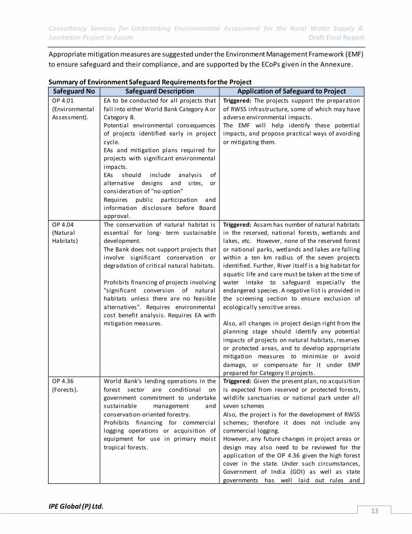
Environment Safeguard Requirements for the Project
From the Environment Perspective, the World Bank’s Operational Policies (OP) relevant for this project
are (i) OP 4.01 Environmental Assessment, (ii) OP 4.04 Natural Habitats and (iii) OP 4.36 Forests. (i) OP
4.01 – Environmental Assessment. This states that an Environment Assessment (EA) are to be conducted
for all projects that fall into either World Bank Category A or Category B. (ii) OP 4.04 - Natural Habitats,
The conservation of natural habitat is essential and thus to ensure their protection during various
project cycle, the Environment Management Plan (EMP) should be included for all project schemes .
Consultancy Services for Undertaking Environmental Assessment for the Rural Water Supply & Sanitation Project in Assam Draft Final Report
IPE Global (P) Ltd. 13
Appropriate mitigation measures are suggested under the Environment Management Framework (EMF)
to ensure safeguard and their compliance, and are supported by the ECoPs given in the Annexure. Summary of Environment Safeguard Requirements for the Project
Safeguard No Safeguard Description Application of Safeguard to Project OP 4.01
(Environmental Assessment).
EA to be conducted for all projects that
fall into either World Bank Category A or Category B. Potential environmental consequences of projects identified early in project
cycle. EAs and mitigation plans required for projects with significant environmental
impacts. EAs should include analysis of alternative designs and sites, or consideration of "no option"
Requires public participation and information disclosure before Board approval.
Triggered: The projects support the preparation
of RWSS infrastructure, some of which may have adverse environmental impacts. The EMF will help identify these potential impacts, and propose practical ways of avoiding
or mitigating them.
OP 4.04 (Natural Habitats)
The conservation of natural habitat is essential for long- term sustainable development.
The Bank does not support projects that involve significant conservation or degradation of critical natural habitats.
Prohibits financing of projects involving "significant conversion of natural habitats unless there are no feasible
alternatives". Requires environmental cost benefit analysis. Requires EA with mitigation measures.
Triggered: Assam has number of natural habitats in the reserved, national forests, wetlands and lakes, etc. However, none of the reserved forest
or national parks, wetlands and lakes are fall ing within a ten km radius of the seven projects identified. Further, River itself is a big habitat for
aquatic l ife and care must be taken at the time of water intake to safeguard especially the endangered species. A negative l ist is provided in the screening section to ensure exclusion of
ecologically sensitive areas. Also, all changes in project design right from the planning stage should identify any potential
impacts of projects on natural habitats, reserves or protected areas, and to develop appropriate mitigation measures to minimize or avoid
damage, or compensate for it under EMP prepared for Category II projects .
OP 4.36
(Forests).
World Bank’s lending operations in the
forest sector are conditional on government commitment to undertake sustainable management and
conservation-oriented forestry. Prohibits financing for commercial logging operations or acquisition of equipment for use in primary moist
tropical forests.
Triggered: Given the present plan, no acquisition
is expected from reserved or protected forests, wildlife sanctuaries or national park under all seven schemes
Also, the project is for the development of RWSS schemes; therefore it does not include any commercial logging. However, any future changes in project areas or
design may also need to be reviewed for the application of the OP 4.36 given the high forest cover in the state. Under such circumstances, Government of India (GOI) as well as state
governments has well laid out rules and
Consultancy Services for Undertaking Environmental Assessment for the Rural Water Supply & Sanitation Project in Assam Draft Final Report
IPE Global (P) Ltd. 14
procedures for making use of fores t lands for
non-forest purposes, which are provided for, in the ECoPs. Also, any required fell ing of trees in the social forest or non-forest areas is to be carried with the
permission of the Forest Department and in accordance with guidelines for compensatory afforestation.
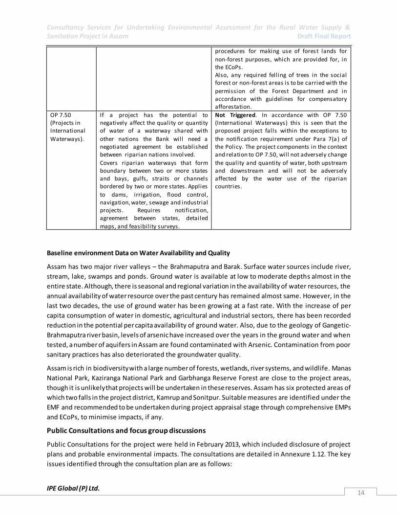
OP 7.50 (Projects in International
Waterways).
If a project has the potential to negatively affect the quality or quantity of water of a waterway shared with
other nations the Bank will need a negotiated agreement be established between riparian nations invol ved.
Covers riparian waterways that form boundary between two or more states and bays, gulfs, straits or channels bordered by two or more states. Applies
to dams, irrigation, flood control, navigation, water, sewage and industrial projects. Requires notification, agreement between states, detailed
maps, and feasibil ity surveys.
Not Triggered. In accordance with OP 7.50 (International Waterways) this is seen that the proposed project falls within the exceptions to
the notification requirement under Para 7(a ) of the Policy. The project components in the context and relation to OP 7.50, will not adversely change
the quality and quantity of water, both upstream and downstream and will not be adversely affected by the water use of the riparian countries.
Baseline environment Data on Water Availability and Quality
Assam has two major river valleys – the Brahmaputra and Barak. Surface water sources include river,
stream, lake, swamps and ponds. Ground water is available at low to moderate depths almost in the
entire state. Although, there is seasonal and regional variation in the availability of water resources, the
annual availability of water resource over the past century has remained almost same. However, in the
last two decades, the use of ground water has been growing at a fast rate. With the increase of per
capita consumption of water in domestic, agricultural and industrial sectors, there has been recorded
reduction in the potential per capita availability of ground water. Also, due to the geology of Gangetic-
Brahmaputra river basin, levels of arsenic have increased over the years in the ground water and when
tested, a number of aquifers in Assam are found contaminated with Arsenic. Contamination from poor
sanitary practices has also deteriorated the groundwater quality.
Assam is rich in biodiversity with a large number of forests, wetlands, river systems, and wildlife. Manas
National Park, Kaziranga National Park and Garbhanga Reserve Forest are close to the project areas,
though it is unlikely that projects will be undertaken in these reserves. Assam has six protected areas of
which two falls in the project district, Kamrup and Sonitpur. Suitable measures are identified under the
EMF and recommended to be undertaken during project appraisal stage through comprehensive EMPs
and ECoPs, to minimise impacts, if any.
Public Consultations and focus group discussions
Public Consultations for the project were held in February 2013, which included disclosure of project
plans and probable environmental impacts. The consultations are detailed in Annexure 1.12. The key
issues identified through the consultation plan are as follows:
Consultancy Services for Undertaking Environmental Assessment for the Rural Water Supply & Sanitation Project in Assam Draft Final Report
IPE Global (P) Ltd. 15
A) Existing:
1. Water Quality: Some of the ground water sources are affected by iron, arsenic and fluoride.
2. Water Availability: Some of the Piped Water Supply Schemes (PWSS) have become dysfunctional
due to drying up of ground water sources, especially in Kamrup, Sonitpur and Morigaon. There
are very few house hold connections and most villagers source their domestic water from
community stand posts.
B) Proposed Concerns:
1. Need for regular supply and monitoring of water quality was voiced in the villages.
2. Transmission issues - Network design. A need to take consent from the villagers while laying the
piped network was highlighted during the meeting.
3. Operation and Maintenance was also highlighted in the meetings.
Key findings from the overall assessment of the project areas
▫ Water quality for both surface and ground water sources may be impacted due to existing economic
activities, such as; oil refineries, agriculture, tea estates and sand mining, in the state.
▫ Water supply networks may be impacted by (i) erosion of land and landslides damaging the
network, and (ii) landslides and other degradation of hills resulting in pump houses and other
infrastructure being damaged or destroyed due to the degradation.
▫ Floods and river bank erosion may impact water quality around intakes severely. However, floods
can also impact other project infrastructure like (i) damage or destruction of the intakes along the
rivers; (ii) flood waters entering toilets resulting in contamination of surface and groundwater
systems; and (iii) damage hand pumps as well as water entering shallow aquifers through hand
pumps during floods may pollute these reserves.
▫ Possible impact from wildlife corridors and impact on ecological resources during the construction
phase of the project, and may need to be considered during the project design and construction
activities.
▫ There are a number of vector and water borne diseases in the project area. These include diarrhoeal
diseases, cholera and malaria. Cases of Japanese Encephalitis and Acute Encephalitis syndrome have
also been noted in a few of the project districts.
▫ Water Treatment Plants (WTPs) in some areas are poorly managed with leakages, poor drainage and
inadequate waste disposal facilities. Poor management of the disinfection such as chlorine tablets or
bleaching powder, results in inadequate treatment prior to distribution, as observed, for the existing
Piped Water Supply Systems (PWSS).
▫ Poor personal hygiene and environmental sanitation in all project villages visited was a concern.
▫ Overall there is low open defecation except in Bongaigaon District. However, it was observed that
Kutccha toilets, which are prevalent in all seven project districts, are not always spaced at an
appropriate distance from hand pumps. This may have serious implication on the quality of water

Consultancy Services for Undertaking Environmental Assessment for the Rural Water Supply & Sanitation Project in Assam Draft Final Report
IPE Global (P) Ltd. 16
and diseases like diarrhoea, Japanese encephalitis, cholera, etc., found to be prevalent in some of
the project districts, can be attributed to the contamination of shallow aquifers.
▫ There is no systematic solid waste management system in the project areas, with waste either burnt
or buried as a means of disposal.
▫ There is little evidence of a systematic waste water disposal system in villages visited with many
areas having mud roads without any drains constructed alongside.
Environmental Impacts
Overall there are expected to be a number of positive impacts from the project. However, a few adverse
impacts were identified as a part of project design, construction and operation and maintenance
activities. Major adverse impacts highlighted above through key findings during each project cycle are
listed below.
Major design related impacts
▫ Excess water in the project area with inadequate drainage provision and sanitation facilities
resulting in water logging, soil toxicity and increased vector habitats.
▫ Inadequately identified waste disposal system resulting in spillage and unsanitary waste dumping.
▫ Damage to infrastructure due to landslides, flooding, etc., due to poor location of infrastructure or
poorly identified borrow sites.
▫ Poorly identified project sites – resulting in destruction or damage of natural habitats, either
terrestrial or aquatic. Two important aquatic species exist near the project sites – the Gangetic
Dolphin in River Brahmaputra at Jorhat and the Indian Gaharial in River Dikhow.
▫ Introduction of alien species due to project plantation activities may lead to degradation of the local
environment.
▫ Poorly designed management plan, resulting in damage to locally significant cultural areas or
archaeological sites.
Further, adverse Impacts on water quality, natural habitats, cultural or heritage sites, etc., may occur
due to wrong selection of sites for intake, WTP and transmission line locations. Care must be taken while
selecting appropriate sites, ensuring they are at a safe distance from protected forest, animal corridors,
heritage sites, wetlands, flood prone areas, tea estate, or downstream of oil ref inery, waste disposal,
etc. However, if the selection cannot be avoided, especially in case of flood prone areas, all mitigation
measures should be effectively taken to minimize adverse impacts both on the project and on the
ecology.
Major construction related impacts
▫ Poor site management at all construction and material procurement sites leading to waste dumping,
toxicity and accidents.
▫ Health and safety concerns of labour due to poor site management, lack of facilities and inadequate
safety measures for labour.
Consultancy Services for Undertaking Environmental Assessment for the Rural Water Supply & Sanitation Project in Assam Draft Final Report
IPE Global (P) Ltd. 17
▫ Disturbance to local population from construction sites – noise and air pollution, inadequate safety
measures, excess traffic, competing resource needs for labour and local population, and use of local
lands for construction material and labour camps.
▫ Disturbance to local fauna and flora due to excess removal of fauna and flora during site clearance.
Further, construction during migratory season, leading to disturbance in their routes, or
procurement of material from ecological sensitive areas in Sonitpur, Sibsagar, Jorhat, Kamrup and
Hailakandi district which have number of reserve forest, wetlands, national parks, etc.
▫ Damage to existing infrastructure due to construction activities.
Major operation and maintenance related impacts
▫ Poor management of the WTP and Rain Water Harvesting Systems (RWHS) resulting in
contamination of water, increase in waterlogging and vector habitats, as well as leading to damage
of existing infrastructure and cultural property.
▫ Poor management of water treatment chemicals as well as heavy equipment’s resulting in
accidents, especially for workers at the WTP, intakes or floating barges.
▫ Inadequate finances or skills resulting in poor management of systems.
Based on the impact assessment, a number of Environmental Code of Practices (ECoPs) has been
identified in the migration plan. These ECoPs include guidelines for Sanitary Protection of Water Supply
Sources, Sustainability of Ground water Sources, Selection of Safe Sanitation Technologies,
Environmental Considerations in Location of Toilets, Construction Practice and Pollution Safeguards for
Twin Pit Pour Flush Latrines, Guidelines for Safe Sullage Disposal at Household and Community Levels,
Guidelines for Drainage Management in Villages, Guidelines for Community Solid Waste Management,
Sullage and biodegradable waste be managed in a non-polluting manner, exclusion list and negative list
of activities as well as the General building safety provisions are incorporated under the Annexures.
Environment Management Framework
Environmental Management Framework (EMF) essentially consists of Environmental Screening,
Environmental Assessment (EA), Environmental Management Planning and monitoring of compliance
with the plan of actions recommended for mitigating environmental risks. The Environmental Screening
was carried out under this assessment to determine the appropriate environmental category for the
proposed projects. Based on the outcome of screening, an Environmental Assessment (EA) respective to
the attached environmental category will be applied for each proposals. The PHED as recommended in
the Environment Data Sheets (EDS) will be responsible for carrying out the required EA and for
confirming that any clearances necessary for the proposed RWSS projects are obtained from the
relevant authorities as prescribed by the national and state legislations which should also meet with the
World Bank procedures as described in the EA/EMF document. Once the EA is performed and
recommendations incorporated into the sub-project, the project can be appraised and sanctioned.
Depending on the environmental category, the package would include one of the following: a) a full
scale Environmental Impact Assessment (EIA) and an Environmental Management Plan (EMP), b)
Environmental Management Plan (EMP), c) a simplified environmental assessment, so called EMP
checklist, or d) a justified statement that no EA are required. To ensure that environmental management

Consultancy Services for Undertaking Environmental Assessment for the Rural Water Supply & Sanitation Project in Assam Draft Final Report
IPE Global (P) Ltd. 18
is an integral part of project activities, the EMF needs to be incorporated in the project and scheme’s
management. The following are the components of EMF, elaborated under the EA/EMF Report.
1. Collection of Basic Environmental Data: To ensure adequate and proper identification of local needs
and monitoring of RWSS projects, the EMF needs environmental data for each scheme. To do this and
ensure a standard format for the project, an Environmental Data Sheet (EDS) for schemes on water
supply, sanitation, solid and liquid waste management, will be made available through the EA/EMF
document. The Assistant Executive Engineer/Executive Engineer (AEE/EE - for each district) of the
scheme fills up the EDS in consultation with the GPWSCs, Gram Panchayat or other local civil society
organisations who are involved in the project.
2. Environmental Classification of Schemes: At the Detailed Scheme Report (DSR) preparation stage, the
available environmental information in the EDS will be evaluated and based on the level of expected
environmental and public health impacts, the proposed scheme would be classif ied as either Category I
(basic) or Category II (detailed environmental appraisal required). The overall in charge for the
identification of the environmental classification of schemes with the help of the screening tool is the
responsibility of the EE (District) of each scheme.
3. Environmental Appraisal and Approval: For all category I schemes, there shall be no separate
environment appraisal other than filling up of EDS included in the DSR. For category II schemes, a
detailed environmental appraisal of the proposed scheme is required. This will be done by the EE and his
team who is in charge of the scheme. This team can be supported by the state level environmental
expert attached to PMU, for any technical help required. The environmental appraisal for category II
schemes shall not take more than 30 days. The DPR of Category I schemes should be accompanied by
the Environmental Data Sheet (EDS). The DPR for Category II schemes should be accompanied by the
Environmental Data Sheet (EDS) and the Category II environmental appraisal. The EE of the RWSS will
ensure this. All documentation will be finally checked for consistency and quality by the PMU
environmental specialist.
4. Environmental Compliance Monitoring during Implementation and O&M phases: The EMF will
ensure the following; i) the prescribed environmental mitigation measures (including construction stage
measures) as identified through the environmental appraisal process are adequately implemented. The
Implementation Completion Report of each scheme will include an Environmental Compliance
Certificate given by the GPWSC/GP or other identified appropriate authority. ii) Monitoring and
Supervision: There will be periodic supervision and monitoring conducted to ensure compliance to the
EMF and identification of any additional concerns that may have risen since. Iii) Capacity building needs
to be undertaken to ensure the proper execution of the EMF. It has been noted that some issues of poor
management of systems at the local level can be rectified by training and capacity building activities. iv)
IEC for the management of water, sanitation, environmental sanitation, drainage etc., will be needed at
the local level. This is imperative to ensure the proper management of village sanitation and reduce
health burden from water and sanitation related diseases.

Consultancy Services for Undertaking Environmental Assessment for the Rural Water Supply & Sanitation Project in Assam Draft Final Report
IPE Global (P) Ltd. 19
Implementation through Institutional System and Capacity Building
The implementation of the EMF is to be done through a series of different actors. At the state level the
State Project Management Unit (SPMU) will have an environmental specialist who has the overall
responsibility for the implementation of the project’s EMF. At the scheme level the actual
implementation will be the responsibility of the scheme Executive Engineer’s along with his staff. Day to
day running of the scheme will be the responsibility of the GPWSC/VWSCs or whoever is identified as
the appropriate authority, depending upon the area. The Assistant Executive Engineers and Assistant
Engineers will be overall in charge for the completion of the Environmental Data Sheets (EDS), and will
receive support from the support organizations for the project, who would be local agencies working in
the sector in the area.
To ensure the appropriate implementation of the EMF the EA has also identifi ed a capacity building
programme. The major areas of capacity building are:
▫ Awareness on World Bank environmental procedures, monitoring and EMP needs and compliance
to WB safeguards.
▫ O&M for systems.
▫ Refreshers programme awareness training, on World Bank environmental procedures and
compliance needs.
▫ Environmental Management – on environmental sanitation, sanitation and hygiene.
▫ Environmental Awareness and Sensitization for project beneficiaries.
▫ Quality Construction Practices for Artisans.
▫ Training for Water quality monitoring & sanitary surveys.
Training Approach and Programmes
Systematic capacity building initiatives are to be introduced only after completion of Training Needs
Assessment (TNA). The training will be in the cascade mode. All the trained staff and others will in turn
conduct further trainings at state, district, block and GP levels, depending upon their roles. However,
since capacity building goes beyond mere imparting training, institutionalization of best practices
becomes a prerequisite for improved service delivery. The training programme should be based on the
felt need, relevance and principle of sustainability as well as the recommendations from the Training
Need Assessment workshops. An enabling condition should be created for stake holders to understand
and implement programmes on rural drinking water and sanitation (as per NRDWP guidelines). Special
emphasis needs to be given to participatory techniques, community facilitation and communication
skills and gender based approaches. The number of suggested training programs is presented in table
below.
Consultancy Services for Undertaking Environmental Assessment for the Rural Water Supply & Sanitation Project in Assam Draft Final Report
IPE Global (P) Ltd. 20
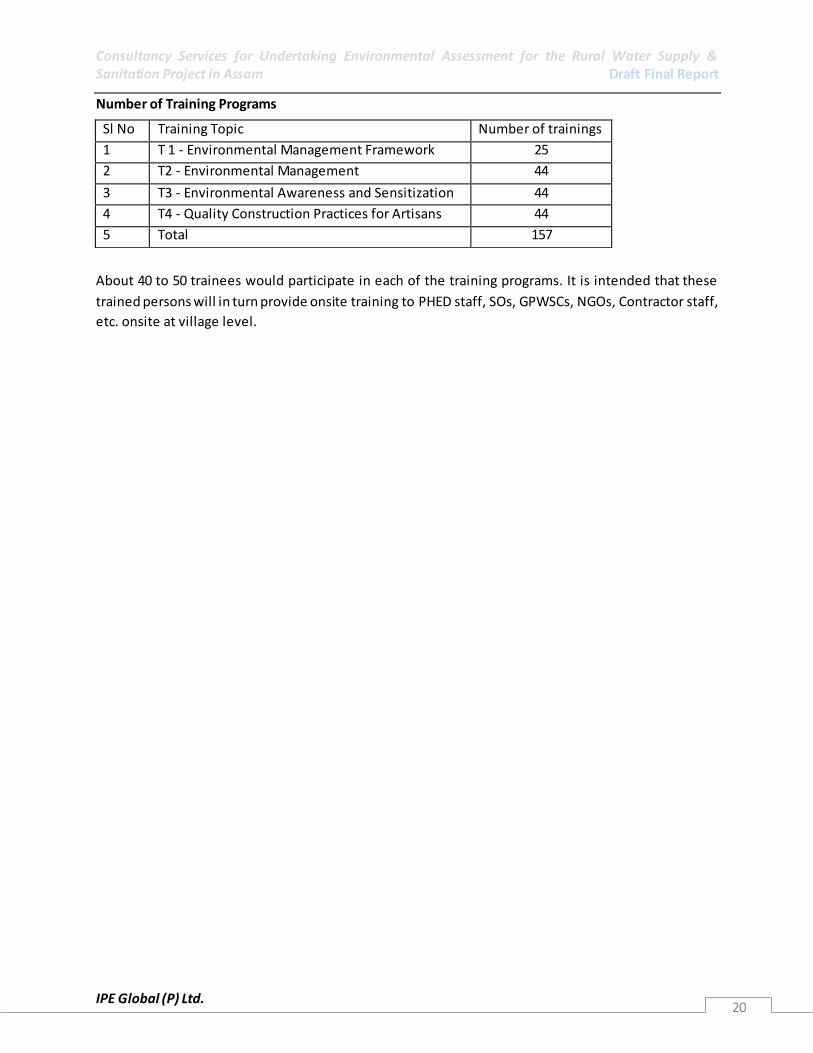
Number of Training Programs
About 40 to 50 trainees would participate in each of the training programs. It is intended that these
trained persons will in turn provide onsite training to PHED staff, SOs, GPWSCs, NGOs, Contractor staff,
etc. onsite at village level.
Sl No Training Topic Number of trainings
1 T 1 - Environmental Management Framework 25
2 T2 - Environmental Management 44
3 T3 - Environmental Awareness and Sensitization 44
4 T4 - Quality Construction Practices for Artisans 44
5 Total 157
Consultancy Services for Undertaking Environmental Assessment for the Rural Water Supply & Sanitation Project in Assam Draft Final Report
IPE Global (P) Ltd. 21
1. INTRODUCTION
1.1 Background The Government of India (GoI) and State Governments have together spent more than Rs. 1,50,000
crore over the last 20 years to for Water and Sanitation Supply services (WSS) in rural India. This has
resulted in the provision of domestic water to more than 70 crore people in 15 lakh rural habitation.
Sanitation coverage has also risen to 69% for rural households. However, intrastate inequities still exist,
as do emerging new demands. There is an increasing demand for the need to cover Scheduled
Caste/Scheduled Tribe (SC/ST) population and peri -urban/rural areas. About 90% of surveyed
households of the National Sample Survey Organization (NSSO) 65th survey in 2008-09 received water
from improved sources. Yet, only 30% of rural households have tap connections and less than 10% of
Gram Panchayats (GPs) have received the Nirmal Gram Puraskar (NGP) award for 100% sanitation
coverage. However, even villages which have received the NGP slip back with about 30-40% of schemes
that were fully or partially covered periodically slip back to “partially covered” or “not covered” status.
This is mainly due to deteriorating quality and quantity, poor operations and maintenance (O&M)
standards and weak cost recovery; formidable constraints in achieving and maintaining full coverage.
One of the reasons for the disconnect between high levels of investment and the subsequent lack of
sustainability is limited institutional reforms in the sector. Emphasis remains on asset creation rather
than asset management and sustainable operations. The bulk of Rural Water Supply and Sanitation
(RWSS) investments are undertaken in a top down manner through state level entities. These state level
agencies are neither equipped for the job nor have incentives to deliver sustainable services.
Sustainability, demand responsive approaches, working with communities and local governments has
been demonstrated under the Sector Reform and Swajaldhara programmes. However, scaling up these
approaches continues to be a challenge. This challenge becomes even more serious in states already
suffering from poor piped water and sanitation coverage.
The challenge is not only increasing the piped water connections and sanitation facilities in states that
are lagging behind; but implementing community-driven, panchayat led institutional models for
improving sustainability of service delivery. Along with the investment program, these states require
huge capacity building, training, and Information, Education and Communication (IEC) awareness
programs for establishing and making operational decentralized institutional arrangements. As part of
its recent strategy, the Department of Drinking Water Supply (DDWS) has placed special emphasis on
piped water and sanitation coverage in eight lagging states with low piped water coverage.
The lagging states include Assam, Bihar, Jharkhand, and Uttar Pradesh. These states face constraints in
institutional and technical capacity at the state, district, block and GP levels for implementing
sustainable rural water supply projects. The constraints include weak institutional capacity involve
communities and panchayats in planning, implementing and managing their own drinking water supply
schemes. The technical capacity of the State Rural Water Supply Departments for supporting and
implementing the decentralization program also needs strengthening. O&M of existing schemes too is

Consultancy Services for Undertaking Environmental Assessment for the Rural Water Supply & Sanitation Project in Assam Draft Final Report
IPE Global (P) Ltd. 22
inadequate, resulting in many schemes becoming dysfunctional. Some areas also face problems of water
availability as safe sources are at great distance habitations.
Key Elements of the RWSS Program for Lagging States
The RWSS Program for lagging states is to be a separate component of NRDWP with different allocation
criteria and funding components. However, it will be implemented within the framework of NRDWP. It
will support the following key elements of the reform program:
Placing GPs and communities in the central role, supported by higher levels of Panchayati Raj
Institutes (PRIs), the State government and the local non-governmental and private sector, for
facilitating, planning, implementing, monitoring and providing a range of O&M back-up services.
Using sustainable, community or local government managed models for intra-GP RWSS schemes
and using State- PRI partnership models for multi-GP schemes.
Putting water resources security as a core theme of the new model, including increased
community management of scarce resources.
Moving the RWSS sector to recovery of at least 50% O&M and replacement costs and initiating
contribution to capital costs keeping affordability and inclusiveness in mind. .
Moving towards metered household connections, with 24/7 water supply where feasible, as a
basic level of service.
Promoting professionalized service provision management models, and/or back -up support
functions, for the different market segments (simple/small single village/GP schemes; large
single village/GP schemes; multi village/GP schemes).
Integrating water supply and sanitation, with effective sanitation promotion programs for
achieving “clean villages”.
Establishing M&E systems with independent reviews and social audits.
Service delivery through the PRI system; as envisaged for the laggard states, fits well with the National
Rural Drinking Water Programme (NRDWP) of the Government of India. This is mainly as the NRDWP
emphasises the involvement of the PRIs and communities in planning, implementing and managing
drinking water supply schemes.
The main objective of the programme is to deliver sustainable water services and improved sanitation
through appropriate decentralized institutional models. The program is to be funded by DDWS under
the NRDWP for the lagging States.
The management of these schemes is to be eventually handed over to the PRIs. A separate component
of support activities like IEC, Human Resources Development (HRD), Management Information Systems
(MIS), Water Quality Monitoring and Surveillance has been introduced. Recently, as part of the NRDWP,
the state departments responsible for drinking water supply and sanitation has prepared their long term
strategic plan (2011-2022) to ensure drinking water security to all rural households. The strategic plans
Consultancy Services for Undertaking Environmental Assessment for the Rural Water Supply & Sanitation Project in Assam Draft Final Report
IPE Global (P) Ltd. 23
aim to cover 90% of households with piped water and at least 80% of households with tap connections
in this period. This forward looking strategy supports the creation of an enabling environment fo r the
PRIs, Self Help Groups (SHG) and local communities to manage rural drinking water sources and
systems. The strategy emphasizes achieving water security through decentralized governance with
oversight and regulation, participatory planning and implementation of sources and schemes. Capacity
building programs will be required for communities to monitor and prudently use their water resources.
Sustainable service delivery mechanisms are a central feature of the program, with State institutions or
Zilla Parishad implementing and managing large multi-village schemes, delivering bulk water to vil lages
in water stressed areas, and GPs implementing and managing in-village and intra-Panchayat schemes.
The strategy highlights source sustainability measures, water quality safety, monitoring and surveillance,
service agreements with operators, convergence of different development programs, and building
professional capacity at all levels.
1.2 Present World Bank Assisted Rural Water Supply and Sanitation Project The Government of India had approached the World Bank for assistance on a National Project for the
lagging states particularly Assam, Uttar Pradesh, Jharkhand and Bihar. The project is to include
programmes related to improved water quality monitoring, health and hygiene education and ground
water recharge for water supply source protection.
1.2.1 Components Possible components of a World Bank supported DDWS NRDWP Component for Lagging States are as
follows:
Component 1: Technical Assistance (TA) to States/PRIs: This component will finance TA required for
participating States and PRIs, to prepare detailed RWSS program covering all aspects of the investment
needs, reform activities, institutional changes and operational capacity improvements (including human
capacity, systems and equipment) necessary to deliver sustainable water supply and sanitation
coverage.
Component 2: RWSS Investments: This component will finance activities aimed at achieving improved
and sustainable piped water supply and sanitation coverage. These activities will include replacing and
rehabilitating the existing RWSS infrastructure as well as new systems for water supply and sanitation
coverage to new customers.
Component 3: Capacity Building for RWSS Institutions: This will support improved performance in the
sector and participating institutions through three dimensions: (i) Improving Operations: professional
service delivery models according to size and scale of operations (single/multi village schemes); (ii)
Improving Finance: O&M cost recovery, financial management and reporting, etc.; (iii) Improving
Governance: Policy development at the State level with clarity of roles and responsibilities at State,
district, village levels; PPP and regulatory arrangements; performance monitoring and independent
assessments; etc. A learning program will complement the above capacity building activities, including
(a) knowledge exchange; (b) structured learning; and (c) training of practitioners to enhance capacity. (d)
strengthening WSSOs on lines of WASMO and DWSMs with infrastructural and other support

Consultancy Services for Undertaking Environmental Assessment for the Rural Water Supply & Sanitation Project in Assam Draft Final Report
IPE Global (P) Ltd. 24
Component 4: Capacity Building for DDWS: This component will provide technical assistance to the
DDWS with a view to increasing the Ministry’s overall capacity for planning and managing the RWSS
program, including strengthening the National Resource Centre, monitoring and evaluation (M&E) and
independent reviews of the sector program.
1.3 Scope of the Project The key feature of the project would be to work with ‘lagging’ States for scaling up sustainable Rural
Water Supply & Sanitation (RWSS) services and establishing new benchmarks and good practice models
for adoption by other States. Within DDWS, the enhanced capacity resulting from the project will allow
it to continue to lead the sector, advocate for reform, and introduce a higher quality of public policy
debate, and more efficient allocation of resources, in the RWSS sector. Subsequently, the project also
intends to take up the following activities under waste management in the villages.
1. Solid waste management.
2. Liquid waste management.
It has been proposed that the segregation of solid waste at household level will be introduced through
IEC campaigns and house-to-house awareness creation activities. Further, for managing bio-degradable
waste, composting or vermi-composting at household level or community level, as required is proposed.
All the recyclable waste will be segregated at household level itsel f and reused. The remaining non-
recyclable waste will be disposed at commonly identified places by the community, as this quantity is
too small. For liquid waste, drains will be provided in the village and village households are encouraged
to build soak pits. Where required liquid waste will be collected and disposed into waste stabilization
ponds for stabilization.
The present project is limited mainly to providing rural water supply and sanitation infrastructure and
does not intend to de-contaminate or reduce existing contamination in the villages. However, any future
contamination due to solid waste and liquid waste in the project villages will be taken care through
using Environmental Code of Practice (ECoPs) and intensive awareness programs through Information
Education and communication (IEC) campaigns proposed in the project.
1.4 Need for Environmental Assessment and Environment Management Framework To contribute to the environmental sustainability of the project, an Environmental Assessment (EA)
Study is required based upon the World Bank’s safeguards policies. The study will collect and analyze
information regarding the environmental issues related to the project from each participat ing state in
the first phase on sample and finally prepare an Environmental Management Framework (EMF) to be
integrated in the overall project. The aim of the EA/EMF study is to analyze the existing environmental
issues related to rural water supply and sanitation and ensure that these inadequacies are addressed or
mitigated in the project design.
The project itself is not expected to cause any major adverse environmental impacts. However, some
key environmental concerns related to the project are:
Water Quantity Issues
Consultancy Services for Undertaking Environmental Assessment for the Rural Water Supply & Sanitation Project in Assam Draft Final Report
IPE Global (P) Ltd. 25
Availability of 'safe' drinking water, especially in the summer months
Management of solid and liquid waste management and so on.
Open Defecation Free (ODF) Gram Panchayat. Based upon the assessment of the project and its activities environmental impact and mitigation measures will be identified. These will be included in the project design.
1.5 Objectives of Environmental Assessment The key objective of the study is to undertake and prepare a state-specific EA/EMF Report with a view to
identify the critical environmental concerns in the RWSS sector and address them as an integral part of
project design.
The specific objective includes:
To assess the existing status of environment in the state and to identify threats and issues which
have effect on RWSS sector
To identify the environmental issues associated with implementation of RWSS schemes (single
village and multi village schemes) and develop environmental codes of practices that need to be
followed during various stages such as planning, construction and operation and maintenance.
To identify generic environmental issues that are beyond the scope of RWSS schemes, but related
to the sector and recommend remedial measures to address them as part of the project.
To identify existing good behaviour in recycling of water, use of traditional method of liquid and
solid waste management.
To identify traditional habitation that result in lower per capita consumption of water.
To identify household and environmental sanitation issues as well as to make an assessment of
pollution level with regard to water supply and its usages & propose appropriate sanitation
technology options.
To prepare an Environment Management Framework including well -defined performance
indicators for addressing the identified issues, through the various activities/tasks under the
proposed project, and strategy for its implementation to achieve sustainable sources for water
supply schemes and environmental sanitation benefits.
1.6 Methodology Adopted for the Study
The EA/EMF analysis included a combination of primary and secondary data, which were used to
identify key (possible) environmental impacts. Sources of primary data include village surveys, field visits
and discussions with key stakeholders, including officials from following departments, Public Health and
Engineering Department (PHED) – Water Supply, PHED-Sanitation, Central Ground Water Board, Health
(NRHM – IDSP Cell), WSSO, Irrigation, ASHA Workers, etc. Secondary data was also collected from
published literature and web searches, especially data on official websites of the state especially for
state level baseline information. Further details of the data sources and collections are given in the
subsections below.

Consultancy Services for Undertaking Environmental Assessment for the Rural Water Supply & Sanitation Project in Assam Draft Final Report
IPE Global (P) Ltd. 26
The review of the schemes is based upon existing situation analysis from field visits by the team,
discussions with the PHED and also key stakeholders both at the village, district and block levels, as well
as other relevant departments, agencies and civil society groups who are working in the Water and
Sanitation sector in Assam. The team, with the help of PHED officials, undertook field visits and transact
walks in few project villages, covering all the nine project areas. This preliminary assessment which was
carried during the month of December 2012 till the end of January 2013, covered discussions, field
observations, data collection, on major issues such as health, environment, water availability and
quality, sanitation, etc., with the residents.
Given that PRI elections were running parallel to the study, discussions with some of the key
stakeholders – members of the PRI were limited during the preliminary field visits and thus was
undertaken again after the 14th Feb 2013 through consultations and FGDs in all the project areas to
include views given by representative of PRI’s.
Interaction was made with other concerned non-governmental organizations for dovetailing of efforts,
which may help in mitigating or reducing the environmental problems.
Discussions with the NGO’s, stakeholders, Members of World Bank, PHED Staff have brought out certain
useful suggestions and proposals to make RWSS sector a sustainable entity. The assessment includes
both impact of the project on the environment and also possible impacts of the environment on the
project. Details of the primary and secondary data collection and analysis are detailed below.
1.6.1 Data Collection and Review
1.6.1.1 Secondary Data Collection and Analysis
The main sources of data were the latest State Statistical Diaries/handbooks, Eleventh Five Year Plan
document of the state, various proposal of the state regarding environment, water, sanitation and
hygiene sectors, annual progress reports and departmental documents of the concerned departments,
such as Public Health Engineering Department, Department of Forests, Land Survey Directorate,
Agriculture, Horticulture, Soil and Water Conservation, Animal Husbandry, Ground Water Survey,
National Rural Health Mission – Integrated Disease Surveillance Project (NRHM – IDSP), Pollution Control
Board, Central Water Commission, Watershed Management Directorate, Botanical Survey of India,
Zoological Survey of India and the like.
Bhuvan, a Geo-portal of Indian Space Research Organisation, Google Earth, Google Pro were some of the
mapping tools used to assess the Project areas with respect to existing topographical features. This
helped in understanding the issues related to the location of the schemes viz a viz features like,
Reserved and protected forest, wetlands, distances from the source ( in case of Assam the source is the
River from which the water will be taken), animal corridors, wildlife sanctuaries, cultural heritage
buildings, etc.
The data was also collected from government statistics and published documents, research documents
and grey literature available on the internet. All attempts have been made to verify the quality of data
by cross checking the information from other sources, such as PHED, Revenue Department, CGWB, etc.
Research papers, books and monographs, annual reports and special study reports of various research

Consultancy Services for Undertaking Environmental Assessment for the Rural Water Supply & Sanitation Project in Assam Draft Final Report
IPE Global (P) Ltd. 27
organizations working in the North East have been used. These include Indian Council of Forestry
Research and Education (Forest Research Institute), Forest Survey of India, Wildlife Institute of India,
Survey of India, Geological Survey of India, Central Soil and Water Conservation Institute, were
consulted to extract important information and to bring out important environmental and RWSS issues
of the state. Studies on the RWSS and environment sector in Assam conducted by NGO’s were also
referred to in this assessment study.
Apart from available literature, to identify project background and baseline, a review of RWSS standards
and water quality and environment related legislation was also undertaken. This comprehensive review
identified possible legal procedures that may be important for the project. Based on this, the EMF,
detailed in the report advices on what is needed to be carried during, planning, implementation,
operation & Maintenance to mitigate probable impacts on environment. Equally, discussions with the
PHED and overlaying the planned scheme with its GPS location on Google Earth Maps has helped
identify possible conflicts with the existing establishments. Subsequently, permissions from relevant
departments have been identified under the legislative framework of the EMF.
Primary Data Collection and Analysis
A combination of surveys, focus group discussions and consultations were undertaken for identification
of project concerns, environmental issues and possible project needs. In total 15 numbers of villages
were visited for each of the identified project areas.
Primary data collection includes qualitative and quantitative surveys at the GP, village and household
level. The survey questions include parameters such as water availability, quality, piped water supply
condition, sanitary surveys, health issues, etc.. Local survey teams were trained to undertake village
level and household level filling of questionnaires. The survey formats were developed and tested in
Panikhaiti Village of Kamrup district, and based on the survey team’s feedback; required changes were
incorporated in the final questionnaires for conducting the primary survey for the project. The field
testing was also used as an opportunity to train the survey team. The questionnaires for the GP and
household are attached in Annexure 1.3. Apart from the field surveys, water quality testing of all the
intake points are conducted to identify any possible water quality concerns in the project area. The tests
report is also given in Annexure 1.4.
Sample Size: Selection of villages and GPs for field investigations is guided by such factors as population,
particularly the total population considered under the RWSS Project; Environmental status such as water
quality; Dysentery and Diarrhoeal cases reported in the block; ground water status and soil degradation;
and distance from sources. Based on these criteria, and in consultation with the PHED, fifty six villages
are selected for surveys. Details of the number of villages selected in each project area along with
number of GPs are given in Annexure 1.2 (in Volume – II).
Subsequently, the team of experts conducting the EA undertook field visits to all nine districts. This was
to undertake a rapid assessment of the existing scenario, possible location concerns and look at some of
the existing water supply treatment systems and related infrastructure to identify major concerns and
impacts on proposed project. The team also undertook transect walks in some of the villages and visited

Consultancy Services for Undertaking Environmental Assessment for the Rural Water Supply & Sanitation Project in Assam Draft Final Report
IPE Global (P) Ltd. 28
a few households and discussed their water and sanitation needs and concerns. The details of the
villages visited and dates are given in Annexure 1. 2 (in Volume – II).
Public consultation and disclosure process were conducted in all seven districts under the project
schemes, which were attended by representatives of key stakeholders of RWSS. The details of the
villages visited and dates are given in Table 1.
1.6.2 Sample Habitations for Pilot Study Minimum three GPs were selected per (nine) Project Area based on their distance from the intake point
(Head, Middle and Tail) and minimum two villages per GP. The Primary Survey will be conducted in 30
House Holds (5-10% representation from each village) from each Village. Subsequently, the villages are
selected to include issues such as, ground & surface water quality, Water Bourne disease outbreaks in
the last five years, socio economic status (SC/ST/Gen), based on the secondary data in combination with
the preliminary field visits to each project area in the seven district and respective consultation with the
district Executive engineer. This is primarily done to ensure that all the environmental issues are
addressed and an effective village sample is taken for the study.
Table 1: Number of GPs and Villages selected for the survey in the planned project districts.
S.No District Project Areas
Sampling
No of GPs No of Villages
1 Kamrup
Composite Water Supply and Sanitation (WSS) at Chandrapur & Dimoria Dev. Block
3 2
2
Composite WSS at Bezera 3 4
2 Sibsagar Amguri Gaurisagar integrated WSS 4
3
3
Gr. Sibsagar integrated WSS 5 2
5
3 Jorhat Composite WSS at Jorhat, Jorhat Central & Jorhat North West Dev. Block
5 3 2
2
4 Sonitpur Composite WSS at Gohpur 6 4
4
5 Morigaon Gr Mayang WSS 5 3
3
6 Boigaingaon Gr Jogighopa WSS 6 4 2
2
7 Hailakandi Gr. Hailakandi-Algapur WSS 5 4
2
1.6.3 Preliminary Site Visits The project team conducting the EA undertook field visits between the mid December, 2012 and end
January, 2013. This rapid assessment included visits to the project villages, where discussions were
undertake with the residents, meeting with Scheme Level User Committee (SLUC) members, Gaon

Consultancy Services for Undertaking Environmental Assessment for the Rural Water Supply & Sanitation Project in Assam Draft Final Report
IPE Global (P) Ltd. 29
Panchayat Water and Sanitation Committee (GPWSC) and where possible also discussions with
members of the GP.
The team also visited planned project intakes and sites under consideration for water treatment plants.
The team had discussions with local officials that included PHED engineers, SLUC members, WTP
employees, Block Panchayat members, tea estate managers and workers and anganwardi workers. The
visits were facilitated by the PHED officials in charge of the project.
1.6.4 Public Consultations and focus group discussions
Public Consultations were concluded by the team in all the seven, project districts. The consultations
were held in the second half of February 2013, after the panchayat elections had been completed. The
consultations were used to disclose the project plan and identify possible implications of the p roject on
the environment, and understand their situation, needs and perspective with reference to water supply
and sanitation. The details of the consultations are given in Annexure 1.9 along with the field plan for
the consultations.
Key Issues which were identified during the consultations.
A) Existing:
3. Water Quality: Some of the ground water sources are affected by Iron, Arsenic and Fluoride.
4. Water Availability: Some of the PWSS have become dysfunctional due to drying up of ground
water sources, especially in Kamrup, Sonitpur and Morigaon. There are very few house hold
connections and most of the villagers are forced to fill water from the stand post provided at the
community level.
B) Proposed Concerns:
4. Regular supply as well as regular monitoring of water quality.
5. Transmission issues- Network design. The concerns were shown on how will the network for
water supply be designed, will a consent be taken from the villagers at the planning process.
6. Operation and Maintenance.
*Note: Some of the findings from the consultations were taken in account and incorporated in the
revised Draft Report (Version II).
1.7 Organisation of the Report
1. Chapter-1: Introductory chapter presents a brief of project, the methodology followed, criteria
for selection of sample habitations for preliminary site visits, schedule and the procedure
followed for public consultations.
2. Chapter-2: This chapter provides Rural Water Supply and Sanitation Policy, Regulatory
Framework, Missions and Programmes. This has information on the rural water policy and on
the legal and regulatory framework relevant to the proposed project. This chapter describes
rural water and sanitation institutions in the state, their roles and responsibilities with special
focus on rural water supply and sanitation. Further it presents a profile of the proposed project
and the rules for participation of the beneficiary community in the project.

Consultancy Services for Undertaking Environmental Assessment for the Rural Water Supply & Sanitation Project in Assam Draft Final Report
IPE Global (P) Ltd. 30
3. Chapter-3: This chapter presents the baseline data on relevant environmental components in
the Assam State. Based on a critical review and analysis of baseline data, the issues of
environmental concern have been identified. *The seven districts with proposed schemes under
RWSS-LIS, World Bank funded projects are in bold for the reader to register the specific impacts
under each baseline parameters.
4. Chapter-4: Fourth chapter has the Environmental Management Framework. This analyses the
potential environmental risks associated with the proposed project activities during the design,
preparation, construction and operation phases as well as, the mitigation measures for
removing/ reducing the adverse impacts and enhancing the beneficial impacts of the project.
The institutional and capacity building arrangements, monitoring and supervision arrangements
as well as the financial arrangements for the implementation of the EMF are presented in this
chapter. Appropriate environmental performance indicators have been proposed which need to
be integrated with other indicators as tools to assess the project performance.
Chapter 1 to 4 are enclosed in Volume I
This report has several annexures including detailed project schemes, detailed guidelines and codes of
practice for improved environmental management, state and district level baseline data on water supply
and sanitation etc., which are enclosed in Volume II.

Consultancy Services for Undertaking Environmental Assessment for the Rural Water Supply & Sanitation Project in Assam Draft Final Report
IPE Global (P) Ltd. 31
2 RWSS– POLICY, REGULATORY FRAMEWORK, MISSIONS AND PROGRAMMES
2.1 State RWSS Vision
“A clean and healthy Assam, in which each person individually and collectively owns and takes the
responsibility to ensure an equitable and good quality of life through safe water supply, adequate
sanitation facilities and best hygiene practices.” Source: PHED, Assam
2.1.1 RWSS at National Context The Ministry of Drinking Water and Sanitation, Government of India, formerly under the Ministry of
Rural Development as Department of Drinking Water and Sanitation, is headed by the Minster for Rural
Development. The Accelerated Rural Water Supply Programme (ARWSP) was the first major
intervention in the water sector that started in 1972-1973. To accelerate coverage, the Technology
Mission on Drinking Water was launched in 1986. In 1991-92, this mission was renamed Rajiv Gandhi
National Drinking Water Mission, and in 1999, the Department of Drinking Water Supply (DDWS) was
formed under Ministry of Rural Development, for focused attention on drinking water and sanitation.
The first major sector reform project (SRP) was started in the same year. Later was renamed as
Department of Drinking Water and Sanitation in 2010 and in 2011, it was given a Ministry status, due to
the importance given to the sector by the ruling government. The Ministry of Drinking Water and
Sanitation is the nodal department for the overall policy, planning, funding and coordination of
programmes of drinking water and sanitation in the country.
A national water supply and sanitation programme was introduced in the social sector in the country in
1954. The Government of India assisted the States to establish special investigation divisions in the
Fourth Five Year Plan to carry out identification of problem villages. Taking into account the magnitude
of the problem, and to accelerate the pace of coverage of problem villages, the Government of India
introduced the Accelerated Rural Water Supply Programme (ARWSP) in 1972- 73 to assist States and
Union Territories with 100% grants-in-aid to implement drinking water supply schemes in such villages.
The entire programme was given a Mission approach when the Technology Mission on Drinking Water
Management, called the National Drinking Water Mission (NDWM), was introduced as one of the five
Missions in social sector in 1986. NDWM was renamed as Rajiv Gandhi National Drinking Water Mission
(RGNDWM) in 1991. During the International Water and Sanitation Decade in 1980s, Central Rural
Sanitation Programme (CRSP) was launched in 1986 in the Ministry of Rural Development to accelerate
sanitation coverage in rural areas with the objective of improving quality of life of the rural people and
to provide privacy and dignity to women. Presently, Rajiv Gandhi National Drinking Water Mission
(RGNDWM), Department of Drinking Water Supply, Ministry of Rural Development administers the
Centrally Sponsored programmes in Rural Drinking Water Supply and Rural Sanitation sectors. During
the Ninth-Plan period, special initiative was taken to cover rural habitations with proper sanitation. The
CRSP was restructured in 1999 with a provision for phasing out the allocation-based component by the
end of the IX Plan i.e. 2001- 2002. The Total Sanitation Campaign (TSC), now named as Nirmal Bharat

Consultancy Services for Undertaking Environmental Assessment for the Rural Water Supply & Sanitation Project in Assam Draft Final Report
IPE Global (P) Ltd. 32
Abhiyan (NBA) under the restructured CRSP was launched with effect from 1.4.1999 adopting a
community led and people centred approach. TSC moves away from the principle of state-wise
allocation to a “demand driven” approach. The programme gives emphasis on IEC for demand
generation of sanitation facilities and offering a wide range of technological choices of sanitation
hardware through an effective delivery mechanism of Rural Sanitary Mart and Product ion Centres to
meet the demand for sanitation facilities so generated. It also lays emphasis on school sanitation and
hygiene education for bringing about attitudinal and behavioural changes for relevant sanitation and
hygiene practices from young age.
The NDWM Plan accords the highest priority to providing the “Not Covered” (NC) habitations with
sustainable and stipulated supply of drinking water. It is envisaged to cover all the rural habitations
including those, which might have been slipped back to Not Covered or Partially Covered (NC/PC)
category by the end of NDWM Plan. The Tenth Plan emphasizes the participatory approach where PRIs
should be the key institutions for convergence of drinking water supply programmes at the ground level.
Considerable success has been achieved in meeting drinking water needs of the rural population.
2.1.2 Sector Reforms Project In April 1999, the GOI decided to move from a target based and supply-driven to the actual practices
and preferences of end users, to a demand-based approach where users get the service they want and
are willing to pay for, in a new initiative called Sector Reform Pilot Projects (SRPP). Apart from demand -
responsiveness, this approach stressed financial viability and sustainability of the schemes, through f ull
cost recovery of operation and maintenance and replacement costs.
These sector reforms were to be implemented on a pilot scale in selected villages in 67 districts spread
over 26 states in the country. The strategies of the sector reform programme were that people will be
willing to maintain and operate water supply schemes only if they,
Owned the assets Had installed the hand pump themselves, or had been actively involved throughout Had been trained to do simple repairs Know the government will not maintain the asset Had sufficient funds for maintenance and Had to pay for operation and maintenance of the system.
2.1.3 Swajaladhara The Government of India has emphasized the need for taking up community based rural water supply
programmes which resulted in the Sector Reforms Pilot Project in 1999. Using experiences gained in the
pilot project the Swajaldhara programme was launched on 25th December 2002.
Principles of Swajaldhara
Adoption of demand responsive, adaptable approach along with community parti cipation based on
empowerment of villages to ensure their full participation in the project through a decision making role
in the choice of the drinking water scheme, planning, design, implementation, control of finances and
management arrangements;

Consultancy Services for Undertaking Environmental Assessment for the Rural Water Supply & Sanitation Project in Assam Draft Final Report
IPE Global (P) Ltd. 33
Full ownership of drinking water assets with appropriate level of Panchayats; Panchayats/communities
to have the powers to plan, implement, operate, maintain and manage all Water Supply and Sanitation
schemes;
Partial capital cost sharing either in cash or kind including labour or both, 100% responsibility of
operation and maintenance by the users;
Taking up conservation measures through rain water harvesting and ground water recharge systems for
sustained drinking water supply; Shifting the role of Government from direct service delivery to that of
planning, policy formulation, monitoring and evaluation, and partial financial support.
Keeping in view the concept of decentralization of powers, the powers to sanction Swajaldhara projects
have now been delegated to District Water and Sanitation Committee (DWSC) as envisaged in the
revised guidelines issued in June 2003.
As per the guidelines issued in June 2003, Swajaldhara will have two Dharas. First Dhara (Swajaldhara-I)
will be for a Gram Panchayat (GP) or a group of GPs or an intermediate Panchayat (at block/Tehsil level)
and the second Dhara (Swajaldhara-II) will have a District as the project area.
Guidelines for environmental safety as per Swajaldhara Projects
States would need to enact and implement law on effective groundwater extraction control,
regulation and recharge
State Government should integrate water conservation and rainwater harvesting schemes with
drinking water supply schemes
Rural drinking water, sanitation, health and hygiene programmes need to be integrated at the State,
District, Block and GP levels
ARWSSA/PHED Assam should arrange for periodic monitoring and review of the functioning of
completed water supply schemes by officers, experts, NGOs, Institutions etc.
Suitable monitoring mechanism and systems may be put in place in this regard by State Government
Funds under Swajaldhara are now allocated to the States/UTs and the allocated amount is intimated to
the States/UTs. The States/UTs make district wise allocation and furnish the details to the Department
of Drinking Water Supply. On receipt of such information, the funds are released directly to
SWSM/DP/DWSM by Department of Drinking Water Supply.
Guidelines on Swajaldhara (June 2003)
The GOI, Ministry of Rural Development, Department of Drinking Water Supply issued the guidelines for
Swajaldhara. The salient features are –
Full ownership of drinking water assets with appropriate levels of Panchayats.
Panchayats/communities to have the powers to plan, implement, operate, maintain and
Consultancy Services for Undertaking Environmental Assessment for the Rural Water Supply & Sanitation Project in Assam Draft Final Report
IPE Global (P) Ltd. 34
manage all water supply and sanitation schemes.
Taking up of conservation measures through rainwater harvesting and ground water recharge
systems, for sustained drinking water supply.
State would need to enact and implement law on effective ground water extraction, regulation
and recharge.
State Govt. should integrate water conservation and rain water harvesting schemes with the
drinking water supply schemes.
The State Govt. would enter into a memorandum of understanding (MOU) with the GOI to
obtain funds from the later. Issues to be included are also listed.
The minimum share of community contribution for 40-lpcd service level will be 10% of
estimated capital cost.
The service level can be improved to 55 lpcd with 20% of capital cost to be borne by the
community, provided all habitation of the state are fully covered by 40 lpcd drinking water
facility. For still higher demand the community or the state will have to bear higher proportion
of capital cost.
Operation, Maintenance and Management will have to be fully borne by the community/ user
groups etc.
The institutional set-up, responsibilities of State Water and Sanitation Mission (SWSM), District
Water and Sanitation Committee (DWSC) and Gram Panchayat (GP)/Village water and Sanitation
Committee (GPWSC) is also proposed.
The technology option for any village should be acceptable, adoptable and affordable for the
community.
The communities will be encouraged to identify and take up water harvesting/recharge
activities. Such activities will be essential component of project funding.
2.1.4 Sub – Mission Project (SMP) Sub-Mission projects are undertaken by the States for providing safe drinking water to the rural
habitations facing water quality problems like excess fluoride, Arsenic, Brackishness, Iron, nitrate o r a
combination of these. Sub Mission projects are also taken up for ensuring source sustainability through
rain water harvesting, artificial recharge etc.
Government of India in February 2006 has approved major policy changes for Sub-Mission programme
on water quality, wherein, it has now been decided to retain upto 20% of ARWSP funds at the Centre to
provide focused funding to those States which have reported drinking water quality problems. This
ceiling could be exceeded in exceptional cases for providing focused funding to tackle severe
contaminations of water. The funding pattern of all projects taken up after February 2006 shall remain
as 75:25 between Centre and State.

Consultancy Services for Undertaking Environmental Assessment for the Rural Water Supply & Sanitation Project in Assam Draft Final Report
IPE Global (P) Ltd. 35
(ii) Sub Mission projects taken up for ensuring source sustainability through rainw ater harvesting,
artificial recharge etc., will continue to be taken up by the State Governments out of 5 % of ARWSP
funds allocated to them for sustainability under the delegated powers.
(iii) Funds to be allocated to States would be governed by the foll owing weightage criteria- Arsenic =
35%, Fluoride = 35%, Salinity = 15%, Nitrate = 5%, Iron = 5% and Multiple problems = 5%. (iv) Since
coverage is dynamic and subsequent surveys may reveal new cases of contamination, the above
weightage criteria may require change at regular intervals. The Department of Drinking Water Supply in
consultation with Planning
Commission and the Department’s Integrated Finance Division will do the same whenever required.
Hence forth, upto 20% of ARWSP funds would be retained by the Centre for focused funding to tackle
water quality problems that will be assessed periodically.
(v) Involvement of Gram Panchayats/GPWSC in selection, implementation and maintenance of the
assets created will be the guiding principle for the new projects sanctioned under the Sub-Mission for
water quality. To facilitate sustainability, community contribution towards capital cost for assets created
for distribution network within the village (habitation in hilly/tribal/difficult area) shall be at least 10%. It
may be only 2.5% for SC/ST habitations. This was decided in consultation with States in the State
Minister’s Conference held on 31st Jan-1st Feb 2006. The community contribution could be paid in cash,
labour, land or material or a combination of these.
The Gram Panchayats/Village Water and Sanitation Committees GPWSC) shall have the responsibility of
mobilizing community participation. Completed single-village schemes and intra-village distribution
network of multi-village schemes are to be transferred in a phased manner along with funds transfer to
Gram Panchayats/GPWSCs for subsequent Operation & Maintenance. The GPs/GPWSCs would recover
O&M cost through collection of user charges and by mobilizing resources. The user charges so collected
would be used exclusively for the O&M of the assets for drinking water. For multi -village schemes, the
State Government Department/ Board would maintain main water supply system to the village. For
difficult single village schemes, particularly, in hilly/tribal/diff icult areas the State Government
Department/Board would maintain the water supply system to the habitation. However, the State
Governments may devolve this responsibility to an appropriate level of the PRI, depending upon the
technical requirements of the scheme. The Department/Board/PRI would maintain the main water
supply system upto the village and could also charge the GPs/GPWSCs for bulk supply of water for
drinking purposes.
2.1.5 Rajiv Gandhi National Drinking Water Mission and the National Rural Drinking Water
Programme The Rajiv Gandhi National Drinking Water Mission of the Department of Drinking Water Supply, under
the Ministry of Rural Development, Government of India has constituted a Technical Expert Group to
examine various emerging issues in the water and sanitation sector and suggest measures to meet the
challenges. The Government of India had introduced the Accelerated Rural Water Supply Programme
(ARWSP) in 1972–73 to support States and UTs with financial and technical assistance to implement
drinking water supply schemes in ‘problem villages’. In 1986, a Technology Mission with stress on water

Consultancy Services for Undertaking Environmental Assessment for the Rural Water Supply & Sanitation Project in Assam Draft Final Report
IPE Global (P) Ltd. 36
quality, appropriate technology intervention, human resource development support and other related
activities were introduced. This was renamed as the Rajiv Gandhi National Drinking Water Mission
(RGNDWM) in 1991. Scaled up in 2002 this was renamed Swajaldhara. Finally in 2009 the programme
was revised and renamed the National Rural Drinking Water Programme.
The National Rural Drinking Water Programme (NRDWP), is a Centrally sponsored scheme aimed at
providing adequate and safe drinking water to the rural population of the country. The NRDWP is the
vehicle through which the rural water supply component of Bharat Nirman is implemented. Focus has
been placed on the provision of adequate resources to the sector and for creating an enabling
environment for the development of infrastructure and capacities for the successful operation of water
supply schemes.
The National Rural Drinking Water Programme (NRDWP) guidelines that came into effect from April
2009, seek to correct this situation by emphasizing the involvement of Panchayati Raj Institutions and
communities in planning, implementing and managing drinking water supply schemes. States are
incentivized to hand over management of their schemes to PRIs. The strategic plan aims to cover 90% of
households with piped water and at least 80% of households with tap connections during this period.
This forward looking strategy supports the creation of an enabling environment for the Panchayati Raj
Institutions and local communities to manage rural drinking water sources and systems. The strategy
emphasizes achieving water security through decentralized governance with oversight and regulation,
participatory planning and implementation of sources and schemes. Capacity building programs will be
required for communities to monitor and prudently use their water resources. Sustainable service
delivery mechanisms are a central feature of the program, with State institutions or Zilla Parishad
implementing and managing large multi-village schemes, delivering bulk water to villages in water
stressed areas, and GPs implementing and managing in-village and intra-Panchayat schemes. The
strategy highlights source sustainability measures, water quality safety, monitoring and surveillance,
service agreements with operators, convergence of different development programs, and building
professional capacity at all levels.
2.1.6 Bharat Nirman Bharat Nirman, a programme to build rural infrastructure, was launched by the Government of India in
2005. Phase I of the programme was implemented in the period 2005- 06 to 2008-09. Phase II is being
implemented from 2009- 10 to 2011-12. Rural drinking water is one of the six components of Bharat
Nirman. No additional funds are provided under Bharat Nirman. The Rural drinking water supply
component of Bharat Nirman is implemented through the ARWSP/NRDWP. During the Bharat Nirman
Phase – I period, 55,067 un-covered and about 3.31 lakh slipped-back habitations were to be covered
with provisions of drinking water facilities and 2.17 lakh quality-affected habitations were to be
addressed for water quality problem.
While prioritizing the addressal of the water quality problem, arsenic and fluoride affected habitations
have been accorded priority followed by iron, salinity, nitrate and other contaminants. To ensure that
habitations once provided with drinking water supply infrastructure do not slip back and face drinking
water problems, sustainability of drinking water sources and systems has been accorded high priority.

Consultancy Services for Undertaking Environmental Assessment for the Rural Water Supply & Sanitation Project in Assam Draft Final Report
IPE Global (P) Ltd. 37
To achieve drinking water security at village/ habitation level, conjunctive use of water i.e. judicious
use of rainwater, surface water and ground water is promoted.
2.1.7 Total Sanitation Campaign
Government started the Central Rural Sanitation Programme (CRSP) in 1986 primarily with the objective of improving the quality of life of the rural people and also to provide privacy and dignity to women.
Total Sanitation Campaign is a comprehensive programme to ensure sanitation facilities in rural areas
with broader goal to eradicate the practice of open defecation. TSC as a part of reform principles was initiated in 1999 when Central Rural Sanitation Programme was restructured making it demand driven
and people cantered. It follows a principle of “low to no subsidy” where a nominal subsidy in the form of
incentive is given to rural poor households for construction of toilets. TSC placed strong emphasis on Information, Education and Communication (IEC), Capacity Building and Hygiene Education for effective
behaviour change with involvement of PRIs, CBOs, and NGOs etc. The key intervention areas are
Individual Household Latrines (IHHL), School Sanitation and Hygiene Education (SSHE), Community Sanitary Complex, Anganwadis toilets supported by Rural Sanitary Marts (RSMs) and Production Centres
(PCs). The main goal of the GOI is to eradicate the practice of open defecation by 2010. To give fillip to
this endeavour, GOI has launched Nirmal Gram Puraskar to recognize the efforts in terms of cash awards for fully covered PRIs and those individuals and institutions who have contributed significantly in
ensuring full sanitation coverage in their area of operation. The main objectives of the TSC are as under
Bring about an improvement in the general quality of life in the rural areas
Accelerate sanitation coverage in rural areas
Generate felt demand for sanitation facilities through awareness creation and health education
Cover schools/ Anganwadis in rural areas with sanitation facilities and promote hygiene education and sanitary habits among students
Encourage cost effective and appropriate technologies in sanitation
Eliminate open defecation to minimize risk of contamination of drinking water sources and food
Convert dry latrines to pour flush latrines, and eliminate manual scavenging practice, wherever in existence in rural areas.
Strategy
The strategy is to make the Programme “community led” and ‘People centred’. A “demand driven
approach” is to be adopted with increased emphasis on awareness creation and demand generation for
sanitary facilities in houses, schools and for cleaner environment.
To give a fillip to the TSC, Government of India also launched the Nirmal Gram Puraskar (NGP) that
sought to recognise the achievements and efforts made in ensuring full sanitation coverage. The award
gained immense popularity and contributed effectively in bringing about a movement in the community
for attaining the Nirmal Status thereby significantly adding to the achievements made for increasing the
sanitation coverage in the rural areas of the country.

Consultancy Services for Undertaking Environmental Assessment for the Rural Water Supply & Sanitation Project in Assam Draft Final Report
IPE Global (P) Ltd. 38
GUIDELINES on Central Rural Sanitation Program (CRSP) & Total Sanitation Campaign (TSC):Jan. 2004
The salient features of the guidelines issued by the Dept. of Drinking Water Supply, Ministry of Rural
Development are given below under the main objectives
a) The main objectives of TSC are –
i. Bring about an improvement in general quality of life in the rural areas.
ii. Accelerate sanitation coverage in rural areas. Generate felt demand for sanitation facilities
through awareness creation and health education.
iii. Cover schools/Anganwadis in rural areas with sanitation facilities and promote hygiene
education and sanitary habits among students.
iv. Encourage cost effective and appropriate technologies in sanitation.
v. Eliminate open defecation to minimize risk of contamination of drinking water sources and
food.
vi. Convert dry latrines to pour flush latrines and eliminate manual scavenging practice,
wherever it exists in rural areas.
vii. Constriction of Individual household latrines is recommended with cost sharing.
viii. As per the constitution’s 73rd Amendment Act 1992, Sanitation is included in 11th schedule.
Accordingly Gram Panchayats have a pivotal role in the implementation of Total Sanitation
Campaign.
2.1.8 Nirmal Bharat Abhiyan
Encouraged by the success of NGP, the TSC is being renamed as “Nirmal Bharat Abhiyan” (NBA). The
objective is to accelerate the sanitation coverage in the rural areas so as to comprehensively cover the
rural community through renewed strategies and saturation approach. Nirmal Bharat Abhiyan (NBA)
envisages covering the entire community for saturated outcomes with a view to create Nirmal Gram
Panchayats with following priorities: Provision of Individual Household Latrine (IHHL) of both Be low Poverty Line (BPL) and Identified
Above Poverty Line (APL) households within a Gram Panchayat (GP).
Gram Panchayats where all habitations have access to water to be taken up. Priority may be
given to Gram Panchayats having functional piped water supply.
Provision of sanitation facilities in Government Schools and Anganwadis in Government
buildings within these GPs.
Solid and Liquid Waste Management (SLWM) for proposed and existing Nirmal Grams.
Extensive capacity building of the stake holders like Panchayati Raj Institutions (PRIs), Gram
Panchayat Water and Sanitation Committees (GPWSCs) and field functionaries for sustainable
sanitation.

Consultancy Services for Undertaking Environmental Assessment for the Rural Water Supply & Sanitation Project in Assam Draft Final Report
IPE Global (P) Ltd. 39
Appropriate convergence with MNREGS with unskilled man-days and skilled man-days.
Objectives : -
The main objectives of the NBA are as under:
Bring about an improvement in the general quality of life in the rural areas.
Accelerate sanitation coverage in rural areas to achieve the vision of Nirmal Bharat by 2022 with
all gram Panchayats in the country attaining Nirmal status.
Motivate communities and Panchayati Raj Institutions promoting sustainable sanitation facilities
through awareness creation and health education.
To cover the remaining schools not covered under Sarva Shiksha Abhiyan (SSA) and Anganwadi
Centres in the rural areas with proper sanitation facilities and undertake proactive promotion of
hygiene education and sanitary habits among students.
Encourage cost effective and appropriate technologies for ecologically safe and sustainable
sanitation.
Develop community managed environmental sanitation systems focusing on solid & liquid waste
management for overall cleanliness in the rural areas.
Strategy : -
The strategy is to transform rural India into ‘Nirmal Bharat’ by adopting the 'community led' and 'people
centred' strategies and community saturation approach. A "demand driven approach" is to be continued
with emphasis on awareness creation and demand generation for sanitary facilities in houses, schools
and for cleaner environment. Alternate delivery mechanisms would be adopted to meet the community
needs. The provision of incentives for individual household latrine units to the poorest of the poor
households has been widened to cover the other needy households too so as to attain community
outcomes. Availability of water in the Gram Panchayat shall be an important factor for sustaining
sanitation facilities created. Rural School Sanitation remains a major component and an entry point for
wider acceptance of sanitation by the rural people. Wider technology options are being provided to
meet the customer preferences and location- specific needs. Intensive IEC Campaign is the corner stone
of the programme involving Panchayati Raj Institutions, Co-operatives, ASHA, Anganwadi workers,
Women Groups, Self Help Groups, NGO’s etc. A roadmap for engagement of corporate houses is being
introduced. More transparent system involving social audit and active people’s participation in the
implementation process of NBA is being introduced. Convergence with MNREGS shall also be important
to facilitate the rural households with fund availability for creating their own sanitation facilities.
Implementation : -
The Guidelines of NBA and the provisions hereunder are applicable with effect from 01.04.2012.
Implementation of NBA is proposed with ‘Gram Panchayat ‘as the base unit. A project proposal that
Consultancy Services for Undertaking Environmental Assessment for the Rural Water Supply & Sanitation Project in Assam Draft Final Report
IPE Global (P) Ltd. 40
emanates from a district is scrutinized and consolidated by the State Government and transmitted to
the Government of India (Ministry of Drinking Water and Sanitation) as a State Plan. NBA is to be
implemented in phases with start-up activities. Funds are to be made available for preliminary IEC work.
The physical implementation gets oriented towards satisfying the felt-needs, wherein individual
households choose from a menu of options for their household latrines. The built-in flexibility in the
menu of options gives the poor and the disadvantaged families opportunity for subsequent upgradation
depending upon their requirements and financial position. In the “campaign approach”, a synergistic
interaction between the Government agencies and other stakeholders is essential. To bring about the
desired behavioural changes for relevant sanitary practices, intensive IEC and advocacy, with
participation of NGOs/Panchayati Raj Institutions/resource organizations is envisaged.
NBA will be implemented with a district as the project. The States/UTs are expected to prepare/revise
NBA Projects for all the districts, consolidate at State level as State Plan and submit before the
Government of India.
2.1.9 Other Sanitation Programmes
Objective of Nirmal Gram Puraskar
To promote safe sanitation and clean environment as a way of life in rural India
To incentivise Panchayati Raj Institutions (PRIs) to make the villages open defecation free (ODF)
and to adopt solid & liquid waste management (SLWM).
To sustain the initiative of the clean environment
To encourage organizations to play a catalytic role in social mobilization in the implementation
of NBA.
Government of India (GoI) has been promoting sanitation coverage in a campaign mode to ensure
better health and quality of life for people in rural India. To add vigour to its implementation, GoI
launched an award based incentive scheme for fully sanitized and open defecation free Gram
Panchayats, Blocks, Districts and states called “Nirmal Gram Purskar” (NGP) in October 2003 and get
away the first award in 2005 as a component of its flagship scheme Total Sanitation Campaign (TSC).
Nirmal Bharat Abhiyan (NBA) lays strong emphasis on Information, Education and Communication (IEC),
capacity building and hygiene education for effective behaviour change covering the entire community
for saturated outcomes with a view to create Nirmal Gram Panchayats with the involvement of PRIs,
community based organizations (CBOs), NGOs, etc. NGP till 2011 was given by Ministry of Drinking Water and Sanitation (MoDWS), Government of India at
all levels of PRIs that is Gram Panchayat, Block Panchayat and District Panchayat. It has now been
decided that with the transition to NBA, selection of GPs to award NGP from the year 2012 shall be
taken up by the states, while selection of the Blocks and District Panchayats shall continue to be with
the Centre. These guidelines have accordingly been formulated.
The NGP is awarded to Gram Panchayats having total coverage of toilets in houses, school and
Anganwadi, open defecation free status and clean and neat environment. The award is also extended to
the Block Panchayats as well as District Panchayats.

Consultancy Services for Undertaking Environmental Assessment for the Rural Water Supply & Sanitation Project in Assam Draft Final Report
IPE Global (P) Ltd. 41
2.2 RWSS Coverage in State
The PHED in Assam is implementing three
major GoI sponsored programmes in RWSS
sector. These are (i) Minimum Need
Programme (MNP), (ii) Accelerated Rural
Water Supply Programme (ARWSP), and
Pradhan Mantri Gramodaya Jojna Rural Water
Supply Programme (PMGY– RWSP). Rural
Water supply has been included uner the MNP
since the 5th Five Year Plan. Also, the
Scheduled Caste Component Plan and the
Tribal Sub Plan (TSP) are integral component of
MNP. The PMGY-RWSP is also included in the
MNP. Assam PHED has also been
implementing sanitation programmes. This
includes the Centrally Sponsored Rural Sanitation Programme (CRSP). An Approximate 18.5% of the
state’s population is covered with piped water supply schemes.
2.2.1 Drinking Water Providing safe drinking water to the rural habitations and schools has been acknowledged as the most
challenging and priority task by the Government of Assam. Public Health Engineering Department is the
nodal Government Department for the rural water supply programmes in the State.
The first nationwide rural habitation survey to assess the rural drinking water supply coverage was
conducted through the State Governments in the year 1991 which were revalidated during 1993-94.
Since then the major thrust has been shifted to cover the habitations with safe drinking water.
Rural School Water Supply under the 10th Finance Commission Award 5272 Tara Hand Pumps have
been installed in Lower Primary and Upper Schools in Assam. Availing UNICEF support up to 01.09.04,
3547 Tara hand Pumps are installed in the schools. For ensuring operation and maintenance of the Tara
Hand Pumps necessary training has been imparted to school committee for enhancing their capacity.
The PHED in Assam is implementing three major GoI sponsored programmes in RWSS sector. These are
(i) Minimum Need Programme (MNP), (ii) Accelerated Rural Water Supply Programme (ARWSP), and
Pradhan Mantri Gramodaya Jojna Rural Water Supply Programme (PMGY– RWSP). Rural Water supply
has been included uner the MNP since the 5th Five Year Plan. Also, the Scheduled Caste Component
Plan and the Tribal Sub Plan (TSP) are integral component of MNP. The PMGY-RWSP is also included in
the MNP. Assam PHED has also been implementing sanitation programmes. This includes the Centrally
Sponsored Rural Sanitation Programme (CRSP). There are approx. 5042 piped water supply schemes
functioning2 in Assam.
2 Status of PWSS as on Nov’2012, PHED Assam
• No of districts – 27
• No. of blocks – 237
• No. of GPs – 2580
• No. of villages – 25964
• No. of habitations – 86976
• Total Population – 31169272
• Rural Population – 25036946 (80%)
• No. of FC Habitation – 49093 (56.4%)
• No. of Quality Affected Hab – 15230 (17.5%)
• No. of Uncovered habitation – 22653 (26 %)
• No of PWSS (01/04/12) – 6,211
• No. of IHHL constructed – 2081442

Consultancy Services for Undertaking Environmental Assessment for the Rural Water Supply & Sanitation Project in Assam Draft Final Report
IPE Global (P) Ltd. 42
Table 2: Status of Piped Water Supply Schemes
Total No. of Sanctioned PWSS
Total No. of completed PWSS
Total No. of Functioning PWSS
Total No. of Non Functioning PWSS
7811 5398 5042 356
Source: Assam, PHED, 2012
2.2.2 Sanitation Under the Nirmal Bharat Abhiyan (NBA, earlier TSC) every household in rural areas should have sanitary
individual latrines in their household premises. However, in Assam, less than 11 % of Gaon Panchayats
have received the Nirmal Gram Puruskar (NGP) for achieving an Open Defecation Free environment.
Table 3: Distribution of Households by sanitation facilities and caste.
Total number
of households
Number of Households
having latrine facilities within the premises
Number of Households
having closed drainage within the premises
Number of Households
having bathrooms within the premises
Total 6367295 4131931(64.89) 230025(3.61) 1558058 (24.47)
Rural 5374553 3201625(59.57) 76764(1.42) 846494(15.75)
ST Rural 814320 57674(7.08) 8243(1.01) 74530(9.15)
SC Rural 539606 326395(60.48) 10114(1.87) 89156 (16.52)
Source: Census of India, 2011.
2.3 Regulatory and Policy Framework At the national level the Ministry of Environment and Forests and the Central Pollution Control Board is
responsible for setting standards and drafting regulations and policies. These standards, regulations and
policies may be followed or new ones adapted to local needs developed at the state level. However, at
the state level polices, standards and regulations need to have as high, if not a higher standard. Also, in
case a state legislation or standard has been developed it will be followed instead of the nation one in
the state where it is legislated.
2.3.1 National and State Environmental Policies and Regulations
2.3.1.1 Environmental Protection Act 1986 and EIA Notification 2006
Enacted for the purpose of safeguarding and improving the environment, this legislation outlines
standards for emission or discharge of pollutants form industries and other processes. It also lists a
number of factors that may be taken into account for locating any industry or process. These include:
Environmental quality standards laid down for an area; Maximum allowed limits on various environmental pollutants for an area; Likely emission or discharge of environmental pollutants; Topography and climate of an area; Biological diversity of an area which needs to be preserved, based on the opinion of the central
government; Environmental compatible land use; Net adverse environmental impact to be caused by proximity to a protected area under the ancient
monuments and archaeological sites and remnants act, 1958, or notified areas under the Wildlife
Consultancy Services for Undertaking Environmental Assessment for the Rural Water Supply & Sanitation Project in Assam Draft Final Report
IPE Global (P) Ltd. 43
(Protection) Act, 1972, or a place protected under any treaty, agreement or convention or in perusal of any decision made in any international conference, association or other body;
Proximity to human settlement; Any other factor considered relevant to the protection of the environment in an are a by the central
government.
This Act also lists 7 industrial processes along with the required emission standards in the Environmental
(Protection) Rules, 1986. The project, prior to implementing any activity should refer to the act and its
amendments in place in case it needs to take any permissions or may require changes in design.
2.3.1.2 The Water (Prevention and Control of Pollution) Act of 1974
This is one of the earliest environmental acts of the country. It has been drafted to prevent and control
the pollution of water, and maintain and restore its wholeness. This law has also been responsible for
the creation of the Central and State Pollution Control Boards which are in charge of setting standards
and regulating the quality of water. The State level standards cannot however be more lenient than the
Central standards.
The Water (Prevention and Control of Pollution) Amendment Act 1988 states that no person can
discharge “establish or take any steps to establish any industry, operation or process, or any treatment
and disposal system, or any extension or addition thereto, which is likely to discharge sewage or trade
effluents into a stream or well or sewer or on land; bring into use any new or altered outlet for discharge
of sewage; or begin any new discharge of sewage” without the consent of the State Pollution Control
Board.
Also, in case of any accident leading to the discharge of effluents or waste, the person in charge has the
responsibility to advise the Board or the prescribed agency on the incident.
The Act also lists possible penalties that can be attracted for non-compliance with this Act. This Act
empowers the State Pollution Control Board to regulate the sector and take action against those
breaking the law.
2.3.1.3 Water (Prevention and Control of Pollution) Act, 1974, its Rules and amendments
This law is to control and prevent water pollution. This legislation also defines discharge standards and
permit needs for any effluent/wastewater discharged. It includes surface and ground water and marine
discharges. The Act also discusses possible water pollution, prevention and control are as for the
application of this Act.
The most likely source of pollution of water is likely to be from construction activities, when there are
likely to be discharges from cement concrete mixing and other activities. There could also be some
discharges during the cleaning and backwashing processes. All these must follow required standards as
defined by the CPCB. Also, if any discharges into rivers or water bodies are considered, permission from
the State Pollution Board will be required and must be taken.

Consultancy Services for Undertaking Environmental Assessment for the Rural Water Supply & Sanitation Project in Assam Draft Final Report
IPE Global (P) Ltd. 44
2.3.1.4 The Biological Diversity Act, 2002
This Act is for ensuring the conservation, sustainable use, fair and equitable sharing of the benefits from
the use and increased knowledge of the country’s biological diversity.
The Central Government has a number of duties to implement this Act. These include the following
The Central Government is supposed to develop national strategies, plans, etc. for the conservation and management of biodiversity. This is to include monitoring of areas with rich biological resources, promotion of in-situ and ex-situ conservation of biological resources, incentives for research, training and public education to increase awareness with respect to biodiversity.
In case the Central Government identifies biodiversity areas where habitats are threatened by overuse, neglect or mismanagement it is to issue directives to the concerned State Government to take immediate ameliorative measures. In such a case the Central Government will provide required technical and other assistance.
To the extent possible the Central Government is to integrate the conservation, promotion and sustainable use of biological diversity into relevant sector or cross-sector plans, programmes and policies.
If needed, the Central Government is to take measures to assess the environmental impact of projects that may have an impact on biodiversity, to minimise the negative impacts and include public participation in the assessment.
Furthermore, any area considered rich in biodiversity and under threat, the Central Government can
give directives to the State Government to take amelioration measures to halt the activities identified as
causing harm.
2.3.1.5 Biological Diversity Rules, 2004
The rules state that the National Biological Diversity Authority may take appropriate action to restrict
access to biological resources for various reasons; including those that may create genetic erosion or
have a negative impact on ecosystem functions.
The present project area is rich in biological diversity and the North East is one of the mega biodiversity
hotspots. Therefore, developed design criteria for this project are going to address any issue identified
through the analysis of data and discussions with experts in the area. Discussions in the field also
highlighted that in some districts such as; Sonitpur, Sibsagar and Jorhat districts there are animal
corridors and wildlife movement. At present, these areas are not included under the seven schemes but
special considerations are made under EMF for all stages of the project cycle to ensure their safeguard .
The animals found in the wildlife sanctuaries include elephants, leopards, pangolins, amongst others.
Therefore, project design must ensure that neither are these animals disturbed nor the infrastructure
damaged by them. Also, as needed the State Department of Environment and Forests must be consulted
for required permissions and appropriate changes in the project design.
2.3.1.6 The Wildlife (Protection) Act, 1972 and Its Amendments
This law discusses the protection of plants in forest areas and states that there should be no damage or
destruction of plants or other vegetation on forest lands. Also, it mentions that there will be no
destruction of wildlife areas and any activities that need to be carried out in sanctuaries, wildlife parks

Consultancy Services for Undertaking Environmental Assessment for the Rural Water Supply & Sanitation Project in Assam Draft Final Report
IPE Global (P) Ltd. 45
and other such protected areas will be with permission of the concerned authority in the area only, and
in accordance to the local restrictions and procedures.
This law will be applicable for schemes which have forests or if the pipelines has to pass through any
protected area. At present, according to PHED, the identified project areas do not include any
designated forest areas. However, during field visits it was observed that there might be practice of
social forestry in some of the project blocks and thus appropriate measure must be taken during project
design and construction to ensure minimum tree cutting. Subsequently , discussions with the Forest
Department would need to be undertaken to identify any project requirements under this law.
2.3.1.7 The Forest (Conservation) Act, 1980
This Act is meant for the conservation of forests and related issues.
According to this Act any area within ‘reserved forests’ can be de -reserved, used for other than forest
purposes, leased out or cleared, without the prior approval of the Central Government. The breaking of
this law invites punitive action. This not only includes forest lands of the Forest Department but also
private and village forests.
2.3.1.8 Assam Forest Policy, 2004
There are a number of issues discussed in this policy; those that could be relevant to the present project
include:
The objective to demarcate all forest lands, irrespective of ownership, for the purpose of scient ific management through special measures;
The protection of and improved productivity of all forests, both classed and un-classed State and community forests;
Strengthening of elephant reserves and ensuring the peaceful co-existence of human beings and elephants, including the promotion of measures to mitigate human-elephant conflict in crucial areas;
Viable, small-size protected areas acting as buffer zones, dispersion corridors and other appropriate measures, may be identified in order to reduce human-animal conflict;
There should be no exotic species introduced without long term scientific trials undertaken by specialists, to ensure their suitability;
Wetlands have been considered areas supporting the highest level of biodiversity and are to be brought under the Protected Area Network (PAN) for the development of efficient management plans; wetlands under heavy human use and important for biodiversity are to be covered by a separate agency;
Studies on ecological risks in important wildlife habitat, including protected areas, is likely to be made mandatory;
Afforesting lands for non-forestry purposes shall be subject to careful examination of social and environmental costs and benefits, and development activities shall be consistent with the need to conserve forests and trees.
2.3.1.9 Assam Forest Regulation, 1891, Government of Assam
This law discusses forests, forest produce and duties on timber in Assam. The law also looks at ways to
manage and safeguard the State’s forests. According to this law if any the State Government needs to
acquire land under the Forest Department for other public purposes it needs to follow the procedures
Consultancy Services for Undertaking Environmental Assessment for the Rural Water Supply & Sanitation Project in Assam Draft Final Report
IPE Global (P) Ltd. 46
provided by the Land Acquisition Act, 1894. The law also states that, if required, the State Government
can de-reserve any forest or a part of it through a notification in the official Gazette.
This law also identified a number of trees which have been classified as ‘Reserved Trees’ regardless of
the ownership of the property they are growing upon. For all unclassified State Forests of the Plain
Districts of Assam the Settlement Rules of the Assam Land and Revenue Regulation, 1886 is applicable.
These unclassified state forests include ‘any land at the disposal of the State and not included in a
reserved or village forest.’
Notification dated 12.05.2001 in WP (Civil) No 202 of 1995 and under the Assam Forest Regulation, 1891
(Regulation VII of 1891) of Government of Assam for controlling the felling and removal of trees from
non-forest lands.
The non-forest land includes all lands that are not under reserved and protected forests or deemed as
forests under the Supreme Court Orders dated 12.12.96. This notification lists a few trees where there
is no permission required from the Forest Department for felling of trees. These include aam, jamun,
kathal, eucalyptus, poplar, all species of home brown bamboo, keteku, paniol and madhuraiam. Species
can however be included or excluded to this list. For tree felling permission needs to be taken from the
Principal Chief Conservation of Forests, Assam. In case of felling of trees for self-consumption
permission is to be granted within 30 days of receipt of the application. Otherwise it is to be granted in
60 days. There is format for the application to fell trees and can be obtained from for office of the PPCF.
Therefore, the project must ensure that if any forest areas are going to be included in the project, they
must not be done without prior permission of the Forest Department. Furthermore, to the extent
possible all forest lands must be avoided to ensure least delays in project implementation. This would
also reduce costs on compensation and other activities required under the act. This should be an
important consideration as discussions with the field PHED officials hi ghlighted that there were some
village forests in the project area.
In areas where trees are to be cut, there will be first a need to discuss this with the local For est
Department representative – the Divisional Forest Official (DFO) responsible for the area. Based upon
the DFO’s guidance and suggestions the compensation and procedures should be followed.
2.3.1.10 The Assam Ancient Monuments and Records Act, 1959 (Assam Act No. XXV of 1959).
According to this Act an ancient monument is “any structure, erection or monument or any tumulus or
place of internment, or any cave, rock sculpture, inscription or monolith which is of historical,
archaeological or artistic interest and which has been in existence for no less than one hundred years
and includes:
The remnants of ancient monuments; The site of an ancient monument; Such portion of land adjoining the site of an ancient monument as may be required for fencing or
covering in or otherwise preserving such monument, and The means to access to, and convenient inspection of any ancient monument.

Consultancy Services for Undertaking Environmental Assessment for the Rural Water Supply & Sanitation Project in Assam Draft Final Report
IPE Global (P) Ltd. 47
2.3.1.11 The Ancient Monuments and Archaeological Sites and Remains Act 1958
The Central Act further states that nobody, including the owner or occupier of a protected area, is to
construct any building within the protected area or carry on any mining, quarrying, excavating, blasting
or any operation of a similar nature in the protected area, or use the whole or part of the area without
prior permission of the Central Government.
This prohibited area has been further defined as an area near or adjoining a protected monument which
the Central Government has, by notification in the Official Gazette, declared to be a prohibited area by
the Ancient Monuments and Archaeological Sites and Remains Rules of 1959.
These laws are important for the project as field visits identified one area – in Bongaigaon where an
Archaeological Survey of India protected Monument exists within 100 meters of the planned intake
structure system. The design of the structure, its intake and raising main will need to ensure that it
follows the distance as prescribed by the law and also takes permission from the State Archaeological
Department for any construction activity. Other future activities and systems will also need to ensure
that the law is adhered to during the designing of the project.
2.3.1.12 Land Policy 1989, Revenue Department, Government of Assam
According to this policy, under ordinary circumstances no agriculture land will be allocated or settled for
the establishment of industries, construction of public institutions/offices, hospitals etc. The Policy also
suggests that the State Government is to evolve a standard norm for the allocation of land for non -
agriculture purposes. It also adds that the transfer of agriculture of land by cultivators for non -
agricultural purposes is to be according to the Executive Instructions No 6 of the Assam Land and
Revenue Regulations, 1886.
Speaking on Ancient monuments and places of historical and archaeological importance the Policy
states that sites should be preserved and not allocated to any individual or private organization. They
should also be kept free from encroachment.
This Land Policy has also given guidelines on the amount of land to be settled in case private person’s
lands are required for other activities to the individuals. The policy also identifies preferential categories
among those eligible for land settlements.
Speaking on the issues of encroachment the policy states that encroachers on government land,
including that acquired under various land ceiling acts are not entitled to settlement of land and are to
be evicted if required.
2.3.1.13 Manufacture, Storage and Import of Hazardous Chemical Rules, 1989
This Rule is for the management and transportation hazardous chemicals and substances – that include
toxic and flammable substances, their use, processing and storage. Schedule 1 to 4 of this rule describes
what is categorized as hazardous, their quantities and levels of toxicity. Equally, any hazardous
chemicals stored or transported need to be labelled as specified in the rules and an updated safety data
sheet to be kept.

Consultancy Services for Undertaking Environmental Assessment for the Rural Water Supply & Sanitation Project in Assam Draft Final Report
IPE Global (P) Ltd. 48
It applies to any industrial activity in which hazardous chemicals and listed criteria as identified in
Schedule I exist of are stored to above the threshold level identified for each chemical in Schedule II.
Chlorine has been listed in Part II of Schedule I of this Rule under ‘hazardous and toxic chemicals’. The
threshold quantity identified under Schedule II of the Rules for storage of the chemical are
Under this law there is a need by the management to;
Identify accident hazards Take steps to prevent identified hazards and/or limit their impact. Provide training, information and equipment for the safety of the plant’s workers. In case of an
accident there is a need to notify the appropriate authority.
The Rule also states no industrial activity is to start till a safety report is prepared for the activity and
submitted as specified in Schedule 8 of the Rule.
This could be relevant to the project as there would be certain chemicals and fuel likely to be stored for
various project needs. Some of these could be flammable or toxic. Prior to starting any activity the
project would need to identify if there are any chemicals as identified in Schedule 3 of the project. If so,
appropriate handling procedures and safety permits etc would need to be developed and submitted to
the concerned authority.
2.3.1.14 The Hazardous Wastes (Management and Handling) Rules, 1989
These rules apply to processes which are producing and handling hazardous waste. They outline
processes for packaging, labelling, transporting and disposal of waste. Also given are instructions in case
of accidents at hazardous waste facilities and the import of such waste. The Rules also list different
categories of hazardous waste, along with the allowable quantities of different substances.
While there is little likelihood that this Rule will apply to the current project, it shall been part of an
environmental legislation filter of design options, as a safeguard. At present the re is little treatment of
wastewater or effluents in the city, leading to high level of contamination of the environment, mainly
groundwater resources. This constitutes a hazard to be considered in the process of identifying drinking
water sources. A detailed assessment and analysis of the water quality should give a more accurate
picture and will be a part of the design process.
Noise Pollution (Regulation and Control) Rules, 2000
This notification has identified Ambient Air Quality Standard for Noise Levels. These standards are given
below:
Area Category/Zone Limit in dB (A) Leq Day time Night time
Industria l 75 70
Commercia l 65 55 Res identia l 55 45 Si lence Zone 50 40

Consultancy Services for Undertaking Environmental Assessment for the Rural Water Supply & Sanitation Project in Assam Draft Final Report
IPE Global (P) Ltd. 49
Note:
1. Day time is from 6.00 am to 10.00 pm 2. Night time is from 10.00 pm to 6 am 3. Silence zone is defined as an area comprising not less than 100 meters around hospitals,
educational institutes and courts. 4. Leq is an energy mean of the noise level over a specified period
Similarly there are also legal provisions for noise and air pollution for running generators of different
capacities. In case the project design includes the use of diesel generators the appropriate legislation
would need to be consulted accordingly.
This legislation will also be important for any construction work undertaken. Since the laying of
pipelines would involve digging, drilling and other activities the noise levels must comply by the
regulation. This could mean that construction in residential areas cannot take place at night hours
unless the noise levels are within the permitted limit. Also, silence zones would need to be identified
and the levels of noise during the construction phase kept well within these levels.
2.3.1.15 Air (Prevention and Control of Pollution) Act, 1981, its Rules and amendments
Under this Act, Boards (Central and State) for the prevention and control of air pollution have been set
up to monitor and manage activities that would lead to air pollution in India, declare air pollution
control areas. The act also sets ambient air quality standards for industrial, residential and ecologically
sensitive areas.
This will be important during the construction phase, where there is likely to be use of diesel generators
for provision of energy and other activities that may result in air pollution. Also, based upon the area the
project activities are underway, the standards, as defined by the Act are to be adhered to. In case diesel
generators are used for provision of energy for management of the systems, standards as defined in the
act must be adhered to.
2.3.1.16 Public Liability Insurance Act, 1991
Under the Public Liability Insurance Act an industry needs to take out a policy to cover any risks arising
from the handling of hazardous substances. In case of an accident causing death or injury the indust ry is
liable to pay compensation, even those persons not classified as the industries workers and any property
that has been damaged by the accident. According to the Ministry of Environment and Forests
notification of 24 March 1992 there is a list of chemicals with quantities to identify what comes under
this Act. This list specifies 10 tonnes as the quantity at which the Act is applicable in the case of
chlorine.
2.3.1.17 The National Environment Tribunal Act, 1995
This Act discusses compensation to any individual, property or the environment due to an accident or
injury from any activity by the owner of the establishment or agency. It lays out procedures for the
application of compensation and for the tribunal for providing relief and the governance of its ow n
activities. The Act is limited to activities arising out of handling of hazardous substances. Hazardous
Consultancy Services for Undertaking Environmental Assessment for the Rural Water Supply & Sanitation Project in Assam Draft Final Report
IPE Global (P) Ltd. 50
substances according to the Government of India (GoI) have been listed in the schedule of the
Manufacture, Storage and Import of Hazardous Chemical Rules, 1989.
This is important for the project in case any hazardous chemical is used in any process or project activity
and includes the construction and day to day management of the planned systems. One of the listed
hazardous chemicals according to the list is chlorine which is to be used during water purification. The
list of hazardous chemicals should also be referred to for any other chemicals that might be used in any
process and are a part of the list.
2.3.1.18 Insecticide Act, 1968
This act provides a list of pesticides which are restricted or banned for use in India. There is a list of 34
pesticides and formulations banned for use in India. There are another seven withdrawn pesticide,
eighteen refused registration and thirteen for restricted use in India.
No insecticide that is in this list should be used or stored during any of the processes in the project
activities. Any cleaning or sanitation activities to be undertaken under this project should only include
those chemicals that are not banned by the GoI.
2.3.1.19 Wetlands (Management and Conservation) Rules, 2010
This rule defines a wetland – which according to the rule is ‘an area of marsh, fen, peat land or water;
natural or artificial, permanent or temporary, with water that is static or flowing, fresh, brackish or salt,
including areas of marine water, the depth of which at low tide does not exceed six meters and includes
all inland waters such as lakes, reservoirs, tanks, backwaters, lagoons, creeks, estuaries and manmade
wetlands and zones of direct influence of wetlands that is to say drainage areas or catchment areas of
the wetlands as determined by the authority, but does not include main river channels, paddy fields and
the coastal wetlands covered under the notification of the Government of India in th e Ministry of
Environment and Forests, S.O. 114 (E) dated 19 February, 1991 published in the Gazette of India
Extraordinary, Section 3, Sub-Section (ii) of dated the 20th of February, 1991. The rules also identifies
various types of wetlands including those in UNESCO World Heritage sites, ecologically sensitive areas,
below 2500 metres with an area of at least 500 ha, or other notified wetlands or those identified by the
Wetland Authority.
Activities not permitted in such areas are identified and they include - reclamation, setting up of new or
expansion of existing industries, dumping of waste or discharge of effluents, any activity that adversely
impacts the wetland ecosystem, amongst others.
2.3.1.20 Draft Guidelines for Integrated Water Resource Development and Management, 2010, Central Water Commission
The Guidelines mention the need to consider ecological needs of water and therefore the maintenance
of appropriate minimum flows of rivers for ecological needs, aesthetics and other requirements. The
guidelines go further and mention the need for catchment treatment, integrated watershed projects,
restoration of ecological balance. No thumb rules or calculations to assessing minimum flows are given
in the guidelines.
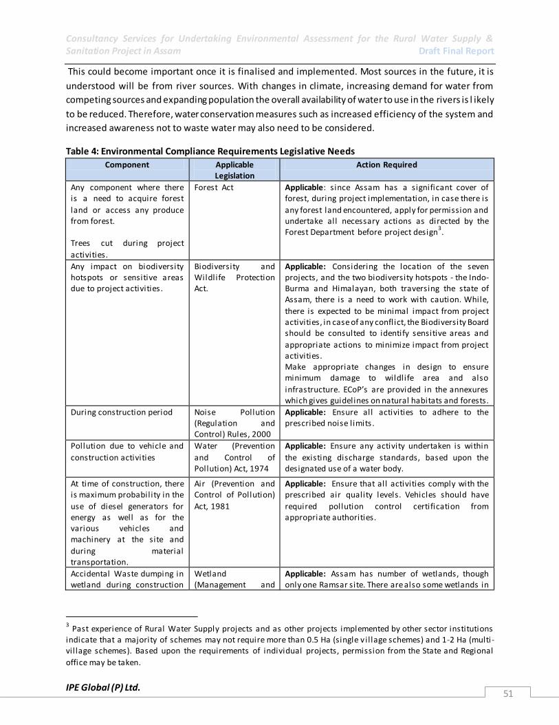
Consultancy Services for Undertaking Environmental Assessment for the Rural Water Supply & Sanitation Project in Assam Draft Final Report
IPE Global (P) Ltd. 51
This could become important once it is finalised and implemented. Most sources in the future, it is
understood will be from river sources. With changes in climate, increasing demand for water from
competing sources and expanding population the overall availability of water to use in the rivers is l ikely
to be reduced. Therefore, water conservation measures such as increased efficiency of the system and
increased awareness not to waste water may also need to be considered.
Table 4: Environmental Compliance Requirements Legislative Needs
Component Applicable Legislation
Action Required
Any component where there is a need to acquire forest
land or access any produce from forest. Trees cut during project
activities.
Forest Act Applicable: since Assam has a significant cover of forest, during project implementation, in case there is
any forest land encountered, apply for permission and undertake all necessary actions as directed by the Forest Department before project design
3.
Any impact on biodiversity hotspots or sensitive areas due to project activities .
Biodiversity and Wildlife Protection Act.
Applicable: Considering the location of the seven projects, and the two biodiversity hotspots - the Indo-Burma and Himalayan, both traversing the state of Assam, there is a need to work with caution. While,
there is expected to be minimal impact from project activities, in case of any conflict, the Biodiversity Board should be consulted to identify sensitive areas and
appropriate actions to minimize impact from project activities. Make appropriate changes in design to ensure minimum damage to wildlife area and also
infrastructure. ECoP’s are provided in the annexures which gives guidelines on natural habitats and forests.
During construction period Noise Pollution (Regulation and Control) Rules, 2000
Applicable: Ensure all activities to adhere to the prescribed noise l imits .
Pollution due to vehicle and
construction activities
Water (Prevention
and Control of Pollution) Act, 1974
Applicable: Ensure any activity undertaken is within
the existing discharge standards, based upon the designated use of a water body.
At time of construction, there is maximum probability in the
use of diesel generators for energy as well as for the various vehicles and machinery at the site and
during material transportation.
Air (Prevention and Control of Pollution)
Act, 1981
Applicable: Ensure that all activities comply with the prescribed air quality levels. Vehicles should have
required pollution control certification from appropriate authorities.
Accidental Waste dumping in wetland during construction
Wetland (Management and
Applicable: Assam has number of wetlands, though only one Ramsar site. There are also some wetlands in
3 Past experience of Rural Water Supply projects and as other projects implemented by other sector institutions
indicate that a majority of schemes may not require more than 0.5 Ha (single v il lage schemes) and 1-2 Ha (multi -vil lage schemes). Based upon the requirements of individual projects, permission from the State and Regional
office may be taken.

Consultancy Services for Undertaking Environmental Assessment for the Rural Water Supply & Sanitation Project in Assam Draft Final Report
IPE Global (P) Ltd. 52
Component Applicable Legislation
Action Required
or in the O&M phase Conservation) Rules, 2010
the project districts. However, no protected wetland is within a five KM range of identified project areas
4.
Nonetheless, to ensure safety of all water bodies and
wetlands in the area, appropriate mechanisms, as identified in the EMF, will be adopted to protect them during the construction and O&M stages. This should
be addressed through the EMPs developed for all schemes.
2.3.2 The World Bank Safeguard Policies The growing awareness of policymakers, in both the developing and industrialized worlds, that
improving water and sanitation services is key to achieving broader poverty reduction goals has been
accompanied by calls for more concerted efforts and additional resources from all stakeholders,
including the World Bank Group. In this context, the Water Supply and Sanitation Sector Board has
elaborated a business strategy which identifies key areas on which the Bank should focus, strategic
priorities at the regional and sub-sectoral levels, and operational choices in terms of instruments, levels
of future World Bank assistance, and associated resource implications. The strategy is a document
intended to guide the Bank’s assistance to the water and sanitation sector over the FY 03-07 period.
Over the past three decades, World Bank assistance has incorporated many of the lessons in WSS
around the world, drawing on a combination of approaches in order to improve the affordability and
sustainability of water supply and sanitation services. These include: (i) incorporating community
preferences regarding service levels, delivery modalities, and management arrangements; (ii) building
local capacities to support communities in expressing their needs and managing services; and (iii)
broadening the scope for public-private partnerships in service delivery, to improve responsiveness to
users and operating efficiency. The lessons have influenced the nature of World Bank assistance for
WSS, for example in India, experience from several rural WSS projects is being brought to scale through
local government initiatives to expand service coverage by adopting the principles of community
development.
Based upon the discussions in the field possible implications of the World Bank’s safeguard policies are
summarised in Table 5 below. From the Environment Perspective the safeguards that may be relevant
for this project are (i) OP 4.01 Environmental Assessment, (ii) OP 4.04 Natural Habitats and (iii) OP 4.36
Forests.
The project is spread over seven different districts of Assam, which both has biodiversity hotspots and
also a very diverse and sensitive ecosystem, where human being coexist with the natural environment.
Although, the seven project areas identified in the seven districts do not encompass any reserve forest,
wetland or lakes, it is possible that planned RWSS systems – such as intakes and rising mains may be
near the identified as well as unidentified natural habitats. Therefore, it is important to fully understand
4 Based on the preliminary assessment of the schemes, there are no wetlands, lakes or any other significant natural
habitats found in the seven project areas (16 blocks) identified under the RWSS project. However, since Assam is endowed with number of natural habitats, including natural forests, wetlands and lakes, their protection are
mandatory if they are within 10 km radius and thus should be addressed in the EMP.

Consultancy Services for Undertaking Environmental Assessment for the Rural Water Supply & Sanitation Project in Assam Draft Final Report
IPE Global (P) Ltd. 53
the project coverage and analyse its impact on the existing natural systems and accordingly provide
appropriate environmental management measures. Under the project three Operations Policies (OPs) as
mentioned above, are important to be discussed to ensure they are not triggered or if triggered are
appropriately addressed.
Table 5: Summary of Environment Safeguard Requirements for the Project Safeguard No Safeguard Description Application of Safeguard to Project OP 4.01
(Environmental Assessment).
EA to be conducted for all projects that fall into
either World Bank Category A or Category B. Potential environmental consequences of projects identified early in project cycle.
EAs and mitigation plans required for projects with significant environmental impacts. EAs should include analysis of alternative designs and sites, or consideration of "no
option" Requires public participation and information disclosure before Board approval.
Triggered: The projects support the
preparation of RWSS infrastructure, some of which may have adverse environmental impacts.
The EMF will help identify these potential impacts, and propose practical ways of avoiding or mitigating them.
OP 4.04 (Natural Habitats)
The conservation of natural habitat is essential for long- term sustainable development. The Bank does not support projects that
involve significant conservation or degradation of critical natural habitats. Prohibits financing of projects involving "significant conversion of natural habitats
unless there are no feasible alternatives". Requires environmental cost benefit analysis. Requires EA with mitigation measures.
Triggered: Assam has number of natural habitats in the reserved, national forests, wetlands and lakes, etc. However, none of
the reserved forest or national parks, wetlands and lakes are fall ing within a ten km radius of the seven projects identified. Further, River itself is a big habitat for aquatic
l ife and care must be taken at the time of water intake to safeguard wild l ife, especially the endangered species. A negative l ist is
provided in the screening section to ensure exclusion of ecologically sensitive areas. Also, all changes in project design right from
the planning stage should identify any potential impacts of projects on natural habitats, reserves or protected areas, and to develop appropriate mitigation measures to
minimize or avoid damage, or compensate for it under EMP prepared for Category II projects.
OP 4.09 (Pest Management).
Projects financing operations, pests are controlled through IPM approaches, such as biological control, cultural practices, and the
development and use of crop varieti es resistant or tolerant to the pest. The Bank may Finance the purchase of pesticides when their use is
justified under an IPM approach. Supports environmentally sound pest management, including integrated pest management, but does not prohibit the use of
highly hazardous pesticides. Pest management is the borrower's responsibility in the context of
Not Triggered: This is unlikely to be triggered given that the project is a Rural Water Supply and Sanitation project.
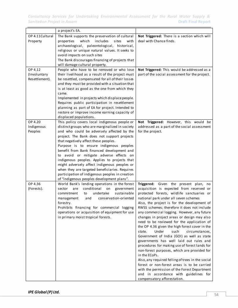
Consultancy Services for Undertaking Environmental Assessment for the Rural Water Supply & Sanitation Project in Assam Draft Final Report
IPE Global (P) Ltd. 54
a project's EA.
OP 4.11Cultural
Property
The Bank supports the preservation of cultural
properties which includes sites with archaeological, paleontological, historical, religious or unique natural values. It seeks to avoid impacts on such sites
The Bank discourages financing of projects that will damage cultural property.
Not Triggered: There is a section which will
deal with Chance finds.
OP 4.12 (Involuntary Resettlement).
People who have to be removed or who lose their l ivelihood as a result of the project must be resettled, compensated for all of their losses and they must be provided with a situation that
is at least as good as the one from which they came. Implemented in projects which displace people. Requires public participation in resettlement
planning as part of EA for project. Intended to restore or improve income earning capacity of displaced populations.
Not Triggered: This would be addressed as a part of the social assessment for the project.
OP 4.20 Indigenous Peoples
This policy covers local indigenous people or distinct groups who are marginalized in society and who could be adversely affected by the
project. The Bank does not support projects that negatively affect these peoples. Purpose is to ensure indigenous peoples
benefit from Bank financed development and to avoid or mitigate adverse effects on indigenous peoples. Applies to projects that might adversely affect indigenous peoples or
when they are targeted beneficiaries. Requires participation of indigenous peoples in creation of “indigenous peoples development plans”.
Not Triggered: However, this would be addressed as a part of the social assessment for the project.
OP 4.36 (Forests).
World Bank’s lending operations in the forest sector are conditional on government commitment to undertake sustainable
management and conservation-oriented forestry. Prohibits financing for commercial logging operations or acquisition of equipment for use
in primary moist tropical forests.
Triggered: Given the present plan, no acquisition is expected from reserved or protected forests, wildlife sanctuaries or
national park under all seven schemes Also, the project is for the development of RWSS schemes; therefore it does not include any commercial logging. However, any future
changes in project areas or design may also need to be reviewed for the application of the OP 4.36 given the high forest cover in the
state. Under such circumstances, Government of India (GOI) as well as state governments has well laid out rules and procedures for making use of forest lands for
non-forest purposes, which are provided for in the ECoPs. Also, any required fell ing of trees in the social
forest or non-forest areas is to be carried with the permission of the Forest Department and in accordance with guidelines for compensatory afforestation.

Consultancy Services for Undertaking Environmental Assessment for the Rural Water Supply & Sanitation Project in Assam Draft Final Report
IPE Global (P) Ltd. 55
OP 4.37 (Safety
of Dams).
Bank financed new dams must be designed and
built under the supervision of competent professionals. Dams over 15 m in height are of concern particularly if there is a large flood handling requirement or the dam is in a zone of
high seismicity and /or where foundations and other design features are complex. The OP requires review by independent experts
throughout project cycle. Requires preparation of EA and detailed plans for construction and operation, and periodic inspection by the Bank.
Not Triggered: No dams are planned as a part
of the project.
OP 7.50 (Projects in International
Waterways).
If a project has the potential to negatively affect the quality or quantity of water of a waterway shared with other nations the Bank
will need a negotiated agreement be established between riparian nations involved. Covers riparian waterways that form boundary between two or more states and bays, gulfs,
straits or channels bordered by two or more states. Applies to dams, irrigation, flood control, navigation, water, sewage and industrial projects. Requires notification,
agreement between states, detailed maps, and feasibil ity surveys.
Not Triggered. In accordance with OP 7.50 (International Waterways) this is seen that the proposed project falls within the
exceptions to the notification requirement under Para 7(a)
5 of the Policy. The project
components in the context and relation to OP 7.50, will not adversely change the quality
and quantity of water, both upstream and downstream and will not be adversely affected by the water use of the riparian countries.
OP 7.60 Disputed areas
Applies to projects where there are territorial disputes present. Projects in disputed areas could affect relations between the country within which the project is being developed
and neighbouring countries. Disputes would be dealt with at the earliest opportunity. Allows Bank to proceed if governments agree
to go forward without prejudice to claims. Requires early identification of territorial disputes and descriptions in all Bank documentation.
Not Triggered: It is unlikely that any disputed area will be involved or impacted by the project.
2.4 State Sector Institutions
2.4.1 Environment
All environments related activities at the state level are largely divided between the Department of
Environment and Forests and the Assam Pollution Control Board. A broad outline of the role of these
departments is given below. Together these look at various aspects of environment for the State.
However, they are governed by the Regional Centre for the Ministry of Environment and Forests at
Shillong. Therefore any clearances and matters for guidance are referred to Shillong. This Regional
Centre has two divisions within it – the environment division and the forest division. The envi ronment
department is largely involved in monitoring activities, along with the SPCB based on directives it
5 According to para 7(a) of OP 7.50, the exception applies: “for any ongoing scheme, projects involving additions or
alterations that require rehabilitation, construction or other cha nges that in the judgement of the bank (a) will not adversely change the quality and quantity of water flows to the other riparian’s; and (b) will not be adversely
affected by the other riparian’s possible water use”.

Consultancy Services for Undertaking Environmental Assessment for the Rural Water Supply & Sanitation Project in Assam Draft Final Report
IPE Global (P) Ltd. 56
receives from the Central office. The forest division is in-charge of giving sanctions for forest clearances
of up to 5 ha; and inspecting and processing clearances of areas between 5 and 40 ha before forwarding
them to the Ministry in Delhi for further action. For areas between 40 and 100 ha the Central Ministry
directly deals in the matters and for areas larger than 100 ha the Regional Office is supposed to provide
its report before any clearance can be sanctioned.
2.4.1.1 Department of Environment and Forests
The mission of the Department of Environment and Forests, Assam is to protect and improve the
environment, to safeguard the forests and wildlife of the State, to preserve and add new dimensions to
the state’s culture, and to protect and improve the natural environment including forests, lakes, rivers
and wildlife. The Department also works towards creating income generation activities though forestry
in the state. The main functions and duties of the department are,
• To act as the Head Quarter of the Forest Department, Government of Assam; • To coordinates with the state Government and Government of India and also with different
agencies on matter related to Forest and wildlife of the state; • To suggest Government on policy matters relating to Forest and environment;
• To oversee the management of Forest and wildlife of the state of Assam.
Government of India (GOI) as well as State Government has well laid out rules and procedures for
making use of forest lands for non-forest purposes. Key principle underpinning the land transactions are:
i. Before awarding any work, an application will be made to the concerned Divisional Forest Officer (DFO) requesting lands specifying location and area required as well as purpose for which it will be
used.
ii. DFO will examine and recommends to the state government which has powers to accord approval for
lands up to five hectare and area beyond needs approval by GOI.
2.4.1.2 Assam Pollution Control Board
State Pollution Control Board, Assam is an autonomous statutory organization constituted to protecting
the environment and preventing and controlling the pollution of water and air in Assam. The SPCB
mainly regulates pollution control, advices the State Government on pollution related matters, inspects
trade effluents and sewage treatment plant discharges, collects water cess, research and lays down
standards for emission and effluent discharge. The major activities of the department are given below.
• Undertake comprehensive programme on water, air, land and other type of pollution and their control and management
• Advice and liaison with the State Government on any matter concerning environmental pollution.
• Collect and disseminate data and information and prepare reports on pollution and environmental problems
• Undertake investigation and research on pollution and environmental problems. • Collaborate with the programmes of the Central Pollution Control Board, Ministry of
Environment and Forests, State Government, NGOs and other organizations relating to pollution control and environment and organise Mass Education Programmes.
• Issue No Objection Certificates and consents to industries and other development projects.

Consultancy Services for Undertaking Environmental Assessment for the Rural Water Supply & Sanitation Project in Assam Draft Final Report
IPE Global (P) Ltd. 57
• Inspect sewage, trade effluent sites, industries, various industrial, plants and sewage treatment plants.
• Monitor industrial/trade effluents, water bodies, air and soil, and laboratory analysis. • Develop or modify effluent and emission standards. • Evolve economical and reliable methods of treatment of sewage and effluent. • Establish or recognize laboratories to perform functions under the Acts and Rules. • Assess and collect water cess. • Undertake environmental education for public, students and others, and publish mass-
education material. • Advise State Government on location of industries, etc.
• Enforce the provisions of pollution control and other rules and monitor implementation.
2.4.2 Rural Water Supply and Sanitation
2.4.2.1 Assam Public Health Engineering Department
Assam Public Health Engineering Department (APHED) is the nodal State Government's department for
the water supply and sanitation programmes for the rural areas of Assam.
Mission
• To enhance quality of life of the people by
• ensuring sustainable safe water and sanitation facilities and services
• promoting hygiene practices
Vision
• A clean and healthy Assam with
• safe water supply
• adequate sanitation facilities and
• best hygiene practices There are a number of different water supply schemes that have been implemented by the PHED under
schemes like the NRDWP, State Plan, SCCP. These schemes include,
• PWSS for larger population and where water needs extensive treatment
• Spot Sources (SHP, THP, India M-II / M-III, RW) for smaller and scattered population with
appropriate treatment
• Rainwater Harvesting schemes
Under the National Rural Water Supply Programme (NRWSP), APHED Department provides 40 litres per
capita per day (lpcd) for rural population to meet their following requirements. Table 6: National Rural Water Supply Programme norms for per capita per day
Purpose Quantity (LPCD)
Drinking 3
Cooking 5
Bathing 15
Washing utensils & house 7
Ablution 10
*Note: In addition, provision of 30 lpcd for animals in hot and cold desert/ecosystems in 227
blocks of 36 DDP districts are to be allowed.

Consultancy Services for Undertaking Environmental Assessment for the Rural Water Supply & Sanitation Project in Assam Draft Final Report
IPE Global (P) Ltd. 58
The checklist for selection of blocks/villages/habitations followed by PHED in establishment of the new
water supply and sanitations schemes has primarily three criteria’s:
1. Habitation with less than 250 persons having no potable source of drinking water should be provided
with atleast one handpump/standpost6.
2. A rural habitation not having any safe water source with a permanently settled population of 20
households or 100 persons, whichever is more, may be taken as the unit for coverage with funds under
the NRWSP. However, the State Government could cover any habitation regardless of its
size/population/number of households with funds under the State Plan.
3. SC/ST habitations with less than 100 persons can, however, be covered under the NRWSP.
Table 7: Checklist issued by GoI and DDWS on Sajal Gram Puruskar
S.No Criteria Marks/Weightage 1 Availability of safe and adequate drinking water (40 lpcd)
on equitable and sustainable basis catering to all sections of the society during the last 3 years.
Total = 40 marks; Sustainability through surface water or ground water recharge = 25 marks. Sustainability through roof-water harvesting = 15 marks.
2 Absence of water borne and water-based diseases during the last 3 years
10
3 Community initiative in water harvesting/ recharge and budgeting for water, understanding the availability scenario during different months including revival of traditional ponds.
10
4 Sanitary protection of all drinking water sources and catchments
5
5 Monitoring the water levels for quantity and checking water quality through field test kits and district laboratories
5
6 Use of new and renewable energy sources and/or non-utilization of electricity power
5
7 Recovering atleast 50% cost of O&M either through structured tariff plan and proper utilization of 12th. Finance Commission/ GP funds for taking up 100% O&M
10 Through TFC = 5 Marks Through any tariff plan = 5 marks
8 Convergence of water conservation issues with activity of other departments for drought proofing measures (NREGA, DPAP, MOWR, MoA, MoEF, etc.)
5
9 Achieving “Nirmal Gram Puraskar” for environmentally safe sanitation status (This is compulsory to become eligible for Sajal Gram Puraskar
10
Total 100
*Note: In order to qualify for the Puraskar, the Gram/Block/ District Panchayat should obtain at least 75
marks out of 100 as tabulated above.
6 Based on NRWSP Norms, one handpump or standpost with normal output of 12 litres per minute is estimated for
every 250 persons.

Consultancy Services for Undertaking Environmental Assessment for the Rural Water Supply & Sanitation Project in Assam Draft Final Report
IPE Global (P) Ltd. 59
2.4.3 Other Relevant Departments
2.4.3.1 Central Ground Water Board
Central Ground Water Authority has been constituted under Section 3 (3) of the Environment
(Protection) Act, 1986 to regulate and control development and management of ground water resources
in the country. A Unit Office of CGWB is established at Guwahati. Its activities are as follows Exploration Drilling Ground water Management Studies Ground water level monitoring Artificial Recharge Studies Estimation of Ground water Resources Short term water supply investigations Photo geology & Remote Sensing Surface Geophysical Surveys Rajiv Gandhi Technology Mission Programme
2.4.3.2 Department of Water Resources
The main purpose of the Department is to formulate State water policy fixing of water rates and
integrated Irrigation Bill and also an Integrated Water resources Development pl an for Assam
for irrigation, drinking water and electricity
Maintenance of the completed projects, prepare Irrigation projects and execute them in time
within the prevailing rules and regulations for the benefit of the people of the State. The
Department is having plan schemes and Non-plan schemes. Plan schemes are either centrally
sponsored or externally aided schemes.
The Water Resources Department is the agency that investigates, designs, constructs, operates
and maintains, minor, medium and major Irrigation Projects, Flood control works on river banks,
coastal protection works, inland navigation, hydrological information system collection, drainage
works, salinity extrusion and land reclamation works, engineering research, coastal, engineering,
field studies etc., based on suitable budget provisions
Major Activities
Conducting Investigation of projects and prepare project reports for implementation for the
benefit of the people.
Implementation of the Irrigation projects after investigation.
Operation and maintenance of the projects for the sustainable development through Project
Advisory Committees of each project.
Make the Irrigation system reliable, predictable and equitable involving users, planners and
policy makers.
Conducting sedimentation surveys in reservoirs and water resources surveys to monitor river
water quality.
Monitoring and Evaluation of the Irrigation Projects using remote Sensing Technique.

Consultancy Services for Undertaking Environmental Assessment for the Rural Water Supply & Sanitation Project in Assam Draft Final Report
IPE Global (P) Ltd. 60
Conducting Model studies for Reservoirs, dams, Spillways etc., and also soil surveys for
investigation of projects and coastal Engineering, Field Studies.
To disseminate knowledge about the availability of water and its utilization to the general
public.
To assist other departments and the general public in preparing water utilization projects .
2.4.4 Nodal Institutions
At the National and State level both UNICEF and IIT-Guwahati are involved in strengthening health and
hygiene especially of children through awareness programme and education. Some of the other i ssues
handled by these agencies are Water Quality, Sanitation, Health and Hygiene. These two institutions
work closely with the State Government, civil society, media and communities . UNICEF also works
actively with children and young people, to ensure children’s rights and wellbeing. UNICEF supports
efforts of Health workers in Assam to better manage pregnancies and deliveries and assist in effectively
handling neonatal and childhood illnesses. Special efforts are being made to reach out to those who are
most isolated and excluded, particularly communities on the vast Brahmaputra River and families
working in tea plantations. Subsequently, providing better access to clean drinking water and sanitation
through the promotion of sanitary toilets and water security is another key area of UNICEF’s work.
Further, Upgrading primary school infrastructure such as toilets and water supply are also key thrust
areas. UNICEF is facilitating the state government to implement the Total Sanitation Campaign to
promote rural and school sanitation and also support an action plan for fluoride mitigation in two
districts. Kamrup district was the first one to receive the benefits of a district-wide School Sanitation and
Health (SSHE) initiative that started in 1999 and was co-sponsored by the Government of Assam and
UNICEF. 748 schools in the district have completed the program and 1,154 schools are currently in their
final stages, since the program began. As part of disaster preparedness, UNICEF organised training of
public health engineers and key representatives of major NGOs in the state on “Disaster Preparedness
on Public Health”. The State Government has developed a proposal for “Vulnerability Mapping for the
state” with UNICEF support. The Vulnerability Mapping exercise will generate a disaster preparedness
database.
IIT Guwahati on the other hand provides technical and academic support to the PHED, Government of
Assam and UNICEF on Water Quality, Suitable designs for sustainable toilets, waste management
practices, etc.
2.4.5 Implementing Departments
PHED is the implementing department for all the schemes under RWSS-LIS. The Public Heath
Engineering Dept. (PHED) was created in 1956 as public Health Engineering Organization under the
Directorate of Health services to look after the implementation of rural and urban water supply. The
dept. starts functioning as major department since 1981 and separate secretariat was created for Public
Health Engineering Department in the year 1989. The main activities of the department are:
1. Water Supply (Both rural and urban)
2. Sanitation
3. Water quality testing and monitoring.
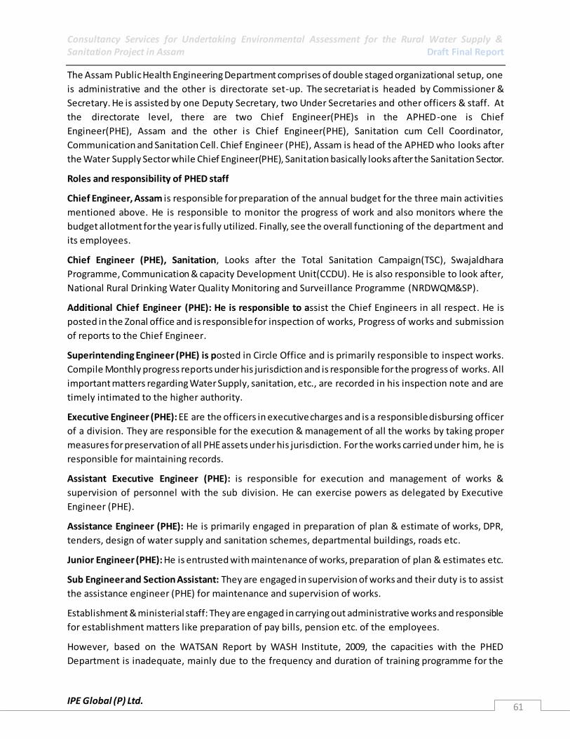
Consultancy Services for Undertaking Environmental Assessment for the Rural Water Supply & Sanitation Project in Assam Draft Final Report
IPE Global (P) Ltd. 61
The Assam Public Health Engineering Department comprises of double staged organizational setup, one
is administrative and the other is directorate set-up. The secretariat is headed by Commissioner &
Secretary. He is assisted by one Deputy Secretary, two Under Secretaries and other officers & staff. At
the directorate level, there are two Chief Engineer(PHE)s in the APHED-one is Chief
Engineer(PHE), Assam and the other is Chief Engineer(PHE), Sanitation cum Cell Coordinator,
Communication and Sanitation Cell. Chief Engineer (PHE), Assam is head of the APHED who looks after
the Water Supply Sector while Chief Engineer(PHE), Sanitation basically looks after the Sanitation Sector.
Roles and responsibility of PHED staff
Chief Engineer, Assam is responsible for preparation of the annual budget for the three main activities
mentioned above. He is responsible to monitor the progress of work and also monitors where the
budget allotment for the year is fully utilized. Finally, see the overall functioning of the department and
its employees.
Chief Engineer (PHE), Sanitation, Looks after the Total Sanitation Campaign(TSC), Swajaldhara
Programme, Communication & capacity Development Unit(CCDU). He is also responsible to look after,
National Rural Drinking Water Quality Monitoring and Surveillance Programme (NRDWQM&SP).
Additional Chief Engineer (PHE): He is responsible to assist the Chief Engineers in all respect. He is
posted in the Zonal office and is responsible for inspection of works, Progress of works and submission
of reports to the Chief Engineer.
Superintending Engineer (PHE) is posted in Circle Office and is primarily responsible to inspect works.
Compile Monthly progress reports under his jurisdiction and is responsible for the progress of works. All
important matters regarding Water Supply, sanitation, etc., are recorded in his inspection note and are
timely intimated to the higher authority.
Executive Engineer (PHE): EE are the officers in executive charges and is a responsible disbursing officer
of a division. They are responsible for the execution & management of all the works by taking proper
measures for preservation of all PHE assets under his jurisdiction. For the works carried under him, he is
responsible for maintaining records.
Assistant Executive Engineer (PHE): is responsible for execution and management of works &
supervision of personnel with the sub division. He can exercise powers as delegated by Executive
Engineer (PHE).
Assistance Engineer (PHE): He is primarily engaged in preparation of plan & estimate of works, DPR,
tenders, design of water supply and sanitation schemes, departmental buildings, roads etc.
Junior Engineer (PHE): He is entrusted with maintenance of works, preparation of plan & estimates etc.
Sub Engineer and Section Assistant: They are engaged in supervision of works and their duty is to assist
the assistance engineer (PHE) for maintenance and supervision of works.
Establishment & ministerial staff: They are engaged in carrying out administrative works and responsible
for establishment matters like preparation of pay bills, pension etc. of the employees.
However, based on the WATSAN Report by WASH Institute, 2009, the capacities with the PHED
Department is inadequate, mainly due to the frequency and duration of training programme for the

Consultancy Services for Undertaking Environmental Assessment for the Rural Water Supply & Sanitation Project in Assam Draft Final Report
IPE Global (P) Ltd. 62
government employees being limited or sometimes unsatisfactory. In the absence of regular trainings
the Engineers do not have the appropriate skills to implement water supply and sanitation projects with
respect to environmental parameters and in co-ordination with the Gaon Panchayats, User Committee
and local people participation.
2.4.6 Converging Departments and Ministries NRHM,
Department of Health; MoEF,
MoA,
MoWR, Panchayat and Rural Development Department.
Forest;
Inland Waterways; Water resource;
Public Works Department;
National and State Highway Authority;
Central Ground Water Board.
2.4.7 RWSS Implementation Procedures
The 73rd Amendment to the Indian Constitution gives the responsibility of implementing rural water
supply and sanitation projects and programmes to the local governance system - the PRIs. At the
revenue village level this translates to the Gram Panchayat (GP), which is to provide RWSS services to
the local. In many villages of Assam Gram Panchayat Water and Sanitation Committees (GPWSCs) co-
exist with GPs, sometimes as sub-committees but many times independently with 10-50%
representation of women. GPWSCs are user groups of a particular RWSS service and they are meant to
maximize user involvement in all phases of a water and sanitation project. This has generated a debate
as to which is the most appropriate and sustainable institution at village -level for delivery of RWSS
services. In reality there is a complex relationship between these two village-level organizations and it
may not be an ‘either-or’ situation but rather a ‘both’ relationship.
2.4.8 Implementation Capacity
In WSS sector, the majority of manpower deployed at different levels across v arious types of
organizations is having purely technical skills i.e. majority of human resource hail from the technical
background having degrees or diplomas in Engineering, Agriculture specialists, Geologists/Hydro-
geologist, etc. And, it is mainly government institutions that employ such technical staff. Public Health
Engineering Department is acting as a nodal agency for Rural water Supply and Sanitation in Assam.
There are also a various non-government players and they are the ones which engage a combination of
engineering an non- engineering professionals and work in the RWSS. The major donors include the
World Bank, ADB, JICA/ There are also a number of NGOs/CBOs and other agencies too supporting the
implementation of RWSS in the state. These agencies provide technical, strategic, consultancy inputs
and financial assistance to the programmes/schemes to the WSS sector in India.

Consultancy Services for Undertaking Environmental Assessment for the Rural Water Supply & Sanitation Project in Assam Draft Final Report
IPE Global (P) Ltd. 63
Table 8: Institutional Structure and Technical manpower
Agency Name
Institutional Structure and Key Stakeholders
Role & Responsibility Their number and existing capacities
PHED, Assam State Level
The Commissioner (PHED)’ is the administrative head of PHED providing all
administrative support while ‘The Chief Engineer’ is the executive and technical head. Thus, at the state level, Chief
Engineer is assisted by Additional Chief Engineer, Surveyor of Works, Engineering
Officer looking after Administrative matters, Accounts Officer who is in charge of the accounts. The
additional chief engineer at the Zonal level, Superintendent Engineer at the circle level and at the division/ district level,
there is Executive Engineer while at the sub-divisional/ Block level there is Junior
Engineer who is in turn supported by
The group of engineers in PHED are responsible for project sanctionings, fund mobilisation, etc.. They are also
responsible for maintenance thereof for providing drinking water to rural population of the state. PHED also collaborates with other agencies for
creating public awareness on public and personal hygiene. Role – State release of funds,
technical support, and development of State Action Plan, Inter-sectoral coordination with concerned departments, Training and capacity
building.
Chief Engineer (PHE), Assam Guwahati; Chief Engineer (PHE),
Sanitation, Assam; Additional Chief Engineer (PHE) (HQ) -2 No.
SE (PHE) (HQ) - 3 Nos. EE (PHE) (HQ) - 9 Nos;
PHED, Assam District Level
District Executive Engineer, Assistance Executive Engineers, Junior Engineer, and Field
Officer
Apart from support to the state level project planning, the district PHED Engineers also performs activities
l ike dril l ing tube wells, constructing, laying of pipelines, distribution network for providing safe drinking water and proper sanitary
conditions, conserving water resources, etc., with the help og SULC and GPWSC.
EE (PHE) District : 9 Nos;
PHED, Assam
Block Level
Assistant Engineer and other
workers such as supervisors, surveyors, etc. at the grass-root level.
Support District and State PHED in
project planning and implementation by identifying the gaps in demand and supply of WSS. They are
responsible for grass root planning and mobilisation,
Around 4 AEE per
district at Block level.

Consultancy Services for Undertaking Environmental Assessment for the Rural Water Supply & Sanitation Project in Assam Draft Final Report
IPE Global (P) Ltd. 64
Agency Name
Institutional Structure and Key Stakeholders
Role & Responsibility Their number and existing capacities
Gram/Gaon Panchayat –
Gaon Panchyat Water and
Sanitation Committee (GPWSC)
The most recent Assam Panchayat Act came into effect from 1994. A three-tier system
with Zil la Parishad has been introduced – Gaon Panchayat, Anchalik Panchayat and Zil la
Parishad. Presently Gaon Panchayats are having share in land revenue,
local rates, revenue earned from the settlement of HJAT, fisheries, House taxes, fines, penalties etc.
Gaon Panchayats: i . President – directly elected
by people.
ii . One Vice President – to be elected from among the members of Gaon Panchayat.
iii . Ten members – directly elected by people.
(GPs) are mainly responsible for seeking project assistance, constituting a GP level GPWSC
representing the user communities and empowering the GPWSCs to take responsibil ity for program
implementation on their behalf. At present, the GPWSC are only looking at the sanitation sector (provision of Individual latrines) in
the vil lages. Role – Baseline survey & development of Action Plan, Inter sectoral coordination with concerned
departments, placement of staff with defined role and responsibil ity, Training & capacity building, overall
implementation, M&E. During the post-implementation phase, the GPs monitor the
sustainability of operations and ensure that the GPWSCs satisfactorily discharge their O&M
management function including levying and collecting user charges from the beneficiaries. For Multi -Vil lage schemes, GPs are responsible
for payment of bulk water charges to DWSS.
The State Government undertakes to
complete the training of all Elected Panchayat
Representatives within a period of 6 months of their election.
Scheme Level User Committees
– Commonly known as User Group
SLUC comprises of 10-20 member committee 9depending on the type of
scheme, such as for multi vil lage scheme the numbers are greater), they are elected by the vil lagers on consensus.
VWSSCs play a very important role in assessing the status of existing installations, prepare a
plan of operations, and compile a l ist of technological options. They are also instrumental in mobilizing funds for O&M
besides keeping a network with local mechanics and other manpower available.
In most districts the user committee functions on its own for water supply provisions with no help from GPs.
At the vil lage level the issues that are taken care by them primarily relate to operation and maintenance. SLUC
are also responsible for identifying and water quality issue and reporting it to the PHED officials. In some Districts l ike Kamrup, they even
collect the water samples and conduct the basic water quality testing.
Role – They collect monthly charges of around 40-50Rs from each household having individual
connection. Their main role include, the following: - Institution Building, Construction of the hardware facil ity,
Mobilization, Monitoring, Operations and Maintenance.
At the grass root level the challenge is more in terms of
operations and maintenance and its sustainability at the local level.
Responsibil ity in this context is poorly defined, although it
always includes O&M and only sometimes includes planning and implementation.

Consultancy Services for Undertaking Environmental Assessment for the Rural Water Supply & Sanitation Project in Assam Draft Final Report
IPE Global (P) Ltd. 65
Agency Name
Institutional Structure and Key Stakeholders
Role & Responsibility Their number and existing capacities
NGOs/ Independent bodies l ike
UNICEF
NGO: Hopeline ; ARCH; Environ etc.
Local NGOs play a critical role in networking among various type of stakeholders mobilizing the
manpower and helping the existing manpower of PHED/boards in their activities. NGO make valuable
contribution to the sector, which includes the capacity to: (i) reach the rural poor and remote areas, (i i) promote local participation; (i i i)
operate at low costs; and (iv) adapt and be innovative when needed.
Since, the PHED or Water boards have limitation in
recruiting the required number and range of manpower
at the community level they most often util ise the skil ls and manpower of local
NGO in making not only supply driven programmes successful but also
making demand driven programmes operational.
Government institutions like PHED is largely housed by engineers. Engineering graduates join PHE
departments and institutions as Assistant engineer/ Executive engineer at block/ district level .
2.5 Proposed World Bank Assisted Project
The PHED has identified nine project areas7 in seven districts of Assam, Kamrup, Sibsagar, Jorhat,
Sonitpur, Morigaon, Bongaigaon, Hailakandi. To be covered under the World Bank Assisted Rural Water
Supply and Sanitation project. A total 201 Gram panchyats identified, based on a demand driven
exercise and existing ground water quality will be supplied with surface water at 55 LPCD per household
from nineteen Blocks, spread across the above mentioned seven districts.
The main elements under the WB aided RWSS scheme will be,
Development of water sources: These may include both surface and groundwater sources, depending upon availability of good quality water, sustainability and other technical feasibility issues.
If no suitable surface source in areas where water is contaminated with arseni c, fluoride, iron or other similar elements shallow dug-wells, ring wells may be considered.
In areas of excess iron and no proper alternate sources a deep tube well with submersible will be used for water abstraction.
In case of shallow source use, individual or small scale water supply systems would also need to be considered. Where source is not a constraint multi -village schemes would be considered.
For surface water sources the intakes considered will include, either an i ntake- well or a floating barge fitted with a Centrifugal Pump is used to lift raw water.
Water treatment: Depending upon the quality of the sourced water treatment will considered. Typically this will consist of Pre-sedimentation, Aeration, Coagulation & Flocculation, Sedimentation, Filtration and then Disinfection.
7 PHED, recently has changed the number of project areas considered under the World Bank funded RWSS project
to seven in seven districts of Assam.
Consultancy Services for Undertaking Environmental Assessment for the Rural Water Supply & Sanitation Project in Assam Draft Final Report
IPE Global (P) Ltd. 66
If the best available source is contaminated with iron beyond BSI permissible limits, the treatment process is likely to be a combination of - Aeration, Filtration and then Disinfection.
Water distributed will be at a minimum terminal head of 5.0metre and a residual chlorine content of 0.2mgl.
The project will also consider upgrading of existing schemes, where practicable.
Costs will be shared in all projects, where the community is expected to pay part of the expenses. Upon
implement of the schemes they will be handed over to the PRIs for the day to day management of the
system
It is planned that the water source for all large multi village schemes shall be from surface sources and
perennial rivers. The project will ensure 100% household connections and me metering for collection of
water charges. Bulk water meters will also be installed at village entry points for all schemes. Water
supply is planned to be 24X7. In case of peri-urban areas, multi storied apartments will have shared
connections with bulk meters.
All customers covered under this scheme will be charged a connection charge. The connection charge is
likely to be INR 2700. This connection charge is to include cost of meters, ferrule, saddle, 10 to 15 m.
pipe length. A higher tariff shall be levied for commercial and institutional connection.
The material used for the rising main will be ductile pipes and the transmission network will use the
Ductile and Galvanized Iron (DI and GI) pipes along with PVC high density pipelines. The implementation
of the project will be in a phased manner, where batch one will be covering three schemes. These
schemes are as follows:
1. Chandrapur and Dimora block of Kamrup district
2. Jorhat, Jorhat Central and Jorhat North West blocks of Jorhat district, and
3. Hailakandi and Algapur blocks of Hailakandi district.
This will be a total of 7 development blocks and 60 Gram Panchayats (GPs), which include 407 villages
consisting of 1962 habitations. The first phase will benefit a total population of 36352 people. However,
a total of 16 blocks will covered under this World Bank funded project in three batches. Under the seven
identified blocks a total of 5041 habitations and 1306133 people will be covered.
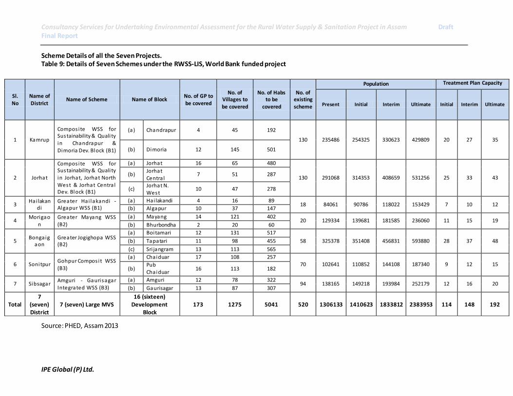
Consultancy Services for Undertaking Environmental Assessment for the Rural Water Supply & Sanitation Project in Assam Draft Final Report
IPE Global (P) Ltd.
Scheme Details of all the Seven Projects. Table 9: Details of Seven Schemes under the RWSS-LIS, World Bank funded project
Source: PHED, Assam 2013
Sl. No
Name of District
Name of Scheme Name of Block No. of GP to be covered
No. of Villages to be covered
No. of Habs to be
covered
No. of existing scheme
Population Treatment Plan Capacity
Present Initial Interim Ultimate Initial Interim Ultimate
1 Kamrup
Compos ite WSS for Sustainability & Quali ty in Chandrapur &
Dimoria Dev. Block (B1)
(a) Chandrapur 4 45 192
130 235486 254325 330623 429809 20 27 35
(b) Dimoria 12 145 501
2 Jorhat
Compos ite WSS for Sustainability & Quali ty
in Jorhat, Jorhat North West & Jorhat Centra l Dev. Block (B1)
(a) Jorhat 16 65 480
130 291068 314353 408659 531256 25 33 43 (b)
Jorhat
Centra l 7 51 287
(c) Jorhat N.
West 10 47 278
3 Hai lakan
di Greater Hai lakandi - Algapur WSS (B1)
(a) Hai lakandi 4 16 89 18 84061 90786 118022 153429 7 10 12
(b) Algapur 10 37 147
4 Morigao
n Greater Mayang WSS (B2)
(a) Mayang 14 121 402 20 129334 139681 181585 236060 11 15 19
(b) Bhurbondha 2 20 60
5 Bongaig
aon Greater Jogighopa WSS (B2)
(a) Boitamari 12 131 517
58 325378 351408 456831 593880 28 37 48 (b) Tapatari 11 98 455
(c) Sri jangram 13 113 565
6 Sonitpur Gohpur Compos it WSS
(B3)
(a) Chaiduar 17 108 257 70 102641 110852 144108 187340 9 12 15
(b) Pub
Chaiduar 16 113 182
7 Sibsagar Amguri - Gaurisagar Integrated WSS (B3)
(a) Amguri 12 78 322 94 138165 149218 193984 252179 12 16 20
(b) Gaurisagar 13 87 307
Total 7
(seven) District
7 (seven) Large MVS 16 (sixteen)
Development Block
173 1275 5041 520 1306133 1410623 1833812 2383953 114 148 192
Consultancy Services for Undertaking Environmental Assessment for the Rural Water Supply & Sanitation Project in Assam Draft Final Report
IPE Global (P) Ltd. 68
3 BASELINE ENVIRONMENTAL STATUS
Assam is located in North East India with its capital in Dispur. The State has a large network of rivers and
water bodies which includes the Brahamaputra and Barak river system, both of which form a part of
international water systems. Assam is very rich in biodiversity and consists of tropical rainforests,
deciduous forests, riverine grasslands, bamboo, orchards and wetland ecosystems. Located in the
Eastern Himalayas, Assam is linked to the mainland by a flood and cyclone prone narrow corridor,
known as the Siliguri Corridor or Chicken's Neck.
3.1 Brief profile of State
Geographically, the State can be divided into three distinctive zones; the Brahmaputra valley, the Barak
Valley and the Barail range and Karbi Plateau. The Brahmaputra or Assam valley is comparatively narrow
and long with River Brahmaputra flowing from east to west. It flows for a length of about 700 km within
the State. The Barak Valley comprises of River Barak and its tributaries and is located in southern Assam.
The Barail range and Karbi Plateau separate these two river systems.
Situated between 90-96 degrees East and 24-28 degrees North, Assam is bordered in the North and East
by the Kingdom of Bhutan and Arunachal Pradesh. Along the south, lie Nagaland, Manipur and Mizoram.
Meghalaya lies to the South-West, Bengal and Bangladesh to the west.
The population of Assam according to the 2011 census is 31.17 million people. There are a total
5.91 million households8. Approximately 87% of the population is rural.
3.2 Administration
Assam has 27 administrative districts. These districts are further sub divided into 49 sub-divisions,
Mohkuma Parishads9. All districts are administered by the Deputy Commissioner, District Magistrate,
Office of the District Panchayat and usually with a district court. Districts are mainly delineated on the
basis of physical features like rivers, hills and forests.
The local governance system is organised under the District Panchayat for a district, Panchayat for group
of or individual rural areas and under the urban local bodies for the towns and cities. There are a total of
2489 Gaon/Gram Panchayats and 26247 villages in Assam. In urban areas there are town committees or
nagar somiti for small towns, municipal boards or pouro sobha for medium towns and municipal
corporations or pouro nigom for the cities.
For the revenue purposes, the districts are divided into revenue circles and mouzas. Districts are divided
into 219 development blocks for development projects, and police stations or thanas for law and order.
There are 206 police thanas in Assam.
8 2011 Census of India.
9 “Mohkuma Parishad” means a Mohkuma Parishad established under the Assam Panchayat Act, 1959. (Assam Act XXIV of 1959). They are equivalent to Sub Divisions, which comprises of few blocks, i .e. a district is divided into
subdivisions or Mohkuma in the case of Assam which are further divided into Blocks.
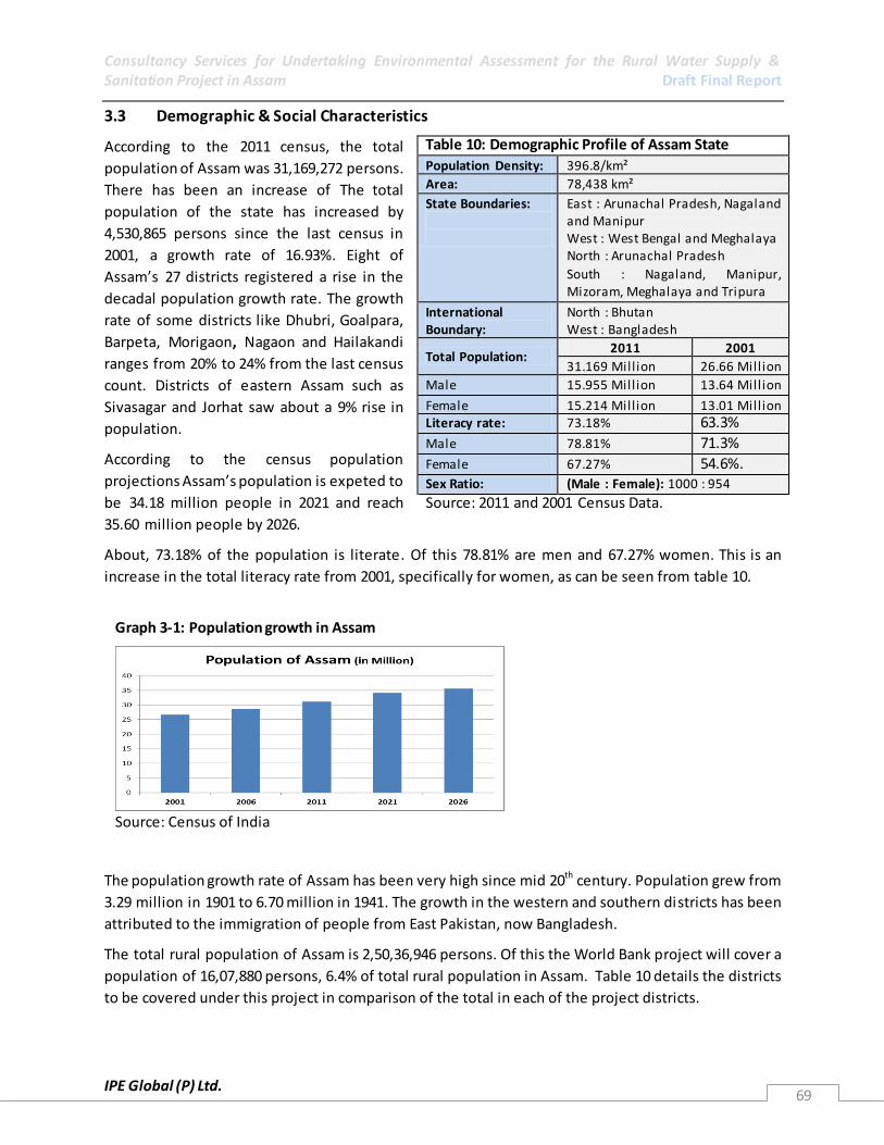
Consultancy Services for Undertaking Environmental Assessment for the Rural Water Supply & Sanitation Project in Assam Draft Final Report
IPE Global (P) Ltd. 69
3.3 Demographic & Social Characteristics
According to the 2011 census, the total
population of Assam was 31,169,272 persons.
There has been an increase of The total
population of the state has increased by
4,530,865 persons since the last census in
2001, a growth rate of 16.93%. Eight of
Assam’s 27 districts registered a rise in the
decadal population growth rate. The growth
rate of some districts like Dhubri, Goalpara,
Barpeta, Morigaon, Nagaon and Hailakandi
ranges from 20% to 24% from the last census
count. Districts of eastern Assam such as
Sivasagar and Jorhat saw about a 9% rise in
population.
According to the census population
projections Assam’s population is expeted to
be 34.18 million people in 2021 and reach
35.60 million people by 2026.
About, 73.18% of the population is literate. Of this 78.81% are men and 67.27% women. This is an
increase in the total literacy rate from 2001, specifically for women, as can be seen from table 10.
The population growth rate of Assam has been very high since mid 20th century. Population grew from
3.29 million in 1901 to 6.70 million in 1941. The growth in the western and southern districts has been
attributed to the immigration of people from East Pakistan, now Bangladesh.
The total rural population of Assam is 2,50,36,946 persons. Of this the World Bank project will cover a
population of 16,07,880 persons, 6.4% of total rural population in Assam. Table 10 details the districts
to be covered under this project in comparison of the total in each of the project districts.
Table 10: Demographic Profile of Assam State
Population Density: 396.8/km²
Area: 78,438 km²
State Boundaries:
East : Arunachal Pradesh, Nagaland and Manipur West : West Bengal and Meghalaya North : Arunachal Pradesh
South : Nagaland, Manipur, Mizoram, Meghalaya and Tripura
International Boundary:
North : Bhutan West : Bangladesh
Total Population: 2011 2001
31.169 Mill ion 26.66 Mill ion
Male 15.955 Mill ion 13.64 Mill ion
Female 15.214 Mill ion 13.01 Mill ion Literacy rate: 73.18% 63.3%
Male 78.81% 71.3%
Female 67.27% 54.6%. Sex Ratio: (Male : Female): 1000 : 954
Source: 2011 and 2001 Census Data.
Graph 3-1: Population growth in Assam
Source: Census of India
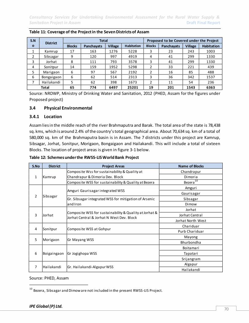
Consultancy Services for Undertaking Environmental Assessment for the Rural Water Supply & Sanitation Project in Assam Draft Final Report
IPE Global (P) Ltd. 70
Table 11: Coverage of the Project in the Seven Districts of Assam
S.No
District Total Proposed to be Covered under the Project
Blocks Panchayats Village Habitation Blocks Panchayats Village Habitation
1 Kamrup 17 163 1276 5228 3 23 243 1003
2 Sibsagar 9 120 997 4919 4 41 299 1330
3 Jorhat 8 111 793 3578 3 41 299 1330
4 Sonitpur 14 159 1952 5298 2 33 221 439
5 Marigaon 6 97 567 2192 2 16 85 488 6 Bongaigaon 6 62 514 2313 3 36 342 1537
7 Hailakandi 5 62 398 1673 2 11 54 236
Total 65 774 6497 25201 19 201 1543 6363
Source: NRDWP, Ministry of Drinking Water and Sanitation, 2012 (PHED, Assam for the figures under
Proposed project)
3.4 Physical Environmental
3.4.1 Location
Assam lies in the middle reach of the river Brahmaputra and Barak. The total area of the state is 78,438
sq. kms, which is around 2.4% of the country’s total geographical area. About 70,634 sq. km of a total of
580,000 sq. km of the Brahmaputra basin is in Assam. The 7 districts under this project are Kamrup,
Sibsagar, Jorhat, Sonitpur, Morigaon, Bongaigaon and Hailakandi. This will include a total of sixteen
Blocks. The location of project areas is given in figure 3-1 below.
Table 12: Schemes under the RWSS-LIS World Bank Project
S.No District Project Areas Name of Blocks
1 Kamrup
Composite Wss for sustainability & Quality at
Chandrapur & Dimoria Dev. Block
Chandrapur
Dimoria
Composite WSS for sustainability & Quality at Bezera Bezera10
2 Sibsagar
Amguri Gaurisagar integrated WSS Amguri
Gaurisagar
Gr. Sibsagar integrated WSS for mitigation of Arsenic
and Iron
Sibsagar
Dimow
3 Jorhat Composite WSS for sustainability & Quality at Jorhat & Jorhat Central & Jorhat N West Dev. Block
Jorhat
Jorhat Central
Jorhat North West
4 Sonitpur Composite WSS at Gohpur Chariduar
Purb Chariduar
5 Morigaon Gr Mayang WSS Mayong
Bhurbondha
6 Boigaingaon Gr Jogighopa WSS
Boitamari
Tapatari
Srijangram
7 Hailakandi Gr. Hailakandi-Algapur WSS Algapur
Hailakandi
Source: PHED, Assam
10
Bezera, Sibsagar and Dimow are not included in the present RWSS-LIS Project.

Consultancy Services for Undertaking Environmental Assessment for the Rural Water Supply & Sanitation Project in Assam Draft Final Report
IPE Global (P) Ltd. 71
Figure 3-1: Location of Project Areas in Assam
Base Map Source: Administrative boundary Map and Google Earth Satellite Map
The humidity that is brought into Assam by the southwest monsoons, shower an average annual rainfall
of 3050 mm or more on the Brahmaputra valley and the surrounding region. The monsoons are Assam's
lifeline; creating a biodiversity that can compete with the equatorial rainforests (State profile, 2009).
The Brahmaputra River flows through Assam from east to west over a length of approximately 650
kilometres. Its main branch originates in the Tibetan plateau, flowing from west to east as the River
Tsangpo, and then turns south through Arunachal Pradesh as River Siang to enter Assam, where it is
joined by other branches to form the Brahmaputra.
The Barak River rises in the Indian state of Nagaland at an elevation of approximately 2,300 mete rs and
passes through the Manipur Hills of Manipur state over a river length of nearly 400 kilometres. It then
flows generally westward from Lakhipur through the Cachar Plains region of Assam over a river length of
approximately 130 kilometres to enter Bangladesh near Bhanga (NHC, Background paper, 2006).
Other than Hailakandi, all project districts are located in the Brahmaputra plains. Hilakandi, is situated in
the plains of River Barak and is separated by the rest of the project districts by Barail range in the north.
Each flood season, the Brahmaputra and its tributaries forsake their earlier channels to cut new swathes
through the soil. As the water recedes, alluvial deposits remain in the river, giving rise to sandy islands.
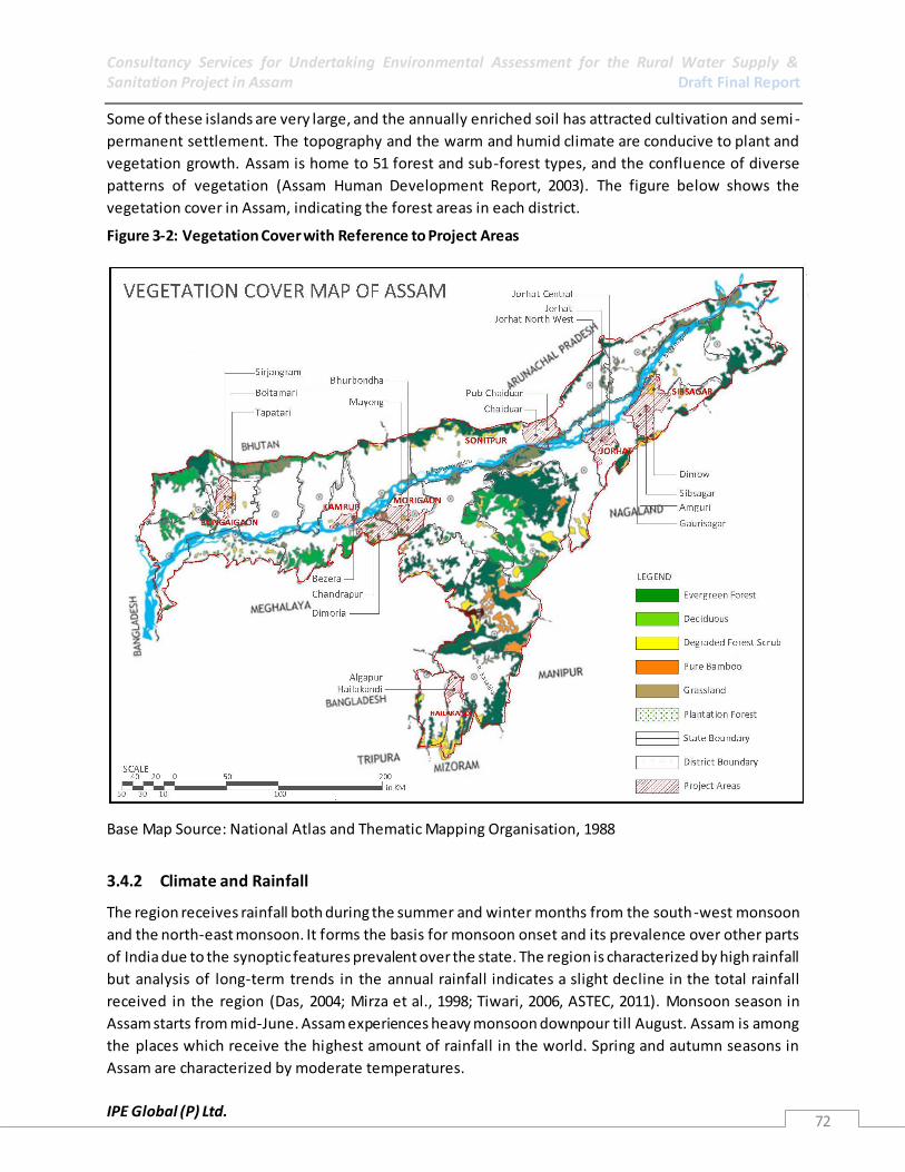
Consultancy Services for Undertaking Environmental Assessment for the Rural Water Supply & Sanitation Project in Assam Draft Final Report
IPE Global (P) Ltd. 72
Some of these islands are very large, and the annually enriched soil has attracted cultivation and semi -
permanent settlement. The topography and the warm and humid climate are conducive to plant and
vegetation growth. Assam is home to 51 forest and sub-forest types, and the confluence of diverse
patterns of vegetation (Assam Human Development Report, 2003). The figure below shows the
vegetation cover in Assam, indicating the forest areas in each district.
Figure 3-2: Vegetation Cover with Reference to Project Areas
Base Map Source: National Atlas and Thematic Mapping Organisation, 1988
3.4.2 Climate and Rainfall
The region receives rainfall both during the summer and winter months from the south-west monsoon
and the north-east monsoon. It forms the basis for monsoon onset and its prevalence over other parts
of India due to the synoptic features prevalent over the state. The region is characterized by high rainfall
but analysis of long-term trends in the annual rainfall indicates a slight decline in the total rainfall
received in the region (Das, 2004; Mirza et al., 1998; Tiwari, 2006, ASTEC, 2011). Monsoon season in
Assam starts from mid-June. Assam experiences heavy monsoon downpour till August. Assam is among
the places which receive the highest amount of rainfall in the world. Spring and autumn seasons in
Assam are characterized by moderate temperatures.

Consultancy Services for Undertaking Environmental Assessment for the Rural Water Supply & Sanitation Project in Assam Draft Final Report
IPE Global (P) Ltd. 73
The pre-monsoon and post-monsoon thundershowers are very dominant over this region due to
orography and the humidity available for convection. Kandalgaonkar et al 2005 in their study to address
the relationship between thunderstorm activity and rainfall over different homogeneous regions of India
also showed that over the North Eastern region the probability of association of thunderstorm wi th
rainfall is quite high when compared to other regions. Also months with high rainfall have been
observed to have more number of thunderstorms. Thunderstorms in post-monsoon season have been
observed to be with higher intensities than during the pre-monsoon season. There is a distinct monsoon
season in which a large part of the annual rainfall is concentrated. There are also two months of cyclonic
activity preceding the monsoon, and rainfall at other times of the year as well . The rainy season in
Assam lasts from May to October as indicated in the graph below.
Graph 3-2: Average Rainfall in the State of Assam
Source: Statistical Handbook of Assam, 2011 (for the year 2010)
Graph 3-3: Rainfall Pattern in the project Area during Monsoon Months from 1995-2000
(Source: Assam Gazetter, 2000)
3.4.3 Physiographic
The State of Assam can be divided into three main physiographic regions, which are as follows:
1. The vast alluvial plains of the Brahmaputra valley in the north, comprising the districts of
Goalpara, Kamrup, Darrang, Nagaon, Sibsagar, North Lakhimpur and Dibrugarh.
2. The Central Assam hills comprising Karbi Anglong and Dima Hasao (Earlier North Cachar Hills)
districts.

Consultancy Services for Undertaking Environmental Assessment for the Rural Water Supply & Sanitation Project in Assam Draft Final Report
IPE Global (P) Ltd. 74
3. The hilly and alluvial terrain in the south covering the Cachar district (Barak valley).
Ranging in average elevation from 50 to 120 m above mean sea level the Brahmaputra valley represents
a unique landscape about 800 km long and 130 km wide valley separated from the comparatively low
lying Barak valley in the south by the Mikir Hills and Barail range in the central part. Thus bounded by
the hill ranges in the north, east and south, Assam experiences the predominant influence of the south -
west tropical monsoon which reigns from April to October with occasional winter showers. The low
clouds of the southwest monsoon after being intercepted by the North Cachar range and Naga Patkai
range, cause heavy rainfall in the southern part of Assam including Hailakandi Districts and precipitate in
the Brahmaputra valley; their intensity increases towards the foothills of the Himalayas. The Map 3-3
shows the location of project areas on the Relief base map of Assam. All the nine project areas are
located in the plains of River Brahmaputra and R. Katakhal (Barak Valley). On the basis of the physical
relief, these areas are prone to high flood levels especially during monsoon months. The soil map will
further elaborate on how the flooding will affect water logging in these areas.
Figure 3-3: Relief of Assam with Respect to Project Areas
Base Map Source: National Atlas and Thematic Mapping Organisation, 1988

Consultancy Services for Undertaking Environmental Assessment for the Rural Water Supply & Sanitation Project in Assam Draft Final Report
IPE Global (P) Ltd. 75
3.4.4 Hydrology
The Brahmaputra River and the 33 major tributaries joining it in Assam, including the main trans-
Himalayan tributaries of Subansiri, Jia Bharali, and Manas, carry about 30% of the country’s total surface
water. Surface water bodies covering about 8,251 square kilometres account for 10.5% of the
geographical area of the state. Of these, the river systems, including waterlogged areas, occupy 6,503 Sq
Km (8.3% of the State). The annual surface water availability is more than 53 Million Hectare-Meters.
Brahmaputra valley in Assam has 3,513 wetlands, covering 1,012.3 km2. Groundwater is also plentiful at
shallow depth in the valley. Based on Central Ground Water Board Report, utilizable groundwater is
estimated to exceed 2 million hectare-meters (in 2001). The hydrological characteristics of the
Brahmaputra valley are dominated by the intensely powerful monsoon rainfall region of the eastern
Himalayas, the freeze–thaw cycle of Himalayan snow, and the immensely dynamic fluvial processes of
the river and its tributaries. It is also influenced by the unique characteristics of the physical terrain and
tectonic framework of the region.
3.4.5 Hydrogeology
According to Central Ground Water Board, Hydrogeology of the state can be divided into three units
namely consolidated formation, semi consolidated formation and unconsolidated formation. More than
75% of the state is underlain by unconsolidated formation comprising of clay, silt, sand, gravel, pebbl e
and boulders. The old alluvial belt11 is about 11 to 15 km wide; the tubewells yield 27 to 59 m3/hr in this
zone. The new or young alluvial zone12 follows immediately down slope of the old alluvial zone where
the yield of the wells ranges between 80-240 m3/hr. The flood plains follow the new alluvial soil in
Brahmaputra valley where the shallow tubewells yield between 20-50 m3/hr and deep tubewells
between 150-240 m3/hr. In the semi consolidated formations of Cachar district, the yield of the tubewell
ranges between 50 to 100 m3/hr. Most of the project area falls under the new alluvial Belt along the
flood plain of Brahmaputra River. (Source: http://cgwb.gov.in/gw_profiles/st_assam.htm).
3.4.6 Geomorphology
The state of Assam, which treasures geological formations of wide age range, and has undergone
diversified pedo-genesis depending upon the composition of the parent materials, paleo-geographical
conditions and climatic conditions to which it was subjected. Soil in the project area is either young
alluvial soil or Old Alluvial soil. In pub chariduar however, new alluvial soil is found in the northern part
of the block. Also, Chandrapur block, in Kamrup District is majorly covered by Red loamy Soil. The soil
groups can be broadly classified into the following soil types which are spatially indicated in the figure 3-
4.
Table 13: Type of soil in the seven district of the scheme
S.No District Major Type of Soil 1 Kamrup Young alluvial soil in Bezera and Red Loamy in Chandrapur and Dimoria
2 Bongaigaon Forest Alluvial Soil in the north along with Red Loamy and Young Alluvial in the other parts
11
Old Alluvial Belt is adjoining to the foothills of the Himalayas and comprises of boulders and pebbles which have been carried down by the river streams. The streams flow underground due to high porosity and have narrow width ranging from 7 to 15 km. 12
New/young Alluvial Belt is found adjoining the old alluvial Belt.
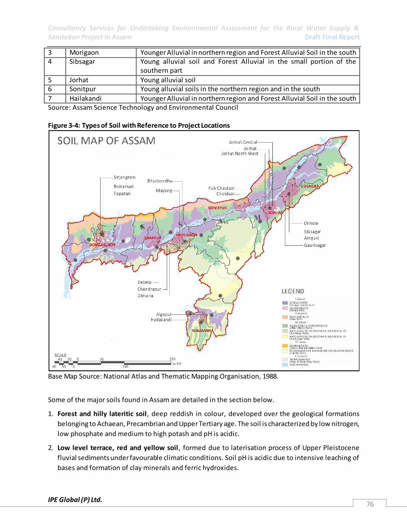
Consultancy Services for Undertaking Environmental Assessment for the Rural Water Supply & Sanitation Project in Assam Draft Final Report
IPE Global (P) Ltd. 76
3 Morigaon Younger Alluvial in northern region and Forest Alluvial Soil in the south 4 Sibsagar Young alluvial soil and Forest Alluvial in the small portion of the
southern part
5 Jorhat Young alluvial soil 6 Sonitpur Young alluvial soils in the northern region and in the south
7 Hailakandi Younger Alluvial in northern region and Forest Alluvial Soil in the south Source: Assam Science Technology and Environmental Council Figure 3-4: Types of Soil with Reference to Project Locations
Base Map Source: National Atlas and Thematic Mapping Organisation, 1988.
Some of the major soils found in Assam are detailed in the section below.
1. Forest and hilly lateritic soil, deep reddish in colour, developed over the geological formations
belonging to Achaean, Precambrian and Upper Tertiary age. The soil is characterized by low nitrogen,
low phosphate and medium to high potash and pH is acidic.
2. Low level terrace, red and yellow soil, formed due to laterisation process of Upper Pleistocene
fluvial sediments under favourable climatic conditions. Soil pH is acidic due to intensive leaching of
bases and formation of clay minerals and ferric hydroxides.

Consultancy Services for Undertaking Environmental Assessment for the Rural Water Supply & Sanitation Project in Assam Draft Final Report
IPE Global (P) Ltd. 77
3. Alluvial plain soil, light grey to dark grey of recent age occurring along the major river valleys. Based
on the Russian system of classification, soils of Assam have been classified into zonal and azonal
based mainly upon soil genesis. Most of the Project area have alluvial plain soil which has high water
retention capacity and high water table.
4. Older Alluvial Soil, are developed almost entirely in Cachar district and is light grey to dark grey in
colour. It is unaltered alluvium representing a broad spectrum of sand, silt and humus rich bog clay
depending on land form component.
5. Red Loamy Soil, are developed in the entire Karbi Anglong district, parts of Duma Hasao and a little
fringe in the northern border of North Lakhimpur district. These are deep red loamy soils with clay
rich latasol profile.
6. Red and Yellow Soil, low level terrace, red yellow to brick red soil, restricted mainly in the northern
border of the Duma Hasao (N C Hills) is having clayey plastic latasol with sedimentary structures and
texture totally obliterated in the solum. Mottling and incipient development ferruginous nodules at
places are quite common.
7. Lateritic Soil, the forested and lateritic Soils are brick red to brownish red in colour. They are
developed in the vicinity of Haflong in Duma Hasao district, southern parts of Kamrup and Nagaon
districts.
8. Alluvial Soil, are alluvial plain soils, developed along vast places of Brahmaputra basin. These are
yellow to yellowish grey in colour and are unaltered alluvium representing sand, silt and humus rich
bog clay depending on land form component. Mineral weathering and geochemical changes are
nominal. Soil pH is generally feebly alkaline excepting bog soils.
3.4.7 Agriculture Agriculture is the dominant land use category in the state. It account for about for about 54.11% of the
total geographical area of the state. Also, more than 80 per cent of the total population of Assam
including population dependent on tea plantation, is dependent on agriculture. The net area sown as
well as the gross cropped area increased significantly in the last few de cades due to better access to
newer technologies. According to the Assam Gazetteer, 2001 the increase in agriculture and plantation
practices has decreased area under forest. The agricultural land use pattern within the Project districts
are as follows:
Table 14: District wise distribution of Agricultural land, Assam, 1990 S.No
District Agricultural Land ( area in hectare)
Area Kharif Rabi Double crop Net area sown Plantation Fallow land Total
1 Bongaigaon 31335 22099 -- 18277 3822 11389 -- 15211 2 Hai lakandi 132293 98270 -- 1723 96547 38640 -- 135187
3 Jorhat 291470 21293 60998 43886 38405 61100 4815 104320
4 Kamrup 473380 235840 156516 145867 246489 25894 1939 274322
5 Morigaon 121966 67968 18972 33914 53026 646 9868 63540 6 Sibsagar 260290 105068 23278 15304 113042 100455 -- 213497
7 Sonitpur 525520 215966 51059 29498 237527 55682 3937 297146
Source: Assam Remote Sensing Application Centre

Consultancy Services for Undertaking Environmental Assessment for the Rural Water Supply & Sanitation Project in Assam Draft Final Report
IPE Global (P) Ltd. 78
3.4.8 Forest Resources Assam is known for its extensive forest areas and availability of rich floras and faunas besides other
valuable forest products. As per information available from the State Forest Department, the total area
under forests in Assam was 26,781.91 Sq.km. at the end of March, 2003, out of which 15,492.33 Sq. Km.
was under Reserved Forests and 2,860.94 Sq. Km. under Protected Forest Area. But this rich forest cover
and valuable forest resources of the state are disappearing rapidly particularly from the last few decades
due to massive deforestation, illegal felling, forest fragmentation, encroachment in the fringe areas,
poaching, bio piracy and other unplanned development activities.
The Forests area constitutes about 34.14 % of the total geographical area of Assam. The forests in the
plain districts are managed by the State Forest Department while the authorities for management of the
forest in the two hill districts are their respective District Councils. The Table 15 below gives the area (in
Ha) under Forest in the scheme districts.
Table 15: Area Under Forest in Assam (As On 31-3-2002) (Area in Ha.)
Forest Division Reserved Forest Proposed Reserved Forest Total Forest (Excluding
unclassified Forest)
ASSAM 1549232.943 267028.117 1816261.060
Kamrup East 43108.065 Nil 43108.065
Kamrup West 68241.150 507.072 68748.222
North Kamrup 75014.484 Nil 75014.484
Jorhat 26104.420 Nil 26104.420
Sibsagar 21950.477 Nil 21950.477
Sonitpur East 52674.770 Nil 52674.770
Sonitpur West 46164.690 910.000 47074.690 Hailakandi 63661.070 170.000 63831.070
Aie Valley (Bongaigaon) 78953.130 Nil 48953.130
Manas Tiger Project 1633.710 Nil 1633.710
East Assam Wild l ife 765.840 Nil 765.840
Source: Office of the Principal Chief Conservator of Forests, Assam. *Unclassified forest data – Forest
data showing forest extent only with no further information about their type and no restriction on the
cutting of trees and cattle grazing.
Social Forestry: The Social Forestry programme is an important programme being undertaken by the
State Forest Department. The programme mainly aims at increasing area under Afforestation especially
in Residential Area and otherwise Occupied Areas of the State. The achievement under Social Forestry
scheme was 3871 hectares of area during 2001-2002. The number of seedlings planted under this
scheme was 96.76 lakh during the year.
3.4.9 Ecologically Sensitive Areas
Ecologically Sensitive Areas (ESAs) have been identified and notified by the Indian Ministry of
Environment & Forests (MoEF) since 1989. Notifications declaring areas as ESAs are issued under the
Environment (Protection) Act 1986. The clauses of the EPA which allow for the notification of ESAs hold
the possibility of realizing landscape-level conservation. One of the landmark cases in recent years is
Numaligarh in Assam. In July 1992, Numaligarh was declared a “No Development Zone” using the EPA’s
provisions. This was linked to the establishment of a refinery in Numaligarh in 1993. The Numaligarh

Consultancy Services for Undertaking Environmental Assessment for the Rural Water Supply & Sanitation Project in Assam Draft Final Report
IPE Global (P) Ltd. 79
Refinery proposal was cleared by the MoEF, despite its close proximity to the Kaziranga National Park.
This was objected to by civil society groups. In response, although the MoEF did not disallow the
refinery, it placed restrictions on the expansion of the industrial area, townships, infrastructure facilities
and such other activities which could lead to pollution and congestion in what it declared as the
‘Numaligarh No Development Zone’. Northeast States of India is blessed with a wide range of
physiographic and eco-climatic conditions and the geographical ‘gateway’ for much of India’s endemic
flora as well as fauna. This region represents an important part of the Indo-Myanmar biodiversity
hotspot, one of the 25 global biodiversity hotspots recognized currently. Although Assam state border
does not touch Myanmar, it is also home to many species of flora and fauna and has a rich biodiversity
under the Indo-Myanmar region, especially the districts falling in south of River Brahmaputra. The Indo-
Myanmar Hotspot is home to 13,500 plant species (2.3% of the global species) of which 7,000 are
endemics and 2,185 vertebrates (1.9% of the global species) of which 528 are endemic. The species
richness in terms of numbers of reptiles and amphibians are 484 and 202 with 201 and 114 endemics
respectively. (Singh et al. P. 42-47).
Specifically the wildlife sanctuaries in Assam are a heterogeneous mixture of a variety of landscapes,
plants, birds and animals. The suitable climatic conditions, geographical location and vast forest reserves
have made Assam a favourable destination for birds, animals and natural vegetation. Assam is home to
several wildlife sanctuaries and national parks that are the breeding ground for some of the rarest global
species. The many wildlife sanctuaries in Assam provide shelter to large number of wildlife right from
the Golden Langur to the horned rhinoceros. Manas reserve falls under one of India’s biologically
sensitive Areas.
The Brahmaputra river and several of its tributaries could still hold hope for the critically-endangered
Indian gharial (Gavialis gangeticus), which is on the verge of extinction across its once-widespread
habitat in South East Asia with a global population of less than 200.
The Indian gharial population recorded a decline of 96 per cent in the past three decades. The species
was thought to be extinct in the Brahmaputra and Barak valleys of Assam but for a few instances of
authentic sighting, including a couple of captures (in the Urpad lake and in the Manas river), in Dikhow
river, Ghagar and Subansiri river, the Dehing-Brahmaputra confluence, Kareng Chapori of Dihingmukh –
some of those occurring during the period 2004 to 2007.
According to a recent survey conducted by a team of zoologists from Guwahati University, the
distribution of the Gharial in the State is mainly concentrated in the Brahmaputra Valley. In eastern
Assam, it is chiefly confined to the districts of undivided Lakhimpur and Sibsagar, while in western
Assam, it is restricted to the Brahmaputra and its tributaries such as Manas, Jinjiram, and the Urpad Beel
(lake).
The list below gives the names of the important ecologically sensitive areas such as Wildlife Sanctuaries
and National Parks in Assam. Kaziranga National Park
Manas National Park Dibru-Saikhowa National Park
Orang (Rajib Gandhi) National Park
Pobitora Wildlife Sanctuary Sonai Rupai Wildlife Sanctuary

Consultancy Services for Undertaking Environmental Assessment for the Rural Water Supply & Sanitation Project in Assam Draft Final Report
IPE Global (P) Ltd. 80
Bura-Chapori Wildlife Sanctuary
Laokhowa Wildlife Sanctuary Pobha Or Milroy Sanctuary
Chakrashila Wildlife Sanctuary
Bornadi Wildlife Sanctuary Gorampani Wildlife Sanctuary, Golaghat
Gibbon Wildlife Sanctuary
Nambor Wildlife Sanctuary East Karbi Anglong Wildlife Sanctuary
Karbi Anglong Wildlife Sanctuary
Panidihing Bird Sanctuary, Sibsagar
Deeporbeel Bird Sanctuary, Guwahati(Proposed) Bordoibam Bilmukh Bird Sanctuary, Lakhimpur, Dhemaji(Proposed)
Figure 3-5: Wildlife Sanctuaries/National Park and Reserve Forests Near Project Areas
Source: Base Map is from Google Maps, 2012
Since, Garbhanga Reserve Forest, Manas National Park and Kaziranga National Park are in a distance
ranging from 3 to 10 kms from the project area, there may be some concerns of conflict due to wildlife
movement and needs (figure 3.5). Another concern could be that of animal corridors, specifically
elephant corridors (figure 3.6). Due to increasing pressures on forest areas, there have been increasing
human-elephant conflicts, as settlements and other infrastructure gets sited in what are traditional
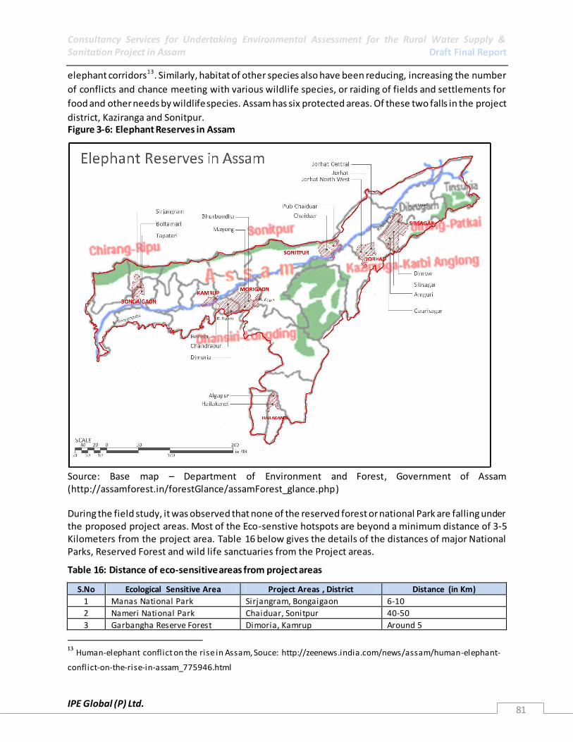
Consultancy Services for Undertaking Environmental Assessment for the Rural Water Supply & Sanitation Project in Assam Draft Final Report
IPE Global (P) Ltd. 81
elephant corridors13. Similarly, habitat of other species also have been reducing, increasing the number
of conflicts and chance meeting with various wildlife species, or raiding of fields and settlements for
food and other needs by wildlife species. Assam has six protected areas. Of these two falls in the project
district, Kaziranga and Sonitpur. Figure 3-6: Elephant Reserves in Assam
Source: Base map – Department of Environment and Forest, Government of Assam (http://assamforest.in/forestGlance/assamForest_glance.php) During the field study, it was observed that none of the reserved forest or national Park are falling under the proposed project areas. Most of the Eco-senstive hotspots are beyond a minimum distance of 3-5 Kilometers from the project area. Table 16 below gives the details of the distances of major National Parks, Reserved Forest and wild life sanctuaries from the Project areas.
Table 16: Distance of eco-sensitive areas from project areas
S.No Ecological Sensitive Area Project Areas , District Distance (in Km)
1 Manas National Park Sirjangram, Bongaigaon 6-10
2 Nameri National Park Chaiduar, Sonitpur 40-50
3 Garbangha Reserve Forest Dimoria, Kamrup Around 5
13 Human-elephant conflict on the rise in Assam, Souce: http://zeenews.india.com/news/assam/human-elephant-
conflict-on-the-rise-in-assam_775946.html
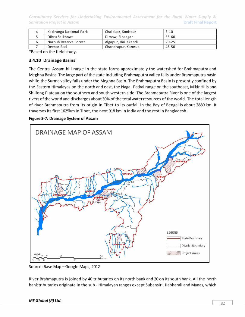
Consultancy Services for Undertaking Environmental Assessment for the Rural Water Supply & Sanitation Project in Assam Draft Final Report
IPE Global (P) Ltd. 82
4 Kaziranga National Park Chaiduar, Sonitpur 5-10
5 Dibru Saikhowa Dimow, Sibsagar 55-60
6 Narpuh Reserve Forest Algapur, Hailakandi 20-25 7 Deepor Beel Chandrapur, Kamrup 45-50
*Based on the field study.
3.4.10 Drainage Basins
The Central Assam hill range in the state forms approximately the watershed for Brahmaputra and
Meghna Basins. The large part of the state including Brahmaputra valley falls under Brahmaputra basin
while the Surma valley falls under the Meghna Basin. The Brahmaputra Basin is presently confined by
the Eastern Himalayas on the north and east, the Naga- Patkai range on the southeast, Mikir Hills and
Shillong Plateau on the southern and south western side. The Brahmaputra River is one of the largest
rivers of the world and discharges about 30% of the total water resources of the world. The total length
of river Brahmaputra from its origin in Tibet to its outfall in the Bay of Bengal is about 2880 km. It
traverses its first 1625km in Tibet, the next 918 km in India and the rest in Bangladesh.
Figure 3-7: Drainage System of Assam
Source: Base Map – Google Maps, 2012
River Brahmaputra is joined by 40 tributaries on its north bank and 20 on its south bank. All the north
bank tributaries originate in the sub - Himalayan ranges except Subansiri, Jiabharali and Manas, which

Consultancy Services for Undertaking Environmental Assessment for the Rural Water Supply & Sanitation Project in Assam Draft Final Report
IPE Global (P) Ltd. 83
are Trans Himalayan. The Subansiri, the Badeng- Pubnai, the Kameng- Jiabharali, the Dhansiri, the
Manas and the Champamati are some of the important rivers on the north bank which are known as
sub-basins. On the south bank, the Dholai, the Burhi Dihing, the Disang, the Dhansiri, the Kopili -Kalang
and the Kulsi- Jinjiram rivers from separate sub- basins. These southern tributaries out crop from Khasi
Hills and are generally not perennial nature. Most of these rivers maintain meagre base flow during dry
winter months.Out of nine, eight intake points which will draw water for the RWSS Scheme in the
project areas are on River Brahmaputra and its tributaries and the last one will draw water from a
tributary of R. Barak.
Figure 3-8: Location of Intake Points of Project Schemes
Source: Base Map – Google Maps, 2012
Table 17: Details of the intake point and Water Treatment Plant (WTP) in the seven districts.
S. No Name of District Proposed Intake point Location
Source of water Proposed WTP Location
1 Sivsagar Amguri Gourijan Dikhow river GP-Mumaitamuli, Vil-Phukanphodia, Habitation-Namdang Kalita
2 Jorhat Nimati Ghat Bramhaputra river Nimati Ghat
3 Morigaon Tinikhutimukh Kopili river Tinikhutimukh
Bihita Kopili river Bihita

Consultancy Services for Undertaking Environmental Assessment for the Rural Water Supply & Sanitation Project in Assam Draft Final Report
IPE Global (P) Ltd. 84
S. No Name of District Proposed Intake point Location
Source of water Proposed WTP Location
Dharamtal Kopili river Dharamtal
4 Bongaigaon Jogighopa Bramhaputra river Jogighopa
5 Kamrup Chandrapur Bramhaputra river Chandrapur
Kolongpar Bramhaputra river Kolongpar 6 Hailakandi Katakhal Katakhal river Katakhal
7 Sonitpur Dipora Bramhaputra river Dipora
Source: Executive Engineers, District, PHED, Assam
3.5 Water Resources
Assam is divided into two major river valleys – the Brahmaputra and Barak and thus, Assam is endowed
with enormous water resources. The large perennial rivers and other water bodies with the rich aquifer
speak about vastness of its water resource. Surface water is available in the forms of rive r, stream, lake,
swamps, pond etc. The ground water is available at low to moderate depth almost in entire state.
Although there is seasonal and regional variation in the availability of water resources, the annual
availability of water resource remain almost same. In the last few decades the use of water has been
growing at a fast rate, which is more than twice the rate of the increase of human population. The
consumption of water has increased due to the increase of human population as well as the
diversification of human activities. With the increase of per capita consumption of water in domestic,
agricultural and industrial sectors, cause the reduction of potential per capita availability of water.
Moreover, it may cause the deterioration of water quality to a great extent.
Besides the river, another important source of surface water is the wetlands of the state. There are
about 3513 numbers of wetlands of different size and shape in the state. The total area under different
categories of wetland in Assam is about 1012.32 Sq.km. during the pre-monsoon season. It constitutes
1.29% of the total geographical area of the state. Of the total wetlands, 1367 inland wetlands suffer due
to the problem of invasion by aquatic weeds and need ameliorative steps for conservation. Out of this,
656 are swampy/marshy areas, 366 ox-bow lakes/cut-off meanders, 193 lakes/ponds, 133 water-logged,
13 tanks and 3 reservoirs. The wetlands of the state are facing serious threat from the human society.
The large-scale encroachment, over fishing in wetlands, filing up of wetlands for other uses and dumping
of wastes in the wetlands are some of the human activities causing serious damage to the wetland
ecosystem.
According to the ENVIS Centre, Assam, the pressure on the ground water is increasing in the state. The
rate of groundwater extraction in the state has been increase by many folds in last decade of for
irrigation through shallow tube wells. Unscientific dumping of municipal solid and industrial wastes on
the ground and in the water body is increasing with the population growth. The excessive extraction of
ground water especially for the irrigation and in densely settled areas for the domestic consumption the
water table in winter season goes down beyond the reach of low and medium depth dug wells and tube
wells and thereby causing water crises in some areas of the state. According to the Central Ground
Water Board, Kamrup Metro has recorded excessive depletion of ground water especially in areas in and
around Guwahati.

Consultancy Services for Undertaking Environmental Assessment for the Rural Water Supply & Sanitation Project in Assam Draft Final Report
IPE Global (P) Ltd. 85
3.5.1 Surface Water Apart from the rain water received, the state is endowed with number of perennial rivers and lake
locally known as beel. The state is drained by the dance networks of two river system, viz the
Brahmaputra and the Barak. These rivers have large number of tributaries joining them from both the
banks. There are about 73 important tributaries of the Brahmaputra River and 11 tributaries of Barak
River. The vast potential surface water resource of the state is not yet properly utilized in the state. In
the last few decades, the rate of consumption of water in the agricultural sector, industrial sector and in
the urban centres has been increased significantly. The discharges of untreated domestic wastewater,
industrial wastewater, run of from the agricultural fields and the urban sewage water posing threat to
the water bodies of the state.
Irrigation: Agriculture constitutes the largest share of water consumption amongst various uses
followed by the domestic and industrial uses. The gross irrigation potential created up to March 2002
through govt. irrigation schemes in Assam was 5,13,341.00 hectare (includes both irrigation from
surface water and ground water) against the irrigation potential of 2,40,406.17 hectare in 1987. This
indicates the increasing trend of water utilization in agricultural sector.
Apart from irrigation, the second most beneficial uses of water are drinking, cooking, bathing, washing,
etc. – domestic use. More than 75 per cent population of the state are living in the rural area and due to
certain factors the direct use of river water is limited in the state. The ground water is the main source
of water for most of the rural population of the state. The per capita abstraction would therefore be
small and may be estimated at 25 litre per day
3.5.1.1 River System
i) Brahmaputra River System: The Brahmaputra is one of the biggest rivers of the world. The
Brahmaputra basin covers an area of 5,80,000 Sq. Km of which 1,94,413 Sq. Km falls in India. In India,
the basin lies in the states of Arunachal Pradesh, Assam, Nagaland, Meghalaya, Sikkim and West Bengal.
Brahmaputra is a perennial river, feed by snow as well as by rain.
The Brahmaputra rolls down the plain of Assam east to west for a distance of 640 km up to Bangladesh
border. Through its course, the river receives innumerable tributaries (about 73) coming out of the
northern, north eastern and the southern hill ranges. The mighty river with a well -knit network of
tributaries drains an area of 56,480 Sq. Km of the state accounting for 72% of its total geographical area.
Most of the right bank tributaries of Brahmaputra are snow as well rain feed and are perennial.
Although the left bank tributaries are mainly rain feed but perennial in nature.
It is the fourth largest river in the world in term of average water discharge at the mouth with a flow of
19,830 cubic meter per second.
The river carries 82 per cent of its annual flow during the rainy season (May through October). The
maximum discharge of the river at Pandu14 (in Guwahati) was 72794 m3s-1 and the minimum discharge
at the same point on 20-02-68 was 1757 m3s-1. The mean annual flood discharge and dry season
discharge of the river at Pandu is 51156 m3s-1and 4420 m3s-1and respectively. The discharge per unit
14
Source: Flood Control Department, Govt. of Assam, on 23-08-62

Consultancy Services for Undertaking Environmental Assessment for the Rural Water Supply & Sanitation Project in Assam Draft Final Report
IPE Global (P) Ltd. 86
area of basin at Pandu is 0.03 m3s-1and. The principal tributaries of Brahmaputra River and their annual
discharge is given in table 18 below.
Table 18: Right Bank Tributaries of the Brahmaputra River and their annual discharge.
Sl. No. Rivers Length (km) Average annual discharge (m 3 s -1)
1 Subansiri 442 7,55,771
2 Ranganadi 150 74,309
3 Baroi 64 20,800
4 Bargang 42 16,000
5 Jia Bharali 247 3,49,487
6 Gabharu 61 8,450
7 Balsiri 110 9,300
8 Dhansiri 123 26,577
9 Noa-Nadi 75 4,450
10 Nanoi 105 10,281
11 Barnadi 112 5,756
12 Puthimari 190 26,324
13 Pagladiya 197 15,201
14 Manas-Aye-Beki 215 3,07,947 15 Champamati 135 32548
16 Gaurang 98 22263
17 Tipkai 108 61786
18 Godadhar 50 7000
Source: Flood Control Department, Govt. of Assam.
Table 19: Left Bank Tributaries of the Brahmaputra River and their annual discharge
Sl. No. Rivers Length (km) Average annual discharge (m 3 s -1)
1 Buridihing 360 141539
2 Desang 230 55101
3 Dikhow 200 41892
4 Jhanji 108 8797
5 Bhogdoi 160 6072
6 Dhansiri 352 68746
7 Kopili 297 90046
8 Krishnai 81 22452
9 Kulsi 93 11643 10 Jinari 60 7783
Source: Flood Control Department, Govt. of Assam.
ii) The Barak River System: Barak is the second largest river system in the North East India as well as in
Assam. The river with a total length of 900 km from source to mouth drains an area of 52,000 sq. km. In
India and traverses a distance of 532 km up to the Indo-Bangla border. Like Brahmaputra, the Barak is
also a perennial river of the state. The important north bank tributaries of Barak River are Jiri, Siri,
Madhura, Jatinga and Larang, while the important south bank tributaries include sonai, Ghagra,
Katakhal, Dhaleswari, Singla and Longai. The flows of the rivers in Assam decrease considerably during
the dry season. They maintained peak flow in summer rainy months (March-October).

Consultancy Services for Undertaking Environmental Assessment for the Rural Water Supply & Sanitation Project in Assam Draft Final Report
IPE Global (P) Ltd. 87
3.5.1.2 Wetlands
The valley of the river Brahmaputra with its innumerable fresh water lakes (locally called beel), or ox -
bow lakes (era suti), marshy tracts and seasonally flooded plains and hundreds of riverine sandbars and
islands was, till recently, an ideal wetland eco-system which contained specialised wetland animals like
the fresh water dolphin, dugong and the great Indian one-horned rhino and reptiles like the crocodile,
the winter monitor lizard and few species of turtles. All these creatures are either extinct or highly
endangered at present. With the progressive destruction of the Brahmaputra valley wetlands, along
with these animals and others, we have lost spectacular natural beauty - the hundreds of thousands of
water birds all along the 800 km. of the river running through the plains of Assam according to the flood
control department, GoA.
The destruction of the Brahmaputra valley wetland system started with the arrival of the w ater
hyacinth15 from Central America more than a century ago. Later it heightened due to the raising of
earthen bunds along the banks of almost the entire length of the river and many of its tributaries after
the 1950 earthquake. These artificial levees cut off, to a great extent, the periodic flushing out of the
wetlands by the monsoon flood. Also, due to the arrival of the human settlers in the sand bars and the
minor riverine islands, mostly in the lower Assam, the wetland has been further affected. Such activates
and others have resulted in a situation where the wetlands are transformed into agricultural zones rich
in rice and vegetables but totally denuded of wildlife.
Lakes / Ponds: In Assam, there are 690 lakes and ponds as recorded by the Assam Remote Sensing
Application Centre. These lakes /ponds cover an area of 15494.00 ha which constitutes 0.20% of the
total geographical area of the state and 15.30% of the total area under wetlands. The smallest of them
measures 2.50 ha while the largest one has 882.50 ha of areal coverage. Majority of these types of
wetlands have water with low turbidity. Highest number of lakes / ponds are observed in Golaghat
district (113 number) followed by Dhubri (73 number) and Nagaon (68 number) districts. But area wise,
the highest area under this category is observed in Kamrup district (15705.00 ha) followed by Nagaon
(2175.50 ha) and Dhubri (1816.50 ha) districts. Some of the important wetlands under this category are
Deepor beel in Kamrup district, Dhir beel in Dhubri district, Tamaranga beel and Dalani beel in
Bongaigaon district. However, none of these wetlands are coming in the project scheme areas.
Nonetheless, their proximity to the project areas cannot be ignored during the Environmental
Management Framework Design and Development. One of the Wetlands like Deepor Beel, is around 35-
50 Km from Kamrup Project areas and it a Ramsar Site16.
Deepor Beel (Ramsar site no. 1207, Area - 4,000 ha. 26°08'N 091°39'E. Sanctuary). A permanent
freshwater lake in a former channel of the Brahmaputra river, of great biological importance and also
essential as the only major storm water storage basin for the city of Guwahati. The beel is a staging site
on migratory flyways and some of the largest concentrations of aquatic birds in Assam. The beel 15
Extensive growth of this fast growing weed can cut out sun light from the micro flora and also pr oduces faster
eutrophication by slowing down water current and depositing debris at the bottom. 16
The Convention on Wetlands of International Importance, called the Ramsar Convention, is an intergovernmental treaty that provides the framework for national action and international cooperation for the conservation and wise use of wetlands and their resources. The Ramsar List of Wetlands of International
Importance now includes 2,098 sites (known as Ramsar Sites).
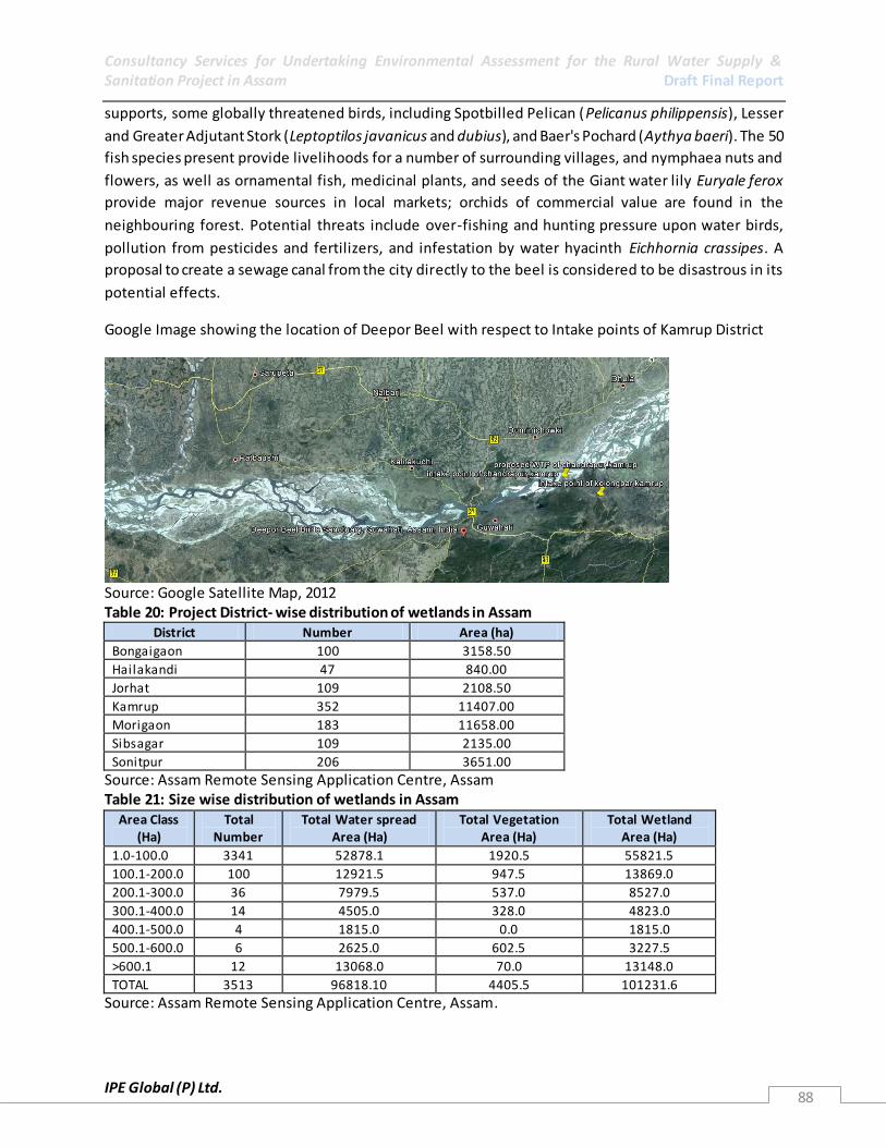
Consultancy Services for Undertaking Environmental Assessment for the Rural Water Supply & Sanitation Project in Assam Draft Final Report
IPE Global (P) Ltd. 88
supports, some globally threatened birds, including Spotbilled Pelican (Pelicanus philippensis), Lesser
and Greater Adjutant Stork (Leptoptilos javanicus and dubius), and Baer's Pochard (Aythya baeri). The 50
fish species present provide livelihoods for a number of surrounding villages, and nymphaea nuts and
flowers, as well as ornamental fish, medicinal plants, and seeds of the Giant water lily Euryale ferox
provide major revenue sources in local markets; orchids of commercial value are found in the
neighbouring forest. Potential threats include over-fishing and hunting pressure upon water birds,
pollution from pesticides and fertilizers, and infestation by water hyacinth Eichhornia crassipes. A
proposal to create a sewage canal from the city directly to the beel is considered to be disastrous in its
potential effects.
Google Image showing the location of Deepor Beel with respect to Intake points of Kamrup District
Source: Google Satellite Map, 2012 Table 20: Project District- wise distribution of wetlands in Assam
District Number Area (ha)
Bongaigaon 100 3158.50
Hailakandi 47 840.00
Jorhat 109 2108.50
Kamrup 352 11407.00
Morigaon 183 11658.00
Sibsagar 109 2135.00
Sonitpur 206 3651.00
Source: Assam Remote Sensing Application Centre, Assam Table 21: Size wise distribution of wetlands in Assam
Area Class (Ha)
Total Number
Total Water spread Area (Ha)
Total Vegetation Area (Ha)
Total Wetland Area (Ha)
1.0-100.0 3341 52878.1 1920.5 55821.5
100.1-200.0 100 12921.5 947.5 13869.0
200.1-300.0 36 7979.5 537.0 8527.0
300.1-400.0 14 4505.0 328.0 4823.0
400.1-500.0 4 1815.0 0.0 1815.0
500.1-600.0 6 2625.0 602.5 3227.5
>600.1 12 13068.0 70.0 13148.0
TOTAL 3513 96818.10 4405.5 101231.6
Source: Assam Remote Sensing Application Centre, Assam.

Consultancy Services for Undertaking Environmental Assessment for the Rural Water Supply & Sanitation Project in Assam Draft Final Report
IPE Global (P) Ltd. 89
iii) Ox-bow Lakes / Cut-off Meanders: A total 861 number of ox-bow lakes/cut-off meanders are
present throughout the state of Assam, covering an area of 15460.60 ha which constitutes 0.20 % of the
total geographical area of the state and 15.27 % of the total area under wetlands. The smallest of them
measures 5.0 ha while the largest one has 582.50 ha of areal coverage. Highest number of ox -bow lakes
/ cut-off meanders are observed in Golaghat district (104 number) followed by Nagaon district (71
number) and Dhubri district (68 number). But area wise, the highest area under this category is
observed in Morigaon district (2143.00 ha) followed by Nagaon (1746.00 ha) and Golaghat (1563.00 ha)
districts. Some of the important wetlands under this category are Morikolong and Patoli beel in Nagaon
district, Mer beel in Golaghat district and Guruajan in Morigaon district.
In Assam, a total of 1125 number of waterlogged areas are observed which are distributed unevenly
covering an area of 23431.50 ha which constitutes 0.30 % of the total geographical area of the state and
23.15 % of the total area under wetlands. Highest number of water logged areas are observed in Cachar
district (231 number) followed by Nagaon district (138 number) and Sonitpur district (110 number). But
area wise, the highest area under this category is observed in Cachar district (4869.50 ha) followed by
Karimganj (4667.00 ha) and Nagaon (2559.50 ha) districts. Some of the important wetlands under this
category are Son beel in Karimganj district and Raumari beel in Darrang district.
These water-logged areas play significant role in the region’s economy as they are present in large
numbers in the rural areas containing good amount of fishes and other aquatic fauna and providing
habitat to a variety of migratory as well as domestic birds. Besides they have remarkable potential for
supplying irrigation water to the nearby agricultural fields during the dry periods. There are some
waterlogged areas which can be developed for recreational purposes and as tourist spots such as the
Son beel in Karimganj district.
iv) Swampy/Marshy areas : These swampy/marshy areas constitute another major group of wetlands in
Assam. These are identifiable on satellite imagery by their reddish tone indicating the presence of
vegetation, associated with dark blue tone inferring to the presence of water and their occurrence in the
low lying areas. Due to the presence of varied quantities of minerals in the water, these swampy/marshy
areas are either moderately or highly turbid. In most cases, there is no feeder channel to control the
inflow or outflow of water.
In Assam, as many as 712 number of swampy/marshy areas have been identified from satellite data
which cover an area of 43433.50 ha constituting 0.55 % of the total geographical area of the state and
42.91 % of the total area under wetlands. The smallest of them is 2.5 ha while the largest one has
1350.00 ha of areal coverage. Highest number of swampy/marshy areas are observed in Kamrup district
(155 number) followed by Nagaon (92 number) and Goalpara (68 number) districts. But area wise, the
highest area under this category is observed in Kamrup district (8109.50 ha) followed by Morigaon
(7051.00 ha) and Nagaon (4764.50 ha) districts. Some of the important wetlands under this category are
Nandan-Sonai beel in Morigaon district, Batha beel in Darrang district and Urpad beel in Goalpara
district.
Consultancy Services for Undertaking Environmental Assessment for the Rural Water Supply & Sanitation Project in Assam Draft Final Report
IPE Global (P) Ltd. 90
Unlike the water-logged areas, the swampy/marshy areas don’t have much contribution to the state's
economy. But with the help of proper developmental schemes by converting them into utilizable form,
these may boost up the economy of the state to a significant level.
v) Reservoirs: Reservoirs are artificial impoundments of water for irrigation, flood control, municipal
water supplies, hydro-electric power generation and so forth. There are as many as 10 number of
reservoirs covering an area of 2662.5 ha which constitutes 0.03 % of the total geographical area of the
state and 2.63 % of the total area under wetlands. The smallest of them covers 17.50 ha while the
largest one has 930.00 ha of areal coverage. Majority of these type of wetlands contains water with low
turbidity. Highest number of reservoirs is observed in N.C.Hills district (4 nos.) followed by Golaghat and
Nalbari districts (2 nos. each). But area wise, the highest area under this category is observed in Duma
Hasao Hills district (2365.00 ha) followed by Kamrup (220.00 ha) and Golaghat (37.50 ha) districts. Some
of the important wetlands under this category are Garampani and Umrangsu in Duma Hasao Hills
district. In Morigaon District, on Kopili River there is a Hydro Power Plant and a reservoir upstream of
the Two blocks covered under the project, Mayang and Bhurbandha. Tanks: Assam has several
thousands of family owned small size tanks, these have not entered into reckoning as far as this report is
concerned because of the scale factor. In Assam, a total of 115 number of tanks are identified from
satellite data. These tanks occupy an area of 749.00 ha which constitutes 0.01 % of the total
geographical area of the state and 0.74 % of the total area under wetlands. Highest number of tanks are
observed in Sibsagar district (20 number) followed by Kamrup (18 number) and Sonitpur (16 number).
But area wise, the highest area under this category is observed in Sibsagar district (267.00 ha) followed
by Sonitpur (83.50 ha) and Kamrup (80.00 ha) districts. Some of the important wetlands under this
category are Gaurisagar Pukhuri, Sibsagar Pukhuri and Joysagar Pukhuri in Sibsagar district. Further, in
Sibsagar District, there is a large tank also known as 'Borpukhuri', covering an area of about 257 acres. It
is also a tourist destination and was built in the year 1734. This tank is surrounded by deep ditches and
earthen moats, and is a heaven to the Siberian migratory ducks during the winter season. Besides
providing water to the people of the nearby areas, these tanks can also be used for rearing fishes and
raising plantation crops like coconut, arecanut, cashewnut etc. along the sides of the ponds. Ornamental
gardens can also be developed on the banks of the ponds.
3.5.2 Groundwater The potential of ground water resources throughout the entire Brahmaputra valley, covering more than
70% of the total area of the state, contains prolific aquifer system. Diverse geological formations require
different types of structures for tapping ground water to meet the human needs.
Table 22: Details of dynamic Ground Water Resources in Assam
Annual Replenishable Ground water Resource
27.23 BCM
Net Annual Ground Water Availability 24.89 BCM
Annual Ground Water Draft 5.44 BCM
Stage of Ground Water Development 22 %
Ground Water Development & Management
Over Exploited NIL
Critical NIL

Consultancy Services for Undertaking Environmental Assessment for the Rural Water Supply & Sanitation Project in Assam Draft Final Report
IPE Global (P) Ltd. 91
Semi- critical NIL
Artificial Recharge to Ground Water (AR) Feasible AR structures: 250 Check Dams, 500 weirs, 1000 Gabion structures, 250 development of springs 600 RWH in Urban Areas
Source: Central Ground Water Board, India
The water table in the Barak valley of Cachar district are influenced by the physiography, therefore in
the synclinal valleys of Silchar, Hailakandi and Karimganj the movement of ground water is to the north
towards the Barak River. But the master slope of ground water is to the west in the Sourthern Assam
(Barak Valley Region). The Barak River and its tributaries is all effluent in nature and their base flow
during the lean period is almost entirely due to the ground water discharge. Ground water development
generally takes place from two types of zones viz. Shallow zone within the depth of 50m and deeper
zone from 50 to 200m. The ground water development in the Shallow zone is generally through the
private agencies aided by institutional sources and in the Deeper zone the Irrigation De partment and
Corporation play an important role.
Table 23: Details of Ground Water Resource in the seven project districts of Assam
District
Ground water resource
(MCM)Dynamic
Utilisable Ground Water
Resource for Irrigation
(MCM)
Utilisable Ground Water
Resource for drinking &
allied (MCM)
Gross Draft
(MCM)
Balance Available
(MCM)
State of Ground Water
Development (%)
Kamrup 1229 1045 184 71 974 6.80
Sibsagar 1658 1409 249 35 1374 2.48
Jorhat 1461 1242 219 35 1207 2.81
Sonitpur 1615 1373 242 110 1263 8.01
Morigaon 321 273 48 43 230 15.75
Boigaingaon 591 502 89 25 477 4.98
Hailakandi 98 83 15 3 80 3.61
Source: Central Ground Water Board, Report-1981*MCM: Million cubic metres;
3.5.2.1 Groundwater Recharge
The potential of ground water resources throughout the entire Brahmaputra valley, covering more than
70% of the total area of the state, contains prolific aquifer system. Diverse geological formations require
different types of structures for tapping ground water to meet the irrigation needs. In Assam, the
ground water is extracted through dug wells, dug - cum - bore wells and shallow tube wells. These
structures yield enough water to meet the irrigation requirements of small farm holdings as well as the
daily domestic need. However, in Kamrup, Sontpur and Morigaon District few of the existing schemes
have become Dysfunctional due to drying up of low and middle level ground water source. These are
attributed to causes such as extensive extraction and usage of Groundwater for irrigation and other
purposes, Change in rainfall pattern, etc. The following table gives the reasons of slippages in the
existing water supply schemes.
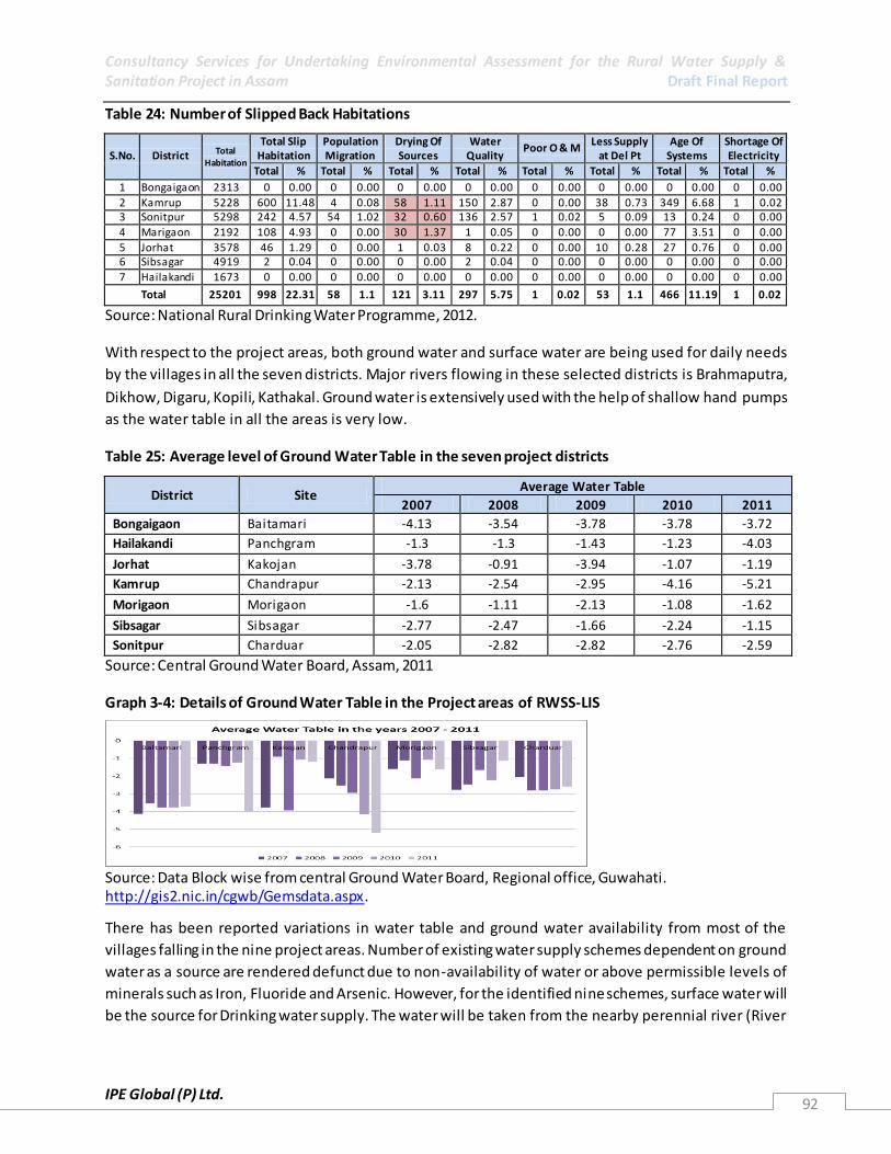
Consultancy Services for Undertaking Environmental Assessment for the Rural Water Supply & Sanitation Project in Assam Draft Final Report
IPE Global (P) Ltd. 92
Table 24: Number of Slipped Back Habitations
S.No. District Total Habitation
Total Slip Habitation
Population Migration
Drying Of Sources
Water Quality
Poor O & M Less Supply
at Del Pt Age Of
Systems Shortage Of Electricity
Total % Total % Total % Total % Total % Total % Total % Total %
1 Bongaigaon 2313 0 0.00 0 0.00 0 0.00 0 0.00 0 0.00 0 0.00 0 0.00 0 0.00
2 Kamrup 5228 600 11.48 4 0.08 58 1.11 150 2.87 0 0.00 38 0.73 349 6.68 1 0.02 3 Sonitpur 5298 242 4.57 54 1.02 32 0.60 136 2.57 1 0.02 5 0.09 13 0.24 0 0.00
4 Marigaon 2192 108 4.93 0 0.00 30 1.37 1 0.05 0 0.00 0 0.00 77 3.51 0 0.00
5 Jorhat 3578 46 1.29 0 0.00 1 0.03 8 0.22 0 0.00 10 0.28 27 0.76 0 0.00 6 Sibsagar 4919 2 0.04 0 0.00 0 0.00 2 0.04 0 0.00 0 0.00 0 0.00 0 0.00
7 Hailakandi 1673 0 0.00 0 0.00 0 0.00 0 0.00 0 0.00 0 0.00 0 0.00 0 0.00
Total 25201 998 22.31 58 1.1 121 3.11 297 5.75 1 0.02 53 1.1 466 11.19 1 0.02
Source: National Rural Drinking Water Programme, 2012.
With respect to the project areas, both ground water and surface water are being used for daily needs
by the villages in all the seven districts. Major rivers flowing in these selected districts is Brahmaputra,
Dikhow, Digaru, Kopili, Kathakal. Ground water is extensively used with the help of shallow hand pumps
as the water table in all the areas is very low.
Table 25: Average level of Ground Water Table in the seven project districts
District Site Average Water Table
2007 2008 2009 2010 2011
Bongaigaon Baitamari -4.13 -3.54 -3.78 -3.78 -3.72
Hailakandi Panchgram -1.3 -1.3 -1.43 -1.23 -4.03
Jorhat Kakojan -3.78 -0.91 -3.94 -1.07 -1.19
Kamrup Chandrapur -2.13 -2.54 -2.95 -4.16 -5.21
Morigaon Morigaon -1.6 -1.11 -2.13 -1.08 -1.62
Sibsagar Sibsagar -2.77 -2.47 -1.66 -2.24 -1.15
Sonitpur Charduar -2.05 -2.82 -2.82 -2.76 -2.59
Source: Central Ground Water Board, Assam, 2011
Graph 3-4: Details of Ground Water Table in the Project areas of RWSS-LIS
Source: Data Block wise from central Ground Water Board, Regional office, Guwahati. http://gis2.nic.in/cgwb/Gemsdata.aspx.
There has been reported variations in water table and ground water availability from most of the
villages falling in the nine project areas. Number of existing water supply schemes dependent on ground
water as a source are rendered defunct due to non-availability of water or above permissible levels of
minerals such as Iron, Fluoride and Arsenic. However, for the identified nine schemes, surface water will
be the source for Drinking water supply. The water will be taken from the nearby perennial river (River

Consultancy Services for Undertaking Environmental Assessment for the Rural Water Supply & Sanitation Project in Assam Draft Final Report
IPE Global (P) Ltd. 93
Brahmaputra or its tributary) with the help of a floating barrage, which will be transported to a
treatment plant, 500 meters away.
3.5.3 Water Quality
Apart from the 55,067 villages, 2.8 lakh villages which have been estimated by the Planning Commission
as slipped-back villages would also be covered of water becoming quality affected, are as cited as
reasons for the slipping back of villages. Water quality issues emerging in the State point to a high
content of iron, fluoride and arsenic in aquifers in many areas of Assam. In addition, there are concerns
over the bacteriological contamination. Sanitation remains another significant challenge. Given the large
population dependent upon agriculture, agrochemical contamination is also likely to be high. Equally,
with a number of oil wells and refineries it is expected that pollution load from these industries will also
add to the pollution load of the aquatic system. Out of the four17 oil refineries in Assam, one is at
Dhaligoan in Bongaigaon District near the proposed project area under the scheme, upstream River Aye
(one of the tributaries of R. Brahmaputra).
Graph 3-5: Population affected by Iron in all Districts of Assam
Source: www.indiawater.gov.in (National Rurla Drinking Water Programme – Rajiv Gandhi National drinking Water Mission).
Graph 3-6: Population affected by Arsenic in all Districts of Assam
Source: www.indiawater.gov.in (National Rurla Drinking Water Programme – Rajiv Gandhi National drinking Water Mission)
Arsenic Screening and surveillance programme in Assam has been carried jointly by PHED, UNICEF and
IIT Guwahati18 towards a comprehensive assessment of Arsenic contamination of Public water sources
of drinking water in rural areas covering the period of 2005 – 2011. The study was carried out in 76
blocks spread across 23 Divisions (in 18 Districts) pre-identified through a rapid assessment. Out of a
total of 56,180 water samples which were tested 16, 742 (around 30%) were tested unsaf e for drinking
17
First, Digboi in Tinsukia district; second at Noonmati in Guwahati under the public sector; third refinery at Dhaligoan near Bongaigaon and fourth refinery in the state was established at Numaligarh of Golaghat district. 18
The information was shared by a UNICEF official as the study and the report i s under publishing at present.

Consultancy Services for Undertaking Environmental Assessment for the Rural Water Supply & Sanitation Project in Assam Draft Final Report
IPE Global (P) Ltd. 94
based on WHO standards of Arsenic permissibility of less than 10 ppb concentrations. Around 1970
Habitations across 18 Districts were estimated to be exposed to the risk of arsenic contamination.
Table 26: Results of Arsenic Screening and Surveillance Programme in 76 Blocks of Assam, by UNICEF, IIT_G and PHED (unpublished study 2005-2010)
S.No PHED Divisions Source Tested Safe Sources
Unsafe Source as per
WHO n(>10ppb concentration)
of Unsafe
sources as per WHO
1 Biswanath Chairali 2163 1425 738 34
2 Bongaigaon 1274 926 348 27
3 Bokakhat 1075 901 174 16
4 Belsor 2076 1055 1021 49
5 BTAD 321 105 216 67
6 Barpeta 7987 6517 1470 18
7 Dhubri 4633 3947 686 15
8 Darrang 3861 2502 1359 35
9 Goalpara 1096 884 212 19 10 Golaghat 2449 1201 1248 51
11 Ghilamara 2346 2076 270 12
12 Hailakandi 2908 2490 418 14
13 Jorhat 6278 2842 3436 55
14 Kaliabor 747 734 13 2
15 Karimganj 2665 2024 641 24
16 Morigaon 1233 1106 127 10
17 N.Lakhimpur 2247 1766 481 21
18 Nalbari (Kamrup) 2236 594 1642 73
19 Rangia (Kamrup) 429 208 221 52
20 Sibsagar 4243 3256 987 23
21 Silchar I 2368 1602 766 32
22 Silchar II 1017 823 194 19
23 Tezpur 528 454 74 14
TOTAL 56180 39438 16742 30
Source: Unpublished report on Arsenic Screening and Surveillance Programme in Assam, study jointly
carried by PHED, UNICEF and IIT- G.
Graph 3-7: Population affected by Fluoride in all Districts of Assam
Source: www.indiawater.gov.in (National Rurla Drinking Water Programme – Rajiv Gandhi National drinking Water Mission)

Consultancy Services for Undertaking Environmental Assessment for the Rural Water Supply & Sanitation Project in Assam Draft Final Report
IPE Global (P) Ltd. 95
Graph 3-8: No of Sources affected by bacteria in all Districts of Assam
Source: www.indiawater.gov.in (National Rurla Drinking Water Programme – Rajiv Gandhi National drinking Water Mission)
Water Quality has been a major environmental issue in the seven districts selected under the RWSS
project scheme. Since, most of the schemes are dependent on ground water resource, presence of
arsenic, due to the inherent characteristics of Brahmaputra belt has been recorded in most of the
districts. Iron is usually found high in all the districts, apart from having few health implications it is
aesthetical unacceptable as it decolours the clothes, utensils and other products in contact such as
water pipes, hand pumps etc. Based on the Arsenic screening and surveillance Programme carried
jointly by PHED, UNICEF and IIT-Guwahati in 76 blocks of Assam, 30% of sources had traces of Arsenic
(above WHO limits of 10ppb) and around 722,633 population in these blocks were exposed to the risk of
Arsenic contamination
Table 27: No Of Quality Affected Habitations & Population as On 01/04/2012
S.No. District
Contamination Wise Number Of Habitations & Population
Total Fluoride Arsenic Iron
Habs Population Habs Population Habs Population Habs Population
1 BONGAIGAON 58 13174 0 0 47 10151 11 3023
2 HAILAKANDI 117 54627 0 0 3 2310 114 52317
3 JORHAT 1145 311887 1 171 448 127119 696 184597
4 KAMRUP 1024 387379 1 338 0 0 1023 387041
5 MARIGAON 166 80133 0 0 23 13644 143 66489
6 SIBSAGAR 838 266898 0 0 53 16070 785 250828
7 SONITPUR 1990 663180 0 0 24 6689 1966 656491
Total 5338 1777278 2 509 598 175983 4738 1600786 Source: National Rural Drinking Water Programme, 2012.
3.4.3.1 Surface Water Quality The vast potential surface water resource of the state is not yet properly utilized in the state. In the last
few decades, the rate of consumption of water in the agricultural sector, industrial sector and i n the
urban centres has been increased significantly. The discharges of untreated domestic wastewater,
industrial wastewater, run of from the agricultural fields and the urban sewage water posing threat to
the water bodies of the state. One of the major issues concerning surface quality is the River Erosion.
Water samples from all the nine intake point were collected and tested. The parameters on which the
water quality testing was carried are as follows, Colour and Odour, PH Value, Temperature, Pesticides,
Turbidity, COD, BOD, Fluoride, Iron, Arsenic, Faecal Coliform, Coliform Organism and Pesticides. The
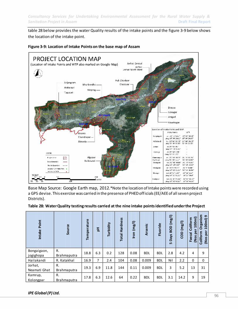
Consultancy Services for Undertaking Environmental Assessment for the Rural Water Supply & Sanitation Project in Assam Draft Final Report
IPE Global (P) Ltd. 96
table 28 below provides the water Quality results of the intake points and the figure 3-9 below shows
the location of the intake point.
Figure 3-9: Location of Intake Points on the base map of Assam
Base Map Source: Google Earth map, 2012.*Note the location of Intake points were recorded using a GPS devise. This exercise was carried in the presence of PHED off icials (EE/AEE of all seven project Districts).
Table 28: Water Quality testing results carried at the nine intake points identified under the Project
Inta
ke P
oin
t
Sou
rce
Tem
pe
ratu
re
pH
Turb
idit
y
Tota
l H
ard
ne
ss
Iro
n (
mg/
l)
Ars
en
ic
Flu
ori
de
5 D
ays
BO
D (
mg/
l)
CO
D (
mg/
l)
Fae
cal
Co
lifo
rm
(No
s p
er
10
0m
l)
Co
lifo
rm O
rgan
ism
(No
s p
er
10
0m
l) 9
Bongaigaon, jogighopa
R. Brahmaputra
18.8 6.3 0.2 128 0.08 BDL BDL 2.8 4.2 4 9
Hailakandi R. Katakhal 16.9 7 2.4 104 0.08 0.009 BDL Nil 2.2 0 0
Jorhat, Neamati Ghat
R. Brahmaputra
19.3 6.9 11.8 144 0.11 0.009 BDL 3 5.2 13 31
Kamrup,
Kolongpar
R.
Brahmaputra 17.8 6.3 12.6 64 0.22 BDL BDL 3.1 14.2 9 19

Consultancy Services for Undertaking Environmental Assessment for the Rural Water Supply & Sanitation Project in Assam Draft Final Report
IPE Global (P) Ltd. 97
Inta
ke P
oin
t
Sou
rce
Tem
pe
ratu
re
pH
Turb
idit
y
Tota
l H
ard
ne
ss
Iro
n (
mg/
l)
Ars
en
ic
Flu
ori
de
5 D
ays
BO
D (
mg/
l)
CO
D (
mg/
l)
Fae
cal
Co
lifo
rm
(No
s p
er
10
0m
l)
Co
lifo
rm O
rgan
ism
(No
s p
er
10
0m
l) 9
Kamrup, Chandrapur
R. Brahmaputra
20.1 6.3 16.8 120 0.26 BDL BDL - 9.2 2 7
Morigaon, Tinikhutimukh
R. Kopili 18.1 6.2 80.8 144 0.28 BDL BDL 34 5.2 6 13
Morigaon, Dhramtul
R. Kopili 18.2 6.1 80.5 144 0.27 BDL BDL 34 5.5 7 12
Sibsagar, Amguri
R. Dikhow 19.9 6.8 4.4 144 0.13 0.008 0.09 35 51.2 23 35
Sonitpur,
Dipora
R.
Brahmaputra 19.3 6.7 20.6 140 0.2 BDL BDL - 9.1 11 13
*Water Quality Testing was carried under the Environmental Assessment –RWSS, Assam Project. The
Results are attached under Scheme details of all seven projects in Annexure 1.8.
3.5.3.1 Ground water Quality
The ground water quality of Assam is feebly alkaline. Calcium, magnesium - the alkaline earth metals
and sodium, potassium - the alkali metals, are the four important cations in ground water are present.
Sulphate, chloride, bicarbonate and carbonate are the major anions present in the ground water of
Assam. Magnesium, Sodium and Potassium content is also low in ground water of Assam. Among
anions, sulphate is generally very low. Bicarbonates are also low in Barak valley. Ground water of Assam
is mostly calcium bicarbonate type with low mineralisation.
Distribution of Chloride: Chlorides are present in all natural waters. High chlorides in both surface and
ground water are often due to contamination from ocean water and other brackish supplies. In Assam
the chloride concentration in ground water is very low. Very low chloride as also low sodium
concentrations point towards remarkably fresh nature of ground water which is almost comparable to
that of rain water. Natural water is being replenished every year directly from rain water which is bei ng
replenished every year directly from rain water together with efficient drainage facilities in the
subsurface formations does not permit enrichment of chloride in ground water of Assam. Very high
concentration of chloride are harmful in irrigation water applied to less resistant crops. Distribution of
Iron: Iron occurs in two states of oxidation, the bivalent ferrous state and trivalent ferric ions. Under
reducing conditions iron in water tends to be in the ferrous state which is unstable in the presence of
oxygen and hence precipitates as ferric compound. The higher concentration of iron in ground water has
been observed when pH of water ranges between 6.5 and 8.0. The distribution of iron in the shallow
ground water shows high concentration of iron along the northern bank of the Brahmaputra River. Iron
poses the lone chemical hazard in the ground water of Assam. In greater part of the Brahmaputra and
Barak River valleys iron content in the shallow ground water is more than the maximum permissible
limit of 1.0 ppm for domestic purposes. Groundwater of Assam has low salinity hazard and low sodium
hazard locally. The ground water is of excellent quality and is suitable for irrigation purposes except for

Consultancy Services for Undertaking Environmental Assessment for the Rural Water Supply & Sanitation Project in Assam Draft Final Report
IPE Global (P) Ltd. 98
some iron hazard found in certain areas. Water of higher conductivity is used occasionally but crop
production has not been satisfactory. All the districts covered in the seven record high content of Iron in
the ground water, which is usually filtered with the help of dometic local filters made at home.
Distribution of fluoride: The element, fluoride, may be found in nature in volcanic gases; as fluorite, or
in fluorspar, which occurs in sedimentary rocks; or as cryolite, and apatite which occur in igneous and
metamorphic rocks. Thus fluoride compounds are usually found in larger concentrations in ground
waters than in surface waters. When present in amount more than the permissible limit, it causes
diseases of bone deformities and mottled teeth. The fluoride content in the groundwater of Assam is
generally very low.
Distribution of Arsenic: From Assam two districts Dhemaji and Karimganj have been surveyed for
groundwater arsenic contamination and both are found arsenic contaminated. A good portion of Assam
is in the Brahmaputra Plain so most scientist as well as the WATSAN engineers suspects a lot much area
falling under the plain with groundwater arsenic contamination, like Bangladesh.
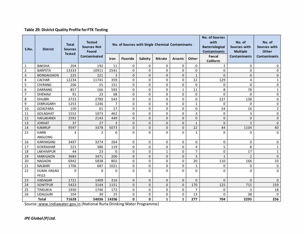
IPE Global (P) Ltd.
Table 29: District Quality Profile for FTK Testing
S.No. District Total
Sources Tested
Tested Sources Not
Found
Contaminated
No. of Sources with Single Chemical Contaminants
No. of Sources
with Bacteriological Contaminants
No. of Sources with
Multiple
Contaminants
No. of Sources with
Other
Contaminants Iron Fluoride Salinity Nitrate Arsenic Other
Faecal Coliform
1 BAKSHA 204 192 11 0 0 0 0 0 1 0 0 2 BARPETA 13333 10911 2541 0 0 0 0 0 0 0 0
3 BONGAIGAON 225 221 3 0 0 0 0 1 0 0 0 4 CACHAR 12234 11741 359 0 0 0 0 12 129 4 1
5 CHIRANG 206 55 151 0 0 0 0 0 0 0 0
6 DARRANG 857 166 593 0 0 0 1 11 8 78 1 7 DHEMAJI 91 23 68 0 0 0 0 0 0 0 0
8 DHUBRI 3723 2789 543 0 0 0 0 0 227 138 0 9 DIBRUGARH 1253 1246 7 0 0 0 0 1 0 0 0
10 GOALPARA 150 61 17 0 0 0 0 0 54 16 2
11 GOLAGHAT 1552 1073 462 0 0 0 0 3 0 3 0 12 HAILAKANDI 2592 2143 449 0 0 0 0 0 0 0 0
13 JORHAT 37 27 3 0 0 0 0 1 0 3 0 14 KAMRUP 9597 3378 5073 0 0 0 0 22 44 1104 40
15 KARBI ANGLONG
3 2 0 0 0 0 0 1 0 0 0
16 KARIMGANJ 3497 3274 264 0 0 0 0 0 0 0 0
17 KOKRAJHAR 521 386 119 0 0 0 0 4 5 8 1 18 LAKHIMPUR 44 23 0 0 0 1 0 7 0 17 1
19 MARIGAON 3683 3471 206 0 0 0 0 3 1 2 0 20 NAGAON 6942 5838 802 0 0 0 0 20 110 166 33
21 NALBARI 1706 687 1021 0 0 0 0 1 0 0 0
22 DUMA HASAO HILLS
0 0 0 0 0 0 0 0 0 0 0
23 SIBSAGAR 1721 1409 316 0 0 0 0 0 0 0 0 24 SONITPUR 5423 3144 1151 0 0 0 0 170 125 715 159
25 TINSUKIA 1930 1746 172 0 0 0 0 7 0 3 18 26 UDALGURI 104 30 25 0 0 0 0 13 0 38 0
Total 71628 54036 14356 0 0 1 1 277 704 2295 256
Source: www.indiawater.gov.in (National Rurla Drinking Water Programme)

Consultancy Services for Undertaking Environmental Assessment for the Rural Water Supply & Sanitation Project in Assam Draft Final Report
PE Global (P) Ltd. 100
3.5.4 Current Water Supply Practices Assam is still dependent on water from rain, streams and rivers for drinking and other
domestic purposes. These sources have proven to be unsafe. Access to safe drinking water
and the status of sanitation & hygiene in Assam is substantially less than the national
average. The population in Assam with access to safe drinking water is only 77.55%
compared to the all India figure of 88% (the same is 84% in rural areas and 95% in urban
areas) while the total sanitation coverage (rural plus urban) in India is 18% and in Assam
15.89%.
Table 30: Distribution of Households by main source of drinking water and location: Assam Rural– Census 2011
Total number of households
Tap water from treated source
Tap water from un-treated source
Covered well
Un-Covered well
Hand-pump
Tubewell / Borehole
Spring River / Canal
Tank / Pond / Lake
Other Sources
Total 5374553 310833 (5.78)
55852 (1.03)
58923 (1.09)
965961 (17.97)
2866428 (53.33)
439414 (8.17)
70287 (1.31)
208593 (3.88)
282954 (5.26)
115308 (2.14)
Within the premises
2707213 100028 16469 24752 433151 1877505 255308 0 0 0 0
Near the premises
1572643 140740 25875 18774 278979 643035 116299 18758 75258 220759 34166
Away 1094697 70605 13508 15397 253831 345888 67807 51529 133335 62195 81142
Source: National Rurla Drinking Water Programme, 2012
The majority of rural people obtain their drinking water from hand pumps and this is higher
than the All India Average. However the proportion of population having treated source is
much lower and the proportion obtaining from uncovered well is much higher than rural
India as a whole.
Water is supplied to rural areas through various Government led schemes. These schemes
can be single village or multi village schemes with both ground water and surface water as
its prime source. PHED is the main government agency which is responsible for water supply.
However, many international NGOs/CBOs , private organisations, and individuals fulfil the
daily demand of rural population by utilising ground water source through, dug wells, dug -
cum - bore wells and shallow tubewells. Villages with reported or observed presence of
Arsenic, Iron and Flouride, are mainly relaying on surface water sources such as River
Brahamputra and its tributaries, ponds, lakes, etc.
The present norms adopted by PHED for coverage of Habitations in Assam are as follows:
40 litres of safe drinking water per capita per day (LPCD) for human being.
A water source should exist within the habitation / within 1.60 km in the plains
and within 100 m elevation in the hilly areas.
Until the year 1993-94 the focus had been to cover the villages with problem of safe drinking
water. Broad coverage status of problem villages is as follows. According to APHED, Govt of
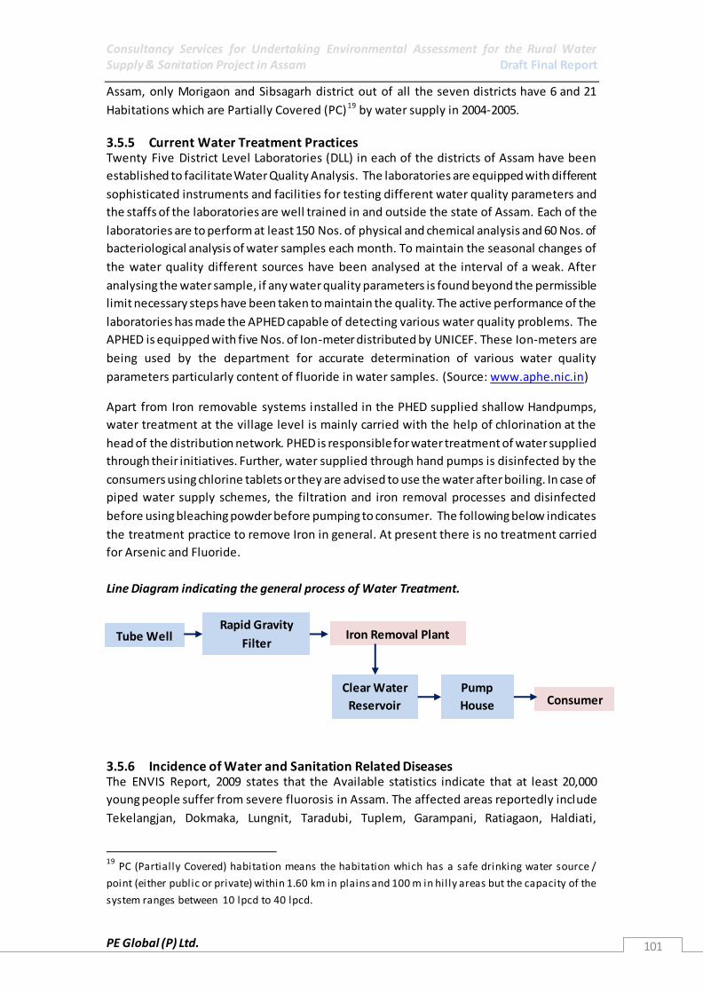
Consultancy Services for Undertaking Environmental Assessment for the Rural Water Supply & Sanitation Project in Assam Draft Final Report
PE Global (P) Ltd. 101
Assam, only Morigaon and Sibsagarh district out of all the seven districts have 6 and 21
Habitations which are Partially Covered (PC)19 by water supply in 2004-2005.
3.5.5 Current Water Treatment Practices Twenty Five District Level Laboratories (DLL) in each of the districts of Assam have been
established to facilitate Water Quality Analysis. The laboratories are equipped with different
sophisticated instruments and facilities for testing different water quality parameters and
the staffs of the laboratories are well trained in and outside the state of Assam. Each of the
laboratories are to perform at least 150 Nos. of physical and chemical analysis and 60 Nos. of
bacteriological analysis of water samples each month. To maintain the seasonal changes of
the water quality different sources have been analysed at the interval of a weak. After
analysing the water sample, if any water quality parameters is found beyond the permissible
limit necessary steps have been taken to maintain the quality. The active performance of the
laboratories has made the APHED capable of detecting various water quality problems. The
APHED is equipped with five Nos. of Ion-meter distributed by UNICEF. These Ion-meters are
being used by the department for accurate determination of various water quality
parameters particularly content of fluoride in water samples. (Source: www.aphe.nic.in)
Apart from Iron removable systems installed in the PHED supplied shallow Handpumps,
water treatment at the village level is mainly carried with the help of chlorination at the
head of the distribution network. PHED is responsible for water treatment of water supplied
through their initiatives. Further, water supplied through hand pumps is disinfected by the
consumers using chlorine tablets or they are advised to use the water after boiling. In case of
piped water supply schemes, the filtration and iron removal processes and disinfected
before using bleaching powder before pumping to consumer. The following below indicates
the treatment practice to remove Iron in general. At present there is no treatment carried
for Arsenic and Fluoride.
Line Diagram indicating the general process of Water Treatment.
3.5.6 Incidence of Water and Sanitation Related Diseases The ENVIS Report, 2009 states that the Available statistics indicate that at least 20,000
young people suffer from severe fluorosis in Assam. The affected areas reportedly include
Tekelangjan, Dokmaka, Lungnit, Taradubi, Tuplem, Garampani, Ratiagaon, Haldiati,
19
PC (Partially Covered) habitation means the habitation which has a safe drinking water source /
point (either public or private) within 1.60 km in plains and 100 m in hil ly areas but the capacity of the
system ranges between 10 lpcd to 40 lpcd.
Tube Well Rapid Gravity
Filter Iron Removal Plant
Clear Water
Reservoir
Pump
House Consumer
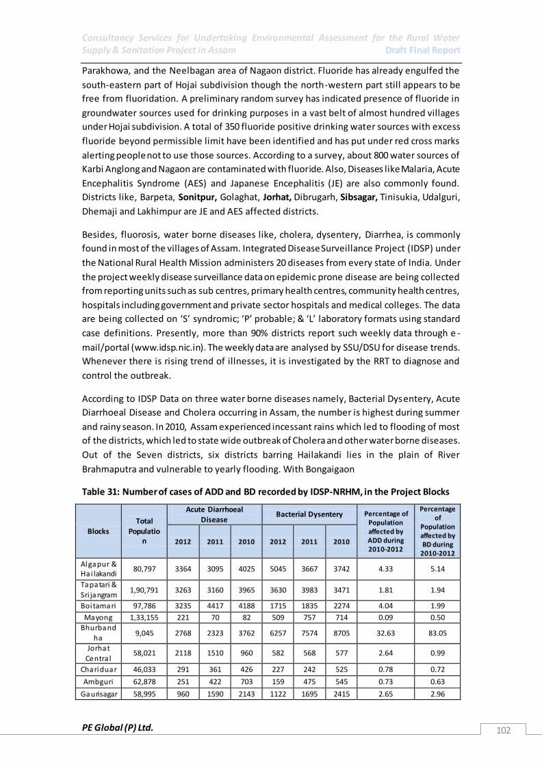
Consultancy Services for Undertaking Environmental Assessment for the Rural Water Supply & Sanitation Project in Assam Draft Final Report
PE Global (P) Ltd. 102
Parakhowa, and the Neelbagan area of Nagaon district. Fluoride has already engulfed the
south-eastern part of Hojai subdivision though the north-western part still appears to be
free from fluoridation. A preliminary random survey has indicated presence of fluoride in
groundwater sources used for drinking purposes in a vast belt of almost hundred villages
under Hojai subdivision. A total of 350 fluoride positive drinking water sources with excess
fluoride beyond permissible limit have been identified and has put under red cross marks
alerting people not to use those sources. According to a survey, about 800 water sources of
Karbi Anglong and Nagaon are contaminated with fluoride. Also, Diseases like Malaria, Acute
Encephalitis Syndrome (AES) and Japanese Encephalitis (JE) are also commonly found.
Districts like, Barpeta, Sonitpur, Golaghat, Jorhat, Dibrugarh, Sibsagar, Tinisukia, Udalguri,
Dhemaji and Lakhimpur are JE and AES affected districts.
Besides, fluorosis, water borne diseases like, cholera, dysentery, Diarrhea, is commonly
found in most of the villages of Assam. Integrated Disease Surveillance Project (IDSP) under
the National Rural Health Mission administers 20 diseases from every state of India. Under
the project weekly disease surveillance data on epidemic prone disease are being collected
from reporting units such as sub centres, primary health centres, community health centres,
hospitals including government and private sector hospitals and medical colleges. The data
are being collected on ‘S’ syndromic; ‘P’ probable; & ‘L’ laboratory formats using standard
case definitions. Presently, more than 90% districts report such weekly data through e -
mail/portal (www.idsp.nic.in). The weekly data are analysed by SSU/DSU for disease trends.
Whenever there is rising trend of illnesses, it is investigated by the RRT to diagnose and
control the outbreak.
According to IDSP Data on three water borne diseases namely, Bacterial Dysentery, Acute
Diarrhoeal Disease and Cholera occurring in Assam, the number is highest during summer
and rainy season. In 2010, Assam experienced incessant rains which led to flooding of most
of the districts, which led to state wide outbreak of Cholera and other water borne diseases.
Out of the Seven districts, six districts barring Hailakandi lies in the plain of River
Brahmaputra and vulnerable to yearly flooding. With Bongaigaon
Table 31: Number of cases of ADD and BD recorded by IDSP-NRHM, in the Project Blocks
Blocks Total
Population
Acute Diarrhoeal
Disease Bacterial Dysentery Percentage of
Population affected by ADD during 2010-2012
Percentage of
Population affected by BD during
2010-2012
2012 2011 2010 2012 2011 2010
Algapur & Hai lakandi
80,797 3364 3095 4025 5045 3667 3742 4.33 5.14
Tapatari &
Sri jangram 1,90,791 3263 3160 3965 3630 3983 3471 1.81 1.94
Boitamari 97,786 3235 4417 4188 1715 1835 2274 4.04 1.99
Mayong 1,33,155 221 70 82 509 757 714 0.09 0.50 Bhurband
ha 9,045 2768 2323 3762 6257 7574 8705 32.63 83.05
Jorhat Centra l
58,021 2118 1510 960 582 568 577 2.64 0.99
Chariduar 46,033 291 361 426 227 242 525 0.78 0.72
Ambguri 62,878 251 422 703 159 475 545 0.73 0.63
Gaurisagar 58,995 960 1590 2143 1122 1695 2415 2.65 2.96
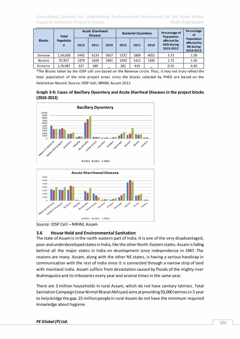
Consultancy Services for Undertaking Environmental Assessment for the Rural Water Supply & Sanitation Project in Assam Draft Final Report
PE Global (P) Ltd. 103
Blocks Total
Population
Acute Diarrhoeal Disease
Bacterial Dysentery Percentage of Population affected by ADD during 2010-2012
Percentage of
Population affected by BD during
2010-2012
2012 2011 2010 2012 2011 2010
Demow 1,54,058 5442 6133 5657 1372 1869 4051 3.73 1.58
Bezera 97,957 1470 1629 1961 1593 1411 1585 1.72 1.56
Dimoria 1,76,987 227 289 _ 281 419 _ 0.15 0.20
*The Blocks taken by the IDSP cell are based on the Revenue circle. Thus, it may not truly reflect the
total population of the nine project areas since the blocks selected by PHED are based on the
Habitation Record. Source: IDSP-Cell, NRHM, Assam 2012.
Graph 3-9: Cases of Bacillary Dysentery and Acute Diarrheal Diseases in the project blocks (2010-2012)
Source: IDSP Cell – NRHM, Assam
3.6 House Hold and Environmental Sanitation The state of Assam is in the north-eastern part of India. It is one of the very disadvantaged,
poor and underdeveloped states in India, like the other North-Eastern states. Assam is falling
behind all the major states in India on development since independence in 1947. The
reasons are many. Assam, along with the other NE states, is having a serious handicap in
communication with the rest of India since it is connected through a narrow strip of land
with mainland India. Assam suffers from devastation caused by floods of the mighty river
Brahmaputra and its tributaries every year and several times in the same year.
There are 3 million households in rural Assam, which do not have sanitary latrines. Total
Sanitation Campaign (now Nirmal Bharat Abhiyan) aims at providing 93,000 latrines in 5 year
to help bridge the gap. 23 million people in rural Assam do not have the minimum required
knowledge about hygiene.

Consultancy Services for Undertaking Environmental Assessment for the Rural Water Supply & Sanitation Project in Assam Draft Final Report
PE Global (P) Ltd. 104
3.6.1 Status of Toilet Construction According to the census report 2011, Scheduled Tribe population in Assam lacks the facility
of latrine within the premises severely compared to total rural population and the Scheduled
Caste counterpart. However, in case of drainage facility the situation remains the same for
the above sub- groups.
Table 32: Distribution of Households by sanitation facilities and caste: Assam Rural– Census 2011
Total number
of households
Number of
Households
having latrine
facilities within
the premises
Number of Households
having closed drainage
within the premises
Number of
Households
having bathrooms
within the
premises
Total 6367295 4131931(64.89) 230025(3.61) 1558058 (24.47)
Rural 5374553 3201625(59.57) 76764(1.42) 846494(15.75)
ST Rural 814320 57674(7.08) 8243(1.01) 74530(9.15)
SC Rural 539606 326395(60.48) 10114(1.87) 89156 (16.52)
Source: Census 2011
Subsequently, based on 2008 TARU report, Impact assessment of Nirmal Gram Puraskar
(NGP) awarded panchayats the following are the main findings of the study in terms of the
sanitation and hygiene situation:
Of the 85% households having access to individual, community or shared toilets,
only around 66% used them. Poor or unfinished installations, lack of super structure
and reluctance to change behaviour led to this non-use of toilets.
Although the NGP had led to almost 70% people using toilets, 30% of the people
were still found to resort to open defecation.
In case of toilets in schools, lack of gender considerations, poor functionality and
inadequate number of toilets as compared to the number of children using it during
peak hours led to lack of use of toilets among children.
More than half the GPs and households visited lacked mechanisms for solid and
liquid waste disposal.
Table 33: Report Card status of Nirmal Bharat Abhiyan (NBA) as on 29 /1/2013
Component Project Targets Project Achievements %age Achievement
IHHL BPL 2220017 1650433 74.34 IHHL APL 1161020 431009 37.12 IHHL TOTAL 3381037 2081442 61.56 School Toilets 34772 33736 97.02
Sanitary Complex 211 63 29.86 Anganwadi Toilets 16819 10997 65.38 RSM/PC 115 183 159.13 Source: http://tsc.gov.in/NBA/State.aspx

Consultancy Services for Undertaking Environmental Assessment for the Rural Water Supply & Sanitation Project in Assam Draft Final Report
PE Global (P) Ltd. 105
*The Block and GP Wise Data on Total Sanitation Coverage is available from the webiste:
http://tsc.gov.in/NBA/State.aspx
3.6.2 Status of Liquid Waste Management There is no provision of drainage system or sewerage system in all the Villages of Assam.
Most of the liquid waste is going to either Agricultural Land or to open ponds and open
fields. This is a major cause of concern and based on the water quality data of surface water
bodies, high contamination of bacteria is observed in some of the districts such as Dhubri,
Cachar, Kamrup, Nagaon and Sonitpur.
Table 34: Details of Bacteriological contamination in all the districts of Assam
S.No
District
No. of Sources with Bacteriological
Contaminants
Faecal Coliform
1 BAKSHA 1 2 BARPETA 0
3 BONGAIGAON 0
4 CACHAR 129
5 CHIRANG 0
6 DARRANG 8
7 DHEMAJI 0
8 DHUBRI 227
9 DIBRUGARH 0
10 GOALPARA 54
11 GOLAGHAT 0
12 HAILAKANDI 0
13 JORHAT 0
14 KAMRUP 44
15 KARBI ANGLONG 0
16 KARIMGANJ 0
17 KOKRAJHAR 5
18 LAKHIMPUR 0 19 MARIGAON 1
20 NAGAON 110
21 NALBARI 0
22 DUMA HASAO HILLS 0
23 SIBSAGAR 0
24 SONITPUR 125
25 TINSUKIA 0
26 UDALGURI 0
Source: Format E21- District Quality Profile For FTK Testing (National Rural Drinking Water
Programme – Rajiv Gandhi National drinking Water Mission)
3.6.3 Status of Solid Waste Management
There is no solid waste management in the rural areas of Assam. The solid waste is either
burnt or buried (biodegradable waste) as a common practice by the villagers. Under health
and hygiene trainings carried by PHED, NGO’s and UNICEF for the villagers, decomposition of
bio degradable waste is preached. Many of the households practice burning of non -
biodegradable along the road side.

Consultancy Services for Undertaking Environmental Assessment for the Rural Water Supply & Sanitation Project in Assam Draft Final Report
PE Global (P) Ltd. 106
3.6.4 Status of Power/Electricity
In Assam as per census 2001, only 70% villages are electrified and only 16.5% rural
households are electrified. The Govt. of Assam has been implementing rural electrification
programme in Assam through Distribution Companies. With a view to achieve electrification
of all villages of Assam and provide access to electricity to all households in line with the
National Rural Electrification Policy 2004 & Rural Electrification Policy of Govt. of Assam,
Rural Electrification works particularly under Rajiv Gandhi Gramin Vidyutikaran Yojana
(RGGVY) scheme have been carried out. Under this scheme all the census villages of Assam
are proposed to be electrified by 2009. Electrification in 16 districts to be implemented by
ASEB and in 7 districts by the Power Grid Corporation of India. District wise schemes for
electrification of villages have been submitted to the Govt. of India and approval for 13
districts has already been received. Currently most villages in Assam have electricity, with
variation in number of hours of supply.
Table 35: Average Hours of electricity in rural areas of Assam
Maximum 14
Minimum 10
Average 12
Source: Statistical Handbook, 2011
3.7 Disasters
Natural calamity like flood is occurring almost every year in Assam and it poses a challenging
task to the APHED with respect to ensuring safe drinking water to the flood affected
population. Floods usually occur during monsoon (mid June till late August) and many a
times can create trouble by destroying roads and railway linkages at places.
Apart from being highly vulnerable to flooding, Assam experiences, river bank erosion, sand
casting, landslides, cyclonic storms annually. The exposure to such hazards is also
aggravated because of the location of the State in the north eastern region which is one of
the most seismically active regions in the world. Assam is said to receive high torrential
rainfall ranging from 248cm to 635cm which also contribute to the flooding of the
Brahmaputra River. The encroachment of a large number of wetlands that serve as natural
reservoirs has decreased the retention capacity of the system causing floods to rise. The
easily erodible geological formations also contribute to river expansion and increased
sediment influx of the river.
River Bank Erosion: The morphology of the Brahmaputra River is characterized by intense
braiding and bar formation—where channels exhibit successive bifurcation and re-joining of
flow around sand bars and islands—and highly dynamic river bank line and bed
configuration. The morphology and behaviour of the river undergoes drastic changes in
response to variations in the flow regime and pattern of sediment transport and deposition
in the river following the seasonal rhythm of the monsoon. Multiple factors, such as
excessive sediment load, large and variable flow, easily erodible bank materials, and
aggradation of the channel, have been the possible underlying factors. Another striking
feature of the river’s morphology is the continuous shift of the thalweg (deep channel) from
one location to another within the unstable bank lines of the river. Bank materials of the

Consultancy Services for Undertaking Environmental Assessment for the Rural Water Supply & Sanitation Project in Assam Draft Final Report
PE Global (P) Ltd. 107
Brahmaputra consist mainly of fine sand and silt with only an occasional presence of clay.
They have a relatively fine-grained top stratum and a coarser substratum.
Graph 3-10: Details of Erosion and deposition in the North Bank of River Brahmaputra
Graph 3-11: Details of Erosion and deposition in the North Bank of River Brahmaputra
Source: RS-GIS Based Assessment of River Dynamics of Brahmaputra River in India, (Sarkar. A, 2011)
Riverbank erosion is chronic problem caused by dynamic shifting of channels flowing
through unconsolidated heavy sand or silt strata of the floodplain, with high sediment
discharge. Since 1954, Assam’s 17 riverine districts have lost 7% of their land area to erosion.
Some 8,000 ha of land (valued at $20 million) is lost annually, which is accompanied by the
appearance of low-lying unproductive sandbars. About 10,000 families are displaced each
year and those who become landless are forced to move to increasingly congested nearby
riverbank lines and dikes. More critically, progressive river erosion is threatening many flood
embankments with possible devastating inundation and associated damage once it reaches
and undercuts the embankments during the monsoon. The Graph below shows the erosion
and depletion of river bank on the north and south of R. Brahmaputra.

Consultancy Services for Undertaking Environmental Assessment for the Rural Water Supply & Sanitation Project in Assam Draft Final Report
PE Global (P) Ltd. 108
Table 36: Erosion/deposition area along Brahmaputra for the period 1990 to 2008.
Reach Number
Locations in Vicinity
South (Left) Bank North (Right) Bank
Total Erosion
km2
Total Deposition
km2
Total Erosion
km2
Total Deposition
km2
1 Dhubri 195.005 4.41 124.461 0.698
2 Goalpara 18.411 3.484 79.046 3.502
3 Palasbari 23.663 9.208 51.97 7.425
4 Guwahati 6.831 0.963 4.618 10.546
5 Morigaon (Near Mangaldai)
99.799 1.49 35.781 5.877
6 Morigaon (Near Dhing) 11.253 8.204 29.057 10.828
7 Tezpur 16.628 7.766 38.758 6.566
8 U/s of Tezpur (Near Gohpur)
26.098 16.616 32.831 1.053
9 Majuli (Near Bessamora) 32.788 9.068 25.562 13.851
10 U/s of Majuli (Near Sibsagar)
43.088 0.375 64.273 0.735
11 Dibrugarh 47.525 3.069 37.896 1.33
12 U/s of Dibrugarh 399.163 3.83 20.376 83.455
TOTAL 920.251 68.483 544.631 145.866
Floods: An overall estimated 92.6% of cultivated land or 3.15 million ha of the area is prone
to floods in the valley (SNC, 2010). Tenth five year plan indicates a crop loss of value of
Rs.14559.95 lakhs. Flood damages to crops, cattle, houses and utilities from 1953 to 1995 is
estimated at 4400 crore, with a peak of 664 crore in a single year (Staff College Report,
2005). An estimated 8,000 ha of riparian land are destroyed annually due to river bank
erosion (SNC, 2010). Sand deposition /casting i.e. accumulation of enormous dunes of sand
are seen to be more severe and devastating since the mid 1990’s especially in the northern
banks of eastern Brahmaputra Valley. This had rendered fertile lands to be fully
unproductive thus displacing people and causing loss of productivity and marginalization. It
has increasingly caused deterioration of wetlands and farmlands (ICIMOD, 2009). Landslides,
causes blocking of courses, bursting of these temporary bunds causes devastating floods
downstream. It also acts an obstacle in the flow of the river, which upset regime of
Brahmaputra Basin (Staff College Report, 2005) Damming of the tributaries of the
Brahmaputra causing liquefaction damage where the river enters the plains. Landslides also
increase the detritus content of the river causing increased water flow. The events of
cyclonic storms have been observed to be more frequent in the western parts of Assam
especially during monsoons causing colossal losses to lives and property (Staff Co llege
Report, 2005).
Major activities taken up by the APHED during and after flood are as follows :-
Distribution of leaflets containing instruction regarding various ‘dos and don’ts’ to
be followed during and after flood.
Distribution of chemical packets (alum, bleaching powder and lime) for domestic
level water purification.
Disinfection of spot sources.

Consultancy Services for Undertaking Environmental Assessment for the Rural Water Supply & Sanitation Project in Assam Draft Final Report
PE Global (P) Ltd. 109
Installation of spot sources at the relief camps and raising of the hand pumps as
required.
Repairing and restoration piped water supply schemes and spot sources damaged by
flood.
Figure 3-10: Flood Affected Districts in Assam, 2012
Source: Down To Earth - Assam, Arunachal Pradesh face worst ever floods recorded in June,
2012
Earthquake: The great earthquake of 1950 created havoc, especially in the upper reaches of
the Himalayas in and around the Siang and the Diboug river courses as well as in the upper
Assam plains. There was considerable impact on the topography on both sides of the
Brahmaputra Valley. This natural calamity was mainly responsible for the abrupt changes in
the river ecology. The river Brahmaputra and its many tributaries in upper Assam badly
suffered due to blockage caused by uprooted trees, boulders and soil erosion.
North East India is one of the most seismically active regions in the world. Part of the Indian
Plate, the Himalayan Plate in the North and the Indo Burma Plate in the East form its
borders. Pushing itself north-eastwards the Indian Plate is continuously moving against
these two plates. The Plate on the eastern front forms a subduction zone as it slips under
the Indo-Burma Plate. Also, due to these intense tectonic movements there are a number of
faults, folds and other tectonic features formed in the area. The result of all this is the
classification of North East India under earthquake Zone V by the Government of India.
Although in general the Assam valley is considered seismi cally stable it is vulnerable to
earthquakes due to its thick sedimentary cover which have suffered extensive damage
through ground rupture and liquefaction, issues noted in past earthquakes. Also, these
earthquakes have resulted in landslides. One such earthquake in 1950 has been responsible

Consultancy Services for Undertaking Environmental Assessment for the Rural Water Supply & Sanitation Project in Assam Draft Final Report
PE Global (P) Ltd. 110
for the course of the Brahmaputra. It is estimated that landslides triggered by this
earthquake was responsible for the deposition of detritus amounting to about 30 times the
average annual load of the river. This has also impacted the nature of the river as it has once
again started to cut its valley, creating higher levels of erosion along the banks. A list of
major damaging earthquakes in the North East Region is given alongside.
Also, The Brahmaputra valley is considered a tectonic-sedimentary basin, 720 km long and
80–90 km wide, underlain by recent alluvium about 200–300 m thick consisting of clay, sand,
and pebble. Because the basin is underlain mostly by very young and unweathered
sedimentary formations, the river carries mainly fine sand and silt with very little clay. Due
to their strategic location close to the border of the colliding Eurasia (Chinese), Indian, and
Burmese tectonic plate boundaries, the Brahmaputra valley and its adjoining hill ranges are
seismically very unstable, falling in zone V (very severe seismic intensity zone) under seismic
zoning. Active seismicity of the North Eastern region has caused extensive landslides and
rock falls on the hill slopes, subsidence and fissuring of ground in the valley, and changes in
the course and configuration of several tributary rivers as well as the Brahmaputra
mainstream. These have had a significant impact on the hydrologic regime and morphology
of the Brahmaputra basin. Their occurrence led to the intensification of flood and river
erosion hazards, especially in the aftermath of the two great earthquakes of 1897 and 1950.
Table 37: List of some of the Major Earthquakes in the North East
Year Location Region Magnitude 1869 26 N, 92.4 E Cachar 7.5
1897 26 N, 91 E Shillong Plateau 8.7 1906 Sibsagar 7.5
1908 7.0
1918 24.5 N, 91 E Srimangal 7.6 1930 25.8 N, 90.2 E Dhubri 7.1
1943 26.8 N, 94 E Hajai Central Assam 7.2
1947 28.5 N, 94 E N W Dibrugarh 7.6
1950 28.7 N, 96.6 E Rima 8.7
1988 25.15 N, 93.13 E Indo-Myanmar 7.3 Source: State of Environment Report, Assam
3.8 Climate Change
So far as climate change in northeast India is concerned, climate scientists have observed
rising temperatures in the region as a whole and decreasing rainfall in the eastern and
southern areas (Das 2004, Mirza et. al.1998). They also refer to recent drought-like
situations in the years 2001, 2005, 2006, 2008, and 2009 as indicators of climate change in
the region (IPCC 2007). Anecdotal references and grey literature recount other symptoms,
such as increasing spells of intense rainfall in the pre-monsoon and monsoon seasons in
some places, as well as lack of rainfall in post-monsoon and winter seasons in others, both
affecting agriculture adversely (ICIMOD 2008). Both extreme rainfall episodes and rates of
soil erosion are believed to have increased in upstream areas (Tibet in China and Arunachal
Pradesh in India) of the Brahmaputra basin. There are increasing reports of floods caused by
damming of landslides in the foothills of the Arunachal Himalayas. As a result flash floods
have increased in the hills affecting vast areas of the flood plains. The intensity, frequency,
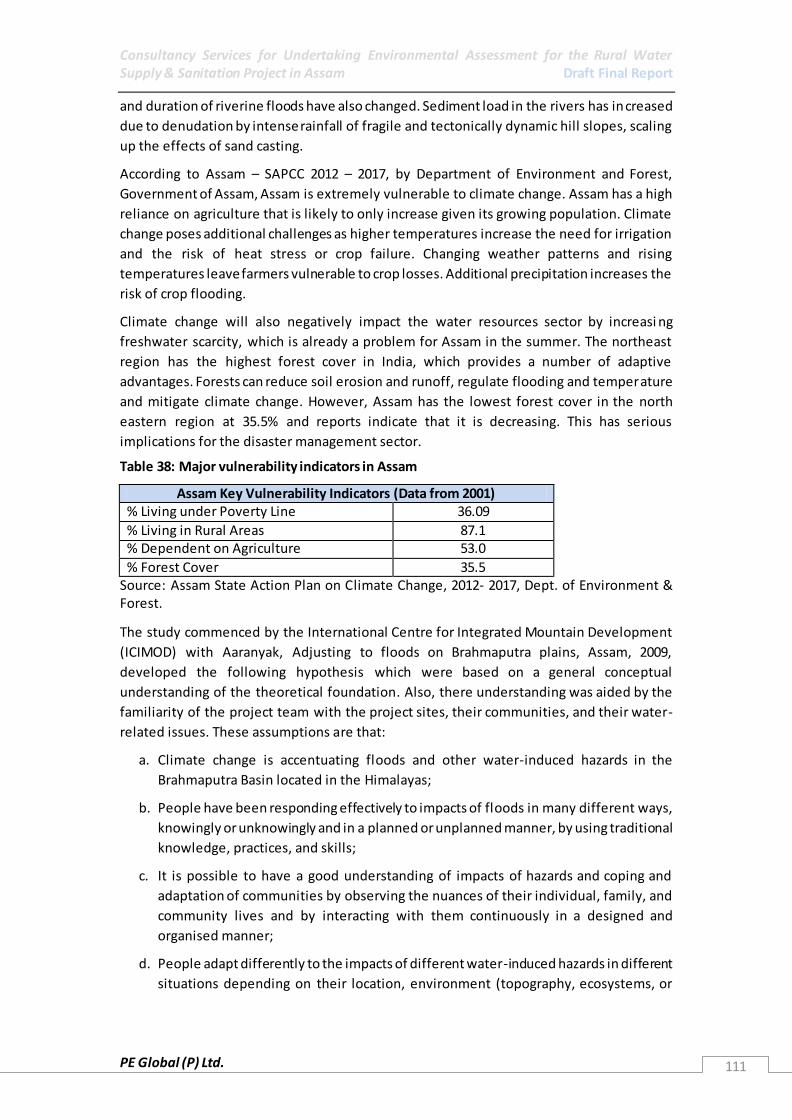
Consultancy Services for Undertaking Environmental Assessment for the Rural Water Supply & Sanitation Project in Assam Draft Final Report
PE Global (P) Ltd. 111
and duration of riverine floods have also changed. Sediment load in the rivers has increased
due to denudation by intense rainfall of fragile and tectonically dynamic hill slopes, scaling
up the effects of sand casting.
According to Assam – SAPCC 2012 – 2017, by Department of Environment and Forest,
Government of Assam, Assam is extremely vulnerable to climate change. Assam has a high
reliance on agriculture that is likely to only increase given its growing population. Climate
change poses additional challenges as higher temperatures increase the need for irrigation
and the risk of heat stress or crop failure. Changing weather patterns and rising
temperatures leave farmers vulnerable to crop losses. Additional precipitation increases the
risk of crop flooding.
Climate change will also negatively impact the water resources sector by increasi ng
freshwater scarcity, which is already a problem for Assam in the summer. The northeast
region has the highest forest cover in India, which provides a number of adaptive
advantages. Forests can reduce soil erosion and runoff, regulate flooding and temperature
and mitigate climate change. However, Assam has the lowest forest cover in the north
eastern region at 35.5% and reports indicate that it is decreasing. This has serious
implications for the disaster management sector.
Table 38: Major vulnerability indicators in Assam
Assam Key Vulnerability Indicators (Data from 2001) % Living under Poverty Line 36.09
% Living in Rural Areas 87.1 % Dependent on Agriculture 53.0
% Forest Cover 35.5 Source: Assam State Action Plan on Climate Change, 2012- 2017, Dept. of Environment & Forest.
The study commenced by the International Centre for Integrated Mountain Development
(ICIMOD) with Aaranyak, Adjusting to floods on Brahmaputra plains, Assam, 2009,
developed the following hypothesis which were based on a general conceptual
understanding of the theoretical foundation. Also, there understanding was aided by the
familiarity of the project team with the project sites, their communities, and their water-
related issues. These assumptions are that:
a. Climate change is accentuating floods and other water-induced hazards in the
Brahmaputra Basin located in the Himalayas;
b. People have been responding effectively to impacts of floods in many different ways,
knowingly or unknowingly and in a planned or unplanned manner, by using traditional
knowledge, practices, and skills;
c. It is possible to have a good understanding of impacts of hazards and coping and
adaptation of communities by observing the nuances of their individual, family, and
community lives and by interacting with them continuously in a designed and
organised manner;
d. People adapt differently to the impacts of different water-induced hazards in different
situations depending on their location, environment (topography, ecosystems, or

Consultancy Services for Undertaking Environmental Assessment for the Rural Water Supply & Sanitation Project in Assam Draft Final Report
PE Global (P) Ltd. 112
climate), economy, culture, religion, age, gender, status of development, governance
(or lack of it), education, and political awareness;
e. The poor are more vulnerable to water-induced stresses than the rich; and
f. Traditional coping and adaptation are losing their effectiveness against the changing
nature of hazards and the fluid social dynamics of indigenous societies.
The Vision stated under the State Action Plan for Climate Change, Assam (2012-2017)
envisages a sustainable and climate resilient development pathway through a synergistic
combination of adaptation & mitigation measures with focus on research, appropriate
technology, capacity creation and governance. The following six Thrust Areas‘are identified
under the Action Plan.
1. Sustainable Livelihood: Major concerns are sustainability of critical ecosystems
including agro-ecosystems, the creation of value chains at the local level, and risk
management. Livelihood systems are considered for both farm sector (agriculture,
fishery, and livestock) and natural resource systems (forest, wetland).
2. Mitigating natural disaster and crisis management: Major concerns will be on
preparedness, mitigation and vulnerability reduction in all forms of climate induced
natural disaster.
3. Health: Major concerns relate to diseases that are sensitive to changes in climatic
parameters, the access to health services of communities living in high risk areas; and
the resilience of public health infrastructure.
4. Urban Planning: Major concern will be human settlement (includes housing,
sanitation, drinking water, transportation, health and other amenities both in rural
and urban context).
5. Energy (focuses on Energy sufficiency and efficiency): Major concerns will be
technological initiations and intervention with more focus on harnessing new and
renewable energy, energy efficiency and conservation.
6. Bio resources Protection and sustainable management of Forest and Wild Life: Major
concern will be on forest and wild-life protection and developing resilience of eco-
system services (includes RF, VF, PA and CCA and wetland under forest areas too).

Consultancy Services for Undertaking Environmental Assessment for the Rural Water Supply & Sanitation Project in Assam Draft Final Report
PE Global (P) Ltd. 113
4 ENVIRONMENT MANAGEMENT FRAMEWORK
4.1 Environmental Assessment The aim of this study is to conduct Environmental Assessment (EA) and provide an
Environment Management Framework (EMF) to identify critical environmental concerns for
the RWSSP in Assam and appropriate mitigation measures. This section therefore looks at
key RWSS related concerns as identified through discussions, review of literature, field work
and primary surveys. This is followed by an analysis of impacts due to planned project
activities and identified environmental concerns. Finally, mitigation and management
measures are identified and are presented in the EMF along with suggested institutional
arrangements to implement the actions.
4.1 Key Environmental Issues Given that the present project aims at supporting the provision of clean drinking water,
improved drainage and environmental sanitation, it is likely to have a number of positive
impacts on the environment. The most important of these is improved health and well being
of those receiving improved services. Also, along with reliable and 24x7 household water
supply, it is expected to result in improved drainage and solid waste management at rural
household level, increased awareness on sanitation and higher use of safe sanitation
options.
Source sustainability: This project is likely to use mainly surface water sources from the
rivers identified earlier in the assessment. Considering the water needs under the project,
and the existing water flows, it is unlikely that there will be any impact on source
sustainability from the planned project.
At present a mix of surface and groundwater sources are being used to source water for
domestic purposes in the state. While data from the Central Ground Water Board suggests
that there are so far no critically, semi-critical or overexploited blocks in relation to
groundwater, discussions in the field and with the PHED suggests that decreasing
groundwater trends are seen in parts of Assam, such as has been indicated in Hailakandi.
Discussions with the PHED indicate that groundwater sources will continue to be used where
ever feasible through existing systems in the rural areas. However, given that in many areas
aquifers are contaminated with arsenic or fluorides and in some areas like Hailakandi, a
reliable water lens is only available at depths that need deep rigs for digging, surface water
sources are considered under the project for water augmentation. Out of the planned
intakes in the project, all nine are to be surface water intakes, located on River Brahmaputra
and its tributaries or the Barak system.
Discussions in the field highlight concerns regarding the existing water supply schemes
which are based on spring sources. Small streams, currently being used to augment water,
may have long term sustainability issues as during the preliminary assessment the existing
Bonda water treatment plant in Kamrup district, a stream originating in the Amchang
Wildlife Sanctuary bordering Guwahati towards the east is utilised as main source of water.

Consultancy Services for Undertaking Environmental Assessment for the Rural Water Supply & Sanitation Project in Assam Draft Final Report
PE Global (P) Ltd. 114
However, encroachment of the wildlife sanctuary and the subsequent degradation of the
catchment has become an issue for the source over the years. Degradation and
encroachment upon forested areas, and cutting of hills to make space for agriculture,
settlements etc., or even collection of firewood and other supplies from forests are some of
the problems being faced presently for the existing schemes. Thus, learnings from these
earlier projects, will help formulate better environment management plans.
Another concern is likely to be the changing availability of water in many of the catchments
with climate change. While the exact understanding of how glacial melt will impact
Brahmaputra is still not completely understood, some studies indicate that there is a general
decrease in the flow of the Brahmaputra. Also, climate change predictions indicate higher
rainfall in the eastern Himalayas, resulting in intense rainfall in Assam in the coming years.
The river systems in Assam, including both the Brahmaputra and the Barak are prone to
bank erosion and undercutting. Together all these factors are likely to have some impact on
source quality. The major concerns would be (i) bank erosion and undercutting over a longer
time frame resulting in washing away of water supply infrastructure (ii) flooding and rainfall
resulting in degradation of the catchment, thereby resulting in damage to infrastructure.
4.1.1 Water Availability An Approximate 18.5% of the state’s population is covered with piped water supply
schemes. Most are dependent upon handpumps, wells – mainly dug wells and PHED
schemes with water available through stand posts. Water in the PHED schemes is available
only for a few hours in a day, depending upon the scheme, with some like in Bongaigaon
where there may be no treatment as water is pumped directly from the river and distributed
though the local network. During discussions it was also noted that some schemes were
defunct due to low level of maintenance or non-availability of parts. In some areas, such as
Hailakandi, fetching water takes more than one hour usually for women or children of the
household to collect from the nearest PHED source (Spot source/Stand post). Due to the
project there will be minimum depletion of water sources as the proposed plan will draw
miniscule amount of water from the surface water source (Rivers) as well as ground water
resource as depicted in the two tables below:
Table 39: Total Requirement of Surface Water under the RWSS-LIS, Assam
S.N Scheme
Design Populati
on - Ultimate
Total Daily Requirem
ent in MLD;
(@70 LPCD)
Total Annual Requiremen
t in MCM;
Total Annual Requiremen
t in Cubic
Metre per
second (Cumec)
Source Name
(Aquifer/ River)
Surface Water
Average
Annual Discharge (Cumec)
Total Requirement Cumec (6) as
% of Flow (8)
1 2 3 4 5 6 7 8 9
1
Composite WSS for Sustainability & Quality in
Chandrapur & Dimoria Dev.
Block (B1)
429809 34.6 13 0.4 R.
Brahmaputra 19820 0.002
2
Composite WSS
for Sustainability & Quality in
Jorhat & Jorhat Central Dev. Block (B1)
531256 42.8 16 0.5 R.
Brahmaputra 19820 0.002
3 Greater Hailakandi –
153429 12.4 5 0.1 R. Katakhal - `-
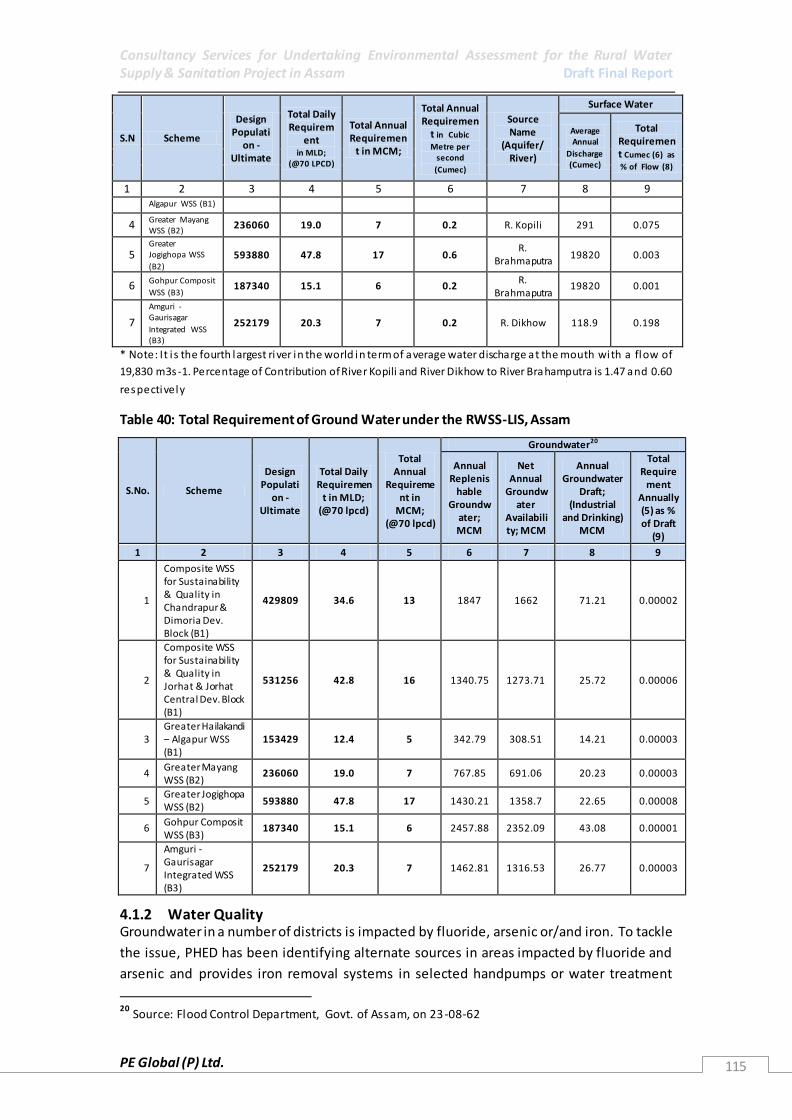
Consultancy Services for Undertaking Environmental Assessment for the Rural Water Supply & Sanitation Project in Assam Draft Final Report
PE Global (P) Ltd. 115
S.N Scheme
Design Populati
on - Ultimate
Total Daily Requirem
ent in MLD;
(@70 LPCD)
Total Annual Requiremen
t in MCM;
Total Annual Requiremen
t in Cubic
Metre per second
(Cumec)
Source Name
(Aquifer/ River)
Surface Water
Average Annual
Discharge (Cumec)
Total Requirement Cumec (6) as
% of Flow (8)
1 2 3 4 5 6 7 8 9 Algapur WSS (B1)
4 Greater Mayang WSS (B2)
236060 19.0 7 0.2 R. Kopili 291 0.075
5 Greater Jogighopa WSS
(B2) 593880 47.8 17 0.6
R. Brahmaputra
19820 0.003
6 Gohpur Composit
WSS (B3) 187340 15.1 6 0.2
R. Brahmaputra
19820 0.001
7
Amguri - Gaurisagar
Integrated WSS (B3)
252179 20.3 7 0.2 R. Dikhow 118.9 0.198
* Note: It i s the fourth largest river in the world in term of average water discharge at the mouth with a flow of
19,830 m3s -1. Percentage of Contribution of River Kopili and River Dikhow to River Brahamputra is 1.47 and 0.60
respectively
Table 40: Total Requirement of Ground Water under the RWSS-LIS, Assam
S.No. Scheme
Design Populati
on - Ultimate
Total Daily Requiremen
t in MLD; (@70 lpcd)
Total Annual
Requirement in
MCM; (@70 lpcd)
Groundwater20
Annual Replenis
hable Groundw
ater; MCM
Net Annual
Groundwater
Availability; MCM
Annual Groundwater
Draft; (Industrial
and Drinking) MCM
Total Require
ment Annually (5) as % of Draft
(9)
1 2 3 4 5 6 7 8 9
1
Composite WSS for Sustainability & Quality in Chandrapur & Dimoria Dev. Block (B1)
429809 34.6 13 1847 1662 71.21 0.00002
2
Composite WSS for Sustainability & Quality in Jorhat & Jorhat Central Dev. Block (B1)
531256 42.8 16 1340.75 1273.71 25.72 0.00006
3 Greater Hailakandi – Algapur WSS (B1)
153429 12.4 5 342.79 308.51 14.21 0.00003
4 Greater Mayang WSS (B2)
236060 19.0 7 767.85 691.06 20.23 0.00003
5 Greater Jogighopa WSS (B2)
593880 47.8 17 1430.21 1358.7 22.65 0.00008
6 Gohpur Composit WSS (B3)
187340 15.1 6 2457.88 2352.09 43.08 0.00001
7
Amguri - Gaurisagar Integrated WSS (B3)
252179 20.3 7 1462.81 1316.53 26.77 0.00003
4.1.2 Water Quality Groundwater in a number of districts is impacted by fluoride, arsenic or/and iron. To tackle
the issue, PHED has been identifying alternate sources in areas impacted by fluoride and
arsenic and provides iron removal systems in selected handpumps or water treatment
20
Source: Flood Control Department, Govt. of Assam, on 23-08-62
Consultancy Services for Undertaking Environmental Assessment for the Rural Water Supply & Sanitation Project in Assam Draft Final Report
PE Global (P) Ltd. 116
plants. However, where there is no treated water available through the PHED, the local
population in iron affected areas is using the water for all their needs and treating the water
with the help of a household makeshift arrangement for iron removal . It was also noted in
Morigaon district, that the local population had developed their personal iron removal
systems which were mainly charcoal and sand filters, to filter water for drinking. The filters
were cleaned once the households felt they are becoming clogged. In case alternate sources
are available, they are prioritised for drinking mainly, with the iron rich water being used for
other domestic purposes.
Diarrhoea and bacterial dysentery are both reported in the project districts according to the
IDSP – NRHM data. Discussions with villagers also pointed to diarrhoeal diseases being
present. While part of this could be due to poor hygiene, it was noted that in many areas the
distance between the handpumps and toilets was only a few meters, with the handpumps
also being the shallow TARA or Singrur. Equally, platforms of handpumps were often broken
or missing and due to poor design they are likely to be the cause of groundwater
contamination. Poor drainage around the handpumps is another issue of concern.
In areas where piped water supply is already available, taps/stand posts may also be poorly
placed, resulting in the contamination of the water at point-of-use. Another possible
concern is that, the pipes carrying water in many places are exposed or near the surface, and
thus have risk of their breakage or damage. This is also likely to result in contamination and
water leakage.
4.1.3 Water Treatment Practice Treatment of water prior to distribution is being carried out in most of the WTPs visited.
While in some areas like one of the systems visited in Hailakandi due to inactive water user
committees/ Gaon Panchayat Water and Sanitation Committees (GPWSC) the PHED is
managing the system, in other areas like Bonda, in kamrup, where there is an active VWSC
the committee is managing the system. There are however some others, such as observed in
Bongaigaon where there is no water treatment underway due to the lack of sufficient
staff/VWSC to manage the system. Therefore water is being provided without treatment at
present. Depending upon the needs and the system planned the treatment may include a
combination of aeration, flocculation and disinfection and iron removal.
The overall management of the WTPs was found inadequate. While most WTPs had
leakages, in some, like the one visited in Hailakandi, the treatment plant was in a state of
degradation due to very high iron content of the water, which gradually was corroding the
system. Drainage at the WTPs to ensure that they were free from stagnant water was not
necessarily present in all visited sites. Also, in many areas there was no clearly identified
system for the disposal of sludge from the WTP.
Another possible concern is that of use and storage of chlorine or bleaching powder.
Presently, most WTPs use bleaching powder and the bags are stored in the WTPs. In many of
the WTPs the bleaching powder bags were not stored properly and therefore are not
adequately protected from moisture or other elements. This is likely to degrade the quality
of the bleaching powder, rendering the treatment ineffective. Furthermore, no protective

Consultancy Services for Undertaking Environmental Assessment for the Rural Water Supply & Sanitation Project in Assam Draft Final Report
PE Global (P) Ltd. 117
gear was available for the operator to handle the bleaching powder and there was no
identified method to dispose slurry.
Discussions at most treatment systems also noted that water testing, even for residual
chlorination is unsystematically done with the water being tested about once a fortnight
with no records being kept right now.
Discussions with members of the VWSC in some areas like Bongaigaon indicated that their
capacity was weak and that they would be interested in more capacity building to manage
their systems better. In other areas there are still no GPWSCs or VWSCs formed and will
need to be formed and trained before they can be made in charge of the work.
4.1.4 Other Water Related Issues In many WTPs Rain Water Harvesting (RWH) systems were also noted. These are used to
supplement the water supplied to the WTPs and in some places also recharge the
groundwater. However, there seems to be no cleaning and management system noted for
the RWH systems. Also, there were in some areas trees and other obstructions that could
create contamination if adequate protection was not taken. Therefore in future, RWH
system planned would need to follow relevant government guidelines and an adequate
management system in place.
Household and point-of-use water management is limited. While a number of households
visited were ensuring that drinking water was not stored on the floor, often it was close to
the ground. Other concerns were also observed such as dipping hands and glasses in the
water to fetch water from containers, unsanitary conditions of taps and hand pumps
resulting in possible contamination of water. While there were some areas w here the
treatment was given to water prior to use, such as boiling or use of halogen tablets, this was
limited to very few households. Halogen tablet distribution and use was only noted during
discussions at a tea estate, where the tablets are distributed in the summer when diarrhoeal
diseases cases are high. Another concern is the availability of energy to run the WTPs and
pump water. Power availability is variable and could be as little as 6-7 hours and is not
reliable. This may not be sufficient to run large multi-village systems.
4.1.5 Wastewater Disposal Overall there is low open defecation in the villages, with a combination of different systems
and structures in place. However, sanitation coverage in Bongaigaon is very low, with some
areas estimating it at 10% only. Coverage by TSC has been low in this area and there are very
few areas where individuals have constructed toilets on their own. While some toilets have
twin pit latrines others have single pit latrines with or without options for a second
connecting chamber.
In Assam, as most houses have a small water body located near them, it is likely that these
water bodies receive waste from the drainage system and perhaps also some toilet waste.
This is also an issue as field observations in some areas l ike Morigaon noted that toilet were
very close to the local water body. Thus, contamination of both the surface and groundwater
system can be largely attributed to poor sanitation. Furthermore, this water is often used for

Consultancy Services for Undertaking Environmental Assessment for the Rural Water Supply & Sanitation Project in Assam Draft Final Report
PE Global (P) Ltd. 118
domestic purposes, though not drinking; but it includes washing utensils and vegetables.
Therefore, this can be a very major health risk.
4.1.6 Solid Waste Disposal In rural areas of Assam the amount of waste generated is less than 200 - 250
gms/day/person, wherein 25% is of this is non- biodegradable and 75% is biodegradable in
nature. Out of the non-biodegradable waste about 75% is recyclable and the reaming 25% is
non-recyclable. For an average village of about 1000 population, the total solid waste
generated is about 250 kg per day; out of which 187.5 kg of bio-degradable waste and 62.5
kg of non-biodegradable waste. Out of this, 62.5 kg of non-biodegradable waste, 47 kg is
recyclable and 15.5 kg is non-recyclable. This non-recyclable waste is mostly inert material.
During field visits and preliminary assessment, there was little solid waste accumulation seen
in the villages. This is mainly because most waste at present is wither buried, especially bio-
degradable or burnt as a means of disposal. In a village visited in Morigaon (Amlighat vill age
in Mayang GP) where there was a dairying community, although the village was using dung
to make energy, the slurry was disposed into the fields and open drains . However, it was
also observed that the villagers had a good knowledge of slurry being dumpe d in open field
could cause contamination of aquifers and is also the cause of presence of E-coli in the
ground water systems.
4.1.7 Sanitation and Hygiene Lack of sanitation facilities and poor hygienic conditions cause waterborne diseases, such as
diarrhoea, cholera, typhoid and several parasitic infections. Moreover, the incidence of
these diseases and others linked to poor sanitation is highest among the poor, especially
school-aged children in most of the districts in Assam. From the project districts,
Bongaigaon, Jorhat, Sonitpur and Sibsagar are worst affected districts, with respect to
diseases like dysentery and diarrhoea, Japanese encephalitis and malaria.
The study revealed the existence of Kuchcha Latrine in large proportions due to shortage of
State budget for meeting expenses on sanitation as reported both by the Government and
Gram Panchayat members. Lack of sanitation facilities has led to the prevalence of
waterborne diseases as reported during many village discussions in the project districts.
Accredited Social Health Activists (ASHA) and Integrated Child Development Services (ICDS)
workers also expressed their dismay about the gap in awareness among the beneficiaries on
issues related to water and sanitation. Even the basic hygiene practices are not practiced by
the community.
There is lack of strategic inter departmental coordination which is needed for effective use
of resources. Water and Sanitation needs to be addressed as an integrated component and
convergence with existing framework of Nirmal Bharat Abhijan (NBA) in the State as a whole
and effective dissemination to be done at the District, Block Gram Panchayat and Habitation
level. Convergence with the Panchyati Raj Institutions (PRIs), PHED and Mahatma Gandhi
National Rural Employment Guarantee Act (MNREGA) is inadequate which hampers
coverage, community mobilisation and community level monitoring and supervision, etc.
There is need for taking support of Health department for involvement of their field staff in
sanitation and in hygiene awareness campaigns mainly through integration with ASHA

Consultancy Services for Undertaking Environmental Assessment for the Rural Water Supply & Sanitation Project in Assam Draft Final Report
PE Global (P) Ltd. 119
programme. Further there is need for taking the support of the NBA program functionaries
in mobilizing people for promoting individual sanitary latrines and creating awareness about
health, hygiene and nutrition.
4.1.8 Other Sanitation Related Issues There is little evidence of a systematic wastewater disposal system in villages visited in the
project area. Within villages, many areas have mud roads, and any water would either run
downhill if sloping or if there are natural drains would drain into the existing water bodies or
low lying areas. Roads in the area are largely devoid of drains alongside.
While in a village in Morigaon- Amlighat village in Mayang Gaon Panchayat there is a big
dairying community with an estimated 95% of villagers engaged in milk production. The
animal dung here is used for producing biogas which is used for cooking and electrification.
However, there is no disposal mechanism identified for the slurry from the biogas plant, and
it is let to flow onto the adjoining lands. This, according to the villagers is leading to the
contamination of groundwater. Such dairying and cattle rearing is however limited to a few
areas in Assam only. Pig rearing is more common with the pigs often being brought up in
relatively unsanitary conditions, which may be a concern due to their role as intermediate
hosts for the Japanese Encephalitis vector.
4.1.9 Topography and land use
Most areas identified for the present project are presently agriculture lands, where paddy is
the main crop. In some districts like Bongaigaon, Hailakandi, Jorhat, Sonitpur and Sibsagar
there are also large tea estates. All of these are likely to use a number of agrochemicals,
both fertilizers and pesticides which will have an impact on the quality of surface and
groundwater. While industrial development is limited to a few pockets, yet oil refineries,
wells and paper mills exist in both upper and lower Assam. In fact, upstream of the identified
probable intake at Bongaigaon, is on River Aye which has an oil refinery in its vicinity.
Similarly, nearly on all rivers systems, upstream of the planned intakes there are identified
sites for sand mining. Apart from possible impact on river morphology due to sand mining
activities, there is also likely to be an impact from all these activities on water quality.
The topography of Assam generally consists of a combination of two major river valleys, hills
and a number of inselbergs (Island Mountains). In parts of Assam these hills and inselbergs
are in a state of degradation. Water supply networks may be impacted by this degradation
due to (i) erosion of land and landslides damaging the network, and (ii) landslides and other
degradation of hills resulting in pump houses and other infrastructure being damaged or
destroyed due to the degradation. This could be further aggravated based upon climate
change predictions that suggest increased rainfall in the eastern Himalayan region in the
times to come.
4.1.10 Floods and river bank erosion
Floods are one of the biggest disasters in Assam. This is further compounded by river bank
erosion which results in undercutting of a number of rivers, including the two major rivers –
the Brahmaputra and Barak, and also the shifting of the river course. Flooding may result in
(i) damage or destruction of the intakes along the rivers; (ii) flood waters entering toilets

Consultancy Services for Undertaking Environmental Assessment for the Rural Water Supply & Sanitation Project in Assam Draft Final Report
PE Global (P) Ltd. 120
resulting in contamination of surface and groundwater systems; and (iii) damage hand
pumps and if water enters the aquifer through hand pumps during floods, also pollute
aquifers.
River bank erosion is of greatest concern for river intake systems. Due to undercutting or
river banks erosion resulting in bank collapse and changing of river courses, intake wells are
likely to be most impacted. The other planned alternative, the floating barges, while may not
be impacted to such an extent as they can be shifted, may result in the need for changed
locations, and additional costs for on-land infrastructure or pipes.
4.1.11 Earthquakes
Assam is categorised as Zone V in terms of seismic activity. Therefore, there is a high
likelihood of high intensity earthquakes in the region. This can result in damage and
destruction of infrastructure, including water supply infrastructure.
4.1.12 Landslides Degradation of hills and inselbergs due to encroachment and deforestation has resulted in
landslides and damage to infrastructure throughout North Eastern states. As the planned
water supply infrastructure is to have a 100% coverage, those living in the hil ls would also be
covered. However, except for Hailakandi, the project areas are mainly in the river plain and
thus due to landslides, there will not be any probable damage to infrastructure.
Nevertheless, to ensure a smoother supply and gravity based suppl y, wherever possible the
water supply reservoirs should be located on highlands. It should also be kept in mind while
designing, that landslides may also result in blocking of drainage systems planned or divert
streams, which if used for procuring water would result in the need to abandon the system.
4.1.13 Impact from wildlife corridors and impact on ecological resources
There are a number of animal corridors for various species in Assam. Most relevant among
these, perhaps from the perspective of infrastructure safety are the elephants. Although,
based on the field survey, there are no animal corridors inside the Project area, but to
ensure precaution as any infrastructure in the way of an elephant corridor is likely to be
damaged, mitigation measures for the same are given in the monitoring plan. Therefore,
appropriate design changes may be required to assure the safety of the system. This could
include ensuring all infrastructure underground, or identifying alternate sites which are
outside corridors. Also, during the migratory season – for any wildlife species, no
construction activities should take place for both the safety and wellbeing of the
construction site workers and the animals/birds.
4.1.14 Issues Identified during Field Visits and Consultations
A variety of issues were identified by the team during the field visits and through the
consultation process, including the survey based questionnaire. The major findings are
discussed below.
Most discussions show that there is a need for domestic water. This has bee n voiced by
women and men, cutting across gender boundaries. The needs may differ a bit
depending upon existing systems. Therefore, while in some areas like the villages visited
in Hailakandi, there was adequate and good quality water available, but at a distance

Consultancy Services for Undertaking Environmental Assessment for the Rural Water Supply & Sanitation Project in Assam Draft Final Report
PE Global (P) Ltd. 121
from the village while groundwater sources were often not viable due to limited yield of
shallow aquifers. Therefore, the major concern was the labour and time consumed in
getting water. On the other hand in the tea estates, water is made available to the tea
labourers, but it is not sufficient to fulfil all their needs. In certain areas there are
shortages during certain months as yields from sources reduce, or in others water
quality is an issue of concern – which is mainly in areas where there is a high iron
content.
Many of those who are suffering from low water availability are willing to pay for water.
However, a concern raised was on how much the water would cost. The ability to pay is
perhaps an important factor in deciding on whether or not the different groups will be
able to afford the planned services. It is therefore recommended that a survey that can
assess the ability to pay be undertaken prior to fixing the prices for water in any area.
The overall understanding of contamination by faecal-oral route is low. There is also very
little hygiene education material seen anywhere in the villages. Variable systems for
point-of-use water treatment, water storage and handling, management of cleaning and
disposal of septic tank waste, location of toilets vis-à-vis handpumps and backyard family
ponds in some areas may result in contamination- are some of the issues identified in
the field. There is therefore a need for more effective IEC to be undertaken to support
the planning and management of the existing systems. In the case of point-of-use water
management, while water in the houses is usually not kept on the ground, collection
points are dirty and are likely to create contamination. Therefore, point-of-use water
management needs strengthening.
Water quality management consisted of a variety of different methods, sand filters for
iron removal, boiling and halogen or chlorine tablets. However, most of this is only done
in a limited way, with a majority of people drinking water directly without any
treatment. Even when the water is procured from wells it is not necessarily treated, as
was noted during discussions with the Mishing people in Sonitpur district.
While in some areas villages are homogeneous with a single social group or tribe
inhabiting them, in many areas it is not so with more than one social group present. In
such cases the different groups were found living in different habitations. Each of these
groups has its own identity, way of living and access to resources. Furthermore, not all of
them have equal access to services and resources. This fact must be considered while
planning a system and service delivery in an area.
There could be some areas where culturally or archaeologically important sites are there
and must be considered during project design, both to work within the parameters of
existing legislation and ensure that there is no damage to these sites. In the field a Tiwa
community gathering site in Morigaon and an old temple site near the intake at
Bongaigaon were noted. Similarly, other sites may also exist and must be considered
while planning and designing the system
There are a number of animal corridors in Assam. During the present series of field visits,
the team did not encounter any such corridors in the project areas. However,
discussions identified that at least in Sibsgar and Sonitpur districts there are elephant
movements, even if they are not within ten kilometres from the project areas. Such
animal movements may also exist in other districts and must be clearly identified to

Consultancy Services for Undertaking Environmental Assessment for the Rural Water Supply & Sanitation Project in Assam Draft Final Report
PE Global (P) Ltd. 122
ensure that neither do they disturb the wildlife using them and nor are they damaged by
wildlife movement. Discussions with the Forest Department and local population in any
area can easily identify animal corridors or animal movements for an area. This would be
an important consideration while planning the project.
Wildlife, forest and sensitive areas: Some of the project areas, such as in Bongaigaon,
Jorhat and Kamrup are near ecologically sensitive areas. This includes the Manas
National Park, Kaziranga National Park and Garbangah Reserved Forest. The former two
are also UNESCO heritage sites. All three of these sites are within 20 kms of the project
area, with some estimated to be less than 10 kms. Therefore, there will be a need to
identify appropriate routes for transportation of material, routes which cause least
damage to the forest and wildlife and forests for pipe laying, O&M as appropriate for the
area, systems that cause least danger to workers during construction and O&M.
Capacity to manage water supply systems is limited with the SLUC and the Goan
Panchayat. Thus, it may also impact other planned infrastructure.
4.2 Environmental Impacts
4.2.1 Design Stage Impacts
Detailed below is an overall assessment of the possible design impacts, including selection of
project locations that may occur from the development of the WSS infrastructure. These
may differ from place to place, as some of the impacts identified here may only be
applicable to specific areas. Therefore, depending upon the identi fied sites for infrastructure
development, this list of impacts should be looked at and used as is appropriate for the
individual sites.
Table41: List of Design Stage Impacts
Design Stage Impacts
Environmental Issue
Positive Impact Adverse Impact
Physical Environment
Land Resources – soil
Improved dra inage in vi l lages , reduced soi l toxici ty loca l ly.
Better solid waste management in vi l lages , reduced soi l toxici ty loca l ly.
Change from groundwater for drinking from arsenic and fluoride
impacted systems would reduce the need to remove these chemical contaminants, reducing
waste from such systems .
Inadequate drainage provided with increased water availability, increasing waterlogging and
soi l toxici ty. Dumping of waste from treatment plants
resulting in increased toxicity of the loca l area.
Inadequate s torage of chemica ls and other materia l at treatment plants resulting in
seepage and contamination of ground loca l ly.
Landscape – hills Need for material to build systems, resulting in
removal of earth may reduce s tabi l i ty and landslides may occur, though this is more l ikely a cumulative impact occurring from a number of
di fferent activi ties as individual ly systems identified from such projects would have limited
needs . Location of s i tes such as pump houses ,
treatment plants and reservoirs and their access
roads on hills may require vegetation clearance
and result in reduced s tabi l i ty of the area
Rivers and Improved management of Confl ict with di fferent users at the location

Consultancy Services for Undertaking Environmental Assessment for the Rural Water Supply & Sanitation Project in Assam Draft Final Report
PE Global (P) Ltd. 123
streams and other surface
flows
systems and reduced wastage resulting in reduced pressure on
surface water resources , where used. On a large scale this is l ikely to have a positive impact, though
individual systems impact may be negl igible
where the intake i s planned Poorly designed infrastructure not accounting
for adequate dra ins may result in loca l area waterlogging.
Des ign not accounting for backwash needs may
result in temporary water s tagnation loca l ly
Rivers and streams - quality
Improved sanitation and envi ronmental sanitation activi ties wi l l reduce toxici ty
reaching river systems
Pol lution due to poor des ign, resulting in leakages or dumping of waste. This may be more of a concern with floating barges .
Inadequately designed wastewater discharges , excessive sewage and toilet waste may result in
contamination of water system Groundwater system - quantity
Proper ra inwater harvesting s tructures resulting in adequate
recharge of system/reduced dependence on groundwater
systems Improved management of
systems and reduced wastage
resulting in reduced pressure on groundwater resources , where used
Excess ive withdrawal of water resulting in groundwater depletion
Groundwater system - quality
Improved dra inage and environmental sanitation wi l l
result in reduced contamination of aqui fers
Inadequately designed wastewater discharges , excessive sewage and toilet waste may result in
contamination of water system. With more water available in the vi llages there i s l ikely to be more l iquid waste and dra inage water discharged
Poorly des igned RWH systems may result in
groundwater contamination Inadequately des igned backwash and waste
disposal system may result in water from system getting stagnant and/or waste collecting in the area and could contaminate the groundwater
Water bodies and wetlands
Improved dra inage and environmental sanitation wi l l result in reduced contamination of aqui fers
Noise and Air quality
Intake, pumping system or WTP in an ecologica l ly sens i tive area may result in dis turbances during the day to day running, and a lso create confl ict with loca l wi ldl i fe.
Ecological Systems
Terrestrial Poor design not accounting for needs of loca l wi ldli fe may result in confl ict, and may a lso
result in the destruction and degradation of the system
Poorly des igned syste m may result in
unnecessary clearance of vegetation and cutting of trees
Introduction of alien species or flora as part of landscape or other activi ties resulting in takeover of ecological niche or destruction of
habitat of loca l flora species Introduction of alien species or flora as part of
landscape or other activities resulting in fauna habitat degradation
Intake – ei ther for groundwater or surface water, floating barge, pumping system or WTP in an ecologically sensi tive area may result in
dis turbances during the day to day running, and
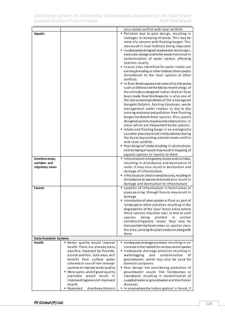
Consultancy Services for Undertaking Environmental Assessment for the Rural Water Supply & Sanitation Project in Assam Draft Final Report
PE Global (P) Ltd. 124
also create confl ict with loca l wi ldl i fe. Aquatic Pol lution due to poor des ign, resulting in
leakages or dumping of waste. This may be more of a concern with floating barges . This
may result in loca l habitats being impa cted. Inadequately designed wastewater discharges ,
excessive sewage and toilet waste may result in
contamination of water system, affecting habitats loca l ly.
In case s i tes identi fied for water intake are
exis ting breeding or other habitats there could a dis turbance to the loca l species or other
confl icts In River Brahmaputra and some of i ts tributaries
such as Dikhow and the Manas recent sitings of
the cri tically endangered Indian Grahia l have been made. River Brahmaputra i s a lso one of the last remaining habitats of the endangered Gangetic Dolphin. Exis ting s tructures , waste management water intakes or day to day running and noise and pollution from floating barges ma disturb these species . Also, poorly
des igned systems may become obstructions in areas which are frequented by the species .
Intake and floating barge in an ecologica l ly
sensitive area may result in disturbances during the day to day running, and a lso create confl ict
with loca l wi ldl i fe. Poor design of intake resulting in obstructions
and dumping of waste may result in trapping of
aquatic species or injuries to them Sensitive areas,
corridors and migratory zones
Infrastructure in migratory routes and corridors,
resulting in dis turbance and destruction of route. It may a lso result in destruction and damage of infrastructure
Infrastructure sited in sensitive area, resulting in dis turbance to species and could also result in
damage and destruction to infrastructure Forests Location of infrastructure in forest areas or
pipes pass ing through fores ts may result in
damage Introduction of alien species or flora as part of
landscape or other activi ties resulting in the degradation of the loca l forest areas where these species may take over, or due to such
species being planted in animal corridors/migra tory routes they may be
transported into forest areas as species cross the area, carrying the plant seeds etc along with them
Socio-Economic Systems Health Better qual i ty would improve
health. There are a l ready many aqui fers impacted by fluoride, arsenic and iron. Such areas wi l l
benefi t from surface water schemes or use of i ron removal
systems to improve water qual i ty More water, and of good qual i ty
ava i lable would result in
improved hygiene and improved health
Repeated diarrhoea/chronic
Inadequate drainage provision resulting in an
increase in the habitat for various vector species Inadequate dra inage provis ion resulting in
waterlogging and contamination of
groundwater, which may a lso be used for domestic purposes
Poor des ign not cons idering protection of groundwater source l ike handpumps or s tandposts resulting in contamination of
supplied water or groundwater and diarrhoeal diseases
In areas where the Indian grahia l i s found, i f

Consultancy Services for Undertaking Environmental Assessment for the Rural Water Supply & Sanitation Project in Assam Draft Final Report
PE Global (P) Ltd. 125
diarrhoea impacts nutri tional ava ilability in the body and has an
impact on mental health and growth for chi ldren. It a lso impacts unborn children i f mother
suffers from nutri tional deficiencies while pregnant with her chi ld. Better water quality will therefore improve nutri tion absorption and health s tatus
Reduced need to carry water from long dis tances wi l l reduce risk of injuries etc
Improved dra inage, reduced waterlogging and better sol id waste management will resul t in better health, with reduction in
contamination of loca l environment and habitat for disease vectors .
there are any intakes or floating barges , accidents of conflict of workers with the species
could occur. Poor design s tandards, not considering exis ting
disasters – such as earthquakes and floods ,
resulting in contamination or breakages and subsequent health i mpacts
Poor design and waste management systems may a lso create habitats for certa in disease vectors l ike the sand fly which results I Ka la -Azar/black fever or Viscera l leishmanias is , a disease with a recent outbreak (2008) in Chandrapur and Panikheti , both of which are within the present project area.
Overall wellbeing of
population
Reduced time taken to fetch water will resul t in greater time
for other activi ties including leisure, economic activi ties and time spent with chi ldren and
fami ly. Chi ldren fetching water wi l l
benefi t from less time spent col lecting water and more time for education, to play and other
activi ties Reduced health problems wi l l
reduce medical expenses , DALYs and care taker time which can be used for other activi ties .
Other WSS infrastructure
Competing for resources with other loca l infrastructure at source, resulting in impacting
ei ther or both infrastructure and overa l l resource susta inabi l i ty
Location of planned s tructures , obstructing or
creating other problems for exis ting WSS infrastructure
Waste from redundant systems – being upgraded.
Other
infrastructure
Improved dra inage and waste
management resulting in reduced water s tagnation, reducing
degradation of infrastructure
Need to cut across lines and roads laid down for
other infrastructure, thereby resulting in dis ruption or damage
Disruption of navigation routes , piers (ghats ) especially in smaller rivers and streams used for supplying water
Local economy and economic
systems
Reduced i l l heal th resulting in larger number of person-days to
work in field and other activi ties
location of intake may interfere with loca l fi sh landing s i tes , access to river, cut across
agricul ture fields , or transport routes Cultural property,
aesthetics
Poor des ign resulting in s tructures reducing aesthetics in area
Structure and connected infrastructure cutting across archaeologica l and other cul tura l ly
important s i tes Waterlogging and dra inage problems due to
greater ava i labi l i ty of water in area without
adequate drainage management, des troying or damaging cultural property and archaeologica l s i tes

Consultancy Services for Undertaking Environmental Assessment for the Rural Water Supply & Sanitation Project in Assam Draft Final Report
PE Global (P) Ltd. 126
4.2.2 Construction Stage Environmental Impacts
A majority of project related impacts are likely to be due to the construction activities, with a
number of short term impacts likely to be over once the construction is completed. Most of
these would also be localised and only affect the immediate surroundings of the
construction site, except for those areas identified for procurement of material. Therefore,
most of the impacts can be easily contained and managed. However, if rehabilitation of sites
as required is not carried out in time, permanent damage at some sites is possible. The
major impacts identified so far are listed below.
Table 42: List of Major Impacts identified at construction Stage
Construction Impacts
Environmental Issue
Positive Impact Adverse Impact
Physical Environment
Land Resources – soil
Poor storage of chemicals and other material at construction sites resulting in toxicity to soil
Erosion from borrow sites
Accumulation of water and increased soil toxicity at borrow sites
Accidents and spillage resulting in toxicity and damage to the soil
Compaction of soil/soil erosion for access to various sites and to quarries by trucks
Landscape – hills Material procurement from hills resulting in hil ls caving in and landslides and scaring of landscape
Destruction and removal of vegetation for fuel for
labour camps, resulting in denudation of hil ls resulting in mud/land slides and scaring of landscape
Rivers and streams - flow
Blockage of natural drains due to waste dumping or during construction
Rivers and
streams - quality
Sediment runoff and deposition near sites or
during transportation. Material procurement – sand from rivers leading
to increased turbidity and course change in smaller streams
Pollution from construction activities in rivers and streams – especially at the time of construction of intake wells.
Poor labour camp management and insufficient WSS systems for them, or no rehabilitation of labour camp and construction site after construction work is over resulting in pollution
Groundwater
system - availability
Excessive pressure on groundwater for provision
of water for construction site, without considering local needs, resulting most l ikely in temporary depletion of resource, though a problem for the local population til l aquifer is replenished
Groundwater
system - quality
Pollution from construction activities, such as the
WTPs where adequate drainage is not provided leading to water stagnating and percolating into ground along with pollutants
Waste dumping, spil lage of chemicals and fuels,
seeping into aquifers

Consultancy Services for Undertaking Environmental Assessment for the Rural Water Supply & Sanitation Project in Assam Draft Final Report
PE Global (P) Ltd. 127
Inadequate drainage provided at time of dril l ing and testing of groundwater for sites used to procure water may result in temporary waterlogging at sites and may also result in
pollution of local aquifer Poor labour camp management and insufficient
WSS systems for them, or no rehabilitation of
labour camp and construction site after construction work is over resulting in pollution
Water bodies and wetlands
Pollution from construction activities in rivers – especially at the time of constructing intakes
Pollution from vehicles being washed in water
bodies and wetlands Pollution from dumping of waste in water bodies Inadequate drainage provided at time of dril l ing
and testing of groundwater for sites used to
procure water may result in temporary waterlogging at sites
Poor labour camp management and insufficient
WSS systems for them, or no rehabilitation of labour camp and construction site after construction work is over resulting in pollution
Noise and Air quality
Pollution from construction activities Noise from generators and other construction
activities l ike trucks etc., passing the area Dust and sand flying from trucks during
transportation Poorly maintained vehicles or heavy dril l ing
activities resulting in high level of noise or vibration
Air pollution from vehicles and machinery
Ecological Systems
Terrestrial Plantation activities resulting in alien species introduction, degrading the local environment
Construction at the time of animal migration that disturbs the migratory routes and patterns
Destruction of vegetation by vehicular movement
and clearance for paths, storage of construction material and for sourcing material
Aquatic Impact on local fisheries and fish spawning and aquatic fauna.
Gharail, dolphin and other species disturbed
during construction activities if in the area River sand – such as River Kulsi, damage to habitat
of the dolphin Increased turbidity mainly from sand mining
though also construction in river, disturbing local habitats
Construction at the time of species migration
disturbing the migratory area Sensitive areas,
corridors and migratory zones
Noise and disturbance from construction activity,
transportation of material Material procurement from sensitive sites,
resulting in damage to site
Construction during migration leading to disturbance to species and conflicts

Consultancy Services for Undertaking Environmental Assessment for the Rural Water Supply & Sanitation Project in Assam Draft Final Report
PE Global (P) Ltd. 128
Forests Disturbance and degradation to forests due to vehicular movement carrying construction material
Degradation of forests as construction material is
procured from them Use of wood from forests for supply of firewood
for construction camps
Waste generated from various project activities, but no adequate disposal system identified, resulting in being dumped in the vil lage lands
Socio-Economic Systems
Settlement and local population
Disturbance to local population due to construction activities, movement of vehicles,
noise or from labour Conflict with local population on resources with
labour camps Conflict with local population due to restriction in
construction sites and access to some sites for them
Accidents from vehicles and poor construction site
management Increase water stagnation and drainage problems
due to construction activities, poorly managed labour or construction sites and vehicles being
cleaned and serviced in the area Increased traffic at sites for material procurement
or construction sites, disturbing population
Health Occupational Safety and construction hazards due to inadequate management of site, access to site
for all people including local population not working at site, and inadequate protection gear and training to labour.
Workers/labour camps and facil ities in sufficient, poorly managed or not existent resulting in health problems to them and the local population.
Health problems due to water stagnation at sites,
resulting in breeding sites for disease vectors Lack of water and sanitation services at labour
camps resulting in health problems Poor rehabilitation of sites – construction, labour,
borrow sites, leading to habitats for disease vectors
Increase in disease due to influx of migrant labour
Poor design and waste management systems may also create habitats for certain disease vectors l ike the sand fly which results in Kala-Azar/black fever or Visceral leishmaniasis, a disease with a recent
outbreak (2008) in Chandrapur and Panikheti, both of which are within the present project area.
Other WSS infrastructure
Damage to infrastructure due to vehicular movement, construction sites or labour camps
May increase pressure on the local infrastructure
as water and sanitation needs of labour also to be accounted for
Other infrastructure
Damage to infrastructure, transportation of material, storage of material

Consultancy Services for Undertaking Environmental Assessment for the Rural Water Supply & Sanitation Project in Assam Draft Final Report
PE Global (P) Ltd. 129
Waste generated from various project activities, but no adequate disposal system identified, resulting in obstructing people pathways or degrading other infrastructure
Local economy
and economic systems
May provide some
local employment opportunities at the sites temporarily
Disturbance to local population due to temporary
reduced access to sites as sites identified for labour camps and storage may be used by local population for various activities such as farming,
storage or threshing or even firewood procurement
Sites l ike agriculture fields used for material storage
Waste generated from various project activities, but no adequate disposal system identified, resulting in being dumped in the vil lage lands
Cultural property Chance findings – archaeological sites. Scaring of landscape due to borrow sites, such as
in hil ls or from firewood collection
4.2.3 Operation & Maintenance Stage Environmental Impacts
Table 43: List of impacts during the O&M Stage
O&M Impacts
Environmental Issue Positive Impact Adverse Impact
Physical Environment Land Resources –
soil
Poor management of WTP resulting in
dumping of waste, backwash water with excessive chemicals and waste and sludge on land, resulting in degrading soil.
Pumping house for floating barges poorly
maintained, resulting in leakages of fuel and other chemicals and dumping of waste on land, degrading soil.
Chemical spil lage from WTP or during O&M
Rivers and streams
– quality
Better sanitation facil ities,
with improved waste disposal will improve the river water quality which at
present is getting polluted due to waste dumping.
Poor management of WTP resulting in
dumping of waste, backwash water with excessive chemicals and waste and sludge in local water body.
Chemical spil lage from WTP or during O&M
Groundwater system – availability
Excessive pumping of groundwater, beyond planned resulting in depletion of resource
Development of other and competing
groundwater systems which together with this system result in depleting of resource
Groundwater system – quality
Less dependency on ground water since the RWSS project will draw
water from the River Brahmaputra and Barak and its tributaries for water augmentation.
Poor management of WTP resulting in dumping of waste, backwash water with excessive chemicals and waste and sludge on
land and percolating into shallow aquifer RWH system poorly maintained resulting in
contamination of aquifer Inadequate finances or skil ls to manage small
or individual systems resulting in their degradation, accumulation of water around the system or breakage resulting in
contamination of aquifer

Consultancy Services for Undertaking Environmental Assessment for the Rural Water Supply & Sanitation Project in Assam Draft Final Report
PE Global (P) Ltd. 130
Water bodies and wetlands
No disposal of wastewater in the neighbourhood water bodies, will improve its condition.
Poor management of WTP resulting in dumping of waste, backwash water with excessive chemicals and waste and sludge in local water body.
Noise and Air
quality
Poor maintenance of WTP and pumping
station and any diesel pump sets used as back up energy supply, resulting in high noise levels and air pollution
Ecological Systems
Aquatic Poor management of WTP resulting in dumping of waste, backwash water with excessive chemicals and waste and sludge in
local water body or river and streams.
Sensitive areas, corridors and migratory zones
In case of systems near sensitive areas, corridors or fly paths poor maintenance of systems or dumping of waste may result in disturbance to wildlife
Socio-Economic Systems
Health Health conditions are l ikely to increase due to abandonment of poor
quality water sources such as Handpumps, stand post which are affected by iron,
arsenic and fluoride. Also, installation of twin pit toilets in each household, will improve overall
sanitation conditions of all vil lages covered under the project. Targeting hygiene practices through IEC
measures will also reduce probabilities of disease.
Accidents, or injuries during maintenance or at the WTP or pumping station due to inadequate training or insufficient safety
equipment or poor management Poor maintenance of system, network and
breakages and leaks not managed properly
resulting in contamination of treated water and il l health
Poorly kept and managed or outdated chlorine/bleaching power, resulting in
ineffective disinfection Insufficient knowledge to manage the system
resulting in inadequate disinfection,, cleaning of system or other management issues
resulting in poor quality water being supplied Unattended leakages from water supply
system leading to vector habitats
Poorly managed drainage and solid waste systems leading to vector habitats
Inadequate finances or skil ls to manage small or individual systems resulting in their
degradation. Inadequate sanitation/ environmental
sanitation management contaminating
shallow aquifers in areas where dugwells or shallow rigs are used to procure water
Cultural property Poor maintenance of system resulting such as drainage and damage to any local cultural property.
4.3 Objectives of Environment Management Framework
The main objective of the Environment Management Framework is to identify management
actions for any possible adverse environmental concerns arising from the project activities,
or possible adverse impact of given environmental situation in the project. This is based
upon identified concerns from the field, secondary data and discussions that have resulted in
the development of impact matrices for environmental impact resulted in the design and
location stage, construction stage and O&M stage of the project and though key

Consultancy Services for Undertaking Environmental Assessment for the Rural Water Supply & Sanitation Project in Assam Draft Final Report
PE Global (P) Ltd. 131
observations. This EMF, through its various steps sets out environmental codes of practices
that need to be followed during various stages such as planning, construction and operation
and maintenance, to ensure sustainability of infrastructure and resource. Also, the EMF
suggests probable actors and stakeholders who need to be involved in the implementation
of the planned actions.
4.4 Environmental Management Framework
4.4.1 Key Elements of the EMF
The key elements of the EMF that apply to the Assam RWSS project are detailed below.
1. Collection of Basic Environmental Data: To ensure adequate and proper identification of
local needs and monitoring of project the EMF needs environmental data for each scheme.
To do this and ensure a standard format for the project an Environmental Data Sheet (EDS)
for schemes on water supply, sanitation, solid and liquid waste management, etc. is available
in Annexure 1.9.
This data is to be completed simultaneously with the development of the DPR. The AEE/ EE
of the scheme fills up the EDS in consultation with the GPWSCs the Gram Panchayat or other
local civil society organisations who are involved in the project.
2. Environmental Classification of Schemes: At the Detailed Scheme Report (DSR)
preparation stage, the available environmental information in the EDS will be evaluated and
based on the level of expected environmental and public health impacts, the proposed
scheme would be classified as either Category I (basic) or Category II (detailed
environmental appraisal required).
The EDS formats are given in Annexure 1.9. The screening tool for the categorization of
schemes is available in 1.4.3. The overall in charge for the identification of the
environmental classification of schemes with the help of the screening tool is the EE of each
scheme.
3. Environmental Appraisal and Approval: For all category I schemes, there shall be no
separate environment appraisal other than filling up of EDS included in the DSR.
For category II schemes, a detailed environmental appraisal of the proposed scheme is
required. This will be done by the EE and his team who is in charge of the scheme. This team
can be supported by the state level environmental expert attached to PMU, for any technical
help required.
The environmental appraisal for category II schemes shall not take more than 30 days. The
DPR of Category I schemes should be accompanied by the Environmental Data Sheet (EDS).
The EE of the RWSS will need to ensure this. The DPR for Category II schemes should be
accompanied by the Environmental Data Sheet (EDS) and the Category II environmental
appraisal. The EE of the RWSSD will ensure this. All documentation will be finally checked for
consistency and quality by the PMU environmental specialist.
4. Environmental Compliance Monitoring during Implementation and O&M phases: The
EMF will ensure that: 1) The prescribed environmental mitigation measures (including
construction stage measures) as identified through the environmental appraisal process are
adequately implemented. The Implementation Completion Report of each scheme will
include an Environmental Compliance Certificate given by the GPWSC/GP or other identified

Consultancy Services for Undertaking Environmental Assessment for the Rural Water Supply & Sanitation Project in Assam Draft Final Report
PE Global (P) Ltd. 132
appropriate authority, depending upon the planned local level management of the scheme
for a completed scheme indicating that the mitigation measures identified in the appraisal
have been implemented.
2) Monitoring and Supervision: There will be periodic supervision and monitoring conducted
to ensure compliance to the EMF and identification of any additional concerns that may
have risen since. The suggested monitoring plan is outlined in section 1.5.8 of this document
titled the Monitoring Plan. In case there is a need for any changes in the monitoring plan,
this can be suggested to the state PMU, and based upon discussions this can be changed as
required. There will also be an independent external audit, as a part of the overall project
monitoring program at mid-term of the project to suggest any course correction, if required.
3) Capacity building needs to be undertaken to ensure the proper execution of the EMF. It
has been noted that some issues of poor management of systems at the local level can be
rectified by training and capacity building activities. Therefore, a capacity building and
training plan has been developed as a part of the EMF and should be used to ensure proper
implementation of the EMF. Section 1.6 includes the suggested training and capacity
building plan.
4) IEC for the management of water, sanitation, environmental sanitation, drainage etc., will
be needed at the local level. This is imperative to ensure proper management of v illage
sanitation and reduce health burden from water and sanitation related diseases. Also, the
IEC, in addition to water related issues, can be focused at increasing the demand for toilets
and their improved management.
4.4.2 Application of EMF to Project
Environmental Management Framework essentially consists of Environmental Screening,
Environmental Assessment (EA), Environmental Management Planning and monitoring of
compliance with the plan of actions recommended for mitigating environmental risks. The
environmental screening was carried out under this assessment to determine the
appropriate environmental category for the proposed projects. Based on the outcome of
screening, an Environmental Assessment (EA) respective to the attached environmental
category will be applied for each proposals.
The PHED as recommended in the Environment Data Sheets (EDS) will be responsible for
carrying out the required EA and for confirming that any clearances necessary for the
proposed RWSS projects are obtained from the relevant authorities as prescribed by the
national and state legislations which should also meet with the World Bank procedures as
described in the EA/EMF document. Once the EA is performed and recommendations
incorporated into the sub-project, the project can be appraised and sanctioned.
Depending on the environmental category, the package would include one of the following:
a) a full scale Environmental Impact Assessment (EIA) and an Environmental Management
Plan (EMP), b) Environmental Management Plan (EMP), c) a simplified environmental
assessment, so called EMP checklist, or d) a justified statement that no EA is required. To
ensure that environmental management is an integral part of project activities, the EMF
needs to be incorporated in the project and scheme’s management. The following flow
diagram elaborates the steps involved in the EA/EMF Process. Also, A Plan of responsibility is
suggested in the Table 43 below.
Consultancy Services for Undertaking Environmental Assessment for the Rural Water Supply & Sanitation Project in Assam Draft Final Report
PE Global (P) Ltd. 133
Baseline Data Collection
and Analysis
Qualitative and
Quantitative Survey
Impact Assessment
Screening Checklist for
Scoping
Identification of Key
Environmental Issues
CATEGORY II
Collect Baseline and fill EDS Collect Baseline and fill EDS
Generic Environment
Management Plan
Environmental Appraisal & Impact
Identification
Mitigation Measures &
Approvals
Specific Environmental
Management Plan
Monitoring Plan
GUIDELINES
(ECoP)
ENVIRONMENTAL ASSESSMENT
ENVIRONMENTAL MANAGEMENT FRAMEWORK
GUIDELINES
(ECoP)
Performance Indicators
Mitigation Measures
CATEGORY I
Supervision and
Monitoring

Consultancy Services for Undertaking Environmental Assessment for the Rural Water Supply & Sanitation Project in Assam Draft Final Report
PE Global (P) Ltd. 134
Table 44: Roles and Responsibilities for Implementation of EMF
Phase EMF Activity Objectives Process Responsibility Result
Preplanning/
Planning
Environmental Data Sheet
To col lect bas ic information on environmental aspect of the proposed scheme.
Discuss scheme with community and identi fy environmental i s sues of concern.
GPWSC or local agency a long with GP
EDS prepared and attached to DSR.
Fi l l EDS. IF required, provide additional information as supplementary notes
AEE/AE/ with support from GPWSC or local
agency and SO Environmental
classi fication of the scheme
To ensure that
schemes with potentia l ly s igni ficant
environmental or publ ic health i ssues are identified at an early s tage for deta i led environmental
appra isa l .
Eva luate a l l the ava i lable
information on environmental aspects as provided in the
Environmental Data Sheet and, assess whether the proposed scheme is Category I or Category II by referring to the Screening Tool .
EE/RWSSD
with Dis trict Level Environmental
Expert, DPMU and the support of the SO.
Scheme classified as
Category I or Category II using the screening tools .
Environmental appraisal and approval required
To ensure that relevant environmental i s sues have been identi fied and appropriate mitigation measures have been des igned
to address them.
For category I schemes, there shal l be no sepa rate environmental appraisa l but environmental aspects shal l be included in the normal appra isa l and evaluation process for the proposed scheme, based on the EDS included in the DSR.
Dis trict level Environmental Expert, DPMU.
Environmental appra isa l of the scheme is made us ing the Checkl i s t for Environmental Appra isa l of Category II Schemes and approval of proposed scheme,
with decis ion to (i ) accept scheme as submitted, or (i i )
accept scheme with modification
suggested in the environmental appra isa l .
For category II schemes, a deta i led environmental appra isa l of the proposed scheme is required, including evaluation of environmental
and publ ic health impacts , ri sk assessment i f needed, and des ign of mitigation
measures .
To ensure that
mitigation measures and their cost are integrated in scheme des ign
and implementation plans
Technica l Sanction for the
scheme will not be accorded without Environmental Clearance from PMU
EE for Category
I schemes. Category II schemes CE
Technica l Sanction
for scheme wi th environmental mitigation measures and accordingly i ts costs are integrated
in scheme des ign and implementation plans .
Implementation
Implementation of
Environmental mitigation measures .
To ensure that the prescribed
environmental mitigation measures for a l l
three project s tages are
implemented.
Implementation Completion Report (ICR) for scheme wi l l
need to include compl iance certi ficate in case of construction phase
For a l l s tages regular monitoring reports to be
developed
ICR to be given by GPWSC or
loca l agency in charge in area Monitoring
reports as identi fied for
various s tages, which is mainly the EE of each
scheme
ICR with environmental
compl iance information. Overa l l semi-annual
monitoring report compi led at PMU
and avai lable for publ ic scrutiny
O&M Environmental
supervis ion,
To ensure that
environmental
Water quality monitoring will
be conducted as per project
State Level
Environmental
Water qual i ty
monitoring reports .

Consultancy Services for Undertaking Environmental Assessment for the Rural Water Supply & Sanitation Project in Assam Draft Final Report
PE Global (P) Ltd. 135
Phase EMF Activity Objectives Process Responsibility Result monitoring,
and evaluation
IEC and capaci ty bui lding on
hygiene and environmental i s sues .
aspects are
integrated in the O&M phase.
water qual i ty monitoring
protocol . Regular testing – such as the
OT test reports wi l l be ava i lable at the WTP. Internal supervis ion wi l l be
conducted for 20% of the schemes completed once in a year.
Monitoring of external environmental parameters
relevant to the project will be conducted once in a year. Environmental Audit through
external agency wi l l be undertaken at midterm and wi l l include about 10% random samples of vi l lages from completed schemes IEC improved dra inage, environmental sanitation,
safe water and hygiene
Expert
supported by Dis trict Level
Monitoring officer
Hi ring of external agency
Periodic environmental
supervis ion, monitoring and audit reports .
Tra ining and IEC
activi ty reports .
4.4.3 Screening Tool for Categorizing Schemes For each sub-project to be taken up by the PHED under this project, there will be a need to
undertake the screening of the project to identify the category of the project and the
environmental process required. This is given in Table 44. Equally important is the need to
identify if the project is appropriate for funding. This would need to be done by the exclusion
list of activities given below.
4.4.3.1 Exclusion list of activities
Given below are concerns that must be considered while developing projects or their design.
Projects that fall under any of the criteria below should not be considered and as required
redesigning undertaken
▫ Project or activities that destroy, encroach upon, degrade or damage or may risk the degradation of any protected area or reserve forest, or any biodiversity conservation hotspots, such as wildlife sanctuaries or national parks, and other significant natural reserves and areas
▫ Any project that is not consistent with the State Forest Act ▫ Project or activities that destroy or encroach upon wildlife migratory routes, corridors or
fly paths ▫ Activities that destroy or disturb any historical and culturally valuable sites, including
archaeological sites. In case there is no choice but to pass near such as site, relevant laws and departments must be consulted for appropriate designing activities. For culturally valuable sites, consultation with the local population is a must.
▫ Projects that result in environmental/natural resource degradation, such as watershed degradation, create or trigger landslides or result in resource degradation
▫ Projects or activities involving the procurement of pesticides not allowable under Bank guidelines
▫ Projects that are not consistent with the National, State or World Bank’s regulations
Consultancy Services for Undertaking Environmental Assessment for the Rural Water Supply & Sanitation Project in Assam Draft Final Report
PE Global (P) Ltd. 136
Table 45: Screening tools
Category I Category II
A. Water Supply Schemes
Schemes with intakes in perennial rives and no identified environmental degradation issues such as major industry or polluter upstream
Schemes located in areas with depleting aquifers, critical or over exploitation zones of groundwater exploitation and deep groundwater source in semi-critical and over exploited zones
Schemes with source in aquifer in safe zones for groundwater sources
Schemes located in or passing through ecologically sensitive areas or within 1 kms of a natural habitat. Schemes in animal corridors/wildlife migratory routes, including village forests, unclassified and private forests and forest department forests
Single villages schemes which do not qualify under any criteria under Category II
Schemes with high risk of flooding or river erosion
Surface water schemes downstream of critically polluted zones, major industries/agricultural areas where risk of contamination is high
Groundwater schemes where high risk of chemical or microbiological risk exists
Multi village schemes
Schemes where there is a high risk of catchment degradation, and may endanger the project
B. Artificial Recharge Structure
All types of rain water harvesting structures to improve water supply sources
E. Storm water / Sullage Drains
If all the following conditions are satisfied:
1. Construction of drains where groundwater table is at depths > 3.0m
2. Subsoil is having sufficient bearing capacity
3. Length of drain is not more than 250 m
If any of the following conditions are satisfied 1. Construction of drains where groundwater table
is at depths < 3.0m 2. Soil bearing capacity is < 5 t/m2 3. Length of drain is more than 250m 4. Area not prone to flooding
F. Solid Waste Management
No scheme 1. All types of solid waste management with source segregation and installing vermi-composting / composting.
4.4.4 Environmental Supervision and Monitoring Environmental supervision: All schemes identified under the project will be visited at six
monthly intervals by a team from the district level, which will include the monitoring expert
with support from the state level environmental officer of the PMU. This will be to ensure
that identified environmental safeguard requirements are met and to identify possible
unforeseen environmental impacts.
Consultancy Services for Undertaking Environmental Assessment for the Rural Water Supply & Sanitation Project in Assam Draft Final Report
PE Global (P) Ltd. 137
Annual monitoring of environmental parameters: An annual report is to be prepared by the
PMU environmental specialist on any identified external constraints to the project and
update of environmental safeguard implementation. Any relevant changes in the legislation
will also be included in this report. The EMF will be suitably revised annually on the basis of
this document by the PSU.
Environmental audit: There will be a mid-term environmental audit study that will look at
implementation of environmental safeguards, possible external or internal constraints for
the proper implementation of the safeguards and mid-term course correction, if required.
This will be an external and independent audit of the project. Annexure 1.13 gives details of
external audit.
4.5 Institutional Arrangements
4.5.1 Introduction
Currently, PHED, Assam (Technical Engineering Department) is responsible for rural water
supply activities. It is also responsible for policy making and overall monitoring and
evaluation. Since, the earlier GoI programs such as Swajaldhara and Sector Reform Project
have had little impact on the decentralization of RWSS services, it is envisaged that there is
an immediate need to address the gaps and increase the roles of PRIs in the planning,
implementation and O&M of schemes.
In the area of rural sanitation, there is not much integration between water and sanitation,
not much focus on environmental sanitation, and very few Open De fecation Free (ODF)
villages. Further, PHED, Assam also handles rural sanitation.
The Project will aim for progressive decentralization, with increasing role of the PRIs (Gram
Panchayats and GP-WSCs) in the planning, implementation and O&M of schemes, along with
separation of governance and operational responsibilities. A stronger and more capacitated
state level SWSM, with support from a newly established SPMU to carry out its work
effectively, will oversee and guide the implementation.
District level DWSMs and DWSCs, strongly supported by the DPMUs will move towards a
district-wide approach in adopting the key principles of decentralization and accountability.
The State Technical Departments will be responsible for providing technical support and
capacity building of the PRIs. The Technical Departments will also be involved in
implementing large Multi- Village Schemes (MVSs) where contract sizes and complexities
may require higher capacities, which are presently not available with the PRIs.
A key design of the proposed Project is to provide strong support to the village level GP
/GPWSC in the form of a local SO staffed with professionals with experience in social
development, community mobilization and communication in rural developmental projects.
Close supervision by district level agencies will ensure that there is adequate attention to
capacity building and cross-learning activities. Following are the institutional and
implementation arrangements agreed for the proposed project.

Consultancy Services for Undertaking Environmental Assessment for the Rural Water Supply & Sanitation Project in Assam Draft Final Report
PE Global (P) Ltd. 138
4.5.2 National Level
i. Ministry of Drinking Water and Sanitation (MoDWS): The RWSSP-LIS will be
implemented through a special window of assistance under the on-going NRDWP. A
Steering Committee will be established at the MoDWS under the Chairmanship of the
Secretary, MoDWS. The Steering Committee will provide guidance on sector policies
and will be responsible for overall monitoring of the project. The Principal Secretaries
of the four States and the Joint Secretary MoDWS (Sanitation) will be its Members,
with Joint Secretary MoDWS (Water) as Member-Secretary. It is proposed that the
Steering Committee meets at least once every quarter to review the project
implementation progress.
ii. National PMU (NPMU) and Technical Advisory Group (TAG): The NPMU will be
established under the MoDWS for implementing the project. The NPMU will be
staffed with experts in technical, social, financial, procurement, etc. for policy
guidance to the states. The NPMU will also have a specially constituted Technical
Advisory Group (TAG) with the primary responsibility for independently reviewing the
design and implementation of the project in each of the four states and guiding the
participating states in their project activities and capacity building and institutional
strengthening programs. The TAG will also be responsible for preparing the
implementation review documents, as required for review during Bank supervision
missions.
iii. Water and Sanitation Management and Resource Centre (WASMARC): The Water and
Sanitation Management and Resource Centre (WASMARC) will be set-up for managing
RWSS programs and advising the MoDWS on technical and policy issues, including
planning and implementation processes, monitoring and evaluation programs,
independent reviews, etc. It is envisaged that the NPMU will converge with
WASMARC during the project implementation period (end of year 3). Its initial
mandate will be to focus on the target low income states, but will gradually expand its
reach and coverage to other states.
iv. National Rural Water & Sanitation Institute (NRWASI): A national level training
institute will be set up under MoDWS as a ‘state of the art’ training and research
institute which will focus on capacity building of the RWSS sector institutions. It will
have linkages to other national and international technical institutions.
4.5.3 State Level
i. State Water and Sanitation Mission (SWSM): The SWSM under the RWSS Minister is
currently responsible for overall policy guidance for the RWSS Sector Program. The
Executive Committee of the SWSM, headed by the RWSS Secretary is assisting SWSM
in all its responsibilities, including planning and policy formulation, capacity building,
fund flow, approval of the annual plan and budget allocation, and monitoring and
evaluation of the Sector and District Programs. The SWSMs are already established in
all the four states, including Assam, though not functioning effectively due to capacity
constraints and limited full time professional support.

Consultancy Services for Undertaking Environmental Assessment for the Rural Water Supply & Sanitation Project in Assam Draft Final Report
PE Global (P) Ltd. 139
ii. Water and Sanitation Management Organization (WASMO): The project will
strengthen the SWSM with the establishment of the WASMO as a dedicated unit for
managing, monitoring and approval functions, and guiding the implementing agencies
in all aspects of project design and implementation. The WASMO will comprise sector
specialists for advising on policy and institutional aspects, social and community
development programs, communications, capacity building programs, sanitation
programs, technical aspects, M&E programs, procurement and financial management.
iii. State Technical Department: The State Technical Departments i.e., PHED, Assam will
work primarily as the ‘facilitator’ for all aspects of the District Program, including
technical support for small SVSs and small SLWM activities, along with technical
capacity building and technical backstopping. The Technical Departments will continue
to plan and implement the large MVSs and large SLWM schemes, with involvement of
participating GPs for intra-village works and operations. The Technical Department’s
key roles will be:
Preparation, planning, design and implementation of MVSs and large SLWM
schemes.
Technical support for planning and design of SVSs and small SLWM schemes.
Technical appraisal and sanction of schemes based on the agreed delegation of
powers.
Monitoring support and technical guidance to DPMUs and DPMCs.
Technical backstopping to GPs for all activities, including water supply, sanitation
and SLWM.
iv. State Rural Water and Sanitation Institutes: The project will set-up and/or strengthen
the State Rural Water and Sanitation Institutes (State RWASIs) for training and
research. The RWASIs will be the state institutions for carrying out training programs
and building capacity of the sector institutions, PRIs, SOs, and other stakeholders .
v. State Project Management Units: The Project will substantially strengthen the SWSMs
through the establishment of a State PMU, with sector specialists for policy and
institutional aspects, social and community development, communication, capacity
building, financial management, procurement, environmental sanitation, technical,
and M&E. The SPMU will be responsible for assisting the SWSM in monitoring and
approval functions as well as guiding the implementing agencies in all aspects of
project implementation.
4.5.4 District Level
i. District Water and Sanitation Mission (DWSM): The states have established DWSMs,
headed by the Zilla Panchayat (ZP) Chairperson, as per the guidelines of the GoI
NRDWP. However, many of these are not fully functional and do not have adequate
capacity. The proposed Project will strengthen the DWSM, so that these can be
responsible for the district RWSS program, including approval of schemes, fund flow,
capacity building, IEC activities and M&E. The DWSM will receive policy guidance from

Consultancy Services for Undertaking Environmental Assessment for the Rural Water Supply & Sanitation Project in Assam Draft Final Report
PE Global (P) Ltd. 140
the SWSM and will be assisted by the District Water and Sanitation Committee
(DWSC).
ii. District Water and Sanitation Committee (DWSC): The DWSC headed by the District
Collector, will be the executive arm of the DWSM for implementing the RWSS policies
and program at the district level, with the following key responsibilities:
Oversee formulation, management and monitoring of district-wide RWSS program.
Provide administrative approvals of all SHS/ SGS/ SLWM schemes.
Select Support Organisations / NGOs and enter into agreements for social
mobilization, capacity development, communication, project management and
supervision, etc.
Coordinate matters relating to water and sanitation between district
representatives of Health, Education, Forests, Agriculture, Rural Development as
well as National projects such as SSA, NRHM, ICDS, etc.
Select GPs based on the criteria laid down by the SWSM.
Release funds to GP/ GP-WSC for SHs/ SGs/ intra habitation assets and
environmental sanitation schemes and release funds to PHED/ DWSD/ UPJN for
MVSs.
iii. PHED/ DWS/ UPJN District Technical Divisions: The District Technical Divisions of the
State Engineering Departments will be responsible for designing and implementing
the MVS in partnership with the participating MVS-WSC. All design, supervision or
operational activities will be undertaken through an agreement between the Technical
Division, DWSC and the MVS-WSC. The MVS-WSC will sign off on all activities related
to the intra-village activities in MVSs. Thus the new role of PHED at the district level
would be:
Identification of district schemes in discussion with DWSC and selection of GPs.
Guidance in preparation of comprehensive water security plan and environmental
sanitation plan (along with SO and consultants) for each of the participating GPs.
Preparation, design, implementation and monitoring of small and large MVSs,
including procuring contractors/ private sector operators for implementation of
the schemes.
Taking over O&M of common assets from contractors after the contract period.
iv. Multi Village Water Supply & Sanitation Committee (MVS-WSC): The MVS-WSC at the
district level will be a representative committee of the group of GPs for a MVS. This
will be a sub-committee of the ZP and will work closely with the Technical Divisions of
RWSSD Division in planning, designing and implementing the MVS. The MVS-WSC will
endorse and sign off the scheme design and implementation stage payments.
v. District Project Management Units (DPMU): The DPMUs will support the district level
DWSMs and DWSCs. Each DPMU will have 5 to 6 staff comprising two technical staff
(for water and sanitation) and 4-5 professionals (community mobilization, IEC, M&E,
capacity building, procurement, and financial management activities), for supporting
the design and implementation of the district program and policies, including
communications and capacity building, monitoring and evaluation projects, technical

Consultancy Services for Undertaking Environmental Assessment for the Rural Water Supply & Sanitation Project in Assam Draft Final Report
PE Global (P) Ltd. 141
and social audits. These units will coordinate with various departments at the district
level.
4.5.5 Village Level
i. Gram Panchayat (GP): The GP is the key institution at the village level for all RWSS
activities, with the following responsibilities:
Providing guidance to the GP-WSCs on village-wide RWSS activities.
Passing resolutions at the Gram Sabha, as per scheme cycle.
Tariff fixation at the GP level, within the overall guidelines given by the SWSM.
ii. Gram Panchayat Water and Sanitation Committee (GP-WSC): GP-WSC as the GP sub-
committees will be responsible for design and implementation of the smaller water
supply schemes (single habitation and single GP with multiple habitations), GP level
SLWM activities, and the intra-village component of MVS. In particular, the GP-WSC
will be responsible for scheme planning, designing, procurement, construction, O&M,
tariff collection / community contributions (capital and O&M), and accounts
management. It will be responsible for all IEC/BCC activities for water and sanitation
programs. It will also be responsible for preparation of comprehensive water security
plan and environmental sanitation plan with the help of SO and State Technical
Agency.
iii. Support Organization: The GP / GP-WSC will work with SO / NGO for community
mobilization and IEC/BCC activities at the village level. The SO will provide technical
expertise in design, implementation and O&M of SHS/ SGS/ intra village MVS and
SLWM activities, as required.
The Project will promote the convergence of water supply and sanitation schemes in Assam.
A strong and dedicated DPMU along with SOs at the village level will ensure that the
intended demand responsive community driven approaches are followed as per scheme
cycle for planning, implementation and maintenance. Chart on next page presents the
agreed State level institutional and implementation arrangements under the Project.
The project intervention will be at four different levels, National, State, District and Village.
At the national and the State level each a Project Monitoring Unit, NPMU and SPMU
respectively, will be established to monitor the progress of the Rural Water Supply and
Sanitation projects. Besides monitoring the State Project Management Unit (SPMU) is the
set up for over all guidance in respect of policy, technical as well as financial aspects. It is a
set up under the existing Apex Body of the State Water & Sanitation Mission (SWSM). The
details are given in the rest of the subsections of the institutional arrangement below.
4.5.6 Support Organisations Many Non-Government Organizations (NGOs) are working in Assam in advocating and
educating on health and hygiene issues at state, district and GP levels. NGOs such as
Hopeline, Environ, Arch, etc., are involved in capacity building of local population as well as
the panchayat representatives. Besides NGO’s, UNICEF, is also very active in carrying
awareness drives on sanitation, health hygiene issues at vi llage, district and state level. It
liaises with PHED, officials and conducts trainings on water quality management, monitoring,

Consultancy Services for Undertaking Environmental Assessment for the Rural Water Supply & Sanitation Project in Assam Draft Final Report
PE Global (P) Ltd. 142
etc., and also provides technical assistance in adopting correct technological options for the
construction of Low-cost sanitary toilets.
Organogram of the Institutional Arrangement for the Implementation of the RWSS-LIS
Scheme.
4.5.7 Performance Indicators A list of environmental performance indicators which have been integrated with the overall
project indicators for monitoring and evaluation of the project performance are given in
Annexure 1.19.
4.5.8 Monitoring Plan In order to ensure that the identified Environmental Management Framework is implemented properly and that the project EMP is in place, there is a need to undertake monitoring of activities for compliance. This monitoring will be undertaken during the design, construction and O&M phase of the project. The monitoring is to have two parts, i) the development of a baseline, and ii) the monitoring activity. The baseline needs to be
DPMUs
DPWSC and GPWSC
APWSC
SLUC
Chief Engineer (PHE) Assam, World Bank Project
NPMU
SPMU
ABC
Secretary
PHE, Assam
Dy. Secretary PHE, Assam
Under Secretary PHE, Assam
Addl. Chief Engineer
Suptd. Engineer
Executive Engineer (District)
Asst. E.E. Asst. Engineer
Sr. Jr. Engineer Junior Engineer
Sub. Engineer
PRI
ABC : Existing
KEY
: Proposed/ Restructured
NGOs / SO

Consultancy Services for Undertaking Environmental Assessment for the Rural Water Supply & Sanitation Project in Assam Draft Final Report
PE Global (P) Ltd. 143
developed prior to the commencing of the activity. Therefore, it is suggested that the baseline be developed before any project construction activity starts. All baselines activities should be included in the project DPR development phase, once infrastructure location is finalised and material sourcing sites identified.
Baseline data collection is to help ensure that project actions do not have an adverse impact on the environment. This is related mainly to the construction phase of the project – and includes all project sites – quarries, borrow pits and the construction site. This should include photographic records of sites, for rehabilitation, the number of trees etc., to be removed and any specific issues identified prior to construction, and during a consultation – as suggested in the public consultation section.
4.5.8.1 Monitoring of project design
Given below is suggested monitoring for the project. This should be used along with the findings of the Environmental Data Sheet (EDS), which will tailor the monitoring to the individual project’s needs, the guidelines in the Annexure, and the environmental performance indicators listed in Annexure 1.22.
Table 46: Monitoring of the Project Design
Monitoring Indicators Frequency Method of Verification
Suggested Responsible Authorities
Supervision
Housekeeping at WTP
that includes cleaning of the WTP, waste disposal, and worker safety. Storage of
chemicals, waste management, and site specific management
plan for each scheme identified through EDS in Annexure 1.16. Some recommended
Annexures 1.14, 1.17.15 and 1.17.13
To be
checked prior to approval of DPR
Physical
verification of inclusion of required actions in
DPR
The DPR consultant or PHED,
depending on who is making the report to include parameters in DPR The PMU environmental
specialist to ensure inclusion of all activities in design. The PMU environmental specialist
may also make site visits to verify if actions appropriate prior to finalisation
GPWSC
Design parameters to ensure safe water for hand pumps and stand
posts, where used. Please refer to guidelines in Annexure
1.14, 1.15 , 1.17.1, To be done of a quarterly basis, and any flood.
To be checked prior to
approval of DPR
Physical verification of inclusion
of required actions in DPR
The DPR consultant or PHED, depending on who is making the report to include
parameters in DPR The PMU environmental specialist to ensure inclusion
of all activities in design. The PMU environmental specialist may also make site visits to verify if actions appropriate
prior to finalisation
Chief Engineer and EE
(State and District wise)
Costing and other measures for site rehabilitation in place as identified through
the EDS, annexure 1.16.
To be checked prior to approval of
DPR
Physical verification of inclusion of required
actions in DPR
The DPR consultant or PHED, depending on who is making the report to include parameters in DPR
The PMU environmental specialist to ensure inclusion of all activities in design. The
PMU environmental specialist
Chief Engineer and EE (State and
District wise)
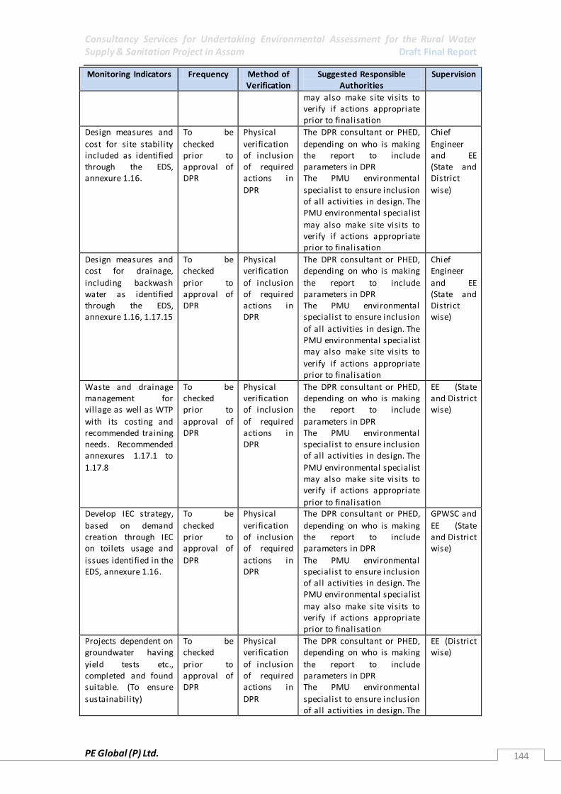
Consultancy Services for Undertaking Environmental Assessment for the Rural Water Supply & Sanitation Project in Assam Draft Final Report
PE Global (P) Ltd. 144
Monitoring Indicators Frequency Method of Verification
Suggested Responsible Authorities
Supervision
may also make site visits to verify if actions appropriate prior to finalisation
Design measures and
cost for site stability included as identified through the EDS, annexure 1.16.
To be
checked prior to approval of DPR
Physical
verification of inclusion of required actions in
DPR
The DPR consultant or PHED,
depending on who is making the report to include parameters in DPR The PMU environmental
specialist to ensure inclusion of all activities in design. The PMU environmental specialist
may also make site visits to verify if actions appropriate prior to finalisation
Chief
Engineer and EE (State and District
wise)
Design measures and cost for drainage,
including backwash water as identified through the EDS, annexure 1.16, 1.17.15
To be checked
prior to approval of DPR
Physical verification
of inclusion of required actions in DPR
The DPR consultant or PHED, depending on who is making
the report to include parameters in DPR The PMU environmental specialist to ensure inclusion
of all activities in design. The PMU environmental specialist may also make site visits to
verify if actions appropriate prior to finalisation
Chief Engineer
and EE (State and District wise)
Waste and drainage management for vil lage as well as WTP
with its costing and recommended training needs. Recommended annexures 1.17.1 to
1.17.8
To be checked prior to
approval of DPR
Physical verification of inclusion
of required actions in DPR
The DPR consultant or PHED, depending on who is making the report to include
parameters in DPR The PMU environmental specialist to ensure inclusion of all activities in design. The
PMU environmental specialist may also make site visits to verify if actions appropriate
prior to finalisation
EE (State and District wise)
Develop IEC strategy,
based on demand creation through IEC on toilets usage and
issues identified in the EDS, annexure 1.16.
To be
checked prior to approval of
DPR
Physical
verification of inclusion of required
actions in DPR
The DPR consultant or PHED,
depending on who is making the report to include parameters in DPR
The PMU environmental specialist to ensure inclusion of all activities in design. The PMU environmental specialist
may also make site visits to verify if actions appropriate prior to finalisation
GPWSC and
EE (State and District wise)
Projects dependent on groundwater having
yield tests etc., completed and found suitable. (To ensure
sustainability)
To be checked
prior to approval of DPR
Physical verification
of inclusion of required actions in
DPR
The DPR consultant or PHED, depending on who is making
the report to include parameters in DPR The PMU environmental
specialist to ensure inclusion of all activities in design. The
EE (District wise)

Consultancy Services for Undertaking Environmental Assessment for the Rural Water Supply & Sanitation Project in Assam Draft Final Report
PE Global (P) Ltd. 145
Monitoring Indicators Frequency Method of Verification
Suggested Responsible Authorities
Supervision
PMU environmental specialist may also make site visits to verify if actions appropriate
prior to finalisation
RWH management system and its costing in place. Refer Annexure 1.16, 1.17.1
and 1.17.2
To be checked prior to approval of
DPR
Physical verification of inclusion of required
actions in DPR
The DPR consultant or PHED, depending on who is making the report to include parameters in DPR
The PMU environmental specialist to ensure inclusion of all activities in design. The
PMU environmental specialist may also make site visits to verify if actions appropriate prior to finalisation
EE (District wise)
Measures for
minimum disturbance to wildlife and forests identified. Refer annexure 1.16,
1.17.11.
Addressed
during Environmental Assessment
of all Projects in Category II.
To be checked prior to approval of
DPR
Physical
verification of inclusion of required actions in
DPR
The DPR consultant or PHED,
depending on who is making the report to include parameters in DPR The PMU environmental
specialist to ensure inclusion of all activities in design. The PMU environmental specialist
may also make site visits to verify if actions appropriate prior to finalisation
Environme
ntal Specialist at SPMU and DPMU
along with EE (District wise)
Tree plantation Plan - taking into account all tree cutting and replantation needs in
place and include plantation costs, location for plantation,
species l ist for planting (which uses locally appropriate species), agreement with owner
of land where plantation is to take place, permission from Forest Department for
clearance and other activities. Reffer Annexure 1.16, 1.17.
11
To be checked prior to approval of
DPR
Physical verification of inclusion of required
actions in DPR
The DPR consultant or PHED, depending on who is making the report to include parameters in DPR
The PMU environmental specialist to ensure inclusion of all activities in design. The
PMU environmental specialist may also make site visits to verify if actions appropriate prior to finalisation
Environmental Specialist at SPMU and
DPMU along with EE (District
wise)
No structures in ecologically sensitive areas, ecologically significant area, or
structures that may obstruct migratory paths or other routes
To be checked prior to approval of
DPR
Physical verification of inclusion of required
actions in DPR, with appropriate
The DPR consultant or PHED, depending on who is making the report to include parameters in DPR
The PMU environmental specialist to ensure inclusion of all activities in design. The
Environmental Specialist at SPMU and
DPMU along with EE (District

Consultancy Services for Undertaking Environmental Assessment for the Rural Water Supply & Sanitation Project in Assam Draft Final Report
PE Global (P) Ltd. 146
Monitoring Indicators Frequency Method of Verification
Suggested Responsible Authorities
Supervision
of species l ike the endangered species – such as the Gharail in
Dikhow. Refer annexure 1.16, 1.17.11 and list of exclusion/
negative l ist of projects.
design changes made
PMU environmental specialist may also make site visits to verify if actions appropriate
prior to finalisation
wise)
Planning and design of unavoidable infrastructure takes
into account cultural and natural habitats , local sensitivities and safety. Refer annexure
1.16, 1.17.11, 1.17.12, 1.17.13, 1.17.14
To be checked prior to
approval of DPR
The DPR consultant or PHED, depending on who is making the report to include
parameters in DPR The PMU environmental specialist to ensure inclusion of all activities in design. The
PMU environmental specialist may also make site visits to verify if actions appropriate
prior to finalisation
EE (District wise)
Tree cutting
undertaken to be only what is essential and in immediate way of
infrastructure. Replanting plan to be reflective of any tree removal actions
undertaken, with plantation actions ensuring a 1:3 ration
of cut to replanted trees. DPR to include all compensation and
permission required from the Forest Department for tree cutting.
Refer annexure 1.16, 1.17.11, 1.17.14
To be
checked prior to approval of
DPR
Physical
verification of inclusion of required
actions in DPR. This must include documentati
on of permissions taken and
costs for the plantation activities.
The DPR consultant or PHED,
depending on who is making the report to include parameters in DPR
The PMU environmental specialist to ensure inclusion of all activities in design. The PMU environmental specialist
may also make site visits to verify if actions appropriate prior to finalisation
Environme
ntal Specialist at SPMU and
DPMU along with EE (District wise)
Worker safety plan identified and safety gears etc., available
and used at site during construction and for O&M. Refer annexure
1.17.1., 1.17.13, 1.17.15, 1.17.10
To be checked prior to
approval of DPR
Physical verification of inclusion
of required actions in DPR.
The DPR consultant or PHED, depending on who is making the report to include
parameters in DPR The PMU environmental specialist to ensure inclusion
of all activities in design. The PMU environmental specialist may also make site visits to verify if actions appropriate
prior to finalisation
Environmental Specialist at
DPMU along with EE (District
wise)
Structural Design of infrastructure following BIS
To be checked prior to
Physical verification of inclusion
The DPR consultant or PHED, depending on who is making the report to include
Structural Engineers, EE at State

Consultancy Services for Undertaking Environmental Assessment for the Rural Water Supply & Sanitation Project in Assam Draft Final Report
PE Global (P) Ltd. 147
Monitoring Indicators Frequency Method of Verification
Suggested Responsible Authorities
Supervision
standards for identified disasters (Earthquake,
Landslide). Refer annexure 1.16, 1.17.10
approval of DPR
of required actions standards in
DPR.
parameters in DPR The PMU environmental specialist to ensure inclusion
of all activities in design. The PMU environmental specialist may also make site visits to
verify if actions appropriate prior to finalisation
and District Levels.
Permissions for digging and laying of infrastructure
undertaken from all land owners, including Forest Department and other government
agencies and certificate and permissions attached
to the DPR.
To be checked prior to
approval of DPR
Physical verification of inclusion
of required permission needs and permission
certificates in DPR
The DPR consultant or PHED, depending on who is making the report to include
parameters in DPR The PMU environmental specialist to ensure inclusion of all activities in design. The
PMU environmental specialist may also make site visits to verify if actions appropriate
prior to finalisation
Chief Engineer and EE
(State)
Navigation routes,
breeding sites for aquatic species mapped out and in
DPR. In case intake is at a ghat, relocation plan and cost in DPR. Refer
annexure 1.16, 1.17.11, 1.17.12, 1.17.14
To be
checked prior to approval of
DPR
Physical
verification of inclusion of required
actions in DPR – the EDS should clearly
identified any changes required
The DPR consultant or PHED,
depending on who is making the report to include parameters in DPR
The PMU environmental specialist to ensure inclusion of all activities in design. The PMU environmental specialist
may also make site visits to verify if actions appropriate prior to finalisation
Chief
Engineer, PHED and Environme
ntal Specialist from SPMU
Design of
infrastructure and is surrounding to be aesthetics and cultural
appropriate
To be
checked prior to approval of
DPR
EDS must
clearly identify any changes in
the design to ensure cultural appropriate
The DPR consultant or PHED,
depending on who is making the report to include parameters in DPR
The PMU environmental specialist to ensure inclusion of all activities in design. The PMU environmental specialist
may also make site visits to verify if actions appropriate prior to finalisation
EE (District
and State)
Mapping of all cultural and archaeologically
important sites with respect to Project sites included in DPR and
required changes in infrastructure design made, permissions taken and certificate
attached to DPR. Refer annexure 1.16, 1.17.12
To be checked
prior to approval of DPR
Physical verification
of inclusion of required maps etc
along with appropriate alignment and included
in DPR
Design in DPR should not disrupt these sites and should
follow rule, with Appropriate permissions. The DPR consultant or PHED,
depending on who is making the report to include parameters in DPR The PMU environmental
specialist to ensure inclusion of all activities in design. The PMU environmental specialist
Chief Engineer
and EE (State)

Consultancy Services for Undertaking Environmental Assessment for the Rural Water Supply & Sanitation Project in Assam Draft Final Report
PE Global (P) Ltd. 148
Monitoring Indicators Frequency Method of Verification
Suggested Responsible Authorities
Supervision
may also make site visits to verify if actions appropriate prior to finalisation
4.5.8.2 Construction phase monitoring
During selection of contractors through QCBS system, Environmental Management capacity
should be within the selected company/contractor to ensure Environmental Management
(Proposed under EMF) of the RWSS project. Thus, it should be pre-required qualification
criteria at the EOI stage to select appropriate contracting firms. The following gives the
construction Phase monitoring indicators as well as specific responsibilities. The supervision
is either carried by a third party or internally through SPMUs formed under PHED, Assam.
Table 47: Construction phase monitoring
Monitoring Indicators Frequency Method of Verification
Suggested Responsible Authorities
Supervision
Site plan identified in the DPR and agreed to by construction
agency in place for all construction and borrow sites, including
construction workers. The site plan to include vehicle movement and
parking, waste temporary parking and final disposal site,
labour camp and facil ities.
Review site management plan in place and being
followed properly. Monitoring at
random at sites, but report compiled on a monthly basis
from before construction commences.
Ensure that construction contractor has
required clauses in place through
physical verification.
Construction contractor to ensure all required activities and
plans are in place. Construction contract clauses to be in place
before the construction takes place. The EE in charge of the
scheme to oversee implementation with any required support
from the PMU
SPMU/ Third Part Inspection
and Monitoring Agency
(TPIMA)
Mitigation actions as outlined in DPR in place to arrest soil
erosion, waterlogging and landslides.
Review if identified mitigation actions
in DPR are in place and being followed properly.
Monitoring at random at sites, but report
compiled on a monthly basis from before construction
commences.
Check for actions being in place,
ensure contractor clauses are in place
Construction contractor to ensure all required activities and
plans are in place. Construction contract clauses to be in place before the
construction takes place. The EE in charge of the
scheme to oversee implementation with any required support from the PMU
SPMU/ Third Part Inspection
and Monitoring Agency (TPIMA)
Silt traps etc., in place to reduce turbidity in river, as suggested in EMP and suitable for
area
Review if identified equipment etc., is in place and being
used Monitoring at random at sites, but report
Check for actions being in place, ensure
contractor clauses are in place
Construction contractor to ensure all required activities and plans are in place.
Construction contract clauses to be in place before the construction takes
SPMU/ Third Part Inspection and
Monitoring Agency (TPIMA)
Consultancy Services for Undertaking Environmental Assessment for the Rural Water Supply & Sanitation Project in Assam Draft Final Report
PE Global (P) Ltd. 149
Monitoring Indicators Frequency Method of Verification
Suggested Responsible Authorities
Supervision
compiled on a monthly basis from before
construction commences.
place. The EE in charge of the scheme to oversee
implementation with any required support from the PMU
All vehicles and
machinery is properly maintained and silent, no excessive noise or
vibrations, as required for each area and identified in DPR through the use of the
EDS.
Pre-construction
baseline. Day time measurement
since all activities are expected to be done in the day time
If not possible to identify schedule – should be done
for 3 different times: peak traffic, day quite hours and late
evening Monitoring on a monthly basis, randomly taken
from different sites
Check for
actions being in place, ensure
contractor clauses are in place
Construction
contractor to ensure all required activities and plans are in place.
Construction contract clauses to be in place before the construction takes
place. The EE in charge of the scheme to oversee
implementation with any required support from the PMU
SPMU/
Third Part Inspection and
Monitoring Agency (TPIMA)
Routes for access to sites identified and
agreed to between construction agency, PHED/DPMU and land owner, and followed
Fortnightly monitoring at
random, based upon route plan
Check for actions being
in place, ensure contractor clauses are in
place
Construction contractor to ensure all
required activities and plans are in place. Construction contract clauses to be in place
before the construction takes place. The EE in charge of the
scheme to oversee implementation with any required support
from the PMU
SPMU/ Third Part
Inspection and Monitoring Agency
(TPIMA)
Vehicles are properly
covered, not dripping waste and not overloaded
Fortnightly
monitoring at random, based upon route plan
Check for
actions being in place, ensure
contractor clauses are in place
Construction
contractor to ensure all required activities and plans are in place.
Construction contract clauses to be in place before the construction takes
place. The EE in charge of the scheme to oversee
implementation with
Consultancy Services for Undertaking Environmental Assessment for the Rural Water Supply & Sanitation Project in Assam Draft Final Report
PE Global (P) Ltd. 150
Monitoring Indicators Frequency Method of Verification
Suggested Responsible Authorities
Supervision
any required support from the PMU
All sites rehabilitated and plantation
activities identified in the DPR and agreed to by the construction agency in the contract
completed before the construction company leaves
Photographic baseline (pre-
construction) for restoration of site after the construction
activity is completed For plantation
activities, plantation done based upon identified need by
DPR Before work baseline and end
of work prior to making final payment for work to contractor
ensure all rehabilitation and plantation completed.
Check for rehabilitation
actions undertaken, ensure contractor
clauses are in place
Construction contractor to ensure all
required activities and plans are in place. Construction contract clauses to be in place
before the construction takes place.
The EE in charge of the scheme to oversee implementation with any required support
from the PMU
SPMU/ Third Part
Inspection and Monitoring Agency
(TPIMA)
Health and safety
measures, as identified in the DPR are in place and
functioning. Accident management and clean-up plan in place, and in case of
accidents is followed.
Monthly
monitoring of health reports and accident
reports to be undertaken
Check for
actions being in place, accidents if
occurring are properly managed, ensure
contractor clauses are in place
Construction
contractor to ensure all required activities and plans are in place.
Construction contract clauses to be in place before the construction takes
place. The EE in charge of the scheme to oversee implementation with
any required support from the PMU
SPMU/
Third Part Inspection and
Monitoring Agency (TPIMA)
Signage and safety measures as identified
in DPR in place and functional at all construction sites
Monthly monitoring for all
construction sites
Check for actions being
in place, ensure contractor
clauses are in place
Construction contractor to ensure all
required activities and plans are in place. Construction contract
clauses to be in place before the construction takes place.
The EE in charge of the scheme to oversee implementation with
any required support
SPMU/ Third Part
Inspection and Monitoring
Agency (TPIMA)

Consultancy Services for Undertaking Environmental Assessment for the Rural Water Supply & Sanitation Project in Assam Draft Final Report
PE Global (P) Ltd. 151
Monitoring Indicators Frequency Method of Verification
Suggested Responsible Authorities
Supervision
from the PMU
Identified grievance redressal system in place, functional , and
responsive if used. There are no repeated complaints
Monthly monitoring of grievance
redressal system. System should also be possible to check online
and not just available with local EE
Check for grievance redressal
system in place
The EE in charge of the scheme to oversee implementation with
any required support from the PMU
SPMU/ Third Part Inspection
and Monitoring Agency (TPIMA)
No destruction or
damage to any culturally important or archaeological site from project activities
Fortnightly
monitoring at any culturally or archaeologically important site
Check for
actions being in place, ensure contractor
clauses are in place
Construction
contractor to ensure all required activities and plans are in place. Construction contract
clauses to be in place before the construction takes place.
The EE in charge of the scheme to oversee implementation with
any required support from the PMU
SPMU/
Third Part Inspection and Monitoring
Agency (TPIMA)
4.5.8.3 O&M phase monitoring
Table 48: O&M Phase Monitoring
Monitoring
Indicators
Frequency Method of
Verification
Suggested
Responsible Authorities
Supervision
WTP and its surroundings and system including
network clean , no water problems or drainage problems.
Management plan identified in DPR in place and
functional
Daily maintenance of WTP and monitoring of
cleanliness and drainage for network and rest of system as
required Quarterly monitoring of WTP
Physical verification O&M in place and
training for system management has taken place as required
Identified management of system to maintain
system Monitoring by EE in charge of scheme Reports to be
submitted to PMU
GPWSC and DWSC
WTP
housekeeping as identified in DPR in place and
functional , with chemicals and equipment properly kept
Daily maintenance
of system Quarterly month monitoring of WTP
Physical
verification of O&M and chemical management
system properly managed
Identified
management of system to maintain system
Monitoring by EE in charge of scheme Reports to be submitted to PMU
GPWSC and
DWSC
Records at WTP
properly maintained, as identified in DPR
Daily records kept
Quarterly monitoring of records at WTP
Physical
verification of records
Identified
management of system to maintain system
GPWSC and
DWSC
Consultancy Services for Undertaking Environmental Assessment for the Rural Water Supply & Sanitation Project in Assam Draft Final Report
PE Global (P) Ltd. 152
Monitoring by EE in charge of scheme Reports to be submitted to PMU
Accident
management plan for WTP in place, known to the
workers and operator
Quarterly
monitoring of WTP In case of accident immediate
reporting to EE in charge of system and immediate action undertaken
based upon plan
Physical
verification to check system in place and
functional
Identified
management of system to maintain system and respond
to emergency Monitoring and support to be provided by EE in
charge of scheme Reports to be submitted to PMU
GPWSC and
DWSC
Change in the percent of
unaccounted for water, resulting in reduced leakages.
(Leak detection and management plan)
Daily maintenance of system
including leak detection. Leaks must be repaired
immediately Records of leak detection and repair with dates
to be kept, including complaints register from
consumer Quarterly monitoring of
registers and reports
Physical verification to
check system in place and functional
Identified management of
system to maintain system Monitoring by EE in
charge of scheme Reports to be submitted to PMU
GPWSC and DWSC
Drinking water disinfection system in place,
storage of bleaching powder and other chemicals for
disinfection in place Bleaching powder
of appropriate quality and standard. Records of purchase and
use up-to-date at WTP
Daily maintenance of system including record
keeping Quarterly monitoring of records and
system
Physical verification to check system in
place and functional, including records being kept
properly
Identified management of system to maintain
system Monitoring by EE in charge of scheme Reports to be
submitted to PMU
GPWSC and DWSC
Protection and drainage at stand posts and hand
pumps in place and functional
Monthly monitoring of protection and
drainage
Physical verification such as sanitary surveys
GPWSC with help from local school children for each
vil lage EE in charge of scheme to undertake
quarterly monitoring
GPWSC and DWSC
Consultancy Services for Undertaking Environmental Assessment for the Rural Water Supply & Sanitation Project in Assam Draft Final Report
PE Global (P) Ltd. 153
of overall system A semi-annual report of overall system to be sent to PMU with
problems and concerns highlighted separately
No animals or
people washing/bathing at stand posts or hand pumps
Monthly
monitoring of protection and drainage Regular IEC, based
upon the identified IEC plan for the project
Physical
verification such as sanitary surveys
GPWSC with help
from local school children for each vil lage EE in charge of
scheme to undertake quarterly monitoring of overall system A semi-annual report
of overall system to be sent to PMU with problems and
concerns highlighted separately
GPWSC and
DWSC
Where groundwater is being used,
appropriate groundwater monitoring system in place
Actions for management of groundwater
identified and in place including water safety plan
Quarterly monitoring undertaken for
time taken to recharge groundwater If any problems
identified, immediate actions to be undertaken
by notifying EE in charge of scheme
Physical verification to check systems in
place and functional, as required
Monitoring by EE in charge of scheme and development of
required plan by EE and is staff, if required Reports to be submitted to PMU
when such problems occur
GPWSC and DWSC
RWH maintenance schedule in place
Workers aware of schedule. System implemented RWH systems
clean and free of contamination – with regular
testing of water taking place for microbiological contamination
and records maintained and up-to-date
Quarterly monitoring of
schedule including a pre monsoon visit to RWH systems randomly
with site reports made and a record kept at the site
and in the EE office
Physical verification to
check systems in place and functional, as required
Identified management of
system to maintain system Monitoring by EE in charge of scheme
Reports to be submitted to PMU
GPWSC and DWSC
Any small and individual
schemes under project are properly
maintained and
Daily maintenance of system
Quarterly monitoring of schemes
Physical verification to
check systems in place and functional, as
required
Identified management of
system to maintain system Monitoring by EE in
charge of scheme
GPWSC and DWSC

Consultancy Services for Undertaking Environmental Assessment for the Rural Water Supply & Sanitation Project in Assam Draft Final Report
PE Global (P) Ltd. 154
water provided is safe as identified in DPR.
Reports to be submitted to PMU
Solid waste management in
place and functioning as identified in DPR.
Quarterly monitoring of
vil lage with records kept, solid waste disposed as
identified in vil lage solid waste management strategy for each
vil lage
Physical verification to
check systems in place and functional, as
identified
Overall responsibil ity for individual
wastewater and solid waste is with each household.
Monitoring at vil lage level with GPWSC or other identified management of
system with help from local school children for each vil lage
GPWSC and DWSC
Sanitation and
environmental sanitation actions as identified in
guidelines developed by DPR in place and functioning
Quarterly
monitoring of vil lage for identification of
implementation of strategy – with reports submitted to EE in charge of
area
Physical
verification to check systems in place and
functional
Overall responsibil ity
for individual wastewater and solid waste is with each
household. Monitoring at vil lage level with GPWSC or other identified
management of system with help from local school children for each vil lage
Monitoring by EE in charge of scheme Reports to be
submitted to PMU
GPWSC and
DWSC
4.6 Training and Capacity Building The state currently has limited capacity for environmental management. The capacity
building and IEC strategy has been outlined as part of the EMF program developed for the
project aims at building environmental awareness and environmental management capacity
in the project administration structure as well as in the intended target communities.
Capacity building for environmental management will be integrated with overall capacity
building component of the project.
4.6.1 Objectives The objectives of the capacity building initiatives are:
To build and strengthen the capability of rural water and sanitation service delivery
institutions (PRIs and RWSSD) and other partners (NGOs, Contractors, Consultants) to
integrate sound environmental management into water and sanitation service delivery.
To orient the service delivery staff and elected PRI representatives to the requirements
of the project’s environmental management framework.

Consultancy Services for Undertaking Environmental Assessment for the Rural Water Supply & Sanitation Project in Assam Draft Final Report
PE Global (P) Ltd. 155
Create understanding on WB environmental safeguards
Ensure proper development of projects and schemes, considering environmental
safeguards as identified in the EMF.
Ensure that monitoring of identified environmental safeguards is undertaken.
Ensure that any unforeseen impacts from project are addressed in time.
4.6.2 TNA (Training Needs Assessment)
A specific training program for the key officials of the project, focused on the procedural and
technical aspects of environmental assessment and management shall be developed. This
training would be mandatory for the SO personnel and GP personnel. The project shall fulfil
(a) short-term training on EMF application in planning and implementing of schemes under
the proposed project to all stakeholders concerned including the potential beneficiary
communities (b) water quality monitoring and watershed conservation training to
Department of Rural Development and regulating authorities. The training shall involve
initial orientation, main training program and livener training programs.
Trainings to introduce, Environmental Management in Proposed RWSS project including EMF
will include, Filling of EDS, procedural & technical aspects of Environmental Assessment. The
main purpose of the training will be (i) To equip relevant officials with knowledge and skills
necessary for undertaking environmental appraisal as per the requirements of the EMF; (ii)
To undertake periodic supervision of environmental performance of schemes; (iii) To
prepare for planning and monitoring implementation of environmental mitigation measures
identified through the appraisal process; (iv) To equip with skills necessary for water quality
testing using the field testing kits under the Community based System for water quality
Monitoring and Surveillance. Trainings towards Environmental Awareness and Sensitization
will be necessary to build awareness on safe drinking water, water conservation,
environmental sanitation and personal hygiene
4.6.3 Training Approach Systematic capacity building initiatives will be introduced only after completion of training
needs assessment. The training will be of cascade mode. All the trained staff and others will
in turn conduct further trainings at state, district, block and GP levels, depending upon their
roles. However, since capacity building goes beyond mere imparting training,
institutionalization of best practices becomes a prerequisite for improved service delivery.
4.6.4 Training Resources In view of the specialized training and capacity building envisaged under the EMF of the
project, it is necessary to identify nodal training institutes that will work closely work with
capacity building wing of PSU for conceptualizing, designing, conducting and managing
training programs on the EMF. Some such specialized institutions are:
Engineering Staff College of India (ESCI) – ESCI is an autonomous organ of The Institution of
Engineers (India). It is the country's premier professional organization, imparting continuing
education for engineers and managers in the Engineering profession. ESCI provides trainings
in Environmental Management as per MOEF guidelines, to government organisations.

Consultancy Services for Undertaking Environmental Assessment for the Rural Water Supply & Sanitation Project in Assam Draft Final Report
PE Global (P) Ltd. 156
National Academy of Construction (NAC) – NAC is provides technical guidance in Engineering
and Construction.
UNICEF – UNICEF facilitated a pilot programme on Water Quality & Security in 9 districts of
Assam in the 2011-12. These districts prepared Village Level Plans which were than
advocated to be integrated in the district as well as State PIP.
4.6.5 Training Programmes
4.6.5.1 T1. Training on the Environmental Management Framework
Purpose of the training:
To equip with knowledge and skills necessary for undertaking environmental appraisal as
per the requirements of the EMF
To prepare for undertaking periodic supervision of environmental performance of
schemes
To prepare for implementing Community Based System for Water Quality Monitoring
and Surveillance
Participants: Key officials of the project including AEE/AE, EE, SE as well as State and District
Level Environmental Experts and District Resource Persons – Environmental Management.
The superintending Engineer of the district will be responsible for selection of suitable
candidates for the training, and the expenses will be borne by the overall project capacity
building budget.
Schedule: The training will include an initial orientation workshop, a main and annual
refresher training workshops on environmental assessment. The main and refresher training
programs will be for duration of 2-3 days each, whereas the initial orientation workshop will
be of one day duration. Five Training programs will be conducted during the first year and 5
refresher programs per year will be conducted for the next 4 years. This will total to 25
programs.
4.6.5.2 T2. Training on Environmental Management
Purpose of the training:
To equip with knowledge and skills necessary for meaningful participation in the
environmental appraisal as per the requirements of the EMF
To prepare for planning and monitoring implementation of environmental mitigation
measures identified through the appraisal process
To equip with skills necessary for water quality testing using the field kits under the
Community Based System for Water Quality Monitoring and Surveillance
Participants: SOs, members of VWSC and GPWSC – Environmental Management.
The Superintending Engineer of the district will be responsible for selection of suitable
candidates for the training, and the expenses will be borne by the overall project capacity
building budget.
Schedule: The training will include an initial orientation workshop, a main and annual
refresher training workshops on environmental assessment. The main and refresher training
programs will be for duration of 2-3 days each, whereas the initial orientation workshop will
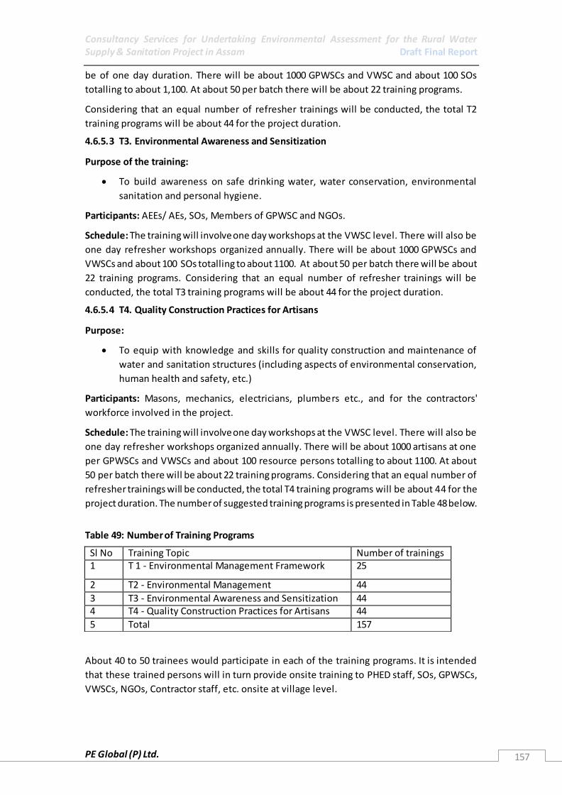
Consultancy Services for Undertaking Environmental Assessment for the Rural Water Supply & Sanitation Project in Assam Draft Final Report
PE Global (P) Ltd. 157
be of one day duration. There will be about 1000 GPWSCs and VWSC and about 100 SOs
totalling to about 1,100. At about 50 per batch there will be about 22 training programs.
Considering that an equal number of refresher trainings will be conducted, the total T2
training programs will be about 44 for the project duration.
4.6.5.3 T3. Environmental Awareness and Sensitization
Purpose of the training:
To build awareness on safe drinking water, water conservation, environmental
sanitation and personal hygiene.
Participants: AEEs/ AEs, SOs, Members of GPWSC and NGOs.
Schedule: The training will involve one day workshops at the VWSC level. There will also be
one day refresher workshops organized annually. There will be about 1000 GPWSCs and
VWSCs and about 100 SOs totalling to about 1100. At about 50 per batch there will be about
22 training programs. Considering that an equal number of refresher trainings will be
conducted, the total T3 training programs will be about 44 for the project duration.
4.6.5.4 T4. Quality Construction Practices for Artisans
Purpose:
To equip with knowledge and skills for quality construction and maintenance of
water and sanitation structures (including aspects of environmental conservation,
human health and safety, etc.)
Participants: Masons, mechanics, electricians, plumbers etc., and for the contractors'
workforce involved in the project.
Schedule: The training will involve one day workshops at the VWSC level. There will also be
one day refresher workshops organized annually. There will be about 1000 artisans at one
per GPWSCs and VWSCs and about 100 resource persons totalling to about 1100. At about
50 per batch there will be about 22 training programs. Considering that an equal number of
refresher trainings will be conducted, the total T4 training programs will be about 44 for the
project duration. The number of suggested training programs is presented in Table 48 below.
Table 49: Number of Training Programs
About 40 to 50 trainees would participate in each of the training programs. It is intended
that these trained persons will in turn provide onsite training to PHED staff, SOs, GPWSCs,
VWSCs, NGOs, Contractor staff, etc. onsite at village level.
Sl No Training Topic Number of trainings 1 T 1 - Environmental Management Framework 25
2 T2 - Environmental Management 44
3 T3 - Environmental Awareness and Sensitization 44 4 T4 - Quality Construction Practices for Artisans 44
5 Total 157
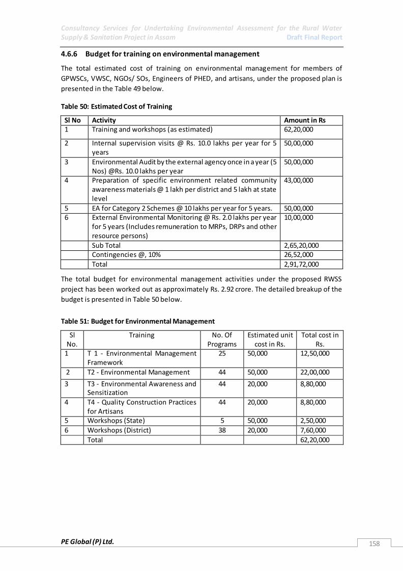
Consultancy Services for Undertaking Environmental Assessment for the Rural Water Supply & Sanitation Project in Assam Draft Final Report
PE Global (P) Ltd. 158
4.6.6 Budget for training on environmental management
The total estimated cost of training on environmental management for members of
GPWSCs, VWSC, NGOs/ SOs, Engineers of PHED, and artisans, under the proposed plan is
presented in the Table 49 below. Table 50: Estimated Cost of Training
The total budget for environmental management activities under the proposed RWSS
project has been worked out as approximately Rs. 2.92 crore. The detailed breakup of the
budget is presented in Table 50 below.
Table 51: Budget for Environmental Management
Sl No.
Training No. Of Programs
Estimated unit cost in Rs.
Total cost in Rs.
1 T 1 - Environmental Management Framework
25 50,000 12,50,000
2 T2 - Environmental Management 44 50,000 22,00,000
3 T3 - Environmental Awareness and Sensitization
44 20,000 8,80,000
4 T4 - Quality Construction Practices for Artisans
44 20,000 8,80,000
5 Workshops (State) 5 50,000 2,50,000
6 Workshops (District) 38 20,000 7,60,000
Total 62,20,000
Sl No Activity Amount in Rs 1 Training and workshops (as estimated) 62,20,000
2 Internal supervision visits @ Rs. 10.0 lakhs per year for 5 years
50,00,000
3 Environmental Audit by the external agency once in a year (5 Nos) @Rs. 10.0 lakhs per year
50,00,000
4
Preparation of specific environment related community awareness materials @ 1 lakh per district and 5 lakh at state level
43,00,000
5 EA for Category 2 Schemes @ 10 lakhs per year for 5 years. 50,00,000 6 External Environmental Monitoring @ Rs. 2.0 lakhs per year
for 5 years (Includes remuneration to MRPs, DRPs and other resource persons)
10,00,000
Sub Total 2,65,20,000 Contingencies @, 10% 26,52,000
Total 2,91,72,000

Consultancy Services for Undertaking Environmental Assessment for the Rural Water Supply & Sanitation Project in Assam Draft Final Report
PE Global (P) Ltd.
4.6.7 EMP for Design and Location Stage
Environmental Issues Mitigation Measures
Inadequate drainage provided with increased water availability, or
at infrastructure sites increasing waterlogging, soil toxicity, impacting habitats, archaeological etc.
Ensure DPR design includes drainage improvement measures that account for present
drainage needs and needs based on extra water availability, and for planned infrastructure.
Dumping of waste from treatment plants resulting in increased toxicity of the local area.
Ensure proper waste management plan identified and implemented. Also refer annexure 1.17.1, 1.17.8 and 1.17.15
Inadequate storage of chemicals and other material at treatment plants resulting in seepage and contamination of ground locally
Ensure proper management plan for WTP in place with trained staff to manage WTP.
Poor design of handpumps, standposts resulting in risk of
contamination of water In protection provided for system resulting in risk of contamination
Ensure that design has protection planned of hand pumps and stand posts, where used
Identify appropriate design parameters for hand pumps and standposts, where used. Also refer annexure 1.17.1
Need for material to build systems, resulting in removal of earth may reduce stability and landslides may occur, though this is more
likely a cumulative impact occurring from a number of different activities as individually systems identified from such projects would have limited needs.
Post construction site rehabilitation to be included in project cost and measures given in DPR. Also refer annexure 1.17.8 and 1.17.14
Location of sites such as pump houses, treatment plants and reservoirs and their access roads on hil ls may require vegetation
clearance and result in reduced stability of the area
All identified sites must have rehabilitation, site stability and other measures taken into account while designing as a part of DPR. Also refer annexure 1.17.8 and 1.17.14
Conflict or competition with other users at the location where the intake and water abstraction structure is planned, Also may impact overall resource sustainability
Plan site after consultation with local population to ensure there is no conflict. Also refer annexure 1.17.13 and 1.17.14
Design not accounting for backwash needs may result in temporary water stagnation locally
WTP design must ensure that there is a proper drainage system in place for backwash water, accounting for local drainage patterns, s lopes etc.
Pollution due to poor design, resulting in leakages or dumping of
waste. This may be more of a concern with floating barges. Need to identify an appropriate waste management system that includes waste collection
and disposal from all infrastructure sites. Should be in project DPR. Also refer annexure 1.17.8
Inadequately designed wastewater discharges, excessive sewage and toilet waste may result in contamination of water system, or creation of disease vector habitats
Identification of wastewater and drainage system as part of DPR. Also, to identify appropriate IEC to increase awareness and demand for toilets and their better management. Also refer annexure 1.17.1 and 1.17.3 to 1.17.9

Consultancy Services for Undertaking Environmental Assessment for the Rural Water Supply & Sanitation Project in Assam Draft Final Report
PE Global (P) Ltd.
Excessive withdrawal of water resulting in groundwater depletion Identify sustainable yield at time of project siting, and consider other users prior to
finalising project. Have monitoring system for all groundwater systems in place, to ensure no unsustainable withdrawal of water.
Augment source in case of excess ive withdrawal with other sources or through RWH for distribution or recharge. Also refer 1.17.2
Poorly designed RWH systems may result in groundwater contamination
Identify RWH systems only where needed and appropriate. For example do not undertake RWH to recharge aquifers rich in arsenic. Identify appropriate RWH management systems as part of DPR and ensure its budgets
and other needs are included in DPR. Also refer 1.17.2
Intake, pumping system or WTP in an ecologically sensitive area, areas with wildlife present or species breeding habitats may result in disturbances during the day to day running, and also create conflict with local wildlife.
To the extent possible do not construct infrastructure in ecologically sensitive area. In areas where no possibility for better siting, only intake should be within an ecologically sensitive area, but design must ensure (i) no disturbance to wildlife with system including sound proofing; (i i) ensure that minimal movement exists in the area; (i i i) in case of
animal corridors, no obstructions should exist and as required structures may be underground, also nothing other than pipes in corridors should be installed and that too only if there is no other option; (iv) no waste or waterlogging in the area should be allowed, with appropriate site management ensured; and appropriate planting and
vegetative cover, as required for the area identified. Prior to finalising anything in such an area discusses with the Forest Department about the project needs. Also refer 1.17.11
Poorly designed system may result in unnecessary clearance of
vegetation and cutting of trees DPR should include minimal vegetation clearance and must be based upon site. To the
extent possible plantation plans must also be made for the area. For all trees cut/removed, plantation should be at the ratio of for every 1 cut planting of 3 trees. Also refer 1.17.11
Introduction of alien species or flora as part of landscape or other activities resulting in take over of ecological niche or destruction
of habitat of local flora species and forest areas, or due to such species being planted in animal corridors/migratory routes they may be transported into forest areas as species cross the area, carrying the plant seeds etc along with them
Ensure no alien species are planted as a part of project activities. In areas of animal corridors, ensure that planted species are appropriate for the overall
ecosystem. For example, they should not result in the degradation of the forest and other ecosystems that the animals pass though as a part of their movement. Also refer 1.17.11
Pollution due to poor design, resulting in leakages or dumping of
waste. This may be more of a concern with floating barges. This may result in local habitats being impacted.
Ensure appropriate waste management systems have been designed, the workers trained
for it and the system is working properly.
In River Brahmaputra and some of its tributaries such as Dikhow Ensure that there is no waste from the intake or other structures dumped in rivers or
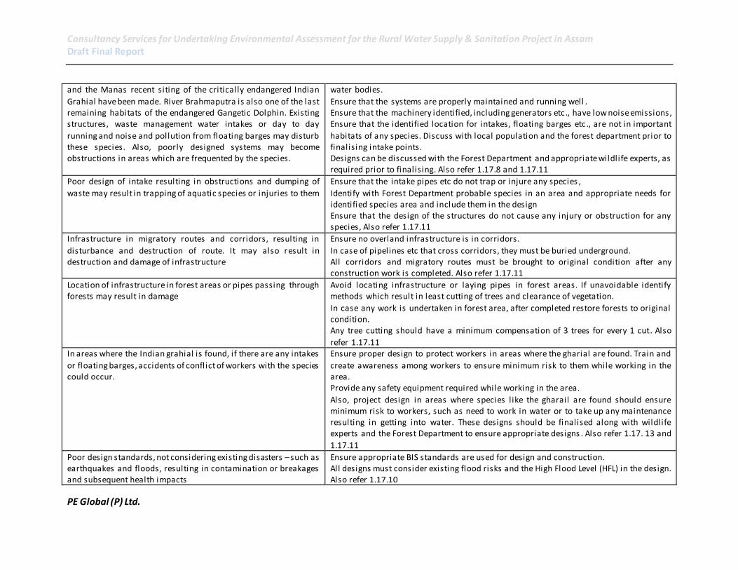
Consultancy Services for Undertaking Environmental Assessment for the Rural Water Supply & Sanitation Project in Assam Draft Final Report
PE Global (P) Ltd.
and the Manas recent siting of the critically endangered Indian
Grahial have been made. River Brahmaputra is also one of the last remaining habitats of the endangered Gangetic Dolphin. Existing structures, waste management water intakes or day to day
running and noise and pollution from floating barges may disturb these species. Also, poorly designed systems may become obstructions in areas which are frequented by the species.
water bodies.
Ensure that the systems are properly maintained and running well . Ensure that the machinery identified, including generators etc., have low noise emissions, Ensure that the identified location for intakes, floating barges etc ., are not in important
habitats of any species. Discuss with local population and the forest department prior to finalising intake points. Designs can be discussed with the Forest Department and appropriate wildlife experts, as required prior to finalising. Also refer 1.17.8 and 1.17.11
Poor design of intake resulting in obstructions and dumping of
waste may result in trapping of aquatic species or injuries to them Ensure that the intake pipes etc do not trap or injure any species ,
Identify with Forest Department probable species in an area and appropriate needs for identified species area and include them in the design Ensure that the design of the structures do not cause any injury or obstruction for any species, Also refer 1.17.11
Infrastructure in migratory routes and corridors, resulting in
disturbance and destruction of route. It may also result in destruction and damage of infrastructure
Ensure no overland infrastructure is in corridors.
In case of pipelines etc that cross corridors, they must be buried underground. All corridors and migratory routes must be brought to original condition after any construction work is completed. Also refer 1.17.11
Location of infrastructure in forest areas or pipes passing through forests may result in damage
Avoid locating infrastructure or laying pipes in forest areas. If unavoidable identify methods which result in least cutting of trees and clearance of vegetation.
In case any work is undertaken in forest area, after completed restore forests to original condition. Any tree cutting should have a minimum compensation of 3 trees for every 1 cut. Also
refer 1.17.11 In areas where the Indian grahial is found, if there are any intakes
or floating barges, accidents of conflict of workers with the species could occur.
Ensure proper design to protect workers in areas where the gharial are found. Train and
create awareness among workers to ensure minimum risk to them while working in the area. Provide any safety equipment required while working in the area.
Also, project design in areas where species l ike the gharail are found should ensure minimum risk to workers, such as need to work in water or to take up any maintenance resulting in getting into water. These designs should be finalised along with wildlife experts and the Forest Department to ensure appropriate designs . Also refer 1.17. 13 and
1.17.11
Poor design standards, not considering existing disasters – such as earthquakes and floods, resulting in contamination or breakages and subsequent health impacts
Ensure appropriate BIS standards are used for design and construction. All designs must consider existing flood risks and the High Flood Level (HFL) in the design. Also refer 1.17.10

Consultancy Services for Undertaking Environmental Assessment for the Rural Water Supply & Sanitation Project in Assam Draft Final Report
PE Global (P) Ltd.
Poor design and waste management systems may also create
habitats for certain disease vectors l ike the sand fly which results I Kala-Azar/black fever or Visceral leishmaniasis, a disease with a recent outbreak (2008) in Chandrapur and Panikheti, both of
which are within the present project area.
Ensure proper waste management systems are in place, drainage is properly addressed in
the project and identify post constructi on waste disposal and site rehabilitation needs in DPR. Also refer 1.17.10
Location of planned structures, obstructing or creating other problems for existing WSS infrastructure
Prior to finalising the project design and location of infrastructure, discus s with local population residing in area to ensure that there are no obstructions or problems to other WSS infrastructure.
Waste from redundant systems – being upgraded. Where possible reuse material. What is not possible to reuse, dispose in an appropri ate area. Also refer 1.17.8
Need to cut across l ines and roads laid down for other
infrastructure, thereby resulting in disruption or damage Design to ensure minimum digging and disturbance of other infrastructure is undertaken.
In case of need to cut across any infrastructure, identify appropriate time to undertake work and take permission. Discuss with local population to ensure minimum disturbance.
Disruption of navigation routes, piers (ghats) especially in smaller rivers and streams used for supplying water
Discuss with vil lagers location of ghats and navigation routes prior to finalising intake sites. In case it is not possible to avoid these locations, identify ways to relocate ghats etc., to other appropriate areas and include the design, cost etc., for relocation in DPR.
Location of intake may interfere with local fish landing sites, access to river, cut across agriculture fields, or transport routes
Discuss with farmers/fisher men etc., prior to locating infrastructure. Where possible avoid these sites, if not refer to social assessment for rehabilitation needs.
Poor design resulting in structures reducing aesthetics in area Ensure design of structures is appropriate for site, and ensure plantation or other
activities as required as part of design.
Structure and connected infrastructure cutting across archaeological and other culturally important sites
Avoid all areas where there are archaeological or other important cultural sites. Also refer 1.17.12
4.6.8 EMP for Construction Stage Impacts of RWSS Projects Environmental Issues Mitigation Measures Poor chemicals storage, spil lage and waste dumping,
waterlogging and accidents resulting in toxicity to environment
Storage of material needs to be considered carefully to ensure that all material is s tored in
the same place Ensure appropriate containers and protection to reduce spillage and contamination of surface and groundwater.
Identify appropriate spil l and accident management plan and educate workers on it. Make required material available for clean up Ensure all vehicles are properly maintained and serviced – and they are not washed or serviced in and around the quarries, rivers and other construction sites
All sites should have a waste collection and disposal plan developed and executed. Ensure all waste is stored properly and required permission for the final disposal is done
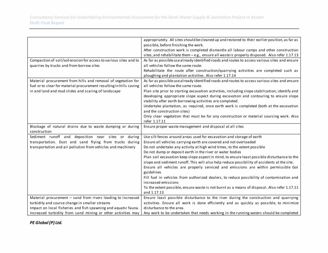
Consultancy Services for Undertaking Environmental Assessment for the Rural Water Supply & Sanitation Project in Assam Draft Final Report
PE Global (P) Ltd.
appropriately. All sites should be cleaned up and restored to their earlier position, as far as
possible, before finishing the work. After construction work is completed dismantle all labour camps and other construction sites, and rehabilitate them – e.g., ensure all waste is properly disposed. Also refer 1.17.13
Compaction of soil/soil erosion for access to various sites and to
quarries by trucks and from borrow sites As far as possible use already identified roads and routes to access various sites and ensure
all vehicles follow the same route. Rehabilitate the route after construction/quarrying activities are completed such as ploughing and plantation activities . Also refer 1.17.14
Material procurement from hills and removal of vegetation for fuel or to clear for material procurement resulting in hil ls caving
in and land and mud slides and scaring of landscape
As far as possible use already identified roads and routes to access various sites and ensure all vehicles follow the same route.
Plan site prior to starting excavation activities, including slope stabilization, identify and developing appropriate slope aspect during excavation and contouring to ensure slope stability after earth borrowing activities are completed. Undertake plantation, as required, once earth work is completed (both at the excavation
and the construction sites) Only clear vegetation that must be for any construction or material sourcing work. Also refer 1.17.11
Blockage of natural drains due to waste dumping or during construction
Ensure proper waste management and disposal at all sites
Sediment runoff and deposition near sites or during
transportation. Dust and sand flying from trucks during transportation and air pollution from vehicles and machinery
Use silt fences around areas used for excavation and storage of earth
Ensure all vehicles carrying earth are covered and not overloaded Do not undertake any activity at high wind times, to the extent possible Do not dump or deposit earth in the river or water bodies Plan soil excavation keep slope aspect in mind, to ensure least possible disturbance to the
slope and sediment runoff. This will also help reduce possibil ity of accidents at the site. Ensure all vehicles are properly serviced and emissions are within permissible GoI guidelines
Fil l fuel in vehicles from authorized dealers, to reduce possibil ity of contamination and increased emissions To the extent possible, ensure waste is not burnt as a means of disposal . Also refer 1.17.11 and 1.17.13
Material procurement – sand from rivers leading to increased
turbidity and course change in smaller streams Impact on local fisheries and fish spawning and aquatic fauna. Increased turbidity from sand mining or other activities may
Ensure least possible disturbance to the river during the construction and quarrying
activities. Ensure all work is done efficiently and as quickly as possible, to minimize disturbance to the area. Any work to be undertaken that needs working in the running waters should be completed

Consultancy Services for Undertaking Environmental Assessment for the Rural Water Supply & Sanitation Project in Assam Draft Final Report
PE Global (P) Ltd.
result in disturbance or degradation of local habitats within the shortest duration of time, and any identified critical biological cycles of fauna
and flora identified (eg migration and spawning) should be avoided. In-stream work should be fenced off to reduce disturbance of sediments of moving waters Ensure all vehicles and machinery are properly maintained so as not to leave grease etc on
river bed Ensure no waste is disposed in riverbed Vehicles should not be wash or clean in water bodies Rehabilitation of borrow sites from the river should be considered. Also refer 1.17.11 and
1.17.14
Poor labour camp management and insufficient WSS systems for them, or no rehabilitation of labour camp and construction site after construction work is over resulting in pollution or accidents and other health risks to labour
Ensure all personnel working at the site have protective gear and are trained in using them; ensure safety equipment is available as required and in good condition. Since some of the sections of the project interventions there could be a risk to the workers and appropriate protective and safety measures need to be considered to avoid and reduce
accidents and injuries to the workers. Ensure sites for storage of all construction material, vehicles etc ., is properly identified, with appropriate signage and areas which are accident prone cordoned with restricted
entry and adequate lighting. Restrict public entry to the area during construction, to avoid accidents. All construction personnel shall be subjected to routine vaccinations and other preventive/healthcare measures, as required.
The work and campsites shall have suitable facil ities for handling any emergency situation like fire, explosion, accidents etc. All areas intended for storage of hazardous materials shall be kept separately and out of reach of unauthorized personnel. Required permits will be needed and adequate safety and
emergency facil ities should be available. The personnel in charge of restricted areas shall be properly trained, l icensed and with sufficient experience.
Any labour brought from outside must be provided with appropriate shelter, toilets with appropriate sewage treatment and disposal systems and energy for cooking. Also refer 1.17.3 to 1.17.14
Excessive pressure on groundwater for provision of water for construction site, without considering local needs, resulting
most l ikely in temporary depletion of resource, though a problem for the local populati on til l aquifer is replenished
Avoid excessive pressure on local water resources. In case any depletion identified stop using and identify alternate sources. Also, undertake remedial actions immediately in
consultation with the PHED.
Pollution from construction activities on land and in Prior to starting any project activity final waste disposal sites should be identified and as

Consultancy Services for Undertaking Environmental Assessment for the Rural Water Supply & Sanitation Project in Assam Draft Final Report
PE Global (P) Ltd.
waterbodies, such as the WTPs where adequate drainage
resulting in water stagnating, or dumping and spill ing of waste and chemicals
required permission taken for disposing waste in them.
At all construction sites a temporary waste collection area should be demarcated, properly developed (to ensure no contamination of soil or water) and have a regular cleaning schedule identified.
All waste should be kept/disposed only in appropriate sites and all workers at a site should be informed about the system. Any hazardous materials, if used – should be segregated and disposed appropriately. If there are no waste disposal systems in the area, the material should be sent to a pre-
identified disposal site. To the extent possible do not undertake any refil l ing activities at sites, but at the fuel pumps in the town. In case unavoidable, and some machinery require refi l l ing at site, fuel
storage and refil l ing activities areas should be demarcated and the surface made impermeable, the avoid contamination of soil or water. Any waste created from the activity should be disposed appropriately. Also refer 1.17.11, 1.17.13, 1.17.8 and 1.17.7
Pollution from vehicles being washed in waterbodies and wetlands
Ensure no vehicles are washed or maintained at the project site but at identified garages.
Noise from generators and other construction activities l ike trucks etc passing the area. Vibrations from construction
activities.
Ensure silent generators are used and they are only used in day hours. All generators and other equipment must be properly maintained.
Ensure low vibration machinery such as hydraulic dril ls are used and they are only used in day hours.
Plantation activities resulting in alien species introduction, degrading the local environment
Do not undertake any plantation activity with alien species. Only locally appropriate species should be used.
Ensure any plantation activities undertaken include species that are endemic to the area, or in consultation with the local Forest Department officials. Also refer 1.17.11
Construction at the time of animal migration that disturbs the migratory routes and patterns
Identify animal migration periods for any migratory routes in the construction area and ensure that they are not used for construction activities.
Impact to local fisheries and fish spawning time or other aquatic fauna and flora
Ensure no work is undertaken in river at the time when fish are migrating No work, sand mining etc should be in areas where there are important fish habitats
Avoid local or important fishing sites. If this is not possible, identify appropriate compensation and development of alternate site. Also refer 1.17.11
Material procurement from sensitive sites, resulting in damage to site
No material should be procured from ecologically sensitive sites. Also refer 1.17.11
Disturbance to and degradation of forests as construction material is procured or transported through them and forests
are used for firewood
No material should be procured from forest. Firewood plantations could be considered for labour camps. All firewood plantations
should be of locally appropriate species.
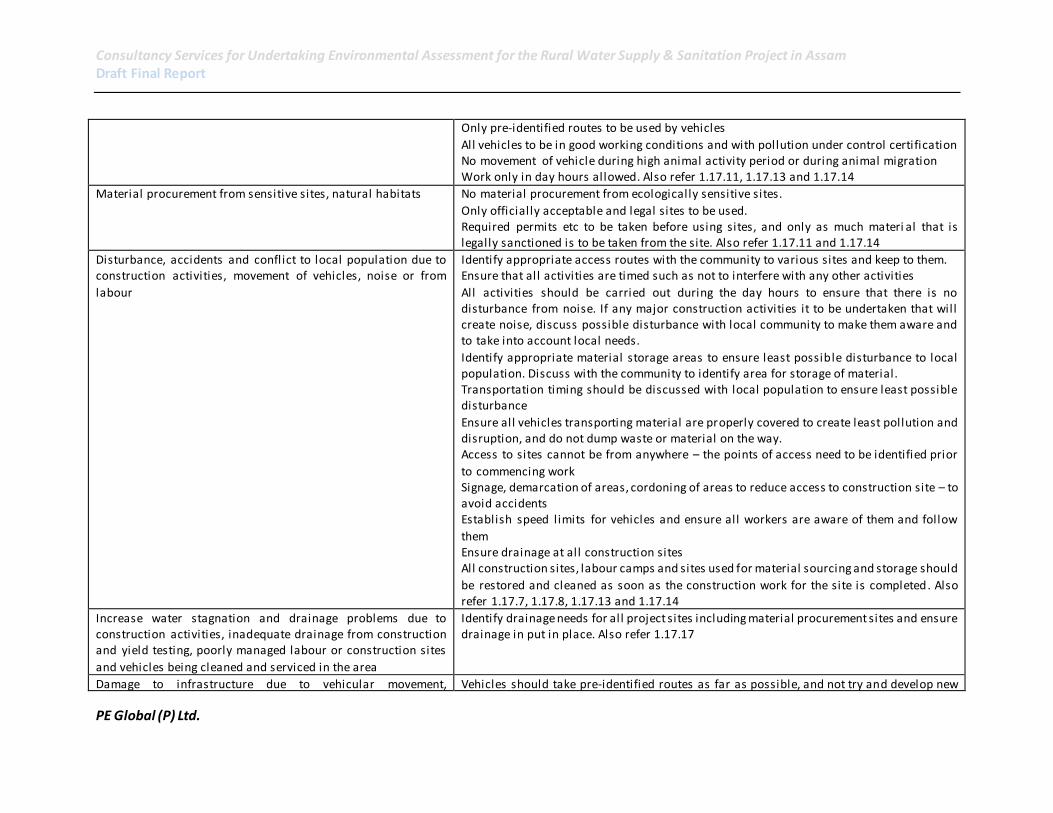
Consultancy Services for Undertaking Environmental Assessment for the Rural Water Supply & Sanitation Project in Assam Draft Final Report
PE Global (P) Ltd.
Only pre-identified routes to be used by vehicles
All vehicles to be in good working conditions and with pollution under control certification No movement of vehicle during high animal activity period or during animal migration Work only in day hours allowed. Also refer 1.17.11, 1.17.13 and 1.17.14
Material procurement from sensitive sites, natural habitats No material procurement from ecologically sensitive sites.
Only officially acceptable and legal sites to be used. Required permits etc to be taken before using sites, and only as much materi al that is legally sanctioned is to be taken from the site. Also refer 1.17.11 and 1.17.14
Disturbance, accidents and conflict to local population due to construction activities, movement of vehicles, noise or from
labour
Identify appropriate access routes with the community to various sites and keep to them. Ensure that all activities are timed such as not to interfere with any other activities
All activities should be carried out during the day hours to ensure that there is no disturbance from noise. If any major construction activities it to be undertaken that will create noise, discuss possible disturbance with local community to make them aware and to take into account local needs.
Identify appropriate material storage areas to ensure least possible disturbance to local population. Discuss with the community to identify area for storage of material. Transportation timing should be discussed with local population to ensure least possible disturbance
Ensure all vehicles transporting material are properly covered to create least pollution and disruption, and do not dump waste or material on the way. Access to sites cannot be from anywhere – the points of access need to be identified prior
to commencing work Signage, demarcation of areas, cordoning of areas to reduce access to construction site – to avoid accidents Establish speed limits for vehicles and ensure all workers are aware of them and follow
them Ensure drainage at all construction sites All construction sites, labour camps and sites used for material sourcing and storage should
be restored and cleaned as soon as the construction work for the site is completed. Also refer 1.17.7, 1.17.8, 1.17.13 and 1.17.14
Increase water stagnation and drainage problems due to construction activities, inadequate drainage from construction and yield testing, poorly managed labour or construction sites
and vehicles being cleaned and serviced in the area
Identify drainage needs for all project sites including material procurement sites and ensure drainage in put in place. Also refer 1.17.17
Damage to infrastructure due to vehicular movement, Vehicles should take pre-identified routes as far as possible, and not try and develop new
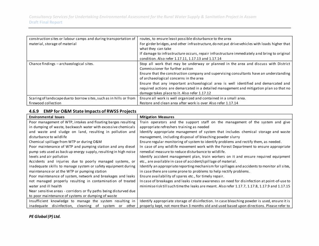
Consultancy Services for Undertaking Environmental Assessment for the Rural Water Supply & Sanitation Project in Assam Draft Final Report
PE Global (P) Ltd.
construction sites or labour camps and during transportation of
material, storage of material
routes, to ensure least possible disturbance to the area
For girder bridges, and other infrastructure, do not put drive vehicles with loads higher that what they can take If damage to infrastructure occurs, repair infrastructure immediately a nd bring to original
condition. Also refer 1.17.11, 1.17.13 and 1.17.14
Chance findings – archaeological sites. Stop all work that may be underway or planned in the area and discuss with District Commissioner for further action Ensure that the construction company and supervising consultants have an understanding of archaeological concerns in the area
Ensure that any important archaeological area is well identified and demarcated and required actions are demarcated in a detailed management and mitigation plan so that no damage takes place to it. Also refer 1.17.12
Scaring of landscape due to borrow sites, such as in hil ls or from firewood collection
Ensure all work is well organized and contained in a small area. Restore and clean area after work is over Also refer 1.17.14
4.6.9 EMP for O&M State Impacts of RWSS Projects Environmental Issues Mitigation Measures
Poor management of WTP, intakes and floating barges resulting in dumping of waste, backwash water with excessive chemicals and waste and sludge on land, resulting in pollution and
disturbance to wildlife Chemical spil lage from WTP or during O&M Poor maintenance of WTP and pumping station and any diesel
pump sets used as back up energy supply, resulting in high noise levels and air pollution Accidents and injuries due to poorly managed systems, or inadequate skil ls to manage system or safety equipment during
maintenance or at the WTP or pumping station Poor maintenance of system, network and breakages and leaks not managed properly resulting in contaminati on of treated
water and il l health Near sensitive areas - corridors or fly paths being disturved due to poor maintenance of systems or dumping of waste
Train operators and the support staff on the management of the system and give appropriate refreshers training as needed Identify appropriate management of system that includes chemical storage and waste
management, including disposal of bleaching powder slurry Ensure regular monitoring of system to identify problems and rectify them, as needed. In case of any wildlife movement work with the Forest Department to ensure appropriate
remedial measure to reduce disturbance to wildlife. Identify accident management plan, train workers on it and ensure required equipment etc., are available in case of accident/spil lage of material . Identify an appropriate reporting mechanism for spil lages and accidents to monitor all sites,
in case there are some prone to problems to help rectify problems . Ensure availability of spares etc., for timely repair. In case of breakages and leaks create awareness on need for disinfection at point-of-use to
minimise risk ti l l such time the leaks are meant. Also refer 1.17.7, 1.17.8, 1.17.9 and 1.17.15
Insufficient knowledge to manage the system resulting in inadequate disinfection, cleaning of system or other
Identify appropriate storage of disinfection. In case bleaching powder is used, ensure it is properly kept, not more than 3 months old and used based upon directions. Please refer to

Consultancy Services for Undertaking Environmental Assessment for the Rural Water Supply & Sanitation Project in Assam Draft Final Report
PE Global (P) Ltd.
management issues resulting in poor quality water being
supplied Public standposts and systems not protected resulting in animals accessing them or people washing and cleaning around them
Annexure 1.17.15 on appropriate use and management of bleaching powder for
disinfection.
Excessive pumping of groundwater, beyond planned resulting in
depletion of resource Development of other and competing groundwater systems which together with this system result in depleting of resource
Any system dependent on groundwater should be monitored to ensure that there is no
over abstraction. If over abstraction exists, based upon the water safety planning of the PHED identify appropriate management actions, such as aquifer recharge. Also refer 1.17.1 and 1.17.2
RWH system poorly maintained resulting in contamination of aquifer
Identify appropriate RWH maintenance schedule, train the operators and workers and ensure all required equipment is available and in good working condition.
Monitor system to ensure system is managed properly. Also refer 1.17.2
Inadequate finances or skil ls to manage small or individual systems resulting in their degradation, accumulation of water around the system or breakage resulting in contamination of aquifer
Identify finances and skil ls for management of small schemes as a part of project design .
Unattended leakages from water supply system or poorly
managed drainage and solid waste systems leading to vector habitats
Ensure all drainage systems are properly maintained.
Ensure there is no waste dumping in and around the system. Monitor system regularly to ensure that system is properly maintained. Also refer 1.17.7, 1.17.8 and 1.17.9
Inadequate sanitation/ environmental sanitation management contaminating shallow aquifers in areas where dugwells or
shallow rigs are used to procure water
Please refer guidelines on sanitation and environmental sanitation. Develop environmental and solid waste management strategy for vil lage. Also refer 1.17.1
to 1.17.9
Poor maintenance of system resulting such as drainage and damage to any local cultural property.
Ensure all drainage systems are properly maintained. Ensure there is no waste dumping in and around the system. Monitor system regularly to ensure that system is properly maintained. Also refer 1.17.7, 1.17.8, 1.17.9 and 1.17.12

Consultancy Services for Undertaking Environmental Assessment for the Rural Water Supply & Sanitation Project in Assam Draft Final Report
IPE Global (P) Ltd. 169
4.6.10 Water safety planning and guidelines
Water security and safety plan as developed by PHED, for the batch I project (Kamrup,
Hailakandi and Jorhat) will include, access to drinking water at individual level, i.e. every
household will get one individual connection which will be provided by PHED, upto 10
meters distance, Mapping of baseline on GIS, regular and comprehensive water quality
monitoring. Access to Drinking water includes an adequate quantity, Sustainable basis and
Good Quality (safety), Leads to Water Security in a community. Also, as per BIS Drinking
Water Quality norms (IS: 10500), 70 LPCD should be the design quantity. To ensure
sustainable future planning of water supply the following needs to be taken into account for
the entire scheme:
Need for improvement in coverage status.
Quality problems need to be addressed in some areas.
Problem may arise with sustainability of existing sources.
Community need to be involved, if water security is to be ensured.
Ensuring regular & constant monitoring of water quality.
4.7 Guidelines / Environmental Code of Practices
Guidelines/ Environmental Code of Practices (ECOP) have been prepared for addressing the
following environmental issues and are furnished in the Annexures as indicated.
1. ECOP for sanitary protection of water supply sources: The well to tap groundwater
sources and intake arrangements to tap surface water sources are located at certain
distance away from the pollution existing sources and the structures are protected
with certain measures to protect the quality of water from getting contaminated.
The detailed guidelines are furnished in Annexure 1.17.1.
2. Guidelines for Sustainability of Ground Water Sources: The yield from the sources in
general and ground water source in particular is likely to decrease during summer. In
order to ensure sustainable yield throughout the year certain measures such as
artificial recharge of the groundwater source with rainwater harvesting structures
are necessary. These measures are furnished in Annexure 1.17.2.
3. Selection and installation of safe sanitation technologies; the checklist for choice of
technology and selection of location is furnished in Annexure 1.17.3.
4. Recommended Construction Practice and Pollution Safeguards for Twin Pit Pour
Flush toilets: Twin Pit Pour Flush Latrines (TPPFL) is the most commonly adopted
sanitation technology which is suitable in most of the environmental conditions
except coastal areas with high groundwater table. Recommended construction
practice and Pollution Safeguards for TPPFTs are described in Annexure 1.17.5.
5. Appropriate Use and Management of Bleaching Powder for Disinfection: The
disinfection is an important treatment of both surface and ground water to ensure
safe water supply. A simple disinfection method with bleaching powder applicable
to small water supplies is sufficient and is provided in Annexure 1.18.

Consultancy Services for Undertaking Environmental Assessment for the Rural Water Supply & Sanitation Project in Assam Draft Final Report
IPE Global (P) Ltd. 170
6. Water Quality Monitoring and Surveillance: The water quality of the sources and in
the distribution system is deteriorating due to contamination especially after rains in
surface water sources and in summer months in groundwater sources. Water quality
monitoring should be undertaken periodically in order to take corrective measures if
the quality changes. The procedure and protocol for water quality monitoring and
surveillance are described in Annexure 1.14.
7. A format for attachment to the contracts of contractors/ consultants is given in
Annexure 1.23. This format need to be filled for each contract package and signed by
the respective contractor/ consultant for conforming to the EMF and implementing
the measures suggested under the EMF.
8. Guidelines on Natural Habitat and Forests: According to the World Bank Operation
Policy (OP) 4.04 on Natural Habitats21, the conservation of natural habitats is
essential for long-term sustainable development. Therefore a precautionary
approach to natural resource management is required. The policy on natural
habitats contains two major provisions with respect to biodiversity conservation and
EA which is detailed out under the Annexure 1.17.11.
9. Guidelines on Cultural Property: As this project not only includes intakes and rising
mains, but also networks within villages, there is a likelihood that some locally
significant cultural property may exist and to be considered as a part of the project
design. This ECoP detailed out in Annexure 1.17.12, has therefore been developed to
ensure minimal impact on any cultural property identified during the detailed design
of the project.
10. Guidelines on Public and worker’s health and safety: These guidelines identify
possible hazards and the management and mitigation actions for both workers in
the various project stages on site and public who may be in the vicinity of the
activities. The Environmental Code of Practice is in Annexure 1.17.13.
11. Development and Management of Borrow Pits: Scope of this ECoP, provided in
Annexure 1.17.14, extends to measures that need to be incorporated during borrow
area location, material extraction and rehabilitation.
21
Natural habitats are land and water areas where (i) the ecosystems’ biological communities are formed largely by native plant and animal species, and (i i) human activity has not essentially modified the areas primary ecological functions.