Embed Size (px)
Citation preview

April 2018
OpEx-T-R-13 Approved for Public Release
Constellation-Incident Management System Experimentation Report

i Approved for Public Release
The Constellation-Incident Management System Experimentation Report was prepared by the National Urban Security Technology Laboratory of the U.S. Department of Homeland Security Science and Technology Directorate.
The views and opinions of authors expressed herein do not necessarily reflect those of the U.S. government.
Reference herein to any specific commercial products, processes, or services by trade name, trademark, manufacturer, or otherwise does not necessarily constitute or imply its endorsement, recommendation, or favoring by the U.S. government.
The information and statements contained herein shall not be used for the purposes of advertising, nor to imply the endorsement or recommendation of the U.S. government.
With respect to documentation contained herein, neither the U.S. government nor any of its employees make any warranty, express or implied, including but not limited to the warranties of merchantability and fitness for a particular purpose. Further, neither the U.S. government nor any of its employees assume any legal liability or responsibility for the accuracy, completeness, or usefulness of any information, apparatus, product, or process disclosed; nor do they represent that its use would not infringe privately owned rights.
The cover photo and images included herein were provided by the National Urban Security Technology Laboratory, unless otherwise noted.

ii Approved for Public Release
FOREWORD
The U.S. Department of Homeland Security (DHS) Science and Technology Directorate (S&T) Urban Operational Experimentation (OpEx)—hosted by the National Urban Security Technology Laboratory (NUSTL)—provides first responders with the opportunity to experiment with new and emerging technologies in realistic, urban settings. This event combines demonstrations of leading-edge technologies with application-based field assessments throughout the New York City metropolitan area.
NUSTL’s Urban OpEx includes participation from a broad range of federal, state, local, academic and private sector partners. NUSTL’s Urban OpEx presents an important opportunity for DHS to gain a greater understanding of the operational needs and requirements of local first responders, while enabling first responder agencies to assess new technologies.
Capability gaps and potential technologies are reviewed with New York City first responder agencies to ensure the S&T Urban OpEx best addresses local responders’ needs, interests and priorities, and benefits the homeland security enterprise as a whole. Participating first responders train on and experiment with technologies they have identified as possible solutions to meet priority capability gaps. Participants are also in the unique position to influence the development of new technologies and provide recommendations for future DHS S&T investments through their field technology experiments.
For more information on NUSTL’s Urban OpEx or to view published Urban OpEx reports, visit www.dhs.gov/science-and-technology/frg-publications.
iii Approved for Public Release
POINTS OF CONTACT
National Urban Security Technology Laboratory U.S. Department of Homeland Security Science and Technology Directorate 201 Varick Street New York, NY 10014
E-mail: [email protected] Website: www.dhs.gov/science-and-technology/frg-publications
Author: Bhargav Patel, NUSTL Experimentation Director

iv Approved for Public Release
EXECUTIVE SUMMARY
Constellation for Incident Management (Constellation), an emergency data exchange language (EDXL)-compliant mobile command and control software developed by Haystax Technology, was evaluated during the U.S. Department of Homeland Security (DHS) Science and Technology Directorate (S&T) Urban Operational Experimentation (OpEx) event hosted by the National Urban Security Technology Laboratory (NUSTL) on January 25, 2017. Constellation is an incident management system that runs on desktop computers and mobile devices. The software creates a configurable common operating picture that provides secure communications, situational awareness and information sharing between various types of organizations and levels of command.
Nine first responder and emergency management personnel participated in this event. The participants were given a presentation on Constellation’s features and capabilities of by the technology developer, and they then experimented with it on desktop computers and mobile devices. The experimentation allowed participants to use Constellation in an operationally relevant way so they could provide feedback on its features and suitability for use in first responder and emergency management organizations. The participants were provided with a list of tasks to accomplish while using Constellation, but they were also encouraged to consider and attempt other actions they might take when responding to a real event or incident.
Participants believed Constellation would increase a first responder’s ability to communicate and share information, such as the location of people and building schematics. The common operating picture created by Constellation allowed participants to view all the information shared by other participants and to make decisions during the experimentation. Participants learned how to use most of Constellation’s functions (such as accessing information in different formats, creating forms and inputting information) and implement them with ease; however, they found some limitations with information streams and search features. They were unable to augment the parameters that governed what type of information would be displayed in the information stream, and the search feature did not search and display information and items they generated.

v Approved for Public Release
TABLE OF CONTENTS
Foreword ......................................................................................................................................... ii
Points of Contact ........................................................................................................................... iii
Executive Summary ....................................................................................................................... iv
1.0 Introduction .............................................................................................................................. 1
1.1 Purpose ............................................................................................................................... 1
1.2 Objective .............................................................................................................................. 2
1.3 Responder Capability Need ............................................................................................... 2
1.4 Product Description ............................................................................................................ 2
2.0 Experimentation Design .......................................................................................................... 4
2.1 Event Design ....................................................................................................................... 4
2.2 Summary of the Operational Experimentation ................................................................. 4
2.2.1 Operational Scenario 1: Pre-Planned Event– Dignitary Visit to New York, NY ............................................................................................ 5
2.2.2 Operational Scenario 2: Unplanned Incident– A Tornado Touches Down in Brooklyn, NY .......................................................................... 6
2.3 Data Collection .................................................................................................................... 7
2.4 Operational Scenario Debrief ............................................................................................ 7
3.0 Results ..................................................................................................................................... 8
3.1 Questionnaire Feedback .................................................................................................... 8
3.2 Data Collector Notes ....................................................................................................... 10
3.3 Debrief Session Feedback .............................................................................................. 11
3.4 Conclusion ........................................................................................................................ 12
LIST OF FIGURES
Figure 1-1 Main Home Screen of Haystax Constellation ............................................................ 3 Figure 2-1 Assets Main Page for Dignitary Visit .......................................................................... 5 Figure 2-2 The Map App Allows Users to Spatially Explore Areas of Interest ............................ 6 Figure 2-3 The Timeline App Allows Users to Temporally Explore Incidents and Events ......... 6
vi Approved for Public Release
LIST OF TABLES
Table 1-1 Urban OpEx Technology Focus Areas .......................................................................... 1 Table 2-1 Equipment Used during Experimentation ................................................................... 4 Table 3-1 A Breakdown of the Evaluators’ Responses to Questions of
Suitability and Ease of Use .......................................................................................... 8 Table 3-2 A Summary of the Evaluators’ Responses to Questions about
Usefulness of Features ................................................................................................ 9
1 Approved for Public Release
1.0 INTRODUCTION
On January 25, 2017, Constellation for Incident Management (Constellation), an emergency data exchange language (EDXL)-compliant mobile command and control software developed by Haystax Technology, was evaluated during the U.S. Department of Homeland Security (DHS) Science and Technology Directorate (S&T) Urban Operational Experimentation (OpEx) event hosted by the National Urban Security Technology Laboratory (NUSTL). This event brought together urban first responders and product developers to experiment with emerging technologies in operational conditions. Subject matter experts participated from New York City Emergency Management (NYCEM), Port Authority of New York and New Jersey (PANYNJ), Boston Emergency Medical Services (Boston EMS), Boston Fire Department (Boston FD), U.S. Customs and Border Protection (CBP) and Monroe County Emergency Communications Department (Monroe County ECD). NUSTL selected the technologies and worked with first responders, emergency managers and the technology developers to plan the experimentation scenarios and arrange experiment venues. Responders from these agencies and members of the First Responder Resource Group (FRRG) experimented with the technologies and provided feedback and observations. Table 1-1 lists the technologies included in this event.
Urban first responders from the New York City Fire Department (FDNY), New York City Police Department (NYPD), NYCEM and PANYNJ were canvassed for input on capability gaps that could be solved with technological solutions and for input regarding their technology areas of interest.
NUSTL then combined input from subject matter experts at these agencies and conducted a thorough technology selection process to establish three topic areas (Table 1-1) for experimentation at the Urban OpEx.
Table 1-1 Urban OpEx Technology Focus Areas
Topic Area Description
Incident Management System
Emergency data exchange language (EDXL)-compliant incident management software--for large and cross-jurisdictional emergency management--that allows for data to readily be received and shared with other EDXL-compliant software.
Communications and Tracking in Subterranean Environments
Technology solutions that enhance a first responder’s ability to communicate voice, data and location information from an incident area that is GPS-denied and impedes RF signals (e.g., tunnels and underground subway systems) to other colleagues and incident commanders who may or may not also be in such environments.
Video Content Analysis and Video Analytics
Mobile and deployable technology solutions that aid law enforcement in threat detection, including but not limited to: anomaly detection (e.g., left behind bags), behavior threat detection (e.g., crimes in progress, people in need of assistance) and facial recognition.
1.1 PURPOSE
The Constellation OpEx was designed to provide first responders and emergency managers with an opportunity to learn about the capabilities and limitations of Constellation, experiment with it in a hands-on fashion, and provide feedback about its use for first responder and emergency management applications. The goal of eliciting evaluator feedback was to provide Haystax
2 Approved for Public Release
Technology with information helpful in optimizing Constellation for use by law enforcement and security personnel, and to provide S&T program managers with a better understanding of first responder and emergency manager needs to guide future S&T investments.
1.2 OBJECTIVE
This experimentation was designed to allow first responders and emergency managers to use Constellation in operational settings and to offer feedback and suggestions to the technology developer that could enhance the product’s capabilities for first responder operations.
1.3 RESPONDER CAPABILITY NEED
Law enforcement and emergency management agencies advising NUSTL on technologies, to include in Urban OpEx 2017, indicated they considered incident management systems to be a technology that could enhance their ability to manage and share information during a major event or disaster.
1.4 PRODUCT DESCRIPTION
Constellation allows its end users to detect, monitor, analyze, communicate and respond to emerging threats and ongoing incidents from a single incident management system. Pre-planning tools include an asset catalog for tracking geo-located facilities, materials, vehicles and people, plus field assessment forms that can be completed from mobile devices or desktop stations.
The system has the ability to import additional map layers in Environmental Systems Research Institute (ESRI)-compliant formats and other geographic information systems formats, as well as hyper-local data like weather, traffic, video, computer-aided dispatch and other feeds. News reports and social media posts also can be configured in advance or ‘on the fly’ to find specific information for continuous awareness monitoring.
Mobile applications enable incident commanders to see their entire area of operations from any device at any time, untethering them from the command post. Continuously updated maps and timelines provide real-time visibility into critical assets, scheduled events, incidents and numerous other data feeds, so they can coordinate available resources during a fast-moving emergency response and share continuous updates with local stakeholders, partner agencies and political leaders.
Constellation can be accessed via web browser or an installed application (or app) on a mobile device or computer. It follows an app-based design scheme similar to the operating systems of many smartphones (see Figure 1-1). There are eight primary apps to input or access information:
1. Assets–Allows users to access or input information about facilities, materials, vehicles and people.
2. Assessments–Allows users to input, track and understand the safety, security, vulnerabilities and risks of an asset, event or incident.
3. Incidents–Allows users to document information to unplanned events of interest; can be customized by the organization.
4. Map–Allows users to visualize different assets, incidents and events in a graphical map-based manner.

3 Approved for Public Release
5. Threat Streams–Allows users to visualize information from multiple sources, including but not limited to news, weather, traffic and social media; additional parameters can be customized to narrow the scope of information displayed.
6. Events–Allows users to access and document information to planned events of interest; can be customized by the organization.
7. Timeline–Allows users to visualize the temporal change in assessments, incidents and events. 8. Mobile Indicator–Allows users to display interviews and other types of information that are
gathered using the Constellation mobile app.
Resilient Network Systems (Resilient) partnered with Haystax to incorporate EDXL compliance into Constellation. This underlying technology standard operates behind the scenes and helps solve some of the access management issues that go hand-in-hand with incident management, communications and resource allocation during emergency response missions. Resilient’s Adaptive Access Management is an identity and access management (IAM) tool. IAM is the security and business discipline that controls which individuals have access to specific resources and when they have access. It addresses the need to ensure appropriate access to resources across increasingly heterogeneous technology environments and to meet increasingly rigorous compliance requirements.
Adaptive Access Management establishes an access management framework that allows users from disparate systems, organizations and agencies to interact and exchange information. It allows different systems to enforce their own policies to external users in real-time. Doing so ensures that authorization rules are met for each user’s specific access requests.
Adaptive Access Management interrogates multiple internal and external authoritative sources, such as identity, attributes, authorizations, entitlements and context, in order to resolve access rights based on the policies of all parties involved while protecting privacy and confidentiality.
Some of the core capabilities are as follows:
• Standards-based and custom representational state transfer application programming interface for connecting authoritative sources and applications;
• A graphical user interface for defining and managing policies based on a set of connected authorities;
• A distributed workflow technology to resolve policy conditions; • Bi-directional policy enforcement; and • Support for IAM standards.
Figure 1-1 Main Home Screen of Haystax Constellation

4 Approved for Public Release
2.0 EXPERIMENTATION DESIGN
2.1 EVENT DESIGN
A detailed description of the experimentation design can be found in the Experimentation Plan for Haystax Constellation and Resilient Network Systems.i The experimentation scenario was developed with input from first responders, emergency managers, the technology developer and NUSTL’s Urban OpEx directors.
The experimentation intended to provide a group of first responder participants with an opportunity to learn about the features and capabilities of Constellation, and—through using the software on both a computer and mobile device platforms—to assess the potential for using Constellation in a command center and by first responders in the field.
2.2 SUMMARY OF THE OPERATIONAL EXPERIMENTATION
Nine participants from PANYNJ, NYCEM, CBP, Boston EMS, Boston FD and Monroe County ECD convened at the NYCEM Emergency Operations Center (EOC) in New York, New York, to participate in an operational experimentation with Constellation.
Activities began in a conference room with a presentation by the NUSTL experimentation director about Urban OpEx and the purpose of the operational experiment. Additional opening remarks were provided by the NUSTL director and a safety briefing was provided by NUSTL’s Safety, Health and Environmental Management System Coordinator. The technology developers from both Haystax Technologies and Resilient Network Systems trained participants on the operation of Constellation and the capabilities of Adaptive Access Management. Participants then operated Constellation on either a computer or one of several available mobile devices. The EOC provided Microsoft Windows-based desktop computers for all participants. Participants accessed Constellation through the World Wide Web, via the Firefox web browser. NUSTL provided 9.7-inch Apple iPads to four different participants, so that they could interact with the Constellation application on a mobile device. Table 2-1 summarizes the equipment used for this experiment.
Table 2-1 Equipment Used during Experimentation
Equipment Description
9.7-inch Apple iPad Tablet Mobile Device; Mac Operating System (OS); Haystax Constellation version 1.4
Desktop Computers in EOC Windows 7 OS; Mozilla Firefox web browser
i NUSTL. Urban Operational Experimentation Plan for Haystax Constellation and Resilient Network Systems, OpEx-T-PL-13. January 2017.

5 Approved for Public Release
2.2.1 OPERATIONAL SCENARIO 1: PRE-PLANNED EVENT–DIGNITARY VISIT TO NEW YORK, NY
Participants were instructed to use Constellation to plan a fictional visit by a dignitary. The dignitary would be arriving at LaGuardia Airport and transiting to a hotel in Times Square. The participants were first instructed to explore pre-populated information associated with the fictional dignitary visit. This included information about places of interest, such as the hotel, nearby hospitals and the airport, which could be viewed within the Assets App (see Figure 2-1).
Figure 2-1 Assets Main Page for Dignitary Visit
The Assets App contained critical information about people and places of interest. In the case of a place, such as a building, it may contain information such as the main points of contact (e.g., building manager, security officer, etc.), photos and schematics, a description of the building, and information about nearby places of interest (e.g., hospitals, police stations, etc.).
Participants were then handed one of six different index cards that contained information about a building and were asked to input this information as an asset into Constellation. These two activities highlighted both how information could be input and how it could be displayed back to a user of the software when planning for an event.
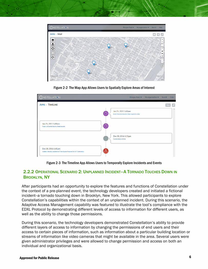
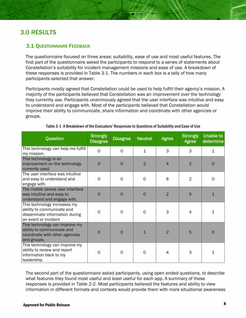
Participants explored the other seven apps, but were not required to input additional data due to time constraints. This process allowed them to better understand Constellation’s ability to retrieve information from other sources, such as social media applications, by reviewing the Threat Streams App to view similar information in a different context; by exploring the Map App, which displays information in a spatial manner (see Figure 2-2); and by examining the Timeline App, which displays that same information in a temporal timeline (see Figure 2-3). Participants were also able to review the Assessment App, which is designed to be used as a checklist before and during planned events.
6 Approved for Public Release
Figure 2-2 The Map App Allows Users to Spatially Explore Areas of Interest
Figure 2-3 The Timeline App Allows Users to Temporally Explore Incidents and Events
2.2.2 OPERATIONAL SCENARIO 2: UNPLANNED INCIDENT–A TORNADO TOUCHES DOWN IN BROOKLYN, NY
After participants had an opportunity to explore the features and functions of Constellation under the context of a pre-planned event, the technology developers created and initiated a fictional incident--a tornado touching down in Brooklyn, New York. This allowed participants to explore Constellation’s capabilities within the context of an unplanned incident. During this scenario, the Adaptive Access Management capability was featured to illustrate the tool’s compliance with the EDXL Protocol by demonstrating different levels of access to information for different users, as well as the ability to change those permissions.
During this scenario, the technology developers demonstrated Constellation’s ability to provide different layers of access to information by changing the permissions of end users and their access to certain pieces of information, such as information about a particular building location or streams of information like video cameras that might be available in the area. Several users were given administrator privileges and were allowed to change permission and access on both an individual and organizational basis.

7 Approved for Public Release
Participants were asked to enter new information or edit pre-loaded information as they would during an actual tornado event.
2.3 DATA COLLECTION
Feedback from the participants was obtained in several ways. During the experimentation, a NUSTL data collector was paired with several participants to record participant comments and concerns. After the experimentation, the participants completed a questionnaire that captured their opinions on the suitability of Constellation’s features for use by first responder and emergency management agencies. Finally, the experimentation director led a debrief session during which participants provided additional comments and feedback about Constellation.
2.4 OPERATIONAL SCENARIO DEBRIEF
Following the experimentation, the experimentation director led a debrief session to gain a better understanding of the suitability, deficiencies, efficiencies and possible improvements to Constellation. The discussion included the following questions:
• In what applications do you anticipate using this technology?
• What did you like about this technology?
• What did you not like about this technology?
• What changes would you recommend? Why?
• Is this technology something that you would actively use if it was available to you?
• How do you think this technology would affect your ability to complete your duties?
The point of this discussion was to engage the participants in a conversation that would lead to feedback that might not be gained from the survey. Notes were taken and incorporated into the results section of this report.
8 Approved for Public Release
3.0 RESULTS
3.1 QUESTIONNAIRE FEEDBACK
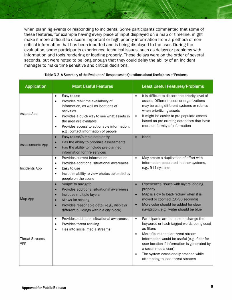
The questionnaire focused on three areas: suitability, ease of use and most useful features. The first part of the questionnaire asked the participants to respond to a series of statements about Constellation’s suitability for incident management missions and ease of use. A breakdown of these responses is provided in Table 3-1. The numbers in each box is a tally of how many participants selected that answer.
Participants mostly agreed that Constellation could be used to help fulfill their agency’s mission. A majority of the participants believed that Constellation was an improvement over the technology they currently use. Participants unanimously agreed that the user interface was intuitive and easy to understand and engage with. Most of the participants believed that Constellation would improve their ability to communicate, share information and coordinate with other agencies or groups.
Table 3-1 A Breakdown of the Evaluators’ Responses to Questions of Suitability and Ease of Use
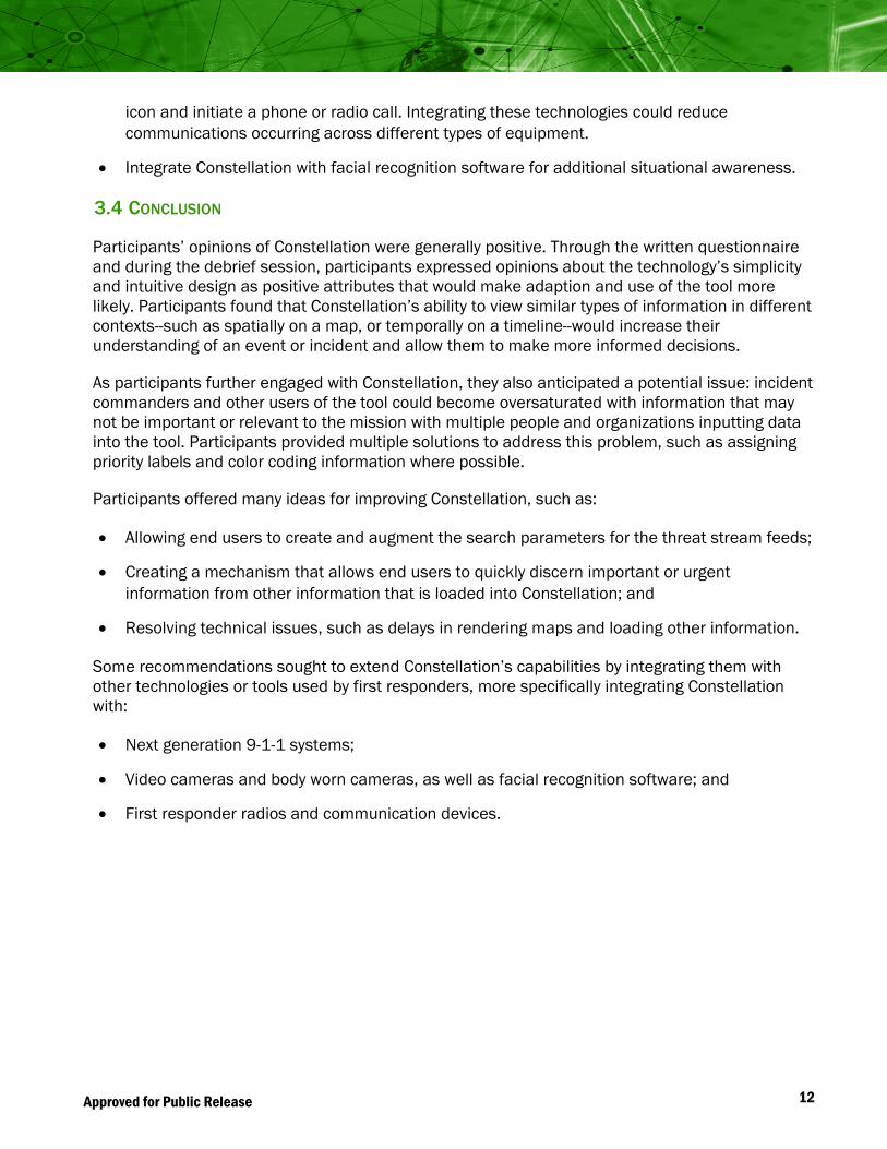
The second part of the questionnaire asked participants, using open ended questions, to describe what features they found most useful and least useful for each app. A summary of these responses is provided in Table 2-2. Most participants believed the features and ability to view information in different formats and contexts would provide them with more situational awareness
Question Strongly Disagree Disagree Neutral Agree Strongly
Agree Unable to determine
This technology can help me fulfill my mission. 0 0 1 3 3 1
This technology is an improvement on the technology currently used.
0 0 2 4 2 0
The user interface was intuitive and easy to understand and engage with.
0 0 0 6 2 0
The mobile device user interface was intuitive and easy to understand and engage with.
0 0 0 2 5 1
This technology increases my ability to communicate and disseminate information during an event or incident
0 0 0 3 4 1
This technology can improve my ability to communicate and coordinate with other agencies and groups.
0 0 1 2 5 0
This technology can improve my ability to review and report information back to my leadership.
0 0 0 4 3 1
9 Approved for Public Release
when planning events or responding to incidents. Some participants commented that some of these features, for example having every piece of input displayed on a map or timeline, might make it more difficult to discern important or high priority information from a plethora of non-critical information that has been inputted and is being displayed to the user. During the evaluation, some participants experienced technical issues, such as delays or problems with information and tools rendering or loading properly. These delays were on the order of several seconds, but were noted to be long enough that they could delay the ability of an incident manager to make time sensitive and critical decisions.
Table 3-2 A Summary of the Evaluators’ Responses to Questions about Usefulness of Features
Application Most Useful Features Least Useful Features/Problems
Assets App
• Easy to use • Provides real-time availability of
information, as well as locations of activities
• Provides a quick way to see what assets in the area are available
• Provides access to actionable information, e.g., contact information of people
• It is difficult to discern the priority level of assets. Different users or organizations may be using different systems or rubrics when prioritizing assets
• It might be easier to pre-populate assets based on pre-existing databases that have more uniformity of information
Assessments App
• Easy to use/simple data entry • Has the ability to prioritize assessments • Has the ability to include pre-planned
information for fire services
• None
Incidents App
• Provides current information • Provides additional situational awareness • Easy to use • Includes ability to view photos uploaded by
people on the scene
• May create a duplication of effort with information populated in other systems, e.g., 911 systems
Map App
• Simple to navigate • Provides additional situational awareness • Includes multiple layers • Allows for scaling • Provides reasonable detail (e.g., displays
different buildings within a city block)
• Experiences issues with layers loading properly
• Map is slow to load/redraw when it is moved or zoomed (10-30 seconds)
• More color should be added for clear navigation, e.g., water should be blue
Threat Streams App
• Provides additional situational awareness • Provides threat ranking • Ties into social media streams
• Participants are not able to change the keywords or hash tagged words being used as filters
• More filters to tailor threat stream information would be useful (e.g., filter for user location if information is generated by a social media user)
• The system occasionally crashed while attempting to load threat streams

10 Approved for Public Release
Application Most Useful Features Least Useful Features/Problems
Timeline App
• Provides additional situational awareness • Events serve as hyperlinks to more
information • Can be useful when later generating
reports of events or incidents
• There is no mechanism to quickly identify which tasks have been completed or closed out
• Timeline list all actions, updates or events that have been input by a user; however, not all events are equally important to emergency managers and incident commanders
3.2 DATA COLLECTOR NOTES
During the experimentation, data collectors recorded observations and comments participants expressed or issues they experienced while operating the Constellation. Data collectors predominately documented issues and recommendations for the software’s user interface, while also hearing minor concerns about technical issues and capability limitations.
User Interface
• Some participants had difficulty logging in. Password complexity could pose as an issue for end users in the field.
• Many spelling errors were observed. It may be useful to incorporate spell check into the software. Misspelled entries could result in the inability to accurately locate or identify assets, events, etc.
• Many participants did not find it intuitive to have to click on the “App” button on the screen to get back to the main menu, so it was suggested that a “Home” or “Menu” button would be more user friendly.
• While trying to search on the map, the mouse cursor must stay hovered over the search icon. If the mouse moves, the search field hides; this was identified as not being user friendly.
Technical Issues
• Some participants were concerned with connectivity issues. While all users were experimenting with the technology, the map layering functionality became delayed, and in some instances would not display. The technology developer indicated that this could have been due to connectivity or bandwidth issues. Participants were concerned that these connectivity issues would grow worse in the field.
Capability Limitation
• Constellation only searches items using the Google search engine, and does not search internally generated information, such as assets entered into the system. One evaluator tried to search the asset he entered into the system and it returned a result in a different country.

11 Approved for Public Release
3.3 DEBRIEF SESSION FEEDBACK
An informal discussion was led by the experimentation director to solicit further feedback from the participants. A diverse set of feedback was collected from the participants that highlighted what first responders valued, what could be improved, and how the system could be further integrated with other systems and tools they use. Participant feedback included:
Positive Attributes
• Ability to import information from existing databases.
• Data stored in an EDXL-compliant format, allowing information to be more readily shared to other systems or organizations.
• Ability to import other data streams (e.g., weather data) into Constellation.
• Tagging feature allows for easy export of relevant information to generate after action reports.
• Essential needs, such as plans, can be downloaded to access later if a user loses Internet connectivity.
Recommended Feature Changes
• Provide users with full access to change the search parameters used to filter threat stream information.
• Add a checklist feature, potentially with the Timeline App, to allow users to mark the completion of tasks and events. This would make it easier to understand what actions or activities were closed or open. The checklist should be color coded to highlight different priority levels.
• Include a “broadcast” feature that allows team leads to broadcast information to their entire unit or organization at once.
• Incorporate language translation tools. This would be particularly useful for evaluating information received from social media on the Threat Stream App.
Recommended Integration Features
• Constellation does not integrate data received from 911 call center systems. Knowledge in the field comes from the 911 center, and first responders want to see this stream of information integrated into Constellation. Constellation should explore and implement data migration and integration with the next generation 911 systems under development.
• Include a real-time camera feature to stream video from body cameras or video chatting streams; this might further add situational awareness and provide end users with more access to decision-making information.
• The Map App should incorporate a feature that allows direct communication with people who have been added into the system as an Asset. The user should be able to click on a person’s
12 Approved for Public Release
icon and initiate a phone or radio call. Integrating these technologies could reduce communications occurring across different types of equipment.
• Integrate Constellation with facial recognition software for additional situational awareness.
3.4 CONCLUSION
Participants’ opinions of Constellation were generally positive. Through the written questionnaire and during the debrief session, participants expressed opinions about the technology’s simplicity and intuitive design as positive attributes that would make adaption and use of the tool more likely. Participants found that Constellation’s ability to view similar types of information in different contexts--such as spatially on a map, or temporally on a timeline--would increase their understanding of an event or incident and allow them to make more informed decisions.
As participants further engaged with Constellation, they also anticipated a potential issue: incident commanders and other users of the tool could become oversaturated with information that may not be important or relevant to the mission with multiple people and organizations inputting data into the tool. Participants provided multiple solutions to address this problem, such as assigning priority labels and color coding information where possible.
Participants offered many ideas for improving Constellation, such as:
• Allowing end users to create and augment the search parameters for the threat stream feeds;
• Creating a mechanism that allows end users to quickly discern important or urgent information from other information that is loaded into Constellation; and
• Resolving technical issues, such as delays in rendering maps and loading other information.
Some recommendations sought to extend Constellation’s capabilities by integrating them with other technologies or tools used by first responders, more specifically integrating Constellation with:
• Next generation 9-1-1 systems;
• Video cameras and body worn cameras, as well as facial recognition software; and
• First responder radios and communication devices.