Embed Size (px)
Citation preview

Connectivity and Corridors in the INRMP
Fraser Shilling, UC Davis
for SEA

Report Outline
1) Need for north‐south wildlife movement corridors and linkages by wildlife in county
2) Barrier effects of Highway 50 and other major roadways
3) Existing locations on Highway 50 that potentially allow safe passage for terrestrial mammals
4) Potential retrofits of existing structures and new construction including issues associated with retrofitting and estimates of probable construction costs
5) Alternative locations for wildlife movement across Highway 50
*Annotated Bibliography

General Plan BasisGeneral Plan Objective 7.4.2 is a requirement to identify and protect resources of the County. This includes: “Identification and protection, where feasible, of critical fish and wildlife habitat including deer winter, summer, and fawning ranges; deer migration routes; stream and river riparian habitat; lake shore habitat; fish spawning areas; wetlands; wildlife corridors; and diverse wildlife habitat.”
General Plan Policy 7.4.2.8 B identifies considerations for wildlife movement on future 4‐ and 6‐lane roadways, as well as improving crossings of existing roadways.
General Plan Policy 7.4.2.8 D gives priority for acquisition to parcels that would preserve natural wildlife movement corridors such as crossings under major roadways.
General Plan Policy 7.4.2.8 E includes construction of roadway under and overcrossings that would facilitate movement by terrestrial wildlife as a habitat management measure.

How did we get here?

“TAKEAWAY” MESSAGES ON WILDLIFE MOVEMENTCaltrans, County DOT, and UC Davis data on roadkill demonstrates considerable wildlife movement throughout most of INRMP study area
Wildlife movement is reduced by land development and the 2004 General Plan is estimated to increase the County’s population from about 121,000 to 200,000 by 2025
Movement of certain wildlife can be retained through low density development, depending on layout
Roads serve as barriers, and will become more of a factor with greater development
Existing under‐crossings (road and stream/drainage) of major roadways can be improved at low cost to enhance wildlife movement
New under‐crossings in key areas can be added cost‐effectively where connectivity will be important in the future
State and federal transportation funding can assist the County with retrofitting existing and adding new crossings to support wildlife movement

1) North‐south connectivity
• INRMP disturbance map

1) North‐south connectivity
Finding: There is likely to be a significant need for north‐south connectivity in the INRMP study area to meet the needs of target/indicator species as well as biodiversity in general
• 316 vertebrate animals have high habitat quality in western El Dorado County; land‐dwelling mammals, reptiles, and amphibians will likely be most impacted.
• Larger animals have large home ranges as individuals or in groups, bringing them into conflict with existing and future roads and development.
• East‐west connectivity is needed too (thinking beyond Highway 50)

0 3 6 9 121.5Miles
®
IBC
Cities and Towns
Highways
Roads
Parcels
Roads and Developed ParcelsValue
High : 30
Low : 3
IBCs: Western El Dorado County

2) Barrier effects from transportation
Finding: There is likely to be a barrier effect of Highway 50 and other roadways in the INRMP area
Possible effects occurring in technical/scientific literature
• Animals don’t want to cross, they sometimes die when trying to cross
• This changes their chances of survival and continuation of the species

Finding: There are existing crossings of Highway 50 that could be improved to provide crossing opportunities for certain animals that can access the crossings
3) Existing locations to cross 50

3) Existing locations to cross 50
Lower‐mid foothills

3) Existing locations to cross 50
Mid/Placerville

3) Existing locations to cross 50
Upper foothills

4) Safe‐crossing retrofits and new construction
Finding: Additional safe crossings are needed for wildlife across county roads and state highways. There are feasible retrofits and new construction alternatives to accomplish this.
• More crossings needed for 50 and major roads; improvement of existing structures, or new structures; need natural openings and floor, frequent for smaller animals; all major roads need these improvements.
• Funds usually come from state and federal grants to local transportation agencies

5) Key Highway 50 Wildlife Crossing Areas
• East of Placerville/Pollock Pines
• West of Placerville/Weber Creek
• Lower Foothills
• South Fork American River Canyon
Finding: There are zones along Highway 50 where crossing possibilities should be increased, and other areas, existing ones enhanced.

“TAKEAWAY” MESSAGES FOR WILDLIFE MOVEMENT
Caltrans, County DOT, and UC Davis data on roadkill demonstrates considerable wildlife movement throughout most of INRMP study area
Wildlife movement is reduced by land development and the 2004 General Plan is estimated to increase the County’s population from about 121,000 to 200,000 by 2025
Movement of certain wildlife can be retained through low density development, depending on layout
Roads serve as barriers, and will become more of a factor with greater development
Existing under‐crossings (road and stream/drainage) of major roadways can be improved at low cost to enhance wildlife movement
New under‐crossings in key areas can be added cost‐effectively where connectivity will be important in the future
State and federal transportation funding can assist the county with retrofitting existing and adding new crossings to support wildlife movement

Solutions
• Land‐Use Planning: Existing pattern is the starting point, subsequent development will reduce connectivity to greater or lesser degrees depending on project decision and implementation
• Transportation Planning: Avoid conflicts (usually means avoiding construction in natural areas), minimize conflicts (reduce animal access to roadway, increase animal access from one side of right of way to the other), compensate for conflicts (probably not possible)
• Monitoring indicator species and locations of critical concern and use the information to inform future restorative actions (adaptive land use and transportation management)

Presentation ends here: The following slides provide background information

1) North‐south connectivity
Finding: There is likely to be a significant need for north‐south connectivity in the INRMP study area to meet the needs of target/indicator species as well as biodiversity in general
• 316 vertebrate animals have high habitat quality in western El Dorado County. All are likely to require the ability to move in all cardinal directions. Of these, land‐dwelling mammals, reptiles, and amphibians will likely be most impacted.
• Larger vertebrates, including black bear, mountain lion, deer, coyote, badger, and bobcat all have large home ranges as individuals or in groups. These large ranges will bring them into conflict with existing and future roads and development.
• East‐west connectivity is needed too (thinking beyond Highway 50)

2) Barrier effects from transportation
Finding: There is likely to be a barrier effect of Highway 50 and other roadways in the INRMP area
Possible effects occurring in technical/scientific literature
• Aversion to crossing
• Finding tortuous paths between disturbances (increased physiological costs)
• Mortality at crossing
• Population structure changed
• Reproductive and other behaviors changed
• Population and genetic isolation
Finding: There are existing crossings of Highway 50 that could be improved to provide crossing opportunities for certain animals that can access the crossings
3) Existing locations to cross 50

3) Existing locations to cross 50
Lower‐mid foothills

3) Existing locations to cross 50
Mid/Placerville

3) Existing locations to cross 50
Upper foothills

4) Safe‐crossing retrofits and New Construction
Finding: Additional safe crossings are needed for wildlife across county roads and state highways. There are feasible retrofits and new construction alternatives to accomplish this.
• Modify existing rights‐of‐way and nearby landscape to facilitate movement through barrier
• More crossings needed for 50 and major roads
• Traffic management
• Use existing crossing structure (e.g., box culvert) or build newinfrastructure
• Funds usually come from state and federal grants to local transportation agencies– Transportation Enhancement grant program (federal money via Caltrans
competitive program)
– Environmental Enhancement and Mitigation Program (State Resources Agency)
4) Safe‐crossing retrofits and New Construction (cont.)
• Vegetated openings – maintenance needed
• Natural‐bottom to crossings
• Frequency of crossings according to need (#/mile)
• Suitability according to development on each end
• Relevant for all major roads, not just Highway 50

4) Safe‐crossing retrofits andNew Construction (cont.)
• Small mammal culvert retrofit with ledges: $60,000 for Highway 50 – existing culverts; $15,000/year maintenance
• Large mammal crossing under two‐lane roadway: ~$200,000 for box culvert under‐crossing, fencing, and escape ramps
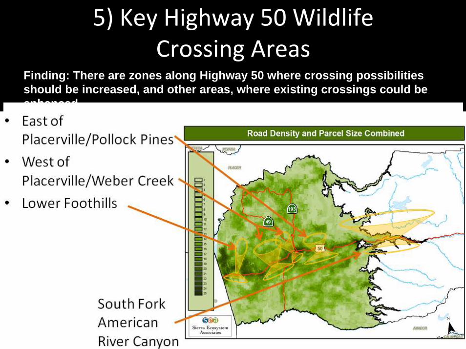
5) Key Highway 50 Wildlife Crossing Areas
• East of Placerville/Pollock Pines
• West of Placerville/Weber Creek
• Lower Foothills
• South Fork American River Canyon
Finding: There are zones along Highway 50 where crossing possibilities should be increased, and other areas, where existing crossings could be enhanced.

1) North‐south connectivity
• Landscape “linkages”according to Caltrans and CDFG (Spencer et al., 2010)
0 2 4 6 81Miles
®
Cities and Towns
Essential Connectivity Areas
Highways
Roads
Parcels
General Natural Landscape Blocks
Nat'l Areas <2000ac
Essential Habitat Connections Project Analysis: Western El Dorado County
PLACER
EL DORADO
AMADOR
NEVADA
CALAVERAS
SACRAMENTO
YUBA
SAN JOAQUINTUOLUMNE0 5 10 15 202.5
Miles
®
Cities and Towns
Essential Connectivity Areas
Highways
Roads
General Natural Landscape Blocks
Nat' l Areas <2000ac
Essential Habitat Connections Project Analysis: Western El Dorado County
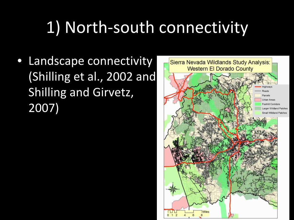
1) North‐south connectivity
• Landscape connectivity (Shilling et al., 2002 and Shilling and Girvetz, 2007)

2) Barrier effects from transportation

2) Barrier effects from transportation

2) Barrier effects from transportation

3) Existing locations to cross 50
Pipes
Nugget
Kyburz

3) Existing locations to cross 50
Box culverts
Joerger
Finders

3) Existing locations to cross 50
Street under‐passes
Snows
Greenstone
Bass Lake

4) Safe‐crossing retrofits andNew Construction (cont.)
• Small mammal culvert retrofit with ledges: $60,000 for Highway 50 – existing culverts; $15,000/year maintenance
• Large mammal crossing under two‐lane roadway: ~$200,000 for box culvert under‐crossing, fencing, and escape ramps

3) Existing locations to cross 50
Natural under‐passes
Weber Creek

4) Safe‐crossing retrofits
• Transportation Barriers (Opportunities)
(Courtesy Tanya Diamond)

4) Safe‐crossing retrofits
• EID Solutions for Canals– Deer (and other animals) fences and canal crossings

5) Alternative locations to cross 50

5) Key Highway 50 wildlife crossing areas
Example: Lower Foothills Connector
• Conservation values: Last lower elevation connector through developed lands, connects natural habitats north to south. Irreplaceable!
• Intensive development: Planned north and south of hwy 50, extending from south of 50 to Pine Hill area
• Stage of development: From intention to subdivide and develop to fully permitted, subdivided and agreements in place
• Resolution?

EL DORADO
PLACER
AMADOR
SACRAMENTO
NEVADA
CALAVERAS
0 2.5 5 7.5 101.25Miles
®
IBC
Cities and Towns
Highways
Roads
IBCs: Western El Dorado County