Embed Size (px)
Citation preview

Concepts & Recommendations for the
Implementation of
Tsunami Early Warning in Bali
Presented by
KESBANG, POL dan LINMAS
Bali Province
compiled by
GTZ IS
March 2009


Concepts & Recommendations for the
Implementation of
Tsunami Early Warning in Bali
Presented by
KESBANG, POL dan LINMAS
Bali Province
compiled by
GTZ IS
March 2009


Contents
1. Executive Summary .................................................................................................1
2. Introduction..............................................................................................................2
3. Tsunami Hazard and Early Warning in Bali: the Challenges.............................4
3.1. Short warning times and uncertainties ...........................................................4
3.2. Institutional setting ...........................................................................................7
3.3. Inter-institutional cooperation and integration of the private sector
(tourism) ..............................................................................................................9
3.4. Community Preparedness ..............................................................................10
4. Tsunami Hazard Maps: the Basis for Preparedness Planning..........................13
5. INA-TEWS: A System under Development – Roles and Responsibilities – the
Current and Future Warning Scheme ................................................................16
5.1 Division of roles and responsibilities within INA-TEWS.............................18
5.2 Current and future decision making reference for local authorities ..........19
6. Recommendations for the implementation and operation of tsunami early
warning in Bali ......................................................................................................21
6.1 Principals of a TEW Policy for Bali................................................................22
6.2 Institutional Requirements: 24/7 Unit ............................................................26
6.4 Decision Making by Standard Operating Procedures (SOP).......................29
6.5 Dissemination of warning and guidance to the communities at risk ...........33
6.6 Strengthening people’s awareness and understanding about INA-TEWS .37
7. References ...............................................................................................................39
7.1 Information regarding GTZ IS’ Cooperation for Tsunami Early Warning
in Bali.................................................................................................................39
7.2 Reference Documents: .....................................................................................41
7.3 Abbreviations: ..................................................................................................42


1
1. Executive Summary
After the devastating tsunami on 26 December 2004, the affected Indian Ocean
countries decided to build up a regional Indian Ocean Tsunami Early Warning
System. The Indonesian Tsunami Early Warning System (INA-TEWS) is a crucial
part of the regional system since the subduction zones offshore the Indonesian islands
are a major (potential) source for ocean wide tsunamis in the Indian Ocean.
The end-to-end Early Warning System in Indonesia, however, can only be called a
“system” once the national warning centre is connected to the communities at risk.
Local governments at province, district/city level play a crucial role in the Early
Warning System as they are responsible to implement Tsunami Early Warning (TEW)
within their administration and communities and provide guidance to the communities
in case that a warning is sent out by the National Warning Centre at BMKG in
Jakarta. This division of responsibility is a huge challenge for many regions in
Indonesia. It requires the set up of a local 24/7 service that is able to respond quickly
and in a reliable way, the development of standard operation procedures and the
strengthening of community awareness and preparedness.
The objective of this document is to provide advice on how Bali authorities can
establish the link to INA-TEWS and describes how appropriate capacities can be
build in order for Goverment of Bali as well as communities to fulfil its role in the
warning system. In order to achieve this goal, certain political, institutional and
technical requirements have to be met. The document suggests answers to six key
questions referring to these requirements and hereby provides a comprehensive
concept to implement TEW in Bali:
I. What are the principles of a TEW policy for Bali?
II. What are the institutional requirements for TEW in Bali?
III. What is required to receive warnings from the National Tsunami Warning Centre?
IV. What is required to decide whether communities should evacuate or not?
V. What is required to disseminate warning and evacuation guidance to the
communities?
VI. What is required to strengthen people’s awareness and understanding about INA-
TEWS?
The document was compiled by GTZ IS and takes into account results from
discussions with the Provincial Government (PEMPROV), Badung District
Government (PEMKAB Badung), the Bali Chapter of the Indonesian Red Cross
(PMI), and incoorperates input from the French Red Cross (FRC), the Bali Hotel
Associaton (BHA) as well as experiences from the Pilot Areas in southern Java and
Padang.

2
2. Introduction
Early Warning is essential to save lives when a tsunami strikes. Indonesia, with the
support of Germany and other countries as well as International Organisations, is
currently setting up the Indonesian Tsunami Early Warning System (INA-TEWS).
This system will be an essential part of an integral Tsunami Early Warning System for
the entire Indian Ocean Region.
The Indonesian Ministry for Research and Technology (RISTEK) coordinates the
development of INA-TEWS. The National Agency for Meteorology, Climatology and
Geophysics (BMKG) operates the National Tsunami Warning Centre. BMKG issues
tsunami warnings to interface institutions and local governments. Local
Governments are responsible for providing guidance to the community at risk based
on the warnings from BMKG, i.e. local authorities are the ones in charge for calling
for evacuation if needed.
The German contribution to INA-TEWS is known as GITEWS (German-Indonesian
Cooperation for a Tsunami Early Warning System). One component of the GITEWS
project focuses on “Capacity Building in Local Communities”. This component
supports the Indonesian partners in developing procedures and mechanisms, which
assure that people in risk areas are alerted in time and are capable to execute an
appropriate reaction to a warning in a timely manner. GTZ IS cooperates with local
governments and other stakeholders in three Pilot Areas while also maintaining close
cooperation with national institutions. The results from the pilot project will
contribute to enabling other tsunami prone communities to link themselves to the
INA-TEWS and to better prepare for future tsunami events.
Bali was selected as one of the Pilot Areas for the project due to its risk regarding
tsunami hazard. In early 2007 a close cooperation with the Bali Provincial as well as
Badung District Government was agreed and formalized by MoU (PEMKAB Badung
in March 2007, PEMPROV in May 2007). Since the beginning PMI joined the
cooperation as an active third partner in the implementation of Tsunami Early
Warning.
During the working process in Bali and the other GITEWS Pilot Areas new concepts,
planning tools and procedures for the implementation and operation of Tsunami Early
Warning at local level have been elaborated together with local stakeholders.
This document describes the Tsunami Early Warning concept developed for Bali. It
focuses on the southern coast of Bali and provides recommendations to local decision
makers and other stakeholders on how to develop structures and procedures that lead
to a coherent and effective tsunami early warning system in Bali. The document was
compiled by GTZ IS and takes into account results from discussions with PEMPROV,
PEMKAB Badung, PMI and and incoorperates input from the French Red Cross
(FRC), the Bali Hotel Associaton (BHA) as well as experiences from the Pilot Areas
in southern Java and Padang.
The authors would like to emphasise that the implementation of an end-to-end TEWS
in Bali requires the consideration of traditional knowledge. It needs to integrate

3
traditional means of communication means with new procedures and technology
introduced by a technology based early warning system like INA-TEWS.

4
3. Tsunami Hazard and Early Warning in Bali: the Challenges
3.1. Short warning times and uncertainties
Bali is located very close to the
collision zone between the Indian-
Australian Plate and the Eurasian Plate
which represents the main source area
for local tsunamis that might affect the
island. It has to be expected that
tsunami waves will need only 20 to 60
minutes to reach the coast. Hence
warning time is very short.
Figure 1: Subduction zone and back arc fault.
Time is the most critical factor when defining procedures for early warning and
evacuation!
Every tsunami is different! Bali might suffer the impact of a smaller tsunami but also
the worst case might happen. Historical research provides important insights into
possible events in the future. Relevant historical tsunami records for Bali are the
Sumba (1977) and Banyuwangi (1994) events that are related to subduction zone
earthquakes (Gempa Subduksi Lempeng) as well as the Flores Tsunami (1992), which
is related to an earthquake in back arc source (Gempa Patahan Belakang). Scientists
also consider the “seismic gap” (related to the subduction zone in the south) as
relevant for tsunami hazard assessment.
Understanding tsunami hazard and the assessment of possible impacts to their
community are preconditions for local decision makers and other stakeholders to
initiate preparedness activities to anticipate future tsunami events. Implementation of
such activities and decisions that have to be taken can only be based on today's
understanding of the hazard. Due to high level of uncertainty these decisions often
appear to be difficult. They involve choices, tradeoffs and risk. While getting
prepared has to be a priority some degree of risk must be accepted due to economic
reasons.
Due to the infrequent occurrence of tsunamis, information regarding their
possible impact, occurrence and run up heights is very uncertain. It must be
assumed that no reasonable action can take into account all possible risk...
Most probably tsunamis in Bali will be triggered by tectonic earthquakes. But not all
earthquakes in the collision zone of the tectonic plates cause tsunamis. Whether an
earthquake has the potential to trigger a tsunami is currently evaluated by analyzing
three factors:

5
1. Location: the earthquake has to be located under the sea
2. Magnitude: higher then 6.5 on the Richter Scale (RS)
3. Depth: less than 70 km
BMKG (National Agency for Meteorology, Climatology and Geophysics) currently
uses the mentioned thresholds (M 6.5 RS, 70 km depth) to analyse whether an
earthquake has tsunami potential or not. Even if an earthquake event matches all three
criteria, this does not necessarily mean that a tsunami has been generated. A fourth
criterion has to be fulfilled: the earthquake caused a vertical movement of the sea
floor.
Besides earthquakes that occur in the
subduction zone of the Sunda Trench
and the back arc fault, two more
sources for tsunamis have been
identified: submarine landslides and
volcanic activity. Submarine landslides
are associated with earthquakes. They
happen during an earthquake, can
increase the energy of a tsunami and
therefore add up to the effect of uplift
by tectonic movements in the
subduction zone (also caused by the
earthquake).
In Bali, earthquakes frequently occur
also on land. Bali experienced several
strong earthquakes (M≥ 6 RS) in the
past (1976, 1979, 1984 and 2004).
These earthquakes are associated with
the “Central Bali Right Lateral Strike
Slip Fault Seismic Source Zone”, a
rupture zone under the island of Bali.
Figure 2: Seismotectonic Map of Bali
Ground shaking should be treated as the first warning sign! However, since it is
not possible to deduce earthquake magnitude and location from ground shaking
alone, this measurement involves a high level of uncertainty!
The Indonesian Tsunami Early Warning System (INA-TEWS) is designed to identify
earthquake parameter and location within 5 to 7 minutes and to communicate the
result to local authorities. At a later stage (second half of 2009) INA-TEWS will
integrate data from GPS, buoys and tide gauges to observe possible vertical
movements of the plates as well as the ocean water in order to confirm whether a
tsunami was generated or not. For this reason it is important to distinguish between
the current and the future warning scheme.
As the current warning scheme depends only on earthquake observation, it is
obvious that BMKG can currently only advert that an earthquake has the potential to
generate a tsunami, but cannot confirm whether a tsunami was actually triggered.

6
Local governments will not know with certainty whether a tsunami is on the way
or not when they have to decide for evacuation.
Having clarified that, it is most important to understand that the moment of ground
shaking during the earthquake provides the first opportunity to react, i.e. move
away from the beach and to higher ground. The first warning from BMKG (5-7
minutes after an earthquake), though it does not provide 100% certainty whether a
tsunami will come or not, is probably the last chance to call for evacuation in case
a tsunami becomes reality and hits the coast. Waiting until natural warnings signs
(e.g. seawater withdrawal) confirm the arrival of a tsunami is definitely not an
option, as it does not provide enough time for evacuation of the community at risk
(see graphic 3).
Figure 3 - Current Warning Scheme: Approximate time line of a tsunami event from the earthquake
until an “All clear” message displaying available information (from nature and INA-TEWS) before,
during and after the tsunami event. Note: time in minutes is just an estimation, time can vary!
As already mentioned, the warnings currently issued by BMKG only provide
information about the earthquake parameter and whether these parameters represent a
threat of a potential tsunami. They do not give any information about possibly
affected areas.
The current warning scheme by BMKG does not provide any information
whether Bali might be affected in case of a particular warning and what level of
impact would have to be expected.
With the future warning scheme (second half of 2009) this situation will change.
The warning system will provide information about potentially affected areas and the
estimated impact. Additionally the system will give additional information that
confirms whether a tsunami was generated or not. This confirmation will be based on
the data from GPS, buoys and tide gauges. A Decision Support System will integrate
all available data, refer to a tsunami simulation database and support the warning
service (see page 18) of BMKG. Once the future scheme is in place it has to be
assessed and discussed whether – and how long – it is worth waiting for a second
warning message from BMKG. This second information might give more certainty
about an actual tsunami occurrence but might not leave enough time for evacuation
and probably risk many lives.
BMKG Information1 - 10 hrs: All Clear
Natural Warning Signs:sea withdraws etc.
- 1 st BMKG Warning
5 - 7 minPotensi Tsunami
Train of Waves
EQ
Natural Warning Sign

7
4th BMG Information
1-10 hrs: All Clear
Natural Warning Signs:
sea withdraws etc.
3rd BMG Information
30-60 min:
Observation at coast
1st BMG Warning
5-7 min
Potensi Tsunami
2nd BMG Warning
10-30 min:
Confirmation or Cancellation
Train of Waves
EQ
Natural
Warning Sign
Figure 4 - Future Warning Scheme: Approximate time line of a tsunami event from the earthquake
until “All clear” message displaying available information (from nature and INA-TEWS) before,
during and after the tsunami event; Note: time in minutes is just estimation, time can vary!
In conclusion: short warning times and uncertainties related to (local) tsunami hazard
and early warning represent a big challenge for Bali in its effort to improve tsunami
preparedness and implement strategies for tsunami early warning. Recognizing these
parameters and taking them into account should be the basis to develop a realistic
preparedness strategy for Bali.
Dealing with tsunamis always means dealing with uncertainty. This is a big
challenge and requires a realistic preparedness strategy.
Figure 5: Relation between available information (uncertainty) and time for reaction along the tsunami
time line. Note: time in minutes is just estimation, time can vary!
3.2. Institutional setting
Major challenges for the implementation of tsunami preparedness are related to the
fundamental change regarding the disaster management framework that is currently
ongoing in Indonesia. A new law for disaster management was released in 2007. The
organisational structures of these institutions, however, have not been completed yet.
The National Disaster Management Agency (BNPB) has been founded in the
beginning of 2008. In some regions, the Local Disaster Management Agency (BPBD)
has been established in some regions (provinces and/or districts/cities) while in others
it does not exist yet. The former and still functioning SATLAK / SATKORLAK
structure was never designed or mandated to deal with disaster preparedness or early
BMG Warning 15-7 minutes:
Potensi Tsunami
BMG Warning 210-30 minutes:
Time Line
BMG Message 4All Clear
Natural
Warning Signs
EQ
BMG Message 330-60 minutes:
100 %
Certainty
Time for
Reaction
BMG Warning 15-7 minutes:
Potensi Tsunami
BMG Warning 210-30 minutes:
Time Line
BMG Message 4All Clear
Natural
Warning Signs
EQ
BMG Message 330-60 minutes:
100 %
Certainty
Time for
Reaction

8
warning. Eventually, the roles and responsibilities of the new BPBD regarding
Tsunami Early Warning in Bali still need to be determined.
Several meetings in 2008 stressed the need for clarification about the roles and
responsibilities of district and province level regarding tsunami early warning. In a
meeting at the Governor’s office on 15 February 2008 it was agreed that the main
responsibility for the provision of guidance to the community at risk (i.e. call for
evacuation) and hence the establishment of local 24/7 services has to be taken care of
by district governments. Following this agreement, the PUSDALOPS (Operations
Control Centre) at province level should have a back-up function and take over in
case district 24/7 services are not available.
As a next step it was decided to establish temporary 24/7 services for tsunami early
warning at province level and in Badung District (at KESBANGLINMAS; Civil
Defence Office). GTZ IS supported the initiative with the development of Standard
Operating Procedures and an Operations Manual for PUSDALOPS, basic
infrastructure for tsunami warning reception from BMKG (RANET, FM-RDS, VHF)
and training of assigned staff. Yet, both services (at province level as well as at
Badung District) have not been fully implemented and are not operational.
Consequently, at present Bali cannot count on these services for tsunami early
warning.
The experiences in Bali and also in other Pilot Areas so far show that the
establishment of 24/7 services for tsunami early warning is difficult to achieve. This is
due to constraints in the provision of human resources (number of staff required,
professional capacity and motivation of staff), financial resources (not budgeted, not
prioritized) and an unclear mandate (no official approval of SOPs and delegation of
decision making to PUSDALOS).
Eight out of nine Balinese districts have tsunami prone coastlines. As Bali is a
comparably small island the question arises whether it makes sense to establish a total
of eight different 24/7 services in the various districts, which will need to be
synchronized and coordinated. The option of creating and operating only one
highly professional 24/7 service (and PUSDALOPS) at province level to serve all
districts in Bali appears to be far more realistic.
Coordination between Bali districts and authorities from Bali Province is
another important issue to address.
Special attention has to be drawn to the management and operation of the BMKG
sirens, which are located in Badung District and Sanur. The maintenance of these
sirens was already officially handed over to province authorities in 2008. Clarification
is needed for the mandate and procedures to activate the sirens.
9
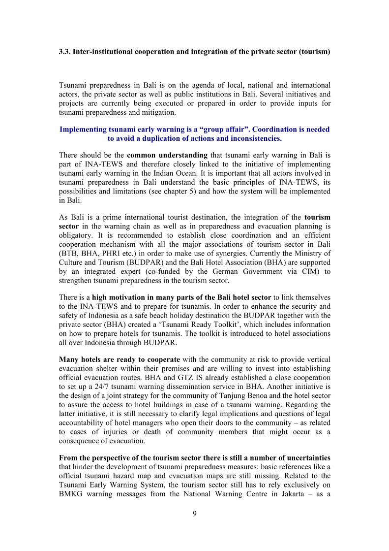
3.3. Inter-institutional cooperation and integration of the private sector (tourism)
Tsunami preparedness in Bali is on the agenda of local, national and international
actors, the private sector as well as public institutions in Bali. Several initiatives and
projects are currently being executed or prepared in order to provide inputs for
tsunami preparedness and mitigation.
Implementing tsunami early warning is a “group affair”. Coordination is needed
to avoid a duplication of actions and inconsistencies.
There should be the common understanding that tsunami early warning in Bali is
part of INA-TEWS and therefore closely linked to the initiative of implementing
tsunami early warning in the Indian Ocean. It is important that all actors involved in
tsunami preparedness in Bali understand the basic principles of INA-TEWS, its
possibilities and limitations (see chapter 5) and how the system will be implemented
in Bali.
As Bali is a prime international tourist destination, the integration of the tourism
sector in the warning chain as well as in preparedness and evacuation planning is
obligatory. It is recommended to establish close coordination and an efficient
cooperation mechanism with all the major associations of tourism sector in Bali
(BTB, BHA, PHRI etc.) in order to make use of synergies. Currently the Ministry of
Culture and Tourism (BUDPAR) and the Bali Hotel Association (BHA) are supported
by an integrated expert (co-funded by the German Government via CIM) to
strengthen tsunami preparedness in the tourism sector.
There is a high motivation in many parts of the Bali hotel sector to link themselves
to the INA-TEWS and to prepare for tsunamis. In order to enhance the security and
safety of Indonesia as a safe beach holiday destination the BUDPAR together with the
private sector (BHA) created a ‘Tsunami Ready Toolkit’, which includes information
on how to prepare hotels for tsunamis. The toolkit is introduced to hotel associations
all over Indonesia through BUDPAR.
Many hotels are ready to cooperate with the community at risk to provide vertical
evacuation shelter within their premises and are willing to invest into establishing
official evacuation routes. BHA and GTZ IS already established a close cooperation
to set up a 24/7 tsunami warning dissemination service in BHA. Another initiative is
the design of a joint strategy for the community of Tanjung Benoa and the hotel sector
to assure the access to hotel buildings in case of a tsunami warning. Regarding the
latter initiative, it is still necessary to clarify legal implications and questions of legal
accountability of hotel managers who open their doors to the community – as related
to cases of injuries or death of community members that might occur as a
consequence of evacuation.
From the perspective of the tourism sector there is still a number of uncertainties that hinder the development of tsunami preparedness measures: basic references like a
official tsunami hazard map and evacuation maps are still missing. Related to the
Tsunami Early Warning System, the tourism sector still has to rely exclusively on
BMKG warning messages from the National Warning Centre in Jakarta – as a

10
dissemination service for warning and guidance by Bali authorities has not been
implemented until present. The information by local and national authorities
regarding the readiness and reliability of sirens and other warning sources as well as
test runs (etc.) is perceived as suboptimal. Contradicting information and a lack of
credible, transparent official information sources leads to frustration of even the most
motivated players of the private sector. Therefore trust on the part of the private sector
regarding the capacity and reliability of national and local authorities to provide
timely early warning is still limited.
The hotel industry is prepared to play a role in the preparation of public evacuation
routes through (e.g.) the donation of signs. However, until present, despite several
initiatives it was not possible to achieve clarity on legal procedures for the installation
of signs in public space.
In summary, cooperation between the (private) tourism sector and the public sector in
Bali provides a huge potential for a win-win situation with regards to tsunami
preparedness. Such cooperation would yield benefits if it is built on mutual respect,
trust and understanding and implemented with a constructive and positive attitude
as well as an appropriate way of communication.
Important public transport facilities like Ngurah Rai Airport or Benoa Harbor also
need to be linked to the early warning chain. They require specific procedures and
should be involved in the development of overall tsunami preparedness planning in
Bali.
3.4. Community Preparedness
Survival during a tsunami will depend in many cases on people’s knowledge and how
quick people are able to assess the situation and take a decision to evacuate or not.
As Bali has to cope with local tsunamis and short warning times, strengthening
community preparedness should be one of the backbones of its preparedness
strategy.
Initiatives for community preparedness in Bali are on the agenda of governmental
institutions as well as PMI and other NGOs. These actors apply community
approaches like CBDRM (Community Based Disaster Risk Management), drills,
awareness campaigns, community workshops and participatory evacuation planning.
CBDRM activities need to be supported by official planning tools (e.g. hazard maps
and reference plans for evacuation) and clear policies regarding early warning
procedures. These tools and procedures often do not exist.
Participation of communities and their organisations, particularly those most
vulnerable, is crucial to a people-centred early warning system. They should be
actively involved in risk assessment, be aware of the hazards to which they are
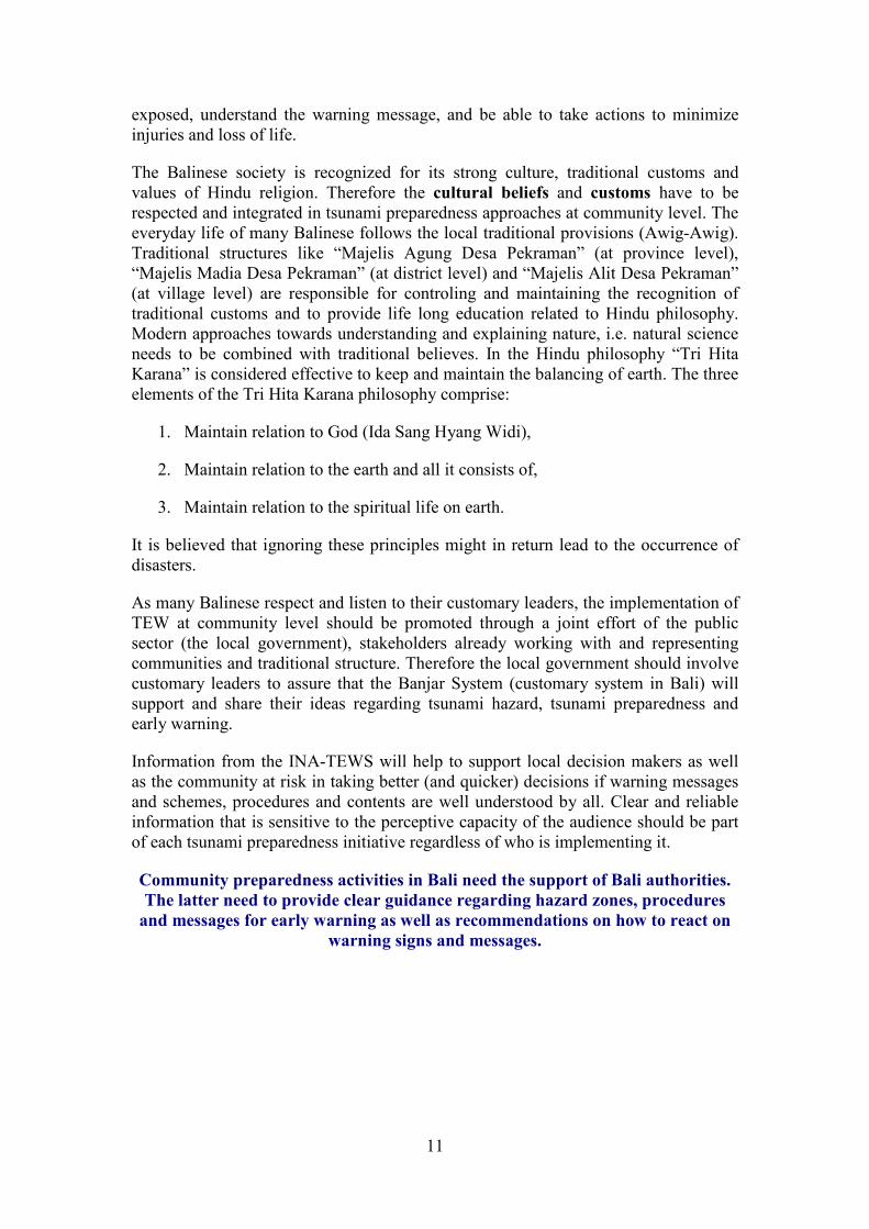
11
exposed, understand the warning message, and be able to take actions to minimize
injuries and loss of life.
The Balinese society is recognized for its strong culture, traditional customs and
values of Hindu religion. Therefore the cultural beliefs and customs have to be
respected and integrated in tsunami preparedness approaches at community level. The
everyday life of many Balinese follows the local traditional provisions (Awig-Awig).
Traditional structures like “Majelis Agung Desa Pekraman” (at province level),
“Majelis Madia Desa Pekraman” (at district level) and “Majelis Alit Desa Pekraman”
(at village level) are responsible for controling and maintaining the recognition of
traditional customs and to provide life long education related to Hindu philosophy.
Modern approaches towards understanding and explaining nature, i.e. natural science
needs to be combined with traditional believes. In the Hindu philosophy “Tri Hita
Karana” is considered effective to keep and maintain the balancing of earth. The three
elements of the Tri Hita Karana philosophy comprise:
1. Maintain relation to God (Ida Sang Hyang Widi),
2. Maintain relation to the earth and all it consists of,
3. Maintain relation to the spiritual life on earth.
It is believed that ignoring these principles might in return lead to the occurrence of
disasters.
As many Balinese respect and listen to their customary leaders, the implementation of
TEW at community level should be promoted through a joint effort of the public
sector (the local government), stakeholders already working with and representing
communities and traditional structure. Therefore the local government should involve
customary leaders to assure that the Banjar System (customary system in Bali) will
support and share their ideas regarding tsunami hazard, tsunami preparedness and
early warning.
Information from the INA-TEWS will help to support local decision makers as well
as the community at risk in taking better (and quicker) decisions if warning messages
and schemes, procedures and contents are well understood by all. Clear and reliable
information that is sensitive to the perceptive capacity of the audience should be part
of each tsunami preparedness initiative regardless of who is implementing it.
Community preparedness activities in Bali need the support of Bali authorities.
The latter need to provide clear guidance regarding hazard zones, procedures
and messages for early warning as well as recommendations on how to react on
warning signs and messages.

12
Figure 6: Tsunami preparedness poster explaining the early warning system (GTZ IS 2006).

13
4. Tsunami Hazard Maps: the Basis for Preparedness Planning
Bali needs to develop a clear framework for tsunami preparedness in order to assure
that activities implemented by different actors are aiming at the same overall strategy
and are not contradicting each other. Providing an official tsunami hazard map is
definitely a priority task to achieve this goal.
Several maps related to tsunami hazard, risk and evacuation planning are available for
Bali but none of them can be considered as an official one:
Map Institution Type Zoning
BAPPEDA Tsunami zoning map
with reference to Aceh
tsunami (max. 33 m run-
up)
Zoning according topography:
Tsunami Potential medium
(elevation 30-40m)
Tsunami Potential high (elevation
0-30m)
BPPT (2006) Tsunami “Run Up Map”
for scenario M 8.9
(developed for Tsunami
Drill 2006)
Zoning according flow depth:
Flow depth 0-0.1 m
Flow depth 0.1-1 m
Flow depth 1-2 m
Flow depth 2-3 m
Flow depth 3-5 m
Flow depth 5-8 m
Flow depth 8-15 m
Badan Geologi
CVGHM
(2007)
Tsunami Hazard Prone
Map based on worst case
scenario M 9, 300x50km
rupture south of Bali,
depth 10 km, reverse
fault
Zoning based on elevation and
inundation
Tsunami Prone Area: high
Elev. <10m / inund. max. 4.5 km
Tsunami Prone Area: moderate
Elev. 10-17m / inund.. ~7.8 km
Tsunami Prone Area: low
Elev. 17-25m / inund. ~ 8.3 km
DLR: Multi-
scenario (Draft
2008)
Hazard Map showing
affected areas by several
hundreds of different
scenarios with EQ-
magnitudes between 7.5
and 9
2 Zones related to BMKG
warning levels:
Impacted area if wave height at
coast 0.5-3 m (Warning Level 1)
Impacted area if wave height at
coast >3 m (Warning Level 2)
DKP (2005)
Evacuation Map based
on inundation prediction:
the map was built by
using 'same level
approximation',
topographic data based
on Global SRTM and the
inundation height was
Zoning according inundation
prediction:
Inundation height 1m
Inundation height 2m
Inundation height 3m
Inundation height 4m
Inundation height 5m

14
modeled by the 1977
Sumba Tsunami
(tsunami wave height in
the coastline as the result
of the model was 5.2
meter)
Table 1: Bali Tsunami Hazard Maps, compiled by GTZ IS, 05-08-2008
In order to revise all existing mapping approaches and explore the current knowledge
about tsunami sources and impacts for Bali a Consultation-Workshop for Tsunami
Hazard Mapping in Bali was organized by PEMPROV with support from GTZ IS.
During the workshop, held on 7-8 July 2008 in Denpasar, participants from national
and international science institutions as well as local stakeholders gathered to achieve
a better understanding about tsunami hazard and the possible impacts for Bali.
During the workshop the science group recommended to develop a multi-scenario
map that includes all scenarios that have been calculated by the different institutions.
This recommendation was based on the fact that current scientific knowledge does not
allow for identifying one specific scenario as the most probable one. A multi-scenario
approach combines the impact of a big number of calculated tsunami scenarios
(generated by numeric modelling) in one map.
It was agreed that the German Aerospace Centre (DLR) should integrate the already
calculated GITEWS scenarios (calculated by AWI – Alfred Wegener Institute) and
the existing scenarios from Indonesian partner institutions into a Multi-scenario
Tsunami Hazard Map for Southern Bali. An updated version was presented during
the International Conference for Tsunami Warning in Bali in November 2008 and a
second map, excluding the less probable scenarios (i.e. > M9 SR), was handed over in
February 2009.
In March 2009 a Technical Document describing the process and technical
background of the Tsunami Hazard Map was written.
Figure 7: Multi-scenario Tsunami Hazard Map for Southern Bali including (left) and excluding (right)
Magnitude 9 SR scenarios (by DLR).
A working group with representatives from KESBANGLINMAS, BAPPEDA (Local
Planning Agency), PU (Public Works Department), BMKG and Uyadana University

15
was formed to steer and accompany the mapping process. The working group will
present a consolidated map and a technical report to the Balinese authorities for
further consideration and official recognition.

16
5. INA-TEWS: A System under Development – Roles and
Responsibilities – the Current and Future Warning Scheme
After the devastating tsunami of 26 December 2004, the affected Indian Ocean
countries decided to build up a regional Indian Ocean Tsunami Early Warning
System. The Indonesian Tsunami Early Warning System is a crucial part of the
regional system since the subduction zones offshore the Indonesian islands are a
major (potential) source for ocean wide tsunamis in the Indian Ocean.
Figure 8: INA-TEWS concept of an “end-to-end” Tsunami Early Warning System
In the last years, substantial progress has been made in setting up INA-TEWS. The
system was officially inaugurated in November 2008. A two-year testing phase is
currently running. At present INA-TEWS has the means to provide credible data and
issue tsunami warnings and hereby inform the general public in advance of a potential
tsunami impact. INA-TEWS is an “end-to-end” early warning system. This means
that the system only works if all components are functioning.
The different components of the system are (see figure above):
1) Observation of earthquake data from seismographs;
2) Observation of ocean (and land, GPS) data from tsunami detection
technology;
3) Generation of tsunami warnings and related messages and information
4) Dissemination of warnings and other tsunami information to public,
interface institutions and local authorities;
5) Community preparedness that allows for appropriate reaction by the
community at risk in case of warning.

17
5-10
min
Current Warning Scheme
Earthquake data
and tsunami warning(tsunami potential or not)
Cancellation or all Clear1-10
hrs
Observation:
Natural warning signs/
Arrival of first wave
30-60
EQEQ
Tsunami warning:
1. Advisory (0-0.5m)
2. Warning (0.5-3m)
3. Major Warning (>3m)(earthquake data and DSS)
Cancellation or All Clear
2-10
1-10
10-30 Tsunami confirmation
or cancellation(pressure sensors, GPS buoys)
Tsunami Information(tide gauges)
30-60
Future Warning Scheme
In the moment (March 2009) INA-TEWS is still a system under construction. While
seismographs already provide earthquake data, not yet all ocean observation
instruments and data processing technology in the National Warning Centre is
operational. The technological components for tsunami detection and data processing
that still need to be completed are:
� The tsunami detection and monitoring technology that consists of a network of
ocean floor pressure sensors, buoys, and tide gauges at the coast. These
instruments enable the warning system to detect tsunami waves. GPS units on
land provide additional data to assess the potential for a tsunami occurrence.
� The tsunami database that contains thousands of tsunami simulations with varying
earthquake parameters and the Decision Support System (DSS)1. Both
components will be used by BMKG to facilitate the processing of incoming data
from seismographs and ocean observation technology and support decision-
making in the National Warning Centre.
Until all components are fully operational (scheduled for the second half of 2009)
INA-TEWS operates on a temporary warning scheme that is based exclusively on
earthquake data gathered from seismographs. The following figure shows the current
and future warning scheme and the information that is already available now and will
be available in the future:
Figure 9: Current and future warning scheme of INA-TEWS
1 The DSS – a computer system – is one of the core contributions of the German-Indonesian
Cooperation for a Tsunami Early Warning System (GITEWS) to INA-TEWS. It combines the results
from different sources (above described sensor and monitoring technology) and assesses the tsunami
threat by comparing the information with pre-calculated tsunami modeling and risk analysis results for
coastal areas. The DSS will provide an estimation of a potential tsunami occurrence, including affected
areas, wave arrival time and wave height at the coast.

18
5.1 Division of roles and responsibilities within INA-TEWS
Within INA-TEWS there is a clear division of tasks (see below figure):
1. The central source of earthquake information and tsunami warnings is BMKG
where the National Tsunami Warning Centre is located. BMKG monitors
earthquake data and issues tsunami warnings to the general public via national
media, to interface institutions and local government authorities.
2. Upon reception of a tsunami warning, local government authorities (at
provincial/ district/ city level) are in charge of reacting to the warning. They are
responsible for making a decision whether an evacuation is necessary or not, and
if so what the extent of evacuation should be. This decision has to be translated
into guidance for evacuation and disseminated to the people at risk as quickly
and directly as possible.
Figure 10: Information and warning chain from national to community level
As stated above, BMKG Jakarta currently distributes the warning of a potential
tsunami to the national media. 11 TV stations and one radio station (Radio Republik
Indonesia – RRI) receive earthquake information and the warning of a potential
tsunami. The TV stations directly broadcast the tsunami warning during their
programme. The warning message that comes via TV and radio, however, does only
state that there is a potential tsunami threat for a certain (very broad) region but does
NOT include any recommendation or guidance for reaction by the people at risk, i.e.
whether to evacuate or not. This guidance for reaction has to come from local
authorities since they are legally in charge of safety of their communities.

19
5.2 Current and future decision making reference for local
authorities
The current warning scheme compared to the anticipated future scheme provides
limited reference for local decision makers. Until the second half of 2009 the standard
warning message of the current warning scheme that can be received by provincial
and/ or district/ city governments connected to BMKG via SMS and other channels
reads as follows2:
Info Gempa (earthquake information) Mag: 7.9 SR, 12-Sept-2007,
18:10:23 WIB (Western Indonesian Time), Lok (location): 4.67 LS -
101.13 BT (159 km barat daya Bengkulu / 159 km southwest of
Bengkulu), Kedlmn (depth): 10 km, Potensi TSUNAMI utk dtrskn pd
msyrkt (potential for tsunami occurrence, to be forwarded to the public):
BMKG
The first part of the message contains earthquake information (i.e. magnitude, date
and time of earthquake occurrence, location of epicentre and distance from reference
location, and depth). These earthquake parameters are followed by the second element
of the message: Potensi TSUNAMI. The two elements: earthquake parameters and
information about tsunami potential combined constitute the tsunami warning
message format that is currently applied by BMKG.
In fact, the term potensi tsunami only indicates that the earthquake due to the given
parameters has the potential to cause a tsunami. The actual occurrence of a tsunami
cannot be determined from earthquake data. However, due to the short travel time of a
local tsunami and the limited time for reaction the information about a tsunami
potential has to be considered as the basis for decision making and guidance.
In the current warning scheme, the next information would come from coastal
observation. The occurrence of a tsunami would be confirmed by natural warning
signs and/ or the arrival of the first tsunami wave at the shoreline.
The future warning scheme – supported by additional monitoring and sensor
technology as well as a tsunami database linked to the DSS – will produce more
detailed information. The first warning message providing earthquake information
and the warning of a (still) potential tsunami will be broken down into three warning
levels, depending on earthquake parameters and database matching:
Advisory � expected tsunami wave height at coast 0 - 0.5 m
Warning � expected tsunami wave height at coast 0.5 - 3 m
Major Warning � expected tsunami wave height at coast > 3 m
Additionally, this first message will provide information about potentially affected
areas (districts) and estimated time of arrival of the first wave. Since the first warning
2 The example is taken from the earthquake in West Sumatra Province (known as the Bengkulu-
Earthquake, 2007) that actually triggered a minor tsunami in the area of Bengkulu (according to
BMKG and DKP, Department for Marine Affairs and Fisheries, measurements).

20
most probably will be – similar to the current scheme – based on earthquake data it
will only indicate that the earthquake has the potential to trigger a tsunami.
In the future warning scheme, BMKG will be able to confirm the first warning after
tsunami waves have been detected by the network of buoys, ocean floor pressure
sensors and tide gauges. According to estimations today, this information will be
available approximately 10-30 minutes after earthquake occurrence – though the
actual time can vary. The final confirmation message will be issued once the tsunami
has reached the coast and has been detected by tide gauges or visually observed.

21
6. Recommendations for the implementation and operation of
tsunami early warning in Bali
The end-to-end Indonesian Tsunami Early Warning System can only be called a
“system” once the National Warning Centre is connected with the communities at
risk. The objective of this document is to provide technical advice on how to establish
this link and how to build the capacities in Bali so that local authorities as well as the
people can fulfil its role in tsunami early warning and reaction to warnings.
In order to achieve this goal, certain political, institutional and technical requirements
have to be met. This section of the document suggests answers to six key questions
referring to these requirements (compare list and figure below) and hereby provides a
comprehensive concept for the implementation of TEW in Bali:
I. What are the principals of a TEW policy for Bali?
II. What are the institutional requirements for TEW in Bali?
III. What is required to receive warnings from the National Tsunami Warning Centre?
IV. What is required to decide whether communities should evacuate or not?
V. What is required to disseminate warning and evacuation guidance to the
communities?
VI. What is required to strengthen people’s awareness and understanding about INA-
TEWS?

22
Figure 11: Roles and responsibilities and communication channels of the TEW chain
6.1 Principals of a TEW Policy for Bali
Implementing and operating Tsunami Early Warning is a “group affair”. It involves
institutions at national and local level. INA-TEWS can reduce the negative effects of
a tsunami disaster substantially. This is only possible if it can rely on proper analysis
and an effective communication chain as well as authorities and communities at the
other end who can translate the warning effectively into action.
Consequently, the success of early warning will be judged by the quality of public
reaction to the warning. Local actors play a very prominent role to achieve this goal.
Generating Awareness and knowledge about tsunami hazard and its potential impacts,
being capable of receiving warnings from national institutions, giving guidance and
instructions to local population and preparing people for disasters are among the
genuine responsibilities of local governments and other local stakeholders.
In order to connect to INA-TEWS, Bali needs to define its own policies. These
policies should refer to national policies regarding Tsunami Early Warning that have
been agreed already.
Nationwide, BMKG is the official source for tsunami information and warnings.
BMKG has introduced the policy to send out earthquake information to the public,
interface institutions and local authorities as quickly as possible after receiving
earthquake data from seismographs. The time frame set for disseminating this

23
information is about 5 to 7 minutes. Local governments recognizing BMKG’s policy
can use it as a reference for setting up the local warning chain – knowing they can
expect information from BMKG within a few minutes after an earthquake.
For Bali, the following key issues need to be addressed:
� Strengthening tsunami preparedness and designing early warning
procedures requires a coordinated approach and policy by the districts and
the province
It needs to be clarified who is in charge of providing guidance for evacuation in
case of a tsunami warning from BMKG. This requires an agreement on who will
make the decision, how this decision is made and what is the reference for it
(preferably an SOP). Special attention needs to be given to the management and
operation of the BMKG sirens as one of the main dissemination devices. The
BMKG siren towers are located in the District of Badung and the City of
Denpasar (Sanur). The control over the sirens will be handed over to the province
authorities.
� Decision on evacuation (by authorities) has to be taken (latest) after receiving the
first warning from BMKG (on a potential tsunami)
A tsunami preparedness strategy for local tsunami hazard needs to recognize the
limited time for reaction – and therefore use the fastest information available.
Ground shaking (if felt) is the first warning. People should start moving away
from the beach and rivers. The next warning will come from BMKG, providing
earthquake data and the information on whether the earthquake has the potential
to cause a tsunami or not. Although this first BMKG warning does not provide
certainty whether a tsunami is on the way or not, it is – most probably – the last
timely information local authorities in Bali can get about the possibility of an
imminent tsunami threat. Waiting for confirmation through natural warning
signs, i.e. such as seawater withdrawal is not an option. The time for evacuation
not be sufficient.
Whether INA-TEWS will be able to deliver a timely message in the future that
confirms a tsunami event has yet to be proven once the future system has been
fully implemented and is operational. Currently, the timing for a confirmation
message is estimated at up to 30 minutes after an earthquake.
� Decision making for reaction to a potential tsunami threat should be based
on Standard Operating Procedures (SOP)
Due to time constrains in regards to the local tsunami threat quick and reliable
decision making procedures are required. Standard Operation Procedures (SOP)
should guide local authorities or staff of 24/7 Operation Centres in the decision
making process. Introducing SOPs will not only allow for delegation of decision-
making to staff of 24/7 Operation Centres but also enable individual (but
coordinated) decision-making by individuals or institutions in case of
communication breakdown. Such SOPs need to be authorized by the local
government.

24
SOPs for decision-making during a local tsunami threat will have to take into
account natural warning signs (ground shaking) and warnings from BMKG. In
the moment of an imminent threat of a local tsunami it is most unlikely that any
other source can provide additional information that support decision-making.
Besides that, standard procedures should be also developed for warning reception
and dissemination of warning and evacuation guidance.
� The future warning scheme from BMKG will alter the possibilities of Bali to
react to a tsunami warning. Bali should consider a two-level evacuation
strategy, as the impacted area at Warning Level 1 will be confined to a
narrow coastal strip. Only Warning Level 2 requires full-scale evacuation.
The future BMKG warning scheme will provide one advisory and two warning
levels. This enables Balinese authorities to make a differentiated decision
depending on the estimated tsunami threat (as indicated by the respective
warning level).
Results from inundation modelling can be used to visualize the impacted areas in
relation to the different warning levels. The DLR multi-scenario Map has
developed a zoning according to the two warning levels. The red zone represents
the affected area at Warning Level 1, which is defined by wave heights at the
coast < 3 m. The yellow zones might get affected by a tsunami with wave heights
at the coast > 3 m (Warning Level 2).
As the impacted areas of Warning Level 1 (red zone in the map below) and
Warning Level 2 (orange and yellow zones) differ considerably it makes sense to
consider a differentiated approach.
This means: when receiving a BMKG warning for a minor tsunami threat
(Warning level 1: Peringatan) there is no need for a large-scale evacuation. An
evacuation of the red zone would be sufficient.
Figure 12: DRAFT of Multi-scenario Hazard Map with zoning according to BMKG warning levels
(DLR 2009)
Area affected at Warning Level 1 wave height at coast 0.5 – 3m
Area affected at Warning Level 2 wave height at coast > 3m

25
A differentiated, two level approach for evacuation, poses a challenge on
community preparedness. However, it also offers opportunities to reduce the
frequency of full-scale evacuation and its implications, i.e. panic, accidents, loss
of assets during the evacuation process and communities’ distrust in the warning
system and its political implications.
� Link between warning levels, hazard zoning and evacuation strategy
The recently developed maps which relate tsunami inundation areas to warning
levels will allow for a consistent link between hazard zones, warning levels and
evacuation strategies.
� Documentation of policies and strategies as basis for implementation
In order to implement Tsunami Early Warning in Bali it is recommended to
document the overall policy, its principles and strategies in official documents:
� Official Tsunami Hazard Map
� General policies for tsunami preparedness and early warning
� Standard Operating Procedures for Tsunami Early Warning
� Evacuation plan at district level
� Official evacuation map at district level
� Integrate the tourism sector into the tsunami early warning system
The tourism sector should be involved as a strategic partner, due to its
importance for the local economy, potentials in terms of infrastructure and
human resources as well as the specific needs of foreign visitors who are not
familiar with local conditions.

26
6.2 Institutional Requirements: 24/7 Unit
Since an earthquake that causes a tsunami can happen at any time it is crucial that
local early warning centres are operational at any time too. An institution that is vital
for tsunami early warning is a 24/7 unit that operates around the clock – 24 hours a
day and 7 days a week. This unit allows receiving warnings and issuing guidance to
the people at risk at any time.
Province authorities, with support from the French Red Cross (FRC), are currently
setting up a Multi-Hazard Emergency Operation Centre (EOC) in Denpasar. It was
agreed that this EOC will also host the 24/7 service for Tsunami Early Warning.
The completion of the building construction of this EOC is scheduled for April 2009
while equipment should be installed gradually between July and September 2009.
At present, Bali cannot count on a reliable 24/7 service for Tsunami Early Warning.
Although it was agreed to establish a temporary 24/7 service at KESBANGLINMAS
at province level and in the District of Badung, both services are not operational.
It is strongly recommended to assure a temporary service operated by the Province
Government until the questions related to the division of roles and responsibilities
between province and districts regarding warning services and its relation with the
new Disaster Management Agency (BPBD) are answered.
Experience suggests that the installation of a highly professional 24/7 service within
the PUSDALOPS of the province that can serve all Balinese districts would be
more reliable and economically feasible instead of implementing 24/7 services in each
of the eight Balinese districts with tsunami prone coastlines. This recommendation
takes into account the specific requirements of the INA-TEWS (short warning time
and quick decision making). For other natural hazards this policy might not apply.
In general any 24/7 unit for TEW in Bali requires:
� An office or post that operates 24 hours a day and 7 days per week,
including the usual office equipment;
� One Officer on Duty and two other 24/7 officers per shift who will be
involved in operations in case of emergency. The Officer on Duty and all
other personnel need to be trained on SOPs for decision-making,
dissemination, operating communication equipment etc;
� Provision of a clear mandate to the 24/7 unit stating that the Officer on Duty
is the person in charge of decision-making for reaction (based on agreed
SOP) upon reception of tsunami warnings;
� Operations Manual containing all procedures and relevant information for
the 24/7 unit;
� Communication technology for reception and dissemination of warnings and
guidance;
27
� Power back up for the case of power black out during a strong earthquake.
(The EOC built with support from the FRC) will include power back-up, i.e.
UPS and Generator Set.
What needs to be done?
It is suggested to continue the definition of the institutional set-up for Tsunami Early
Warning in Bali and in the meantime implement a temporary warning service as soon
as possible.
As by March 2009, a first draft of an EOC guideline for Bali has been finalized by
KESBANGLINMAS with the support of GTZ, FRC, PMI and IDEP Foundation. This
document will be presented to the Governor of Bali in April and will hopefully be
validated through a decree. It will then become a basis for various operational
procedures that are currently being draft (TEWS, response coordination and
command, information sharing, communication mechanisms etc.)
Meanwhile, KESBANGLINMAS is upgrading its EOC team with the recruitment of
new operators. FRC plans to conduct a Human Resource Diagnostic of the new team
in April and to start implementing basic, practical trainings on IT, reporting, data
compiling etc.
6.3 Receiving information and warnings from BMKG
In order to be able to warn the people at risk in Bali, local 24/7 units for Tsunami
Early Warning need to be capable of receiving information from BMKG through
various channels.
For receiving warnings and information from BMKG a local 24/7 unit requires:
� Communication technology to receive information and warnings from
BMKG;
� Standard Operating Procedures for warning reception;
� Personnel trained in operating and maintaining the communication
equipment.
Strong earthquakes can cause power black out and other disturbance that might effect
communication equipment. One principle of warning systems is redundancy in the
means of communication. In order to effectively operate a 24/7 unit all below
communication equipment has to be available to make sure that if one communication
channel fails a warning can still be received through another channel.
Receiving warnings from BMKG requires the following communication devices:

28
Communication device Remarks
� RANET (will be substituted) [available from BMKG]
� Mobile phone for SMS reception [registration with BMKG required]
� Phone (landline) [more than one line required]
� FM RDS (includes radio FM) [service not yet operational]
� Computer with internet connection [ – ]
� [multiband] VHF radio [ – ]
� FAX [registration with BMKG required]
� TV [ – ]
� Power back up (UPS, generator) [ – ]
The EOC provided by FRC will include multimodal communication devices (internet,
phone, fax, satellite phone and radio) and is designed to be operational on a 24/7
basis. There is a need for coordination with BMKG to make sure that the server and
antenna required for certain devices is provided.
What needs to be done?
To provide the 24/7 unit with equipment the following steps have to be taken:
� Revise the assessment of the existing communication devices – what is
already in place?
� Provision of funds for procurement of missing communication equipment;
� Provision of budget for maintenance of communication equipment;
� Appointing a skilled person in charge of technical equipment;
� Training the personnel of the 24/7 unit in operating and maintaining the
communication devices.

29
RANET FM-RDS Telephone
Fax Internet VHF radio
6.4 Decision Making by Standard Operating Procedures (SOP)
As stated in the principle policies (chapter 6.1) it is strongly recommended that the
decision whether to evacuate or not is based on Standard Operating Procedures
(SOP).
For the current warning scheme (valid until approximately mid-2009) the following
temporary Standard Operating Procedure for decision-making can be applied:

30
Figure 13: Standard Operating Procedure (SOP) for decision making in current warning scheme
Since the first warning message in the current warning scheme does not provide any
information on potentially affected areas the decision maker in the local 24/7 unit
requires an additional data analysis and decision making tool. In order to
determine whether an earthquake with a potential for tsunami poses a threat on the
coastline of Bali simple reference maps can be used. These maps allow for checking
whether an earthquake epicentre is located in an area from which tsunami waves
would still affect the coast of Bali. The areas in which earthquakes with a tsunami
threat for Bali are located have been labeled “zona bahaya”. As the size of this area
varies with earthquake magnitudes, maps for four different ranges of magnitudes (6.5-
7.5 / 7.6-8.0 / 8.1-8.5 / 8.6-9.0) have been designed to allow a quick location search.
These maps have been developed by AWI in July 2008 and are based on the results of
a big number of pre-calculated scenarios (see next page).

31
Figure 14: Reference Maps to locate earthquake epicentre and estimate whether tsunami waves would affect the coast of Bali (based on AWI modelling results, 2008)

32
For the future warning scheme starting mid-2009 the following Standard Operating
Procedure for decision-making can be applied:
Figure 15: Standard Operating Procedure (SOP) for decision making in future warning scheme
(preliminary version)
The first warning message in the future warning scheme will already provide
information on potentially affected areas and warning levels (see 5.2: current and
future decision making reference for local authorities). The SOP above already
considers the two-level approach for evacuation (partial and full scale; see 6.1: Principals of
a TEW Policy for Bali).
What needs to be done?
In order to implement standard decision-making the following aspects require official
and written approval by local authorities:
� The standard procedure for decision-making needs to be approved by
local authorities and understood by all stakeholders in Bali. This has to
be done long before the case of emergency. In case of emergency, the 24/7
unit analyses the incoming data from BMKG and uses the procedures to
make a decision that is in line with previous agreements.
� It is also recommended to provide the mandate for decision-making upon
reception of a warning to the 24/7 unit. An Officer on Duty should be
authorized for autonomous decision-making based on the agreed
reference (SOP).

33
6.5 Dissemination of warning and guidance to the communities at risk
In order for a 24/7 unit to be able to disseminate warning and guidance messages to
the community at risk the following components are required:
� Standard Operating Procedures for dissemination of warning and guidance
messages;
� Communication technologies and networks for dissemination;
� Set of standard warning and guidance messages.
Standard communication and dissemination procedures will help officers at a
24/7 unit to effectively disseminate warning and guidance messages to all relevant
local institutions (e.g. Police, Military and SAR) and the community at risk.
These SOPs should be developed and regularly updated by the 24/7 unit in
accordance to the communication networks and technologies used for dissemination
of early warning in Bali.
The 24/7 unit should be equipped with all necessary communication devices which
are necessary to (1) activate warning devices like sirens, (2) communicate with other
emergency response agencies and decision makers and (3) disseminate warning and
guidance messages to the community at risk:
The following devices for communication and dissemination are required in the 24/7
unit:
Device Purpose Status Comment
Trigger for sirens Activate siren system To be
clarified with
BMKG
Need personnel for continuous
maintenance
HF/VHF/UHF and
SSB Radio
Communication between the
24/7 unit and all emergency units
(SATLAK & SATKORLAK)
Available?
RANET 5in1 Distribution of information from
BMKG using SMS etc.
Not yet fully
operational
Telephony system
(VoIP, PSTN, GSM
and Satellite)
Dissemination FRC,
ongoing
project
The telephone network in
PUSDALOPS comprises four
technologies, which backup one another
if one channel fails to work.
Phone (landline) Communication between 24/7
unit and authorized institution
Available More than one line required
HP Communication between
authorized personnel
It is proposed that VIPs hold a special
number which is also registered in the
phone provider in order to be able to

34
receive prompt alert
Internet (terrestrial and
satellite)
Global information
dissemination and
communication
FRC,
ongoing
project
It is important for PUSDALOPS to
have redundant system of internet
connection since internet is crucial the
information system
Portable multimode
communicator
Communication and
dissemination from the field to
PUSDALOPS and authorized
personnel
FRC,
ongoing
project
This smart portable system enables the
authorized person to send report,
warning, needs and even command in
critical situation
EOC are planned to be equipped with ten landline connections, including two for fax
and eight for voice.
Warning and guidance messages from a local 24/7 unit for Tsunami Early Warning
can reach the people at risk in Bali through different channels and networks:
� Public announcements through sirens and loudspeakers. Due to short
warning times a direct communication link to communities at risk is vital
and has to be prioritized. For this purpose sirens and loudspeakers shall be
used that will be operated directly from the local 24/7 unit. Announcements
by the local warning centre should be heard directly.
� Furthermore warning and guidance messages should simultaneously be
announced through local public FM radio and community radios. It is
recommended to identify local radio station(s) that will be used for
broadcasting information in emergency situations. Agreements and reliable
links between the 24/7 unit and the respective radio station should be
established. The general public should be aware of which radio station or
frequency they should tune in to in case of emergency. The selected radio
station(s) should be on air 24/7 and equipped with a reliable power back up
system in case of power black out.
� Bali was a Pilot Area for the testing of FM-RDS technology for TEW
purposes. Around 30 receivers have been distributed to public and private
institutions. Warnings will be sent out by BMKG in Jakarta. In principle it is
also possible to trigger the FM-RDS radio devices from the province level
and disseminate guidance information via the integrated text display screen.
� Dissemination of warning and guidance by community networks and
organisations. For those areas that are not covered by loudspeakers and
sirens local organisations and networks should be used (e.g. RAPI, ORARI).
� Additionally, warning and guidance messages can be disseminated by using
traditional communication means or religious infrastructure (e.g. kulkul)
at Banjar level.
� PMI maintains a network of CBAT (Community-Based Action Teams) at
village level who could be an effective relay for the warning at community
level. This would require that CBAT members are provided with basic
communication tools (i.e. radio handsets) and that the PMI “POSKO” which

35
is active on a 24/7 basis (at province and district level) receives messages
directly from the EOC.
Clear messages containing simple, useful information are critical to enable proper
reaction to warnings will help to safeguard lives and livelihoods. Therefore the
development of standard warning and guidance messages is required. It has to be
assured that warning and instruction messages from the different levels and
institutions are consistent in content and time. The content and meaning of those
messages need to be introduced to the communities at risk (awareness campaign) and
trained beforehand (drill).
Clearly defined siren sounds are known as appropriate means for early warning.
Within INA-TEWS a standard national sound scheme has not been officially
approved yet. A national standard, however, is crucial for consistent application of
sirens all over the country.
Tsunami Early Warning requires the following set of standard warning and guidance
messages:
Type of message When to disseminate?
Warning and Evacuation Guidance:
� Move away from Beaches and Rivers!
� Partial Evacuation
� Full Scale Evacuation
� Potential for minor tsunami
� Potential for medium tsunami
� Potential for major tsunami
EQ Information EQ felt but no tsunami threat
Cancellation No tsunami generated by EQ
Confirmation Tsunami occurrence confirmed
All Clear Tsunami event over
Note: Immediate reaction upon ground shaking – i.e. moving away from beach and
rivers – should not need an official announcement but should be an individual
standard reaction by people in Bali when being close to the coast or rivers.
What needs to be done?
In order to support the mechanisms for disseminating warning and guidance the
following aspects have to be considered:
� Development of Standard Procedures for dissemination;
Content and wording of clear warning and guidance messages
for Bali needs to be determined!

36
� Agreement on who triggers the sirens (Province/ BMKG?), definition of
standard siren sounds and their meaning;
� Assessment of existing communication devices for dissemination in the 24/7
unit;
� Provision of additional funds for communication devices in the local 24/7
warning centre (as required);
� Agreement on official local radio FM frequency (radio channel) for tsunami
warnings and guidance that people can tune in to in case of emergency;
� Assessment of coverage by sirens and other means of dissemination,
including communication networks such as RAPI/ ORARI;
� Provision of funds for dissemination equipment in the communities, i.e.
loudspeakers and sirens (as required);
� Development, official approval and introduction of content, wording and
meaning of standard warning and guidance messages.

37
6.6 Strengthening people’s awareness and understanding about INA-TEWS
Timely and effective community reaction will be achieved when people respect and
trust the warning service and understand the tsunami risk. Therefore the public
perception of tsunami risk and warning services has to be understood and strategies
need to be developed by the local government to build confidence towards warning
and guidance services. This includes the assignment of a credible source authorized to
generate and distribute warning and guidance, minimize false alarms, and
communicate the progress to set up the warning system.
In its effort to strengthen community awareness and understanding of INA-TEWS,
Bali can draw from the strength and experience of its civil society organizations,
including PMI.
Special attention should be drawn to the tourism sector, which needs to develop a
strategy to inform national and international visitors about basic facts and procedures.
Basis for this strategy is, however, a functioning official Tsunami Early Warning
System with reliable and credible early warning dissemination channels as well as
official references (hazard, risk and evacuation maps). Currently BUDPAR is
conducting ‘Tsunami Ready’ workshops throughout Indonesia to encourage hotels to
prepare for tsunamis on the basis of its ‘Tsunami Ready Toolbox’. The creation of a
common standard for evacuation route signs to be used within private hotel grounds
was a success. The signs resemble the official Indonesian tsunami evacuation signs to
avoid confusion when crossing from public into private hotel space. The signs are
already used by BHA Member Hotels. Other hotels are encouraged by BUDPAR to
use the same design for their own evacuation routes.
What needs to be done?
� Information of the general public about source(s) for Tsunami Early
Warning in Bali and how warning and guidance messages will be
disseminated;
� Development of a special program to equip highly vulnerable institutions
and public facilities (schools, hospitals, markets, public transport facilities
etc.) in the risk areas with communication devices which will allow the
direct reception and dissemination of warning and guidance messages from
the local 24/7 unit;
� A public information campaign (once official standard messages have been
developed and tested) to assure that people in the risk areas understand the
different types of warning messages and know what kind of information
they can expect from the local authorities in case of an emergency.
� Awareness campaigns and drills that are run on a regular basis to familiarize
people in risk areas with evacuation procedures and strengthen basic
knowledge regarding risk zones and safe areas.
� Community preparedness activities by NGO or other initiatives in Bali that
are supported with the provision of official information and guidance from

38
Balinese authorities regarding hazard and risk zones, evacuation, procedures
and messages for early warning as well as recommendations how to react on
warning signs and messages.
� Cooperation with the private sector, especially within the tourism industry as
essential activity to include visitors and tourists

39
7. References
7.1 Information regarding GTZ IS’ Cooperation for Tsunami Early Warning in
Bali
Cooperation partners are the governments of the District of Badung and the Province
of Bali. The Balinese branch of the Indonesian Hotel Association (PHRI) and the Bali
Hotel Association (BHA) are private sector cooperation partners. The project further
cooperates with local branches of BMKG, RRI, PPLH and PMI. Relations were also
initiated with representatives of traditional religious and adat groups to include the
Balinese traditional perspective on natural disasters and preparedness. The provincial
government of Bali provides facilities for the local project office in Denpasar.
Objectives and modes of cooperation are documented in agreements and work plans.
Project activities in Bali started in November 2006 with an information event about
FM-RDS and the introduction and testing of this technology on behalf of BMBF
(German Ministry of Education and Research) and RISTEK (Indonesian Ministry for
Research and Technology). Assessment workshops were held at district (April 2007)
and province level (May 2007) to obtain a common understanding of basic concepts
of Tsunami Early Warning and to assess what is already in place and thereby define
the working strategy.
SOP development was the initial focus at province level. Representatives from
PEMPROV participated in a series of SOP workshops and continued as in the form of
a working group. Open questions related to the Tsunami Early Warning chain were
addressed in several inter-institutional meetings organized by BMKG and PEMPROV
with support from GTZ IS. In February 2008 a meeting between representatives from
province and several district governments led to an agreement on the division of
responsibilities between the two levels.
As a result of the presentation of GITEWS tsunami inundation scenarios to the Bali
Governor in January 2008, the development of an official tsunami hazard map was
prioritized. In July 2008 Indonesian and German scientists analyzed existing hazard
maps for Bali and agreed on recommendations regarding methodology and type of an
official tsunami hazard map. DLR provided an updated version of its Multi-scenario
Tsunami Hazard Map for Southern Bali at the end of 2008, incorporating data of
other organizations. DLR and GTZ IS drafted a technical document in close
cooperation with the Balinese Working Group for Tsunami Hazard Mapping in
March 2009.
Additionally, the project provides advisory to SATKORLAK members regarding the
development of the legal framework (PERDA, RENSTRA) and budgeting for disaster
management. Mid 2008, KESBANGLINMAS created an own division (UPT) for
early warning and is now preparing staff to operate 24/7 services.

40
The main focus in the District of Badung was the implementation of a 24/7 Tsunami
Early Warning service within the SATLAK structure. After an initial assessment of
existing communication facilities and procedures, the project conducted a series of
training workshops to develop SOPs and to prepare a group of government officials
to operate the local warning centre. The concept of 24/7 operations and the SOPs
were discussed with local decision makers and are documented in an Operations
Manual. Another project initiative is related to evacuation planning in Kuta. Shelter
buildings and locations in Kuta had been identified based on DLR research regarding
population distribution and spatial accessibility. The study provides valuable inputs
for the development of a future evacuation strategy. GTZ IS is currently
accompanying and advising a local working group to develop the evacuation plan for
Kuta.
The project contributes to strengthening knowledge and awareness about tsunami
hazard and TEW by facilitating or supporting training workshops and information
meetings for representatives from local government institutions, coastal villages,
NGOs, women groups, SAR and the education sector. Meetings with representatives
from villages were held to inform about tsunami preparedness and promote the link
between villages and INA-TEWS. In cooperation with the province government the
project organized a seminar on Hindu Religion, Balinese Custom and Cultural
Perspectives on Tsunami Early Warning in September 2007.
Cooperation with the tourism sector addressed questions on how to access and
interpret tsunami early warning. In several occasions hotel managers were updated on
the implementation process of INA-TEWS. In cooperation between the Indonesian
Ministry of Culture and Tourism and BHA a “Tsunami Ready Tool Kit” for the
tourism sector has been developed – supported by a German CIM expert. GTZ IS
supported this initiative through advice and the joint development of fact sheets. Currently the focus shifts to the relation between hotels and neighbouring
communities due to the fact that hotel facilities will play an important role during
evacuation in highly populated areas in southern Bali. Evacuation procedures for
Tanjung Benoa have been agreed upon between the community and the hotel sector
recently.
41
7.2 Reference Documents:
� Grand Scenario INA-TEWS
� Decree No. 21/ix/2006 of the Coordinating Minister for People’s Welfare in the
capacity of Executive Director for National Coordinating Agency for Disaster
Management (Bakornas PB), 2006
� Memorandum of Understanding (MoU) between Meteorological and Geophysical Agency (BMKG) and Local Governments on Tsunami Disaster Management,
March 2007
� Warning Chain Analysis, GTZ IS, 12-2006
� TEW Assessment Workshop, Badung District, GTZ IS, 04-2007
� TEW Assessment Workshop, Bali Province, GTZ IS, 05-2007
� Bali Consultative Workshop on Hazard Mapping, Meeting Report, 01-2008
� Buku Pedoman Operasi Peringatan Dini Tsunami dalam INA-TEWS untuk
PUSDALOPS Provinsi / Kabupaten / Kota di Bali, GTZ IS, October 2008
� Technical Document: Tsunami Hazard Map for southern Bali, March 2009
� Multi-scenario Tsunami Hazard Map for southern Bali, 1:100.000 with zoning based on wave height at coast and related INA-TEWS warning levels as well as
probabilities of areas to be affected by a major tsunami, DLR, March 2009
� FM-RDS Dissemination Technology - Manual for Pilot Project Bali, GTZ IS, December 2006
� Checklist for Assessment, Planning and Monitoring - English and Indonesian Version”, GTZ IS, 2007
� Warning Dissemination Technologies for Tsunami Early Warning in Local
Communities, GTZ IS, November 2007

42
7.3 Abbreviations:
AWI = Alfred Wegener Institute
BAKORNAS = Badan Koordinasi Nasional (National Disaster
Coordinating Agency)
BAPPEDA = Badan Perencanaan Pembangunan Daerah (Local Planning
Agency)
BHA = Bali Hotels Association
BPBD = Badan Penanggulangan Bencana Daerah (Local Disaster
Management Agency)
BMBF = German Ministry of Education and Research
BMKG = Badan Metereologi, Klimatologi dan Geofisika (National
Agency for Meteorology, Climatology and Geophysics)
BTB = Bali Tourism Board
CBDRM = Community Based Disaster Risk Management
CBAT = Commnunity-Based Action Teams
CGS = Centre for Geological Survey
CIM = Centre for International Migration
CVGHM = Centre Volcanology and Geological Hazard Mitigation
DEPDAGRI = Departemen Dalam Negeri (Ministry of Home Affairs)
DKP = Departemen Kelautan dan Perikanan (Department for
Marine Affairs and Fisheries)
DLR = German Aerospace Centre
DSS = Decision Support System
EOC = Emergency Operation Centre
FAX = Faxcimile
FRC = French Red Cross
FM-RDS = Frequency Modulation Radio Data System
GITEWS = German-Indonesian Tsunami Early Warning System
GPS = Global Positioning System
43
GSM = Global System for Mobile Communications
GTZ = German Technical Cooperation
Hp = Handphone
Ina TEWS = Indonesian Tsunami Early Warning System
KESBANG, POL dan LINMAS= Kesatuan Bangsa Politik dan Perlindungan Masyarakat
(Civil Defense and Community Protection)
MoU = Memorandum Of Understanding
NGO = Non Goverment Organization
ORARI = Organisasi Radio Amatir Republik Indonesia (Indonesian
Amateur Radio Association)
PEMKAB = Pemerintah Kabupaten (District Government)
PEMPROV = Pemerintah Provinsi (Provincial Government)
PERDA = Peraturan Daerah (Provincial Regulation)
PHRI = Perhimpunan Hotel dan Restoran Indonesia (Indonesian
Hotel Association)
PMI = Palang Merah Indonesia (Indonesian Red Cross)
PPLH = Pusat Penelitian Lingkungan Hidup (Environmental
Research Centre)
PSTN = Public Switched telephone Network
PU = Pekerjaan Umum (Public Works)
PUSDALOPS = Pusat Pengendalian Operasi (Operational Control Centre)
RAPI = Radio Antar Penduduk Indonesia
RANET = Radio and Internet
RENSTRA = Rencana Strategis (Strategic Plan)
RISTEK = Kementrian Negara Riset dan Teknologi (State Ministry of
Research and Technology)
RRI = Radio Republik Indonesia
SAR = Search and Rescue
SATLAK = Satuan Pelaksana (Implementing Unit)
SMS = Short Message Service
SR = Skala Richter (Richter Scale)

44
SSB = Single Sideband Modulation
SOP = Standard Oprating Procedures
TEW = Tsunami Early Warning
TNI = Tentara Nasional Indonesia (Indonesian Army)
TV = Television
UHF = Ultra High Frequency
UPS = Uniterrutible Power Supply
UPT = Unit Pelaksana Tekhnis (Technical Implementing Unit)
VHF = Very High Frequency
VIP = Visual Information processing
VoIP = Voice- over Internet protocol
WIB = Waktu Indonesia bagian Barat (Western Indonesia Time)

45

46